View allAll Photos Tagged Form
Emerging, double-flowered Bloodroot, wild-collected (legally and responsibly) in Illinois by a botanist I exchanged plants with. Double-flowered bloodroot has long been commercially available through commercially propagated sources.
This image is a B&W copy of the original painting by Alfred W. Dufty. This formed part of the generous colleague Graeme Andrews who has, over his lifetime, made an incredible collection of images of ships. It was Graeme's wish that his images be made availale to all.
This report has been prepared by Chris Borough, Graham Nicholson and Philip Pope
DETAILS
Name: Wauchope
Official Number: 121103
Type: Steamer – ketch rigged
Register 1: Sydney 30/1905
Register 2: Melbourne 1/1912
Builder: Denis Sullivan, Coopernook
Materials: North Coast Hardwood and Kauri (bulwarks)
Launch: Coopernook, Saturday 20th May 1905
Length: 127.5 ft.
Breadth: 25.5 ft.
Depth in Hold: 9.2 ft.
Tonnage: (n.b. 1 shipping ton = 100 cubic ft. or 2.83 cubic metres)
Gross: 269.12 tons
Nett or Register: 161.62 tons (457.38 cu. m.)
Engines: Two-cylinder Compounding Surface Condensing - Mort’s Dock and Engineering Co. Ltd.
Propeller: one
OWNERS
1905 – Sept 1905 - Nicholas Cain, Wauchope, NSW
Sept 1905 - June 1910 - N. Cain’s Coastal Co-operative Steamship Co. Ltd., Sydney
June 1910 – October 1911 Francis Henry Stephenson, King Island & Thomas Gunn of Launceston Tasmania (n.b. Thomas Gunn died in August 1910)
October 1911 – December 1911 William Thomas Traill Appleton of Melbourne (n.b. died in the Somme 1916)
December 1911 – August 1919 – King Island Steamers Ltd., Launceston (subsidiary of W. Holyman and Sons); W. Holyman and Sons operated as agents)
LAUNCH
Launch of a Steamer.
Mr, N. CAINS NEW STEAMER.
THE S.S. WAUCHOPE.
The launching of Mr. N. Cain's new boat for the Hastings River trade took place[on 20th May] at Coopernook in the presence of about 800 per sons, and was a most successful function.
As the vessel glided gracefully into the water with about 100 persons on board, Miss Priscilla Cain, daughter of the Owner, aged 10 years, broke a bottle of "Douglas Vale" wine over her bow, christening her the ''Wauchope." She is the sixth, boat built at Coopernook by Mr. D. Sullivan, and is said to reflect very much credit on the builder. Her dimensions are as follows :— 135 feet overall, 35 feet beam, and 9 feet 3 inches
moulded. The cabins are to accommodate 32 saloon passengers, whilst the steerage will carry 8. Her engines are to be fitted by the Mort's Dock Engineering Co., and her speed is expected to average 10 knots an hour whilst her carrying capacity will about 2000 bags maize. The Port Macquarie News and Hastings River Advocate (NSW : 1882 - 1950) - Sat 27 May 1905
TRIALS
THE STEAMER WAUCHOPE
For the Coastal Trade.
An excellent sped of 11-knotp was obtained by the new coastal steamer Wauchope on her official trial trip over the measured mile yesterday, and she will therefore rank as one of the smartest vessels in the northern river timber and produce trade.
The Wauchope was especially designed and built for the passenger and cargo trade between Sydney and Port Macquarie, and was described by the large number of guests who accompanied her on the trial as one of the best appointed steamers of her size ever built in Australian waters. A run was taken down the harbour, and the new vessel, gaily decorated with bunting, given her first taste of the deep sea by steaming out between the Heads. She made several trips over the mile and each time did better, as the engines became tuned up, finally accomplishing 11 knots, which was eminently satisfactory to builders, owners, and engineers alike.
The Wauchope has accommodation of the highest class for 32 first-class and five second-class passengers, comprising two and four berth cabins. A pretty little saloon is situated well aft, and nicely furnished and upholstered. The new steamer, too, has the advantage of electric light installed throughout, and is replete with all the most modern life-saving appliances. The Australian Star (Sydney, NSW : 1887 - 1909) - Fri 22 Sep 1905
1908 - WAUCHOPE AGROUND
PORT MACQUARIE, Tuesday.
The steamer Wauchope grounded entering to-day [7th April]. The passengers were taken off. There is no immediate danger. She is in shallow water, with a jobbly sea. Attempts will be made at midnight to float her.
The Sydney Morning Herald (NSW : 1842 - 1954) - Wed 8 Apr 1908
PORT MACQUARIE, Thursday.
The steamer Wauchope, which went aground on the bar on Monday, was successfully floated this afternoon with the assistance of the pilot crew and the tug Undaunted. She was towed to the wharf.
The Sydney Morning Herald (NSW : 1842 - 1954) Fri 10 Apr 1908
1910 WAUCHOPE SOLD TO STEPHENSON AND GUNN – FOR TASMANIA
SALE OF A STEAMER.
-By Telegraph.)
SYDNEY. Monday.
The coastal steamer Wauchope has been sold to Messrs. Stephens [Stephenson] and Gunn for the Melbourne-Tasmania trade. Daily Mercury (Mackay, Qld. 1906 - 1954) - Tue 14 Jun 1910
The Wauchope was primarily trading between Burnie. Launceston and King Island. This was unfortunately a very short period under control of Stephenson and Gunn as the Tasmanian partner (Thomas Gunn) died on 15th August 1910.
1911 WAUCHOPE SOLD TO KING ISLAND STEAMERS LTD.
After a brief ownership by William Appleton, the Wauchope was sold to King Island Steamers Ltd. (A company owned by W. Holyman and Sons, Launceston).
KING ISLAND SERVICE.
LAUNCESTON, Saturday. — The steamers Yambacoona and Wauchope lave been taken over by a company known as the King Island Steamers Limited, and the vessels will run between King Island and Launceston via Burnie. Messrs. W. Holyman and Sons will be the managing agents.
The Wauchope will take the first trip under the new running on Thursday. When
the Yambacoona returns to Launceston from King Island she will be laid up for a short while until final arrangements are completed, and the Wauchope will maintain the service in the meantime. The North Western Advocate and the Emu Bay Times (Tas. : 1899 - 1919) Mon 9 Oct 1911
1914 CLOSE CALL FOR WAUCHOPE AT CURRIE
WAUCHOPE'S NARROW ESCAPE - A STARTLING DISCOVERY.
One of the narrowest escapes from marine disasters recorded within recent years in relation to Tasmanian shipping, must be accredited to Messrs. Holyman and Sons' steamer Wauchope, which is now on the slip to undergo repairs necessitated by her recent mishap at Currie Harbour, (King Island). The discovery of how close was the call to the Wauchope and those aboard was only, made when the vessel was slipped.
"It was while we were in the fair way that the accident happened," was the story told an "Examiner" representative, "and at night the vessel swung on to the beach, where she stayed until Monday, at 5 a.m. She must have struck the bottom of the channel with considerable force, judging by the amount of water shipped. At the rising of the tide we got her off, and after coming alongside the wharf she was relieved of the water and all her cargo. We left Currie on Monday Morning, and as the Wauchope was leaking badly, pumping operations were not suspended during the entire voyage, the pumps being manned by 'every mother's son on board.' We arrived here on Tuesday, and put her on the mud bank alongside the dock. It was then discovered that a piece of rock bigger than a man's hand had forced itself into the keel, keeping the water out of the hole it had made. Had the piece of rock, which was kept in place by the pressure of the water, fallen out, the pumps would never have saved us, and it is extremely probable that the vessel would have gone to the bottom. Three or four planks were damaged considerably, and the necessary work will entail a stay of two or three days in dock.' Such was a sailor's thrilling narrative of an occurrence which might have easily eventuated far more seriously to all concerned.
Examiner (Launceston, Tas. : 1900 - 1954) Sat 17 Oct 1914
STRIKE IN VICTORIA RESULTS IN CREW OF WAUCHOPE QUITTING
POSITION in VICTORIA - MORE MEN STRIKE, OTHERS RESUME.
MELBOURNE, September 3.
There were a few minor extensions of the strike in Victoria to-day, owing to the refusal of the union of Storemen and Carters to handle "black"' goods and merchandise, which were to be placed on a steamer by loyalists.
The crew of the King Island trading steamer, Wauchope, resigned to-day
The Mercury (Hobart, Tas. : 1860 - 1954) Tue 4 Sep 1917
A STRIKE LEVY - WAUCHOPE'S CREW GIVE NOTICE.
A meeting of the Victorian branch of the Seamen's Federation of Australia was held in the wharf laborer's' building last evening. Many seamen, the married men particularly, are beginning to feel acutely the financial aspect of the strike. The meeting was informed that 'relief money' would be paid out on Wednesday next, and the official assurance was given that it would not be less than £1 per week. A levy was also struck upon the seamen at present in work at the rate of one day's pay per week.
Early yesterday morning the crew of the steamer Wauchope, which arrived from King Island on Sunday, gave the formal 24 hours' notice of their intention to leave the ship. Representatives of J. B. Ellerker Pty. Ltd., agent for the steamer Wareatea, stated yesterday that no difficulty had been experienced in obtaining the necessary crew, and the steamer would sail for Tasmania to-day. With regard to the Wauchope, it is not anticipated that she will be detained in port for any length of time, but her departure for King Island to-day is doubtful.
While some members of crews, after leaving their ships, have signed on again, others are said to have accepted work on the wharfs with the 'national service' volunteers.
The Age (Melbourne, Vic. : 1854 - 1954) Tue 4 Sep 1917
The widely adopted term “loyalists” refers to volunteer crews comprised of non-union members. The loyalists were often subject to verbal and physical abuse by Union members.
1919 - WAUCHOPE DESTROYED BY FIRE
A SHIP ON FIRE - S.S. WAUCHOPE DESTROYED
DISASTER IN QUARANTINE. - ALL CARGO LOST.
PASSENGERS AND CREW SAVED.
Another unfortunate loss has been sustained by the inter-State mercantile marine, the steamer Wauchope, a well-known Bass Strait trader, having been destroyed as the result of a spectacular and disastrous outbreak of fire during the early hours of Saturday morning. Bound for Launceston and King Island, the Wauchope left Melbourne wharf last Tuesday,
and subsequently anchored in Port Phillip quarantine station, where passengers and crew were expecting at least seven days' monotonous idleness, but the monotony was rudely disturbed in an unexpected and sensational fashion. Fortunately, no serious casualty occurred amongst passengers or crew. The cargo, however, was completely destroyed, while the vessel now lies a burned wreck on the sand bank at Port King.
Loud explosions disturbed the residents of Sorrento and Queenscliff.
Fires have occurred on vessels in the port of Melbourne during recent years, but it is long since an outbreak of fire has succeeded in getting such complete hold of a vessel. The Wauchope, according to the opinion of its officers and crew, is beyond repair.
She was not amongst the fleet of vessels requisitioned by the Government controlling authority, and had recently been recommissioned in Tasmania with the aid of a volunteer crew, commanded by Captain G. Bennett.
Melbourne shipping circles were advised of the fire early on Saturday through the medium of an official telegram from Queenscliff lookout station, which apparently observed the burning ship drifting about 4 a.m. In a telegram from Sorrento to the Shipping and Trading Agency, agent for the Wauchope's owners, it was stated that the fire had commenced in the forward end of the vessel about 9.30 p.m. Pumping plant had failed to overcome the outbreak. Passengers had been landed, and the Wauchope had eventually drifted ashore "gutted from stem to stem " to a position about a quarter of a mile from Sorrento pier. She was not in the fairway.
In the meantime, an application for fire-fighting assistance had been made to the Harbor Trust, which possesses two thoroughly equipped fire-fighting vessels.
Apparently, in order to afford protection if needed for the Wauchope's "loyalist" crew, a strong force of police was detailed off to No. 4 North Wharf at 6.30 p.m., the hour, at which the tug was to arrive. The tug did not arrive until nearly 8.30, and when she moored on the south side the man in charge of the rowing boat ferry at little dock experienced an unexpected rush of traffic, conveying constables and some civilians across in one
direction and a collection of ship-wrecked passengers in the other.
The Age (Melbourne, Vic. : 1854 - 1954) Mon 4 Aug 1919
WRECK SOLD
Daily Commercial News and Shipping List (Sydney, NSW : 1891 - 1954) Thu 14 Aug 1919
THE WRECKED STEAMER WAUCHOPE SOLD.
£182 REALISED.
All that remains of the s.s. Wauchope, which was burnt to the water's edge by a fire which occurred on board at Melbourne on Friday, August 4, as the vessel was lying in quarantine at Point Nepean, was, together with the cargo disposed of by public auction at the rooms of Messrs. G. B. Appleton & Co. on Monday. There was an at tendance of about 50 speculators, and the bidding, which started at £100, was brisk until £130 was reached, at which price the wreck was purchased by a syndicate consisting of Messrs. W. Brown, J. E. Stone and G. Hill. There was a loud protest from Mr. Brown when the auctioneer announced, "Now for the two lifeboats," but when Mr. Appleton said, ''Very well, as there is a dispute we will put the wreck up again.' Mr. Brown insisted that he had bought the vessel, and a separate bid being made for the lifeboats the sale proceeded. From £5, which was the first offer, bidders competed keenly, and the lifeboats were ultimately bought for £52 by Mr. J. Shaw, boat builder of Yarra Bank Road. The lifeboats, which were not touched by the fire, are at present at the quarantine station. The wreck is now in about 8ft. of water, near Sorrento, and experts have reported that her engines are in comparatively good order.
Acknowledgements: The assistance of Mori Flapan (Mori Flapan boatregister) by providing access to his extensive database is greatly appreciated.
Image Source: Dufty Collection - courtesy Graeme Andrews
Image Enhancement - Philip Pope
All Images in this photostream are Copyright - Great Lakes Manning River Shipping and/or their individual owners as may be stated above and may not be downloaded, reproduced, or used in any way without prior written approval.
GREAT LAKES MANNING RIVER SHIPPING, NSW - Flickr Group --> Alphabetical Boat Index --> Boat builders Index --> Tags List
Shiva, meaning "The Auspicious One"), also known as Mahadeva ("Great God"), is a popular Hindu deity. Shiva is regarded as one of the primary forms of God. He is the Supreme God within Shaivism, one of the three most influential denominations in contemporary Hinduism. He is one of the five primary forms of God in the Smarta tradition, and "the Destroyer" or "the Transformer" among the Trimurti, the Hindu Trinity of the primary aspects of the divine.
Shiva has many benevolent and fearsome forms. At the highest level Shiva is limitless, transcendent, unchanging and formless. In benevolent aspects, he is depicted as an omniscient Yogi who lives an ascetic life on Mount Kailash, as well as a householder with wife Parvati and his two children, Ganesha and Kartikeya and in fierce aspects, he is often depicted slaying demons. Shiva is also regarded as the patron god of yoga and arts.
The main iconographical attributes of Shiva are the third eye on his forehead, the snake Vasuki around his neck, the crescent moon adorning, the holy river Ganga flowing from his matted hair, the trishula as his weapon and the damaru as his instrument.
Shiva is usually worshiped in the aniconic form of Lingam. Temples of Lord Shiva are called shivalayam.
ETYMOLOGY & OTHER NAMES
The Sanskrit word Shiva (Devanagari: शिव, śiva) comes from Shri Rudram Chamakam of Taittiriya Samhita (TS 4.5, 4.7) of Krishna Yajurveda. The root word śi means auspicious. In simple English transliteration it is written either as Shiva or Siva. The adjective śiva, is used as an attributive epithet not particularly of Rudra, but of several other Vedic deities.
The other popular names associated with Shiva are Mahadev, Mahesh, Maheshwar, Shankar, Shambhu, Rudra, Har, Trilochan, Devendra (meaning Chief of the gods) and Trilokinath (meaning Lord of the three realms).
The Sanskrit word śaiva means "relating to the God Shiva", and this term is the Sanskrit name both for one of the principal sects of Hinduism and for a member of that sect. It is used as an adjective to characterize certain beliefs and practices, such as Shaivism. He is the oldest worshipped Lord of India.
The Tamil word Sivan, Tamil: சிவன் ("Fair Skinned") could have been derived from the word sivappu. The word 'sivappu' means "red" in Tamil language but while addressing a person's skin texture in Tamil the word 'Sivappu' is used for being Fair Skinned.
Adi Sankara, in his interpretation of the name Shiva, the 27th and 600th name of Vishnu sahasranama, the thousand names of Vishnu interprets Shiva to have multiple meanings: "The Pure One", or "the One who is not affected by three Gunas of Prakrti (Sattva, Rajas, and Tamas)" or "the One who purifies everyone by the very utterance of His name."Swami Chinmayananda, in his translation of Vishnu sahasranama, further elaborates on that verse: Shiva means "the One who is eternally pure" or "the One who can never have any contamination of the imperfection of Rajas and Tamas".
Shiva's role as the primary deity of Shaivism is reflected in his epithets Mahādeva ("Great God"; mahā "Great" and deva "god"), Maheśvara ("Great Lord"; mahā "great" and īśvara "lord"), and Parameśvara ("Supreme Lord").
There are at least eight different versions of the Shiva Sahasranama, devotional hymns (stotras) listing many names of Shiva. The version appearing in Book 13 (Anuśāsanaparvan) of the Mahabharata is considered the kernel of this tradition. Shiva also has Dasha-Sahasranamas (10,000 names) that are found in the Mahanyasa. The Shri Rudram Chamakam, also known as the Śatarudriya, is a devotional hymn to Shiva hailing him by many names.
The worship of Shiva is a pan-Hindu tradition, practiced widely across all of India, Nepal and Sri Lanka.
ASSIMILATION OF TRADITIONS
The figure of Shiva as we know him today was built up over time, with the ideas of many regional sects being amalgamated into a single figure. How the persona of Shiva converged as a composite deity is not well documented. According to Vijay Nath:
Visnu and Siva [...] began to absorb countless local cults and deities within their folds. The latter were either taken to represent the multiple facets of the same god or else were supposed to denote different forms and appellations by which the god came to be known and worshipped. [...] Siva became identified with countless local cults by the sheer suffixing of Isa or Isvara to the name of the local deity, e.g., Bhutesvara, Hatakesvara, Chandesvara."
Axel Michaels the Indologist suggests that Shaivism, like Vaishnavism, implies a unity which cannot be clearly found either in religious practice or in philosophical and esoteric doctrine. Furthermore, practice and doctrine must be kept separate.
An example of assimilation took place in Maharashtra, where a regional deity named Khandoba is a patron deity of farming and herding castes. The foremost center of worship of Khandoba in Maharashtra is in Jejuri. Khandoba has been assimilated as a form of Shiva himself, in which case he is worshipped in the form of a lingam. Khandoba's varied associations also include an identification with Surya and Karttikeya.
INDUS VALLEY ORIGINS
Many Indus valley seals show animals but one seal that has attracted attention shows a figure, either horned or wearing a horned headdress and possibly ithyphallic figure seated in a posture reminiscent of the Lotus position and surrounded by animals was named by early excavators of Mohenjo-daro Pashupati (lord of cattle), an epithet of the later Hindu gods Shiva and Rudra. Sir John Marshall and others have claimed that this figure is a prototype of Shiva and have described the figure as having three faces seated in a "yoga posture" with the knees out and feet joined.
This claim has been criticised, with some academics like Gavin Flood and John Keay characterizing them as unfounded. Writing in 1997 Doris Srinivasan said that "Not too many recent studies continue to call the seal's figure a 'Proto-Siva'", rejecting thereby Marshall's package of proto-Siva features, including that of three heads. She interprets what John Marshall interpreted as facial as not human but more bovine, possibly a divine buffalo-man. According to Iravatham Mahadevan symbols 47 and 48 of his Indus script glossary The Indus Script: Texts, Concordance and Tables (1977), representing seated human-like figures, could describe Hindu deity Murugan, popularly known as Shiva and Parvati's son.
INDO-EUROPEAN ORIGINS
Shiva's rise to a major position in the pantheon was facilitated by his identification with a host of Vedic deities, including Purusha, Rudra, Agni, Indra, Prajāpati, Vāyu, and others.
RUDRA
Shiva as we know him today shares many features with the Vedic god Rudra, and both Shiva and Rudra are viewed as the same personality in Hindu scriptures. The two names are used synonymously. Rudra, the god of the roaring storm, is usually portrayed in accordance with the element he represents as a fierce, destructive deity.
The oldest surviving text of Hinduism is the Rig Veda, which is dated to between 1700 and 1100 BCE based on linguistic and philological evidence. A god named Rudra is mentioned in the Rig Veda. The name Rudra is still used as a name for Shiva. In RV 2.33, he is described as the "Father of the Rudras", a group of storm gods. Furthermore, the Rudram, one of the most sacred hymns of Hinduism found both in the Rig and the Yajur Vedas and addressed to Rudra, invokes him as Shiva in several instances, but the term Shiva is used as an epithet for the gods Indra, Mitra and Agni many times. Since Shiva means pure, the epithet is possibly used to describe a quality of these gods rather than to identify any of them with the God Shiva.
The identification of Shiva with the older god Rudhra is not universally accepted, as Axel Michaels explains:
Rudra is called "The Archer" (Sanskrit: Śarva), and the arrow is an essential attribute of Rudra. This name appears in the Shiva Sahasranama, and R. K. Sharma notes that it is used as a name of Shiva often in later languages.
The word is derived from the Sanskrit root śarv-, which means "to injure" or "to kill", and Sharma uses that general sense in his interpretive translation of the name Śarva as "One who can kill the forces of darkness". The names Dhanvin ("Bowman") and Bāṇahasta ("Archer", literally "Armed with arrows in his hands") also refer to archery.
AGNI
Rudra and Agni have a close relationship. The identification between Agni and Rudra in the Vedic literature was an important factor in the process of Rudra's gradual development into the later character as Rudra-Shiva. The identification of Agni with Rudra is explicitly noted in the Nirukta, an important early text on etymology, which says, "Agni is also called Rudra." The interconnections between the two deities are complex, and according to Stella Kramrisch:
The fire myth of Rudra-Śiva plays on the whole gamut of fire, valuing all its potentialities and phases, from conflagration to illumination.
In the Śatarudrīya, some epithets of Rudra, such as Sasipañjara ("Of golden red hue as of flame") and Tivaṣīmati ("Flaming bright"), suggest a fusing of the two deities. Agni is said to be a bull, and Lord Shiva possesses a bull as his vehicle, Nandi. The horns of Agni, who is sometimes characterized as a bull, are mentioned. In medieval sculpture, both Agni and the form of Shiva known as Bhairava have flaming hair as a special feature.
INDRA
According to Wendy Doniger, the Puranic Shiva is a continuation of the Vedic Indra. Doniger gives several reasons for his hypothesis. Both are associated with mountains, rivers, male fertility, fierceness, fearlessness, warfare, transgression of established mores, the Aum sound, the Supreme Self. In the Rig Veda the term śiva is used to refer to Indra. (2.20.3, 6.45.17, and 8.93.3.) Indra, like Shiva, is likened to a bull. In the Rig Veda, Rudra is the father of the Maruts, but he is never associated with their warlike exploits as is Indra.
The Vedic beliefs and practices of the pre-classical era were closely related to the hypothesised Proto-Indo-European religion, and the Indo-Iranian religion. According to Anthony, the Old Indic religion probably emerged among Indo-European immigrants in the contact zone between the Zeravshan River (present-day Uzbekistan) and (present-day) Iran. It was "a syncretic mixture of old Central Asian and new Indo-European elements", which borrowed "distinctive religious beliefs and practices" from the Bactria–Margiana Culture. At least 383 non-Indo-European words were borrowed from this culture, including the god Indra and the ritual drink Soma. According to Anthony,
Many of the qualities of Indo-Iranian god of might/victory, Verethraghna, were transferred to the adopted god Indra, who became the central deity of the developing Old Indic culture. Indra was the subject of 250 hymns, a quarter of the Rig Veda. He was associated more than any other deity with Soma, a stimulant drug (perhaps derived from Ephedra) probably borrowed from the BMAC religion. His rise to prominence was a peculiar trait of the Old Indic speakers.
LATER VEDIC LITERATURE
Rudra's transformation from an ambiguously characterized deity to a supreme being began in the Shvetashvatara Upanishad (400-200 BCE), which founded the tradition of Rudra-Shiva worship. Here they are identified as the creators of the cosmos and liberators of souls from the birth-rebirth cycle. The period of 200 BCE to 100 CE also marks the beginning of the Shaiva tradition focused on the worship of Shiva, with references to Shaiva ascetics in Patanjali's Mahabhasya and in the Mahabharata.
Early historical paintings at the Bhimbetka rock shelters, depict Shiva dancing, Shiva's trident, and his mount Nandi but no other Vedic gods.
PURANIC LITERATURE
The Shiva Puranas, particularly the Shiva Purana and the Linga Purana, discuss the various forms of Shiva and the cosmology associated with him.
TANTRIC LITERATURE
The Tantras, composed between the 8th and 11th centuries, regard themselves as Sruti. Among these the Shaiva Agamas, are said to have been revealed by Shiva himself and are foundational texts for Shaiva Siddhanta.
POSITION WITHIN HINDUISM
SHAIVISM
Shaivism (Sanskrit: शैव पंथ, śaiva paṁtha) (Kannada: ಶೈವ ಪಂಥ) (Tamil: சைவ சமயம்) is the oldest of the four major sects of Hinduism, the others being Vaishnavism, Shaktism and Smartism. Followers of Shaivism, called "Shaivas", and also "Saivas" or "Saivites", revere Shiva as the Supreme Being. Shaivas believe that Shiva is All and in all, the creator, preserver, destroyer, revealer and concealer of all that is. The tantric Shaiva tradition consists of the Kapalikas, Kashmir Shaivism and Shaiva Siddhanta. The Shiva MahaPurana is one of the purāṇas, a genre of Hindu religious texts, dedicated to Shiva. Shaivism is widespread throughout India, Nepal, and Sri Lanka, mostly. Areas notable for the practice of Shaivism include parts of Southeast Asia, especially Malaysia, Singapore, and Indonesia.
PANCHAYATANA PUJA
Panchayatana puja is the system of worship ('puja') in the Smarta sampradaya of Hinduism. It is said to have been introduced by Adi Shankara, the 8th century CE Hindu philosopher. It consists of the worship of five deities: Shiva, Vishnu, Devi, Surya and Ganesha. Depending on the tradition followed by Smarta households, one of these deities is kept in the center and the other four surround it. Worship is offered to all the deities. The five are represented by small murtis, or by five kinds of stones, or by five marks drawn on the floor.
TRIMURTI
The Trimurti is a concept in Hinduism in which the cosmic functions of creation, maintenance, and destruction are personified by the forms of Brahmā the creator, Vishnu the maintainer or preserver and Śhiva the destroyer or transformer. These three deities have been called "the Hindu triad" or the "Great Trinity", often addressed as "Brahma-Vishnu-Maheshwara."
ICONOGRAPHY AND PROPERTIES
ATTRIBUTES
Shiva's form: Shiva has a trident in the right lower arm, and a crescent moon on his head. He is said to be fair like camphor or like an ice clad mountain. He wears five serpents and a garland of skulls as ornaments. Shiva is usually depicted facing the south. His trident, like almost all other forms in Hinduism, can be understood as the symbolism of the unity of three worlds that a human faces - his inside world, his immediate world, and the broader overall world. At the base of the trident, all three forks unite.
Third eye: (Trilochana) Shiva is often depicted with a third eye, with which he burned Desire (Kāma) to ashes, called "Tryambakam" (Sanskrit: त्र्यम्बकम् ), which occurs in many scriptural sources. In classical Sanskrit, the word ambaka denotes "an eye", and in the Mahabharata, Shiva is depicted as three-eyed, so this name is sometimes translated as "having three eyes". However, in Vedic Sanskrit, the word ambā or ambikā means "mother", and this early meaning of the word is the basis for the translation "three mothers". These three mother-goddesses who are collectively called the Ambikās. Other related translations have been based on the idea that the name actually refers to the oblations given to Rudra, which according to some traditions were shared with the goddess Ambikā. It has been mentioned that when Shiva loses his temper, his third eye opens which can destroy most things to ashes.
Crescent moon: (The epithets "Chandrasekhara/Chandramouli") - Shiva bears on his head the crescent moon. The epithet Candraśekhara (Sanskrit: चन्द्रशेखर "Having the moon as his crest" - candra = "moon"; śekhara = "crest, crown") refers to this feature. The placement of the moon on his head as a standard iconographic feature dates to the period when Rudra rose to prominence and became the major deity Rudra-Shiva. The origin of this linkage may be due to the identification of the moon with Soma, and there is a hymn in the Rig Veda where Soma and Rudra are jointly implored, and in later literature, Soma and Rudra came to be identified with one another, as were Soma and the moon. The crescent moon is shown on the side of the Lord's head as an ornament. The waxing and waning phenomenon of the moon symbolizes the time cycle through which creation evolves from the beginning to the end.
Ashes: (The epithet "Bhasmaanga Raaga") - Shiva smears his body with ashes (bhasma). The ashes are said to represent the end of all material existence. Some forms of Shiva, such as Bhairava, are associated with a very old Indian tradition of cremation-ground asceticism that was practiced by some groups who were outside the fold of brahmanic orthodoxy. These practices associated with cremation grounds are also mentioned in the Pali canon of Theravada Buddhism. One epithet for Shiva is "inhabitant of the cremation ground" (Sanskrit: śmaśānavāsin, also spelled Shmashanavasin), referring to this connection.
Matted hair: (The epithet "Jataajoota Dhari/Kapardina") - Shiva's distinctive hair style is noted in the epithets Jaṭin, "the one with matted hair", and Kapardin, "endowed with matted hair" or "wearing his hair wound in a braid in a shell-like (kaparda) fashion". A kaparda is a cowrie shell, or a braid of hair in the form of a shell, or, more generally, hair that is shaggy or curly. His hair is said to be like molten gold in color or being yellowish-white.
Blue throat: The epithet Nīlakaṇtha (Sanskrit नीलकण्ठ; nīla = "blue", kaṇtha = "throat"). Since Shiva drank the Halahala poison churned up from the Samudra Manthan to eliminate its destructive capacity. Shocked by his act, Goddess Parvati strangled his neck and hence managed to stop it in his neck itself and prevent it from spreading all over the universe, supposed to be in Shiva's stomach. However the poison was so potent that it changed the color of his neck to blue. (See Maha Shivaratri.)
Sacred Ganges: (The epithet "Gangadhara") Bearer of Ganga. Ganges river flows from the matted hair of Shiva. The Gaṅgā (Ganges), one of the major rivers of the country, is said to have made her abode in Shiva's hair. The flow of the Ganges also represents the nectar of immortality.
Tiger skin: (The epithet "Krittivasana").He is often shown seated upon a tiger skin, an honour reserved for the most accomplished of Hindu ascetics, the Brahmarishis.
Serpents: (The epithet "Nagendra Haara" or 'Vasoki"). Shiva is often shown garlanded with a snake.
Deer: His holding deer on one hand indicates that He has removed the Chanchalata of the mind (i.e., attained maturity and firmness in thought process). A deer jumps from one place to another swiftly, similar to the mind moving from one thought to another.
Trident: (Trishula): Shiva's particular weapon is the trident. His Trisul that is held in His right hand represents the three Gunas— Sattva, Rajas and Tamas. That is the emblem of sovereignty. He rules the world through these three Gunas. The Damaru in His left hand represents the Sabda Brahman. It represents OM from which all languages are formed. It is He who formed the Sanskrit language out of the Damaru sound.
Drum: A small drum shaped like an hourglass is known as a damaru (ḍamaru). This is one of the attributes of Shiva in his famous dancing representation known as Nataraja. A specific hand gesture (mudra) called ḍamaru-hasta (Sanskrit for "ḍamaru-hand") is used to hold the drum. This drum is particularly used as an emblem by members of the Kāpālika sect.
Axe: (Parashu):The parashu is the weapon of Lord Shiva who gave it to Parashurama, sixth Avatar of Vishnu, whose name means "Rama with the axe" and also taught him its mastery.
Nandī: (The epithet "Nandi Vaahana").Nandī, also known as Nandin, is the name of the bull that serves as Shiva's mount (Sanskrit: vāhana). Shiva's association with cattle is reflected in his name Paśupati, or Pashupati (Sanskrit: पशुपति), translated by Sharma as "lord of cattle" and by Kramrisch as "lord of animals", who notes that it is particularly used as an epithet of Rudra. Rishabha or the bull represents Dharma Devata. Lord Siva rides on the bull. Bull is his vehicle. This denotes that Lord Siva is the protector of Dharma, is an embodiment of Dharma or righteousness.
Gaṇa: The Gaṇas (Devanagari: गण) are attendants of Shiva and live in Kailash. They are often referred to as the bhutaganas, or ghostly hosts, on account of their nature. Generally benign, except when their lord is transgressed against, they are often invoked to intercede with the lord on behalf of the devotee. Ganesha was chosen as their leader by Shiva, hence Ganesha's title gaṇa-īśa or gaṇa-pati, "lord of the gaṇas".
Mount Kailāsa: Mount Kailash in the Himalayas is his traditional abode. In Hindu mythology, Mount Kailāsa is conceived as resembling a Linga, representing the center of the universe.
Varanasi: Varanasi (Benares) is considered to be the city specially loved by Shiva, and is one of the holiest places of pilgrimage in India. It is referred to, in religious contexts, as Kashi.
LINGAM
Apart from anthropomorphic images of Shiva, the worship of Shiva in the form of a lingam, or linga, is also important. These are depicted in various forms. One common form is the shape of a vertical rounded column. Shiva means auspiciousness, and linga means a sign or a symbol. Hence, the Shivalinga is regarded as a "symbol of the great God of the universe who is all-auspiciousness". Shiva also means "one in whom the whole creation sleeps after dissolution". Linga also means the same thing—a place where created objects get dissolved during the disintegration of the created universe. Since, according to Hinduism, it is the same god that creates, sustains and withdraws the universe, the Shivalinga represents symbolically God Himself. Some scholars, such as Monier Monier-Williams and Wendy Doniger, also view linga as a phallic symbol, although this interpretation is disputed by others, including Christopher Isherwood, Vivekananda, Swami Sivananda, and S.N. Balagangadhara.
JYOTIRLINGA
The worship of the Shiva-Linga originated from the famous hymn in the Atharva-Veda Samhitâ sung in praise of the Yupa-Stambha, the sacrificial post. In that hymn, a description is found of the beginningless and endless Stambha or Skambha, and it is shown that the said Skambha is put in place of the eternal Brahman. Just as the Yajna (sacrificial) fire, its smoke, ashes, and flames, the Soma plant, and the ox that used to carry on its back the wood for the Vedic sacrifice gave place to the conceptions of the brightness of Shiva's body, his tawny matted hair, his blue throat, and the riding on the bull of the Shiva, the Yupa-Skambha gave place in time to the Shiva-Linga. In the text Linga Purana, the same hymn is expanded in the shape of stories, meant to establish the glory of the great Stambha and the superiority of Shiva as Mahadeva.
The sacred of all Shiva linga is worshipped as Jyotir linga. Jyoti means Radiance, apart from relating Shiva linga as a phallus symbol, there are also arguments that Shiva linga means 'mark' or a 'sign'. Jyotirlinga means "The Radiant sign of The Almighty". The Jyotirlingas are mentioned in Shiva Purana.
SHAKTI
Shiva forms a Tantric couple with Shakti [Tamil : சக்தி ], the embodiment of energy, dynamism, and the motivating force behind all action and existence in the material universe. Shiva is her transcendent masculine aspect, providing the divine ground of all being. Shakti manifests in several female deities. Sati and Parvati are the main consorts of Shiva. She is also referred to as Uma, Durga (Parvata), Kali and Chandika. Kali is the manifestation of Shakti in her dreadful aspect. The name Kali comes from kāla, which means black, time, death, lord of death, Shiva. Since Shiva is called Kāla, the eternal time, Kālī, his consort, also means "Time" or "Death" (as in "time has come"). Various Shakta Hindu cosmologies, as well as Shākta Tantric beliefs, worship her as the ultimate reality or Brahman. She is also revered as Bhavatārini (literally "redeemer of the universe"). Kālī is represented as the consort of Lord Shiva, on whose body she is often seen standing or dancing. Shiva is the masculine force, the power of peace, while Shakti translates to power, and is considered as the feminine force. In the Vaishnava tradition, these realities are portrayed as Vishnu and Laxmi, or Radha and Krishna. These are differences in formulation rather than a fundamental difference in the principles. Both Shiva and Shakti have various forms. Shiva has forms like Yogi Raj (the common image of Himself meditating in the Himalayas), Rudra (a wrathful form) and Natarajar (Shiva's dance are the Lasya - the gentle form of dance, associated with the creation of the world, and the Tandava - the violent and dangerous dance, associated with the destruction of weary worldviews – weary perspectives and lifestyles).
THE FIVE MANTRAS
Five is a sacred number for Shiva. One of his most important mantras has five syllables (namaḥ śivāya).
Shiva's body is said to consist of five mantras, called the pañcabrahmans. As forms of God, each of these have their own names and distinct iconography:
Sadyojāta
Vāmadeva
Aghora
Tatpuruṣha
Īsāna
These are represented as the five faces of Shiva and are associated in various texts with the five elements, the five senses, the five organs of perception, and the five organs of action. Doctrinal differences and, possibly, errors in transmission, have resulted in some differences between texts in details of how these five forms are linked with various attributes. The overall meaning of these associations is summarized by Stella Kramrisch:
Through these transcendent categories, Śiva, the ultimate reality, becomes the efficient and material cause of all that exists.
According to the Pañcabrahma Upanishad:
One should know all things of the phenomenal world as of a fivefold character, for the reason that the eternal verity of Śiva is of the character of the fivefold Brahman. (Pañcabrahma Upanishad 31)
FORMES AND ROLES
According to Gavin Flood, "Shiva is a god of ambiguity and paradox," whose attributes include opposing themes.[168] The ambivalent nature of this deity is apparent in some of his names and the stories told about him.
DESTROYER AND BENEFACTOR
In the Yajurveda, two contrary sets of attributes for both malignant or terrific (Sanskrit: rudra) and benign or auspicious (Sanskrit: śiva) forms can be found, leading Chakravarti to conclude that "all the basic elements which created the complex Rudra-Śiva sect of later ages are to be found here". In the Mahabharata, Shiva is depicted as "the standard of invincibility, might, and terror", as well as a figure of honor, delight, and brilliance. The duality of Shiva's fearful and auspicious attributes appears in contrasted names.
The name Rudra (Sanskrit: रुद्र) reflects his fearsome aspects. According to traditional etymologies, the Sanskrit name Rudra is derived from the root rud-, which means "to cry, howl". Stella Kramrisch notes a different etymology connected with the adjectival form raudra, which means "wild, of rudra nature", and translates the name Rudra as "the wild one" or "the fierce god". R. K. Sharma follows this alternate etymology and translates the name as "terrible". Hara (Sanskrit: हर) is an important name that occurs three times in the Anushasanaparvan version of the Shiva sahasranama, where it is translated in different ways each time it occurs, following a commentorial tradition of not repeating an interpretation. Sharma translates the three as "one who captivates", "one who consolidates", and "one who destroys". Kramrisch translates it as "the ravisher". Another of Shiva's fearsome forms is as Kāla (Sanskrit: काल), "time", and as Mahākāla (Sanskrit: महाकाल), "great time", which ultimately destroys all things. Bhairava (Sanskrit: भैरव), "terrible" or "frightful", is a fierce form associated with annihilation.
In contrast, the name Śaṇkara (Sanskrit: शङ्कर), "beneficent" or "conferring happiness" reflects his benign form. This name was adopted by the great Vedanta philosopher Śaṇkara (c. 788 - 820 CE), who is also known as Shankaracharya. The name Śambhu (Sanskrit: शम्भु), "causing happiness", also reflects this benign aspect.
ASCETIC AND HOUSEHOLDER
He is depicted as both an ascetic yogi and as a householder, roles which have been traditionally mutually exclusive in Hindu society.[185] When depicted as a yogi, he may be shown sitting and meditating. His epithet Mahāyogi ("the great Yogi: Mahā = "great", Yogi = "one who practices Yoga") refers to his association with yoga. While Vedic religion was conceived mainly in terms of sacrifice, it was during the Epic period that the concepts of tapas, yoga, and asceticism became more important, and the depiction of Shiva as an ascetic sitting in philosophical isolation reflects these later concepts. Shiva is also depicted as a corpse below Goddess Kali, it represents that Shiva is a corpse without Shakti. He remains inert. While Shiva is the static form, Mahakali or Shakti is the dynamic aspect without whom Shiva is powerless.
As a family man and householder, he has a wife, Parvati and two sons, Ganesha and Kartikeya. His epithet Umāpati ("The husband of Umā") refers to this idea, and Sharma notes that two other variants of this name that mean the same thing, Umākānta and Umādhava, also appear in the sahasranama. Umā in epic literature is known by many names, including the benign Pārvatī. She is identified with Devi, the Divine Mother; Shakti (divine energy) as well as goddesses like Tripura Sundari, Durga, Kamakshi and Meenakshi. The consorts of Shiva are the source of his creative energy. They represent the dynamic extension of Shiva onto this universe. His son Ganesha is worshipped throughout India and Nepal as the Remover of Obstacles, Lord of Beginnings and Lord of Obstacles. Kartikeya is worshipped in Southern India (especially in Tamil Nadu, Kerala and Karnataka) by the names Subrahmanya, Subrahmanyan, Shanmughan, Swaminathan and Murugan, and in Northern India by the names Skanda, Kumara, or Karttikeya.
Some regional deities are also identified as Shiva's children. As one story goes, Shiva is enticed by the beauty and charm of Mohini, Vishnu's female avatar, and procreates with her. As a result of this union, Shasta - identified with regional deities Ayyappa and Ayyanar - is born. Shiva is also mentioned in some scriptures or folktales to have had daughters like the serpent-goddess Manasa and Ashokasundari. Even the demon Andhaka is sometimes considered a child of Shiva.
NATARAJA
he depiction of Shiva as Nataraja (Tamil: நடராஜா,Kannada: ನಟರಾಜ, Telugu: నటరాజు, Sanskrit: naṭarāja, "Lord of Dance") is popular. The names Nartaka ("dancer") and Nityanarta ("eternal dancer") appear in the Shiva Sahasranama. His association with dance and also with music is prominent in the Puranic period. In addition to the specific iconographic form known as Nataraja, various other types of dancing forms (Sanskrit: nṛtyamūrti) are found in all parts of India, with many well-defined varieties in Tamil Nadu in particular. The two most common forms of the dance are the Tandava, which later came to denote the powerful and masculine dance as Kala-Mahakala associated with the destruction of the world. When it requires the world or universe to be destroyed, Lord Śiva does it by the tāṇḍavanṛtya. and Lasya, which is graceful and delicate and expresses emotions on a gentle level and is considered the feminine dance attributed to the goddess Parvati. Lasya is regarded as the female counterpart of Tandava. The Tandava-Lasya dances are associated with the destruction-creation of the world.
DAKSHINAMURTHY
Dakshinamurthy, or Dakṣiṇāmūrti (Tamil:தட்சிணாமூர்த்தி, Telugu: దక్షిణామూర్తి, Sanskrit: दक्षिणामूर्ति), literally describes a form (mūrti) of Shiva facing south (dakṣiṇa). This form represents Shiva in his aspect as a teacher of yoga, music, and wisdom and giving exposition on the shastras. This iconographic form for depicting Shiva in Indian art is mostly from Tamil Nadu. Elements of this motif can include Shiva seated upon a deer-throne and surrounded by sages who are receiving his instruction.
ARDANARISHVARA
An iconographic representation of Shiva called (Ardhanārīśvara) shows him with one half of the body as male and the other half as female. According to Ellen Goldberg, the traditional Sanskrit name for this form (Ardhanārīśvara) is best translated as "the lord who is half woman", not as "half-man, half-woman". According to legend, Lord Shiva is pleased by the difficult austerites performed by the goddess Parvati, grants her the left half of his body. This form of Shiva is quite similar to the Yin-Yang philosophy of Eastern Asia, though Ardhanārīśvara appears to be more ancient.
TRIRUPANTAKA
Shiva is often depicted as an archer in the act of destroying the triple fortresses, Tripura, of the Asuras. Shiva's name Tripurantaka (Sanskrit: त्रिपुरान्तक, Tripurāntaka), "ender of Tripura", refers to this important story.[216] In this aspect, Shiva is depicted with four arms wielding a bow and arrow, but different from the Pinakapani murti. He holds an axe and a deer on the upper pair of his arms. In the lower pair of the arms, he holds a bow and an arrow respectively. After destroying Tripura, Tripurantaka Shiva smeared his forehead with three strokes of Ashes. This has become a prominent symbol of Shiva and is practiced even today by Shaivites.
OTHER FORMS, AVATARS IDENTIFICATIONS
Shiva, like some other Hindu deities, is said to have several incarnations, known as Avatars. Although Puranic scriptures contain occasional references to "ansh" avatars of Shiva, the idea is not universally accepted in Saivism. The Linga Purana speaks of twenty-eight forms of Shiva which are sometimes seen as avatars. According to the Svetasvatara Upanishad, he has four avatars.
In the Hanuman Chalisa, Hanuman is identified as the eleventh avatar of Shiva and this belief is universal. Hanuman is popularly known as “Rudraavtaar” “Rudra” being a name of “Shiva”. Rama– the Vishnu avatar is considered by some to be the eleventh avatar of Rudra (Shiva).
Other traditions regard the sage Durvasa, the sage Agastya, the philosopher Adi Shankara, as avatars of Shiva. Other forms of Shiva include Virabhadra and Sharabha.
FESTIVALS
Maha Shivratri is a festival celebrated every year on the 13th night or the 14th day of the new moon in the Shukla Paksha of the month of Maagha or Phalguna in the Hindu calendar. This festival is of utmost importance to the devotees of Lord Shiva. Mahashivaratri marks the night when Lord Shiva performed the 'Tandava' and it is the day that Lord Shiva was married to Parvati. The holiday is often celebrated with special prayers and rituals offered up to Shiva, notably the Abhishek. This ritual, practiced throughout the night, is often performed every three hours with water, milk, yogurt, and honey. Bel (aegle marmelos) leaves are often offered up to the Hindu god, as it is considered necessary for a successful life. The offering of the leaves are considered so important that it is believed that someone who offers them without any intentions will be rewarded greatly.
BEYOND HINDUISM
BUDDHISM
Shiva is mentioned in Buddhist Tantra. Shiva as Upaya and Shakti as Prajna. In cosmologies of buddhist tantra, Shiva is depicted as active, skillful, and more passive.
SIKHISM
The Japuji Sahib of the Guru Granth Sahib says, "The Guru is Shiva, the Guru is Vishnu and Brahma; the Guru is Paarvati and Lakhshmi." In the same chapter, it also says, "Shiva speaks, the Siddhas speak."
In Dasam Granth, Guru Gobind Singh have mentioned two avtars of Rudra: Dattatreya Avtar and Parasnath Avtar.
OTHERS
The worship of Lord Shiva became popular in Central Asia through the Hephthalite (White Hun) Dynasty, and Kushan Empire. Shaivism was also popular in Sogdiana and Eastern Turkestan as found from the wall painting from Penjikent on the river Zervashan. In this depiction, Shiva is portrayed with a sacred halo and a sacred thread ("Yajnopavita"). He is clad in tiger skin while his attendants are wearing Sodgian dress. In Eastern Turkestan in the Taklamakan Desert. There is a depiction of his four-legged seated cross-legged n a cushioned seat supported by two bulls. Another panel form Dandan-Uilip shows Shiva in His Trimurti form with His Shakti kneeling on her right thigh. It is also noted that Zoroastrian wind god Vayu-Vata took on the iconographic appearance of Shiva.
Kirant people, a Mongol tribe from Nepal, worship a form of Shiva as one of their major deity, identifying him as the lord of animals. It is also said that the physical form of Shiva as a yogi is derived from Kirants as it is mentioned in Mundhum that Shiva took human form as a child of Kirant. He is also said to give Kirants visions in form of a male deer.
In Indonesia, Shiva is also worshiped as Batara Guru. His other name is "Sang Hyang Jagadnata" (king of the universe) and "Sang Hyang Girinata" (king of mountains). In the ancient times, all kingdoms were located on top of mountains. When he was young, before receiving his authority of power, his name was Sang Hyang Manikmaya. He is first of the children who hatched from the eggs laid by Manuk Patiaraja, wife of god Mulajadi na Bolon. This avatar is also worshiped in Malaysia. Shiva's other form in Indonesian Hindu worship is "Maharaja Dewa" (Mahadeva). Both the forms are closely identified with the Sun in local forms of Hinduism or Kebatinan, and even in the genie lore of Muslims. Mostly Shiva is worshipped in the form of a lingam or the phallus.
WIKIPEDIA
Tiny sea creatures inhabit every tiny compartment
Shapes and designs with perfect form and proportion
Ancient history embedded in every shape
Historic episodes etched into every fold
Every crevice
Every mark....
I need to learn your codes
I need to understand how
You all came about???
"Contrapuntal Forms 1950-51" is carved from Irish blue limestone. It was commissioned for the Festival of Britain by the Arts Council and in 1953 was presented to the new town of Harlow where it still (normally) stands.
Meenakshi Amman Temple is a historic Hindu temple located on the southern bank of the Vaigai River in the temple city of Madurai, Tamil Nadu, India. It is dedicated to Parvati, known as Meenakshi, and her consort, Shiva, here named Sundareswarar. The temple forms the heart and lifeline of the 2,500-year-old city of Madurai and is a significant symbol for the Tamil people, mentioned since antiquity in Tamil literature though the present structure was built between 1623 and 1655 CE. It houses 14 gopurams (gateway towers), ranging from 45–50m in height. The tallest is the southern tower, 51.9 metres high, and two golden sculptured vimanas, the shrines over the garbhagrihas (sanctums) of the main deities. The temple attracts 15,000 visitors a day, around 25,000 on Fridays, and receives an annual revenue of ₹ 60 million. There are an estimated 33,000 sculptures in the temple. It was on the list of top 30 nominees for the "New Seven Wonders of the World". The temple is the most prominent landmark and most visited tourist attraction in the city. The annual 10-day Meenakshi Tirukalyanam festival, celebrated during April and May, attracts 1 million visitors.
LEGEND
Meenakshi (IAST Mīnākṣī Tamil மீனாட்சி) is an avatar of the Hindu goddess Parvati - the consort of Shiva, one of the few Hindu female deities to have a major temple devoted to her. The name "Mīnachchi" means fish-eyed and is derived from the words "mīna" meaning fish and "akṣi" meaning eyes. The lady goddess Meenakshi is the principal deity of the temple, not Sundareswarar, unlike most Shiva temples in South India where Shiva is the principal deity. According to Hindu legend, in order to answer the prayers of the second Pandya king Malayadwaja Pandya and his wife Kanchanamalai, Parvati appeared out of the holy fire of the Putra Kameshti Yagna (sacrifice for childhood) performed by the king. According to another legend, the goddess herself gave notice to Kanchanamalai in one of her previous births that Kanchanamalai would have the privilege of mothering the goddess. The girl who came out of the holy fire had three breasts. A voice from the heavens told the king not to worry about the abnormality and added that the third breast would vanish as soon as the girl met her future husband. The happy king named the girl "Tadaatagai" and as the heir to the throne, Tadaatagai was trained carefully in all the 64 sastras, the fields of science .
As the time came for Tadaatagai's coronation, she had to wage war in three worlds encompassing eight directions. After conquering Brahma's Abode, Sathyaloka, Vishnu's Abode, Vaikunta, and Devas' abode Amaravati, she advanced to Shiva's Abode Kailasha. She very easily defeated the bhoota ganas (IAST: Bhūtagana, meaning Shiva's army) and Nandi, the celestial bull of Shiva, and headed to attack and conquer Shiva. The moment she looked at Shiva, she was unable to fight and bowed her head down due to shyness, and the third breast vanished immediately. Tadaatagai realized that Shiva was her destined husband. She also realized that she was the incarnation of Parvati. Both Shiva and Tadaatagai returned to Madurai and the king arranged the coronation ceremony of his daughter, followed by her marriage with Shiva.
The marriage was to be the biggest event on earth, with the whole earth gathering near Madurai. Vishnu, the brother of Meenakshi, prepared to travel from his holy abode at Vaikuntam to preside over the marriage. Due to a divine play, he was tricked by the Deva, Indra and was delayed on the way. After the marriage, the pair ruled over Madurai for a long time and then assumed divine forms as Sundareswarar and Meenakshi, the presiding deities of the temple. Following the tradition, every evening, before closing the temple, a ritual procession led by drummers and a brass ensemble carries the image of Sundareswarar to Meenakshi's bedroom to consummate the union, to be taken back the next morning in dawn. The marriage is celebrated annually as Chithirai Thiruvizha in Madurai. During the period of Nayakar rule in Madurai, the ruler Thirumalai Nayakar linked the festival Azhakar Thiruvizha and the Meenakshi wedding ceremony.
HISTORY
The Meenakshi temple is believed to have been founded by Indra (king of Deva celestial deities). While he was on a pilgrimage to atone for his misdeeds. He felt his burden lifting as he neared the swayambu lingam (self formed lingam, a representation of Shiva used for worship in temples) of Madurai. He ascribed this miracle to the lingam and constructed the temple to enshrine it. Indra worshipped Shiva, who caused golden lotuses to appear in the nearby pool. Tamil literature speaks of the temple over the last two millennia. Thirugnanasambandar, the famous Hindu saint of Saiva philosophy, mentioned this temple as early as the 7th century, and described the deity as Aalavai Iraivan. The temple is believed to have been sacked by the infamous Muslim invader Malik Kafur in 1310 and all the ancient elements were destroyed. The initiative to rebuild the structure was taken by first Nayak king of Madurai, Viswanatha Nayak (1559–1600) under the supervision of Ariyanatha Mudaliar, the prime minister of the Nayak Dynasty and the founder of the Poligar System. The original design by Vishwanatha Nayak in 1560 was substantially expanded to the current structure during the reign of Thirumalai Nayak (1623–55). He took considerable interest in erecting many complexes inside the temple. His major contributions are the Vasantha Mandapam for celebrating vasanthorsavam (spring festival) and Kilikoondu Mandapam (corridor of parrots). The corridors of the temple tank and Meenatchi Nayakar Mandapam were built by Rani Mangammal.
Rous Peter (1786–1828), the Collector of Madurai in 1812, was nicknamed 'Peter Pandian’ as he respected and treated people of all faiths equally. He donated a set of golden stirrups studded with diamonds and red stones to the temple. Goddess Meenatchi is believed to have saved Rous Peter from a fatal incident. He also wished that after his death, his body be buried in a position that would enable his eyes to face the temple.
During the period of early pandian kings, the king taxed the people for constructing this temple. People paid taxes and donations in the form of gold and silver. But the king wanted contribution as low as a bag of rice which would help in feeding the masans who constructed the temple. so the kings collected one handful of rice daily from every house. This would make few bags of rice in the month end. Thus people from all sectors of life contributed in building the temple. Thus, every family has an emotional attachment towards the temple.
THE TEMPLE
ARCHITECTURE
The temple is the geographic and ritual center of the ancient city of Madurai and one of the largest temple complexes in Tamil Nadu. The temple complex is divided into a number of concentric quadrangular enclosures contained by high masonry walls. It is one of the few temples in Tamil Nadu to have four entrances facing four directions. Vishwantha Nayaka allegedly redesigned the city of Madurai in accordance with the principles laid down by Shilpa Shastras (Sanskrit: śilpa śāstra, also anglicized as silpa sastra meaning rules of architecture) relevant to urban planning. The city was laid out in the shape of square with a series of concentric streets culminating from the temple. These squares continue to retain their traditional names, Aadi, Chittirai, Avani-moola and Masi streets, corresponding to Tamil month names. Ancient Tamil classics mention that the temple was the center of the city and the streets happened to be radiating out like lotus and its petals. The temple prakarams (outer precincts of a temple) and streets accommodate an elobrate festival calendar in which dramatic processions circumabulate the shrines at varying distances from the centre. The vehicles used in processions are progressively more massive the further they travel from the centre. The complex is in around 180,000 m2.
GOPURAMS
The temple is surrounded by gopurams (gateway tower), - There are 14 gopuram the tallest of which, the famous southern tower, rises to over 52 m and was built in 1559. The oldest gopuram is the eastern one, built by Maravarman Sundara Pandyan during 1216-1238 Each gopuram is a multi-storeyed structure, covered with thousands of stone figures of animals, gods and demons painted in bright hues. The outer gopuram presents steeply pyramidal tower encrusted with plaster figures, while the inner gopuram serves as the entrance to the inner enclosure of Sundareswarar shrine.
SHRINES
The central shrine of Meenakshi Amman temple and her consort Sundareswarar are surrounded by three enclosures and each of these are protected by four minor towers at the four points of the compass, the outer tower growing larger and reaching higher to the corresponding inner one. The Meenakshi shrine has the emerald-hued black stone image of Meenakshi. The Sundareswarar shrine lies at the centre of the complex, suggesting that the ritual dominance of the goddess developed later. Both the Meenakshi and Sundareswarar shrines have gold plated Vimanam (tower over sanctum). The golden top can be seen from a great distance in the west through the apertures of two successive towers. The area covered by the shrine of Sundareswarar is exactly one fourth of the area of the temple and that of Meenakshi is one fourth that of Sundareswarar.
The tall sculpture of Ganesh carved of single stone located outside the Sundareswarar shrine in the path from Meenashi shrine is called the Mukuruny Vinayakar. A large measure of rice measuring 3 kurini (a measure) is shaped into a big ball of sacrifice and hence the Ganesh is called Mukkurni Vinayagar (three kurinis). This deity is believed to be found during a 17th-century excavation process to dig the Mariamman temple tank.
TEMPLE TANK AND SURROUNDING PORTICO
The sacred temple tank Porthamarai Kulam ("Pond with the golden lotus"), is 50 m by 37 m in size. In the Tamil legends, the lake is supposed to judge the worth of a new piece of literature. Authors place their works here and the poorly written works are supposed to sink and the scholastic ones are supposed to float, Tirukkural by Tiruvalluvar was one such work.
Only a fraction of 17th and 18th century paintings of Nayak period survives and one such portion is found in the small portico on the western side of the tank. It depicts the marriage of Sundareswarar and Meenkashi attended by Vijayaranga Chokkanatha and Rani Mangammal. The painting is executed on a vivid red background, with delicate black linework and large areas of white, green and ochre. The celestial couple is seated inside an architectural frame with a flowering tree in the background.
HALLS
The corridor surrounding the sanctum the Meenakshi is called kilikoondu Mandapam ("bird cage corridor"). The space was once used to keep green parrots that were trained to utter the name of Meenakshi. There are two large cages full of squawking green parrots.
The Kambatadi Mandapam ("Hall of temple tree") with its seated Nandi (sacred bull) has various manifestations of Shiva carved and also contains the famous "Marriage of Meenakshi" sculpture. Sculptures of Shiva and Kali trying to out-dance one another are pelted with balls of ghee by devotees. A golden flagstaff with 32 sections symbolizes the human backbone and is surrounded by various gods, including Durga and Siddar.
The Puthu Mandapam ("new hall") constructed by Tirumala Nayak contains large number of sculptures. It is situated opposite to the east gopuram.
The Ashta Shakthi Mandapam ("Hall of eight goddess") is the first hall in the entrance of Meenakshi shrine tower near to East Tower. Ashta indicates eight and Shakthi refers to goddess - the hall has statues of eight goddesses. The gopurams (towers) can be viewed from this hall. The passage was named for eight forms of goddess Shakti carved on its pillars. Other sculptures and paintings depict the Tiruvilayadal (holy games of Shiva). The sculptures of heroes of Mahabharata, the Pancha pandavas can be seen in the Pancha Pandava Mandapam (Hall of Pandavas).
The Viravasantharaya Mandapam is a large hall with huge corridors. To the south of this hall is the kalyana mandapam, to the south of the pillared hall, is where the marriage of Shiva and Parvati is celebrated every year during the Chithirai Festival in mid-April. The golden images of Meenakshi and Sundareswarar are carried into the 16th century oonjal mandapam (swing corridor) and placed on the swing every Friday at 5:30 p.m. The shrine has a 3-storied gopuram guarded by two stern dwarapalakas (guardians) and supported by golden, rectangular columns that bear lotus markings. Along the perimeter of the chamber, granite panels of the divine couple are present. The hall is situated in the western bank of the temple tank.
The Mudali Pillai Mandapam or Iruttu Mandapam (Dark hall) is a wide and long hall built by Muthu Pillai during 1613. On the pillars of the halls, there are fine sculptures depicting the story of Shiva taking the form of Bikshadanar to teach the sages a lesson.
The Mangayarkarasi mandapam is a newly built hall situated opposite to the marriage halls and bears the name of saindy queen, Mangayarkarasi who contributed to Saivism and Tamil language. To the south of Mangayarkarasi mandapam lies the Servaikarar Mandapam, a hall built by Marudu brothers in 1795. The Nagara mandapam (Hall of beating drums) lies opposite to Sundareswarar shrine was built by Achaya Rayar, the minister of Rani Mangammal in 1635. The Kolu Mandapam is a hall for displaying dolls during the Navarathri festival celebrated during September–October. This hall is situated in the second corridor of the Meenakshi shrine at the western side.
HALL OF THOUSAND PILLARS
The Meenakshi Nayakkar Mandapam ("Hall of 1000 pillars") has two rows of pillars carved with images of yali (mythological beast with body of lion and head of an elephant), commonly used as the symbol of Nayak power. It is situated to the north of Sundareswarar flag staff hall. The Thousand Pillar Hall contains 985 (instead of 1000) carved pillars. The hall was built by Ariyanatha Mudaliar in 1569 and blends engineering skill and artistic vision. Ariyanatha Mudaliar was prime minister and general of Viswanatha Nayak, the first Nayaka of Madurai (1559–1600). He was also the founder of Poligar System, the quasi-feudal organization of the country dividing it into multiple palayams or small provinces in which each palayam was ruled by a palayakkarar or a petty chief. At the entrance of the hall is the statue of Ariyanatha Mudaliar seated on a horse-back, flanking one side of the entrance to the temple. The statue is periodically garlanded by worshippers. Each pillar in the hall is a carved monument of the Dravidian sculpture. The more prominent among the carved figures are those of Rati (wife of Kama), Karthikeya, Ganesha, Shiva as a wandering mendicant and endless number of yalis (mythical figures of lions). There is a Temple Art Museum in the hall where icons, photographs, drawings, and other exhibits of the 1200 years old history of the temple are displayed. Just outside this hall, towards the west, are the Musical Pillars. Each pillar, when struck, produces a different musical note.
RELIGIOUS SIGNIFICANCE OF THE TEMPLE
A distinct feature of Meenakshi in terms of iconography is the presence of parrot in her right hand. The parrot is generally associated with the Vaishnava azhwar saint Andal. "Pancha Sabhai" refers to the five royal courts of Nataraja (dancing form of Shiva) where he performed cosmic dance. The Tamil word velli means silver and ambalam means stage or altar. This massive Nataraja sculpture is enclosed in a huge silver altar and hence called "Velli Ambalam" (silver abode). This is a special figure of Natarja which usually differs from Chola bronzes; in the Chola images, Nataraja is shown dancing with his left leg raised, but this sculpture has the right leg raised. According to the Tiruvilayaadal Puranam (Shiva's sacred games), this is on the request of Rajasekara Pandya, who was a sincere devotee of Shiva. He requested the deity to change his position, as he felt that keeping the same foot raised would put enormous strain and got a graceful acquiescence from the divine master.
RITUALS
WORSHIP
There are close to 50 priests in the temple who perform the puja (rituals) during festivals and on a daily basis. Like other Shiva temples of Tamil Nadu, the priests belong to Shivaite to the Adishaivas, a Brahmin sub-caste. The priests live in a closed area north of the temple. The temple has a six time pooja calendar everyday, each comprising four rituals namely abhisheka (sacred bath), alangaram (decoration), neivethanam (food offerings) and deepa aradanai (waving of lamps) for both Meenakshi and Sundareswarar. The puja (worship) ceremonies are held amidst music with nadhaswaram (pipe instrument) and tavil (percussion instrument), religious instructions in the Vedas by priests and prostration by worshippers in front of the temple mast. The common practise is to worship Meenakshi before Sundareswarar. Margazhi (December–January) ritual is prominent one for winning a perfect, god-like husband - it is Meenakshi's ennai kappu festival. Aligned with the cardinal points, the street plans forms a giant mandala (group) whose sacred properties are believed to be activated during the mass clockwise circumambulation of the central temple.
FESTIVALS
The most important festival associated with the temple is the "Meenakshi Thirukalyanam" (the divine marriage of Meenakshi) that is celebrated in April every year. The wedding of the divine couple is regarded as a classic instance of south Indian female-dominated marriage, an arrangement referred as "Madurai marriage". The male dominated marriage is called "Chidambaram marriage", referring to Shiva's uncontested dominance, ritual and mythic, at the famous Shiva temple of Chidhambaram. The marriage brings together rural and urban people, deities and mortals, Saivas (those who worship Shiva) and Vaishnavas (those who worship Vishnu) in order to celebrate Meenakshi as the royal monarch. During the one-month period, there are a number of events including the "Ther Thiruvizhah" (chariot festival) and "Theppa Thiruvizhah" (float festival). Major Hindu festivals like Navrathri and Shivrathri are celebrated in the temple. Like most Shakti temples in Tamil Nadu, the Fridays during the Tamil months of Aadi (July–August) and Thai (January–February) are celebrated in the temple by thousands of devotees. "Avani Moola Utsavam" is a 10-day festival mainly devoted to Sundareswarar describes his various Thiruvilayadal meaning Shiva's sacred games.
LITERARY MENTION
Down the centuries, the temple has been a centre of education of Tamil culture, literature, art, music and dance. All three assemblies of Tamil language, the Tamil Sangam (about the 3rd century BCE to the 3rd century CE), were held at Madurai. Tamil poets of different epochs participated in these assemblies and their composition is called Sangam literature. During the third Tamil sangam, the comparative merit of the poets was decided by letting the works float in the lotus tank of the temple. It was believed that a divine force would cause the work of superior merit to float on the surface while the inferior literary work would sink. Tevaram, the 7th-8th century Tamil canonoical work on Shiva, are works by the three prominent Nayanars (Saivites) namely Appar, Sundarar and Thirugnanasambandar. The temple has been glorified by the hymns of Tevaram by all the three poets. Different hymns of Sambandar on the temple mention the queen of Pandya Nadu, his desire to defeat Jains in debate, the miracles performed by him curing the king's fever, the Jains' provocation of Sambandar by burning his house and challenging him to debate, and Sambandar's eventual victory over them. A poem from the Third Tirumurai by Sambandar is as under –
"Lady who has eyes that are comparable to the startled eyes of the deer!
the great chief queen of the Vaḻuti! listen to what I say. Do not feel distressed that I am such a young boy from whose mouth milk is flowing. when the god in Tiruvālavāy stands by my side as help, I can not be easily defeated by the low people who inflict many sufferings on others and who live in hills beginning with great Āṉaimalai."
There are few poets in Tamil history who sang about goddess Parvati. The notable among them is Kumaraguruparar, a 17th-century Tamil poet, who composed Meenakshi Pillaitamil on Meenakshi of this temple. King Tirumalai Nayak's patronage of Kumaraguruparar has an important place in the history of pillaitamil (a genre of Tamil literature). Kumaraguruparar visited a lot of temples and when he visited this temple, he composed Meenakshi pillaitamil on Meenakshi. Legend has it that goddess appeared in the dreams of Nayak directing him to arrange the recital of Kumaraguruparar before a learned assembly. The king made elobrate arrangements for the event. Meenakshi impersonated herself in the form of a small girl and enjoyed the recital. As Kumaraguruparar was explaining the 61st verse, the goddess appreciated by garlanding the poet with a string of pearls and disappeared.
WIKIPEDIA
Rapid strata formation in soft sand (field evidence).
Photo of strata formation in soft sand on a beach, created by tidal action of the sea.
Formed in a single, high tidal event. Stunning evidence which displays multiple strata/layers.
Why this is so important ....
It has long been assumed, ever since the 17th century, that layers/strata observed in sedimentary rocks were built up gradually, layer upon layer, over many years. It certainly seemed logical at the time, from just looking at rocks, that lower layers would always be older than the layers above them, i.e. that lower layers were always laid down first followed, in time, by successive layers on top.
This was assumed to be true and became known as the superposition principle.
It was also assumed that a layer comprising a different material from a previous layer, represented a change in environmental conditions/factors.
These changes in composition of layers or strata were considered to represent different, geological eras on a global scale, spanning millions of years. This formed the basis for the Geologic Column, which is used to date rocks and also fossils. The evolutionary, 'fossil record' was based on the vast ages and assumed geological eras of the Geologic Column.
There was also circular reasoning applied with the assumed age of 'index' fossils (based on evolutionary beliefs & preconceptions) used to date strata in the Geologic Column. Dating strata from the assumed age of (index) fossils is known as Biostratigraphy.
We now know that, although these assumptions seemed logical, they are not supported by the evidence.
At the time, the mechanics of stratification were not properly known or studied.
An additional factor was that this assumed superposition and uniformitarian model became essential, with the wide acceptance of Darwinism, for the long ages required for progressive microbes-to-human evolution. There was no incentive to question or challenge the superposition, uniformitarian model, because the presumed, fossil 'record' had become dependant on it, and any change in the accepted model would present devastating implications for Darwinism.
This had the unfortunate effect of linking the study of geology so closely to Darwinism, that any study independent of Darwinian considerations was effectively stymied. This link of geology with Darwinian preconceptions is known as biostratigraphy.
Some other field evidence, in various situations, can be observed here: www.flickr.com/photos/101536517@N06/sets/72157635944904973/
and also in the links to stunning, experimental evidence, carried out by sedimentologists, given later.
_______________________________________________
GEOLOGIC PRINCIPLES (established by Nicholas Steno in the 17th Century):
What Nicolas Steno believed about strata formation is the basis of the principle of Superposition and the principle of Original Horizontality.
dictionary.sensagent.com/Law_of_superposition/en-en/
“Assuming that all rocks and minerals had once been fluid, Nicolas Steno reasoned that rock strata were formed when particles in a fluid such as water fell to the bottom. This process would leave horizontal layers. Thus Steno's principle of original horizontality states that rock layers form in the horizontal position, and any deviations from this horizontal position are due to the rocks being disturbed later.”)
BEDDING PLANES.
'Bedding plane' describes the surface in between each stratum which are formed during sediment deposition.
science.jrank.org/pages/6533/Strata.html
“Strata form during sediment deposition, that is, the laying down of sediment. Meanwhile, if a change in current speed or sediment grain size occurs or perhaps the sediment supply is cut off, a bedding plane forms. Bedding planes are surfaces that separate one stratum from another. Bedding planes can also form when the upper part of a sediment layer is eroded away before the next episode of deposition. Strata separated by a bedding plane may have different grain sizes, grain compositions, or colours. Sometimes these other traits are better indicators of stratification as bedding planes may be very subtle.”
______________________________________________
Several catastrophic events, flash floods, volcanic eruptions etc. have forced Darwinian, influenced geologists to admit to rapid stratification in some instances. However they claim it is a rare phenomenon, which they have known about for many years, and which does nothing to invalidate the Geologic Column, the fossil record, evolutionary timescale, or any of the old assumptions regarding strata formation, sedimentation and the superposition principle. They fail to face up to the fact that rapid stratification is not an extraordinary phenonemon, but rather the prevailing and normal mechanism of sedimentary deposition whenever and wherever there is moving, sediment-laden water. The experimental evidence demonstrates the mechanism and a mass of field evidence in normal (non-catastrophic) conditions shows it is a normal everyday occurrence.
It is clear from the experimental evidence that the usual process of stratification is - that strata are not formed by horizontal layers being laid on top of each other in succession, as was assumed. But by sediment being sorted in the flowing water and laid down diagonally in the direction of flow. See diagram:
www.flickr.com/photos/truth-in-science/39821536092/in/dat...
The field evidence (in the image) presented here - of rapid, simultaneous stratification refutes the Superposition Principle and the Principle of Lateral Continuity.
We now know, the Superposition Principle only applies on a rare occasion where sedimentary deposits are laid down in still water.
Superposition is required for the long evolutionary timescale, but the evidence shows it is not the general rule, as was once believed. Most sediment is laid down in moving water, where particle segregation is the general rule, resulting in the simultaneous deposition of strata/layers as shown in the photo.
See many other examples of rapid stratification (with geological features): www.flickr.com/photos/101536517@N06/sets/72157635944904973/
Rapid, simultaneous formation of layers/strata, through particle segregation in moving water, is so easily created it has even been described by sedimentologists (working on flume experiments) as a law ...
"Upon filling the tank with water and pouring in sediments, we immediately saw what was to become the rule: The sediments sorted themselves out in very clear layers. This became so common that by the end of two weeks, we jokingly referred to Andrew's law as "It's difficult not to make layers," and Clark's law as "It's easy to make layers." Later on, I proposed the "law" that liquefaction destroys layers, as much to my surprise as that was." Ian Juby, www.ianjuby.org/sedimentation/
The example in the photo is the result of normal, everyday tidal action formed in a single incident, and subsequently eroded by water flow revealing the strata/layers.
Where the water current or movement is more turbulent, violent, or catastrophic, great depths (many metres) of stratified sediment can be laid down in a short time. Certainly not the many millions of years assumed by evolutionists.
The composition of strata formed in any deposition event. is related to whatever materials are in the sediment mix, not to any particular timescale. Whatever is in the mix will be automatically sorted into strata/layers. It could be sand, or other material added from mud slides, erosion of chalk deposits, coastal erosion, volcanic ash etc. Any organic material (potential fossils), alive or dead, engulfed by, or swept into, a turbulent sediment mix, will also be sorted and buried within the rapidly, forming layers.
See many other examples of rapid stratification with geological features: www.flickr.com/photos/101536517@N06/sets/72157635944904973/
Stratified, soft sand deposit. demonstrates the rapid, stratification principle.
Important, field evidence which supports the work of the eminent, sedimentologist Dr Guy Berthault MIAS - Member of the International Association of Sedimentologists.
(Dr Berthault's experiments (www.sedimentology.fr/)
And also the experimental work of Dr M.E. Clark (Professor Emeritus, U of Illinois @ Urbana), Andrew Rodenbeck and Dr. Henry Voss, (www.ianjuby.org/sedimentation/)
Location: Yaverland, Isle of Wight. Photographed 12/10/2018 This field evidence demonstrates that multiple strata in sedimentary deposits do not need millions of years to form and can be formed rapidly. This natural example confirms the principle demonstrated by the sedimentation experiments carried out by Dr Guy Berthault and other sedimentologists. It calls into question the standard, multi-million year dating of sedimentary rocks, and the dating of fossils by depth of burial or position in the strata.
Mulltiple strata/layers are evident in this example.
Dr Berthault's experiments (www.sedimentology.fr/) and other experiments (www.ianjuby.org/sedimentation/) and field studies of floods and volcanic action show that, rather than being formed by gradual, slow deposition of sucessive layers superimposed upon previous layers, with the strata or layers representing a particular timescale, particle segregation in moving water or airborne particles can form strata or layers very quickly, frequently, in a single event.
And, most importantly, lower strata are not older than upper strata, they are the same age, having been created in the same sedimentary episode.
Such field studies confirm experiments which have shown that there is no longer any reason to conclude that strata/layers in sedimentary rocks relate to different geological eras and/or a multi-million year timescale. www.youtube.com/watch?v=5PVnBaqqQw8&feature=share&.... they also show that the relative position of fossils in rocks is not indicative of an order of evolutionary succession. Obviously, the uniformitarian principle, on which the geologic column is based, can no longer be considered valid. And the multi-million, year dating of sedimentary rocks and fossils needs to be reassessed. Rapid deposition of stratified sediments also explains the enigma of polystrate fossils, i.e. large fossils that intersect several strata. In some cases, tree trunk fossils are found which intersect the strata of sedimentary rock up to forty feet in depth. upload.wikimedia.org/wikipedia/commons/thumb/0/08/Lycopsi... They must have been buried in stratified sediment in a short time (certainly not millions, thousands, or even hundreds of years), or they would have rotted away. youtu.be/vnzHU9VsliQ
In fact, the vast majority of fossils are found in good, intact condition, which is testament to their rapid burial. You don't get good fossils from gradual burial, because they would be damaged or destroyed by decay, predation or erosion. The existence of so many fossils in sedimentary rock on a global scale is stunning evidence for the rapid depostion of sedimentary rock as the general rule. It is obvious that all rock containing good intact fossils was formed from sediment laid down in a very short time, not millions, or even thousands of years.
See set of photos of other examples of rapid stratification: www.flickr.com/photos/101536517@N06/sets/72157635944904973/
Carbon dating of coal should not be possible if it is millions of years old, yet significant amounts of Carbon 14 have been detected in coal and other fossil material, which indicates that it is less than 50,000 years old. www.ldolphin.org/sewell/c14dating.html
www.grisda.org/origins/51006.htm
Evolutionists confidently cite multi-million year ages for rocks and fossils, but what most people don't realise is that no one actually knows the age of sedimentary rocks or the fossils found within them. So how are evolutionists so sure of the ages they so confidently quote? The astonishing thing is they aren't. Sedimentary rocks cannot be dated by radiometric methods*, and fossils can only be dated to less than 50,000 years with Carbon 14 dating. The method evolutionists use is based entirely on assumptions. Unbelievably, fossils are dated by the assumed age of rocks, and rocks are dated by the assumed age of fossils, that's right ... it is known as circular reasoning.
* Regarding the radiometric dating of igneous rocks, which is claimed to be relevant to the dating of sedimentary rocks, in an occasional instance there is an igneous intrusion associated with a sedimentary deposit -
Prof. Aubouin says in his Précis de Géologie: "Each radioactive element disintegrates in a characteristic and constant manner, which depends neither on the physical state (no variation with pressure or temperature or any other external constraint) nor on the chemical state (identical for an oxide or a phosphate)."
"Rocks form when magma crystallizes. Crystallisation depends on pressure and temperature, from which radioactivity is independent. So, there is no relationship between radioactivity and crystallisation.
Consequently, radioactivity doesn't date the formation of rocks. Moreover, daughter elements contained in rocks result mainly from radioactivity in magma where gravity separates the heavier parent element, from the lighter daughter element. Thus radiometric dating has no chronological signification." Dr. Guy Berthault www.sciencevsevolution.org/Berthault.htm
Rapid strata formation and rapid erosion at Mount St Helens.
slideplayer.com/slide/5703217/18/images/28/Rapid+Strata+F...
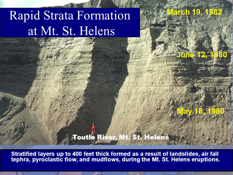
Visit the fossil museum:
www.flickr.com/photos/101536517@N06/sets/72157641367196613/
Just how good are peer reviews of scientific papers?
www.sciencemag.org/content/342/6154/60.full
www.examiner.com/article/want-to-publish-science-paper-ju...
The neo-Darwinian idea that the human genome consists entirely of an accumulation of billions of mutations is, quite obviously, completely bonkers. Nevertheless, it is compulsorily taught in schools and universities as 'science'.
second rounded form; smoked céramic
antroji apvalaina forma
céramique enfumée, env. 20x25cm
mon blog inspirations -- įkvėpimai
www.dabasformumebeles.lv - wooden gates and fences
Nature form furniture - Unique furniture and design elements:
Harijs Stradiņš - a craftsman working with natural shape wood processing, has been designing furniture and other interior design elements since 1997 selecting the best parts of the tree from top to root. In his works Harijs uses such materials as stone, glass, hammered works, fabric, clay and other natural materials to be able to make common design for a particular room.
Мебель природных форм - Уникальная мебель и элементы дизайна:
С 1997 года мастер по обработке природных форм дерева Харий Cтрадиньш, работая с деревом, изпользует его с корня до верхушки, отбирая самые интерессные части для создания своей мебели и елементов дизайна. Думая об общем дизайне помещения, в своих работах Xaрий изпользует также камень, ковку, лён, стекло, глину и другие природные елементы.
Dabas formu mēbeles - Unikālas mēbeles un dizaina elementi:
Kopš 1997. gada dabiska koka formu apstrādes meistars Harijs Stradiņš sadarbojas ar koku, kā dabas elementu, mēbeļu un dizaina elementu radīšanā, izmantojot to pēc iespējas pilnīgi (no saknes līdz gaotnei). Domājot par telpas kopējā dizaina risinājumu, savos darbos Harijs Stradiņš izmanto arī akmeni, stiklu, metālkalumus, audumu, mālu un citus dabas elementus.
COPYRIGHT - Creative Commons Attribution-Noncommercial-No Derivative Works:
- This image is licensed under Creative Commons, this means you can use it on your site (blog) if you credit the author (or authors website).
Floriated, inhabited and historiated woodcut border (leaf [b]1r, f. [i]) with an initial S formed by the body of the serpent tempting Adam and Eve, hand-colored in red, green and yellow, from an incunable German translation by Heinrich Steinhöwel of Giovanni Boccaccio's De mulieribus claris, printed by Johannes Zainer at Ulm ca. 1474 (cf. ISTC ib00720000). The leaves of this copy have been cropped at head and fore-edge margins with damage to the head of the border, including loss of some minor figures. See this image for a complete version.
Established form: Zainer, Johannes, ‡d d. 1541?.
Established form: Adam (Biblical figure)
Established form: Eve (Biblical figure)
Penn Libraries call number: Inc B-720 All images from this book
Penn Libraries catalog record
St. Lawrence (Nuremberg)
Towers of St. Lorenz Church, view from the west
St. Lawrence is a Gothic church in Nuremberg. The Lorenz church was the parish church of the medieval settlement located south of Pegnitz core of the former free imperial city of Nuremberg and forms the urban counterpart to the older Church of St. Sebald in the northern area . Construction of the three-aisled basilica was in 1250, the late Gothic choir was completed in 1477. Patron of the church is the Holy Lorenz. The heavily damaged in World War II construction was built according to the old model again. Since the Reformation, the Lorenz church is next to the Church of St. Sebald one of the two major Protestant Churches of Nuremberg, both of which belong to the deanery of the Evangelical Lutheran Church in Bavaria. The Lorenz Church Nuremberg city is the seat of the Dean and finds it in the traditionally held launch of the country's newly elected bishop.
Architectural History
Iron scale from the 15th Century on the west facade. The unit is six Nuremberg Shoe (equivalent to 6 × 27.84 cm = 167.04 cm)
The first mention of Lawrence 's Chapel in Nuremberg from the years 1235 and 1258, during an excavation in 1929 found that it was a small three-aisled basilica with the previous Romanesque. Parts of this building from the early 13th Century have been reused in the rising masonry.
The architectural history of the Lorenz church was always inspired by the model and the competition of the more important in the Middle Ages St. Sebald church. Construction of the three-aisled basilica is dated to about 1250 (St. Sebald ca. 1230/40). However, the exact series episode has yet to be determined. The dating of the sculpture of the west facade plays a supporting role, the workshop will also be seen in Nuremberg at the Tomb of Konrad Gross. The three-aisled basilica was completed around 1390th.
As early as 1400 but was extended (again, following the example of St. Sebald) the aisles by as much moved to their outside walls that is now located in the interior of the church buttresses forming small private chapels for the Council sexes. The last major phase of construction of the hall choir to the altar Deocarus fell in the years 1439-77 (The project is backed by inscriptions; hall choir of St. Sebald 1361-79).
The church was heavily damaged by the air raids in World War II and in the final battle for Nuremberg in April 1945 and has been rebuilt from 1949. Mainly the roof and the vault were destroyed. The roof has been completely redesigned, and the roof was built over the nave due to material shortages of steel. It had to be installed along 1.5 km pursuit and new vault keystones.
History
Lorenz Church, view from south
At least the predecessor of St. Lorenz church, mentioned in the first half of the 13th Century, the bambergischen upper parish in Fuerth was assumed, while St. Sebald originally belonged to Poppenreuth. St. Lawrence could never reach the significance of the sister church, the highlight of this development was in 1425 with the canonization of the public for the past two centuries revered local saint Sebald achieved by the Curia of the entire Middle Ages. St. Lawrence, patron of St. Lorenz church, did not offer the same ID space, especially since you did not have his body . This explains also the 15th Century growing devotion to the Holy Deocarus, confessor of Charles the Great, whose relics were kept in the Lorenz Church since 1316. On his 1436/37 donated altar was allowed, proven from the funds of Nuremberg citizens, establish the late-Gothic hall choir to the east of the church.
Not only for the construction of Hall Choir (1439-1477), but for the entire construction financed by wealthy citizens and the City Council is likely. The same is true for some very valuable assets, in some cases it is here a concrete founder of the patricians can be found ( as in the tabernacle, and the English greeting). This was probably also the reason that the art treasures of St. Lawrence were spared during the Reformation period of iconoclasm. St. Lawrence was one of the first churches in Germany, which were Lutheran (1525), but apparently they wanted to Nuremberg in the memory of the ancestors own honor and had therefore made by them donated sculptures.
In the subsequent history of the church, there are well-known personalities: That there was a preacher among others Andreas Osiander who in St. Lawrence worked - his picture hangs in the sacristy Lorenz .
Building design
The west facade is extremely rich articulated for a parish church, which reflects the high standards of the Nuremberg citizenship, which funded the building substantially. The facade is dominated by the two towers, the model can again to be found in St. Sebald and thus indirectly in the Bamberg Cathedral, the towering sharp Gewändeportal (embrasure portal), well-indented rose window with nine feet in diameter, and the finely perforated Maßwerkgiebel (tracery gable), elements in the form are borrowed and claim all the Gothic cathedrals.
The main building has the shape of a three-nave pillar basilica of eight yokes. In the nave pointed arches on clustered piers carry the nave wall, per yoke breaks through a pointed arch window, the clerestory wall. Presented service bundles to wear a ribbed vault, the ribs are pulled down to the level of the clerestory window sills. The peculiarity of the side aisles is much lower in small family bands, caused by the displacement of the outer walls to the outer edge of the buttress.
The late Gothic hall choir, mirror of the architectural fashion of his time, is seamlessly connected to the main ship. It is distinguished above all by its playful vaulting and the magnificent two-story window tracery in handling. On the south side of a two-storey is inserted the sacristy.
Dimensions of the church nave aisle hall choir
Length: 91.20 m Height: 24.20 m Height: 11.50 m Height: 24.20 m
Width: 30,00 m Beam : 10,40 m Width : 5,90 m Width: 28,60 m
The towers are 80.8 m and 81 m high.
Artworks
Nuremberg, St. Lawrence, north side, angle of nave and transept house: entrance hall with Olives
Tabernacle by Adam Kraft
Annunciation (1517/18) by Veit Stoss
Not all the moving pieces on the rich furnishings are originally from St. Lawrence. Many of the cultural heritage came from secular or destroyed monasteries of Nuremberg and the surrounding area.
Particularly noteworthy are two masterpieces of late Gothic sculpture belonging to the original design of the church: The brainchild of Adam Kraft 1493-1496 tabernacle (donated by Hans Imhoff the Elder.), a 18.70 meter high sandstone tabernacle, consisting of a walk-handling stage and a consequent growing up, pointed, but towards the ceiling rolled spire, which is diverse finely broken. The structure is supported by the back of three crouching figures in three different ages whose mean, equipped with stone tool, probably represents the artist himself. Above the actual Sakramentsschränkchens (small sacrament cabinet) various scenes of Christ's Passion are presented. Despite its delicate shape and the severe damage to the Lorenz Church by bombing in the Second World War, the tabernacle was largely spared from destruction by a surrounding wall.
Another brilliant performance of late Gothic art is hung in the choir German greeting (also: Annunciation in the Rosary), which was 1517/18 given by the patrician Anton Tucher at the sculptor Veit Stoss in order. It shows on the big man, colorful framed and gilded largely linden wood figures of Mary and Gabriel at the Annunciation, surrounded by a wreath of gold roses 55 (372 × 320 cm). Perched above the scene of the blessing God the Father, for the minds of the protagonists buzz musical angels, at the bottom there is a snake with bitten into apple in its mouth. Seven medallions show the seven joys of Mary. Due to a crash on the 2nd April 1817 almost completely destroyed the English greeting had to be carefully restored. Belonging to the twelve angels candlesticks on the choir stalls and the central upstream Marie chandelier.
As one of the few dated altarpieces are the Deocarusaltar of 1436/1437 for the history of the Nuremberg painting and Bilderschnitzerei (sculpture) of great importance. From 1316 to the 19th Century housed the Lorenz Church in Deocarusaltar Deocarus relics of saints, the legendary founder and first abbot of the city Herrieden. Predellenflügel (predella wing) on the right shows how Ludwig the Bavarian city of Nuremberg is about the relics of the saint.
In the right aisle is the Rochus-Altar, a foundation of the Nuremberg trade Imhoff family. When the Altarbau (construction of the altar) started, can not be ascertained clearly, probably around 1485, when the plague was raging in Nuremberg and each solution was welcome. In Venice, the dealer Imhoff family knew very well from Peter Imhoff the Elder managed in Venice from 1465 to 1476 the benefice for the altar of St. Sebald in the church of San Bartolomeo at the Rialto Bridge, which was the altar of German merchants, and is the year he was appointed consul of the Germans in fondaco dei Tedeschi. 1499th Francis Imhoff was a member of the Fraternity of Saint Roch in Venice and knew the local customs very well. And also the success of this saint cult. So it made sense for the Imhoff to make Rochus also known at home in Nuremberg. In the plague year 1484 was celebrated on 16 August in the Lorenz Church in Nuremberg the feast of Saint Roch, a little later probably Imhoff began building the altar. The altar Rochus includes not only the image of Rochus but also of Sebastian, the other plague saint, and is one of the most distinctive sign of early dissemination of the cult of Roch from Venice north of the Alps, before the 1500s. In the lower part you can see the coat of arms of the Imhoff and the Holzschuher, another Nuremberg family.
Numerous altars with paintings and carvings, sculptures in wood and stone, stained glass, some wall paintings, bells, epitaphs, dead shields and a choir from the late 15th Century complete the picture. Also mounted on the exterior are numerous sculptures, some are copies.
Bell
Tagmessglocke (a bell to call the churchgoers or monks)
Laurentia (prayer bell)
The bells of St. Lorenz church consists of 16 bells läutbaren (ringable) and thus representIing the second largest peal of a Protestant church in Germany. It consists of the main elfstimmigen (in eleven voices) bells (1-11 ) and the Cymbelgeläut (cymbeline ringing) ( 12-16). The fire bell is restored as a memorial to the two world wars on the west portal. The old silver bell hangs in the east choir and can be rung from there by cable, but it does not belong to the regular ringing bells ringing but only occasionally to Mittagslob (pray of noonday) on Krell altar. All the bells hang in a wooden belfries of wooden yokes. Due to static problems were in the course of a reorganization almost all the bells upper weights placed on the yoke to slow the Läuterhythmus (rhythm of ringing).
1 bell Christ Friedrich Wilhelm Schilling 1953 1815 4407 -4 h0 North Tower
2 Tagmessglocke 1552 Hans (III ) Glockengieser 1490 2006 d1 -1 North Tower
3 Laurentia ( prayer bell ) 1409 1608 2600 Hainrich Grunwalt e1 -1 south tower
4 dead memorial bell Friedrich Wilhelm Schilling 1953 1180 1153 fis1 ± 0 South Tower
5 Garausglocke ~ 1400 ( Hermann Kessler ) 1040 ~ 700 g # 1 +2 South Tower
6 Paul Bell 1953 988 668 Friedrich Wilhelm Schilling a1 -1 south tower
7 Luther Bell in 1953 Friedrich Wilhelm Schilling h1 +1 885 480 South Tower - octagon
8 Osianderglocke 1953 Friedrich Wilhelm Schilling 802 377 d2 ± 0 - south tower octagon
9 Lazarus Spengler bell Friedrich Wilhelm Schilling 1953 705 253 -1 South Tower e2 - octagon
10 Youth With Bell 1953 Friedrich Wilhelm Schilling fis2 630 185 -1 South Tower - octagon
11 Silver Bell 1960 Friedrich Wilhelm Schilling 39 389 d3 +6 silver turrets ( Westgebiel )
I Laudate 1954 Friedrich Wilhelm Schilling 505 90 a2 +4 North Tower octagon
Magnificat II 1954 Friedrich Wilhelm Schilling 454 h2 64 +5 North Tower octagon
Bendedictus 1954 Frederick William III Shilling sharp3 +5 410 39 North Tower octagon
Nunc Dimittis in 1954 Frederick William IV Shilling 355 35 e3 +5 North Tower octagon
V Adorate 1954 Friedrich Wilhelm Schilling 325 28 +4 fis3 North Tower octagon
- Old silver bell 2 H. 14 Century ( Hermann Kessler ) 375 d3 +6 ~ 30 east chancel
- Fire bell 1 H. 14 Century ( Hermann Kessler ) 1504 2637 e1 +0.5 parked at the west portal
Läuteordnung
Like other churches, too, St. Lorenz Church has a fixed Läuteordnung (regime of ringing) that lets the bells ring out both on a regular basis as well as on special occasions. At 8 am and in the evening by 21 clock rings the Tagmessglocke, the beep for lunch ringing by 12 clock to Laurentia, which was in 2009 600 years, the Garausläuten (burn out ringing) done with the Garausglocke depending on the sunset 16 to 20 clock. Fridays by 15 clock reminds the great bell at the crucifixion of Jesus Christ on Good Friday. Our Father in all worship the Paul Bell is rung. Saturday is by 14 clock of Sunday, heralded by the ringing of the bells 8, 7 , 6, 4 and 2 ( d2 h1 -a1 -d1 - f k1 ), which does not change over the church year. Depending on the form of worship, church festival degrees and years vary the number and/or the musical compositions (motives ) of the bells.
de.wikipedia.org/wiki/St._Lorenz_(N%C3%BCrnberg)
Volkswagen (en alemán ‘automóvil del pueblo’) es un fabricante de automóviles con sede en Wolfsburgo, Alemania.[1] Forma parte del Grupo Volkswagen, mayor fabricante de automóviles de Europa.
El Grupo Volkswagen, con sede en Wolfsburg, es uno de los grupos líderes de automoción en el mundo. En el año 2009 el grupo aumentó el número de entregas de vehículos a sus clientes a 6,34 millones de coches (2008: 6,26 millones). El Grupo está constituido por nueve marcas procedentes de siete países europeos: Volkswagen, Audi, SEAT, Škoda, Volkswagen Vehículos Comerciales, Bentley, Bugatti, Lamborghini y Scania. El Grupo opera en 61 plantas de producción en quince países europeos y en más de seis países en América, Asia y África, contando alrededor del mundo con unos 370,000 empleados produciendo unos 26,000 vehículos o involucrados en servicios relacionados con los productos del Grupo. El Grupo Volkswagen vende sus vehículos en más de 153 países.
[editar] Historia[editar] Inicios de la fábricaEl nombre Volkswagen se debe a que en los años 1930 surgió en Alemania el proyecto de construir un automóvil que fuese accesible para un gran número de personas. Cuando Adolf Hitler se alza con el poder en 1933, decide poner en marcha un plan de fomento de la industria del automóvil, con el objetivo de relanzar sus fábricas y hacerlas más competitivas frente a las inglesas y las francesas. De este modo se lanza un concurso a los empresarios para la concesión de la fabricación del denominado 'automóvil del pueblo' (Volks Wagen). Ferdinand Porsche fue el encargado de llevar a cabo el proyecto cuyo fin era construir un vehículo sencillo y barato que pudiese estar al alcance de la mayoría de los alemanes.[2]
Hitler pretendía construir la fábrica más grande de Europa para la fabricación del automóvil del pueblo. Para ello, el requisito era tener acceso a una vía fluvial navegable. También era necesaria una central eléctrica propia, que abasteciera tanto a la fábrica como a la nueva ciudad. Hitler escogió el pueblo de Fallersleben, a orillas del canal de Mittelland. El lugar formaba parte desde el siglo XIV del Condado de Schloss Wolfsburg, propiedad del conde von Schulenburg. Según las ideas de Hitler, la fábrica debía disponer de su propia ciudad anexada a la misma, para alojar a los trabajadores y sus familias.
El nombre escogido por Hitler para el automóvil fue Kdf-Wagen (Kraft durch Freude: ‘fuerza a través de la alegría’) y la ciudad, Kdf-Stadt. Sin embargo, ni en la fábrica ni en toda Alemania nadie empleó otro nombre que no fuese el de Volkswagen para referirse al Escarabajo. El nombre Kdf-Wagen sólo fue utilizado en los catálogos y por los militares nazis.
El partido nazi facilitó a Ferdinand Porsche la infraestructura necesaria para la construcción de la que sería posteriormente la fábrica encargada del proyecto. Para la realización de este proyecto, se fundó la nueva ciudad el 26 de mayo de 1938. La ceremonia de tan importante acontecimiento para el régimen nazi, buscaba claramente impresionar al pueblo alemán, un pueblo que se mostraba confiado con su dirigente. Más de 70.000 personas llegadas de todos los rincones de Alemania acudieron a la ceremonia. Lógicamente, Ferdinand Porsche estuvo presente, junto a los generales nazis y al mismísimo Führer. En dicha ceremonia, Hitler subió a bordo de un Kdf-Wagen descapotable, conducido por Ferdinand Porsche.
[editar] Segunda Guerra MundialCon el propósito de financiar todo este proyecto de dotar al pueblo alemán de un automóvil de bajo costo, el gobierno alemán ideó un sistema en el que los ahorradores deseosos de poseer un Volkswagen (automóvil del pueblo), aportaban 5 marcos semanalmente. Así se reunieron alrededor de 286 millones de marcos. Ninguna de estas personas recibió su Kdf-Wagen, ya que los proyectos militares monopolizaban la atención del país tras el inicio de la Segunda Guerra Mundial en septiembre de 1939. La fábrica de Fallersleben se destinó a la producción militar, y después de 6 años de guerra, el dinero del Kdf-Wagen fue requisado por los rusos en concepto de reparaciones de guerra.
Comenzada la guerra, la fábrica se convirtió en objetivo militar, a pesar de que el propio Hitler le auguró a Porsche: ”La fábrica no tendrá importancia estratégica” en obvia referencia a la exclusiva construcción del Kdf civil y la victoria relámpago que se obtendría con la Blitzkrieg. No bien iniciadas las hostilidades, la planta pasó a la órbita del Ministerio de Armamentos y de la Luftwaffe. De esa suerte, además de los ya conocidos Kdf; Kübelwagen; y Schwimmwagen, se produjeron allí alas y fuselajes para el Schnellbomber Junkers Ju-88; motores BMW 801 D para el caza Focke-Wulf Fw 190; granadas de mano; minas; y aproximadamente un millón y medio de calefactores para las tropas en Rusia. Asimismo a partir de septiembre de 1943, se ensamblaron también las bombas voladoras Fieseler Fi 103, popularmente conocidas como V-1 (Vergeltungswaffe 1: ‘arma de represalia n.º 1’).
Los aliados dieron prioridad a los ataques a la planta del Kdf en razón de su contribución al esfuerzo bélico enemigo. Años antes, por su parte, expertos de la Luftwaffe (Fuerza Aérea Alemana) habían sugerido su prudente dispersión en los bosques aledaños. Sin embargo, hasta el momento mismo de las primeras incursiones no se había tomado la más mínima precaución en ese sentido
Al tiempo de las primeras incursiones en abril de 1944 aún se carecía de camuflaje, defensa antiaérea, y refugios subterráneos para los trabajadores. El enemigo podía ver fácilmente la masiva mole rectangular a un lado del Mittellandkanal.
El 8 de abril de 1944 cincuenta y seis bombardeos descargaron allí 146 toneladas de bombas incendiarias y de alto poder explosivo. Aunque no se causaron grandes daños materiales, trece personas murieron y cuarenta resultaron heridas. Tres semanas después, un Boeing B-17 sin tripulación, se estrelló en los techos del Hall 1 de la planta ocasionando graves destrozos en toda esa área. A ello le siguieron otros tres importantes raides: El 20 de junio, 137 Fortalezas Volantes lanzaron 500 toneladas de bombas incendiarias y de alto poder explosivo. De éstas aproximadamente 582 hicieron blanco en la fábrica causando la muerte de veintisiete trabajadores y heridas a noventa y tres más. Nueve días después, sesenta y cinco aviones atacaron con 826 bombas, matando a 14 personas y dañando en forma considerable a la planta, ciudad y barracas de prisioneros. Por último el 5 de agosto, ochenta y cinco Liberator dejaron caer 300 toneladas de bombas de alto poder explosivo, consiguiendo un estimativo de 300 aciertos en la planta de ensamblado, cocinas, barracas y calles. Murieron 7 personas y 27 fueron heridas. Todas las incursiones se realizaron de noche conforme la modalidad operativa de la Octava Fuerza Aérea Estadounidense.
El 10 de abril de 1945, tropas estadounidenses dirigieron su avance en dirección a la ciudad del Volkswagen. Sin embargo no llegaron a entrar en ella pues desconocían su existencia. La ciudad era demasiado nueva y no figuraba aún en sus más recientes mapas. El 18 de abril tomaron posesión de la fábrica y ciudad varios tanques Sherman apoyados por doscientos soldados estadounidenses.
Los estadounidenses originariamente tenían la intención de desguazar y luego destruir toda la fábrica debido a su connotación nazi. Enterado el inspector-jefe de la planta, Rudolf Brörmann, se les opuso tenazmente evitando la planeada demolición durante los meses de primavera y verano de 1945. Su gestión en esa crítica época, ha sido olvidada por la historia oficial de la Volkswagenwerk. Así entonces el 25 de mayo, con la venia estadounidense, se resolvió rebautizar a la antigua Stadt des KdF-Wagen con el nombre de Wolfsburgo, tomado del castillo vecino de Von Schulemburg.
El 28 de mayo Rudolf Brörmann fue puesto en la función de director ejecutivo de la planta. Para fines de ese mismo mes se habían armado manualmente 110 Kübelwagen con piezas sobrantes.
Hitler nunca llegó a ver su Kdf-Wagen salir de las líneas de producción. Con el fin de la guerra, Ferdinand Porsche fue encarcelado por su vinculación con el régimen nazi y los ingleses tomaron el control de la factoría. El 27 de diciembre se comenzó la producción en serie del escarabajo.[2]
[editar] Desde los años cincuentaAunque sus primeros pasos comenzaron antes de la Segunda Guerra Mundial, no fue hasta los años cincuenta cuando el Escarabajo se convierte en un vehículo de gran aceptación social tanto en Europa como América. En 1955 salió de la fábrica el ejemplar un millón,[2] y en 1972 el Escarabajo, como ya se le conocía en todo el mundo, superó el récord de unidades fabricadas de un automóvil, que ostentaba Ford con su modelo "T", al alcanzar la cifra de 15.007.034 Volkswagen fabricados.
En 1978 el Escarabajo dejó de fabricarse en Alemania al bajar la demanda en la mayoría de los países,[2] ya que habían aparecido en el mercado mundial automóviles equivalentes, pero de diseño y tecnología mucho más actuales. Siguió produciéndose, no obstante, en Brasil continuò su producción hasta 1985, reintroduciéndose en aquel país por mandato presidencial en 1993, descontinuándose en 1996.[3] En México la producción del Volkswagen Sedán continuó de forma ininterrumpida hasta 30 de junio de 2003[4] cuando se produce el último Volkswagen Sedán Última Edición,[5] el cual portaba equipamiento distintivo. La última unidad producida se encuentra en el Museo de Volkswagen en Wolfsburgo, y otro de estos codiciados ejemplares fue obsequiado al Papa Juan Pablo II por un grupo de concesionarios de la marca en México.[6]
Durante finales del siglo pasado, el Volkswagen Sedán (escaabajo) fue considerado «el automóvil del siglo».
Volkswagen no se quedó atrás en la evolución de los automóviles y presentó en 1974 el modelo Golf, que de inmediato tuvo un gran éxito. Volkswagen fue ampliando paso a paso su gama de modelos, abandonando su anterior política de modelo único. Así fue incorporando en primer lugar el Passat, un poco antes que el Golf, y a continuación el Polo y el Lupo, modelos más pequeños. En 1997 aparece el New Beetle, que ofrece un diseño basado en el antiguo Escarabajo, pero totalmente modernizado, al igual que la tecnología. Este automóvil está destinado principalmente al mercado estadounidense, donde sigue existiendo un gran número de conductores nostálgicos del Escarabajo. La aparición de este modelo, unida a un descenso de la demanda también en los países latinoamericanos, lleva en el año 2003 al cierre de la fabricación del clásico "Vocho" en México.[2] Con anterioridad han ido saliendo otros modelos nuevos, como el Phaeton, buque insignia de la marca, el Touran, un monovolumen de siete plazas, y el Touareg, un todoterreno para uso en ciudad, carretera y en terrenos difíciles.
En el año 2002 Volkswagen entregó casi 5.000.000 de vehículos. El número de empleados y trabajadores fue de 325.000. Su participación en el mercado mundial fue del 12,1%. También en 2002 y después de 28 años de producción, el Golf superó en ventas al legendario Escarabajo
WIKIPEDIA
twitter.com/Memoire2cite?fbclid=IwAR3JmEG0v02xG5uFvJNSn_x... - Après 1945, les collines agricoles du sud-est de la ville connaissent un programme d’urbanisation de grande ampleur pour répondre à la crise du logement. Près de 4600 logements sociaux vont ainsi être construits en quatre tranches successives de 1953 à 1970 : Beaulieu, la Marandinière, Montchovet, la Métare et la Palle formant aujourd’hui les quartiers sud-est. Touché par la crise économique et urbaine de dingue, le secteur sud-est apparaît à la fin des années 1990 comme un espace monofonctionnel dédié en totalité à l’habitat locatif social et porté par un seul bailleur l'OPAC devenu Métropole Habitat. Bien que bénéficiant de nombreux atouts (accessibilité et environnement agréable...), le quartier souffre du gigantisme de son urbanisation et du manque de résidentialisation des unités d’habitation. Par une action en profondeur et dans la durée, la Ville de Saint-Étienne, à travers son Programme de Rénovation Urbaine (PRU), a amorcé une transformation durable du quartier depuis 1989 avec la 1ere demolition du programme à la rue Pierre Loti le 31 janvier 1989 (BANLIEUE89), 30 ans de renouvellement urbain sur la ville.... une ville pilote en la matiere des 1990. Aujourd'hui et demain Les quartiers sud-est vont poursuivre leur mutation, avec l’appui continu de l’Agence Nationale de Rénovation Urbaine et ses partenaires l'ANRU2. Développer le secteur économique
L'objectif est de dynamiser l’économie dans ce territoire en portant de nouveaux projets et en restructurant l’offre commerciale de proximité. La Ville de Saint-Étienne a prévu la création de nouvelles zones d’activités permettant l’accueil d’entreprises. Ainsi une zone d’activités économiques, rue Pierre Loti, répondra aux besoins fonciers des entreprises et des artisans locaux. Ce projet de zone économique, en visibilité directe de la RN 88, permettra l’implantation d’une cinquantaine d’entreprises et la création de 300 emplois. Un nouveau centre commercial sur le secteur de la Marandinière, couplé à la démolition des centres commerciaux de la Palle et Sembat, permettra de restructurer et moderniser l’offre commerciale de proximité. Renouveller l'offre d'habitat Une qualité résidentielle s’affirme progressivement au sein des quartiers Sud-Est, grâce à une nouvelle offre d’habitat variée qui émerge depuis plusieurs années. Les nombreuses démolitions réalisées et à venir (Boulevard des Mineurs en 2018 et immeubles Loti en 2020), ainsi que les réhabilitations d’immeubles en cours, vont permettre de diversifier l’offre de logements. L’un des objectifs du projet urbain est donc de conforter la vocation résidentielle du quartier en stimulant l’offre et en accompagnant des projets comme la construction de logements passifs sur le secteur de Beaulieu, la transformation de l’ancienne école Baptiste-Marcet et la réhabilitation de logements à Monchovet. Améliorer le cadre de vie des habitants
Les quartiers sud-est bénéficient d’un environnement naturellement riche et varié, à l’interface entre les grands parcs de la ville (jardin des Plantes, parc de l’Europe, Bois d’Avaize) et le Pilat. Le projet urbain de la Ville de Saint-Étienne prévoit de relier ces espaces naturels entre-eux avec la création d’une continuité verte, qui permettra aux marcheurs et autres randonneurs de bénéficier d’un véritable réseau de chemins autour de la commune. Le boulevard Alexandre-de-Fraissinette, véritable colonne vertébrale du quartier, et la rue Pierre-Loti seront entièrement revus pour assurer un meilleur partage de l’espace entre tous les modes de déplacements (voiture, vélo et piéton) et assurer un maillage inter-quartiers plus efficace. fr.calameo.com/read/0005441131b4119eaa674
Depuis 2014, la rénovation urbaine dans les quartiers sud-est s’est traduite par de nombreux travaux: la construction du centre commercial de la Grande Marandinière, l’aménagement d’un lotissement de treize maisons individuelles passives, impasse Clémenceau, les rénovations des écoles de Montchovet et de Beaulieu, la réhabilitation de locaux rue Henri-Dunant (pour y installer la Maison des associations), et enfin les démolitions récentes du centre commercial du boulevard de la Palle et d’un garage, au 41 rue de Terrenoire.Démolitions mais aussi constructions sont au programme. Plusieurs acteurs entrent en jeu dans le financement de ces projets, notamment l’ANRU (Agence nationale de rénovation urbaine) mais aussi la Ville, le Département et la Région. Ainsi, le contrat avec l’ANRU, signé le 14 mars, dégage une somme de 23 millions d’euros, somme à laquelle il faut ajouter 3,3 millions d’euros de la Région. Pour les années à venir, les objectifs visent à la poursuite du développement économique, de la mutation de l’habitat par des constructions individuelles ou de petits immeubles, des démolitions ponctuelles, de la valorisation des espaces publics et du renforcement des espaces du quartier. Deux secteurs sont concernés : Loti et la Grande Marandinière. Le 11 AVRIL 1964, le développement de la ville de Saint Etienne, et ses travaux ..La ville de Saint Etienne se développe tout comme l'ensemble du territoire... Pour accompagner cet accroissement de population, de nouveaux quartiers se construisent aux abords de la ville chaque jours. Et pour faire face aux problèmes de circulation, un boulevard périphérique a été aménagé. Réalisé à l'occasion de la construction de la déviation sud de l'autoroute de Saint Etienne, ce reportage témoigne de la visite du sénateur maire de la ville, Mr. Michel DURAFOUR, sur le chantier du tunnel de la déviation. Accueilli par Mr. Rocher, président de la société forêzienne de travaux publics, Michel DURAFOUR découvre avec les membres du conseil municipal l'avancée des travaux. (voir aussi le chantier de l A 47 avec la video du tunnel du rond-point içi : www.ina.fr/video/LXC9610041788 . Ce quartier est né des programmes de grands ensembles mis en œuvre à partir des années 1950 afin de réduire la pénurie de logements. La mairie choisit donc de développer un quartier moderne 4 600 logements en HLM pour pouvoir loger plus de 30 000 habitants avec des loyers modérés dans des bâtiments modernes. Ce quartier avait comme emblème un des plus grands immeubles d’Europe surnommé la Muraille de Chine qui était visible depuis l’autoroute. Ce quartier s’est construit en quatre tranches : Beaulieu I (Beaulieu) de 1953 à 1955 ; Beaulieu II (La Marandinière) en 1959 ; Beaulieu III (Montchovet) en 1964 ; Beaulieu IV (La Palle) en 1971. Il est aujourd’hui en profonde mutation avec un programme de renouvellement urbain qui prévoit la démolition de plus 1000 logements et la reconstruction de 250. Bâtiments spécifiques : CHPL (Centre Hospitalier Privé de la Loire) qui remplace la Muraille de Chine ; Ecole Nationale d'ingénieurs de Saint-Etienne Un modèle de l'urbanisme des années 1950. Beaulieu-Montchovet: La ville choisit de construire un immense quartier neuf de plus de 4.600 logements, prévu pour loger 30.000 habitants, sur les basses pentes du Pilat, à la sortie sud-est de Saint-Etienne.Entre les forêts, qui seront classées parc naturel quelques années plus tard, et les quartiers chics du cours Fauriel, c'est un des endroits les mieux situés de la ville.C'est aussi le seul grand emplacement proche du centre où il n'y aie pas eu de mines, parce que les couches de charbon s'arrêtent juste avant : le terrain est assez solide pour supporter de gros immeubles. Içi le chantier de construction de MONTCHOVET soit Beaulieu 3, la continuitée des constructions HLM de nos quartiers sud-est (les chantiers de l'OPAC) , la vidéo içi :
www.ina.fr/video/LXF99004401 .
Retour sur son historique de 1962 à aujourd'hui e n 2018.
Un grand-Ensemble qui rappelle combien la politique d'urbanisme des années 1960 et suivantes a été conduite en dépit du bon sens la video içi www.google.fr/search?q=montchovet+ina&oq=montchovet+i... et là www.ina.fr/video/CAC00029801 , mais aussi içi www.ina.fr/video/CAC00029801 - avec Claude BARTOLONE içi avec la Visite à Saint Etienne du ministre délégué à la ville le jour de la démolition de la muraille de Chine. Rencontre avec des associations pr discuter du futur du quartier Montchovet. www.ina.fr/video/LY00001263573 - fresques.ina.fr/rhone-alpes/fiche-media/Rhonal00046/demol... - et les differentes videos de la demolition la encore : La démolition de la "muraille de Chine" de Saint Etienne www.youtube.com/watch?v=aq1uOc6Gtd0, www.youtube.com/watch?v=YB3z_Z6DTdc terrible :( ^^ l interview de Michel Thiolliere Le Grisou.fr a interviewé Michel Thiollière, ancien maire de Saint-Etienne et sénateur de la Loire, membre du Parti radical et actuel vice-président de la Commission de régulation de l'énergie. Il livre son analyse sur les prochaines échéances politiques, notamment la campagne des municipales en cours à Saint-Etienne, les alliances de la droite et du centre, mais aussi le mandat de Maurice Vincent. Michel Thiollière s'attarde également sur les besoins de l'agglomération stéphanoise et évoque les enjeux énergétiques en France.(Interview : Maxime Petit -- Réalisation : Studios Bouquet) www.youtube.com/watch?v=AJAylpe8G48,"François Mitterrand, après la visite de deux quartiers -l'un à Saint Etienne et l'autre à Vénissieux, inscrits sur la liste de ceux à réhabiliter -, parle du plan de réhabilitation pour de meilleures conditions de logement.François Mitterrand / Georgina Dufoix / Gilbert Trigano / François Dubanchet / Marcel Houël Thèmes : Grands travaux et grands projets
Le Président > 1er septennat 1981-1988 > 1981-1986 Éclairage
Depuis la fin des années 1970, la région lyonnaise apparaît comme l'épicentre des violences urbaines qui se déroulent en France. Durant l'été 1981, des violences urbaines ont conduit le gouvernement à engager le plus tôt possible une nouvelle politique en faveur des quartiers dégradés. Malgré les premières opérations de réhabilitation engagées par la Commission nationale pour le développement social des quartiers, la situation demeure extrêmement tendue dans un certain nombres de quartiers populaires. L'assassinat d'un jeune de la Cité des 4 000 par un habitant en juillet 1983 a ravivé les débats autour du thème du "mal des grands ensembles" selon l'expression de l'époque. D'autre part, le contexte politique conduit également le pouvoir à s'intéresser encore davantage à la question de la dégradation urbaine dans la mesure où de très nombreux quartiers populaires n'ont pas cette fois-ci apporté leurs suffrages aux candidats de la gauche.La visite de François Mitterrand dans deux quartiers dégradés de la région lyonnaise constitue donc un signal fort à l'égard des populations qui y vivent. Ce déplacement fait également écho à celui réalisé quelques jours plus tôt au sein de la Cité des 4 000 à La Courneuve en Seine Saint Denis (voir Visite de François Mitterrand à La Courneuve). Le principe est d'ailleurs le même et il est exprimé par le président de la République : voir par lui-même l'état réel de ses quartiers. Le fait qu'il soit mentionné dans le reportage que "ces visites surprises" se soient faites dans la "plus grande discrétion" (notamment sans les élus locaux concernés) marque effectivement la volonté du président de la République d'établir une sorte de lien direct avec les habitants qui vivent dans ces quartiers. Il ne s'agit pas de faire l'annonce de nouvelles mesures mais "de voir les choses par moi-même" selon l'expression utilisée par François Mitterrand lors de son allocution à la Préfecture à Lyon. Au moment où la Commission nationale pour le développement social des quartiers établit la liste définitive des 22 quartiers qui bénéficieront d'un programme de réhabilitation, la visite du président de la République sur le terrain suggère une forme de "présidentialisation" du thème de la réhabilitation des grands ensembles.La création au même moment de Banlieue 89 suscitée par deux architectes proches de François Mitterrand, Roland Castro et Michel Cantal-Duparc, suggère également l'intérêt du président de la République pour les questions urbaines (voir Inauguration de l'exposition organisée par Banlieue 89)."http://fresques.ina.fr/mitterrand/fiche-media/Mitter00106/visite-de-francois-mitterrand-a-saint-etienne-et-aux-minguettes.html Journaliste
Visites surprises qui se sont déroulées dans la plus grande discrétion, seule Madame Georgina Dufoix, Secrétaire d’Etat à la Famille et aux Immigrés, Monsieur Gilbert Trigano, le PDG du Club Méditerranée qui participe à la Commission Dubedout, et deux collaborateurs du Chef de l’État étaient présents. Ni à Saint-Étienne, ni à Vénissieux, les autorités locales n’y ont participés. Peu avant midi, le Président est arrivé à la Préfecture du Rhône à Lyon où s’est déroulée pendant 45 minutes une séance de travail avec les élus locaux et notamment Messieurs Dubanchet, Maire de Saint-Étienne et Houël, Maire de Vénissieux. Réunion qui a donné l’occasion d’aborder les problèmes de fond, devait souligner François Mitterrand.(Bruit)François Mitterrand
Les deux quartiers que je viens de visiter, celui de Montchovet à Saint-Étienne et celui de Monmousseau à l’intérieur des Minguettes sur la commune de Vénissieux, sont inscrits sur la liste des 22 quartiers à réhabiliter, retenus, proposés par la Commission Dubedout devenue la Commission Pesce, et retenus par le Gouvernement. Et je compte appliquer nos efforts pour qu’effectivement, ces quartiers soient réhabilités, c’est-à-dire, soient habitables. Qu’on y trouve, pour ceux qui y vivent, euh, suffisamment de convivialité, de capacité de développer une famille et, euh, revenant de son travail quand on en a, de pouvoir vivre avec les autres. Les conditions de logement, la construction de ces ensembles, les liaisons avec l’extérieur, l’école, le sport, les espaces verts, bref, l’espace tout court, contribuent, vous le comprenez bien à, au futur équilibre, ou contribueront au futur équilibre de ces quartiers. Alors, je préfère voir les choses par moi-même. Il faut bien se dire que à l’origine de nombreux désordres sociaux se trouvent ces fâcheuses, ces déplorables conditions de vie. Et moi, je veux lutter contre ces désordres et pour cela, il faut que je m’attaque avec le Gouvernement et ceux qui ont la charge auprès de moi, je veux absolument m’attaquer aux sources d’un malaise et d’un déséquilibre social qui sont d’une immense ampleur. Raison de plus pour commencer par un bout avec énergie et continuité. Et de ce point de vue, je compte bien, au cours des semaines et des mois à venir, persévérer dans cette enquête personnelle qui me permet ensuite de donner des instructions précises à ceux qui participent à la gestion de l’État., à Saint-Étienne comme dans les communes de sa proche banlieue. Une sorte de grand monument à la gloire des HLM, comme si on avait fait exprès de la faire aussi énorme pour montrer comme les gens étaient fiers de ce quartier. Autour on construit tout ce qu'il faut pour les habitants : une école, Montchovet, qui donne sur le grand pré derrière, une MJC, une piscine, un centre commercial, avec la Poste, plus tard le bureau de police. En 1978, comme les enfants des habitants grandissent, on ouvre un deuxième collège dans la ZUP. Il prendra le nom de Jean Dasté, qui a créé la Comédie de Saint-Etienne, le plus grand théatre de province en France, et son école de comédiens. Après 1984 les loyers des HLM ont augmenté, beaucoup d'habitants sont partis. La population de Saint-Etienne diminue surtout dans les quartiers sud : beaucoup de gens déménagent vers la plaine du Forez, moins froide, où il y a la place de batir des maisons. On a rénové beaucoup d'appartements anciens en ville : la crise du logement est finie. On ne sait même plus qu'elle a existé. Les ZUP ont vieilli et la plupart des gens préfèrent se loger dans des appartements récents. Alors on ferme : le collège de Beaulieu, l'école de la Marandinière, la Poste. La Muraille coute très cher à entretenir : il n'y a plus asssez d'habitants pour payer les frais. Les HLM ont décidé de la détruire: c'est le plus gros projet de démolition jamais réalisé en Europe. Les familles qui restaient ont du déménager. On va faire exploser la Muraille de Chine au printemps de l'an 2000. Peut être qu'il fallait le faire, mais pour les gens du quartier c'est un gros morceau de notre Histoire qu'on nous détruit.
1954: les premiers travaux à Beaulieu : la campagne devient une ville à grands coups de bulldozer..
Le projet est de construire en grande quantité des logements de bonne qualité, avec tout le confort, des chambres pour les enfants, l'eau, le chauffage central, des sanitaires, des arbres et des pelouses, et surtout .... des loyers accessibles pour tous. Ce seront les Habitations à Loyers Modérés, les HLM.
Il faudra les construires en dehors des villes, pour en finir avec le mélange des industries et des logements, qui amène le bruit et la pollution. Y prévoir tous les équipements : commerces, écoles, collèges, lycées, transports, parcs, équipements sportifs, police, pompiers, Postes. Construire des villes entières où tout le monde aura accès à ce qui n'était encore que le luxe de quelques gens très riches.
Cinq villes sont choisies pour être prioritaires : Paris ( Pantin ) et Lyon ( Bron-Parilly) à cause de leur taille, Angers et Rouen détruites dans les bombardements de 1944, Saint-Etienne, la ville la plus sinistrée de France pour le logement. C'est là que naissent les cinq premières Zone à Urbaniser en Priorité, les ZUP, modèles de l'urbanisme pour toute une génération. Elles ne s'appellent pas encore comme ça : on les construites avant que l'expression de ZUP existe, c'est de leur réussite que naitra le modèle repris partout pour lequel on inventera le mot plus tard.
Beaulieu I: le projet d'urbanisme
Maquette de 1953 - Projet des architectes Gouyon-Clément
Une architecture géométrique, de grands espaces, des arbres, des formes qui soulignent le relief.
La ZUP de Beaulieu est construite en quatre tranches:
- Beaulieu I ( Beaulieu ) de 1953 à 1955
- Beaulieu II ( La Marandinière ) en 1959
- Beaulieu III ( Montchovet ) en 1964, dont fait partie la Muraille de Chine, le grand immeuble le long du boulevard à gauche.
- Beaulieu IV ( La Palle ) en 1971
Le quartier:
Au premier plan, en bas à droite Beaulieu, la Marandinière est à droite derrière l'autoroute, Montplaisir à gauche, Monchovet au milieu, le long du boulevard de la Palle.
A gauche des tennis, les batiments du collège de Beaulieu. C'était l'autre collège de la ZEP, le seul collège "sensible" de France a avoir été fermé, en 1995.
Nouvelles techniques, nouveaux matériaux :
Construire vite pour un prix raisonnable oblige à inventer de nouvelles techniques, d'autant que l'on manque de travailleurs qualifiés.
La construction s'industrialise: immeubles à structure porteuse ( des poteaux en béton armé tiennent les dalles, ce ne sont plus les murs qui soutiennent les immeubles ), murs rideaux ( les murs sont fait de morceaux préfabriqués accrochés aux dalles ), éléments standardisés ( les éléments: murs, tuyauterie, portes et fenêtres, sanitaires, etc... sont tous identiques, fabriqués en usine en grande série, installés de la même façon dans tous les immeubles ), nouveaux matériaux ( matières plastiques, béton armé, acier ) qui ne s'utilisaient pas dans la construction traditionnelle.
Cela permet de diminuer les prix, en automatisant les fabrications, mais aussi parce qu'on peut utiliser des ouvriers beaucoup moins qualifiés, qui ne font que du montage et que l'on paye moins cher.
Bien après les gens se plaindront de ces appartements tous identiques, de ces matériaux peu agréables, de la taille inhumaine des batiments.
Mais à l'époque il faut compter deux à trois ans d'attente pour obtenir un appartement dans le quartier. Les familles sont si contentes de leur quartier tout neuf que les collègiens qui prennent le bus emportent une paire de bottes en plus de leur chaussures pour aller des immeubles à l'arrêt de bus : pas question de ramener de la boue dans les bus ou dans les escaliers.La crise du logement:
1950 : la France connait la pire crise du logement de son Histoire. La crise économique de 1929 puis la guerre de 1939-1945 ont arrêté la construction de logements, déja insuffisante avant 1930, pendant plus de vingt ans.
La France est au maximum du "baby-boom" ( période de très forte natalité qui commence à la fin de la guerre ) : les 40 millions de français de 1950 font deux fois plus de bébés que les 60 millions d'aujourd'hui. La très forte croissance économique relance l'immigration. Plus de la moitié des familles sont mal logées alors que la France commence la plus forte croissance démographique de son Histoire.
La IV° République, héritière du programme de la Résistance donne la priorité aux besoins sociaux : école, santé, logement, sur la rentabilité financière. L'Etat, les villes, sont décidés à investir dans le logement, qui est déclaré prioritaire dans le Plan d'organisation de l'économie.
Entre les années 50 et 60, et suite à la seconde guerre mondiale, la municipalité stéphanoise a vu sa population passée d’un peu moins de 180 000 habitants en 1950 à plus de 200 000 habitants dix ans plus tard en 1960. Cette forte augmentation de la population pouvait s’expliquer par le fort taux de natalité de cette époque (baby-boom), mais aussi par l’afflux de travailleurs de la classe ouvrière venus dans la grande cité stéphanoise pour trouver un travail. De ce fait, la construction d’un logement sain pour chaque ouvrier était devenue une priorité absolue pour les élus qui considéraient à raison que cela était une condition vitale dans le cadre de ce grand développement. Pour ce faire, la ville a lancé dans les années 50 une vaste opération de construction de barres d’habitation dans la zone de Beaulieu, destinée à fournir un logement à une population grandissante.
Une barre d’habitation innovante
A l’époque, avec une majorité d’architectes, les appartements modernes construits possédaient des cloisons lourdes empêchant toute modification interne ainsi que des espaces de renvoi sombres et non ventilés ressemblant à des alcôves.
Mais à l’inverse, pour certains architectes précurseurs de la région à l’image d’Yves et Henri Gouyon, la modernité reflétait le gout de la clarté, de l’air, et du soleil, avec de larges horizons. Ainsi, ces derniers donnaient la priorité non pas aux façades qu’ils considéraient comme de simples élévations du plan, mais aux cellules d’habitations et à leur orientation. Dans cette optique, le bâtiment proposé par Henri Gouyon, qui était donc un partisan de l’espace ouvert moderne, supprimait les circulations et profitait de ce gain de place pour aménager de nouveaux espaces de vie communes. De plus, dans ces cellules d’habitations, les architectes ont tirés profit au maximum de la double orientation des appartements (ces derniers étaient traversant) avec par exemple l’accolement de balcons.
Conception et réalisation d’un quartier entier
Pour le projet de Beaulieu, l’on confia la conception ainsi que la réalisation des interventions aux agences Henri et Yves Gouyon puis Yves Gouyon et associés. Ainsi, dés le milieu des années 50, des études concernant Beaulieu II – La Marandinière furent conduites, suivis de la construction du bâtiment entre 1957 et 1959. S’en suivit Beaulieu III – Montchovet entre 1962 et 1964, surnommé la « Muraille de Chine », qui comprenait entre autres, une barre de type HLM haute de 10 à 17 mètres et longue de 270 mètres, avec 560 logements. Suites à ces constructions, l’urbanisation des vallées et collines du sud-est de Saint-Etienne continua jusque dans les années 70 avec les séries de la Métare I, II, et III. Au total, ce sont plus de 8 000 logements, pour l’essentiel de type HLM, qui ont été construits durant cette période.
Ces constructions ont également contribué à la création du parc de l’Europe et d’un boulevard circulaire qui servait de jonction entre les différents édifices et le centre-ville de la cité stéphanoise.Un projet pharaonique
Le centre commercial fut un projet d’une dimension sans précédent pour la ville, plus grand centre commercial intra-urbain de la région Loire-Auvergne, avec 100 magasins, 1500 places de stationnement, 90 000 m² de surface, et sur 3 niveaux (4 niveaux avec la terrasse). Le 2 octobre 1979, CENTRE DEUX ouvre ses portes pour la première fois, et constitue une renaissance et un véritable tournant pour la ville.L’avis de l’architecte
De toutes les constructions de cette époque, Beaulieu est un des ensembles construits qui se porte le mieux si l’on en croit les nombreuses enquêtes menées auprès de la population de ces logements, dont certains l’occupe pratiquement depuis le début. Les arbres atteignent désormais le haut des immeubles, et la rue Le Corbusier adjacente a pris les allures « d’une banlieue des années 30 » avec un niveau d’urbanisme parfaitement acceptable. En conclusion, on peut parler pour cette construction d’un véritable savoir faire architectural et en quelques sortes d’art urbain. Ce projet a été récompensé par un prix d’urbanisme, mettant en valeur le travail en amont du projet. St-Etienne Cimaise Architectes -
Entretien avec François Tomas, géographe, spécialiste de l'aménagement urbain, et enseignant à l'université et à l'école d'architecture de Saint-Etienne. Il est notamment l'auteur des Grands Ensembles, une histoire qui continue (Publications de l'université de Saint-Etienne, 2003). Cet intellectuel a également mis la main à la pâte. Entre 1977 et 1983, il fut adjoint à l'urbanisme du maire communiste de l'époque, Joseph Sanguedolce. Engagé au PC de 1974 à 1985, il a, depuis, rejoint le Parti socialiste «comme militant de base»Quelle est l'ampleur des destructions provoquées par la Seconde Guerre mondiale à Saint-Etienne?
La ville subit un important bombardement des Alliés le 26 mai 1944. Celui-ci vise les usines qu'utilisaient les Allemands dans la région pour leur effort de guerre et les noeuds de communication ferroviaire. Comme prévu, la gare de Châteaucreux, les usines de Marais et le tunnel de Tardy sont touchés. Mais les bombes, larguées trop rapidement, atteignent aussi les quartiers du Soleil et de Tardy - notamment les écoles - ainsi que l'église Saint-François, emplie de fidèles. Au total, le bilan est lourd: un millier de morts, 1 500 blessés, 22 000 sinistrés; 800 immeubles ont été plus ou moins détruits.Que prévoit-on pour la reconstruction?Pas grand-chose. A la différence de la refonte spectaculaire du Havre, par exemple, on se contente ici de bâtir de petits immeubles, plus modernes bien sûr, mais sans réelle innovation architecturale ou urbanistique.Est-il vrai que Saint-Etienne, après guerre, traîne une réputation de «capitale des taudis»?C'est exact, et celle-ci n'est pas usurpée. En 1946, 7% seulement des logements sont jugés «confortables», et 17%, «acceptables»; 56% sont médiocres, et 20% peuvent véritablement être qualifiés de taudis: 1 logement sur 5 n'a pas d'eau à l'évier, les deux tiers ne disposent pas de WC, et 95%, de salle d'eau. Mais le problème n'a pas été créé par la guerre. Depuis la fin du XIXe siècle, Saint-Etienne a beaucoup grandi, mais très peu construit. Résultat: la ville a vieilli sur elle-même et se trouve après guerre dans une situation désastreuse, que les bombardements ont simplement aggravée.C'est alors qu'Alexandre de Fraissinette, maire élu en 1947, fixe le logement comme l'une de ses priorités.
Oui. Et ce ne sera pas un vain mot. Rendez-vous compte: on passe de 114 logements construits en 1948 à 531 en 1951, 1 085 en 1954, 1 694 en 1957 et même 2 932 en 1959! L'effort est gigantesque. Mais le changement est aussi qualitatif. A la fin des années 1940 et au début des années 1950, la France va connaître une rupture architecturale avec l'apparition des premiers grands ensembles. Saint-Etienne sera l'une des villes symboles de cette rupture.Comment cette nouvelle architecture est-elle accueillie?Très favorablement par les classes moyennes, beaucoup moins par les classes populaires.Cela paraît paradoxal, pour du logement social!
Le paradoxe n'est qu'apparent. On l'a oublié aujourd'hui, mais les premiers grands ensembles sont réservés aux familles de moins de trois enfants ayant des revenus corrects, autrement dit aux classes moyennes. Alors que, depuis la guerre, celles-ci devaient se contenter d'une ou de deux pièces mal équipées, elles se voient soudain proposer des logements spacieux, avec de la verdure, de la lumière, une salle d'eau, des WC, le chauffage central. Cela leur paraît merveilleux! Les pauvres, eux, continuent de s'entasser dans de petits appartements sans confort, quand ce ne sont pas des taudis, en particulier à Tarentaize et à Beaubrun, ou des bidonvilles, du côté de Méons, près des puits de mine et des usines sidérurgiques. Ce n'est que plus tard, à partir des années 1970, que les grands ensembles seront prioritairement réservés aux pauvres et aux familles immigrées. Mais, dans les années 1950, les grands ensembles sont encore synonymes de progrès social. Et même au-delà. On est persuadé que ce nouvel habitat va entraîner le recul de la maladie, de la délinquance, voire de la mésentente entre les époux! Il existe ainsi une «commission du bonheur ou des grands ensembles»!On croit rêver...
C'était l'ambiance de l'époque, avec ses utopies et ses excès. Pour les architectes, si l'un des repoussoirs est le taudis de centre-ville, l'autre est le petit pavillon de banlieue, symbole à leurs yeux de l'individualisme petit-bourgeois, avec ses gaspillages de terrain, son absence d'horizon et son coût pour la communauté...Quels sont les quartiers typiques de cette période, à Saint-Etienne?Le premier est constitué par le très bel ensemble de la place du Maréchal-Foch. Il s'agit d'une étape intermédiaire entre l'îlot traditionnel (des immeubles accolés, formant un pâté de maisons) et sa suppression totale. Du côté de la Grand-Rue, plusieurs immeubles constituent encore des semi-îlots. Mais, à l'ouest, deux immeubles sont déjà totalement indépendants: ils sont construits au milieu de la verdure. Et cela, c'est très nouveau. Jusqu'à présent, tous les immeubles érigés à Saint-Etienne, y compris les plus hauts, étaient accolés à d'autres édifices. Cela reste encore, cinquante ans plus tard, l'un des quartiers chics de Saint-Etienne.L'autre grande opération de l'époque, c'est Beaulieu I.Evidemment. On est, cette fois, face à un grand ensemble «pur». Le chantier commence en 1953 - il y a juste cinquante ans - et s'achève en 1955. Ce nouveau quartier de 1 264 logements est remarquablement conçu. Non seulement il respecte la topographie des lieux, mais aussi il joue avec elle: les bâtiments sont implantés soit parallèlement, soit perpendiculairement aux courbes de niveau, ce qui met en valeur la colline tout en préservant son sommet. Pour rompre l'anonymat, les entrées, les façades et les balcons sont individualisés. Les logements sont de qualité, et les espaces verts, confiés aux services de la ville, tout simplement magnifiques. Beaulieu produit d'ailleurs un effet prodigieux sur ses premiers habitants.Son implantation n'est pas non plus le fait du hasard...En effet. Compte tenu des préoccupations hygiénistes de l'époque, le conseil municipal a choisi ce site «loin des zones minières et industrielles, à l'abri des poussières et des fumées, au climat salubre». Il souligne qu'il ne sera «jamais exploité par les houillères, car son sous-sol est stérile» et qu'il est également «bien relié à Saint-Etienne par le cours Fauriel, la seule avenue large de la ville». C'est véritablement le contre-modèle du taudis. Il a d'ailleurs, lui également, remarquablement bien vieilli.Etes-vous aussi enthousiaste pour les projets qui ont suivi Beaulieu I?Hélas!... Beaulieu II-La Marandinière (1957-1959), Beaulieu III-Montchovet (1962-1964), avec la fameuse «muraille de Chine», Beaulieu IV-la Palle (1967-1970) et la Métare (1962-1974), représentant à eux tous quelque 6 000 logements, constituent - à l'exception de la Métare, qui ne comprend que des appartements en copropriété - des échecs complets. Et tragiques.Pourquoi cette différence?
Beaulieu I a bénéficié d'une accumulation de partis pris judicieux qui n'ont pas été appliqués par la suite. Outre la qualité de son architecture et de ses espaces verts, on a évité le zonage bête et méchant, qui allait s'imposer plus tard: les zones commerciales, d'un côté; les tours et les barres d'habitation, d'un deuxième; les emplois, d'un troisième. Enfin, Beaulieu I, réservé presque exclusivement aux classes moyennes, n'a pas connu le processus de dégradation que l'on constatera ailleurs, et dont la destruction de la «muraille de Chine» constituera le symbole.Qui ont été les grands aménageurs de cette époque?Parmi les politiques: le maire, Alexandre de Fraissinette (modéré), et son premier adjoint, qui lui succédera à sa mort, le radical Michel Durafour. Parmi les architectes: Edouard Hur et Henri Gouyon, concepteurs de Beaulieu I. Et, bien sûr, l'Etat, qui reste très présent. C'est lui qui, de manière générale, garde la haute main sur l'urbanisme. Beaulieu constitue une opération nationale, décidée de Paris. Cependant, ce qui est remarquable, c'est que, pour Beaulieu I, l'Etat va accepter de composer.Dans quels domaines?Le ministère de la Reconstruction souhaitait, ici comme ailleurs, que l'opération fût entièrement industrialisée. Autrement dit, que l'on adaptât au bâtiment les méthodes de l'automobile. Les constructions devaient se faire en préfabriqué, et l'on devait se contenter de les monter sur place. Mais, à Saint-Etienne, les architectes, soutenus par le maire, s'opposent à cette directive. Parce qu'ils sont expérimentés, et reconnus, ils vont obtenir gain de cause. Et heureusement.Y a-t-il eu des projets, conçus à cette époque, qui n'ont pas vu le jour? A la fin des années 1950, l'Etat fait appel à de grands architectes pour remodeler les villes. A Saint-Etienne, c'est Dufau, distingué par le prix de Rome, qui est choisi. Il présente un projet radical: raser les 70 îlots qui se trouvent à l'est de la Grand-Rue, entre la place du Peuple et Bellevue, et les remplacer par autant de tours et de barres! Son projet, finalement, ne sera appliqué qu'en partie. Au sud, jusqu'à Bellevue, presque tout est démoli, beaucoup de tours et de barres sont construites. Au nord, les démolitions sont également presque systématiques, mais, cette fois, les nouveaux immeubles reproduisent la forme traditionnelle de l'îlot. On détruit également une partie du quartier derrière la grande poste, ainsi que l'ancienne caserne de Tréfilerie et la prison de Bizillon. Le futur Centre-Deux...
C'est cela. Au départ, l'opération se nomme «prison-Tréfilerie», mais les promoteurs, qui ont le sens du commerce, préfèrent la rebaptiser. Ce quartier est conçu comme un centre d'affaires à l'américaine, type la Défense, à Paris, ou la Part-Dieu, à Lyon. On explique aux élus que, s'ils veulent que Saint-Etienne devienne une grande ville, ils doivent la doter d'un centre d'affaires, avec des immeubles atteignant 100 ou 150 mètres de hauteur, comme aux Etats-Unis! Le projet est lancé (en 1969), mais il sera peu à peu amendé, pour tenir compte de la réalité économique, de la montée des oppositions et de l'évolution des mentalités.
Comment l'économie stéphanoise se porte-t-elle alors?
La ville croit encore à l'avenir de la mine et des industries traditionnelles. Cela se comprend: le plan Monnet pour la relance de l'économie française s'appuie sur l'énergie, les transports, les industries lourdes... Bref, tous les points forts de Saint-Etienne, mais ce sera un cadeau empoisonné, car, bercée par cette illusion, la cité s'endort. Quand elle se décidera à moderniser ses structures industrielles, ce sera toujours avec quelques années de retard. Au fond, c'est dans les années 1950 que l'on commet les erreurs qui conduiront, plus tard, au démantèlement des industries locales.
Le secteur tertiaire a-t-il déjà commencé son essor?
Pas encore. Dans les années 1950, Saint-Etienne reste une ville très fortement industrielle. La tertiarisation, avec l'enseignement supérieur, la transformation de l'hôpital en centre hospitalier régional et universitaire et l'essor de Casino, avec les supermarchés et les hypermarchés, ne commencera véritablement que dans les années 1960.
Culturellement, la ville est aussi très active...
Elle est même, à ce moment-là, l'un des hauts lieux de la création culturelle en France, notamment dans les domaines théâtral et artistique. Maurice Allemand fait du musée de Saint-Etienne l'un des plus grands musées d'art moderne en France. Et Jean Dasté propose au public le théâtre moderne. Ce bouillonnement est dû, notamment, à Alexandre de Fraissinette. Comme, après lui, Michel Durafour, il est persuadé que l'avenir de la cité est dans la modernité. Il considère donc qu'elle doit être déclinée dans tous ses aspects: économique, urbanistique et culturel.
La population comprend-elle cette volonté?
Oui et non. Dans les années 1950, il existe un certain consensus, car tout le monde partage la vision d'un avenir meilleur. Mais, en réalité, Fraissinette, et surtout Durafour, sont très décalés. Dans leur obsession d'une ville «blanche», ils refusent en bloc le passé, dont on a heureusement découvert depuis lors les richesses. Ils rêvent d'une ville qui n'existe pas, peuplée d'habitants qui ne ressemblent pas aux Stéphanois réels... C'est d'ailleurs ce qui, plus tard, provoquera la chute de Michel Durafour.Le chantier de l'autoroute de Saint Etienne 01 nov. 1965, la video içi www.ina.fr/video/LXC9610041788 - ST-Etienne,Montchovet (Beaulieu III) "la Muraille de Chine" construction 1962-1964, architecte HUR/FARRAT/GOUYON.
Rappelez vous...Aout 1983, François Mitterand, se déplace incognito à la Muraille de Chine à Saint-Etienne. Quelques mois plus tard, la grande réhabilitation de cette barre d’habitation sera lancée.
& le 24 octobre 1987 : visite officielle à Saint-Etienne. Il retourne à La Muraille de Chine pour constater les travaux. Le même jour il se rendra à Saint-Chamond et Roanne.
« En 1983, le président s’est rendu à Montchovet à l’improviste »
François Mitterrand est venu une première à Montchovet en 1983 incognito. Pourquoi une telle démarche ?
C’est l’architecte Roland Castro qui a convaincu le président d’aller dans des quartiers populaires. Son but était de lui montrer où vivaient les gens à cette époque et qu’il fallait entreprendre un programme de rénovation.
François Mitterrand m’a appelé et m’a dit d’organiser trois ou quatre » descentes » sur le terrain mais le président ne voulait ni policiers, ni gendarmes. Il m’a simplement demandé d’avertir, par correction, le préfet une fois arrivé. C’était d’ailleurs le meilleur gage de sécurité car lorsque vous n’êtes pas attendu, il n’y a pas de risques. Nous sommes donc allés à Saint-Etienne à Montchovet, aux Minguettes à Lyon, dans le 93.. et, à chaque fois, à l’improviste
> Quelle a été la réaction des habitants ?
Ils étaient très étonnés de croiser le président de la République dans leur cage d’escaliers ! Partout, nous avons reçu un accueil très chaleureux.
Nous étions quatre : le président, Roland Castro, un policier et moi-même. Je me souviens qu’aux Minguettes, le président a été invité par une famille pour boire le thé. Les habitants étaient très heureux que le président s’intéresse à eux.
> Comment François Mitterrand a-t-il réagi en voyant la vie de ses quartiers ?Il était fasciné. Je n’irais pas jusqu’à dire que c’était, pour lui, une découverte mais il était un rural et le fait de se confronter à la vie de ces gens qui vivaient dans de grandes barres fut enrichissant.> Ces visites impromptues ont-elles été suivies d’effets ?Oui car la mission Banlieues 89 est née de ces visites de terrain. Ce fut d’ailleurs la naissance de la politique de la ville.> En 1987, cette fois, la visite fut officielle - Proposer de nouveaux logements dans une démarche environnementale forte. Dans la poursuite des opérations engagées depuis 2001 (démolition de la Muraille de Chine en 2000, implantation du CHPL, de l ’AIMV en 2005), une qualité résidentielle s'affirme progressivement au sein des quartiers Sud-Est, grâce à une nouvelle offre d'habitat variée (en forme comme en type de produits). Le dynamisme du quartier s'appuie sur l'accueil et le développement de services, d'activités économiques et d'équipements d'agglomération (centre nautique, Nouveau Théâtre de Beaulieu...) et de proximité (salles de sport, travaux dans les écoles). Les atouts paysagers du site sont pleinement exploités dans une démarche environnementale forte. L'aménagement des espaces libres et la requalification des axes structurants et de desserte renforcent les liaisons internes aux quartiers et les ouvrent sur l'ensemble de la ville. Beaulieu, un patrimoine de qualité, valorisé et adapté à ses occupants
40 logement ont été adaptés au vieillissement de leur occupants (bacs à douche, volets électriques, aménagement des ascenseurs, …). L'amélioration des espaces extérieurs, résidentiels ou publics (rue K.Marx, square Renoir, allée Clémenceau) viendra rendre plus conviviaux ces lieux de vie partagés. Petite Marandinière : une cité jardin qui se rénove en gardant son caractère Sur la Petite Marandinière, 320 logements de Métropole Habitat ont été rénovés. Les bâtiments ont été transformés pour arriver à 32 logements, avec création de T3, T4, et T5 en tenant compte de la rénovation thermique et du confort des logements. 54 logements ont été construits, répartis en 6 bâtiments à l'architecture contemporaine et fonctionnelle (surfaces généreuses, double ou triple orientation, terrasse ou loggia). En parallèle, les espaces publics ont été réaménagés dans une démarche environnementale durable et innovante : résidentialisation et embellissement des espaces extérieurs, traitement paysager d'ensemble, requalification des voiries et des circulations douces adaptées aux usages, gestion optimisée du stationnement et des eaux pluviales...Une nouvelle mixité pour le quartier : les maisons de ville "Jardins Sembat" 22 maisons de ville (du T3 au T5) ont été construites à l’angle de la rue Marcel Sembat et du boulevard de Fraissinette. Conçu et développé par l'équipe XXL-Civita-Spirit, ce projet se caractérise par la qualité de la construction (matériaux durables, aménagement soigné des espaces extérieurs…) et par la mise en valeur paysagère du site, ouvert sur les collines du Pilat. 3 types de maisons ont été proposées en location libre : maisons jumelées le long du boulevard de Fraissinette, maisons en pente en fond de parcelle adossée au talus, maisons patio au cœur de l’îlot. Un nouveau centre nautique sur le secteur Loti Souhaité par les habitants, exemplaire d’une démarche participative de coproduction, le centre nautique Yves Naime a été ouvert à l'été 2013, en remplacement de l'ancienne piscine de la Marandinière. Ce centre nautique comprend un bassin sportif (25m, 6 lignes d'eau), un bassin destiné aux activités ludiques (bains bouillonnants, aquagym...), une pataugoire et des plages extérieures.Grande Marandinière : un secteur d'habitat en développement . Après la démolition de la barre Sisley et celle en cours de la barre Féguide, c'est un nouveau quartier qui se dessine sur ce secteur. La reconfiguration de la rue Sisley en voie de promenade avec des vues en belvédère et l'aménagement d'une « coulée verte » ont profondément modifié le paysage urbain du secteur. Ce nouvel environnement a permis à Métropole Habitat de réaliser un programme immobilier de 27 logements locatifs. Dans ce bâtiment collectif moderne et fonctionnel, chaque logement comporte un espace extérieur privatif, balcon ou terrasse. Au rez-de-chaussée, des locaux d'activités (centre social espace-loisirs) ou de services sont déployés le long de la nouvelle rue Sisley. La Palle : des résidentialisations de qualité
La résidentialisation des immeubles du boulevard de la Palle apporte aux habitants de nouvelles terrasses privatives en rez-de-chaussée, des espaces en cœur d’îlots plus agréables, et de nouveaux parcours piétonniers avec aires de jeux. Elle s’accompagne de la réhabilitation des immeubles (réfection des façades, changement des garde-corps…). Des opérations de résidentialisation ont été menées immeuble par immeuble de 2006 à 2009. Elles permettent de définir les limites entre les parties publiques ouvertes à tous, et les parties privées. Des petits jardins privatifs sont ainsi aménagés pour chaque logement de rez-de-chaussée.
Le Pont Aven : du logement social à haute performance environnementale
Développé par Métropole Habitat, le Pont-Aven est un exemple en matière de construction écologique. Il accueille 20 logements sociaux du T2 au T5. L’ensemble de la conception du bâtiment intègre des critères environnementaux : parois extérieures en brique mono-mur, eau chaude solaire, chauffage collectif au gaz naturel, ventilation intérieure à double flux pour une meilleure circulation de l’air, équipements électriques et sanitaires économes en énergie. La toiture végétalisée permet quant à elle une meilleure conservation de la fraîcheur en été, les auvents du toit protègent les fenêtres du soleil et les eaux de pluie seront récupérées pour arroser les espaces extérieurs…Résultat : une diminution des rejets en CO2 et une baisse significative des charges de chauffage pour les locataires.
Favoriser l'accessibilité et les relations inter-quartiers Le réaménagement du boulevard de la Palle a favorisé une meilleure desserte du quartier en transports en commun. Une station de taxis, des pistes cyclables et des pelouses ont été aménagées le long du boulevard, sécurisant ainsi la traversée piétonne entre les terrasses Roinat et le centre hospitalier. A l'intérieur du quartier, la trame piétonnière a été développée dans le principe d'une continuité paysagère entre les différents secteurs. Initiée avec l’aménagement des terrasses Roinat, une coulée verte, nouveau poumon vert du quartier, facilitant la circulation des piétons et des cyclistes, relie désormais le boulevard de la Palle, et plus loin le bois d'Avaize, au Parc de l'Europe. - Après la seconde guerre mondiale, un immense chantier s'ouvre en France dans le but de loger massivement une population démunie, les réalisations des HLM en France et la lutte contre l'habitat indigne insalubre , le film parle de St-Etienne entre autre avec les Cités du soleil 1958 de Jean-Claude Sée : www.dailymotion.com/video/xgj74q .
Jusqu'au milieu des années 1970, cette période dite des « Trente Glorieuses l'après guerre et montre la plupart des grandes réalisations de 1945 à 1960. A travers les exemples de la région parisienne et de quelques grandes villes françaises sont posé les problèmes de la diversité architecturale, de l'esthétique et de l'harmonie entre le passé et l'avenir. Les images montrent les grands ensembles de Beaulieu, la Marandiniére, à Saint-Etienne, la cité le Haut du Lièvre à Nancy, des cités à Sarcelles, Asnières, Bron-Parilly, Epinay, Pantin, Bobigny, la cité radieuse de Le Corbusier à Marseille, le front de mer à Royan, la video de l'Année 1962, une réalisation de Philippe Brunet içi www.dailymotion.com/video/xgj2zz » fut le terrain de nombreuses expérimentations architecturales et urbanistiques, fondées notamment sur les idées émises plus tôt dans le siècle par le Mouvement moderne.
Aujourd'hui, ces ensembles bâtis sont au cœur d'une autre actualité, liée à leur adaptation à l'évolution des modes de vie de notre société contemporaine. Cette question qui se posa dès la fin des années 1970 apparaît sous un jour nouveau, avec les premières démolitions dans les années 1980 et, plus récemment, le vaste programme de réhabilitation mis en place dans le cadre de la loi Solidarité et Renouvellement Urbain.
Après Les Grands Ensembles. Une histoire qui continue…, ce nouvel ouvrage, fruit de la collaboration entre l'École Nationale Supérieure d'Architecture de Saint-Étienne et l'Université Jean Monnet, apporte un éclairage nouveau sur cet héritage bâti, mettant au jour simultanément la question de son vécu et celle des acteurs engagés dans son édification. En réunissant quinze auteurs spécialistes de ce domaine, il s'agit de regrouper autant de points de vue, pour comprendre la diversité et la complexité des enjeux liés à la postérité de ce bâti. - « Petite enquête sur Beaulieu – Le Rond-Point », La Tribune du centre et du sud-est, 13 octobre 1955 et « Le chantier de Beaulieu – Le Rond-Point (1ère tranche) sera terminé le 30 juin 1956 très exactement »,La Tribune du centre & du sud-est, 26 juin 1956 -
«St-Etienne, la place des grands ensembles dans l’histoire de l’habitat social français »
Saint-Étienne/Beaulieu, au sud-est de l’agglomération, sur le versant sud de la colline de Beaulieu, en forte pente et d’aspect semi-rural, la cité de Beaulieu est mise à l’étude dès 1950. Elle débute en 1953 et comprend 1 221 logements, un groupe scolaire et 35 boutiques. Des parrains prestigieux et l’élite de l’architecture sté- phanoise sont mobilisés pour ce premier grand ensemble local.
Tantôt les bâtiments suivent le dessin de la courbe de niveau 600, devenue rue Le Corbusier, tantôt ils s’installent perpendi-culairement à la pente, reliés à la rue par des passerelles ou de grands escaliers. A l’implantation exemplaire des bâtiments répond une maîtrise raffinée du végétal d’accompagnement, décliné selon les modes habituels aux squares urbains, avec une virtuosité étonnante dus aux talents de l’ingénieur des Services techniques de la ville, Jean Marc, associé à l’équipe de concep-tion dès l’origine de l’opération.
Le vocabulaire de l’art des jardins s’adapte au grand ensemble : les espaces sont découpés à partir des courbes de niveau et des allées, et caractérisés par un système de haies et de contre-haies (haies étagées doubles ou triples) constituées de troènes com-muns ou dorés, prunus, berbéris et buffets de laurier, et sont plantés d arbres rythmés et colorés (érables négundo et acacias), ou parfois fastigiés (la gamme d’arbres est d’ailleurs peu riche), selon un dessin géométrique et des alternances de couleurs. Ces espaces verts ne sont réalisés qu’à partir de 1964, après avoir été longtemps laissés en prairies fauchées. Cet état de fait, dû au départ à l’étirement des financements des projets d’espaces exté-rieurs, s’inscrivait aussi dans la logique de conception de notre ingénieur, qui pensait « qu’il était nécessaire de laisser vivre un groupe d’habitations avant de planter » – afin de reprendre notamment les chemins tracés par l’usage.
Cette réalisation révèle le décalage entre les réflexions et les savoir-faire architecturaux et paysagers et exprime quelques traits caractéristiques de la pratique paysagiste. Le festonnage des haies qui jalonne les espaces extérieurs rejoint celui des collines boca- gères surplombant les bâtiments. Il rappelle le site environnant et inspirera plus tard l’AUA et Alexandre Chemetoff pour la réhabilitation du quartier de Montreynaud.
Relevons que, sans l’action concertée des services de la ville et de l’office d’HLM, qui finança entièrement la réalisation des espaces verts, rien n’aurait été fait à cette époque, compte tenu du désintérêt pour cet aspect du projet des principaux responsables du chantier. « D’ailleurs, à cette époque, les architectes ne jouaient pas au paysagiste… », queleques superbes videos du Ministere de la Cohésion et des Territoires içi : .Naissance d'une banlieue mort d'un village 2000 www.dailymotion.com/video/x1a98iz
Réalisateur : Sidney Jézéquel Production : Les Films Roger Leenhardt Sujet : la commune de Goussainville (95) --------
Quatre murs et un toit 1953 www.dailymotion.com/video/xk6xui Scenario et réalisation Pierre Jallaud MRU (ministère de la reconstruction et de l'urbanisme) ----------------Le Bonheur est dans le béton www.dailymotion.com/video/x413amo - 2015 Documentaire réalisé par Lorenz Findeisen produit par Les Films du Tambour de Soie ---------------------Beaulieu par son constructeur la Cimaise :" Entre les années 50 et 60, et suite à la seconde guerre mondiale, la municipalité stéphanoise a vu sa population passée d’un peu moins de 180 000 habitants en 1950 à plus de 200 000 habitants dix ans plus tard en 1960. Cette forte augmentation de la population pouvait s’expliquer par le fort taux de natalité de cette époque (baby-boom), mais aussi par l’afflux de travailleurs de la classe ouvrière venus dans la grande cité stéphanoise pour trouver un travail. De ce fait, la construction d’un logement sain pour chaque ouvrier était devenue une priorité absolue pour les élus qui considéraient à raison que cela était une condition vitale dans le cadre de ce grand développement. Pour ce faire, la ville a lancé dans les années 50 une vaste opération de construction de barres d’habitation dans la zone de Beaulieu, destinée à fournir un logement à une population grandissante.--- Bâtir mieux plus vite et moins cher 1975 l'industrialisation du bâtiment et ses innovations : la préfabrication en usine, le coffrage glissant... www.dailymotion.com/video/xyjudq ----
SAINT-ETIENNE BEAULIEU une barre d’habitation innovante
A l’époque, avec une majorité d’architectes, les appartements modernes construits possédaient des cloisons lourdes empêchant toute modification interne ainsi que des espaces de renvoi sombres et non ventilés ressemblant à des alcôves.
Mais à l’inverse, pour certains architectes précurseurs de la région à l’image d’Yves et Henri Gouyon, la modernité reflétait le gout de la clarté, de l’air, et du soleil, avec de larges horizons. Ainsi, ces derniers donnaient la priorité non pas aux façades qu’ils considéraient comme de simples élévations du plan, mais aux cellules d’habitations et à leur orientation. Dans cette optique, le bâtiment proposé par Henri Gouyon, qui était donc un partisan de l’espace ouvert moderne, supprimait les circulations et profitait de ce gain de place pour aménager de nouveaux espaces de vie communes. De plus, dans ces cellules d’habitations, les architectes ont tirés profit au maximum de la double orientation des appartements (ces derniers étaient traversant) avec par exemple l’accolement de balcons. Conception et réalisation d’un quartier entier. Pour le projet de Beaulieu, l’on confia la conception ainsi que la réalisation des interventions aux agences Henri et Yves Gouyon puis Yves Gouyon et associés. Ainsi, dés le milieu des années 50, des études concernant Beaulieu II – La Marandinière furent conduites, suivis de la construction du bâtiment entre 1957 et 1959. S’en suivit Beaulieu III – Montchovet entre 1962 et 1964, surnommé la « Muraille de Chine la plus grande barre d'Europe avec 540 appartements à sa livraison mi 1964, les chantiers de l'OPAC devenu Métropole-Habitat, www.ina.fr/video/LY00001263522 », qui comprenait entre autres, une barre de type HLM haute de 10 à 17 mètres et longue de 270 mètres, avec 560 logements. Suites à ces constructions, l’urbanisation des vallées et collines du sud-est de Saint-Etienne continua jusque dans les années 70 avec les séries de la Métare I, II, et III. Au total, ce sont plus de 8 000 logements, pour l’essentiel de type HLM, qui ont été construits durant cette période. Ces constructions ont également contribué à la création du parc de l’Europe et d’un boulevard circulaire qui servait de jonction entre les différents édifices et le centre-ville de la cité stéphanoise.
Un projet pharaonique
Le centre commercial fut un projet d’une dimension sans précédent pour la ville, plus grand centre commercial intra-urbain de la région Loire-Auvergne, avec 100 magasins, 1500 places de stationnement, 90 000 m² de surface, et sur 3 niveaux (4 niveaux avec la terrasse). Le 2 octobre 1979, CENTRE DEUX ouvre ses portes pour la première fois, et constitue une renaissance et un véritable tournant pour la ville. L’avis de l’architecte
De toutes les constructions de cette époque, Beaulieu est un des ensembles construits qui se porte le mieux si l’on en croit les nombreuses enquêtes menées auprès de la population de ces logements, dont certains l’occupe pratiquement depuis le début. Les arbres atteignent désormais le haut des immeubles, et la rue Le Corbusier adjacente a pris les allures « d’une banlieue des années 30 » avec un niveau d’urbanisme parfaitement acceptable. En conclusion, on peut parler pour cette construction d’un véritable savoir faire architectural et en quelques sortes d’art urbain. Ce projet a été récompensé par un prix d’urbanisme, mettant en valeur le travail en amont du projet. www.cimaise-architectes.com/realisations/divers/construct... cité HLM labellisée Patrimoine du XXeme siecle -"Il faut bien le dire, avant même d’être livré, Beaulieu est l' un des grands-ensembles, parmis 6 autres qui fasçinait en 1954..En effet c'etait le début de la longue & grande histoire des chantiers de l'Office Public de l'Aménagement et de la Construction* içi, ou à Montreynaud, Solaure, Monthieu etc
( l'OPAC l'office public de logements sociaux, devenu plus tard Métropole-Habitat, est la plus importante au niveau National, c'est la plus grosse boite d'HLM). Bref, les habituels promeneurs du coin genre les "Bois du Four (la Metare, le nom ançien, qui par ailleurs appartenait a Mme de Métarie une veuve riche qui légua son domaine soit "la Métare" à la ville, pour un Franc symbolique à l'epoque et aux CHU anciennement les HCL Hospiçes Civils de la Ville comme à Lyon... (on notera qu il y a des tas de logements en centre ville propriété du CHU)..se rendant le dimanche
dans le Pilat ou à Rochetaillée et sur les collines* alentours (on en a 7 comme a Rome) font un léger détour par le chantier. Ils constatent alors de visu cet avancement des travaux que la presse qualifie de « belle prouesse ». Le rythme est en effet rapide : « un étage par semaine » pour certaines barres, comme le raconte un témoin. Les « grandes maisons », soient les immeubles de hauteur et nombre de logements importants (IGH), étant alors encore rares dans la
ville, les Stéphanois n’y sont pas habitués@ les H.L.M. Beaulieu est la 1ere cité Stéphanoise de toutes,. Les barres de dix-sept et quatorze niveaux gises respectivement rues Gomy Herriot et de Vlaminck, ainsi que la tour de 22 niveaux au 33 rue Le-Corbusier,surprennent donc encore pire pour la plus grande barre d'Europe qui arrvera 7 ans plus tard, la Muraille qui mettront certains certaines à la renverse , le gigantisme à l'état brut, du lourd.... La référence qui vient à l’esprit de beaucoup ajoute à la fascination : l’Amérique. « C’est New-York ! c'est tres joile, tres vert... », se rappelle avoir pensé un habitant de la première harre...Mais plus que les immeubles, ce sont surtout les logements qui emportent l’adhésion des « heureux locataires », comme aime à les appeler la presse tout court. La satisfaction procurée aux habitants par l’hygiène et le confort des logements des Grands-Ensembles soit les quartiers NEUF est une information connue, les études de sciences humaines sur le sujet abondent. Aussi, pour le cas de Beaulieu devenu un cas d'Ecole idem pour Montchovet (Beaulieu3) et les transformations de la Marandiniere (Beaulieu2)...Les entretiens réalisés avec des locataires n’apportent pas sur ce point-ci d’éléments nouveaux :les premiers motifs de satisfaction invoqués sont, comme pour bien d’autres Grands-Ensembles Français,
l’eau courante, le chauffage central dont sont pourvus les immeubles les plus hauts, les WC intérieurs et salles de bain, l’ensoleillement et la luminosité permis par l’orientation, la hauteur et la disposition des immeubles, les placards et les tout aussi pratiques balcons à parois séchoirs permettant de faire sécher le linge, hiver compris. Entretien avec François Tomas, géographe, spécialiste de l'aménagement urbain, et enseignant à l'université et à l'école d'architecture de Saint-Etienne. Il est notamment l'auteur des Grands Ensembles, une histoire qui continue (Publications de l'université de Saint-Etienne, 2003). Cet intellectuel a également mis la main à la pâte. Entre 1977 et 1983, il fut adjoint à l'urbanisme du maire communiste de l'époque, Joseph Sanguedolce. Engagé au PC de 1974 à 1985, il a, depuis, rejoint le Parti socialiste «comme militant de base»
L"apres guerre...Que prévoit-on pour la reconstruction? Pas grand-chose. A la différence de la refonte spectaculaire du Havre, par exemple, on se contente ici de bâtir de petits immeubles, plus modernes bien sûr, mais sans réelle innovation architecturale ou urbanistique.Est-il vrai que Saint-Etienne, après guerre, traîne une réputation de «capitale des taudis»?C'est exact, et celle-ci n'est pas usurpée. En 1946, 7% seulement des logements sont jugés «confortables», et 17%, «acceptables»; 56% sont médiocres, et 20% peuvent véritablement être qualifiés de taudis: 1 logement sur 5 n'a pas d'eau à l'évier, les deux tiers ne disposent pas de WC, et 95%, de salle d'eau. Mais le problème n'a pas été créé par la guerre. Depuis la fin du XIXe siècle, Saint-Etienne a beaucoup grandi, mais très peu construit. Résultat: la ville a vieilli sur elle-même et se trouve après guerre dans une situation désastreuse, que les bombardements ont simplement aggravée. C'est alors qu'Alexandre de Fraissinette, maire élu en 1947, fixe le logement comme l'une de ses priorités.Oui. Et ce ne sera pas un vain mot. Rendez-vous compte: on
Rapid strata formation in soft sand (field evidence).
Photo of strata formation in soft sand on a beach, created by tidal action of the sea.
Formed in a single, high tidal event. Stunning evidence which displays multiple strata/layers.
Why this is so important ....
It has long been assumed, ever since the 17th century, that layers/strata observed in sedimentary rocks were built up gradually, layer upon layer, over many years. It certainly seemed logical at the time, from just looking at rocks, that lower layers would always be older than the layers above them, i.e. that lower layers were always laid down first followed, in time, by successive layers on top.
This was assumed to be true and became known as the superposition principle.
It was also assumed that a layer comprising a different material from a previous layer, represented a change in environmental conditions/factors.
These changes in composition of layers or strata were considered to represent different, geological eras on a global scale, spanning millions of years. This formed the basis for the Geologic Column, which is used to date rocks and also fossils. The evolutionary, 'fossil record' was based on the vast ages and assumed geological eras of the Geologic Column.
There was also circular reasoning applied with the assumed age of 'index' fossils (based on evolutionary beliefs & preconceptions) used to date strata in the Geologic Column. Dating strata from the assumed age of (index) fossils is known as Biostratigraphy.
We now know that, although these assumptions seemed logical, they are not supported by the evidence.
At the time, the mechanics of stratification were not properly known or studied.
An additional factor was that this assumed superposition and uniformitarian model became essential, with the wide acceptance of Darwinism, for the long ages required for progressive microbes-to-human evolution. There was no incentive to question or challenge the superposition, uniformitarian model, because the presumed, fossil 'record' had become dependant on it, and any change in the accepted model would present devastating implications for Darwinism.
This had the unfortunate effect of linking the study of geology so closely to Darwinism, that any study independent of Darwinian considerations was effectively stymied. This link of geology with Darwinian preconceptions is known as biostratigraphy.
Some other field evidence, in various situations, can be observed here: www.flickr.com/photos/101536517@N06/sets/72157635944904973/
and also in the links to stunning, experimental evidence, carried out by sedimentologists, given later.
_______________________________________________
GEOLOGIC PRINCIPLES (established by Nicholas Steno in the 17th Century):
What Nicolas Steno believed about strata formation is the basis of the principle of Superposition and the principle of Original Horizontality.
dictionary.sensagent.com/Law_of_superposition/en-en/
“Assuming that all rocks and minerals had once been fluid, Nicolas Steno reasoned that rock strata were formed when particles in a fluid such as water fell to the bottom. This process would leave horizontal layers. Thus Steno's principle of original horizontality states that rock layers form in the horizontal position, and any deviations from this horizontal position are due to the rocks being disturbed later.”)
BEDDING PLANES.
'Bedding plane' describes the surface in between each stratum which are formed during sediment deposition.
science.jrank.org/pages/6533/Strata.html
“Strata form during sediment deposition, that is, the laying down of sediment. Meanwhile, if a change in current speed or sediment grain size occurs or perhaps the sediment supply is cut off, a bedding plane forms. Bedding planes are surfaces that separate one stratum from another. Bedding planes can also form when the upper part of a sediment layer is eroded away before the next episode of deposition. Strata separated by a bedding plane may have different grain sizes, grain compositions, or colours. Sometimes these other traits are better indicators of stratification as bedding planes may be very subtle.”
______________________________________________
Several catastrophic events, flash floods, volcanic eruptions etc. have forced Darwinian, influenced geologists to admit to rapid stratification in some instances. However they claim it is a rare phenomenon, which they have known about for many years, and which does nothing to invalidate the Geologic Column, the fossil record, evolutionary timescale, or any of the old assumptions regarding strata formation, sedimentation and the superposition principle. They fail to face up to the fact that rapid stratification is not an extraordinary phenonemon, but rather the prevailing and normal mechanism of sedimentary deposition whenever and wherever there is moving, sediment-laden water. The experimental evidence demonstrates the mechanism and a mass of field evidence in normal (non-catastrophic) conditions shows it is a normal everyday occurrence.
It is clear from the experimental evidence that the usual process of stratification is - that strata are not formed by horizontal layers being laid on top of each other in succession, as was assumed. But by sediment being sorted in the flowing water and laid down diagonally in the direction of flow. See diagram:
www.flickr.com/photos/truth-in-science/39821536092/in/dat...
The field evidence (in the image) presented here - of rapid, simultaneous stratification refutes the Superposition Principle and the Principle of Lateral Continuity.
We now know, the Superposition Principle only applies on a rare occasion where sedimentary deposits are laid down in still water.
Superposition is required for the long evolutionary timescale, but the evidence shows it is not the general rule, as was once believed. Most sediment is laid down in moving water, where particle segregation is the general rule, resulting in the simultaneous deposition of strata/layers as shown in the photo.
See many other examples of rapid stratification (with geological features): www.flickr.com/photos/101536517@N06/sets/72157635944904973/
Rapid, simultaneous formation of layers/strata, through particle segregation in moving water, is so easily created it has even been described by sedimentologists (working on flume experiments) as a law ...
"Upon filling the tank with water and pouring in sediments, we immediately saw what was to become the rule: The sediments sorted themselves out in very clear layers. This became so common that by the end of two weeks, we jokingly referred to Andrew's law as "It's difficult not to make layers," and Clark's law as "It's easy to make layers." Later on, I proposed the "law" that liquefaction destroys layers, as much to my surprise as that was." Ian Juby, www.ianjuby.org/sedimentation/
The example in the photo is the result of normal, everyday tidal action formed in a single incident. Where the water current or movement is more turbulent, violent, or catastrophic, great depths (many metres) of stratified sediment can be laid down in a short time. Certainly not the many millions of years assumed by evolutionists.
The composition of strata formed in any deposition event. is related to whatever materials are in the sediment mix, not to any particular timescale. Whatever is in the mix will be automatically sorted into strata/layers. It could be sand, or other material added from mud slides, erosion of chalk deposits, coastal erosion, volcanic ash etc. Any organic material (potential fossils), alive or dead, engulfed by, or swept into, a turbulent sediment mix, will also be sorted and buried within the rapidly, forming layers.
See many other examples of rapid stratification with geological features: www.flickr.com/photos/101536517@N06/sets/72157635944904973/
Stratified, soft sand deposit. demonstrates the rapid, stratification principle.
Important, field evidence which supports the work of the eminent, sedimentologist Dr Guy Berthault MIAS - Member of the International Association of Sedimentologists.
(Dr Berthault's experiments (www.sedimentology.fr/)
And also the experimental work of Dr M.E. Clark (Professor Emeritus, U of Illinois @ Urbana), Andrew Rodenbeck and Dr. Henry Voss, (www.ianjuby.org/sedimentation/)
Location: Yaverland, Isle of Wight. Photographed: 14/03/2019
This field evidence demonstrates that multiple strata in sedimentary deposits do not need millions of years to form and can be formed rapidly. This natural example confirms the principle demonstrated by the sedimentation experiments carried out by Dr Guy Berthault and other sedimentologists. It calls into question the standard, multi-million year dating of sedimentary rocks, and the dating of fossils by depth of burial or position in the strata.
Mulltiple strata/layers are evident in this example.
Dr Berthault's experiments (www.sedimentology.fr/) and other experiments (www.ianjuby.org/sedimentation/) and field studies of floods and volcanic action show that, rather than being formed by gradual, slow deposition of sucessive layers superimposed upon previous layers, with the strata or layers representing a particular timescale, particle segregation in moving water or airborne particles can form strata or layers very quickly, frequently, in a single event.
And, most importantly, lower strata are not older than upper strata, they are the same age, having been created in the same sedimentary episode.
Such field studies confirm experiments which have shown that there is no longer any reason to conclude that strata/layers in sedimentary rocks relate to different geological eras and/or a multi-million year timescale. www.youtube.com/watch?v=5PVnBaqqQw8&feature=share&.... they also show that the relative position of fossils in rocks is not indicative of an order of evolutionary succession. Obviously, the uniformitarian principle, on which the geologic column is based, can no longer be considered valid. And the multi-million, year dating of sedimentary rocks and fossils needs to be reassessed. Rapid deposition of stratified sediments also explains the enigma of polystrate fossils, i.e. large fossils that intersect several strata. In some cases, tree trunk fossils are found which intersect the strata of sedimentary rock up to forty feet in depth. upload.wikimedia.org/wikipedia/commons/thumb/0/08/Lycopsi... They must have been buried in stratified sediment in a short time (certainly not millions, thousands, or even hundreds of years), or they would have rotted away. youtu.be/vnzHU9VsliQ
In fact, the vast majority of fossils are found in good, intact condition, which is testament to their rapid burial. You don't get good fossils from gradual burial, because they would be damaged or destroyed by decay, predation or erosion. The existence of so many fossils in sedimentary rock on a global scale is stunning evidence for the rapid depostion of sedimentary rock as the general rule. It is obvious that all rock containing good intact fossils was formed from sediment laid down in a very short time, not millions, or even thousands of years.
See set of photos of other examples of rapid stratification: www.flickr.com/photos/101536517@N06/sets/72157635944904973/
Carbon dating of coal should not be possible if it is millions of years old, yet significant amounts of Carbon 14 have been detected in coal and other fossil material, which indicates that it is less than 50,000 years old. www.ldolphin.org/sewell/c14dating.html
www.grisda.org/origins/51006.htm
Evolutionists confidently cite multi-million year ages for rocks and fossils, but what most people don't realise is that no one actually knows the age of sedimentary rocks or the fossils found within them. So how are evolutionists so sure of the ages they so confidently quote? The astonishing thing is they aren't. Sedimentary rocks cannot be dated by radiometric methods*, and fossils can only be dated to less than 50,000 years with Carbon 14 dating. The method evolutionists use is based entirely on assumptions. Unbelievably, fossils are dated by the assumed age of rocks, and rocks are dated by the assumed age of fossils, that's right ... it is known as circular reasoning.
* Regarding the radiometric dating of igneous rocks, which is claimed to be relevant to the dating of sedimentary rocks, in an occasional instance there is an igneous intrusion associated with a sedimentary deposit -
Prof. Aubouin says in his Précis de Géologie: "Each radioactive element disintegrates in a characteristic and constant manner, which depends neither on the physical state (no variation with pressure or temperature or any other external constraint) nor on the chemical state (identical for an oxide or a phosphate)."
"Rocks form when magma crystallizes. Crystallisation depends on pressure and temperature, from which radioactivity is independent. So, there is no relationship between radioactivity and crystallisation.
Consequently, radioactivity doesn't date the formation of rocks. Moreover, daughter elements contained in rocks result mainly from radioactivity in magma where gravity separates the heavier parent element, from the lighter daughter element. Thus radiometric dating has no chronological signification." Dr. Guy Berthault www.sciencevsevolution.org/Berthault.htm
Rapid strata formation and rapid erosion at Mount St Helens.
slideplayer.com/slide/5703217/18/images/28/Rapid+Strata+F...

Visit the fossil museum:
www.flickr.com/photos/101536517@N06/sets/72157641367196613/
Just how good are peer reviews of scientific papers?
www.sciencemag.org/content/342/6154/60.full
www.examiner.com/article/want-to-publish-science-paper-ju...
The neo-Darwinian idea that the human genome consists entirely of an accumulation of billions of mutations is, quite obviously, completely bonkers. Nevertheless, it is compulsorily taught in schools and universities as 'science'.
www.flickr.com/photos/truth-in-science/35505679183
Dr James Tour - 'The Origin of Life'
The UN Secretary-General’s UNiTE to End Violence against Women campaign has proclaimed 25th of every month as “Orange Day” – a day to take action to raise awareness and prevent violence against women and girls. Activists from around the world, governments and UN partners have organized Orange Day actions calling for safety from violence at homes, schools, work places and public spaces.
Otive Igbuzor, UN Secretary-General’s Network of Men Leaders, joined in, explaining that, “I wear orange because I want to mobilize and campaign across Africa to bring an end to all forms of violence against women and girls.”
Now it's your turn: From 25 November to 10 December, we want your help to make these actions bigger, bolder, and global. We want to Orange the World in 16 Days.
For more information: saynotoviolence.org/16days2013
The Royal Air Force Comforts Committee (RAF Comforts Committee) was formed by the Air Council in October 1939 to determine the type and quantities of ‘knitted comforts’ required for the RAF as well as arrange for their collection, storage and distribution through their depots. Local knitting parties or groups were organised mainly by the Women’s Institute (WI) and the Women’s Voluntary Service (WVS) according to guidance issued by the Committee. Anyone who could knit was roped into these knitting parties and that included many men too (it was commonplace back then for men to be competent knitters). Groups needed to be registered with the Comforts Committee to ensure they got supplies of free wool and badges/certificates. As the war drew to a close in 1945, knitted comforts were also made for needy children in the liberated countries and distributed by the Red Cross.
The main forms of knitted RAF Comforts were mittens, pullovers (preferably with polo necks), woollen helmets (balaclavas) and gum-boot stockings (of oiled wool). Other items such as ordinary socks and gloves were knitted in smaller quantities as required by the RAF and only to supplement regulation uniform issues. The official colour was a grey/blue but by 1941 there was a shortage of wool as it was required in ever increasing quantities and so wool of many shades of blue and sometimes other colours were supplied for the knitted comforts. The RAF had issued a standard book containing instructions for knitting parties with approved patterns.
This badge issued by the RAF Comforts Committee was given free to each registered local knitting party but only the first badge (usually the party leader), additional badges required were supplied according to the amount of work done by an individual and at the cost of 1/- (one shilling) each, accompanied by the certificate. All this would have been monitored by the Comforts Committee.
Knitted garments and ‘Comforts’ were an important wartime contribution for the men and women of the Defence Forces, whether it was the Royal Navy, RAF, Army or Auxiliary forces. Invariably, these garments were hand-knitted in wool by countless volunteer throughout Britain who helped ensure those at war would be wearing their extra ‘comforts’ and make the endurance that bit more bearable. Regulation clothing issue was generally considered basic and not the most comfortable. Besides, standard issue may not have included sufficient protection against harsh weather conditions and ‘comforts’ were seen as filling that gap.
Knitting wool was sourced and purchased by The Board of Trade according to a set specification and colour (blue/grey for the RAF & Royal Navy blue) to be stored at their depots. Since the beginning of the war, the number of knitted items grew to the extent it had become more difficult to source wool in the quantities required and its cost went up. Funds to purchase the wool came mainly from the Penny-a-Week savings schemes and Comforts Fund collections – all voluntary donations in aid of the War Effort. Some figures quoted in the Hansard Parliamentary report (link below) give an indication of the huge quantities of wool required and its increased rate of usage.
Figures stated are the total number of finished garments distributed regardless of type:
Feb 1 1940 – 31 Jan 1941 – 152,737
Feb 1 1941 – 31 Jan 1942 – 392,191
Feb 1 1942 – Jan 31 1943 – 599,246
.
When the Comforts knitting scheme started up at the beginning of the War, it was very much on an ad-hoc basis with individual women and groups knitting garments to supply their own men away at war. The schemes were quickly integrated into the general Home Front organisation and their potential harnesses by the various Comforts Committees to ensure more efficient supply, quality and upkeep of morale. The official line was generally that the ‘individual’s reward was the satisfaction in knowing the men’s appreciation’ to encourage the volunteers to greater effort. Anyone who could knit were encouraged to join a knitting group, officially known as ‘parties, a word used to engender a greater feeling of solidarity. By April 1943, there were between 6,000 and 7,000 knitting ‘parties’ across Britain (see Hansard link below).
References:
ticketybootupney.blogspot.ie/2012/10/knitting-for-raf.html (Knitting for the RAF, official booklet issued 1940 by the Royal Air Force Comforts Committee costing one shilling each).
www.sentimentaljourney.co.uk/tl/comfort.htm (About knitted comforts for the defence forces).
hansard.millbanksystems.com/lords/1943/aug/03/merchant-na... (Parliamentry proposal to extent clothing coupon scheme to cover knitted comforts for the Merchant Navy. Aim is to ensure fairer and more efficient distribution of Comforts packs and eliminate possible abuses but the order was withdrawn. Give an insight into how the scheme works.)
barbaraknitsagain.blogspot.com/2012/02/knitting-for-army.... (Short article about WW2 knitted comforts and the 1940 booklet Knitting for the Army, Official Guide issued by authority of the Director of Voluntary Organizations during 1940. Notice the image of the ‘Volunteer Worker for the Forces’ badge on the cover.)
Enamels: 1 (blue).
Finish: Chrome plated.
Material: Brass.
Fixer: Pin.
Size: 15/16” x 15/16” (24mm x 24mm).
Process: Die-stamped.
Imprint: THOMAS FATTORINI LTD. REGENT ST. BIRMINGHAM.
You faithfully answer our prayers with awesome deeds,
O God our savior.
You are the hope of everyone on earth,
even those who sail on distant seas.
You formed the mountains by your power
and armed yourself with mighty strength.
You quieted the raging oceans
with their pounding waves
and silenced the shouting of the nations.
Those who live at the ends of the earth
stand in awe of your wonders.
From where the sun rises to where it sets,
you inspire shouts of joy.
[Psalm 65:5-8 NLT]
5 MORE THINGS YOU SHOULD KNOW:
1. Like it or not, we are ALL sinners: As the Scriptures say, “No one is righteous—not even one. No one is truly wise; no one is seeking God. All have turned away; all have become useless. No one does good, not a single one.” (Romans 3:10-12 NLT)
2. The punishment for sin is death: When Adam sinned, sin entered the world. Adam’s sin brought death, so death spread to everyone, for everyone sinned. (Romans 5:12 NLT)
3. Jesus is our only hope: But God showed his great love for us by sending Christ to die for us while we were still sinners. (Romans 5:8 NLT) For the wages of sin is death, but the free gift of God is eternal life through Christ Jesus our Lord. (Romans 6:23 NLT)
4. SALVATION is by GRACE through FAITH in JESUS: God saved you by his grace when you believed. And you can’t take credit for this; it is a gift from God. Salvation is not a reward for the good things we have done, so none of us can boast about it. For we are God’s masterpiece. He has created us anew in Christ Jesus, so we can do the good things he planned for us long ago. (Ephesians 2:8-10 NLT)
5. Accept Jesus and receive eternal life: If you openly declare that Jesus is Lord and believe in your heart that God raised him from the dead, you will be saved. (Romans 10:9 NLT) But to all who believed him and accepted him, he gave the right to become children of God. (John 1:12 NLT) And this is what God has testified: He has given us eternal life, and this life is in his Son. Whoever has the Son has life; whoever does not have God’s Son does not have life. (1 John 5:11-12 NLT)
Read the Bible for yourself. Allow the Lord to speak to you through his Word. YOUR ETERNITY IS AT STAKE!
Aythya collaris
Porron Collarejo
Hotel Los Lagos, La Fortuna
Historia Natural
Alimentación
Se zambullen en busca de plantas acuáticas, insectos y moluscos para alimentarse.
Comportamiento
Generalmente forman bandadas.
Toleran aguas menos profundas que Aythya affinis y permanecen bien avanzada la estación seca.
Ciclo anual
Es una especie migratoria neártica (ver Distribución en Costa Rica). Asimismo, efectúa movimientos estacionales pronunciados, relacionados con el cambio del nivel del agua en su hábitat.
Habitat y Distribución
Habitat
Prefieren aguas abiertas y profundas de pantanos de agua dulce, estanques y lagos.
Distribución
Es una especie residente invernal entre poco común y común en ciertas localidades, sobre todo en Guanacaste (principalmente la cuenca del Tempisque). Es rara y local en la vertiente del Caribe y el Valle Central. Llega a finales de octubre o en noviembre y permanece a lo largo de enero y a veces hasta marzo, según el nivel de las aguas.
Distribución fuera de Costa Rica
Se reproduce desde el este de Alaska y la parte central de Canadá hasta el norte y parte central de E.U.A. Invierna hacia el sur hasta Panamá.
Distribución de Area de conservación
TempisqueAmistad CaribeAmistad PacificoHuetar NorteArenalCordillera Volcanica CentralGuanacasteOsaPacifico CentralTortugueroIsla del Coco
Usos y Manejos
Usos
Es una especie apreciada por los cazadores para la caza deportiva y también para aprovechar su carne.
Descripción
Descripción científica
Mide 41 cm. y pesa 700 grs. Son diagnósticos la lista alar gris larga y el pico oscuro con un anillo claro cerca de la punta.
En el macho adulto la cabeza, cuello, pecho y espalda son de color negro lustroso (rara vez es obvio el collar castaño alrededor del cuello). El costado y los flancos son grises. El abdomen y la barra en la parte delantera del ala son blancos y el iris es amarillo.
En las hembras, casi todo es café opaco oscuro, incluso la coronilla. La cara y la parte anterior del cuello es café grisáceo y gradualmente pasa a blanco en la base del pico. El anillo ocular y la lista del ojo es de color blanco. El abdomen es blanco y el iris es oscuro.
Sobre el agua, su línea de flotación es más baja que la de los otros patos (Anas spp.), como es típico de los Aythya.
Información taxonómica
Reino: Animalia
Filo: Chordata
Clase: Aves
Orden: Anseriformes
Familia: Anatidae
Género: Aythya
LEGAL NOTICE • This work is a copyrighted protected image © Bernard Egger :: rumoto images | All Rights Reserved |
no release | no flickr API | None of my works, no part of this photostream may be published, copied, reproduced, stored in retrieval system, or transmitted, in any form or by any means, without the prior express permission of Bernard Egger.
📷 licence:
Please contact me to buy the rights to use and publish this photo, to obtain a license or to get a version in higher resolution. more...
Todos los Derechos Reservados • Tous droits réservés • Todos os Direitos Reservados • Все права защищены • Tutti i diritti riservati
📷 photographer: Bernard Egger :: rumoto images
event:
ENNSTAL-CLASSIC 2008 Chopard Grand Prix
Sir Stirling Moss, MB 300 SLR
----
Jean Sage
Der 1940 geborene Franzose war zwischen 1977 und 1985 Sport-Direktor bei Renault. Das war jene abenteuerliche Epoche, in der Renault zum Turbo-Pionier der Formel 1 wurde.
Begonnen hat alles 1959, als bei der Mont-Blanc Ralye ein Copilot "voller Todesangst" davon rannte, worauf Jean seinen Platz einnahm, obwohl er keine Lizenz besaß.
Von 1959 bis 1961 arbeitete er als Journalist, 1962 startete er seine Rennfahrer-Karriere, 1965 und 1966 war er auch als Profi-Pilot bei Rallies unterwegs.
Mit Larrousse hatte er in der Korsika-Rallye 1966 einen schweren Unfall, der ihm einen Halswirkelbruch bescherte: "Daher meine gebeugte Haltung."
Heute ist er als Renn-Historiker und Chef der Technischen Abnahme bei internationalen Oldtimer-Rennen gefragt, wenn er nicht gerade selber ein Juwel aus seinem Rennstall anheizt. Zur Ennstal-Classic kam er auf Achse mit seiner Ferrari SWB Berlinetta.
LEGAL NOTICE • This work is a copyrighted protected image © Bernard Egger | All Rights Reserved | no release | no flickr API
None of my works, no part of this photostream may be published, copied, reproduced, stored in retrieval system, or transmitted, in any form or by any means, without my prior express permission.
📷 licence:
To buy the rights to use and publish this photo, to obtain a license or to get a version in higher resolution, please contact:
photo.egger [at]gmail.com and klick here... for more.
Todos los Derechos Reservados • Tous droits réservés • Todos os Direitos Reservados • Все права защищены • Tutti i diritti riservati
📷 photographer:
Bernard Egger :: rumoto images
event:
ENNSTAL-CLASSIC 2008 Chopard Grand Prix
----
Ein legendäres Duo am Steuer eines Mercedes-Benz 300 SLR, Baujahr 1957, mit dem Stirling Moss und Denis Jenkinson 1955 mit #722 die Mille Miglia gewannen.
Der 300 SLR als letzter Vertreter der 300SL-Modellreihe war ein reiner Rennwagen und mechanisch eher mit dem Formel-1-Wagen W 196 verwandt. Der Roadster hat ebenfalls einen Gitterrohrahmen, jedoch verfügt er einen 282-PS-3-Liter-Achtzylinderreihenmotor, Einspritzung, Wälzlager und eine leistungsstarke Zwangssteuerung.
Die Fahrleistung ließ einem seinerzeit den Atem stocken: 219 km/h im vierten Gang und 290 km/h im fünften Gang...
[Quelle: Ennstal-Classic]
ENNSTAL-CLASSIC - Chopard Grand Prix - Sir Stirling Moss, MB 300 SLR
+++ DISCLAIMER +++
Nothing you see here is real, even though the model, the conversion or the presented background story might be based on historical facts. BEWARE!
Some background:
No. 19 Squadron of the Royal Flying Corps was formed on 1 September 1915, from members of No. 5 Squadron, at Castle Bromwich training on a variety of aircraft before being deployed to France in July 1916 flying Royal Aircraft Factory B.E.12 and re-equipping with the more suitable French-built SPAD S.VIIs. From November 1917, the squadron started to receive Sopwith Dolphins to replace its SPADs, it being fully equipped with the Dolphin during January 1918, flying its first operational patrol with the new fighter on 3 February. In 1917, the squadron was re-equipped with Sopwith Dolphins, flying escort duties.
No. 19 Squadron was disbanded after the First World War on 31 December 1919. On 1 April 1923, the squadron was reformed at RAF Duxford with the Sopwith Snipe, initially operating as part of No. 2 Flying Training School (No. 2 FTS). After becoming independent No. 2 FTS, No. 19 Squadron remained at Duxford flying number of different fighters such as the Gloster Grebe, Armstrong Whitworth Siskin Mk. IIIa and the Bristol Bulldog Mk. IIa. In May 1935, the unit became the first squadron to be equipped with the Gloster Gauntlet which they flew until March 1939. In 1938, No. 19 Squadron became the first squadron in the RAF to operate the Supermarine Spitfire Mk. I, when K9789 was delivered on 4 August. The squadron lost its first Spitfire when K9792 crashed on landing at RAF Duxford on 20 September 1938, having only been delivered on 16 August.
After the outbreak of World War 2, No. 19 Squadron was stationed at RAF Duxford in September 1939, and was part of No. 12 Group, RAF Fighter Command. In May and June 1940, the squadron helped provide air cover over the Dunkirk beaches. In June 1940, No. 19 Squadron began the receive Spitfire Mk. Ibs, which were armed with the Hispano cannon, however due to reliability issues the unit soon reverted to the Spitfire Mk. Ia. No. 19 Squadron formed part of the Duxford Wing, No. 12 Group's 'Big Wing' formation during the Battle of Britain.
Later versions of Spitfires were flown until the arrival of North American Mustang Mk. IIIs for close-support duties in early 1944. After D-Day, No. 19 Squadron briefly went across the English Channel before starting long-range escort duties from RAF Peterhead, Scotland, for Coastal Command off the coast of Norway. The Squadron converted to the Mustang Mk. IV in April 1945 while based at RAF Peterhead.
Just as the Mustang transformed USAAF fighter escort operations on missions deep into Germany, so the RAF would use the impressive range of the aircraft to provide fighter cover for strike aircraft which would previously have operated autonomously. These missions included anti-shipping strikes by Beaufighters and Mosquitos along the coastline of Norway, which could last almost six hours in duration, with most of the flying time taking place over the vast, unforgiving expanse of the North Sea. Ensuring German units in Norway were never in a position to threaten the eastern coast of Britain and importantly, keeping significant forces occupied in the region and unable to reinforce units further south, these dangerous long-range operations continued right up until the eventual end of hostilities in Europe and in their own way, were as demanding as any flown by pilots serving through WWII. As Bomber Command decided to re-commence daylight strike operations from 1944, the European Theatre witnessed the unusual situation of both RAF and USAAF Mustangs providing bomber protection cover in the same airspace at the same time and as the Luftwaffe finally began to crack under the unrelenting pressure, Allied Mustangs were free to hunt for anything they deemed a suitable target. At this time, there must have been hundreds of Mustangs flying in European skies, both British and American, and all manner of production variants – even the first Allison powered Mustang Is were used right until the final stages of the War in Europe.
Flight Lieutenant Arthur S ‘Joe’ Doley joined the Royal Air Force during the Second World War and went on to fly Spitfires and Hurricanes with Nos 610 and 87 Squadrons, in Britain, North Africa and Italy. He later joined No19 Squadron at Peterhead in February 1945, where he was introduced to the Mustang IV and long-range operations over the North Sea, very different form the shorter-range combat operations he had been used to in North Africa and Italy. Even at this late stage of the war, Doley was kept extremely busy on these shipping strike protection missions and undertook at least 12 of these missions during the last few weeks of WWII, with several further missions aborted due to various technical issues. Following the end of hostilities, No.19 Squadron relocated to RAF Acklington on 13th May 1945, where it continued its association with the Mustang, even though the aircraft looked very different from their appearance during the final weeks of the war. The rather disheveled camouflage appearance associated with aircraft operating over large expanses of ocean had gone, to be replaced with a handsome natural metal presentation, which really suited the striking profile of the magnificent Mustang. It was during this time that Flt. Lt. Doley began his association with a particularly striking Mustang and one which must be considered one of the most distinctive piston-engine fighter aircraft to see service with the Royal Air Force. Mustang IV KM272 (QV-V) was resplendent with its blue and white spinner and front engine cowling, but also carried name ‘Dooleybird’ in large red letters on the port side of the fuselage.
After WWII, No. XIX (Fighter) Squadron soon exchanged their Mustangs for Spitfire Mk. XVIs. The original ‘Dooleybird’ was exchanged for a Spitfire LF.16, too (with NR761, to be specific), but the lively livery of KM 272 was taken over and to honor the pilot the machine was assigned the individual code letter ‘J’, for A. S. Doley’s nickname ‘Joe’.
The Spitfire Mk. XVI was the same as the Mk. IX in nearly all respects except for the engine, a Merlin 266. The Merlin 266 was the Merlin 66 and was built under license in the USA by the Packard Motor Company. The "2" was added as a prefix in order to avoid confusion with the British-built engines, as they were built with metric gauges that required different tooling in both production and maintenance, so that units would only exclusively use either type of engine and not mix it with other Spitfire variants. Because of a slightly taller intercooler and rearranged accessories on the Packard Merlins a new, bulged upper cowling was introduced which also appeared on late production IXs. Production commenced in September 1944 with the first aircraft reaching No.443 Sqn. Royal Canadian Air Force in January 1945. However, problems with the license-built engines limited the Mk. XVI’s introduction to front-line squadrons for several months, so that this version saw only limited use during the last months of WWII in Europe. A total of 1,054 Mk. XVIs were built at Castle Bromwich near Birmingham, with the last delivery taking place in August 1945. Spitfire Mk. XVIs equipped 36 RAF squadrons, including eight squadrons of the Royal Auxiliary Air Force after the war, these serving until 1951.
All Mk. XVI aircraft produced were of the Low-Altitude Fighter (LF) variety. This was not determined by the length of the wings (clipped wings were fitted to most LF Spitfires, though), but by the engine, which had been optimized for low-altitude operation. All production Mk. XVIs had clipped wings for low altitude work and were fitted with the rear fuselage fuel tanks with a combined capacity of 75 gal. Many (but not all) XVIs featured cut-down rear fuselages with bubble canopies, and on these aircraft the rear fuselage tank capacity was limited to 66 gal.
Armament for most Mk. XVIs (re-designated LF.16 soon after the war) consisted of 2× 20 mm Hispano II cannon and 2× 0.50” caliber Browning machine guns in the so-called “E” wing. 1× 500 lb (227 kg) bomb or an auxiliary tank could be carried under the fuselage on a central hardpoint, and 1× 250 lb (114 kg) bomb could be slung under each wing.
After their introduction in mid-1945, the Spitfire LF.16’s service with RAF No. 19 Squadron was only short and lasted only several months. In October 1946, the unit moved again, from Northumberland southward to RAF Wittering at the boundary between Cambridgeshire and Northamptonshire. There, the Spitfires were retired or handed over to RAuxAF units. NR 761 was handed over to No. 614 (County of Glamorgan) Squadron where it served until July 1950 (replaced with D. H. Vampires), and No. 19 (F) Squadron converted to the de Havilland Hornet Mk. I, which were operated for about five years until January 1951 when the Squadron received their first jet aircraft, the Gloster Meteor F.4.
General characteristics:
Crew: one pilot
Length: 31 ft 2 in (9,55 m)
Wingspan: 32 ft ½ in (9,93 m)
Height: 11 ft 5 in (3.86 m)
Wing area: 242.1 sqft (22.48 m²)
Airfoil: NACA 2209.4(tip)
Empty weight: 5,065 lb (2,297 kg)
Loaded weight: 6,622 lb (3,000 kg)
Max. takeoff weight: 8,731 lb (3,946 kg)
Powerplant:
1× Rolls-Royce Merlin 266 liquid-cooled V12 engine with a two speed, two-stage supercharger,
rated at 1.470 hp (1.096 kW) at 9.250 ft (2.820 m), maximum output of 1.710 hp (1,276 kW),
driving a 4 blade constant speed Rotol airscrew with Jablo or Hydulignum wood blades
Performance:
Maximum speed: 415 mph, (364 kn, 669 km/h)
Combat radius: 411 mi (360 nmi, 662 km)
Ferry range: 1,135 mi (991 nmi, 1,827 km)
Service ceiling: 40,500 ft (13,265 m)
Rate of climb: 2,600 ft/min (13.2 m/s)
Wing loading: 27.35 lb/sqft (133.5 kg/m²)
Power/mass: 0.22 hp/lb (0.36 kW/kg)
Armament:
2x 20mm Hispano Mk II cannon (120 RPG)
2x 0.5 in (12,7 mm) Browning machine guns (250 RPG)
Three hardpoints (1 ventral, 1 under each outer wing) for up to 1.000 lb (454 kg)
The kit and its assembly:
My submission for the 2022 “One Week” Group build at whatifmodellers.com, a tactical choice. This is what would at warthunder.com be called a “semi-authentic” whif. The inspiration came when I found a leftover decal sheet from the classic Matchbox P-51D/K Mustang kit, which offers the famous and pretty ‘Dooleybird’ KM 272 as a painting option from May 1945. I wondered how long the aircraft had carried this bright livery, and eventually found out that RAF No. 19 Squadron operated the Mustang only for a couple of months after the end of WWII, replaced by Spitfire LF.16s. This became the simple concept for this whif: what would such a Spitfire have looked like?
For the kit I went for Heller’s venerable Spitfire LF.16 kit: it is pretty cheap and still a decent representation of the last Merlin-powered type, despite some flaws. I also was happy that I could build the model basically OOB, without major modifications, saving time for the short group build period of just nine days for the model itself and the pictures. However, the Heller kit has its weaknesses: surface details are raised (yet quite fine), the cockpit interior is complete with bulkheads and a separate seat, but highly simplified. The same goes for the landing gear wells and the radiators: they are molded into the main parts. Detail freaks will certainly wrinkle their noses, but for the kit’s typical price it’s O.K. and there are certainly worse Spitfire kits in 1:72 around!
A fundamental problem, though: The overall material thickness is rather poor, what causes troubles when you glue the fuselage halves together and when inserting the wing section into its respective hull opening: aligning and simply attaching everything is hazardous, the wings are later so wobbly that their seams frequently break up!
The main landing gear is also very flimsy, and why the mold designers decided to use only half of the already tiny locator pins as attachment points is beyond my understanding. The legs are so wobbly that they hardly hold the model up – I had to support them with superglue.
Nevertheless, the kit was built totally OOB, I just implanted a styrene tube adapter for the propeller with a longer axis.
Painting and markings:
This was quite challenging, and I have the impression that the original RAF KM 272 and its livery are just as elusive and speculative as Indian Air Force C992, a MiG-21FL that carried a spectacular tiger stripe livery – often offered as a painting option in kits or depicted in artwork, but these are only based on blurry b/w pictures that do not reveal the aircraft’s actual colors and do not show details like the underside. The ‘Dooleybird’ seems to be a similar affair, and the more you try to find out about the aircraft, the more controversial the details become – esp. under the light that the aircraft apparently operated only for a couple of months in this livery in peacetime, so there cannot have been many variations.
For instance: what’s the color of the anti-glare panel? US-style olive drab or black? Or was it even dark blue? And how would this translate onto a later Spitfire? The cheatline under the anti-glare panel is controversial, too: Matchbox and some others depict it as dark blue (reflecting the white-and-blue spinner and the checkered collar behind it, No. 19 Squadron’s unit colors), while Airfix offers deep yellow with its recent 1:48 kit. Well, I do not believe in the latter, because a b/w picture of KM 272 at Airfix’ website that is used as reference for the model(!) shows the cheatlines in a relatively dark color, while the yellow wing leading edges are much lighter. Even when you consider different angles and light reflections of the respective areaa, I do not buy the yellow trim on the fuselage – so I stuck with the blue, which IMHO also looks better and more plausible. I coupled this with a black anti-glare panel; typical post-war Spitfires did not feature such a panel at all and were all-silver, but to replicate KM 272’s looks on the different airframe I kept it. As s side benefit, the dark panel stretches the Spitfire LF.16’s elegant lines with its low rear section even further.
Another dubious detail: the color of the codes. The Matchbox kit shows them in black, but roundel blue could have been an option, too. And even the ‘Dooleybird’ tag in red is not 100% certain: I have found an aftermarket decal sheet that shows it in blue! The more you look, the more confused you get… :-/
Painting started with an overall coat with a tone called “White Aluminum” from the rattle can, which yields a nice metallic shine. The cockpit was, typical for late WWII RAF aircraft, painted in a very dark grey (Revell 09 Anthracite), with dry-brushed details in a slightly lighter grey – but the cockpit is so tight that hardly anything can be discerned. The interior of the landing gear wells and of the radiators was painted with Humbrol 56 (Aluminum Dope), a more greyish silver tone.
The blue on the spinner and for the cheatlines is probably “Oxford Blue” (Humbrol 104), the same as the color used on the roundels, but I used a slightly lighter mix with some Humbrol 25, in an attempt to match the print color from the decals.
As mentioned above, the anti-glare panel became deep black. Since the contrast between the black and the blue was very weak I experimented with a white 0.5 mm demarcation line between the colors, but that looked weird and reduced the contrast even more, so that I eventually stuck to the original (Matchbox) design.
To liven up the silver airframe the fabric-covered surfaces on the tail were painted with Humbrol 56, too, and single panels all over the hull were painted with Revell 99 (Aluminum) for a light contrast. Then the model received a light black ink washing to emphasize the recessed surface details (esp. around the rudders/flaps), and some light post-panel-shading with Humbrol 27001 (Matt Aluminum Metallizer), slightly lighter than the overall White Aluminum, was done for an even more “uneven” surface.
The decals came next, and this took some improvisation. Roundels were, after some consideration, taken from the Matchbox sheet – even though these left me uncertain, too. These are still Type C roundels from the WWII period, but they are shown with a bright red that was AFAIK officially introduced in 1947 with the post-war Type D roundels? Or did KM 272 still use wartime “Identification Red (dull)“? I decided to stick with the brighter option, even if it was wrong, because it matches the aircraft’s overall rather bright complexion, and this is a what-if model, after all.
Fitting the checkered collar behind the propeller was quite challenging – from former builds of the Matchbox ‘Dooleybird’ many years ago I remembered that the decals already did not fit well around the original kit’s front end, and despite carrying a Merlin, too, the Spitfire’s cowling is quite different from the Mustang’s. To have more flexibility, I trimmed down the carrier film and cut each half of the ring into four segments and tried to apply them evenly – not perfect, but I think that I could not expect more.
The yellow ID markings on the outer wings’ leading edges were created with decal sheet material – again I was uncertain how long these would have been worn after WWII? KM 272 still had them, a successor one year later maybe not – but I kept them, too, to stay close to the original ‘Dooleybird’ and for the additional color on the airframe.
The serial number of this Spitfire, NR 761, is fictional and was AFAIK not assigned to an active RAF aircraft. To give the Spitfire a post-war look I decided to use a more modern font: all serial numbers on the fuselage and under the wings were created with material for respective decals from an Xtradecal BAC Lightning sheet. As an adaptation to the different underwing space due to the radiators I placed the large code letters in two lines instead of just one (as seen on KM 272, where the codes extend over the landing gear covers).
The tactical code on the flanks was created with single black 8 mm DIN font letters from TL Modellbau, which is similar to the RAF font but slightly bolder. Again, I was not certain how long the WWII practice with a pair of unit letters and a single letter for the individual aircraft had been kept by RAF units – but RAF Tempests in Europe were marked this way until at least mid-1946, and overseas even until 1949.
Once the decals were in place, the model received a light rubbing with graphite to apply an additional metallic shine and to emphasize the raised panel lines. Slightly more graphite was added behind the exhaust stubs. Finally, the model was sealed with semi-gloss acrylic varnish (Italeri), except for the anti-glare panel and the propeller blades, which became matt.
A project with many question marks – despite the simple idea and the alleged short building time. However, despite some twists and turns, the result looks very attractive, the fictional ‘Dooleybird’ successor is a real eye-catcher, esp. when you expect a Mustang at first glance behind the masquerade. 😉 Besides, I have plans to build the real ‘Dooleybird’ in 1:72, too, but based on the Academy P-51D/K and with some detail improvements to better match the real aircraft (which had, for instance, uncuffed propeller blades).
From my set entitled ‘Sumac”
www.flickr.com/photos/21861018@N00/sets/72157607186471302/
In my collection entitled “The Garden”
www.flickr.com/photos/21861018@N00/collections/7215760718...
From Wikipedia, the free encyclopedia
Sumac (also spelled sumach) is any one of approximately 250 species of flowering plants in the genus Rhus and related genera, in the family Anacardiaceae. The dried berries of some species are ground to produce a tangy purple spice often used in juice.
Sumacs grow in subtropical and warm temperate regions throughout the world, especially in North America.
Sumacs are shrubs and small trees that can reach a height of 1-10 meters. The leaves are spirally arranged; they are usually pinnately compound, though some species have trifoliate or simple leaves. The flowers are in dense panicles or spikes 5-30 cm long, each flower very small, greenish, creamy white or red, with five petals. The fruits form dense clusters of reddish drupes called sumac bobs.
Sumacs propagate both by seed (spread by birds and other animals through their droppings), and by new sprouts from rhizomes, forming large clonal colonies.
The drupes of the genus Rhus are ground into a deep-red or purple powder used as a spice in Middle Eastern cuisine to add a lemony taste to salads or meat; in the Turkish cuisine e.g. added to salad-servings of kebabs and lahmacun. In North America, the smooth sumac (Rhus glabra), and the staghorn sumac (Rhus typhina), are sometimes used to make a beverage, termed "sumac-ade" or "Indian lemonade" or "rhus juice". This drink is made by soaking the drupes in cool water, rubbing them to extract the essence, straining the liquid through a cotton cloth and sweetening it. Native Americans also used the leaves and berries of the smooth and staghorn sumacs combined with tobacco in traditional smoking mixtures.
Species including the fragrant sumac (Rhus aromatica), the littleleaf sumac (R. microphylla), the skunkbush sumac (R. trilobata), the smooth sumac and the staghorn sumac are grown for ornament, either as the wild types or as cultivars.
The leaves of certain sumacs yield tannin (mostly pyrogallol), a substance used in vegetable tanning. Leather tanned with sumac is flexible, light in weight, and light in color, even bordering on being white.
Dried sumac wood is fluorescent under long-wave UV light. Mowing of sumac is not a good control measure as the wood is springy resulting in jagged, sharp pointed stumps when mowed. The plant will quickly recover with new growth after mowing. See Nebraska Extension Service publication G97-1319 for suggestions as to control.
At times Rhus has held over 250 species. Recent molecular phylogeny research suggests breaking Rhus sensu lata into Actinocheita, Baronia, Cotinus, Malosma, Searsia, Toxicodendron, and Rhus sensu stricta. If this is done, about 35 species would remain in Rhus. However, the data is not yet clear enough to settle the proper placement of all species into these genera.
Abandoned rural library. Providence Forge, Va. I really wanted better light from the window with this one but there was a major storm howling outside. Too bad I couldn't catch the lightening through the window. :(
A women’s cooperative is forming in the township of Yoko, Cameroon. It’s called SOCCOMAD and has 42 members, including four men, who joined as allies.
Tukuri Marie Chantal, 52 years old, is an active member. “Because of the road project, we decided to start a cooperative and to empower women in our village,” she says.
Guindong Jaqueline, 60, explains further: “We realized that the road was going to bring workers and the population will increase. Through the cooperative we can grow enough food and we will have a ready market to sell to.”
A small section of the road near the farm is already paved. Once the road is completed, women farmers will have easier access to bigger markets to sell their produce.
“Personally, I decided to join the cooperative to be united with other women. When I have a problem, I now have sisters who can stand by me,” says Seto Satou.
“Before, we were producing food only for our families; now we can grow food and sell in the market,” adds Chantal. “Through the cooperative we can also get partners, access to finance, seeds, and we can commercialize our products. But we need access to many markets, where we can sell the cassava. The cassava crop cannot be left in the ground too long, because it rots.”
The cooperative is not just about income, it’s also about solidarity. In this impoverished area where social protection barely exists, the cooperative has given women a support system that they never had before.
“For me, firstly, [the cooperative] gives me the spirit of solidarity and the sense of belonging to a group,” says Yonah Virginie. “It encourages me to work hard when I see other women working to become independent.”
The cooperative members help each other with a range of issues—from helping each other farm their crops if someone is sick, to talking to couples when there’s a family dispute and helping each other save.
Their message to other women is unequivocally about solidarity: “United, we are stronger. We can do bigger things when we are together.”
Background:
A 200-kilometre road (124 miles) project stretches between the townships of Batschenga, Ntui and Yoko, in central Cameroon. The road crosses farms, forests, water bodies and pastoral areas that sustain the mostly agrarian economy of nearly 40 villages and three towns.
The road, a basic infrastructure that many countries take for granted, literally shapes the lives and livelihood of the people living along it. It decides whether a small entrepreneur will get her products transported on time, and at what cost, and whether more people will come to a restaurant that another has invested in. It determines what markets a woman farmer can access and how often a working mother can visit her daughter who is studying in the city. The red dirt road, waiting for asphalt, will determine if food, income, job, healthcare, livelihood will come, when, and to whom.
UN Women’s “Gender Road Project”, funded by The Development Bank of Central African States and the Government of Cameroon, is aiming to reach at least 20,000 women by 2020, living in rural communities along this road, to prepare them for a better future and access to bigger markets once the road is built. The project teaches them financial and entrepreneurial skills, improved farming techniques and facilitates their access to public services and land rights.
Photo: UN Women/Ryan Brown
Read More: www.unwomen.org/en/news/stories/2019/3/feature-story-came...
my first form of liquid painting was on abstract spiritual forms in motion.
i finished that series in 1999 after a show in which no one seemed to be intrigued by the essential qualities of what our eyes show to us.
i switched over to REAL representational art.
but i kept the NOT GALLERY aspect of my work pretty strong -- using way more black, only tints and shades and full chroma colors. i painted my feelings with the colors i chose.
and "my feelings" weren't intended to be my own.
i love classical ideology.
form and beauty and also our modern understanding that the 1 percent is fetish and nazi/fascist by its nature.
so i'm not into perfection as much as the idea of things that are just obviously better or trying or engaged or activated.
arguments about perfection are weird.
why do people like to fight so much?
my eyes tend to see all things as rather ordinary and i want to show off the simple things i find, to revel in their nature and then to figure out an expression that suits the two -- the object itself and my attitudinal relationship with it. for me, more than ambiguous emotional terms, i favor HEAT and MOTION as the aspects of light that i choose to focus on.
because my life is so interlapped with photography, i am both a camera and a painter, a robot and a brain, a drone and brighter magick user.
i can't help this double nature and like prince said, you'd better know your dark side and your bright side and if they can get along and you end up bright, that is the path of the philosopher guide.
so if that's you, now is the time!
RISE up among the people.
use your intelligent power to untangle the ropes of darkness!
but i digress.
so through and along my urban and townsy journeys -- santa barbara, seattle, san francisco, santa fe, san diego, amsterdam, manhattan -- i eventually found my way to flowers.
they grow in the front yards of the people's homes wherever i walk, or in buckets at a florist shop along the street or a grocery store. the beauty of flowers is everywhere.
and flowers are a reminder that everything dies. but it can be beautiful.
and we cut flowers for their beauty.
for me, roses are wanton.
they are my third form/series of liquid paintings.
the second one, and the most explored/exploded, is the exploding rainbow dahlia.
and where roses are wanton and vain-glorious (really, i had no idea!), the dahlia is like a swiss community with its order and its architectural phenomenon.
my exposure to dahlias was limited before i arrived in san francisco. i had painted orchids, peonies, chinese rose, birds of paradise, cala lilies, california golden poppies, and tulips.
but dahlias and the rainbow seemed like they were made for each other. that those TWO THINGS were US. that we, as people were just like dahlias in the way we ordered and constructed our lives. the dahlia with its form for capturing and storing light and moisture, and the exploding rainbow with its blatant and broken spectrum of blasting color.
so i floated those dahlias in space where a million things were happening all at once. everything as one moved into a constellation. i added multiple sided die and glinty bits of ambiguous crow candy for the eye.
vanity and selfism, the star charisma of the rose's nature -- that of desire and death masked as finality -- was just another form of circustry in this new unexploited world of die and glinty, treasury bits spinning and rolling and falling through space, into space, as space. hitting and colliding, forcing loss and explosion and aiding decay.
and there was a war in these pieces which forced them into a liquidity.
that war was between the clarity of stasis and our fascination with movement.
the impressionists, aided ENTIRELY BY THE USE OF THE CAMERA, had learned that aperture values that the camera's limited technology could exploit at the time had shown new essentials.
aperture values taught the impressionists that they could DELETE things from the environment to increase the imaginative suggestibility of the viewers mind.
for example, if i have my focus on the nostrils of a racing horse and progressively blur and fade out the clarity as the horse goes away through foreshortening, the horse's nose will seem MUCH closer to the viewer and more three dimensional than it would if the receding part of the horse were in perfect detailed clarity.
people like manet realized even further, using the same deletion technique of the intelligence, that a glove could literally look MORE glove-like with just three strokes of a brush. indeed, that the SUGGESTION of a glove was infinitely more powerful and perfect to the impression of the piece than an actual glove ever could be.
so in my liquid painting, i envisioned a human circus as exploding rainbow dahlias. our vanity and self-love; our beauty and our grace; and our aging and exploding.
all with dreams of promise, jewelry in the sky, and an unending ability to NEVER grasp much of anything.
and we are constantly coming in and out of focus in our own lives, a living constellatory fascination with ourselves and others creating patterns and habits and occupations.
and that rabbit hole lasted for several years.
it started in 2010/11 as a discovery process and eventually ended up producing over 6,000 images of that world. enough to create an app that could endlessly recreate the world imagined.
and the goal was to document every conceivable color pattern that the human eye could see.
and i think it worked.
it also led to the conclusion of the PIXELWITHIN theory.
which i have elaborated over on torbakhopper's news outlet, lol. the merkaba is a beautiful thing!!
so now the rose.
sometimes slutty, sometimes regaling and proud. sometimes curvy, sometimes more than curvy or with torn edges and hot little shadows.
england had a war over roses.
just like the u.s. had a war over rubber. just kidding. it was all about democracy and partiotism.
and roses are more likely to cause trouble than dahlias.
dahlias are all about the community as a metaphor.
there is a fundamental "coming together" about dahlias.
whereas, honestly, roses are all about falling apart.
this large group of examples are all different now. just like the other forms of liquid painting, CHANGE is a part of the game.
Kingfisher looking to defy authority. All these Kingfisher shots today are posted with huge thanks to Martin Webber's invaluable help and patience. (Webbyu61) We were expecting shots around the nest but the young had fledged (see "Hiding"). Martin knew where to find them
Rīga
In the NL we don't have such marketlpaces, so it was quite facinating to see this. Here is some info about it:
Riga Central Market (Latvian: Rīgas Centrāltirgus) is Europe's largest market and bazaar in Riga, Latvia. It is one of the most notable structures from 20th century in Latvia and has been included in UNESCO World Heritage Site list together with Old Riga in 1998. It was planned from 1922 and built from 1924 to 1930. The main structures of the market are five pavilions constructed by reusing old German Zeppelin hangars and incorporating Neoclassicism and Art Deco styles. The market is 72,300 square metres (778,000 sq ft) wide with more than 3,000 trade stands.
Produce has been sold on the banks of Daugava since 1571 and in 1863 trade stand rows were built. On December 18, 1922, Riga City Council decided to move the crowded and highly unsanitary Daugavmala Market to a new enclosed location in conformity with hygienic and economic requirements. The market's plan was selected in an international competition. One of the highest prizes was received by Riga's architect Pāvils Dreijmanis and engineer S. Žitkovs collaborative proposal to reuse metal frameworks from World War I German Zeppelin hangars Walhalla and Walther used in Vaiņode Air Base. The initial large structure design was impractical due to their size and weather conditions and the new buildings only used the top parts of the hangar design. The buildings themselves were constructed from stone and reinforced concrete.
The construction started in June 1924 and finished in autumn 1930, taking seven years instead of planned five as construction halted during 1926–1928 due to financial problems. The development was overseen by the city council's marketing department head Klāvs Lorencs. The overseeing architects were Pāvils Dreijmanis and P. Pavlovs together with engineers V. Isajevs and G. Tolstojs. The construction was carried out by stock company "Construction" (Latvian: a/s "Būve") and market's construction office under the supervision of V. Isajevs. Riga paid nearly 5 million Latvian rublis to the state property commission. This was at the time the biggest project in Europe spanning 57,000 square metres (610,000 sq ft). Five pavilions were envisioned with the largest 5,000 square metres (54,000 sq ft) hangar for wholesale and meat processing and smaller ones for retail. Four of them are located side by side and the biggest, fifth, was built perpendicular to them. All buildings had modern central heating and electric lighting. The complex was built in Art Deco style. A wide basement was built under the hangars for storage. Up to 310,000 kilograms (680,000 lb) of goods could be stored in the 27 freezers in 1938. In 1961, during Soviet time, almost 700 metric tons (690 long tons; 770 short tons) of goods could be stored. The products were moved topside with cranes without disturbing traffic and sellers. The basement has three underground tunnels connecting to the adjacent river bank. Retail sales began November 10, 1930, the same day Daugavmala Market closed. Even before the opening, hangars were used for various expositions and shows during the first half of the year.
Although the Central Market was three times the size of the Daugavmala Market, the majority of space was occupied by offices, warehouses and basements. The rent per square meters exceeded that of other markets and locations. Retail sellers could not afford the rent and wholesale merchants could not place their workers. This gave rise to high prices. This was solved by making an open-air 1,370 square metres (14,700 sq ft) roofed porch, with a 170 horse team capacity. In 1938 a separate horse stable opened. In 1936 the most modern bird slaughterhouse in the state opened.
Juris Dambis, head of the State Inspection for Heritage Protection, says "When Riga Central Market was first opened on November 2, 1930, it was the largest and the most progressive marketplace on earth." During the 1930s the market pavilions were one of the main tourist attractions. A wide and cheap array of produce was available for degustation. Tourists from Germany and England highly appreciated the butter and bacon. The fish pavilion was especially attractive with large, colourful aquariums. The large number of tourists furthered the Central Markets reputation as one of the more grandiose buildings in Europe.
The market was not affected by the first Soviet occupation in 1940. However, the Nazi German occupation lasted for three and a half years. Farmers were not allowed to freely sell their produce and were forced to supply the German Army and the market sold only limited amounts. Beginning September 1, 1941, food cards were required for purchase. During these years first roof repairs were carried out on May 30, 1942. The market's territory was readjusted to be suitable for war times. The two pavilions closest to the Daugava were converted into housing the German 726th supply unit's vehicle engine repair shop. A fire hazardous lumber storage was set nearby to necessitate Opel. Three repair shop office barracks were planned, but only one was active prior to the 1944
During the Soviet occupation, the market was renamed Central Kolkhoz Market (Latvian: Centrālais Kolhozu tirgus) in 1949. The Soviet press praised the market as one of the best markets in the Soviet Union. In 1950 nine out of ten farms were unified in kolkhozes during the agriculture collectivisation and by 1961 the majority of goods were supplied collectively by 60 kolkhozes. Daily about 50-70 thousand customers shopped at the market — up to 100 thousand during weekends. 1961 market statistics showed sells of 200,000 metric tons (200,000 long tons; 220,000 short tons) of poultry, 768,000 litres (169,000 imp gal; 203,000 US gal) of milk, about 7 million eggs, and more than 22,000 metric tons (22,000 long tons; 24,000 short tons) of vegetables and fruits.
In the 1980s the market's ammonia based refrigerating plants were replaced with freon machinery. The low-pressure steam heating system was swapped with a connection to the city's central heating system. In 1983 the fruit and vegetable pavilion caught fire, which spread to peat insulation and lasted for tens of hours. In 1987 rat problems were solved in the market.
On October 18, 1983, the Latvian Soviet Socialist Republic's Council of Ministers announced the market as a cultural heritage site. Shortly after Latvia regained independence 1991, market director Leonīds Lapoško showed that the market was in dire condition, especially underground. On January 3, 1995, the city council established stock company Riga Central Market (Latvian: a/s Rīgas Centrāltirgus). In the next half year it merged with Riga Market Company (Latvian: Rīgas tirgus) to form a combined location between the central market's pavilions and outside street bazaar. In August 1998 Riga City Council rented the outside market territory until 2045.
In 1998 the market territory, together with Old Riga, were included in the UNESCO World Heritage Site list. The market's pavilions are five of nine Zeppelin hangars remaining in the world.