View allAll Photos Tagged exploit
Véhicule : IVECO BUS UrbanWay 12 CNG
Identification : 10457 (EH-778-ME)
Exploitant : Keolis Lille
Unité : Faidherbe
Réseau : ILÉVIA (Métropole Européenne de Lille)
Ligne : 16
Voiture : n.c.
Destination : MARCQ-EN-BAROEUL Collège
22/10/2019 08:59
Avenue le Corbusier ; F-59 LILLE
Un train de berlines vides entre dans le tunnel d'une exploitation minière, vers Villaseca de Laciana le 14 avril 1983.
Se recomienda ver en la caja oscura ( Pulsa "L" )
See recommended in black box ( push "l" )
Copyright © – Fernando Romero Santos ©.
The reproduction, publication, modification, transmission or exploitation of any work
contained herein for any use outside FlickR, personal or commercial,
without my prior written permission is strictly prohibited. All rights reserved."
If interested, please contact with author by private mail in flickr.
This former motor vehicle factory was built in 1917 by Wallis, Gilbert and Partners, in collaboration with Truscon, for Tilling-Stevens Ltd. It is an example of a factory designed using the Kahn Daylight System. The various sheds which adjoin the factory building to the south are not of special interest.
Reasons for Designation
The former Tilling-Stevens factory, 1917 by Wallis, Gilbert and Partners, in collaboration with Truscon, is designated at Grade II for the following principal reasons: * Historic interest: the building is the earliest surviving by the practice of Wallis, Gilbert and Partners, the foremost factory architects of the inter-war period; it is also one of few surviving examples of their early Daylight factories not to have undergone significant alteration; * Technical interest: the building is one of few surviving examples of a group of English factories built using the Kahn Daylight System, an adaptable, efficient and influential system of factory building, developed in America for the construction of automotive factories; * Architectural interest: the front elevation of this imposing building employs the compositional devices and decorative motifs which became synonymous with the work of Wallis, Gilbert and Partners; the powerful rationality of its other elevations expresses the modern approach to industrial architecture that its design, construction and layout embodies.
History
In 1916 Thomas Wallis (1872-1953) founded the architectural practice of Wallis, Gilbert and Partner (becoming Wallis, Gilbert and Partners the following year). In the early years of the practice it worked in close collaboration with Trussed Concrete Steel Limited (Truscon). Truscon's proprietary system of concrete reinforcement had been developed by the Kahn family, who had set up Truscon to exploit the system in America; an English branch of the company formed in 1907. In America the Kahn system had been applied to the creation of a particular model of factory design which was based on a regular grid of column, beam and slab, in which the concrete frame was fully exposed, and the external walls were glass-filled, it was called the 'Kahn Daylight System' of factory design. The best known and most influential American example is Henry Ford's Highland Park Ford Plant, Michigan, designed and built in 1908 by Albert Kahn. Truscon built several Daylight factories in Britian prior to the partnership with Wallis, Gilbert and Partners (including three in Scotland), but the only English one known to survive in anything like original condition is Enterprise House, Hayes, of 1912, listed Grade II.
Together, Wallis, Gilbert and Partners and Truscon designed and constructed of a number of Daylight factories in England, of which the Tilling-Stevens factory is the earliest surviving. Wallis Gilbert and Partners went on to great success as an architectural practice, designing many factories and commercial buildings in the interwar period. One of their best known works is the Grade II* listed former Hoover Factory (1932-35) in Ealing.
Tilling-Stevens Ltd was formed in 1915 after WA Stevens, inventor of the petrol-electric motor, met Richard Tilling of Thomas Tilling Ltd, London's oldest omnibus operator (established 1847). The men recognised the potential for petrol-electric transmission in motorised buses, and the companies went into partnership together, manufacturing their own vehicles. New premises were added to Stevens' Maidstone works (known as the Victoria Works) in 1912, and following the formation of Tilling-Stevens Limited the works were enlarged again with the construction of the Wallis Gilbert and Partners factory in 1917 to accommodate production for war requirements.
The original design for the factory was a five-storey hollow rectangle, with a central, glazed, single-storey space within the well, which would contain part of the assembly shop. It was designed to be built in stages, with the south and west sides of the rectangle shown on the plans as 'future extension' (J Skinner 1997, 50). It is thought likely that the decision only to build the north and east sides of the rectangle was taken at an early stage, as the attic storey is centred over the existing front elevation. The factory was designed so as to accommodate all the various manufacturing processes in a downward flow through the building, each level being linked by electric lifts. Power was supplied to work stations by shafted over-head motors suspended from the beams.
In the early 1950s Tilling-Stevens was taken over by the Rootes Group, which was itself taken over in the mid-1960s by Chrysler (UK) Ltd; the Tilling-Stevens factory closed in 1975.
Details
The factory is constructed of a regular reinforced concrete grid, expressed throughout the exterior of the building; the front elevation, also of concrete, is dressed to present a classically-styled composition to the street.
MATERIALS: the building is composed of a grid of exposed horizontal and vertical reinforced concrete members, which divide the building into 20' by 20' bays; on the outer faces of the building the bays are in-filled with panels of red brick and glazing. The original windows were multi-light steel casements however these have almost universally been replaced with uPVC casements.
PLAN: the building is five storeys high with a small attic storey. The factory floor is L-shaped in plan; the core is 3 bays wide by 16 bays deep, with a perpendicular wing to the rear, 3 bays wide by 3 deep, extending southwards. Another 3 bay by 3 bay wing projects to the north, which contains the main goods lift and stair; this was where the services and amenities for the building were housed. The front of the building is an additional two bays wide to the north, providing a vehicular access at street level. A roadway runs from this entrance, through the centre of the northerly service wing (where there is a weigh bridge), and down the side and rear of the building. To the rear there is a projecting stair and lift tower, and to the south there is a second projecting lift tower; this is later in date, but appears to use the same construction system. There is a third internal fire escape stair on the south side of the building which exits onto St Peter's Street at the front.
EXTERIOR: with the exception of the front, all elevations of the building are without architectural embellishment and form a regular pattern of concrete grid, brick, and glass. The concrete grid is also expressed on the front elevation, however here the concrete is also used decoratively to shape the elevation into a classical composition. There is a heavy cornice over the fourth storey, with recessed ribbing and nail-head corner stops; the fifth storey is treated as a classical attic, having smaller windows and a much plainer and shallower cornice above. The true attic storey is three bays wide, central to the elevation and set back from the front. The bays to the far left and right of the elevation are treated as towers, defined by slightly projecting pilaster-like verticals to either side. The 'capitals' of these pilasters take the form of a circular disk, flanked by triglyph-like elements. At ground floor there is a pedestrian and vehicular entrance/exit to either side of the elevation. These openings are framed by wide, flat, unmoulded architraves and above each of the vehicular openings is a framed panel (which once bore the name of the company) with a stylised tassel motif to either side. This panel with tassels motif is repeated within the parapet above the attic storey.
The exterior of the building is generally little altered, the most notable exception being the replacement of the windows. The largest windows to the front were originally 54-light windows, they are now 12-light windows, those to the sides and rear were mostly 45-light windows, these are now 8-light windows. On the front elevation a doorway has been inserted into the left-hand of the three central bays to give access into a site office from St Peter's Street.
INTERIOR: the interior is utilitarian; at each storey concrete pillars support beams and joists which support the floor above. The pillars get progressively smaller in cross-section at each storey up. Circular holes are cast into the joists, through which a conduit carrying electrical cable ran; in some places slots are cast into beams and joists to carry the motors which were suspended overhead, providing power to the factory machinery. The factory floors, which would have been completely open, are now divided into units with concrete block walls built between pillars. Fixtures and fittings which may have been associated with the service and amenity block (which included an office, boiler house, first-aid rooms, lavatories and rest rooms) do not survive.
Sources
Books and journals
Collins, P, Stratton, M , British Car Factories from 1896: A complete historical, geographical, architectural and technological survey, (1993)
Skinner, J, Form and Fancy: Factories and Factory Buildings by Wallis Gilbert and Partners, 1919-1939, (1997)
Souster, E G W , The Design of Factory and Industrial Buildings, (1928), 142-148
'The Architects' Journal' in The Utility of Reinforced Concrete, (26 January 1928), 100-107
X 3800
Autorail « Picasso » X 4039 en exposition sur les Champs-Élysées en juin 2003.
Identification
Exploitant(s)SNCF
DésignationX 3801-4051
Surnom"Picasso"
CompositionAutorail monocaisse
CouplageJumelage possible avec d'autres autorails
Constructeur(s)Régie Renault/ANF/De Dietrich/SACM
Mise en service1950-1961
Retrait1988 sauf X3997
Caractéristiques techniques
Disposition des essieuxB'2'
Écartementstandard
Carburantgazole
Moteur thermique1 moteur Saurer BZDSe ou Renault
Puissance continue250 kW
Transmissionmécanique
Dimensions
Longueur hors tampons21,851 m
Largeur3,090 m
Hauteur3,952 m
Masse totale31,5 t
Longueur totale21,851 m
Empattement14,201 m
Bogiesmoteur Y 107
porteur Y 108
Empattement du bogie2,600 m
Vitesse maximale120 km/h
Places
1re classe2e classeStrapontins
Classe unique
-625
1re/2e
20326
Consultez la documentation du modèle
La série d'autorails X 3800 constitue l'une des plus importantes séries d'autorails unifiés de la SNCF élaborés par la "Division d'études des autorails de la traction thermique de la SNCF" (DEA) en 1947.
Description:
L'autorail X 3800, dit unifié 300 ch et surnommé autorail « Picasso », est une série d'autorails diesel à bogies exploités par la SNCF entre 1950 et 19881. Ces autorails facilement reconnaissables à leur kiosque de conduite latéral surélevé ont été construits à 251 exemplaires, et en plusieurs sous-séries par trois constructeurs différents, à savoir par la Régie Nationale des Usines Renault (RNUR), De Dietrich et les Ateliers de construction du Nord de la France (ANF).
Vue du compartiment moteur de l'X 4039.
Ils étaient aménagés le plus souvent en deuxième classe, offraient 62 places assises et pouvaient circuler en jumelage et/ou avec une remorque. Ils étaient dotés d'un moteur Renault de type 517 G (d'une puissance unitaire de 300 ch portée par la suite à 340 ch) ou de type 575 (d'une puissance unitaire de 360 ch), ou Saurer de type BZDS (d'une puissance unitaire de 320 ch), ces derniers étant fabriqués sous licence par la Société des Forges et Ateliers du Creusot (SFAC).
Ils sont surnommés « Picasso » à cause de leur cabine de conduite excentrée et dont la forme n'était pas en harmonie avec celle de la caisse, ce qui faisait penser aux tableaux de visages peints par Pablo Picasso où les yeux, le nez étaient complètement décalés1.
La série X 3800 « Picasso » a été remplacée par la famille des Éléments Automoteurs Doubles (EAD). En fin de carrière de rares exemplaires, comme l'X 3828, eurent le toit peint en rouge.
Leur fiabilité, leur rusticité, mais aussi leur ligne si particulière avec le poste de conduite dans le kiosque, sont autant d'atouts qui ont poussé à en conserver : plusieurs exemplaires ont été préservés et sont exploités par des chemins de fer touristiques.
Services assurés
Ces autorails de puissance moyenne ont été utilisés sur la grande majorité des lignes françaises non électrifiées, dans quasiment toutes les régions. En voici quelques exemples :
Laroche-Migennes - Corbigny
Nantes - Saint-Nazaire
Annemasse - Genève Eaux-Vives (en service international)
Annemasse - Bellegarde
Bellegarde -Divonne-les-Bains
Montchanin - Besançon
Besançon - Bourg-en-Bresse
Lyon - Bourg-en-Bresse
Valence - Grenoble - Chambéry - Aix-les-Bains
Nevers -Montchanin - Le Creusot
Épinal - Saint-Dié-des-Vosges
Épinal - Remiremont
Saintes - La Rochelle
Nice - Cannes
Caen - Argentan
Nantes - Saint-Nazaire
Poitiers - La Rochelle
La Rochelle - Saintes
Rouen - Le Havre
Charleville-Mézières - Givet
Belfort - Mulhouse
Sarrebourg - Abreschviller
Vierzon - Montluçon
Nevers - Montchanin
Cahors - Capdenac
Cahors - Montauban
Agen - Montauban
Gare de Dinant - Charleville-Mézières (trajet international)
Paris - Dreux
Paris-Est - Sézanne, puis Paris-Est - La Ferté-Gaucher
Navettes Freyming-Merlebach - Petite-Rosselle
Navettes Paris-Est - Paris-Ourcq
Villefranche - Perpignan
Bollwiller - Lautenbach
(liste non exhaustive)
Dépôts titulaires[modifier | modifier le code]
Bordeaux (de 1975 jusqu'au 28 mai 1988)
Chalindrey (de 1970 à 1980)
Châlons-sur-Marne (de 1958 à 1969)
Chalon-sur-Saône (de 1964 à 1973)
Clermont-Ferrand (dès 1952)
Douai (de 1954 à 1968)
Evreux (dès 1958)
La Plaine (de 1975 à 1985)
La Rochelle - Bongrène (transférés de Saintes en 1960, jusqu'en 1976)
Laroche-Migennes (de 1965 à 1972)
Le Mans-Pontlieue (de 1951 à 1970)
Limoges (dès 1951)
Longueau (de 1970 à 1977)
Lyon-Perrache (dès 1952, puis transfert à Lyon-Vaise en 1957)
Lyon-Vaise (transférés de Lyon-Perrache en 1957, jusqu'en 1980)
Marseille-Blancarde (transférés de Marseille-Saint-Charles en 1957, jusqu'en 1975)
Marseille-Saint-Charles (dès février 1955, puis transfert à Marseille-Blancarde en 1957)
Mohon (dès 1959 et jusqu'en mai 1987)
Nancy-Heillecourt (de 1951 à 1970)
Nantes (dès 1951)
Narbonne (dès 1958)
Nevers (de 1970 jusqu'en mai 1987)
Nice-Saint-Roch (dès septembre 1954, jusqu'en 1961)
Noisy-le-Sec (dès 1959)
Rouen-Orléans (dès 1951)
Rennes (1er dépôt titulaire de France avec l'X 3801 livré neuf en 1950, puis jusqu'en 1980)
Rouge-Barres, près de Lille (dès 1951)
Saintes (de 1951 à 1960, puis transfert à La Rochelle)
Sotteville (de 1970 à 1987, sauf X 3997 modifié toujours en service en 2009)
Tours-Saint-Pierre (de 1955 à 1967)
Vesoul (dès 1951)
Vitry-le-François (de 1953 à 1960)
Engins spéciaux[modifier | modifier le code]
L'X 3953 transformé en X 93953 bleu et blanc pour la ligne de Bréauté - Beuzeville à Fécamp retransformé en X 3953.
L'X 3896 fut transformé le 23 juin 1976 par les Ateliers de Périgueux en autorail de tournée d'inspection, en remplacement du X 42511, et a reçu une livrée vert clair soulignée par des bandes en gris dauphin. À partir de 1988, cet autorail fut affecté au Service de la Recherche pour des essais dans le cadre du projet "ASTREE", première ébauche du système de signalisation ERTMS.
L'X 3900 fut également transformé en 1976 par les Ateliers de Périgueux en autorail de tournée d'inspection, en remplacement du X 42514, et a reçu une livrée vert clair agrémentée d'une bande blanche et soulignée par des bandes en gris dauphin. Il a été acheté par l'Autorail Touristique du Minervois en 1993, puis garé au dépôt de Clermont-Ferrand avant d'assurer les premiers trains pour le compte des Chemins de Fer de la Haute Auvergne (Gentiane Express) en 1997. Depuis, il stationne à Bort-les-Orgues (19) et est en cours de réfection extérieure.
L'X 3997 fut transformé en autorail de mesures de la SNCF (analyse et mesure des courants dans le rail) et a reçu une livrée gris béton, gris-vert foncé avec bandeaux orange.
Autorails préservés et en état de marche[modifier | modifier le code]
X 3814 : AATY: Association des Autorails Touristiques de l'Yonne
X 3817 : Chemin de fer touristique de la vallée de l'Aa
X 3818 : Chemin de Fer Touristique de la Traconne (racheté par la commune de Sézanne2)
X 3823 : Chemin de Fer de la Vendée
X 3824 : Collection privée (Jean-Philippe Isnard) confié à l'AGRIVAP
X 3835 : AATY
X 3837 : Chemin de fer touristique de la Vallée de la Canner
X 3838 : Chemin de Fer Touristique du Sud des Ardennes3
X 3850 : Chemin de Fer Touristique du Sud des Ardennes3
X 3853 : Chemin de fer touristique de la vallée de l'Aa
X 3867 : Agrivap, ex Train Touristique du Mont des Avaloirs (Alençon-Près en Pail), racheté par Agrivap en 2000, remis en service depuis juin 2001. Visible dans le film Etre et Avoir.
X 3876 : Auberge du chemin de Fer de Lanester (56) (tranformation en gites)
X 3886 : ARE, puis revendu à l'association "Les Autorails de Bourgogne et de Franche-Comté"
X 3890 : Association Chemins de fer du Centre-Bretagne4 (CFCB)
X 3898 : Chemin de Fer Touristique du Sud des Ardennes3
X 3900 : Autorail de Commandement, basé à Bort-les-Orgues
X 3926 : Anciennement CFTS, aujourd'hui rénové avec 1re classe entièrement d'origine par le TFBCO en vue d'une exploitation sur Mézy-Montmirail5
X 3943 : Chemin de Fer Touristique du Sud des Ardennes3
X 3944 : Restauré roulant depuis le 14 mai 2001 au Train du Pays Cathare et du Fenouillèdes6. En 2015 il est en cours de restauration intégrale et de réaménagement.
X 3953 : Train touristique de la Sarthe TRANSVAP - ancien X 93953 bleu et blanc
X 3959 : En cours de restauration au Chemin de Fer de Charente-Limousine
X 3968 : Chemin de fer touristique du Haut Quercy
X 3998 : Chemin de Fer à Vapeur des 3 Vallées - Mariembourg (Belgique)
X 4001 : Chemin de Fer du Haut Forez
X 4039 : Les Autorails de Bourgogne et de Franche-Comté
Autorails préservés puis ferraillés, ou hors-service, ou conservés pour pièces[modifier | modifier le code]
X 3801 : Chemin de Fer Touristique des Hautes Falaises (épave)
X 3810 : Train touristique du centre-Var (épave)
X 3825 : Train touristique du Cotentin, vendu en 1998 à Quercyrail (hors service)
X 3846 : Chemin de Fer Touristique du Minervois (ferraillé en 2012)
X 3847 : Musée de Mulhouse, découpé à un tiers de sa longueur
X 3865 : Train touristique de l'Ardèche méridionale, association Viaduc 07 (ferraillé en juillet 2010).
X 3866 : Chemin de fer touristique du Vermandois (hors service, en cours de restauration)
X 3871 : AATY (épave)
X 3897 : ACTA (épave)
X 3907 : Train touristique Étretat-Pays de Caux (épave et ferraillé)
X 3934 : Agrivap (détruit à la suite d'une collision avec un poids-lourd à un passage à niveau en 1998, pièces récupérées, caisse et châssis ferraillés).
X 3937 : Association de modélistes Rambolitrain, Rambouillet (78) (ferraillé, moteur racheté par Agrivap)
X 3997 : autorail de mesures (envoyé au chantier de démolition de Culoz en février 2014)
Autorail X4039 à l'arrêt en gare d'Oyonnax, mars 2014.
X 4013 : a servi de vestiaire pour une discothèque installée dans l'ancienne gare de Sancerre (18) (ferraillé)
X 4025 : préservé par l'ABFC, à Perrigny-lès-Dijon (21) (ferraillé en 2001)
X 4028 : CFT du Minervois, à Narbonne (11) - Garé au TPCF à Caudiès (ferraillé en mars 2013)
X 4042 : Musée de la Mine du Carreau Wendel (hors service)
X 4046 : Centre d’Études Ferroviaires à Denain (59) (hors service)
X 4051 : CFTA-Carhaix (hors service)
The exploitation rights for this text are the property of the Vienna Tourist Board. This text may be reprinted free of charge until further notice, even partially and in edited form. Forward sample copy to: Vienna Tourist Board, Media Management, Invalidenstraße 6, 1030 Vienna; media.rel@wien.info. All information in this text without guarantee.
Author: Andreas Nierhaus, Curator of Architecture/Wien Museum
Last updated January 2014
Architecture in Vienna
Vienna's 2,000-year history is present in a unique density in the cityscape. The layout of the center dates back to the Roman city and medieval road network. Romanesque and Gothic churches characterize the streets and squares as well as palaces and mansions of the baroque city of residence. The ring road is an expression of the modern city of the 19th century, in the 20th century extensive housing developments set accents in the outer districts. Currently, large-scale urban development measures are implemented; distinctive buildings of international star architects complement the silhouette of the city.
Due to its function as residence of the emperor and European power center, Vienna for centuries stood in the focus of international attention, but it was well aware of that too. As a result, developed an outstanding building culture, and still today on a worldwide scale only a few cities can come up with a comparable density of high-quality architecture. For several years now, Vienna has increased its efforts to connect with its historical highlights and is drawing attention to itself with some spectacular new buildings. The fastest growing city in the German-speaking world today most of all in residential construction is setting standards. Constants of the Viennese architecture are respect for existing structures, the palpability of historical layers and the dialogue between old and new.
Culmination of medieval architecture: the Stephansdom
The oldest architectural landmark of the city is St. Stephen's Cathedral. Under the rule of the Habsburgs, defining the face of the city from the late 13th century until 1918 in a decisive way, the cathedral was upgraded into the sacral monument of the political ambitions of the ruling house. The 1433 completed, 137 meters high southern tower, by the Viennese people affectionately named "Steffl", is a masterpiece of late Gothic architecture in Europe. For decades he was the tallest stone structure in Europe, until today he is the undisputed center of the city.
The baroque residence
Vienna's ascension into the ranks of the great European capitals began in Baroque. Among the most important architects are Johann Bernhard Fischer von Erlach and Johann Lucas von Hildebrandt. Outside the city walls arose a chain of summer palaces, including the garden Palais Schwarzenberg (1697-1704) as well as the Upper and Lower Belvedere of Prince Eugene of Savoy (1714-22). Among the most important city palaces are the Winter Palace of Prince Eugene (1695-1724, now a branch of the Belvedere) and the Palais Daun-Kinsky (auction house in Kinsky 1713-19). The emperor himself the Hofburg had complemented by buildings such as the Imperial Library (1722-26) and the Winter Riding School (1729-34). More important, however, for the Habsburgs was the foundation of churches and monasteries. Thus arose before the city walls Fischer von Erlach's Karlskirche (1714-39), which with its formal and thematic complex show façade belongs to the major works of European Baroque. In colored interior rooms like that of St. Peter's Church (1701-22), the contemporary efforts for the synthesis of architecture, painting and sculpture becomes visible.
Upgrading into metropolis: the ring road time (Ringstraßenzeit)
Since the Baroque, reflections on extension of the hopelessly overcrowed city were made, but only Emperor Franz Joseph ordered in 1857 the demolition of the fortifications and the connection of the inner city with the suburbs. 1865, the Ring Road was opened. It is as the most important boulevard of Europe an architectural and in terms of urban development achievement of the highest rank. The original building structure is almost completely preserved and thus conveys the authentic image of a metropolis of the 19th century. The public representational buildings speak, reflecting accurately the historicism, by their style: The Greek Antique forms of Theophil Hansen's Parliament (1871-83) stood for democracy, the Renaissance of the by Heinrich Ferstel built University (1873-84) for the flourishing of humanism, the Gothic of the Town Hall (1872-83) by Friedrich Schmidt for the medieval civic pride.
Dominating remained the buildings of the imperial family: Eduard van der Nüll's and August Sicardsburg's Opera House (1863-69), Gottfried Semper's and Carl Hasenauer's Burgtheater (1874-88), their Museum of Art History and Museum of Natural History (1871-91) and the Neue (New) Hofburg (1881-1918 ). At the same time the ring road was the preferred residential area of mostly Jewish haute bourgeoisie. With luxurious palaces the families Ephrussi, Epstein or Todesco made it clear that they had taken over the cultural leadership role in Viennese society. In the framework of the World Exhibition of 1873, the new Vienna presented itself an international audience. At the ring road many hotels were opened, among them the Hotel Imperial and today's Palais Hansen Kempinski.
Laboratory of modernity: Vienna around 1900
Otto Wagner's Postal Savings Bank (1903-06) was one of the last buildings in the Ring road area Otto Wagner's Postal Savings Bank (1903-06), which with it façade, liberated of ornament, and only decorated with "functional" aluminum buttons and the glass banking hall now is one of the icons of modern architecture. Like no other stood Otto Wagner for the dawn into the 20th century: His Metropolitan Railway buildings made the public transport of the city a topic of architecture, the church of the Psychiatric hospital at Steinhofgründe (1904-07) is considered the first modern church.
With his consistent focus on the function of a building ("Something impractical can not be beautiful"), Wagner marked a whole generation of architects and made Vienna the laboratory of modernity: in addition to Joseph Maria Olbrich, the builder of the Secession (1897-98) and Josef Hoffmann, the architect of the at the western outskirts located Purkersdorf Sanatorium (1904) and founder of the Vienna Workshop (Wiener Werkstätte, 1903) is mainly to mention Adolf Loos, with the Loos House at the square Michaelerplatz (1909-11) making architectural history. The extravagant marble cladding of the business zone stands in maximal contrast, derived from the building function, to the unadorned facade above, whereby its "nudity" became even more obvious - a provocation, as well as his culture-critical texts ("Ornament and Crime"), with which he had greatest impact on the architecture of the 20th century. Public contracts Loos remained denied. His major works therefore include villas, apartment facilities and premises as the still in original state preserved Tailor salon Knize at Graben (1910-13) and the restored Loos Bar (1908-09) near the Kärntner Straße (passageway Kärntner Durchgang).
Between the Wars: International Modern Age and social housing
After the collapse of the monarchy in 1918, Vienna became capital of the newly formed small country of Austria. In the heart of the city, the architects Theiss & Jaksch built 1931-32 the first skyscraper in Vienna as an exclusive residential address (Herrengasse - alley 6-8). To combat the housing shortage for the general population, the social democratic city government in a globally unique building program within a few years 60,000 apartments in hundreds of apartment buildings throughout the city area had built, including the famous Karl Marx-Hof by Karl Ehn (1925-30). An alternative to the multi-storey buildings with the 1932 opened International Werkbundsiedlung was presented, which was attended by 31 architects from Austria, Germany, France, Holland and the USA and showed models for affordable housing in greenfield areas. With buildings of Adolf Loos, André Lurçat, Richard Neutra, Gerrit Rietveld, the Werkbundsiedlung, which currently is being restored at great expense, is one of the most important documents of modern architecture in Austria.
Modernism was also expressed in significant Villa buildings: The House Beer (1929-31) by Josef Frank exemplifies the refined Wiener living culture of the interwar period, while the house Stonborough-Wittgenstein (1926-28, today Bulgarian Cultural Institute), built by the philosopher Ludwig Wittgenstein together with the architect Paul Engelmann for his sister Margarete, by its aesthetic radicalism and mathematical rigor represents a special case within contemporary architecture.
Expulsion, war and reconstruction
After the "Anschluss (Annexation)" to the German Reich in 1938, numerous Jewish builders, architects (female and male ones), who had been largely responsible for the high level of Viennese architecture, have been expelled from Austria. During the Nazi era, Vienna remained largely unaffected by structural transformations, apart from the six flak towers built for air defense of Friedrich Tamms (1942-45), made of solid reinforced concrete which today are present as memorials in the cityscape.
The years after the end of World War II were characterized by the reconstruction of the by bombs heavily damaged city. The architecture of those times was marked by aesthetic pragmatism, but also by the attempt to connect with the period before 1938 and pick up on current international trends. Among the most important buildings of the 1950s are Roland Rainer's City Hall (1952-58), the by Oswald Haerdtl erected Wien Museum at Karlsplatz (1954-59) and the 21er Haus of Karl Schwanzer (1958-62).
The youngsters come
Since the 1960s, a young generation was looking for alternatives to the moderate modernism of the reconstruction years. With visionary designs, conceptual, experimental and above all temporary architectures, interventions and installations, Raimund Abraham, Günther Domenig, Eilfried Huth, Hans Hollein, Walter Pichler and the groups Coop Himmelb(l)au, Haus-Rucker-Co and Missing Link rapidly got international attention. Although for the time being it was more designed than built, was the influence on the postmodern and deconstructivist trends of the 1970s and 1980s also outside Austria great. Hollein's futuristic "Retti" candle shop at Charcoal Market/Kohlmarkt (1964-65) and Domenig's biomorphic building of the Central Savings Bank in Favoriten (10th district of Vienna - 1975-79) are among the earliest examples, later Hollein's Haas-Haus (1985-90), the loft conversion Falkestraße (1987/88) by Coop Himmelb(l)au or Domenig's T Center (2002-04) were added. Especially Domenig, Hollein, Coop Himmelb(l)au and the architects Ortner & Ortner (ancient members of Haus-Rucker-Co) by orders from abroad the new Austrian and Viennese architecture made a fixed international concept.
MuseumQuarter and Gasometer
Since the 1980s, the focus of building in Vienna lies on the compaction of the historic urban fabric that now as urban habitat of high quality no longer is put in question. Among the internationally best known projects is the by Ortner & Ortner planned MuseumsQuartier in the former imperial stables (competition 1987, 1998-2001), which with institutions such as the MUMOK - Museum of Modern Art Foundation Ludwig, the Leopold Museum, the Kunsthalle Wien, the Architecture Center Vienna and the Zoom Children's Museum on a wordwide scale is under the largest cultural complexes. After controversies in the planning phase, here an architectural compromise between old and new has been achieved at the end, whose success as an urban stage with four million visitors (2012) is overwhelming.
The dialogue between old and new, which has to stand on the agenda of building culture of a city that is so strongly influenced by history, also features the reconstruction of the Gasometer in Simmering by Coop Himmelb(l)au, Wilhelm Holzbauer, Jean Nouvel and Manfred Wehdorn (1999-2001). Here was not only created new housing, but also a historical industrial monument reinterpreted into a signal in the urban development area.
New Neighborhood
In recent years, the major railway stations and their surroundings moved into the focus of planning. Here not only necessary infrastructural measures were taken, but at the same time opened up spacious inner-city residential areas and business districts. Among the prestigious projects are included the construction of the new Vienna Central Station, started in 2010 with the surrounding office towers of the Quartier Belvedere and the residential and school buildings of the Midsummer quarter (Sonnwendviertel). Europe's largest wooden tower invites here for a spectacular view to the construction site and the entire city. On the site of the former North Station are currently being built 10,000 homes and 20,000 jobs, on that of the Aspangbahn station is being built at Europe's greatest Passive House settlement "Euro Gate", the area of the North Western Railway Station is expected to be developed from 2020 for living and working. The largest currently under construction residential project but can be found in the north-eastern outskirts, where in Seaside Town Aspern till 2028 living and working space for 40,000 people will be created.
In one of the "green lungs" of Vienna, the Prater, 2013, the WU campus was opened for the largest University of Economics of Europe. Around the central square spectacular buildings of an international architect team from Great Britain, Japan, Spain and Austria are gathered that seem to lead a sometimes very loud conversation about the status quo of contemporary architecture (Hitoshi Abe, BUSarchitektur, Peter Cook, Zaha Hadid, NO MAD Arquitectos, Carme Pinós).
Flying high
International is also the number of architects who have inscribed themselves in the last few years with high-rise buildings in the skyline of Vienna and make St. Stephen's a not always unproblematic competition. Visible from afar is Massimiliano Fuksas' 138 and 127 meters high elegant Twin Tower at Wienerberg (1999-2001). The monolithic, 75-meter-high tower of the Hotel Sofitel at the Danube Canal by Jean Nouvel (2007-10), on the other hand, reacts to the particular urban situation and stages in its top floor new perspectives to the historical center on the other side.
Also at the water stands Dominique Perrault's DC Tower (2010-13) in the Danube City - those high-rise city, in which since the start of construction in 1996, the expansion of the city north of the Danube is condensed symbolically. Even in this environment, the slim and at the same time striking vertically folded tower of Perrault is beyond all known dimensions; from its Sky Bar, from spring 2014 on you are able to enjoy the highest view of Vienna. With 250 meters, the tower is the tallest building of Austria and almost twice as high as the St. Stephen's Cathedral. Vienna, thus, has acquired a new architectural landmark which cannot be overlooked - whether it also has the potential to become a landmark of the new Vienna, only time will tell. The architectural history of Vienna, where European history is presence and new buildings enter into an exciting and not always conflict-free dialogue with a great and outstanding architectural heritage, in any case has yet to offer exciting chapters.
Info: The folder "Architecture: From Art Nouveau to the Presence" is available at the Vienna Tourist Board and can be downloaded on www.wien.info/media/files/guide-architecture-in-wien.pdf.
Véhicule : IRISBUS IVECO Citelis 18 GNV
Identification : 2673 (BN-036-LT)
Exploitant : Keolis Bordeaux Métropole
Dépôt : Centre d'Exploitation du Lac (CEL)
Réseau : TBM (Bordeaux Métropole)
Ligne : Lianes 4
Voiture : 0409
Destination : PESSAC Magonty
14/05/2019 17:59
Cours de Verdun ; Bordeaux
"Photograph the moment"
Place de la République à Paris (France)
Website : www.fluidr.com/photos/pat21
"Copyright © – Patrick Bouchenard
The reproduction, publication, modification, transmission or exploitation of any work contained here in for any use, personal or commercial, without my prior written permission is strictly prohibited. All rights reserved."
"Child Jesus"
Paroisse de Molsheim (Alsace - Bas-Rhin)
"Copyright © – Patrick Bouchenard
The reproduction, publication, modification, transmission or exploitation of any work contained here in for any use, personal or commercial, without my prior written permission is strictly prohibited. All rights reserved
One of the characteristics of the present age is the exploitation of everything that had hitherto been neglected as being of insufficient importance for men to devote their time and energy to, but which nevertheless had to be developed before the end of the cycle, since the things concerned had their place among the possibilities destined to be manifested within it; such in particular is the case of the experimental sciences that have come into existence in recent centuries.
There are even some modern sciences that represent, quite literally, residues of ancient sciences that are no longer understood: in a period of decadence, the lowest part of these sciences became isolated from all the rest, and this part, grossly materialized, served as the starting-point for a completely different development, in a direction conforming to modern tendencies; this resulted in the formation of sciences that have ceased to have anything in common with those that preceded them. Thus, for example, it is wrong to maintain, as is generally done, that astrology and alchemy have respectively become modern astronomy and modern chemistry, even though this may contain an element of truth from a historical point of view; it contains, in fact, the very element of truth to which we have just alluded, for, if the latter sciences do in a certain sense come from the former, it is not by 'evo-lution' or 'progress' - as is claimed - but on the contrary, by degeneration.
(…)
These are the two complementary functions proper to the traditional sciences: on the one hand, as applications of the doctrine, they make it possible to link the different orders of reality and to integrate them into the unity of a single synthesis, and on the other, they constitute, at least for some, and in accordance with their individual aptitudes, a preparation for a higher knowledge and a way of approach to it - forming by virtue of their hierarchical positioning, according to the levels of existence to which they refer, so many rungs as it were by which it is possible to climb to the level of pure intellectuality.
It is only too clear that modern sciences cannot in any way serve either of these purposes; this is why they can be no more than 'profane science', whereas the 'traditional sciences', through their connection with metaphysical principles, are effectively incorporated in 'sacred science'.
The ways leading to knowledge may be extremely different at the lowest degree, but they draw closer and closer together as higher levels are reached. This is not to say that any of these preparatory degrees are absolutely necessary, since they are mere contingent methods having nothing in common with the end to be attained; it is even possible for some persons, in whom the tendency to contemplation is predominant, to attain directly to true intellectual intuition without the aid of such means; but this is a more or less exceptional case, and in general it is accepted as being necessary to proceed upward gradually.
The whole question may also be illustrated by means of the traditional image of the 'cosmic wheel': the circumference in reality exists only in virtue of the center, but the beings that stand upon the circumference must necessarily start from there or, more precisely, from the point thereon at which they actually find themselves, and follow the radius that leads to the center. Moreover, because of the correspondence that exists between all the orders of reality, the truths of a lower order can be taken as symbols of those of higher orders, and can therefore serve as 'supports' by which one may arrive at an understanding of these; and this fact makes it possible for any science to become a sacred science, giving it a higher or 'anagogical' meaning deeper than that which it possesses in itself.
Every science, we say, can assume this character, whatever may be its subject-matter, on the sole condition of being constructed and regarded from the traditional standpoint; it is only necessary to keep in mind the degrees of importance of the various sciences according to the hierarchical rank of the diverse realities studied by them; but whatever degree they may occupy, their character and functions are essentially similar in the traditional conception.
What is true of the sciences is equally true of the arts, since every art can have a truly symbolic value that enables it to serve as a support for meditation, and because it’s rules, like the laws studied by the sciences, are reflections and 'applications of fundamental principles: there are then in every normal civilization 'traditional arts', but these are no less unknown to the modern West than are the 'traditional sciences'. The truth is that there is really no 'profane realm' that could in any way be opposed to a 'sacred realm'; there is only a 'profane point of view', which is really none other than the point of view of ignorance.
This is why 'profane science', the science of the moderns, can as we have remarked elsewhere be justly styled 'ignorant knowledge', knowledge of an inferior order confining itself entirely to the lowest level of reality, knowledge ignorant of all that lies beyond it, of any aim more lofty than itself, and of any principle that could give it a legitimate place, however humble, among the various orders of knowledge as a whole. Irremediably enclosed in the relative and narrow realm in which it has striven to proclaim itself independent, thereby voluntarily breaking all connection with transcendent truth and supreme wisdom, it is only a vain and illusory knowledge, which indeed comes from nothing and leads to nothing.
This survey will suffice to show how great is the deficiency of the modern world in the realm of science, and how that very science of which it is so proud represents no more than a deviation and, as it were, a downfall from true science, which for us is absolutely identical with what we have called 'sacred' or 'traditional' science. Modern science, arising from an arbitrary limitation of knowledge to a particular order-the lowest of all orders, that of material or sensible reality-has lost, through this limitation and the consequences it immediately entails, all intellectual value; as long, that is, as one gives to the word 'intellectuality' the fullness of its real meaning, and refuses to share the 'rationalist' error of assimilating pure intelligence to reason, or, what amount to the same thing, of completely denying intellectual intuition.
The root of this error, as of a great many other modern errors - and the cause of the entire deviation of science that we have just described - is what may be called 'individualism', an attitude indistinguishable from the anti-traditional attitude itself and whose many manifestations in all domains constitute one of the most important factors in the confusion of our time; we shall therefore now study this individualism more closely.
----
excerpts from The Crisis of the Modern World by René Guenon
Chapter 4: Sacred and profane science
Hadrian's Wall (Latin: Vallum Hadriani, also known as the Roman Wall, Picts' Wall, or Vallum Aelium in Latin), is a former defensive fortification of the Roman province of Britannia, begun in AD 122 in the reign of the Emperor Hadrian.[1] Running from Wallsend on the River Tyne in the east to Bowness-on-Solway in the west of what is now northern England, it was a stone wall with large ditches in front of it and behind it that crossed the whole width of the island. Soldiers were garrisoned along the line of the wall in large forts, smaller milecastles, and intervening turrets. In addition to the wall's defensive military role, its gates may have been customs posts.
Hadrian's Wall Path generally runs very close to the wall. Almost all of the standing masonry of the wall was removed in early modern times and used for local roads and farmhouses. None of it stands to its original height, but modern work has exposed much of the footings, and some segments display a few courses of modern masonry reconstruction. Many of the excavated forts on or near the wall are open to the public, and various nearby museums present its history. The largest Roman archaeological feature in Britain, it runs a total of 73 miles (117.5 kilometres) in northern England. Regarded as a British cultural icon, Hadrian's Wall is one of Britain's major ancient tourist attractions. It was designated as a UNESCO World Heritage Site in 1987. The turf-built Antonine Wall in what is now central Scotland, which briefly superseded Hadrian's Wall before being abandoned, was declared a World Heritage Site in 2008.
Hadrian's Wall marked the boundary between Roman Britannia and unconquered Caledonia to the north. The wall lies entirely within England and has never formed the Anglo-Scottish border, though it is sometimes loosely or colloquially described as being such.
Roman Britain was the territory that became the Roman province of Britannia after the Roman conquest of Britain, consisting of a large part of the island of Great Britain. The occupation lasted from AD 43 to AD 410.
Julius Caesar invaded Britain in 55 and 54 BC as part of his Gallic Wars. According to Caesar, the Britons had been overrun or culturally assimilated by the Belgae during the British Iron Age and had been aiding Caesar's enemies. The Belgae were the only Celtic tribe to cross the sea into Britain, for to all other Celtic tribes this land was unknown. He received tribute, installed the friendly king Mandubracius over the Trinovantes, and returned to Gaul. Planned invasions under Augustus were called off in 34, 27, and 25 BC. In 40 AD, Caligula assembled 200,000 men at the Channel on the continent, only to have them gather seashells (musculi) according to Suetonius, perhaps as a symbolic gesture to proclaim Caligula's victory over the sea. Three years later, Claudius directed four legions to invade Britain and restore the exiled king Verica over the Atrebates. The Romans defeated the Catuvellauni, and then organized their conquests as the province of Britain. By 47 AD, the Romans held the lands southeast of the Fosse Way. Control over Wales was delayed by reverses and the effects of Boudica's uprising, but the Romans expanded steadily northward.
The conquest of Britain continued under command of Gnaeus Julius Agricola (77–84), who expanded the Roman Empire as far as Caledonia. In mid-84 AD, Agricola faced the armies of the Caledonians, led by Calgacus, at the Battle of Mons Graupius. Battle casualties were estimated by Tacitus to be upwards of 10,000 on the Caledonian side and about 360 on the Roman side. The bloodbath at Mons Graupius concluded the forty-year conquest of Britain, a period that possibly saw between 100,000 and 250,000 Britons killed. In the context of pre-industrial warfare and of a total population of Britain of c. 2 million, these are very high figures.
Under the 2nd-century emperors Hadrian and Antoninus Pius, two walls were built to defend the Roman province from the Caledonians, whose realms in the Scottish Highlands were never controlled. Around 197 AD, the Severan Reforms divided Britain into two provinces: Britannia Superior and Britannia Inferior. During the Diocletian Reforms, at the end of the 3rd century, Britannia was divided into four provinces under the direction of a vicarius, who administered the Diocese of the Britains. A fifth province, Valentia, is attested in the later 4th century. For much of the later period of the Roman occupation, Britannia was subject to barbarian invasions and often came under the control of imperial usurpers and imperial pretenders. The final Roman withdrawal from Britain occurred around 410; the native kingdoms are considered to have formed Sub-Roman Britain after that.
Following the conquest of the Britons, a distinctive Romano-British culture emerged as the Romans introduced improved agriculture, urban planning, industrial production, and architecture. The Roman goddess Britannia became the female personification of Britain. After the initial invasions, Roman historians generally only mention Britain in passing. Thus, most present knowledge derives from archaeological investigations and occasional epigraphic evidence lauding the Britannic achievements of an emperor. Roman citizens settled in Britain from many parts of the Empire.
History
Britain was known to the Classical world. The Greeks, the Phoenicians and the Carthaginians traded for Cornish tin in the 4th century BC. The Greeks referred to the Cassiterides, or "tin islands", and placed them near the west coast of Europe. The Carthaginian sailor Himilco is said to have visited the island in the 6th or 5th century BC and the Greek explorer Pytheas in the 4th. It was regarded as a place of mystery, with some writers refusing to believe it existed.
The first direct Roman contact was when Julius Caesar undertook two expeditions in 55 and 54 BC, as part of his conquest of Gaul, believing the Britons were helping the Gallic resistance. The first expedition was more a reconnaissance than a full invasion and gained a foothold on the coast of Kent but was unable to advance further because of storm damage to the ships and a lack of cavalry. Despite the military failure, it was a political success, with the Roman Senate declaring a 20-day public holiday in Rome to honour the unprecedented achievement of obtaining hostages from Britain and defeating Belgic tribes on returning to the continent.
The second invasion involved a substantially larger force and Caesar coerced or invited many of the native Celtic tribes to pay tribute and give hostages in return for peace. A friendly local king, Mandubracius, was installed, and his rival, Cassivellaunus, was brought to terms. Hostages were taken, but historians disagree over whether any tribute was paid after Caesar returned to Gaul.
Caesar conquered no territory and left no troops behind, but he established clients and brought Britain into Rome's sphere of influence. Augustus planned invasions in 34, 27 and 25 BC, but circumstances were never favourable, and the relationship between Britain and Rome settled into one of diplomacy and trade. Strabo, writing late in Augustus's reign, claimed that taxes on trade brought in more annual revenue than any conquest could. Archaeology shows that there was an increase in imported luxury goods in southeastern Britain. Strabo also mentions British kings who sent embassies to Augustus, and Augustus's own Res Gestae refers to two British kings he received as refugees. When some of Tiberius's ships were carried to Britain in a storm during his campaigns in Germany in 16 AD, they came back with tales of monsters.
Rome appears to have encouraged a balance of power in southern Britain, supporting two powerful kingdoms: the Catuvellauni, ruled by the descendants of Tasciovanus, and the Atrebates, ruled by the descendants of Commius. This policy was followed until 39 or 40 AD, when Caligula received an exiled member of the Catuvellaunian dynasty and planned an invasion of Britain that collapsed in farcical circumstances before it left Gaul. When Claudius successfully invaded in 43 AD, it was in aid of another fugitive British ruler, Verica of the Atrebates.
Roman invasion
The invasion force in 43 AD was led by Aulus Plautius,[26] but it is unclear how many legions were sent. The Legio II Augusta, commanded by future emperor Vespasian, was the only one directly attested to have taken part. The Legio IX Hispana, the XIV Gemina (later styled Martia Victrix) and the XX (later styled Valeria Victrix) are known to have served during the Boudican Revolt of 60/61, and were probably there since the initial invasion. This is not certain because the Roman army was flexible, with units being moved around whenever necessary. The IX Hispana may have been permanently stationed, with records showing it at Eboracum (York) in 71 and on a building inscription there dated 108, before being destroyed in the east of the Empire, possibly during the Bar Kokhba revolt.
The invasion was delayed by a troop mutiny until an imperial freedman persuaded them to overcome their fear of crossing the Ocean and campaigning beyond the limits of the known world. They sailed in three divisions, and probably landed at Richborough in Kent; at least part of the force may have landed near Fishbourne, West Sussex.
The Catuvellauni and their allies were defeated in two battles: the first, assuming a Richborough landing, on the river Medway, the second on the river Thames. One of their leaders, Togodumnus, was killed, but his brother Caratacus survived to continue resistance elsewhere. Plautius halted at the Thames and sent for Claudius, who arrived with reinforcements, including artillery and elephants, for the final march to the Catuvellaunian capital, Camulodunum (Colchester). Vespasian subdued the southwest, Cogidubnus was set up as a friendly king of several territories, and treaties were made with tribes outside direct Roman control.
Establishment of Roman rule
After capturing the south of the island, the Romans turned their attention to what is now Wales. The Silures, Ordovices and Deceangli remained implacably opposed to the invaders and for the first few decades were the focus of Roman military attention, despite occasional minor revolts among Roman allies like the Brigantes and the Iceni. The Silures were led by Caratacus, and he carried out an effective guerrilla campaign against Governor Publius Ostorius Scapula. Finally, in 51, Ostorius lured Caratacus into a set-piece battle and defeated him. The British leader sought refuge among the Brigantes, but their queen, Cartimandua, proved her loyalty by surrendering him to the Romans. He was brought as a captive to Rome, where a dignified speech he made during Claudius's triumph persuaded the emperor to spare his life. The Silures were still not pacified, and Cartimandua's ex-husband Venutius replaced Caratacus as the most prominent leader of British resistance.
On Nero's accession, Roman Britain extended as far north as Lindum. Gaius Suetonius Paulinus, the conqueror of Mauretania (modern day Algeria and Morocco), then became governor of Britain, and in 60 and 61 he moved against Mona (Anglesey) to settle accounts with Druidism once and for all. Paulinus led his army across the Menai Strait and massacred the Druids and burnt their sacred groves.
While Paulinus was campaigning in Mona, the southeast of Britain rose in revolt under the leadership of Boudica. She was the widow of the recently deceased king of the Iceni, Prasutagus. The Roman historian Tacitus reports that Prasutagus had left a will leaving half his kingdom to Nero in the hope that the remainder would be left untouched. He was wrong. When his will was enforced, Rome[clarification needed] responded by violently seizing the tribe's lands in full. Boudica protested. In consequence, Rome[clarification needed] punished her and her daughters by flogging and rape. In response, the Iceni, joined by the Trinovantes, destroyed the Roman colony at Camulodunum (Colchester) and routed the part of the IXth Legion that was sent to relieve it. Paulinus rode to London (then called Londinium), the rebels' next target, but concluded it could not be defended. Abandoned, it was destroyed, as was Verulamium (St. Albans). Between seventy and eighty thousand people are said to have been killed in the three cities. But Paulinus regrouped with two of the three legions still available to him, chose a battlefield, and, despite being outnumbered by more than twenty to one, defeated the rebels in the Battle of Watling Street. Boudica died not long afterwards, by self-administered poison or by illness. During this time, the Emperor Nero considered withdrawing Roman forces from Britain altogether.
There was further turmoil in 69, the "Year of the Four Emperors". As civil war raged in Rome, weak governors were unable to control the legions in Britain, and Venutius of the Brigantes seized his chance. The Romans had previously defended Cartimandua against him, but this time were unable to do so. Cartimandua was evacuated, and Venutius was left in control of the north of the country. After Vespasian secured the empire, his first two appointments as governor, Quintus Petillius Cerialis and Sextus Julius Frontinus, took on the task of subduing the Brigantes and Silures respectively.[38] Frontinus extended Roman rule to all of South Wales, and initiated exploitation of the mineral resources, such as the gold mines at Dolaucothi.
In the following years, the Romans conquered more of the island, increasing the size of Roman Britain. Governor Gnaeus Julius Agricola, father-in-law to the historian Tacitus, conquered the Ordovices in 78. With the XX Valeria Victrix legion, Agricola defeated the Caledonians in 84 at the Battle of Mons Graupius, in north-east Scotland. This was the high-water mark of Roman territory in Britain: shortly after his victory, Agricola was recalled from Britain back to Rome, and the Romans initially retired to a more defensible line along the Forth–Clyde isthmus, freeing soldiers badly needed along other frontiers.
For much of the history of Roman Britain, a large number of soldiers were garrisoned on the island. This required that the emperor station a trusted senior man as governor of the province. As a result, many future emperors served as governors or legates in this province, including Vespasian, Pertinax, and Gordian I.
Roman military organisation in the north
In 84 AD
In 84 AD
In 155 AD
In 155 AD
Hadrian's Wall, and Antonine Wall
There is no historical source describing the decades that followed Agricola's recall. Even the name of his replacement is unknown. Archaeology has shown that some Roman forts south of the Forth–Clyde isthmus were rebuilt and enlarged; others appear to have been abandoned. By 87 the frontier had been consolidated on the Stanegate. Roman coins and pottery have been found circulating at native settlement sites in the Scottish Lowlands in the years before 100, indicating growing Romanisation. Some of the most important sources for this era are the writing tablets from the fort at Vindolanda in Northumberland, mostly dating to 90–110. These tablets provide evidence for the operation of a Roman fort at the edge of the Roman Empire, where officers' wives maintained polite society while merchants, hauliers and military personnel kept the fort operational and supplied.
Around 105 there appears to have been a serious setback at the hands of the tribes of the Picts: several Roman forts were destroyed by fire, with human remains and damaged armour at Trimontium (at modern Newstead, in SE Scotland) indicating hostilities at least at that site.[citation needed] There is also circumstantial evidence that auxiliary reinforcements were sent from Germany, and an unnamed British war of the period is mentioned on the gravestone of a tribune of Cyrene. Trajan's Dacian Wars may have led to troop reductions in the area or even total withdrawal followed by slighting of the forts by the Picts rather than an unrecorded military defeat. The Romans were also in the habit of destroying their own forts during an orderly withdrawal, in order to deny resources to an enemy. In either case, the frontier probably moved south to the line of the Stanegate at the Solway–Tyne isthmus around this time.
A new crisis occurred at the beginning of Hadrian's reign): a rising in the north which was suppressed by Quintus Pompeius Falco. When Hadrian reached Britannia on his famous tour of the Roman provinces around 120, he directed an extensive defensive wall, known to posterity as Hadrian's Wall, to be built close to the line of the Stanegate frontier. Hadrian appointed Aulus Platorius Nepos as governor to undertake this work who brought the Legio VI Victrix legion with him from Germania Inferior. This replaced the famous Legio IX Hispana, whose disappearance has been much discussed. Archaeology indicates considerable political instability in Scotland during the first half of the 2nd century, and the shifting frontier at this time should be seen in this context.
In the reign of Antoninus Pius (138–161) the Hadrianic border was briefly extended north to the Forth–Clyde isthmus, where the Antonine Wall was built around 142 following the military reoccupation of the Scottish lowlands by a new governor, Quintus Lollius Urbicus.
The first Antonine occupation of Scotland ended as a result of a further crisis in 155–157, when the Brigantes revolted. With limited options to despatch reinforcements, the Romans moved their troops south, and this rising was suppressed by Governor Gnaeus Julius Verus. Within a year the Antonine Wall was recaptured, but by 163 or 164 it was abandoned. The second occupation was probably connected with Antoninus's undertakings to protect the Votadini or his pride in enlarging the empire, since the retreat to the Hadrianic frontier occurred not long after his death when a more objective strategic assessment of the benefits of the Antonine Wall could be made. The Romans did not entirely withdraw from Scotland at this time: the large fort at Newstead was maintained along with seven smaller outposts until at least 180.
During the twenty-year period following the reversion of the frontier to Hadrian's Wall in 163/4, Rome was concerned with continental issues, primarily problems in the Danubian provinces. Increasing numbers of hoards of buried coins in Britain at this time indicate that peace was not entirely achieved. Sufficient Roman silver has been found in Scotland to suggest more than ordinary trade, and it is likely that the Romans were reinforcing treaty agreements by paying tribute to their implacable enemies, the Picts.
In 175, a large force of Sarmatian cavalry, consisting of 5,500 men, arrived in Britannia, probably to reinforce troops fighting unrecorded uprisings. In 180, Hadrian's Wall was breached by the Picts and the commanding officer or governor was killed there in what Cassius Dio described as the most serious war of the reign of Commodus. Ulpius Marcellus was sent as replacement governor and by 184 he had won a new peace, only to be faced with a mutiny from his own troops. Unhappy with Marcellus's strictness, they tried to elect a legate named Priscus as usurper governor; he refused, but Marcellus was lucky to leave the province alive. The Roman army in Britannia continued its insubordination: they sent a delegation of 1,500 to Rome to demand the execution of Tigidius Perennis, a Praetorian prefect who they felt had earlier wronged them by posting lowly equites to legate ranks in Britannia. Commodus met the party outside Rome and agreed to have Perennis killed, but this only made them feel more secure in their mutiny.
The future emperor Pertinax (lived 126–193) was sent to Britannia to quell the mutiny and was initially successful in regaining control, but a riot broke out among the troops. Pertinax was attacked and left for dead, and asked to be recalled to Rome, where he briefly succeeded Commodus as emperor in 192.
3rd century
The death of Commodus put into motion a series of events which eventually led to civil war. Following the short reign of Pertinax, several rivals for the emperorship emerged, including Septimius Severus and Clodius Albinus. The latter was the new governor of Britannia, and had seemingly won the natives over after their earlier rebellions; he also controlled three legions, making him a potentially significant claimant. His sometime rival Severus promised him the title of Caesar in return for Albinus's support against Pescennius Niger in the east. Once Niger was neutralised, Severus turned on his ally in Britannia; it is likely that Albinus saw he would be the next target and was already preparing for war.
Albinus crossed to Gaul in 195, where the provinces were also sympathetic to him, and set up at Lugdunum. Severus arrived in February 196, and the ensuing battle was decisive. Albinus came close to victory, but Severus's reinforcements won the day, and the British governor committed suicide. Severus soon purged Albinus's sympathisers and perhaps confiscated large tracts of land in Britain as punishment. Albinus had demonstrated the major problem posed by Roman Britain. In order to maintain security, the province required the presence of three legions, but command of these forces provided an ideal power base for ambitious rivals. Deploying those legions elsewhere would strip the island of its garrison, leaving the province defenceless against uprisings by the native Celtic tribes and against invasion by the Picts and Scots.
The traditional view is that northern Britain descended into anarchy during Albinus's absence. Cassius Dio records that the new Governor, Virius Lupus, was obliged to buy peace from a fractious northern tribe known as the Maeatae. The succession of militarily distinguished governors who were subsequently appointed suggests that enemies of Rome were posing a difficult challenge, and Lucius Alfenus Senecio's report to Rome in 207 describes barbarians "rebelling, over-running the land, taking loot and creating destruction". In order to rebel, of course, one must be a subject – the Maeatae clearly did not consider themselves such. Senecio requested either reinforcements or an Imperial expedition, and Severus chose the latter, despite being 62 years old. Archaeological evidence shows that Senecio had been rebuilding the defences of Hadrian's Wall and the forts beyond it, and Severus's arrival in Britain prompted the enemy tribes to sue for peace immediately. The emperor had not come all that way to leave without a victory, and it is likely that he wished to provide his teenage sons Caracalla and Geta with first-hand experience of controlling a hostile barbarian land.
Northern campaigns, 208–211
An invasion of Caledonia led by Severus and probably numbering around 20,000 troops moved north in 208 or 209, crossing the Wall and passing through eastern Scotland on a route similar to that used by Agricola. Harried by punishing guerrilla raids by the northern tribes and slowed by an unforgiving terrain, Severus was unable to meet the Caledonians on a battlefield. The emperor's forces pushed north as far as the River Tay, but little appears to have been achieved by the invasion, as peace treaties were signed with the Caledonians. By 210 Severus had returned to York, and the frontier had once again become Hadrian's Wall. He assumed the title Britannicus but the title meant little with regard to the unconquered north, which clearly remained outside the authority of the Empire. Almost immediately, another northern tribe, the Maeatae, went to war. Caracalla left with a punitive expedition, but by the following year his ailing father had died and he and his brother left the province to press their claim to the throne.
As one of his last acts, Severus tried to solve the problem of powerful and rebellious governors in Britain by dividing the province into Britannia Superior and Britannia Inferior. This kept the potential for rebellion in check for almost a century. Historical sources provide little information on the following decades, a period known as the Long Peace. Even so, the number of buried hoards found from this period rises, suggesting continuing unrest. A string of forts were built along the coast of southern Britain to control piracy; and over the following hundred years they increased in number, becoming the Saxon Shore Forts.
During the middle of the 3rd century, the Roman Empire was convulsed by barbarian invasions, rebellions and new imperial pretenders. Britannia apparently avoided these troubles, but increasing inflation had its economic effect. In 259 a so-called Gallic Empire was established when Postumus rebelled against Gallienus. Britannia was part of this until 274 when Aurelian reunited the empire.
Around the year 280, a half-British officer named Bonosus was in command of the Roman's Rhenish fleet when the Germans managed to burn it at anchor. To avoid punishment, he proclaimed himself emperor at Colonia Agrippina (Cologne) but was crushed by Marcus Aurelius Probus. Soon afterwards, an unnamed governor of one of the British provinces also attempted an uprising. Probus put it down by sending irregular troops of Vandals and Burgundians across the Channel.
The Carausian Revolt led to a short-lived Britannic Empire from 286 to 296. Carausius was a Menapian naval commander of the Britannic fleet; he revolted upon learning of a death sentence ordered by the emperor Maximian on charges of having abetted Frankish and Saxon pirates and having embezzled recovered treasure. He consolidated control over all the provinces of Britain and some of northern Gaul while Maximian dealt with other uprisings. An invasion in 288 failed to unseat him and an uneasy peace ensued, with Carausius issuing coins and inviting official recognition. In 293, the junior emperor Constantius Chlorus launched a second offensive, besieging the rebel port of Gesoriacum (Boulogne-sur-Mer) by land and sea. After it fell, Constantius attacked Carausius's other Gallic holdings and Frankish allies and Carausius was usurped by his treasurer, Allectus. Julius Asclepiodotus landed an invasion fleet near Southampton and defeated Allectus in a land battle.
Diocletian's reforms
As part of Diocletian's reforms, the provinces of Roman Britain were organized as a diocese governed by a vicarius under a praetorian prefect who, from 318 to 331, was Junius Bassus who was based at Augusta Treverorum (Trier).
The vicarius was based at Londinium as the principal city of the diocese. Londinium and Eboracum continued as provincial capitals and the territory was divided up into smaller provinces for administrative efficiency.
Civilian and military authority of a province was no longer exercised by one official and the governor was stripped of military command which was handed over to the Dux Britanniarum by 314. The governor of a province assumed more financial duties (the procurators of the Treasury ministry were slowly phased out in the first three decades of the 4th century). The Dux was commander of the troops of the Northern Region, primarily along Hadrian's Wall and his responsibilities included protection of the frontier. He had significant autonomy due in part to the distance from his superiors.
The tasks of the vicarius were to control and coordinate the activities of governors; monitor but not interfere with the daily functioning of the Treasury and Crown Estates, which had their own administrative infrastructure; and act as the regional quartermaster-general of the armed forces. In short, as the sole civilian official with superior authority, he had general oversight of the administration, as well as direct control, while not absolute, over governors who were part of the prefecture; the other two fiscal departments were not.
The early-4th-century Verona List, the late-4th-century work of Sextus Rufus, and the early-5th-century List of Offices and work of Polemius Silvius all list four provinces by some variation of the names Britannia I, Britannia II, Maxima Caesariensis, and Flavia Caesariensis; all of these seem to have initially been directed by a governor (praeses) of equestrian rank. The 5th-century sources list a fifth province named Valentia and give its governor and Maxima's a consular rank. Ammianus mentions Valentia as well, describing its creation by Count Theodosius in 369 after the quelling of the Great Conspiracy. Ammianus considered it a re-creation of a formerly lost province, leading some to think there had been an earlier fifth province under another name (may be the enigmatic "Vespasiana"), and leading others to place Valentia beyond Hadrian's Wall, in the territory abandoned south of the Antonine Wall.
Reconstructions of the provinces and provincial capitals during this period partially rely on ecclesiastical records. On the assumption that the early bishoprics mimicked the imperial hierarchy, scholars use the list of bishops for the 314 Council of Arles. The list is patently corrupt: the British delegation is given as including a Bishop "Eborius" of Eboracum and two bishops "from Londinium" (one de civitate Londinensi and the other de civitate colonia Londinensium). The error is variously emended: Bishop Ussher proposed Colonia, Selden Col. or Colon. Camalodun., and Spelman Colonia Cameloduni (all various names of Colchester); Gale and Bingham offered colonia Lindi and Henry Colonia Lindum (both Lincoln); and Bishop Stillingfleet and Francis Thackeray read it as a scribal error of Civ. Col. Londin. for an original Civ. Col. Leg. II (Caerleon). On the basis of the Verona List, the priest and deacon who accompanied the bishops in some manuscripts are ascribed to the fourth province.
In the 12th century, Gerald of Wales described the supposedly metropolitan sees of the early British church established by the legendary SS Fagan and "Duvian". He placed Britannia Prima in Wales and western England with its capital at "Urbs Legionum" (Caerleon); Britannia Secunda in Kent and southern England with its capital at "Dorobernia" (Canterbury); Flavia in Mercia and central England with its capital at "Lundonia" (London); "Maximia" in northern England with its capital at Eboracum (York); and Valentia in "Albania which is now Scotland" with its capital at St Andrews. Modern scholars generally dispute the last: some place Valentia at or beyond Hadrian's Wall but St Andrews is beyond even the Antonine Wall and Gerald seems to have simply been supporting the antiquity of its church for political reasons.
A common modern reconstruction places the consular province of Maxima at Londinium, on the basis of its status as the seat of the diocesan vicarius; places Prima in the west according to Gerald's traditional account but moves its capital to Corinium of the Dobunni (Cirencester) on the basis of an artifact recovered there referring to Lucius Septimius, a provincial rector; places Flavia north of Maxima, with its capital placed at Lindum Colonia (Lincoln) to match one emendation of the bishops list from Arles;[d] and places Secunda in the north with its capital at Eboracum (York). Valentia is placed variously in northern Wales around Deva (Chester); beside Hadrian's Wall around Luguvalium (Carlisle); and between the walls along Dere Street.
4th century
Emperor Constantius returned to Britain in 306, despite his poor health, with an army aiming to invade northern Britain, the provincial defences having been rebuilt in the preceding years. Little is known of his campaigns with scant archaeological evidence, but fragmentary historical sources suggest he reached the far north of Britain and won a major battle in early summer before returning south. His son Constantine (later Constantine the Great) spent a year in northern Britain at his father's side, campaigning against the Picts beyond Hadrian's Wall in the summer and autumn. Constantius died in York in July 306 with his son at his side. Constantine then successfully used Britain as the starting point of his march to the imperial throne, unlike the earlier usurper, Albinus.
In the middle of the century, the province was loyal for a few years to the usurper Magnentius, who succeeded Constans following the latter's death. After the defeat and death of Magnentius in the Battle of Mons Seleucus in 353, Constantius II dispatched his chief imperial notary Paulus Catena to Britain to hunt down Magnentius's supporters. The investigation deteriorated into a witch-hunt, which forced the vicarius Flavius Martinus to intervene. When Paulus retaliated by accusing Martinus of treason, the vicarius attacked Paulus with a sword, with the aim of assassinating him, but in the end he committed suicide.
As the 4th century progressed, there were increasing attacks from the Saxons in the east and the Scoti (Irish) in the west. A series of forts had been built, starting around 280, to defend the coasts, but these preparations were not enough when, in 367, a general assault of Saxons, Picts, Scoti and Attacotti, combined with apparent dissension in the garrison on Hadrian's Wall, left Roman Britain prostrate. The invaders overwhelmed the entire western and northern regions of Britannia and the cities were sacked. This crisis, sometimes called the Barbarian Conspiracy or the Great Conspiracy, was settled by Count Theodosius from 368 with a string of military and civil reforms. Theodosius crossed from Bononia (Boulogne-sur-Mer) and marched on Londinium where he began to deal with the invaders and made his base.[ An amnesty was promised to deserters which enabled Theodosius to regarrison abandoned forts. By the end of the year Hadrian's Wall was retaken and order returned. Considerable reorganization was undertaken in Britain, including the creation of a new province named Valentia, probably to better address the state of the far north. A new Dux Britanniarum was appointed, Dulcitius, with Civilis to head a new civilian administration.
Another imperial usurper, Magnus Maximus, raised the standard of revolt at Segontium (Caernarfon) in north Wales in 383, and crossed the English Channel. Maximus held much of the western empire, and fought a successful campaign against the Picts and Scots around 384. His continental exploits required troops from Britain, and it appears that forts at Chester and elsewhere were abandoned in this period, triggering raids and settlement in north Wales by the Irish. His rule was ended in 388, but not all the British troops may have returned: the Empire's military resources were stretched to the limit along the Rhine and Danube. Around 396 there were more barbarian incursions into Britain. Stilicho led a punitive expedition. It seems peace was restored by 399, and it is likely that no further garrisoning was ordered; by 401 more troops were withdrawn, to assist in the war against Alaric I.
End of Roman rule
The traditional view of historians, informed by the work of Michael Rostovtzeff, was of a widespread economic decline at the beginning of the 5th century. Consistent archaeological evidence has told another story, and the accepted view is undergoing re-evaluation. Some features are agreed: more opulent but fewer urban houses, an end to new public building and some abandonment of existing ones, with the exception of defensive structures, and the widespread formation of "dark earth" deposits indicating increased horticulture within urban precincts. Turning over the basilica at Silchester to industrial uses in the late 3rd century, doubtless officially condoned, marks an early stage in the de-urbanisation of Roman Britain.
The abandonment of some sites is now believed to be later than had been thought. Many buildings changed use but were not destroyed. There was a growing number of barbarian attacks, but these targeted vulnerable rural settlements rather than towns. Some villas such as Chedworth, Great Casterton in Rutland and Hucclecote in Gloucestershire had new mosaic floors laid around this time, suggesting that economic problems may have been limited and patchy. Many suffered some decay before being abandoned in the 5th century; the story of Saint Patrick indicates that villas were still occupied until at least 430. Exceptionally, new buildings were still going up in this period in Verulamium and Cirencester. Some urban centres, for example Canterbury, Cirencester, Wroxeter, Winchester and Gloucester, remained active during the 5th and 6th centuries, surrounded by large farming estates.
Urban life had generally grown less intense by the fourth quarter of the 4th century, and coins minted between 378 and 388 are very rare, indicating a likely combination of economic decline, diminishing numbers of troops, problems with the payment of soldiers and officials or with unstable conditions during the usurpation of Magnus Maximus 383–87. Coinage circulation increased during the 390s, but never attained the levels of earlier decades. Copper coins are very rare after 402, though minted silver and gold coins from hoards indicate they were still present in the province even if they were not being spent. By 407 there were very few new Roman coins going into circulation, and by 430 it is likely that coinage as a medium of exchange had been abandoned. Mass-produced wheel thrown pottery ended at approximately the same time; the rich continued to use metal and glass vessels, while the poor made do with humble "grey ware" or resorted to leather or wooden containers.
Sub-Roman Britain
Towards the end of the 4th century Roman rule in Britain came under increasing pressure from barbarian attacks. Apparently, there were not enough troops to mount an effective defence. After elevating two disappointing usurpers, the army chose a soldier, Constantine III, to become emperor in 407. He crossed to Gaul but was defeated by Honorius; it is unclear how many troops remained or ever returned, or whether a commander-in-chief in Britain was ever reappointed. A Saxon incursion in 408 was apparently repelled by the Britons, and in 409 Zosimus records that the natives expelled the Roman civilian administration. Zosimus may be referring to the Bacaudic rebellion of the Breton inhabitants of Armorica since he describes how, in the aftermath of the revolt, all of Armorica and the rest of Gaul followed the example of the Brettaniai. A letter from Emperor Honorius in 410 has traditionally been seen as rejecting a British appeal for help, but it may have been addressed to Bruttium or Bologna. With the imperial layers of the military and civil government gone, administration and justice fell to municipal authorities, and local warlords gradually emerged all over Britain, still utilizing Romano-British ideals and conventions. Historian Stuart Laycock has investigated this process and emphasised elements of continuity from the British tribes in the pre-Roman and Roman periods, through to the native post-Roman kingdoms.
In British tradition, pagan Saxons were invited by Vortigern to assist in fighting the Picts, Scoti, and Déisi. (Germanic migration into Roman Britannia may have begun much earlier. There is recorded evidence, for example, of Germanic auxiliaries supporting the legions in Britain in the 1st and 2nd centuries.) The new arrivals rebelled, plunging the country into a series of wars that eventually led to the Saxon occupation of Lowland Britain by 600. Around this time, many Britons fled to Brittany (hence its name), Galicia and probably Ireland. A significant date in sub-Roman Britain is the Groans of the Britons, an unanswered appeal to Aetius, leading general of the western Empire, for assistance against Saxon invasion in 446. Another is the Battle of Deorham in 577, after which the significant cities of Bath, Cirencester and Gloucester fell and the Saxons reached the western sea.
Historians generally reject the historicity of King Arthur, who is supposed to have resisted the Anglo-Saxon conquest according to later medieval legends.
Trade
During the Roman period Britain's continental trade was principally directed across the Southern North Sea and Eastern Channel, focusing on the narrow Strait of Dover, with more limited links via the Atlantic seaways. The most important British ports were London and Richborough, whilst the continental ports most heavily engaged in trade with Britain were Boulogne and the sites of Domburg and Colijnsplaat at the mouth of the river Scheldt. During the Late Roman period it is likely that the shore forts played some role in continental trade alongside their defensive functions.
Exports to Britain included: coin; pottery, particularly red-gloss terra sigillata (samian ware) from southern, central and eastern Gaul, as well as various other wares from Gaul and the Rhine provinces; olive oil from southern Spain in amphorae; wine from Gaul in amphorae and barrels; salted fish products from the western Mediterranean and Brittany in barrels and amphorae; preserved olives from southern Spain in amphorae; lava quern-stones from Mayen on the middle Rhine; glass; and some agricultural products. Britain's exports are harder to detect archaeologically, but will have included metals, such as silver and gold and some lead, iron and copper. Other exports probably included agricultural products, oysters and salt, whilst large quantities of coin would have been re-exported back to the continent as well.
These products moved as a result of private trade and also through payments and contracts established by the Roman state to support its military forces and officials on the island, as well as through state taxation and extraction of resources. Up until the mid-3rd century, the Roman state's payments appear to have been unbalanced, with far more products sent to Britain, to support its large military force (which had reached c. 53,000 by the mid-2nd century), than were extracted from the island.
It has been argued that Roman Britain's continental trade peaked in the late 1st century AD and thereafter declined as a result of an increasing reliance on local products by the population of Britain, caused by economic development on the island and by the Roman state's desire to save money by shifting away from expensive long-distance imports. Evidence has been outlined that suggests that the principal decline in Roman Britain's continental trade may have occurred in the late 2nd century AD, from c. 165 AD onwards. This has been linked to the economic impact of contemporary Empire-wide crises: the Antonine Plague and the Marcomannic Wars.
From the mid-3rd century onwards, Britain no longer received such a wide range and extensive quantity of foreign imports as it did during the earlier part of the Roman period; vast quantities of coin from continental mints reached the island, whilst there is historical evidence for the export of large amounts of British grain to the continent during the mid-4th century. During the latter part of the Roman period British agricultural products, paid for by both the Roman state and by private consumers, clearly played an important role in supporting the military garrisons and urban centres of the northwestern continental Empire. This came about as a result of the rapid decline in the size of the British garrison from the mid-3rd century onwards (thus freeing up more goods for export), and because of 'Germanic' incursions across the Rhine, which appear to have reduced rural settlement and agricultural output in northern Gaul.
Economy
Mineral extraction sites such as the Dolaucothi gold mine were probably first worked by the Roman army from c. 75, and at some later stage passed to civilian operators. The mine developed as a series of opencast workings, mainly by the use of hydraulic mining methods. They are described by Pliny the Elder in his Natural History in great detail. Essentially, water supplied by aqueducts was used to prospect for ore veins by stripping away soil to reveal the bedrock. If veins were present, they were attacked using fire-setting and the ore removed for comminution. The dust was washed in a small stream of water and the heavy gold dust and gold nuggets collected in riffles. The diagram at right shows how Dolaucothi developed from c. 75 through to the 1st century. When opencast work was no longer feasible, tunnels were driven to follow the veins. The evidence from the site shows advanced technology probably under the control of army engineers.
The Wealden ironworking zone, the lead and silver mines of the Mendip Hills and the tin mines of Cornwall seem to have been private enterprises leased from the government for a fee. Mining had long been practised in Britain (see Grimes Graves), but the Romans introduced new technical knowledge and large-scale industrial production to revolutionise the industry. It included hydraulic mining to prospect for ore by removing overburden as well as work alluvial deposits. The water needed for such large-scale operations was supplied by one or more aqueducts, those surviving at Dolaucothi being especially impressive. Many prospecting areas were in dangerous, upland country, and, although mineral exploitation was presumably one of the main reasons for the Roman invasion, it had to wait until these areas were subdued.
By the 3rd and 4th centuries, small towns could often be found near villas. In these towns, villa owners and small-scale farmers could obtain specialist tools. Lowland Britain in the 4th century was agriculturally prosperous enough to export grain to the continent. This prosperity lay behind the blossoming of villa building and decoration that occurred between AD 300 and 350.
Britain's cities also consumed Roman-style pottery and other goods, and were centres through which goods could be distributed elsewhere. At Wroxeter in Shropshire, stock smashed into a gutter during a 2nd-century fire reveals that Gaulish samian ware was being sold alongside mixing bowls from the Mancetter-Hartshill industry of the West Midlands. Roman designs were most popular, but rural craftsmen still produced items derived from the Iron Age La Tène artistic traditions. Britain was home to much gold, which attracted Roman invaders. By the 3rd century, Britain's economy was diverse and well established, with commerce extending into the non-Romanised north.
Government
Further information: Governors of Roman Britain, Roman client kingdoms in Britain, and Roman auxiliaries in Britain
Under the Roman Empire, administration of peaceful provinces was ultimately the remit of the Senate, but those, like Britain, that required permanent garrisons, were placed under the Emperor's control. In practice imperial provinces were run by resident governors who were members of the Senate and had held the consulship. These men were carefully selected, often having strong records of military success and administrative ability. In Britain, a governor's role was primarily military, but numerous other tasks were also his responsibility, such as maintaining diplomatic relations with local client kings, building roads, ensuring the public courier system functioned, supervising the civitates and acting as a judge in important legal cases. When not campaigning, he would travel the province hearing complaints and recruiting new troops.
To assist him in legal matters he had an adviser, the legatus juridicus, and those in Britain appear to have been distinguished lawyers perhaps because of the challenge of incorporating tribes into the imperial system and devising a workable method of taxing them. Financial administration was dealt with by a procurator with junior posts for each tax-raising power. Each legion in Britain had a commander who answered to the governor and, in time of war, probably directly ruled troublesome districts. Each of these commands carried a tour of duty of two to three years in different provinces. Below these posts was a network of administrative managers covering intelligence gathering, sending reports to Rome, organising military supplies and dealing with prisoners. A staff of seconded soldiers provided clerical services.
Colchester was probably the earliest capital of Roman Britain, but it was soon eclipsed by London with its strong mercantile connections. The different forms of municipal organisation in Britannia were known as civitas (which were subdivided, amongst other forms, into colonies such as York, Colchester, Gloucester and Lincoln and municipalities such as Verulamium), and were each governed by a senate of local landowners, whether Brythonic or Roman, who elected magistrates concerning judicial and civic affairs. The various civitates sent representatives to a yearly provincial council in order to profess loyalty to the Roman state, to send direct petitions to the Emperor in times of extraordinary need, and to worship the imperial cult.
Demographics
Roman Britain had an estimated population between 2.8 million and 3 million people at the end of the second century. At the end of the fourth century, it had an estimated population of 3.6 million people, of whom 125,000 consisted of the Roman army and their families and dependents.[80] The urban population of Roman Britain was about 240,000 people at the end of the fourth century. The capital city of Londinium is estimated to have had a population of about 60,000 people. Londinium was an ethnically diverse city with inhabitants from the Roman Empire, including natives of Britannia, continental Europe, the Middle East, and North Africa. There was also cultural diversity in other Roman-British towns, which were sustained by considerable migration, from Britannia and other Roman territories, including continental Europe, Roman Syria, the Eastern Mediterranean and North Africa. In a study conducted in 2012, around 45 percent of sites investigated dating from the Roman period had at least one individual of North African origin.
Town and country
During their occupation of Britain the Romans founded a number of important settlements, many of which survive. The towns suffered attrition in the later 4th century, when public building ceased and some were abandoned to private uses. Place names survived the deurbanised Sub-Roman and early Anglo-Saxon periods, and historiography has been at pains to signal the expected survivals, but archaeology shows that a bare handful of Roman towns were continuously occupied. According to S.T. Loseby, the very idea of a town as a centre of power and administration was reintroduced to England by the Roman Christianising mission to Canterbury, and its urban revival was delayed to the 10th century.
Roman towns can be broadly grouped in two categories. Civitates, "public towns" were formally laid out on a grid plan, and their role in imperial administration occasioned the construction of public buildings. The much more numerous category of vici, "small towns" grew on informal plans, often round a camp or at a ford or crossroads; some were not small, others were scarcely urban, some not even defended by a wall, the characteristic feature of a place of any importance.
Cities and towns which have Roman origins, or were extensively developed by them are listed with their Latin names in brackets; civitates are marked C
Alcester (Alauna)
Alchester
Aldborough, North Yorkshire (Isurium Brigantum) C
Bath (Aquae Sulis) C
Brough (Petuaria) C
Buxton (Aquae Arnemetiae)
Caerleon (Isca Augusta) C
Caernarfon (Segontium) C
Caerwent (Venta Silurum) C
Caister-on-Sea C
Canterbury (Durovernum Cantiacorum) C
Carlisle (Luguvalium) C
Carmarthen (Moridunum) C
Chelmsford (Caesaromagus)
Chester (Deva Victrix) C
Chester-le-Street (Concangis)
Chichester (Noviomagus Reginorum) C
Cirencester (Corinium) C
Colchester (Camulodunum) C
Corbridge (Coria) C
Dorchester (Durnovaria) C
Dover (Portus Dubris)
Exeter (Isca Dumnoniorum) C
Gloucester (Glevum) C
Great Chesterford (the name of this vicus is unknown)
Ilchester (Lindinis) C
Leicester (Ratae Corieltauvorum) C
Lincoln (Lindum Colonia) C
London (Londinium) C
Manchester (Mamucium) C
Newcastle upon Tyne (Pons Aelius)
Northwich (Condate)
St Albans (Verulamium) C
Silchester (Calleva Atrebatum) C
Towcester (Lactodurum)
Whitchurch (Mediolanum) C
Winchester (Venta Belgarum) C
Wroxeter (Viroconium Cornoviorum) C
York (Eboracum) C
Religion
The druids, the Celtic priestly caste who were believed to originate in Britain, were outlawed by Claudius, and in 61 they vainly defended their sacred groves from destruction by the Romans on the island of Mona (Anglesey). Under Roman rule the Britons continued to worship native Celtic deities, such as Ancasta, but often conflated with their Roman equivalents, like Mars Rigonemetos at Nettleham.
The degree to which earlier native beliefs survived is difficult to gauge precisely. Certain European ritual traits such as the significance of the number 3, the importance of the head and of water sources such as springs remain in the archaeological record, but the differences in the votive offerings made at the baths at Bath, Somerset, before and after the Roman conquest suggest that continuity was only partial. Worship of the Roman emperor is widely recorded, especially at military sites. The founding of a Roman temple to Claudius at Camulodunum was one of the impositions that led to the revolt of Boudica. By the 3rd century, Pagans Hill Roman Temple in Somerset was able to exist peaceably and it did so into the 5th century.
Pagan religious practices were supported by priests, represented in Britain by votive deposits of priestly regalia such as chain crowns from West Stow and Willingham Fen.
Eastern cults such as Mithraism also grew in popularity towards the end of the occupation. The London Mithraeum is one example of the popularity of mystery religions among the soldiery. Temples to Mithras also exist in military contexts at Vindobala on Hadrian's Wall (the Rudchester Mithraeum) and at Segontium in Roman Wales (the Caernarfon Mithraeum).
Christianity
It is not clear when or how Christianity came to Britain. A 2nd-century "word square" has been discovered in Mamucium, the Roman settlement of Manchester. It consists of an anagram of PATER NOSTER carved on a piece of amphora. There has been discussion by academics whether the "word square" is a Christian artefact, but if it is, it is one of the earliest examples of early Christianity in Britain. The earliest confirmed written evidence for Christianity in Britain is a statement by Tertullian, c. 200 AD, in which he described "all the limits of the Spains, and the diverse nations of the Gauls, and the haunts of the Britons, inaccessible to the Romans, but subjugated to Christ". Archaeological evidence for Christian communities begins to appear in the 3rd and 4th centuries. Small timber churches are suggested at Lincoln and Silchester and baptismal fonts have been found at Icklingham and the Saxon Shore Fort at Richborough. The Icklingham font is made of lead, and visible in the British Museum. A Roman Christian graveyard exists at the same site in Icklingham. A possible Roman 4th-century church and associated burial ground was also discovered at Butt Road on the south-west outskirts of Colchester during the construction of the new police station there, overlying an earlier pagan cemetery. The Water Newton Treasure is a hoard of Christian silver church plate from the early 4th century and the Roman villas at Lullingstone and Hinton St Mary contained Christian wall paintings and mosaics respectively. A large 4th-century cemetery at Poundbury with its east–west oriented burials and lack of grave goods has been interpreted as an early Christian burial ground, although such burial rites were also becoming increasingly common in pagan contexts during the period.
The Church in Britain seems to have developed the customary diocesan system, as evidenced from the records of the Council of Arles in Gaul in 314: represented at the council were bishops from thirty-five sees from Europe and North Africa, including three bishops from Britain, Eborius of York, Restitutus of London, and Adelphius, possibly a bishop of Lincoln. No other early sees are documented, and the material remains of early church structures are far to seek. The existence of a church in the forum courtyard of Lincoln and the martyrium of Saint Alban on the outskirts of Roman Verulamium are exceptional. Alban, the first British Christian martyr and by far the most prominent, is believed to have died in the early 4th century (some date him in the middle 3rd century), followed by Saints Julius and Aaron of Isca Augusta. Christianity was legalised in the Roman Empire by Constantine I in 313. Theodosius I made Christianity the state religion of the empire in 391, and by the 5th century it was well established. One belief labelled a heresy by the church authorities — Pelagianism — was originated by a British monk teaching in Rome: Pelagius lived c. 354 to c. 420/440.
A letter found on a lead tablet in Bath, Somerset, datable to c. 363, had been widely publicised as documentary evidence regarding the state of Christianity in Britain during Roman times. According to its first translator, it was written in Wroxeter by a Christian man called Vinisius to a Christian woman called Nigra, and was claimed as the first epigraphic record of Christianity in Britain. This translation of the letter was apparently based on grave paleographical errors, and the text has nothing to do with Christianity, and in fact relates to pagan rituals.
Environmental changes
The Romans introduced a number of species to Britain, including possibly the now-rare Roman nettle (Urtica pilulifera), said to have been used by soldiers to warm their arms and legs, and the edible snail Helix pomatia. There is also some evidence they may have introduced rabbits, but of the smaller southern mediterranean type. The European rabbit (Oryctolagus cuniculus) prevalent in modern Britain is assumed to have been introduced from the continent after the Norman invasion of 1066. Box (Buxus sempervirens) is rarely recorded before the Roman period, but becomes a common find in towns and villas
Legacy
During their occupation of Britain the Romans built an extensive network of roads which continued to be used in later centuries and many are still followed today. The Romans also built water supply, sanitation and wastewater systems. Many of Britain's major cities, such as London (Londinium), Manchester (Mamucium) and York (Eboracum), were founded by the Romans, but the original Roman settlements were abandoned not long after the Romans left.
Unlike many other areas of the Western Roman Empire, the current majority language is not a Romance language, or a language descended from the pre-Roman inhabitants. The British language at the time of the invasion was Common Brittonic, and remained so after the Romans withdrew. It later split into regional languages, notably Cumbric, Cornish, Breton and Welsh. Examination of these languages suggests some 800 Latin words were incorporated into Common Brittonic (see Brittonic languages). The current majority language, English, is based on the languages of the Germanic tribes who migrated to the island from continental Europe
Bus : MAN Lion's City 12 G Efficient Hybrid
n°7467 - ligne 281
Exploitant : RATP
Réseau : Ile de France Mobilités, RATP
Lieu : Créteil, Val de Marne, France
The exploitation rights for this text are the property of the Vienna Tourist Board. This text may be reprinted free of charge until further notice, even partially and in edited form. Forward sample copy to: Vienna Tourist Board, Media Management, Invalidenstraße 6, 1030 Vienna; media.rel@wien.info. All information in this text without guarantee.
Author: Andreas Nierhaus, Curator of Architecture/Wien Museum
Last updated January 2014
Architecture in Vienna
Vienna's 2,000-year history is present in a unique density in the cityscape. The layout of the center dates back to the Roman city and medieval road network. Romanesque and Gothic churches characterize the streets and squares as well as palaces and mansions of the baroque city of residence. The ring road is an expression of the modern city of the 19th century, in the 20th century extensive housing developments set accents in the outer districts. Currently, large-scale urban development measures are implemented; distinctive buildings of international star architects complement the silhouette of the city.
Due to its function as residence of the emperor and European power center, Vienna for centuries stood in the focus of international attention, but it was well aware of that too. As a result, developed an outstanding building culture, and still today on a worldwide scale only a few cities can come up with a comparable density of high-quality architecture. For several years now, Vienna has increased its efforts to connect with its historical highlights and is drawing attention to itself with some spectacular new buildings. The fastest growing city in the German-speaking world today most of all in residential construction is setting standards. Constants of the Viennese architecture are respect for existing structures, the palpability of historical layers and the dialogue between old and new.
Culmination of medieval architecture: the Stephansdom
The oldest architectural landmark of the city is St. Stephen's Cathedral. Under the rule of the Habsburgs, defining the face of the city from the late 13th century until 1918 in a decisive way, the cathedral was upgraded into the sacral monument of the political ambitions of the ruling house. The 1433 completed, 137 meters high southern tower, by the Viennese people affectionately named "Steffl", is a masterpiece of late Gothic architecture in Europe. For decades he was the tallest stone structure in Europe, until today he is the undisputed center of the city.
The baroque residence
Vienna's ascension into the ranks of the great European capitals began in Baroque. Among the most important architects are Johann Bernhard Fischer von Erlach and Johann Lucas von Hildebrandt. Outside the city walls arose a chain of summer palaces, including the garden Palais Schwarzenberg (1697-1704) as well as the Upper and Lower Belvedere of Prince Eugene of Savoy (1714-22). Among the most important city palaces are the Winter Palace of Prince Eugene (1695-1724, now a branch of the Belvedere) and the Palais Daun-Kinsky (auction house in Kinsky 1713-19). The emperor himself the Hofburg had complemented by buildings such as the Imperial Library (1722-26) and the Winter Riding School (1729-34). More important, however, for the Habsburgs was the foundation of churches and monasteries. Thus arose before the city walls Fischer von Erlach's Karlskirche (1714-39), which with its formal and thematic complex show façade belongs to the major works of European Baroque. In colored interior rooms like that of St. Peter's Church (1701-22), the contemporary efforts for the synthesis of architecture, painting and sculpture becomes visible.
Upgrading into metropolis: the ring road time (Ringstraßenzeit)
Since the Baroque, reflections on extension of the hopelessly overcrowed city were made, but only Emperor Franz Joseph ordered in 1857 the demolition of the fortifications and the connection of the inner city with the suburbs. 1865, the Ring Road was opened. It is as the most important boulevard of Europe an architectural and in terms of urban development achievement of the highest rank. The original building structure is almost completely preserved and thus conveys the authentic image of a metropolis of the 19th century. The public representational buildings speak, reflecting accurately the historicism, by their style: The Greek Antique forms of Theophil Hansen's Parliament (1871-83) stood for democracy, the Renaissance of the by Heinrich Ferstel built University (1873-84) for the flourishing of humanism, the Gothic of the Town Hall (1872-83) by Friedrich Schmidt for the medieval civic pride.
Dominating remained the buildings of the imperial family: Eduard van der Nüll's and August Sicardsburg's Opera House (1863-69), Gottfried Semper's and Carl Hasenauer's Burgtheater (1874-88), their Museum of Art History and Museum of Natural History (1871-91) and the Neue (New) Hofburg (1881-1918 ). At the same time the ring road was the preferred residential area of mostly Jewish haute bourgeoisie. With luxurious palaces the families Ephrussi, Epstein or Todesco made it clear that they had taken over the cultural leadership role in Viennese society. In the framework of the World Exhibition of 1873, the new Vienna presented itself an international audience. At the ring road many hotels were opened, among them the Hotel Imperial and today's Palais Hansen Kempinski.
Laboratory of modernity: Vienna around 1900
Otto Wagner's Postal Savings Bank (1903-06) was one of the last buildings in the Ring road area Otto Wagner's Postal Savings Bank (1903-06), which with it façade, liberated of ornament, and only decorated with "functional" aluminum buttons and the glass banking hall now is one of the icons of modern architecture. Like no other stood Otto Wagner for the dawn into the 20th century: His Metropolitan Railway buildings made the public transport of the city a topic of architecture, the church of the Psychiatric hospital at Steinhofgründe (1904-07) is considered the first modern church.
With his consistent focus on the function of a building ("Something impractical can not be beautiful"), Wagner marked a whole generation of architects and made Vienna the laboratory of modernity: in addition to Joseph Maria Olbrich, the builder of the Secession (1897-98) and Josef Hoffmann, the architect of the at the western outskirts located Purkersdorf Sanatorium (1904) and founder of the Vienna Workshop (Wiener Werkstätte, 1903) is mainly to mention Adolf Loos, with the Loos House at the square Michaelerplatz (1909-11) making architectural history. The extravagant marble cladding of the business zone stands in maximal contrast, derived from the building function, to the unadorned facade above, whereby its "nudity" became even more obvious - a provocation, as well as his culture-critical texts ("Ornament and Crime"), with which he had greatest impact on the architecture of the 20th century. Public contracts Loos remained denied. His major works therefore include villas, apartment facilities and premises as the still in original state preserved Tailor salon Knize at Graben (1910-13) and the restored Loos Bar (1908-09) near the Kärntner Straße (passageway Kärntner Durchgang).
Between the Wars: International Modern Age and social housing
After the collapse of the monarchy in 1918, Vienna became capital of the newly formed small country of Austria. In the heart of the city, the architects Theiss & Jaksch built 1931-32 the first skyscraper in Vienna as an exclusive residential address (Herrengasse - alley 6-8). To combat the housing shortage for the general population, the social democratic city government in a globally unique building program within a few years 60,000 apartments in hundreds of apartment buildings throughout the city area had built, including the famous Karl Marx-Hof by Karl Ehn (1925-30). An alternative to the multi-storey buildings with the 1932 opened International Werkbundsiedlung was presented, which was attended by 31 architects from Austria, Germany, France, Holland and the USA and showed models for affordable housing in greenfield areas. With buildings of Adolf Loos, André Lurçat, Richard Neutra, Gerrit Rietveld, the Werkbundsiedlung, which currently is being restored at great expense, is one of the most important documents of modern architecture in Austria.
Modernism was also expressed in significant Villa buildings: The House Beer (1929-31) by Josef Frank exemplifies the refined Wiener living culture of the interwar period, while the house Stonborough-Wittgenstein (1926-28, today Bulgarian Cultural Institute), built by the philosopher Ludwig Wittgenstein together with the architect Paul Engelmann for his sister Margarete, by its aesthetic radicalism and mathematical rigor represents a special case within contemporary architecture.
Expulsion, war and reconstruction
After the "Anschluss (Annexation)" to the German Reich in 1938, numerous Jewish builders, architects (female and male ones), who had been largely responsible for the high level of Viennese architecture, have been expelled from Austria. During the Nazi era, Vienna remained largely unaffected by structural transformations, apart from the six flak towers built for air defense of Friedrich Tamms (1942-45), made of solid reinforced concrete which today are present as memorials in the cityscape.
The years after the end of World War II were characterized by the reconstruction of the by bombs heavily damaged city. The architecture of those times was marked by aesthetic pragmatism, but also by the attempt to connect with the period before 1938 and pick up on current international trends. Among the most important buildings of the 1950s are Roland Rainer's City Hall (1952-58), the by Oswald Haerdtl erected Wien Museum at Karlsplatz (1954-59) and the 21er Haus of Karl Schwanzer (1958-62).
The youngsters come
Since the 1960s, a young generation was looking for alternatives to the moderate modernism of the reconstruction years. With visionary designs, conceptual, experimental and above all temporary architectures, interventions and installations, Raimund Abraham, Günther Domenig, Eilfried Huth, Hans Hollein, Walter Pichler and the groups Coop Himmelb(l)au, Haus-Rucker-Co and Missing Link rapidly got international attention. Although for the time being it was more designed than built, was the influence on the postmodern and deconstructivist trends of the 1970s and 1980s also outside Austria great. Hollein's futuristic "Retti" candle shop at Charcoal Market/Kohlmarkt (1964-65) and Domenig's biomorphic building of the Central Savings Bank in Favoriten (10th district of Vienna - 1975-79) are among the earliest examples, later Hollein's Haas-Haus (1985-90), the loft conversion Falkestraße (1987/88) by Coop Himmelb(l)au or Domenig's T Center (2002-04) were added. Especially Domenig, Hollein, Coop Himmelb(l)au and the architects Ortner & Ortner (ancient members of Haus-Rucker-Co) by orders from abroad the new Austrian and Viennese architecture made a fixed international concept.
MuseumQuarter and Gasometer
Since the 1980s, the focus of building in Vienna lies on the compaction of the historic urban fabric that now as urban habitat of high quality no longer is put in question. Among the internationally best known projects is the by Ortner & Ortner planned MuseumsQuartier in the former imperial stables (competition 1987, 1998-2001), which with institutions such as the MUMOK - Museum of Modern Art Foundation Ludwig, the Leopold Museum, the Kunsthalle Wien, the Architecture Center Vienna and the Zoom Children's Museum on a wordwide scale is under the largest cultural complexes. After controversies in the planning phase, here an architectural compromise between old and new has been achieved at the end, whose success as an urban stage with four million visitors (2012) is overwhelming.
The dialogue between old and new, which has to stand on the agenda of building culture of a city that is so strongly influenced by history, also features the reconstruction of the Gasometer in Simmering by Coop Himmelb(l)au, Wilhelm Holzbauer, Jean Nouvel and Manfred Wehdorn (1999-2001). Here was not only created new housing, but also a historical industrial monument reinterpreted into a signal in the urban development area.
New Neighborhood
In recent years, the major railway stations and their surroundings moved into the focus of planning. Here not only necessary infrastructural measures were taken, but at the same time opened up spacious inner-city residential areas and business districts. Among the prestigious projects are included the construction of the new Vienna Central Station, started in 2010 with the surrounding office towers of the Quartier Belvedere and the residential and school buildings of the Midsummer quarter (Sonnwendviertel). Europe's largest wooden tower invites here for a spectacular view to the construction site and the entire city. On the site of the former North Station are currently being built 10,000 homes and 20,000 jobs, on that of the Aspangbahn station is being built at Europe's greatest Passive House settlement "Euro Gate", the area of the North Western Railway Station is expected to be developed from 2020 for living and working. The largest currently under construction residential project but can be found in the north-eastern outskirts, where in Seaside Town Aspern till 2028 living and working space for 40,000 people will be created.
In one of the "green lungs" of Vienna, the Prater, 2013, the WU campus was opened for the largest University of Economics of Europe. Around the central square spectacular buildings of an international architect team from Great Britain, Japan, Spain and Austria are gathered that seem to lead a sometimes very loud conversation about the status quo of contemporary architecture (Hitoshi Abe, BUSarchitektur, Peter Cook, Zaha Hadid, NO MAD Arquitectos, Carme Pinós).
Flying high
International is also the number of architects who have inscribed themselves in the last few years with high-rise buildings in the skyline of Vienna and make St. Stephen's a not always unproblematic competition. Visible from afar is Massimiliano Fuksas' 138 and 127 meters high elegant Twin Tower at Wienerberg (1999-2001). The monolithic, 75-meter-high tower of the Hotel Sofitel at the Danube Canal by Jean Nouvel (2007-10), on the other hand, reacts to the particular urban situation and stages in its top floor new perspectives to the historical center on the other side.
Also at the water stands Dominique Perrault's DC Tower (2010-13) in the Danube City - those high-rise city, in which since the start of construction in 1996, the expansion of the city north of the Danube is condensed symbolically. Even in this environment, the slim and at the same time striking vertically folded tower of Perrault is beyond all known dimensions; from its Sky Bar, from spring 2014 on you are able to enjoy the highest view of Vienna. With 250 meters, the tower is the tallest building of Austria and almost twice as high as the St. Stephen's Cathedral. Vienna, thus, has acquired a new architectural landmark which cannot be overlooked - whether it also has the potential to become a landmark of the new Vienna, only time will tell. The architectural history of Vienna, where European history is presence and new buildings enter into an exciting and not always conflict-free dialogue with a great and outstanding architectural heritage, in any case has yet to offer exciting chapters.
Belgian postcard, no. 2. Publicity postcard by The Three Caballeros (Norman Ferguson, Clyde Geronimi, Jack Kinney, Bill Roberts, 1944). Caption: Panchito recounts his exploits to Joe Carioca and Donald Duck.
The Three Caballeros (Norman Ferguson, Clyde Geronimi, Jack Kinney, Bill Roberts, 1944) is an American animated musical film produced by Walt Disney Productions and released by RKO Radio Pictures. It is the seventh animated feature in the Disney Animated Canon, as well as the first animated Disney film to be a sequel (to Saludos Amigos). The film also marked Donald Duck's 10th anniversary and is the first Walt Disney feature to combine animation with live-action footage.
The Three Caballeros plots an adventure through parts of Latin America, combining live-action and animation. It is the second of the Disney package films of the 1940s. The film is a series of self-contained segments, strung together by the device of Donald Duck opening birthday gifts from his Latin American friends. Several Latin American stars of the period appear, including singers Aurora Miranda (sister of Carmen Miranda) and Dora Luz, and dancer Carmen Molina. Throughout the film, the Aracuan Bird appears at random moments. He usually pesters everyone, sometimes stealing José's cigar. His most famous gag is when he re-routes the train by drawing new tracks. He later returns in Melody Time.
The Three Caballeros was produced as part of the studio's goodwill message for South America but is less obviously propagandistic than many of its wartime productions. The film again stars Donald Duck, who in the course of the film is joined by an old friend, José Carioca, the cigar-smoking parrot from Saludos Amigos, representing Brazil, and later makes a new friend in the persona of a pistol-packing rooster Panchito Pistoles, representing Mexico. The Three Caballeros received mixed reviews upon its original release. Most critics were relatively perplexed by the "technological razzle-dazzle" of the film, thinking that, in contrast to the previous feature films up to this time, "it displayed more flash than substance, more technique than artistry." Bosley Crowther wrote in The New York Times, "Dizzy Disney and his playmates have let their technical talents run wild." Today critics are more positive. Stephen Thomas Erlewine at AllMovie: "Filled with achingly funny jokes, good music, and stunning, ground-breaking animation, The Three Caballeros remains extremely entertaining decades after its release. It is one of Disney's unacknowledged classics." Calstanhope at IMDb: "The animation is very good and some of the music (especially the title song) is memorable. Watch it for what it is and enjoy!"
Sources: Stephen Thomas Erlewine (AllMovie), Disney Wiki, Wikipedia, and IMDb.
And, please check out our blog European Film Star Postcards.
Another photo of this fondly remembered 'domino' split headcode peak that carried them to its demise, the last of the peaks to carry headcodes and not succumb to marker headlights. It is seen here in the Park Sidings off platform 8. Strangely I have never referred to them as 'the Park Sidings' until recent years as that is what the railway staff call them but we never did. 45036 was waiting to take over the 11.15 Newquay - Leeds. For details of my previous 24 hour's exploits and how I came to be here please read the link - www.flickr.com/photos/145100037@N05/49736177511/
Spitfire PR.XI PL983 (G-PRXI) is a rare survivor of this mark of Spitfire, with just two ‘Mark Elevens’ remaining in an airworthy condition. This variant was specially designed to perform high altitude, long distance photographic operations – indeed one of the type’s most famous exploits was taking the initial images following the ‘Dambusters’ raid to prove to what extent the dams had been breached. Armament was removed in place of extra fuel tanks to allow for a significantly increased range. As such, the only defences the ‘Eleven’ had to hand were height and speed. Whilst the PR.XI could avoid most enemy fire at operating height, it was by no means an easy job for the pilots who suffered from the extreme conditions in unpressurised cockpits.
PL983 first flew in October 1944 and saw active service from 1945 onwards, taking photographs across Europe as part of 4 Squadron before transferring to 2 Squadron in Germany following the end of hostilities. The continued introduction of jet aircraft to the RAF saw units gradually replacing their Spitfires which became surplus to requirements and were often scrapped. However this airframe survived and was gifted to the American Air Attaché at the time, Livingstone Satterthwaite, for use as his personal transport. The aircraft still wore its ‘PR Blue’ colour scheme but the roundels were overpainted and the military identity PL983 was removed in place of an American civil registration. Consequently, famous Air Transport Auxiliary pilot Lettice Curtis was invited to fly PL983 in a number of civilian air races. In 1948, Lettice flew the Spitfire in the Lympne International Air Races and broke the National 100km close-circuit record, recording an average speed of 313.07mph.
The aircraft was returned to the Vickers Armstrong factory in late 1950 and was then donated to the Shuttleworth Collection at Old Warden, Bedfordshire. PL983 remained there for the next 25 years - mainly on static display outside - until it was moved to Duxford where a restoration back to flying condition began. Before completion, Shuttleworth sold the aeroplane at auction where it was purchased by French collector and pilot, Roland Frassinet. The Spitfire flew again from East Midlands Airport in 1984 where Trent Aero had completed the rebuild. Three years later the aircraft was acquired by warbird collector Doug Arnold, and soon had a leading role in the TV series ‘Piece of Cake’ where it depicted an early-mark Spitfire deployed to France towards the start of WWII. Upon Arnold’s death in 1992, G-PRXI – as the airframe was known by now – entered storage until re-emerging in 1999 with a new owner, Justin Fleming.
The Aircraft Restoration Company acquired the airframe some years later and commissioned a full rebuild. At this point it regained the PR.XI ’wrap-around’ Perspex windscreen – removed some years earlier - and the aircraft’s factory original Rolls-Royce Merlin 70 engine was tracked down, overhauled and re-fitted. PL983 flew again in 2018, adorned in the authentic ‘PR blue’ livery which was so effective at camouflaging the aircraft at height. A small addition was Lettice Curtis’s distinctive signature, reproduced in white paint next to the cockpit as a tribute to her and all other ATA pilots active throughout the era. During the restoration PL983 picked up the nickname ‘Eleven’ amongst the team, this over time was affectionately shortened to ‘L’. ‘L’ because it also happened to be the first letter of ‘Lettice Curtis’ and because it’s pronounced ‘el’, as in the first syllable of Eleven. Since then the nickname has stuck and you will rarely hear us refer to this wonderful machine as anything else.
In 2020, G-PRXI was nearing the end of some maintenance work and required a test flight. We decided to schedule John Romain’s test flight to coincide with the ‘Clap for Carers’ initiative which was ongoing amidst the COVID-19 pandemic. He flew the aircraft around local villages in an effort to raise morale during a difficult time for many. Following positive feedback, this was repeated again – this time with the words ‘THANK U NHS’ painted in large white lettering underneath the wings. With word of the ‘NHS Spitfire’ spreading and the NHS themselves now in direct contact to voice their support of the idea, the fuselage began to be adorned with the names of those nominated by their loved ones in return for a donation. The tail feathers of the ‘NHS Spitfire’ were soon a sea of names and the project raised over £130,000 for the ‘NHS Charities Together’. As restrictions eased, John flew this now iconic symbol of hope over some 255 hospitals across England, Scotland, Wales and Northern Ireland to spread the aircraft’s message of thanks to those it represented. Having carried cameras rather than weapons during active service, this non-combat variant of the Spitfire was the perfect machine for the NHS project and we would like to say a heartfelt thank you to everyone who help make it possible.
So… if you are ever passing by Duxford Airfield at dusk, always keep your eyes peeled for a dash of PR blue dancing among the golden evening clouds.
2023 Season Scheme Update:
With the NHS Spitfire project donation window having been closed for over a year and the final sum raised having been handed over to NHS Charities Together, the ‘THANK U NHS’ has now been removed from the underside of the Spitfire’s
wings. The thousands of names subtly hand written over the tail and rear fuselage section of the aircraft will remain on the aircraft for this season in order to give as many people as possible the chance to read them.
En 1965, Peter Wolkonsky achète les vieux bâtiments de ferme d'une exploitation agricole et recompose façades et toitures dans le style d'un ancien logis manorial du XVIIe siècle. Il creuse les différentes pièces d'eau, bâtit et décore des constructions annexes, fontaine ou pavillons et grotte italienne ornés de coquillages.
Les tempêtes de 1987 et 1999 causent de grands dégâts. Après la mort de Peter Wolkonsky en 1997, sa fille Isabelle et son mari Timothy Vaughan, paysagiste, restaurent le jardin et poursuivent l'œuvre de son créateur. Le paysagiste meurt en août 2025.
En 2021, les jardins sont achetés par le créateur de chaussures de luxe Christian Louboutin.
En mai 2025, ce jardin est considéré comme l'un des vingt-cinq plus beaux du monde, selon une liste publiée par le New York Times. Le paysagiste Louis Benech est à l'origine du classement du jardin à la 18e place.
Les jardins de Kerdalo s'étendent sur 18 hectares, le long d'un vallon encaissé qui descend en pente douce vers la rivière du Jaudy. Ce jardin-paysage à l'anglaise emprunte différents éléments d'inspiration italienne ou exotique.
lesjardinsdekerdalo.com/?lang=en
In 1965, Peter Wolkonsky purchased the old farm buildings of a working farm and redesigned the facades and roofs in the style of a 17th-century manor house. He created various water features, built and decorated outbuildings, a fountain, pavilions, and an Italian grotto adorned with seashells. Storms in 1987 and 1999 caused extensive damage. After Peter Wolkonsky's death in 1997, his daughter Isabelle and her husband, landscape architect Timothy Vaughan, restored the garden and continued his work. The landscape architect died in August 2025. In 2021, the gardens were purchased by luxury shoe designer Christian Louboutin. In May 2025, this garden was ranked among the twenty-five most beautiful in the world, according to a list published by The New York Times. Landscape architect Louis Benech is responsible for the garden's 18th place ranking.
The Kerdalo gardens extend over 18 hectares, along a narrow valley that slopes gently down to the Jaudy River. This English-style landscape garden incorporates various elements of Italian and exotic inspiration.
The USMF's elite pilots (those given the rank of Paladin) are a tough breed whose exploits are well known across the galaxy. Though qualified on a wide array of different craft (including ones not used by the USMF) most Paladins operate solo or in small groups; often great distances from allied bases or capital ships and thus have found great use in one-man fighter craft with FTL capability.
Miniaturizing FTL jump drives is a complex and costly process, but the benefits of a faster-than-light starfighter are numerous. For years, the USMF Paladins utilized the AX-20 "Katana" in this role. While a sturdy and fast ship, the Katana's production foundry was completely destroyed in the beginning stages of the Dimension Wars, and as such, it's service numbers dwindled further from the already small amount (in comparison to non-FTL fighters in the fleet).
Starcom Solution's answered the call for a "faster-than-light jack of all trades" by introducing the "Tekkan" (a name of Japanese origin inspired by its spiritual predecessor "Katana"). Starcom Solutions, living up to it's name, conquered the complex issue of small FTL jump drives with a unique solution; the drive systems were built at the capital ship shipyards on Saturn and then shipped to Neptune where quantum technology was used to shrink the units down to a smaller size.
Impressed by the originality of Starcom Solutions' engineering prowess, the USMF quickly requested a Tekkan for immediate trial runs. The first Tekkan produced (which was painted red with white markings as tribute to the Katana) passed its tests with flying colors (no pun intended) and was assigned to Paladin Kira Janus.
The Tekkan features twin heavy repeating lasers (much like those found on Hyperius Industries' "Scorpion"-class heavy fighter) and twin "Mjölnir"-type lightning cannons, which fire thunderous bolts of energy across great distances. These weapons pack quite the punch and require no ammunition, but require a great amount of charge time. If safety protocols are bypassed, the capacitor banks can overcharge and result in a devastating chain reaction.
The exploitation rights for this text are the property of the Vienna Tourist Board. This text may be reprinted free of charge until further notice, even partially and in edited form. Forward sample copy to: Vienna Tourist Board, Media Management, Invalidenstraße 6, 1030 Vienna; media.rel@wien.info. All information in this text without guarantee.
Author: Andreas Nierhaus, Curator of Architecture/Wien Museum
Last updated January 2014
Architecture in Vienna
Vienna's 2,000-year history is present in a unique density in the cityscape. The layout of the center dates back to the Roman city and medieval road network. Romanesque and Gothic churches characterize the streets and squares as well as palaces and mansions of the baroque city of residence. The ring road is an expression of the modern city of the 19th century, in the 20th century extensive housing developments set accents in the outer districts. Currently, large-scale urban development measures are implemented; distinctive buildings of international star architects complement the silhouette of the city.
Due to its function as residence of the emperor and European power center, Vienna for centuries stood in the focus of international attention, but it was well aware of that too. As a result, developed an outstanding building culture, and still today on a worldwide scale only a few cities can come up with a comparable density of high-quality architecture. For several years now, Vienna has increased its efforts to connect with its historical highlights and is drawing attention to itself with some spectacular new buildings. The fastest growing city in the German-speaking world today most of all in residential construction is setting standards. Constants of the Viennese architecture are respect for existing structures, the palpability of historical layers and the dialogue between old and new.
Culmination of medieval architecture: the Stephansdom
The oldest architectural landmark of the city is St. Stephen's Cathedral. Under the rule of the Habsburgs, defining the face of the city from the late 13th century until 1918 in a decisive way, the cathedral was upgraded into the sacral monument of the political ambitions of the ruling house. The 1433 completed, 137 meters high southern tower, by the Viennese people affectionately named "Steffl", is a masterpiece of late Gothic architecture in Europe. For decades he was the tallest stone structure in Europe, until today he is the undisputed center of the city.
The baroque residence
Vienna's ascension into the ranks of the great European capitals began in Baroque. Among the most important architects are Johann Bernhard Fischer von Erlach and Johann Lucas von Hildebrandt. Outside the city walls arose a chain of summer palaces, including the garden Palais Schwarzenberg (1697-1704) as well as the Upper and Lower Belvedere of Prince Eugene of Savoy (1714-22). Among the most important city palaces are the Winter Palace of Prince Eugene (1695-1724, now a branch of the Belvedere) and the Palais Daun-Kinsky (auction house in Kinsky 1713-19). The emperor himself the Hofburg had complemented by buildings such as the Imperial Library (1722-26) and the Winter Riding School (1729-34). More important, however, for the Habsburgs was the foundation of churches and monasteries. Thus arose before the city walls Fischer von Erlach's Karlskirche (1714-39), which with its formal and thematic complex show façade belongs to the major works of European Baroque. In colored interior rooms like that of St. Peter's Church (1701-22), the contemporary efforts for the synthesis of architecture, painting and sculpture becomes visible.
Upgrading into metropolis: the ring road time (Ringstraßenzeit)
Since the Baroque, reflections on extension of the hopelessly overcrowed city were made, but only Emperor Franz Joseph ordered in 1857 the demolition of the fortifications and the connection of the inner city with the suburbs. 1865, the Ring Road was opened. It is as the most important boulevard of Europe an architectural and in terms of urban development achievement of the highest rank. The original building structure is almost completely preserved and thus conveys the authentic image of a metropolis of the 19th century. The public representational buildings speak, reflecting accurately the historicism, by their style: The Greek Antique forms of Theophil Hansen's Parliament (1871-83) stood for democracy, the Renaissance of the by Heinrich Ferstel built University (1873-84) for the flourishing of humanism, the Gothic of the Town Hall (1872-83) by Friedrich Schmidt for the medieval civic pride.
Dominating remained the buildings of the imperial family: Eduard van der Nüll's and August Sicardsburg's Opera House (1863-69), Gottfried Semper's and Carl Hasenauer's Burgtheater (1874-88), their Museum of Art History and Museum of Natural History (1871-91) and the Neue (New) Hofburg (1881-1918 ). At the same time the ring road was the preferred residential area of mostly Jewish haute bourgeoisie. With luxurious palaces the families Ephrussi, Epstein or Todesco made it clear that they had taken over the cultural leadership role in Viennese society. In the framework of the World Exhibition of 1873, the new Vienna presented itself an international audience. At the ring road many hotels were opened, among them the Hotel Imperial and today's Palais Hansen Kempinski.
Laboratory of modernity: Vienna around 1900
Otto Wagner's Postal Savings Bank (1903-06) was one of the last buildings in the Ring road area Otto Wagner's Postal Savings Bank (1903-06), which with it façade, liberated of ornament, and only decorated with "functional" aluminum buttons and the glass banking hall now is one of the icons of modern architecture. Like no other stood Otto Wagner for the dawn into the 20th century: His Metropolitan Railway buildings made the public transport of the city a topic of architecture, the church of the Psychiatric hospital at Steinhofgründe (1904-07) is considered the first modern church.
With his consistent focus on the function of a building ("Something impractical can not be beautiful"), Wagner marked a whole generation of architects and made Vienna the laboratory of modernity: in addition to Joseph Maria Olbrich, the builder of the Secession (1897-98) and Josef Hoffmann, the architect of the at the western outskirts located Purkersdorf Sanatorium (1904) and founder of the Vienna Workshop (Wiener Werkstätte, 1903) is mainly to mention Adolf Loos, with the Loos House at the square Michaelerplatz (1909-11) making architectural history. The extravagant marble cladding of the business zone stands in maximal contrast, derived from the building function, to the unadorned facade above, whereby its "nudity" became even more obvious - a provocation, as well as his culture-critical texts ("Ornament and Crime"), with which he had greatest impact on the architecture of the 20th century. Public contracts Loos remained denied. His major works therefore include villas, apartment facilities and premises as the still in original state preserved Tailor salon Knize at Graben (1910-13) and the restored Loos Bar (1908-09) near the Kärntner Straße (passageway Kärntner Durchgang).
Between the Wars: International Modern Age and social housing
After the collapse of the monarchy in 1918, Vienna became capital of the newly formed small country of Austria. In the heart of the city, the architects Theiss & Jaksch built 1931-32 the first skyscraper in Vienna as an exclusive residential address (Herrengasse - alley 6-8). To combat the housing shortage for the general population, the social democratic city government in a globally unique building program within a few years 60,000 apartments in hundreds of apartment buildings throughout the city area had built, including the famous Karl Marx-Hof by Karl Ehn (1925-30). An alternative to the multi-storey buildings with the 1932 opened International Werkbundsiedlung was presented, which was attended by 31 architects from Austria, Germany, France, Holland and the USA and showed models for affordable housing in greenfield areas. With buildings of Adolf Loos, André Lurçat, Richard Neutra, Gerrit Rietveld, the Werkbundsiedlung, which currently is being restored at great expense, is one of the most important documents of modern architecture in Austria.
Modernism was also expressed in significant Villa buildings: The House Beer (1929-31) by Josef Frank exemplifies the refined Wiener living culture of the interwar period, while the house Stonborough-Wittgenstein (1926-28, today Bulgarian Cultural Institute), built by the philosopher Ludwig Wittgenstein together with the architect Paul Engelmann for his sister Margarete, by its aesthetic radicalism and mathematical rigor represents a special case within contemporary architecture.
Expulsion, war and reconstruction
After the "Anschluss (Annexation)" to the German Reich in 1938, numerous Jewish builders, architects (female and male ones), who had been largely responsible for the high level of Viennese architecture, have been expelled from Austria. During the Nazi era, Vienna remained largely unaffected by structural transformations, apart from the six flak towers built for air defense of Friedrich Tamms (1942-45), made of solid reinforced concrete which today are present as memorials in the cityscape.
The years after the end of World War II were characterized by the reconstruction of the by bombs heavily damaged city. The architecture of those times was marked by aesthetic pragmatism, but also by the attempt to connect with the period before 1938 and pick up on current international trends. Among the most important buildings of the 1950s are Roland Rainer's City Hall (1952-58), the by Oswald Haerdtl erected Wien Museum at Karlsplatz (1954-59) and the 21er Haus of Karl Schwanzer (1958-62).
The youngsters come
Since the 1960s, a young generation was looking for alternatives to the moderate modernism of the reconstruction years. With visionary designs, conceptual, experimental and above all temporary architectures, interventions and installations, Raimund Abraham, Günther Domenig, Eilfried Huth, Hans Hollein, Walter Pichler and the groups Coop Himmelb(l)au, Haus-Rucker-Co and Missing Link rapidly got international attention. Although for the time being it was more designed than built, was the influence on the postmodern and deconstructivist trends of the 1970s and 1980s also outside Austria great. Hollein's futuristic "Retti" candle shop at Charcoal Market/Kohlmarkt (1964-65) and Domenig's biomorphic building of the Central Savings Bank in Favoriten (10th district of Vienna - 1975-79) are among the earliest examples, later Hollein's Haas-Haus (1985-90), the loft conversion Falkestraße (1987/88) by Coop Himmelb(l)au or Domenig's T Center (2002-04) were added. Especially Domenig, Hollein, Coop Himmelb(l)au and the architects Ortner & Ortner (ancient members of Haus-Rucker-Co) by orders from abroad the new Austrian and Viennese architecture made a fixed international concept.
MuseumQuarter and Gasometer
Since the 1980s, the focus of building in Vienna lies on the compaction of the historic urban fabric that now as urban habitat of high quality no longer is put in question. Among the internationally best known projects is the by Ortner & Ortner planned MuseumsQuartier in the former imperial stables (competition 1987, 1998-2001), which with institutions such as the MUMOK - Museum of Modern Art Foundation Ludwig, the Leopold Museum, the Kunsthalle Wien, the Architecture Center Vienna and the Zoom Children's Museum on a wordwide scale is under the largest cultural complexes. After controversies in the planning phase, here an architectural compromise between old and new has been achieved at the end, whose success as an urban stage with four million visitors (2012) is overwhelming.
The dialogue between old and new, which has to stand on the agenda of building culture of a city that is so strongly influenced by history, also features the reconstruction of the Gasometer in Simmering by Coop Himmelb(l)au, Wilhelm Holzbauer, Jean Nouvel and Manfred Wehdorn (1999-2001). Here was not only created new housing, but also a historical industrial monument reinterpreted into a signal in the urban development area.
New Neighborhood
In recent years, the major railway stations and their surroundings moved into the focus of planning. Here not only necessary infrastructural measures were taken, but at the same time opened up spacious inner-city residential areas and business districts. Among the prestigious projects are included the construction of the new Vienna Central Station, started in 2010 with the surrounding office towers of the Quartier Belvedere and the residential and school buildings of the Midsummer quarter (Sonnwendviertel). Europe's largest wooden tower invites here for a spectacular view to the construction site and the entire city. On the site of the former North Station are currently being built 10,000 homes and 20,000 jobs, on that of the Aspangbahn station is being built at Europe's greatest Passive House settlement "Euro Gate", the area of the North Western Railway Station is expected to be developed from 2020 for living and working. The largest currently under construction residential project but can be found in the north-eastern outskirts, where in Seaside Town Aspern till 2028 living and working space for 40,000 people will be created.
In one of the "green lungs" of Vienna, the Prater, 2013, the WU campus was opened for the largest University of Economics of Europe. Around the central square spectacular buildings of an international architect team from Great Britain, Japan, Spain and Austria are gathered that seem to lead a sometimes very loud conversation about the status quo of contemporary architecture (Hitoshi Abe, BUSarchitektur, Peter Cook, Zaha Hadid, NO MAD Arquitectos, Carme Pinós).
Flying high
International is also the number of architects who have inscribed themselves in the last few years with high-rise buildings in the skyline of Vienna and make St. Stephen's a not always unproblematic competition. Visible from afar is Massimiliano Fuksas' 138 and 127 meters high elegant Twin Tower at Wienerberg (1999-2001). The monolithic, 75-meter-high tower of the Hotel Sofitel at the Danube Canal by Jean Nouvel (2007-10), on the other hand, reacts to the particular urban situation and stages in its top floor new perspectives to the historical center on the other side.
Also at the water stands Dominique Perrault's DC Tower (2010-13) in the Danube City - those high-rise city, in which since the start of construction in 1996, the expansion of the city north of the Danube is condensed symbolically. Even in this environment, the slim and at the same time striking vertically folded tower of Perrault is beyond all known dimensions; from its Sky Bar, from spring 2014 on you are able to enjoy the highest view of Vienna. With 250 meters, the tower is the tallest building of Austria and almost twice as high as the St. Stephen's Cathedral. Vienna, thus, has acquired a new architectural landmark which cannot be overlooked - whether it also has the potential to become a landmark of the new Vienna, only time will tell. The architectural history of Vienna, where European history is presence and new buildings enter into an exciting and not always conflict-free dialogue with a great and outstanding architectural heritage, in any case has yet to offer exciting chapters.
Info: The folder "Architecture: From Art Nouveau to the Presence" is available at the Vienna Tourist Board and can be downloaded on www.wien.info/media/files/guide-architecture-in-wien.pdf.
Véhicule : HEULIEZ BUS GX 127 L €4
Identification : 087014 (EK-754-HD)
Exploitant : Keolis Gironde
Dépôt : Villenave d'Ornon
Réseau : TBM (Bordeaux Métropole)
Ligne : Citeis 89
Voiture : 8901
Destination : Circulaire - BÈGLES Lycée Vaclav Havel - par VILLENAVE D'ORNON
31/05/2019 14:11
Avenue Danielle Mitterrand ; F-33 BÈGLES
France, Région Auvergne-Rhône-Alpes, département de l'Ain, Massif du Jura, Région géographique du Bugey, Vallée du Valromey, Brénod
...
Le Valromey est à la fois une région historique et une vallée de France, qui au sein du Bugey, participe à la transition entre Haut-Bugey et Bas-Bugey ; elle est drainée par le Séran.
...
Toponymie
Une étymologie fausse prétend que Valromey signifie « vallée romaine » en ancien français, mais cette étymologie est sans doute victime des apparences. En effet, l'ancien français n'y était que peu parlé avant l'annexion en 1601, la langue vernaculaire était en effet le francoprovençal, langue dans laquelle cette vallée se nomme Verromey. Des attestations plus anciennes apparaissent dans les textes sous les noms de Verrumensi en 1110, Veromensi en 1142 et Verrometum en 1169. Ces évolutions de la dénomination dérivent sans doute de Venetonimagus ou plus anciennement de Vernemetonimagos.
...
Objectif entièrement manuel Laowa 12mm f/2.8 Zero-Distorsion
Exploitant : Cars Hourtoule
Réseau : SQY Terre d'Innovations
Ligne : 9
Lieu : Gare de Plaisir – Grignon (Plaisir, F-78)
Lien TC Infos : tc-infos.fr/id/35058
"Inverted Flight"
Extra 330 SC de l'EVAA de Salon de Provence - Meeting de France (Dijon 2017 - Bourgogne)
Website : www.fluidr.com/photos/pat21
"Copyright © – Patrick Bouchenard
The reproduction, publication, modification, transmission or exploitation of any work contained here in for any use, personal or commercial, without my prior written permission is strictly prohibited. All rights reserved
The Great Opencast and Windmill - a monochrome view.
Mining for copper at Parys Mountain is believed to date back to the Bronze Age around 4,000 years ago. Later the Romans also exploited the copper reserves. Mining on a larger scale commenced in the 18th Century. By the 1780s the mine had become the largest in Europe and its output was responsible for putting the Cornish Mines under pressure. The mine eventually closed around 1904.
In 1988 Anglesey Mining plc undertook exploratory work sinking the Morris Shaft and have discovered reserves of 6,500,000 tonnes containing 10% combined zinc, lead, copper with some silver and gold. Commercial mining has yet to commence though the company owns leases on much of the site.
Though recent work has seen the sinking of a new shaft, Parys Mountain is noted for the massive pit known as the Great Opencast. The dumps and contamination of the soil means few plants grow and the whole mine site presents an unusual appearance. This has led to its use as a filming location for sci-fi and fantasy movies in recent years.
The Parys Mountain Mine is an anchor point on the European Route of Industrial Heritage.
For detailed information on the mine please visit: www.parysmountain.co.uk/
For more pictures of Parys Mountain Copper Mine please click here: www.jhluxton.com/Industrial-Archaeology/Mines-and-Collier...
Chemin de fer-musée Blonay-Chamby (BC): after the suppression of the railway service on May 22, 1966, a group of fans began the procedures for the exploitation of the meter gauge line between Blonay and Chamby, a three-kilometer route, as a tourist railway. After forming a cooperative society for the exploitation of the railway, and an association to support it, on July 20, 1968, the tourist operation was inaugurated. The line remains property of MVR (Transports Montreux-Vevey-Riviera, successor company of CEV, Chemins de fer électriques veveysans), except for the depot and museum, as well as the link track, which are property of the BC.
The electric locomotive Ge 4/4 81 shunting to go to the rescue of a broken down train. It comes from the Bernina line of the Rätische Bahn, and was built by SLM and BBC in 1916.
Ganesha, also spelled Ganesh, and also known as Ganapati and Vinayaka, is a widely worshipped deity in the Hindu pantheon. His image is found throughout India and Nepal. Hindu sects worship him regardless of affiliations. Devotion to Ganesha is widely diffused and extends to Jains, Buddhists, and beyond India.
Although he is known by many attributes, Ganesha's elephant head makes him easy to identify. Ganesha is widely revered as the remover of obstacles, the patron of arts and sciences and the deva of intellect and wisdom. As the god of beginnings, he is honoured at the start of rituals and ceremonies. Ganesha is also invoked as patron of letters and learning during writing sessions. Several texts relate mythological anecdotes associated with his birth and exploits and explain his distinct iconography.
Ganesha emerged as a distinct deity in the 4th and 5th centuries CE, during the Gupta Period, although he inherited traits from Vedic and pre-Vedic precursors. He was formally included among the five primary deities of Smartism (a Hindu denomination) in the 9th century. A sect of devotees called the Ganapatya arose, who identified Ganesha as the supreme deity. The principal scriptures dedicated to Ganesha are the Ganesha Purana, the Mudgala Purana, and the Ganapati Atharvashirsa.
ETYMOLOGY AND OTHER NAMES
Ganesha has been ascribed many other titles and epithets, including Ganapati and Vighneshvara. The Hindu title of respect Shri is often added before his name. One popular way Ganesha is worshipped is by chanting a Ganesha Sahasranama, a litany of "a thousand names of Ganesha". Each name in the sahasranama conveys a different meaning and symbolises a different aspect of Ganesha. At least two different versions of the Ganesha Sahasranama exist; one version is drawn from the Ganesha Purana, a Hindu scripture venerating Ganesha.
The name Ganesha is a Sanskrit compound, joining the words gana, meaning a group, multitude, or categorical system and isha, meaning lord or master. The word gaņa when associated with Ganesha is often taken to refer to the gaņas, a troop of semi-divine beings that form part of the retinue of Shiva. The term more generally means a category, class, community, association, or corporation. Some commentators interpret the name "Lord of the Gaņas" to mean "Lord of Hosts" or "Lord of created categories", such as the elements. Ganapati, a synonym for Ganesha, is a compound composed of gaṇa, meaning "group", and pati, meaning "ruler" or "lord". The Amarakosha, an early Sanskrit lexicon, lists eight synonyms of Ganesha : Vinayaka, Vighnarāja (equivalent to Vighnesha), Dvaimātura (one who has two mothers), Gaṇādhipa (equivalent to Ganapati and Ganesha), Ekadanta (one who has one tusk), Heramba, Lambodara (one who has a pot belly, or, literally, one who has a hanging belly), and Gajanana; having the face of an elephant).
Vinayaka is a common name for Ganesha that appears in the Purāṇas and in Buddhist Tantras. This name is reflected in the naming of the eight famous Ganesha temples in Maharashtra known as the Ashtavinayak (aṣṭavināyaka). The names Vighnesha and Vighneshvara (Lord of Obstacles) refers to his primary function in Hindu theology as the master and remover of obstacles (vighna).
A prominent name for Ganesha in the Tamil language is Pillai. A. K. Narain differentiates these terms by saying that pillai means a "child" while pillaiyar means a "noble child". He adds that the words pallu, pella, and pell in the Dravidian family of languages signify "tooth or tusk", also "elephant tooth or tusk". Anita Raina Thapan notes that the root word pille in the name Pillaiyar might have originally meant "the young of the elephant", because the Pali word pillaka means "a young elephant".
In the Burmese language, Ganesha is known as Maha Peinne, derived from Pali Mahā Wināyaka. The widespread name of Ganesha in Thailand is Phra Phikhanet or Phra Phikhanesuan, both of which are derived from Vara Vighnesha and Vara Vighneshvara respectively, whereas the name Khanet (from Ganesha) is rather rare.
In Sri Lanka, in the North-Central and North Western areas with predominantly Buddhist population, Ganesha is known as Aiyanayaka Deviyo, while in other Singhala Buddhist areas he is known as Gana deviyo.
ICONOGRAPHY
Ganesha is a popular figure in Indian art. Unlike those of some deities, representations of Ganesha show wide variations and distinct patterns changing over time. He may be portrayed standing, dancing, heroically taking action against demons, playing with his family as a boy, sitting down or on an elevated seat, or engaging in a range of contemporary situations.
Ganesha images were prevalent in many parts of India by the 6th century. The 13th century statue pictured is typical of Ganesha statuary from 900–1200, after Ganesha had been well-established as an independent deity with his own sect. This example features some of Ganesha's common iconographic elements. A virtually identical statue has been dated between 973–1200 by Paul Martin-Dubost, and another similar statue is dated c. 12th century by Pratapaditya Pal. Ganesha has the head of an elephant and a big belly. This statue has four arms, which is common in depictions of Ganesha. He holds his own broken tusk in his lower-right hand and holds a delicacy, which he samples with his trunk, in his lower-left hand. The motif of Ganesha turning his trunk sharply to his left to taste a sweet in his lower-left hand is a particularly archaic feature. A more primitive statue in one of the Ellora Caves with this general form has been dated to the 7th century. Details of the other hands are difficult to make out on the statue shown. In the standard configuration, Ganesha typically holds an axe or a goad in one upper arm and a pasha (noose) in the other upper arm.
The influence of this old constellation of iconographic elements can still be seen in contemporary representations of Ganesha. In one modern form, the only variation from these old elements is that the lower-right hand does not hold the broken tusk but is turned towards the viewer in a gesture of protection or fearlessness (abhaya mudra). The same combination of four arms and attributes occurs in statues of Ganesha dancing, which is a very popular theme.
COMMON ATTRIBUTES
Ganesha has been represented with the head of an elephant since the early stages of his appearance in Indian art. Puranic myths provide many explanations for how he got his elephant head. One of his popular forms, Heramba-Ganapati, has five elephant heads, and other less-common variations in the number of heads are known. While some texts say that Ganesha was born with an elephant head, he acquires the head later in most stories. The most recurrent motif in these stories is that Ganesha was created by Parvati using clay to protect her and Shiva beheaded him when Ganesha came between Shiva and Parvati. Shiva then replaced Ganesha's original head with that of an elephant. Details of the battle and where the replacement head came from vary from source to source. Another story says that Ganesha was created directly by Shiva's laughter. Because Shiva considered Ganesha too alluring, he gave him the head of an elephant and a protruding belly.
Ganesha's earliest name was Ekadanta (One Tusked), referring to his single whole tusk, the other being broken. Some of the earliest images of Ganesha show him holding his broken tusk. The importance of this distinctive feature is reflected in the Mudgala Purana, which states that the name of Ganesha's second incarnation is Ekadanta. Ganesha's protruding belly appears as a distinctive attribute in his earliest statuary, which dates to the Gupta period (4th to 6th centuries). This feature is so important that, according to the Mudgala Purana, two different incarnations of Ganesha use names based on it: Lambodara (Pot Belly, or, literally, Hanging Belly) and Mahodara (Great Belly). Both names are Sanskrit compounds describing his belly. The Brahmanda Purana says that Ganesha has the name Lambodara because all the universes (i.e., cosmic eggs) of the past, present, and future are present in him. The number of Ganesha's arms varies; his best-known forms have between two and sixteen arms. Many depictions of Ganesha feature four arms, which is mentioned in Puranic sources and codified as a standard form in some iconographic texts. His earliest images had two arms. Forms with 14 and 20 arms appeared in Central India during the 9th and the 10th centuries. The serpent is a common feature in Ganesha iconography and appears in many forms. According to the Ganesha Purana, Ganesha wrapped the serpent Vasuki around his neck. Other depictions of snakes include use as a sacred thread wrapped around the stomach as a belt, held in a hand, coiled at the ankles, or as a throne. Upon Ganesha's forehead may be a third eye or the Shaivite sectarian mark , which consists of three horizontal lines. The Ganesha Purana prescribes a tilaka mark as well as a crescent moon on the forehead. A distinct form of Ganesha called Bhalachandra includes that iconographic element. Ganesha is often described as red in color. Specific colors are associated with certain forms. Many examples of color associations with specific meditation forms are prescribed in the Sritattvanidhi, a treatise on Hindu iconography. For example, white is associated with his representations as Heramba-Ganapati and Rina-Mochana-Ganapati (Ganapati Who Releases from Bondage). Ekadanta-Ganapati is visualized as blue during meditation in that form.
VAHANAS
The earliest Ganesha images are without a vahana (mount/vehicle). Of the eight incarnations of Ganesha described in the Mudgala Purana, Ganesha uses a mouse (shrew) in five of them, a lion in his incarnation as Vakratunda, a peacock in his incarnation as Vikata, and Shesha, the divine serpent, in his incarnation as Vighnaraja. Mohotkata uses a lion, Mayūreśvara uses a peacock, Dhumraketu uses a horse, and Gajanana uses a mouse, in the four incarnations of Ganesha listed in the Ganesha Purana. Jain depictions of Ganesha show his vahana variously as a mouse, elephant, tortoise, ram, or peacock.
Ganesha is often shown riding on or attended by a mouse, shrew or rat. Martin-Dubost says that the rat began to appear as the principal vehicle in sculptures of Ganesha in central and western India during the 7th century; the rat was always placed close to his feet. The mouse as a mount first appears in written sources in the Matsya Purana and later in the Brahmananda Purana and Ganesha Purana, where Ganesha uses it as his vehicle in his last incarnation. The Ganapati Atharvashirsa includes a meditation verse on Ganesha that describes the mouse appearing on his flag. The names Mūṣakavāhana (mouse-mount) and Ākhuketana (rat-banner) appear in the Ganesha Sahasranama.
The mouse is interpreted in several ways. According to Grimes, "Many, if not most of those who interpret Gaṇapati's mouse, do so negatively; it symbolizes tamoguṇa as well as desire". Along these lines, Michael Wilcockson says it symbolizes those who wish to overcome desires and be less selfish. Krishan notes that the rat is destructive and a menace to crops. The Sanskrit word mūṣaka (mouse) is derived from the root mūṣ (stealing, robbing). It was essential to subdue the rat as a destructive pest, a type of vighna (impediment) that needed to be overcome. According to this theory, showing Ganesha as master of the rat demonstrates his function as Vigneshvara (Lord of Obstacles) and gives evidence of his possible role as a folk grāma-devatā (village deity) who later rose to greater prominence. Martin-Dubost notes a view that the rat is a symbol suggesting that Ganesha, like the rat, penetrates even the most secret places.
ASSOCIATIONS
OBSTACLES
Ganesha is Vighneshvara or Vighnaraja or Vighnaharta (Marathi), the Lord of Obstacles, both of a material and spiritual order. He is popularly worshipped as a remover of obstacles, though traditionally he also places obstacles in the path of those who need to be checked. Paul Courtright says that "his task in the divine scheme of things, his dharma, is to place and remove obstacles. It is his particular territory, the reason for his creation."
Krishan notes that some of Ganesha's names reflect shadings of multiple roles that have evolved over time. Dhavalikar ascribes the quick ascension of Ganesha in the Hindu pantheon, and the emergence of the Ganapatyas, to this shift in emphasis from vighnakartā (obstacle-creator) to vighnahartā (obstacle-averter). However, both functions continue to be vital to his character.
BUDDHI (KNOWLEDGE)
Ganesha is considered to be the Lord of letters and learning. In Sanskrit, the word buddhi is a feminine noun that is variously translated as intelligence, wisdom, or intellect. The concept of buddhi is closely associated with the personality of Ganesha, especially in the Puranic period, when many stories stress his cleverness and love of intelligence. One of Ganesha's names in the Ganesha Purana and the Ganesha Sahasranama is Buddhipriya. This name also appears in a list of 21 names at the end of the Ganesha Sahasranama that Ganesha says are especially important. The word priya can mean "fond of", and in a marital context it can mean "lover" or "husband", so the name may mean either "Fond of Intelligence" or "Buddhi's Husband".
AUM
Ganesha is identified with the Hindu mantra Aum, also spelled Om. The term oṃkārasvarūpa (Aum is his form), when identified with Ganesha, refers to the notion that he personifies the primal sound. The Ganapati Atharvashirsa attests to this association. Chinmayananda translates the relevant passage as follows:
(O Lord Ganapati!) You are (the Trinity) Brahma, Vishnu, and Mahesa. You are Indra. You are fire [Agni] and air [Vāyu]. You are the sun [Sūrya] and the moon [Chandrama]. You are Brahman. You are (the three worlds) Bhuloka [earth], Antariksha-loka [space], and Swargaloka [heaven]. You are Om. (That is to say, You are all this).
Some devotees see similarities between the shape of Ganesha's body in iconography and the shape of Aum in the Devanāgarī and Tamil scripts.
FIRST CHAKRA
According to Kundalini yoga, Ganesha resides in the first chakra, called Muladhara (mūlādhāra). Mula means "original, main"; adhara means "base, foundation". The muladhara chakra is the principle on which the manifestation or outward expansion of primordial Divine Force rests. This association is also attested to in the Ganapati Atharvashirsa. Courtright translates this passage as follows: "[O Ganesha,] You continually dwell in the sacral plexus at the base of the spine [mūlādhāra cakra]." Thus, Ganesha has a permanent abode in every being at the Muladhara. Ganesha holds, supports and guides all other chakras, thereby "governing the forces that propel the wheel of life".
FAMILY AND CONSORTS
Though Ganesha is popularly held to be the son of Shiva and Parvati, the Puranic myths give different versions about his birth. In some he was created by Parvati, in another he was created by Shiva and Parvati, in another he appeared mysteriously and was discovered by Shiva and Parvati or he was born from the elephant headed goddess Malini after she drank Parvati's bath water that had been thrown in the river.
The family includes his brother the war god Kartikeya, who is also called Subramanya, Skanda, Murugan and other names. Regional differences dictate the order of their births. In northern India, Skanda is generally said to be the elder, while in the south, Ganesha is considered the first born. In northern India, Skanda was an important martial deity from about 500 BCE to about 600 CE, when worship of him declined significantly in northern India. As Skanda fell, Ganesha rose. Several stories tell of sibling rivalry between the brothers and may reflect sectarian tensions.
Ganesha's marital status, the subject of considerable scholarly review, varies widely in mythological stories. One pattern of myths identifies Ganesha as an unmarried brahmacari. This view is common in southern India and parts of northern India. Another pattern associates him with the concepts of Buddhi (intellect), Siddhi (spiritual power), and Riddhi (prosperity); these qualities are sometimes personified as goddesses, said to be Ganesha's wives. He also may be shown with a single consort or a nameless servant (Sanskrit: daşi). Another pattern connects Ganesha with the goddess of culture and the arts, Sarasvati or Śarda (particularly in Maharashtra). He is also associated with the goddess of luck and prosperity, Lakshmi. Another pattern, mainly prevalent in the Bengal region, links Ganesha with the banana tree, Kala Bo.
The Shiva Purana says that Ganesha had begotten two sons: Kşema (prosperity) and Lābha (profit). In northern Indian variants of this story, the sons are often said to be Śubha (auspiciouness) and Lābha. The 1975 Hindi film Jai Santoshi Maa shows Ganesha married to Riddhi and Siddhi and having a daughter named Santoshi Ma, the goddess of satisfaction. This story has no Puranic basis, but Anita Raina Thapan and Lawrence Cohen cite Santoshi Ma's cult as evidence of Ganesha's continuing evolution as a popular deity.
WOSHIP AND FESTIVALS
Ganesha is worshipped on many religious and secular occasions; especially at the beginning of ventures such as buying a vehicle or starting a business. K.N. Somayaji says, "there can hardly be a [Hindu] home [in India] which does not house an idol of Ganapati. [..] Ganapati, being the most popular deity in India, is worshipped by almost all castes and in all parts of the country". Devotees believe that if Ganesha is propitiated, he grants success, prosperity and protection against adversity.
Ganesha is a non-sectarian deity, and Hindus of all denominations invoke him at the beginning of prayers, important undertakings, and religious ceremonies. Dancers and musicians, particularly in southern India, begin performances of arts such as the Bharatnatyam dance with a prayer to Ganesha. Mantras such as Om Shri Gaṇeshāya Namah (Om, salutation to the Illustrious Ganesha) are often used. One of the most famous mantras associated with Ganesha is Om Gaṃ Ganapataye Namah (Om, Gaṃ, Salutation to the Lord of Hosts).
Devotees offer Ganesha sweets such as modaka and small sweet balls (laddus). He is often shown carrying a bowl of sweets, called a modakapātra. Because of his identification with the color red, he is often worshipped with red sandalwood paste (raktacandana) or red flowers. Dūrvā grass (Cynodon dactylon) and other materials are also used in his worship.
Festivals associated with Ganesh are Ganesh Chaturthi or Vināyaka chaturthī in the śuklapakṣa (the fourth day of the waxing moon) in the month of bhādrapada (August/September) and the Gaṇeśa jayanti (Gaṇeśa's birthday) celebrated on the cathurthī of the śuklapakṣa (fourth day of the waxing moon) in the month of māgha (January/February)."
GANESH CHATURTI
An annual festival honours Ganesha for ten days, starting on Ganesha Chaturthi, which typically falls in late August or early September. The festival begins with people bringing in clay idols of Ganesha, symbolising Ganesha's visit. The festival culminates on the day of Ananta Chaturdashi, when idols (murtis) of Ganesha are immersed in the most convenient body of water. Some families have a tradition of immersion on the 2nd, 3rd, 5th, or 7th day. In 1893, Lokmanya Tilak transformed this annual Ganesha festival from private family celebrations into a grand public event. He did so "to bridge the gap between the Brahmins and the non-Brahmins and find an appropriate context in which to build a new grassroots unity between them" in his nationalistic strivings against the British in Maharashtra. Because of Ganesha's wide appeal as "the god for Everyman", Tilak chose him as a rallying point for Indian protest against British rule. Tilak was the first to install large public images of Ganesha in pavilions, and he established the practice of submerging all the public images on the tenth day. Today, Hindus across India celebrate the Ganapati festival with great fervour, though it is most popular in the state of Maharashtra. The festival also assumes huge proportions in Mumbai, Pune, and in the surrounding belt of Ashtavinayaka temples.
TEMPLES
In Hindu temples, Ganesha is depicted in various ways: as an acolyte or subordinate deity (pãrśva-devatã); as a deity related to the principal deity (parivāra-devatã); or as the principal deity of the temple (pradhāna), treated similarly as the highest gods of the Hindu pantheon. As the god of transitions, he is placed at the doorway of many Hindu temples to keep out the unworthy, which is analogous to his role as Parvati’s doorkeeper. In addition, several shrines are dedicated to Ganesha himself, of which the Ashtavinayak (lit. "eight Ganesha (shrines)") in Maharashtra are particularly well known. Located within a 100-kilometer radius of the city of Pune, each of these eight shrines celebrates a particular form of Ganapati, complete with its own lore and legend. The eight shrines are: Morgaon, Siddhatek, Pali, Mahad, Theur, Lenyadri, Ozar and Ranjangaon.
There are many other important Ganesha temples at the following locations: Wai in Maharashtra; Ujjain in Madhya Pradesh; Jodhpur, Nagaur and Raipur (Pali) in Rajasthan; Baidyanath in Bihar; Baroda, Dholaka, and Valsad in Gujarat and Dhundiraj Temple in Varanasi, Uttar Pradesh. Prominent Ganesha temples in southern India include the following: Kanipakam in Chittoor; the Jambukeśvara Temple at Tiruchirapalli; at Rameshvaram and Suchindram in Tamil Nadu; at Malliyur, Kottarakara, Pazhavangadi, Kasargod in Kerala, Hampi, and Idagunji in Karnataka; and Bhadrachalam in Andhra Pradesh.
T. A. Gopinatha notes, "Every village however small has its own image of Vighneśvara (Vigneshvara) with or without a temple to house it in. At entrances of villages and forts, below pīpaḹa (Sacred fig) trees [...], in a niche [...] in temples of Viṣṇu (Vishnu) as well as Śiva (Shiva) and also in separate shrines specially constructed in Śiva temples [...]; the figure of Vighneśvara is invariably seen." Ganesha temples have also been built outside of India, including southeast Asia, Nepal (including the four Vinayaka shrines in the Kathmandu valley), and in several western countries.
RISE TO PROMINENCE
FIRST APEARANCE
Ganesha appeared in his classic form as a clearly recognizable deity with well-defined iconographic attributes in the early 4th to 5th centuries. Shanti Lal Nagar says that the earliest known iconic image of Ganesha is in the niche of the Shiva temple at Bhumra, which has been dated to the Gupta period. His independent cult appeared by about the 10th century. Narain summarizes the controversy between devotees and academics regarding the development of Ganesha as follows:
What is inscrutable is the somewhat dramatic appearance of Gaņeśa on the historical scene. His antecedents are not clear. His wide acceptance and popularity, which transcend sectarian and territorial limits, are indeed amazing. On the one hand there is the pious belief of the orthodox devotees in Gaņeśa's Vedic origins and in the Purāṇic explanations contained in the confusing, but nonetheless interesting, mythology. On the other hand there are doubts about the existence of the idea and the icon of this deity" before the fourth to fifth century A.D. ... [I]n my opinion, indeed there is no convincing evidence of the existence of this divinity prior to the fifth century.
POSSIBLE INFLUENCES
Courtright reviews various speculative theories about the early history of Ganesha, including supposed tribal traditions and animal cults, and dismisses all of them in this way:
In the post 600 BC period there is evidence of people and places named after the animal. The motif appears on coins and sculptures.
Thapan's book on the development of Ganesha devotes a chapter to speculations about the role elephants had in early India but concludes that, "although by the second century CE the elephant-headed yakṣa form exists it cannot be presumed to represent Gaṇapati-Vināyaka. There is no evidence of a deity by this name having an elephant or elephant-headed form at this early stage. Gaṇapati-Vināyaka had yet to make his debut."
One theory of the origin of Ganesha is that he gradually came to prominence in connection with the four Vinayakas (Vināyakas). In Hindu mythology, the Vināyakas were a group of four troublesome demons who created obstacles and difficulties but who were easily propitiated. The name Vināyaka is a common name for Ganesha both in the Purāṇas and in Buddhist Tantras. Krishan is one of the academics who accepts this view, stating flatly of Ganesha, "He is a non-vedic god. His origin is to be traced to the four Vināyakas, evil spirits, of the Mānavagŗhyasūtra (7th–4th century BCE) who cause various types of evil and suffering". Depictions of elephant-headed human figures, which some identify with Ganesha, appear in Indian art and coinage as early as the 2nd century. According to Ellawala, the elephant-headed Ganesha as lord of the Ganas was known to the people of Sri Lanka in the early pre-Christian era.
A metal plate depiction of Ganesha had been discovered in 1993, in Iran, it dated back to 1,200 BCE. Another one was discovered much before, in Lorestan Province of Iran.
First Ganesha's terracotta images are from 1st century CE found in Ter, Pal, Verrapuram and Chandraketugarh. These figures are small, with elephant head, two arms, and chubby physique. The earliest Ganesha icons in stone were carved in Mathura during Kushan times (2nd-3rd centuries CE).
VEDIC AND EPIC LITERATURE
The title "Leader of the group" (Sanskrit: gaṇapati) occurs twice in the Rig Veda, but in neither case does it refer to the modern Ganesha. The term appears in RV 2.23.1 as a title for Brahmanaspati, according to commentators. While this verse doubtless refers to Brahmanaspati, it was later adopted for worship of Ganesha and is still used today. In rejecting any claim that this passage is evidence of Ganesha in the Rig Veda, Ludo Rocher says that it "clearly refers to Bṛhaspati—who is the deity of the hymn—and Bṛhaspati only". Equally clearly, the second passage (RV 10.112.9) refers to Indra, who is given the epithet 'gaṇapati', translated "Lord of the companies (of the Maruts)." However, Rocher notes that the more recent Ganapatya literature often quotes the Rigvedic verses to give Vedic respectability to Ganesha .
Two verses in texts belonging to Black Yajurveda, Maitrāyaṇīya Saṃhitā (2.9.1) and Taittirīya Āraṇyaka (10.1), appeal to a deity as "the tusked one" (Dantiḥ), "elephant-faced" (Hastimukha), and "with a curved trunk" (Vakratuņḍa). These names are suggestive of Ganesha, and the 14th century commentator Sayana explicitly establishes this identification. The description of Dantin, possessing a twisted trunk (vakratuṇḍa) and holding a corn-sheaf, a sugar cane, and a club, is so characteristic of the Puranic Ganapati that Heras says "we cannot resist to accept his full identification with this Vedic Dantin". However, Krishan considers these hymns to be post-Vedic additions. Thapan reports that these passages are "generally considered to have been interpolated". Dhavalikar says, "the references to the elephant-headed deity in the Maitrāyaṇī Saṃhitā have been proven to be very late interpolations, and thus are not very helpful for determining the early formation of the deity".
Ganesha does not appear in Indian epic literature that is dated to the Vedic period. A late interpolation to the epic poem Mahabharata says that the sage Vyasa (Vyāsa) asked Ganesha to serve as his scribe to transcribe the poem as he dictated it to him. Ganesha agreed but only on condition that Vyasa recite the poem uninterrupted, that is, without pausing. The sage agreed, but found that to get any rest he needed to recite very complex passages so Ganesha would have to ask for clarifications. The story is not accepted as part of the original text by the editors of the critical edition of the Mahabharata, in which the twenty-line story is relegated to a footnote in an appendix. The story of Ganesha acting as the scribe occurs in 37 of the 59 manuscripts consulted during preparation of the critical edition.[174] Ganesha's association with mental agility and learning is one reason he is shown as scribe for Vyāsa's dictation of the Mahabharata in this interpolation. Richard L. Brown dates the story to the 8th century, and Moriz Winternitz concludes that it was known as early as c. 900, but it was not added to the Mahabharata some 150 years later. Winternitz also notes that a distinctive feature in South Indian manuscripts of the Mahabharata is their omission of this Ganesha legend. The term vināyaka is found in some recensions of the Śāntiparva and Anuśāsanaparva that are regarded as interpolations. A reference to Vighnakartṛīṇām ("Creator of Obstacles") in Vanaparva is also believed to be an interpolation and does not appear in the critical edition.
PURANIC PERIOD
Stories about Ganesha often occur in the Puranic corpus. Brown notes while the Puranas "defy precise chronological ordering", the more detailed narratives of Ganesha's life are in the late texts, c. 600–1300. Yuvraj Krishan says that the Puranic myths about the birth of Ganesha and how he acquired an elephant's head are in the later Puranas, which were composed from c. 600 onwards. He elaborates on the matter to say that references to Ganesha in the earlier Puranas, such as the Vayu and Brahmanda Puranas, are later interpolations made during the 7th to 10th centuries.
In his survey of Ganesha's rise to prominence in Sanskrit literature, Ludo Rocher notes that:
Above all, one cannot help being struck by the fact that the numerous stories surrounding Gaṇeśa concentrate on an unexpectedly limited number of incidents. These incidents are mainly three: his birth and parenthood, his elephant head, and his single tusk. Other incidents are touched on in the texts, but to a far lesser extent.
Ganesha's rise to prominence was codified in the 9th century, when he was formally included as one of the five primary deities of Smartism. The 9th-century philosopher Adi Shankara popularized the "worship of the five forms" (Panchayatana puja) system among orthodox Brahmins of the Smarta tradition. This worship practice invokes the five deities Ganesha, Vishnu, Shiva, Devi, and Surya. Adi Shankara instituted the tradition primarily to unite the principal deities of these five major sects on an equal status. This formalized the role of Ganesha as a complementary deity.
SCRIPTURES
Once Ganesha was accepted as one of the five principal deities of Brahmanism, some Brahmins (brāhmaṇas) chose to worship Ganesha as their principal deity. They developed the Ganapatya tradition, as seen in the Ganesha Purana and the Mudgala Purana.
The date of composition for the Ganesha Purana and the Mudgala Purana - and their dating relative to one another - has sparked academic debate. Both works were developed over time and contain age-layered strata. Anita Thapan reviews comments about dating and provides her own judgement. "It seems likely that the core of the Ganesha Purana appeared around the twelfth and thirteenth centuries", she says, "but was later interpolated." Lawrence W. Preston considers the most reasonable date for the Ganesha Purana to be between 1100 and 1400, which coincides with the apparent age of the sacred sites mentioned by the text.
R.C. Hazra suggests that the Mudgala Purana is older than the Ganesha Purana, which he dates between 1100 and 1400. However, Phyllis Granoff finds problems with this relative dating and concludes that the Mudgala Purana was the last of the philosophical texts concerned with Ganesha. She bases her reasoning on the fact that, among other internal evidence, the Mudgala Purana specifically mentions the Ganesha Purana as one of the four Puranas (the Brahma, the Brahmanda, the Ganesha, and the Mudgala Puranas) which deal at length with Ganesha. While the kernel of the text must be old, it was interpolated until the 17th and 18th centuries as the worship of Ganapati became more important in certain regions. Another highly regarded scripture, the Ganapati Atharvashirsa, was probably composed during the 16th or 17th centuries.
BEYOND INDIA AND HINDUISM
Commercial and cultural contacts extended India's influence in western and southeast Asia. Ganesha is one of a number of Hindu deities who reached foreign lands as a result.
Ganesha was particularly worshipped by traders and merchants, who went out of India for commercial ventures. From approximately the 10th century onwards, new networks of exchange developed including the formation of trade guilds and a resurgence of money circulation. During this time, Ganesha became the principal deity associated with traders. The earliest inscription invoking Ganesha before any other deity is associated with the merchant community.
Hindus migrated to Maritime Southeast Asia and took their culture, including Ganesha, with them. Statues of Ganesha are found throughout the region, often beside Shiva sanctuaries. The forms of Ganesha found in Hindu art of Java, Bali, and Borneo show specific regional influences. The spread of Hindu culture to southeast Asia established Ganesha in modified forms in Burma, Cambodia, and Thailand. In Indochina, Hinduism and Buddhism were practiced side by side, and mutual influences can be seen in the iconography of Ganesha in the region. In Thailand, Cambodia, and among the Hindu classes of the Chams in Vietnam, Ganesha was mainly thought of as a remover of obstacles. Today in Buddhist Thailand, Ganesha is regarded as a remover of obstacles, the god of success.
Before the arrival of Islam, Afghanistan had close cultural ties with India, and the adoration of both Hindu and Buddhist deities was practiced. Examples of sculptures from the 5th to the 7th centuries have survived, suggesting that the worship of Ganesha was then in vogue in the region.
Ganesha appears in Mahayana Buddhism, not only in the form of the Buddhist god Vināyaka, but also as a Hindu demon form with the same name. His image appears in Buddhist sculptures during the late Gupta period. As the Buddhist god Vināyaka, he is often shown dancing. This form, called Nṛtta Ganapati, was popular in northern India, later adopted in Nepal, and then in Tibet. In Nepal, the Hindu form of Ganesha, known as Heramba, is popular; he has five heads and rides a lion. Tibetan representations of Ganesha show ambivalent views of him. A Tibetan rendering of Ganapati is tshogs bdag. In one Tibetan form, he is shown being trodden under foot by Mahākāla, (Shiva) a popular Tibetan deity. Other depictions show him as the Destroyer of Obstacles, and sometimes dancing. Ganesha appears in China and Japan in forms that show distinct regional character. In northern China, the earliest known stone statue of Ganesha carries an inscription dated to 531. In Japan, where Ganesha is known as Kangiten, the Ganesha cult was first mentioned in 806.
The canonical literature of Jainism does not mention the worship of Ganesha. However, Ganesha is worshipped by most Jains, for whom he appears to have taken over certain functions of Kubera. Jain connections with the trading community support the idea that Jainism took up Ganesha worship as a result of commercial connections. The earliest known Jain Ganesha statue dates to about the 9th century. A 15th-century Jain text lists procedures for the installation of Ganapati images. Images of Ganesha appear in the Jain temples of Rajasthan and Gujarat.
WIKIPEDIA
L'exploitation de sept filons d'ardoises pendant trois siècles a formé des falaises abruptes parallèles de roches inexploitables (à trop forte teneur en quartz) de 50 à 150 mètres de profondeur.
D'une qualité remarquable avec seulement 2 % de porosité, ces ardoises de Corrèze ont notamment été choisies pour la rénovation de l'abbaye du Mont-Saint-Michel.
No filter and no PP.
Thanks for the visit, comments and favourites.
My images do not belong to the Public Domain.
All of my works are owned and copyrighted . ©
Any reproduction, modification, publication, transmission, transfer, or exploitation of this work, for personal or commercial use, whether in whole or in part, without written permission from myself is prohibited by law. All rights reserved. © ph.p.ph.
Bouwjaar 1926 door Société pour l'Exploitation des Etablissements John Cockerill, Seraing, België
Voormalige eigenaar: NV Zuid Chemie Sas van Gent
Snowdonia, or Eryri is a mountainous region and national park in North Wales. It contains all 15 mountains in Wales over 3000 feet high, including the country's highest, Snowdon (Yr Wyddfa), which is 1,085 metres (3,560 ft) tall. These peaks are all part of the Snowdon, Glyderau, and Carneddau ranges in the north of the region. The shorter Moelwynion and Moel Hebog ranges lie immediately to the south.
The national park has an area of 823 square miles (2,130 km2) (the fourth-largest in the UK), and covers most of central and southern Gwynedd and the western part of Conwy County Borough. This is much larger than the area traditionally considered Snowdonia, and in addition to the five ranges above includes the Rhinogydd, Cadair Idris, and Aran ranges and the Dyfi Hills. It also includes most of the coast between Porthmadog and Aberdyfi. The park was the first of the three national parks of Wales to be designated, in October 1951, and the third in the UK after the Peak District and Lake District, which were established in April and May 1951 respectively. The park received 3.89 million visitors in 2015.
The name Snowdon means 'snow hill' and is derived from the Old English elements snāw and dūn, the latter meaning 'hill'. Snowdonia is simply taken from the name of the mountain.
The origins of Eryri are less clear. Two popular interpretations are that the name is related to eryr, 'eagle', and that it means 'highlands' and is related to the Latin oriri ('to rise'). Although eryri is not any direct form of the word eryr in the meaning 'eagle', it is a plural form of eryr in the meaning 'upland'.
Before the boundaries of the national park were designated, "Snowdonia" was generally used to refer to a smaller upland area of northern Gwynedd centred on the Snowdon massif. The national park covers an area more than twice that size, extending south into the Meirionnydd area.
This difference is apparent in books published before 1951. In George Borrow's 1907 Wild Wales he states that "Snowdon or Eryri is no single hill, but a mountainous region, the loftiest part of which is called Y Wyddfa", making a distinction between the summit of the mountain and the surrounding massif. The Mountains of Snowdonia by H. Carr & G. Lister (1925) defines "Eryri" as "composed of the two cantrefs of Arfon and Arllechwedd, and the two commotes of Nant Conwy and Eifionydd", which corresponds to Caernarfonshire with the exception of southwest Llŷn and the Creuddyn Peninsula. In Snowdonia: The National Park of North Wales (1949), F. J. North states that "When the Committee delineated provisional boundaries, they included areas some distance beyond Snowdonia proper".
Snowdonia National Park, also known as Eryri National Park in English and Parc Cenedlaethol Eryri in Welsh, was established in October 1951. It was the third national park in the United Kingdom, following the Peak District and Lake District in April and May of the same year. It covers 827 square miles (2,140 km2) in the counties of Gwynedd and Conwy, and has 37 miles (60 km) of coastline.
The park is governed by the Snowdonia National Park Authority, which has 18 members: 9 appointed by Gwynedd, 3 by Conwy, and 6 by the Welsh Government to represent the national interest. The authority's main offices are at Penrhyndeudraeth.
The park authority used Snowdonia and Snowdon when referring to the national park and mountain in English until February 2023, when it resolved to primarily use the Welsh names, Eryri and Yr Wyddfa. There will be a transitional period of approximately two years in which the authority will continue to use the English names in parentheses — for example "Yr Wyddfa (Snowdon)" — where the context requires.
Unlike national parks in other countries, national parks in the UK are made up of both public and private lands under a central planning authority. The makeup of land ownership in the national park is as follows:
More than 26,000 people live within the park, of whom 58.6% could speak Welsh in 2011. While most of the land is either open or mountainous land, there is a significant amount of agricultural activity within the park.
The national park does not include the town of Blaenau Ffestiniog, which forms a unique non-designated enclave within the park boundaries. The town was deliberately excluded from the park when it was established because of its slate quarrying industry. The boundaries of the Peak District National Park exclude the town of Buxton and its adjacent limestone quarries for a similar reason.
The geology of Snowdonia is key to the area's character. Glaciation during a succession of ice ages, has carved from a heavily faulted and folded succession of sedimentary and igneous rocks, a distinctive rocky landscape. The last ice age ended only just over 11,500 years ago, leaving a legacy of features attractive to visitors but which have also played a part in the development of geological science and continue to provide a focus for educational visits. Visiting Cwm Idwal in 1841 Charles Darwin realised that the landscape was the product of glaciation. The bedrock dates largely from the Cambrian and Ordovician periods with intrusions of Ordovician and Silurian age associated with the Caledonian Orogeny. There are smaller areas of Silurian age sedimentary rocks in the south and northeast and of Cenozoic era strata on the Cardigan Bay coast though the latter are concealed by more recent deposits. Low grade metamorphism of Cambrian and Ordovician mudstones has resulted in the slates, the extraction of which once formed the mainstay of the area's economy.
The principal ranges of the traditional Snowdonia are the Snowdon massif itself, the Glyderau, the Carneddau, the Moelwynion and the Moel Hebog range. All of Wales' 3000ft mountains are to be found within the first three of these massifs and are most popular with visitors. To their south within the wider national park are the Rhinogydd and the Cadair Idris and Aran Fawddwy ranges. Besides these well-defined areas are a host of mountains which are less readily grouped though various guidebook writers have assigned them into groups such as the 'Arenigs', the 'Tarrens' and the 'Dyfi hills'.
Snowdon's summit at 1085 metres (3560 feet) is the highest in Wales and the highest in Britain south of the Scottish Highlands. At 905 metres (2970 feet) Aran Fawddwy is the highest in Wales outside of northern Snowdonia; Cadair Idris, at 893 metres (2930 feet), is next in line.
Rivers draining the area empty directly into Cardigan Bay are typically short and steep. From north to south they include the Glaslyn and Dwyryd which share a common estuary, the Mawddach and its tributaries the Wnion and the Eden, the smaller Dysynni and on the park's southern margin the Dyfi. A series of rivers drain to the north coast. Largest of these is the Conwy on the park's eastern margin which along with the Ogwen drains into Conwy Bay. Further west the Seiont and Gwyrfai empty into the western end of the Menai Strait. A part of the east of the national park is within the upper Dee (Dyfrydwy) catchment and includes Bala Lake, the largest natural waterbody in Wales. A fuller list of the rivers and tributaries within the area is found at List of rivers of Wales.
There are few natural waterbodies of any size in Wales; Snowdonia is home to most. Besides Bala Lake, a few lakes occupy glacial troughs including Llyn Padarn and Llyn Peris at Llanberis and Tal-y-llyn Lake south of Cadair Idris. Llyn Dinas, Llyn Gwynant, and Llyn Cwellyn to the south and west of Snowdon feature in this category as do Llyn Cowlyd and Llyn Ogwen on the margins of the Carneddau. There are numerous small lakes occupying glacial cirques owing to the former intensity of glacial action in Snowdonia. Known generically as tarns, examples include Llyn Llydaw, Glaslyn and Llyn Du'r Arddu on Snowdon, Llyn Idwal within the Glyderau and Llyn Cau on Cadair Idris.
There are two large wholly man-made bodies of water in the area, Llyn Celyn and Llyn Trawsfynydd whilst numerous of the natural lakes have had their levels artificially raised to different degrees. Marchlyn Mawr reservoir and Ffestiniog Power Station's Llyn Stwlan are two cases where natural tarns have been dammed as part of pumped storage hydro-electric schemes. A fuller list of the lakes within the area is found at List of lakes of Wales. In 2023, the park standardised its Welsh language lake names, to be also used in English.
The national park meets the Irish Sea coast within Cardigan Bay between the Dovey estuary in the south and the Dwyryd estuary. The larger part of that frontage is characterised by dune systems, the largest of which are Morfa Dyffryn and Morfa Harlech. These two locations have two of the largest sand/shingle spits in Wales. The major indentations of the Dovey, the Mawddach and Dwyryd estuaries, have large expanses of intertidal sands and coastal marsh which are especially important for wildlife: see #Natural history. The northern tip of the national park extends to the north coast of Wales at Penmaen-bach Point, west of Conwy, where precipitous cliffs have led to the road and railway negotiating the spot in tunnels.
There are only three towns within the park boundary, though there are several more immediately beyond it. Dolgellau is the most populous followed by Bala on the eastern boundary and then Harlech overlooking Tremadog Bay. More populous than these is the town of Blaenau Ffestiniog, which is within an exclave, that is to say it is surrounded by the national park but excluded from it, whilst the towns of Tywyn and Barmouth on the Cardigan Bay coast are within coastal exclaves. Llanrwst in the east, Machynlleth in the south and Porthmadog and Penrhyndeudraeth in the west are immediately beyond the boundary but still identified with the park; indeed the last of these hosts the headquarters of the Snowdonia National Park Authority. Similarly the local economies of the towns of Conwy, Bethesda, and Llanberis in the north are inseparably linked to the national park as they provide multiple visitor services. The lower terminus of the Snowdon Mountain Railway is at Llanberis. Though adjacent to it, Llanfairfechan and Penmaenmawr are less obviously linked to the park.
There are numerous smaller settlements within the national park: prominent amongst these are the eastern 'gateway' village of Betws-y-Coed, Aberdyfi on the Dovey (Dyfi) estuary and the small village of Beddgelert each of which attract large numbers of visitors. Other sizeable villages are Llanuwchllyn at the southwest end of Bala Lake (Llyn Tegid), Dyffryn Ardudwy, Corris, Trawsfynydd, Llanbedr, Trefriw and Dolwyddelan.
Six primary routes serve Snowdonia, the busiest of which is the A55, a dual carriageway which runs along the north coast and provides strategic road access to the northern part of the national park. The most important north–south route within the park is the A470 running from the A55 south past Betws-y-Coed to Blaenau Ffestiniog to Dolgellau. It exits the park a few miles to the southeast near Mallwyd. From Dolgellau, the A494 runs to Bala whilst the A487 connects with Machynlleth. The A487 loops around the northwest of the park from Bangor via Caernarfon to Porthmadog before turning in land to meet the A470 east of Maentwrog. The A5 was built as a mail coach road by Thomas Telford between London and Holyhead; it enters the park near Pentrefoelas and leaves it near Bethesda. Other A class roads provide more local links; the A493 down the Dovey valley from Machynlleth and up the coast to Tywyn then back up the Mawddach valley to Dolgellau, the A496 from Dolgellau down the north side of the Mawddach to Barmouth then north up the coast via Harlech to Maentwrog. The A4212 connecting Bala with Trawsfynydd is relatively modern having been laid out in the 1960s in connection with the construction of Llyn Celyn. Three further roads thread their often twisting and narrow way through the northern mountains; A4085 links Penrhyndeudraeth with Caernarfon, the A4086 links Capel Curig with Caernarfon via Llanberis and the A498 links Tremadog with the A4086 at Pen-y-Gwryd. Other roads of note include that from Llanuwchllyn up Cwm Cynllwyd to Dinas Mawddwy via the 545 metre (1788') high pass of Bwlch y Groes, the second highest tarmacked public road in Wales and the minor road running northwest and west from Llanuwchllyn towards Bronaber via the 531 metre (1742') high pass of Bwlch Pen-feidiog.
The double track North Wales Coast Line passes along the northern boundary of the park between Conwy and Bangor briefly entering it at Penmaen-bach Point where it is in tunnel. Stations serve the communities of Conwy, Penmaenmawr, Llanfairfechan and Bangor. The single-track Conwy Valley Line runs south from Llandudno Junction, entering the park north of Betws-y-coed which is served by a station then west up the Lledr valley by way of further stations at Pont-y-pant, Dolwyddelan and Roman Bridge. After passing through a tunnel the passenger line now terminates at Blaenau Ffestiniog railway station. Prior to 1961 the route continued as the Bala and Ffestiniog Railway via Trawsfynydd to Bala joining another former route along the Dee valley which ran southwest via Dolgellau to join the still extant coastal Cambrian Line south of Barmouth. The Pwllheli branch of the Cambrian Line splits from the Aberystwyth branch at Dovey Junction and continues via stations at Aberdovey, Tywyn, Tonfanau, Llwyngwril, Fairbourne and Morfa Mawddach to Barmouth where it crosses the Mawddach estuary by the Grade II* listed wooden Barmouth Bridge, a structure which also provides for walkers and cyclists. Further stations serve Llanaber, Tal-y-bont, Dyffryn Ardudwy, Llanbedr, Pensarn and Llandanwg before reaching Harlech. Tygwyn, Talsarnau and Llandecwyn stations are the last before the line exits the park as it crosses the Dwyryd estuary via Pont Briwet and turns westwards bound for Pwllheli via Penrhyndeudraeth, Porthmadog and Criccieth.
Many sections of dismantled railway are now used by walking and cycling routes and are described elsewhere. The Bala Lake Railway is a heritage railway which has been established along a section of the former mainline route between Bala and Llanuwchllyn. Other heritage railways occupy sections of former mineral lines, often narrow gauge and are described in a separate section.
The national park is served by a growing bus network, branded Sherpa'r Wyddfa (formerly Snowdon Sherpa). Together with the TrawsCymru network of buses this provides a car-free option to tourists and locals wishing to travel across the National Park.
The network was relaunched in July 2022 with a new brand, Sherpa'r Wyddfa, to reflect the National Park's new push for the promotion of Welsh place names. As such the publicity and websites for the newly branded service only use these Welsh names, even for English language users.
Snowdonia is one of the wettest parts of the United Kingdom; Crib Goch in Snowdonia is the wettest spot in the United Kingdom, with an average rainfall of 4,473 millimetres (176.1 in) a year over the 30-year period prior to the mid-2000s. (There is a rainfall gauge at 713 metres, 2340' on the slopes below Crib Goch.)
The earliest evidence for human occupation of the area dates from around 4000–3000 BCE with extensive traces of prehistoric field systems evident in the landscape. Within these are traces of irregular enclosures and hut circles. There are burial chambers of Neolithic and Bronze Age such as Bryn Cader Faner and Iron Age hillforts such as Bryn y Castell near Ffestiniog.
The region was finally conquered by the Romans by AD 77–78. Remains of Roman marching camps and practice camps are evident. There was a Roman fort and amphitheatre at Tomen y Mur. Roads are known to have connected with Segontium (Caernarfon) and Deva Victrix (Chester) and include the northern reaches of Sarn Helen.
There are numerous memorial stones of Early Christian affinity dating from the post-Roman period. The post-Roman hillfort of Dinas Emrys also dates to this time. Churches were introduced to the region in the 5th and 6th centuries. Llywelyn the Great and Llywelyn ap Gruffudd had various stone castles constructed to protect their borders and trade routes. Edward I built several castles around the margins including those at Harlech and Conwy for military and administrative reasons. Most are now protected within a World Heritage Site. Some of Snowdonia's many stone walls date back to this period too. In the Middle Ages, the title Prince of Wales and Lord of Snowdonia (Tywysog Cymru ac Arglwydd Eryri) was used by Llywelyn ap Gruffudd; his grandfather Llywelyn Fawr used the title Prince of north Wales and Lord of Snowdonia.
The 18th century saw the start of industrial exploitation of the area's resources, assisted by the appearance in the late part of the century of turnpike trusts making it more accessible. The engineer Thomas Telford left a legacy of road and railway construction in and around Snowdonia. A new harbour at Porthmadog linked to slate quarries at Ffestiniog via a narrow gauge railway. At its peak in the 19th century the slate industry employed around 12,000 men. A further 1000 were employed in stone quarrying at Graiglwyd and Penmaenmawr. Mining for copper, iron and gold was undertaken during the 18th and 19th centuries, leaving a legacy of mine and mill ruins today. Ruins of the gold industry are found at Cefn Coch on the Dolmelynllyn estate.
The Snowdonia Society is a registered charity formed in 1967; it is a voluntary group of people with an interest in the area and its protection.
Amory Lovins led the successful 1970s opposition to stop Rio Tinto digging up the area for a massive mine.
The park's entire coastline is a Special Area of Conservation, which runs from the Llŷn Peninsula down the mid-Wales coast, the latter containing valuable sand dune systems.
The park's natural forests are of the mixed deciduous type, the commonest tree being the Welsh oak. Birch, ash, mountain-ash and hazel are also common. The park also contains some large (planted) coniferous forested areas such as Gwydir Forest near Betws-y-Coed, although some areas, once harvested, are now increasingly being allowed to regrow naturally.
Northern Snowdonia is the only place in Britain where the Snowdon lily (Gagea serotina), an arctic–alpine plant, is found and the only place in the world where the Snowdonia hawkweed Hieracium snowdoniense grows.
One of the major problems facing the park in recent years has been the growth of Rhododendron ponticum. This fast-growing invasive species has a tendency to take over and stifle native species. It can form massive towering growths and has a companion fungus that grows on its roots producing toxins that are poisonous to any local flora and fauna for a seven-year period after the Rhododendron infestations have been eradicated. As a result, there are a number of desolate landscapes.
Mammals in the park include otters, polecats, feral goats, and pine martens. Birds include raven, red-billed chough, peregrine, osprey, merlin and the red kite. The rainbow-coloured Snowdon beetle (Chrysolina cerealis) is only found in northern Snowdonia.
Snowdonia has a particularly high number of protected sites in respect of its diverse ecology; nearly 20% of its total area is protected by UK and European law. Half of that area was set aside by the government under the European Habitats Directive as a Special Area of Conservation. There are a large number of Sites of special scientific interest (or 'SSSIs'), designated both for fauna and flora but also in some cases for geology. Nineteen of these sites are managed as national nature reserves by Natural Resources Wales. The park also contains twelve Special Areas of Conservation (or 'SACs'), three Special Protection Areas (or 'SPAs') and three Ramsar sites. Some are wholly within the park boundaries, others straddle it to various degrees.
There are numerous SSSIs within the park, the most extensive of which are Snowdonia, Migneint-Arenig-Dduallt, Morfa Harlech, Rhinog, Berwyn, Cadair Idris, Llyn Tegid, Aber Mawddach / Mawddach Estuary, Dyfi, Morfa Dyffryn, Moel Hebog, Coedydd Dyffryn Ffestiniog and Coedydd Nanmor.
The following NNRs are either wholly or partly within the park: Allt y Benglog, Y Berwyn (in multiple parts), Cader Idris, Ceunant Llennyrch, Coed Camlyn, Coed Cymerau, Coed Dolgarrog, Coed Ganllwyd, Coed Gorswen, Coed Tremadog, Coedydd Aber, Coedydd Maentwrog (in 2 parts), Coed y Rhygen, Cwm Glas Crafnant, Cwm Idwal, Hafod Garregog, Morfa Harlech, Rhinog and Snowdon.
The twelve SACs are as follows: Snowdonia SAC which covers much of the Carneddau, Glyderau, and the Snowdon massif, Afon Gwyrfai a Llyn Cwellyn, Corsydd Eifionydd / Eifionydd Fens (north of Garndolbenmaen), the Coedydd Derw a Safleoedd Ystlumod Meirion / Meirionydd Oakwoods and Bat Sites - a series of sites between Tremadog, Trawsfynydd, and Ffestiniog and Beddgelert and extending up the Gwynant. It also includes many of the oakwoods of the Mawddach and its tributaries. Afon Eden – Cors Goch Trawsfynydd, Rhinog, Cadair Idris (in 2 parts), Migneint-Arenig-Dduallt, River Dee and Afon Dyfrdwy a Llyn Tegid (Wales), Mwyngloddiau Fforest Gwydir / Gwydyr Forest Mines (north of Betws-y-Coed) and a part of the Berwyn a Mynyddoedd De Clwyd / Berwyn and South Clwyd Mountains SAC. The Pen Llyn a'r Sarnau / Lleyn Peninsula and the Sarnau SAC covers the entire Cardigan Bay coastline of the park and the sea area and extends above the high water mark at Morfa Harlech, Mochras and around the Dovey and Mawddach estuaries.
The three SPAs are Dovey Estuary / Aber Dyfi (of which a part is within the park), Berwyn (of which a part is within the park) and Migneint-Arenig-Dduallt.
The three designated Ramsar sites are the Dyfi Biosphere (Cors Fochno and Dyfi), Cwm Idwal and Llyn Tegid (Bala Lake).
The area's economy was traditionally centred upon farming and from the early 19th century increasingly on mining and quarrying. Tourism has become an increasingly significant part of Snowdonia's economy during the 20th and 21st centuries.
The extensive farming of sheep remains central to Snowdonia's farming economy.
Significant sections of the park were afforested during the 20th century for timber production. Major conifer plantations include Dyfi Forest, Coed y Brenin Forest between Dolgellau and Trawsfynydd, Penllyn Forest south of Bala, Beddgelert Forest and Gwydyr (or Gwydir) Forest near Betws-y-Coed which is managed as a forest park by Natural Resources Wales.
The region was once the most important producer of slate in the world. Some production continues but at a much reduced level from its peak. The park boundaries are drawn such that much of the landscape affected by slate quarrying and mining lies immediately outside of the designated area.
Construction of a nuclear power station beside Llyn Trawsfynydd began in 1959 with the first power produced in 1965. The site was operational until 1991 though it continues as an employer during its decommissioning phase. Pumped storage hydroelectric schemes are in operation at Llanberis and Ffestiniog.
Research indicates that there were 3.67 million visitors to Snowdonia National Park in 2013, with approximately 9.74 million tourist days spent in the park during that year. Total tourist expenditure was £433.6 million in 2013.
Many of the hikers in the area concentrate on Snowdon itself. It is regarded as a fine mountain, but at times gets very crowded; in addition the Snowdon Mountain Railway runs to the summit.
The other high mountains with their boulder-strewn summits as well as Tryfan, one of the few mountains in the UK south of Scotland whose ascent needs hands as well as feet are also very popular. However, there are also some spectacular walks in Snowdonia on the lower mountains, and they tend to be relatively unfrequented. Among hikers' favourites are Y Garn (east of Llanberis) along the ridge to Elidir Fawr; Mynydd Tal-y-Mignedd (west of Snowdon) along the Nantlle Ridge to Mynydd Drws-y-Coed; Moelwyn Mawr (west of Blaenau Ffestiniog); and Pen Llithrig y Wrach north of Capel Curig. Further south are Y Llethr in the Rhinogydd, and Cadair Idris near Dolgellau.
The park has 1,479 miles (2,380 km) of public footpaths, 164 miles (264 km) of public bridleways, and 46 miles (74 km) of other public rights of way. A large part of the park is also covered by right to roam laws.
The Wales Coast Path runs within the park between Machynlleth and Penrhyndeudraeth, save for short sections of coast in the vicinity of Tywyn and Barmouth which are excluded from the park. It touches the park boundary again at Penmaen-bach Point on the north coast. An inland alternative exists between Llanfairfechan and Conwy, wholly within the park. The North Wales Path, which predates the WCP, enters the park north of Bethesda and follows a route broadly parallel to the north coast visiting Aber Falls and the Sychnant Pass before exiting the park on the descent from Conwy Mountain. The Cambrian Way is a long-distance trail between Cardiff and Conwy that stays almost entirely within the national park from Mallwyd northwards. It was officially recognised in 2019, and is now depicted on Ordnance Survey maps.
The use of the English names for the area has been divisive, with an increase in protests against their use since 2020; these led to the national park authority deciding to use Welsh names as far as legally possible in November 2022. An early example of pressure to deprecate Snowdon and Snowdonia was a 2003 campaign by Cymuned, inspired by campaigns to refer to Ayers Rock as Uluru and Mount Everest as Qomolangma.
In 2020 an e-petition calling for the removal of the English names was put forward to the Senedd, but rejected as responsibility lies with the national park authority. In 2021 an e-petition on the same topic attracted more than 5,300 signatures and was presented to the national park authority.
On 28 April 2021 Gwynedd councillor John Pughe Roberts put forward a motion to use the Welsh names exclusively, calling this a "question of respect for the Welsh language". The motion was not considered and delayed, as the national park authority already appointed a "Welsh Place Names Task and Finish Group" to investigate the issue. The park authority however cannot compel other bodies and/or individuals to stop using the English names, with the proposals facing some criticism.
In May 2021, following the dismissal of the motion, YouGov conducted a poll on Snowdon's name. 60% of Welsh adults supported the English name Snowdon, compared to 30% wanting the Welsh name Yr Wyddfa. Separating by language, 59% of Welsh speakers preferred the Welsh name, but 37% of these still wanted Snowdon to be used as well. 69% of non-Welsh speakers firmly supported Snowdon as the Mountain's name. The proposals to rename Snowdon are usually accompanied with proposals to rename Snowdonia.
On 16 November 2022, Members of the Snowdonia National Park Authority committee voted to use the Welsh names Yr Wyddfa and Eryri to refer to the mountain and the national park, rather than the English names, in materials produced by the authority. The national park authority described the decision as "decisive action" and the authority's head of culture heritage stated that Welsh place names were part of the area's "special qualities" and that other public bodies, English-language press and filming companies have used the Welsh-language names. Before the decision the park had already prioritised the Welsh names by using them first and giving the English names in parentheses. The name "Snowdonia" cannot be abandoned entirely, as it is set in law and so must be used in statutory documents. The authority announced a review of the authority's branding in 2023 to adapt to the new approach to Welsh place names.
Gwynedd is a county in the north-west of Wales. It borders Anglesey across the Menai Strait to the north, Conwy, Denbighshire, and Powys to the east, Ceredigion over the Dyfi estuary to the south, and the Irish Sea to the west. The city of Bangor is the largest settlement, and the administrative centre is Caernarfon. The preserved county of Gwynedd, which is used for ceremonial purposes, includes the Isle of Anglesey.
Gwynedd is the second largest county in Wales but sparsely populated, with an area of 979 square miles (2,540 km2) and a population of 117,400. After Bangor (18,322), the largest settlements are Caernarfon (9,852), Bethesda (4,735), and Pwllheli (4,076). The county has the highest percentage of Welsh speakers in Wales, at 64.4%, and is considered a heartland of the language.
The geography of Gwynedd is mountainous, with a long coastline to the west. Much of the county is covered by Snowdonia National Park (Eryri), which contains Wales's highest mountain, Snowdon (Yr Wyddfa; 3,560 feet, 1,090 m). To the west, the Llŷn Peninsula is flatter and renowned for its scenic coastline, part of which is protected by the Llŷn AONB. Gwynedd also contains several of Wales's largest lakes and reservoirs, including the largest, Bala Lake (Llyn Tegid).
The area which is now the county has played a prominent part in the history of Wales. It formed part of the core of the Kingdom of Gwynedd and the native Principality of Wales, which under the House of Aberffraw remained independent from the Kingdom of England until Edward I's conquest between 1277 and 1283. Edward built the castles at Caernarfon and Harlech, which form part of the Castles and Town Walls of King Edward in Gwynedd World Heritage Site. During the Industrial Revolution the slate industry rapidly developed; in the late nineteenth century the neighbouring Penrhyn and Dinorwic quarries were the largest in the world, and the Slate Landscape of Northwest Wales is now a World Heritage Site. Gwynedd covers the majority of the historic counties of Caernarfonshire and Merionethshire.
In the past, historians such as J. E. Lloyd assumed that the Celtic source of the word Gwynedd meant 'collection of tribes' – the same root as the Irish fine, meaning 'tribe'. Further, a connection is recognised between the name and the Irish Féni, an early ethnonym for the Irish themselves, related to fían, 'company of hunting and fighting men, company of warriors under a leader'. Perhaps *u̯en-, u̯enə ('strive, hope, wish') is the Indo-European stem. The Irish settled in NW Wales, and in Dyfed, at the end of the Roman era. Venedotia was the Latin form, and in Penmachno there is a memorial stone from c. AD 500 which reads: Cantiori Hic Iacit Venedotis ('Here lies Cantiorix, citizen of Gwynedd'). The name was retained by the Brythons when the kingdom of Gwynedd was formed in the 5th century, and it remained until the invasion of Edward I. This historical name was revived when the new county was formed in 1974.
Gwynedd was an independent kingdom from the end of the Roman period until the 13th century, when it was conquered by England. The modern Gwynedd was one of eight Welsh counties created on 1 April 1974 under the Local Government Act 1972. It covered the entirety of the historic counties of Anglesey and Caernarfonshire, and all of Merionethshire apart from Edeirnion Rural District (which went to Clwyd); and also a few parishes of Denbighshire: Llanrwst, Llansanffraid Glan Conwy, Eglwysbach, Llanddoged, Llanrwst and Tir Ifan.
The county was divided into five districts: Aberconwy, Arfon, Dwyfor, Meirionnydd and Anglesey.
The Local Government (Wales) Act 1994 abolished the 1974 county (and the five districts) on 1 April 1996, and its area was divided: the Isle of Anglesey became an independent unitary authority, and Aberconwy (which included the former Denbighshire parishes) passed to the new Conwy County Borough. The remainder of the county was constituted as a principal area, with the name Caernarfonshire and Merionethshire, as it covers most of the areas of those two historic counties. As one of its first actions, the Council renamed itself Gwynedd on 2 April 1996. The present Gwynedd local government area is governed by Gwynedd Council. As a unitary authority, the modern entity no longer has any districts, but Arfon, Dwyfor and Meirionnydd remain as area committees.
The pre-1996 boundaries were retained as a preserved county for a few purposes such as the Lieutenancy. In 2003, the boundary with Clwyd was adjusted to match the modern local government boundary, so that the preserved county now covers the two local government areas of Gwynedd and Anglesey. Conwy county borough is now entirely within Clwyd.
A Gwynedd Constabulary was formed in 1950 by the merger of the Anglesey, Caernarfonshire and Merionethshire forces. A further amalgamation took place in the 1960s when Gwynedd Constabulary was merged with the Flintshire and Denbighshire county forces, retaining the name Gwynedd. In one proposal for local government reform in Wales, Gwynedd had been proposed as a name for a local authority covering all of north Wales, but the scheme as enacted divided this area between Gwynedd and Clwyd. To prevent confusion, the Gwynedd Constabulary was therefore renamed the North Wales Police.
The Snowdonia National Park was formed in 1951. After the 1974 local authority reorganisation, the park fell entirely within the boundaries of Gwynedd, and was run as a department of Gwynedd County Council. After the 1996 local government reorganisation, part of the park fell under Conwy County Borough, and the park's administration separated from the Gwynedd council. Gwynedd Council still appoints nine of the eighteen members of the Snowdonia National Park Authority; Conwy County Borough Council appoints three; and the Welsh Government appoints the remaining six.
There has been considerable inwards migration to Gwynedd, particularly from England. According to the 2021 census, 66.6% of residents had been born in Wales whilst 27.1% were born in England.
The county has a mixed economy. An important part of the economy is based on tourism: many visitors are attracted by the many beaches and the mountains. A significant part of the county lies within the Snowdonia National Park, which extends from the north coast down to the district of Meirionnydd in the south. But tourism provides seasonal employment and thus there is a shortage of jobs in the winter.
Agriculture is less important than in the past, especially in terms of the number of people who earn their living on the land, but it remains an important element of the economy.
The most important of the traditional industries is the slate industry, but these days only a small percentage of workers earn their living in the slate quarries.
Industries which have developed more recently include TV and sound studios: the record company Sain has its HQ in the county.
The education sector is also very important for the local economy, including Bangor University and Further Education colleges, Coleg Meirion-Dwyfor and Coleg Menai, both now part of Grŵp Llandrillo Menai.
The proportion of respondents in the 2011 census who said they could speak Welsh.
Gwynedd has the highest proportion of people in Wales who can speak Welsh. According to the 2021 census, 64.4% of the population aged three and over stated that they could speak Welsh,[7] while 64.4% noted that they could speak Welsh in the 2011 census.
It is estimated that 83% of the county's Welsh-speakers are fluent, the highest percentage of all counties in Wales.[9] The age group with the highest proportion of Welsh speakers in Gwynedd were those between ages 5–15, of whom 92.3% stated that they could speak Welsh in 2011.
The proportion of Welsh speakers in Gwynedd declined between 1991 and 2001,[10] from 72.1% to 68.7%, even though the proportion of Welsh speakers in Wales as a whole increased during that decade to 20.5%.
The Annual Population Survey estimated that as of March 2023, 77.0% of those in Gwynedd aged three years and above could speak Welsh.
Notable people
Leslie Bonnet (1902–1985), RAF officer, writer; originated the Welsh Harlequin duck in Criccieth
Sir Dave Brailsford (born 1964), cycling coach; grew up in Deiniolen, near Caernarfon
Duffy (born 1984), singer, songwriter and actress; born in Bangor, Gwynedd
Edward II of England (1284–1327), born in Caernarfon Castle
Elin Fflur (born 1984), singer-songwriter, TV and radio presenter; went to Bangor University
Bryn Fôn (born 1954), actor and singer-songwriter; born in Llanllyfni, Caernarfonshire.
Wayne Hennessey (born 1987), football goalkeeper with 108 caps for Wales; born in Bangor, Gwynedd
John Jones (c. 1530 – 1598), a Franciscan friar, Roman Catholic priest and martyr; born at Clynnog
Sir Love Jones-Parry, 1st Baronet (1832–1891), landowner and politician, co-founder of the Y Wladfa settlement in Patagonia
T. E. Lawrence (1888–1935), archaeologist, army officer and inspiration for Lawrence of Arabia, born in Tremadog
David Lloyd George (1863–1945), statesman and Prime Minister; lived in Llanystumdwy from infancy
Sasha (born 1969), disc jockey, born in Bangor, Gwynedd
Sir Bryn Terfel (born 1965), bass-baritone opera and concert singer from Pant Glas
Sir Clough Williams-Ellis (1883–1978), architect of Portmeirion
Owain Fôn Williams, (born 1987), footballer with 443 club caps; born and raised in Penygroes, Gwynedd.
Hedd Wyn (1887–1917), poet from the village of Trawsfynydd; killed in WWI
Exploitant : CAB Solution
Réseau : Navette Substitution SNCF Île-de-France
Ligne : Navette Transilien J
Lieu : Gare d'Argenteuil (Argenteuil, F-95)
Lien TC Infos : tc-infos.fr/id/36803
This is the same flower that I exploited yesterday in a horizontal format. Today I decided to go with a vertical format to give it a different look
Lighting stuff: This was a 3 light setup with 24 inch soft boxes on either side of the flower with the back edge of the softboxes lined up with the flower, and one hand held flash behind the flower at camera left. The three Yongnuo strobes were triggered with a Yongnuo RF=603N.
Other pictures that I've taken of Birds of Paradise flowers can be seen in my cleverly titled Birds of Paradise album.
www.flickr.com/photos/9422878@N08/albums/72157631967781801
I've photographed a lot of plants and flowers, because they're all around us, work cheap, and never complain. I have an album of these images with over 1000 pictures, and for each one, I have described how I lit them, in case you're interested in that kind of thing.
The Sycamore Gap Tree or Robin Hood Tree was a sycamore tree standing next to Hadrian's Wall near Crag Lough in Northumberland, England. It was located in a dramatic dip in the landscape, which was created by glacial meltwater and was a popular photographic subject, described as one of the most photographed trees in the country and an emblem for the North East of England. It derived its alternative name from featuring in a prominent scene in the 1991 film Robin Hood: Prince of Thieves. The tree won the 2016 England Tree of the Year award. It was felled in the early morning of 28 September 2023 in what the authorities described as "an act of vandalism". The felling of the tree led to an outpouring of anger and sadness.
Location
The Sycamore Gap Tree was by Hadrian's Wall at grid reference NY 761677, between Milecastle 39 and Crag Lough, about 2 miles (3.2 km) west of Housesteads Roman Fort in Northumberland, northern England. This section of the wall follows the edge of a cliff – an outcrop of the Whin Sill – and several sharp dips in it caused by melting glacial waters. The tree stood within one of these dips with the cliff and wall rising dramatically either side of it. The wall and adjacent land, including the site of the tree, are owned by the National Trust.
A popular attraction, the tree was described as one of the most photographed in the country and the location may be the most photographed point in all of Northumberland National Park. It was visible from the nearby B6318 Military Road. The name "Sycamore Gap" was coined by a National Trust employee when the Ordnance Survey were remapping the area and asked if the previously unnamed spot had a designation
Roman Britain was the territory that became the Roman province of Britannia after the Roman conquest of Britain, consisting of a large part of the island of Great Britain. The occupation lasted from AD 43 to AD 410.
Julius Caesar invaded Britain in 55 and 54 BC as part of his Gallic Wars. According to Caesar, the Britons had been overrun or culturally assimilated by the Belgae during the British Iron Age and had been aiding Caesar's enemies. The Belgae were the only Celtic tribe to cross the sea into Britain, for to all other Celtic tribes this land was unknown. He received tribute, installed the friendly king Mandubracius over the Trinovantes, and returned to Gaul. Planned invasions under Augustus were called off in 34, 27, and 25 BC. In 40 AD, Caligula assembled 200,000 men at the Channel on the continent, only to have them gather seashells (musculi) according to Suetonius, perhaps as a symbolic gesture to proclaim Caligula's victory over the sea. Three years later, Claudius directed four legions to invade Britain and restore the exiled king Verica over the Atrebates. The Romans defeated the Catuvellauni, and then organized their conquests as the province of Britain. By 47 AD, the Romans held the lands southeast of the Fosse Way. Control over Wales was delayed by reverses and the effects of Boudica's uprising, but the Romans expanded steadily northward.
The conquest of Britain continued under command of Gnaeus Julius Agricola (77–84), who expanded the Roman Empire as far as Caledonia. In mid-84 AD, Agricola faced the armies of the Caledonians, led by Calgacus, at the Battle of Mons Graupius. Battle casualties were estimated by Tacitus to be upwards of 10,000 on the Caledonian side and about 360 on the Roman side. The bloodbath at Mons Graupius concluded the forty-year conquest of Britain, a period that possibly saw between 100,000 and 250,000 Britons killed. In the context of pre-industrial warfare and of a total population of Britain of c. 2 million, these are very high figures.
Under the 2nd-century emperors Hadrian and Antoninus Pius, two walls were built to defend the Roman province from the Caledonians, whose realms in the Scottish Highlands were never controlled. Around 197 AD, the Severan Reforms divided Britain into two provinces: Britannia Superior and Britannia Inferior. During the Diocletian Reforms, at the end of the 3rd century, Britannia was divided into four provinces under the direction of a vicarius, who administered the Diocese of the Britains. A fifth province, Valentia, is attested in the later 4th century. For much of the later period of the Roman occupation, Britannia was subject to barbarian invasions and often came under the control of imperial usurpers and imperial pretenders. The final Roman withdrawal from Britain occurred around 410; the native kingdoms are considered to have formed Sub-Roman Britain after that.
Following the conquest of the Britons, a distinctive Romano-British culture emerged as the Romans introduced improved agriculture, urban planning, industrial production, and architecture. The Roman goddess Britannia became the female personification of Britain. After the initial invasions, Roman historians generally only mention Britain in passing. Thus, most present knowledge derives from archaeological investigations and occasional epigraphic evidence lauding the Britannic achievements of an emperor. Roman citizens settled in Britain from many parts of the Empire.
History
Britain was known to the Classical world. The Greeks, the Phoenicians and the Carthaginians traded for Cornish tin in the 4th century BC. The Greeks referred to the Cassiterides, or "tin islands", and placed them near the west coast of Europe. The Carthaginian sailor Himilco is said to have visited the island in the 6th or 5th century BC and the Greek explorer Pytheas in the 4th. It was regarded as a place of mystery, with some writers refusing to believe it existed.
The first direct Roman contact was when Julius Caesar undertook two expeditions in 55 and 54 BC, as part of his conquest of Gaul, believing the Britons were helping the Gallic resistance. The first expedition was more a reconnaissance than a full invasion and gained a foothold on the coast of Kent but was unable to advance further because of storm damage to the ships and a lack of cavalry. Despite the military failure, it was a political success, with the Roman Senate declaring a 20-day public holiday in Rome to honour the unprecedented achievement of obtaining hostages from Britain and defeating Belgic tribes on returning to the continent.
The second invasion involved a substantially larger force and Caesar coerced or invited many of the native Celtic tribes to pay tribute and give hostages in return for peace. A friendly local king, Mandubracius, was installed, and his rival, Cassivellaunus, was brought to terms. Hostages were taken, but historians disagree over whether any tribute was paid after Caesar returned to Gaul.
Caesar conquered no territory and left no troops behind, but he established clients and brought Britain into Rome's sphere of influence. Augustus planned invasions in 34, 27 and 25 BC, but circumstances were never favourable, and the relationship between Britain and Rome settled into one of diplomacy and trade. Strabo, writing late in Augustus's reign, claimed that taxes on trade brought in more annual revenue than any conquest could. Archaeology shows that there was an increase in imported luxury goods in southeastern Britain. Strabo also mentions British kings who sent embassies to Augustus, and Augustus's own Res Gestae refers to two British kings he received as refugees. When some of Tiberius's ships were carried to Britain in a storm during his campaigns in Germany in 16 AD, they came back with tales of monsters.
Rome appears to have encouraged a balance of power in southern Britain, supporting two powerful kingdoms: the Catuvellauni, ruled by the descendants of Tasciovanus, and the Atrebates, ruled by the descendants of Commius. This policy was followed until 39 or 40 AD, when Caligula received an exiled member of the Catuvellaunian dynasty and planned an invasion of Britain that collapsed in farcical circumstances before it left Gaul. When Claudius successfully invaded in 43 AD, it was in aid of another fugitive British ruler, Verica of the Atrebates.
Roman invasion
The invasion force in 43 AD was led by Aulus Plautius,[26] but it is unclear how many legions were sent. The Legio II Augusta, commanded by future emperor Vespasian, was the only one directly attested to have taken part. The Legio IX Hispana, the XIV Gemina (later styled Martia Victrix) and the XX (later styled Valeria Victrix) are known to have served during the Boudican Revolt of 60/61, and were probably there since the initial invasion. This is not certain because the Roman army was flexible, with units being moved around whenever necessary. The IX Hispana may have been permanently stationed, with records showing it at Eboracum (York) in 71 and on a building inscription there dated 108, before being destroyed in the east of the Empire, possibly during the Bar Kokhba revolt.
The invasion was delayed by a troop mutiny until an imperial freedman persuaded them to overcome their fear of crossing the Ocean and campaigning beyond the limits of the known world. They sailed in three divisions, and probably landed at Richborough in Kent; at least part of the force may have landed near Fishbourne, West Sussex.
The Catuvellauni and their allies were defeated in two battles: the first, assuming a Richborough landing, on the river Medway, the second on the river Thames. One of their leaders, Togodumnus, was killed, but his brother Caratacus survived to continue resistance elsewhere. Plautius halted at the Thames and sent for Claudius, who arrived with reinforcements, including artillery and elephants, for the final march to the Catuvellaunian capital, Camulodunum (Colchester). Vespasian subdued the southwest, Cogidubnus was set up as a friendly king of several territories, and treaties were made with tribes outside direct Roman control.
Establishment of Roman rule
After capturing the south of the island, the Romans turned their attention to what is now Wales. The Silures, Ordovices and Deceangli remained implacably opposed to the invaders and for the first few decades were the focus of Roman military attention, despite occasional minor revolts among Roman allies like the Brigantes and the Iceni. The Silures were led by Caratacus, and he carried out an effective guerrilla campaign against Governor Publius Ostorius Scapula. Finally, in 51, Ostorius lured Caratacus into a set-piece battle and defeated him. The British leader sought refuge among the Brigantes, but their queen, Cartimandua, proved her loyalty by surrendering him to the Romans. He was brought as a captive to Rome, where a dignified speech he made during Claudius's triumph persuaded the emperor to spare his life. The Silures were still not pacified, and Cartimandua's ex-husband Venutius replaced Caratacus as the most prominent leader of British resistance.
On Nero's accession, Roman Britain extended as far north as Lindum. Gaius Suetonius Paulinus, the conqueror of Mauretania (modern day Algeria and Morocco), then became governor of Britain, and in 60 and 61 he moved against Mona (Anglesey) to settle accounts with Druidism once and for all. Paulinus led his army across the Menai Strait and massacred the Druids and burnt their sacred groves.
While Paulinus was campaigning in Mona, the southeast of Britain rose in revolt under the leadership of Boudica. She was the widow of the recently deceased king of the Iceni, Prasutagus. The Roman historian Tacitus reports that Prasutagus had left a will leaving half his kingdom to Nero in the hope that the remainder would be left untouched. He was wrong. When his will was enforced, Rome[clarification needed] responded by violently seizing the tribe's lands in full. Boudica protested. In consequence, Rome[clarification needed] punished her and her daughters by flogging and rape. In response, the Iceni, joined by the Trinovantes, destroyed the Roman colony at Camulodunum (Colchester) and routed the part of the IXth Legion that was sent to relieve it. Paulinus rode to London (then called Londinium), the rebels' next target, but concluded it could not be defended. Abandoned, it was destroyed, as was Verulamium (St. Albans). Between seventy and eighty thousand people are said to have been killed in the three cities. But Paulinus regrouped with two of the three legions still available to him, chose a battlefield, and, despite being outnumbered by more than twenty to one, defeated the rebels in the Battle of Watling Street. Boudica died not long afterwards, by self-administered poison or by illness. During this time, the Emperor Nero considered withdrawing Roman forces from Britain altogether.
There was further turmoil in 69, the "Year of the Four Emperors". As civil war raged in Rome, weak governors were unable to control the legions in Britain, and Venutius of the Brigantes seized his chance. The Romans had previously defended Cartimandua against him, but this time were unable to do so. Cartimandua was evacuated, and Venutius was left in control of the north of the country. After Vespasian secured the empire, his first two appointments as governor, Quintus Petillius Cerialis and Sextus Julius Frontinus, took on the task of subduing the Brigantes and Silures respectively.[38] Frontinus extended Roman rule to all of South Wales, and initiated exploitation of the mineral resources, such as the gold mines at Dolaucothi.
In the following years, the Romans conquered more of the island, increasing the size of Roman Britain. Governor Gnaeus Julius Agricola, father-in-law to the historian Tacitus, conquered the Ordovices in 78. With the XX Valeria Victrix legion, Agricola defeated the Caledonians in 84 at the Battle of Mons Graupius, in north-east Scotland. This was the high-water mark of Roman territory in Britain: shortly after his victory, Agricola was recalled from Britain back to Rome, and the Romans initially retired to a more defensible line along the Forth–Clyde isthmus, freeing soldiers badly needed along other frontiers.
For much of the history of Roman Britain, a large number of soldiers were garrisoned on the island. This required that the emperor station a trusted senior man as governor of the province. As a result, many future emperors served as governors or legates in this province, including Vespasian, Pertinax, and Gordian I.
Roman military organisation in the north
In 84 AD
In 84 AD
In 155 AD
In 155 AD
Hadrian's Wall, and Antonine Wall
There is no historical source describing the decades that followed Agricola's recall. Even the name of his replacement is unknown. Archaeology has shown that some Roman forts south of the Forth–Clyde isthmus were rebuilt and enlarged; others appear to have been abandoned. By 87 the frontier had been consolidated on the Stanegate. Roman coins and pottery have been found circulating at native settlement sites in the Scottish Lowlands in the years before 100, indicating growing Romanisation. Some of the most important sources for this era are the writing tablets from the fort at Vindolanda in Northumberland, mostly dating to 90–110. These tablets provide evidence for the operation of a Roman fort at the edge of the Roman Empire, where officers' wives maintained polite society while merchants, hauliers and military personnel kept the fort operational and supplied.
Around 105 there appears to have been a serious setback at the hands of the tribes of the Picts: several Roman forts were destroyed by fire, with human remains and damaged armour at Trimontium (at modern Newstead, in SE Scotland) indicating hostilities at least at that site.[citation needed] There is also circumstantial evidence that auxiliary reinforcements were sent from Germany, and an unnamed British war of the period is mentioned on the gravestone of a tribune of Cyrene. Trajan's Dacian Wars may have led to troop reductions in the area or even total withdrawal followed by slighting of the forts by the Picts rather than an unrecorded military defeat. The Romans were also in the habit of destroying their own forts during an orderly withdrawal, in order to deny resources to an enemy. In either case, the frontier probably moved south to the line of the Stanegate at the Solway–Tyne isthmus around this time.
A new crisis occurred at the beginning of Hadrian's reign): a rising in the north which was suppressed by Quintus Pompeius Falco. When Hadrian reached Britannia on his famous tour of the Roman provinces around 120, he directed an extensive defensive wall, known to posterity as Hadrian's Wall, to be built close to the line of the Stanegate frontier. Hadrian appointed Aulus Platorius Nepos as governor to undertake this work who brought the Legio VI Victrix legion with him from Germania Inferior. This replaced the famous Legio IX Hispana, whose disappearance has been much discussed. Archaeology indicates considerable political instability in Scotland during the first half of the 2nd century, and the shifting frontier at this time should be seen in this context.
In the reign of Antoninus Pius (138–161) the Hadrianic border was briefly extended north to the Forth–Clyde isthmus, where the Antonine Wall was built around 142 following the military reoccupation of the Scottish lowlands by a new governor, Quintus Lollius Urbicus.
The first Antonine occupation of Scotland ended as a result of a further crisis in 155–157, when the Brigantes revolted. With limited options to despatch reinforcements, the Romans moved their troops south, and this rising was suppressed by Governor Gnaeus Julius Verus. Within a year the Antonine Wall was recaptured, but by 163 or 164 it was abandoned. The second occupation was probably connected with Antoninus's undertakings to protect the Votadini or his pride in enlarging the empire, since the retreat to the Hadrianic frontier occurred not long after his death when a more objective strategic assessment of the benefits of the Antonine Wall could be made. The Romans did not entirely withdraw from Scotland at this time: the large fort at Newstead was maintained along with seven smaller outposts until at least 180.
During the twenty-year period following the reversion of the frontier to Hadrian's Wall in 163/4, Rome was concerned with continental issues, primarily problems in the Danubian provinces. Increasing numbers of hoards of buried coins in Britain at this time indicate that peace was not entirely achieved. Sufficient Roman silver has been found in Scotland to suggest more than ordinary trade, and it is likely that the Romans were reinforcing treaty agreements by paying tribute to their implacable enemies, the Picts.
In 175, a large force of Sarmatian cavalry, consisting of 5,500 men, arrived in Britannia, probably to reinforce troops fighting unrecorded uprisings. In 180, Hadrian's Wall was breached by the Picts and the commanding officer or governor was killed there in what Cassius Dio described as the most serious war of the reign of Commodus. Ulpius Marcellus was sent as replacement governor and by 184 he had won a new peace, only to be faced with a mutiny from his own troops. Unhappy with Marcellus's strictness, they tried to elect a legate named Priscus as usurper governor; he refused, but Marcellus was lucky to leave the province alive. The Roman army in Britannia continued its insubordination: they sent a delegation of 1,500 to Rome to demand the execution of Tigidius Perennis, a Praetorian prefect who they felt had earlier wronged them by posting lowly equites to legate ranks in Britannia. Commodus met the party outside Rome and agreed to have Perennis killed, but this only made them feel more secure in their mutiny.
The future emperor Pertinax (lived 126–193) was sent to Britannia to quell the mutiny and was initially successful in regaining control, but a riot broke out among the troops. Pertinax was attacked and left for dead, and asked to be recalled to Rome, where he briefly succeeded Commodus as emperor in 192.
3rd century
The death of Commodus put into motion a series of events which eventually led to civil war. Following the short reign of Pertinax, several rivals for the emperorship emerged, including Septimius Severus and Clodius Albinus. The latter was the new governor of Britannia, and had seemingly won the natives over after their earlier rebellions; he also controlled three legions, making him a potentially significant claimant. His sometime rival Severus promised him the title of Caesar in return for Albinus's support against Pescennius Niger in the east. Once Niger was neutralised, Severus turned on his ally in Britannia; it is likely that Albinus saw he would be the next target and was already preparing for war.
Albinus crossed to Gaul in 195, where the provinces were also sympathetic to him, and set up at Lugdunum. Severus arrived in February 196, and the ensuing battle was decisive. Albinus came close to victory, but Severus's reinforcements won the day, and the British governor committed suicide. Severus soon purged Albinus's sympathisers and perhaps confiscated large tracts of land in Britain as punishment. Albinus had demonstrated the major problem posed by Roman Britain. In order to maintain security, the province required the presence of three legions, but command of these forces provided an ideal power base for ambitious rivals. Deploying those legions elsewhere would strip the island of its garrison, leaving the province defenceless against uprisings by the native Celtic tribes and against invasion by the Picts and Scots.
The traditional view is that northern Britain descended into anarchy during Albinus's absence. Cassius Dio records that the new Governor, Virius Lupus, was obliged to buy peace from a fractious northern tribe known as the Maeatae. The succession of militarily distinguished governors who were subsequently appointed suggests that enemies of Rome were posing a difficult challenge, and Lucius Alfenus Senecio's report to Rome in 207 describes barbarians "rebelling, over-running the land, taking loot and creating destruction". In order to rebel, of course, one must be a subject – the Maeatae clearly did not consider themselves such. Senecio requested either reinforcements or an Imperial expedition, and Severus chose the latter, despite being 62 years old. Archaeological evidence shows that Senecio had been rebuilding the defences of Hadrian's Wall and the forts beyond it, and Severus's arrival in Britain prompted the enemy tribes to sue for peace immediately. The emperor had not come all that way to leave without a victory, and it is likely that he wished to provide his teenage sons Caracalla and Geta with first-hand experience of controlling a hostile barbarian land.
Northern campaigns, 208–211
An invasion of Caledonia led by Severus and probably numbering around 20,000 troops moved north in 208 or 209, crossing the Wall and passing through eastern Scotland on a route similar to that used by Agricola. Harried by punishing guerrilla raids by the northern tribes and slowed by an unforgiving terrain, Severus was unable to meet the Caledonians on a battlefield. The emperor's forces pushed north as far as the River Tay, but little appears to have been achieved by the invasion, as peace treaties were signed with the Caledonians. By 210 Severus had returned to York, and the frontier had once again become Hadrian's Wall. He assumed the title Britannicus but the title meant little with regard to the unconquered north, which clearly remained outside the authority of the Empire. Almost immediately, another northern tribe, the Maeatae, went to war. Caracalla left with a punitive expedition, but by the following year his ailing father had died and he and his brother left the province to press their claim to the throne.
As one of his last acts, Severus tried to solve the problem of powerful and rebellious governors in Britain by dividing the province into Britannia Superior and Britannia Inferior. This kept the potential for rebellion in check for almost a century. Historical sources provide little information on the following decades, a period known as the Long Peace. Even so, the number of buried hoards found from this period rises, suggesting continuing unrest. A string of forts were built along the coast of southern Britain to control piracy; and over the following hundred years they increased in number, becoming the Saxon Shore Forts.
During the middle of the 3rd century, the Roman Empire was convulsed by barbarian invasions, rebellions and new imperial pretenders. Britannia apparently avoided these troubles, but increasing inflation had its economic effect. In 259 a so-called Gallic Empire was established when Postumus rebelled against Gallienus. Britannia was part of this until 274 when Aurelian reunited the empire.
Around the year 280, a half-British officer named Bonosus was in command of the Roman's Rhenish fleet when the Germans managed to burn it at anchor. To avoid punishment, he proclaimed himself emperor at Colonia Agrippina (Cologne) but was crushed by Marcus Aurelius Probus. Soon afterwards, an unnamed governor of one of the British provinces also attempted an uprising. Probus put it down by sending irregular troops of Vandals and Burgundians across the Channel.
The Carausian Revolt led to a short-lived Britannic Empire from 286 to 296. Carausius was a Menapian naval commander of the Britannic fleet; he revolted upon learning of a death sentence ordered by the emperor Maximian on charges of having abetted Frankish and Saxon pirates and having embezzled recovered treasure. He consolidated control over all the provinces of Britain and some of northern Gaul while Maximian dealt with other uprisings. An invasion in 288 failed to unseat him and an uneasy peace ensued, with Carausius issuing coins and inviting official recognition. In 293, the junior emperor Constantius Chlorus launched a second offensive, besieging the rebel port of Gesoriacum (Boulogne-sur-Mer) by land and sea. After it fell, Constantius attacked Carausius's other Gallic holdings and Frankish allies and Carausius was usurped by his treasurer, Allectus. Julius Asclepiodotus landed an invasion fleet near Southampton and defeated Allectus in a land battle.
Diocletian's reforms
As part of Diocletian's reforms, the provinces of Roman Britain were organized as a diocese governed by a vicarius under a praetorian prefect who, from 318 to 331, was Junius Bassus who was based at Augusta Treverorum (Trier).
The vicarius was based at Londinium as the principal city of the diocese. Londinium and Eboracum continued as provincial capitals and the territory was divided up into smaller provinces for administrative efficiency.
Civilian and military authority of a province was no longer exercised by one official and the governor was stripped of military command which was handed over to the Dux Britanniarum by 314. The governor of a province assumed more financial duties (the procurators of the Treasury ministry were slowly phased out in the first three decades of the 4th century). The Dux was commander of the troops of the Northern Region, primarily along Hadrian's Wall and his responsibilities included protection of the frontier. He had significant autonomy due in part to the distance from his superiors.
The tasks of the vicarius were to control and coordinate the activities of governors; monitor but not interfere with the daily functioning of the Treasury and Crown Estates, which had their own administrative infrastructure; and act as the regional quartermaster-general of the armed forces. In short, as the sole civilian official with superior authority, he had general oversight of the administration, as well as direct control, while not absolute, over governors who were part of the prefecture; the other two fiscal departments were not.
The early-4th-century Verona List, the late-4th-century work of Sextus Rufus, and the early-5th-century List of Offices and work of Polemius Silvius all list four provinces by some variation of the names Britannia I, Britannia II, Maxima Caesariensis, and Flavia Caesariensis; all of these seem to have initially been directed by a governor (praeses) of equestrian rank. The 5th-century sources list a fifth province named Valentia and give its governor and Maxima's a consular rank. Ammianus mentions Valentia as well, describing its creation by Count Theodosius in 369 after the quelling of the Great Conspiracy. Ammianus considered it a re-creation of a formerly lost province, leading some to think there had been an earlier fifth province under another name (may be the enigmatic "Vespasiana"), and leading others to place Valentia beyond Hadrian's Wall, in the territory abandoned south of the Antonine Wall.
Reconstructions of the provinces and provincial capitals during this period partially rely on ecclesiastical records. On the assumption that the early bishoprics mimicked the imperial hierarchy, scholars use the list of bishops for the 314 Council of Arles. The list is patently corrupt: the British delegation is given as including a Bishop "Eborius" of Eboracum and two bishops "from Londinium" (one de civitate Londinensi and the other de civitate colonia Londinensium). The error is variously emended: Bishop Ussher proposed Colonia, Selden Col. or Colon. Camalodun., and Spelman Colonia Cameloduni (all various names of Colchester); Gale and Bingham offered colonia Lindi and Henry Colonia Lindum (both Lincoln); and Bishop Stillingfleet and Francis Thackeray read it as a scribal error of Civ. Col. Londin. for an original Civ. Col. Leg. II (Caerleon). On the basis of the Verona List, the priest and deacon who accompanied the bishops in some manuscripts are ascribed to the fourth province.
In the 12th century, Gerald of Wales described the supposedly metropolitan sees of the early British church established by the legendary SS Fagan and "Duvian". He placed Britannia Prima in Wales and western England with its capital at "Urbs Legionum" (Caerleon); Britannia Secunda in Kent and southern England with its capital at "Dorobernia" (Canterbury); Flavia in Mercia and central England with its capital at "Lundonia" (London); "Maximia" in northern England with its capital at Eboracum (York); and Valentia in "Albania which is now Scotland" with its capital at St Andrews. Modern scholars generally dispute the last: some place Valentia at or beyond Hadrian's Wall but St Andrews is beyond even the Antonine Wall and Gerald seems to have simply been supporting the antiquity of its church for political reasons.
A common modern reconstruction places the consular province of Maxima at Londinium, on the basis of its status as the seat of the diocesan vicarius; places Prima in the west according to Gerald's traditional account but moves its capital to Corinium of the Dobunni (Cirencester) on the basis of an artifact recovered there referring to Lucius Septimius, a provincial rector; places Flavia north of Maxima, with its capital placed at Lindum Colonia (Lincoln) to match one emendation of the bishops list from Arles;[d] and places Secunda in the north with its capital at Eboracum (York). Valentia is placed variously in northern Wales around Deva (Chester); beside Hadrian's Wall around Luguvalium (Carlisle); and between the walls along Dere Street.
4th century
Emperor Constantius returned to Britain in 306, despite his poor health, with an army aiming to invade northern Britain, the provincial defences having been rebuilt in the preceding years. Little is known of his campaigns with scant archaeological evidence, but fragmentary historical sources suggest he reached the far north of Britain and won a major battle in early summer before returning south. His son Constantine (later Constantine the Great) spent a year in northern Britain at his father's side, campaigning against the Picts beyond Hadrian's Wall in the summer and autumn. Constantius died in York in July 306 with his son at his side. Constantine then successfully used Britain as the starting point of his march to the imperial throne, unlike the earlier usurper, Albinus.
In the middle of the century, the province was loyal for a few years to the usurper Magnentius, who succeeded Constans following the latter's death. After the defeat and death of Magnentius in the Battle of Mons Seleucus in 353, Constantius II dispatched his chief imperial notary Paulus Catena to Britain to hunt down Magnentius's supporters. The investigation deteriorated into a witch-hunt, which forced the vicarius Flavius Martinus to intervene. When Paulus retaliated by accusing Martinus of treason, the vicarius attacked Paulus with a sword, with the aim of assassinating him, but in the end he committed suicide.
As the 4th century progressed, there were increasing attacks from the Saxons in the east and the Scoti (Irish) in the west. A series of forts had been built, starting around 280, to defend the coasts, but these preparations were not enough when, in 367, a general assault of Saxons, Picts, Scoti and Attacotti, combined with apparent dissension in the garrison on Hadrian's Wall, left Roman Britain prostrate. The invaders overwhelmed the entire western and northern regions of Britannia and the cities were sacked. This crisis, sometimes called the Barbarian Conspiracy or the Great Conspiracy, was settled by Count Theodosius from 368 with a string of military and civil reforms. Theodosius crossed from Bononia (Boulogne-sur-Mer) and marched on Londinium where he began to deal with the invaders and made his base.[ An amnesty was promised to deserters which enabled Theodosius to regarrison abandoned forts. By the end of the year Hadrian's Wall was retaken and order returned. Considerable reorganization was undertaken in Britain, including the creation of a new province named Valentia, probably to better address the state of the far north. A new Dux Britanniarum was appointed, Dulcitius, with Civilis to head a new civilian administration.
Another imperial usurper, Magnus Maximus, raised the standard of revolt at Segontium (Caernarfon) in north Wales in 383, and crossed the English Channel. Maximus held much of the western empire, and fought a successful campaign against the Picts and Scots around 384. His continental exploits required troops from Britain, and it appears that forts at Chester and elsewhere were abandoned in this period, triggering raids and settlement in north Wales by the Irish. His rule was ended in 388, but not all the British troops may have returned: the Empire's military resources were stretched to the limit along the Rhine and Danube. Around 396 there were more barbarian incursions into Britain. Stilicho led a punitive expedition. It seems peace was restored by 399, and it is likely that no further garrisoning was ordered; by 401 more troops were withdrawn, to assist in the war against Alaric I.
End of Roman rule
The traditional view of historians, informed by the work of Michael Rostovtzeff, was of a widespread economic decline at the beginning of the 5th century. Consistent archaeological evidence has told another story, and the accepted view is undergoing re-evaluation. Some features are agreed: more opulent but fewer urban houses, an end to new public building and some abandonment of existing ones, with the exception of defensive structures, and the widespread formation of "dark earth" deposits indicating increased horticulture within urban precincts. Turning over the basilica at Silchester to industrial uses in the late 3rd century, doubtless officially condoned, marks an early stage in the de-urbanisation of Roman Britain.
The abandonment of some sites is now believed to be later than had been thought. Many buildings changed use but were not destroyed. There was a growing number of barbarian attacks, but these targeted vulnerable rural settlements rather than towns. Some villas such as Chedworth, Great Casterton in Rutland and Hucclecote in Gloucestershire had new mosaic floors laid around this time, suggesting that economic problems may have been limited and patchy. Many suffered some decay before being abandoned in the 5th century; the story of Saint Patrick indicates that villas were still occupied until at least 430. Exceptionally, new buildings were still going up in this period in Verulamium and Cirencester. Some urban centres, for example Canterbury, Cirencester, Wroxeter, Winchester and Gloucester, remained active during the 5th and 6th centuries, surrounded by large farming estates.
Urban life had generally grown less intense by the fourth quarter of the 4th century, and coins minted between 378 and 388 are very rare, indicating a likely combination of economic decline, diminishing numbers of troops, problems with the payment of soldiers and officials or with unstable conditions during the usurpation of Magnus Maximus 383–87. Coinage circulation increased during the 390s, but never attained the levels of earlier decades. Copper coins are very rare after 402, though minted silver and gold coins from hoards indicate they were still present in the province even if they were not being spent. By 407 there were very few new Roman coins going into circulation, and by 430 it is likely that coinage as a medium of exchange had been abandoned. Mass-produced wheel thrown pottery ended at approximately the same time; the rich continued to use metal and glass vessels, while the poor made do with humble "grey ware" or resorted to leather or wooden containers.
Sub-Roman Britain
Towards the end of the 4th century Roman rule in Britain came under increasing pressure from barbarian attacks. Apparently, there were not enough troops to mount an effective defence. After elevating two disappointing usurpers, the army chose a soldier, Constantine III, to become emperor in 407. He crossed to Gaul but was defeated by Honorius; it is unclear how many troops remained or ever returned, or whether a commander-in-chief in Britain was ever reappointed. A Saxon incursion in 408 was apparently repelled by the Britons, and in 409 Zosimus records that the natives expelled the Roman civilian administration. Zosimus may be referring to the Bacaudic rebellion of the Breton inhabitants of Armorica since he describes how, in the aftermath of the revolt, all of Armorica and the rest of Gaul followed the example of the Brettaniai. A letter from Emperor Honorius in 410 has traditionally been seen as rejecting a British appeal for help, but it may have been addressed to Bruttium or Bologna. With the imperial layers of the military and civil government gone, administration and justice fell to municipal authorities, and local warlords gradually emerged all over Britain, still utilizing Romano-British ideals and conventions. Historian Stuart Laycock has investigated this process and emphasised elements of continuity from the British tribes in the pre-Roman and Roman periods, through to the native post-Roman kingdoms.
In British tradition, pagan Saxons were invited by Vortigern to assist in fighting the Picts, Scoti, and Déisi. (Germanic migration into Roman Britannia may have begun much earlier. There is recorded evidence, for example, of Germanic auxiliaries supporting the legions in Britain in the 1st and 2nd centuries.) The new arrivals rebelled, plunging the country into a series of wars that eventually led to the Saxon occupation of Lowland Britain by 600. Around this time, many Britons fled to Brittany (hence its name), Galicia and probably Ireland. A significant date in sub-Roman Britain is the Groans of the Britons, an unanswered appeal to Aetius, leading general of the western Empire, for assistance against Saxon invasion in 446. Another is the Battle of Deorham in 577, after which the significant cities of Bath, Cirencester and Gloucester fell and the Saxons reached the western sea.
Historians generally reject the historicity of King Arthur, who is supposed to have resisted the Anglo-Saxon conquest according to later medieval legends.
Trade
During the Roman period Britain's continental trade was principally directed across the Southern North Sea and Eastern Channel, focusing on the narrow Strait of Dover, with more limited links via the Atlantic seaways. The most important British ports were London and Richborough, whilst the continental ports most heavily engaged in trade with Britain were Boulogne and the sites of Domburg and Colijnsplaat at the mouth of the river Scheldt. During the Late Roman period it is likely that the shore forts played some role in continental trade alongside their defensive functions.
Exports to Britain included: coin; pottery, particularly red-gloss terra sigillata (samian ware) from southern, central and eastern Gaul, as well as various other wares from Gaul and the Rhine provinces; olive oil from southern Spain in amphorae; wine from Gaul in amphorae and barrels; salted fish products from the western Mediterranean and Brittany in barrels and amphorae; preserved olives from southern Spain in amphorae; lava quern-stones from Mayen on the middle Rhine; glass; and some agricultural products. Britain's exports are harder to detect archaeologically, but will have included metals, such as silver and gold and some lead, iron and copper. Other exports probably included agricultural products, oysters and salt, whilst large quantities of coin would have been re-exported back to the continent as well.
These products moved as a result of private trade and also through payments and contracts established by the Roman state to support its military forces and officials on the island, as well as through state taxation and extraction of resources. Up until the mid-3rd century, the Roman state's payments appear to have been unbalanced, with far more products sent to Britain, to support its large military force (which had reached c. 53,000 by the mid-2nd century), than were extracted from the island.
It has been argued that Roman Britain's continental trade peaked in the late 1st century AD and thereafter declined as a result of an increasing reliance on local products by the population of Britain, caused by economic development on the island and by the Roman state's desire to save money by shifting away from expensive long-distance imports. Evidence has been outlined that suggests that the principal decline in Roman Britain's continental trade may have occurred in the late 2nd century AD, from c. 165 AD onwards. This has been linked to the economic impact of contemporary Empire-wide crises: the Antonine Plague and the Marcomannic Wars.
From the mid-3rd century onwards, Britain no longer received such a wide range and extensive quantity of foreign imports as it did during the earlier part of the Roman period; vast quantities of coin from continental mints reached the island, whilst there is historical evidence for the export of large amounts of British grain to the continent during the mid-4th century. During the latter part of the Roman period British agricultural products, paid for by both the Roman state and by private consumers, clearly played an important role in supporting the military garrisons and urban centres of the northwestern continental Empire. This came about as a result of the rapid decline in the size of the British garrison from the mid-3rd century onwards (thus freeing up more goods for export), and because of 'Germanic' incursions across the Rhine, which appear to have reduced rural settlement and agricultural output in northern Gaul.
Economy
Mineral extraction sites such as the Dolaucothi gold mine were probably first worked by the Roman army from c. 75, and at some later stage passed to civilian operators. The mine developed as a series of opencast workings, mainly by the use of hydraulic mining methods. They are described by Pliny the Elder in his Natural History in great detail. Essentially, water supplied by aqueducts was used to prospect for ore veins by stripping away soil to reveal the bedrock. If veins were present, they were attacked using fire-setting and the ore removed for comminution. The dust was washed in a small stream of water and the heavy gold dust and gold nuggets collected in riffles. The diagram at right shows how Dolaucothi developed from c. 75 through to the 1st century. When opencast work was no longer feasible, tunnels were driven to follow the veins. The evidence from the site shows advanced technology probably under the control of army engineers.
The Wealden ironworking zone, the lead and silver mines of the Mendip Hills and the tin mines of Cornwall seem to have been private enterprises leased from the government for a fee. Mining had long been practised in Britain (see Grimes Graves), but the Romans introduced new technical knowledge and large-scale industrial production to revolutionise the industry. It included hydraulic mining to prospect for ore by removing overburden as well as work alluvial deposits. The water needed for such large-scale operations was supplied by one or more aqueducts, those surviving at Dolaucothi being especially impressive. Many prospecting areas were in dangerous, upland country, and, although mineral exploitation was presumably one of the main reasons for the Roman invasion, it had to wait until these areas were subdued.
By the 3rd and 4th centuries, small towns could often be found near villas. In these towns, villa owners and small-scale farmers could obtain specialist tools. Lowland Britain in the 4th century was agriculturally prosperous enough to export grain to the continent. This prosperity lay behind the blossoming of villa building and decoration that occurred between AD 300 and 350.
Britain's cities also consumed Roman-style pottery and other goods, and were centres through which goods could be distributed elsewhere. At Wroxeter in Shropshire, stock smashed into a gutter during a 2nd-century fire reveals that Gaulish samian ware was being sold alongside mixing bowls from the Mancetter-Hartshill industry of the West Midlands. Roman designs were most popular, but rural craftsmen still produced items derived from the Iron Age La Tène artistic traditions. Britain was home to much gold, which attracted Roman invaders. By the 3rd century, Britain's economy was diverse and well established, with commerce extending into the non-Romanised north.
Government
Further information: Governors of Roman Britain, Roman client kingdoms in Britain, and Roman auxiliaries in Britain
Under the Roman Empire, administration of peaceful provinces was ultimately the remit of the Senate, but those, like Britain, that required permanent garrisons, were placed under the Emperor's control. In practice imperial provinces were run by resident governors who were members of the Senate and had held the consulship. These men were carefully selected, often having strong records of military success and administrative ability. In Britain, a governor's role was primarily military, but numerous other tasks were also his responsibility, such as maintaining diplomatic relations with local client kings, building roads, ensuring the public courier system functioned, supervising the civitates and acting as a judge in important legal cases. When not campaigning, he would travel the province hearing complaints and recruiting new troops.
To assist him in legal matters he had an adviser, the legatus juridicus, and those in Britain appear to have been distinguished lawyers perhaps because of the challenge of incorporating tribes into the imperial system and devising a workable method of taxing them. Financial administration was dealt with by a procurator with junior posts for each tax-raising power. Each legion in Britain had a commander who answered to the governor and, in time of war, probably directly ruled troublesome districts. Each of these commands carried a tour of duty of two to three years in different provinces. Below these posts was a network of administrative managers covering intelligence gathering, sending reports to Rome, organising military supplies and dealing with prisoners. A staff of seconded soldiers provided clerical services.
Colchester was probably the earliest capital of Roman Britain, but it was soon eclipsed by London with its strong mercantile connections. The different forms of municipal organisation in Britannia were known as civitas (which were subdivided, amongst other forms, into colonies such as York, Colchester, Gloucester and Lincoln and municipalities such as Verulamium), and were each governed by a senate of local landowners, whether Brythonic or Roman, who elected magistrates concerning judicial and civic affairs. The various civitates sent representatives to a yearly provincial council in order to profess loyalty to the Roman state, to send direct petitions to the Emperor in times of extraordinary need, and to worship the imperial cult.
Demographics
Roman Britain had an estimated population between 2.8 million and 3 million people at the end of the second century. At the end of the fourth century, it had an estimated population of 3.6 million people, of whom 125,000 consisted of the Roman army and their families and dependents.[80] The urban population of Roman Britain was about 240,000 people at the end of the fourth century. The capital city of Londinium is estimated to have had a population of about 60,000 people. Londinium was an ethnically diverse city with inhabitants from the Roman Empire, including natives of Britannia, continental Europe, the Middle East, and North Africa. There was also cultural diversity in other Roman-British towns, which were sustained by considerable migration, from Britannia and other Roman territories, including continental Europe, Roman Syria, the Eastern Mediterranean and North Africa. In a study conducted in 2012, around 45 percent of sites investigated dating from the Roman period had at least one individual of North African origin.
Town and country
During their occupation of Britain the Romans founded a number of important settlements, many of which survive. The towns suffered attrition in the later 4th century, when public building ceased and some were abandoned to private uses. Place names survived the deurbanised Sub-Roman and early Anglo-Saxon periods, and historiography has been at pains to signal the expected survivals, but archaeology shows that a bare handful of Roman towns were continuously occupied. According to S.T. Loseby, the very idea of a town as a centre of power and administration was reintroduced to England by the Roman Christianising mission to Canterbury, and its urban revival was delayed to the 10th century.
Roman towns can be broadly grouped in two categories. Civitates, "public towns" were formally laid out on a grid plan, and their role in imperial administration occasioned the construction of public buildings. The much more numerous category of vici, "small towns" grew on informal plans, often round a camp or at a ford or crossroads; some were not small, others were scarcely urban, some not even defended by a wall, the characteristic feature of a place of any importance.
Cities and towns which have Roman origins, or were extensively developed by them are listed with their Latin names in brackets; civitates are marked C
Alcester (Alauna)
Alchester
Aldborough, North Yorkshire (Isurium Brigantum) C
Bath (Aquae Sulis) C
Brough (Petuaria) C
Buxton (Aquae Arnemetiae)
Caerleon (Isca Augusta) C
Caernarfon (Segontium) C
Caerwent (Venta Silurum) C
Caister-on-Sea C
Canterbury (Durovernum Cantiacorum) C
Carlisle (Luguvalium) C
Carmarthen (Moridunum) C
Chelmsford (Caesaromagus)
Chester (Deva Victrix) C
Chester-le-Street (Concangis)
Chichester (Noviomagus Reginorum) C
Cirencester (Corinium) C
Colchester (Camulodunum) C
Corbridge (Coria) C
Dorchester (Durnovaria) C
Dover (Portus Dubris)
Exeter (Isca Dumnoniorum) C
Gloucester (Glevum) C
Great Chesterford (the name of this vicus is unknown)
Ilchester (Lindinis) C
Leicester (Ratae Corieltauvorum) C
Lincoln (Lindum Colonia) C
London (Londinium) C
Manchester (Mamucium) C
Newcastle upon Tyne (Pons Aelius)
Northwich (Condate)
St Albans (Verulamium) C
Silchester (Calleva Atrebatum) C
Towcester (Lactodurum)
Whitchurch (Mediolanum) C
Winchester (Venta Belgarum) C
Wroxeter (Viroconium Cornoviorum) C
York (Eboracum) C
Religion
The druids, the Celtic priestly caste who were believed to originate in Britain, were outlawed by Claudius, and in 61 they vainly defended their sacred groves from destruction by the Romans on the island of Mona (Anglesey). Under Roman rule the Britons continued to worship native Celtic deities, such as Ancasta, but often conflated with their Roman equivalents, like Mars Rigonemetos at Nettleham.
The degree to which earlier native beliefs survived is difficult to gauge precisely. Certain European ritual traits such as the significance of the number 3, the importance of the head and of water sources such as springs remain in the archaeological record, but the differences in the votive offerings made at the baths at Bath, Somerset, before and after the Roman conquest suggest that continuity was only partial. Worship of the Roman emperor is widely recorded, especially at military sites. The founding of a Roman temple to Claudius at Camulodunum was one of the impositions that led to the revolt of Boudica. By the 3rd century, Pagans Hill Roman Temple in Somerset was able to exist peaceably and it did so into the 5th century.
Pagan religious practices were supported by priests, represented in Britain by votive deposits of priestly regalia such as chain crowns from West Stow and Willingham Fen.
Eastern cults such as Mithraism also grew in popularity towards the end of the occupation. The London Mithraeum is one example of the popularity of mystery religions among the soldiery. Temples to Mithras also exist in military contexts at Vindobala on Hadrian's Wall (the Rudchester Mithraeum) and at Segontium in Roman Wales (the Caernarfon Mithraeum).
Christianity
It is not clear when or how Christianity came to Britain. A 2nd-century "word square" has been discovered in Mamucium, the Roman settlement of Manchester. It consists of an anagram of PATER NOSTER carved on a piece of amphora. There has been discussion by academics whether the "word square" is a Christian artefact, but if it is, it is one of the earliest examples of early Christianity in Britain. The earliest confirmed written evidence for Christianity in Britain is a statement by Tertullian, c. 200 AD, in which he described "all the limits of the Spains, and the diverse nations of the Gauls, and the haunts of the Britons, inaccessible to the Romans, but subjugated to Christ". Archaeological evidence for Christian communities begins to appear in the 3rd and 4th centuries. Small timber churches are suggested at Lincoln and Silchester and baptismal fonts have been found at Icklingham and the Saxon Shore Fort at Richborough. The Icklingham font is made of lead, and visible in the British Museum. A Roman Christian graveyard exists at the same site in Icklingham. A possible Roman 4th-century church and associated burial ground was also discovered at Butt Road on the south-west outskirts of Colchester during the construction of the new police station there, overlying an earlier pagan cemetery. The Water Newton Treasure is a hoard of Christian silver church plate from the early 4th century and the Roman villas at Lullingstone and Hinton St Mary contained Christian wall paintings and mosaics respectively. A large 4th-century cemetery at Poundbury with its east–west oriented burials and lack of grave goods has been interpreted as an early Christian burial ground, although such burial rites were also becoming increasingly common in pagan contexts during the period.
The Church in Britain seems to have developed the customary diocesan system, as evidenced from the records of the Council of Arles in Gaul in 314: represented at the council were bishops from thirty-five sees from Europe and North Africa, including three bishops from Britain, Eborius of York, Restitutus of London, and Adelphius, possibly a bishop of Lincoln. No other early sees are documented, and the material remains of early church structures are far to seek. The existence of a church in the forum courtyard of Lincoln and the martyrium of Saint Alban on the outskirts of Roman Verulamium are exceptional. Alban, the first British Christian martyr and by far the most prominent, is believed to have died in the early 4th century (some date him in the middle 3rd century), followed by Saints Julius and Aaron of Isca Augusta. Christianity was legalised in the Roman Empire by Constantine I in 313. Theodosius I made Christianity the state religion of the empire in 391, and by the 5th century it was well established. One belief labelled a heresy by the church authorities — Pelagianism — was originated by a British monk teaching in Rome: Pelagius lived c. 354 to c. 420/440.
A letter found on a lead tablet in Bath, Somerset, datable to c. 363, had been widely publicised as documentary evidence regarding the state of Christianity in Britain during Roman times. According to its first translator, it was written in Wroxeter by a Christian man called Vinisius to a Christian woman called Nigra, and was claimed as the first epigraphic record of Christianity in Britain. This translation of the letter was apparently based on grave paleographical errors, and the text has nothing to do with Christianity, and in fact relates to pagan rituals.
Environmental changes
The Romans introduced a number of species to Britain, including possibly the now-rare Roman nettle (Urtica pilulifera), said to have been used by soldiers to warm their arms and legs, and the edible snail Helix pomatia. There is also some evidence they may have introduced rabbits, but of the smaller southern mediterranean type. The European rabbit (Oryctolagus cuniculus) prevalent in modern Britain is assumed to have been introduced from the continent after the Norman invasion of 1066. Box (Buxus sempervirens) is rarely recorded before the Roman period, but becomes a common find in towns and villas
Legacy
During their occupation of Britain the Romans built an extensive network of roads which continued to be used in later centuries and many are still followed today. The Romans also built water supply, sanitation and wastewater systems. Many of Britain's major cities, such as London (Londinium), Manchester (Mamucium) and York (Eboracum), were founded by the Romans, but the original Roman settlements were abandoned not long after the Romans left.
Unlike many other areas of the Western Roman Empire, the current majority language is not a Romance language, or a language descended from the pre-Roman inhabitants. The British language at the time of the invasion was Common Brittonic, and remained so after the Romans withdrew. It later split into regional languages, notably Cumbric, Cornish, Breton and Welsh. Examination of these languages suggests some 800 Latin words were incorporated into Common Brittonic (see Brittonic languages). The current majority language, English, is based on the languages of the Germanic tribes who migrated to the island from continental Europe
Photo taken by Wilhelm Hell, scan kindly provided by him for inclusion on this page.
München-Riem
June 1982
F-BLHX
Nord 262A-12
20
DGAC (Direction Générale de l'Aviation Civile)/
SEFA (Service D'Exploitation de la Formation Aéronautique)
F-BLHX is taxiing to runway 25 for take-off. This Nord had visited Riem before on 19 September 1977. Here it is wearing the DGAC logo on the tailplane which it didn’t feature in 1977 (at least not on the starboard side).
This 1966 built Nord 262 was bought by SEFA (French national flight school, managed by French civil aviation authority Direction Générale de l'Aviation Civile (DGAC)) in January 1971. It was sold to Compagnie Aerienne du Languedoc (CAL) in December 1983 and flew on with Air Littoral from April 1988. Last operated by Air Affaires as TJ-AHU from December 1991, wfu 1996 at Douala, Cameroon. (Source: rzjets.net)
I didn’t find any information about this airframe’s time with Lake Central Airlines before its sale to DGAC/SEFA.
Registration details for this airframe:
www.planelogger.com/Aircraft/Registration/F-BLHX/814570
This airframe as F-BLHX with Lake Central Airlines at IND in May 1967:
www.airlinefan.com/photos/memberdir203/watermarked/large_...
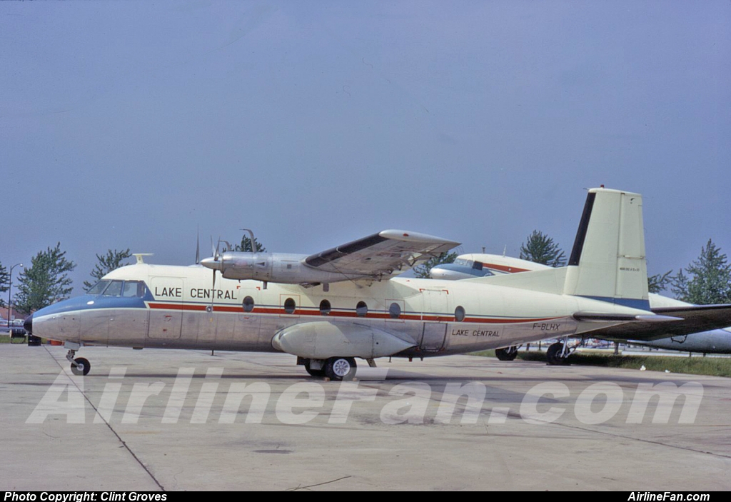
This airframe as F-BLHX with Compagnie Aerienne du Languedoc (CAL) at ORY in June 1985:
www.flickr.com/photos/egcb_egcc/16254816041
This airframe as F-BLHX with Air Littoral:
www.flickr.com/photos/154191970@N03/47447567652
Scan from Kodachrome slide (on Kodak Photo CD).
Always just on that edge of a good shot the Pacific Loons keep their distance. Taken at the Campbell River Estuary we don't see these loons very often in Cowichan Bay.
Cool Facts
The Pacific and Arctic loons are extremely similar and were formerly considered the same species. Where the two species meet in western Alaska and eastern Siberia, the Arctic Loon has a greenish patch on its throat. Arctic Loons from the rest of Eurasia have purplish throats similar to that of the Pacific Loon.
Pacific and Arctic loons in the waters off Japan in late winter forage cooperatively, swimming under and around schools of sand lance (a small fish) and concentrating them into an area about one meter in diameter. Japanese fishermen exploited this habit by fishing for sea bream that gathered to feed on the sand lance. With such assistance from the loons, the fishermen could earn a year's livelihood in February and March alone; as a result, the loons were worshipped as messengers from heaven. Now, this practice has ceased because of unexplained declines in loon populations, collapse of sea bream populations, and adoption of other fishing methods.
Like other loons, the Pacific Loon walks extremely awkwardly on land, and cannot take flight from land at all. It requires about 30-50 meters of open water to take flight, flapping and pattering across the surface.
info from Cornell
Hi everyone todays painting is (The Exploited Worker) there is so much that can be said about this evil practice that I will just say this way of living for many must come to a end,or will people continue to turn a blind eye all in the name of many times for profit? take care steve.
Russ Meyer Box Set
Fullmedia, Japan, 2004
Russ Meyer's Mondo Box (Full Screen) -- REGION 2
- The Immoral Mr. Teas (1959)
- Cherry, Harry & Raquel! (1970)
- Lorna (1964)
- Common Law Cabin (Conjugal Cabin) (1967)
- Mondo Topless (1966)
+ Bonus Disc
Inscription on postcard translates to something like "Solemnity [near] monument to Nevelskoy" written in pre-Revolution orthograthy. Gennady Ivanovich Nevelskoy was russian admiral and explorer of Far East. (This information was provided by flickr member Hans KC)
Unveiled in 1897, the monument to Nevelskoy became the first monument in Vladivostok. The cornerstone was laid in 1891 by Cesarevich Nikolai who was to be the last imperial ruler of Russia. The townspeople had been donating since 1889 when the idea of commemorating the memory of G. Nevelskoy was first put into words. Admiral Nevelskoy (1813-1876), Russian explorer of the Far East proved that Sakhalin was an island--not a peninsula as it had been thought of before--and that the Amur was navigable in all its parts--the mouth of the Amur had been believed to be lost in quick sands. Nevelskoy also founded Nikolayevsk-on-Amur in 1850.
Simple in form and modest in embellishment, the Nevelskoy Monument began to symbolize the collective exploration exploits and pioneering spirit of sailors, soldiers, cossacks and first explorers. Designed by the navy engineer A.Antipov, the monument consists of twelve gray granite slabs topped with the globe circled along the diameter and crowned with a two-headed eagle, a symbol of Russian csars' autocracy. In the niche facing the Golden Horn Inlet stands the Nevelskoy bust perfectly executed by a renouned Russian sculptor R.Bach (1859 - 1933). Inconspicuous presence of Nevelskoy highlights the expressiveness of the whole. In the rest three niches there are the bronze plaques bearing the names of Nevelskoy's collaborators who participated in 1849 - 1853 expeditions.
The story of the Nevelskoy Monument is typical of post-revolutionary Russia: in 1923 the five-pointed star came to replace the two-headed eagle, the remains of revolutionaries were reburied in front of the monument. Since then the small public garden surrounding it has been named the Victims of the Revolution Public Garden. In 1958 two years before the centenary of Vladivostok, N.Kukel'-Krayevsky, the grandson of Nevelskoy, addressed the local government to restore the monument. By 1960 the Nevelskoy Monument had been restored.
Vladivostok literally 'ruler of the east' is a city and the administrative centre of the Far Eastern Federal District and Primorsky Krai, Russia, located around the Golden Horn Bay, not far from Russia's borders with China and North Korea. The population of the city as of 2018 was 604,901, up from 592,034 recorded in the 2010 Russian census. Harbin in China is about 515 kilometres (320 mi) away, while Sapporo in Japan is about 775 kilometres (482 mi) east across the Sea of Japan. The city is the home port of the Russian Pacific Fleet and is the largest Russian port on the Pacific coast.