View allAll Photos Tagged highest
Cabo Girão is a lofty sea cliff located along the southern coast of the island of Madeira, in the Portuguese archipelago of Madeira. Cabo Girão is a popular lookout point, especially after a glass-floored viewing platform was installed in October 2012.[ The location is a popular starting point for hikers.
It is situated less than two kilometres west from the centre of Câmara de Lobos, between the parishes of Quinta Grande and Câmara de Lobos. A diamond-shaped sea-cliff escarpment from 560 metres (1,840 ft) to 589 metres (1,932 ft) above sea level, Cabo Girão lies between two river-valleys that flow into the Atlantic Ocean. The escarpment/cliffs extend approximately three kilometres between the urban sprawl of Câmara de Lobos to the east and the river-valley of Quinta Grande in the west.
Although brochures claim that it is the second highest cliff in Europe, at least five European cliffs (Hornelen at 860 metres, Cape Enniberg at 750 metres, Vixía Herbeira at 613 metres, Preikestolen at 604 metres and Slieve League at 601 metres) are higher.
There are terraced fields (Fajãs de Cabo Girão) located below the sheer cliffs, which at one time only accessible by boat. In August 2003, a cable car was installed on the slope of the cliff so farmers can reach these low-lying fields.
Highest Explore Position #493 ~ On December 16th 2007.
Squirrel - Lincoln Inn Fields Park - Holborn, London, England - Thursday December Thirteenth 2007.
Highest EXPLORE no 341........................
Best Viewed LARGE!
THANK YOU for all your lovely comments, invitations & awards.
Beinn Alligin with with the highest peak of Sgurr Mhòr (986 m) photographed from Na Rathanan (The Horns of Alligin).
Krafla is an area of about 10 km in diameter with a 90 km long fissure zone, in the north of Iceland in the Mývatn region. Its highest peak reaches up to 818 m and it is 2 km in depth. The Icelandic word "víti" means "hell". In former times, people often believed hell to be under volcanoes. The crater Víti has a green lake inside of it. The Krafla area also includes Námafjall, a geothermal area with boiling mudpools and steaming fumaroles.
Read our travel report/guide to Iceland here
John & Tina Reid | Travel Portfolio | Photography Blog | Travel Flickr Group
Tarpon Springs is a city in Pinellas County, Florida, United States. The population was 23,484 at the 2010 census. Tarpon Springs has the highest percentage of Greek Americans of any city in the US. Downtown Tarpon Springs has long been a focal point and is currently undergoing beautification.
The region, with a series of bayous feeding into the Gulf of Mexico, was first settled by white and black farmers and fishermen around 1876. Some of the newly arrived visitors spotted tarpon jumping out of the waters and so named the location Tarpon Springs. The name is said to have originated with a remark of Mrs. Ormond Boyer, an early settler from South Carolina, and who, while standing on the shore of the Bayou and seeing fish leaping exclaimed, "See the tarpon spring!' However, for the most part, the fish seen splashing here were mullets rather than tarpon. In 1882, Hamilton Disston, who in the previous year had purchased the land where the city of Tarpon Springs now stands, ordered the creation of a town plan for the future city.
On February 12, 1887, Tarpon Springs became the first incorporated city in what is now Pinellas County. Less than a year later on January 13, 1888, the Orange Belt Railway, the first railroad line to be built in what is now Pinellas County, arrived in the city. During this time the area was developed as a wintering spot for wealthy northerners.
In the 1880s, John K. Cheyney founded the first local sponge business. The industry continued to grow in the 1890s. Many people from Key West and the Bahamas settled in Tarpon Springs to hook sponges and then process them. A few Greek immigrants also arrived in this city during the 1890s to work in the sponge industry.
In 1905, John Cocoris introduced the technique of sponge diving to Tarpon Springs by recruiting divers and crew members from Greece. The first divers came from the Saronic Gulf islands of Aegina and Hydra, but they were soon outnumbered by those from the Dodecanese islands of Kalymnos, Symi, and Halki. The sponge industry soon became one of the leading maritime industries in Florida and the most important business in Tarpon Springs, generating millions of dollars a year. The 1953 film Beneath the 12-Mile Reef, depicting the sponge industry, takes place and was filmed in Tarpon Springs.
In 1947, red tide algae bloom wiped out the sponge fields in the Gulf of Mexico, causing many of the sponge boats and divers to switch to shrimping for their livelihood, while others left the business. Eventually, the sponges recovered, allowing for a smaller but consistent sponge industry today. In the 1980s, the sponge business experienced a boom due to a sponge disease that killed the Mediterranean sponges. Today there is still a small active sponge industry. Visitors can often view sponge fishermen working at the Sponge Docks on Dodecanese Boulevard. In addition, visitors can enjoy shops, restaurants, and museum exhibits that detail Tarpon Springs' Greek heritage.
In 2007 and 2008, the City of Tarpon Springs established Sister City relationships with Kalymnos, Halki, Symi, and Larnaca, Cyprus, honoring the close historical link with these Greek-speaking islands.
There are several districts or properties in Tarpon Springs that have been listed on the National Register of Historic Places:
Tarpon Springs Greektown Historic District
Tarpon Springs Historic District
Arcade Hotel
Old Tarpon Springs City Hall
Old Tarpon Springs High School
Safford House
Rose Hill Cemetery
Tarpon Springs Depot
Many sites related to the sponge industry within the Greektown District also have been recognized. They include but are not limited to two sponge packing houses:
E.R. Meres Sponge Packing House
N.G. Arfaras Sponge Packing House
And several boats:
N.K. Symi (Sponge Diving Boat)
St. Nicholas III (Sponge Diving Boat)
St. Nicholas VI (Sponge Diving Boat)
Credit for the data above is given to the following websites:
en.wikipedia.org/wiki/Tarpon_Springs,_Florida
www.pcpao.org/?pg=https://www.pcpao.org/general.php?strap...
© All Rights Reserved - you may not use this image in any form without my prior permission.
Highest Explore Position #365 ~ On August 18th 2008.
Wolf - Colchester Zoo, Colchester, Essex, England - Monday August 11th 2008.
Clubhouse, Xavier Estate
Cagayan de Oro City, PH
-3 exp, HDR
Explore: 10th- highest position as of March 16, 2009 thanks for the clicks.
.
.
**** This frame was chosen on September 28th 2018 to appear on FLICKR EXPLORE (Highest Ranking: #285. This is my 108th photograph to be selected, which for me is both amazing and exciting, as I never view my images as worthy compared to some of the awesome photography out there. EXPLORE is Flickr's way of showcasing the most interesting photos within a given point in time -- usually over a 24 hour period.
Flickr receives about 6,000 uploads every minute -- That's about 8.6 million photos a day! From this huge group of images, the Flickr Interestingness algorithm chooses only 500 images to showcase for each 24-hour period. That's only one image in every 17,000!..... so I am really thrilled to have a frame picked and most grateful to every one of the 17.950 Million people who have visited, favourite and commented on this and all of my other photographs here on my FLICKR site. *****
.
.
This Two and a half seconds long exposure was taken standing in the River Cray at an altitude of Twenty one metres at 05:46am on Thursday 22nd March 2018, in the golden hour around sunrise, (Sunrise was at precisely 05:59am),off Rectory Lane in the grounds of Foots Cray Meadows, over the River Cray in Bexley, Kent, England.
.
.
Nikon D850 24mm 2.5 seconds long exposure f/6.3 iso100 RAW (14 bit uncompressed) Image size L 8256 x 5504 FX). Colour space Adobe RGB. AF-C focus 51 point with 3-D tracking. Area mode single. Manual exposure. Matrix metering. Auto 0 white balance. Nikon Distortion control on. Vignette control Normal.Manfrotto 055Xprob Carbon Fiber Tripod 3 Sections. Manfrotto 327RC2 Magnesium Ball Head. Manfrotto quick release plate 200PL-14. Jessops Tripod bag.
Nikkor AF-S 24-120mm F4G ED VR. Phot-R ultra slim 77mm UV filter. Nikon EN-EL15a battery. Matin quick release neckstrap. My Memory 32GB Class 10 SDHC. Lowepro Flipside 400 AW camera bag. Nikon GP-1 GPS module.
.
.
LATITUDE: N 51d 25m 35.90s
LONGITUDE: E 0d 7m 51.20s
ALTITUDE: 21.0m
RAW (TIFF) FILE: 130.00MB (NEF 91.8MB)
PROCESSED (JPeg) FILE: 23.00MB
.
.
PROCESSING POWER:
Nikon D850 Firmware versions C 1.01 (16/01/2018) LD Distortion Data 2.017 (20/3/18)
HP 110-352na Desktop PC with AMD Quad-Core A6-5200 APU 64Bit processor. Radeon HD8400 graphics. 8 GB DDR3 Memory with 1TB SATA storage. 64-bit Windows 10. Verbatim USB 2.0 1TB desktop hard drive. WD My Passport Ultra 1tb USB3 Portable hard drive. Nikon ViewNX-1 64bit (Version 1.2.11 15/03/2018). Nikon Capture NX-D 64bit (Version 1.4.7 15/03/2018). Nikon Picture Control Utility 2 (Version 1.3.2 15/03/2018). Adobe photoshop Elements 8 Version 8.0 64bit.
Highest Explore Position: 423 on Wednesday, September 30, 2009.
It's been raining for about two days straight! Once the rain stopped, I went out to my backyard to snap some quick pictures of this interesting purple flower. Luckily, my camera didn't get wet - only my shoes did!
This is a Foxglove flower. Its Latin name is "Digitalis Purpurea".
Equipment: D90, tripod, Sigma 105mm macro, and a wireless shutter remote.
Enjoy!
What I'm listening to:
Explore Highest position # 207 on Saturday, December 20, 2008
The above photo is a hatpins flowers I found on the mountain in Phitsanulok, Thailand. The below photo is a shot while I was taking this.:)
กระดุมเงิน มณีเทวา ชื่อพฤกษศาสตร์: Eriocaulon smitinandii Mold. วงศ์ : ERIOCAULACEAE ชื่ออื่น : กระดุมเต็ม กระดุมเงิน Pipewort, Hatpins ทางเข้าลานหินปุ่ม ภูหินร่องกล้า จ.พิษณุโลก
Exposure: 1/640, Aperture: f/3, Focal Length: 105 mm, ISO:100 (Lo-1),
Nikon D90, Nikkor 105mm f/2.8G ED-IF AF-S VR Micro
(No very long multi invitations please.:))
Highest Explore Position #422 ~ On December 3rd 2008.
London Wetland Centre, Barnes, London, England - Saturday November 22nd 2008.
Click here to see the Larger image
Click here to see My most interesting images
From Wikipedia, the free encyclopedia ~ WWT London Wetland Centre is a wetland reserve managed by the Wildfowl and Wetlands Trust in the Barnes area of the London Borough of Richmond upon Thames, by Barn Elms.
In 2002 the Centre was recognized as a 'Site of Special Scientific Interest', a tribute to the positive environmental impact on the local area. Many birds have now made their home in the Centre that cannot be found anywhere else in London. The Centre was first opened in 2000, the London Wetlands Centre is host to regular lectures and events concerned with preserving Britain’s wetland animals.
The centre occupies more than 100 acres (40 hectares) of land which was formerly occupied by several small reservoirs. These were converted into a wide range of wetland features and habitats before the centre opened in May 2000. It was the first urban project of its kind in the United Kingdom. It became a SSSI (Site of Special Scientific Interest) in 2002 and supports nationally significant numbers of gadwall and shoveler duck.
Other wild birds that can be found on the reserve include: great bittern, pintail, lapwing, water rail, ring-necked parakeet, sparrowhawk, sand martin, kingfisher, little grebe and great crested grebe.
It was featured on the television programme Seven Natural Wonders as one of the wonders of the London area, with focus on the region's parakeets, in an episode presented by Bill Oddie.
EXPLORE Highest Rank #54
OK, I know that I said that I would be sharing a "mix" of shots, but I'm sorry - for this shot from Grand Teton NP was still calling to have it's moment on Flickr.
Oxbow Bend in GTNP is an amazing place, in any season, though I have to believe that in autumn - with it's brilliant display of fall colors wonderfully reflecting on the waters below - it's a special place to be. Here Mt. Moran, at 12,605', stands proudly in the distance. It is home to several small glaciers including the largest of them, Skillet Glacier. The aspens and cottonwoods have begun their transformation of colors as the seasons change and make way for the arrival of winter. It was a very still morning, so the reflections were amazing as well.
Oxbow Bend is actually a bend in the Snake River where the waters are cut off from the main channel and therefore the waters are very slow moving. This is an awesome place to view wildlife, but sadly for us we didn't that morning.
Imagine a big bull moose wading in the waters in the midst of this shot ..... that's what I kept doing :-).
The air was crisp, but very still that morning. If you were lucky, you could hear the distant calls from the nearby elk bugling.
Yes, this is an often photographed view at the park for obvious reasons. How I would love to capture this view in the winter or early spring as well. Maybe one day, but for now, this will have to do.
Hope that you enjoy our memories. Thanks for all of your views and comments! They are all truly appreciated.
Highest Explore Position #375 ~ On August 31st 2008.
Cygnet - Harwich, Essex, England - Monday August 25th 2008.
Click here to see the Larger image
OK....seeing as sooooooooo many people wanted to see it...I have bowed to public demand..lol
Here's is the shot of the Cygnet getting a little too close for comfort, he/she actually pecked the lens..lol
I think this is the Avian equivalent of Amy Winehouse or Lily Allen punching the photographer..lol
Hope everybody is having a great weekend..:O))
highest tower in the world .. it is of course Burj Khalifah located in Dubai.
it took 7 photos, 35MB, 4248 × 11279 pixels to create this panorama. it is the first time i make a serious panorama work , i hope you like it.
Nikon D300S
Nikon 35mm f1.8 DX
>>>> NOTE: please open it in original size to see it in details.<<<<
Highest position: #115 on Friday, July 20, 2007
...but not really - it's a boat buoy in Weymouth marina
Laser Barrier @ Red Light District
Part of installation 'THE BODY OF LIGHT' - Immersive environment
by Margareta Hesse
Highest spot on Explore: 241
Captured this beautiful sunrise this morning after dropping the kids at school. It made me think of all that has been going on and the things we take for granted. No matter what happens, every day is a new beginning, always remember that.
nle Lake is a freshwater lake located in the Nyaungshwe Township of Taunggyi District of Shan State, part of Shan Hills in Myanmar (Burma). It is the second largest lake in Myanmar with an estimated surface area of 44.9 square miles (116 km2), and one of the highest at an elevation of 2,900 feet (880 m). During the dry season, the average water depth is 7 feet (2.1 m), with the deepest point being 12 feet (3.7 m), but during the rainy season this can increase by 5 feet (1.5 m).
The watershed area for the lake lies to a large extent to the north and west of the lake. The lake drains through the Nam Pilu or Balu Chaung on its southern end. There is a hot spring on its northwestern shore.
Although the lake is not large, it contains a number of endemic species. Over twenty species of snails and nine species of fish are found nowhere else in the world. Some of these, like the silver-blue scaleless Sawbwa barb, the crossbanded dwarf danio, and the Lake Inle danio, are of minor commercial importance for the aquarium trade. It hosts approximately 20,000 brown and black head migratory seagulls in November, December and January.
In June 2015, it becomes the Myanmar's first designated place of World Network of Biosphere Reserves. It was one of 20 places added at at the Unesco's 27th Man and the Biosphere (MAB) International Coordinating Council (ICC) meeting.
The people of Inle Lake (called Intha), some 70,000 of them, live in four cities bordering the lake, in numerous small villages along the lake's shores, and on the lake itself. The entire lake area is in Nyaung Shwe township. The population consists predominantly of Intha, with a mix of other Shan, Taungyo, Pa-O (Taungthu), Danu, Kayah, Danaw and Bamar ethnicities. Most are devout Buddhists, and live in simple houses of wood and woven bamboo on stilts; they are largely self-sufficient farmers.
Most transportation on the lake is traditionally by small boats, or by somewhat larger boats fitted with single cylinder inboard diesel engines. Local fishermen are known for practicing a distinctive rowing style which involves standing at the stern on one leg and wrapping the other leg around the oar. This unique style evolved for the reason that the lake is covered by reeds and floating plants making it difficult to see above them while sitting. Standing provides the rower with a view beyond the reeds. However, the leg rowing style is only practiced by the men. Women row in the customary style, using the oar with their hands, sitting cross legged at the stern.
In addition to fishing, locals grow vegetables and fruit in large gardens that float on the surface of the lake. The floating garden beds are formed by extensive manual labor. The farmers gather up lake-bottom weeds from the deeper parts of the lake, bring them back in boats and make them into floating beds in their garden areas, anchored by bamboo poles. These gardens rise and fall with changes in the water level, and so are resistant to flooding. The constant availability of nutrient-laden water results in these gardens being incredibly fertile. Rice cultivation is also significant.
Highest Explore Position #359 ~ On May 19th 2008.
Butterfly - Sydenham Hill Woods, South London, England - Sunday May 11th 2008.
Komic, Himachal Pradesh, India
Komic, literally meaning “eye of a snow cock” (Ko – snow-cock, mic – eye), is a remote village in Spiti valley. It is the world's highest village in the world connected with a motorable road. It also has the world's highest restaurant. Komic village is situated at an height of 4587 metres or 15027 feet above sea level.
The Lundup Tsemo Gompa Buddhist Monastery in Komic houses the ‘Maitreya Buddha’ (Future Buddha). People believe that the Maitreya Buddha looks after the wellbeing of the villagers. The 14th-century monastery has a fortified castle made of slanted mud walls, taking you back to the yesteryears through the beautiful murals, scriptures, and arts.
Highest position: 325 on Thursday, July 29, 2010
"Then a piece of mind- fell over me
In these troubled times- I still can see
We can use the stars– to guide the way
It is not that far- one fine…
One fine day"
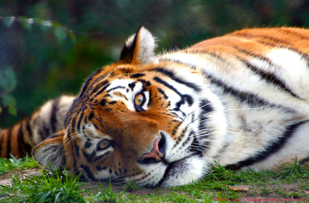
Highest Explore Position #447 ~ On October 24th 2008.
Tiger - Howletts Wildlife Park, Kent, England - Sunday October 19th 2008.
Ausschnitt aus einem größeren Wandbild in einem ehemaligen Kasernengebäude der Sowjetarmee in Ostdeutschland
Excerpt from a larger mural in a former soviet army building in eastern Germany
Highest EXPLORE No 37
Going in Hospital for the day tommorrow, for a minor op on my foot, so thought I'd post twice tonight.
Hoping I can still get out with the camera!!!!!!..................................................
THANK YOU for all your lovely comments, invitations & awards.
Yosemite Falls is the highest measured waterfall in North America. Located in Yosemite National Park in the Sierra Nevada of California, it is a major attraction in the park, especially in late spring (above) when the water flow is at its peak.
The total 739m from the top of the upper fall to the base of the lower fall puts Yosemite Falls in the top 10 of the world's highest waterfalls.
The main village of the native people of Yosemite Valley, the Ahwahneechee, was located at the base of the falls. The Ahwahneechee called the waterfall "Cholock" ("the fall") and believed that the plunge pool at its base was inhabited by the spirits of several witches, called the Poloti. An Ahwaneechee folktale describes a woman going to fetch a pail of water from the pool, and drawing it out full of snakes. Later that night, after the woman had trespassed into their territory, the spirits caused the woman's house to be sucked into the pool by a powerful wind, taking the woman and her newborn baby with it.
Seen in early afternoon from the Swinging Bridge in early June 2002, with the falls almost as full as they can get. Scanned from a negative.
Lake Titicaca, the highest navigable lake in the World and home to the Uros people. Indigenous to Peru and Bolivia the Uros live on floating islands made from reed.
Here is a travel blog I wrote about the Uros Islands in Peru
If you would like to use any of my photos please contact me and ask permission first.
If you want to look at more of my photography you can check my website and social media links below:
www.facebook.com/geraintrowlandphotography
www.instagram.com/geraint_rowland_photography/