Sponsored images from 
View allAll Photos Tagged differences,
This modified Harris Shutter Effect image emphasizes things that move and other differences between three sequential photos while turning the background black. A slow shutter speed and shallow focus were selected to blur the atheletes. Registration errors, due in part to different focus points giving different sized bokeh, leave ghostly outlines of some gym and ball features. Targeted EV adjustment (+1.0) of the ball brought out details.
Quick links
View the traditional Harris shutter effect version.
Read how to construct this type of image from three sequential photos.
Other subtractive filter Harris shutter effect images
View all subtractive filter images.
Luca Giordano (1634-1705), actif à Naples, Florence
L'Archange Michael renverse les anges rebelles, approximativement 1664
Quand une partie des anges s'est rebellé contre Dieu, ils ont été renversés par l'Archange Michael dans l'abîme de l'enfer. Les cris désespérés, visages déformés des anges vaincus - maintenant devenu diables - témoignent du réalisme brutal du peintre de la cour espagnol-napolitaine Juseppe de Ribera. Même dans les couleurs sophistiquées de l'Michael, l'oeuvre est déterminé par la palette influencé à la vénitien de Ribera. Le retable, dont la destination initiale est inconnue, était à la fin du 18e Siècle amené de la Minoritenkirche viennois dans la galerie des peintures impériale.
Luca Giordano (1634-1705), tätig in Neapel, Florenz
Der Erzengel Michael stürzt die abtrünnigen Engel, um 1664
Als sich ein Teil der Engel gegen Gott empörte, wurden diese vom Erzengel Michael in den Abgrund der Hölle gestürzt. Die verzweifelt schreienden, verzerrten Gesichter der besiegten Engel - nun zu Teufeln geworden - zeugen vom krassen Realismus des spanisch-neapolitanischen Hofmalers Juseppe de Ribera. Auch in der raffinierten Farbigkeit des Micheal ist das Werk von der venezianisch beeinflußten Palette Riberas bestimmt. Das Altarbild, dessen ursprünglicher Bestimmungsort unbekannt ist, wurde im späten 18. Jahrhundert aus der Wiener Minoritenkirche in die kaiserliche Gemäldegalerie gebracht.
Austria Kunsthistorisches Museum
Federal Museum
Logo KHM
Regulatory authority (ies)/organs to the Federal Ministry for Education, Science and Culture
Founded 17 October 1891
Headquartered Castle Ring (Burgring), Vienna 1, Austria
Management Sabine Haag
www.khm.at website
Main building of the Kunsthistorisches Museum at Maria-Theresa-Square
The Kunsthistorisches Museum (KHM abbreviated) is an art museum in Vienna. It is one of the largest and most important museums in the world. It was opened in 1891 and 2012 visited of 1.351.940 million people.
The museum
The Kunsthistorisches Museum is with its opposite sister building, the Natural History Museum (Naturhistorisches Museum), the most important historicist large buildings of the Ringstrasse time. Together they stand around the Maria Theresa square, on which also the Maria Theresa monument stands. This course spans the former glacis between today's ring road and 2-line, and is forming a historical landmark that also belongs to World Heritage Site Historic Centre of Vienna.
History
Archduke Leopold Wilhelm in his Gallery
The Museum came from the collections of the Habsburgs, especially from the portrait and armor collections of Ferdinand of Tyrol, the collection of Emperor Rudolf II (most of which, however scattered) and the art collection of Archduke Leopold Wilhelm into existence. Already In 1833 asked Joseph Arneth, curator (and later director) of the Imperial Coins and Antiquities Cabinet, bringing together all the imperial collections in a single building.
Architectural History
The contract to build the museum in the city had been given in 1858 by Emperor Franz Joseph. Subsequently, many designs were submitted for the ring road zone. Plans by August Sicard von Sicardsburg and Eduard van der Null planned to build two museum buildings in the immediate aftermath of the Imperial Palace on the left and right of the Heroes' Square (Heldenplatz). The architect Ludwig Förster planned museum buildings between the Schwarzenberg Square and the City Park, Martin Ritter von Kink favored buildings at the corner Währinger street/Scots ring (Schottenring), Peter Joseph, the area Bellariastraße, Moritz von Loehr the south side of the Opera ring, and Ludwig Zettl the southeast side of the Grain market (Getreidemarkt).
From 1867, a competition was announced for the museums, and thereby set their current position - at the request of the Emperor, the museum should not be too close to the Imperial Palace, but arise beyond the ring road. The architect Carl von Hasenauer participated in this competition and was able the at that time in Zürich operating Gottfried Semper to encourage to work together. The two museum buildings should be built here in the sense of the style of the Italian Renaissance. The plans got the benevolence of the imperial family. In April 1869, there was an audience of Joseph Semper with the Emperor Franz Joseph and an oral contract was concluded, in July 1870 was issued the written order to Semper and Hasenauer.
Crucial for the success of Semper and Hasenauer against the projects of other architects were among others Semper's vision of a large building complex called "Imperial Forum", in which the museums would have been a part of. Not least by the death of Semper in 1879 came the Imperial Forum not as planned for execution, the two museums were built, however.
Construction of the two museums began without ceremony on 27 November 1871 instead. Semper subsequently moved to Vienna. From the beginning on, there were considerable personal differences between him and Hasenauer, who finally in 1877 took over sole construction management. 1874, the scaffolds were placed up to the attic and the first floor completed, in 1878, the first windows installed, in 1879, the Attica and the balustrade finished, and from 1880 to 1881 the dome and the Tabernacle built. The dome is topped with a bronze statue of Pallas Athena by Johannes Benk.
The lighting and air conditioning concept with double glazing of the ceilings made the renunciation of artificial light (especially at that time, as gas light) possible, but this resulted due to seasonal variations depending on daylight to different opening times.
Dome hall
Entrance (by clicking on the link at the end of the side you can see all the pictures here indicated!)
Grand staircase
Hall
Empire
The Kunsthistorisches Museum was on 17 October 1891 officially opened by Emperor Franz Joseph I. Since 22 October 1891, the museum is accessible to the public. Two years earlier, on 3 November 1889, the collection of arms, Arms and Armour today, had their doors open. On 1 January 1890 the library service resumed its operations. The merger and listing of other collections of the Highest Imperial Family from the Upper and Lower Belvedere, the Hofburg Palace and Ambras in Tyrol needs another two years.
1891, the Court museum was organized in seven collections with three directorates:
Directorate of coins, medals and antiquities collection
The Egyptian Collection
The Antique Collection
The coins and medals collection
Management of the collection of weapons, art and industrial objects
Weapons collection
Collection of industrial art objects
Directorate of Art Gallery and Restaurieranstalt (Restoration Office)
Collection of watercolors, drawings, sketches, etc.
Restoration Office
Library
Very soon the room the Court Museum (Hofmuseum) for the imperial collections was offering became too narrow. To provide temporary help, an exhibition of ancient artifacts from Ephesus in the Theseus Temple was designed. However, additional space had to be rented in the Lower Belvedere.
1914, after the assassination of Franz Ferdinand, heir to the throne, his "Estensische Sammlung (Collection)" passed to the administration of the Court Museum. This collection, which emerged from the art collection of the house of d'Este and world travel collection of Franz Ferdinand, was placed in the New Imperial Palace since 1908. For these stocks, the present collection of old musical instruments and the Museum of Ethnology emerged.
The First World War went by, apart from the oppressive economic situation without loss. The Court museum remained during the five years of war regularly open to the public.
Until 1919 the K.K. Art Historical Court Museum was under the authority of the Oberstkämmereramt (head chamberlain office) and belonged to the House of Habsburg-Lorraine. The officials and employees were part of the royal household.
First Republic
The transition from monarchy to republic, in the museum took place in complete tranquility. On 19 November 1918 the two imperial museums on Maria Theresa Square were placed under the state protection of the young Republic of German Austria. Threatening to the stocks of the museum were the claims raised in the following weeks and months of the "successor states" of the monarchy as well as Italy and Belgium on Austrian art collection. In fact, it came on 12th February 1919 to the violent removal of 62 paintings by armed Italian units. This "art theft" left a long time trauma among curators and art historians.
It was not until the Treaty of Saint-Germain on 10 September 1919, providing in Article 195 and 196 the settlement of rights in the cultural field by negotiations. The claims of Belgium, Czechoslovakia, and Italy again could mostly being averted in this way. Only Hungary, which presented the greatest demands by far, was met by more than ten years of negotiation in 147 cases.
On 3 April 1919 was the expropriation of the House of Habsburg-Lorraine by law and the acquisition of its property, including the "Collections of the Imperial House", by the Republic. On 18 June 1920 the then provisional administration of the former imperial museums and collections of Este and the secular and clergy treasury passed to the State Office of Internal Affairs and Education, since 10 November 1920, the Federal Ministry of the Interior and Education. A few days later it was renamed the Art History Court Museum in the "Kunsthistorisches Museum, Vienna State", 1921 "Kunsthistorisches Museum" . Of 1st January 1921 the employees of the museum staff passed to the state of the Republic.
Through the acquisition of the former imperial collections owned by the state, the museum found itself in a complete new situation. In order to meet the changed circumstances in the museum area, designed Hans Tietze in 1919 the "Vienna Museum program". It provided a close cooperation between the individual museums to focus at different houses on main collections. So dominated exchange, sales and equalizing the acquisition policy in the interwar period. Thus resulting until today still valid collection trends. Also pointing the way was the relocation of the weapons collection from 1934 in its present premises in the New Castle, where since 1916 the collection of ancient musical instruments was placed.
With the change of the imperial collections in the ownership of the Republic the reorganization of the internal organization went hand in hand, too. Thus the museum was divided in 1919 into the
Egyptian and Near Eastern Collection (with the Oriental coins)
Collection of Classical Antiquities
Collection of Ancient Coins
Collection of modern Coins and Medals
Weapons collection
Collection of Sculptures and Crafts with the Collection of Ancient Musical Instruments
Picture gallery
The Museum 1938-1945
Count Philipp Ludwig Wenzel Sinzendorf according to Rigaud. Clarisse 1948 by Baroness de Rothschildt "dedicated" to the memory of Baron Alphonse de Rothschildt; restituted to the Rothschilds in 1999, and in 1999 donated by Bettina Looram Rothschild, the last Austrian heiress.
With the "Anschluss" of Austria to the German Reich all Jewish art collections such as the Rothschilds were forcibly "Aryanised". Collections were either "paid" or simply distributed by the Gestapo at the museums. This resulted in a significant increase in stocks. But the KHM was not the only museum that benefited from the linearization. Systematically looted Jewish property was sold to museums, collections or in pawnshops throughout the German Reich.
After the war, the museum struggled to reimburse the "Aryanised" art to the owners or their heirs. They forced the Rothschild family to leave the most important part of their own collection to the museum and called this "dedications", or "donations". As a reason, was the export law stated, which does not allow owners to bring certain works of art out of the country. Similar methods were used with other former owners. Only on the basis of international diplomatic and media pressure, to a large extent from the United States, the Austrian government decided to make a change in the law (Art Restitution Act of 1998, the so-called Lex Rothschild). The art objects were the Rothschild family refunded only in the 1990s.
The Kunsthistorisches Museum operates on the basis of the federal law on the restitution of art objects from the 4th December 1998 (Federal Law Gazette I, 181 /1998) extensive provenance research. Even before this decree was carried out in-house provenance research at the initiative of the then archive director Herbert Haupt. To this end was submitted in 1998 by him in collaboration with Lydia Grobl a comprehensive presentation of the facts about the changes in the inventory levels of the Kunsthistorisches Museum during the Nazi era and in the years leading up to the State Treaty of 1955, an important basis for further research provenance.
The two historians Susanne Hehenberger and Monika Löscher are since 1st April 2009 as provenance researchers at the Kunsthistorisches Museum on behalf of the Commission for Provenance Research operating and they deal with the investigation period from 1933 to the recent past.
The museum today
Today the museum is as a federal museum, with 1st January 1999 released to the full legal capacity - it was thus the first of the state museums of Austria, implementing the far-reaching self-financing. It is by far the most visited museum in Austria with 1.3 million visitors (2007).
The Kunsthistorisches Museum is under the name Kunsthistorisches Museum and Museum of Ethnology and the Austrian Theatre Museum with company number 182081t since 11 June 1999 as a research institution under public law of the Federal virtue of the Federal Museums Act, Federal Law Gazette I/115/1998 and the Museum of Procedure of the Kunsthistorisches Museum and Museum of Ethnology and the Austrian Theatre Museum, 3 January 2001, BGBl II 2/ 2001, in force since 1 January 2001, registered.
In fiscal 2008, the turnover was 37.185 million EUR and total assets amounted to EUR 22.204 million. In 2008 an average of 410 workers were employed.
Management
1919-1923: Gustav Glück as the first chairman of the College of science officials
1924-1933: Hermann Julius Hermann 1924-1925 as the first chairman of the College of the scientific officers in 1925 as first director
1933: Arpad Weixlgärtner first director
1934-1938: Alfred Stix first director
1938-1945: Fritz Dworschak 1938 as acting head, from 1938 as a chief, in 1941 as first director
1945-1949: August von Loehr 1945-1948 as executive director of the State Art Collections, in 1949 as general director of the historical collections of the Federation
1945-1949: Alfred Stix 1945-1948 as executive director of the State Art Collections, in 1949 as general director of art historical collections of the Federation
1949-1950: Hans Demel as administrative director
1950: Karl Wisoko-Meytsky as general director of art and historical collections of the Federation
1951-1952: Fritz Eichler as administrative director
1953-1954: Ernst H. Buschbeck as administrative director
1955-1966: Vincent Oberhammer 1955-1959 as administrative director, from 1959 as first director
1967: Edward Holzmair as managing director
1968-1972: Erwin Auer first director
1973-1981: Friderike Klauner first director
1982-1990: Hermann Fillitz first director
1990: George Kugler as interim first director
1990-2008: Wilfried Seipel as general director
Since 2009: Sabine Haag as general director
Collections
To the Kunsthistorisches Museum also belon the collections of the New Castle, the Austrian Theatre Museum in Palais Lobkowitz, the Museum of Ethnology and the Wagenburg (wagon fortress) in an outbuilding of Schönbrunn Palace. A branch office is also Ambras in Innsbruck.
Kunsthistorisches Museum (main building)
Picture Gallery
Egyptian and Near Eastern Collection
Collection of Classical Antiquities
Vienna Chamber of Art
Numismatic Collection
Library
New Castle
Ephesus Museum
Collection of Ancient Musical Instruments
Arms and Armour
Archive
Hofburg
The imperial crown in the Treasury
Imperial Treasury of Vienna
Insignia of the Austrian Hereditary Homage
Insignia of imperial Austria
Insignia of the Holy Roman Empire
Burgundian Inheritance and the Order of the Golden Fleece
Habsburg-Lorraine Household Treasure
Ecclesiastical Treasury
Schönbrunn Palace
Imperial Carriage Museum Vienna
Armory in Ambras Castle
Ambras Castle
Collections of Ambras Castle
Major exhibits
Among the most important exhibits of the Art Gallery rank inter alia:
Jan van Eyck: Cardinal Niccolò Albergati, 1438
Martin Schongauer: Holy Family, 1475-80
Albrecht Dürer : Trinity Altar, 1509-16
Portrait Johann Kleeberger, 1526
Parmigianino: Self Portrait in Convex Mirror, 1523/24
Giuseppe Arcimboldo: Summer 1563
Michelangelo Merisi da Caravaggio: Madonna of the Rosary 1606/ 07
Caravaggio: Madonna of the Rosary (1606-1607)
Titian: Nymph and Shepherd to 1570-75
Portrait of Jacopo de Strada, 1567/68
Raffaello Santi: Madonna of the Meadow, 1505 /06
Lorenzo Lotto: Portrait of a young man against white curtain, 1508
Peter Paul Rubens: The altar of St. Ildefonso, 1630-32
The Little Fur, about 1638
Jan Vermeer: The Art of Painting, 1665/66
Pieter Bruegel the Elder: Fight between Carnival and Lent, 1559
Kids, 1560
Tower of Babel, 1563
Christ Carrying the Cross, 1564
Gloomy Day (Early Spring), 1565
Return of the Herd (Autumn), 1565
Hunters in the Snow (Winter) 1565
Bauer and bird thief, 1568
Peasant Wedding, 1568/69
Peasant Dance, 1568/69
Paul's conversion (Conversion of St Paul), 1567
Cabinet of Curiosities:
Saliera from Benvenuto Cellini 1539-1543
Egyptian-Oriental Collection:
Mastaba of Ka Ni Nisut
Collection of Classical Antiquities:
Gemma Augustea
Treasure of Nagyszentmiklós
Gallery: Major exhibits
With 1 old go ahead london general seat, on a preserved WVL of ex Go Ahead london.
©️ Francis Wadsworth
Mike and I arrived at Port Everglades in Fort Lauderdale around 11am. After parking and checking in at Cruise Terminal 4, we boarded the Celebrity Constellation and set off to explore the ship and take in the views. This whimsical sculpture on Deck 11 captured my attention, and I couldn't resist taking a few photos of it.
I found a few details on the work and its sculptor online:
Angus Fairhurst
1966-2008, Great Britain
A Couple of Differences Between Thinking and Feeling
2000
Cast Bronze
The seven-foot bronze sculpture depicts the unlikely but comfortable pairing of a gorilla carrying a huge fish under its right arm. The sculpture's form and stance reference the tradition of civic bronze statuary but turn the traditional sense of pomp and authority on its head. I wanted to make a classical sculpture which has the lightness of a cartoon. The relationship between the gorilla and fish is ambiguous; one represents thinking and the other represents feeling. One begins where the other ends, or they are the same thing. One is there for the other to function, but a protective relationship is also an interdependent one. You can't have the material without the thought, and you can't have a friend without an enemy. A solid object cannot look like it might just disappear if you stopped thinking about it, but a cartoon seems light enough that it might just do that.
+++ DISCLAIMER +++
Nothing you see here is real, even though the conversion or the presented background story might be based historical facts. BEWARE!
Some background:
Both the T-62 and T-64 were innovative in their own ways, but not successful in the long run because of their cost, complicated features, rushed production, or primitive FCS. The T-54/55 had been a highly successful export for the Soviet Union, but so far, nothing replaced it in this area. Due to their age and the never-ending competition between ammo and armor with the west, a new MBT with a large gun was needed. This model had to incorporate some innovations but had to be mature enough to exploit them fully and be fast enough to catch up with other vehicles. Overall, WARPAC quickly needed a replacement for its aging fleet of T-54/55s (the T-62 was only adopted by Bulgaria and the T-64 was even denied to the Warsaw Pact allies). So a “mobilization” model was called for, even though the T-64 was still in development.
Although in its general shape the T-72 superficially resembled previous designs, and especially the T-62 (small turret, low hull, very long gun), there were many differences in the drivetrain, turret design, engine, main gun and equipment. Compared to western standards, its specifics were regarded as drawbacks, being too small, cramped and uncomfortable. It was believed in the west the crewmen had to be of small stature (1.60 m or 5ft 3in), but after the fall of the iron curtain, it appeared to have been officially 1.75 m (5ft 9in). For its designers and commanders, the vehicle was in line with the experience of the Soviet armored forces during the “Great Patriotic War”. The USSR modeled its tanks along a specific tactical use. Tanks were generally low, nimble and fast, being difficult to hit, contrary to western tanks, which were, comparatively, at least 50 cm (1ft 8in) taller – and the T-72 was even 60 cm lower than its potential opponents!
The height requirement also helped to keep the total weight largely under the NATO practice. This allowed a great deal of mobility despite an aged V-12 diesel. For example, two T-72 could cross a bridge instead of waiting in line to cross it one at a time. This low profile was a problem when fording rivers more than 5 meters (16 ft) deep and a comprehensive sealing procedure, a snorkel and tightly waterproof interior were needed. These fittings also helped NBC protection, rendered possible by a synthetic fabric made of boron compound lining which reduced (but did not) radiations. There was also an extensive air filter system with safety valves and constant over-pressure. This helped eliminate any poisonous contamination as well as residual fumes that could leak out from the autoloader. Overall vision was not outstanding, with a set of extremely small periscope viewports. The hull construction called for an RHA (rolled homogenous armor) hull made of cast steel.
Crew comfort was seen as unnecessary, due to the survivability rates on the battlefield. The same law applied to a relatively non-refined interior and the simple, rugged, but efficient firing equipment, which was designed for mass production and easy maintenance. Any fragile and/or non-standard piece of equipment was therefore eliminated before production. This explained not only the production scale itself - much bigger than their western counterparts - but also the tank’s export success. Such manufacturing principles allowed costs to be kept very low, and at the same time produced a rugged piece of equipment which was durable, with part standardization (= interchangeability) and relatively low-tech, which was an advantage in many pre-industrial countries, both for maintenance and upgrades.
The hull’s basic RHA construction was augmented by spaced armor, which was upgraded to the T-64 standard composite armor in 1979. In the early 1980s, T-72s received additional add-on armor along with rubber side skirts, and, in the late 1980s, full ERA made of active protective tiles was generalized. At the origin, the basic cast armor was about 280 mm (11 in) at the thickest, with the nose up to 80 mm (3.1 in) and the glacis made of a 200 mm (7.9 in) thick laminated armor, well inclined. This gave a virtual equivalent of 500–600 mm (20–24 in) thickness against direct fire.
The turret was small in comparison to the T-62 and even the T-55, due to the elimination of the loader and its replacement by an auto-loader. The latter picked-up its rounds directly from a horizontal storage area (horizontally auto-fed), contrary to the faster and much more complex vertical actuators of the T-64 main gun automatic loader. The commander cupola was situated to the right rear, with four vision blocks, one periscope (later equipped with infrared sight), and a standard night illuminator. The gunner’s hatch was situated on the right-hand side and slightly angled down to the turret side.
The V12 was basically derived from the WW2 era 500 hp T-34 engine. Rugged and well-tested, it was also shared with the T-54/55 and T-62 families, meaning a lot of parts were interchangeable. It was capable of 780 hp (582 kW), which made the T-72 look underpowered compared to western tanks of the time, but its performances were kept high due to the lightweight hull. It was also much faster and nimbler than the T-62 and even the T-55. This engine was coupled to a synchromesh, hydraulically assisted, seven forward/one reverse gears transmission. The steering system is a traditional dual-tiller layout, rather than the steering wheel/yoke familiar in the west, imposing constant two-hands handling. By the 1980s, the powerplant upgraded to the new 840 bhp (630 kW) V-84 diesel.
The suspension set was a moderately new one, combining traditional torsion bars and shock dampers on the last and two first roadwheel sets. There were six evenly spaced sets of rubberized roadwheels per side. These roadwheels were completely redesigned and partly hollow, like the T-64 roadwheels, but made of steel rather than aluminum, due to costs and durability. They were also smaller and much lighter than the traditional “starfish” model, imposing four sets of return rollers to support the upper tracks. The tracks themselves were similar to the previous models, but not advanced like those of the T-64.
By 1973, the T-72 was accepted for service and over 25,000 units were built, but the production lines never really shut down. The T-72, in its modernized form, now represents the bulk of the Russian armored forces, and was adopted by the best armored units in all Eastern Europe forces. It was widely exported despite its price -double of that of a T-55- because it represented a good compromise, not complicated to operate and maintain, with many commonalities with previous models. It was a real upgrade in firepower, protection, speed and even fire accuracy compared to previous models, and even contemporary western MBTs. Unlike the T-62, the T-72 became an instant hit, was well-modernized over decades and is still frontline today, in thirty-six armies, including the Iraq.
Due to a ban on weapons deliveries after the Iran-Iraq war (where Iraq lost some 60 T-72Ms), a covert agreement was found to pass Czech-built M1 parts for a local assembly which was done as the “Asad Babil” or “Lion of Babylon”. There were armed with downgraded FCS and LRF, and a poor-quality glacis plate armor. Like the “Saddam”, a local adaptation of the M1 (downgraded for desert warfare), some suspensions’ shock absorbers were removed and a local-built searchlight was added on the right-hand-side. Saddams and Asad Babils were seen in action by 1991 and again in 2001 gulf war. Iraq had about 1000 T-72s, M, M1, but also the locally built Saddam and Asad Babil in 1990. After 2003, their numbers had dwindled to 375, and only 125 were listed in the new Iraqi Army - even though there were negotiations to procure up to 2.000 revamped T-72 by 2009.
But this deal did not come to fruition, and in 2010 twelve mothballed Iraqi T-72 survivors, mostly only hulls with engines but without a turret or armament, were modified into anti-aircraft systems, through the adaptation of the British Marksman short range air defense system developed by Marconi.
The Marksman system consists of a turret which carries a Marconi Series 400 radar and two Swiss Oerlikon 35 mm anti-aircraft autocannons. It is similar to the German Gepard system in terms of performance, ammunition carried and effective range of the ammunition, and intended to provide low-level air-defense for tank battalions.
The Marconi 400 series frequency agile surveillance and tracking X/J-band radar is able to detect targets out to 12 km in search mode and 10 km in tracking mode. The additional laser distance measure device functions up to 8 km. The turret can traverse a full 360 degrees and has an elevation range of −10 to +85 degrees. The magazines hold 460 fragmentation rounds and 40 armor-piercing anti-tank rounds. The vehicle is operated by only three crew members: commander, gunner, and driver. The commander and the gun operator in the turret both have gyro-stabilized optical aiming devices, and there are three communication radios in the vehicle for fire guidance and communications. The Swiss 35 mm Oerlikon anti-aircraft guns have a rate of fire of 18 rounds per second and the fragmentation round has a muzzle velocity of 1,175 m/s. The effective range of the weapons is 4,000 meters. For self-defense, the vehicle is also equipped with eight Wegmann 76 mm smoke dischargers, a 7.62 mm assault rifle, and a flare gun.
In 2014 the Iraqi Army's T-72 battle tanks and the Marksman SPAAGs were actively involved in the Iraqi Civil War, an armed conflict which began in January 2014 with the Iraqi insurgency and which escalated into a civil war with the conquest of Fallujah, Mosul, Tikrit and in the major areas of northern Iraq by the Islamic State of Iraq and the Levant (ISIL, also known as ISIS or IS). Even though no enemy aircraft were deployed, the T-72 Marksman SPAAGs proved to be very effective against lightly or unarmored vehicles and semi-fortified dugouts at medium range. The conflict ended in December 2017.
Specifications:
Crew: Three (commander, gunner, driver)
Weight: 47.2 tonnes (52.1 short tons)
Length: 8.06 m (26 ft 3 in) with turret forward and guns in march position
6.95 m (22 ft 10 in) hull only
Width: 3.59 m (11 ft 9 in)
Height: 4.46 metres (14 ft 7 1/2 in)
Suspension: torsion-bar
Ground clearance: 0.49 m (19 in)
Fuel capacity: 1,200 L (320 U.S. gal; 260 imp gal)
Engine:
V-92S2F V12 Diesel engine with 1,130 hp (840 kW)
Transmission:
Synchromesh, hydraulically assisted, with 7 forward and 1 reverse gears
Armor:
Steel and composite armour with ERA
250 mm (10 in) maximum in the hull front
Performance:
Speed:
- Maximum, road: 80 km/h (50 mph)
- Sustained, road: 60 km/h (37 mph)
- Cross country: up to 45 km/h (28 mph)
Operational range: 460 km (290 mi)
700 km (430 mi) with additional fuel drums
Power/weight: 18 hp/t
Armament:
2× 35 mm Oerlikon autocannon with 460 fragmentation rounds and 40 anti-tank rounds
The kit and its assembly:
Well, this is a rather simple, whiffy tank model. I have always been a fan of AA tanks, but there are only a few model kits in 1:72 scale, esp. of modern vehicles like the German Gepard, the American Sargeant Baker or the Finnish T-55 Marksman.
However, recently the German short run producer Silesian Models released a resin aftermarket conversion set with the Marksman turret, and I immediately was hooked and started wondering with which hull I could combine it? The resin set is actually intended for an M60 chassis, and while I found it to be a good idea I wanted a personal alternative. Using the Finnish T-55 variant as benchmark, I wondered if the Marksman system could be combined with a more modern hull of Soviet/Russian origin, and the omnipresent T-72 became an almost natural choice. Searching for a potential operator I eventually came across the New Iraqi Army, which operated the T-72 since the Eighties kept it in service until today.
The conversion is very simple and straightforward. The Modelcollect T-72 chassis was built OOB, using optional parts from the kit for the eight spoke wheels and a simple glacis plate without ERA. The side skirts were cut back.
A curious feature of the kit is the lower hull: it is a white metal piece instead of injected plastic, and the suspension parts are an integral part of this piece. This creates no major problem, though, and lowers the kit's CoG. You just need some superglue in order to attach the wheels and the upper hull parts, even though the latter can simple be attached in a snap-fit style. Overall detailling is superb and the fit is very good, too.
The nicely detailed Silesian Models resin Marksman turret went together well, too, even though the gun barrels were slightly bent. Some cleaning was necessary, but that has to be expected from such a short run kit. The turret also comes with an adapter plate for the M60 turret bearing, but it turned out to be too wide for the T-72 hull. So I simply cut out the T-72 kit's turret underside and glued it under the Marksman turret - and this worked very well and even had the bonus that I did not have to modify the kit's original turret bearing.
The only other addition are the wire antennae on the Marksman turret, made from heated sprue material.
Painting and markings:
Very straightforward, too. I used real life Iraqi T-72s as benchmark and chose a typical desert scheme, with an overall sand tone on top of which some brown mottles had been added. For the sand tone I used a car color: a Sixties Volkswagen tone called "Mexicobeige", applied with a rattle can. The brown mottles were later added with a small brush and they were mixed from Humbrol 29 (RAF Dark Earth) and 66 (Olive Drab) in a 2:1 ratio.
The Arabian tactical code number actually belongs to a MiG-29 (from a Begemot sheet), while the New Iraqi Army flag and the grey/green marking were printed with an inkjet at home on white decal paper.
The kit received a light dry-brushing treatment with Humbrol 168 (Hemp) and also a light wash with a highly thinned mix of red brown and grey. A coat of matt acrylic varnish sealed the model.
After the track segments had been mounted, the running gear was dusted with fine artist pigments, and another dusting treatment was finally applied to the upper hull, too, once the tank model had been fully assembled.
An interesting result, and even though the T-72/Marksman combo is fictional, the resulting SPAAG looks very plausible, even "natural"? The modern Iraqi colors and markings suit it well, too. Besides, a relatively quick and pleasant build/conversion, completed in less than five days.
Both a mix of wheat meal, white flour, and bran.
On left: made with store-bought powdered yeast.
On right: made with homemade sourdough starter mixture (wet).
I thought the difference in texture and crumb, as well as color and crust, was interesting. The store-yeast one was definitely lighter, more elastic, stringier and sweeter (no sugar added). The sourdough one was denser, more crumbly, much more full-flavored, and with a more pronounced crust, and, of course, a more sour--and rich--taste.
James Ottice Neill, Jr., was Josephine’s younger brother. Although it doesn’t seem like much of a difference, in the early 20th century, the eight years between the time Josephine was born in 1908 to 1915, when J.O. (as he was always called) was born saw a big change in the landscape and attitudes in America.
Josephine was born in the last years of Teddy Roosevelt’s vigorous presidency in a pivotal and almost magical year when so many facets of American life seemed to change almost overnight. It was the year that Roosevelt’s Great White Fleet toured the world’s oceans, making America’s power known in the distant lands of the Far East and beyond. It was the year that man finally mastered the skies with Wright Brothers first flight at Kitty Hawk. It was the year that Ford invented the Model T, that Robert Peary reached the North Pole, that the Giants and Cubs had one of the most incredible baseball seasons in history. It was the dawn of a new, exciting era full of hope and promise for the future, and Josephine’s birth on January 5, 1908 got the whole ball rolling!
By 1915 when J.O. was born, the world had become a much more ominous and frightening place, indeed. The previous year, a Bosnian nationalist assassinated Archduke Franz Ferdinand of Austro-Hungary and his wife, Sophie, on the streets of Sarajevo, toppling the fragile house of cards that comprised the political alliances throughout Europe. Some say that WWI was really a fight between the cousins, aunts, uncles, brothers, sisters, fathers, sons, and mothers of the ruling houses of Europe. It is true that few in the family cared for the pompous, spoiled, military-obsessed Willie (as Kaiser Wilhem II of Germany was known within the family), who was born with a withered arm and who, some say, may have acted in such a grandiose, erratic, and obnoxious way to compensate for his deformity. And, although he was Queen Victoria’s very own grandson, Willie certainly had no love for his English cousin, George V, or George’s recently deceased father, Edward VII. So, perhaps it was a family squabble gone too far, but if that’s the case, few came out winners in the deal because, by the end of the war, every monarchy but the Windsors of England would be history.
It was in this time of fear and mistrust that J.O. was born in 1915, a few months after the sinking of the Lusitania. By the time that little J.O. was toddling across his parents’ wood floor at the farm in Bradley, OK, the United States was sending her sons across the ocean to fight in a war that many said was none of our business to begin with. It was a warring world that J.O. was born into, and it was a warring world that would define, and nearly destroy, him as a man.
J.O. grew up on the farm in Bradley with his mother (his dad died when he was nine) and brothers and sisters and friends and animals. He attended the old Bradley school and graduated in the early 30’s. After graduation, he may have stayed on the farm awhile, or he may have decided that he wanted a little adventure and to see the world. All I know is that sometime as the clouds of war were once again looming on the horizon in Europe, J.O. became a U.S. Marine, married a woman named Nan, and had a son.
He likely left his new family stateside for the sandy beaches and salty air of Hawaii aboard the 10,000 ton heavy cruiser, U.S.S. New Orleans, in 1939. Eighteen months later on a beautiful December morning, it was aboard ship, which was docked in the Navy Yard repair basin next to the cruiser, San Francisco, that 26-year-old J.O. probably first heard the steady hum of engines off in the distance. The sound deepened and grew deafeningly loud until he could no longer hear himself breathe … then the hum became a quiet whisper as the roaring thunder of the first torpedoes exploded into nearby ships, including the battleship Pennsylvania, which was also in for repairs nearby.
The New Orleans was moored in the repair basin to get engine work done and was taking power and light when the attack began. “With yard power out during the attack, New Orleans’ engineers fought to raise steam, working by flashlight, while on deck men fired on the Japanese attackers with rifles and pistols. Though guns had to be worked by hand, within 10 minutes all her AA batteries were in action. A number of her crew were injured when a fragmentation bomb exploded close aboard.”
After hearing family stories about J.O., I’m sure that he was one of the brave men on deck firing like a Wild West desperado at the swarm of Japanese planes flying low to drop death on the doomed Oklahoma and her sisters directly across the bay in Battleship Row. Although he would have been a good aim after spending years hunting jackrabbits and small game on the farm back home in Bradley, I doubt that J.O. or any of his shipmates did much damage to the enemy until the New Orleans' big guns were ready to go.
I can't even imagine how frustrated the men aboard the ship must have felt seeing the attack going on and not being able to do much to fight back in those first moments of America's involvement in WWII. It was a frustration that the crew of the New Orleans would have ample opportunity to remedy.
So, for the second time since J.O. was born, the United States was once again sending her sons across the ocean to fight in a war that, until Pearl Harbor, many, including national hero Charles Lindberg, said was none of our business to begin with. Well, now it was our business, and J.O. was right in the thick of things.
Over the next two years, he and the New Orleans found themselves embroiled in over a dozen battles in the Pacific theater, but it was the Battle of Tassafaronga on the evening of November 30, 1942 that would haunt J.O.’s dreams for the rest of his life.
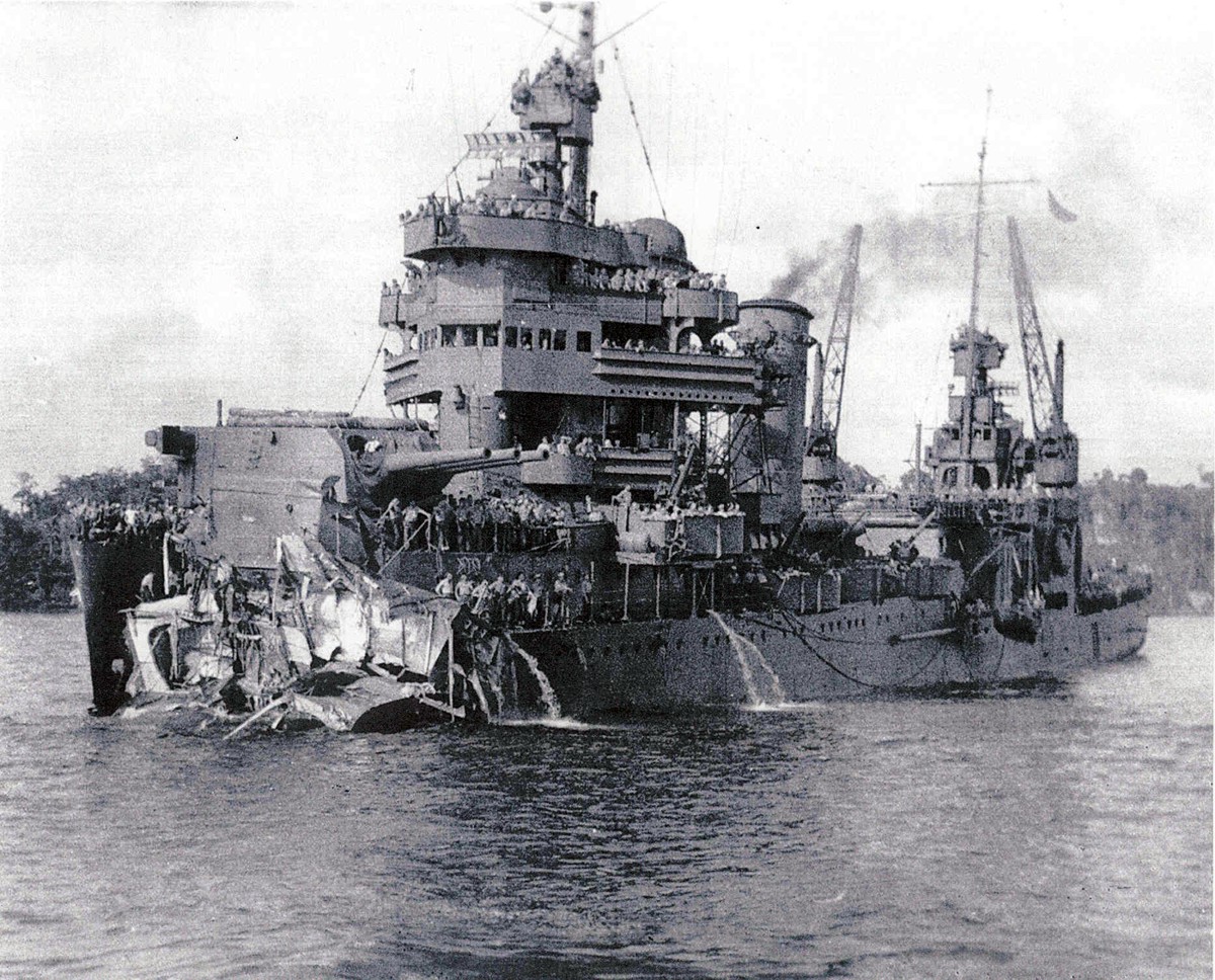
“When flagship Minneapolis was struck by two torpedoes, New Orleans, next astern, was forced to sheer away to avoid collision, and ran into the track of a torpedo which ripped off her bow. Bumping down the ship’s port side, the severed bow punched several holes in New Orleans’ hull. A fifth of her length gone, slowed to 2 knots, and blazing forward, the ship fought for survival.”
What the official history doesn’t say, and what kept J.O. up at night long after the war was over, was that, in order to keep the ship afloat, the command was given to close off all the bulkheads to the ship’s broken and leaking section. This meant that dozens of men were locked inside flooding rooms with no hope of escape.
The New Orleans limped to the safety of Australia two weeks later for repairs. I can only imagine the scene J.O. and his surviving shipmates found when they opened up those bulkheads. It was one of the events that his family says turned J.O. from a happy, carefree person into a forlorn, tortured soul. But, that didn’t stop him from fighting in 13 major battles aboard the famous New Orleans before he returned to the U.S. in late 1943 or early 1944.
When the battle weary J.O. finally came home, he went back home to quiet Bradley for a brief visit. I believe it was during this time that Dr. Jerry Nye, a 4th grader at the Bradley School at the time, recalls a visit J.O. made to the students. “Once, J.O. Neill, a Marine sergeant who had fought in the vicious battles in the Pacific, visited our school. We were stunned by this handsome warrior in his Marine uniform with his campaign ribbons and combat awards on his chest.”
A dashing figure he must have been, but, sadly, not to Nan. J.O. came home expecting to find his wife and son waiting with open arms, but he had been gone for so long, changed so much that Nan didn’t know him anymore, and she wanted out. She took their son and left the state, never to return.
Alone in a still, quiet house with his nightmares and demons, J.O. couldn’t cope, so he checked himself into a V.A. hospital for treatment. I don’t know how long he remained, but he must have been well enough to leave by June of 1944 because, when his little brother, Sam, was lost over France, J.O. was a gunnery instructor in New River, N.C.
The years after the war were lonely ones for J.O. He lived for a time with his aging mother on the farm in Bradley, then, as she got older, she moved into nearby Lindsay, and he followed. Once there, he became a Deputy Sheriff and lived the quiet life of an aged bachelor.
J.O.’s nephew and namesake, James, recalls that, if no one talked to him for awhile at family gatherings, J.O. would get very quiet and even ghost like, and no amount of cajoling could get him to snap out of his trancelike quiet. Maybe he was thinking about his lost shipmates back on the New Orleans. Maybe he was thinking of his son, whom he saw infrequently because the child lived in another state with Nan and her new husband. Or maybe he was thinking of simpler days on the farm in the years between the wars … between the time he was born and the time in November of 1942 that some say he really died.
J.O. is buried in the family plot in Erin Springs Cemetery, which is just outside Lindsay, OK. RIP, J.O., you deserve it.
Acknowledgements:
Quotes regarding the New Orleans: www.acepilots.com/ships/new_orleans.html
Quote from Dr. Jerry Nye was taken from the December 2007 edition of the Lindsay, OK News
For more information about the events of 1908, I recommend reading America: 1908, which is a compelling and utterly fascinating book about this incredible year in history.
Here's a photo of the U.S.S. New Orleans as she looked after Tassafaronga:
Just a rose with a little twist. Take a closer look!
The barbed wire is supposed to be a contrast to the rose. One is there to keep you on a distance, the other to get closer.
Katja Stock helped me with making the "new roses". Thanks for that!
Nur eine Rose mit einem kleinen Twist! Sieh etwas genauer hin.
Der Stacheldraht soll ein Kontrast zu Rose darstellen. Das eine schaft Distanz, das andere schaft Nähe.
Katja Stock hat mir beim basteln der Rosen und allem anderen geholfen, vielen Dank!
We decided to go for a city break rather than sun in Tenerife again this September. Other than a few days in the North East we haven’t been away since last March and wanted a change and hopefully some sun. The problem is getting flights from the north of England to the places we want to go to. We chose Valencia as we could fly from East Midlands – which was still a pain to get to as it involved the most notorious stretch of the M1 at five in the morning. In the end we had a fairly good journey, the new Ryanair business class pre-booked scheme worked quite well and bang on time as usual. It was dull when we landed with storms forecast all week, the sky was bright grey – the kiss of death to the photography I had in mind. I was full of cold and wishing I was at work. It did rain but it was overnight on our first night and didn't affect us. There has been a drought for eleven months apparently and it rained on our first day there! The forecast storms didn't materialise in Valencia but they got it elsewhere.
You May notice discrepancies in the spelling of some Spanish words or names, this is because Valencian is used on signs, in some guide books and maps. There are two languages in common use with distinct differences. There may also be genuine mistakes - it has been known!
Over the course of a Monday to Sunday week we covered 75 miles on foot and saw most of the best of Valencia – The City of Bell Towers. The Old City covers a pretty large area in a very confusing layout. There was a lot of referring to maps – even compass readings! – a first in a city for us. The problem with photography in Valencia is that most of the famous and attractive building are closely built around, some have poor quality housing built on to them. Most photographs have to be taken from an extreme angle looking up. There are no high points as it is pan flat, there are a small number of buildings where you can pay to go up on to the roof for a better view and we went up them – more than once!
The modern buildings of The City of Arts and Sciences – ( Ciutat de Las Arts I de les Ciencies ) are what the city has more recently become famous for, with tourists arriving by the coachload all day until late at night. They must be photographed millions of times a month. We went during the day and stayed till dark one evening, I gave it my best shot but a first time visit is always a compromise between ambition and realism, time dictates that we have to move on to the next destination. I travelled with a full size tripod – another first – I forgot to take it with me to TCoAaS! so It was time to wind up the ISO, again! Needless to say I never used the tripod.
On a day when rain was forecast but it stayed fine, albeit a bit dull, we went to the Bioparc north west of the city, a zoo by another name. There are many claims made for this place, were you can appear to walk alongside some very large animals, including, elephants, lions, giraffe, rhino, gorillas and many types of monkey to name a few. It is laid out in different geographical regions and there is very little between you and the animals, in some cases there is nothing, you enter the enclosure through a double door arrangement and the monkeys are around you. It gets rave reviews and we stayed for most of the day. The animals it has to be said gave the appearance of extreme boredom and frustration and I felt quite sorry for them.
The course of The River Turia was altered after a major flood in the 50’s. The new river runs west of the city flanked by a motorway. The old river, which is massive, deep and very wide between ancient walls, I can’t imagine how it flooded, has been turned into a park that is five miles long. There is an athletics track, football pitches, cycle paths, restaurants, numerous kids parks, ponds, fountains, loads of bridges, historic and modern. At the western end closest to the sea sits The City of Arts and Sciences – in the river bed. Where it meets the sea there is Valencia’s urban Formula One racetrack finishing in the massive marina built for The Americas Cup. The race track is in use as roadways complete with fully removable street furniture, kerbs, bollards, lights, islands and crossings, everything is just sat on the surface ready to be moved.
We found the beach almost by accident, we were desperate for food after putting in a lot of miles and the afternoon was ticking by. What a beach, 100’s of metres wide and stretching as far as the eye could see with a massive promenade. The hard thing was choosing, out of the dozens of restaurants, all next door to each other, all serving traditional Paella – rabbit and chicken – as well as seafood, we don’t eat seafood and it constituted 90% of the menu in most places. Every restaurant does a fixed price dish of the day, with a few choices, three courses and a drink. Some times this was our only meal besides making the most of the continental breakfast at the hotel. We had a fair few bar stops with the local wine being cheap and pleasant it would have been a shame not to, there would have been a one woman riot – or strike!
On our final day, a Sunday, we were out of bed and down for breakfast at 7.45 as usual, the place was deserted barring a waiter. We walked out of the door at 8.30 – in to the middle of a mass road race with many thousands of runners, one of a series that take place in Valencia – apparently! We struggled to find out the distance, possibly 10km. The finish was just around the corner so off we went with the camera gear, taking photos of random runners and groups. There was a TV crew filming it and some local celebrity (I think) commentating. Next we came across some sort of wandering religious and musical event. Some sort of ritual was played out over the course of Sunday morning in various locations, it involved catholic priests and religious buildings and another film crew. The Catholic tourists and locals were filling the (many) churches for Sunday mass. Amongst all of this we had seen men walking around in Arab style dress – the ones in black looked like the ones from ISIS currently beheading people – all carrying guns. A bit disconcerting. We assumed that there had been some sort of battle enactment. We were wrong, it hadn’t happened yet. A while later, about 11.30 we could hear banging, fireworks? No it was our friends with the guns. We were caught up in total mayhem, around 60 men randomly firing muskets with some sort of blank rounds, the noise, smoke and flames from the muzzles were incredible. We were about to climb the Torres de Serranos which is where, unbeknown to us, the grand, and deafening, finale was going to be. We could feel the blast in our faces on top of the tower. Yet again there was a film camera in attendance. I couldn’t get close ups but I got a good overview and shot my first video with the 5D, my first in 5 years of owning a DLSR with the capability. I usually use my phone ( I used my phone as well). Later in the day there was a bullfight taking place, the ring was almost next to our hotel, in the end we had other things to do and gave it a miss, it was certainly a busy Sunday in the city centre, whether it’s the norm or not I don’t know.
There is a tram system in Valencia but it goes from the port area into the newer part of the city on the north side, it wouldn’t be feasible to serve the historic old city really. A quick internet search told me that there are 55,000 university students in the city, a pretty big number. I think a lot of the campus is on the north side and served by the tram although there is a massive fleet of buses as well. There is a massive, very impressive market building , with 100’s of stalls that would make a photo project on its own, beautiful on the inside and out but very difficult to get decent photos of the exterior other than detail shots owing to the closeness of other buildings and the sheer size of it. Across town, another market has been beautifully renovated and is full of bars and restaurants and a bit of a destination in its own right.
A downside was the all too typical shafting by the taxi drivers who use every trick in the book to side step the official tariffs and rob you. The taxi from the airport had a “broken” meter and on the way home we were driven 22 km instead of the nine that is the actual distance. Some of them seem to view tourists as cash cows to be robbed at all costs. I emailed the Marriot hotel as they ordered the taxi, needless to say no answer from Marriot – they’ve had their money. We didn’t get the rip off treatment in the bars etc. that we experienced in Rome, prices are very fair on most things, certainly considering the city location.
All in all we had a good trip and can highly recommend Valencia.
Tanner Blackheart 's ears flick as he walks, the cat in his shoulder mewing every now and then as he explores Midian and Apoc, noting some differences in the city here and there.
Amara was on her PDA at the moment, speaking in fluent Japanese with a client. She nodded when appropriate even though the caller on the other end could not see her.
Toriah whistled on his way down the street, groaning at the fact the pub was closed for whatever reason. He liked that bar; not as many fights. When he turned the corner, Toriah noticed two hybrids. The shorter one he paid no serious mind to, but 609 was front and center. He'd wait and see if she noticed him before trying to get closer.
Tanner Blackheart sighs as he glances around, looking over as he spotted two people. His eyes wandered past Toriah and over to Amara as he smiled warmly, though she hadn't yet noticed him.
Amara walked further into the alleyway to avoid noise and eavesdroppers. What she was discussing in a foreign tongue was not for polite company to hear. She had not noticed anyone was nearby since her back was to the street. Her tails flickered about as her business conversation continued.
Tanner Blackheart frowns a bit, ears twitching, "guess she's busy Midi... maybe we should leave her be... I wonder where the kids are hnn? Bet the great grandkids are all grown up by now..."
Toriah started to follow her. He stopped short when it sounded like the other hybrid knew her as well. Someone so young had grandchildren? "Interesting city this is." he mumbled, staying a clear distance from Amara for now.
Tanner Blackheart wanders forward a bit, lifting an eyebrow at the gentleman and smiling just a bit once he spots Amara's form again, ears twitching, "she's always so busy... bet it's probably something to do with Ashagi... that is if she still runs it or at least works for it..." he lets out, nuzzling the kitten a bit. Neither one of them had changed over the year that they'd been gone from Midian... Midia was still a kitten and Tanner... still the same as ever.
Amara finished her phone call and flipped the PDA shut. She took a deep breath to gather her thoughts; that client had asked for an interesting order. It was not difficult for Ashagi...just unusual. Amara turned to leave, only then spotting Dr. Foster behind her. "...fuck...how long have you been there?!" she asked in a panic, backing away from the pale man.
Toriah quickly closed the gap between them as his left hand moved to circle Amara's waist. "A while." He'd be close enough whether she was caught or not to smell her perfume. "No more vanilla? I was becoming rather fond of it, 609. And I noticed your belly's back to normal- how'd the delivery go?" He smirked, annoyingly confident of the answer. He didn't care about her or the others, but the baby he was interested in. "The family doing well?"
Tanner Blackheart 's ears twitched a bit at Amara's words, not sure if they were directed at him, or the man in front of him. Midia mewed softly as Tanner smiled a bit to the other hybrid watching as the man neared his friend. He narrowed his eyes a bit when the other got too close, tense as he moved forward, "Everything ok Amara?"
Amara cursed under her breath when the doctor forced them to be chest against chest. Seeing the monster was one thing but being near him sent Amara into a mental panic. "Let go of me! What do you care about my family you bastard?!" She flailed, struggling to get out of his strong grip. She had to get away from him before she lost her senses again. Before her old self started to take over. Hearing someone in the distance asking if things were alright, she immediately screamed, "Help!"
Toriah used his height and weight to push his former pet against a wall. "Come now. I'll have none of that." he said, cupping her mouth with his free hand while keeping his weight against her. With 609 pinned down, his focus turned to the other hybrid. "I see you two know each other after all. Strong word of advice, don't interrupt this conversation." A sinister grin curved across his lips. She wasn't pregnant anymore which meant he in turn had no reason to hold back. His right hand moved to the holstered handgun by his hip.
Tanner Blackheart hands instantly went up, gripping the hilts of his sword and bringing them out. He didn't even bother to give the man a warning as he moved. He was fast... very fast and it wasn't long before he slashed forward with one sword. He was aiming for the other’s arm, the moment he saw it wander towards his gun. His eyes weren’t the usual innocent meek ones of the neko Amara had once known… they were filled with strength and confidence now… something the former Tanner had lacked in boatloads.
Toriah had no choice but to move away from his prize when the smaller hybrid charged at him. He barely avoided losing his arm, pulling the weapon free. He fired one shot at the male's shoulder before yelling, "Stay right where you are 609!" He'd been interrupted enough times now to know that fighting back was the best plan of action. He was too close to catching his beloved pet to be bothered by some vigilante now. ((might make sense if I posted before Amara did))
Amara Parmelee: ((okay))
Tanner Blackheart: [[I agree XD]]
Amara flinched, watching the fight while frozen in place. She was terrified of moving after that command. Despite her better judgment, the twin tailed hybrid just whimpered a soft, "Yes...Doctor." She was losing this mental fight already. The distance was closed enough that she could recognize the owner of the other voice. "T-Tanner? Or is it Rennat?" She'd never seen the normally timid neko fight like that before. What had he been doing while away?
Tanner Blackheart sidestepped quickly, his shoulder very lightly grazed by the shot but he didn’t seem to really notice the burning sensation as he used his momentum to turn himself right around and back, swinging both swords forward again, aiming to get the man further from Amara. He didn’t speak a word, the kitten on his shoulder growling, baring her fangs at the man with the gun. The teen's three other personalities had all merged with his original personality finally... he was finally whole.
Toriah backed up when the blades came at him. The dodge was not as successful this time since one of the blades managed to cut at his chest. The torn material of his jacker revealed Tanner had pierced skin. "This is troublesome," he noted, firing two more rounds at Tanner's arms in an attempt to disable him when he charged again. At least he had only one thing to worry about; 609 wasn't going anywhere. "Good girl 609." he added. "You stay out of harm's way, understand? I'll be done shortly."
Amara trembled, clawing into the brick wall like she was bound to it. "Y-Yes Doctor..." How frightened she was. Her feet refused to move. Her heart and mind raced. Everything was telling her that the torment of the past was over but her fragile mind refused to hear it. She'd be punished if she disobeyed him, she believed. Terrible consequences would fall upon her if she thought of going against the doctor's words.
Tanner Blackheart smirked a bit when he felt the blades hit. He whipped around again, ears ringing at the two shots, managing to avoid one but the other hit his left arm, pain shooting through his body. He snarled at the man but focused after a moment, the pain seeming to numb, a gift he got from his Rennat personality who could feel no pain what-so-ever… the rest he could handle… a gift from Tearnn who would fight through any pain. He dashed forward once more at this point, the left sword dropped but his right one slashed at the man, shouting finally, “AMARA! Get out of here! Now!”
Toriah yelled out in pain when the right slash struck deep into his upper left arm. Toriah spun backwards, colliding into the other wall. He panted, wincing at the sharp pains in his chest and arm. "Her name is 609 and she's not going anywhere. Isn't that right, my little fox?" Toriah snickered in a maddening tone, raising his good arm with the gun in hand to take careful aim at the smaller hybrid's leg. "She's not going to hear a word you say." he noted, firing two rounds at the man's thighs in hopes of immobilizing him to some degree.
609 nodded slowly, not speaking a word for or against the thought. Amara had lost. Her body remained where it was, eyes glazed over as her mind transferred to the control of her former self. "Correct Dr. Foster. I will stay...where I am." she stated in a soft monotone-like voice.
Tanner Blackheart gasped out, wincing as one of the shots got his thigh as he attempted to dodge. He dropped to the ground and winced, looking to Amara, seeming completely confused, "w... what? Amara..." he murmured, not sure what to do now as he frowned a bit, trying to focus to force the pain away, "Damn it..."
Toriah laughed at the feline hybrid's look of shock. Casually passing Tanner, he'd holster the gun. "I said this from the start. Don't interrupt. She was always mine, always. You poor unowned lot seem so deeply against ownership, but notice how placid her features are now compared to before." He cupped 609's chin just to show her face to Tanner better. "No more trembling. She's relaxed. Now if you will excuse us..." he offered 609 his elbow. "We need to be going. These cuts you gave me are something of an annoyance. Come 609."
609 nods, taking the doctor's arm as they left Tanner injured on the ground. She didn't know him or why he had been fighting the doctor.
Giannina Caviezel, Founder, Student Impact, Switzerland, speaking at the Annual Meeting 2017 of the World Economic Forum in Davos, January 19, 2017
Copyright by World Economic Forum / Walter Duerst
Well, I split the difference today. My size Y11 small child's slippers. Fun to wear like this.
I used to see a guy with much larger feet than mine wearing equally small or smaller slippers from time to time. So I decided to emulate him.
It is common to see people with large feet wearing slippers that are several sizes "too small", but I wanted to push the limit.
Worn with the difference split is fine as shown here. Worn with the strap tight so the toes are on the sole and the heel is on the ground works also, kind of an interesting sensation. Loosening the strap so the heel is completely on the sole and the forefoot hangs over the front is problematical. Unless one keeps his/her toes bent to the ground, the slipper will slide right off as one walks.
There are a couple of differences between Harriet and M15. Harriet is larger than M15.
M15’s supraorbital ridge (bone over the eye) has more feather cover than Harriet’s. M15’s eyes are darker in color and he has a dark area surrounding the back of the eye (in the feathers).
Harriet’s beak is larger in size (deeper and longer). Where the dividing line of the cere (area of beak closer to face) is located there is a dark line/mark on the beak in front of the nare on M15. His nares are more open and at the right angle the inside is visible. On the right side of M15’s face there is a small dark spot in the cere below the nare. Harriet has a dark spot on the top of her beak (in the cere area) near the forehead.
On the back of M15’s neck in the center there are some light colored feathers in the dark brown feathers where the white meets the brown (giving a speckled appearance). M15 has an overall darker appearance around the eye area.
When viewing from above Harriet’s feathers have a more gradual change from brown to white feathers (making it look speckled). M15’s tail feathers (retices) have a neater, rounded appearance than Harriet’s. All photos taken from SWFEC.
Today in Ireland and in the US new regulations relating to drones has been introduced [effective from the 21st of December 2015]. There are many similarities in the regulations but there is one major differences in that here in Ireland they have not mention the penalties for failure to register but in the US the cost of failure to register appears to be rather extreme … “civil penalties up to $27,500, or criminal penalties up to 3 years in prison and $250,000.” According to the minister the aim here in Ireland is to encourage drone users to be responsible citizens.
I have included the press releases from both administrations, have a read and see what you think.
Thursday, 17th December 2015: The Irish Aviation Authority (IAA) today announced a new drone regulation which includes the mandatory registration of all drones weighing 1kg or more from Monday, 21st December 2015.
The use of drones worldwide is expanding rapidly and there are estimated to be between 4,000 – 5,000 drones already in use in Ireland. Ireland has taken a proactive role in this fast emerging area and is currently one of only a handful of EU Member states that has legislation governing the use of drones.
The new legislation is intended to further enhance safety within Ireland and specifically addresses the safety challenges posed by drones.
From 21st December 2015, all drones weighing 1kg or more must be registered with the IAA via www.iaa.ie/drones. Drone registration is a simple two-step process. To register a drone, the registrant must be 16 years of age or older (Drones operated by those under 16 years of age must be registered by a parent or legal guardian). A nominal fee will apply from February 2016 but this has been initially waived by the IAA in order to encourage early registration.
Mr Ralph James, IAA Director of Safety Regulation, said
“Ireland is already recognised worldwide as a centre of excellence for civil aviation and the drone sector presents another major opportunity for Ireland. We’re closely working with industry to facilitate its successful development here. At the same time, safety is our top priority and we must ensure that drones are used in a safe way and that they do not interfere with all other forms of aviation.
Mr James explained that drone registration has been made a mandatory requirement as this will help the IAA to monitor the sector in the years ahead. The IAA encourages all drone operators to take part in training courses which are available through a number of approved drone training organisations.
“We would strongly encourage drone operators to register with us as quickly as possible, to complete a training course and to become aware of their responsibilities. People operating drones must do so in safe and responsible manner and in full compliance with the new regulations”, he said.
Welcoming the introduction of drone regulation, Minister for Transport, Tourism and Sport, Paschal Donohoe TD highlighted the importance of the new legislation and commended the IAA for the efficient manner to have the new registration system in place so quickly.
“The core safety message promoted today advocates the safe use of drones in civilian airspace. The development of drone technology brings opportunities as well as challenges for businesses and services in Ireland. I expect hundreds if not thousands of drones to be bought as presents this Christmas so getting the message to ensure that new owners and operators are aware of their responsibilities and the requirement to register all drones over 1 kg from 21st December 2015 is key. Tremendous potential exists for this sector and Ireland is at the forefront of its development. The speedy response by the IAA to this fast developing aviation area will make sure that drones are properly regulated and registered for use. As a result, Ireland is well placed to exploit the drone sector and to ensure industry growth in this area,” he said.
The new legislation prohibits users from operating their drones in an unsafe manner. This includes never operating a drone:
• if it will be a hazard to another aircraft in flight
• over an assembly of people
• farther than 300m from the operator
• within 120m of any person, vessel or structure not under the operator’s control
• closer than 5km from an aerodrome
• in a negligent or reckless manner so as to endanger life or property of others
• over 400ft (120m) above ground level
• over urban areas
• in civil of military controlled airspace
• in restricted areas (e.g. military installations, prisons, etc.)
• unless the operator has permission from the landowner for takeoff and landing.
For further information please visit www.iaa.ie/drones and see the IAA’s detailed Q&A sheet.
The Federal Aviation Administration has officially launched the drone registration program first reported in October. Drone operators are required to register their UAVs with the Unmanned Aircraft System registry starting December 21. Failure to register could result in criminal and civil penalties.
Under the new system, all aircraft must be registered with the FAA including those 'operated by modelers and hobbyists.' Once registered, drone operators must carry the registration certificate during operation. This new system only applies to drones weighing more than 0.55lbs/250g and less than 55lbs/25kg. The only exception to the registration requirement is indoor drone flights.
Required registration information includes a mailing address and physical address, email address, and full names; however, no information on the drone's make, model, or serial number is required from recreational users. Non-recreational users will need to provide drone information, including serial number, when that particular registration system goes live.
Failure to register could result in civil penalties up to $27,500, or criminal penalties up to 3 years in prison and $250,000. A $5 registration charge is applied, but will be refunded to those who register before January 20. The registration certificate is sent in an email to be printed at home.
Staff at the Riad are very accomodating and are exceptional. They absolutely make a difference and treat all their guests with generous hospitality. The meal that Leila cooked for us was the best we had whilst in Morroco and she is definately a treasure.We enjoyed our time with the other staff members and are already missing the fun we shared with Ahmed , Amin,'Maroc'-Mohamed,Mohamed and Tarek. Sorry if spellings are incorrect or we have missed anyone out . Oliver was very hospitable and we saw him most days during our stay.The Riad is clean and the staff were always dusting and polishing and washing.The Riad is in a great location and we felt safe whilst out and about,and we soon got used to the sights , sounds, and smells of this completely different environment.The Riad has lovely charm , ambience and is nicely furnished , the bedding (although clean) could do with updating as a previous guest has already mentioned .But we would definately stay here again
Stayed February 2012, traveled as a couple Value
Location
Sleep Quality
Rooms
Cleanliness
Service
Was this review helpful? Yes
Problem with this review?
Ask Heather W about Riad Dar Najat
This review is the subjective opinion of a TripAdvisor member and not of TripAdvisor LLC.
SheFlop
Manchester
Reviewer
3 reviews
2 helpful votes
“An excellent team”
Reviewed February 20, 2012
1
person found this review helpful
Compared to the prices of similar Riad's we did expect the quality of the furnishings, particularly the bedding, to be of a better quality, also we were placed in a room with 2 singles pushed together which again we didn't expect for that price and after specifically requesting a double.
It is a shame we didn't get to meet Oliver after extended communication with him before our trip, it seemed he had left a team of youngsters in charge.
However!
When we complained about the bed, our room was changed immediately without a problem; the free transfers were comfortable and on time; the breakfasts were good; the communal areas of the riad are lovely and the location is good (5 minutes from the "big square".
The highlight however was one guy in particular who spoke excellent English, gave us great advice on how much we should pay for some items we wanted to buy, saved us from a taxi-gone-wrong coming back from a trek in the mountains, stored our luggage safely while we trekked and even tried to source toys for our children that we had failed to buy in the square! He definitely needs some sort of promotion!
Room Tip: Look at the pictures and request a specific room buy name when booking.
See more room tips
Stayed October 2011, traveled as a couple Value
Location
Sleep Quality
Rooms
Cleanliness
Service
Was this review helpful? Yes
Problem with this review?
Ask SheFlop about Riad Dar Najat
This review is the subjective opinion of a TripAdvisor member and not of TripAdvisor LLC.
behar olivier, Owner at Riad Dar Najat, responded to this review
February 22, 2012
Hi dear guest!
First, thanks for nice words!
Sorry not to have the chance to see you if i hear you but. May i just say I’m on site 8 to 14 hours/day 7 days / week..but sometimes I did experiment not to see guests even when there and them too! as..some go on day trip very early and go back sometimes very late..and it can happen not to have the luck to meet some travelers even if for sure I try to have the best and direct contacts with all.
but again.. a little surprised as I’m in Marrakech in Dar Najat since 7 weeks without being in our other place in Essaouira on the coast..So sorry if not the luck to meet you and hope to have this chance another time.
I would say that even when not there…you may find the team (youngsters..) with Amin (our Bob Marley.).& Tarek & Aicha & Leila & Malika & Ahmed and Maroc are there to provide the best and we are numerous team to try to do our real best for you with or without me!
i would just say few things regarding your nice post apart the fact that i didn’t meet you unfortunately as it appears:
1)furniture and bed are in the highest standard and all creations and unique in the best essences of wood and done with the most respectable way of production to have the best and only the best.
You may like or dislike the design which is logical but regarding the quality ,again ,dear guest ,we are really creating and buying the best and nothing less.
and..we totally renovate and restructured all the Riad and with also ALL brand new and with highest standards:
The total re looking and work finished in august 2011 after two months of huge work and i don't think that your words do justice to the place where you can find a unique art craft creations and Art from Africa that you didn't ever noticed in your post.
Regarding the bed ,right!
better to have a real double bed than two singles put together but in any Riads in the medina ,when you have the choice with two possible configurations ,it is the same way to do it :or twins or a double bed but again ,i agree on this point ,right ,better having a real double bed and not two singles! you will find the souad & sakina & widded & guizelaine which are only in double beds ( and not in twins) to have a better comfort for the doubles bed accommodations my friends.
The other three accommodations of the riad ,Leila & walida and noura are declinable in twin or doubles ,good to know!
I would just say that we upgraded you to a real double bed room at the minute you did asked and without any extra if I’m not wrong..(so all in all..no shame maybe..)
Last .even if your post is nice and friendly ..calling the team "youngsters" who are clearly dedicated to the guests and their welfare…seems a little odd to me.
..the "youngsters" are kind of family and i will say nice and generous people with the most attentive sense of hospitality(& rather fun.) and all work in dar najat since numerous years.. and i regret even if your post is globally nice that you employ this term of "youngsters" which doesn’t seem appropriate or so nice dear guests.
We are really more than concerned by again having you totally glad of your experience in dar najat and sorry when a guest doesn’t find the place not totally" great "as we try day by day to improve the place and service to provide the best and in the most sincere way to have our guests becoming some kind of friends and ambassadors of the Riad if you prefer.
So..i hope you will give us an extra chance to give you a total satisfaction in a future trip.
With respect ,sincerely yours ,Oliver& team.
Report response as inappropriate
This response is the subjective opinion of the management representative and not of TripAdvisor LLC.
Mogens J
Herlev
Senior Reviewer
7 reviews
1 helpful vote
“Friendly and higly recommendable place”
Reviewed February 19, 2012
1
person found this review helpful
This riad is a hidden jewel in a great city. Very friendly and helpful staff, great location, wonderful food. What more can you ask for?
Stayed February 2012, traveled with family Value
Location
Sleep Quality
Rooms
Cleanliness
Service
Was this review helpful? Yes
Problem with this review?
Ask Mogens J about Riad Dar Najat
This review is the subjective opinion of a TripAdvisor member and not of TripAdvisor LLC.
MadyMoo3
Canterbury
Senior Contributor
36 reviews
9 helpful votes
“Great service, great dining, great price!”
Reviewed February 18, 2012
1
person found this review helpful
Superb food and a really friendly vibe in the heart if the medina
Stayed February 2012 Value
Location
A documentary film by Tod Lending
PBS Airdate: Season 29 of POV (September 12, 2016)
Caption: Robert Henderson at Lake Forest
Credit: Tod Lending
Photos are for press and private use only. All rights reserved. All uses of the photos must be credited as indicated in the captions. For additional information on rights or for any clearance issues, please contact communications(at)pov.org.
We are back...
Spot the difference. Be in the spotlight!
Here's your chance to show us how good an eye you have for fashion.
Gokarna (Kannada: ಗೋಕರ್ಣ) is a small temple town located on the western coast of India in the Uttara Kannada district of the Indian state of Karnataka. Main temple and deity is Lord Shiva, who is also known as Mahabhaleshwara. This temple houses what is believed to be original image of Lord Shiva's lingam (Atmalinga). There are many other temples all over this small town. Ankola and Kumta on Highway 17 are the main towns near Gokarna.
Gokarna is historically known as one of the seven important Hindu pilgrimage centers and is located on what was once unspoiled beach near the estuary of river Aghanashini with its palm trees, other colorful tropical fruit and flower trees. Of late due to the numbers of tourists the character of this town has changed. This town is no longer just a center of pilgrimage though massive numbers of devotees still visit the town for the purposes of offering prayers and worship to Lord Shiva.
Due to its laid back unspoiled and rustic nature, many younger western tourists started visiting Gokarna about a decade ago. The beaches around Gokarna were hardly used by the locals until these mainly Western tourists started coming to undeveloped beaches around Gokarna. Many enterprising locals started stores restaurants and now fully fledged resorts cater even to the well heeled tourists.
ETYMOLOGY
Gokarna means Cow's Ear. It is believed that Lord Shiva emerged from the ear of a cow (Prithvi, the Mother Earth) here. It is also located at the ear-shaped confluence of two rivers Gangavali and Aghanashini.
MYTOLOGY
Gokarna is mentioned in the Shrimad Bhagavata Purana as being the home of the two brothers Gokarna and Dhundhakari and the Bhagawat also gives details of the differences in their temperament, nature and exploits.
The sthalapuranam of gokarna then available in Tamil as it was a part of Tamil Kingdoms during sangam times, has the following account. Inorder that Brahma who out arrogance arising out of his power to create the universe, sat penancing to redeem himself from curse of shivan, lord shiva appeared in front of him from the ears of a cow. So the place came to be known as gokarnam or ear of the cow. The sangam period writings refer to a class of chieftains going by names kocar and kilans, in charge of the region between gokarnam and present day Mumbai. Even though the Tamil saints have revered this temple, their composed hymns on the same are not available to us as of today.
HISTORY
The earliest history of the city is not known. Tamil saints like the Nayanmars Appar and Sambanthar from the 6th century CE praised the deity of Tulu Nadu in their hymn canon Tevaram. It is an established fact that Mayurvarma of the Kadamba kings brought Brahmins from Ahicchatra. A sect of Brahmins fled from the Gomantak to escape forcible conversions by the Portuguese and British and settled in and around Gokarna in the 15th century. It was part of the Sodhe and Vijayanagar kingdoms. Later, when the Konkan region - including Goa - was occupied by the Portuguese, it became part of their rule. A few temples were destroyed by the Portuguese in 1714 and then rebuilt later in the 18th century and also under the supervision of Guru H. H. Shrimat Anandashram Swamiji in 1928.
CULTURE
Gokarna is a town of contrasts, as it is a temple town and also a holiday destination. Gokarna is full of coconut, banana and other trees, blue seas and relatively clean sands. It is a laid back town with two main streets lined with shops and traditional tile-roofed brick houses. The beaches near Gokarna have shacks (huts) for rent. Kannada is the main language spoken here, however Konkani as well as Indian version of English are spoken here.
RELIGIOUS ATTRACTIONS
Gokarna is also an important centre of Sanskrit learning and houses Bhandikeri Math and Toggu Math. It is a place where Sanskrit knowledge is passed down from generations in Brahmin families. Many Hindus also perform the last rites of a person here.
- Mahabaleshwar Temple (Maha: great, bal: strength) is a famous Shiva Temple and it houses the 'Atmalinga'. Named so after Ravana referred to the linga's great strength.
It is situated at the western end of the main street. In the sanctuary is 'Athmalinga' in between the Saligrama Peethaa. The idol of Lord Mahabaleshwara is called Nagabharana. It is so named because of the Lord rests under the head of Naga (serpent). The floor of the hall in front has an intricate engraving of a giant tortoise.
- Maha Ganapathi Temple built in honour of the boy Ganapathi, who deceived the demon Ravana by keeping Atmalinga on ground before ravana returns from sandyavandanam. The deity here is two-armed, standing and at least 1500 years old.
- Uma Maheshwara Temple
- Bhadrakali Temple
- Tamra Gauri Temple
- Venkataramana Temple
- Kotitheertha is a man-made tank that is used for immersion of idols and ritual bathing. It is surrounded by temples.
- Shivaratri festival is celebrated here with great enthusiasm. The temple has two chariots - named locally as 'Dodda Ratha' (Dodda for Big in Kannada) and 'Sanna Ratha' (sanna for small in Kannada). Dodda Ratha is quite huge. While 'Sanna Ratha' is out in the open during winter and summer, the 'Dodda Ratha' is brought out and made ready only during Maha Shivaratri. On the last day of Maha Shivaratri festival the Lord Mahabaleshwara idol is carried in 'Dodda Ratha' in a procession through the town's big Car Street, while priests and pilgrims chant hymns in praise of Shiva. More than a hundred people are needed to pull the chariots with thick ropes while priests conduct religious ceremonies inside. During the nine-day Maha Shivaratri festival, the small town of Gokarna is visited by up to 20,000 pilgrims.
COMMUNITY FESTIVALS
- Mahashivaratri
- Kartika mahotsava
- suggi habba is the main cultural festival of halakki vakkaligas
BEACHES
The drive up the winding path that leads to Gokarna is scenic, with the rocky mountains and Western Ghats on one side and the Arabian Sea on the other.Gokarna is also known for the beaches. The main beaches in Gokarna are the Gokarna beach (also known as Indian Beach), Main Beach, Kuddle Beach, Om Beach, Half moon Beach, Paradise Beach (also known as Full moon)and Nirvana beach (3 km long with fine white sand). The Gokarna beach forms the coast of the town and is followed by Main beach in northern direction while the other four beaches lie to the south of Gokarna. Gokarna Beach is mainly used by Indian pilgrims. Main Beach is a long open beach, also known for surfing. Kuddle and Om are around 6 km from Gokarna town along a muddy hill; they are accessible by rickshaw or foot. Half moon and Paradise are beyond Om beach and are accessible only by foot or boat, Nirvana beach is accessible by boat and road from Kumta town. Om beach is named so because it is shaped like the auspicious ॐ [Om] symbol. Om beach is the only naturally Om shaped beach. Three other beaches - Paradise, Half Moon and Nirvana beach.
LOCATION
Gokarna is about 583 km from Bangalore, 238 km north of Mangalore and about 59 km from Karwar. It is between the Gangavali and Agnashini rivers and situated along the Karwar coast by the Arabian Sea. It is 200 km north from the college towns of Suratkal.
Gokarna can be reached by buses and maxicabs from Kumta (30 km), Ankola (26 km) and Karwar (59 km) on National Highway 17( NH-17 ). Karnataka State Road Transport Corporation (KSRTC) also runs long-journey buses from many cities like Panaji, Bangalore and Mangalore. Private buses (Vijayanand Roadlines - VRL, Sugama, Sea Bird, etc.) operate night journeys from the capital city of Bangalore to Gokarna daily. It can be reached by train Konkan Railway on the Mumbai to Mangalore route. The railway station ( called Gokarna Road ) is 6 km away from the town. The station also has a retiring room at a nominal price. Many important trains like Matsyagandha Express have a halt here. The nearest airports are Dabolim at Goa and Mangalore International Airport at Bajpe.
WIKIPEDIA
A fungus (pl.: fungi or funguses) is any member of the group of eukaryotic organisms that includes microorganisms such as yeasts and molds, as well as the more familiar mushrooms. These organisms are classified as one of the traditional eukaryotic kingdoms, along with Animalia, Plantae and either Protista or Protozoa and Chromista.
A characteristic that places fungi in a different kingdom from plants, bacteria, and some protists is chitin in their cell walls. Fungi, like animals, are heterotrophs; they acquire their food by absorbing dissolved molecules, typically by secreting digestive enzymes into their environment. Fungi do not photosynthesize. Growth is their means of mobility, except for spores (a few of which are flagellated), which may travel through the air or water. Fungi are the principal decomposers in ecological systems. These and other differences place fungi in a single group of related organisms, named the Eumycota (true fungi or Eumycetes), that share a common ancestor (i.e. they form a monophyletic group), an interpretation that is also strongly supported by molecular phylogenetics. This fungal group is distinct from the structurally similar myxomycetes (slime molds) and oomycetes (water molds). The discipline of biology devoted to the study of fungi is known as mycology (from the Greek μύκης mykes, mushroom). In the past mycology was regarded as a branch of botany, although it is now known that fungi are genetically more closely related to animals than to plants.
Abundant worldwide, most fungi are inconspicuous because of the small size of their structures, and their cryptic lifestyles in soil or on dead matter. Fungi include symbionts of plants, animals, or other fungi and also parasites. They may become noticeable when fruiting, either as mushrooms or as molds. Fungi perform an essential role in the decomposition of organic matter and have fundamental roles in nutrient cycling and exchange in the environment. They have long been used as a direct source of human food, in the form of mushrooms and truffles; as a leavening agent for bread; and in the fermentation of various food products, such as wine, beer, and soy sauce. Since the 1940s, fungi have been used for the production of antibiotics, and, more recently, various enzymes produced by fungi are used industrially and in detergents. Fungi are also used as biological pesticides to control weeds, plant diseases, and insect pests. Many species produce bioactive compounds called mycotoxins, such as alkaloids and polyketides, that are toxic to animals, including humans. The fruiting structures of a few species contain psychotropic compounds and are consumed recreationally or in traditional spiritual ceremonies. Fungi can break down manufactured materials and buildings, and become significant pathogens of humans and other animals. Losses of crops due to fungal diseases (e.g., rice blast disease) or food spoilage can have a large impact on human food supplies and local economies.
The fungus kingdom encompasses an enormous diversity of taxa with varied ecologies, life cycle strategies, and morphologies ranging from unicellular aquatic chytrids to large mushrooms. However, little is known of the true biodiversity of the fungus kingdom, which has been estimated at 2.2 million to 3.8 million species. Of these, only about 148,000 have been described, with over 8,000 species known to be detrimental to plants and at least 300 that can be pathogenic to humans. Ever since the pioneering 18th and 19th century taxonomical works of Carl Linnaeus, Christiaan Hendrik Persoon, and Elias Magnus Fries, fungi have been classified according to their morphology (e.g., characteristics such as spore color or microscopic features) or physiology. Advances in molecular genetics have opened the way for DNA analysis to be incorporated into taxonomy, which has sometimes challenged the historical groupings based on morphology and other traits. Phylogenetic studies published in the first decade of the 21st century have helped reshape the classification within the fungi kingdom, which is divided into one subkingdom, seven phyla, and ten subphyla.
Etymology
The English word fungus is directly adopted from the Latin fungus (mushroom), used in the writings of Horace and Pliny. This in turn is derived from the Greek word sphongos (σφόγγος 'sponge'), which refers to the macroscopic structures and morphology of mushrooms and molds; the root is also used in other languages, such as the German Schwamm ('sponge') and Schimmel ('mold').
The word mycology is derived from the Greek mykes (μύκης 'mushroom') and logos (λόγος 'discourse'). It denotes the scientific study of fungi. The Latin adjectival form of "mycology" (mycologicæ) appeared as early as 1796 in a book on the subject by Christiaan Hendrik Persoon. The word appeared in English as early as 1824 in a book by Robert Kaye Greville. In 1836 the English naturalist Miles Joseph Berkeley's publication The English Flora of Sir James Edward Smith, Vol. 5. also refers to mycology as the study of fungi.
A group of all the fungi present in a particular region is known as mycobiota (plural noun, no singular). The term mycota is often used for this purpose, but many authors use it as a synonym of Fungi. The word funga has been proposed as a less ambiguous term morphologically similar to fauna and flora. The Species Survival Commission (SSC) of the International Union for Conservation of Nature (IUCN) in August 2021 asked that the phrase fauna and flora be replaced by fauna, flora, and funga.
Characteristics
Fungal hyphae cells
Hyphal wall
Septum
Mitochondrion
Vacuole
Ergosterol crystal
Ribosome
Nucleus
Endoplasmic reticulum
Lipid body
Plasma membrane
Spitzenkörper
Golgi apparatus
Fungal cell cycle showing Dikaryons typical of Higher Fungi
Before the introduction of molecular methods for phylogenetic analysis, taxonomists considered fungi to be members of the plant kingdom because of similarities in lifestyle: both fungi and plants are mainly immobile, and have similarities in general morphology and growth habitat. Although inaccurate, the common misconception that fungi are plants persists among the general public due to their historical classification, as well as several similarities. Like plants, fungi often grow in soil and, in the case of mushrooms, form conspicuous fruit bodies, which sometimes resemble plants such as mosses. The fungi are now considered a separate kingdom, distinct from both plants and animals, from which they appear to have diverged around one billion years ago (around the start of the Neoproterozoic Era). Some morphological, biochemical, and genetic features are shared with other organisms, while others are unique to the fungi, clearly separating them from the other kingdoms:
With other eukaryotes: Fungal cells contain membrane-bound nuclei with chromosomes that contain DNA with noncoding regions called introns and coding regions called exons. Fungi have membrane-bound cytoplasmic organelles such as mitochondria, sterol-containing membranes, and ribosomes of the 80S type. They have a characteristic range of soluble carbohydrates and storage compounds, including sugar alcohols (e.g., mannitol), disaccharides, (e.g., trehalose), and polysaccharides (e.g., glycogen, which is also found in animals).
With animals: Fungi lack chloroplasts and are heterotrophic organisms and so require preformed organic compounds as energy sources.
With plants: Fungi have a cell wall and vacuoles. They reproduce by both sexual and asexual means, and like basal plant groups (such as ferns and mosses) produce spores. Similar to mosses and algae, fungi typically have haploid nuclei.
With euglenoids and bacteria: Higher fungi, euglenoids, and some bacteria produce the amino acid L-lysine in specific biosynthesis steps, called the α-aminoadipate pathway.
The cells of most fungi grow as tubular, elongated, and thread-like (filamentous) structures called hyphae, which may contain multiple nuclei and extend by growing at their tips. Each tip contains a set of aggregated vesicles—cellular structures consisting of proteins, lipids, and other organic molecules—called the Spitzenkörper. Both fungi and oomycetes grow as filamentous hyphal cells. In contrast, similar-looking organisms, such as filamentous green algae, grow by repeated cell division within a chain of cells. There are also single-celled fungi (yeasts) that do not form hyphae, and some fungi have both hyphal and yeast forms.
In common with some plant and animal species, more than one hundred fungal species display bioluminescence.
Unique features:
Some species grow as unicellular yeasts that reproduce by budding or fission. Dimorphic fungi can switch between a yeast phase and a hyphal phase in response to environmental conditions.
The fungal cell wall is made of a chitin-glucan complex; while glucans are also found in plants and chitin in the exoskeleton of arthropods, fungi are the only organisms that combine these two structural molecules in their cell wall. Unlike those of plants and oomycetes, fungal cell walls do not contain cellulose.
A whitish fan or funnel-shaped mushroom growing at the base of a tree.
Omphalotus nidiformis, a bioluminescent mushroom
Most fungi lack an efficient system for the long-distance transport of water and nutrients, such as the xylem and phloem in many plants. To overcome this limitation, some fungi, such as Armillaria, form rhizomorphs, which resemble and perform functions similar to the roots of plants. As eukaryotes, fungi possess a biosynthetic pathway for producing terpenes that uses mevalonic acid and pyrophosphate as chemical building blocks. Plants and some other organisms have an additional terpene biosynthesis pathway in their chloroplasts, a structure that fungi and animals do not have. Fungi produce several secondary metabolites that are similar or identical in structure to those made by plants. Many of the plant and fungal enzymes that make these compounds differ from each other in sequence and other characteristics, which indicates separate origins and convergent evolution of these enzymes in the fungi and plants.
Diversity
Fungi have a worldwide distribution, and grow in a wide range of habitats, including extreme environments such as deserts or areas with high salt concentrations or ionizing radiation, as well as in deep sea sediments. Some can survive the intense UV and cosmic radiation encountered during space travel. Most grow in terrestrial environments, though several species live partly or solely in aquatic habitats, such as the chytrid fungi Batrachochytrium dendrobatidis and B. salamandrivorans, parasites that have been responsible for a worldwide decline in amphibian populations. These organisms spend part of their life cycle as a motile zoospore, enabling them to propel itself through water and enter their amphibian host. Other examples of aquatic fungi include those living in hydrothermal areas of the ocean.
As of 2020, around 148,000 species of fungi have been described by taxonomists, but the global biodiversity of the fungus kingdom is not fully understood. A 2017 estimate suggests there may be between 2.2 and 3.8 million species The number of new fungi species discovered yearly has increased from 1,000 to 1,500 per year about 10 years ago, to about 2000 with a peak of more than 2,500 species in 2016. In the year 2019, 1882 new species of fungi were described, and it was estimated that more than 90% of fungi remain unknown The following year, 2905 new species were described—the highest annual record of new fungus names. In mycology, species have historically been distinguished by a variety of methods and concepts. Classification based on morphological characteristics, such as the size and shape of spores or fruiting structures, has traditionally dominated fungal taxonomy. Species may also be distinguished by their biochemical and physiological characteristics, such as their ability to metabolize certain biochemicals, or their reaction to chemical tests. The biological species concept discriminates species based on their ability to mate. The application of molecular tools, such as DNA sequencing and phylogenetic analysis, to study diversity has greatly enhanced the resolution and added robustness to estimates of genetic diversity within various taxonomic groups.
Mycology
Mycology is the branch of biology concerned with the systematic study of fungi, including their genetic and biochemical properties, their taxonomy, and their use to humans as a source of medicine, food, and psychotropic substances consumed for religious purposes, as well as their dangers, such as poisoning or infection. The field of phytopathology, the study of plant diseases, is closely related because many plant pathogens are fungi.
The use of fungi by humans dates back to prehistory; Ötzi the Iceman, a well-preserved mummy of a 5,300-year-old Neolithic man found frozen in the Austrian Alps, carried two species of polypore mushrooms that may have been used as tinder (Fomes fomentarius), or for medicinal purposes (Piptoporus betulinus). Ancient peoples have used fungi as food sources—often unknowingly—for millennia, in the preparation of leavened bread and fermented juices. Some of the oldest written records contain references to the destruction of crops that were probably caused by pathogenic fungi.
History
Mycology became a systematic science after the development of the microscope in the 17th century. Although fungal spores were first observed by Giambattista della Porta in 1588, the seminal work in the development of mycology is considered to be the publication of Pier Antonio Micheli's 1729 work Nova plantarum genera. Micheli not only observed spores but also showed that, under the proper conditions, they could be induced into growing into the same species of fungi from which they originated. Extending the use of the binomial system of nomenclature introduced by Carl Linnaeus in his Species plantarum (1753), the Dutch Christiaan Hendrik Persoon (1761–1836) established the first classification of mushrooms with such skill as to be considered a founder of modern mycology. Later, Elias Magnus Fries (1794–1878) further elaborated the classification of fungi, using spore color and microscopic characteristics, methods still used by taxonomists today. Other notable early contributors to mycology in the 17th–19th and early 20th centuries include Miles Joseph Berkeley, August Carl Joseph Corda, Anton de Bary, the brothers Louis René and Charles Tulasne, Arthur H. R. Buller, Curtis G. Lloyd, and Pier Andrea Saccardo. In the 20th and 21st centuries, advances in biochemistry, genetics, molecular biology, biotechnology, DNA sequencing and phylogenetic analysis has provided new insights into fungal relationships and biodiversity, and has challenged traditional morphology-based groupings in fungal taxonomy.
Morphology
Microscopic structures
Monochrome micrograph showing Penicillium hyphae as long, transparent, tube-like structures a few micrometres across. Conidiophores branch out laterally from the hyphae, terminating in bundles of phialides on which spherical condidiophores are arranged like beads on a string. Septa are faintly visible as dark lines crossing the hyphae.
An environmental isolate of Penicillium
Hypha
Conidiophore
Phialide
Conidia
Septa
Most fungi grow as hyphae, which are cylindrical, thread-like structures 2–10 µm in diameter and up to several centimeters in length. Hyphae grow at their tips (apices); new hyphae are typically formed by emergence of new tips along existing hyphae by a process called branching, or occasionally growing hyphal tips fork, giving rise to two parallel-growing hyphae. Hyphae also sometimes fuse when they come into contact, a process called hyphal fusion (or anastomosis). These growth processes lead to the development of a mycelium, an interconnected network of hyphae. Hyphae can be either septate or coenocytic. Septate hyphae are divided into compartments separated by cross walls (internal cell walls, called septa, that are formed at right angles to the cell wall giving the hypha its shape), with each compartment containing one or more nuclei; coenocytic hyphae are not compartmentalized. Septa have pores that allow cytoplasm, organelles, and sometimes nuclei to pass through; an example is the dolipore septum in fungi of the phylum Basidiomycota. Coenocytic hyphae are in essence multinucleate supercells.
Many species have developed specialized hyphal structures for nutrient uptake from living hosts; examples include haustoria in plant-parasitic species of most fungal phyla,[63] and arbuscules of several mycorrhizal fungi, which penetrate into the host cells to consume nutrients.
Although fungi are opisthokonts—a grouping of evolutionarily related organisms broadly characterized by a single posterior flagellum—all phyla except for the chytrids have lost their posterior flagella. Fungi are unusual among the eukaryotes in having a cell wall that, in addition to glucans (e.g., β-1,3-glucan) and other typical components, also contains the biopolymer chitin.
Macroscopic structures
Fungal mycelia can become visible to the naked eye, for example, on various surfaces and substrates, such as damp walls and spoiled food, where they are commonly called molds. Mycelia grown on solid agar media in laboratory petri dishes are usually referred to as colonies. These colonies can exhibit growth shapes and colors (due to spores or pigmentation) that can be used as diagnostic features in the identification of species or groups. Some individual fungal colonies can reach extraordinary dimensions and ages as in the case of a clonal colony of Armillaria solidipes, which extends over an area of more than 900 ha (3.5 square miles), with an estimated age of nearly 9,000 years.
The apothecium—a specialized structure important in sexual reproduction in the ascomycetes—is a cup-shaped fruit body that is often macroscopic and holds the hymenium, a layer of tissue containing the spore-bearing cells. The fruit bodies of the basidiomycetes (basidiocarps) and some ascomycetes can sometimes grow very large, and many are well known as mushrooms.
Growth and physiology
Time-lapse photography sequence of a peach becoming progressively discolored and disfigured
Mold growth covering a decaying peach. The frames were taken approximately 12 hours apart over a period of six days.
The growth of fungi as hyphae on or in solid substrates or as single cells in aquatic environments is adapted for the efficient extraction of nutrients, because these growth forms have high surface area to volume ratios. Hyphae are specifically adapted for growth on solid surfaces, and to invade substrates and tissues. They can exert large penetrative mechanical forces; for example, many plant pathogens, including Magnaporthe grisea, form a structure called an appressorium that evolved to puncture plant tissues.[71] The pressure generated by the appressorium, directed against the plant epidermis, can exceed 8 megapascals (1,200 psi).[71] The filamentous fungus Paecilomyces lilacinus uses a similar structure to penetrate the eggs of nematodes.
The mechanical pressure exerted by the appressorium is generated from physiological processes that increase intracellular turgor by producing osmolytes such as glycerol. Adaptations such as these are complemented by hydrolytic enzymes secreted into the environment to digest large organic molecules—such as polysaccharides, proteins, and lipids—into smaller molecules that may then be absorbed as nutrients. The vast majority of filamentous fungi grow in a polar fashion (extending in one direction) by elongation at the tip (apex) of the hypha. Other forms of fungal growth include intercalary extension (longitudinal expansion of hyphal compartments that are below the apex) as in the case of some endophytic fungi, or growth by volume expansion during the development of mushroom stipes and other large organs. Growth of fungi as multicellular structures consisting of somatic and reproductive cells—a feature independently evolved in animals and plants—has several functions, including the development of fruit bodies for dissemination of sexual spores (see above) and biofilms for substrate colonization and intercellular communication.
Fungi are traditionally considered heterotrophs, organisms that rely solely on carbon fixed by other organisms for metabolism. Fungi have evolved a high degree of metabolic versatility that allows them to use a diverse range of organic substrates for growth, including simple compounds such as nitrate, ammonia, acetate, or ethanol. In some species the pigment melanin may play a role in extracting energy from ionizing radiation, such as gamma radiation. This form of "radiotrophic" growth has been described for only a few species, the effects on growth rates are small, and the underlying biophysical and biochemical processes are not well known. This process might bear similarity to CO2 fixation via visible light, but instead uses ionizing radiation as a source of energy.
Reproduction
Two thickly stemmed brownish mushrooms with scales on the upper surface, growing out of a tree trunk
Polyporus squamosus
Fungal reproduction is complex, reflecting the differences in lifestyles and genetic makeup within this diverse kingdom of organisms. It is estimated that a third of all fungi reproduce using more than one method of propagation; for example, reproduction may occur in two well-differentiated stages within the life cycle of a species, the teleomorph (sexual reproduction) and the anamorph (asexual reproduction). Environmental conditions trigger genetically determined developmental states that lead to the creation of specialized structures for sexual or asexual reproduction. These structures aid reproduction by efficiently dispersing spores or spore-containing propagules.
Asexual reproduction
Asexual reproduction occurs via vegetative spores (conidia) or through mycelial fragmentation. Mycelial fragmentation occurs when a fungal mycelium separates into pieces, and each component grows into a separate mycelium. Mycelial fragmentation and vegetative spores maintain clonal populations adapted to a specific niche, and allow more rapid dispersal than sexual reproduction. The "Fungi imperfecti" (fungi lacking the perfect or sexual stage) or Deuteromycota comprise all the species that lack an observable sexual cycle. Deuteromycota (alternatively known as Deuteromycetes, conidial fungi, or mitosporic fungi) is not an accepted taxonomic clade and is now taken to mean simply fungi that lack a known sexual stage.
Sexual reproduction
See also: Mating in fungi and Sexual selection in fungi
Sexual reproduction with meiosis has been directly observed in all fungal phyla except Glomeromycota (genetic analysis suggests meiosis in Glomeromycota as well). It differs in many aspects from sexual reproduction in animals or plants. Differences also exist between fungal groups and can be used to discriminate species by morphological differences in sexual structures and reproductive strategies. Mating experiments between fungal isolates may identify species on the basis of biological species concepts. The major fungal groupings have initially been delineated based on the morphology of their sexual structures and spores; for example, the spore-containing structures, asci and basidia, can be used in the identification of ascomycetes and basidiomycetes, respectively. Fungi employ two mating systems: heterothallic species allow mating only between individuals of the opposite mating type, whereas homothallic species can mate, and sexually reproduce, with any other individual or itself.
Most fungi have both a haploid and a diploid stage in their life cycles. In sexually reproducing fungi, compatible individuals may combine by fusing their hyphae together into an interconnected network; this process, anastomosis, is required for the initiation of the sexual cycle. Many ascomycetes and basidiomycetes go through a dikaryotic stage, in which the nuclei inherited from the two parents do not combine immediately after cell fusion, but remain separate in the hyphal cells (see heterokaryosis).
In ascomycetes, dikaryotic hyphae of the hymenium (the spore-bearing tissue layer) form a characteristic hook (crozier) at the hyphal septum. During cell division, the formation of the hook ensures proper distribution of the newly divided nuclei into the apical and basal hyphal compartments. An ascus (plural asci) is then formed, in which karyogamy (nuclear fusion) occurs. Asci are embedded in an ascocarp, or fruiting body. Karyogamy in the asci is followed immediately by meiosis and the production of ascospores. After dispersal, the ascospores may germinate and form a new haploid mycelium.
Sexual reproduction in basidiomycetes is similar to that of the ascomycetes. Compatible haploid hyphae fuse to produce a dikaryotic mycelium. However, the dikaryotic phase is more extensive in the basidiomycetes, often also present in the vegetatively growing mycelium. A specialized anatomical structure, called a clamp connection, is formed at each hyphal septum. As with the structurally similar hook in the ascomycetes, the clamp connection in the basidiomycetes is required for controlled transfer of nuclei during cell division, to maintain the dikaryotic stage with two genetically different nuclei in each hyphal compartment. A basidiocarp is formed in which club-like structures known as basidia generate haploid basidiospores after karyogamy and meiosis. The most commonly known basidiocarps are mushrooms, but they may also take other forms (see Morphology section).
In fungi formerly classified as Zygomycota, haploid hyphae of two individuals fuse, forming a gametangium, a specialized cell structure that becomes a fertile gamete-producing cell. The gametangium develops into a zygospore, a thick-walled spore formed by the union of gametes. When the zygospore germinates, it undergoes meiosis, generating new haploid hyphae, which may then form asexual sporangiospores. These sporangiospores allow the fungus to rapidly disperse and germinate into new genetically identical haploid fungal mycelia.
Spore dispersal
The spores of most of the researched species of fungi are transported by wind. Such species often produce dry or hydrophobic spores that do not absorb water and are readily scattered by raindrops, for example. In other species, both asexual and sexual spores or sporangiospores are often actively dispersed by forcible ejection from their reproductive structures. This ejection ensures exit of the spores from the reproductive structures as well as traveling through the air over long distances.
Specialized mechanical and physiological mechanisms, as well as spore surface structures (such as hydrophobins), enable efficient spore ejection. For example, the structure of the spore-bearing cells in some ascomycete species is such that the buildup of substances affecting cell volume and fluid balance enables the explosive discharge of spores into the air. The forcible discharge of single spores termed ballistospores involves formation of a small drop of water (Buller's drop), which upon contact with the spore leads to its projectile release with an initial acceleration of more than 10,000 g; the net result is that the spore is ejected 0.01–0.02 cm, sufficient distance for it to fall through the gills or pores into the air below. Other fungi, like the puffballs, rely on alternative mechanisms for spore release, such as external mechanical forces. The hydnoid fungi (tooth fungi) produce spores on pendant, tooth-like or spine-like projections. The bird's nest fungi use the force of falling water drops to liberate the spores from cup-shaped fruiting bodies. Another strategy is seen in the stinkhorns, a group of fungi with lively colors and putrid odor that attract insects to disperse their spores.
Homothallism
In homothallic sexual reproduction, two haploid nuclei derived from the same individual fuse to form a zygote that can then undergo meiosis. Homothallic fungi include species with an Aspergillus-like asexual stage (anamorphs) occurring in numerous different genera, several species of the ascomycete genus Cochliobolus, and the ascomycete Pneumocystis jirovecii. The earliest mode of sexual reproduction among eukaryotes was likely homothallism, that is, self-fertile unisexual reproduction.
Other sexual processes
Besides regular sexual reproduction with meiosis, certain fungi, such as those in the genera Penicillium and Aspergillus, may exchange genetic material via parasexual processes, initiated by anastomosis between hyphae and plasmogamy of fungal cells. The frequency and relative importance of parasexual events is unclear and may be lower than other sexual processes. It is known to play a role in intraspecific hybridization and is likely required for hybridization between species, which has been associated with major events in fungal evolution.
Evolution
In contrast to plants and animals, the early fossil record of the fungi is meager. Factors that likely contribute to the under-representation of fungal species among fossils include the nature of fungal fruiting bodies, which are soft, fleshy, and easily degradable tissues and the microscopic dimensions of most fungal structures, which therefore are not readily evident. Fungal fossils are difficult to distinguish from those of other microbes, and are most easily identified when they resemble extant fungi. Often recovered from a permineralized plant or animal host, these samples are typically studied by making thin-section preparations that can be examined with light microscopy or transmission electron microscopy. Researchers study compression fossils by dissolving the surrounding matrix with acid and then using light or scanning electron microscopy to examine surface details.
The earliest fossils possessing features typical of fungi date to the Paleoproterozoic era, some 2,400 million years ago (Ma); these multicellular benthic organisms had filamentous structures capable of anastomosis. Other studies (2009) estimate the arrival of fungal organisms at about 760–1060 Ma on the basis of comparisons of the rate of evolution in closely related groups. The oldest fossilizied mycelium to be identified from its molecular composition is between 715 and 810 million years old. For much of the Paleozoic Era (542–251 Ma), the fungi appear to have been aquatic and consisted of organisms similar to the extant chytrids in having flagellum-bearing spores. The evolutionary adaptation from an aquatic to a terrestrial lifestyle necessitated a diversification of ecological strategies for obtaining nutrients, including parasitism, saprobism, and the development of mutualistic relationships such as mycorrhiza and lichenization. Studies suggest that the ancestral ecological state of the Ascomycota was saprobism, and that independent lichenization events have occurred multiple times.
In May 2019, scientists reported the discovery of a fossilized fungus, named Ourasphaira giraldae, in the Canadian Arctic, that may have grown on land a billion years ago, well before plants were living on land. Pyritized fungus-like microfossils preserved in the basal Ediacaran Doushantuo Formation (~635 Ma) have been reported in South China. Earlier, it had been presumed that the fungi colonized the land during the Cambrian (542–488.3 Ma), also long before land plants. Fossilized hyphae and spores recovered from the Ordovician of Wisconsin (460 Ma) resemble modern-day Glomerales, and existed at a time when the land flora likely consisted of only non-vascular bryophyte-like plants. Prototaxites, which was probably a fungus or lichen, would have been the tallest organism of the late Silurian and early Devonian. Fungal fossils do not become common and uncontroversial until the early Devonian (416–359.2 Ma), when they occur abundantly in the Rhynie chert, mostly as Zygomycota and Chytridiomycota. At about this same time, approximately 400 Ma, the Ascomycota and Basidiomycota diverged, and all modern classes of fungi were present by the Late Carboniferous (Pennsylvanian, 318.1–299 Ma).
Lichens formed a component of the early terrestrial ecosystems, and the estimated age of the oldest terrestrial lichen fossil is 415 Ma; this date roughly corresponds to the age of the oldest known sporocarp fossil, a Paleopyrenomycites species found in the Rhynie Chert. The oldest fossil with microscopic features resembling modern-day basidiomycetes is Palaeoancistrus, found permineralized with a fern from the Pennsylvanian. Rare in the fossil record are the Homobasidiomycetes (a taxon roughly equivalent to the mushroom-producing species of the Agaricomycetes). Two amber-preserved specimens provide evidence that the earliest known mushroom-forming fungi (the extinct species Archaeomarasmius leggetti) appeared during the late Cretaceous, 90 Ma.
Some time after the Permian–Triassic extinction event (251.4 Ma), a fungal spike (originally thought to be an extraordinary abundance of fungal spores in sediments) formed, suggesting that fungi were the dominant life form at this time, representing nearly 100% of the available fossil record for this period. However, the relative proportion of fungal spores relative to spores formed by algal species is difficult to assess, the spike did not appear worldwide, and in many places it did not fall on the Permian–Triassic boundary.
Sixty-five million years ago, immediately after the Cretaceous–Paleogene extinction event that famously killed off most dinosaurs, there was a dramatic increase in evidence of fungi; apparently the death of most plant and animal species led to a huge fungal bloom like "a massive compost heap".
Taxonomy
Although commonly included in botany curricula and textbooks, fungi are more closely related to animals than to plants and are placed with the animals in the monophyletic group of opisthokonts. Analyses using molecular phylogenetics support a monophyletic origin of fungi. The taxonomy of fungi is in a state of constant flux, especially due to research based on DNA comparisons. These current phylogenetic analyses often overturn classifications based on older and sometimes less discriminative methods based on morphological features and biological species concepts obtained from experimental matings.
There is no unique generally accepted system at the higher taxonomic levels and there are frequent name changes at every level, from species upwards. Efforts among researchers are now underway to establish and encourage usage of a unified and more consistent nomenclature. Until relatively recent (2012) changes to the International Code of Nomenclature for algae, fungi and plants, fungal species could also have multiple scientific names depending on their life cycle and mode (sexual or asexual) of reproduction. Web sites such as Index Fungorum and MycoBank are officially recognized nomenclatural repositories and list current names of fungal species (with cross-references to older synonyms).
The 2007 classification of Kingdom Fungi is the result of a large-scale collaborative research effort involving dozens of mycologists and other scientists working on fungal taxonomy. It recognizes seven phyla, two of which—the Ascomycota and the Basidiomycota—are contained within a branch representing subkingdom Dikarya, the most species rich and familiar group, including all the mushrooms, most food-spoilage molds, most plant pathogenic fungi, and the beer, wine, and bread yeasts. The accompanying cladogram depicts the major fungal taxa and their relationship to opisthokont and unikont organisms, based on the work of Philippe Silar, "The Mycota: A Comprehensive Treatise on Fungi as Experimental Systems for Basic and Applied Research" and Tedersoo et al. 2018. The lengths of the branches are not proportional to evolutionary distances.
The major phyla (sometimes called divisions) of fungi have been classified mainly on the basis of characteristics of their sexual reproductive structures. As of 2019, nine major lineages have been identified: Opisthosporidia, Chytridiomycota, Neocallimastigomycota, Blastocladiomycota, Zoopagomycotina, Mucoromycota, Glomeromycota, Ascomycota and Basidiomycota.
Phylogenetic analysis has demonstrated that the Microsporidia, unicellular parasites of animals and protists, are fairly recent and highly derived endobiotic fungi (living within the tissue of another species). Previously considered to be "primitive" protozoa, they are now thought to be either a basal branch of the Fungi, or a sister group–each other's closest evolutionary relative.
The Chytridiomycota are commonly known as chytrids. These fungi are distributed worldwide. Chytrids and their close relatives Neocallimastigomycota and Blastocladiomycota (below) are the only fungi with active motility, producing zoospores that are capable of active movement through aqueous phases with a single flagellum, leading early taxonomists to classify them as protists. Molecular phylogenies, inferred from rRNA sequences in ribosomes, suggest that the Chytrids are a basal group divergent from the other fungal phyla, consisting of four major clades with suggestive evidence for paraphyly or possibly polyphyly.
The Blastocladiomycota were previously considered a taxonomic clade within the Chytridiomycota. Molecular data and ultrastructural characteristics, however, place the Blastocladiomycota as a sister clade to the Zygomycota, Glomeromycota, and Dikarya (Ascomycota and Basidiomycota). The blastocladiomycetes are saprotrophs, feeding on decomposing organic matter, and they are parasites of all eukaryotic groups. Unlike their close relatives, the chytrids, most of which exhibit zygotic meiosis, the blastocladiomycetes undergo sporic meiosis.
The Neocallimastigomycota were earlier placed in the phylum Chytridiomycota. Members of this small phylum are anaerobic organisms, living in the digestive system of larger herbivorous mammals and in other terrestrial and aquatic environments enriched in cellulose (e.g., domestic waste landfill sites). They lack mitochondria but contain hydrogenosomes of mitochondrial origin. As in the related chrytrids, neocallimastigomycetes form zoospores that are posteriorly uniflagellate or polyflagellate.
Microscopic view of a layer of translucent grayish cells, some containing small dark-color spheres
Arbuscular mycorrhiza seen under microscope. Flax root cortical cells containing paired arbuscules.
Cross-section of a cup-shaped structure showing locations of developing meiotic asci (upper edge of cup, left side, arrows pointing to two gray cells containing four and two small circles), sterile hyphae (upper edge of cup, right side, arrows pointing to white cells with a single small circle in them), and mature asci (upper edge of cup, pointing to two gray cells with eight small circles in them)
Diagram of an apothecium (the typical cup-like reproductive structure of Ascomycetes) showing sterile tissues as well as developing and mature asci.
Members of the Glomeromycota form arbuscular mycorrhizae, a form of mutualist symbiosis wherein fungal hyphae invade plant root cells and both species benefit from the resulting increased supply of nutrients. All known Glomeromycota species reproduce asexually. The symbiotic association between the Glomeromycota and plants is ancient, with evidence dating to 400 million years ago. Formerly part of the Zygomycota (commonly known as 'sugar' and 'pin' molds), the Glomeromycota were elevated to phylum status in 2001 and now replace the older phylum Zygomycota. Fungi that were placed in the Zygomycota are now being reassigned to the Glomeromycota, or the subphyla incertae sedis Mucoromycotina, Kickxellomycotina, the Zoopagomycotina and the Entomophthoromycotina. Some well-known examples of fungi formerly in the Zygomycota include black bread mold (Rhizopus stolonifer), and Pilobolus species, capable of ejecting spores several meters through the air. Medically relevant genera include Mucor, Rhizomucor, and Rhizopus.
The Ascomycota, commonly known as sac fungi or ascomycetes, constitute the largest taxonomic group within the Eumycota. These fungi form meiotic spores called ascospores, which are enclosed in a special sac-like structure called an ascus. This phylum includes morels, a few mushrooms and truffles, unicellular yeasts (e.g., of the genera Saccharomyces, Kluyveromyces, Pichia, and Candida), and many filamentous fungi living as saprotrophs, parasites, and mutualistic symbionts (e.g. lichens). Prominent and important genera of filamentous ascomycetes include Aspergillus, Penicillium, Fusarium, and Claviceps. Many ascomycete species have only been observed undergoing asexual reproduction (called anamorphic species), but analysis of molecular data has often been able to identify their closest teleomorphs in the Ascomycota. Because the products of meiosis are retained within the sac-like ascus, ascomycetes have been used for elucidating principles of genetics and heredity (e.g., Neurospora crassa).
Members of the Basidiomycota, commonly known as the club fungi or basidiomycetes, produce meiospores called basidiospores on club-like stalks called basidia. Most common mushrooms belong to this group, as well as rust and smut fungi, which are major pathogens of grains. Other important basidiomycetes include the maize pathogen Ustilago maydis, human commensal species of the genus Malassezia, and the opportunistic human pathogen, Cryptococcus neoformans.
Fungus-like organisms
Because of similarities in morphology and lifestyle, the slime molds (mycetozoans, plasmodiophorids, acrasids, Fonticula and labyrinthulids, now in Amoebozoa, Rhizaria, Excavata, Opisthokonta and Stramenopiles, respectively), water molds (oomycetes) and hyphochytrids (both Stramenopiles) were formerly classified in the kingdom Fungi, in groups like Mastigomycotina, Gymnomycota and Phycomycetes. The slime molds were studied also as protozoans, leading to an ambiregnal, duplicated taxonomy.
Unlike true fungi, the cell walls of oomycetes contain cellulose and lack chitin. Hyphochytrids have both chitin and cellulose. Slime molds lack a cell wall during the assimilative phase (except labyrinthulids, which have a wall of scales), and take in nutrients by ingestion (phagocytosis, except labyrinthulids) rather than absorption (osmotrophy, as fungi, labyrinthulids, oomycetes and hyphochytrids). Neither water molds nor slime molds are closely related to the true fungi, and, therefore, taxonomists no longer group them in the kingdom Fungi. Nonetheless, studies of the oomycetes and myxomycetes are still often included in mycology textbooks and primary research literature.
The Eccrinales and Amoebidiales are opisthokont protists, previously thought to be zygomycete fungi. Other groups now in Opisthokonta (e.g., Corallochytrium, Ichthyosporea) were also at given time classified as fungi. The genus Blastocystis, now in Stramenopiles, was originally classified as a yeast. Ellobiopsis, now in Alveolata, was considered a chytrid. The bacteria were also included in fungi in some classifications, as the group Schizomycetes.
The Rozellida clade, including the "ex-chytrid" Rozella, is a genetically disparate group known mostly from environmental DNA sequences that is a sister group to fungi. Members of the group that have been isolated lack the chitinous cell wall that is characteristic of fungi. Alternatively, Rozella can be classified as a basal fungal group.
The nucleariids may be the next sister group to the eumycete clade, and as such could be included in an expanded fungal kingdom. Many Actinomycetales (Actinomycetota), a group with many filamentous bacteria, were also long believed to be fungi.
Ecology
Although often inconspicuous, fungi occur in every environment on Earth and play very important roles in most ecosystems. Along with bacteria, fungi are the major decomposers in most terrestrial (and some aquatic) ecosystems, and therefore play a critical role in biogeochemical cycles and in many food webs. As decomposers, they play an essential role in nutrient cycling, especially as saprotrophs and symbionts, degrading organic matter to inorganic molecules, which can then re-enter anabolic metabolic pathways in plants or other organisms.
Symbiosis
Many fungi have important symbiotic relationships with organisms from most if not all kingdoms. These interactions can be mutualistic or antagonistic in nature, or in the case of commensal fungi are of no apparent benefit or detriment to the host.
With plants
Mycorrhizal symbiosis between plants and fungi is one of the most well-known plant–fungus associations and is of significant importance for plant growth and persistence in many ecosystems; over 90% of all plant species engage in mycorrhizal relationships with fungi and are dependent upon this relationship for survival.
A microscopic view of blue-stained cells, some with dark wavy lines in them
The dark filaments are hyphae of the endophytic fungus Epichloë coenophiala in the intercellular spaces of tall fescue leaf sheath tissue
The mycorrhizal symbiosis is ancient, dating back to at least 400 million years. It often increases the plant's uptake of inorganic compounds, such as nitrate and phosphate from soils having low concentrations of these key plant nutrients. The fungal partners may also mediate plant-to-plant transfer of carbohydrates and other nutrients. Such mycorrhizal communities are called "common mycorrhizal networks". A special case of mycorrhiza is myco-heterotrophy, whereby the plant parasitizes the fungus, obtaining all of its nutrients from its fungal symbiont. Some fungal species inhabit the tissues inside roots, stems, and leaves, in which case they are called endophytes. Similar to mycorrhiza, endophytic colonization by fungi may benefit both symbionts; for example, endophytes of grasses impart to their host increased resistance to herbivores and other environmental stresses and receive food and shelter from the plant in return.
With algae and cyanobacteria
A green, leaf-like structure attached to a tree, with a pattern of ridges and depression on the bottom surface
The lichen Lobaria pulmonaria, a symbiosis of fungal, algal, and cyanobacterial species
Lichens are a symbiotic relationship between fungi and photosynthetic algae or cyanobacteria. The photosynthetic partner in the relationship is referred to in lichen terminology as a "photobiont". The fungal part of the relationship is composed mostly of various species of ascomycetes and a few basidiomycetes. Lichens occur in every ecosystem on all continents, play a key role in soil formation and the initiation of biological succession, and are prominent in some extreme environments, including polar, alpine, and semiarid desert regions. They are able to grow on inhospitable surfaces, including bare soil, rocks, tree bark, wood, shells, barnacles and leaves. As in mycorrhizas, the photobiont provides sugars and other carbohydrates via photosynthesis to the fungus, while the fungus provides minerals and water to the photobiont. The functions of both symbiotic organisms are so closely intertwined that they function almost as a single organism; in most cases the resulting organism differs greatly from the individual components. Lichenization is a common mode of nutrition for fungi; around 27% of known fungi—more than 19,400 species—are lichenized. Characteristics common to most lichens include obtaining organic carbon by photosynthesis, slow growth, small size, long life, long-lasting (seasonal) vegetative reproductive structures, mineral nutrition obtained largely from airborne sources, and greater tolerance of desiccation than most other photosynthetic organisms in the same habitat.
With insects
Many insects also engage in mutualistic relationships with fungi. Several groups of ants cultivate fungi in the order Chaetothyriales for several purposes: as a food source, as a structural component of their nests, and as a part of an ant/plant symbiosis in the domatia (tiny chambers in plants that house arthropods). Ambrosia beetles cultivate various species of fungi in the bark of trees that they infest. Likewise, females of several wood wasp species (genus Sirex) inject their eggs together with spores of the wood-rotting fungus Amylostereum areolatum into the sapwood of pine trees; the growth of the fungus provides ideal nutritional conditions for the development of the wasp larvae. At least one species of stingless bee has a relationship with a fungus in the genus Monascus, where the larvae consume and depend on fungus transferred from old to new nests. Termites on the African savannah are also known to cultivate fungi, and yeasts of the genera Candida and Lachancea inhabit the gut of a wide range of insects, including neuropterans, beetles, and cockroaches; it is not known whether these fungi benefit their hosts. Fungi growing in dead wood are essential for xylophagous insects (e.g. woodboring beetles). They deliver nutrients needed by xylophages to nutritionally scarce dead wood. Thanks to this nutritional enrichment the larvae of the woodboring insect is able to grow and develop to adulthood. The larvae of many families of fungicolous flies, particularly those within the superfamily Sciaroidea such as the Mycetophilidae and some Keroplatidae feed on fungal fruiting bodies and sterile mycorrhizae.
A thin brown stick positioned horizontally with roughly two dozen clustered orange-red leaves originating from a single point in the middle of the stick. These orange leaves are three to four times larger than the few other green leaves growing out of the stick, and are covered on the lower leaf surface with hundreds of tiny bumps. The background shows the green leaves and branches of neighboring shrubs.
The plant pathogen Puccinia magellanicum (calafate rust) causes the defect known as witch's broom, seen here on a barberry shrub in Chile.
Gram stain of Candida albicans from a vaginal swab from a woman with candidiasis, showing hyphae, and chlamydospores, which are 2–4 µm in diameter.
Many fungi are parasites on plants, animals (including humans), and other fungi. Serious pathogens of many cultivated plants causing extensive damage and losses to agriculture and forestry include the rice blast fungus Magnaporthe oryzae, tree pathogens such as Ophiostoma ulmi and Ophiostoma novo-ulmi causing Dutch elm disease, Cryphonectria parasitica responsible for chestnut blight, and Phymatotrichopsis omnivora causing Texas Root Rot, and plant pathogens in the genera Fusarium, Ustilago, Alternaria, and Cochliobolus. Some carnivorous fungi, like Paecilomyces lilacinus, are predators of nematodes, which they capture using an array of specialized structures such as constricting rings or adhesive nets. Many fungi that are plant pathogens, such as Magnaporthe oryzae, can switch from being biotrophic (parasitic on living plants) to being necrotrophic (feeding on the dead tissues of plants they have killed). This same principle is applied to fungi-feeding parasites, including Asterotremella albida, which feeds on the fruit bodies of other fungi both while they are living and after they are dead.
Some fungi can cause serious diseases in humans, several of which may be fatal if untreated. These include aspergillosis, candidiasis, coccidioidomycosis, cryptococcosis, histoplasmosis, mycetomas, and paracoccidioidomycosis. Furthermore, persons with immuno-deficiencies are particularly susceptible to disease by genera such as Aspergillus, Candida, Cryptoccocus, Histoplasma, and Pneumocystis. Other fungi can attack eyes, nails, hair, and especially skin, the so-called dermatophytic and keratinophilic fungi, and cause local infections such as ringworm and athlete's foot. Fungal spores are also a cause of allergies, and fungi from different taxonomic groups can evoke allergic reactions.
As targets of mycoparasites
Organisms that parasitize fungi are known as mycoparasitic organisms. About 300 species of fungi and fungus-like organisms, belonging to 13 classes and 113 genera, are used as biocontrol agents against plant fungal diseases. Fungi can also act as mycoparasites or antagonists of other fungi, such as Hypomyces chrysospermus, which grows on bolete mushrooms. Fungi can also become the target of infection by mycoviruses.
Communication
Main article: Mycorrhizal networks
There appears to be electrical communication between fungi in word-like components according to spiking characteristics.
Possible impact on climate
According to a study published in the academic journal Current Biology, fungi can soak from the atmosphere around 36% of global fossil fuel greenhouse gas emissions.
Mycotoxins
(6aR,9R)-N-((2R,5S,10aS,10bS)-5-benzyl-10b-hydroxy-2-methyl-3,6-dioxooctahydro-2H-oxazolo[3,2-a] pyrrolo[2,1-c]pyrazin-2-yl)-7-methyl-4,6,6a,7,8,9-hexahydroindolo[4,3-fg] quinoline-9-carboxamide
Ergotamine, a major mycotoxin produced by Claviceps species, which if ingested can cause gangrene, convulsions, and hallucinations
Many fungi produce biologically active compounds, several of which are toxic to animals or plants and are therefore called mycotoxins. Of particular relevance to humans are mycotoxins produced by molds causing food spoilage, and poisonous mushrooms (see above). Particularly infamous are the lethal amatoxins in some Amanita mushrooms, and ergot alkaloids, which have a long history of causing serious epidemics of ergotism (St Anthony's Fire) in people consuming rye or related cereals contaminated with sclerotia of the ergot fungus, Claviceps purpurea. Other notable mycotoxins include the aflatoxins, which are insidious liver toxins and highly carcinogenic metabolites produced by certain Aspergillus species often growing in or on grains and nuts consumed by humans, ochratoxins, patulin, and trichothecenes (e.g., T-2 mycotoxin) and fumonisins, which have significant impact on human food supplies or animal livestock.
Mycotoxins are secondary metabolites (or natural products), and research has established the existence of biochemical pathways solely for the purpose of producing mycotoxins and other natural products in fungi. Mycotoxins may provide fitness benefits in terms of physiological adaptation, competition with other microbes and fungi, and protection from consumption (fungivory). Many fungal secondary metabolites (or derivatives) are used medically, as described under Human use below.
Pathogenic mechanisms
Ustilago maydis is a pathogenic plant fungus that causes smut disease in maize and teosinte. Plants have evolved efficient defense systems against pathogenic microbes such as U. maydis. A rapid defense reaction after pathogen attack is the oxidative burst where the plant produces reactive oxygen species at the site of the attempted invasion. U. maydis can respond to the oxidative burst with an oxidative stress response, regulated by the gene YAP1. The response protects U. maydis from the host defense, and is necessary for the pathogen's virulence. Furthermore, U. maydis has a well-established recombinational DNA repair system which acts during mitosis and meiosis. The system may assist the pathogen in surviving DNA damage arising from the host plant's oxidative defensive response to infection.
Cryptococcus neoformans is an encapsulated yeast that can live in both plants and animals. C. neoformans usually infects the lungs, where it is phagocytosed by alveolar macrophages. Some C. neoformans can survive inside macrophages, which appears to be the basis for latency, disseminated disease, and resistance to antifungal agents. One mechanism by which C. neoformans survives the hostile macrophage environment is by up-regulating the expression of genes involved in the oxidative stress response. Another mechanism involves meiosis. The majority of C. neoformans are mating "type a". Filaments of mating "type a" ordinarily have haploid nuclei, but they can become diploid (perhaps by endoduplication or by stimulated nuclear fusion) to form blastospores. The diploid nuclei of blastospores can undergo meiosis, including recombination, to form haploid basidiospores that can be dispersed. This process is referred to as monokaryotic fruiting. This process requires a gene called DMC1, which is a conserved homologue of genes recA in bacteria and RAD51 in eukaryotes, that mediates homologous chromosome pairing during meiosis and repair of DNA double-strand breaks. Thus, C. neoformans can undergo a meiosis, monokaryotic fruiting, that promotes recombinational repair in the oxidative, DNA damaging environment of the host macrophage, and the repair capability may contribute to its virulence.
Human use
See also: Human interactions with fungi
Microscopic view of five spherical structures; one of the spheres is considerably smaller than the rest and attached to one of the larger spheres
Saccharomyces cerevisiae cells shown with DIC microscopy
The human use of fungi for food preparation or preservation and other purposes is extensive and has a long history. Mushroom farming and mushroom gathering are large industries in many countries. The study of the historical uses and sociological impact of fungi is known as ethnomycology. Because of the capacity of this group to produce an enormous range of natural products with antimicrobial or other biological activities, many species have long been used or are being developed for industrial production of antibiotics, vitamins, and anti-cancer and cholesterol-lowering drugs. Methods have been developed for genetic engineering of fungi, enabling metabolic engineering of fungal species. For example, genetic modification of yeast species—which are easy to grow at fast rates in large fermentation vessels—has opened up ways of pharmaceutical production that are potentially more efficient than production by the original source organisms. Fungi-based industries are sometimes considered to be a major part of a growing bioeconomy, with applications under research and development including use for textiles, meat substitution and general fungal biotechnology.
Therapeutic uses
Modern chemotherapeutics
Many species produce metabolites that are major sources of pharmacologically active drugs.
Antibiotics
Particularly important are the antibiotics, including the penicillins, a structurally related group of β-lactam antibiotics that are synthesized from small peptides. Although naturally occurring penicillins such as penicillin G (produced by Penicillium chrysogenum) have a relatively narrow spectrum of biological activity, a wide range of other penicillins can be produced by chemical modification of the natural penicillins. Modern penicillins are semisynthetic compounds, obtained initially from fermentation cultures, but then structurally altered for specific desirable properties. Other antibiotics produced by fungi include: ciclosporin, commonly used as an immunosuppressant during transplant surgery; and fusidic acid, used to help control infection from methicillin-resistant Staphylococcus aureus bacteria. Widespread use of antibiotics for the treatment of bacterial diseases, such as tuberculosis, syphilis, leprosy, and others began in the early 20th century and continues to date. In nature, antibiotics of fungal or bacterial origin appear to play a dual role: at high concentrations they act as chemical defense against competition with other microorganisms in species-rich environments, such as the rhizosphere, and at low concentrations as quorum-sensing molecules for intra- or interspecies signaling.
Other
Other drugs produced by fungi include griseofulvin isolated from Penicillium griseofulvum, used to treat fungal infections, and statins (HMG-CoA reductase inhibitors), used to inhibit cholesterol synthesis. Examples of statins found in fungi include mevastatin from Penicillium citrinum and lovastatin from Aspergillus terreus and the oyster mushroom. Psilocybin from fungi is investigated for therapeutic use and appears to cause global increases in brain network integration. Fungi produce compounds that inhibit viruses and cancer cells. Specific metabolites, such as polysaccharide-K, ergotamine, and β-lactam antibiotics, are routinely used in clinical medicine. The shiitake mushroom is a source of lentinan, a clinical drug approved for use in cancer treatments in several countries, including Japan. In Europe and Japan, polysaccharide-K (brand name Krestin), a chemical derived from Trametes versicolor, is an approved adjuvant for cancer therapy.
Traditional medicine
Upper surface view of a kidney-shaped fungus, brownish-red with a lighter yellow-brown margin, and a somewhat varnished or shiny appearance
Two dried yellow-orange caterpillars, one with a curly grayish fungus growing out of one of its ends. The grayish fungus is roughly equal to or slightly greater in length than the caterpillar, and tapers in thickness to a narrow end.
The fungi Ganoderma lucidum (left) and Ophiocordyceps sinensis (right) are used in traditional medicine practices
Certain mushrooms are used as supposed therapeutics in folk medicine practices, such as traditional Chinese medicine. Mushrooms with a history of such use include Agaricus subrufescens, Ganoderma lucidum, and Ophiocordyceps sinensis.
Cultured foods
Baker's yeast or Saccharomyces cerevisiae, a unicellular fungus, is used to make bread and other wheat-based products, such as pizza dough and dumplings. Yeast species of the genus Saccharomyces are also used to produce alcoholic beverages through fermentation. Shoyu koji mold (Aspergillus oryzae) is an essential ingredient in brewing Shoyu (soy sauce) and sake, and the preparation of miso while Rhizopus species are used for making tempeh. Several of these fungi are domesticated species that were bred or selected according to their capacity to ferment food without producing harmful mycotoxins (see below), which are produced by very closely related Aspergilli. Quorn, a meat substitute, is made from Fusarium venenatum.
Four women ascending on a mountain in Manakamana, Nepal. The are carrying heavy packs on their backs and it will take about two hours to reach to their destination. The cable cars are passing by them just above them, some of which are even empty. The cable cars are not affordable for many poor locals.
View above wallpapers in difference sizes visit - harekrishnawallpapers.com/sri-radha-madhava-with-asta-sak...
Deviating mold on the right throughout; it's supposed to be a factory reject but I'm not sure. The other two are Simply Love Me and Petit Dejeuner.
I don't even know why I spend any energy on this. Maybe I'm just too curious about the entire factory doll concept and why there are so many of them... and whether I should feel bad for buying them.
I mean, the differences above hardly matter.
+++ DISCLAIMER +++
Nothing you see here is real, even though the conversion or the presented background story might be based on historical facts. BEWARE!
Some Background:
The Hawker Typhoon was a British single-seat fighter-bomber, produced by Hawker Aircraft. It was intended to be a medium-high altitude interceptor, as a replacement for the Hawker Hurricane, but several design problems were encountered and it never completely satisfied this requirement.
Even before Hurricane production began in March 1937, Sydney Camm had embarked on designing its successor. Two preliminary designs were similar and were larger than the Hurricane. These later became known as the "N" and "R" (from the initial of the engine manufacturers), because they were designed for the newly developed Napier Sabre and Rolls-Royce Vulture engines respectively. Both engines used 24 cylinders and were designed for over 2,000 hp (1,500 kW); the difference between the two was primarily in the arrangement of the cylinders – an H-block in the Sabre and an X-block in the Vulture. Hawker submitted these preliminary designs in July 1937 but were advised to wait until a formal specification for a new fighter was issued.
In March 1938, Hawker received from the Air Ministry, Specification F.18/37 for a fighter which would be able to achieve at least 400 mph (640 km/h) at 15,000 feet (4,600 m) and specified a British engine with a two-speed supercharger. The armament fitted was to be twelve 0.303” Browning machine guns with 500 rounds per gun, with a provision for alternative combinations of weaponry. The basic design of the Typhoon was a combination of traditional Hawker construction, as used in the earlier Hawker Hurricane, and more modern construction techniques; the front fuselage structure, from the engine mountings to the rear of the cockpit, was made up of bolted and welded duralumin or steel tubes covered with skin panels, while the rear fuselage was a flush-riveted, semi-monocoque structure. The forward fuselage and cockpit skinning was made up of large, removable duralumin panels, allowing easy external access to the engine and engine accessories and most of the important hydraulic and electrical equipment.
The Typhoon’s service introduction in mid-1941 was plagued with problems and for several months the aircraft faced a doubtful future. When the Luftwaffe brought the new Focke-Wulf Fw 190 into service in 1941, the Typhoon was the only RAF fighter capable of catching it at low altitudes; as a result it secured a new role as a low-altitude interceptor.
By 1943, the RAF needed a ground attack fighter more than a "pure" fighter and the Typhoon was suited to the role (and less-suited to the pure fighter role than competing aircraft such as the Spitfire Mk IX). The powerful engine allowed the aircraft to carry a load of up to two 1,000 pounds (450 kg) bombs, equal to the light bombers of only a few years earlier. Furthermore, from early 1943 the wings were plumbed and adapted to carry cylindrical 45 imp gal (200 l; 54 US gal) drop tanks increasing the Typhoon's range from 690 miles (1,110 km) to up to 1,090 miles (1,750 km). This enabled Typhoons to range deep into France, the Netherlands and Belgium.
From September 1943, Typhoons were also armed with four "60 lb" RP-3 rockets under each wing. Although the rocket projectiles were inaccurate and took considerable skill to aim and allow for ballistic drop after firing, "the sheer firepower of just one Typhoon was equivalent to a destroyer's broadside".
By the end of 1943, eighteen rocket-equipped Typhoon squadrons formed the basis of the RAF Second Tactical Air Force (2nd TAF) ground attack arm in Europe. In theory, the rocket rails and bomb-racks were interchangeable; in practice, to simplify supply, some used the rockets only, while other squadrons were armed exclusively with bombs, what also allowed individual units to more finely hone their skills with their assigned weapons.
The Typhoon was initially exclusively operated in the European theatre of operations, but in 1944 it was clear that a dedicated variant might become useful for the RAF’s operations in South-East Asia. In the meantime, Hawker had also developed what was originally an improved Typhoon II, but the differences between it and the Mk I were so great that it was effectively a different aircraft, and it was renamed the Hawker Tempest. However, as a fallback option and as a stopgap filler for the SEAC, Hawker also developed the Typhoon Mk. IV, a tropicalized late Mk. I with a bubble canopy and powered by the new Bristol Centaurus radial engine that could better cope with high ambient temperatures than the original liquid-cooled Sabre engine. The Centaurus IV chosen for the Typhoon Mk. IV also offered slightly more power than the Sabre and the benefit of reduced vulnerability to small arms fire at low altitude, since the large and vulnerable chin cooler could be dispensed with.
3,518 Typhoons of all variants were eventually built, 201 of them late Mk. IVs, almost all by Gloster. Once the war in Europe was over Typhoons were quickly removed from front-line squadrons; by October 1945 the Typhoon was no longer in operational use, with many of the wartime Typhoon units such as 198 Squadron being either disbanded or renumbered.
The SEAC’s few operational Mk IVs soldiered on, however, were partly mothballed after 1945 and eventually in 1947 handed over or donated to regional nascent air forces after their countries’ independence like India, Pakistan or Burma, where they served as fighters and fighter bombers well into the Sixties.
The Burmese Air Force; initially only called “The military”, since there was no differentiation between the army’s nascent servies, was founded on 16 January 1947, while Burma (as Myanmar was known until 1989) was still under British rule. By 1948, the fleet of the new air force included 40 Airspeed Oxfords, 16 de Havilland Tiger Moths, four Austers, and eight Typhoon Mk. IVs as well as three Supermarine Spitfires transferred from the Royal Air Force and had a few hundred personnel.
The Mingaladon Air Base HQ, the main air base in the country, was formed on 16 June 1950. No.1 Squadron, Equipment Holding Unit and Air High Command - Burma Air Force, and the Flying Training School, were placed under the jurisdiction of the base. A few months later, on 18 December 1950, No. 2 Squadron was formed with nine Douglas Dakotas as a transport squadron. In 1953, the Advanced Flying Unit was formed under the Mingaladon Air Base with de Havilland Vampire T55s, and by the end of 1953 the Burmese Air Force had three main airbases, at Mingaladon, Hmawbi, and Meiktila, in central Burma.
In 1953, the Burmese Air Force bought 30 Supermarine Spitfires from Israel and 20 Supermarine Seafires as well as 22 more Typhoon Mk. IVs from the United Kingdom. In 1954 it bought 40 Percival Provost T-53s and 8 de Havilland Vampire Mark T55s from the United Kingdom and two years later, in 1956, the Burmese Air Force bought 10 Cessna 180 aircraft from the United States. The same year, 6 Kawasaki Bell 47Gs formed its first helicopter unit. The following year, the Burmese Air Force procured 21 Hawker Sea Fury aircraft from the United Kingdom and 9 de Havilland Canada DHC-3 Otters from Canada. In 1958, it procured 7 additional Kawasaki Bell 47Gs and 12 Vertol H-21 Shawnees from the United States. Five years later, No. 503 Squadron Group was formed with No. 51 Squadron (de Havilland Canada DHC-3 Otters and Cessna 180s) and No. 53 Squadron (Bell 47Gs, Kaman HH-43 Huskies, and Aérospatiale Alouettes) in Meiktila.
When the non-Burman ethnic groups pushed for autonomy or federalism, alongside having a weak civilian government at the center, the military leadership staged a coup d'état in 1962, and this was the only conflict in which the aging Burmese Typhoons became involved. On 2 March 1962, the military led by General Ne Win took control of Burma through a coup d'état, and the government had been under direct or indirect control by the military since then. Between 1962 and 1974, Myanmar was ruled by a revolutionary council headed by the general. Almost all aspects of society (business, media, production) were nationalized or brought under government control under the Burmese Way to Socialism, which combined Soviet-style nationalization and central planning, and also meant the end of operation of many aircraft of Western origin, including the last surviving Burmese Typhoons, which were probably retired by 1964. The last piston engine fighters in Burmese service, the Hawker Sea Furies, are believed to have been phased out in 1968.
General characteristics:
Crew: One
Length: 32 ft 6 in (9.93 m)
Wingspan: 41 ft 7 in (12.67 m)
Height: 15 ft 4 in (4.67 m)
Wing area: 279 sq ft (25.9 m²)
Airfoil: root: NACA 2219; tip: NACA 2213
Empty weight: 8,840 lb (4,010 kg)
Gross weight: 11,400 lb (5,171 kg)
Max takeoff weight: 13,250 lb (6,010 kg) with two 1,000 lb (450 kg) bombs
Powerplant:
1× Bristol Centaurus IV 18-cylinder air-cooled radial engine with 2,210 hp (1,648 kW) take-off
power, driving a 4-bladed Rotol constant-speed propeller
Performance:
Maximum speed: 412 mph (663 km/h, 358 kn) at 19,000 ft (5,800 m)
Stall speed: 88 mph (142 km/h, 76 kn)
Range: 510 mi (820 km, 440 nmi) with two 500 lb (230 kg) bombs;
690 mi (1,110 km) "clean";
1,090 mi (1,750 km) with two 45 imp gal (200 l; 54 US gal) drop tanks.[65]
Service ceiling: 35,200 ft (10,700 m)
Rate of climb: 2,740 ft/min (13.9 m/s)
Wing loading: 40.9 lb/sq ft (200 kg/m²)
Power/mass: 0.20 hp/lb (0.33 kW/kg)
Armament:
4× 20 mm (0.787 in) Hispano Mk II cannon in the outer wings with 200 rpg
Underwing hardpoints for 8× RP-3 unguided air-to-ground rockets,
or 2× 500 lb (230 kg) or 2× 1,000 lb (450 kg) bombs or a pair of drop tanks
The kit and its assembly:
The Hawker Typhoon is IMHO an overlooked WWII aircraft, and it’s also “underwiffed”. I have actually built no single Typhoon in my 45 years of model kit building - time to change that!
Inspiration was a lot of buzz in the model kit builder community after KP’s launch of several Hawker Tempest kits, with all major variants including the Sabre- and Centaurus-powered types. While the Tempest quickly outpaced the Typhoon in real life and took the glory, I wondered about a Centaurus-powered version for the SEA theatre of operations – similar to the Tempest Mk. II, which just came too late to become involved in the conflict against the Japanese forces. A similar Typhoon variant could have arrived a couple of months earlier, though.
Technically, this conversion is just an Academy Hawker Typhoon Mk Ib (a late variant without the “car door”, a strutless bubble canopy and a four-blade propeller) mated with the optional Centaurus front end from a Matchbox Hawker Tempest. Sounds simple, but there are subtle dimensional differences between the types/kits, and the wing roots of the Matchbox kit differ from the Academy kit, so that the engine/fuselage intersection as well as the wing roots called for some tailoring and PSR. However, the result of this transplantation stunt looked better and more natural than expected! Since I did not want to add extra fairings for air carburetor and oil cooler to the Wings (as on the Tempest), I gave the new creation a generous single fairing for both under the nose – the space between the wide landing gear wells offered a perfect location, and I used a former Spitfire radiator as donor part. The rest, including the unguided missiles under the wings was ordnance, was taken OOB, and the propeller (from the Academy kit) received an adapter consisting of styrene tubes to match it with the Matchbox kit’s engine and its opening for the propeller axis.
Painting and markings:
This was initially a challenge since the early Burmese aircraft were apparently kept in bare metal or painted in silver overall. This would certainly have looked interesting on a Typhoon, too – but then I found a picture of a Spitfire (UB 421) at Myanmar's Air Force Museum at Naypyidaw, which carries camouflage – I doubt that it is authentic, though, at least the colors, which markedly differ from RAF Dark Green/Dark Earth and the bright blue undersides also look rather fishy. But it was this paint scheme that I adapted for my Burmese Typhoon with Modelmaster 2027 (FS 34096, B-52 Dark Green, a rather greyish and light tone) and 2107 (French WWII Chestnut, a reddish, rich chocolate brown tone) from above and Humbrol 145 (FS 35237, USN Gray Blue) below – a less garish tone.
As usual, the model received a black ink washing and post-panel-shading for dramatic effect; the cockpit interior became very dark grey (Revell 06 Anthracite) while the landing gear became Medium Sea Grey (Humbrol 165), as a reminder of the former operator of the aircraft and its painting standards. The red spinner as well as the red-and-white-checkered rudder were inspired by Burmese Hawker Sea Furies, a nice contrast to the camouflage. It's also a decal, from a tabletop miniatures accessory sheet. This contrast was furthermore underlined through the bright and colorful national markings, which come from a Carpena decal sheet for exotic Spitfires, just the tactical code was changed.
After some signs of wear with dry-brushed silver and some graphite soot stains around the exhausts and the guns the model was sealed with matt acrylic varnish.
Voilà, a whiffy Hawker Typhoon – and it looks better than expected. Not only does the brawny Centaurus look good on the rather burly Typhoon, the transplantation worked out better than expected, too. However, with the radial engine the Typhoon looks even more like an Fw 190 on steroids?
First up was Boughton Malherbe, which no one can seem to agree on how to spell, which I go to following the sat nav down narrow, twisting lanes, that finally dived over the edgeof the down, and there on a small level space was the church.
And a welcoming committee.
They watched me park, get my cameras out and begin to walk towards the church.
You'd better not park thar, large tractor comes by regular. One of the group is an old farmer, I guess, he smiles and shows just two teeth remaining. He is leaning on a shepherds crook, like you see in films but never see in real life.
I move the car to the area of grass they indicate, then ask me 50 questions on why I wanted to photograph the church, in a light hearted manner, of course.
Satisfied, they let me in, though are keen I see the fallen yew tree to the east of the church, that English Heritage would let them cut fully down.
I go in and they group are keen to stay out of my way lest I get them in a shot, I pretend to snap them, and they scuttle for cover.
------------------------------------------
It is worth persevering to get into this church which is regularly open on set days in the summer. The setting is delightful - in a small farming hamlet with trimmed verges and distant views. The church was heavily handled by the late 1840s restorer (Apsley of Ashford) - but this date alone is very early for this type of work, and shows that the person responsible had a good knowledge of the work of the Camden Society and its principals. The chancel screen is particularly elaborate - it was this part of the building that received most attention. The chancel was extended to provide space for more elaborate ceremonial. The difference in texture of the wall is easily seen. The church also contains the remains of monuments to the Wootton family. Regrettably most of the monuments have been pulled apart or reset but enough survives to show that they were once a very grand collection. I especially like the lovely carved lions form the Countess of Chesterfield's monument. She was a Royalist rewarded by the King after the Restoration. The vestry is now floored with marble from her monument. In the nave is a memorial to Lionel Sharp, Chaplain to Elizabeth I.
www.kentchurches.info/church.asp?p=Boughton+Malherbe
-----------------------------------------------
BOUGHTON-MALHERB (St. Nicholas), a parish, in the union of Hollingbourn, hundred of Eyhorne, lathe of Aylesford, W. division of Kent, 1½ mile (S. W. by S.) from Lenham. [1]
Boughton Malherbe is a village and civil parish in the Maidstone district of Kent, see Boughton Malherbe Wikipedia
Boughton Malherbe St Nicholas is an Ancient parish in the Diocese of Canterbury and includes the village of Grafty Green within the parish boundary. A Map of the parish boundary may be viewed at A church near you
The Church of St Nicholas, Boughton Road, Boughton Malherbe was restored in 1848-1850 and again in 1909 and has been designated as a grade II* listed building British listed building
See also Edward Hasted The History and Topographical Survey of the County of Kent: Volume 5 (1798), pp. 397-415. Malherbe+ at British History Online and Kent Churches website.
familysearch.org/wiki/en/Boughton_Malherbe,_Kent_Genealogy
------------------------------------------------
Boughton Malherbe (/ˈbɔːtən ˈmælərbi/b baw-ton mal-erby) is a village and civil parish in the Maidstone district of Kent, England equidistant between Maidstone and Ashford. According to the 2001 census it had a population of 428, including Sandway and increasing to 476 at the 2011 Census.[1]
Boughton Place, a 16th-century manor house, was home to Sir Henry Wotton and other members of the Wotton family and was later owned by the Earls of Chesterfield and the Earls Cornwallis. Many of the Wottons are buried in the Church of St Nicholas.
Aretas Akers-Douglas, 1st Viscount Chilston (1851–1926) who was a Home Secretary, lived at Chilston Park, and has a memorial stone dedicated to him in the village church.[2]
In August 2011 a hoard of more than 350 bronze weapons, tools, ornaments and other objects dating to the late Bronze Age was found in a field at Boughton Malherbe by two metal detectorists. The objects are of types that are unusual in southern Britain, but are common in northern and north-west France and therefore it is thought that the objects were made in France and later brought to southern Britain where they were subsequently buried in about 875–800 BC.
en.wikipedia.org/wiki/Boughton_Malherbe
------------------------------------------------
THE next parish eastward from Ulcomb, is situated almost in the middle of this county, and is so called from a family antiently possessors of it, and to distinguish it from the several other parishes of the name of Boughton within this county.
It is written in antient deeds both Boughton and Bocton, and in some, Bocton, alias Boughton, and seems, as well as the other parishes of this name, to have been so called from Boc, signifying in Saxon a charter, and ton, a town or parish; that is, the place held by charter. So much of this parish as is eastward of a line drawn from the church of it across, through the middle of Chilston-house to Lenham church, is in the lath of Shipway, and in the division of East Kent.
The summit of the hill, which crosses this parish from west to east, is the northern boundary of the Weald of Kent; so much of it, therefore, as is southward of that line, is within that district.
But a very small-part of this parish lies above, or northward of the quarry hills, in which part the soil is a deep unfertile sand, at the northern boundary of it, at a place called Sandway, the high road runs from Ashford towards Maidstone, the pales of Chilston park join it, the mansion of which stands about a quarter of a mile within it, on lower ground, rather in a damp and wet situation, but well cloathed round it with trees, behind it the ground rises to the hills, near the summit of which is the church, and not far distant eastward the parsonage, a good habitation; close to the church-yard westward are the small remains of Boughton-place, by no means an unpleasant situation, the greatest part of which has been pulled down many years ago, andwhat is left of it, though only sufficient for a farm-house, gives a strong idea of what it once was. Here the quarry rock abounds pretty near the surface, and from the church here southward the Weald begins, the lands above and below the hill being distinguished by the names of Boughton upland, and Boughton Weald, in like manner as the other parishes in the same situation. From the church southward the hill declines, and not far from the bottom of it is the village, or to say more properly, the hamlet of Grassley-green, and not far from it Eastwood common, with another smaller hamlet of houses on the lower side of it. Hence the parish extends over an unpleasant country, very flat and deep; the soil a miry stiff clay, the same in every particular as those parts of the adjoining parishes last described, which lie below these hills, continuing over it for more than three miles, till it joins Hedcorne and Smarden, the whole being watered by several small streamlets, which run into the larger one at Hedcorne; about a mile only from this boundary of the parish is the scite of Colbridge-castle, the mote and foundations of which are all that remain of it.
Dr. Plot mentions in his MSS. collections for a natural history of this county, some petrified oyster shells, being found at Chilston, which were larger than even those of Cyzicum, mentioned in Pliny to be the largest of any then known. (fn. 1)
AT THE TIME of taking the general survey of Domesday, about the year 1080, this manor was held of the archbishop of Canterbury, by knights service, and seems to have been included in the donation which Æthelstan Etheling gave by his will in 1015, to Christ-church, in Canterbury, of lands in Hollingborne, as will more plainly appear by the following entry of it in that record.
In Haithorne hundred, Ralph Fitzturald holds Boltone of the archbishop. It was taxed at balf a suling, and lies in the six sulings of Holingeborne. The arable land is one carucate and an half. In demesne there is one carucate, and three villeins, with two borderers having one carucate. There is a church, and two acres of meadow, and wood for the pannage of sixteen hogs. In the whole it is, and was, worth separately forty shillings.
The above description plainly relates to that small part of this parish above or northward of the hill, the otherpart below it in the Weald, at that time, being for the most part, an uncultivated forest, and part of the royal demesnes of the crown of England, though many grants had been made of different parts of it, even at that time.
The manor came afterwards into the possession of the family of Malherb, who implanted their name on this parish. Robert de Malherb held it in the reign of king John, of the archbishop of Canterbury, as appears by the roll of knights fees returned to the king's treasurer, in the twelfth and thirtenth years of that reign.
Alicia Malherb possessed Boughton Malherb manor in the beginning of the next reign of king Henry III.
Robert de Gatton, son of Robert de Gatton, who was one of the Recognitores Magne Assisæ, or judges of the great assise, in the second year of king John, and bore for his arms, Chequy, or and azure, died possessed of this manor in the thirty-eighth year of king Henry III. and was succeeded in it by Hamo his son, who died possessed of it in the twentieth year of king Edward I. holding it of the king in capite, as of the honor of Peverel, and by the service of ward to the castle of Dover, and by suit to the court of Osprenge from three weeks to three weeks, Hamo his son, being his heir, who left his two daughters his coheirs; of whom Elizabeth married to William de Dene, entitled her husband to the possession of this manor. He died in the fifteenth year of king Edward III. possessed of it, with the advowson of the church, as of the inheritance of Elizabeth his wife, having, in the tenth year of king Edward II. obtained a charter of free-warren to his lands here.
His eldest son, Thomas de Dene, died possessed of it in the twenty-third year of king Edward III. bearing for his arms, Argent, a fess dancette, gules. He left by Martha his wife, daughter of Benedict Shelving, four daughters his coheirs, of whom Martha, afterwards was married to Sir John Gousall, who bore for his arms, A plain shield azure.
Soon after his death this manor, by what means I have not discovered, came into the possession of Robert Corbie, who appears to have built a stately mansion here, having in the 36th year of Edward III. obtained the king's licence so to do, and to fortify this his manor-house at Boughton with embattlements and towers, according to the defence of those times. His son Robert Corbye, esq. of this place, kept his shrievalty here in the 8th year of Richard II. He left by Alice, daughter and coheir of Sir John Gousall before-mentioned, an only daughter and heir, Joane, who carried this manor in marriage to Nicholas Wotton, esq. whose descendants flourished in this parish for many generations afterwards, and for their learning, fortune, and honors, at times when honors were really such, may truly be said to have been ornaments to their country in general, and to this county in particular. Mr. Wotton was of the Draper's company, and was twice lord-mayor of London, at which time he bore for his arms, Argent, a cross patee, sitched at the foot, sable, quartered with Corbye, Argent, a saltire ingrailed sable, which arms of Corbye, his mother's, his son bore, in preference to his own, as the elder branch of this family, which, his descendants continued to do for some time afterwards. Stow says, it was reckoned a privilege for any one, who had been lord-mayor and alderman of London, not to serve the king, without his own consent, in any other part of the kingdom. Such a matter once happened in the reign of Henry VI. for Nicholas Wotton, some time mayor and alderman, living in Kent, stood upon this privilege, and refused to serve when he was impanelled with others before the judges of assize, in this county, upon articles touching the king's peace, and on pretence of the liberty of the city of London, refused to be sworn. But this was held as a contempt, and he afterwards had his pardon anno 17 Henry VI. (fn. 2) He retired to Boughton place, where he died in 1448, and was buried in the church here. His grandson, Sir Robert Wotton, was lieutenant of Guisnes, and comptroller of Calais, where he died, and was buried in the church there. He had been sheriff anno 14 Henry VII. and married Anne, one of the sisters and coheirs of Sir Edward Belknap, by whom he left two sons, Edward, his heir, and Henry, LL. D. afterwards dean of York and Canterbury, of whom more may be seen under the account of the deans of the latter cathedral, in which he lies buried.
Sir Edward Wotton, the eldest son, succeeded him here, who was treasurer of Calais, and of the privy council to Henry VIII. and Hollingshed says, the king offered to make him lord chancellor, which, through his great modesty, he refused. In the 27th year of king Henry VIII. he kept his shrievalty at Boughton-place, and procured his lands to be disgavelled by both the acts of the 31st Henry VIII. and 2d and 3d Edward VI. He died in 1550, being then possessed of the manor and rectory of Boughton Malherb, held in capite, as of the king's manor of Ospringe, the manor of Colbridge, and the manor of Byndwardsmarsh, together with other lands purchased of Henry VIII. and held in capite by knights service, with many other manors and lands, as mentioned in the inquisition then taken.
Thomas Wotton, esq. his eldest son, succeeded him in Boughton-place, where he resided. He was closely imprisoned in the Fleet, in 1553, by queen Mary, under pretence of his religion, but really at the request of his uncle, Dr. Nicholas Wotton, on account of a dream he had had in France, where he was then ambassador, and this in all likelihood saved Mr. Wotton's life: for whilst he was in prison, Wyat's rebellion broke out, in which he had most probably been concerned, had he not been confined there. He was twice sheriff, and in July 1573, being the 16th year of queen Elizabeth's reign had the honor of entertaining the queen, with her whole court, at his seat here, in her progress through this county. Walton says, that the queen, when at Boughton, offered to knight Mr. Wotton, as an earnest of some more honorable and profitable employment under her, which he declined, being unwilling to change his country retirement and recreations for a courtier's life; however, it appears by his epitaph, that he afterwards accepted of that honor. He resided here till his death, in 1587, having been remarkable for his hospitality; a great lover and much beloved of his country, a cherisher of learning, and besides his own abilities, possessed of a plentiful estate, and the antient interest of his family.
He was twice married; by his first wife he had Edward his heir, and other children; by his second he had only one son Henry, afterwards knighted, and provost of Eton college. (fn. 3)
He was succeeded here by his eldest surviving son, Sir Edward Wotton, who was employed by queen Elizabeth, as her ambassador, on several occasions; after which he was made comptroller of her houshold; represented this county in parliament, and served the office of sheriff in the 36th year of that reign. In the 1st year of king James I.'s reign he was created lord Wotton, baron of Merley, in this county; (fn. 4) and next year he was appointed lord lieutenant of it, a privy counsellor, and afterwards comptroller and treasurer of the houshold. He inclosed the grounds round his house here as a park, but they have been long since again disparked, and died in 1628, being succeeded by Thomas, lord Wotton, his only son, who died two years afterwards. It has been observed that Nicholas Wotton, esq. son of Sir Nicholas Wotton, by Joane, daughter and heir of Corbye, bore his mother's arms in preference to his own, as his descendants of the eldest branch seem to have done, till Thomas, lord Wotton, as appears by his arms on his grave-stone, reassumed the arms of Wotton in his first quartering again, which was followed by his four daughters and coheirs, and Guillim says, that argent, a saltire (engraited) sable, was borne by the name of Wotton, and was in effect confirmed to Edward Wotton, esq. being allowed, and with his quarterings, being seventeen in number, marshalled, by Robert Cooke, in 1580. He left four daughters his coheirs, Catherine, married to Henry, lord Stanhope, son and heir of Philip, earl of Chesterfield; Hester, to Baptist Noel, viscount Camden; Margaret, to Sir John Tuston, of the Mote, knight and baronet, and Anne, to Sir Edward Hales, of Tunstal.
On the partition of his estates among his daughters, the manor of Boughton, with the mansion of Boughton-place, and the advowson of the rectory, were, among other estates, allotted to the eldest daughter, the lady Catherine, in whose right her husband, Henry, lord Stanhope, became possessed of them. He was descended from ancestors seated in early times in the county of Nottingham, where they flourished with much eminence and renown, bearing for their arms, quarterly, Ermine and gules. After a succession of many generations of them, Michael Stanhope became the heir male of this family in the reign of Henry VIII. whose grandson, Sir John Stanhope, was first of Shelford, and afterwards of Elvaston, in Derbyshire, where he died in 1611, leaving by his first wife, one son Philip; by his second wife he had several sons and daughters; of whom, Sir John, the eldest, was seated at Elvaston, from whom the present earl of Harrington is descended. Sir Philip Stanhope, eldest son of Sir John, was, anno 14 James I. 1616, created lord Stanhope of Shelford, and afterwards in 1628 Earl of Chesterfield. Continuing stedfast in his loyalty to the king, his house was by storm burnt to the ground, and the earl being taken prisoner at Litchfield, endured a long confinement, and died in 1656. By his first wife he had eleven sons and four daughters, of the former, Henry, the second, but eldest surviving son, married Katherine, daughter and coheir of Thomas, lord Wotton, and possessed Boughton Malherb as before-mentioned.
He died in the life-time of his father in 1635, leaving his wife surviving, and one son, Philip, then a year old. The lady Catherine Stanhope, on her husband's death, became again possessed in her own right of this estate, among the rest of her inheritance, and was after wards created countess of Chesterfield, to hold during her life. She had before the death of king Charles I. remarried John Vanden Kerkhoven, lord of Henulflet in Holland, by whom she had a son Charles Henry Kerkhoven, who was, by reason of his mother's descent, created lord Wotton, baron Wotton of Boughton Malherb, and was naturalized. He was likewise created earl of Bellamont in Ireland, and bore for his arms, Argent, three hearts gules. He died s. p. having resided at Boughton-place, and was buried in Canterbury cathedral in 1683, having by his will given this, among the rest of his estates, to his nephew Charles Stanhope, younger son of his half-brother Philip, then earl of Chesterfield; remainder to Philip, lord Stanhope, eldest son and heir apparent of his brother; remainder to his brother Philip, earl of Chesterfield, with divers remainders over, in tail male.
Charles Stanhope, esq. upon this changed his surname to Wotton, being the last of this family who resided at Boughton-place, where he died in 1704, s. p. Upon which this estate came by the above entail to Philip, lord Stanhope, his elder brother, who on his father's death in 1713, succeeded as earl of Chesterfield, and died in 1726. His eldest son Philip Dormer Stanhope, earl of Chesterfield, became remarkable for the brilliancy of his wit, and the politeness of his manners. He was an eminent statesman, and much in favor with king George I. and II. who conferred on him from time to time several offices and trusts of honor and advantage, in all which he shewed his eminent abilities and public spirit, whenever the interest and honor of his country was concerned, but at length his health declining, he retired from all public business. However, before this period he passed away this manor, with the scite of Boughton-place, and the advowson of the rectory appendant to the manor, and all the rest of the Wotton estates in this part of the county, by the description of the heriotable manor of Bocton, alias Boughton Malherbe, the manors of Burscombe, Wardens, alias Egerton, Southerdon, Colbridge, Marley, alias Marleigh, Sturry, East Farborne, Holmill, alias Harrietsham, and Fill, in 1750, to Galfridus Mann, esq. of London. This family is descended from ancestors seated at Ipswich, in Suffolk, of whom Edward Mann, esq. was comptroller of the customs at that place, who bore for his arms, Sable on a fess counter embattled, between three goats passant argent, as many ogresses; which was confirmed to him by Byshe, clarencieux, in 1692. His descendant, Robert Mann, was of London, and afterwards of Linton, in this county, esq. who died in 1752, leaving five sons and three daughters, Edward Louisa, the eldest son, was of Linton, esq. where he died unmarried in 1775, and was succeeded in his estates in this county by his brother, Sir Horatio Mann, bart. and K. B. who was the second son, and was many years resident at Florence, as envoy extraordinary. On March 3, 1755, he was created a baronet, to him and his heirs male, and in default of such issue, to his brother Galfridus, and his heirs male, he died unmarried in 1786, and was succeeded in title and estate by his nephew Sir Horace Mann, whose father was Galfridus, the third son, who was purchaser of Boughton manor, as before-mentioned. Of the daughters of Robert Mann, Eleanor married Sir John Torriano, of London, merchant, by whom she had issue; Mary-married Benjamin Hatley Foote, esq. (fn. 5) and Catherine married the Rev. Francis Hender Foote. Galfridus Mann, esq. died possessed of this estate in 1756, leaving by Sarah his wife, daughter of John Gregory, of London, one son, Horatio, and three daughters, viz. Alice, married to Mr. Apthorpe; Sarah, who died unmarried; Catherine, married to the hon. and Rev. Dr. Cornwallis now bishop of Litchfield, next brother to marquis Cornwallis, and Eleanor, married to Thomas Powis, lord Lilford.
Horatio Mann, esq. succeeded his father in the possession of this estate, of which he is the present owner. He was afterwards knighted, being then stiled Sir Horace Mann, to distinguish him from his uncle Sir Horatio, on whose death he succeeded him in the title of baronet. He has been twice M. P. for Maidstone, as he is now for the town and port of Sandwich. He married in 1765 lady Lucy Noel, sister of Thomas, earl of Gainsborough, who died at Nice in 1778, by whom he has three daughters, Lucy, Emely, and Harriot, the eldest of whom is married to James Mann, esq. of Linton-place; the second to Robert Heron, esq. of Lincolnshire.
Wormsell has always been counted as an appendage to the manor of Boughton.
COLBRIDGE antiently called Colewebregges, is an eminent manor in this parish, the mansion of which, called Colbridge-castle, stood below the hill towards Egerton, considerable remains of its former strength being visible in the ruins of it, even at this time; and the report of the country is, that the stones and other materials of this ruined mansion were made use of, ages ago, to build Boughton-place.
In the reign of king Henry III. this place was in the possession of the family of Peyforer; one of whom, Fulk de Peyforer, obtained a charter of free-warren for his lands at Colewebrugge in the 32d year of king Edward I. (fn. 6) and he had licence in the 7th year of the next reign of king Edward II. to embattle, that is, to build and fortify in a castle like manner, his mansion here. Soon after which it seems to have passed into the family of Leyborne, who had long before this possessions in this parish, and William de Clinton, earl of Huntingdon, husband to Juliana, daughter of Thomas de Leyborne, died possessed of it in the 28th year of king Edward III. She survived him, and afterwards became again possessed of it in her own right, and continued so at her death, anno 41 Edward III. when there being found no one who could claim consanguinity to her, this manor, among the rest of her estates, escheated to the crown, where it remained till the beginning of king Richard II's. reign, when it became vested in John, Duke of Lancaster, and other feoffees in trust, for the performance of certain religious bequests in the will of Edward III. then lately deceased. In consequence of which, the king afterwards, in his 21st year, granted it, among other premises, to the dean and canons of St. Stephen's college in Westminster, for ever, for the performance of the religious purposes therein mentioned, and in part of the exoneration of the sum of 500l. to be taken at his treasury till he should in such manner provide for them.
In which situation this manor continued till the 1st year of king Edward VI. when an act passing for the surrendry of all free chapels, chantries, &c. this, among others, was soon afterwards dissolved, and the lands and possessions of it were surrendered into the king's hands, at which time it appears to have been in the tenure of William Hudson, at the yearly rent of 8l. 13s. 4d. The year afterwhich, the king granted it to Sir Edward Wotton, to hold in capite, who died possessed of it in the 5th year of that reign, holding it in manner as above mentioned. After which, it passed through the like succession of ownership as Boughton manor before described, down to Philip Dormer Stanhope, earl of Chesterfield, who in 1750 sold it, with the rest of the Wotton estates in this part of the county, to Galfridus Mann, esq. whose only son Sir Horace Mann, bart. is the present possessor of it.
CHILSON, or Chilston, is a manor, situated in the borough of Sandway, at the north-west boundary of this parish, which crosses the middle of this house, the eastern part of which is in the parish of Lenham, lath of Shipway, and eastern division of this county. It was antiently called Childeston, and was in the reign of king Henry I. part of the possessions of William Fitz-Hamon, as appears by the register of the neighbouring priory of Ledes. After which it became the property of the family of Hoese, afterwards called. Hussey. Henry Hoese or Husley had a charter of free-warren for his manor of Childerston in the 55th year of king Henry III. before which he had taken an active part with the rebellious barons against that king. He died in the 18th year of king Edward I. leaving by Joane his wife, daughter and coheir of Alard Fleming, and niece of that noted pluralist John Maunsell, provost of Beverly, &c. Henry Hussee his son and heir, who, in the 23d year of that reign, had summons to Parliament, as he had likewise in all the succeeding ones of it, and of the next of king Edward II. in whose descendants it continued down to Henry Husley, who in the 31st year of Henry VIIIths. reign, procured his lands to be disgavelled by the general act passed that year, and afterwards transmitted it by sale to John Parkhurst, whose descendant Sir William Parkhurst alienated it to Mr. Richard Northwood, of Dane-court, in Thanet, whose eldest son Alexander Northwood, or Norwood, as he was usually called, was of St. Stephen's, near Canterbury, and succeeded his father in this manor, which he sold soon after the death of king Charles I. to Cleggat, and he again sold it to Mr. Manley, of London, who quickly afterwards alienated it to Edward Hales, esq. who was the son of Samuel Hales, a younger son of Sir Edward Hales, created a baronet in 1611. He afterwards resided at Chilston, and died in 1696, leaving his three daughters his coheirs, viz. Thomasine, wife of Gerard Gore, gent. Elizabeth Hales, and Frances, wife of William Glanville, esq. of London, who in 1698 joined in the conveyance of this manor, with other estates in this parish and neighbourhood, to the hon. Elizabeth Hamilton, the eldest daughter of John lord Colepeper, and widow of James Hamilton, esq. the eldest son of Sir George Hamilton, of Tyrone, in Ireland.
She resided at Chilston, and dying here in 1709, was buried in Hollingborne church, leaving two sons surviving; James, earl of Abercorn, and William Hamilton, esq. to the latter of whom she gave by her will this manor, with her other estates in this county. He resided at Chilston, and died possessed of it in 1737, leaving by Margaret his wife, daughter of Sir Thomas Colepeper, of Hollingborne, four sons and one daughter; of whom, John Hamilton, esq. the eldest, succeeded him at Chilston, where he resided and inclosed the ground round it for a park, bestowing much cost on the improvement both of the house and grounds adjoining to it. He kept his shrievalty here in 1719, and afterwards with the concurrence of his eldest son William, joined in the sale of this estate to Thomas Best, esq. the eldest son of Mawdistley Best, esq. of Boxley, who resided at Chilston, the mansion of which he rebuilt, and made other very considerable improvements to the park, and grounds. He died in 1795, s. p. having married Caroline, daughter of George Scott, esq. of Scott's hall, who died in 1782, and by his will gave this among his other estates to his nephew George, the youngest son of his brother James Best, esq. of Boxley and Chatham, who now resides here, He was M. P. for Rochester in the last parliament. and in 1784 married Caroline, daughter of Edward Scott, esq. of Scott's-hall, by whom he has several children.
THE TYTHES of the manor of Chilston, or Childeston, were given to the priory of Leeds soon after the foundation of it, by William Fitz-Hamon, the owner of it; viz. in corn, fruit, hay fowls, calves, flax, pannage, cheeses, pigs, and in all other things which belonged to the demesne, to Edwin de Bletchindenne, with his tenancy, to hold as freely as he ever held it. (fn. 7)
This portion of tithes remained part of the possessions of the priory till the dissolution of it in the reign of Henry VIII. when it was surrendered into the king's hands, among other estates belonging to it. After which the king, by his dotation charter in his 33d year settled this portion of tithes on his new-founded dean and chapter of Rochester, who now possess the inheritance of it. George Best, esq. of Chilston, is the present lessee of it.
On the intended dissolution of deans and chapters, after the death of king Charles I. these tithes were surveyed in 1649, by order of the state; when it was returned, that this portion consisted of all the tithes of corn, grain, hay, wool, lambs, calves, and other spiritual obventions and duties, arising out of the manor of Chilston, in Boughton Malherbe and Lenham, of the yearly improved value of fourteen pounds, which premises were let by the dean and chapter, anno 15 Charles I. to Richard Norwood, esq. for twenty-one years, at the yearly rent of ten shillings, so that there remained the clear yearly rent of 13l. 10s.
BEWLEY is a manor in this parish, of considerable repute, extending itself into the parish of Harrietsham. It was antiently called Boughley, and was part of those possessions which William the Conqueror gave to his half-brother Odo, bishop of Baieux; under the general title of whose lands it is thus entered in Domesday:
Adam Fitzbubert holds of the bishop of Baieux, Bogelei. It was taxed at two sulings. The arable land is two carucates and an half. In demesne there is one carucate, and two villeins, with two borderers having half a carucate. There is a church, and four servant:, and one mill of five shillings, and six acres of meadow. Wood for the pannage of twenty hogs.
After which there follows another entry, importing, that of this same manor one tenant named Adam held one suling, called Merlea, of which a further account will be given, under the description of Marley, in the adjoining parish of Harrietsham.
On the bishop of Baieux's disgrace in 1084, all his possessions were confiscated to the crown; after which this manor appears to have become the property of Eudo Dapiser, and afterwards of Philip de Leleburne, or Leyburne, whose descendant Robert de Leiburne held it in the reign of king Edward I. in which name it continued till it was alienated to Tregoze, (fn. 8) one of whom, Thomas Tregoze, held it in the beginning of king Edward III.'s reign, in the 5th year of which he obtained a charter of free warren for his lands at Boggeleye. John Tregoze died possessed of this manor in the 5th year of Henry IV. but it did not remain long in that name; for in the reign of Henry VI. it was become the property of Goldwell, from whence it was alienated to Atwater, of Lenham, from whence by Joane, daughter and coheir of Robert Atwater, of Royton, in that parish, it went in marriage to Humphry Hales, esq. of the Dungeon, in Canterbury, who had a numerous issue by her. He was succeeded in it by his eldest son Sir James Hales, of the Dungeon, whose son Cheney Hales, esq. of the Dungeon, passed it away to his kinsman John Hales, esq. eldest son of Sir Edward Hales, created a baronet in 1611. He parted with it to his brother Mr. Samuel Hales, whose son Edward Hales, esq. of Chilston, succeeded him in it. Since which it has passed in like manner as Chilston, before described, down to George Best, esq. of Chilston, the present possessor of it.
THE TITHES of this manor were given by Eudo Dapifer to Anschetill, archdeacon of Canterbury, who afterwards, with the consent of Eudo, granted them to the priory of St. Andrew, in Rochester. These tithes were afterwards confirmed to the priory on the payment annually of five shillings to the monks of Colchester. Henry de Leiburne, possessor of this manor, having inspected the charters of his ancestors, confirmed these tithes in pure alms to the church of St. Andrew, and the monks of Rochester.
This portion of tithes remained with the priory till the dissolution of it, in the 32d year of Henry VIII. when it was, among the rest of the possessions of that monastery, surrendered into the king's hands, who in his 33d year settled them, by his dotation charter, on his new-erected dean and chapter of Rochester, part of whose inheritance they remain at this time. George Best, esq. of Chilston, is the present lessee of them.
On the intended dissolution of deans and chapters, soon after the death of king Charles I. this portion was surveyed, by order of the state, in 1649; when it was returned, that these tithes arose out of the manor of Bugley, together with the tithe of the mill, called Bugley-mill, of the improved yearly value of nine pounds, which premises were let by the dean and chapter in the 10th year of Charles I. to Samuel Hales, esq. for twentyone years, at the yearly rent of two quarters of malt heaped, and one capon, or two shillings in money; so there remained clear the rent of 5l. 14s. per annum.
There are no parochial charities. The poor constantly relieved are about forty, casually twenty-five.
BOUGHTON is within the ECCLESIASTICAL JURISDICTION of the diocese of Canterbury, and deanry of Charing.
The church is a handsome building, with a square tower steeple at the west end. The inside of it is much ornamented by the several monuments of the Wotton family, most of whom lie buried in it; but there was one of them, a large pyramid of black marble, supported by three lions couchant, on a deep base, erected to the memory of Henry, lord Stanhope, his widow lady Catherine, countess of Chesterfield, her third husband Daniel O'Neal, and several of her children, which was injudiciously placed just within the altar rails eastward, and filled up almost the whole space of it, but has lately been taken down to make room for an altar and railing. In the south chancel there is a very antient figure in Bethersden marble of a man in armour lying cross-legged with his shield and sword. It lies on the pavement, and seems to have been removed from some other part of the church. On the opposite side of the chancel is the figure of a woman, full as antient as the, former, and of the like marble, but fixed in the pavement, these most probably were in memory of one of the family of Peyforer and his wife.
The families of Hales and Hamilton, both of Chilston, and all their children, were christened and married in Boughton church, but were all buried from time to time in Lenham church.
"The difference between ordinary and extraordinary is that little extra". ~Jimmy Johnson
Hadley is now more than halfway through chemo. Yay. On Wednesday, he'll be at the halfway mark for radiation. He tolerated today well, and that made it an extraordinary day.
Two West Midlands Metro cars showing detail differences are seen in this view in Corporation Street near New Street railway station on 08.03.2019. Car 30 on the right is departing for Wolverhampton and is in the original pink colour scheme but with a revised symbol above the number. Car 18 on the other hand now has blue instead of pink on the front and is one of those fitted with shrouding to cover the roof-mounted batteries.
My brand new 2013 Classic Cinderella doll has been fully deboxed. She is posed standing, supported by a Kaiser doll stand (not included with the doll). She is photographed from various angles.
The 2013 Classic Cinderella doll has many differences from the 2012 model, most of which are improvements in my view. She has the same head and almost the same face as the 2012 doll, but her hair and dress are significantly changed. She is also wearing light blue flats, and not her iconic glass slippers. As with all the new Classic Princess dolls, she has rubber legs with internal knee joints and fixed angled feet. There are also minor changes to her headband, choker and gloves. I like this doll much better than last year's, and she represents the movie character much more faithfully.
Her head mold has remained the same, but there are some subtle changes in her face. She has eyes that are a lighter shade of blue, glancing to her left. She now has four eyelashes instead of three over her left eye, the right eye still has three lashes. She has silver eyeshadow, as before, and light brown eyelashes that are mostly hidden by her front bangs. She has a thin, straight nose. She has a thin upper lip and full lower lips, in a slightly open mouthed smile. Her lips are now a hot pink color (possibly shading towards salmon), instead of the bright purplish pink lips of last year's model. Her pink rouge is applied more heavily on her cheeks. The changes make her look more mature, and closer to the movie character. Her face is lively, cheerful, confident and beautiful. She has pale flesh colored skin that is smooth but not shiny.
Her hairstyle is back to the more conservative 2011 style. Gone is the solitary curl on her left side and the smurf shaped bun. Her front curly bangs are now larger, and her bun is fan shaped, and a very short pony tail sticks out the back of it. This style is simpler and more elegant than last year's style. There doesn't appear to be any gel used in her hair, so it is soft to the touch. Her hair is her usual light blonde color, although her movie character has strawberry blonde hair.
Her gown is much improved over the 2012 model, in looks and movie accuracy. Her bodice and skirt are made of pale blue satin with a silver swirling pattern that incorporates heart and 'C' shapes. The decoration is covered in a thick layer of silver glitter, that sheds easily and profusely. She has short puffy white satin sleeves and large round peplum of unhemmed white satin. She has 3/4 length what satin gloves, that are shorter and looser fitting than last year's. Her black satin choker is tighter on her neck than last years, so it stays in place. It is sewn closed in the back, so is not removable. Her blue satin headband is a little darker and shorter than last years, with a longer elastic band connecting the ends in the back.
Her shoes are pale blue flats that have the same construction as the ones that Mulan normally wears. Their soles are rounded upwards at the toes. This design looks better on a doll with angled feet, than would the 2012 style flats, which had very flat soles. However, she would look much better with the clear high heels that the 2012 doll wore, that matches the iconic glass slippers that are so important to the fairy tale.
Her body is fully articulated in the arms, but now has the rubber legs of 2011 and earlier dolls, which has internal knee joints and fixed angled feet. I would rather that they fixed the problems with the fully articulated 2012 legs, but when exposed the rubber legs do look a lot better, with the disadvantage of being much less posable. Also the glitter tends to stick to the rubber legs, and it cannot simply be brushed off.
The packaging for the dolls is much improved. The box art has been completely redesigned, with beautiful decorations unique to each Princess (actually for each movie), and a cameo of the animated movie character. The boxes are the same height and width, but are 1/2'' flatter, making them smaller and lighter.
The 2013 Disney Princess Classic Doll Collection, released on June 10, 2013. They consist of 11-12'' articulated dolls of the 11 official Disney Princesses, from Snow White to Merida, as well as Princes, Villains and Sidekicks. I now have all 11 Princesses, Queen Elinor, Charlotte and Gaston. I will photograph them boxed, during deboxing and fully deboxed. I will also post reviews and comparative photos.
Classic Disney Princess Cinderella Doll - 12''
US Disney Store
Released online June 10, 2013.
Purchased online June 13, 2013.
Received June 24, 2013.
$14.95 (was on sale for $10 at time of purchase).
Day 2 of The Indy KA500 and After a Fantastic First Day of Racing and Celebrations now is where the Real Hard Work Begins as The Entire Field of 46 KA'S were in the Garages with Drivers Teams and Engineers at The Ready as they were about to tackle 8 Hours of the Indy Circuit.
With an 8 Hour Race anything can Happen and with such a Large Field of Cars a lot of Overtakes and Careful Navigation will be Required to Ensure Victory.
With The Start of The Race About to get underway Its Time to See Who will be able to Hold out the Longest and Take the Title of IndyKa500 Endurance Champion for 2021.
Hour 1 (11:04AM)
As The Field of 46 KA'S Completed the Formation Lap and Slowly made their way Towards the Start Finish Straight The Lights went Green and at Exactly 11:04AM the Race Had Begun.
Racing Down Towards Paddock Hill Bend it was The KA of Team (IP Racing's Adam Blair Scott Parkin Oliver Wilmot and Mark Witherington) Who took the Lead Followed Closely by Team (Octane Junkies Adam Smith Martyn Smith and Bazza Ward) in Second Place and Team (Alex Read Motorsport's Chris Reade Sam Luke's Carlito Miracco and Luke Read) in Third Place as they Thundered Up the Hill Towards The Tops of Druids and Back Down Again through Bottom Bend where Team (Ferguson Motorsport's Damon Astin Billy Ferguson Joe Ferguson and Daniel Ferguson) took the Lead from (Octane Junkies) before Flying Around The Track to Complete Lap 1 of 500.
As The Cars came Round Paddock for The Second Time The KA of (Ferguson Motorsport) Now Leads by a Heathy Margin While Further Back (IP Racing) and (Octane Junkies) Have A Fantastic Scrap over Second Place with The Two of Them Swapping The Lead Over and Over again. Car Number 55 of (Al Most Racers Alistair Hardie Alistair McDonald Lee Conway and Will Denny) was Seen Getting Air of The Inside Curb on the Exit of Paddock Hill Bend making for a Spectacular Sight.
Hour 2 (11:54AM)
Hour 2 and All 46 KA'S are Still Alive and Well with Each Driver Pushing Hard to Maintain their Advantage as the Tyres Begin to Warm Up and Start to Grip the Track More.
KA Number 56 Team (Hard And Enthusiastic Martyn Dilworth Mark Figes and Mike Hickey) are Locked in a Tight Battle at The Top of Paddock Hill Bend with KA Number 27 Team (Semprini Racing's Jeremy Evans James Hart Phil Hart and William Puttergill) as they Fight it Out Between the Two Cars for a Position.
Further Down the Field KA Number 23 Team (Kastrol's Michael Keegan Tim Keegan and David Murfitt) is Having its Own Battle with KA Number 4 of Team (Alex Read Motorsport) as The Two Teams Have a Go at One Another Thought the Course of The Lap trying Hard to Hold onto that Position they Worked so Hard for.
Another Battle at Paddock is the KA Number 3 of Team (Wingdat Racing's Andy Chapman Jonathan Barret and Wayne Jackson) Having to Fend off The KA Number 16 of Team (M and D Racing's Alex Martin Daniel Martin Tony Perfect and Mathew Rowling) as they Also were Looking to be in an Intense Battle Thought the Lap with Many Other Teams and Drivers Now Settling into a Rhythm. at The Endo f The Second Hour The KA't Mobile Number 49 of Team (LDR Performance Tuning's David Bywater Adrian Clarke Andy Grear Hardy and Sammy Bryan) is Seen Making its way Through Paddock Hill Bend and Through the Gravel Trap but Manages to Get Out Unaided and Safely.
At 12:12PM a Huge and Very Loud Crash is Heard at The Bottom of Paddock Hill Bend and Seen Rowling Through The Gravel Trap and Ending up on its Wheels is the KA Number 3 of Team (Windgat Racing) Bringing out the First Safety Car of The Endurance Race. Lucky The Driver was Fine and After a Few Minutes Due to The Recovery Taking Place they Are Back out in the Race But with a Lot of Catching Up to do.
Hour 3 (13:08PM)
With the Safety Car Now in the Race gets Back Underway and Already each Driver was Pushing Even Harder trying to either Create a Gap or Make Up for Lost Time Due to The Safety Car Intervention.
At The Top of Paddock Hill Bend a Fierce Battle is Taking Place Between the Two Teams of KA Number 13 and KA Number 155 Team (Deranged Motorsport's Jason Pelosi Josh Larkin and Alex Kelby) and Team (JRS's Nick Walker Alex Day and William Foster) as they Duel Thought the Whole of Paddock Hill Bend Starting at The Top and Still Keeping the Fight Going Right Up towards Druids in The End Deranged Motorsport Wins Out and Takes The Position Away from JRS.
At 13:24PM The Fighting Between each Team Continues at The Top of Paddock Hill Bend which is Proving to be the Best Overtaking Area as Each Car has Only 73 Break Horse Power so Carrying as Much Speed as Possible from the Main Straight Towards Paddock is Essential for a Successful Overtake.
Team (Piston Heads Peter Dignan Oliver Lewis Benjamin Lowden and Sam Sheehan) Battles it out with Team (LDR Performance Tuning's Laurence Davey Mike Paul James Parker and Glen Copeland) as The Two Cars Do Battle for All to See with Team LDR Taking The Position Away.
At 13:39PM A Set of 4 KA's are Seen Fighting Their Way up Towards Druids with All Four Teams not Giving up the Fight as they Swap Positions Relentlessly with not One Driver Willing to Give Up his Position.
The 98 55 53 and 13 All Really Having a Good Go at One Another Thought their Fight. As The Sun Starts its Slow Dissent Down Over The Hills and Valleys that Surround The Circuit Bottom Bend was Providing Some More Opportunities for Drivers to do Battle with One Another. A Four way Fight Between KA's Number 56 51 44 and 64 was Occurring with Number 56 Holding Strong at The Front of This Fight and Leading them on Towards Clearways.
Finally at 13:48PM An Epic Battle Between KA's Number 64 and 44 was Witnessed Through Bottom Bend with The Likes of The Number 64 Bouncing a Wheel Into The Air as The Car Took the Tight Racing Line making for an Amazing Picture and a Superb bit of Car Control To Keep that KA Pointing The Right Way.
Hour 4 (14:02PM)
The Fourth Hour and Pit Stops and Driver Changes were Imminent with Many Teams Choosing to Go into The Pits to Change Both Drivers and Top Up the Fuel as Well as Change Tyres if Necessary. Every Team was Running to a Different Strategy Depending Upon the Amount of Drivers they Had with Teams of Four Drivers Taking 2 Hours in the Car Each While Teams of Three or Less would Have to Take on Longer Stints of 3 To Maybe Even 4 Hours in the Car Hoping that Having to do Fewer Driver Changes would Mean they could make Up The Difference on Track.
Back on The Track at 14:02PM More Battles were Commencing Through Pilgrims Drop With KA's Number 81 Team (GM Performance's Gary Mitchell and Ian Mitchell) Going Head to Head with KA Number 46 Team (JDC Motorsport's Stu Neal Andy Gaugler and Simon Walker Hensell) with The KA of GM Performance Narrowly Taking The Place From JDC Motorsport on the Run towards Clearways.
At 14:20PM a Fantastic Battle Between KA Number's 18 100 127 3 55 and 115 was Seen as they Powered their Way onto Clearways with 155 Leading Followed by 55 and 3 127 100 and 18 All Slowly Gaining Ground to the Two Leading KA's at The Front of This Train.
Shortly After This Train of Cars Came Through Another Train of 5 KA's was not Far Behind this Time Being Lead by Number 13 Deranged Motorsport with 131 (Team Viking's Mark Holme Harry Nunn and Nick Nunn) Then came Number 4 Alex Read Motorsport with 98 Piston Heads and 41 (Rowe Rage Motorsport's Alex Butler Greg Caswell Jason Handcock and Sam Rowe) As they All Fought Hard to Catch One Another Thought their Fight.
KA's Number 98 4 and 64 were Also Seen at 14:48PM Having a Really Good Three Way Fight with 64 and 98 Side by Side down Pilgrims Drop with The Number 4 Car Closing Fast.
At 14:54PM A Final Battle was Seen on the Run Up Towards Clearways with The KA's of Number 60 (Powerflex's David Power Paul Cowland and Dom David) Battling Hard with KA's Number 7 (G and B Finch's Joe Bragg Lee Finch Steve Finch Benjamin Smith and Arthur Thurtle) and Number 127 (Fat Boys Racing's Charlie Jackson and Matt Pinny) with The Number 7 KA Leading The Trio On Towards Clearways as The Sun Began to Set.
Hour 5 (15:25PM)
The Fith Hour and a Swarm of KA's were Seen Storming Down the Main Straight towards Paddock Hill Bend with the Number 131 Car of (Team Viking) in the Lead by Some Distance Followed by Number 64 125 18 81 and 155 as they All Made their Way Towards Paddock for another Chance at an Overtake.
Another Battle Followed Closely Behind with KA Numbers 11 18 49 and 111 All Fighting as Well in order to Maintain or Improve their Positions as The Race Went on.
At 15:28PM The Safety Car was Out again While Another KA Somewhere on Track was Being Recovered and The Leading car Number 36 IP Racing's (Adam Blair Scott Parkin Oliver Wilmot and Mark Witherington's Lead Evaporates as the Field is Once again Bunched up.
Behind Them are KA's Number 44 (Mini Challenges Max Coates Dominic Wheatley Lewis Saunders and Dan Zelos) Looking to Make a More Once the Safety Car Period Ends The 14 of (Frugal Racing) and 51 of (Barwell Autosport's Taylor Norton Kamran Tunio Ryan Brinsted and Kester Cook) Also Looking to Take the Lead of This Endurance Race.
At 15:36PM The Car that Had Caused The Safety Car was Seen Being Recovered into the Outer Garage Area where cars are Held Before the Start of Each Race. KA Number 46 (JDC Motorsport) Had Made Contact Somewhere on the Circuit and Looked to Have a Broken Front Left Steering Arm with the Wheel Being Completely Bend Backwards into The Car with the Car Heading Back to the Garage for Repairs Before Rendering The Race Quite a Few Laps Down.
15:38PM and The Two KA's of Positive Motorsport's Andrew Rogerson Samuel Rendon and Ryan Frith Battle it Out with Number 13 Deranged Motorsport Through Westfield Towards Dingle dell with The Number 13 Beautifully Sweeping Around the Outside to Take The Position Away.
Another Battle was Seen at 15:38PM with (Alex Read Motorsport) Number 4 Battling Number 64 (Auto Teach Motorsport's Reece Kellow Andrew Howell Luca Ataccini Anzanello and Megan) through Westfields Side by Side on Towards Dingle dell.
Finally at 15:57PM Another KA Had Fallen Victim to an Issue with the Number 23 Car of (PSR's Carl Beresford Russel Danzey Tom Gilbert and Jack Wood) Being Taken on the Back of the Recovery Truck to The Garages for Repairs Before Going back Out into The Race as Night Began to Fall Upon The Indy Circuit.
Hour 6 (16:15PM)
As The Light Slowly began to Fade Away from the Indy Circuit Many Drivers were Now starting to use their Headlights as The Lighting Conditions got Darker and Darker as Time went by.
At 16:15PM A Massive Group of Cars came Flying Down Through Paddock Hill Bend with KA Number 55 Al Most Racers on the Inside Line 127 Fat Boys Racing on the Middle Line and 39 Kameleon Racing's Chris Bright Richard Cox Steve Goldsmith and Leigh Youles Michael on the Outside Line as they Fought their way Through the Bend and Up Towards Druids.
At 16:21PM Piston Heads Racing KA Number 98 was Seen Leading another Group of Cars Through Paddock Hill Bend with Numbers 41 52 33 and 2 All Fighting for Places as they Came Towards Paddock Hill Bend.
16:24PM and The Paddock Hill Bend Gravel Trap Claims Another Victim This Time the Number 131 KA of Team Viking Had Ended up Taking a Trip Through it Before a Half Spin Left Him Facing the Marshalls Post Opposite before Returning to the Track after Losing a Few Places. Recovery Teams set to work Once Again with The Safety Car Being Called into Action for The Third Time.
16:40PM and at The Top of Paddock Hill Bend a Three way Fight Becomes a Two Way Fight as The Number 127 KA of Fat Boys Racing Goes for a Spin after Trying to Get a Run on the Number 19 KA of LDR Performance Tuning with The Number 14 Car of Frugal Racing Just Narrowly Missing The Spinning Car.
16:42PM and a Final Intense Battle Between the Number 44 KA and The Number 1 KA of Burton Power Racing's Andy Burton Kyle Sagar Tom Valentine and Sammy Venables as They Fight Hard to try and Take that Position away from Mini Challenge to Round off The 6th Hour.
Hour 7 (16:50PM)
The Seventh Hour and at The Bottom of Surtees a Massive Crash is Heard as The KA's of Number 42 The K Teams (Paul Simmons Edward Simmons Glen Woodbridge Damo) is Seen Running off Track with Number 13 Deranged Motorsport Onto The Grass and Number 81 GM Performance Being Spun Out Trying to Avoid The Carnage in Front. All Drivers Okay and They Get back on Track and Continue on As Day Turns into Night.
17:02PM and a Top of Druids The Ka's of Number 72 Misty Racings (Adam Bonham and Simon Bonham) are Fighting Hard to Keep their Position from the Number 49 Car of LDR Performance Tuning as well as Number 7 of G and B Finch Trying to Find a Way Through on the Outside of Druids. The 98 of Piston Heads is also Closing in by This Stage with Headlights A Blaze.
17:05PM and Coming Towards Druids is a Sea of KA's All With Headlights A Blaze as they Fight for Positions Cars Number 60 3 19 and 39 All in Different Positions and Yet Still Fighting to try and Gain an Advantage that Could Swine this Endurance Race in Any of the Teams Favours. Further Back 127 and 140 Are Doing Battle on the Run Up Towards Druids.
17:09PM Once Again Another Battle at Druids This Time its The Trio of Number 127 36 and 60 That are All Trying to Better One Another in their Attempt to Gain a Place with Number 36 IP Racing Leading The Way.
17:14PM One Final Battle is Seen Coming Up towards Druids with The Number's 18 44 55 and 2 Fighting it Out Number 2 Kastrol's Has The Lead of This Group of Cars with Blazing Bright Headlights to Aid the Drivers Around The Circuit.
17:27PM and Now Darkness was Everywhere Making Visibility Very Difficult and Yet this did not Stop the Likes of Cars Number 128 JTR's Eliot Mason Nick Tandy David Mason and James Rhodes from Battling with Car Number 16 M and D Racing's Alex Martin Daniel Martin Tony Perfect and Mathew Rowling. In a Daring Move in the Pitch Black Darkness The Two Cars Go Side by Side Trying to Gain One over The Other Before JTR's Takes The Inside Line and The Position.
17:30PM Another Daring Battle is Captured Between The Number 180 Car of (Shine Auto motive's Colin French Mathew Eldridge and Wayne Clelland) and Number 44 (Mini Challenge's Max Coates Dominic Whitely Lewis Saunders and Dan Zelos) Defending The Outside Line as Best as they Can but Ultimately Shine Automotive Makes their way Through.
17:51PM A KA is Seen Flying Down Through The Bottom of Druids and into a Cloud of Dust Caused by Another KA Going off The KA is Just Barely Visible Showing The Dangers of what can Happen at Night When Visibility Becomes Low or Obstructed. Other KA's Soon Followed Through the Dust Cloud as Well with Many Backing off Slightly In case a Car was Stuck out on The Track but Thankfully All was Good as Hour 7 Ended.
Hour 8 (17:56PM) (THE FINAL HOUR)
The FINAL Hour of The 8 Hour Indy KA 500 and With Every Driver Now Getting into a Rhythm it was Up to Each Teams Last Driver to Strap in and Go for it to the Checkered Flag. However not All had gone to Plan for every Driver as The Number 29 KA of LDR Performance Tuning Found Out Slipping into the Gravel and Costing Them a Ridge Back to the Pits for Repairs with Less than 1 Hour to go.
18:00PM and The Number 2 KA of Kastrol's was Captured Racing Through Paddock Hill Bend During The Night Pushing Incredibly Hard to Ensure a Good Top 25 Finnish in the Points with Headlights Illuminating their way Around Paddock Hill Bend as The Car Flew Through The Bend.
18:30PM The Safety Car was Out for The Last Time During The Race and was Captured Leading a whole Train of KA's Through Pilgrims Drop and Onto Clearways with Each Driver Poised and Ready to Get Going Once the Safety Car Had Come In.
19:07PM An Amazing Sight to Behold with Just 15 Minutes Left on the Clock a Huge Rush of KA's Flooded their way Down The Main Straight and Past The Start Finnish Straight with Headlights on Full Beam to Aid in Visibility. The Number 8 KA Leads The way in This Group of Cars with The Number 18 CHR Hoonikan Car of Stratton MacKay Dave Mayer and Paul Robson Closing in Behind.
19:09PM And The Green Flag is Dropped for The Final Time as The Safety Car Comes into the Pitlane All 44 Remaining KA's Race Towards Druids with the Field so Bunched up this is Anyone's Race to both Win or Lose at This Stage.
The Number 42 KA of The K Teams Paul Simmons Edward Simmons and Glen Woodbridge Damo takes off Leading from Number 20 A Reeve's Motorsport Aron Reeve Stuart Lane and Andy Godfrey while The Number 127 of Fat Boys Racing Chases Them Down into a Nail Biting Finnish at The Centre of The Field.
19:13PM A Group of Six KA's are Captured Having an Intense Battle with Only 5 Minutes Left to Run The Likes of KA Number 127 36 and 128 All Putting Up One Hell of a Good Fight in The Closing Stages of The Endurance Race with Some Drives Having Driven for 4 Hours Straight.
19:21PM and after 8 Hours of Continuous Racing and 5 KA's Out of The Race The Checkered Flag was Ready and Waiting as The Number 81 KA of GM Performance's Gary Mitchell and Ian Mitchell Takes the Victory at The 2021 8 Hour Indy Car 500!!!! Followed Closely by The Number 72 Car Misty Racing's Adam Bonham and Simon Bonham in Second Place with KA Number 14 Frugal Racing's Jim McDougal Callum McDougal Mike Marais and Leon Bidgeway Taking Third Place.
A Huge Congratulations to The Overall Top Three Winners and to All of the other Teams and Competitors for Showing some Incredible Racing To End of The 2021 Motorsport Season. From
Historic Formula 1 to Classic Touring Cars To The Indy KA 500 This Season Has been One of The Best to Date.
See You All Again Next Year Where We Will do it All Over Again.
A participant asks questionsat the Annual Meeting 2017 of the World Economic Forum in Davos, January 19, 2017
Copyright by World Economic Forum / Walter Duerst
"The University of Toronto (UToronto or U of T) is a public research university in Toronto, Ontario, Canada, located on the grounds that surround Queen's Park. It was founded by royal charter in 1827 as King's College, the first institution of higher learning in Upper Canada. Originally controlled by the Church of England, the university assumed its present name in 1850 upon becoming a secular institution. As a collegiate university, it comprises eleven colleges each with substantial autonomy on financial and institutional affairs and significant differences in character and history. The university maintains three campuses, the oldest of which, St. George, is located in downtown Toronto. The other two satellite campuses are located in Scarborough and Mississauga.
The University of Toronto offers over 700 undergraduate and 200 graduate programs. In all major rankings, the university consistently ranks in the top ten public universities in the world and as the top university in the country. It receives the most annual scientific research funding and endowment of any Canadian university and is one of two members of the Association of American Universities outside the United States, the other being McGill University in Montreal.
Academically, the University of Toronto is noted for influential movements and curricula in literary criticism and communication theory, known collectively as the Toronto School. The university was the birthplace of insulin and stem cell research, the first artificial cardiac pacemaker, and the site of the first successful lung transplant and nerve transplant. The university was also home to the first electron microscope, the development of deep learning, neural network, multi-touch technology, the identification of the first black hole Cygnus X-1, and the development of the theory of NP-completeness.
The Varsity Blues are the athletic teams that represent the university in intercollegiate league matches, primarily within U Sports, with ties to gridiron football, rowing and ice hockey. The earliest recorded instance of gridiron football occurred at University of Toronto's University College in November 1861. The university's Hart House is an early example of the North American student centre, simultaneously serving cultural, intellectual, and recreational interests within its large Gothic-revival complex.
University of Toronto alumni include three Governors General of Canada, five Prime Ministers of Canada, nine foreign leaders, and seventeen justices of the Supreme Court of Canada. As of March 2019, twelve Nobel laureates, six Turing Award winners, 94 Rhodes Scholars, and one Fields Medalist have been affiliated with the university.
Toronto (/təˈrɒntoʊ/ tə-RON-toh; locally [təˈɹɒɾ̃ə] or [ˈtɹɒɾ̃ə]) is the capital city of the Canadian province of Ontario. With a recorded population of 2,794,356 in 2021, it is the most populous city in Canada and the fourth most populous city in North America. The city is the anchor of the Golden Horseshoe, an urban agglomeration of 9,765,188 people (as of 2021) surrounding the western end of Lake Ontario, while the Greater Toronto Area proper had a 2021 population of 6,712,341. Toronto is an international centre of business, finance, arts, sports and culture, and is recognized as one of the most multicultural and cosmopolitan cities in the world.
Indigenous peoples have travelled through and inhabited the Toronto area, located on a broad sloping plateau interspersed with rivers, deep ravines, and urban forest, for more than 10,000 years. After the broadly disputed Toronto Purchase, when the Mississauga surrendered the area to the British Crown, the British established the town of York in 1793 and later designated it as the capital of Upper Canada. During the War of 1812, the town was the site of the Battle of York and suffered heavy damage by American troops. York was renamed and incorporated in 1834 as the city of Toronto. It was designated as the capital of the province of Ontario in 1867 during Canadian Confederation. The city proper has since expanded past its original limits through both annexation and amalgamation to its current area of 630.2 km2 (243.3 sq mi).
The diverse population of Toronto reflects its current and historical role as an important destination for immigrants to Canada. More than half of residents were born outside of Canada, more than half of residents belong to a visible minority group, and over 200 distinct ethnic origins are represented among its inhabitants. While the majority of Torontonians speak English as their primary language, over 160 languages are spoken in the city. The mayor of Toronto is elected by direct popular vote to serve as the chief executive of the city. The Toronto City Council is a unicameral legislative body, comprising 25 councillors since the 2018 municipal election, representing geographical wards throughout the city.
Toronto is a prominent centre for music, theatre, motion picture production, and television production, and is home to the headquarters of Canada's major national broadcast networks and media outlets. Its varied cultural institutions, which include numerous museums and galleries, festivals and public events, entertainment districts, national historic sites, and sports activities, attract over 43 million tourists each year. Toronto is known for its many skyscrapers and high-rise buildings, in particular the tallest free-standing structure on land outside of Asia, the CN Tower.
The city is home to the Toronto Stock Exchange, the headquarters of Canada's five largest banks, and the headquarters of many large Canadian and multinational corporations. Its economy is highly diversified with strengths in technology, design, financial services, life sciences, education, arts, fashion, aerospace, environmental innovation, food services, and tourism. Toronto is the third-largest tech hub in North America after Silicon Valley and New York City, and the fastest growing." - info from Wikipedia.
The fall of 2022 I did my 3rd major cycling tour. I began my adventure in Montreal, Canada and finished in Savannah, GA. This tour took me through the oldest parts of Quebec and the 13 original US states. During this adventure I cycled 7,126 km over the course of 2.5 months and took more than 68,000 photos. As with my previous tours, a major focus was to photograph historic architecture.
On this trip I had a surprise 4 day layover in Toronto.
Now on Instagram.