View allAll Photos Tagged develop
Skyscrapers after skyscrapers, each taller than the other, developing countries like Malaysia might not compare to those instant metropolises of China, but optimisms are ahead!
then froze
They watched every move I made in that position until I left the scene.
" Most art is fragile and some should be placed and never moved away. "
--- Donald Judd
In 1979, with help from the Dia Art Foundation, Judd purchased a 340 acre (1.4 km²) tract of desert land near Marfa, Texas which included the abandoned buildings of the former U.S. Army Fort D. A. Russell.
The Chinati Foundation opened on the site in 1986 as a non-profit art foundation, dedicated to Judd and his contemporaries.
Balloon's Day Parade - Comic Strip Experience 2020
The immersive experience
Ta-da! The Brussels Comic Strip Festival has turned into an immersive experience in the impressive Gare Maritime at Tour & Taxis. The route, spread over more than 3,400m2 and combining breathtaking scenery and giant balloons, takes you on a journey through nine drawn worlds. It's an educational experience developed in collaboration with publishers and various partners.
Curious? Follow the guide.
9 worlds
Bob et Bobette/Suske &Wiske (Willy Vandersteen / Standaard Uitgeverij)
You start your immersive journey with Spike & Suzy (Bob & Bobette in French, Suske & Wiske in Dutch). Professor Barabas welcomes you in his strange laboratory. It is here that the famous duo reveals the secrets that link them to Brussels. What's more, Spike & Suzy are celebrating their 75th anniversary this year! It's a great opportunity to discover the new giant balloon bearing their faces. You can also see the heroes in their famous car 'Vitamitje' (Vitaminette in French), one of professeur Barabas' thousands of inventions, which appeared for the first time in the album 'De sprietatoom' (le Rayon Magique in French) in 1946.
Yakari (Joris Chamblain, Job & Derib / Le Lombard)
A very different world reveals itself to you here; that of Yakari. By the new giant Yakari balloon and in the setting of a real native American village, you learn the history of Yakari and his people. They have a rich past, full of history and legends, and have a lot to teach us about respect for nature and ecological values.
Yasmina (Wauter Mannaert / Dargaud) (French)
Go for a stroll through the big vegetable garden belonging to Yasmina. Salads, pumpkins, carrots, edible plants, ... Yasmina, a talented young chef, gives you her tips for 'good food'.
Lucien et les mysterieux phenomenes (Le Lay & Horellou / Casterman) (French)
Discover the unique decor of Lucien et les mysterieux phenomenes (Lucien and the mysterious phenomena). Do you know Art Nouveau? Inside Mr Price's splendid building you will learn more about this architectural and artistic movement. The art of 'living together' is also a theme specific to his world.
Alternative comic strips
Ten young Belgian authors present their wonderful worlds. An exhibition introduces you to alternative comic strips with original works by Charlotte Pollet, Mortis Ghost, Gabri Molist, Aniss El Hamouri, Felix Laurent, Exaheva, Aurelie Wilmet, Rebecca Rosen, Stephane de Groef and Mathilde Van Gheluwe. Each author edited a comic strip with alternative comics publishers.
Star Wars - 501st FanWars Garrison South Belgium
Welcome to a galaxy far, far away. FanWars and its garrison of empire soldiers accompanies you through a decor filled with a 6m AT-AT and a giant BB8 balloon, both well-known to Star Wars fans around the world.
Korean Webtoons - The Korean Cultural Center
What is a Webtoon? They're digital comics which are loved by Koreans. Discover this new trend thanks to the Korean Cultural Center in Brussels.
L'Eleve Ducobu (Zidrou et Godi / Le Lombard)
It's the perfect opportunity (or not) to go back to school. Ducobu, the nation's favourite dunce, welcomes you to his classroom and gives you some tips on how to cheat. You never know, they could come in handy...
Gaston (Franquin / Dupuis)
At a time when teleworking is in vogue, discover the unlikely office of Gaston Lagaffe and his zany inventions. But how does he ever get any work done?
The giant balloons and Billy and Buddy's 2CV
Your comic strip stroll is accompanied by about fifteen giant balloons distributed all along the route. You'll find the stars of the Balloon Parade floating in the heart of the majestic Gare Maritime at Tour & Taxis. Ducobu, Spirou, Tintin, a Classic Smurf, Papa Smurf, Lucky Luke, Gaston Lagaffe, BB8, Blork, Le Chat, Billy, Yakari (new 2020), Spike & Suzy (new 2020), Dooly, Toto and the Atomium... they're all here. Even Moucherot, the hero of our 2020 poster by Francois Boucq, will make an appearance for this edition.
Exclusive! The Comics Art Museum has also brought out Billy & Buddy's 2CV.
( Balloon's Day Parade
Journal Tintin Rally )
Konica Autoreflex T3N
Konica Hexanon AR 50mm f/1.7
Kodak Color Plus 200, expired June 2008
Home developed in Unicolor/Argentix
Pakon F135
The Flatiron Building was developed as the headquarters of construction firm Fuller Company, which acquired the site from the Newhouse family in May 1901. Construction proceeded rapidly, and the building opened on October 1, 1902. Originally 20 floors,[8] a "cowcatcher" retail space (a low attached building so called for its resemblance to the device on rail locomotives) and penthouse were added shortly after the building's opening. The Fuller Company sold the building in 1925 to an investment syndicate. The Equitable Life Assurance Society took over the building after a foreclosure auction in 1933 and sold it to another syndicate in 1945. Helmsley-Spear managed the building for much of the late 20th century, renovating it several times. The Newmark Group started managing the building in 1997. Ownership was divided among several companies, which started renovating the building again in 2019. Jacob Garlick agreed to acquire the Flatiron Building at an auction in early 2023, but failed to pay the required deposit, and three of the four existing ownership groups took over the building. In October 2023, it was announced that the building would be converted to residential condominiums.
The Flatiron Building's facade is divided vertically into three sections, similarly to the components of a classical column. The three-story base is clad with limestone, while the upper stories are clad with glazed terracotta. The building's steel frame, designed by structural engineering firm Purdy and Henderson, was intended to withstand four times the maximum wind force of the area. Called "one of the world's most iconic skyscrapers and a quintessential symbol of New York City",[11] the building anchors the south (downtown) end of Madison Square and the north (uptown) end of the Ladies' Mile Historic District. The neighborhood around it is called the Flatiron District after its signature, iconic building.[a] The building was designated a New York City landmark in 1966,[7] was added to the National Register of Historic Places in 1979,[12] and was designated a National Historic Landmark in 1989.[13][14] A survey in 2023 found that the Flatiron Building was the fourth-most-loved building in the United States.[15]
Developed in Spring 2012, BATTLEWAR is a series of professional wrestling events focused on delivering an exciting brand of live action to the ticket holders. With a variety of talent, styles and characters, BATTLEWAR is a unique concept pitting only the best against the best in the squared circle. The only venue fitting enough for such an event is the famous Foufounes Électriques, located in downtown Montreal.
Abandoned gift shop on Route 66 in New Mexico.
Photographed with a Ricoh Diacord L with a Rikenon f/3.5 8cm lens. The film is Fujifilm Neopan Acros 100 developed in Kodak HC-110 Dilution B.
The Mount Elliott Mining Complex is an aggregation of the remnants of copper mining and smelting operations from the early 20th century and the associated former mining township of Selwyn. The earliest copper mining at Mount Elliott was in 1906 with smelting operations commencing shortly after. Significant upgrades to the mining and smelting operations occurred under the management of W.R. Corbould during 1909 - 1910. Following these upgrades and increases in production, the Selwyn Township grew quickly and had 1500 residents by 1918. The Mount Elliott Company took over other companies on the Cloncurry field in the 1920s, including the Mount Cuthbert and Kuridala smelters. Mount Elliott operations were taken over by Mount Isa Mines in 1943 to ensure the supply of copper during World War Two. The Mount Elliott Company was eventually liquidated in 1953.
The Mount Elliott Smelter:
The existence of copper in the Leichhardt River area of north western Queensland had been known since Ernest Henry discovered the Great Australia Mine in 1867 at Cloncurry. In 1899 James Elliott discovered copper on the conical hill that became Mount Elliott, but having no capital to develop the mine, he sold an interest to James Morphett, a pastoralist of Fort Constantine station near Cloncurry. Morphett, being drought stricken, in turn sold out to John Moffat of Irvinebank, the most successful mining promoter in Queensland at the time.
Plentiful capital and cheap transport were prerequisites for developing the Cloncurry field, which had stagnated for forty years. Without capital it was impossible to explore and prove ore-bodies; without proof of large reserves of wealth it was futile to build a railway; and without a railway it was hazardous to invest capital in finding large reserves of ore. The mining investor or the railway builder had to break the impasse.
In 1906 - 1907 copper averaged £87 a ton on the London market, the highest price for thirty years, and the Cloncurry field grew. The railway was extended west of Richmond in 1905 - 1906 by the Government and mines were floated on the Melbourne Stock Exchange. At Mount Elliott a prospecting shaft had been sunk and on the 1st of August 1906 a Cornish boiler and winding plant were installed on the site.
Mount Elliott Limited was floated in Melbourne on the 13th of July 1906. In 1907 it was taken over by British and French interests and restructured. Combining with its competitor, Hampden Cloncurry Copper Mines Limited, Mount Elliott formed a special company to finance and construct the railway from Cloncurry to Malbon, Kuridala (then Friezeland) and Mount Elliott (later Selwyn). This new company then entered into an agreement with the Queensland Railways Department in July 1908.
The railway, which was known as the 'Syndicate Railway', aroused opposition in 1908 from the trade unions and Labor movement generally, who contended that railways should be State-owned. However, the Hampden-Mount Elliott Railway Bill was passed by the Queensland Parliament and assented to on the 21st of April 1908; construction finished in December 1910. The railway terminated at the Mount Elliott smelter.
By 1907 the main underlie shaft had been sunk and construction of the smelters was underway using a second-hand water-jacket blast furnace and converters. At this time, W.H. Corbould was appointed general manager of Mount Elliott Limited.
The second-hand blast furnace and converters were commissioned or 'blown in' in May 1909, but were problematic causing hold-ups. Corbould referred to the equipment in use as being the 'worst collection of worn-out junk he had ever come across'. Corbould soon convinced his directors to scrap the plant and let him design new works.
Corbould was a metallurgist and geologist as well as mine/smelter manager. He foresaw a need to obtain control and thereby ensure a reliable supply of ore from a cross-section of mines in the region. He also saw a need to implement an effective strategy to manage the economies of smelting low-grade ore. Smelting operations in the region were made difficult by the technical and economic problems posed by the deterioration in the grade of ore. Corbould resolved the issue by a process of blending ores with different chemical properties, increasing the throughput capacity of the smelter and by championing the unification of smelting operations in the region. In 1912, Corbould acquired Hampden Consols Mine at Kuridala for Mount Elliott Limited, followed with the purchases of other small mines in the district.
Walkers Limited of Maryborough was commissioned to manufacture a new 200 ton water jacket furnace for the smelters. An air compressor and blower for the smelters were constructed in the powerhouse and an electric motor and dynamo provided power for the crane and lighting for the smelter and mine.
The new smelter was blown in September 1910, a month after the first train arrived, and it ran well, producing 2040 tons of blister copper by the end of the year. The new smelting plant made it possible to cope with low-grade sulphide ores at Mount Elliott. The use of 1000 tons of low-grade sulphide ores bought from the Hampden Consols Mine in 1911 made it clear that if a supply of higher sulphur ore could be obtained and blended, performance, and economy would improve. Accordingly, the company bought a number of smaller mines in the district in 1912.
Corbould mined with cut and fill stoping but a young Mines Inspector condemned the system, ordered it dismantled and replaced with square set timbering. In 1911, after gradual movement in stopes on the No. 3 level, the smelter was closed for two months. Nevertheless, 5447 tons of blister copper was produced in 1911, rising to 6690 tons in 1912 - the company's best year. Many of the surviving structures at the site were built at this time.
Troubles for Mount Elliott started in 1913. In February, a fire at the Consols Mine closed it for months. In June, a thirteen week strike closed the whole operation, severely depleting the workforce. The year 1913 was also bad for industrial accidents in the area, possibly due to inexperienced people replacing the strikers. Nevertheless, the company paid generous dividends that year.
At the end of 1914 smelting ceased for more than a year due to shortage of ore. Although 3200 tons of blister copper was produced in 1913, production fell to 1840 tons in 1914 and the workforce dwindled to only 40 men. For the second half of 1915 and early 1916 the smelter treated ore railed south from Mount Cuthbert. At the end of July 1916 the smelting plant at Selwyn was dismantled except for the flue chambers and stacks. A new furnace with a capacity of 500 tons per day was built, a large amount of second-hand equipment was obtained and the converters were increased in size.
After the enlarged furnace was commissioned in June 1917, continuing industrial unrest retarded production which amounted to only 1000 tons of copper that year. The point of contention was the efficiency of the new smelter which processed twice as much ore while employing fewer men. The company decided to close down the smelter in October and reduce the size of the furnace, the largest in Australia, from 6.5m to 5.5m. In the meantime the price of copper had almost doubled from 1916 due to wartime consumption of munitions.
The new furnace commenced on the 16th of January 1918 and 77,482 tons of ore were smelted yielding 3580 tons of blister copper which were sent to the Bowen refinery before export to Britain. Local coal and coke supply was a problem and materials were being sourced from the distant Bowen Colliery. The smelter had a good run for almost a year except for a strike in July and another in December, which caused Corbould to close down the plant until New Year. In 1919, following relaxation of wartime controls by the British Metal Corporation, the copper price plunged from about £110 per ton at the start of the year to £75 per ton in April, dashing the company's optimism regarding treatment of low grade ores. The smelter finally closed after two months operation and most employees were laid off.
For much of the period 1919 to 1922, Corbould was in England trying to raise capital to reorganise the company's operations but he failed and resigned from the company in 1922. The Mount Elliott Company took over the assets of the other companies on the Cloncurry field in the 1920s - Mount Cuthbert in 1925 and Kuridala in 1926. Mount Isa Mines bought the Mount Elliott plant and machinery, including the three smelters, in 1943 for £2,300, enabling them to start copper production in the middle of the Second World War. The Mount Elliott Company was finally liquidated in 1953.
In 1950 A.E. Powell took up the Mount Elliott Reward Claim at Selwyn and worked close to the old smelter buildings. An open cut mine commenced at Starra, south of Mount Elliott and Selwyn, in 1988 and is Australia's third largest copper producer producing copper-gold concentrates from flotation and gold bullion from carbon-in-leach processing.
Profitable copper-gold ore bodies were recently proved at depth beneath the Mount Elliott smelter and old underground workings by Cyprus Gold Australia Pty Ltd. These deposits were subsequently acquired by Arimco Mining Pty Ltd for underground development which commenced in July 1993. A decline tunnel portal, ore and overburden dumps now occupy a large area of the Maggie Creek valley south-west of the smelter which was formerly the site of early miner's camps.
The Old Selwyn Township:
In 1907, the first hotel, run by H. Williams, was opened at the site. The township was surveyed later, around 1910, by the Mines Department. The town was to be situated north of the mine and smelter operations adjacent the railway, about 1.5km distant. It took its name from the nearby Selwyn Ranges which were named, during Burke's expedition, after the Victorian Government Geologist, A.R. Selwyn. The town has also been known by the name of Mount Elliott, after the nearby mines and smelter.
Many of the residents either worked at the Mount Elliott Mine and Smelter or worked in the service industries which grew around the mining and smelting operations. Little documentation exists about the everyday life of the town's residents. Surrounding sheep and cattle stations, however, meant that meat was available cheaply and vegetables grown in the area were delivered to the township by horse and cart. Imported commodities were, however, expensive.
By 1910 the town had four hotels. There was also an aerated water manufacturer, three stores, four fruiterers, a butcher, baker, saddler, garage, police, hospital, banks, post office (officially from 1906 to 1928, then unofficially until 1975) and a railway station. There was even an orchestra of ten players in 1912. The population of Selwyn rose from 1000 in 1911 to 1500 in 1918, before gradually declining.
Source: Queensland Heritage Register.
Taken from the high road along the north side of Miller Canyon.
Camera: Kodak Pony IV (1957-1961).
Film: 35mm 100 ISO Arista.edu Ultra, developed in Arista Liquid Developer for 6:30 minutes @ 70 degrees, scanned with an Epson V600 scanner.
+++ DISCLAIMER +++
Nothing you see here is real, even though the conversion or the presented background story might be based on historical facts. BEWARE!
Some background:
The OV-10 Bronco was initially conceived in the early 1960s through an informal collaboration between W. H. Beckett and Colonel K. P. Rice, U.S. Marine Corps, who met at Naval Air Weapons Station China Lake, California, and who also happened to live near each other. The original concept was for a rugged, simple, close air support aircraft integrated with forward ground operations. At the time, the U.S. Army was still experimenting with armed helicopters, and the U.S. Air Force was not interested in close air support.
The concept aircraft was to operate from expedient forward air bases using roads as runways. Speed was to be from very slow to medium subsonic, with much longer loiter times than a pure jet. Efficient turboprop engines would give better performance than piston engines. Weapons were to be mounted on the centerline to get efficient aiming. The inventors favored strafing weapons such as self-loading recoilless rifles, which could deliver aimed explosive shells with less recoil than cannons, and a lower per-round weight than rockets. The airframe was to be designed to avoid the back blast.
Beckett and Rice developed a basic platform meeting these requirements, then attempted to build a fiberglass prototype in a garage. The effort produced enthusiastic supporters and an informal pamphlet describing the concept. W. H. Beckett, who had retired from the Marine Corps, went to work at North American Aviation to sell the aircraft.
The aircraft's design supported effective operations from forward bases. The OV-10 had a central nacelle containing a crew of two in tandem and space for cargo, and twin booms containing twin turboprop engines. The visually distinctive feature of the aircraft is the combination of the twin booms, with the horizontal stabilizer that connected them at the fin tips. The OV-10 could perform short takeoffs and landings, including on aircraft carriers and large-deck amphibious assault ships without using catapults or arresting wires. Further, the OV-10 was designed to take off and land on unimproved sites. Repairs could be made with ordinary tools. No ground equipment was required to start the engines. And, if necessary, the engines would operate on high-octane automobile fuel with only a slight loss of power.
The aircraft had responsive handling and could fly for up to 5½ hours with external fuel tanks. The cockpit had extremely good visibility for both pilot and co-pilot, provided by a wrap-around "greenhouse" that was wider than the fuselage. North American Rockwell custom ejection seats were standard, with many successful ejections during service. With the second seat removed, the OV-10 could carry 3,200 pounds (1,500 kg) of cargo, five paratroopers, or two litter patients and an attendant. Empty weight was 6,969 pounds (3,161 kg). Normal operating fueled weight with two crew was 9,908 pounds (4,494 kg). Maximum takeoff weight was 14,446 pounds (6,553 kg).
The bottom of the fuselage bore sponsons or "stub wings" that improved flight performance by decreasing aerodynamic drag underneath the fuselage. Normally, four 7.62 mm (.308 in) M60C machine guns were carried on the sponsons, accessed through large forward-opening hatches. The sponsons also had four racks to carry bombs, pods, or fuel. The wings outboard of the engines contained two additional hardpoints, one per side. Racked armament in the Vietnam War was usually seven-shot 2.75 in (70 mm) rocket pods with white phosphorus marker rounds or high-explosive rockets, or 5" (127 mm) four-shot Zuni rocket pods. Bombs, ADSIDS air-delivered/para-dropped unattended seismic sensors, Mk-6 battlefield illumination flares, and other stores were also carried.
Operational experience showed some weaknesses in the OV-10's design. It was significantly underpowered, which contributed to crashes in Vietnam in sloping terrain because the pilots could not climb fast enough. While specifications stated that the aircraft could reach 26,000 feet (7,900 m), in Vietnam the aircraft could reach only 18,000 feet (5,500 m). Also, no OV-10 pilot survived ditching the aircraft.
The OV-10 served in the U.S. Air Force, U.S. Marine Corps, and U.S. Navy, as well as in the service of a number of other countries. In U.S. military service, the Bronco was operated until the early Nineties, and obsoleted USAF OV-10s were passed on to the Bureau of Alcohol, Tobacco, and Firearms for anti-drug operations. A number of OV-10As furthermore ended up in the hands of the California Department of Forestry (CDF) and were used for spotting fires and directing fire bombers onto hot spots.
This was not the end of the OV-10 in American military service, though: In 2012, the type gained new attention because of its unique qualities. A $20 million budget was allocated to activate an experimental USAF unit of two airworthy OV-10Gs, acquired from NASA and the State Department. These machines were retrofitted with military equipment and were, starting in May 2015, deployed overseas to support Operation “Inherent Resolve”, flying more than 120 combat sorties over 82 days over Iraq and Syria. Their concrete missions remained unclear, and it is speculated they provided close air support for Special Forces missions, esp. in confined urban environments where the Broncos’ loitering time and high agility at low speed and altitude made them highly effective and less vulnerable than helicopters.
Furthermore, these Broncos reputedly performed strikes with the experimental AGR-20A “Advanced Precision Kill Weapons System (APKWS)”, a Hydra 70-millimeter rocket with a laser-seeking head as guidance - developed for precision strikes against small urban targets with little collateral damage. The experiment ended satisfactorily, but the machines were retired again, and the small unit was dissolved.
However, the machines had shown their worth in asymmetric warfare, and the U.S. Air Force decided to invest in reactivating the OV-10 on a regular basis, despite the overhead cost of operating an additional aircraft type in relatively small numbers – but development and production of a similar new type would have caused much higher costs, with an uncertain time until an operational aircraft would be ready for service. Re-activating a proven design and updating an existing airframe appeared more efficient.
The result became the MV-10H, suitably christened “Super Bronco” but also known as “Black Pony”, after the program's internal name. This aircraft was derived from the official OV-10X proposal by Boeing from 2009 for the USAF's Light Attack/Armed Reconnaissance requirement. Initially, Boeing proposed to re-start OV-10 manufacture, but this was deemed uneconomical, due to the expected small production number of new serial aircraft, so the “Black Pony” program became a modernization project. In consequence, all airframes for the "new" MV-10Hs were recovered OV-10s of various types from the "boneyard" at Davis-Monthan Air Force Base in Arizona.
While the revamped aircraft would maintain much of its 1960s-vintage rugged external design, modernizations included a completely new, armored central fuselage with a highly modified cockpit section, ejection seats and a computerized glass cockpit. The “Black Pony” OV-10 had full dual controls, so that either crewmen could steer the aircraft while the other operated sensors and/or weapons. This feature would also improve survivability in case of incapacitation of a crew member as the result from a hit.
The cockpit armor protected the crew and many vital systems from 23mm shells and shrapnel (e. g. from MANPADS). The crew still sat in tandem under a common, generously glazed canopy with flat, bulletproof panels for reduced sun reflections, with the pilot in the front seat and an observer/WSO behind. The Bronco’s original cargo capacity and the rear door were retained, even though the extra armor and defensive measures like chaff/flare dispensers as well as an additional fuel cell in the central fuselage limited the capacity. However, it was still possible to carry and deploy personnel, e. g. small special ops teams of up to four when the aircraft flew in clean configuration.
Additional updates for the MV-10H included structural reinforcements for a higher AUW and higher g load maneuvers, similar to OV-10D+ standards. The landing gear was also reinforced, and the aircraft kept its ability to operate from short, improvised airstrips. A fixed refueling probe was added to improve range and loiter time.
Intelligence sensors and smart weapon capabilities included a FLIR sensor and a laser range finder/target designator, both mounted in a small turret on the aircraft’s nose. The MV-10H was also outfitted with a data link and the ability to carry an integrated targeting pod such as the Northrop Grumman LITENING or the Lockheed Martin Sniper Advanced Targeting Pod (ATP). Also included was the Remotely Operated Video Enhanced Receiver (ROVER) to provide live sensor data and video recordings to personnel on the ground.
To improve overall performance and to better cope with the higher empty weight of the modified aircraft as well as with operations under hot-and-high conditions, the engines were beefed up. The new General Electric CT7-9D turboprop engines improved the Bronco's performance considerably: top speed increased by 100 mph (160 km/h), the climb rate was tripled (a weak point of early OV-10s despite the type’s good STOL capability) and both take-off as well as landing run were almost halved. The new engines called for longer nacelles, and their circular diameter markedly differed from the former Garrett T76-G-420/421 turboprop engines. To better exploit the additional power and reduce the aircraft’s audio signature, reversible contraprops, each with eight fiberglass blades, were fitted. These allowed a reduced number of revolutions per minute, resulting in less noise from the blades and their tips, while the engine responsiveness was greatly improved. The CT7-9Ds’ exhausts were fitted with muzzlers/air mixers to further reduce the aircraft's noise and heat signature.
Another novel and striking feature was the addition of so-called “tip sails” to the wings: each wingtip was elongated with a small, cigar-shaped fairing, each carrying three staggered, small “feather blade” winglets. Reputedly, this installation contributed ~10% to the higher climb rate and improved lift/drag ratio by ~6%, improving range and loiter time, too.
Drawing from the Iraq experience as well as from the USMC’s NOGS test program with a converted OV-10D as a night/all-weather gunship/reconnaissance platform, the MV-10H received a heavier gun armament: the original four light machine guns that were only good for strafing unarmored targets were deleted and their space in the sponsons replaced by avionics. Instead, the aircraft was outfitted with a lightweight M197 three-barrel 20mm gatling gun in a chin turret. This could be fixed in a forward position at high speed or when carrying forward-firing ordnance under the stub wings, or it could be deployed to cover a wide field of fire under the aircraft when it was flying slower, being either slaved to the FLIR or to a helmet sighting auto targeting system.
The original seven hardpoints were retained (1x ventral, 2x under each sponson, and another pair under the outer wings), but the total ordnance load was slightly increased and an additional pair of launch rails for AIM-9 Sidewinders or other light AAMs under the wing tips were added – not only as a defensive measure, but also with an anti-helicopter role in mind; four more Sidewinders could be carried on twin launchers under the outer wings against aerial targets. Other guided weapons cleared for the MV-10H were the light laser-guided AGR-20A and AGM-119 Hellfire missiles, the Advanced Precision Kill Weapon System upgrade to the light Hydra 70 rockets, the new Laser Guided Zuni Rocket which had been cleared for service in 2010, TV-/IR-/laser-guided AGM-65 Maverick AGMs and AGM-122 Sidearm anti-radar missiles, plus a wide range of gun and missile pods, iron and cluster bombs, as well as ECM and flare/chaff pods, which were not only carried defensively, but also in order to disrupt enemy ground communication.
In this configuration, a contract for the conversion of twelve mothballed American Broncos to the new MV-10H standard was signed with Boeing in 2016, and the first MV-10H was handed over to the USAF in early 2018, with further deliveries lasting into early 2020. All machines were allocated to the newly founded 919th Special Operations Support Squadron at Duke Field (Florida). This unit was part of the 919th Special Operations Wing, an Air Reserve Component (ARC) of the United States Air Force. It was assigned to the Tenth Air Force of Air Force Reserve Command and an associate unit of the 1st Special Operations Wing, Air Force Special Operations Command (AFSOC). If mobilized the wing was gained by AFSOC (Air Force Special Operations Command) to support Special Tactics, the U.S. Air Force's special operations ground force. Similar in ability and employment to Marine Special Operations Command (MARSOC), U.S. Army Special Forces and U.S. Navy SEALs, Air Force Special Tactics personnel were typically the first to enter combat and often found themselves deep behind enemy lines in demanding, austere conditions, usually with little or no support.
The MV-10Hs are expected to provide support for these ground units in the form of all-weather reconnaissance and observation, close air support and also forward air control duties for supporting ground units. Precision ground strikes and protection from enemy helicopters and low-flying aircraft were other, secondary missions for the modernized Broncos, which are expected to serve well into the 2040s. Exports or conversions of foreign OV-10s to the Black Pony standard are not planned, though.
General characteristics:
Crew: 2
Length: 42 ft 2½ in (12,88 m) incl. pitot
Wingspan: 45 ft 10½ in(14 m) incl. tip sails
Height: 15 ft 2 in (4.62 m)
Wing area: 290.95 sq ft (27.03 m²)
Airfoil: NACA 64A315
Empty weight: 9,090 lb (4,127 kg)
Gross weight: 13,068 lb (5,931 kg)
Max. takeoff weight: 17,318 lb (7,862 kg)
Powerplant:
2× General Electric CT7-9D turboprop engines, 1,305 kW (1,750 hp) each,
driving 8-bladed Hamilton Standard 8 ft 6 in (2.59 m) diameter constant-speed,
fully feathering, reversible contra-rotating propellers with metal hub and composite blades
Performance:
Maximum speed: 390 mph (340 kn, 625 km/h)
Combat range: 198 nmi (228 mi, 367 km)
Ferry range: 1,200 nmi (1,400 mi, 2,200 km) with auxiliary fuel
Maximum loiter time: 5.5 h with auxiliary fuel
Service ceiling: 32.750 ft (10,000 m)
13,500 ft (4.210 m) on one engine
Rate of climb: 17.400 ft/min (48 m/s) at sea level
Take-off run: 480 ft (150 m)
740 ft (227 m) to 50 ft (15 m)
1,870 ft (570 m) to 50 ft (15 m) at MTOW
Landing run: 490 ft (150 m)
785 ft (240 m) at MTOW
1,015 ft (310 m) from 50 ft (15 m)
Armament:
1x M197 3-barreled 20 mm Gatling cannon in a chin turret with 750 rounds ammo capacity
7x hardpoints for a total load of 5.000 lb (2,270 kg)
2x wingtip launch rails for AIM-9 Sidewinder AAMs
The kit and its assembly:
This fictional Bronco update/conversion was simply spawned by the idea: could it be possible to replace the original cockpit section with one from an AH-1 Cobra, for a kind of gunship version?
The basis is the Academy OV-10D kit, mated with the cockpit section from a Fujimi AH-1S TOW Cobra (Revell re-boxing, though), chosen because of its “boxy” cockpit section with flat glass panels – I think that it conveys the idea of an armored cockpit section best. Combining these parts was not easy, though, even though the plan sound simple. Initially, the Bronco’s twin booms, wings and stabilizer were built separately, because this made PSR on these sections easier than trying the same on a completed airframe. One of the initial challenges: the different engines. I wanted something uprated, and a different look, and I had a pair of (excellent!) 1:144 resin engines from the Russian company Kompakt Zip for a Tu-95 bomber at hand, which come together with movable(!) eight-blade contraprops that were an almost perfect size match for the original three-blade props. Biggest problem: the Tu-95 nacelles have a perfectly circular diameter, while the OV-10’s booms are square and rectangular. Combining these parts and shapes was already a messy PST affair, but it worked out quite well – even though the result rather reminds of some Chinese upgrade measure (anyone know the Tu-4 copies with turboprops? This here looks similar!). But while not pretty, I think that the beafier look works well and adds to the idea of a “revived” aircraft. And you can hardly beat the menacing look of contraprops on anything...
The exotic, so-called “tip sails” on the wings, mounted on short booms, are a detail borrowed from the Shijiazhuang Y-5B-100, an updated Chinese variant/copy of the Antonov An-2 biplane transporter. The booms are simple pieces of sprue from the Bronco kit, the winglets were cut from 0.5mm styrene sheet.
For the cockpit donor, the AH-1’s front section was roughly built, including the engine section (which is a separate module, so that the basic kit can be sold with different engine sections), and then the helicopter hull was cut and trimmed down to match the original Bronco pod and to fit under the wing. This became more complicated than expected, because a) the AH-1 cockpit and the nose are considerably shorter than the OV-10s, b) the AH-1 fuselage is markedly taller than the Bronco’s and c) the engine section, which would end up in the area of the wing, features major recesses, making the surface very uneven – calling for massive PSR to even this out. PSR was also necessary to hide the openings for the Fujimi AH-1’s stub wings. Other issues: the front landing gear (and its well) had to be added, as well as the OV-10 wing stubs. Furthermore, the new cockpit pod’s rear section needed an aerodynamical end/fairing, but I found a leftover Academy OV-10 section from a build/kitbashing many moons ago. Perfect match!
All these challenges could be tackled, even though the AH-1 cockpit looks surprisingly stout and massive on the Bronco’s airframe - the result looks stockier than expected, but it works well for the "Gunship" theme. Lots of PSR went into the new central fuselage section, though, even before it was mated with the OV-10 wing and the rest of the model.
Once cockpit and wing were finally mated, the seams had to disappear under even more PSR and a spinal extension of the canopy had to be sculpted across the upper wing surface, which would meld with the pod’s tail in a (more or less) harmonious shape. Not an easy task, and the fairing was eventually sculpted with 2C putty, plus even more PSR… Looks quite homogenous, though.
After this massive body work, other hardware challenges appeared like small distractions. The landing gear was another major issue because the deeper AH-1 section lowered the ground clearance, also because of the chin turret. To counter this, I raised the OV-10’s main landing gear by ~2mm – not much, but it was enough to create a credible stance, together with the front landing gear transplant under the cockpit, which received an internal console to match the main landing gear’s length. Due to the chin turret and the shorter nose, the front wheel retracts backwards now. But this looks quite plausible, thanks to the additional space under the cockpit tub, which also made a belt feed for the gun’s ammunition supply believable.
To enhance the menacing look I gave the model a fixed refueling boom, made from 1mm steel wire and a receptor adapter sculpted with white glue. The latter stuff was also used add some antenna fairings around the hull. Some antennae, chaff dispensers and an IR decoy were taken from the Academy kit.
The ordnance came from various sources. The Sidewinders under the wing tips were taken from an Italeri F-16C/D kit, they look better than the missiles from the Academy Bronco kit. Their launch rails came from an Italeri Bae Hawk 200. The quadruple Hellfire launchers on the underwing hardpoints were left over from an Italeri AH-1W, and they are a perfect load for this aircraft and its role. The LAU-10 and -19 missile pods on the stub wings were taken from the OV-10 kit.
Painting and markings:
Finding a suitable and somewhat interesting – but still plausible – paint scheme was not easy. Taking the A-10 as benchmark, an overall light grey livery (with focus on low contrast against the sky as protection against ground fire) would have been a likely choice – and in fact the last operational American OV-10s were painted in this fashion. But in order to provide a different look I used the contemporary USAF V-22Bs and Special Operations MC-130s as benchmark, which typically carry a darker paint scheme consisting of FS 36118 (suitably “Gunship Gray” :D) from above, FS 36375 underneath, with a low, wavy waterline, plus low-viz markings. Not spectacular, but plausible – and very similar to the late r/w Colombian OV-10s.
The cockpit tub became Dark Gull Grey (FS 36231, Humbrol 140) and the landing gear white (Revell 301).
The model received an overall black ink washing and some post-panel-shading, to liven up the dull all-grey livery. The decals were gathered from various sources, and I settled for black USAF low-viz markings. The “stars and bars” come from a late USAF F-4, the “IP” tail code was tailored from F-16 markings and the shark mouth was taken from an Academy AH-64. Most stencils came from another Academy OV-10 sheet and some other sources.
Decals were also used to create the trim on the propeller blades and markings on the ordnance.
Finally, the model was sealed with a coat of matt acrylic varnish (Italeri) and some exhaust soot stains were added with graphite along the tail boom flanks.
A successful transplantation – but is this still a modified Bronco or already a kitbashing? The result looks quite plausible and menacing, even though the TOW Cobra front section appears relatively massive. But thanks to the bigger engines and extended wing tips the proportions still work. The large low-pressure tires look a bit goofy under the aircraft, but they are original. The grey livery works IMHO well, too – a more colorful or garish scheme would certainly have distracted from the modified technical basis.
Tucumcari, NM. October 13, 2018. Shot on a Canon AE-1 and Kodak Portra 400. Developed and scanned by The Darkroom.
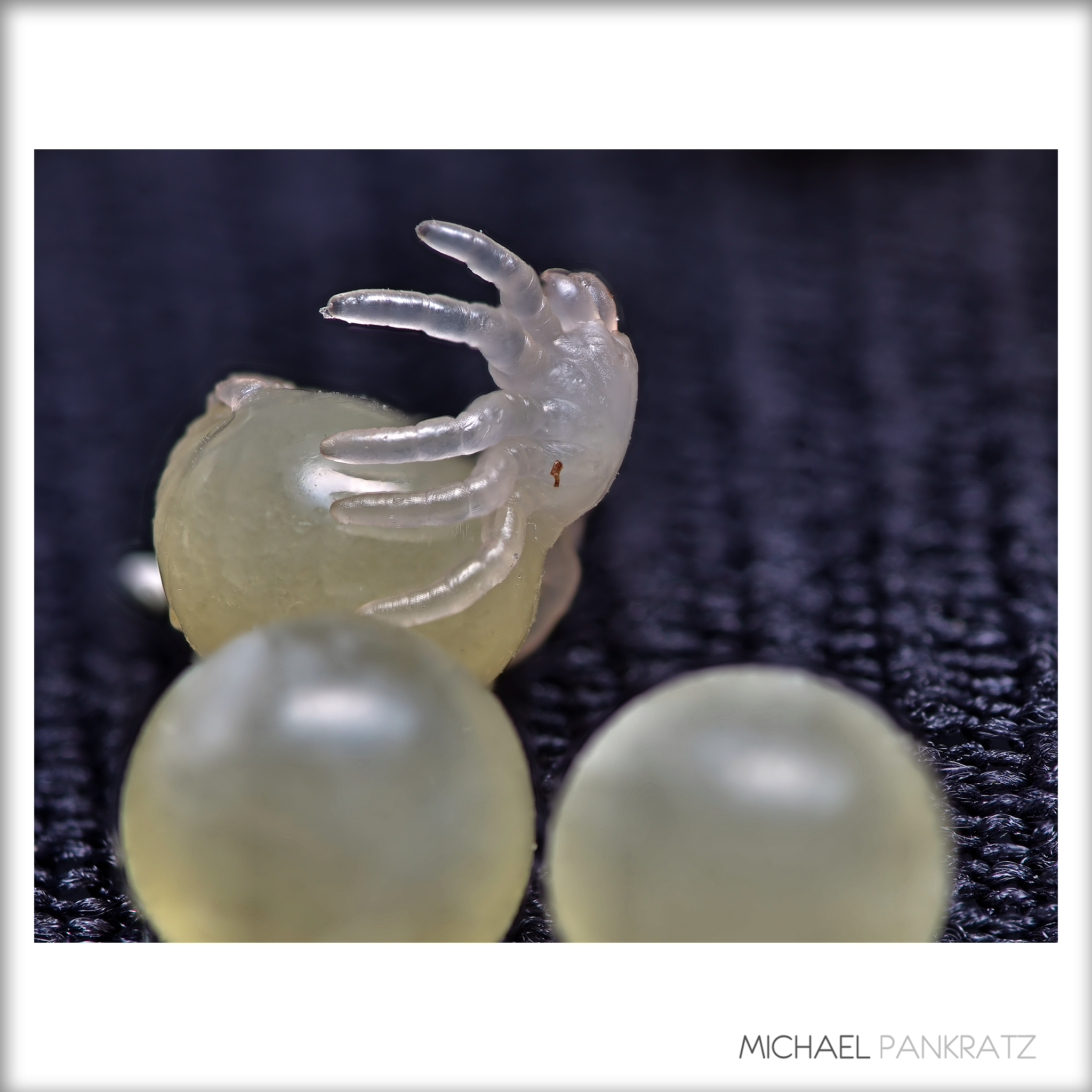
Once the tarantula embryo is sufficiently developed, the legs and torso (cephalothorax and 'carapace') break through the egg's thin outer membrane ... and the mass of the egg itself essentially becomes the abdomen.
So why does this spider have TEN legs? The front two are actually pedipalps, which the male (although both sexes have them) uses to inject sperm while breeding. See this image of a male charging its emboli with sperm, www.flickr.com/photos/_papilio/6028456151/ . Ts also use their pedipalps much like a pair of hands. The two stubby appendages at the top are its chelicerae, at the ends of which are the T's fangs.
The area with the reflection is of course the T's belly, and the tiny protuberances at the tail are the spinnerets.
These are EWLs, Eggs With Legs. :)
7 stacked images
Sahoro, Shintoku. Visit beautiful Hokkaido !
Canon T70, NFD 50mm F1.8, Kodak Microfilm Imagelink HQ, exposed as ISO 40, developed as described before, scanned with Plustek OpticFilm 120, edited with GIMP. Bigger sizes: www.flickr.com/photos/threepinner/49256444813/sizes/ up to 10000 × 6627 pixels compatible. Learn DIY development and upgrade to film !
Developed at home with the Digibase C-41 kit using the 37°c method.
Canonet GIII QL17
Canon 40mm f/1.7mm
Kodak Ultramaxx 400
Converted to B&W in LR5
I eventually got around to finishing off the film in my Canonet QL17, that I bought just over a year or so ago.
This is a shot of a very popular snack bar in Berlin, famous for their curry flavoured tomato sauce covered sausages....known as a 'Currywurst'.
It was that long ago (April 2019) I even forgot I took this shot :0)
I'm really please with the quality of the images produced by this rangefinder....looking forward to giving it a good day out.
Thanks for taking the time to view my image. Your comments, faves & constructive criticism are greatly appreciated.
Iron Dome (Hebrew: כִּפַּת בַּרְזֶל, romanized: Kippat Barzel) is a mobile all-weather air defense system[8] developed by Rafael Advanced Defense Systems and Israel Aerospace Industries.[7] The system is designed to intercept and destroy short-range rockets and artillery shells fired from distances of 4 kilometres (2.5 mi) to 70 kilometres (43 mi) away and whose trajectory would take them to an Israeli populated area.[9][10] From 2011 to 2021, the United States contributed a total of US$1.6 billion to the Iron Dome defense system,[11] with another US$1 billion approved by the US Congress in 2022.[12][needs update]
Iron Dome
IDF Iron Dome 2021.jpg
Iron Dome launches interceptor, 2021
Type
C-RAM and short range air defence system[1]
Place of origin
Israel
Service history
In service
2011–present
Used by
Israel Defense Forces
Wars
Gaza–Israel conflict (2011, 2012, 2021)
Operation Pillar of Defense
Operation Protective Edge
Sinai insurgency
2021 Israel–Palestine crisis
Operation Breaking Dawn
Production history
Designer
Rafael Advanced Defense Systems
Israel Aerospace Industries
Designed
2005
Manufacturer
Rafael Advanced Defense Systems
Israel Aerospace Industries
Unit cost
$50 million per battery[2]
$100,000–150,000 per interception[3]
Produced
2011–present
No. built
10 batteries deployed[4] (planned deployment is 15)[5][6]
Specifications
Mass
90 kg (200 lb)[7]
Length
3 m (9.8 ft)[7]
Diameter
160 mm (6.3 in)[7]
Detonation
mechanism
Proximity fuze[8]
Maximum speed
Mach 2.2
Launch
platform
Three/four launchers, each carrying 20 interceptors.
1:31
Short video about Iron Dome from the Israeli News Company
The EL/M-2084 active electronically scanned array scaled down derivative radar of the Iron Dome
US Ambassador Dan Shapiro visits the Battle Management & Control (BMC) unit of the Iron Dome
Iron Dome was declared operational and initially deployed on 27 March 2011 near Beersheba.[13] On 7 April 2011, the system successfully intercepted a rocket launched from Gaza for the first time.[14] On 10 March 2012, The Jerusalem Post reported that the system shot down 90% of rockets launched from Gaza that would have landed in populated areas.[10] In late 2012 Israel said that it hoped to increase the range of Iron Dome's interceptions, from a maximum of 70 kilometres (43 mi) to 250 kilometres (160 mi) and make it more versatile so that it could intercept rockets coming from two directions simultaneously.[15]
In November 2012, official statements indicated that it had intercepted over 400 rockets.[16][17] By late October 2014, the Iron Dome systems had intercepted over 1,200 rockets.[18]
In addition to their land-based deployment, it was reported in 2017 that Iron Dome batteries would in future be deployed at sea on Sa'ar 6-class corvettes, to protect off-shore gas platforms in conjunction with Israel's Barak 8 missile system.[19]
Background
Name
Specifications
Funding
Plans for co-production with the United States
Development
Deployment
Deployment at sea
Foreign sales
Effectiveness
Criticism
See also
References
External links
Last edited 3 days ago by AnomieBOT
RELATED ARTICLES
Israeli Air Defense Command
List of Palestinian rocket attacks on Israel in 2011
March 2012 Gaza–Israel clashes
Israel Defense Forces military operation in the Gaza Strip
Wikipedia
Content is available under CC BY-SA 3.0 unless otherwise noted.
Privacy policy Terms of Use Desktop
Scanned print.
Mamiya 645 ProTL with Mamiya-Sekor 80 mm/f1.9.
Åmål, Dec 29, 2018.
Fomapan 100 @ box speed, developed in Fomadon R09 1:100, semistand one hour.
Printed on Fomatone MG 131 (24x30 cm) and toned in selenium.
For a good friend that I barely knew, but knew well enough to call him that. This one is for you, Henry. Thank you for surprising me, and for always having time to say hello. You were one of my favorites so far in this life. I know you're still smiling.
Mikasa, Hokkaido.
Mamiya Universal press shot on a monopod, Sekor 50mm F6.3, Acros exosed as ISO 50, developed with SPD for four minutes at 20 DegC., scanned with Plustek OpticFilm 120 + VueScan at 5300 dpi, edited with GIMP.
Which sounds like a rather dreadful sports injury.
But is indeed the intersection of two barrel vaults.
patrickjoust | flickr | tumblr | IG | prints for sale
...
Mamiya C330 S and Sekor 80mm f/2.8
Bergger Pancro 400 developed in Rodinal (1:50)
downtown eureka, ca, usa
the sad story of the diana mini roll.
it sat in my purse for over a year
I thought it was color, but it was b&w
so I developed, but....
I usually load at night when it's dark in my walk-in, but I tried jordan's closet and realized after I got the film out that there was light in the darkness.
I had a hard time loading. I do 120 better than 35 mm.
I developed, fixed and then thought the fixer what probably bad so I re-mixed fixer, and rewashed.
then I dropped the film trying to unscrew the reel and got lint on it.
the result is grainy.
but fun.
[I am easily pleased]
Developed at home with the Digibase C-41 kit using the 37°c method.
Canonet GIII QL17
Canon 40mm f/1.7mm
Kodak Ultramaxx 400
Converted to B&W in LR5
The building in the background is the Kaiser Wilhelm Memorial Church also known as the Gedächtniskirche in Berlin.
The church has not been repaired since it was damaged in a bombing raid in 1943 and stands as a reminder of WW2.
Thanks for taking the time to view my image. Your comments, faves & constructive criticism are greatly appreciated.
This was a little bit of imaging fun. I photographed this scene at night. It was pitch black out, so I did a 15 second exposure at f/3.2, and ISO 1000. The OM-D E-M1 was set to manual and mounted to a tripod. I employed the 7-14mm f/2.8 Pro at 7mm. I'd chosen the exposure values just to get a sense of the sky colour. I was hoping I'd see some green from the aurora colouring the clouds, at which point, I'd take a real photo. Unfortunately, there was absolutely nothing visible so with the heavy cloud and lack of aurora activity, I packed it in and went home.
While my night photo was never intended to be a finished image, one experiment can often lead to another so I wondered what I could achieve with the new version of DxO PhotoLab if I processed the picture anyway. To make a long story shorter, just getting a reasonably exposed photo was a feat. I had to raise exposure by well over a stop in post in order to get some detail from the darkly underexposed scene. This caused a fair bit of noise to appear, which I subsequently removed using the "DeepPrime" algorithm in DxO PhotoLab 6. The result was acceptable--the noise was essentially gone, but given its extreme prevalence, there was some significant smudging in the darkest areas. In fact, I felt that the image had developed a painterly quality in many respects. This caused me to wonder what I could do with the resulting image if I really went crazy and ran it through a paint program I own?
Well, one thing led to another, and my original photo has been transformed into a faux art painting. In fact, I rather like the result. Which goes to show that you can always achieve something if you're willing to try. Looking at this finished piece, it's hard to imagine that it started out as an almost black image taken on a very dark night with a small micro four-thirds sensor on a six year old camera.