View allAll Photos Tagged Positioning.
A nice set of color position light signals – including one "fully loaded" signal – guards the interlocking at Carroll in Baltimore, Maryland.
The color position light signal was first devised and prototyped near here in 1921, the first installation being between Camden Station and Mount Royal.
As CSX continues to replace the venerable B&O classics over time, it's likely the color position lights in Baltimore will be among the last survivors of this type of signal on the system – perhaps this is fitting.
Different Position – Sir you are now a women 8
transgenre.silicone-breast.com/2016/11/04/different-posit...
imgur.com/NOHZhPO.jpg?utm_source=rss&utm_medium=rss
Notice : Releasing this comic on every Monday to Thursday
With the dark nights of the fall, I get interest to work with remote flash again. Last fall, I read through "Lighting 101" and started "Lighting 102" by Strobist, but I did not have functioning gear yet to start experimenting with off-camera flash. Now I have (some of the) gear, and the same desire as a year ago to learn to use additional light in some of the photography work.
So, I will start going through the excercises of Lighting 102. This is a result of making the first exercise. The only thing that changed was the angle of the flash to the subject, everything else remained constant. The flash was at the table about at the same level with the subject. I went around the subject, taking a photo roughly every 30 degrees.
Strobist info: Canon 430 EX II flash triggered with PW MiniTT1, FlexTT5, AC3. Distance to subject about 30 cm, 1/32 power, camera-to-subject about 1.5 m.
Original assignment:
strobist.blogspot.com/2007/06/lighting-102-unit-11-positi...
Camera: Calypso/Nikkor II
Lens: W-Nikkor 35mm f/2.5 Prime
Film: Fujifilm Fujicolor C200 (C41 Colour Negative)
Experimenting
© Britta Niermeyer All Rights Reserved. No usage allowed including copying or sharing without written permission.
From Marie in the Forest, a children's book from Webster Press in which the Degas Little Dancer sculpture is imagined to go come to life and dance through the woods with various animals. (It's black and white because the book can be colored by the reader.) www.websterpress.com for full text PDF if interested :-)
My Toyota Camry on Pole position at the Mount Panorama (Bathurst) track. (The track is a 'normal' road when not being used for motor racing
Strobist info: Bare Flash settings ( 1/128 ; 85mm-zoom- , @ 2 feet away from subject ) with a snoot to restrict the light tilted down @ about 30°.
Camera : was 1/250s , f/9 ; ISO: 200.canon 300D, 28-105mm f/3.5 4.5
Kevin Aitcheson
James Kevin Aitcheson
Born: November 27, 1960 in Stratford, Ontario, Canada
Position: Outfielder
Bats: Left, Throws: Right
Height: 6' 2", Weight: 190 lb.
Newspaper report (2 May 1981) Blue Jays sign Aitcheson TORONTO (AP) Kevin Aitcheson, considered by many baseball scouts to be the best non-pitching prospect in Canada, has signed with the Toronto Blue Jays, the American League club said yesterday. Aitcheson, a 20-year-old outfielder from Stratford, Ontario, is to report to the Blue Jays' Pioneer League rookie affiliate at Medicine Hat, Alberta, in June.
The Phillies made him a contract offer, but being a proud Canadian, Aitcheson had dreams of playing for the Toronto Blue Jays and contacted the club to see if they would match Philadelphia's offer. They did, but a part of Aitcheson wishes they didn't. Looking back, he says if he could change one thing in his sports career it would be to sign with Philly, who weren't nearly as deep at the outfield position, rather than with T.O. "In hindsight, with the Jays having (Lloyd) Moseby, (Jesse) Barfield and (George) Bell, who were all my age, already in the outfield, it was an awful bad decision," said Aitcheson with a laugh. "The Phillies were struggling...so if I had one thing I could do over again I would have been very satisfied to sign with Philadelphia."
Aitcheson is unsure whether or not he could have eventually made it onto the Phillies roster, but he would have loved a chance. "I just wish I would have had an opportunity to hit at the triple-A level," said Aitcheson, who recently had his jersey added to Stratford's baseball Wall of Fame. "
Despite never getting a crack at triple-A or the big leagues, Aitcheson had a successful four-year minor career.
After signing with Toronto, Aitcheson was sent to the Jays' affiliate in Medicine Hat, Alta. where he set the league record for games played and batted .301.
The following year, while with single-A Carolina, he was selected to play in the All Star game.
But Aitcheson says some of his most profound memories in baseball came from his two years of double-A ball in Knoxville, playing alongside future major leaguers such as Cecil Fielder, Fred McGriff, David Wells, John Cerutti, Jimmy Key and Mike Sharperson.
Returning to Stratford after failing to make the Jays' triple-AAA affiliate, Aitcheson finished out his career playing with the Stratford Hillers from 1985-91.
Minor league stats (4 seasons / 1981 - 1984)
Hits - 410
Doubles - 53
HR - 19
RBI - 171
Batting Average - .269
Link to all of his issued baseball cards - www.tradingcarddb.com/Person.cfm/pid/75454/col/1/yea/0/Ke...
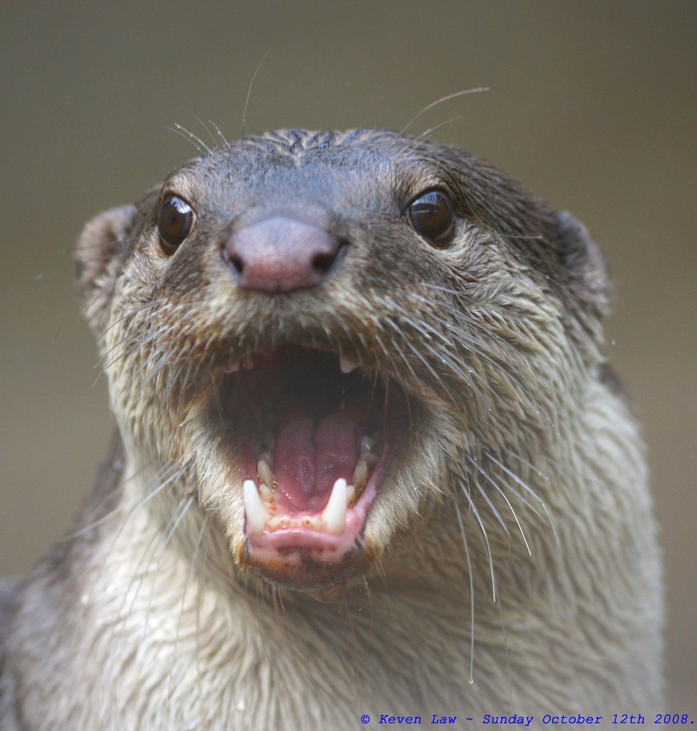
Highest Explore Position #494 ~ On October 28th 2008.
Smooth-coated Otter - Rare Species Conservation Centre, Kent, England - Sunday October 12th 2008.
Click here to see the Larger image
Click here to see My most interesting images
Yup...me an Mr Otter here are Miffed that the Mighty Hammers were robbed by inept refereeing at the footie game today...as much as I don't like Carlton Cole...twas NEVER!!! a SENDING OFF!!!...And..the Gooners first goal was a lucky own goal....GRRRRR!!!!!!!!!
Still...I now watching the first NFL league match to be played in London (At Wembley Stadium) for 10 years at the mo...and guess what...the team I am supporting San Diego...are loosing...It's not a good sporting weekend for me..:O((
Plus I have noooooooooo idea what's going in the game...apparently...if you have a great "Tight End" that's a good thing...lol..:O)))
From Wikipedia, the free encyclopedia ~ The Smooth-coated Otter (Lutrogale perspicillata) is a species of otter, the only extant representative of the genus Lutrogale. The species is found from India east to Southeast Asia, and there is a disjunct population in Iraq. As its name indicates, the fur of this species is smoother and shorter than that of other otters.
Distribution and Habitat ~ Smooth-coated otters occur throughout much of southern Asia, in the Indomalaya ecozone, from India eastward. There is also an isolated population of the species found in the marshes of Iraq. Smooth-coated otters are found in areas where water is plentiful- peat swamp forests, freshwater wetlands, large forested rivers, lakes, and rice paddies. Smooth-coated otters have adapted to life in an aqueous biome, but are nonetheless comfortable on land, and may travel long distances overland in search of suitable habitat. Their holts are within shallow burrows, rock heaps or driftwood piles. Some may construct permanent holts near water, in a layout similar to the of a beaver dam, with an underwater entrance and a tunnel that leads to a nest above the water.
Conservation Status ~ The Smooth-coated Otter is listed as a vulnerable species. The range and population of smooth-coated otters is shrinking due to loss of wetland habitat, poaching, and contamination of waterways by pesticides. Smooth-coated otters are protected in India under the Wildlife (Protection) Act, 1972, and are listed as endangered.
Description ~ Smooth-coated otters are the largest otters in southeast Asia, from 7-11 kg in weight and up to 1.3 m in length as adults. Smooth-coated otters may be distinguished from other species of otter by a more rounded head and a hairless nose in the shape of a distorted diamond. The tail is flattened, in contrast to the more rounded tails of other species, and may be up to 60 percent of the total body length. Like other otters, smooth-coated otters have webbed toes and strong paws with sharp claws.
The coat of smooth-coated otters is shorter and smoother than that of other otters species. The fur is light to dark brown along the back, while the underside is light brown to almost gray in color.
Behavior ~ Smooth-coated otters, like many carnivorous mammals, use scent to communicate both within the otter species, and with other animals. Each otter possesses a pair of scent glands at the base of the tail which are uses to mark land or objects, such as rocks or vegetation, near feeding areas in a behavior called sprainting.
Diet ~ Smooth-coated otters eat insects, earthworms, crustaceans, frogs, water rats, turtles, birds, and fish. Fish comprise between 75 to 100% of the otter's diet.[citation needed] Smooth-coated otters frequently hunt in groups, herding schools of fish together for easier feeding.[citation needed] A group of otters can have a feeding range of 7 to 12 square kilometers. A single adult consumes about 1 kg of food per day in captivity.
Reproduction ~ Smooth-coated otters form strong monogamous pairs. The specific mating times of the smooth-coated otter are unknown, but when otters are dependent on monsoons for precipitation, breeding occurs between August and December. Once mating has occurred, the gestation period is 61-65 days. Smooth-coated otters give birth to and raise their young in a burrow near water, which they may construct themselves or may assume an abandoned one. Two to five cubs are produced per litter. At birth, the cubs are blind and helpless, but after thirty days their eyes open, and after sixty days, the cubs can swim. They are weaned at about 130 days, and leave their parents at about 1 year of age. Sexual maturity is reached at two years of age.
Ideal sex positions
Ideal sex positions All these are ideal sex positions. Sex is a complicated issue and every young male and female want to know about sex. You can say on sex “ We waste time looking for the perfect lover, instead of creating the perfect love” Sex lovers like all these pos...
A View Around The No.2 End Drivers Seat Of Network Rails 97302 While Stabled In Bescot Yard.
Saturday 18th April 2015
Our friends from the PSNI preparing for the NorthWest 200 'After Party'
Mono conversion for the Mono MAYhem Group
Sex positions shot glass
For these items, visit Prime Time Print www.primetimeprint.com The Glass Mall www.theglassmall.com
Strobist;
Cámara: Olympus E-3
Objetivo : Zuiko 12-60
Flash: Metz 58 AF; Manual a 1/8
f/11 - 1/250 - ISO 100
Cactus sin modificaciones
Ejercicio LIGHTING 102 / POSITION/ ANGLE
El flash se ha ido colocando a niveld ela mdoelo, pero canbiando 45º de una toma a otra.
As seen at New Freedom, PA. While the trackage is used by the NCRR. The signal has long been abandoned. It was made by the Union Switch and Signal Co. US&S was founded in 1881 by George Westinghouse and operated independently until 1917, then becoming a part of Westinghouse Brake Co.
Update: Turns out that it is actually a Safetran signal. The position lights were replaced by Conrail. This specific signal was later refurbished by an amtrak employee for use with the North Central Dinner Train. It was battery powered at that time. It apparently sits unused, currently.
This was taken on my 4h trip onboard the Finnish icebreaker SAMPO this march. Very impressive trip and the crew was very nice. On the right you can see a lot of snowmobiles. It is possible to book a combination-trip where you ride on snowmobiles from Kemi over the frozen sea and then meet SAMPO. Great stuff!
Remember that Wasp Spider I posted a few weeks ago? I visited him again days later.
He grew in size, assumed the perfect position and colors and light were better than the previous time!
Location: Ciconio Canavese, Torino, Piemonte, Italy
Canon EOS 60D with Sigma 150mm f/2.8 EX DG OS HSM Macro, single shot
One of the greatest band names of all times. This photo is the evidence that you can even fucking rock out with a bottle of mineral water behind you. D'oh.
Lighting Angle assignment. 1x Minolta Auto128 ±90° sweep in 30° increments.
Follow my L102 journey at ericspaethphotography.blogspot.com/
haven't been keeping this updated, but i'm going to start using different cameras, literally any i can find to achieve a different look.
Calais (/ˈkæleɪ/ cal-ay, traditionally /ˈkælɨs/; French pronunciation: [kaˈlɛ]; Picard: Calés; Dutch: Kales) is a town and major ferry port in northern France in the department of Pas-de-Calais, of which it is a sub-prefecture. Although Calais is by far the largest city in Pas-de-Calais, the department's prefecture is its third-largest city of Arras. The population of the metropolitan area at the 2010 census was 126,395. Calais overlooks the Strait of Dover, the narrowest point in the English Channel, which is only 34 km (21 mi) wide here, and is the closest French town to England. The White Cliffs of Dover can easily be seen on a clear day from Calais. Calais is a major port for ferries between France and England, and since 1994, the Channel Tunnel has linked nearby Coquelles to Folkestone by rail.
Due to its position, Calais since the Middle Ages has been a major port and a very important centre for transport and trading with England. It was annexed by Edward III of England in 1347 and grew into a thriving centre for wool production. Calais was a territorial possession of England until its capture by France in 1558. The town came to be called the "brightest jewel in the English crown" owing to its great importance as the gateway for the tin, lead, lace and wool trades (or "staples"). In 1805 it was a staging area for Napoleon's troops for several months during his planned invasion of the United Kingdom. The town was virtually razed to the ground during World War II, when in May 1940, it was a strategic bombing target of the invading German forces who took the town during the Siege of Calais. During World War II, the Germans built massive bunkers along the coast in preparation for launching missiles on England.
The old part of the town, Calais proper (known as Calais-Nord), is situated on an artificial island surrounded by canals and harbours. The modern part of the town, St-Pierre, lies to the south and south-east. In the centre of the old town is the Place d'Armes, in which stands the Tour du Guet, or watch-tower, a structure built in the 13th century, which was used as a lighthouse until 1848 when a new lighthouse was built by the port. South east of the Place is the church of Notre-Dame, built during the English occupancy of Calais. It is arguably the only church built in the English perpendicular style in all of France. In this church former French President Charles de Gaulle married his wife Yvonne Vendroux. South of the Place and opposite the Parc St Pierre is the Hôtel-de-ville (the town hall), and the belfry from the 16th and early 17th centuries. Today, Calais is visited by more than 10 million annually. Aside from being a key transport hub, Calais is also a notable fishing port and a centre for fish marketing, and some 3,000 people are still employed in the lace industry for which the town is also famed.
History
Early history
Although the early history of habitation in the area is limited, the Romans called the settlement Caletum. Julius Caesar mustered 800 to 1,000 sailing boats, five legions and some 2,000 horses at Calais due to its strategic position to attack Britannia.[1] At some time prior to the 10th century, it would have been a fishing village on a sandy beach backed by pebbles and a creek,[2] with a natural harbour[3] located at the western edge of the early medieval estuary of the River Aa. As the pebble and sand ridge extended eastward from Calais, the haven behind it developed into fen, as the estuary progressively filled with silt and peat. Subsequently, canals were cut between Saint-Omer, the trading centre formerly at the head of the estuary, and three places to the west, centre and east on the newly formed coast: respectively Calais, Gravelines and Dunkirk.[4] Calais was improved by the Count of Flanders in 997 and fortified by the Count of Boulogne in 1224.[1][3]
The first document mentioning the existence of this community is the town charter granted by Mathieu d'Alsace in 1181 to Gerard de Guelders, Count of Boulogne; Calais thus became part of the county of Boulogne.[1][5] In 1189, Richard the Lionheart is documented to have landed at Calais on his journey to the Third Crusade.[1] In medieval times, the settlement was inhabited by people who spoke Dutch, and who called it Kales.[citation needed] It is mentioned in Welsh documents as Caled, in Irish documents as Calad and in Breton documents as Kaled.
English wool trade interests and King Edward III's claims to be heir to the Kingdom of France led to the Battle of Crécy between England and France in 1346,[6] followed by Edward's siege and capture of Calais in 1347.[7] Angered, the English king demanded reprisals against the town's citizens for holding out for so long and ordered that the town's population be killed en masse. He agreed, however, to spare them, on condition that six of the principal citizens would come to him, bareheaded and barefooted and with ropes around their necks, and give themselves up to death.[8] On their arrival he ordered their execution, but pardoned them when his queen, Philippa of Hainault, begged him to spare their lives.[9][10] This event is commemorated in The Burghers of Calais (Les Bourgeois de Calais), one of the most famous sculptures by Auguste Rodin, erected in the city in 1895.[11] Though sparing the lives of the delegation members, King Edward drove out most of the French inhabitants, and settled the town with English. The municipal charter of Calais, previously granted by the Countess of Artois, was reconfirmed by Edward that year (1347).[12]
In 1360 the Treaty of Brétigny assigned Guînes, Marck and Calais—collectively the "Pale of Calais"—to English rule in perpetuity, but this assignment was informally and only partially implemented.[13] On 9 February 1363 the town was made a staple port.[14] It had by 1372 become a parliamentary borough sending burgesses to the House of Commons of the Parliament of England.[15] It remained part of the Diocese of Thérouanne from 1379, keeping an ecclesiastical tie with France.[16]
The town came to be called the "brightest jewel in the English crown" owing to its great importance as the gateway for the tin, lead, cloth and wool trades (or "staples").[17] Its customs revenues amounted at times to a third of the English government's revenue, with wool being the most important element by far. Of its population of about 12,000 people, as many as 5,400 were recorded as having been connected with the wool trade. The governorship or Captaincy of Calais was a lucrative and highly prized public office; the famous Dick Whittington was simultaneously Lord Mayor of the City of London and Mayor of the Staple in 1407.[18]
Calais was regarded for many years as being an integral part of the Kingdom of England, with its representatives sitting in the English Parliament. The continued English hold on Calais however depended on expensively maintained fortifications, as the town lacked any natural defences. Maintaining Calais was a costly business that was frequently tested by the forces of France and the Duchy of Burgundy, with the Franco-Burgundian border running nearby.[19] The British historian Geoffrey Elton once remarked "Calais—expensive and useless—was better lost than kept".[20] The duration of the English hold over Calais was, to a large extent, the result of the feud between Burgundy and France, under which both sides coveted the town, but preferred to see it in the hands of the English rather than their domestic rivals. The stalemate was broken by the victory of the French crown over Burgundy following Joan of Arc's final battle in the Siege of Compiègne in 1430, and the later incorporation of the duchy into France.[21]
16th century
In 1532, English king Henry VIII visited Calais and his men calculated that the town had about 2400 beds and stabling to keep some 2000 horses.[22] In September 1552, the English adventurer Thomas Stukley, who had been for some time in the French service, betrayed to the authorities in London some French plans for the capture of Calais, to be followed by a descent upon England.[23] Stukley himself might have been the author of these plans.
On 7 January 1558, king Henry II of France sent forces led by Francis, Duke of Guise, who laid siege to Calais.[24] When the French attacked, they were able to surprise the English at the critical strongpoint of Fort Nieulay and the sluice gates, which could have flooded the attackers, remained unopened.[25] The loss was regarded by Queen Mary I of England as a dreadful misfortune. When she heard the news, she reportedly said, "When I am dead and opened, you shall find 'Philip' [her husband] and 'Calais' lying in my heart."[26] The region around Calais, then-known as the Calaisis, was renamed the Pays Reconquis ("Reconquered Country") in commemoration of its recovery by the French.[27] Use of the term is reminiscent of the Spanish Reconquista, with which the French were certainly familiar—and, since it occurred in the context of a war with Spain (Philip II of Spain was at the time Queen Mary's consort), might have been intended as a deliberate snub.[28] After that time the Dutch-speaking population was forced to speak French.
The town was captured by the Spanish on 24 April 1596 in an invasion mounted from the nearby Spanish Netherlands by Archduke Albert of Austria, but it was returned to France under the Treaty of Vervins in May 1598.[29][30]
17th century to World War I
Calais remained an important maritime city and smuggling center throughout the 17th century. However, during the next century the port of Calais began to stagnate gradually, as the nearby ports of Boulogne and Dunkirk began to rise and compete.
The French revolution at the end of the 18th century did not disturb Calais and no executions took place.[31]
World War II bunkers at Calais
In 1805, Calais hosted part of Napoleon's army and invasion fleet for several months before his aborted invasion of Britain.[32] From October to December 1818, the British army used Calais as their departing port to return home after occupying post-Waterloo France. General Murray appointed Sir Manley Power to oversee the evacuation of British troops from France. Cordial relations had been restored by that time and on 3 December the mayor of Calais wrote a letter to Power to express thanks for his "considerate treatment of the French and of the town of Calais during the embarkation."[33]
Debris from the Siege of Calais
The British Expeditionary Force or BEF arrived in Calais on its way to the nearby frontline cutting through Nord-Pas-de-Calais and Flanders. Calais was a key port for the supply of arms and reinforcements to the Western Front.[34] In the 1930s, the town was known for being a politically socialist stronghold.[35]
World War II
Calais was virtually razed to the ground during World War II.[36] In May 1940, it was a key objective of the invading German forces and became the scene of a last-ditch defence—the Siege of Calais—which diverted a sizable amount of German forces for several days immediately prior to the Battle of Dunkirk. 3,000 British and 800 French troops, assisted by Royal Navy warships, held out from 22 to 27 May 1940 against the 10th Panzer Division. The town was flattened by artillery and precision dive bombing and only 30 of the 3800-strong defending force were evacuated before the town fell. This may have helped Operation Dynamo, the evacuation of Allied forces at Dunkirk, as 10th Panzer would have been involved on the Dunkirk perimeter had it not been busy at Calais.[37] Between 26 May and 4 June 1940, some 330,000 Allied troops escaped from the Germans at Dunkirk.[38]
During the ensuing German occupation, it became the command post for German forces in the Pas-de-Calais/Flanders region and was very heavily fortified, as it was generally believed by the Germans that the Allies would invade at that point.[39] It was also used as a launch site for V1 flying bombs and for much of the war, the Germans used the region as the site for railway guns used to bombard the south-eastern corner of England. In 1943 they built massive bunkers along the coast in preparation for launching missiles on the southeast of England.[40] Despite heavy preparations for defence against an amphibious assault, the Allied invasion took place well to the west in Normandy on D-Day. Calais was very heavily bombed and shelled in a successful effort to disrupt German communications and persuade them that the Allies would target the Pas-de-Calais for invasion (rather than Normandy). The town, by then largely in ruins, was liberated by General Daniel Spry's 3rd Canadian Infantry Division between 25 September and 1 October 1944.[41] On 27 February 1945 Calais suffered a last bombing raid—this time by British bombers who mistook the town for Dunkirk, which was at that time still occupied by German forces.[42] After the war there was little rebuilding of the historic city and most buildings were modern ones.
21st century - migration issues
Since 1999 or earlier, an increasingly large number of migrants and refugees have started to arrive in the vicinity of Calais, where they remain living in the Calais jungle, the nickname given to a series of makeshift camps. The people live there while they attempt to enter the United Kingdom by stowing away on lorries, ferries, cars, or trains travelling through the Port of Calais or the Eurotunnel Calais Terminal.[43] The people are a mix of refugees, asylum seekers and economic migrants from Darfur, Afghanistan, Syria, Iraq, Eritrea and other troubled areas of the world.
The Calais migrant crisis[44] led to escalating tension between the UK and France in the summer of 2015.[45] The UK blamed France for not doing enough to stop migrants from entering the tunnel or making attempts to scale fences built along the border. The British Prime Minister David Cameron released a statement saying that illegal immigrants would be removed from the UK even if they reach the island.[46] To discourage migrants and refugees from jumping on train shuttles at Calais, the UK government supplied fencing to be installed in the Eurotunnel where the vehicles are loaded on to train shuttles in Calais.
Geography and climate
Calais is located on the Pas de Calais, which marks the boundary between the English Channel and North Sea and located at the opposite end of the Channel Tunnel, 34 kilometres (21 miles) from Dover. On a clear day the White cliffs of Dover can be viewed across the channel.[47] Aside from being an important port and boarding point between France and England, it is at the nucleus of many major railway and highway networks and connected by road to Arras, Lens, Béthune and St. Omer. Dunkirk is located about 47 km (29 mi) by road to the east.[48] Calais is located 288 km (179 mi) north by road from the French capital of Paris, roughly a 3-hour 15 minute journey.[48] The commune of Calais is bordered by the English channel to the north, Sangatte and Coquelles to the west, Coulogne to the south and Marck to the east. The core area of the city is divided into the Old Town area within the old city walls, and the younger suburbs of St. Pierre, which are connected by a boulevard.
Calais is part of the Côte d'Opale (Opal Coast), a cliff-lined section of northern French coast that parallels the white cliffs on the British coast and is part of the same geological formation. It is known for its scenic cliffs such as Cape Blanc Nez and Cape Gris Nez and for its wide area of dunes. Many artists have been inspired by its landscapes, among them the composer Henri Dutilleux, the writers Victor Hugo and Charles Dickens, and the painters J. M. W. Turner, Carolus-Duran, Maurice Boitel and Eugène Boudin. It was the painter Édouard Lévêque who coined the name for this area in 1911 to describe the distinctive quality of its light.[49]
The climate is temperate oceanic in Calais. Temperature ranges are moderate and the winters are mild with unstable weather. It rains on average about 700 to 800 mm (28 to 31 in) per year.
Economy
Town centre
The city's proximity to England has made it a major port for centuries. It is the principal ferry crossing point between England and France, with the vast majority of Channel crossings being made between Dover and Calais. Companies operating from Calais include SeaFrance (currently in liquidation[57]), DFDS Seaways,[58] and P&O Ferries.[59] The French end of the Channel Tunnel is situated in the vicinity of Calais, in Coquelles some 4 miles (6.4 km) to the west of the town. Calais possesses direct rail links to Paris, 148 miles (238 km) to the south. More than 10 million people visit Calais annually.[32]
From medieval times, English companies thrived in Calais. Calais was a particularly important centre in the production and trade of wool and cloth, which outweighed the costs of maintaining the town as part of England. In 1830 some 113 manufacturers were based in Calais and the St Pierre suburbs, the majority of which were English.[60] There are still two major lace factories in Calais with around 700 looms and 3000 employees.[60] The town exports in the early 20th century were lace, chemicals, paper, wines, especially champagne, spirits, hay, straw, wool, potatoes, woven goods, fruit, glass-ware, lace and metal-ware.[61] Principal imports in the early 20th century included cotton and silk goods, coal, iron and steel, petroleum, timber, raw wool, cotton yarn and cork.[61] During the five years 1901–1905 the average annual value of exports was £8,388,000 (£6,363,000 in the years 1896–1900), of imports £4,145,000 (£3,759,000 in 1896–1900).[61]
As a fishing port, Calais has several notable fishing markets including Les Délices de la Mer and Huîtrière Calaisenne on the Boulevard La Fayette, the latter of which is noted for its oysters, lobster and crabs from Brittany. The Emile Fournier et Fils market on the Rue Mouron sells mainly smoked fish including salmon, trout, herring and halibut.[62]
Notable landmarks
Place d'Armes
Place d'Armes is one of the largest squares in the city of Calais, adjoins the watchtower, and during medieval times was once the heart of the city. During the English occupation (1347–1558), it became known as Market Square (place du Marché). Only at the end of English occupation did it take the name of Place d'Armes. After the reconquest of Calais in 1558 by Francis, Duke of Guise, Francis II gave Calais the right to hold a fair twice a year on the square, which still exists today, as well as a bustling Wednesday and Saturday market.[63]
Hôtel de Ville
The town centre, which has seen significant regeneration over the past decade, is dominated by its distinctive town hall (Hôtel de Ville) at Place du Soldat Inconnu. It was built in the Flemish Renaissance style between 1911 and 1925 to commemorate the unification of the cities of Calais and Saint Pierre in 1885.[64] A previous town hall had been erected in 1818.[65] One of the most elegant landmarks in the city, its ornate 74 metre (246 ft) high clock tower and belfry can be seen from out to sea and chimes throughout the day and has been protected by UNESCO since 2005 as part of a series of belfries across the region.[66] The building parts have also been listed as a series of historic monuments by government decree of 26 June 2003, including its roofs and belfry, main hall, glass roof, the staircase, corridor serving the first floor, the rooms on the first floor (including decoration): the wedding room, the VIP lounge, the lounge of the council and the cabinet room. The hall has stained glass windows and numerous paintings and exquisite decor.[64] It houses police offices.[35]
Église Notre-Dame
Église Notre-Dame is a cathedral which was originally built in the late 13th century and its tower was added in the late 14th or early 15th century. Like the town hall it is one of the city's most prominent landmarks. It was arguably the only church in the English perpendicular style in France.[67] Much of the current 1400 capacity church dates to 1631–1635.[67] It contains elements of Flemish, Gothic, Anglo-Norman and Tudor architecture. In 1691, an 1800 cubic metre cistern was added to the church under orders by Vauban.[68] The church is dedicated to the Virgin, and built in the form of a cross, consisting of a nave and four aisles—[69] The old grand altar dated to 1628 and was built from Carrara marble wrecked on the coast, during its transit from Genoa to Antwerp. It contained eighteen figures, the two standing on either side of the altar-piece—representing St. Louis and Charlemagne.[69] The organ—of a deep and mellow tone, and highly ornamented by figures in relief—was built at Canterbury sometime around 1700. The pulpit and reading-desk, richly sculptured in oak, is another well-executed piece of ecclesiastical workmanship from St. Omers. The altar-piece, the Assumption, was often attributed to Anthony van Dyck, though in reality it is by Van Sulden; whilst the painting over the side altar, believed to be by Peter Paul Rubens.[69] A high and strongly built wall, partaking more of the fortress than a cathedral in its aspect, flanks the building, and protects it from the street where formerly ran the old river, in its course through Calais to the sea.[69]
The square, massive Norman tower has three-arched belfry windows on each face, surmounted by corner turrets, and a conically-shaped tower of octagonal proportions, topped again by a short steeple. The tower was a main viewing point for the Anglo-French Survey (1784–1790) which linked the Paris Observatory with the Royal Greenwich Observatory using trigonometry. Cross-channel sightings were made of signal lights at Dover Castle and Fairlight, East Sussex.
The church was assigned as a historic monument by decree of 10 September 1913, only to have its stained glass smashed during a Zeppelin bombardment on 15 January 1915, falling through the roof.[70][71] General de Gaulle married Yvonne Vendroux on 6 April 1921 at the cathedral.[68] The building experienced extensive damage during World War II, and was partially rebuilt, although much of the old altar and furnishings were not replaced.
Towers
Tour de Guet
The Tour du Guet (Watch Tower), situated in Calais Nord on the Places d'Armes, is one of the few surviving pre-war buildings. Dating from 1229, when Philip I, Count of Boulogne, built the fortifications of Calais, it is one of the oldest monuments of Calais, although the oldest remaining traces date to 1302.[72] It has a height of 35–39 metres (sources differ). An earthquake in 1580 split the tower in two, and at one time it threatened to collapse completely.[73] The tower was repaired in 1606, and then had the purpose of serving as a hall to accommodate the merchants of Calais.[73] It was damaged in 1658 when a young stable boy set fire to it, while it was temporarily being used as royal stables during a visit of King Louis XIV.[74] It was not repaired for some 30 years. In 1770,[39] a bell identical to the original bell of 1348 was cast. Due to its height, from the late 17th century it became an important watchout post for the city for centuries until 1905;[72] the last keeper of the tower was forced to leave in 1926. Abraham Chappe, (a brother of Ignace Chappe) installed a telegraph office in the tower in 1816 and operated for 32 years.[65] It was this office which announced the death of Napoleon I to the French public in 1821. It also had the dual function as lighthouse with a rotating beacon fuelled by oil from 1818.[72] The lantern was finally replaced by a new lighthouse on 15 October 1848. During the First World War, it served as a military observation post and narrowly missed destruction during World War II.[73] This tower has been classified as a historic monument since 6 November 1931.[73]
The Calais Lighthouse (Le phare de Calais) was built in 1848, replacing the old watch tower as the lighthouse of the port. The 55 metre high tower was electrified in 1883 and automated in 1992. The staircase has 271 steps leading up to the lantern. By day it is easily distinguishable from other coastal lighthouses by its white color and black lantern. The lighthouse was classified as a historical monument on 22 November 2010.
Forts
The Citadel of Calais
The Citadel, located on the Avenue Roger Salengro, was built between 1560 and 1571 on the site of a former medieval castle which was built in 1229 by Philippe de Hureprel.[29] Its purpose of its construction was to fend off would-be invaders, but it wasn't long until the city was successfully invaded by Archduke Albert of Austria on 24 April 1596. Both Louis XIII and Cardinal Richelieu at one time considered expanding the citadel and Calais into a great walled city for military harbour purposes but the proposals came to nothing.[29]
Fort Risban
Fort Risban, located on the coast on the Avenue Raymond Poincaré at the port entrance, was besieged by the English in November 1346 and was used by them until 1558 when Calais was restored to France. In 1596, the fort was captured by the Spanish Netherlands until May 1598 when it was returned to the French following the Treaty of Vervins. It was rebuilt in 1640.[75] Vauban, who visited the fort some time in the 1680s, described it as "a home for owls, and place to hold the Sabbath" rather than a fortification.[76] During World War II it served as an air raid shelter. It contains the Lancaster Tower, a name often given to the fort itself.[73]
Fort Nieulay, located along the Avenue Pierre Coubertin originally dated to the 12th or 13th century. During the English invasion in 1346, sluices gates were added as water defences and a fort was built up around it in 1525 on the principle that the people of the fort could defend the town by flooding it.[77] In April and May 1677, Louis XIV and Vauban visited Calais and ordered a complete rebuilding of Fort Nieulay. It was completed in 1679, with the purpose to protect the bridge of Nieulay crossing the Hames River.[78] By 1815 the fort had fallen into a ruined state and it wasn't until 1903 that it was sold and improved by its farmer tenants.[77] The fort was briefly the site of a low-key scuffle with Germans in May 1940.
Museums, theatres and cultural centres
Calais Theatre
Calais contains several museums. These include the Musée des Beaux-Arts et de la Dentelle de Calais, Cité internationale de la Dentelle et de la Mode de Calais and the Musée de la Seconde Guerre Mondiale (World War II museum). Cité internationale de la Dentelle et de la Mode de Calais is a lace and fashion museum located in an old Boulart factory on the canalside and contains workshops, a library and a restaurant and regularly puts on fashion shows.[60] The World War II museum is located at Parc St Pierre opposite the town hall and south of the train station. The building is a former Nazi bunker and wartime military headquarters, built in 1941 by the Todt Organisation. The 194-metre-long structure contains twenty rooms with relics and photographs related to World War II, and one room dedicated to World War I.[60][79]
Theatres and cultural centres include Le théâtre municipal, Le Centre Culturel Gérard Philipe, Le Conservatoire à rayonnement départemental (CRD), L'auditorium Didier Lockwood, L'École d'Art de Calais, Le Channel, Le Cinéma Alhambra and La Médiathèque municipale. Le théâtre municipal or Calais Theatre is located on the Boulevard Lafayette and was built in 1903 on a plot of land which was used as a cemetery between 1811 and 1871.[80] The theatre opened in 1905. On the first floor of the façade are statues which represent the performing arts subjects of Poetry, Comedy, Dance and Music.[80]
Monuments and memorials
The Burghers of Calais
Louis XVIII column
Directly in front of the town hall is a bronze cast of Les Bourgeois de Calais ("The Burghers of Calais"), a sculpture by Auguste Rodin to commemorate six men who were to have been executed by Edward III in 1347. The cast was erected in 1895, funded by a public grant of 10,000 francs.[11] Rodin (who based his design on a fourteenth-century account by Jean Froissart) intended to evoke the viewer's sympathy by emphasizing the pained expressions of the faces of the six men about to be executed.[11]
Monument Le Pluviôse
The Monument des Sauveteurs ("Rescuers' Monument") was installed in 1899 on Boulevard des Alliés, and transferred to the Quartier of Courgain in 1960. It is a bronze sculpture, attributed to Edward Lormier.
The Monument Le Pluviôse is a 620 kg (1,367 lb) bronze monument built in 1912 by Émile Oscar Guillaume on the centre of the roundabout near the beach of Calais, commemorating the accidental sinking of the submarine Pluviôse in May 1910, off the beach by the steamer Pas de Calais.[81] Armand Fallières, president of the Republic, and his government came to Calais for a state funeral for its 27 victims. One of these victims, Delpierre Auguste, (1889–1910), drowned at age 21 before the beach at Calais; a dock in the city is named for him. The monument was dedicated on June 22, 1913.
Monument "Jacquard" was erected on the square in 1910, opposite the entrance to the Calais theatre. It commemorates Joseph Marie Jacquard, popular in Calais because of his contribution to the development of lace through his invention of the Jacquard loom.[82]
A tall column in the Courgain area of the city commemorates a visit by Louis XVIII.
Parc Richelieu, a garden behind the war memorial, was built in 1862 on the old city ramparts and redesigned in 1956.[83] It contains a statue designed by Yves de Coëtlogon in 1962, remembering both world wars with an allegorical figure, representing Peace, which clutches an olive branch to her breast.[84]
Hotels and nightclubs
Hôtel Meurice de Calais is a hotel, established in 1771 as Le Chariot Royal by the French postmaster, Charles-Augustin Meurice, who would later establish the five-star Hôtel Meurice, one of Paris' most famous luxury hotels. It was one of the earliest hotels on the continent of Europe to specifically cater for the British elite.[85] The hotel was rebuilt in 1954–55.[86] It has 41 en-suite rooms.
The main centre of night activity in Calais is at the Casino Le Touquet’s on the Rue Royale and at the 555 Club. Every month, Casino Le Touquet hosts a dinner and dance cabaret. The casino features slot machines, blackjack, roulette, and poker facilities.[87]
Education
There are several schools in Calais. These include Groupe Scolaire Coubertin, Eglise Saint-Pierre, Universite du Littoral, Centre Universitaire,[48] Lycée HQE Léonard de Vinci on Rue du Pasteur Martin Luther-King, École d'Art de Calais on Rue des Soupirants, and the Centre Scolaire Saint-Pierre on Rue du Four à Chaux which provides education in the primary grades, high school, and vocational school.[88] There are at least seven colleges in the city, such as Collège Martin Luther King on Rue Martin Luther King, Collège Nationalisé Lucien Vadez on Avenue Yervant Toumaniantz, Collège Les Dentelliers on Rue Gaillard, College Jean Mace on Rue Maréchaux, Collège République on Place République, Collège Vauban on Rue Orléansville, and Collège Privé Mixte Jeanne d'Arc on Rue Champailler.
Sport
Calais is represented in association football by the Calais RUFC, who compete in the Championnat National. The club was founded 1902 as Racing Club de Calais and in 1974 was renamed as Calais Racing Union Football Club.[89] Calais RUFC have a good reputation in French cup competitions and went as far as the final in the 1999/2000 season, losing out finally to Nantes. Since 2008 they have played at the Stade de l'Épopée, a stadium which holds about 12,000 spectators. The rugby club in Calais is Amicale Rugby Calaisien. Basketball is popular in Calais with the teams Calais Basket (male) and COB Calais (female) as is volleyball with the Lis Calais (male) and Stella Calais (female) teams. There is also the SOC club which caters in a range of sports including athletics, handball and football and Yacht Club de Calais, a yachting club. Calais also has Les Seagulls, an American football team.
Transport
Sea
The Port of Calais was the first cable ship port in Europe and is the fourth largest port in France and the largest for passenger traffic.[97] The port accounts for more than a third of economic activity of the town of Calais. Cargo traffic has tripled over the past two decades. In 2007 more than 41.5 million tonnes of traffic passed through Calais with some 11.52 million passengers, 1.4 million trucks and trailers, 2.249 million cars and 4,700 crossings a year. On average, ships sail from the port every 30 minutes. A new 400 million euro project is underway at the port to create a breakwater protecting a pool of 700 meters long, thus allowing virtually all types of ships to stop at Calais.
Rail
As well as the large port, the town is served by three railway stations: Gare de Calais-Fréthun, Gare de Calais-Ville, and Gare des Fontinettes, the former being the first stop on mainland Europe of the Eurostar line. Gare de Calais-Ville is the nearest station to the port with trains to Gare de Boulogne-Ville and either Gare de Lille Flandres or Gare de Lille Europe.
Road
Local bus services are provided by STCE. Free car parking facilities are available in front of the Calais ferry terminal and the maximum stay is three days. Calais is served by an airport and an airfield. Calais–Dunkerque Airport is located at Marck, 7 kilometres (4.3 mi) east north east of Calais. Saint-Inglevert Airfield is located at Saint-Inglevert, 13 kilometres (8.1 mi) south west of Calais.
the golden gate bridge and fort baker - golden gate national recreation area, marin county, california.
7 stitched images
A rusting electricity fuse board at an abandoned farm and stable block in Sussex, with all the fuses in the Off position.
Richmond Castle in Richmond, North Yorkshire, England, stands in a commanding position above the River Swale, close to the centre of the town of Richmond. It was originally called Riche Mount, 'the strong hill'. The castle was constructed from 1071 onwards following the Norman Conquest of England, and the Domesday Book of 1086 refers to 'a castlery' at Richmond.
In 1069 William the Conqueror had put down a rebellion at York which was followed by his "harrying of the North" – an act of ethnic cleansing which depopulated large areas for a generation or more. As a further punishment, he divided up the lands of north Yorkshire among his most loyal followers. Alan Rufus, of Brittany, received the borough of Richmond and began constructing the castle to defend against further rebellions and to establish a personal power base. His holdings, called the Honour of Richmond, covered parts of eight counties and amounted to one of the most extensive Norman estates in England. The Dukes of Brittany became the owners of the castle as Earls of Richmond though it was often confiscated for various periods by English Kings.
A 100-foot (30 m)-high keep of honey-coloured sandstone was constructed at the end of the 12th century by Duke Conan IV of Brittany. The Earldom of Richmond was seized in 1158 by Henry II of England. It was King Henry II who probably completed the keep which had 11-foot (3.4 m)-thick walls. Modern visitors can climb to the top of the keep for magnificent views of the town of Richmond. At the same time that the keep was probably completed, Henry II considerably strengthened the castle by adding towers and a barbican. Henry III and King Edward I spent more money on the site including Edward's improvements to the keep interior.
In addition to the main circuit of the wall, there was the barbican in front of the main gate which functioned as a sealed entry space, allowing visitors and wagons to be checked before they gained entry to the castle itself. On the other side of the castle, overlooking the river, was another enclosure or bailey called the Cockpit, which may have functioned as a garden and was overlooked by a balcony. A drawing of 1674 suggests there was another longer balcony overlooking the river side of Scolland's Hall, the Great Hall.
Richmond Castle had fallen out of use as a fortress by the end of the 14th century and it did not receive major improvements after that date. A survey of 1538 shows it was partly in ruins, but paintings by Turner and others, together with the rise of tourism and an interest in antiquities, led to repairs to the keep in the early 19th century.
In 1855 the castle became the headquarters of the North Yorkshire Militia, and a military barracks block was constructed in the great courtyard. For two years, from 1908 to 1910, the castle was the home of Robert Baden-Powell, later founder of the Boy Scouts, while he commanded the Northern Territorial Army but the barracks building was demolished in 1931.
The castle was used during the First World War as the base of the Non-Combatant Corps made up of conscientious objectors – conscripts who refused to fight. It was also used to imprison some conscientious objectors who refused to accept army discipline and participate in the war in any way. These included the "Richmond Sixteen" who were taken to France from the castle, charged under Field Regulations, and then sentenced to death, but their death sentences were commuted to ten years' hard labour.
As presented today Richmond Castle has one of the finest examples of Norman buildings in Britain including Scollands Hall, the Great Hall of the castle. The keep has a restored roof and floors but is shown with the original 11th-century main gate arch unblocked. This arch is now in the basement of the later 12th century keep which was built in front of it, the main gate then being moved to its present position which was dominated by the adjacent keep while the original arch we see today was filled-in to secure the keep.
The castle is a Scheduled Monument, a "nationally important" historic building and archaeological site which has been given protection against unauthorised change. It is also a Grade I listed building and therefore recognised as an internationally important structure. Today the castle is in the care of English Heritage which publishes a guidebook written by John Goodall PhD FSA. English Heritage provides a visitor centre for the castle with an informative exhibition containing artefacts form the castles history, they also hold regular events there throughout the year.
According to legend, King Arthur and his knights are sleeping in a cave underneath the castle. It is said that they were once discovered by a potter named Thompson, who ran away when they began to awake. Another legend tells that a drummer boy was lost while investigating an underground tunnel, and that his ghostly drumming is sometimes heard around the castle.
Richmond Castle consists of four main parts: a triangular main enclosure, an outer enclosure to the east, a keep at the northern corner of the main enclosure, and a small enclosure around the keep.