View allAll Photos Tagged Accounting
Green Sky had been the Tribe’s Shaman for so long no one could count how many full moons had been made since. This evening, just before sunset, he brought his favorite young braves out to the great lake as eagles to teach them how to War Dance atop the water. Climbs up Trees took to the lesson as he did all things. He was stomping and strutting fierce in no time at all. Naughty Fox tried to cut in, flapping and jumping with all the vim and vigor he could muster, but he could not steal Climbs up Trees thunder. Talks too Much couldn’t keep his mouth shut, and they all laughed at his colorful account of the dancing duel … Except Walks Without Sound, who … as always was off on his own. He worried Green Sky not for what he was, which was beautiful. But for what he might become ... which was death.
~ Stewart
A rare crossover from my black and white account
@mastersofmonochrome check it out if you get a chance! Have a fantastic Christmas everyone.
Okay guys this is a forever old pic :P Like from a year ago when I only had these 4.
ANYWAYS
I think I've confused some people because I uploaded a few pics to this account, but I use my other one to upload now :)
LINK:
www.flickr.com/photos/63232053@N04/
Also added to the photo :)
DEADLINE: March 10, 2015
View all contest details at: coloredpencilmagazine.blogspot.com/2015/01/february-cpm-a...
SUBMITTING YOUR ART:
1) Sign up for a Flickr.com account and UPLOAD your file.
2) Visit www.flickr.com/groups/cpmchallenge to JOIN GROUP
3) Click the ADD PHOTO button to upload your artwork
4) In your description Be sure to add - CHALLENGE NAME, ARTIST NAME, CATEGORY
Photograph by: Sally Robertson
This photo is copyright released but please give credit to the photographer when possible.
PRIZES: Sponsored by Jerry's Artarama
Advanced: $100 eGift Card
Beginner: $75 eGift Card
Junior: $50 eGift Card
Bonus: Random drawing to win "Max" the teddy bear (in plaid)
As many of you probably already know, I've uploaded pics of this prop over on my main account back when I made it. I was gonna just upload the picture as I did on my main account, but I thought I'd show you guys something a little different. And the reason I'm re-uploading pics of my props is I want my full portfolio here.
The bottle was just a old Coca Cola bottle that I got from my brother, and the label was a water slide decal that I applied over a little white paint. The caps are the same, just old bottle caps that have been in my drawer for years. I painted them silver then applied water slide decals over them. The label on the bottle was weathered using Citadel paints.
That's pretty much it. :P It's kinda self explanatory.
As always, tell me what you guys think, I'd love to hear what you have to say! :) Drop a fave, comment or even a follow. They all go a long way!
Seeya in the next one!
This was just what I needed, a complete pampering and lovely makeover and photo session.... huge thanks to the fantastic JoJo and Tim/Tamara from FourthSpace, a brilliant makeover service and such lovely and friendly people. (www.thefourthspace.com or their flickr account at www.flickr.com/photos/thefourthspace.)
So what do you think about the new look? More pics to come from this session... don't worry, I won't subject you to all 350 though :)
**Bezoek en volg ook mijn andere Flickr account als je foto's van reguliere reizigerstreinen en trams wilt zien!**
www.flickr.com/photos/185557432@N07/
*English description available below.*
(NL)
Smokin' Shed Power!
Een in mooi blauw gespoten Class 66 na revisie in Longport stond al enige tijd op mijn lijstje en nu ik dan ook op vrijdagavond las dat één van deze locs met een trein onderweg was die op zaterdagochtend terug zou komen was de keuze snel gemaakt en werden zelfs de plannen met vrienden op pad te gaan geannulleerd zodat ik mijn eigen plan kon trekken. Waar het mijn eigen plan behelst staat 'Let's get a shed!' hoe dan ook altijd bovenaan!
Omdat de trein gedurende zijn rit een halfuur eerder bleek te zijn dan gedacht werd een wat landelijker plekje in Etten-Leur niet langer tijdig bereikt en moest ik gaan voor plan B, en dat werd in dit geval de Badhuisstraat in Roosendaal. Terwijl de stoptrein naar Puurs, de Intercity's van/naar Vlissingen en twee goederentreinen voor gingen op mijn doel werd het sein naar België uiteindelijk toch groen en moest dan nu de prachtige PB 15 met zijn goed beladen Neuss-shuttle als trein 44560 naar Antwerpen Bundel Krommenhoek passeren.
In alle rust slingert de trein zich door een groot aantal wissels om helemaal aan de linkerzijde van alle sporen te komen om vervolgens flink tractie te geven om de reis naar het Belgische te aanvaarden. Dat laatste ging samen met een grootse rookpluim die doet denken aan de betere dag van een Ludmilla en daarbij groeide voor mij de hoop dat hij dat ook nog zou doen wanneer hij mijn camera bereikte. En wat heet, met alleen maar meer rook brult het nog enige échte beest te zien op het Nederlandse spoor aan me voorbij. Uiteindelijk was deze plek dus een véél leukere keuze voor een gaaf resultaat!
Tenslotte maakte mijn enthousiasme dat ik even vergat dat ik iets hoger stond dan gedacht en me bezeerde aan het hek met een schaafwondje en een pijnlijk aanvoelende arm als gevolg. Een flesje water om het wondje schoon te maken was gelukkig meer dan voldoende om ongestoord verder te gaan met de nog erg leuke plannen voor de rest van deze dag!
_______________
(ENG)
Smokin' Shed Power!
Just a small step back in time brings us to the 1st of april 2019 being the day a third 66 arrived at EMD workshop Longport for big maintenance. Still being in the dark green Ascendos Leasing colors new fresh paint was added to the PB 15 (92 80 1266 066-0 D-BRLL) which is hired by Crossrail since 2008. To be fine with UK rules PB 15 got numbered as 66997 during transport through England just being put on a small paper behind the cab windows. About two months later it returned to the Netherlands and hunt was on for me as soon as it would get back on track!
Being back operating Crossrail trains since july I got my chance to catch it on the 44560 service working from Neuss to the biggest container terminal of Europe called MPET and located in the Port of Antwerp. This route contains a 2 hour ride through the Netherlands crossing the border with Germany near Venlo and the border with Belgium near Roosendaal which I live fairly close too.
Crossrail PB 15 is seen running 90 minutes late while crossing the yard just south of Roosendaal railway station to reach the right track heading for Belgium. Smoke generators are turned on while the powerfull V12 two stroke diesel engine revs up to gain speed getting up mainline 12 towards Antwerp. That's what we call a shed showing off the best way possible, and I love it!
[149:366]
“Wickedness is a myth invented by good people to account for the curious attractiveness of others” - Oscar Wilde
It seems the only way to get a nice shot of my cat is to open the window and lure her to it. Here she is watching the pigeons picking out the seeds from my neighbours garden. I choose this shot today because of the reflection in her eye, you can see the neighbourhood through her eye.
Hope your Monday treated you well... on to Tuesday.
Click "L" for a darker background.
My dear flickr friends. After 5 years I'll stop to upload here (maybe for a while, I don't know..).
Anyway, if you miss my photos, try my other account.
A year ago yesterday I signed up for a flickr account.
I had a $110 digital camera and knew nothing about photography.
400+ photographs later, 44,000+ views later...
and well, here I am.
I'm now shooting with a DSLR and turning photography into a job.
HA.
it's ridiculous.
I've also met many incredible people. I've made friendships around the world with a group of talented and inspirational photographers.
Chris - I can't believe we found eachother in a group called "Peterborough, Ontario"
*sigh*
gotta love the internetz.
Dissociative identity disorder (DID), previously known as multiple personality disorder (MPD), is an extremely rare mental disorder characterized by at least two distinct and relatively enduring identities or dissociated personality states that alternately control a person's behavior, and is accompanied by memory impairment for important information not explained by ordinary forgetfulness. These symptoms are not accounted for by substance abuse, seizures, other medical conditions, nor by imaginative play in children. Diagnosis is often difficult as there is considerable comorbidity with other mental disorders. Malingering should be considered if there is possible financial or forensic gain, as well as factitious disorder if help-seeking behavior is prominent.
DID is one of the most controversial psychiatric disorders with no clear consensus regarding its diagnosis or treatment. Research on treatment effectiveness still focuses mainly on clinical approaches and case studies. Dissociative symptoms range from common lapses in attention, becoming distracted by something else, and daydreaming, to pathological dissociative disorders.[6] No systematic, empirically-supported definition of "dissociation" exists.
Although neither epidemiological surveys nor longitudinal studies have been done, it is thought DID rarely resolves spontaneously. Symptoms are said to vary over time.In general, the prognosis is poor, especially for those with co-morbid disorders. There are few systematic data on the prevalence of DID. The International Society for the Study of Trauma and Dissociation states that the prevalence is between 1 and 3% in the general population, and between 1 and 5% in inpatient groups in Europe and North America.[5] DID is diagnosed more frequently in North America than in the rest of the world, and is diagnosed three to nine times more often in females than in males. The prevalence of DID increased greatly in the latter half of the 20th century, along with the number of identities (often referred to as "alters") claimed by patients (increasing from an average of two or three to approximately.DID is also controversial within the legal system[3] where it has been used as a rarely-successful form of the insanity defense.The 1990s showed a parallel increase in the number of court cases involving the diagnosis.
Dissociative disorders including DID have been attributed to disruptions in memory caused by trauma and other forms of stress, but research on this hypothesis has been characterized by poor methodology. So far, scientific studies, usually focusing on memory, have been few and the results have been inconclusive. An alternative hypothesis for the etiology of DID is as a product of techniques employed by some therapists, especially those using hypnosis, and disagreement between the two positions is characterized by intense debate.DID became a popular diagnosis in the 1970s, 80s and 90s but it is unclear if the actual incidence of the disorder increased, if it was more recognized by clinicians, or if sociocultural factors caused an increase in iatrogenic presentations. The unusual number of diagnoses after 1980, clustered around a small number of clinicians and the suggestibility characteristic of those with DID, support the hypothesis that DID is therapist-induced.[15] The unusual clustering of diagnoses has also been explained as due to a lack of awareness and training among clinicians to recognize cases of DID
Signs and symptoms]
According to the fifth Diagnostic and Statistical Manual of Mental Disorders (DSM), DID includes "the presence of two or more distinct identities or personality states" that alternate control of the individual's behavior, accompanied by the inability to recall personal information beyond what is expected through normal forgetfulness. In each individual, the clinical presentation varies and the level of functioning can change from severely impaired to adequate. The symptoms of dissociative amnesia, dissociative fugue and depersonalization disorder are subsumed under the DID diagnosis and are not diagnosed separately. Individuals with DID may experience distress from both the symptoms of DID (intrusive thoughts or emotions) as well as the consequences of the accompanying symptoms (dissociation rendering them unable to remember specific information). The majority of patients with DID report childhood sexual and/or physical abuse, though the accuracy of these reports is controversial. Identities may be unaware of each other and compartmentalize knowledge and memories, resulting in chaotic personal lives.Individuals with DID may be reluctant to discuss symptoms due to associations with abuse, shame and fear. DID patients may also frequently and intensely experience time disturbances.
The number of alters varies widely, with most patients identifying fewer than ten, though as many as 4,500 have been reported. The average number of alters has increased over the past few decades, from two or three to now an average of approximately 16. However it is unclear whether this is due to an actual increase in alters, or simply that the psychiatric community has become more accepting of a high number of alters.The primary identity, which often has the patient's given name, tends to be "passive, dependent, guilty and depressed" with other personalities or "alters" being more active, aggressive or hostile, and often containing more complete memories. Most identities are of ordinary people, though fictional, mythical, celebrity and animal alters have also been reported.
Developmental trauma]
People diagnosed with DID often report that they have experienced severe physical and sexual abuse, especially during early to mid-childhood, (although the accuracy of these reports has been disputed and others report an early loss, serious medical illness or other traumatic event. They also report more historical psychological trauma than those diagnosed with any other mental illness.[not in citation given]Severe sexual, physical, or psychological trauma in childhood has been proposed as an explanation for its development; awareness, memories and emotions of harmful actions or events caused by the trauma are removed from consciousness, and alternate personalities or subpersonalities form with differing memories, emotions and behavior. DID is attributed to extremes of stress or disorders of attachment. What may be expressed as post-traumatic stress disorder in adults may become DID when occurring in children, possibly due to their greater use of imagination as a form of coping. Possibly due to developmental changes and a more coherent sense of self past the age of six, the experience of extreme trauma may result in different, though also complex, dissociative symptoms and identity disturbances. A specific relationship between childhood abuse, disorganized attachment, and lack of social support are thought to be a necessary component of DID. Other suggested explanations include insufficient childhood nurturing combined with the innate ability of children in general to dissociate memories or experiences from consciousness.
Delinking early trauma from the etiology of dissociation has been explicitly rejected by those supporting the early trauma model. However, a 2012 review article supports the hypothesis that current or recent trauma may affect an individual's assessment of the more distant past, changing the experience of the past and resulting in dissociative states. Giesbrecht et al. have suggested there is no actual empirical evidence linking early trauma to dissociation, and instead suggest that problems with neuropsychological functioning, such as increased distractibility in response to certain emotions and contexts, account for dissociative features. A middle position hypothesizes that trauma, in some situations, alters neuronal mechanisms related to memory. Evidence is increasing that dissociative disorders are related both to a trauma history and to "specific neural mechanisms". It has also been suggested that there may be a genuine but more modest link between trauma and DID, with early trauma causing increased fantasy-proneness, which may in turn render individuals more vulnerable to socio-cognitive influences surrounding the development of DID.
dédoublement de personnalité
Il est important de différencier deux termes : le dédoublement de la personnalité et la personnalité multiple.
En effet, la définition donnée est celle de la , qui fait qu'une personne possède deux (voire plus) personnalités complètement différentes, chacune ayant une vie sociale et professionelle distinctes, parfois un nom propre à chacune d'entre elles et étant parfaitement adaptées à leur(s) milieu(x). Ce n'est pas vraiment un trouble, mais une surconstruction personnelle donnant naissance à plusieurs personnalités au lieu d'une seule.
Le dédoublement de personnalité, en revanche, est un trouble de la personnalité provoqué par le subconscient, qui impose occasionnellement à la personnalité "normale" un comportement incohérent, parfois violent, incontrôlé. Il arrive que la personnalité première ne se rende plus compte de ce qu'elle fait (elle est "déconnectée") ce qui donne l'impression d'une autre personnalité, inadaptée socialement , sentimentalement et intellectuelement.
Ce sujet prète à polémique, car certains se contentent du terme troubles dissociatifs de l'identité (Dissociative Identity Disorder) pour englober les deux cas. La différence est de taille : avec cette notion, il n'y aurait pas plusieurs personnalités égales, mais une majeure à laquelle on doit redonner pleine maîtrise de son corps. Comme expliqué plus haut, ce serait dans un cas de dédoublement que l'on peut envisager cette façon de voir les personnalités, et non dans un cas de multiples personnalités. En effet, comment décider qu'une personnalité a plus de droit qu'une autre sur un corps, lorsqu'il n'y en a pas d'originelle ?
Je pense que le sens donné est le sens courant, non ? On peut rajouter des précisions ou mises en garde sur le sens technique du point de vue médical. Lmaltier 18 décembre 2007 à 17:05 (UTC)
En fait, les deux sont liées pour la plupart des gens, c'est pour cela qu'il faut les différencier : on a tendance à croire que les personnes ayant des personnalités multiples sont dangeureuses, peuvent avoir des accès de violence incontrolée dirigés par une personnalité instable. Ce n'est souvent pas le cas (même si c'est possible, comme pour n'importe quelle personnalité dite "normale"). Ce n'est donc pas sur un plan médical qu'il est important de les différencier, mais sur un plan humain : les personnalité multiples sont des personnalités tout ce qu'il y a de plus banales, mais sont persécutées à cause de la mauvaise image que l'on a d'elles, dûe aux dédoublement de personnalités qui, eux, sont des cas de dissociation de personnalités potentiellement dangereux car instables. S Vidal 20 décembre 2007 à 13:20 (UTC)
Peut-être, mais on étudie le mot, pas la maladie (faut voir Wikipédia pour ça). On peut mettre en garde sur les différents sens utilisés, mais c'est tout. Lmaltier 20 décembre 2007 à 17:21 (UTC)
mais justement, le problème est là ! on utilise un même mot pour deux choses différentes... si la définition du mot est faussée, l'étude de ce mot n'a pas lieu d'être, pas sans précisions...
PRECISION:
Il n'y a pas de différence entre ces deux troubles, ils n'en forment en vérité qu'un seul. Le trouble de la personnalité multiple était le nom donné auparavent à cet état, et maintenant il s'appelle Trouble dissociatif de l'identité. Dans les deux cas (puisque ça n'est en fait qu'une maladie) des traumas subits de façon répétitifs ont poussé la personnalité de l'enfant à se dissocier, pour pouvoir supporter les chocs traumatiques, le manque d'attention, etc. Les personnalités apparaissent à différents moments, et peuvent même restées complètement cachées jusqu'assez tard dans la vie d'un individu, avant les premières vraies crises, souvent dues à un stress ou un choc émotionnel important. Elles ont différent degrés de constructions émotionnelles, intellectuelles et sociales, ce qui peut penser à une structure de multiples personnalités toutes égales. Il n'en est en fait rien. même quand on parle de personnalité hote qui doit rester alors que les autres doivent disparaitre, ce n'est pas encore tout à fait juste. Toutes les peronnalités doivent, petit à petit à petit et au long d'une thérapie qui apprendra au patient multiple à se construire et trouver le moyen d'affronter autrement ses traumas passés et à venir, fusionner et ne redevenir qu'une seule et même entité, plus stable, et capable de vivre pleinement sa vie.
dédoublement de la personnalité[modifier]
Ma soeur jumelle souffre de ce trouble depuis l'âge de 16 ans mais ne le reconnait que depuis peu,depuis sa première grosse crise. Elle peut changer de comportement d'une minute à l'autre,laissant place à une femme extravertie et sans limites..alcool,hommes,jeux.. Souvent il lui arrive de se réveiller sans souvenirs de la veille et découvre que son compte en banque a fondu p.ex. Elle devient également plus brusque,plus mauvaise.quand l'alcool s'en mêle elle n'a plus de limites et se bagarre violement(en général avec des hommes)et fini parfois à l'hôpital après avoir brutalisé le personnel infirmier.La plupart du temps perd connaissance. Mais reste persuadée que rien de tout ça ne s'est produit.. Qu'y a-t-il à faire pour atténuer cette maladie?Existe-t-il un moyens de guérison?
Ma plus grande question,pouvons-nous faire confiance aux personnes atteintes de ce trouble?
Il existe un moyen. Il faut emmener la personne a l'hopital, et les medecins vous donnerons un planing a respecter. (ex: ce coucher a une heure exacte et ne pas manger n'importe quoi). mais attention il faut emmener la personne au plus vite a l'hopital car elle peut passer a l'acte.
Recently I purchased a camera (about time!) so as I am no longer borrowing other peoples, I decided I might try a spot of street photography, outside of the Lego world. As I want this account to be dedicated to the bricks, I've created a second account, which you can follow here if you're interested :)
www.flickr.com/photos/138536607@N08
Cheers!
Cootamundra.
The Cootamundra run of around 50,000 acres was licensed in 1847. A few years later in 1860 a town was surveyed on the banks of Muttama Creek within the Cootamundra run. Town lots were sold in 1862 and were taken up quickly as gold mining had started on the Muttama Reef. But there was no rush to Muttama until a much bigger find of gold was made in 1882. By 1864 the town had the Albion Hotel, a Post Office, a general store and a few residents. The police station and a second hotel opened by 1866 and the first stone Catholic Church was built in 1870 followed by a slab hut Anglican Church in 1874 and the first government school in 1875. The current state school was built in 1877 which was also the year in which the first train reached the town. With access to markets in Sydney the town started to grow and many substantial buildings were erected in the next 20 years. Early in the 20th century two significant events occurred; firstly the birth of Donald Bradman, later Sir Donald, in a cottage hospital in Adams Street; secondly in 1911 the establishment of the Cootamundra Domestic Training Home for Aboriginal Girls. It operated until 1968. Girls removed from their families by the state government were sent here to be trained as domestic servants. Whilst there is some acknowledged abuse at the home there was certainly more abuse of the girls once they turned 14 years when they were sent to be servants. The home was run in the former hospital (1887) called Bimbadeen which was handed over to the Aboriginal Evangelical Fellowship in the 1970s. To promote the Bradman connection (his family moved to Bowral in 1911) there is a statue of all 42 of the Australian cricket team captains, including the Aboriginal captain who led the 1868 his team against England. The busts are in Jubilee Park.
Historic buildings in Cootamundra include: the Gothic style railway station built in 1884 to 1888 with a tower; the Catholic Church in Morris St.(1916) and the convent (about 1880) and behind it the first Catholic Church 1870; along Thompson St is the state school (1877); in Wallendoon St the old Council Chamber (1936); the NAB bank formerly CBC bank (1887)- exceptionally fine cast iron veranda columns; the Post Office and its four storey tower designed by architect Walter Vernon (1881); the Globe Hotel ( rebuilt after a fire in 1903); behind the Globe is the Courthouse(1901) with symmetry, side pavilions, Greek columns; old corner bank now Custom Accounting (about 1900); the Albion Hotel (rebuilt 1920);the Bank of NSW now Westpac (1895) with classical colonnade and Victoria gable; the ANZ Bank (about 1920); quaint building next to ANZ (about 1900) still with slate roof; turn right at end main street at Cootamundra Hotel (1875 but remodelled 1930s) and then right again – Presbyterian Church now Uniting(1936) – the first Presbyterian church built 1882. In the park west of the Main Street is the Captains’’ Walk a series of busts of all Australian cricket team captains.
This GO Ahead vehicle from South London was on SouthEastern Trains Rail Replacement Services from Faversham and Canterbury East, and was seen arriving in Dover in East Kent looking rather out of place against the backdrop of Dover Castle.
This year I am once again making Photography Calendars, and so if you still like my work as much as all your favourites and comments say you do, here is the EBAY link: www.ebay.co.uk/itm/375845182841, and you do not need an EBAY Account to buy one, as you can "Check Out as Guest".
Please feel free to follow me on Flickr by adding me as a contact www.flickr.com/relationship.gne?id=24366212@N07 so I can follow all your new uploads.
Previews are on my instagram account at www.instagram.com/charlespuckle/
I also curate a photographic magazine on Flipboard. Do drop into Charles' Photographic Scrapbook at flip.it/Fo0Ng.
Alternatively follow me on Twitter @CharlesPuckle
(c) Charles Puckle
This account has been closed to converge into the Visit Tuscany account. Follow us on www.flickr.com/people/visittuscany/
Thanks!
my account is almost full. BOO.
mahaha.
FAIL TITLE IS FAIL
>.<
model/mua/styling: Arianna Gajudo
photo/pp/concept/directing: Me~ Lea Ann V.D.
related links:
leipre.deviantart.com/art/sweet-bliss-140629560
leipre.deviantart.com/art/kiss-from-a-rose-140544593
www.flickr.com/photos/leatwotowns/4021860010/
i feel so blessed to have pretty models~
"Your account has been determined to contain prohibited content, specifically videos containing Restricted content"
Which has now forced me to keep my content here to a minimum.
i was tagged by lagoonalicious (meiyin) a very long time ago on my old account, and i still haven't done it, so why not?
Fave color? Orange, i don't really know why :P
Biggest dream? Being in the avatar world, it would be awesome to bend elements :D
Lucky or favorite number? 7
Celeb crush: Tarja Turunen, when she was still together with Nightwish ..
Sexuality? Straight
If you could meet anyone on earth, who would it be? Team Avatar and Tarja Turunen :p
Middle name? Daniel, i know, it is ugly but okay :P
Believe in love at the first sight? Not really.,
Allergies? I'm not sure but i think none..
Addiction? Avatar and internet.
Fave serial killer? I have no idea...
Birthday? 03/09
Best friends: On the internet Meiyin, and i think that is the only real friend on the internet i have :P In real life I have a lot of friends, but only Some of them are real friends. (And all of them are girls lol :P)
Fave food? Pizza from dr. oetker :D
Milkshakes or yoghurt? None :p
Cheetos or fritos? Cheetos
Favorite social media site? Flickr, Facebook and Youtube
Current mood: Sad, because next week school starts again in Belgium :((((
Age? 12
Have you ever stolen anything? Yes, the diary of my pixie magic stella. xD
When did you get your first kiss? When I was 4
What is the weirdest food you like? It depends on what you call weird.
Have you ever cheated on somebody? No
How long have you waited before you took a shower? I take a shower everyday so yeah..
Ever been in love with 'just a friend'? Not really, but to be honest, I wouldn't care if my best friends (girls) would be in love with me xD
How many girls have you dated? 1
What is your favorite movie? Kampioen zijn blijft plezant, Interstellar, The Conjuring and a lot of other movies :)
Do you remember a lot of your dreams? Mostly, especially when it was a bad dream :o
What do you like about yourself? I'm good in learning languages. I speak Dutch, English and French, I follow Latin and Greek at school, and I also speak a little bit Swedish and Finnish :D
What is your favorite sport? Swimming
Do you smoke? No
Do you drink? No
Do you like to play video games? Yes :D Especially Minecraft!
What do you think of Valentine's day? It is just a normal day to me..
How do you feel about tattoos? They're cool in my opinion xD
Do you like anyone? Yes :p
Have you ever broken a bone? Yeah... -_- 4 times. 3 times my left arm and 1 time my other arm.. :/
If you could live anywhere, where would it be? At one of the air temples, i would love to be an air nomad xD
What is your biggest regret? I have no idea xD
If you could change one thing about yourself, what would it be? I just hate that i always cry, even when i don't feel sad :/
What was the name of your favorite toy as a kid? All Winx stuff, Barbie dolls and Playmobil
What is the name of your favorite sugary cereal? i never eat cereal.
Do you like cheese? Yes
Who are you talking to right now? To you? :p
When did you go to sleep last night? 11.40 pm
Do you have armpit hair? No
What is your favorite TV show? Avatar: The last airbender, The legend of Korra and Winx season 1-4
What is your longest relationship? 5 years
If you could travel anywhere in the world, where would it be? Avatar world, Finland, Sweden or Norway.
Favorite song(s)? Ghost love score and 10th man down by Nightwish and compass by Two Steps From Hell.
What do you want to be when you grow up? i don't know.
What is the naughtiest thing you've ever done? i don't know… again :P
What is your favorite animal? Cats
Would you rather have love or a million dollars? Love
How many kids do you want? Probaply 3
Do you like messages? yes :D
Okay that was it :D
wheeeeeeeeeeeeeee
my pro account runs out in a couple of days so i thought to end this ~tiiiiiiiiiime~, id upload one of my favourite things: blossoms
it makes me so happy to see them everywhere
i'm in the middle of a photography exam right now which is funfunfun. well, its alright. and yay for exam season! jkjk
this will probably be my last upload for a long while. so i wish you all the best, have a beautiful spring and keep photographing ^___^
My old FlickR account is suspended (not yet technically):
www.flickr.com/photos/91512973@N06/
I will upload my future photos only here. If you are a follower of my old account, please switch. I will upload the remaining photos later in a higher resolution.
Old account resolutions: 1024x768, 1500x1000 or 1800x1200
New account resolution: 2560x1701 (2560 width for 27inch displays. Unfortunately 2560 is not divisible by 3 without remainder).
I know you can exchange photos, but I have other reasons.
I remembered the password of the old account and I've deleted it :) I'll continue in this account . .
♥♥♥Bтнσn.A ♡ © All rights reserved♥♥♥
Joe: It's all real. I knew it must be, but to actually see it... at first it was euphoric. Now I just feel heavy. It may be a realization of 'what now?' It may be what you said.* Abs, why did you come? Was it just to get Jack and I out of your life?
Abby: That was definitely a motivation. It still is...
Joe: But?
Abby: I guess Sashya's account rang true. I told you I had always heard of Paprihaven but had dismissed it. But that night when you brought it up,** it suddenly seemed so right.
____________________
* See Paprihaven 1053 www.flickr.com/photos/paprihaven/26447972175/
** See Paprihaven 903 www.flickr.com/photos/paprihaven/20435935012/
As of this morning, to Flickr I am Case number 1376751...
This morning, at about 6:03 am, Eastern European Time, I received the following e-mail from Flickr Administration.
Hello Aster-oid,
We've changed the safety level of your photostream to
"moderate".
As per our Community Guidelines, content like that in your
account is not considered "safe" for everyone to view. You
may or may not be aware that Flickr has a Safe Search
system. When people browse or search on Flickr, they can
filter what they see based on a safety level that they are
comfortable with - either Safe Search is on, set to
moderate, or off. In order for Safe Search to work, we
relying on *you* to filter your content appropriately. As
you upload stuff to Flickr, you need to make sure that
you're applying appropriate filters (safe, moderate or
restricted) and telling us what sort of content it is
(photos, video, screenshots, art & illustration). If you
don't apply filters correctly, there's a very good chance
another member will let us know - in fact that's why we've
taken action today. (No need to be upset - it's every
member's right to let us know if they ever feel
uncomfortable. Yours too.)
We want Flickr to be a place that everyone can enjoy. That
means making sure that potentially offensive content is
filtered from public, safe areas of the site. If you read
our Community Guidelines, you'll see the key points are:
play nice, upload things that you have created yourself,
and
respect the fact that there are millions of people visiting
Flickr who may not see the world the same way you do. Use
your common sense about whether or not your content is
suitable for a global, public audience. If the answer is
no,
you need to filter it from public view. You should
also know that if we receive another report about your
content or conduct, it's very likely we'll terminate your
account.
So, please take a moment to find out how to work with
safety levels, use 'em, and everybody's happy!
Regards,
Flickr Staff
If you'd like to respond to this warning, please send the email to case1376751@support.flickr.com to ensure a timely response.
What I understand from this messageare the following:
1. Someone reported or flagged a photo of mine as being rude, offensive, provocative or whatever.
2. As a result, Flickr Administration marked my WHOLE account of about 4.000 photos as "moderate" - which practically means my pictures are no longer public and cannot be viewed freely by anyone who wishes to see them or looks for me on Flickr by nickname or photography subject.
3. There's no reference to the specific picture - let alone the Flickr member who reported that picture of mine.
4. There's no reference either to what the Flickr Administration's own opinion is on that picture or on my photostream as a whole.
5. There's a direct threat that my account may be terminated at any time, in case of a second complaint.
Of course, I have sent a message immediately to the
above address and I am waiting for a response. I haven't got any yet, but I am sure all this is only the beginning of a very interesting exchange of thoughts and ideas...
Meanwhile, I wish to thank all of you who have been kind enough to call me, to write to me or leave a comment of support.
Your words mean a lot to me and they certainly make a difference!
For those interested in participating in an open discussion on this extremely important issue, I have opened a thread in the Flickr Help Forum:
Sadly, I have not found out how to access or
put an alternative email address into my flickr account. flickr help, say I have to verify I am the owner of it by sending them a photo of my self which can be compared to the one in my account which I know it doesn't have as it was not asked for when I set it up in around 2009.
I have finally got around to changing my broadband provider, which means that I will not be able to access my flickr stream after Monday. May be when things have calmed down, I will be able to open a new stream.
In case I lose contact with you, I thank you all for your friendship and the love and joy you have shared with me.
It is a fast and changing world, Love and light to you all, until we meet again,
Bettina ❤️
O Glory! This morning I found that Amanda, on the flickr support team has sorted everything out overnight for me and that I won't be locked out or lose my flickr stream or most importantly, contact with you all.
I am so happy and now have the heart to face the day and to sort out the rest of our computer admin before our new broadband provider plugs us in on Monday
Hi Everyone!
I can't use this flickr account anymore sadly, I didn't get the confirmation email to my yahoo email adress, altough I tried to resend the confirmation request many times :(
If you have some advice what can I do in this case, please let me know.
Thank you! :) Here's my new flickr: www.flickr.com/photos/182576136@N07/
Follow me if you like my photos :)
All the best
Eszter :)
Yet another of the many, many companies helped by National Accounting Machines. Here are a few more:
www.flickr.com/photos/hollywoodplace/3086037524/
www.flickr.com/photos/hollywoodplace/3183505678/
www.flickr.com/photos/hollywoodplace/3021832847/
ugh. i just saw my pro account expires on april 2nd. crap. anyway, more practice with cloning, this is my second one. i'm behind on posting my photo-a-day again. i've been caught up in other things recently. i already have so much on my plate, and still not having an answer from my doctors as to what is wrong with me just seems to make all the daily stress that much more intense. i am more scattered than i've ever been. this self-portrait just about captures it.
Some of you noticed that my pictures were gone from FlickR for about a week. My account was suspended due to the "risque" content that I have shared over of the years. That kind of material is no longer allowed on free accounts. So after cleaning house and removing about two thirds of the things I have shared over the years I am now back in good standing.
That's the bad news. The good news is that I have a lot more available space to share new things with all of my friends and fans!
I bought this sweater from Venus a few years ago and I absolutely love it! Brown usually isn't a color that I would choose to wear, but this looks magnificent on me I think. I love the open shoulders and the big turtleneck is definitely an added bonus. Plus when I wear it with these jeans and boots it all just looks so wonderful together.
Thank you to everyone who reached out while I was away, I greatly appreciate that you took the time to check in and make sure I was OK.
I'll be with the non-pro account for a while and there will be no massive uploads until sometime in June.
I'm still uploading some old pictures that being stacked in my HDD
Cheers
I fell in love with Jodiedoll's girls at BCEU Amsterdam, but I never seemed to have funds available when a girl came up for adoption.
Queueing to enter BCEU Paris I got chatting to a lovely lady and her husband, and during our conversation I realised I was talking to Jodie Dolls herself! (doh! me) I was so excited to get to speak to her and was even more delighted when an opportunity arose to buy one of her girls from Momolita whilst in Paris. Unfortunately paypal decided that I couldn't use my account so I couldn't complete the transaction.
All was not lost though, because I adopted this gorgeous girl, created by Jodiedolls, from the lovely Cinz, who waited for me to get home and speak to paypal.
I have decided to call her Albertine, or Alby for short. She is a customised EBL Fancy Pansy and is just lush.
Follow my Instagram and facebook account for more of my work and behind the scenes:
www.messersmith.name/wordpress/2011/10/12/arizonas-tigers...
I won't belabor the obvious. I posted only once in September. This is my first post in October. It would be a gross understatement to say that something is happening. In fact, a great many things are happening. I have been "busy". That word covers a huge swath of ground. The day-to-day changes are not amusing, so I'll not waste precious time by accounting for them here. The big changes pretty much take my breath away. In the space of a little over a year I have made countless difficult. perplexing but sometimes happy decisions at a time when I'm not supposed, according to popular wisdom, to be making any substantial decisions at all. I won't go back over those either. Once is enough.
However, I might tally up the results. I have disposed of nearly every possession which I previously owned, except for some technical gear (what man can live without it?) a bit of furniture and my meager wardrobe. I have traveled here and yon for months searching for my future. I have wooed and won my life long friend, Grace. She was (and presumably still is) the life long friend of my late wife, Eunie. I have relocated the stage for the last acts of my life half way around the world from wet and wild Madang to dry and wild Sedona. If that's not enough, well . . . okay, I'm getting married again this Saturday afternoon.
Whew!
And this is me, charging bravely, if still somewhat clueless, into whatever comes next:
Uhhh . . . well, no. Actually, that's not me. I am not nearly so handsome. Grace and I, on her birthday this Monday, visited Out of Africa at Camp Verde, Arizona. I have never been to a wildlife park before. The glitz factor has, until now, kept me at bay. I like Out of Africa, because my perception is that there is far more focus on the animals themselves than on providing excessive comfort and pizazz to appeal to jaded tourists. Frankly, much of the park is ever so slightly shabby. That appeals to me when viewed beside the care and concern offered to the animals.
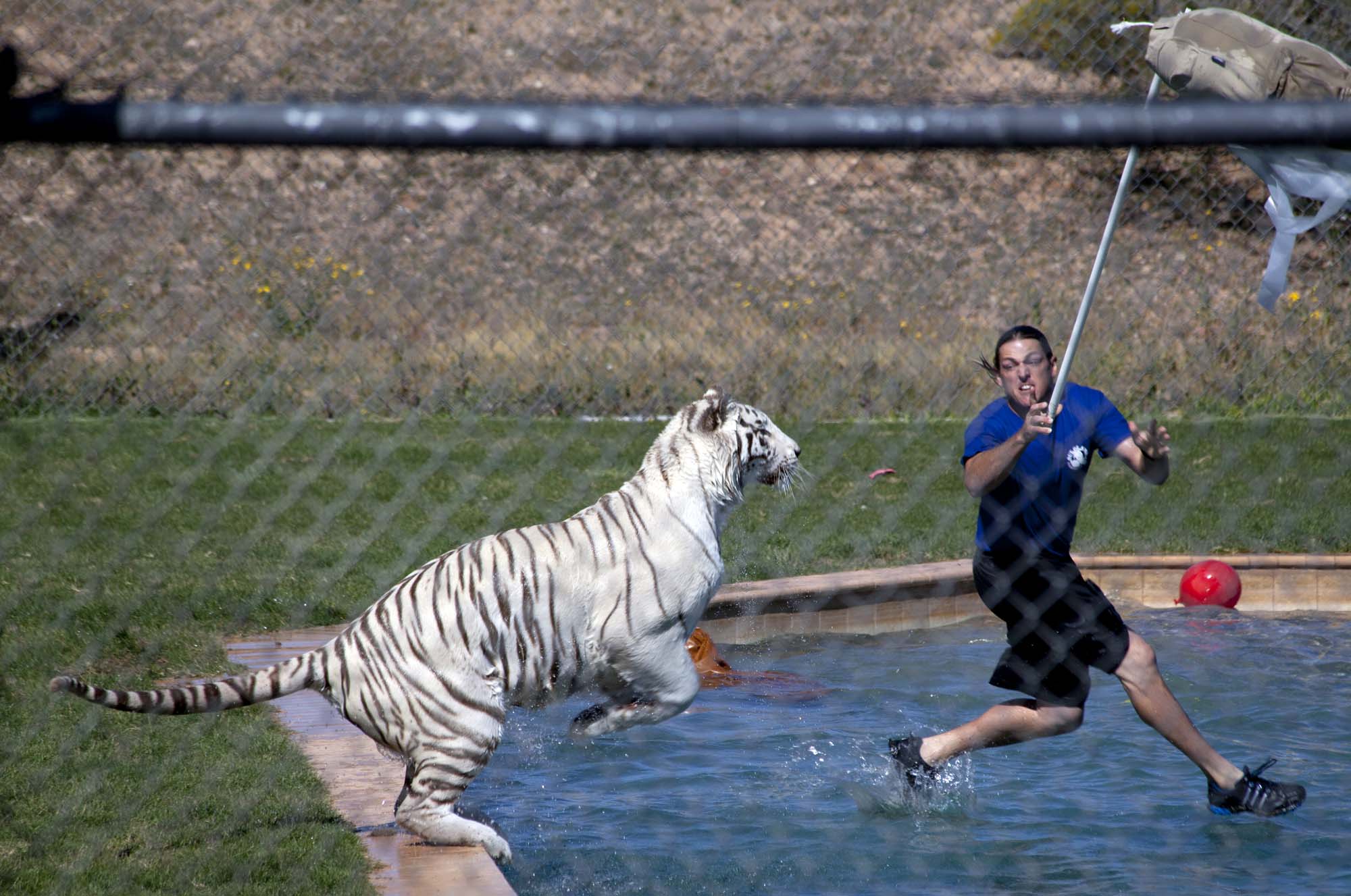
Watching the gorgeous white tiger being exercised in the enclosed area containing a large pool was one of the most exciting and interesting animal exhibits I've seen. Though one might blink at the idea of tigers out of Africa, nothing else in this show is fake. The big predators here might appear to be tame, but the handlers insist that they do not train them in any way. The say that they take care to give the big cats experiences which are as close to hunting as can be devised in captivity. Here Chalet, the white Bengal takes another dramatic leap into the water:
Why the huge lunges into the pool? The answer is in this shot:
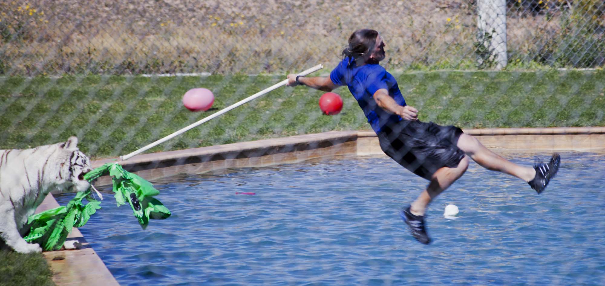
I imagine that the park tigers puncture enough large inflatable plastic toys each year to keep a small Chinese factory going. It is one leap - one shredded blow up. The tiger always gets what it's after:
In the shot above it's interesting to examine the focus of the tiger's attention. It it clearly on the toy and not on the handler. As you watch the show this tactic becomes clear. The toy is the game, not the person controlling it. The cats don't seem to mind the fakery. The handler in the image above will soon flip the toy over the tiger's head and run like crazy for the pool, making certain that he is well away from the toy when the tiger lunges powerfully through the air at the sailing object. The puffy plastic will suffer the same fate as a leaping antelope.
Some of these antics are so stunning that I don't really feel like commenting about them. The images speak much more elegantly than I:
I was worried that shooting through the chain-link fence would be a problem. As it turns out the shallow depth of field of the Canon 300mm telephoto lens saved the day. It focused flawlessly on the main subjects while blurring the fence enough so that it is not too distracting.
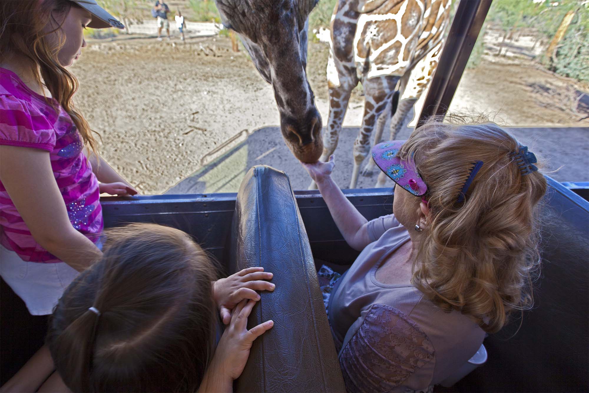
The big cats, lions, tigers and a lone black leopard are not the only denizens of the park. Here is Grace having her hand washed by one of the giraffes' sixteen inch purple tongue. This is a sensory treat which I have, so far, avoided:
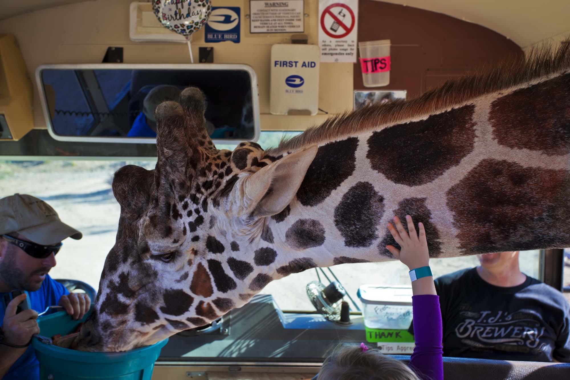
And here is something that you don't see every day:
It is amusing to watch the giraffe as it withdraws from the coach. It carefully lowers its head just enough to avoid konking its knobby antlers on the window frame.
I have a couple of more leaping tiger shots for you. I set the Canon 5D MkII for rapid fire. It usually digests five frames per second at full resolution, though it does occasionally stutter at an imappropriate moment. I think this is because my memory card is not quite fast enough to keep up:
What you see above and below are nice examples of what the handlers are trying to accomplish. One must suppose that everybody is winning here. The paying audience is certainly getting their $36 worth, even better if you've gotten in on one of the common half-price deals. The big cats appear to be getting some much needed aerobic exercise and having what passes for fun in captivity. The handlers, hopefully well paid, are getting an adrenalin rush second to none.
Once in a while the tiger gets the jump on the toy and the handler, preparing to flip the thing over the top for a good leap, gets jerked onto his back in mid-air:
Out of Africa is a little off the beaten path, but well worth the trip. For family fun at a very reasonable price you would be hard pressed to beat it.
I got fitted for my getting married outfit today. I won't be spectacular, but Grace will certainly look classy, as she always does. We are going down by Beaver Creek where the wonderful red rocks are reflected in the water.
Maybe I'll get some good pictures. I don't really care as long as I get that ring on my finger.
Somehow I had missed Boxley from previous crawls in the area. I guess, once upon a time, Boxley was a quiet village halfway up the downs, relying on sheepfarming for its income. In the 21st century, its just a suburb of Maidstone, though a mile or so outside the county town.
All Saints popped up on the churchcrawling group on Facebook, and thought it looked interesting, which is something of an understatement.
We arrived at just after eleven, in the lych gate there was a sign saying the church was open, so, result!
Approaching the church aloong a stone path it feels very un-Kent-like, especially as entrance to the church is in the very west end.
You enter, and are in a large space, in fact this was the Norman chancel of the original church, then into the space below the west tower, and there is the door into the church as it is now.
But I could hear voices from within, probably wardens cleaning, or so I thought...
But turned out to be a lecture on wildflowers; maybe i should crash it? But don't.
We find a leaflet and find that it had been going on nearly an hour, so we go to sit outside to see if it was going to end on the hour mark....
We give up after 20 minutes, but decide to visit a third church, then come back. Maybe it would be free then......
-------------------------------------------------
The church lies at the far end of the village green. Visitors who do not first walk around the outside of the church wonder if they are ever going to get in - for they have to walk through two rooms first! From the outside it is not so puzzling; the first room is in fact the nave of the Norman church. Then comes the base of the fifteenth-century tower, built on the site of the Norman chancel. Only after we have gone through this do we come to the church proper - a complete fourteenth-century structure. It is wide, with two aisles, and relatively short. The chancel is well proportioned and has a definite lean to the south indicating medieval building error.
www.kentchurches.info/church.asp?p=Boxley
-------------------------------------------------
BOXLEY.
ADJOINING to Maidstone north-eastward lies the parish of Boxley, written in Domesday, Boseleu, and in the Textus Roffensis, Boxele and Boxle, a parish noted, as well for the famous assembly of the whole county, held at Pinenden heath, within the boundaries of it, in the reign of the Conqueror, as for the abbey not long afterwards founded in it.
THE VILLAGE of Boxley situated at the foot of the chalk hills, above which this parish extends among the coppice woods, over a barren dreary country covered with flints, to Dun-street, at the northern boundaries of it. Southward it extends to the rivulet in the valley, at a very small distance from the town of Maidstone, a length of near four miles, the width of it is not more than three at its greatest extent, and in most parts much less; the soil from its extent is of course various, to the northward it is chalk; in the middle, and towards the west a deep sand; to the eastward a wet cludgy earth, and to the south and south-east for the most part a not unfertile loamy soil bounding upon the rock. It is a situation much more healthy than it is pleasant, owing to its chalky and sandy soils, and its bleak situation. The village is watered by a clear spring, which rises just below the church, and directs its course through the street; this spring, as well as another, which rises likewise at the foot of the chalk hill, just above Boxley abbey, are both very inviting to the sight, but the water is very hard and unfit for culinary uses, especially the latter, which in two months will petrify wood, the incrustation resembling brown and unpolished marble. These join just below the abbey, and flow together into the Medway, almost opposite to Allington castle.
The village lies on a descent from the hills, there are several genteel houses in it; at the upper or northern part of it is Boxley house, lord Romney's, inhabited by his three sisters and Mr. Coker; somewhat lower down is a house, which for many years was the property and residence of the family of Charlton, who bore for their arms, Or, a lion rampant gules, the last of them, John Charlton, esq. dying in 1770 unmarried, it came by his will, together with the chief of his other estates, to his eldest nephew, the Rev. George Burville, (son of the Rev. Henry Burville, by Anne his sister). The Burvilles bear for their arms, Argent, a chevron between three oak leaves erect, vert. Mr. Burville married Juliana, daughter of William Bowyer, esq. of Denham, in Buckinghamshire, by whom he has a son John, and daughter Frances, married to the Rev. Philip Rashleigh. He is the present possessor of this house, in which he resides; below this is the parsonage and vicarage, the latter a handsome genteel house, and just above it at a small distance from the east side of the street, the church; almost adjoining to Mr. Burville's house, is another more antient one, called Park-house, once part of the estate of Boxley abbey, and afterwards in like manner, the estate of Sir Thomas Wyatt, whose son forfeited it for treason in the 1st year of queen Mary How it passed afterwards I have not found, though it seems never to have been restored to his descendants; in the beginning of the present century it was in the possession of the family of St. John, in which it remained till Mrs. St. John joining with her son, Paulet St. John, sold it in 1720 to Maudistley Best, esq. (son of Mr. Thomas Best, of Chatham) who resided and kept his shrievalty here in 1730, bearing for his arms, sable, two cross croslets in chief, and a cinquefoil in base, or. He died in 1740, leaving two sons, Thomas, late of Chilston, esq. and James, of Chatham, and a daughter, married to the hon. Robert, afterwards lord Fairfax, of Leeds castle, who died s. p. He gave by will this seat to his youngest son James, who served the office of sheriff in 1751, and resided here at times, and died in 1782, leaving by Frances his wife, one of the daughters of Richard Shelley, esq. four sons and four daughters, to the eldest of the former, Thomas Best, esq. he by will gave this house and his estate in this parish, and he now resides in it. There has been from time immemorial a warren for rabbits here, the lands of which lay close at the foot of the chalk hills, it formerly belonged to Boxley abbey, and was afterwards in the possession of the Wyatts, and is now from them the estate of lord Romney, and there was likewise another part of it used likewise as a warren, lying near Pinenden-heath, which was part of the Park-house estate, and as such, is now the property of Mr. Best, but the name only remains, the rabbits having been for some time destroyed, and the land made arable. About a mile. eastward from the village in a low flat situation, at no great distance from the high road from Rochester to Maidstone, is Boxley abbey, with a small hamlet of houses near it, and nearer to the hills the abbey farm. The plantations of the estate called the Park-house, likewise, the old seat of which was situated in Maidstone parish, near the high road to Rochester, as has been already described, extend into the western part of this parish. The late Sir Henry Calder, whose property it was, pulled down the old house, and on a beautiful spot near adjoining, though within this parish, began a handsome stone mansion, which after his death was finished by his widow, who with her son Sir Henry, for some time resided in it; it is now inhabited by Mr. Osborne. At a small distance eastward from hence, in nearly the centre of this parish, excepting that Maidstone stretches itself with a point or nook over a part of it, is that noted plain Pinnenden, now usually called Pickenden heath, a place made famous in early times; the western part is in Maidstone parish, the remainder in this of Boxley. From its situation almost in the middle of the county or shire of Kent, this heath has been time out of mind used for all county meetings, and for the general business of it, the county house for this purpose, a poor low shed, is situated on the north side of it, where the sheriff continues to hold his county court monthly, and where he takes the poll for the members of the county, and for the coroners, the former of which, after a few suffrages is usually adjourned to Maidstone; on a conspicuous hill on the opposite side of the heath, though in Maidstone parish, is the gallows, for the public execution of criminals condemned at the assizes.
At the time of the conquest it was the noted place for the public meetings of the county; for in the book of Domesday there is mention made, that when the inhabitants of Kent were summoned to meet ad sciram, that is, in public assembly at the shyregemot or Sheriff'stourn, for the trial of certain customs therein mentioned, they should go for that purpose as far as Pinnedenna, but no further.
In the year 1076, being the 11th of the Conqueror's reign, a famous assembly was held at this place on the following occasion.
Odo, bishop of Baieux and earl of Kent, had by means of his great power, defrauded the church of Canterbury of many manors and lands, and of several liberties, and had kept possession of them; but upon Lanfranc's being made archbishop in the year 1070, he represented the whole of the injury done to his church to the king, who forthwith commanded that it should be enquired into and determined by the nobles, and other competent men, not only of this county, but of the other counties of England, assembled for this purpose at this heath.
There were present at this meeting Goisfrid, bishop of Constance, who sat as the king's representative on this occasion; archbishop Lanfranc, who pleaded his church's cause; Odo, earl of Kent, who defended himself against his accusers in what he had done; Ernest, bishop of Rochester; Agelric, bishop of Chester, an antient man, and well versed in the laws of the realm; who on account of his great age was, by the king's order, brought hither in a waggon, in una quadriga; Richard de Tunebrige, Hugh de Montfort, William de Arsic, Hamo Vicecomes or Sheriff, and many others, barons of the king and of the archbishop, many tenants of those bishops, and many others of good and great account, as well of this as of other counties, both French and English.
This trial lasted three days, at the end of which the archbishop recovered several of the antient possessions of his church, as well from Odo as from Hugh Montfort and Ralph de Curva Spina or Crookthorne, and established the liberties of it, in matters between the king and himself. (fn. 1)
On the south side of the heath the turnpike road from Maidstone through Detling to Key-street aud Sittingbourn crosses this parish, and another branches off from hence to Bersted and Ashford; in the southern part of it are the hamlets of Grove green and Wavering-street, Newnham court, and the beautiful seat of Vinters, most pleasantly situated; below which in the vale is the stream which turns the paper mills, and separates this parish from Maidstone. At Grove, as has been already noticed, is a remarkable fine vein of fuller's earth, by the working of which Mr. John Watts, the owner of it, at the beginning of this century, became famous. But this earth was in working in 1630, at which time John Ray, merchant, of London, was sentenced to a severe fine and punishment in the Star Chamber, for transporting of it clandestinely to Holland. (fn. 2) This vein lies about thirty feet deep, and is about seven feet thick. There are two sorts of it, the blue and the dark grey, the latter of which lying under the former is most valuable; a great quantity of this earth is sent from hence by sea for the use of the clothiers in distant countries. For the manufacture carried on in this parish for the making of paper there are four sets of mills, two of which are situated at the south-east extremity of it, on the stream called the Little River, which rises near Lenham, and runs by Leeds castle hither; the upper ones, belonging to lord Aylesford, and the lower ones to Messrs. Hollingworth's; the other two are situated on the western side of the parish, near Aylesford, on the rivulet which rises under the chalk hills, and are made use of for making an inferior kind of merchandize, one of these belongs to lord Romney. The lower mills above-mentioned belonging to Messrs. Hollingworth, stand at a small distance on the north side of the road leading from Maidstone to the Mote, and are called the Old Turkey Mills, they deserve a more particular notice in this place for their superiority, as well in the many extensive buildings, machines and conveniences erected for carrying on this large and curious manufacture, and the number of people continually employed in the different branches of it, as the easy and regular method, and the neatness with which the whole is conducted. They were formerly used as fulling mills, but on the decay of the cloathing trade in these parts, were, by Mr. Gill, the proprietor, converted into paper mills, and used by him as such for a few years; he sold them to Mr. James Whatman, who in 1739 pulled the whole of them down, and erected them on a much more curious and extensive plan, which was afterwards much more improved by his son James Whatman, esq. who with infinite pains and expence, brought his manufactory of writing paper, for no other sort is made here, to a degree of perfection, superior to most in the kingdom. In 1794 he sold these mills to Messrs. Hollingworth, and retired to Vintners, where he now resides, and they now carry on this manufacture here; under the buildings is a strong chalybeat spring, which however does not produce any great quantity of water. In 1711 a Roman urn was dug up at Grove, by the workmen, near the vein of Fuller's earth there, as several others have been since, with other relics of antiquity and coins, both there and at Vintners, most of the coins having the inscription of the emperor Adrian, and the like have been from time to time discovered at Goddard's hill, in this parish, where there are several stones set up similar to those about Horsted.
OUR BOTANISTS have observed the following scarce plants in this parish:
Borago minor silvestris, small white bugloss, or German madwort.
Scopyllum angustifolium glabrum, smooth narrowleased thyme.
Buxus, the box tree, which grows plentifully in the woods here. (fn. 3)
Stellaria sanicula major, ladies mantle.
BOXLEY, at the time of taking the general survey of Domesday, was part of the vast estate of Odo, the great bishop of Baieux and earl of Kent, the Conqueror's half-brother; in which record it is thus described:
Robert Latin holds to ferm Boseleu. It was taxed at seven sulings in the time of king Edward the Confessor, and now at five sulings. The arable land is twenty carucates. In demesne there are three carucates, and fortyseven villeins, with eleven borderers having sixteen carucates. There are three mills of thirty-six shillings and eight-pence, and sixteen servants, and twenty acres of meadow. Wood for the pannage of thirty hogs. In the time of king Edward the Confessor, and afterwards, it was worth twenty-five pounds, now thirty pounds, and Robert yet pay fifty-five pounds. Alnod Cilt held it.
Four years after the taking of the above survey, about the year 1084, this estate, on the bishop of Baieux's disgrace, became forfeited to the crown, among the rest of his possessions.
In the year 1146, (fn. 4) William d'Ipre, earl of Kent, who afterwards became a monk himself at Laon, in Flanders, (fn. 5) founded an ABBEY at this place for monks of the Cistertian order, some of whom he brought from Claravalle, in Burgundy, for this purpose, and dedicated it to the Virgin Mary, as all the houses of this order were. The first monastery of this order in England was at Waverly, which was built in 1129, by Walter Gifford, bishop of Winchester. They were a branch of the Benedictines, called by the English, from their habit, White monks, and likewise Cif tertians; which last name they had from the town of Cistertium or Cisteaux, in the bishopric of Chalons, in Burgundy, where this order was first instituted by Robert, abbot of Molesme, in the year 1098. There were eighty-five houses of this order, at the time of the dissolution, in England.
King Richard I. in his 1st year, anno 1189, gave the MANOR of BOXELE (fn. 6) to this abbey, which king Henry III. in his 37th year, confirmed by his letters of inspeximus. (fn. 7)
King Henry III. in his 37th year, granted to the abbot and convent to hold a market weekly within their manor of Boxley. (fn. 8) The place where it was held appears to have been called Farthings.
In the 7th year of Edward I. the abbot claimed, before the justices itinerant, certain liberties, by the charters of king Henry and king Richard, and the confirmation of them by the charter of king Henry, the then king's father. And he claimed to have warren in all his demesne lands in Kent and Surry, which he had in the time of king Henry, the king's father; and that he and his predecessors had fully used those liberties, &c. and it was then found, that the abbot had in his manor of Boxley a free court, &c. and that the tenants of the manor ought to plead in the hundred of Maidstone, pleas of Withernam, &c. and that the abbot ought to allow pannage, &c, and that the tenants of the manor owed pontage, and paid it to Rochester bridge. (fn. 9)
The abbot of Boxley was summoned to parliament twice in the 23d year of king Edward I. once in the 24th, and twice in the 28th years of that reign, but never afterwards, that I can find. (fn. 10)
In the reign of king Henry III. there were sixtyfour abbots and thirty-six priors summoned to parliament; but this number being thought too great, king Edward III. reduced them to twenty-five abbots and two priors, to which were afterwards added two more abbots, so that there were no more than twentynine in all, who statedly and constantly enjoyed this privilege, of which only St. Austen's, near Canterbury, was in this county. (fn. 11)
King Edward II. in his 15th year, honoured this abbey with his presence, where, on Oct. 25, he granted to the aldermen and citizens of London to nominate a mayor out of their own body, at his will. (fn. 12) King Edward III. in his 33d year, granted to the abbot, &c. free warren in their manor of Boxele, &c. (fn. 13)
In the reign of king Richard II. the revenues of this abbey were valued at 218l. 19s. 10d. of which 98l. 19s. 7d. was in the diocese of Canterbury, (fn. 14)
John Dobbes, the last abbot, and the convent of Boxley, surrendered it into the hands of Henry VIII. on January 29, in the 29th year of his reign, (fn. 15) and it was, together with all the lands and possessions belonging to it, confirmed to the king and his heirs, by the general words of the act, passed in the 31st year of that reign for this purpose; after which there were pensions allowed to the abbot, 50l. and to eight of the canons, from 2l. 13s. 4d. to 4l. yearly, for their lives, or until the person was promoted to a benefice of equal or superior value; the five last of which pensions remained in charge in 1553. (fn. 16)
It was endowed, at its dissolution, with 204l. 4s. 11d. per annum, clear revenue, according to Dug dale; or, according to Speed, with 218l. 9s. 10d. per annum, yearly income. (fn. 17)
The coat of arms belonging to it was, Argent, a dexter bend lozenge, gules; on a canton of the second, a crozier or pastoral staff of the field. (fn. 18) This coat, without the crozier, as also another, being a pastoral staff, surmounted of a bend, are still remaining carved in stone on the capitals of two pillars, from which springs a small circular arch in the garden, at the back of this abbey.
There was a chapel, dedicated to St. Andrew the apostle, founded hard by the outer gate of this monastery, which was served by a curate appointed for that purpose.
The lands of the abbey of Boxley, of the order of Cistertians, were as such, in particular circumstances, exempted from the payment of tithes. Pope Pascal II. exempted all the religious in general from the payment of tithes for lands in their own occupation, and this continued till the reign of Henry II. when pope Hadrian IV. restrained this exemption to the three religious orders of Cistertians, Templars, and Hospitallers, to which pope Innocent III. added a fourth, viz. the Præmonstratenses, from whence these were generally called the four privileged orders. After which the general council of Lateran, in 1215, further restrained this exemption to lands in their own occupation, and to those which they possessed before that time. After this the Cistertians procured bulls to exempt all their lands likewise which were letten to farm. To restrain which, the statute of the second of king Henry IV. cap. 4. was made, which enacted, that whoever, religious as well as secular, should put these bulls in execution, and purchase any others, and by colour of them should take any advantage in any shape, should be guilty of a præmunire. This restrained their privilege again to such lands only as they had before the Lateran council above mentioned; so that the lands they afterwards acquired are in no wise exempted, and this statute left them subject to the payment of such composition for tithes of their demesne lands as they had made with any particular rectors, &c. who contesting their privileges, even under that head, brought them to compound. This monastery of Boxley was one of those dissolved by the act of the 31st of king Henry VIII. the only ones which continued these privileges to their possessors afterwards; by which act, as well the king, his heirs and successors, as all others who should have any of those monasteries, their lands or possessions, were to hold and enjoy them, according to their estates and titles, discharged and acquitted of payment of tithes, as freely, and in as large and ample a manner as the late abbots, priors, &c. of the same before held them. (fn. 19)
In the Registrum Roffense, (fn. 20) are the names of the fields, woods, and other premises in the parish of Boxley, of which the abbot and convent here should in future be free and exempt from the payment of all tithes whilst they were in their own hands.
In the church of this abbey was the statue of St. Rumbald, usually called by the common people, St. Grumbald, which was held in great reverence for his fancity by them, for the miracles it was said to perform.
¶King Henry VIII. in his 32d year, exchanged with Sir Thomas Wyatt, of Allynton, for other premises, the house and scite of this monastery, lately dissolved, and the church, steeple, and church yard of it, with the buildings, lands, &c. as well nigh and adjoining to the scite and precinct of it, his lordship of Boxley, Hoo, and Newenham court, with their appurtenances and the farm and lands, called Upper Grange, and all lands, tenements, and other premises late belonging to it, in the parishes, townships, or hamlets of Boxley, Boxley-street, Burley, Burthin, Sandelyng, Wilston, Wavering, Havurland, Oxefiyth, Dunstreet upon the Hill, and elsewhere, in Kent, excepting to the king the parsonage of Boxley and the advowson of the parish church; (fn. 21) all which were soon afterwards again vested in the crown, as appears by the Escheat rolls of the 38th year of that reign, (fn. 22) when the king regranted the whole of them to Sir Thomas Wyatt, son of Sir Thomas before mentioned, to hold in capite by knight's service, who having, in the 1st year of queen Mary, with other gentlemen of note in this county, raised a rebellion, was found guilty of high treason, and executed that year, and his estate was consiscated to the crown; but the queen, through her bounty, the next year, granted the manor of Boxly, with the Upper Grange, and some other lands adjoining, to his widow, the lady Jane Wyatt, (daughter and coheir of Sir William Haut, of Bourne) and her heirs male, to hold in like manner. On her death, her son, George Wyatt, succeeded to them; but the abbey seems to have continued in the crown, for queen Elizabeth, in her 11th year, granted the scite and mansion of it to John Astley for a term of years. In the 13th year of that reign, George Wyatt, esq. was restored in blood by act of parliament, after which he became possessed of this seat, and resided here, having the fee of it granted to him by the crown. He died in 1624, and was buried in the chancel of this church, as were his several descendants, who bore for their arms, Per fess azure and gules, a barnacle argent, the ring or; he left several sons and daughters, of whom the second son, Haute Wyatt, was vicar of this parish; and Francis, the eldest, succeeded him in the manor of Boxley, the mansion of the abbey, the Grange, and his other estates in this parish. He was afterwards knighted, and was twice governor of Virginia. He died in 1644, leaving two sons, Henry, his eldest son and heir, and Edwin, who afterwards became possessed of this manor, seat, and estates, above mentioned, and a daughter, Elizabeth, who married Thomas Bosvile, esq. of Littlemote in Eynsford, esq. whose daughter Margaret became the wife of Sir Robert Marsham, bart. great grandfather of the present lord Romney.
Henry Wyatt, esq. was of Boxley abbey, and left an only daughter and heir, Francis, who carried this manor, seat, with the Grange and other estates above mentioned, in marriage to Sir Thomas Selyard, bart. but Edwin Wiat, the younger brother of Henry above mentioned, disputing at law the lady Selyard's title to them, recovered the manor of Boxley, with other estates last mentioned, in this parish and elsewhere; but the abbey, with the lands belonging to it, remained in the possession of Sir Thomas Selyard, as will be mentioned hereafter.
BOXLEY is within the ECCLESIASTICAL JURISDICTION of the diocese of Canterbury, and deanry of Sutton.
The church, which is dedicated to All Saints, stands on the east side of the village; it is not large, but neat, and contains three isles and a chancel, with a handsome square tower at the west end, in which hang four small bells, which were cast in 1652, by M. Darby.
In this church, before the Reformation, was a famous rood, called the Rood of Grace, which was held in great esteem for the miracles it was supposed to work. It was broken to pieces by the king's command at St. Paul's cross, in London, on Sunday, February 24, 1538, in the presence of John Hilsey, bishop of Rochester, and a vast concourse of the populace. (fn. 35)
The church of Boxley was given by king Henry I. in 1130, to the church of Rochester, with all its liberties and rights, in like manner as his chaplain, Jeffry or Ansfrid, the clerk, had ever held it; but that church and monastery, having been destroyed by fire, and the monks dispersed abroad, king Stephen, in 1137, dispossessed them of this church, which, howeever, on their return to their monastery, was on their remonstrance to the court of Rome, by the pope's bull, restored and confirmed to them; and Walter, bishop of Rochester, not only confirmed to them the appropriation of it, but granted to them the free disposal and presentation of the vicarage, saving the right of the bishop of the diocese; which grant was confirmed likewise by the several archbishops of Canterbury afterwards.
In the year 1180, there was an agreement made between the monks of Boxley and those of Rochester, concerning the parochial tithes of this church; by which the latter granted to the former a certain field belonging to the parish church of Boxley, above the hills, but by the consent of the former they retained out of it for ever half an acre of wood for fencing; and the monks of Rochester granted to those of Boxley all the tithes above the hills of all lands, as well of those free lands, which the latter had of the king's gift, as of those which they had acquired, to be held finally in villenage, or might acquire in future, at any time for their own use; and likewise certain land belonging to this parish church, under the hill, with the meadow adjoining, between the abbey and village of Boxley; on the other hand, the monks of Boxley granted to those of Rochester all their tithes under the hills, without the bounds of the abbey and grange; that is to say, of all corn only and pulse, of all their lands under the hills, as well of those antiently as newly cultivated, and which they had from the foundation of the abbey, or might bring into culture at any time in future; and that the monks of Rochester should have all the tithes on the sides of the hills of all lands which at that time, or before were reduced to culture, excepting the field which the monks of Boxley bought of John de Horespole; which composition was confirmed by Richard, archbishop of Canterbury.
The confirmations of this church to the priory seem afterwards to have been but little regarded, and they were again dispossessed of it, with a reservation of 60s. annual pension only from it; and it appears, that the bishop of Rochester, together with the prior and convent, used to present to it on a vacancy, till the time of archbishop Islip, who at the petition of the monks, with the consent of the bishop, in 1363, restored this church to them, in as ample a manner as they had before held it; and he granted them full liberty to reenter into the corporal possession of it, with all its rights and appurtenances, on the vacancy of the rector then incumbent on it; reserving, nevertheless, in the first place, a proper portion out of the fruits and profits, for the maintenance of a perpetual vicar, at the presentation of the bishop, to be instituted by him and his successors, and for the due support of the episcopal and archidiaconal burthens, and others belonging to it; and a vicarage was afterwards accordingly endowed in it by archbishop Sudbury, in the year 1377. (fn. 36)
In 1403, a definitive sentence was passed concerning the tithes of this vicarage; (fn. 37) at which time, and so late as the year 1485, this church and advowson belonged to the priory of Rochester, for in the latter year, archbishop Bouchier, cardinal and apostolic legate, confirmed the appropriation of it to them; and a composition was entered into, anno 20 Richard II. between the prior and convent, and Adam Motrum, archdeacon of Canterbury; that as the archdeacon and his archdeaconry was detrimented in the yearly sum of 6s. 8d. the like sum should be yearly paid to the latter, out of the profits of it so long as they possessed it.
The appropriation, as well as the advowson of the vicarage, seems very soon afterwards to have passed into the hands of the prior and convent of Boxley, tho' by what means I do not find, before its dissolution, which happened in the 29th year of king Henry VIII. for that king, by his dotation charter, in his 32d year, settled his rectory and church of Boxley, late belonging to the dissolved monastery of Boxley, and the vicarage of it, on his new erected dean and chapter of Rochester, part of whose possessions they now remain.
In the 15th year of king Edward I. this church was valued at 32l. the vicarage is valued in the king's books at 12l. 19s. 2d. and the yearly tenths at 1l. 5s. 11d.
King Henry VIII. in his 29th year, let to Thomas Vicary, one of his surgeons, the tithes of corn and the glebe lands of this rectory, and the capital messuage, houses, and buildings belonging to it, and ten pieces of land, late belonging to the monastery of Boxley and the advowson of the vicarage, for twenty-one years, at the yearly rent of forty pounds.
In the exchange of lands, made between Henry VIII. and Sir Thomas Wyatt, in the 32d year of his reign, the parsonage of Boxley, and the advowson of the vicarage, with their appurtenances, were particularly excepted, to remain to the king's use.
By a survey of this parsonage, on the abolition of deans and chapters, after the death of king Charles I. in 1649, by order of the state, is appears, that the par sonage-house, a fair and goodly house, with its appurtenances, tithes, &c. late belonging to the late monastery there, and forty-eight acres, three roods, and two perches of land, in the improved rents, were the whole of them worth 140l. 3s. 6d. per annum; and were let by the dean and chapter, anno 15 Charles I. to Robert Parker for twenty-one years, at the yearly rent of 26l. 13s. 4d. and twelve couple of conies, or 16s. in money; that the lessee was bound to repair the chancel, and that the vicarage, which was excepted out of the lease, was worth sixty pounds per annum.
The present lessee of the parsonage is Mr. William Fowle; the vicarage is reserved out of the lease of it, and is in the disposal of the dean and chapter.
The vicar of Boxley has belonging to him all tithes of wood, hops, hay, clover, cinquefoil, flax, wold, wool, lambs, milk, eggs, apples, cherries, and other fruit, and of pasture; his dues are, for burials, 2s. for marriages, 5s. for christenings in houses, 2s. 6d. and for churchings at church, 6d. at home, 1s. for Easter offerings he can demand of every person, above sixteen years old, 6d. so of a man and his wife, 1s.
He has a pension of 8l. per annum, payable out of the exchequer, as an augmentation; the fees for receiving of which are, if he receives it himself, 12s. if by another, 20s. (fn. 38)
¶The land the vicarage house, with its appurtenances, stands on, with the garden and court yard, is not above the third part of an acre; which, with the herbage of the church yard, is all the glebe the vicar has. The house, which is built of brick, and sashed, is handsome and commodious, and has proper offices adjoining to it. It was erected by Mr. archdeacon Spratt, whilst vicar of this parish; since which it has been considerably improved by Dr. Markham, vicar likewise, now arch bishop of York, who sometimes resided in it, as did his successor, Dr. North, now bishop of Winchester.
In 1733, the vicarage was valued at 200l. it is now 300l. per annum.
Bishop Henry de Sandford, by his decree temp. Henry III. at the petition of the vicar and parishioners, changed the feast of the dedication of this church, from the 10th of February to the Monday next after the feast of St. Peter and St. Paul.