View allAll Photos Tagged Locale
Walking for exercise during lockdown, camera in hand, capturing passing movements.
A modicum of colour, deliberately muted, on today's walk that required a face-full-of-dirt prone position - but not for long.
No lingering allowed they say, which begs the question, just how long is a linger?
Happy to find some bluebells in the near vicinity albeit a skinny patch.
Au petit matin, la Toyota ou la Land Rover classique du local de Fuerteventura, se gare pour aller promener les chiens dans les collines et profiter de la lumière encore douce.
Fuerteventura
.
.
.
Follow me on FACEBOOK
.
.
.
WEBSITE .......: www.jeansurprenant.com
.
.
.
My GETTY IMAGES work
.
.
.
Licence disponible sur [ GETTY IMAGES ]
Licence available at
.
.
.
Thanks for the visits, comments, awards, invitations and favorites. Please don't use my images on websites, blogs or others medias without my explicit permission.
Thanks!
© All rights reserved
My technique is alway the same:
Three exposures -2EV, 0, +2EV and then temperature adjustement using Lightroom and layering with luminosity mask using photoshop. Removal of distracting stuff with the stamp tool or patch tool. High pass filter to enhance details. Then saturation, contrast selectively control, dodge and burn where need...
DRI stand for Dynamic Range Increase. Three RAW files are used to achieve this. Rather than using a software like Photomatix for instance, I simply use mask to blend, my own way, the light, dark and normal shot with Photoshop and Lightroom.. To me, It looks more natural than the usual HDR treatment that I would normally applied.
Merci pour les visites, commentaires, récompenses, invitations et favoris. S.V.P. n'utilisez pas mes images sur des sites web, blogs ou autres médias sans ma permission.
Merci!
© Tous droits réservés
Ma technique est toujours la même:
Trois prises de vue -2EV, 0, +2EV. Ensuite ajustement de la température de couleur avec Lightroom et usage de calques et masques de luminosités avec Photoshop. Retrait d'éléments de distraction avec l'outil tampon. Filtre High pass pour le rehaussement des détails. Ensuite saturation et contraste ajustés de façon sélectives et locales. Dodge and burn là où requis...
DRI vient de l'anglais Dynmic Range Increase, qui pourrait se traduire par étendue dynamique améliorée. Les même 3 fichiers RAW entrent dans la composition d'un DRI. Plutôt que de se servir d'un logiciel comme Photomatix qui fait tout le travail, je me sers plutôt de masques pour filtrer l'éclairage dans photoshop et Lightroom. De mon point de vue, cette façon de faire donne une image plus naturel que le traitement HDR que j'employais auparavant.
.
.
.
Follow me on FACEBOOK
.
.
.
WEBSITE .......: www.jeansurprenant.com
.
.
.
My GETTY IMAGES work
.
.
.
Licence disponible sur [ GETTY IMAGES ]
Licence available at
.
.
.
Lycra clad cyclists, gentlemen holding on for dear life, wine shops selling expensive Argentinian Merlot. This could be anywhere in Europe.
.
.
.
Follow me on FACEBOOK
.
.
.
WEBSITE .......: www.jeansurprenant.com
.
.
.
BUY or LICENCE IT HERE
.
.
.
My GETTY IMAGES work
.
.
.
Thanks for the visits, comments, awards, invitations and favorites. Please don't use my images on websites, blogs or others medias without my explicit permission.
Thanks!
© All rights reserved
My technique is alway the same:
Three exposures -2EV, 0, +2EV and then temperature adjustement using Lightroom and layering with luminosity mask using photoshop. Removal of distracting stuff with the stamp tool or patch tool. High pass filter to enhance details. Then saturation, contrast selectively control, dodge and burn where need...
DRI stand for Dynamic Range Increase. Three RAW files are used to achieve this. Rather than using a software like Photomatix for instance, I simply use mask to blend, my own way, the light, dark and normal shot with Photoshop and Lightroom.. To me, It looks more natural than the usual HDR treatment that I would normally applied.
Merci pour les visites, commentaires, récompenses, invitations et favoris. S.V.P. n'utilisez pas mes images sur des sites web, blogs ou autres médias sans ma permission.
Merci!
© Tous droits réservés
Ma technique est toujours la même:
Trois prises de vue -2EV, 0, +2EV. Ensuite ajustement de la température de couleur avec Lightroom et usage de calques et masques de luminosités avec Photoshop. Retrait d'éléments de distraction avec l'outil tampon. Filtre High pass pour le rehaussement des détails. Ensuite saturation et contraste ajustés de façon sélectives et locales. Dodge and burn là où requis...
DRI vient de l'anglais Dynmic Range Increase, qui pourrait se traduire par étendue dynamique améliorée. Les même 3 fichiers RAW entrent dans la composition d'un DRI. Plutôt que de se servir d'un logiciel comme Photomatix qui fait tout le travail, je me sers plutôt de masques pour filtrer l'éclairage dans photoshop et Lightroom. De mon point de vue, cette façon de faire donne une image plus naturel que le traitement HDR que j'employais auparavant.
.
.
.
Follow me on FACEBOOK
.
.
.
WEBSITE .......: www.jeansurprenant.com
.
.
.
BUY or LICENCE IT HERE
.
.
.
My GETTY IMAGES work
________________________________________________
Hola amigos : hoy os quiero comentar algo más que se celebra en estas fiestas de Getafe. Aunque son en honor de Nuestra Patrona, La Virgen de los Angeles, no solo se realizan actos de la Iglesia. Hay mas cosas que ahora os cuento.
En el recinto ferial, hay toda clase de cachivaches para los mas peques, la noria, los caballitos, el tren de la bruja, y un sin fin de cosas, que ya ni me acuerdo. Asi como muchas casetas, con rifas, el famoso azúcar tostado, y otras donde degustar un vino dulce muy rico, y otras donde poder sentarse a cenar.
Fuera del recinto ferial hay de todo, todos los diass.:
Pasacalles, gigantes y cabezudos, gran desfile de carrozas, muchos conciertos, ofrecidos, por orquestas, y bandas de musica de aqui, y de fuera, cantantes, como, Nena Daconte, Edurne, y Soleá Morente entre otros.
Sibre todo mucha musica, tanto en el centro como en los distintos barrios.
No os he dicho que también tememos noches de fuegos artificiales, y ayer precisamente fue una de ellas, pero esta es distinta de las demás, y atrae a mucho público.
Se trata de un espectàculo piromusical,con,cohetes, luces de colores, agua y música amenizado con la música de la Banda Municipal de Getafe y se realiza en el Lago del Sectdor-3 , en mi barrio, y es un concierto muy bonito.
Concursos, eventos deportivos y hasta nuestra propia falla, cada año se planta una, y va dedicada a algo o alguien que se ha distinguido o celebrado algo en este año.
La del 2002,realizada por el artista fallero Antonio Sanchez, con la temática 100 años de la Base Aérea en Gerafe.
Me dejo todavía muchas cosas, pero no quiero resultar pesada, creo que mas o menos os he hecho un resumen de las Fiestas de mi pueblo y espero haya sido de vuestro agrado.
********************************************************************************
Nanjing Road (en chino, 南京路; pinyin, Nánjīng Lù) es la principal calle de tiendas de Shanghái, China, y una de las calles de tiendas más transitadas del mundo.1 En la actualidad, Nanjing Road se compone de dos secciones: Nanjing Road East y Nanjing Road West. En algunos contextos, "Nanjing Road" se refiere solo a lo que fue Nanjing Road hasta el 1945, en la actualidad Nanjing Road East, ampliamente peatonal. Antes de 1949, el nombre en inglés de la calle era "Nanking Road", usando la romanización estándar de aquella época.
Nanjing Road es el distrito de compras más largo del mundo, con una longitud de unos 6 km, y atrae más de 1 millón de visitantes diariamente.
East Nanjing Road es una zona dedicada a los comercios. En su extremo este está la sección central del Bund, donde se sitúa el Peace Hotel. Inmediatamente al oeste del Bund estaba tradicionalmente la zona de restaurantes y cafeterías, aunque en años recientes se han convertido en menos importantes porque la demografía de los visitantes de Nanjing Road ha cambiado de residentes locales ricos a visitantes de todo el país. Cerca está el Mercado Central, un mercado al aire libre de un siglo de antigüedad especializado actualmente en componentes electrónicos y medios digitales. Más hacia el oeste está el centro comercial peatonal de Nanjing Road. Aquí se sitúan la mayoría de los grandes almacenes más antiguos y grandes de Shanghái, así como muchos comercios domésticos y algunos restaurantes tradicionales con larga historia.
es.wikipedia.org/wiki/Calle_Nanjing
Nanjing Road (Chinese: 南京路; pinyin: Nánjīng Lù; Shanghainese: Noecin Lu) is a road in Shanghai, the eastern part of which is the main shopping district of Shanghai. It is one of the world's busiest shopping streets, along with Fifth Avenue, Oxford Street, Orchard Road, Takeshita Street and the Champs-Élysées. The street is named after Nanjing, capital of Jiangsu province and the former capital of the Republic of China. Today's Nanjing Road comprises two sections, Nanjing Road East and Nanjing Road West.
Nanjing Road is located in the city center, running in a west–east direction. Its eastern section is in Huangpu District and extends from The Bund west to People's Square. The western section begins at People's Square and continues westward towards Jing'an District.
East Nanjing Road is a dedicated commercial zone. At its eastern end is the central section of the Bund, featuring the Peace Hotel. Immediately west of the Bund precinct was traditionally the hub of European-style restaurants and cafes, although in recent years these have become less of a feature as the demographics of visitors to Nanjing Road have shifted from affluent local residents to visitors from around the country. Close by is the Central Market, a century-old outdoor market today specialising in electronic components and digital media. Further west is the Nanjing Road pedestrian mall. Located here are most of Shanghai's oldest and largest department stores, as well as a variety of domestic retail outlets, and some traditional eateries with a long history. From the perspective of the historical development of Nanjing East Road, the start and redevelopment of this road were driven by the pursuit of commerce and image. The commercialization of Nanjing East Road has both a promotion and a restrictive effect.
... for a City in Pain
--------------------------------------------------------------------------------
Image Basis: Skyline of a city along its coastline.
--------------------------------------------------------------------------------
Locale: North lakefront along Lake Michigan - Milwaukee, Wisconsin, USA.
Vantage Point: Looking southward at a distance north of the McKinley Beach Observation Deck.
Year & Season: 2019 ; Mid fall
--------------------------------------------------------------------------------
Camera: Olympus OM-D E-M1 Mirrorless
Sensor: Micro 4/3
IBIS: ON
Support: Hand-held
Lens: Olympus M.Zuiko Digital ED 12-40mm f/2.8
--------------------------------------------------------------------------------
Exposure Program: Aperture priority
Metering Mode: Spot
Drive/Focus Mode: Single-shot/Auto focus
Focus Area: Spot
Exposure Quality: Raw (Lightroom DNG)
--------------------------------------------------------------------------------
Processing: Lightroom 6.12 (CR 9.12)
LR Presets: (none) ; Processing Plug-Ins: (none)
Original File Aspect & Size: 4:3 ; 15.9MP (4608 x 3456)
Cropped Aspect & **Size: 3:2 ; 13.1MP (4436 x 2945)
**Size is prior to downsizing and JPG conversion using Lightroom.
JPG Size: 2.78MP (2048 x 1359)
JPG Quality: 100 (Lightroom Export Quality setpoint)
File ID: RequiemAtHM Extr(2TntNonLin)V01R00 Mke.Lkfrnt.N 20191021-01-01 SShJ100.jpg
.
.
.
Follow me on FACEBOOK
.
.
.
WEBSITE .......: www.jeansurprenant.com
.
.
.
BUY or LICENCE IT HERE
.
.
.
My GETTY IMAGES work
.
.
.
Thanks for the visits, comments, awards, invitations and favorites. Please don't use my images on websites, blogs or others medias without my explicit permission.
Thanks!
© All rights reserved
My technique is alway the same:
Three exposures -2EV, 0, +2EV and then temperature adjustement using Lightroom and layering with luminosity mask using photoshop. Removal of distracting stuff with the stamp tool or patch tool. High pass filter to enhance details. Then saturation, contrast selectively control, dodge and burn where need...
DRI stand for Dynamic Range Increase. Three RAW files are used to achieve this. Rather than using a software like Photomatix for instance, I simply use mask to blend, my own way, the light, dark and normal shot with Photoshop and Lightroom.. To me, It looks more natural than the usual HDR treatment that I would normally applied.
Merci pour les visites, commentaires, récompenses, invitations et favoris. S.V.P. n'utilisez pas mes images sur des sites web, blogs ou autres médias sans ma permission.
Merci!
© Tous droits réservés
Ma technique est toujours la même:
Trois prises de vue -2EV, 0, +2EV. Ensuite ajustement de la température de couleur avec Lightroom et usage de calques et masques de luminosités avec Photoshop. Retrait d'éléments de distraction avec l'outil tampon. Filtre High pass pour le rehaussement des détails. Ensuite saturation et contraste ajustés de façon sélectives et locales. Dodge and burn là où requis...
DRI vient de l'anglais Dynmic Range Increase, qui pourrait se traduire par étendue dynamique améliorée. Les même 3 fichiers RAW entrent dans la composition d'un DRI. Plutôt que de se servir d'un logiciel comme Photomatix qui fait tout le travail, je me sers plutôt de masques pour filtrer l'éclairage dans photoshop et Lightroom. De mon point de vue, cette façon de faire donne une image plus naturel que le traitement HDR que j'employais auparavant.
.
.
.
Follow me on FACEBOOK
.
.
.
WEBSITE .......: www.jeansurprenant.com
.
.
.
BUY or LICENCE IT HERE
.
.
.
My GETTY IMAGES work
Find me on Instagram & please like Millie Clinton Photography on Facebook! These images are protected by copyright, please do not use them for any commercial or non-commercial purposes without permission.
To preserve my passion for my hobby, I stopped taking on clients in 2021 and now only occasionally make money from photography through licensing agreements. For enquiries, contact me on social media. I am so appreciative of all your kindness and I love reading your comments and DMs!
If you want to support me in another way, check out my Amazon wish list or Paypal.me/millieclinton.
✼ Retour au milieu du paradis éphémère là où le soleil venait faire briller de mille feu les parois rocheuses.
✼ Loin de me retrouver seul à venir découvrir cette fabuleuse caverne, certains locaux y viennent rituellement. Dans la bonne ambiance, chacun s'émerveille devant toutes ces couleurs..
Bretagne, France
---
.
.
.
Follow me on FACEBOOK
.
.
.
WEBSITE .......: www.jeansurprenant.com
.
.
.
BUY or LICENCE IT HERE
.
.
.
My GETTY IMAGES work
.
.
.
Thanks for the visits, comments, awards, invitations and favorites. Please don't use my images on websites, blogs or others medias without my explicit permission.
Thanks!
© All rights reserved
DRI out of a single frame for this one...
My technique is alway the same:
Three exposures -2EV, 0, +2EV and then temperature adjustement using Lightroom and layering with luminosity mask using photoshop. Removal of distracting stuff with the stamp tool or patch tool. High pass filter to enhance details. Then saturation, contrast selectively control, dodge and burn where need...
DRI stand for Dynamic Range Increase. Three RAW files are used to achieve this. Rather than using a software like Photomatix for instance, I simply use mask to blend, my own way, the light, dark and normal shot with Photoshop and Lightroom.. To me, It looks more natural than the usual HDR treatment that I would normally applied.
Merci pour les visites, commentaires, récompenses, invitations et favoris. S.V.P. n'utilisez pas mes images sur des sites web, blogs ou autres médias sans ma permission.
Merci!
© Tous droits réservés
DRI fait à partir d'une seule image cette fois-ci...
Ma technique est toujours la même:
Trois prises de vue -2EV, 0, +2EV. Ensuite ajustement de la température de couleur avec Lightroom et usage de calques et masques de luminosités avec Photoshop. Retrait d'éléments de distraction avec l'outil tampon. Filtre High pass pour le rehaussement des détails. Ensuite saturation et contraste ajustés de façon sélectives et locales. Dodge and burn là où requis...
DRI vient de l'anglais Dynmic Range Increase, qui pourrait se traduire par étendue dynamique améliorée. Les même 3 fichiers RAW entrent dans la composition d'un DRI. Plutôt que de se servir d'un logiciel comme Photomatix qui fait tout le travail, je me sers plutôt de masques pour filtrer l'éclairage dans photoshop et Lightroom. De mon point de vue, cette façon de faire donne une image plus naturel que le traitement HDR que j'employais auparavant.
.
.
.
Follow me on FACEBOOK
.
.
.
WEBSITE .......: www.jeansurprenant.com
.
.
.
BUY or LICENCE IT HERE
.
.
.
My GETTY IMAGES work
.
.
WAINMAN'S PINICLE, OR KNOWN LOCALY AS COWLING PINNACLE AS IT IS CLOSEST TO THE TOWN OF COWLING IN NORTH YORKSHIRE. THE PINICLE IS TAPERING SOLID STRUCTURE, AND THERE ARE A NUMBER OF POSSIBLE SUGGESTIONS AS TO ITS EXISTENCE - A MEMORIAL TO LADY AMCOTT'S HUSBAND, WHO DIED IN THE CIVIL WAR; ERECTED BY RICHARD WAINMAN TO MARK THE DEFEAT OF NAPOLEON AT THE BATTLE OF WATERLOO IN 1815; OR A MEMORIAL TO HIS SON, WHO DIED IN THE NAPOLEONIC WAR. BY THE LATTER PART OF THE 19TH CENTURY THE PINNACLE HAD BECOME SEVERELY DAMAGED BY LIGHTNING, AS A RESULT OF WHICH IT WAS DEMOLISHED AND REBUILT IN JANUARY 1900 BY MESSRS. GOTT AND RIDDIOUGH OF COWLING.
This is Rainbow Falls in Watkin’s Glen, a lovely little spot in Upstate New York. I made time to visit this location when traveling to Princeton, NJ recently to hold some photography workshops, and I’m glad I made the journey!
I was accompanied by a student of mine, Carl Crumley, who had been here years prior. While there were many places to set up for a shot, this iconic point of view was what attracted me to the locale. Carl set up in a drier location about 20 feet away from me, but I opted for a dripping-wet position (the overhanging cliff above me was drenching me and my camera gear) because it had a better view down the gorge to show more of the path of water.
I used my Trioplan 100 lens for this, which at first might seem like an odd choice, but it worked incredibly well. This manual-only lens is known for its “soap bubble bokeh” when shooting wide open, but I find it to be a tack sharp lens when stopped down. It’s sharper than my Canon 24-105 F/4L, especially in the corners; this might be due to the way I’ve abused my more “modern” lens over the years, having sent it in for repairs a number of times. It was great when it was new, but I rarely use it these days – opting for prime lenses of any variety for better results.
Shooting at 100mm from this vantage point means that I needed to shoot this image as a grid panorama, taking roughly 20 shots with sufficient overlap and extra coverage around the edges to allow flexibility in the final crop afterwards. This technique has the benefit of creating a higher resolution image, and avoids some of the issues I have with wide angle lenses “stretching” things in the corners of the frame more than I care for in scenarios like this.
I don’t often shoot for a black & white image, but the colour image was more distracting than helpful. The water wasn’t a pleasing blue tone, and while I could adjust this in post, things felt a little more serene when the colour was removed entirely. If you’re curious, here’s the colour version: donkom.ca/bts/DKP_0317.jpg
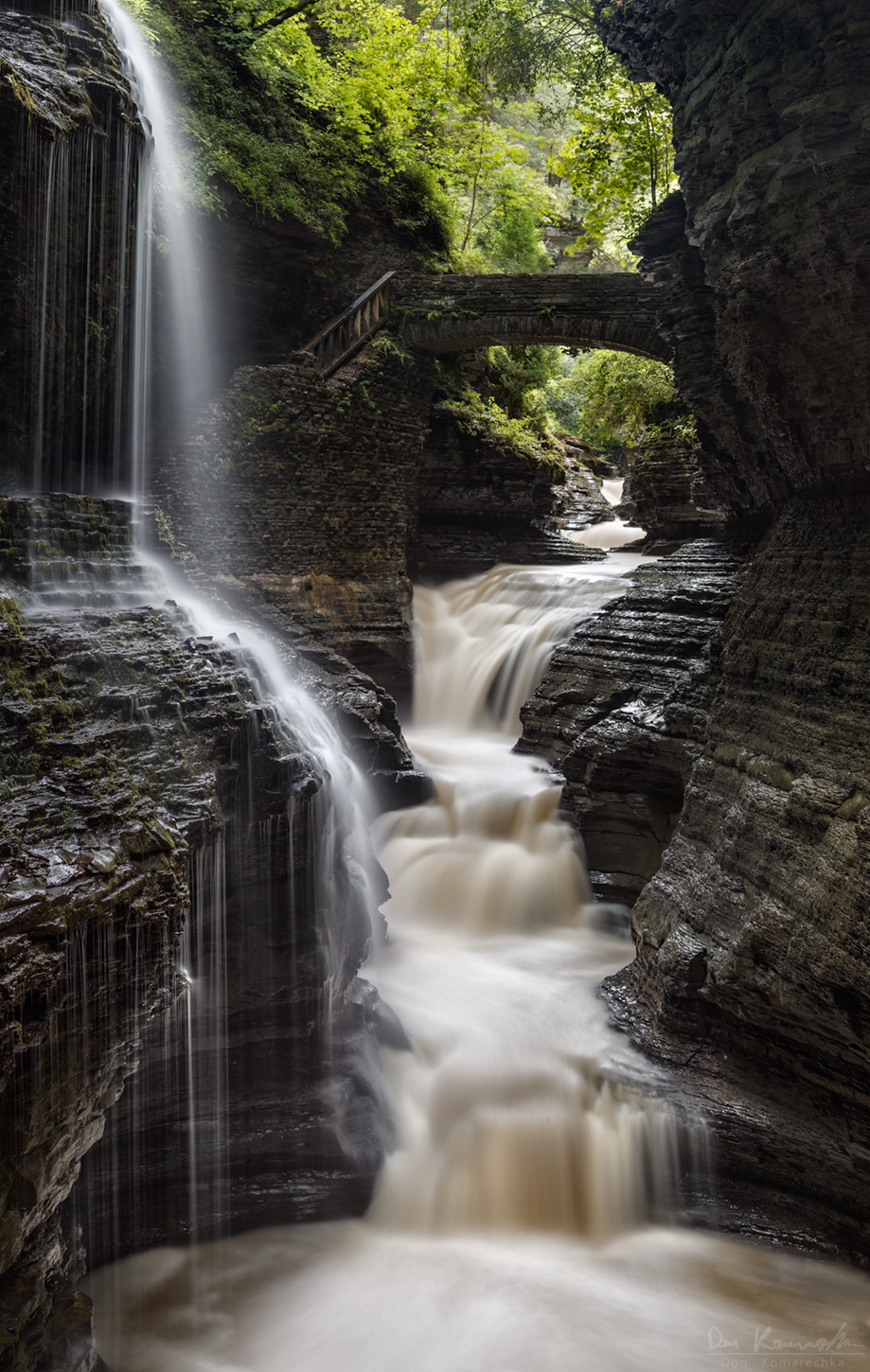
Each of the component images was 30 seconds long, which served two purposes relating to motion blur. Any exposure of 1 second or longer would help to smooth out the water and create a soft flow, but going longer than this usually has minimal effect on the water. This location was FILLED with tourists however, and a 30 second exposure is long enough to blur people so far that they become invisible (as long as they keep moving during that time). As a result, a very busy location appears much more isolated and peaceful.
Waterfalls are a fun element of “the unseen world” to explore when you slow down the exposure and remove colour, forcing us to see them in terms of lines and shapes more than we would with our own eyes. The adventure continues!
Borage is native to the Mediterranean region and has naturalized in many other locales. Already during the middle ages, the plant has been cultivated in Central Europe. Since then, it has made it's way further north and into other parts of the world, notable North America. The flower, which is know for its blue colour, is actually rose coloured at first but turns blue over time.
☛ SPONSOR☚
♛MEWSERY♛
꧁ ⊱Neko Earmuffs⊰꧂
★★ ★★
Mainstore
Social Media
☛ SPONSOR☚
♛[Mond] ♛
꧁ ⊱ Shin Set ⊰꧂
Applier For Void Mirage Lashes
Kawaii Secrets Event
★★ ★★
Mainstore
Social Media
Splashes are characterized by transient ballistic flow, and are governed by the Reynolds number and the Weber number. In the image of a brick splashing into water to the right, one can identify freely moving airborne water droplets.
Lovaina (Leuven, Louvain, Löwen) es una ciudad de Bélgica, ubicada en la confluencia de los ríos Dijle y Voer. Y capital de la provincia de Brabante Flamenco, en la región de Flandes.
El principal recurso económico de la villa es la universidad, lo que hace que se le conozca desde el barroco como «ciudad de estudiantes y monjas». Y durante el año académico la mayoría de los habitantes del centro son estudiantes.
La Universidad Católica de Lovaina (KU Leuven), fundada en 1425, es una de las más antiguas del mundo, es la más grande de Bélgica y está entre las mejores del mundo. Según el ranking de Reuters, la KU Leuven es la segunda universidad más innovadora de Europa, solo superada por el Imperial College de Londres.
Lovaina es el lugar de nacimiento de varias cervezas como Stella Artois, Leuvense Tripel, Domus y Keizersberg. Y tiene varios bares que se enorgullecen de ofrecer una amplia variedad de cervezas locales e internacionales (uno de ellos presume de ofrecer más de 3.000 cervezas diferentes.
Entre sus monumentos cabe destacar la biblioteca de la universidad, incendiada durante la Primera Guerra Mundial y reconstruida con aportaciones de las universidades estadounidenses. La plaza Mayor o «Grote Markt», con un espléndido Ayuntamiento típico de la arquitectura flamenca. La «Oude Markt», o plaza vieja, centro de la noche universitaria.
Especial atención merece el beaterio o begijnhof o Beguinaje, que la Unesco declaró patrimonio de la humanidad y que es en realidad un viejo monasterio habilitado como colegio mayor de estudiantes.
La iglesia de San Pedro (1425-1500) fue acabada por Jan Keldermans y Matheus de Layens. y hay varias pinturas de los siglos XVII y XVIII, pero la más famosa es la gótica Última cena de Dirk Bouts. Aquí se encuentra la tumba del duque Enrique I de Brabante. Su torre, de 50 metros de altura, estaba pensada para alcanzar los 169 metros, pero nunca se completó, alberga un carillón. Y fue incluida en la lista de la Unesco de «Campanarios de Bélgica y Francia» en 1999.
Leuven or Louvain is the capital and largest city of the province of Flemish Brabant in the Flemish Region of Belgium. It is located about 25 kilometres (16 miles) east of Brussels. It is the eighth largest city in Belgium, with more than 100,244 inhabitants.
Leuven has been a university city since 1425. This makes it the oldest university city in the Low Countries. KU Leuven, the largest Dutch-speaking university in the world and the largest university in the Low Countries (and thus also Belgium's largest university), has its flagship campus in Leuven.
Leuven is the worldwide headquarters of Anheuser-Busch InBev, the largest beer company in the world and is considered one of the largest fast-moving consumer goods (FMCG) companies in the world. InBev's Stella Artois brewery and main offices dominate the entire north-eastern part of the town, between the railway station and the canal to Mechelen. Finally, Leuven is the ancestral home of the KBC Group. KBC is one of the leading financial groups in Europe. It is a multi-channel bank-insurance group, with a geographic focus on Belgium and Central Europe, catering mainly to retail clients, SMEs and local midcaps. As one of the largest companies in Belgium and it has its insurance and auto lease HQ in Leuven.
Leuven has a rich beer culture, being the birthplace of several beers such as Stella Artois, Leuvense Tripel, Domus and Keizersberg. It has several bars priding themselves in offering a wide variety of local and international beers, including a bar that claims to offer more than 3000 different beers.
Leuven has a large international student population, mainly concentrated around the city centre. The Katholieke Universiteit Leuven (KU Leuven; University of Leuven) has two campuses in the city, with a total of more than 45,000 students as of January 2020. It is the oldest Catholic university still in existence in the world, and the largest university in Belgium. There are also a number of hogescholen (universities of applied sciences), such as the UC Leuven-Limburg (UCLL).
One of Belgium's conservatories is based in Leuven: the Lemmens Institute, which is described as "Faculty of Music, Performing Arts and Education". It is known for its music therapy education and its wordart-drama education. Kunstencentrum STUK is a cultural centre and venue in the city center for music, theatre, sound art, and dance. Leuven holds a summer rock festival, Marktrock. Leuven has some university orchestras, such as the University Symphony Orchestra (USO), the University Symphonic Band (UHO). and the Arenberg Orchestra.
Cedar Waxwing CEDW* (Bombycilla cedrorum)
Pendray Farm (Private Property)
North Saanich
(Saanich Peninsula)
Capital Regional District
Vancouver Island
British Columbia
DSCN9391
Yeah ... i am a sucker for any bird with a crest.
Although this species is seasonally abundant in some locales in our area, i never tire of seeing it and/or observing
***
So ..as per previous i have stretched the definition of "fence" to include gaurdrail assemblies which "fence " to keep people from going over an edge
In this case on a reservoir's dock like assembly that facilitates
irrigation on a multi generational family farm out on "The Peninsula"
In early spring and lasting into early July, Shortspur Seablush (Plectritis congesta) flowers appear as swaths of small pink pom-poms that brighten often overcast and rainy spring days. Plants can reach a height of 60 cm in some locales. The flower head bears many tubular flowers, each with an upper and lower lobed lip. Three stamens tipped with purple anthers carry yellow pollen. Copyright © Kim Toews/All Rights Reserved.
Otternes, a Norwegian linear - and cluster collective farmyard midway between Aurland and Flåm in Vestland county. The farmyard consists of 27 buildings.
Evidence shows settlements from about 300 A.D. The oldest buildings, Guttormstova and Eilertstova were built about 1700. The land redistribution reform in the 1860s were not implemented in Otternes where the allocation of strip of fields lasted until 1987. Otternes consisted originally of four farms: Tomas farm, Guttorm farm, Odda farm and Anders farm. In the nineteenth century about 30 people lived there in the farmplace. The two remaining farms were run in the old fashion until 1970. Otternes has thus been hardly affected by the passage of time, and some of the buildings appear more or less as they did in the 18th century. The cultivated landscape remains essentially intact with hills, stairs, stone walls, wells, etc.
Otternes has been without residents since 1996. As a result of its historic flavor, the locale has therefore been a setting for several film productions.
Today Otternes serves as a rural museum and a center for the older crafts. It is also used for traditional activities as spinning, weaving, thin wafer crispbread (flat bread) baking, yarn dyeing, ale brewing and a variety of other exhibitions in the summer time.