View allAll Photos Tagged rust
Union Pacific Railroad 900075 built by Lima in 1949
Rotary Snowplow & Tender
Illinois Railway Museum
Union, IL
The Porsche 914 is known for being a bit of a rust bucket. Probably why so few of these little go-karts are still on the road. This one is visiting UK while it's not raining.
Cute, eh?
I've always had a soft spot for this model - it's the pop-up headlamps.
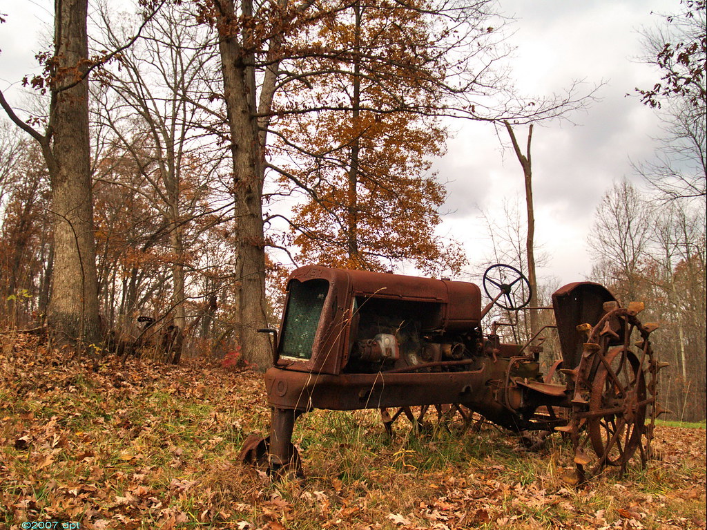
This old, rusting tractor sits in an area just off the road along Rt 9 north of Carrollton, Ohio. I've lost track of how many times I have passed this thing this year alone since Rt 9 is one of my favorite riding routes going south. I have no idea how old this tractor is but the emblem says "Oliver" and it has a crank starter.
Large = farm3.static.flickr.com/2325/2052952130_f700201dfe_b.jpg
The "Picture This!" assignment for this week was Ghosts on the Landscape. When I read that assignment a week ago, this was the first thing that came to mind.
Rusting away in Cumming, GA
Follow Sussman Imaging on Facebook at www.facebook.com/sussmanimaging
This farm implement was last licensed in 1945 but it surely is a clue as to why our US infrastructure, roads and bridges are being destroyed; well, that and the righties. I am using a McIntosh Ag Museum shot to finish a greenish series by adding rust and weeds. This certainly is a fitting title for this image. This machinery is for the ages, the iron ages! This is some kind of weird plowing implement, it must be an older iron implement and possibly horse-drawn but probably not in 1945. I see some rust on it. It had to be iron heavy in order to be able to "bite" into the soil. I ought to go again and figure out the exact function but I am close.
This June found a return to hot temperatures. Wundermaps reported 101 degrees while I was out there. Whew! The direct sun blazed across the scene. I decided that I had missed some shots at McIntosh and went out in the baking sun.
Highway #66 seemed overloaded with early summer travelers to the hills, probably not knowing summer might not arrive until July in the Rockies. They are still dumped a lot of snow into the rivers yet there are plenty of folks willing to jump in a drown.
Previous set of Pripyat here www.flickr.com/photos/timster1973/sets/72157643944616235/
Named for the nearby Pripyat River, Pripyat was founded on 4 February 1970, the ninth nuclear city in the Soviet Union, for the Chernobyl Nuclear Power Plant. It was officially proclaimed a city in 1979, and had grown to a population of 49,360 before being evacuated a few days after the 26 April 1986 Chernobyl disaster.
Though Pripyat is located within the administrative district of Ivankiv Raion, the abandoned city now has a special status within the larger Kiev Oblast (province), being administered directly from Kiev. Pripyat is also supervised by Ukraine's Ministry of Emergencies, which manages activities for the entire Chernobyl Exclusion Zone.
Access to Pripyat, unlike cities of military importance, was not restricted before the disaster as nuclear power stations were seen by the Soviet Union as safer than other types of power plants. Nuclear power stations were presented as being an achievement of Soviet engineering, where nuclear power was harnessed for peaceful projects. The slogan "peaceful atom" (Russian: mirnyj atom) was popular during those times. The original plan had been to build the plant only 25 km (16 mi) from Kiev, but the Ukrainian Academy of Sciences, among other bodies, expressed concern about it being too close to the city. As a result, the power station and Pripyat were built at their current locations, about 100 km (62 mi) from Kiev. After the disaster the city of Pripyat was evacuated in two days.
My blog:
timster1973.wordpress.com
Also on Facebook
www.Facebook.com/TimKniftonPhotography
online store: www.artfinder.com/tim-knifton
instagram: instagram.com/timster_1973
Beauty in Decay.
This was my old builders wheebarrow before it went to the dump.
See Rust Landscape 1 here www.flickr.com/photos/16054928@N07/10755990124/in/set-721...
A detail of the effects of time and elements on the paint of an old piece of rolling stock at the Railroad Museum of Pennsylvania in Strasburg, PA. From this detail, I am not sure what the original paint color was when this car was new. Fun with a macro lens.