Sponsored images from ![]()
View allAll Photos Tagged position
www.playgardcondoms.com/play-talks/5-sex-positions-to-ton... - Some sex positions can be very conducive in helping you to tone your body. Here are some sex positions that will help you get the exact same results as gym exercises. Visit www.playgardcondoms.com for more information.
#1 #2 & #3
Nikon D40 18-200mm f/3.5-5.6 VR
ISO 200
1/400
F5.6
Vivitar 285HV 1/8 Power
ebay trigger
#4
Nikon D40 18-200mm f/3.5-5.6 VR
ISO 200
1/400
F7.1
Vivitar 285HV 1/8 Power
ebay trigger
#5
Nikon D40 18-200mm f/3.5-5.6 VR
ISO 200
1/400
F11
Vivitar 285HV 1/8 Power
ebay trigger
#6
Nikon D40 18-200mm f/3.5-5.6 VR
ISO 200
1/400
F36
Vivitar 285HV 1/8 Power
ebay trigger
The Finale to the BARC Club Car Championships Weekender at Brands Hatch and after a Very Thrilling set of both Qualifying Sessions and Races which took place on the Saturday it was Time once again for each Driver to strap in and get ready for some high speed Racing Action thought the Sunday.
In Tribute to the Marshall who was Tragically Killed on the Saturday Some Car and Driver Pairings were Racing with Orange Hearts on their Cars as a Tribute to all of Motorsports Family of Marshalls for who without Racing would not be possible. Thank You!
So Lets get started and see what the days events Haver to Offer and who can Push their Machinery to the Limits and beyond for a Victory.
Britcar Endurance Championship - Trophy Category (Race 1 Results FINAL)
The Britcar Endurance Trophy was the First up and it was time to see who could claim that elusive Pole Position and to see if anyone else could challenge the Top Three Drivers Lets see how things turned out.
In First Place was the Pairing Of (Datum Motorsport's Axel Van Nederveen and Adriano Medeiros) in their Ginetta G55A with a Best Lap Time of 52:193 and an Average Speed of 64.75mph. Congratulations Axel and Adriano a Really Fantastic Drive and A Super Victory.
In Second Place was (SVG's Mark Lee) in his Ginetta G56A with a Best Lap Time of 52.086 and an Average Speed of 64.70mph. Amazing Drive Mark Keeping that Ginetta on the Track and Taking Second Place while Nearly Matching the Speed of Axel and Adriano. Well Done.
In Third Place was (Terry Stephens) in his Peugeot 308 with a Best Lap Time of 53.421 and an Average Speed of 64.50mph. Well Fought Terry a Fantastic Finish in Third Place and Staying Ahead by just over 11 seconds to the Pair of Jasver and Bryan in 4th. Amazing Job.
A Really Enjoyable and Exciting First Race of the Sunday with High Speed Action and Incredible Victories on Track. Congratulations Axel Adriano Mark and Terry. Lets see what Race 2 Brings in terms of the Action.
Britcar Endurance Championship - Trophy Category (Race 2 Results FINAL)
Race 2 For Britcar Next and after a Very Fast and Action Packed First Race Will we see a New Face on the Top Step of the Podium? Lets find out.
In First Place was the Pairing of (Woodrow Motorsport's Simon Baker and Kevin Clarke) in their BMW 1 Series with a Best Lap Time of 51.837 and an Average Speed of 78.22mph. Amazing work Simon and Kevin who have Beaten the Pairing Of (Datum Motorsport's Axel Van Nederveen and Adriano Medeiros) to Victory. An Incredible Drive by Both of them Well Done.
In Second Place was (SVG Mark Lee) in his Ginetta G56A with a Best Lap Time of 52.281 and an Average Speed of 76.89mph. Again a Huge Congratulations to Mark Lee for hanging onto that Second Place Despite Fierce Competition during The Race. Amazing Drive.
In Third Place was (Simon Green Motorsport's Pairing of Jasver Sapra and Brian Branson) in their BMW M3 E46 with a Best Lap Time of 52.718 and an Average Speed of 76.88mph. Congratulations Jasver and Brain Brilliant Drive and well Defended to keep that Third Place in Tact.
Two Incredible Races with Two Very Different Outcomes of Race Winners and Runners Up The Britcar Endurance Trophy is Proving to be Very Competitive this Year.
A Huge Congratulations to Simon Kevin Mark Jasver and Brain for some Amazing Racing and Victories and Good Luck to All Other Drivers. Keep working Hard and Pushing for that All Important Victory.
CTCRC Edmundson Electrical Classic / Historic Thunder Saloons (Race 1 Result FINAL)
Next Up was the CTCRC Electrical and Historic Thunder Saloons and After a Thrilling Qualifying Session Yesterday Lets see what Each Driver has got and who can Push to the Limits for that All Important Victory.
In First Place was (Jason West) in his BMW E46 M3 3200 with a Best Lap Time of 51.907 and an Average Speed of 59.84mph. Congratulations Jason for Another Incredible Drive for First Place and a well Deserved Victory Amongst some Stiff Competition.
In Second Place was (Andrew Wilson) in his Holden Monaro 7000 with a Best Lap Time of 52.418 and an Average Speed of 59.96mph. Well Done Andrew Fantastic Driving and a Super Defensive Drive for Second Place.
In Third Place was (Samuel Wilson) in his Aston Martin V8 Vantage with a Best Lap Time of 52.699 and an Average Speed of 59.50mph. Amazing Work Samuel and a Beautiful Example of the Aston Martin V8 Vantage on Display Showing its Raw Power and Racing Pedigree to Finish in Third Place.
A Fantastic Finish to The Historic and Electrical Thunder Saloons Racing at The Weekend. A Huge Congratulations to Our Top Three Finishers Jason Andrew and Samuel. Fantastic Racing from all Three of you and Good Luck to all other Drivers Keep Tuning and Working Hard and I'm sure Victory Will not be too Far Away from you.
CTCRC JEC Saloon & GT Championship & Burton Power BOSS (Race 2 Results FINAL)
Next Up CTCRC Saloon and GT Championships and with some Fierce Competition on Display during not only Qualifying but also Their First Race on the Saturday Which saw Malcom Harding Storm to an Insane Victory who Will be able to Take him on and Potentially Steal his Crown during the Next Race Today? Lets See.
In First Place was (Malcom Harding) in his Ford Escort MK2 Zakspeed 2500 with a Best Lap Time of 53.888 and an Average Speed of 78.49mph. Another Incredible Victory for Malcom that Highly Modified Zakspeed Escort Really Shows off the Power and Performance of a True Champion and a Fantastic Driver. Congratulations Malcom.
In Second Place was (Steven Goldsmith) in his Ford Anglia 105e 260 with a Best Lap Time of 54.335 and an Average Speed of 78.21mph. Another Storming Drive to Achieve Second Place for Steven. Fantastic Driving and Amazing Car Control through Every Corner. Congratulations Steven.
In Third Place was (Tom Robinson) in his Jaguar XJ6 4000 with a Best Lap Time of 55.481 and an Average Speed of 55.481mph. Congratulations Tom Superb Display of Driving Ability behind the Jag and a Well Deserved Third Place for Him.
Another Incredible Weekend of Racing for the CTCRC Saloon and GT Championships with Some New and Some Old Drivers Stepping onto the Podium. Massive Congratulations to Malcolm Steven and Tom for their First Second And Third Place Finishes. Keep Up the Good Work and Never Stop Trying.
CTCRC Laser Tools Pre 93 & Simply Serviced Pre 03 Touring Cars (Race 1 Results FINAL)
Now Its Time for The Laser Tools Pre 93 and Simply Serviced Pre 03 Touring Cars to make their way back onto The Track for what Looked to be a Spectacular Race. A Whole Range of Different Cars to Race Against and Stiff Competition after Qualifying Proves that This Race will be One not to be Missed. Lets See what Unfolded.
In First Place was (Gary Prebble) in his Honda Civic EG 2000 with a Best Lap Time of 54.100mph and an Average Speed of 78.60mph. Well Done Gary a Really Well Deserved First Place Victory and an Amazing Drive to the Flag.
In Second Place was (David Griffith) in his BMW E36 M3 3058 with a Best Lap Time of 54.558 and an Average of 78.42mph. Incredible Drive their David Pushing that BMW For Everything that it Has got to Achieve Second Place.
In Third Place was (Kam Tunio) in his Honda Civic EK9 1595 with a Best Lap Time of 55.347 and an Average Speed of 77.05mph. Well Driven Kam Super Driving on Display and a Well Deserved Third Place Finish.
Another Amazing Race for The Pre 93 and Pre 03 Touring Cars and a Huge Congratulations to Gary David and Kam for their First Second and Third Place Victories. Keep up the Hard Work and Good Luck to everyone Else wherever your Next Races take you.
CTCRC Poultec Classic Race Engines Pre 66 Touring Cars (Race 1 Results)
Now it was Time for the Fan Favourite to Enter onto the Brands Hatch Circuit with the Pre 66 Touring Cars Championship. With Mini's Lotus Cortina's and Ford Falcons. This was One Race that No One Wanted to Miss. After a Very Fast Paced Qualifying Session on the Saturday Which saw (Alan Greenhalgh) take Pole Position who Will be able to Challenge Him During the Race and Snatch Victory Away from Him.
In First Place was (Alan Greenhalgh) in his Ford Falcon with A Best Lap Time of 58.707 and an Average Speed of 72.63mph. Congratulations Alan A Beautiful Example of the Ford Falcon and Certainly a Very Fast One too. Congratulations on Your Victory.
In Second Place was (Robyn Slater) in his Ford Anglia 1550 with a Best Lap Time of 58.992 and an Average Speed of 72.06mph. Very Good Drive their From Robyn to Secure Second Place in The First Race of the Day for the Pre 66 Touring Cars.
In Third Place was (Barry Sime) in his Morris Mini Cooper S 1293 with a Best Lap Time of 59.116 and an Average Speed of 71.95mph. Fantastic Work their Barry Keeping that Little Rocket on The Track looked to be Very Challenging but A Very Well Deserved Third Place.
What A First Race for The Historic Pre 66 Touring Cars showing The Power and Pride Each Driver takes in Both Racing and Preservation on Their Beloved Racing Machines. Congratulations to Alan Robyn and Barry on their First Second and Third Place Finishes. Lets See what New Challenges Await Them in Race 2 The Final Race of The Day for Them.
CTCRC Poultec Classic Race Engines Pre 66 Touring Cars (Race 2 Results FINAL)
The Epic FINALE To The Pre 66 Touring Cars Race was A Race in Wet Conditions Making it even more Challenging for The Top Three Drivers. Who would Win and be able to Retain if not Take on thease Three Giants of Touring Car Racing in thease Conditions. Lets See How Things Concluded.
In First Place was (Barry Sime) in his Morris Mini Cooper S 1293 with a Best Lap Time of 1:11.482 and an Average Speed of 58.62mph. Amazing Work Barry to take Home a Superb Victory and a Brilliant Bit of Wet Weather Driving in The Mini Well Done.
In Second Place was (John Davies) in his Austin Mini Cooper S 1293 with a Best Lap Time of 1:11.416 and an Average Speed of 58.38mph. Amazing Work John Racing A Mini in thease Conditions is Very Tricky and Yet both You and Barry made it look Easy.
In Third Place was (James Ibbotson) in his Hillman Imp Super 998 with a Best Lap Time of 1:11.518 and an Average Speed of 58.12mph. Well Done James Sliding that Imp around in the Wet for a Magnificent Third Place was Well Deserved.
What A Race to End the Day for the Pre 66 Touring Cars and with So many Old and New Winners Lets Hope we Get to see More Races like This One Thought the Rest of the 2021 Season. A Big Congratulations to Barry John and James on their Respective Victories and Keep Trying Everyone Else The Hard Work will Pay off.
CTCRC Shell Oils Pre 83 Touring Cars (Race 1 FINAL)
Up Next The Pre 83 Touring Cars took to the Track for Their Only Race of The Day and from what We Have Seen Already This Race also looks like its going to be a Very Strong Battle for First Second and Third Place. Lets See who Came First and Took that All Important Victory.
In First Place was (Mark Lucock) in his Ford Escort MK1 RS2000 2040 with a Best Lap Time of 57.687 and an Average Speed of 74.53mph. Amazing work there Mark Pushing All the Power the RS2000 Engine Has and Keeping it on Track to Score an Amazing Victory.
In Second Place was (Stephen Primett) in his Ford Escort MK1 2037 with a Best Lap Time of 57.503 and an Average Speed of 74.52mph. Another Brilliant Drive from the Likes of Stephen Keep the Pace with Mark and Making for some Fierce Competition Thought the Race.
In Third Place was (Mike Luck in his BMW E21 320 1998 with a Best Lap Time of 57.236 and an Average Speed of 74.46mph. Super Driving there Mike to take Third Place and a Very Classic Looking BMW Indeed.
What A Race from the Pre 83 Touring Cars showcasing Speed Power and What a Touring Car was Made to do around a Race Track. A Big Congratulations to Mark Stephen and Mike on their First Second and Third Place Finishes. Keep Racing and Keep Having Fun Out There.
Junior Saloon Car Championship (Race 1 Result FINAL)
The Junior Saloon Car Championship was Up Next and Even Though the Age Range of thease Next Drivers Taking to the Circuit Might Shock you at The Fact that Many of them are as Young as 15 Years of age don't be Fooled Because thease Guys Know how to Race Having been brought up from Carting since the age of 4. They are always a Fan Favourite and After Qualifying on the Saturday its Anyone's Game as to Who Wins and Who Losses in Thease Races.
In First Place was (Ruben Hage) in his Citroen Saxo VTR 1600 with a Best Lap Time of 59.967 and an Average Speed of 65.65mph. Congratulations Ruben What A Drive and an Incredible Run for First Place Fending off the Other On Coming Drivers. Truly a Championship Winning Drive.
In Second Place was (Harvey Caton) in his Citroen Saxo VTR 1600 with a Best Lap Time of 59.629 and an Average Speed of 65.64mph. Very Well Driven there Harvey Staying very Close to Ruben in First Place and Keeping Him on His Toes Thought the Entire Race.
In Third Place was (Charlie Hand) in his Citroen Saxo VTR 1600 with a Lap Time of 1:00.006 and an Average Speed of 65.57mph. Solid Third Place there Charlie Keep Up the Momentum and Never Give Up Chasing Your Dreams.
What a Fantastic Race from the Junior Saloon Car Championship with New Winners on the Podium and Some Close Wheel to Wheel Action Thought the Race Thease Guys will be Fantastic To see in Future Racing Series All Over The World. Congratulations to Ruben Harvey and Charlie for First Second and Third Place and Good Luck to All Other Aspiring Young Drivers Following in the Footsteps of Your Greatest Racing Heroes.
Kumho BMW Championship (Race 1 Results)
Finally it was Time for the Last Two Races of the Day the Kumo BMW Championship. Featuring The Makes and Models of Many BMW'S taking to the Circuit for Race 1. After a Busy Day Qualifying on Saturday Lets See what Each Driver Cando in The Frist of Two Races for their Championship.
In First Place was (Niall Bradley) in his BMW E46 M3 with a Best Lap Time of 50.920 and an Average Speed of 83.60mph. Brilliant Driving There Niall Pushing the Power of the BMW Engine to Max and Putting the Pedal to the Metal the Whole Race. A Superb Victory.
In Second Place was (Michael Vitulli) in his BMW E36 M3 3200 with a Best Lap Time of 51.158 and an Average Speed of 83.45mph. Another Incredible Driver Pushing Hard and Taking Second Place. Well Done Michael.
In Third Place was (James Card) in his BMW E46 M3 3200 with a Best Lap Time of 51.154 and an Average Speed of 83.42mph. Very Well Done their James Keep Pushing.
Three Fantastic Drivers in Niall Michael and James all Fighting for that Victory and Showing The Racer Inside each and Everyone of them. Lets see what Their Final Race of the Day Brings Them.
Kumho BMW Championship (Race 2 Results FINAL)
In First Place was (Niall Bradley) in his BMW E46 M3 with a Best Lap Time of 53.581 and an Average Speed of 77.79mph. Another Well Deserved First Place Finish to Round of The Days Racing. Congratulations Niall Go and Celebrate with The Team In Style.
In Second Place was (Darren Morgan Owen) in his BMW E46 M3 3200 with a Best Lap Time of 53.200 and an Average Speed of 77.43mph. Super Drive There Darren for Second Place and a New Winner onto The Podium.
In Third Place was (Brad Sheean) in his BMW E46 M3 3200 with a Best Lap Time of 53.227 and an Average Speed of 77.13mph. Fantastic Drive there Brad and Some Incredible Car Control thought the Entire Race to Finish Third.
And That Concludes Racing for the Kumho BMW Championship with 4 Different Winners Across two Races and A lot of Really Fast Action you could not Have Asked for a better Finish to The End of The Days Racing. Massive Congratulations to Niall Darren and Brad and Good Luck to all Other Competing Drivers who are still Looking for that almighty Victory.
That Concludes Racing for The BARC Club Car Championships Weekend A Big Congratulations to All of the Drivers of Every Team and a Huge Thank You to Marshalls Far and Wide as Without Your Support Events like This and Champion Drivers May Never Get to Achieve Their Dreams.
See You All At The Next One!
Last time I visited some twenty months ago, most of All Saints was shrouded in scaffolding and thick plastic, as the tower needed to be shored up.
You must come back when the work is complete the warden told me.
I went back.
And the same warden greeted me, though she didn't remember me.
Large and airy now, showing off the fine Victorian tiles in the Chancel, though the lighting gave my pictures a strong cast. Liked the 1950s windows with over 50 saint's symbols.
Open between 14:00 and 156:00 every summer Saturday afternoon.
You'll get a warm welcome. Worth seeking out.
-------------------------------------------
In an awkward position, cut off from its village by the railway and bypass and somewhat compromised by the adjoining paper mill. The present church has been extended from its thirteenth century origins, most noticeably by the addition of a tall tower in the fifteenth century. There is a rood loft staircase in the south wall and on a pillar nearby can still be seen an unusual fourteenth-century Crucifixion painted on the stonework within an incised outline. The church was over-restored by Blomfield in 1870 and suffered damage in the Second World War when the medieval glass was destroyed. Fragments that survived have been assembled where possible. New windows were installed, including the thirty-six symbols of the saints in the east window by Hugh Easton (1953), and the Becket Pilgrim window by Moira Forsyth (1966). A large memorial in the south aisle commemorates Thomas Waghorn (d. 1850), who pioneered the overland route to India.
www.kentchurches.info/church.asp?p=Snodland
NORTHWARD from Ditton, on the western side of the Medway, a small part of Aylesford at New Hyth intervening, is Snodland, called in Domesday, ESNOILAND, and in the Textus Roffensis, SNODDINGLAND and SNODILAND.
SNODLAND lies on the western bank of the river, which is its eastern boundary opposite to Burham. The high road from Stroud to Larkfield goes through the village, which is situated about half a mile, and the church about midway from the river. It lies low, and being near the salt marshes, is not either very pleasant or very wholesome. In the southern part of the parish the stream which flows from Birling turns a pa per mill here, and thence flows into the Medway, not far from which is Snodland and New-Hyth common. In the northern part of the parish next to Lower Halling, is the hamlet of Holborough, usually called Hoborow, no doubt for Old Borough, a name implying the antiquity of this place. Many are inclined to believe, that the usual passage across the river in the time of the Romans, was from hence to Scarborough on the opposite shore. However that may be, Holborow was certainly known to them, for in queen Elizabeth's reign, an urn filled with ashes was discovered in digging for chalk on the hill above this place, a sure token of the Romans having frequented it. (fn. 1) In this hamlet Mr. John May resides in a handsome new-built house, near it there rises a small brook, which flows from hence into the Medway, at about half a mile distance. From this low and flat country, on the bank of the river, the ground rises westward up to the range of high chalk hills, where the land becomes poor and much covered with flints. Upon these hills among the woods is an estate, corruptly called Punish, for it takes its name from the family of Pouenesse, or Pevenashe, written by contraction Poneshe, who were possessed of it as high as king Henry the IIId's. reign, in queen Elizabeth's reign it was called Poynyshe, and was then in possession of the name of Brown, who held it of the bishop of Rochester as of his manor of Halling. (fn. 2) About a mile eastward from the above is a farm called Lads, which in king Edward I's. reign, and some generations afterwards, was in the possession of a family of that name, written in deeds of those times, Lad, and Le Lad.
This parish ought antiently to have contributed to the repair of the ninth pier of Rochester bridge.
Sir John Marsham, bart. and Sir Charles Bickerstaff, had a design of supplying the towns of Stroud, Rochester, and Chatham, with fresh water, by bringing it from the spring rising at the foot of Holborough hill, and others thereabouts, by a cut or channel through Halling and Cuxton thither, four miles of which was through Sir John Marsham's own lands, but after they had proceeded two miles, finding some obstructions, which could not be removed, but by an act, one was procured for the purpose in the 1st year of James II. but nothing further was afterwards done in it, for what reason does not appear.
In the year 838, king Egbert, with the consent of his son king Æthelwulf, gave to Beormod, bishop of Rochester, four plough lands at Snoddinglond and Holanbeorge, with the privilege of leaving them to whomever he pleased; and he granted that the lands should be free from all service, to which he added one mill on the stream, named Holanbeorges bourne, and on the hill belonging to the king fifty loads of wood, and likewife four denberies in the Weald. And in the year 841, Ethelwulf, king of the West Saxons, with the advice of his bishops and great men, gave to the bishop two ploughlands at Holanbeorges, in perpetual inheritance, with the like privilege, and that they should be free from all regal service.
Whilst Ælfstane was bishop of Rochester, who came to the see in 945, and died in 984, one Birtrick, a rich man, who lived at Meopham, with the consent of Elfswithe, his wife, made his testament, and gave, after their deaths, his lands at Snodland to St. Andrew's church at Rochester. (fn. 3)
The bishop of Rochester continued in the possession of this place at the time of taking the general survey of Domesday, about the 15th year of the Conqueror's reign, anno 1080, in which record it is thus entered, under the general title of that bishop's lands:
The same bishop (of Rochester) holds Esnoiland. In the time of king Edward the Confessor it was taxed at six sulings, and now at three. The arable land is six carucates. In demesne there are two carucates and ten villeins, with six borderers, having six carucates. There is a church and five servants, and three mills of forty shillings, and thirty acres of meadow, wood for the pannage of four hogs. In the time of king Edward and afterwards, it was worth six pounds, and now nine pounds.
When bishop Gundulph, soon after this, following archbishop Lanfranc's example, separated his revenue from that of his priory, this manor, together with Holborough, continued part of the bishop's possessions, and was confirmed to the church of Rochester by archbishops Anselm and Boniface.
On a taxation of the bishop's manors next year, it appeared that Holeberge was a member of the manor of Halling, and had in it one hundred and ninety-seven acres of arable land, valued at four-pence per acre at the most, as there was no marle there. That there were here fourteen acres of meadow, six acres of pasture, which were salt, and three lately made fresh, each acre at eight-pence, and the mill at twenty shillings per annum.
Hamo, bishop of Rochester, in the year 1323, new built the mill at Holbergh, with timber from Perstede, at the expence of ten pounds. (fn. 4) At which time the bishop seems to have had a park here.
The estate of Snodland with Holborow, still continue part of the possessions of the right reverend the lord bishop of Rochester. William Dalyson, esq. of West Peckham, is the present lessee of the bishop's estate in this parish.
THE FAMILY of Palmer, who bore for their arms, Argent, a chevron between three palmers scrips, sable, tasselled and buckled, or resided for some time in this parish, at a seat they possessed in it, called The courtlodge. Several of them lie buried in the church of Snodland, particularly Thomas Palmer, who married the daughter of Fitzsimond, and died anno 1407. Weaver recites his epitaph thus, now obliterated:
Palmers al our faders were
I, a Palmer, livyd here
And travylled till worne wythe age
I endyd this worlds pylgramage
On the blyst Assention day
In the cherful month of May
A thowsand wyth fowre hundryd seven
And took my jorney hense to Heuen
From him descended the Palmers, of Tottington, in Aylesford, and of Howlets, in Bekesborne, now extinct.
The Palmers were succeeded here by the Leeds's, one of whom, William Leeds, lay interred in this church, whose arms, A fess between three eagles, were engraved in brass on his tomb, but they are now torn away; to whom, in the reign of king Charles I. succeeded the Whitfields, of Canterbury. It afterwards passed into the name of Crow, and from thence to the Mays, and it is now the estate of Mr. John May, of Holborough.
VELES, alias SNODLAND, is a manor in this parish, which in the reign of king Edward I. was held as half a knight's fee, of the bishop of Rochester, by John de Pevenashe, John Harange, and Walter Lad, as coparceners, and in the 20th year of king Edward III. Richard Pevenashe, John de Melford, John Lade, and Richard le Veel, paid aid for it.
This manor seems afterwards to have been wholly vested in the family of Veel, called in deeds likewise Le Vitele, and in Latin Vitulus. After they were extinct here, it passed into the name of Blunt, and from that to Turvye, of whose heirs it was held in the latter end of the reign of king Henry VIII. by Richard Harvey. (fn. 5) It passed, after some intermediate owners, by sale to Crow, and from thence in like manner to Mr. John May, whose two sons, Mr. John and William May, of this parish, afterwards possessed it. The latter died in 1777, on which the entire fee of it became vested in his brother Mr. John May, of Holborough, the present possessor of it.
HOLLOWAY COURT is a seat in this parish, which gave name to a family that resided at it. Henry de Holeweye paid aid for it in the beginning of the reign of king Henry III. (fn. 6) His descendant, William de Holeweye possessed it in the 30th year of king Edward I. from which name it passed into that of Tilghman, who were owners of it in the reign of king Edward III. Many of whom lie buried in this church, bearing for their arms, Per fess sable and argent, a lion rampant regardant, doubled queved counterchanged, crowned, as they were painted in very old glass in the windows of this house. Their pedigree is in Vistn. co. of Kent, anno 1619.
Richard Tilghman possessed it in the reign of king Henry IV. and in his descendants it continued down to Edward Tilghman, esq. who was of Snodland, and was twice married; by his first wife he had a son, Francis, and by his second, two sons, the eldest of whom, Whetenhall Tilghman, had part of his father's lands in this parish, which continued in his descendants till about the year 1680, when they were alienated to Sir John Marsham, bart. whose descendant, the right honorable Charles, lord Romney, is the present possessor of them.
¶Francis Tilghman, only son of Edward, by his first wife, was of Snodland, and possessed Holoway-court, where he resided in the reign of king James I. but died without surviving issue. He passed away this estate by sale to Clotworthy, descended from those of that name in Devonshire, and he by will gave it to his sister's son, Mr. Thomas Williams, who alienated it to Richard Manley, esq. who resided here, and dying in 1684, was buried in this church, leaving by Martha, daughter of John Baynard, of Shorne, widow of Bonham Faunce, of St. Margaret's, Rochester one son, Charles, and a daughter, Frances, married to Dr. Robert Conny, hereafter-mentioned. He sold Holloway court to Mr. John Conny, of Rochester, surgeon, son of Robert Conny, gent. of Godmanchester, in Huntingdonshire, and bore for his arms, Sable, a fess argent, cotized or, between three conies of the second. On whose decease his eldest son, Robert Conny, of Rochester, M. D. succeeded to it, and he sold it to Thomas Pearce, esq. a commissioner of the navy, whose three sons and coheirs, Thomas, Best, and Vincent Pearce, conveyed it by sale to Mr. John May, and his eldest son, Mr John May, of Holborough, in this parish, now possesses it.
The church is dedicated to All Saints. It is a small mean building with a low pointed steeple.
The church of Snodland has ever been appendant to the manor. It has never been appropriated, but con tinues a rectory in the patronage of the right reverend the lord bishop of Rochester.
¶Much dispute having arisen between the rector of this parish, and the rector of Woldham, on the opposite side of the river Medway, concerning the tithe of fish caught within the bounds of the parish of Woldham by the parishioners of Snodland, the same was settled, with the consent of both parties, by the bishop of Rochester, 1402, as may be seen more at large in the account of the rectory of Woldham. (fn. 7)
This rectory is valued in the king's books at twenty pounds, and the yearly tenths at two pounds.
Children play around the totem poles near the entrance to Conrad Prebys Australian Outback at the San Diego Zoo. The pillars were inspired by the artwork of aboriginal Australians.
We've been stranded here for days. They come in the night, in large numbers. We've set up fences, but they don't do much. Everyday we go out there with our guns and masks. We kill off a few hundred, but they come back. When will it end?
I really don't know whad she did with her LONG LEGS...
*** Bula died in 20 August 2007 [*] *** I miss her a lot...
Zawsze się dziwię jak ona składa te swoje długie łapy, żeby się tak równiutko zwinąć ;))
Out of the Archives: Physical examinations were also given by the Municipal Civil Service Commission at a gymnasium for relevant positions. 1915. (Image ID: p000913)
For children to be able to understand and communicate positions and directions, knowledge of ordinal numbers is important. Print, laminate and play simple games involving ordinal numbers with your pupils or for spelling too. They can also be used as classroom display. Available for FREE at:
www.sharemylesson.com/teaching-resource/Trophy-and-amp-Ro...
A position time graph and a velocity time graph have a lot of the same information. There must be a way if you have one to recreate the other. On the front side of Mr. David Askey's "Slappy the Clown" worksheet, we went from a position graph to a velocity graph by getting the slopes at every point and plotting that slope against time on a velocity graph. But we could also go the other way. If we had the velocity graph, the area under the curve on that graph tells us how far the object gets during each time period. So as long as we know where someone started, we can take these areas under the curve and add them up to regenerate the position graph.
Mr. Askey wrote this worksheet to help teach his students two functions that are as important as the ones on the left side of this photo. Getting the slope at every point along a graph is called taking the derivative, and is about half of what students learn in a first year calculus course. Just like every + has its minus, and every * has its / , there is an opposite of getting a slope as well. It's called getting the area under the curve and its formal name is integration. We take the derivative of the position graph to get the velocity graph. We take the integral of the velocity graph to get the position graph.
happy weekend everyone. go out and shoot. as i have to work. boo.
----------
taken during the monthly meet of Flickr Tokyo Photo Session
Positioned by an 08 sent down from Barrow Hill the Tubeworks Thomas hill shunter will take the rake of the wagons into their yard
A few months back, I was told about the ruined church in Sittingbourne, but due to COVID I did nothing about it. But as we would be in the area to revisit Borden, I sought out All Saints and noted its position and even used GSV to scout it out, or the area as it was hidden behind trees.
We arrived in the area, driving through a industrial estate/retail park; a network of wide roads criss-crossing with lorries parked up, litter piled up at the sides of warehouses and so on.
It seemed the most unlikely area to find a Medieval church.
And the area really didn't change that much until we came to a roundabout, and to the right was the part I had seen on GSV.
We parked beside the road, and through the gate which had been demolished by a stolen car, I guess, there was the church, or what was left of it, a single side chapel, all boarded up and looking forlorn.
------------------------------------------
Sited on the Murston side near the banks of Milton Creek stands this little historic gem set in a green oasis of calm and serenity.
The Murston Heart project is the working title for the innovative project to preserve, restore and secure the future of the beautiful 14th Century Chancel of Murston Old Church and its grounds.
Murston All Saints Trust (MAST) the holding charity’s vision is to bring back this scheduled monument to the heart of the community by creating a creative community hub on the site. This will include exhibition space in the chancel and a new building in the corner of the churchyard containing studios, a café and wcs.
2020 update: We now have planning permission and scheduled building consent and funding in place to undertake both the building work and a programme of activities with a couple of local schools. Covid-19 permitting we hope to commence work on site in October
historicswale.org.uk/murston-old-church
---------------------------------------------
MURSTON.
THE next parish westward from Tong is Murston, usually called Muston, which takes its name from its vicinity to the marshes.
The PARISH is almost all of it situated on the north side of the high Dover road, to the left of the hill next beyond Sittingborne, a very small part of it only extending southward of the road, where, near the boundaries of the parish is the parsonage, with the glebe belonging to it, and the only small wood within it. It extends northward across the marshes and salts, as far as the waters of the Swale, which separates the main land from the Isle of Shepey. The village is situated midway between the London road and the marshes, and the church and court-lodge at no great distance from it. The parish contains about one thousand acres of land, of which about thirty are wood. Its situation is most unpleasant as well as unhealthy, even in the highest grounds of it, but the greatest part lying so exceeding low and watry, enveloped by creeks, marshes and salts, the air is very gross, and much subject to fogs, which smell very offensive, and in winter it is scarce ever free from them, and when most so, they yet remain hovering over the lands for three or four feet or more in height, which, with the badness of the water, occasions severe agues, which the inhabitants are very rarely without, whose complexions from those distempers become of a dingy yellow colour, and if they survive, are generally afflicted with them till summer, and often for several years, so that it is not unusual to see a poor man, his wife, and whole family of five or six children, hovering over their fire in their hovel, shaking with an ague all at the same time; and Dr. Plot remarks, that seldom any, though born here, continuing in it, have lived to the age of twenty-one years. This character of unhealthiness extends to the neighbouring parishes on the northern side of the road, which, however, is not peculiar to this county, as all other parts of the kingdom in a like situation, are subject to the same satality. The lands in this parish, like those of Tong and Bapchild before-described, are very rich and fertile for corn, and there is some good hop-ground in it; was it not for this prospect of gain, and high wages given for the hazard of life itself, these situa tions would probably be nearly deserted of inhabitants, but this temptation draws them hither in preference to the healthy country among the poor and barren hills, but a few miles distance from them.
In Frid wood, southward of Murston parsonage, and likewise in the neighbourhood of Faversham, there are several hollow caves dug in the ground, much like those at Crayford, mentioned in the second volume of this history, p. 266, which seem to have been hiding places in the time of the Saxons, where the inhabitants secured their wives, children and effects, from the ravages and cruelty of their enemies.
A small part of this parish, consisting of some acres of arable and wood, lies at some distance from the rest of it, entirely surrounded by the parish of Luddenham, several other parishes intervening; it seems formerly to have been of some account, and in antient records to have been mentioned by the name of the manor of Herst-hall, in Herst; part of it in Bizing wood belongs to the glebe of this rectory.
The MANOR, after William the Conqueror had seized on the bishop of Baieux, his half-brother, for his seditious and turbulent behaviour, in the year 1084, with his other estates became confiscated to the crown, after which the king granted this manor to Hugh de Port, who held it of the king in capite by barony, as of the castle of Dover, by the tenure of castle guard for the defence of it, of him and of his descendants, the St. John's, this manor was again held by a family which took their name from their residence at it.
Bartholomew de Murston is in the list of those Kentish gentlemen, who assisted king Richard I. at the siege of Acon, in Palestine; and his descendant John de Murston held it in the reign of king Edward III. in the 20th year of which he paid aid for it, as one knight's fee.
But before the end of the next reign of Richard II. this family was become extinct here, when Walter, lord Fitzwalter, was become the possessor of it, whose descendant Walter, lord Fitzwalter, likewise possessed it in the reign of king Henry VI. bearing for his arms, Or, a fess between two chevrons, gules.
He seems to have alienated this manor to Sir William Cromer, lord mayor in the years 1413 and 1423, and he died possessed of it anno 1433. After which this manor continued in his descendants in like manner as Tunstall before-described, till it came with that manor, by a female coheir, in marriage to John, eldest son of Sir Edward Hales, of Tenterden, knight and baronet. In whose descendants this manor continued down to Sir Edward Hales, bart. of St. Stephen's, near Canterbury, (fn. 1) who sold it some few years since to Rebecca, the widow of Sir Roger Twisden, bart. of Bardbourn, and she is the present possessor of it. (fn. 2)
East-HALL is an estate in this parish, which was once accounted a manor. It was in early times possessed by a family which assumed its surname from it; one of whom, Joane de Easthall, is recorded in the leiger book of Davington priory, as having been a good benefactor to the nuns there, in the reign of king Henry III. After this name was extinct here, it came into the possession of the De la Pines, who bore for their arms, Sable, three pine apples, or. One of whom, James de la Pine, was sheriff of Kent in the 26th, and part of the 27th years of king Edward III. and died possessed of this manor in the 37th year of that reign, then holding it of the king in capite, by the tenth part of one knight's fee.
His son and heir Thomas de la Pine, about the beginning of king Richard II.'s reign, conveyed this manor to Thomas St. Leger, second son of Sir Ralph St. Leger, of Ulcomb, who resided at Otterden. He left a daughter Joane, who marrying Henry Aucher, esq. of Newenden, entitled her to the possession of it. She survived him, and afterwards married Robert Capys, to whom Henry Aucher, esq. her only son and heir by her first husband, in the 19th year of Henry VI. confirmed a life-estate in East-hall and other places.
From him it passed into the name of Eveas; for Humphry Eveas was found by inquisition to die possessed of the manor of Esthall in the 32d year of king Henry VI. as did his son John Eveas in the 4th year of king Henry VII. and was buried with his wife in the north chancel of this church. His wife Mildred, daughter of Bartholomew Bourne, seems to have survived him, and afterwards to have married Lewis Clifford, esq. of Bobbing. She died in the 20th year of king Henry VII. possessed of this manor with its appurtenances, in the parishes of Murston, Tong, Bapchild, and Elmele, held in capite by knight's service. At length her grandson, Humphry Eveas, dying in the 27th year of Henry VIII. leaving four daughters his coheirs, one of them Alicia, carried it in marriage to Thomas Hales, whose son Christopher Hales, in the 5th year of Edward VI. alienated it to Sir Anthony Aucher, of Otterden, who the next year passed it away by sale to Thomas Gardyner, and he, in the 10th year of queen Elizabeth, transmitted it by sale to Mr. John Norden, who in the 17th year of that reign, levied a fine of it; and afterwards alienated it to William Pordage, esq. of Rodmersham, in whose descendants it continued till it was at length sold to Iles, by a daughter of which name it went in marriage to Hazard, from which name it passed into that of shard, and thence again to Seath, in which it still continues, Rich. Seath, esq. being the present owner, who resides in it.
MERE-COURT is an estate in this parish, once esteemed a capital mansion, and seems to have been so named from its low watery situation, near the marshes; for it does not appear to have had any owners of that surname.
Thomas Abelyn held this manor in the reign of Edward I. in the 4th year of which he died, holding it of the king in capite. His grandson Thomas Abelyn, at length succeeded to it, and left his widow Isolda surviving, who, in the 21st year of that reign, married Henry de Apulderfield, which being without the king's leave, he paid his fine, and had then possession of his wife's land here and elsewhere.
¶This manor afterwards came into the possession of the family of Savage, of Bobbing, one of whom, Sir Arnold Savage, of Bobbing, died possessed of it in the 49th year of king Edward III. anno 1374. His grandson of the same name dying s. p. his sister Eleanor became his heir, she married William Clifford, esq. and entitled him to this estate, among the rest of her inheritance, and in his descendants it probably continued till it was alienated to Crosts, whose descendant Mr. Daniel Crofts died in the 22d year of queen Elizabeth, leaving one son John, and two daughters, Helen and Margaret, and they, upon the death of their brother, who was an ideot, becoming joint heirs to this estate, sold it, in the 42d year of that reign, to Mr. Stephen Hulks, (fn. 3) whose descendant Mr. Nathaniel Hulks dying without issue male, devised it by will to his two daughters and coheirs, Mary and Anne; the former of whom carried her part of this estate in marriage to Mr. John Austen, of St. Martin's hill, near Canterbury, who died possessed of it in 1770. She survived her husband, and again became entitled to this share of Mere-court in her own right, and afterwards, by the death of her sister Anne, who died unmarried, to her share of it likewise, of both which she died possessed in 1781, since which it has been sold by her heirs to Mr. John Lemmey, the present owner, who now resides in it.
Charities.
WILLIAM HOUSSON, gent. gave by will in 1783, for the instruction of poor children of this parish, Tong, and Bapchild, the interest to be equally divided between them in money, 200l. vested in the 4 per cent. consolidated annuities, trustees the incumbents of the three parishes, now of the annual product of 10l. 13s. 6d.
The number of poor constantly relieved are about eighteen; casually about fifteen.
MURSTON is within the ECCLESIASTICAL JURISDICTION of the diocese of Canterbury, and deanry of Sittingborne.
The church, dedicated to All Saints, is a large building, of three isles and three chancels, having a square tower, with a wooden turret, in which are three bells.
The advowson of Murston was always an appendage to the manor, and as such continued in the same owners, till Sir Edward Hales, bart. sold it to Thomas Leigh, clerk, rector of this parish, whose son the Rev. Egerton Leigh, likewise rector, died possessed of it in 1788, and his heirs are now entitled to it.
It is valued in the king's books at 10l. 14s. 2d. the yearly tenths of which are 1l. 1s. The value of it is now computed to be about two hundred and sixty pounds per annum. In 1578 there were forty-two communicants, and ten houses in this parish.
There are about forty acres of glebe land, the greatest part of which lie in Bizing-wood, near Ospringe, entirely surrounded by Luddenham.
Cave 1, Ajanta Caves
One of the finest monasteries at Ajanta. Graciously posed Bodhisattvas with elaborate head-dresses flank the antechamber doorway. On either side are two of the best known murals - Bodhisattva Padmapani (holding a lotus, on the left) and Bodhisattva Vajrapani (holding a thunderbolt, on the right) accompanied by attendants, divine musicians and flying figures. The left wall of the antechamber depicts the assault and temptation by Mara, the god of passion, and on the right wall is the dark princess being offered lotuses by a lady. In the shrine, the Buddha is seen in the teaching position. Under his throne appears the Wheel of Life. The left wall of the hall shows scenes from the Mahajanaka Jataka. To the right of the rear wall are episodes from the Champeyya Jataka.
Cave 1 was built on the eastern end of the horse-shoe shaped scarp and is now the first cave the visitor encounters. This cave, when first made, would have been a less prominent position, right at the end of the row. According to Spink, it is one of the last caves to have been excavated, when the best sites had been taken and was never fully inaugurated for worship by the dedication of the Buddha image in the central shrine. This is shown by the absence of sooty deposits from butter lamps on the base of the shrine image, and the lack of damage to the paintings that would have happened if the garland-hooks around the shrine had been in use for any period of time. Although there is no epigraphic evidence, Spink believes that the Vākāţaka Emperor Harishena was the benefactor of the work, and this is reflected in the emphasis on imagery of royalty in the cave, with those Jataka tales being selected that tell of those previous lives of the Buddha in which he was royal.
The cliff has a more steep slope here than at other caves, so to achieve a tall grand facade it was necessary to cut far back into the slope, giving a large courtyard in front of the facade. There was originally a columned portico in front of the present facade, which can be seen "half-intact in the 1880s" in pictures of the site, but this fell down completely and the remains, despite containing fine carvings, were carelessly thrown down the slope into the river, from where they have been lost.
This cave has one of the most elaborate carved façades, with relief sculptures on entablature and ridges, and most surfaces embellished with decorative carving. There are scenes carved from the life of the Buddha as well as a number of decorative motifs. A two pillared portico, visible in the 19th-century photographs, has since perished. The cave has a front-court with cells fronted by pillared vestibules on either side. These have a high plinth level. The cave has a porch with simple cells on both ends. The absence of pillared vestibules on the ends suggests that the porch was not excavated in the latest phase of Ajanta when pillared vestibules had become a norm. Most areas of the porch were once covered with murals, of which many fragments remain, especially on the ceiling. There are three doorways: a central doorway and two side doorways. Two square windows were carved between the doorways to brighten the interiors.
Each wall of the hall inside is nearly 40 feet (12 m) long and 20 feet (6.1 m) high. Twelve pillars make a square colonnade inside supporting the ceiling, and creating spacious aisles along the walls. There is a shrine carved on the rear wall to house an impressive seated image of the Buddha, his hands being in the dharmachakrapravartana mudra. There are four cells on each of the left, rear, and the right walls, though due to rock fault there are none at the ends of the rear aisle.
The walls and ceilings of Cave 1 are covered with paintings in a fair state of preservation, though the full scheme was never completed. The scenes depicted are mostly didactic, devotional, and ornamental, with scenes from the Jataka stories of the Buddha's former lives as a bodhisattva), the life of the Gautama Buddha, and those of his veneration. The two most famous individual painted images at Ajanta are the two over-life-size figures of the protective bodhisattvas Padmapani and Vajrapani on either side of the entrance to the Buddha shrine on the wall of the rear aisle (see illustrations above).
Cave 1 also features a fresco with characters with foreign looking faces and dresses. One of these shows Sassanian (or Persian) characters bowing before an Indian king. According to Spink, James Fergusson, a 19th-century architectural historian, had decided that this scene corresponded to the Persian ambassador in 625 CE to the court of the Hindu Chalukya king Pulakeshin II. An alternate theory has been that the fresco represents a Hindu ambassador visiting the Persian king Khusrau II in 625 CE, a theory that Fergusson disagreed with. These assumptions by colonial British era art historians, state Spink and other scholars, has been responsible for wrongly dating this painting to the 7th century, when in fact this reflects an incomplete Harisena-era painting of a Jataka tale with the representation of trade between India and distant lands such as Sassanian near East that was common by the 5th century.
The Ajanta Caves in Aurangabad district of Maharashtra state of India are about 29 rock-cut Buddhist cave monuments which date from the 2nd century BCE to about 480 or 650 CE. The caves include paintings and rock cut sculptures described as among the finest surviving examples of ancient Indian art, particularly expressive paintings that present emotion through gesture, pose and form.
According to UNESCO, these are masterpieces of Buddhist religious art that influenced Indian art that followed. The caves were built in two phases, the first group starting around the 2nd century BC, while the second group of caves built around 400–650 CE according to older accounts, or all in a brief period of 460 to 480 according to Walter M. Spink. The site is a protected monument in the care of the Archaeological Survey of India, and since 1983, the Ajanta Caves have been a UNESCO World Heritage Site.
The Ajanta Caves constitute ancient monasteries and worship halls of different Buddhist traditions carved into a 250 feet wall of rock. The caves also present paintings depicting the past lives and rebirths of the Buddha, pictorial tales from Aryasura's Jatakamala, as well as rock-cut sculptures of Buddhist deities in vogue between the 2nd century BCE and 5th century CE. Textual records suggest that these caves served as a monsoon retreat for monks, as well as a resting site for merchants and pilgrims in ancient India. While vivid colours and mural wall painting were abundant in Indian history as evidenced by historical records, Caves 16, 17, 1 and 2 of Ajanta form the largest corpus of surviving ancient Indian wall-painting.
Ajanta is famous for its ancient Buddhist paintings.
The Ajanta Caves site are mentioned in the memoirs of several medieval era Chinese Buddhist travelers to India and by a Mughal era official of Akbar era in early 17th century. They were covered by jungle until accidentally "discovered" and brought to the Western attention in 1819 by a colonial British officer on a tiger hunting party. The Ajanta caves are located on the side of a rocky cliff that is on the north side of a U-shaped gorge on the small river Waghur, in the Deccan plateau. Further round the gorge are a number of waterfalls, which when the river is high are audible from outside the caves.
The Ajanta Caves are generally agreed to have been made in three distinct periods, the first belonging to the 2nd century BCE to 1st century CE, and second period that followed several centuries later.
The caves consist of 36 identifiable foundations, some of them discovered after the original numbering of the caves from 1 through 29. The later identified caves have been suffixed with the letters of the alphabet, such as 15A identified between originally numbered caves 15 and 16. The cave numbering is a convention of convenience, and has nothing to do with chronological order of their construction
On 28 April 1819, a British officer named John K Smith, of the 28th Cavalry, while hunting tiger, "discovered" the entrance to Cave No. 10 when a local shepherd boy guided him to the location and the door. The caves were well known by locals already. Captain Smith went to a nearby village and asked the villagers to come to the site with axes, spears, torches and drums, to cut down the tangled jungle growth that made entering the cave difficult. He then vandalised the wall by scratching his name and the date over the painting of a bodhisattva. Since he stood on a five-foot high pile of rubble collected over the years, the inscription is well above the eye-level gaze of an adult today. A paper on the caves by William Erskine was read to the Bombay Literary Society in 1822.
Within a few decades, the caves became famous for their "exotic" setting, impressive architecture, and above all their exceptional and unique paintings. A number of large projects to copy the paintings were made in the century after rediscovery. In 1848, the Royal Asiatic Society established the "Bombay Cave Temple Commission" to clear, tidy and record the most important rock-cut sites in the Bombay Presidency, with John Wilson as president. In 1861 this became the nucleus of the new Archaeological Survey of India.
During the colonial era, the Ajanta site was in the territory of the princely state of the Hyderabad and not British India. In early 1920s, the Nizam of Hyderabad appointed people to restore the artwork, converted the site into a museum and built a road to bring tourists to the site for a fee. These efforts resulted in early mismanagement, states Richard Cohen, and hastened the deterioration of the site. Post-independence, the state government of Maharashtra built arrival, transport, facilities and better site management. The modern Visitor Center has good parking facilities and public conveniences and ASI operated buses run at regular intervals from Visitor Center to the caves.
The Ajanta Caves, along with the Ellora Caves, have become the most popular tourist destination in Maharashtra, and are often crowded at holiday times, increasing the threat to the caves, especially the paintings. In 2012, the Maharashtra Tourism Development Corporation announced plans to add to the ASI visitor centre at the entrance complete replicas of caves 1, 2, 16 & 17 to reduce crowding in the originals, and enable visitors to receive a better visual idea of the paintings, which are dimly-lit and hard to read in the caves.
The Ajanta Caves painting are a significant source of socio-economic information in ancient India. The Cave 1, for example, shows some Sassanian (or Persian) characters, as do other paintings that states Spink, are "filled with such foreign" looking types. This likely reflects merchants and visitors from the flourishing trade routes of that age.
Chuck always positions himself like this near the stove for a treat that may come his direction
Wednesday November 24th, 2021
Track 03, Missionary Position. This one was also way too easy to peg a name for. The wavforms looked similar but one seemed to have a big top, and thus was the bottom chick, and the other flipped around was the dude. Throw in a mattress and you have it finished.
Second exercise in Strobist's "Lighting 102-class"
10 pictures illuminated by one flash. The flash is placed about 1 foot away from the subject in the upper left picture and maybe 9 feet away from the subject on the last picture.
Camera is placed about 6 feet from the subject which is placed about 15 feet away from the white bakground.
Gear:
Canon 5d Mk II @ ISO:100 Shutter: 1/200
EF 100mm 2.8 Macro between f/32-8
Profoto D4 4800 between 9 - 3
Prohead with zoom reflector @ 7
Door to a Machine Gun Position located on the inside, Southeast corner of the Mortar Battery, Fort Hancock, New Jersey.
Fort Hancock Mortar Battery
Consisting of Batteries Reynolds and McCook, the Fort Hancock Mortar Battery was equipped with sixteen 12-inch mortars from the late 1880s through the 1920's before advancing technology made the battery obsolete. Today only parts of the battery are open to the public, and only very limited sections of the internal storage; communication and fire direction facilities are open for special events.
This shrine, built for the Elamite king Untaš Napiriša (r. 1275-1240 BC) of the Igehalkid dynasty at Dur-Untaš (City of Untash, 38 km.s SE of Susa), is the world's best preserved ziggurat (!), the largest outside Mesopotamia, and the best surviving example of Elamite architecture anywhere. Dur-Untaš was designed to serve both as a capital city and as a federal sanctuary and centre of pilgrimage in which the principal gods of the Elamite realm, Napiriša, Inšušinak, et al. were honoured. Its construction, the largest project undertaken by the dynasty, represented a radical departure from tradition and must've been intended to challenge the long-established position of Susa as the regional centre.
- youtu.be/RvykfDQcVLA?si=L2xFW5GW2USa0ZHb
- The ziggurat's plan is square, 105.2 m.s2 in area, and it consists of a mud-brick core within a facing of baked bricks stacked 2 m.s thick, forming 5 concentric levels or terraces with a quadrangular temple at the summit (the 'kukunnum') dedicated to Inšušinak, "Lord of Susa" at times, and at others to both Inšušinak and Napiriša, the latter thought to be the chief deity of the Elamite highlands. Exclusive to Elam's elite, it was accessible by external stairs. (There's an entrance to steps at the centre of each of the 4 sides, but only the SW entrance gave access to the stairs that led to the kukunnum.) Only 3 levels or storeys remain to a height of some 25 m.s., less than 1/2 the ziggurat's estimated original height of @ 53 m.s. www.flickr.com/photos/bijantaravels/3064569086/in/faves-9... The kukunnum is known only from inscribed bricks found out of context. Nonetheless, the bldg.'s state of preservation is unsurpassed. "It's hard to believe that such an imposing landmark could have been lost to the world for over 2500 years, as it was until it was accidentally discovered in 1935 in an aerial survey conducted by the Anglo-Iranian Oil Co., forerunner to BP." (LP and Iranicaonline)
- Every 11th row of baked bricks is inscribed in intricate Elamite cuneiform with a dedication by Untaš Napiriša, with his genealogy and title, to Inšušinak, 'Lord of Susa'. Remnants of glazed brick, glass and ivory suggest the exterior was richly decorated, and that the NE wall, at least, had moulded glazed tiles depicting a huge winged bull, the symbol of Inšušinak, which guarded the main staircase at ground level. (Bradt)
- According to archaeologist R. Ghirshman, "construction of the ziggurat began with a square open courtyard paved with baked bricks, with asymmetrical interior walls and surrounded on all sides by long, relatively narrow rooms, 4 of which constituted a temple dedicated to Inšušinak (temple A), entered through the interior of the courtyard on its SE side. In a 2nd major building phase the courtyard was filled with a series of mud-brick terraces, each of diminishing dimensions as they rise. The rooms opening from the courtyard were blocked off, although some continued in use as storerooms, entered by steps leading down from the first terrace. Grain, wood, pottery, many architectural ornaments (incl. glazed tiles and knobs), door leaves [?], and shells were among the provisions stored there. North of this, a 2nd temple, Inšušinak B, entered through the exterior facade of the courtyard, consisted of rooms from the original bldg. ... Inscribed bricks found on-site seem to indicate that there had been an earlier ziggurat construction in approximately the same area of the site." (Iranicaonline)
- The LP writes that "[t]he original 5 storeys were erected vertically from the foundation level as a series of concentric towers, not one atop another as was the custom in neighbouring Mesopotamia."
- The ziggurat was surrounded by 2 concentric walls, both articulated by niches and buttresses, in a vast, walled precinct of 1,200 x 800 m.s with 7 gates, all within a 3rd concentric outer wall, @ 4 km.s in circumference, which enclosed the surrounding town in an area of @ 100 ha.s.
- Temples had stood "[a]t the foot of the ziggurat ... [that were] dedicated to the highest-ranking Elamite divinities of the time: Napiriša; Išnikarab, close associate of Inšušinak; and Kiririša, consort of Napiriša. The addition of Napiriša’s name to the kukunnum inscriptions and the construction of the Kiririša temple next to the ziggurat some time after the foundation of the city may reflect a conscious change in policy intended to give a more prominent position to highland deities and thus strengthen political links with the peoples east of Susiana" and unite the cults of the gods of both highland and lowland Elam at one site. (Iranica online)
- Two major sectors in the complex include the central enclosure with the ziggurat and its dependencies (siyan-kuk), enclosed by the innermost wall, and the 'royal quarter' adjacent to a major city gate @ 240 m.s east of the ziggurat enclosure, where 3 monumental palaces have been excavated (incl. one considered to have been a funerary palace or complex surmounting the remains of subterranean baked-brick royal tombs. See my next photo.) (Unesco) Other temples in the outer courtyard within the Outer Temenos, none aligned with the ziggurat, include "a group of 4 [small, rectangular and semi-detached in the East corner] dedicated to the goddess Pinikir, 2 divine couples, IM (IŠKUR = Adad) [sic?] and Šala, the other Simut and NIN a-li (a title of the goddess Manzat, "referred to with the epithet 'lady of the siyan kuk' ['sacred precinct']"), and to a group of 8 gods, Na-ap.ra-te-ip (Napratep), each honored by one of 8 altars amongst the 4 small shrines." Another dedicated to the Elamite divinities Hišmitik and Ruhuratir, north of the ziggurat, contained a separate wing with a washroom in which purification rituals of some type may have been performed. To the west and NW is a square temple to Nabu, the long, irregular temple of Ishnikarib and Kirisha in the wall of the Inner Temenos, and a small square temple to Napiriša, per a map in Bradt. Further south, a T-shaped sanctuary was dedicated to the god Nusku. (Iranicaonline) "Little of [any of] these remain." (LP)
- In all, the remains of some 11 sanctuaries have been identified as well as those of 3 palaces, an elaborate water system with a reservoir and ganat channels (some distance behind the ziggurat, and large and impressive [I'll scan a photo]; "[as] the site's climate became drier, qanats brought water an incredible 45 km.s from ancient rivers" [LP]), and tombs and tunnels (again, see the next photo). It's thought that urban planners planned to build 22 temples at Dur Untaš, but Untaš Napiriša died before they could be completed, his successors discontinued construction, and the Elamite nobility returned to Susa. But the sacred city remained a site of religious pilgrimage and was in use as a necropolis until @ 1000 B.C.
- An abundance of votive objects found on-site includes many stone mace-heads and bronze weapons from a shrine dedicated to Kiririša, cylinder seals (many with banquet imagery) made of faience found in association with many small animal figurines, 13th-cent.-BC "glass seals carved with images imitating or expanding on contemporary Kassite glyptic styles", and figurines of women and animals and fragments of an inscribed, 1/2-life-sized faience bull found in the temple of IM and Šala. Provisions made to secure the doors of the ziggurat's lower rooms indicate that many valuable objects were once stored there. Faience statues of winged griffins and bulls guarded the entrances to the ziggurat, and monumental stelae stood in the courtyard. (Iranicaonline)
- Walkways, altars, and podia of baked and glazed brick bear witness to the elaborate processionals and sacrifices once conducted in the temenos. Bradt writes about an altar next to a pit that was used to catch the blood of slain animals (which I don't recall). A 12th-cent. BC bronze tableau found at Susa, now in the Louvre, depicts essential features of the 'high places' ('bamah' in Hebrew) mentioned in the Old Testament (1 Kings 3:3, etc.): 2 altars for liquid offerings, 2 standing stones, tree stumps representing the goddess Asherah, a vessel of water for ritual ablutions, and 2 naked priests or supplicants squatting /b/ the altars, etc., preparing an offering, one pouring water on the outstretched hands of the other. (Bradt) commons.wikimedia.org/wiki/File:Sit-Shamski_bronze_model_...
- A gate once stood "[a]t the foot of the northeastern steps, ... [consisting of] 2 rows of 7 columns, where supplicants sought the pleasure of the king." (LP) The foundations are all that remain. On the northern side of the perimeter of the base of the ziggurat, faint remnants of blue, white, black and gold faience tiles can be seen (which I dont recall).
- A large, ancient sundial can be seen, and near the altar is an ancient Elamite footprint in the clay pavement (which I do recall).
- "Visitors are restricted to certain areas of the ground level and must follow prescribed paths /b/ roped-off areas" today, which wasn't so in 2000, although I wasn't permitted to ascend the stairs of the ziggurat.
- On my 2nd visit to the site at dusk near the end of my stay in Khuzestan, I spied a long, flattish brick sticking out of the ground near the ziggurat with much cuneiform on the exposed end. I tried to dig @ it to free it with a stick, although I was in plain view of some workmen a couple hundred metres off, but to no avail. It's just as well, of course. (What would I do with it? I'd be playing with fire if I tried to take it through customs back to Turkey and then home via Istanbul, all ethical questions aside.) I'll scan a photo I took of it.
- It's an atmospheric site on an arid, alluvial plateau, it was warm, and there were no tourists @ that I recall, but there were local workmen onsite. I took my time to see everything on site well and returned to see some of it (as it was on my route back to Andimeshk that 2nd time) although I wish I knew then what I've written above.
- Chogha Zanbil is a Unesco world heritage site, designated back in '79 and one of the first 3 in the country, together with the Meidan Emam in Esfahan and, of course, Persepolis. In a sense it's in a very elite club of tourist attractions. A 4th (Takht-e Soleyman) wouldn't be designated until 2003. 27 Iranian sites have been designated as of 2023.
- A tour with Ali Aghajanzadeh: youtu.be/oB2twPU59IA?si=EWsqCptCUG1YrFCh
- A 10 minute video with Elamite history. For Chogha Zanbil, skip to the 7:04 min. point. www.youtube.com/watch?v=kBi_qv_hGl8
- I think it was at the end of my 2nd day in the region that I wandered more or less from my home-stay that evening down to Dezful and the Dez river where I found the huge, awesome, ancient Sassanian bridge there and ate a snack or had a picnic beneath it by the banks of the river. I'll write more about it in the next photo description.
- My 3rd morning in the region I headed From Andimeshk I headed one morning (by minibus or shared taxi?) west and south down the 27 through and past Shush / Susa another 15 clicks or so and turned due east onto a side road just north of Hosseinabad and hitched and walked a few clicks along it to the 15th-14th-cent. BC 'Middle Elamite' site of Haft Tappeh, ancient Kabnak.
HAFT TAPPEH / KABNAK
- This large site is comprised of several individual mounds forming a mass that rises above the surrounding plain, once the heart of an ancient city with religious and public bldg.s constructed of sun-dried and baked brick at its centre. It became THE most prominent centre within the Elamite empire for a century or two (15th-14th cent.s BC) in the 'Middle Elamite period'. It's "a single-level site with almost no evidence of occupation before the major construction period" and with minimal evidence following. 'Haft Tappeh' is Persian for '7 mounds', although there are 14 on-site, the tallest 17 m.s in height and 1500 m.s long x 800 m.s wide with its related extensions. It's likely the city was named 'Ka-ap-nak' (aka 'Kabnak'), a name found on several seal impressions and clay tablets on-site.
- "Most construction was with sun-dried brick; baked brick was reserved for the most important bldg.s or those most exposed to the elements. Sun-dried brick was stacked with a simple clay mortar and baked brick with a strong gypsum mortar, which was also used to coat baked brick pavements and to plaster walls and the inner surfaces of vaulted roofs. Natural bitumen was used to seal basins and water channels and to coat mortar and surfaces." (Iranica online)
- The site was discovered in the 50s and 60s when land was cleared and leveled for a sugar cane plantation, and it was excavated over 14 seasons from 1965 to '78 (when the dig was suspended in light of political conditions) by the Iranian Archaeological Service, with huge trenches cut into a terrace which might've served as a platform for a temple. "Altogether over 14 seasons, 150 trenches, 10 x 10 m.s on average, concentrated together and covering an area of 15,000 m.s2, were opened." (I read somewhere or had the impression when I was there that a dig or two was hapless and involved great damage to or the destruction of a ziggurat, but I haven't read that online.) Portions of 2 monumental mud-brick complexes and a mortuary bldg. were excavated, although only a small fraction of the site was uncovered.
- "Architectural remains thus far uncovered include the Tomb Temple Complex with 2 royal tombs of baked brick and gypsum plaster under barrel-vaulted roofs, one now collapsed, used as mass graves. Inside the larger tomb a large platform was divided in 3 by a small wall." (Iranica online) I'll scan a photo. Per a plaque on-site on google maps, the positioning of the 13 skeletons in the tomb indicates they weren't all interred at once. But 23 skeletons were laid out neatly in a row within the smaller tomb indicating simultaneous interment, and "9 others [were] bundled unceremoniously in the doorway" (Bradt). On my tour I was told or read that these were sacrificed to accompany the royal occupant, likely Tepti-ahar, to the afterlife.
- On a tour of the site, a man who works in a research centre there mentioned, almost in passing, that the brick barrel vault over the tomb is the oldest in the world (I think). I was very and duly impressed, but it's not true. The barrel vault made its appearance more than a millenium earlier in both Egypt and Sumer. (See below. I wonder if he said or meant to say "the oldest in the country".)
- Update April '25: Ali Aghajanzadeh tours this site and this tomb in this vlog and seems to make or repeat the same claim that its vault "is the oldest vault in the world built by the Elamites" at the 22 min. pt. youtu.be/oB2twPU59IA?si=RdkIiWcLU6ztEotR Was he was given the same misinformation? (It's possible he meant to say that it's the oldest Elamite vault found to date, but I think he meant that it's the oldest anywhere and that the Elamites built it, what with his use of the words "in the world".)
- Both tombs were attached to a large temple of sun-dried brick with 2 parallel halls opening onto a large portico which in turn opens onto a large courtyard paved with layers of baked brick and which contained 2 broken stone stelae inscribed with the name of Tepti-ahar, the king who likely built the complex. A massive wall of sun-dried brick surrounds the Tomb complex. A large, solid, multi-sided, sun-dried-brick construction forming 'Terrace Complex I', built in sections SE of the royal tomb complex, is connected to it by an > 60 m.-long-wall. This might have been the foundation of a much taller structure, a ziggurat temple or palace. Several halls on its periphery had walls covered in polychrome paintings on a gypsum surface and flat roofs supported by large timbers of palm-tree-fibre covered with reeds and matting. An artists' workshop was found in one containing "bowls with dried paint, a sawn elephant skeleton, a solidified cluster of several hundred bronze arrowheads and bronze hooks, fragments of colourful stone mosaic framed in bronze, a butterfly pin of gold and carnelian, and the most famous objects found on-site, 2 [creepy] life-sized, painted, portrait heads of an Elamite king and queen, together with a clay mask." See those heads from the 4:17 to 4:23 min. pt. in this video filmed in the Haft Tappeh museum.: youtu.be/vYDUu8QVa20?si=OO8u1Q440pgEq5B4 Pottery and bronze were baked in a large, adjacent kiln. Another massive, solid-brick terrace sits south of the Terrace complex.
- youtube.com/shorts/M09LM91BcP0?si=FvPIfWXA2idRgAbC
- Excavations resumed in 2002, two years after my tour, and "several large complexes with very wide walls were identified in the north of the city, and ... an archive of cuneiform tablets was discovered in the south, the most important discovery on-site". The archive consists primarily of "Elamite tablets written in Babylonian which include letters, accounts, scholarly treatises, and works of divination. The name Kadashman Enlil is inscribed on one with an impression of the seal of Tepti-ahar, king of Elam, his contemporary, the Kassite king of Mesopotamia, known to have reigned before Burnaburiash III whose rule began @ 1375 B.C.E. (Negahban, 1991). One tablet with Tepti-Ahar's seal is dated to "the year when the king expelled Kadašman-KUR.GAL. (KUR.GAL could be read either as 'Harbe' or 'Enlil' [?], as Harbe is a Kassite god parallel to the Babylonian Enlil.)" Tepti-ahar, the king who built this city and who returned to use of the old title 'King of Susa and Anshan', was apparently the last king of the Kidinuid dynasty.
- The pottery on-site is comparable to that of the late Kassite period. Most vessels are plain and unpainted in various shades of buff. Other finds include stone vessels and mace heads, many small figurines of a fertility goddess (see below), male figurines incl. musicians holding stringed instruments, small figurines of animals in various materials, bronze objects incl. arrowheads, daggers, and various tools incl. a variety of chisels.
- "With Elam in decline, [this city] also declined." Again, it was sacked and burned sometime in the late 14th cent. "In the courtyard of the Tomb Temple Complex a solid platform of 9 layers of baked brick was badly damaged. Bits of stone with cuneiform, incl. fragments of stelae originally installed on the platform, were found scattered over it. The stelae were forcibly removed from the platform but proved too heavy to carry off and were abandoned. Traces of burned timbers were found in halls of the Terrace Complex I. In 2014-'15, several hundred victims of a massacre were discovered piled atop one another behind the wall of a large complex".
- While I was exploring the mounds at the site (but with less to see than from the 3:30 min. pt. in this vlog: youtu.be/5HfpJNrJn8Y?si=eYgCWefXplhbOUcq ), I met a tall, soft-spoken, kind man who was working in a bldg. at the site (likely the 'Haft Tappeh museum') in some capacity. ("Its relics [were] temporarily safeguarded in Tehran till repairs to the damages it suffered during the Iran-Iraq war [were] completed." www.iraniantours.com/attraction/haft-tappeh-museum/ Likely the case in 2000, but it's back up and running today.) He might've been an archaeologist, and he showed me @ some. (He was the one who commented about the vault over the royal tomb.) He took me into a room in the bldg. where he found an old, well thumbed booklet (in a filing cabinet I think), written about the site in English and gave it to me (very kind!), which I took with me to read on a 2nd, self-guided tour of the site.
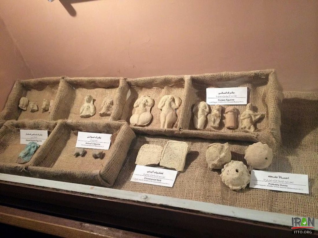
- I was very impressed with a shelf in a case against a wall in that room, covered in clay effigy figurines of what was clearly a fertility goddess, nude with big hair (a headdress?), wide hips, and cupping her breasts in her hands. Here she is.: ishtargates.tumblr.com/image/138152349361 They were so abundant they were more or less piled up. I should've asked to take a photo. (Maybe I knew not to. It's likely he would've politely refused. I wasn't really supposed to be in there.) I note that only fragments of those figurines are seen (at the 2:30 min. pt.) in this video filmed in the museum.: youtu.be/t4XNTOPjEho?si=Uq7ADKJpx6e3UdjY and in this photo.: itto.org/iran/image-bin/1919071103335afj4kuefc.jpg?w=1100 But I'm pretty sure at least some in the jumble on that shelf were intact. - ?
- "Who this goddess might be isn't exactly known. ... She could be the mother goddess Kiririsha, aka Kirrisi, Pinikir, Parti (her name at Izeh/Malemir, a settlement nearby), or Partikira (her name at Susa). She might've been known as the 'Great Goddess' and/or as the 'Proprietor of Heaven', titles held by similar goddesses throughout the ancient Middle East." ishtargates.tumblr.com/post/138152349361/along-with-the-r... Or she might have been the goddess Manzât, aka Mazzi'at, Manzi'at and Mazzêt, to whom a temple was dedicated at Chogha Zanbil and who was "believed to be responsible for the prosperity of cities. ... References to the worship of Manzât are known chiefly from the Elamite lowlands, esp. Susa and its surroundings. ... Theophoric names invoking her are attested in texts found at Haft Tappeh." (Wikipedia) Pinikir is discussed in this podcast.: youtu.be/uGz5zkMakjA?si=IByqOgzVSLfQ4JJp
- An older, shorter, balding man was in the vicinity while the younger man gave me that tour, made a comment to him at one point in a tone of disapproval if I recall, and the younger man seemed a bit chastened. Later as I was walking @ reading the booklet he gave me, the older man espied it, approached me and asked to see it, said the other man shouldn't've given it to me (to paraphrase), and took it back. He was the younger man's boss or supervisor evidently, and I fear that I got the kind, younger man in some trouble. (No good deed goes unpunished.)
Re the Development of the Arch or Barrel Vault:
- "The prototype [of the arch and the barrel vault] was a structure built of bundles of reeds placed upright in the ground, bent inward and tied together at the top to form a roof. Early Egyptian drawings, including hieroglyphs, depict reed vaults over sanctuaries, boat huts and other structures. Although no ancient reed bldg.s have survived, the technique has - in southern Iraq, at the confluence of the Tigris and Euphrates where 'Marsh Arabs' still construct enormous vaulted bldg.s of reeds. ... Nearly all the surviving [Near or Middle] Eastern arches are made of mud brick, or adobe (a Spanish loanword from the Arabic 'at-tub', 'the brick'). ... The same arid climate that makes mud-brick the ideal building material in the Near East makes vaulting the perfect technique for constructing a ceiling or a roof. A vaulted ceiling allows hot air to rise higher which helps to cool the living space. Many regions in the Near East lack forests, and the timber needed to support flat ceilings is scarce. A mud-brick vault requires no wooden beams for support. Not only is it practical and economical but it is a singularly graceful way to cover a building. ...
- "At Tell Razuk in Iraq a bldg. dating from @ 2,900 BC displays what may be transitional evolutionary forms: vaulted roofs in which the successive layers are both corbeled and canted inward. In Egypt radial arches and vaults were built sporadically in most periods of Pharaonic history, primarily in tombs and in monumental gateways. The earliest examples found of a radial vault in Egypt and of a pitched-brick vault anywhere are at Helwan in the same tomb which dates from late in the 1st Dynasty (@ 3,000 BC). [The "mature design" of the latter "suggests, however, that the technique had been employed for some time."] A somewhat later but particularly instructive example is the arched gateway of a mastaba (a bench-like tomb with inclined sides) at Giza from the 4th Dynasty (2,680-2,560 BC) that belonged to Neferi, a nobleman. ... The radial arch was more fully exploited in Mesopotamia. ... The earliest example known is in a hall built at Tepe Gawra late in the 4th mill. BC at the time of the emergence of Sumer. At Ur, the most famous Sumerian site, the tombs of King Abargi and Queen Shubad (@ 2,500 BC) had radially vaulted roofs and doorways. The most impressive Mesopotamian radial arches and vaults and the oldest Mesopotamian pitched-brick vaults (although a millenium younger than the earliest found in Egypt) are at Tell al Rimah, which date from the end of the 3rd and the 1st 1/2 of the 2nd mill. BC. Vaults span rooms 3.8 m.s wide in a temple, a burial chamber, 8 successive arches cover a stairway, etc. [Those at Haft Tappeh are pitched-brick vaults as well.] ... The acme of pitched-brick vaulting is the Taq Kisra, the great hall of the [Sassanian] palace at Ctesiphon, south of Baghdad, built sometime /b/ the 3rd and 6th cent.s. It still stands 28.4 m.s high and spans 25.5 m.s, the largest single-span vault of unreinforced brick anywhere." - case.edu/lifelonglearning/sites/default/files/2020-02/Van...
- According to Wikipedia, "[t]he earliest known example of [the] barrel vault [might be] under the [Sumerian] ziggurat at Nippur, built of fired bricks cemented with clay mortar." www.jstor.org/stable/496542?seq=18 A section of an arch in an ancient drain which "may have originally covered the whole drain, ... is perfectly elliptical" with a span of 1'8" and a total height of 2'4". (But I haven't found the date of construction of Nippur's arches.) Here's an old photo of that site.: en.wikipedia.org/wiki/File:John_Henry_Haynes._The_Nippur_...
The Rib or Ribbed Vault:
- It seems that the rib or ribbed vault, which became such an important and basic element of medieval Gothic architecture in Western Europe (essential to the construction of the great Gothic cathedrals, beginning with the Basilica of St. Denis near Paris in the mid 12-cent.), was invented or at least developed in ancient Iran (by the Medes?), where it "appears to have been confined, primarily." It was "employed extensively" at Nush-i-Jan (Median, 750-600 BC), with huge vault bricks, 1.2 m.s long. case.edu/lifelonglearning/sites/default/files/2020-02/Van... Van Beek writes (in his comprehensive article in the link re the development of "Arches and Vaults in the Ancient Near East") of the discovery of simple rib vaulting in a large Assyrian bldg. dating from @ 675 BC at Tell Jemmeh in Iraq (in which he also found "the oldest vaults known built of wedge-shaped bricks"). "The technique [of construction with rib vaulting] may have been brought to Tell Jemmeh by a Median builder in the service of the Assyrian imperial forces." (Nush-i-Jan is claimed to be the finest surviving Median bldg., one of the oldest surviving Zoroastrian ateshkades [it might be the oldest in Iran {?}, but I've read about the discovery of an earlier one somewhere in Central Asia which I'll write about sometime], and again, it's the site of the "extensive employment" of pioneering rib vaulting. It should be a Unesco site, but it's not on Iran's Tentative list for designation, not yet.)
"One would expect such long bricks to be fragile, but they were strong enough to support the floor of an upper room in the central temple." (Van Beek) flickr.com/photos/97924400@N00/3623624478/in/photostream/ Van Beek writes that "a rib vault couldn't have been as strong as a pitched-brick or radial vault, and apart from a certain simplicity of construction it probably had few advantages." But it was essential to Gothic architecture for good reason. "The ribs transmit the load downward and outward to specific points, usually rows of columns or piers, greatly reduc[ing] the weight and thus the outward thrust of the vault", permitting medieval Western European architects to build "higher and thinner walls with much larger windows." (Wikipedia)
- youtu.be/qU4ngo2UTXE?si=6qZHftlgYCczXpLq
- I think I hitched and walked back to Chogha Zanbil after completing my tour of Haft Tappeh, and then back to Andimeshk for the evening.
A young family watches as Team Pole Position rolls down Grand Avenue during the Downtown L.A. soapbox derby.
In Position, an art exhibition by Brendan Fernandes at the Varley Art Gallery
This entire batch is a test to my post editing skills due to poor lighting...
Engine off, in park, handbrake applied... and then we chocked the rear wheels too. Take no chances at this lark.
Position: Latitude 56° 43.630'N, Longitude 006° 13.567'W.
Character: Flashing (2) White every 20 Secs
Elevation: 55 metres
Nominal Range: 24 nautical miles
Structure: Grey granite tower, 35 metres in height.
There are 152 steps to the top of the tower. (NLB)
The illuminant is by halogen lamps - as shown above.
CP Perry at the apex of the wye with NS's Port Road is protected by what Amtrak refers to as "Position Color Light" signals.
Albert Gallatin
Born-Jan. 29, 1761
Died-Aug. 12, 1849
Albert Gallatin was born into an aristocratic Swiss family, but gave up fortune and social position and emigrated to America in 1780, where he might "drink in a love for independence in the freest country of the universe". Following fifteen years of being involved in various business ventures and teaching French at Harvard, Gallatin was elected to Congress from Pennsylvania in 1795. As a member of Congress, he made the Treasury Department and its control the object of constant scrutiny and criticism. He helped to create the House Committee on Ways and Means to assure Treasury's accountability to Congress by reviewing the Department's annual report concerning revenues, debts, loans and expenditures. He was appointed Secretary of the Treasury in 1801 by President Thomas Jefferson and continued in that position under President James Madison until 1814. His service of nearly 14 years is the longest term of any Secretary of the Treasury in the country's history. As Secretary he was responsible for significantly reducing the federal debt and his management of the Treasury resulted in the adoption of accounting practices still in use today. Following his service as Secretary of the Treasury, Gallatin was appointed one of the Commissioners to negotiate the Treaty of Ghent, which ended the War of 1812. He served as Minister to France and as Envoy to Great Britain before leaving public service and moving to New York in 1817. He became the first president of the National Bank of New York, was a founding trustee of New York University and served as president of the New York Historical Society. Gallatin was a founding member of the American Ethnological Society, served as its first president, and wrote extensively on the languages of American Indian tribes.
Trinity Churchyard
New York, New York
Nuremberg held great significance during the Nazi Germany period. Because of the city's relevance to the Holy Roman Empire and its position in the center of Germany, the Nazi Party chose the city to be the site of huge Nazi Party conventions–the Nuremberg rallies. The rallies were held annually from 1927 to 1938 in Nuremberg. After Hitler's rise to power in 1933 the Nuremberg rallies became huge state propaganda events, a center of anti-Semitism and other Nazi ideals. At the 1935 rally, Hitler specifically ordered the Reichstag to convene at Nuremberg to pass the anti-Semitic Nuremberg Laws which revoked German citizenship for all Jews. A number of premises were constructed solely for these assemblies, some of which were not finished. Today many examples of Nazi architecture can still be seen in the city. The city was also the home of the Nazi propagandist Julius Streicher, the publisher of Der Stürmer.
During World War II, Nuremberg was the headquarters of Wehrkreis (military district) XIII, and an important site for military production, including airplanes, submarines, and tank engines. A subcamp of Flossenbürg concentration camp was located here. Extensive use was made of slave labour.[2] The city was severely damaged in Allied strategic bombing from 1943-1945. On January 2, 1945, the medieval city centre was systematically bombed by the Royal Air Force and the U.S. Army Air Forces and about ninety percent of it was destroyed in only one hour, with 1,800 residents killed and roughly 100,000 displaced. In February 1945, additional attacks followed. In total, about 6,000 Nuremberg residents are estimated to have been killed in air raids. Despite this, the city was rebuilt after the war and was to some extent, restored to its pre-war appearance including the reconstruction of some of its medieval buildings.
Defendants in the dock at Nuremberg Trials
Defendants in the dock at Nuremberg Trials
Between 1945 and 1946, German officials involved in the Holocaust and other war crimes were taken in front of an international tribunal in the Nuremberg Trials. The Soviet Union had wanted the trials to take place in Berlin, but Nuremberg was chosen as the site for the trials for specific reasons:
Since the Napoleonic Wars, Sweden has pursued a policy of strict neutrality in Europe’s many wars; however, its position, squarely between Western Europe and Russia and along the Baltic Sea, has made maintaining that neutrality difficult. In a potential war between NATO and the Warsaw Pact, Sweden assumed that it would likely be overflown by both sides, and given its fierce defense of its territorial waters from Soviet submarines, that Sweden could not rely on the Soviets not to strike at Sweden during a hypothetical conflict. Therefore, the nation not only needed the very best its aerospace industry could field, but also aircraft that could operate away from fixed bases and be repaired by a wartime Swedish armed forces, which would be made up largely of ill-trained conscripts.
Just after World War II, Sweden had already entered the jet age by converting its pusher-propeller Saab J21 fighter to jet propulsion, but this was only an interim solution. With the United States fielding the F-84 Thunderjet and F-86 Sabre, and the Soviet Union the MiG-15, Saab decided to “steal a march” on both nations by fielding what was then a radical concept: an all-delta winged interceptor. Delta wings were barely on the drawing boards of the superpowers, but by 1952, Saab had built the Saab 210 Lillidraken (Little Dragon) proof-of-concept aircraft, and by October 1955, the first J35 Draken (Dragon) had taken to the air, at a time when the United States was still struggling with the F-102 Delta Dagger and the Soviet Union with the MiG-21. Despite its radical nature (for the time), the Draken’s test program went smoothly and it accidentally went supersonic on its second flight soon after takeoff.
Since the Draken was intended as a point-defense interceptor, dogfighting capability was considered secondary, but Swedish pilots found the J35 to have superb manueverability, especially in snap turns. To save time and money, Saab used license-built British engines and French radars. The only fault found in the Draken was a lack of sufficient thrust in sustained climbs, and so J35As were retrofitted with better afterburners, necessitating a stretch in the fuselage, which in turn forced Saab to equip the Draken with a tailwheel to prevent damaging the tail on takeoff.
So ahead of its time was the Draken that it had a long and fruitful career. It was continually updated, deleting one gun in favor of improving its missile armament: the J35F, which entered service in 1965, could carry four AIM-4 Falcons, while later J35Js and export versions could carry AIM-9 Sidewinders. Though the AJ37 Viggen mostly replaced it in service by 1980, J35J Drakens remained in the Swedish inventory until 1995, and there was serious consideration to even more updates to the design, due to the delays in the Viggen’s replacement, the JAS39 Gripen. It would be exported to the nonaligned Finnish Air Force, which would operate S35Fs until replaced by the F/A-18C Hornet in 2000, and Denmark, which operated S35XDs until 1993, when they were replaced by F-16A Fighting Falcons. A final export customer came in 1993, very late in the Draken’s career, in Austria: the Austrian Army Air Force had been relying on the obsolescent Saab 105O, but with war breaking out in the nearby Balkans, Austria feared that the slow Saab 105O would not be able to stop overflights. Reconditioned J35Ds were supplied to Austria as the S35O, which would be the last Drakens in service, retired in 2005 in favor of the Eurofighter Typhoon. 644 were built, and several dozen survive, most in flyable condition.
Though it is almost impossible to tell, this RF.35XD Draken is AR-106, a former Royal Danish Air Force aircraft. It was delivered to the RDAF in 1971 and spent its career with 729 Squadron at Skrydstrup. Like a surprisingly large number of RDAF Drakens, it was purchased after it was retired in 1992 by an American company, Flight Test Dynamics. It continued to fly, but by the early 21st Century, it had been grounded and stored, along with several other Drakens, at Chino, California. It remained there for several decades, but by 2023, it had been acquired by the Estrella Warbirds Museum in Paso Robles.
AR-106 is going to need a lot of work: it shows the effects of sitting forgotten in the California sun for over 20 years. The RDAF dark green has faded and chipped down to the bare metal, though 729 Squadron's crest is still visible on the nose. It's still actually in better shape that some of the aircraft Estrella has gotten, so this will probably get restored sooner or later.
Strobist Lighting 102 Unit 1.2 Position (Distance).
Sequence shows effect when flash moved right in (~0.25m from subject) and power decreased. Background gets progressively darker since light falls off quickly beyond the subject.
Strobist: f6.7, shutter 1/180th, ASA200. 580EXII flash 1/4 > 1/16 > 1/32 > 1/64 > 1/128.
A Ugandan gunner serving with the African Union Mission in Somalia (AMISOM) ranges a scope on a heavy machine-gun mounted on the roof of Mogadishu University 23 January. AMSIOM and Somali National Army (SNA) forces have consolidated newly captured positions, including the the strategically important university, following a major joint offensive to oust the insurgent group Al Shabaab from remaining pockets of Mogadishu and for the first time sees AMSIOM occupying positions and territory outside the Somali capital. AU-UN IST PHOTO / STUART PRICE.