View allAll Photos Tagged include
The Trade Facilitation Programme (TFP) currently includes almost 100 Issuing Banks in the EBRD region and more than 800 Confirming Banks worldwide. The event gave EBRD confirming and issuing banks the opportunity to review and discuss industry challenges and opportunities with leading specialists, including International Chamber of Commerce and Chief Economist Office. It also featured 25th anniversary award ceremony which will recognize most active banks in EBRD Countries of Operations.
14:30 – 14:45 Opening and Welcome Speeches
• Alexander Saveliev, Director, Financial Institutions, EBRD
• Rudolf Putz, Head of Trade Facilitation Programme, EBRD
14:50 – 15:30 Panel Discussion: Development of Trade & Trade Finance - SEMED
Moderator: Kamola Makhmudova, Senior Banker, EBRD
• Alexander Plekhanov, Office of the Chief Economist, EBRD
• Hanane El Boury, Banque Centrale Populaire (BCP), the Kingdom of Morocco
• Ahmed Benyahya, BMCE Bank, the Kingdom of Morocco
• Hossam Mustafa Rageh, Commercial International Bank (CIB), the Arab Republic of Egypt
• Anas AlMasri, Bank Al Etihad, the Hashemite Kingdom of Jordan 15:30 –
15:50 – 16:30 Panel Discussion: EBRD’s new Partner Banks
Moderator: Marco Nindl, Principal Banker, EBRD
• Sally Hamdalla, QNB Alahli, the Arab Republic of Egypt
• Malliotis Achilleas, Eurobank Cyprus, Republic of Cyprus
• Vladislav Berezhny, Credit Agricole Bank, Ukraine
• Ahu Heper Dolu, Fibabanka, Republic of Turkey
• Andrew Wood, Norton Rose Fulbright LLP, the United Kingdom
16:35 – 17:15 Panel Discussion: Trade Finance Solutions for Imports of Energy Efficient Machinery & Equipment – Gaps and Constraints
Moderator: Terry McCallion, Director, Energy Efficiency and Climate Change, EBRD
• Sergiy Kostogryz, Raiffeisen Bank Aval, Ukraine
• Gagik Sahakyan, Ameriabank, Armenia
• Maria Mogilnaya, Associate Banker, EBRD
• Holger Kautzky, Commerzbank
• Eugenia Zhiglova, KBC Bank
17:35 – 18:10 TFP Annual Awards Ceremony
Hosted by Nick Tesseyman, Managing Director, Financial Institutions, EBRD
Congratulations from Ambassador Chih-Kung Liu, Head of the Taipei Representative Office in the UK
Check Tweed outfit by Ambrosia includes skirt, lace knit half sleeve and scarf - 1L
slurl.com/secondlife/Symmetry/148/207/49
Basics pocket cardigan (blank) by Ohmai - free
slurl.com/secondlife/Cheesecake/220/174/38
Dot line tights (black) by Humming - 1L
slurl.com/secondlife/SkyBeam FirstLand/71/236/27
Suede fat heart belt (blacks) by Baby Monkey - group gift
slurl.com/secondlife/Dindrane Elfor/227/37/34
Basic flats (white) by Fri.day at Sunny - free
slurl.com/secondlife/Sunny/46/125/24
Granny bag by Pop Feel - group gift
slurl.com/secondlife/Lazy Bloom/91/101/22
Hair accessoire: bling bling by JM:Mai - lucky board
slurl.com/secondlife/Upadhyaya/104/153/237
Morning after hair (dirty blonde) by Posh - past Easter gift
slurl.com/secondlife/Liberty/233/222/22
Lucy first sight love skin (light) by Imabee - group gift
slurl.com/secondlife/Planete Terre/129/175/21
From today's Rugby match at Buckingham Park, Shoreham. Shoreham 1st XV against Hove Volunteers. Shoreham, in yellow and green came back strongly to win in a thrilling and contentious finish. Let's just say that the Hove contingent weren't too impressed with some key refereeing decisions towards the end of the match.
I include the following few photos for posterity, for once the railway left Honeybourne and ran north to Stratford it was an older and not the Honeybourne and Cheltenham Line anymore, though many trains ran through from Stratford-upon-Avon to Cheltenham. The Stratford Branch was opened by the OWW Railway on 11.7.1859 and ran for nearly 9 miles through flat country. Stations and halts existed at Pebworth, Broad Marston, Long Marston, Milcote, Chambers Crossing, Stratford Racecourse and Stratford itself. The history of the line is beyond my interest, but I include the following photos purely for interest. The bulk of the line, other than the last 3-ish miles, is now a cyclepath . The stretch from Honeybourne to Long Marston depot is now effectively a private siding but maintained to standards required for Class 66 freight. This bridge marks the Worcestershire-Warwickshire border and crosses the line at SP151469, ELR code STD 2 68. The gates beyond lead into the former MOD Depot of Long Marston.
Part yard sale, part art installation, part “happening,” the aptly named Yard Sale Time Machine promises to be a unique, first-time event on the Houston arts calendar. On October 23rd, more than 20 of Houston’s leading contemporary artists will set up a network of yard sales across several lots at the intersection of 16th Street and Studewood -- presenting cutting edge art within a neighborhood setting. The art presented will feature almost every media imaginable -- sculpture, painting, photography, mixed media, print works, graffiti, clothing, interactive works, balloon art, performances, stunts, and more. Some artists will scour their garages and storage buildings for artworks never shown before. Many will create new work specifically for the event. Hundreds of works will be exhibited, and many will be offered for sale. It’s art from across time...past, present, and future.
Participating artists include Ian Anderson, The Art Guys, Wendy Brown, Scott Burns, Crawdad, Bill Davenport, Roberto del Rio, Kelley Devine, Carter Ernst, Molly Gochman, GOT TACO?, David Graeve, Dana Harper, Hana Hillerova, Paul Horn, I love you baby, Solomon Kane, Paul Kittelson, Marcus Mann, Matt Messinger, Mark Nelson, Lindsay Peyton, Jim Pirtle, Alfredo Scaroina, Chip Schneider, Amy Wright, and others to be announced.
Package includes:
- PD3 front bumper - fits all 996 models converted into 997 with PD3 conversion kit(front fenders PD3 + front bumper PD3)
- PD3 front fenders (fits all 911 996 models only in combination with PD3 front bumper)
- PD1 side skirts (2X) (fits all 911 996 models except Turbo)
- PD1 rear bumper (fits all 911 996 models except Turbo)
- PD1 front lip-spoiler (fits all 911 996 models in combination with PD1 front bumper)
- Mounting material
Mr Bean's Mini - on display at Chelmsford Market - spotted before a nice lunch with brother on his 60th birthday.
UUSC's JustWorks programming includes a service-learning trip entitled "Freedom Summer: A Civil Rights Journey." This inter-generational experience visits important historical locations from the Civil Rights movement and participants hear firsthand accounts from activists who took a stand for social justice.
uusc.org
The Miao are one of several ethnic minorities living in the
subtropical mountainous areas of southwestern China. Different groups
include the Dong, Yi, Yao, Shui, Buyi (Bouyei), Li, Gejia, and Bai among many
others. For thousands of years, these migrating peoples have developed
rich, cultural traditions and they are increasingly being recognized
for their extraordinary handcrafted textiles and silver jewelry. It is
the area of costume where mythology, technical skill, and cultural
identity coalesce in vivid aesthetic expression. Until recently, most
of these remote, ethnic villages were relatively isolated from the
majority Han Chinese population. China’s rapid modernization, however,
has penetrated even the minority districts of Guizhou, Yunnan,
Guangxi, and Guangdong provinces. The resultant economic, educational,
and social changes have already begun to erode the look and use of
traditional festive costumes worn by the Miao and other ethnic groups.
In the Spring of 2008, staff of the Minneapolis Institute of Arts
documented villages throughout Guizhou, China and the Sisters Meal
Festival in Shidong.
Explore the MIA's Ethnic Minority Textiles Collection
Photos by Dan Dennehy for the Minneapolis Institute of Arts.
This project has been funded with a grant from the The Institute of
Museum and Library Services. The Institute of Museum and Library
Services is the primary source of federal support for the nations
123,000 libraries and 17,500 museums. The Institute's mission is to
create strong libraries and museums that connect people to information
and ideas.www.imls.gov/
Copyright: Some rights reserved. Attribution Noncommercial Share Alike
Attribution-NonCommercial-ShareAlike License
When couples dream of their perfect wedding destination abroad, their vision often includes escaping to a far-away place that offers all of the charms one could possibly desire for their Religious or Civil Ceremony. So, if you're looking at celebrating your wedding in Sicily, Taormina is a good choice.Taormina's beauty is uncontested. Some cities are known for their art treasures, others for their natural beauties; only a few, like Taormina, own both.Visitors to this magical yet relatively undiscovered island, leave with its images of sheer beauty, its cultural simplicity, the passion and warmth of the people and historical delights etched permanently in their memories.Within its ancient stone gates, the old town has fascinating archeological monuments and medieval homes. Magnificent views of the sea complete the picture.The city is located on a cliff top overlooking the deep blue of the never ending horizon reflected in a clear turquoise sea which surrounds the bays and beaches.In fact it is Sicily's number one tourist resort, boasting magnificent scenery, architecture and great local cuisine. It's no wonder tourists flock to Taormina every year.
Its rich culture and crystal clear sea and views of Mount Etna create a magical atmosphere. Taormina has endlessly winding medieval streets and tiny passages, each with its own secrets.Some of these intriguing places are secluded gardens hidden by stone walls; others are set on terraces overlooking the coast or in more public but equally pleasant squares.Taormina is beautiful by day but in the evenings its atmosphere is simply enchanting, whether you stroll the illuminated streets or indulge in the view of the coast over an authentic Sicilian dinner. Taormina's ancient Greek splendor, medieval charm and unique views will leave you with a lasting impression of Sicily.The climate is mild even in the winter, where it feels like eternal spring time. Its air is filled with the scent of orange and lemon blossoms. Steal away on an island retreat in beautiful Sicily, as it offers a taste of the traditional with a delicate touch of the exotic.There are several charming churches here in which to have a Catholic wedding, as well as Palazzo Santo Stefano for civil weddings, which takes an exquisitely charming medieval mood. Taormina's regal Norman Byzantine, Romanesque and Baroque churches offer a beautiful venue for a religious wedding.Couples may choose to exchange their wedding vows in any of these spectacular locations!The whole Taormina experience leaves visitors breathless and enthusiastic to plan their dream wedding here.
Make the dream come true for you...
www.facebook.com/pages/Weddinginsicily-Taormina/475641052...
Brownsea Island sits in Poole harbour it is the second largest natural harbour in the world, second on to Sydney harbour in Australia. Brownsea Island ( was also known as Branksea ) is the largest of the islands in Poole Harbour in the county of Dorset, England. The island is owned by the National Trust. Much of the island is open to the public and includes areas of woodland and heath with a wide variety of wildlife, together with cliff top views across Poole Harbour and the Isle of Purbeck. The island was the location of an experimental camp in 1907 that led to the formation of the Scout movement the following year. Access is by public ferry or private boat; in 2017 the island received 133,340 visitors. The ferry trip itself is well worth the time. When I went it was £11.50 return trip. But on the way back the ferry takes a scenic route round the islands to arrive back at Poole Quay.
The island was purchased by wealthy stockbroker Charles van Raalte who used the island as a residential holiday retreat. During this time the castle was renovated and served as host to famous visitors such as Guglielmo Marconi. Robert Baden-Powell, a close friend of the van Raaltes, hosted an experimental camp for boys on the island in the summer of 1907. Brownsea was largely self-supporting, with a kitchen garden and a dairy herd. Many of the pottery factory workers had stayed on after it closed, farming and working for the owners. Charles van Raalte died in Calcutta in 1907 and his wife eventually sold the island in 1925. In 1927 it was purchased at auction by Mary Bonham-Christie for £125,000. A recluse by nature, she ordered a mass eviction of the island's residents to the mainland. The National Trust then agreed to take over responsibility for the island if enough funds were raised and in 1962 it then purchased Brownsea for £100,000. Work was carried out to prepare the island for visitors; tracks were cleared through areas overgrown with rhododendrons and firebreaks were created to prevent repetition of the 1934 fire.
Brownsea Island lies in Poole Harbour opposite the town of Poole. It is the largest of eight islands in the harbour. The island can be reached by one of the public ferries or by private boat. There is a wharf and a small dock near the main castle. The island is about 1 1⁄2 miles ( 2.4 km ) long and 3⁄4 mile ( 1.2 km ) wide and consists of 500 acres of woodland ( pine and oak trees ), heathland and salt-marsh. The entire island, except the church and a few other buildings which are leased or managed by third parties, is owned by the National Trust. Most of the buildings are situated near the small landing stage. The northern portion of the island is a Nature Reserve managed by Dorset Wildlife Trust and an important habitat for birds; this part of the island has limited public access so as not to disturb the wildlife.. A small portion to the southeast of the island, along with Brownsea Castle, is leased to the John Lewis Partnership for use as a holiday hotel for staff, and is not open to the public. The island forms part of the Studland civil parish in the Purbeck local government district. It is within the South Dorset constituency of the House of Commons and the South West England constituency of the European Parliament.
In all the time I have lived in this area I never knew there was a very lovely Church on the Island and managed to take photos and videos of my visit there both inside and out. St Mary’s Church was built in 1853, the church remains very much as it was then - its organ is pumped by hand and the only lighting comes from candles. It's a Victorian church that isfixed in the past so with no electricity or water supply. But its regular spring and summer services can attract congregations between 3 and 300 - and it remains an important part of Brownsea's small island community. A Family Service is held at St.Mary’s at 3.00pm every Sunday from May to September.
From 1st August until 8th in August 1907, Robert Baden-Powell held an experimental camp on the island, to test out his Scouting ideas. He gathered 21 boys of mixed social backgrounds ( from boy's schools in the London area and a section of boys from the Poole, Parkstone,Hamworthy, Bournemouth, and Winton Boys' Brigade units ) and held a week-long camp. The boys took part in activities such as camping, observation, woodcraft, chivalry, lifesaving and patriotism. Following the successful camp, Baden-Powell published his first book on the Scouting movement in 1908, Scouting for Boys, and the international Scouting movement grew rapidly. Boy Scouts continued to camp on the island until the 1930’s, when all public access to the island was forbidden by the island's owner. After ownership of the island transferred to the National Trust, a permanent 20 hectares or 49 acres Scout camp site was opened in 1963 by Olave Baden-Powell. In August 2007, 100 years after the first experimental camp, Brownsea Island was the focus of worldwide celebrations of the centenary of Scouting.
The 3 Day Blinds Drapery Panel collection includes a hand-chosen assortment of solids, textures, prints, jacquards and stripes in styles ranging from traditional to modern.
3 decorative hardware kits are available to perfectly complement our exclusive color and style selection. Drapery Panels are a great addition to any room for adding color, interest and tying colors together. Functionally, they can hide light gaps and add additional protection from the sun. Light filtering and room darkening linings can be added to panels enhance light control, privacy and energy efficiency. Sheer fabrics can be coupled with opaque fabrics for a double layer treatment. Our luxurious fabric offering and comprehensive collection of styles make Drapery Panels an excellent choice for virtually any window.
Call Al @ 916.799.4376
Email @ Al.Turk@3Day.com
Pages from 'The Haworth Water-Wolf and other Yorkshire Stories' by Ian Dewhirst, published by The Ridings Publishing Company in 1967. These pages include a short biography of Ian Dewhirst and the title page.
Ian Dewhirst (1936-2019) was an acclaimed local historian. He made an invaluable contribution to preserving, cataloguing and recounting the history of the town. During his life he wrote many articles and books on the town, and gave thousands of talks and tours to various societies and groups, including the History Society. He was born in Keighley in 1936. He went to Keighley Boys’ Grammar School where his talent for poetry flourished and saw various poems published in the school magazine ‘The Keighlian’. He graduated from the University of Manchester in 1958 with a degree in English. He did his National Service as a Sergeant-Instructor in the Royal Army Educational Corps from 1958 to 1960.
He started working at Keighley Library in 1960 and was promoted to Reference Librarian in 1967, a role he fulfilled until retirement in 1991. During that time he wrote ‘A History of Keighley’, published by the Keighley Corporation in 1974, and reprinted several times since. Other publications included ‘The Handloom Weaver and other poems’ (1965), ‘The Haworth Water-Wolf and other Yorkshire stories’ (1967), ‘Scar Top and other poems’ (1968), ‘Gleanings from Victorian Yorkshire’ (1972), ‘Old Keighley in Photographs’ (1972), ‘More Old Keighley in Photographs’ (1973), ‘Gleanings from Edwardian Yorkshire’ (1975), ‘Yorkshire Through the Years’ (1975), ‘The Story of a Nobody: a Working Class Life 1880-1939’ (1980), ‘You Don’t Remember Bananas… A Pennine Half-Century’ (1985), ‘Keighley in Old Picture Postcards’ (1987), ‘Keighley in the 1930s & 40s’ (1989), ‘Victorian Keighley Characters’ (1990), ‘In the Reign of the Peacemaker: Keighley and District in Edwardian Photographs’ (1993), ‘Down Memory Lane’ (1993), ‘A Century of Yorkshire Dialect’ (with Arnold Kellett, 1997), ‘Keighley in the Second World War’ (2005), and ‘Nah Then! A Treasury of Yorkshire Dialect Quotations’ (2010).
Ian began writing the popular ‘Memory Lane’ column for the Keighley News in 1992 and carried on doing so right up until his death. In 1996, he was made an Honorary Doctor of Letters by the University of Bradford. And in February 1999, he was awarded an MBE by the Queen for his services to local history, at a ceremony held at Buckingham Palace. In 2009 he had a Northern Rail 158 diesel train named after him. In 2018, the Dalesman awarded him the W. R. Mitchell Lifetime Achievement Award in recognition of his prolific work as a local historian and public speaker.
He spent almost his whole life in Keighley, living in his parents’ former home on Raglan Avenue, off Fell Lane. He served on the Council of the Yorkshire Dialect Society and spent time as secretary of the Friends of Cliffe Castle Museum and Art Gallery. He died on 20th January 2019 and his funeral service was held at Trinity Church, Fell Lane, on 15th February, followed by a private cremation.
The publication was donated to Keighley and District Local History Society by Andrew Jackson in December 2020. It is held in the History Society's physical archive.
This is a photograph from the Forest Marathon festival 2013 which was held in the beautiful Coillte forest of Portumna in Co. Galway, Ireland on Saturday 15th June 2013. The event includes a 10k, a full marathon, a half marathon and two ultra-running events - a 50k and 100k race. The races started at 08:00 with the 100KM, the 50KM at 10:00, and subsequent races at two hour intervals onwards. All events started and finished within the forest with the exception of the half marathon and marathon which started outside of the forest. All events see participants complete 5KM loops of the forest which start and end at the car-park/amenity end of the forest. There is an official Refreshment/Handling Zones at this point on the loop.
The event was organised by international coach Sebastien Locteau from SportsIreland.ie and his fantastic team of volunteers from Galway and beyond. Congratulations to Seb on organising a very professionally run event and an event which is growing bigger and more prestigious with each passing year. There was an incredible atmosphere amongst the runners, the spectators, and the organisers. Hats off to everyone involved.
The marathon, 50KM, and 100KM events are sanctioned by Athletics Ireland and AIMS (the Association of International Marathons and Distance Races). The event has also achieved IAU (International Association of Ultrarunners) Bronze Label status for 2013.
Electronic timing was provided by RedTagTiming: www.redtagtiming.com/
Energy Bars, Gels, Drinks etc were provided by Fuel4Sport: www.fuel4sport.ie/
This is a set of photographs taken at various points on the 5KM loop in the Forest and contains photographs of competitors from all of the events except the 10KM race.
Viewing this on a smartphone device?
If you are viewing this Flickr set on a smartphone and you want to see the larger version(s) of this photograph then: scroll down to the bottom of this description under the photograph and click the "View info about this photo..." link. You will be brought to a new page and you should click the link "View All Sizes".
Overall Race Summary
Participants: Approximately 600 people took part across all of the events which were staged: 10km, half marathon, marathon, 50km, and 100KM.
Weather: The weather was unfortunately not what a summer's day in June should be like - there was rain, some breeze, but mild temperatures.
Course: This is a fast flat course depending on your event. The course is left handed around the Forest and roughly looks like a figure of 8 in terms of routing.
Location Map: Start/finish area on Google StreetView [goo.gl/maps/WWTgD] are inside the parklands and trails
Refreshments: There are no specific refreshments but the race organizers provide very adequate supplies for all participants.
Some Useful Links
Official Race Event Website: www.forestmarathon.com/
The Boards.ie Athletics Forum Thread for the 2013 Event: www.boards.ie/vbulletin/showthread.php?t=2056874371
A GPS Garmin Trace of the Course Profile (from the 50KM event) connect.garmin.com/activity/189495781
Our Flickr Photographs from the 2012 Events: www.flickr.com/photos/peterm7/sets/72157630146344494/
Our Flickr Photographs from the 2011 Events: www.flickr.com/photos/peterm7/sets/72157626865466587/
Title Sponsors Sports Ireland Website: sites.google.com/a/sportsireland.ie/welcome-sports-irelan...
A VIDEO of the Course: www.youtube.com/watch?feature=player_embedded&v=2FLxE...
Google StreetView of the Entrance to Portuma Forest: goo.gl/maps/MX62O
Wikipedia: Read about Portumna and Portumna Forest Park: en.wikipedia.org/wiki/Portumna#Portumna_Forest_Park
Coilte Ourdoors Website: www.coillteoutdoors.ie/?id=53&rec_site=115
Portumna Forest on EveryTrails: www.everytrail.com/guide/portumna-forest-park-woodland-tr...
More about the IAU Bronze Label: www.iau-ultramarathon.org/index.asp?menucode=h07&tmp=...
How can I get a full resolution copy of these photographs?
All of the photographs here on this Flickr set have a visible watermark embedded in them. All of the photographs posted here on this Flickr set are available offline, free, at no cost, at full image resolution WITHOUT watermark. We take these photographs as a hobby and as a contribution to the running community in Ireland. Our only "cost" is our request that if you are using these images: (1) on social media sites such as Facebook, Tumblr, Pinterest, Twitter,LinkedIn, Google+, etc or (2) other websites, web multimedia, commercial/promotional material that you provide a link back to our Flickr page to attribute us. This also extends the use of these images for Facebook profile pictures. In these cases please make a separate wall or blog post with a link to our Flickr page. If you do not know how this should be done for Facebook or other social media please email us and we will be happy to help suggest how to link to us.
Please email petermooney78 AT gmail DOT com with the links to the photographs you would like to obtain a full resolution copy of. We also ask race organisers, media, etc to ask for permission before use of our images for flyers, posters, etc. We reserve the right to refuse a request.
In summary please remember - all we ask is for you to link back to our Flickr set or Flickr pages. Taking the photographs and preparing them for online posting does take a significant effort. We are not posting photographs to Flickr for commercial reasons. If you really like what we do please spread the link around your social media, send us an email, leave a comment beside the photographs, send us a Flickr email, etc.
If you would like to contribute something for your photograph(s)?
Many people offer payment for our photographs. As stated above we do not charge for these photographs. We take these photographs as our contribution to the running community in Ireland. If you feel that the photograph(s) you request are good enough that you would consider paying for their purchase from other photographic providers we would suggest that you can provide a donation to any of the great charities in Ireland who do work for Cancer Care or Cancer Research in Ireland.
I ran in the race - but my photograph doesn't appear here in your Flickr set! What gives?
As mentioned above we take these photographs as a hobby and as a voluntary contribution to the running community in Ireland. Very often we have actually ran in the same race and then switched to photographer mode after we finished the race. Consequently, we feel that we have no obligations to capture a photograph of every participant in the race. However, we do try our very best to capture as many participants as possible. But this is sometimes not possible for a variety of reasons:
►You were hidden behind another participant as you passed our camera
►Weather or lighting conditions meant that we had some photographs with blurry content which we did not upload to our Flickr set
►There were too many people - some races attract thousands of participants and as amateur photographs we cannot hope to capture photographs of everyone
►We simply missed you - sorry about that - we did our best!
You can email us petermooney78 AT gmail DOT com to enquire if we have a photograph of you which didn't make the final Flickr selection for the race. But we cannot promise that there will be photograph there. As alternatives we advise you to contact the race organisers to enquire if there were (1) other photographs taking photographs at the race event or if (2) there were professional commercial sports photographers taking photographs which might have some photographs of you available for purchase. You might find some links for further information above.
Don't like your photograph here?
That's OK! We understand!
If, for any reason, you are not happy or comfortable with your picture appearing here in this photoset on Flickr then please email us at petermooney78 AT gmail DOT com and we will remove it as soon as possible. We give careful consideration to each photograph before uploading.
I want to tell people about these great photographs!
Great! Thank you! The best link to spread the word around is probably www.flickr.com/peterm7/sets
St. George Historic District, St. George, Staten Island
The St. George Historic District, which includes portions of St. Marks Piace, Carroll Piace, Westervett Avenue, and Hamilton Avenue, the Phelps Place cul-de-sac, and short stretches of Richmond Terrace, is a small enclave containing some 78 buildings, part of a larger suburban development, located along Staten Island's North Shore. Predominantly late nineteenth century in character, the area of the district had its roots in one of the earliest ptanned suburban communities in New York City. Initiated by Thomas E. Davis, a wealthy Manhattan real estate developer, in 1834-35, the project was taken over in 1836 by the New Brighton Association, a consortium of wealthy New York City entrepreneurs who promoted this location as a commuter suburb called New Brighton which was readily accessible to New York City by steamboat ferry service.
The proposed development slowed, almost immediately affected by the economic collapse of 1837; within the historic district, however, part of the existing street pattern reflects that shown on the plan of New Brighton of 1835 - three crescent-shaped streets ascending a steep hillside and another that surrounded them. The present street names are those shown on that original plan: Richmond Terrace, Carroll Place, St. Marks Place, and Hamilton Avenue (its original westernmost end is today part of Westervelt Avenue). In addition, there are four structures from this earliest phase of development. The oldest structure in the district is the house at 404 Richmond Terrace (now "Pavilion on the Terrace"), a temple-fronted Greek Revival residence built c. 1835 by Thomas Davis and acquired shortly thereafter by Henry P. Robertson, a Manhattan merchant.
Another early house remains at 272 Richmond Terrace, originally part of a grouping of three similar houses constructed c. 1839-45 by Henry McFarlane. Also surviving are two early carriage houses that were buHt to serve houses on Richmond Terrace.
In the 1840s and 1850s New Brighton developed into a fashionable summer resort. One Italianate villa, now modified, at 97 St. Marks Place and two [arge brick Italianate outbuildings on the north side of Carrolt Place survive from this period.
A Civil War business boom brought new development and a population increase to Staten Island as New York's populace sought affordable housing. Among the most notable houses built in the area of the historic district was the Anson Phelps Stokes residence (1862), one of three large estate houses constructed at the top of the hill on land between St. Mark's Place and Hamilton Avenue. This period was marked by the introduction of a new building type to the district, the double house, and a new style, the Second Empire. Several houses dating from the 1860s and early 1870s, designed in this style and distinguished by their mansard roofs, are located on Westervelt Avenue and the north side of St. Mark's Place. This period of development was halted by the Depression of 1873.
Sometime between 1878 and 1882, the saloon and hotel keeper Joseph Wilks built the brick double house at 30-32 Westervelt Avenue which shows the influence of the Romanesque Revival style. The increase in building activity within the proposed district starting in the 1880s coincided with the consolidation of competing Staten Island ferry lines at one location, the site of the present St. George ferry terminal. Improved transportation, making the area more convenient to lower Manhattan, was the primary impetus for the suburb's development boom. The story has been told that the appellation, St. George, which first appears on an 1885 map, was the name that ferry promoter Erastus Wiman gave to the terminal, after George Law, a railroad engineer and financier, made land available for the new railroad and new terminal.
The majority of houses in the proposed district were constructed in the 1880s and 1890s and reflect combination of the decorative Queen Anne styie and aspects of the Coionial Revival and Shingie styles; it is these houses which give the proposed district its predominant architectural character. Most of the houses are wood-frame structures with clapboard or shingie siding, although there are some masonry buildings. Taking advantage of the hilly topography, the houses are designed with picturesque features such as comer towers, protecting bays, and porches which add architectural variety. The houses on the south side of St. Marks Place, for example, are set uphill and back from the street while those on the north side of the street are located on narrow, deep jots running downhill to Carroll Place and have additional stories at the rear. Historically Carroll Place was lined with outbuildings related to the properties on St. Marks Place and Richmond Terrace.
A few of the surviving buildings on Carroll Place, such as those at Nos. 9, 17, and 135, appear on an 1874 map; they were subsequently converted for residential use. Other buildings on Carrol! Place are garages for the properties on St. Marks Place.
The Phelps Place cul-de-sac is located on what was once the Anson Phelps Stokes estate. The double houses at 7-8 and 9-10 Phelps Place, as well as the freestanding house at 11 Phelps Place, were all designed by Manhattan architect Douglass Smyth and built c. 1890. They display elements of the popular Shingle style as adapted to specuiativety developed suburban architecture.
The district is also notable for the large number of works; from this era designed by Staten Island architect Edward Alfred Sargent (1842-1914). Examples of Sargent's work within the proposed district include the houses at 103, 115, 119, and 125 St. Marks Place, dating from c. 1890, which show the influence of the Shingle style. No. 103 was built for banker Frederick L. Rodewald, while Nos. 115 and 119 were built for Vernon Brown, a shipping agent for Cunard Lines. No. 1-5 St. Marks Place (c. 1887-91) and No. 27 St. Mark's Place (1906) are also documented as having been designed by Sargent, as were the c. 1890 alterations to the earlier house at No. 75 which included the addition of the porch and projecting bays.
As the governmental and business center developed near the ferry terminal in the years after Staten Island was consolidated into Greater New York, the larger neighborhood including the area of the district came to be known as St. George. Suburban development continued in the district as the owners of large estates died and the heirs sold off the properties. He freestanding frame houses from this period, many of them on the east side of Westervelt Avenue and on Hamilton Avenue, continue the stylistic trends established by Sargent and his contemporaries in the 1890s.
Also included within the district are examples of non-residential architecture which contribute to its character. The neo-Romanesque St. Peter's Roman Catholic Church, built in 1900-01 to the designs of Harding & Gooch, on the site of an 1844 structure which had been Staten Island's first Roman Catholic church, dominates the view down St. Mark's Place. Two one-story commercial buildings, faced in decorative terra cotta and built along the west side of Westervelt Avenue, are typical of small stores constructed in suburban residential neighborhoods during the 1920s and '30s.
The historical significance of the St. George Historic District comes in part because of its prominent residents over several generations, including many leading members of the arts, professions, and business community, political and social leaders, and founders of such important local institutions as the Staten Island Institute of Arts and Sciences and the Staten Island Women's Club.
The architecture of the district reflecting several distinct eras of suburban development on Staten Island, the curving streetscapes, the distinctive topography, and the terraced landscape al! work together to give the area its special character.
- From the 1994 NYCLPC Historic District Designation Report
This is a photograph from the Forest Marathon festival 2013 which was held in the beautiful Coillte forest of Portumna in Co. Galway, Ireland on Saturday 15th June 2013. The event includes a 10k, a full marathon, a half marathon and two ultra-running events - a 50k and 100k race. The races started at 08:00 with the 100KM, the 50KM at 10:00, and subsequent races at two hour intervals onwards. All events started and finished within the forest with the exception of the half marathon and marathon which started outside of the forest. All events see participants complete 5KM loops of the forest which start and end at the car-park/amenity end of the forest. There is an official Refreshment/Handling Zones at this point on the loop.
The event was organised by international coach Sebastien Locteau from SportsIreland.ie and his fantastic team of volunteers from Galway and beyond. Congratulations to Seb on organising a very professionally run event and an event which is growing bigger and more prestigious with each passing year. There was an incredible atmosphere amongst the runners, the spectators, and the organisers. Hats off to everyone involved.
The marathon, 50KM, and 100KM events are sanctioned by Athletics Ireland and AIMS (the Association of International Marathons and Distance Races). The event has also achieved IAU (International Association of Ultrarunners) Bronze Label status for 2013.
Electronic timing was provided by RedTagTiming: www.redtagtiming.com/
Energy Bars, Gels, Drinks etc were provided by Fuel4Sport: www.fuel4sport.ie/
This is a set of photographs taken at various points on the 5KM loop in the Forest and contains photographs of competitors from all of the events except the 10KM race.
Viewing this on a smartphone device?
If you are viewing this Flickr set on a smartphone and you want to see the larger version(s) of this photograph then: scroll down to the bottom of this description under the photograph and click the "View info about this photo..." link. You will be brought to a new page and you should click the link "View All Sizes".
Overall Race Summary
Participants: Approximately 600 people took part across all of the events which were staged: 10km, half marathon, marathon, 50km, and 100KM.
Weather: The weather was unfortunately not what a summer's day in June should be like - there was rain, some breeze, but mild temperatures.
Course: This is a fast flat course depending on your event. The course is left handed around the Forest and roughly looks like a figure of 8 in terms of routing.
Location Map: Start/finish area on Google StreetView [goo.gl/maps/WWTgD] are inside the parklands and trails
Refreshments: There are no specific refreshments but the race organizers provide very adequate supplies for all participants.
Some Useful Links
Official Race Event Website: www.forestmarathon.com/
The Boards.ie Athletics Forum Thread for the 2013 Event: www.boards.ie/vbulletin/showthread.php?t=2056874371
A GPS Garmin Trace of the Course Profile (from the 50KM event) connect.garmin.com/activity/189495781
Our Flickr Photographs from the 2012 Events: www.flickr.com/photos/peterm7/sets/72157630146344494/
Our Flickr Photographs from the 2011 Events: www.flickr.com/photos/peterm7/sets/72157626865466587/
Title Sponsors Sports Ireland Website: sites.google.com/a/sportsireland.ie/welcome-sports-irelan...
A VIDEO of the Course: www.youtube.com/watch?feature=player_embedded&v=2FLxE...
Google StreetView of the Entrance to Portuma Forest: goo.gl/maps/MX62O
Wikipedia: Read about Portumna and Portumna Forest Park: en.wikipedia.org/wiki/Portumna#Portumna_Forest_Park
Coilte Ourdoors Website: www.coillteoutdoors.ie/?id=53&rec_site=115
Portumna Forest on EveryTrails: www.everytrail.com/guide/portumna-forest-park-woodland-tr...
More about the IAU Bronze Label: www.iau-ultramarathon.org/index.asp?menucode=h07&tmp=...
How can I get a full resolution copy of these photographs?
All of the photographs here on this Flickr set have a visible watermark embedded in them. All of the photographs posted here on this Flickr set are available offline, free, at no cost, at full image resolution WITHOUT watermark. We take these photographs as a hobby and as a contribution to the running community in Ireland. Our only "cost" is our request that if you are using these images: (1) on social media sites such as Facebook, Tumblr, Pinterest, Twitter,LinkedIn, Google+, etc or (2) other websites, web multimedia, commercial/promotional material that you provide a link back to our Flickr page to attribute us. This also extends the use of these images for Facebook profile pictures. In these cases please make a separate wall or blog post with a link to our Flickr page. If you do not know how this should be done for Facebook or other social media please email us and we will be happy to help suggest how to link to us.
Please email petermooney78 AT gmail DOT com with the links to the photographs you would like to obtain a full resolution copy of. We also ask race organisers, media, etc to ask for permission before use of our images for flyers, posters, etc. We reserve the right to refuse a request.
In summary please remember - all we ask is for you to link back to our Flickr set or Flickr pages. Taking the photographs and preparing them for online posting does take a significant effort. We are not posting photographs to Flickr for commercial reasons. If you really like what we do please spread the link around your social media, send us an email, leave a comment beside the photographs, send us a Flickr email, etc.
If you would like to contribute something for your photograph(s)?
Many people offer payment for our photographs. As stated above we do not charge for these photographs. We take these photographs as our contribution to the running community in Ireland. If you feel that the photograph(s) you request are good enough that you would consider paying for their purchase from other photographic providers we would suggest that you can provide a donation to any of the great charities in Ireland who do work for Cancer Care or Cancer Research in Ireland.
I ran in the race - but my photograph doesn't appear here in your Flickr set! What gives?
As mentioned above we take these photographs as a hobby and as a voluntary contribution to the running community in Ireland. Very often we have actually ran in the same race and then switched to photographer mode after we finished the race. Consequently, we feel that we have no obligations to capture a photograph of every participant in the race. However, we do try our very best to capture as many participants as possible. But this is sometimes not possible for a variety of reasons:
►You were hidden behind another participant as you passed our camera
►Weather or lighting conditions meant that we had some photographs with blurry content which we did not upload to our Flickr set
►There were too many people - some races attract thousands of participants and as amateur photographs we cannot hope to capture photographs of everyone
►We simply missed you - sorry about that - we did our best!
You can email us petermooney78 AT gmail DOT com to enquire if we have a photograph of you which didn't make the final Flickr selection for the race. But we cannot promise that there will be photograph there. As alternatives we advise you to contact the race organisers to enquire if there were (1) other photographs taking photographs at the race event or if (2) there were professional commercial sports photographers taking photographs which might have some photographs of you available for purchase. You might find some links for further information above.
Don't like your photograph here?
That's OK! We understand!
If, for any reason, you are not happy or comfortable with your picture appearing here in this photoset on Flickr then please email us at petermooney78 AT gmail DOT com and we will remove it as soon as possible. We give careful consideration to each photograph before uploading.
I want to tell people about these great photographs!
Great! Thank you! The best link to spread the word around is probably www.flickr.com/peterm7/sets
The North Fruita desert recreation area includes over 250 miles of designated recreation routes. Much of the area is desert valley floor with washes and sharp ridges. With close proximity to Fruita and Grand Junction, this area is popular for mountain bikers as it provides a close to home riding opportunities. The 18 road trails provide options for riders to experience some of the most playful mountain bike trails in the State of Colorado. The area is characterized by flow, providing mountain bike optimized features including rollers, berms and table top jumps.
Photos by Leslie Kehmeier, Mapping Manager, International Mountain Bicycling Association.
The Lidl Run Kildare Events 2013 were held at the Curragh Racecourse, Newbridge, Co. Kildare, Ireland on Sunday 12th May 2013. There were three events: a 10KM, a half marathon, and a full marathon. This is a selection of photographs which includes all events. The photographs are taken from the start and finish of the marathon, the finish of the 10KM, and the finish of the half marathon. Due to the large numbers participating we did not manage to photograph everyone - which was not helped by the weather. Congratulations to Jo Cawley and her RunKildare crew for another great event. The weather didn't dampen the spirits of the many happy participants.
Electronic timing was provided by Red Tag Timing [www.redtagtiming.com/]
Overall Race Summary
Participants: There were approximately 3,000 participants over the 3 race events - there were runners, joggers, and walkers participating.
Weather: A cold breezy morning with heavy rain at the start. The weather dried up for the 10KM and the Half Marathon races
Course: This is an undulating course with some good flat stretches on the Curragh.
Viewing this on a smartphone device?
If you are viewing this Flickr set on a smartphone and you want to see the larger version(s) of this photograph then: scroll down to the bottom of this description under the photograph and click the "View info about this photo..." link. You will be brought to a new page and you should click the link "View All Sizes".
Some Useful Links
GPS Garmin Trace of the Kildare Marathon Route: connect.garmin.com/activity/175709313
Homepage of the Lidl Run Kildare Event: www.kildaremarathon.ie/index.html
Facebook Group page of the Lidl Run Kildare Event: www.facebook.com/RunKildare
Boards.ie Athletics Discussion Board pages about the race series: www.boards.ie/vbulletin/showthread.php?t=2056815306
Our photographs from Run Kildare 2012: www.flickr.com/photos/peterm7/sets/72157629707887620/
Our photographs from Run Kildare 2011: www.flickr.com/photos/peterm7/sets/72157626725200956/
A small selection of photographs from Run Kildare 2010: www.flickr.com/photos/peterm7/sets/72157623899845567/ (first event)
Can I use the photograph with the watermark?
Yes! Absolutely - you can post this photograph to your social networks, blogs, micro-blogging, etc.
How can I get a full resolution, no watermark, copy of these photographs?
All of the photographs here on this Flickr set have a visible watermark embedded in them. All of the photographs posted here on this Flickr set are available, free, at no cost, at full resolution WITHOUT watermark. We take these photographs as a hobby and as a contribution to the running community in Ireland. We do not know of any other photographers who operate such a policy. Our only "cost" is our request that if you are using these images: (1) on social media sites such as Facebook, Tumblr, Pinterest, Twitter,LinkedIn, Google+, etc or (2) other websites, web multimedia, commercial/promotional material that you provide a link back to our Flickr page to attribute us. This also extends the use of these images for Facebook profile pictures. In these cases please make a separate wall or blog post with a link to our Flickr page. If you do not know how this should be done for Facebook or other social media please email us and we will be happy to help suggest how to link to us.
Please email petermooney78 AT gmail DOT com with the links to the photographs you would like to obtain a full resolution copy of. We also ask race organisers, media, etc to ask for permission before use of our images for flyers, posters, etc. We reserve the right to refuse a request.
In summary please remember - all we ask is for you to link back to our Flickr set or Flickr pages. Taking the photographs and preparing them for online posting does take a significant effort. We are not posting photographs to Flickr for commercial reasons. If you really like what we do please spread the link around, send us an email, leave a comment beside the photographs, send us a Flickr email, etc.
If you would like to contribute something for your photograph(s)?
Some people offer payment for our photographs. We do not charge for these photographs. We take these photographs as our contribution to the running community in Ireland. If you feel that the photograph(s) you request are good enough that you would pay for their purchase from other photographic providers we would suggest that you can provide a donation to any of the great charities in Ireland who do work for Cancer Care or Cancer Research in Ireland.
I ran in the race - but my photograph doesn't appear here in your Flickr set! What gives?
As mentioned above we take these photographs as a hobby and as a voluntary contribution to the running community in Ireland. Very often we have actually ran in the same race and then switched to photographer mode after we finished the race. Consequently, we feel that we have no obligations to capture a photograph of every participant in the race. However, we do try our very best to capture as many participants as possible. But this is sometimes not possible for a variety of reasons:
►You were hidden behind another participant as you passed our camera
►Weather or lighting conditions meant that we had some photographs with blurry content which we did not upload to our Flickr set
►There were too many people - some races attract thousands of participants and as amateur photographs we cannot hope to capture photographs of everyone
►We simply missed you - sorry about that - we did our best!
You can email us petermooney78 AT gmail DOT com to enquire if we have a photograph of you which didn't make the final Flickr selection for the race. But we cannot promise that there will be photograph there. As alternatives we advise you to contact the race organisers to enquire if there were (1) other photographs taking photographs at the race event or if (2) there were professional commercial sports photographers taking photographs which might have some photographs of you available for purchase. You might find some links for further information above.
Don't like your photograph here?
That's OK! We understand!
If, for any reason, you are not happy or comfortable with your picture appearing here in this photoset on Flickr then please email us at petermooney78 AT gmail DOT com and we will remove it as soon as possible. We give careful consideration to each photograph before uploading.
I want to tell people about these great photographs!
Great! Thank you! The best link to spread the word around is probably www.flickr.com/peterm7/sets
Kanchipuram otherwise known as Kanchi is a city in the Indian state of Tamil Nadu, 72 km from Chennai – the capital of Tamil Nadu. The city covers an area of 11.605 km2 and had a population of 164,265 in 2001. It is the administrative headquarters of Kanchipuram District. Kanchipuram is well-connected by road and rail. Chennai International Airport is the nearest domestic and international airport to the city, which is located at Tirusulam in Kanchipuram district.
Located on the banks of the Vegavathy River, Kanchipuram has been ruled by the Pallavas, the Medieval Cholas, the Later Cholas, the Later Pandyas, the Vijayanagar Empire, the Carnatic kingdom, and the British. The city's historical monuments include the Kailasanathar Temple and the Vaikunta Perumal Temple. Historically, Kanchipuram was a centre of education and was known as the ghatikasthanam, or "place of learning". The city was also a religious centre of advanced education for Jainism and Buddhism between the 1st and 5th centuries. Kanchipuram based Buddhist institutions were instrumental in spreading Theravada Buddhism to South East Asia.
In Hindu theology, Kanchipuram is one of the seven Indian cities to reach final attainment. The city houses Varadharaja Perumal Temple, Ekambareswarar Temple, Kamakshi Amman Temple, and Kumarakottam Temple, which are some of major Hindu temples in the state. The city is a holy pilgrimage site for both Saivites and Vaishnavites. Of the 108 holy temples of the Hindu god Vishnu, 14 are located in Kanchipuram. The city is well known for its hand woven silk sarees and most of the city's workforce is involved in the weaving industry.
Kanchipuram is administered by a Special grade municipality constituted in 1947. It is the headquarters of the Kanchi matha, a Hindu monastic institution believed to have been founded by the Hindu saint and commentator Adi Sankaracharya, and was the capital city of the Pallava Kingdom between the 4th and 9th centuries.
ETYMOLOGY
Kanchipuram was known in early Tamil literature as Kachi or Kachipedu but was later Sanskritized to Kanchi or Kanchipuram. According to legend, the name Kanchi is derived from Ka referring to the Hindu god Brahma and anchi, referring to his worship of Hindu god Vishnu at this place. The earliest inscription from the Maurya period (325–185 BCE) denote the city as Kanchipuram, where King Visnugopa was defeated by Samudragupta Maurya (320–298 BCE). Patanjali (150 BCE or 2nd century BCE) refers to the city in his Mahabhasya as Kanchipuraka. The city was referred to by various Tamil names like Kanchi, Kanchipedu and Sanskrit names like Kanchipuram. The Pallava inscriptions from (250–355) and the inscriptions of the Chalukya dynasty refers the city as Kanchipura. Jaina Kanchi refers to the area around Tiruparutti Kundram. During the British rule, the city was known as Conjeevaram and later as Kanchipuram. The municipal administration was renamed Kancheepuram, while the district retains the name Kanchipuram.
HISTORY
While it is widely accepted that Kanchipuram had served as an Early Chola capital, the claim has been contested by Indian historian P. T. Srinivasa Iyengar who wrote that the Tamil culture of the Sangam period did not spread through the Kanchipuram district, and cites the Sanskritic origins of its name in support of his claim. The earliest references to Kanchipuram are found in the books of the Sanskrit grammarian Patanjali, who lived between the 3rd and 2nd centuries BCE. The city is believed to have been part of the mythical Dravida Kingdom of the Mahabharatha, and was described as "the best among cities" (Sanskrit: Nagareshu Kanchi) by the 4th-century Sanskrit poet, Kalidasa.
Kanchipuram grew in importance when the Pallavas of southern Andhra Pradesh, wary of constant invasions from the north, moved their capital south to the city in the 6th century. The Pallavas fortified the city with ramparts, wide moats, well-laid-out roads, and artistic temples. During the reign of the Pallava King Mahendravarman I, the Chalukya King Pulakesin II (610–642) invaded the Pallava kingdom as far as the Kaveri River. The Pallavas successfully defended Kanchipuram and foiled repeated attempts to capture the city.[18] A second invasion ended disastrously for Pulakesin II, who was forced to retreat to his capital Vatapi which was besieged and Pulakesin II was killed by Narasimhavarman I (630–668), son of Mahendravarman I (600–630), at the Battle of Vatapi. Under the Pallavas, Kanchipuram flourished as a centre of Hindu and Buddhist learning. King Narasimhavarman II built the city's important Hindu temples, the Kanchi Kailasanathar Temple, the Varadharaja Perumal Temple and the Iravatanesvara Temple. Xuanzang, a Chinese traveller who visited Kanchipuram in 640, recorded that the city was 9.7 km in circumference and that its people were renowned for their bravery, piety, love of justice, and veneration for learning.
The Medieval Chola king Aditya I conquered the Pallava kingdom, including Kanchipuram, after defeating the Pallava ruler Aparajitavarman (880–897) in about 890. Under the Cholas, the city was the headquarters of the northern viceroyalty. The province was renamed "Jayamkonda Cholamandalam" during the reign of King Raja Raja Chola I (985–1014), who constructed the Karchapeswarar Temple and renovated the Kamakshi Amman Temple. His son, Rajendra Chola I (1012–44) constructed the Yathothkari Perumal Temple. According to the Siddhantasaravali of Trilocana Sivacharya, Rajendra Chola I brought a band of Saivas with him on his return from the Chola expedition to North India and settled them in Kanchipuram. In about 1218, the Pandya king Maravarman Sundara Pandyan (1216–1238) invaded the Chola country, making deep inroads into the kingdom which was saved by the intervention of the Hoysala king Vira Narasimha II (1220–1235), who fought on the side of the Chola king Kulothunga Chola III. Inscriptions indicate the presence of a powerful Hoysala garrison in Kanchipuram, which remained in the city until about 1230. Shortly afterwards, Kanchipuram was conquered by the Telugu Cholas, from whom Jatavarman Sundara Pandyan I took the city in 1258. The city remained with the Pandyas until 1311 when the Sambuvarayars declared independence, taking advantage of the anarchy caused by Malik Kafur's invasion. After short spells of occupation by Ravivarman Kulasekhara of Venad (Quilon, Kerala) in 1313–1314 and the Kakatiya ruler Prataparudra, Kanchipuram was conquered by the Vijayanagar general Kumara Kampana, who defeated the Madurai Sultanate in 1361.
The Vijayanagar Empire ruled Kanchipuram from 1361 to 1645. The earliest inscriptions attesting to Vijayanagar rule are those of Kumara Kampanna from 1364 and 1367, which were found in the precincts of the Kailasanathar Temple and Varadaraja Perumal Temple respectively. His inscriptions record the re-institution of Hindu rituals in the Kailasanathar Temple that had been abandoned during the Muslim invasions. Inscriptions of the Vijayanagar kings Harihara II, Deva Raya II, Krishna Deva Raya, Achyuta Deva Raya, Sriranga I, and Venkata II are found within the city. Harihara II endowed grants in favour of the Varadaraja Perumal Temple. In the 15th century, Kanchipuram was invaded by the Velama Nayaks in 1437, the Gajapati kingdom in 1463–1465 and 1474–75 and the Bahmani Sultanate in about 1480. A 1467 inscription of Virupaksha Raya II mentions a cantonment in the vicinity of Kanchipuram. In 1486, Saluva Narasimha Deva Raya, the governor of the Kanchipuram region, overthrew the Sangama Dynasty of Vijayanagar and founded the Saluva Dynasty. Like most of his predecessors, Narasimha donated generously to the Varadaraja Perumal Temple. Kanchipuram was visited twice by the Vijayanagar king Krishna Deva Raya, considered to be the greatest of the Vijayanagar rulers, and 16 inscriptions of his time are found in the Varadaraja Perumal Temple. The inscriptions in four languages – Tamil, Telugu, Kannada, and Sanskrit – record the genealogy of the Tuluva kings and their contributions, along with those of their nobles, towards the upkeep of the shrine. His successor, Achyuta Deva Raya, reportedly had himself weighed against pearls in Kanchipuram and distributed the pearls amongst the poor. Throughout the second half of the 16th and first half of the 17th centuries, the Aravidu Dynasty tried to maintain a semblance of authority in the southern parts after losing their northern territories in the Battle of Talikota. Venkata II (1586–1614) tried to revive the Vijayanagar Empire, but the kingdom relapsed into confusion after his death and rapidly fell apart after the Vijayanagar king Sriranga III's defeat by the Golconda and Bijapur sultanates in 1646.
After the fall of the Vijayanagar Empire, Kanchipuram endured over two decades of political turmoil. The Golconda Sultanate gained control of the city in 1672, but lost it to Bijapur three years later. In 1676, Shivaji arrived in Kanchipuram at the invitation of the Golconda Sultanate in order to drive out the Bijapur forces. His campaign was successful and Kanchipuram was held by the Golconda Sultanate until its conquest by the Mughal Empire led by Aurangazeb in October 1687. In the course of their southern campaign, the Mughals defeated the Marathas under Sambhaji, the elder son of Shivaji, in a battle near Kanchipuram in 1688 which caused considerable damage to the city but cemented Mughal rule. [11]Soon after, the priests at the Varadaraja Perumal, Ekambareshwarar and Kamakshi Amman temples, mindful of Aurangazeb's reputation for iconoclasm, transported the idols to southern Tamil Nadu and did not restore them until after Aurangazeb's death in 1707. Under the Mughals, Kanchipuram was part of the viceroyalty of the Carnatic which, in the early 1700s, began to function independently, retaining only a nominal acknowledgement of Mughal rule. The Marathas invaded Kanchipuram during the Carnatic period in 1724 and 1740, and the Nizam of Hyderabad in 1742.
Kanchipuram was a battlefront for the British East India Company in the Carnatic Wars against the French East India Company and in the Anglo-Mysore Wars with the Sultanate of Mysore. The popular 1780 Battle of Pollilur of the Second Anglo-Mysore War, known for the use of rockets by Hyder Ali of Mysore, was fought in the village of Pullalur near Kanchipuram. In 1763, the British East India Company assumed indirect control from the Nawab of the Carnatic over the erstwhile Chingleput District, comprising the present-day Kanchipuram and Tiruvallur districts, in order to defray the expenses of the Carnatic wars. The Company brought the territory under their direct control during the Second Anglo-Mysore War, and the Collectorate of Chingleput was created in 1794. The district was split into two in 1997 and Kanchipuram made the capital of the newly created Kanchipuram district.
DEMOGRAPHICS
During the rule of King Narasimha Varma in the 7th century, the city covered about 10 square kilometres and had a population of 10,000. The population increased to 13,000 in subsequent years and the city developed cross patterned links with rectangular streets. The settlements in the city were mostly caste based. During the period of Nandivarma Pallavan II, houses were built on raised platforms and burnt bricks. The concepts of the verandah in the front yard, garden in the backyard, ventilation facilities and drainage of rainwater were all introduced for the first time. The centre of the city was occupied by Brahmins, while the Tiruvekka temple and houses of agricultural labourers were situated outside the city. There were provisions in the city's outskirts for training the cavalry and infantry.
During the Chola era, Kanchipuram was not the capital, but the kings had a palace in the city and lot of development was extended eastwards. During the Vijayanagara period, the population rose to 25,000. There were no notable additions to the city's infrastructure during British rule. The British census of 1901 recorded that Kanchipuram had a population of 46,164, consisting of 44,684 Hindus, 1,313 Muslims, 49 Christians and 118 Jains.
According to 2011 census, Kanchipuram had a population of 164,384. About 800,000 pilgrims visit the city every year as of 2001.
______________________________________________
TEMPLE HISTORY
The Devaraja Swami Temple is a very ancient Vainava holy place. Not only the vaishnavites but the whole Hindu Community visits this temple regularly.
The temple was constructed at various stages, centuries ago by various kings. A number of new structures were added and Tiruppanies done during the dynasty of Vijaya Nagara Kings between 14th and 16th century.
During the reign of Vijananagar kings such as Krishna Devarayar, Achutharayar, Sadasivarayar, Sri Rangarayar I, Sri Venkatarayar I and Venkatarayar III, new buildings came up in Devarajaswamy Temple. They made Punniya Kodi Vimanam golden.
The hundred pillared Mandapam was also built by them. This has become a center of attraction to the foreign tourists with exquisite carvings and delicate works of art. The Tiruppanies done by Alam Kheer Basha of Delhi during 1645 was inscribed on the walls of the temple.
TEMPLE STRUCTURE
The height of East Gopuram is 125 feet; width 99 feet. The height of West Raja Gopuram is 96 feet and width 92.5 feet.
Bonnie Julien: Chinese Zodiac. Explosion Box structure as taught by Marilyn Stablein at the Newport Paper & Book Arts Festival in 2017. Papers include: Strathmore Artist Paper, drawing paper, and others from my stash. Information from the Internet with illustrations from Google image search. The booklets were composed in PageMaker using Microsoft JhegHei font. The interior origami box is a design found on YouTube (search "Tomoko Fuse Origami Box").
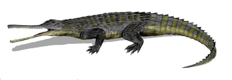
Alligator mississippiensis (Daudin, 1801) - American alligator in Florida, USA (January 2016).
The crocodilians have been around since the Triassic (early Mesozoic). Crocodilians include four groups: eusuchians (the only living group), mesosuchians (extinct), protosuchians (extinct), and sphenosuchians (extinct). Some fossil crocodilians reached such immense sizes that they preyed on dinosaurs. Another fossil group of reptiles, the phytosaurs (upload.wikimedia.org/wikipedia/commons/d/d2/Rutiodon_BW.jpg), closely resemble crocodilians, but are unrelated (phytosaurs are crurotarsan archosaurs).
All modern and fossil crocodilians have the same overall skeletal structure, although some fossils forms did depart somewhat from the stereotypical crocodile body plan (quadrupedal, dorso-ventrally compressed bodies, elongated skull & snout with eyes atop the head). So, the crocodilians are, in relative terms, evolutionarily conservative.
Living crocodilians are tropical to temperate, predatory semiaquatic reptiles, but fossil representatives include fully marine forms and inferred terrestrial forms.
Only two living crocodilians are native to America - the American alligator and the American crocodile. Both occur in the far-southeastern parts of the USA (Florida). The individual shown above is a medium-sized American alligator - it is about 8 feet long. As are all crocodilians, the alligator is a predator (carnivore), although it is also known to be a frugivore (fruit eater). The breathing rate is slow - I observed between-breath intervals ranging from 1 minute, 10 seconds to 2.5 minutes.
Classification: Animalia, Chordata, Vertebrata, Reptilia, Crocodilia, Alligatoridae
Locality: Ding Darling National Wildlife Refuge, Sanibel Island, southwestern Florida, USA
Day 23: Our drive to Pittsburgh always includes a stop at Casey's alma mater, Bucknell, for lunch. We don't always get on campus, but she wanted to take a look around this time. When I spotted the football field -- Christy Mathewson Memorial Stadium -- we detoured down the hill. I hadn't seen it since visiting my high school friend Amy Beth in the mid-90s.
The "greatest of all the great pitchers in the 20th Century's first quarter" (or so says his Hall of Fame plaque), Mathewson was truly the big man on campus, probably from his first day. His biography by the Society for American Baseball Research notes:
"In September 1898 Mathewson enrolled at Bucknell University in Lewisburg, 75 miles west of Factoryville. He pitched for the baseball team and played center on the basketball team, but football was his chief claim to fame at Bucknell, which played a rugged schedule that included powerhouses such as Penn State, Army, and Navy. For three years Christy was the varsity's first-string fullback, punter, and drop kicker; no less an authority than Walter Camp, the originator of the All-America team, called him 'the best all-around football player I ever saw.' Majoring in forestry, Mathewson also was a top-flight student who excelled in extracurricular activities, serving as class president and joining the band, glee club, two literary societies, and two fraternities. It was also at Bucknell that he met his future bride, Jane Stoughton."
Mathewson died of tuberculosis at 45 in 1925, and two years later, Bucknell dedicated this gate, funded by donations from every Major League team (16 at the time). In 1989, the university renamed the football stadium after him. He's buried in nearby Lewisburg Cemetery bordering campus.
The Trade Facilitation Programme (TFP) currently includes almost 100 Issuing Banks in the EBRD region and more than 800 Confirming Banks worldwide. The event gave EBRD confirming and issuing banks the opportunity to review and discuss industry challenges and opportunities with leading specialists, including International Chamber of Commerce and Chief Economist Office. It also featured 25th anniversary award ceremony which will recognize most active banks in EBRD Countries of Operations.
14:30 – 14:45 Opening and Welcome Speeches
• Alexander Saveliev, Director, Financial Institutions, EBRD
• Rudolf Putz, Head of Trade Facilitation Programme, EBRD
14:50 – 15:30 Panel Discussion: Development of Trade & Trade Finance - SEMED
Moderator: Kamola Makhmudova, Senior Banker, EBRD
• Alexander Plekhanov, Office of the Chief Economist, EBRD
• Hanane El Boury, Banque Centrale Populaire (BCP), the Kingdom of Morocco
• Ahmed Benyahya, BMCE Bank, the Kingdom of Morocco
• Hossam Mustafa Rageh, Commercial International Bank (CIB), the Arab Republic of Egypt
• Anas AlMasri, Bank Al Etihad, the Hashemite Kingdom of Jordan 15:30 –
15:50 – 16:30 Panel Discussion: EBRD’s new Partner Banks
Moderator: Marco Nindl, Principal Banker, EBRD
• Sally Hamdalla, QNB Alahli, the Arab Republic of Egypt
• Malliotis Achilleas, Eurobank Cyprus, Republic of Cyprus
• Vladislav Berezhny, Credit Agricole Bank, Ukraine
• Ahu Heper Dolu, Fibabanka, Republic of Turkey
• Andrew Wood, Norton Rose Fulbright LLP, the United Kingdom
16:35 – 17:15 Panel Discussion: Trade Finance Solutions for Imports of Energy Efficient Machinery & Equipment – Gaps and Constraints
Moderator: Terry McCallion, Director, Energy Efficiency and Climate Change, EBRD
• Sergiy Kostogryz, Raiffeisen Bank Aval, Ukraine
• Gagik Sahakyan, Ameriabank, Armenia
• Maria Mogilnaya, Associate Banker, EBRD
• Holger Kautzky, Commerzbank
• Eugenia Zhiglova, KBC Bank
17:35 – 18:10 TFP Annual Awards Ceremony
Hosted by Nick Tesseyman, Managing Director, Financial Institutions, EBRD
Congratulations from Ambassador Chih-Kung Liu, Head of the Taipei Representative Office in the UK
Grand Teton National Park is a United States National Park in northwestern Wyoming. At approximately 310,000 acres (130,000 ha), the park includes the major peaks of the 40-mile-long (64 km) Teton Range as well as most of the northern sections of the valley known as Jackson Hole. It is only 10 miles (16 km) south of Yellowstone National Park, to which it is connected by the National Park Service-managed John D. Rockefeller, Jr. Memorial Parkway. Along with surrounding National Forests, these three protected areas constitute the almost 18,000,000-acre (7,300,000 ha) Greater Yellowstone Ecosystem, one of the largest intact mid-latitude temperate ecosystems in the world.
In the early 19th century, the first White explorers encountered the eastern Shoshone natives. Between 1810 and 1840, the region attracted fur trading companies that vied for control of the lucrative beaver pelt trade. U.S. Government expeditions to the region commenced in the mid-19th century as an offshoot of exploration in Yellowstone, with the first permanent white settlers in Jackson Hole arriving in the 1880s. Efforts to preserve the region as a national park commenced in the late 19th century, and in 1929 Grand Teton National Park was established, protecting the major peaks of the Teton Range. The valley of Jackson Hole remained in private ownership until the 1930s, when conservationists led by John D. Rockefeller, Jr. began purchasing land in Jackson Hole to be added to the existing national park.
Grand Teton National Park is named for Grand Teton, the tallest mountain in the Teton Range. The naming of the mountains is attributed to early 19th-century French-speaking trappers—les trois tétons (the three teats) was later anglicized and shortened to Tetons. At 13,775 feet (4,199 m), Grand Teton abruptly rises more than 7,000 feet (2,100 m) above Jackson Hole, almost 850 feet (260 m) higher than Mount Owen, the second-highest summit in the range. The park has numerous lakes, including 15-mile-long (24 km) Jackson Lake as well as streams of varying length and the upper main stem of the Snake River. Though in a state of recession, a dozen small glaciers persist at the higher elevations near the highest peaks in the range.
Grand Teton National Park is an almost pristine ecosystem and the same species of flora and fauna that have existed since prehistoric times can still be found there. More than 1,000 species of vascular plants, dozens of species of mammals, 300 species of birds, more than a dozen fish species and a few species of reptiles and amphibians exist.
Grand Teton National Park is a popular destination for mountaineering, hiking, fishing and other forms of recreation. There are more than 1,000 drive-in campsites and over 200 miles (320 km) of hiking trails that provide access to backcountry camping areas. Noted for world-renowned trout fishing, the park is one of the few places to catch Snake River fine-spotted cutthroat trout. Grand Teton has several National Park Service-run visitor centers, and privately operated concessions for motels, lodges, gas stations and marinas.
en.wikipedia.org/wiki/Grand_Teton_National_Park
en.wikipedia.org/wiki/Wikipedia:Text_of_Creative_Commons_...
The Prince Albert pub in Brighton has recently been decorated with a fabulous mural of Musical Legends - reinforcing the pub's musical traditions. The mural is a collaboration between graffiti artist Req, the original creator, SinnaOne and pub owner Chris Steward.
The pub is close to Brighton Station, next time you're in the area, why not take a look
North Country families serving with the Colours include the following: Mr. J. Stephenson, Springwell: 4 sons ans 1 son-in-law (C. Nutter)
This photograph was published in the Illustrated Chronicle on the 5th of May 1915.
During the Great War the Illustrated Chronicle published photographs of soldiers and sailors from Newcastle and the North East of England, which had been in the news. The photographs were sent in by relatives and give us a glimpse into the past.
The physical collection held by Newcastle Libraries comprises bound volumes of the newspaper from 1910 to 1925. We are keen to find out more about the people in the photographs. If you recognise anyone in the images or have any stories or information to add please comment below.
Copies of this photograph may be ordered from us, for more information see: www.newcastle.gov.uk/tlt Please make a note of the image reference number above to help speed up your order.
Panelists include Colin Ferguson (Jack Carter), Jordan Hinson (Zoe Carter), Salli Richardson (Allison Blake), Ed Quinn (Nathan Stark), Joe Morton (Henry Deacon), Jaime Paglia (co-creator and executive producer), and Tony Optican (VP, original programming, SCI FI).
Check out my Blog on info of my Comic Con trip.
Baggs work includes photography & computer based painting. He is a current Jacksonville resident and self taught artist with studies in Electrical Engineering, Communications and a degree in English from the University of Cincinnati, graduating in 1976. From his earliest manipulations of imagery done with video processing equipment to today’s computer based artistic tools, Baggs has exhibited in Cincinnati, Dayton, Chicago, San Antonio, and for the past 3 years at the Public Library in downtown Jacksonville.
Since 1996, Baggs has been concerned with “symmetry and harmony”. He finds elements within a photograph and then “samples” or “paints” with these elements to obtain colorful patterns and an exploration of textures embedded in a photograph. A selection of works spanning 2004 – 2011 will be included in this exhibition.
Baggs has included “art books” in his past Jacksonville exhibitions. Elements from a new book study, “Painting with Light – the Peruvian Diaries” will be included, drawing from photography taken over the past 3 years in Lima and Tarma, Peru during mission trips with Shepherd of the Woods Lutheran Church of Jacksonville. Baggs limited edition art books can be found in the Library collection as well as the Jaffe Center for Book Arts in Boca Raton.
Photo credit: JAXPORT, Meredith Fordham Hughes
The Kerala backwaters are a chain of brackish lagoons and lakes lying parallel to the Arabian Sea coast (known as the Malabar Coast) of Kerala state in southern India. The network includes five large lakes linked by canals, both manmade and natural, fed by 38 rivers, and extending virtually half the length of Kerala state. The backwaters were formed by the action of waves and shore currents creating low barrier islands across the mouths of the many rivers flowing down from the Western Ghats range.
The Kerala Backwaters are a network of interconnected canals, rivers, lakes and inlets, a labyrinthine system formed by more than 900 km of waterways, and sometimes compared to the American Bayou. In the midst of this landscape there are a number of towns and cities, which serve as the starting and end points of backwater cruises. National Waterway No. 3 from Kollam to Kottapuram, covers a distance of 205 km and runs almost parallel to the coast line of southern Kerala facilitating both cargo movement and backwater tourism.
The backwaters have a unique ecosystem - freshwater from the rivers meets the seawater from the Arabian Sea. In certain areas, such as the Vembanad Kayal, where a barrage has been built near Kumarakom, salt water from the sea is prevented from entering the deep inside, keeping the fresh water intact. Such fresh water is extensively used for irrigation purposes.
Many unique species of aquatic life including crabs, frogs and mudskippers, water birds such as terns, kingfishers, darters and cormorants, and animals such as otters and turtles live in and alongside the backwaters. Palm trees, pandanus shrubs, various leafy plants and bushes grow alongside the backwaters, providing a green hue to the surrounding landscape.
Vembanad Kayal is the largest of the lakes, covering an area of 200 km², and bordered by Alappuzha (Alleppey), Kottayam, and Ernakulam districts. The port of Kochi (Cochin) is located at the lake's outlet to the Arabian Sea. Alleppey, "Venice of the East", has a large network of canals that meander through the town. Vembanad is India’s longest lake.
HOUSE BOATS
The kettuvallams (Kerala houseboats) in the backwaters are one of the prominent tourist attractions in Kerala. More than 2000 kettuvallams ply the backwaters, 120 of them in Alappuzha. Kerala government has classified the tourist houseboats as Platinum, Gold and silver.
The kettuvallams were traditionally used as grain barges, to transport the rice harvested in the fertile fields alongside the backwaters. Thatched roof covers over wooden hulls, 30 m in length, provided protection from the elements. At some point in time the boats were used as living quarters by the royalty. Converted to accommodate tourists, the houseboats have become floating cottages having a sleeping area, with western-style toilets, a dining area and a sit out on the deck. Most tourists spend the night on a house boat. Food is cooked on board by the accompanying staff – mostly having a flavour of Kerala. The houseboats are of various patterns and can be hired as per the size of the family or visiting group. The living-dining room is usually open on at least three sides providing a grand view of the surroundings, including other boats, throughout the day when it is on the move. It is brought to a standstill at times of taking food and at night. After sunset, the boat crew provide burning coils to drive away mosquitoes. Ketuvallams are motorised but generally proceed at a slow speed for smooth travel. All ketuvallams have a generator and most bedrooms are air-conditioned. At times, as per demand of customers, electricity is switched off and lanterns are provided to create a rural setting.
While many ketuvalloms take tourists from a particular point and bring them back to around the same point next morning there are some specific cruises mostly in the Alappuzha area, such as the one night cruise from Alappuzha to Thotapally via Punnamada Lake two nights cruise from Alappuzha to Alumkavadi,[8] one night cruise from Alappuzha to Kidangara, and one night cruise from Alappuzha to Mankotta. There are numerous such cruises.
Beypore, located 10 km south of Kozhikode at the mouth of the Chaliyar River, is a famous fishing harbour, port and boat building centre. Beypore has a 1,500 year-tradition of boatbuilding. The skill of the local shipwrights and boat builders are widely sought after. There is a houseboat-building yard at Alumkadavu, in Ashtamudi Kayal near Kollam.
FERRY SERVICES
Regular ferry services connect most locations on both banks of the backwaters. The Kerala State Water Transport Department operates ferries for passengers as well as tourists. It is the cheapest mode of transport through the backwaters.
ECONOMIC SIGNIFICANCE
Connected by artificial canals, the backwaters form an economical means of transport, and a large local trade is carried on by inland navigation. Fishing, along with fish curing is an important industry.
Kerala backwaters have been used for centuries by the local people for transportation, fishing and agriculture. It has supported the efforts of the local people to earn a livelihood. In more recent times, agricultural efforts have been strengthened with reclamation of some backwater lands for rice growing, particularly in the Kuttanad area. Boat making has been a traditional craft, so has been the coir industry.
Kuttanad is crisscrossed with waterways that run alongside extensive paddy fields, as well as fields of cassava, banana and yam. A unique feature of Kuttanad is that many of these fields are below sea level and are surrounded by earthen embankments. The crops are grown on the low-lying ground and irrigated with fresh water from canal and waterways connected to Vembanad lake. The area is similar to the dikes of the Netherlands where land has been reclaimed from the sea and crops are grown.
WIKIPEDIA
Includes photos from the David Thompson Highway 11 Rocky Mountains Alberta near Nordegg and the David Thompson Resort
Our itinerary today was designed to include many of the lesser known and visited temples of the Angkor archaeological park since we were due to visit the more major ones over the following days. All these sites would be major attractions in their own right anywhere else, but in Angkor there is simply too much for the regular visitor to take in, but since we're not regular visitors we aimed to try our best regardless!
Our third stop was Banteay Samre, one of the more remote of the Angkor temples being situated some distance to the east of the main sites of the archaeological park.
Banteay Samre temple dates from the early 12h century and follows a very concise plan, square in layout with outer and inner enclosure walls. The centrepiece at the heart of the temple is a single tower in the same style as nearby Angkor Wat, with several smaller courts and corridors surrounding it. Like many of the Angkor temples it was originally built for Hindu worship prior to the state religion changing from Hinduism to Buddhism, and as a result there is some minor evidence of iconoclasm in some of the smaller carvingswhere tiny images od deites have been removed (several other sites also betray evidence of this with smaller figures chiselled away).
The temple was well restored in the early 20th century and is more or less structurally complete.
The Trade Facilitation Programme (TFP) currently includes almost 100 Issuing Banks in the EBRD region and more than 800 Confirming Banks worldwide. The event gave EBRD confirming and issuing banks the opportunity to review and discuss industry challenges and opportunities with leading specialists, including International Chamber of Commerce and Chief Economist Office. It also featured 25th anniversary award ceremony which will recognize most active banks in EBRD Countries of Operations.
14:30 – 14:45 Opening and Welcome Speeches
• Alexander Saveliev, Director, Financial Institutions, EBRD
• Rudolf Putz, Head of Trade Facilitation Programme, EBRD
14:50 – 15:30 Panel Discussion: Development of Trade & Trade Finance - SEMED
Moderator: Kamola Makhmudova, Senior Banker, EBRD
• Alexander Plekhanov, Office of the Chief Economist, EBRD
• Hanane El Boury, Banque Centrale Populaire (BCP), the Kingdom of Morocco
• Ahmed Benyahya, BMCE Bank, the Kingdom of Morocco
• Hossam Mustafa Rageh, Commercial International Bank (CIB), the Arab Republic of Egypt
• Anas AlMasri, Bank Al Etihad, the Hashemite Kingdom of Jordan 15:30 –
15:50 – 16:30 Panel Discussion: EBRD’s new Partner Banks
Moderator: Marco Nindl, Principal Banker, EBRD
• Sally Hamdalla, QNB Alahli, the Arab Republic of Egypt
• Malliotis Achilleas, Eurobank Cyprus, Republic of Cyprus
• Vladislav Berezhny, Credit Agricole Bank, Ukraine
• Ahu Heper Dolu, Fibabanka, Republic of Turkey
• Andrew Wood, Norton Rose Fulbright LLP, the United Kingdom
16:35 – 17:15 Panel Discussion: Trade Finance Solutions for Imports of Energy Efficient Machinery & Equipment – Gaps and Constraints
Moderator: Terry McCallion, Director, Energy Efficiency and Climate Change, EBRD
• Sergiy Kostogryz, Raiffeisen Bank Aval, Ukraine
• Gagik Sahakyan, Ameriabank, Armenia
• Maria Mogilnaya, Associate Banker, EBRD
• Holger Kautzky, Commerzbank
• Eugenia Zhiglova, KBC Bank
17:35 – 18:10 TFP Annual Awards Ceremony
Hosted by Nick Tesseyman, Managing Director, Financial Institutions, EBRD
Congratulations from Ambassador Chih-Kung Liu, Head of the Taipei Representative Office in the UK
Materials include:
::: Sterling Silver
::: Fine Silver
::: Recycled Plastic Computer Key
::: 3mm Stone - Amethyst
www.etsy.com/listing/83875621/computer-key-jewelry-made-t...
---------------------------------------
All designs, text and images by Lauren Anabela Beaudoin of Creative Dexterity. No images or text may be copied without written permission.
The Adventure Medical Kit Weekender Kit is the best selling kit in the mountain series! Built with weekend adventurers in mind, this kit includes a variety of medical essentials in an affordable, organized package. Perfect for small groups going on short adventures.
Ideal Uses:
72 Hour Home Emergency Kit
Backcountry Trips
Camping
Hiking / Backpacking
RV / Car / Camper
Contents:
Bandage Materials
5 Bandage, Adhesive, Fabric, 1" x 3"
2 Dressing, Gauze, Sterile, 2" x 2", Pkg./2
2 Dressing, Gauze, Sterile, 4" x 4", Pkg./2
2 Bandage, Conforming Gauze, 3"
2 Dressing, Non-Adherent, Sterile, 3" x 4"
5 Bandage, Adhesive, Fabric, Knuckle
Bleeding
1 Trauma Pad, 5" x 9"
1 Instructions, Easy Care Bleeding
1 Gloves, Nitrile (Pair), Hand Wipe
Blister / Burn
1 GlacierGel (Large Oval)
11 Moleskin, Pre-Cut & Shaped
CPR
1 CPR Face Shield, Laerdal
Duct Tape
1 Duct Tape, 2" x 5 Yards
Fracture / Sprain
1 Instructions, Easy Care Fracture & Sprain
1 Bandage, Elastic with Velcro, 3"
1 Bandage, Triangular
Instrument
1 EMT Shears, 4"
1 Splinter Picker/Tick Remover Forceps
3 Safety Pins
1 Pencil
3 Thermometer, Disposable
Medical Information
1 Comp. Guide to Wilderness & Travel Medicine
1 Patient Assessment Form
Medication
2 Acetaminophen (500 mg), Pkg./2
2 Ibuprofen (200 mg), Pkg./2
1 Instructions, Easy Care Medications
2 Antihistamine (Diphenhydramine 25 mg)
1 Aspirin (325 mg), Pkg./2
Wound Care
1 Instructions, Easy Care Wound
1 Tape, 1" x 10 Yards
1 Syringe, Irrigation, 20 cc, 18 Gauge Tip
2 Tincture of Benzoin Topical Adhesive
6 After Cuts & Scrapes Anethestic/Antiseptic Wipe
1 Povidone Iodine, 3/4 oz
1 Wound Closure Strips, 1/4" x 4", Pkg./10
1 Cotton Tip Applicator, Pkg./2
Features:
Ibuprofen for aches and pains and antihistamine for allergies
Laerdal
Wound irrigation system to clean and close wounds
Hospital quality instruments
Nitrile gloves and infectious control bag
Weight: 1lb 10oz
Size: 8.5" x 7" x 4"
Pattern includes easy to follow instructions.
Materials Needed:
Straight knitting needles, size US 7 (4.5mm)
100% Cotton Medium/Worsted Weight yarn [65 yards]
In any color you choose.
Stitches: knit & purl.
Skill: Beginner
Finished Size: 7.5"W X 8" H
Darning needle needed for finishing.
This pattern will be delivered via email as an attached PDF file to anywhere in the world.
Located @ www.zibbet.com/ezcareknits and www.etsy.com/shop/ezcareknits
Students from ȽÁU,WELṈEW̱ Tribal School, along with First Nations Chiefs, Elders and representatives from the W̱SÁNEĆ Leadership Council, are celebrating their efforts to have John Dean Provincial Park renamed to include a traditional Indigenous name.
Learn more: news.gov.bc.ca/19892
Drawing is a form of visual art in which a person uses various drawing instruments to mark paper or another two-dimensional medium. Instruments include graphite pencils, pen and ink, inked brushes, wax color pencils, crayons, charcoal, chalk, pastels, various kinds of erasers, markers, styluses, various metals (such as silverpoint), and electronic drawing.
An artist who practices or works in technical drawing may be called a drafter, draftsman, or draughtsman.[1]
A drawing instrument releases small amount of material onto a surface, leaving a visible mark. The most common support for drawing is paper, although other materials, such as cardboard, plastic, leather, canvas, and board, may be used. Temporary drawings may be made on a blackboard or whiteboard or indeed almost anything. The medium has been a popular and fundamental means of public expression throughout human history. It is one of the simplest and most efficient means of communicating visual ideas.[2] The wide availability of drawing instruments makes drawing one of the most common artistic activities.
Drawing is one of the major forms of expression within the visual arts. It is generally concerned with the marking of lines and areas of tone onto paper, where the accurate representation of the visual world is expressed upon a plane surface.[3] Traditional drawings were monochrome, or at least had little colour,[4] while modern colored-pencil drawings may approach or cross a boundary between drawing and painting. In Western terminology, drawing is distinct from painting, even though similar media often are employed in both tasks. Dry media, normally associated with drawing, such as chalk, may be used in pastel paintings. Drawing may be done with a liquid medium, applied with brushes or pens. Similar supports likewise can serve both: painting generally involves the application of liquid paint onto prepared canvas or panels, but sometimes an underdrawing is drawn first on that same support.
Drawing is often exploratory, with considerable emphasis on observation, problem-solving and composition. Drawing is also regularly used in preparation for a painting, further obfuscating their distinction. Drawings created for these purposes are called studies.
There are several categories of drawing, including figure drawing, cartooning, doodling and shading. There are also many drawing methods, such as line drawing, stippling, shading, the surrealist method of entopic graphomania (in which dots are made at the sites of impurities in a blank sheet of paper, and lines are then made between the dots), and tracing (drawing on a translucent paper, such as tracing paper, around the outline of preexisting shapes that show through the paper).
A quick, unrefined drawing may be called a sketch.
In fields outside art, technical drawings or plans of buildings, machinery, circuitry and other things are often called "drawings" even when they have been transferred to another medium by printing.
Drawing as a Form of Communication Drawing is one of the oldest forms of human expression, with evidence for its existence preceding that of written communication.[5] It is believed that drawing was used as a specialised form of communication before the invent of the written language,[5][6] demonstrated by the production of cave and rock paintings created by Homo sapiens sapiens around 30,000 years ago.[7] These drawings, known as pictograms, depicted objects and abstract concepts.[8] The sketches and paintings produced in prehistoric times were eventually stylised and simplified, leading to the development of the written language as we know it today.
Drawing in the Arts Drawing is used to express one's creativity, and therefore has been prominent in the world of art. Throughout much of history, drawing was regarded as the foundation for artistic practise.[9] Initially, artists used and reused wooden tablets for the production of their drawings.[10] Following the widespread availability of paper in the 14th century, the use of drawing in the arts increased. At this point, drawing was commonly used as a tool for thought and investigation, acting as a study medium whilst artists were preparing for their final pieces of work.[11][12] In a period of artistic flourish, the Renaissance brought about drawings exhibiting realistic representational qualities,[13] where there was a lot of influence from geometry and philosophy.[14]
The invention of the first widely available form of photography led to a shift in the use of drawing in the arts.[15] Photography took over from drawing as a more superior method for accurately representing visual phenomena, and artists began to abandon traditional drawing practises.[16] Modernism in the arts encouraged "imaginative originality"[17] and artists' approach to drawing became more abstract.
Drawing Outside of the Arts Although the use of drawing is extensive in the arts, its practice is not confined purely to this field. Before the widespread availability of paper, 12th century monks in European monasteries used intricate drawings to prepare illustrated, illuminated manuscripts on vellum and parchment. Drawing has also been used extensively in the field of science, as a method of discovery, understanding and explanation. In 1616, astronomer Galileo Galilei explained the changing phases of the moon through his observational telescopic drawings.[16] Additionally, in 1924, geophysicist Alfred Wegener used illustrations to visually demonstrate the origin of the continents.[16]
Notable draftsmen[edit]
Since the 14th century, each century has produced artists who have created great drawings.
Notable draftsmen of the 14th, 15th and 16th centuries include Leonardo da Vinci, Albrecht Dürer, Michelangelo and Raphael.
Notable draftsmen of the 17th century include Claude, Nicolas Poussin, Rembrandt, Guercino, and Peter Paul Rubens.
Notable draftsmen of the 18th century include Jean-Honoré Fragonard, Giovanni Battista Tiepolo, and Antoine Watteau.
Notable draftsmen of the 19th century include Paul Cézanne, Aubrey Beardsley, Jacques-Louis David, Pierre-Paul Prud'hon, Edgar Degas, Théodore Géricault, Francisco Goya, Jean Ingres, Odilon Redon, Henri de Toulouse-Lautrec, Honoré Daumier, and Vincent van Gogh.
Notable draftsmen of the 20th century include Käthe Kollwitz, Max Beckmann, Jean Dubuffet, George Grosz, Egon Schiele, Arshile Gorky, Paul Klee, Oscar Kokoschka, Alphonse Mucha, M. C. Escher, André Masson, Jules Pascin, and Pablo Picasso.
The medium is the means by which ink, pigment or color are delivered onto the drawing surface. Most drawing media are either dry (e.g. graphite, charcoal, pastels, Conté, silverpoint), or use a fluid solvent or carrier (marker, pen and ink). Watercolor pencils can be used dry like ordinary pencils, then moistened with a wet brush to get various painterly effects. Very rarely, artists have drawn with (usually decoded) invisible ink. Metalpoint drawing usually employs either of two metals: silver or lead.[18] More rarely used are gold, platinum, copper, brass, bronze, and tinpoint.
Paper comes in a variety of different sizes and qualities, ranging from newspaper grade up to high quality and relatively expensive paper sold as individual sheets.[19] Papers can vary in texture, hue, acidity, and strength when wet. Smooth paper is good for rendering fine detail, but a more "toothy" paper holds the drawing material better. Thus a coarser material is useful for producing deeper contrast.
Newsprint and typing paper may be useful for practice and rough sketches. Tracing paper is used to experiment over a half-finished drawing, and to transfer a design from one sheet to another. Cartridge paper is the basic type of drawing paper sold in pads. Bristol board and even heavier acid-free boards, frequently with smooth finishes, are used for drawing fine detail and do not distort when wet media (ink, washes) are applied. Vellum is extremely smooth and suitable for very fine detail. Coldpressed watercolor paper may be favored for ink drawing due to its texture.
Acid-free, archival quality paper keeps its color and texture far longer than wood pulp based paper such as newsprint, which turns yellow and become brittle much sooner.
The basic tools are a drawing board or table, pencil sharpener and eraser, and for ink drawing, blotting paper. Other tools used are circle compass, ruler, and set square. Fixative is used to prevent pencil and crayon marks from smudging. Drafting tape is used to secure paper to drawing surface, and also to mask an area to keep it free of accidental marks sprayed or spattered materials and washes. An easel or slanted table is used to keep the drawing surface in a suitable position, which is generally more horizontal than the position used in painting.
Almost all draftsmen use their hands and fingers to apply the media, with the exception of some handicapped individuals who draw with their mouth or feet.[20]
Prior to working on an image, the artist typically explores how various media work. They may try different drawing implements on practice sheets to determine value and texture, and how to apply the implement to produce various effects.
The artist's choice of drawing strokes affects the appearance of the image. Pen and ink drawings often use hatching—groups of parallel lines.[21] Cross-hatching uses hatching in two or more different directions to create a darker tone. Broken hatching, or lines with intermittent breaks, form lighter tones—and controlling the density of the breaks achieves a gradation of tone. Stippling, uses dots to produce tone, texture or shade. Different textures can be achieved depending on the method used to build tone.[22]
Drawings in dry media often use similar techniques, though pencils and drawing sticks can achieve continuous variations in tone. Typically a drawing is filled in based on which hand the artist favors. A right-handed artist draws from left to right to avoid smearing the image. Erasers can remove unwanted lines, lighten tones, and clean up stray marks. In a sketch or outline drawing, lines drawn often follow the contour of the subject, creating depth by looking like shadows cast from a light in the artist's position.
Sometimes the artist leaves a section of the image untouched while filling in the remainder. The shape of the area to preserve can be painted with masking fluid or cut out of a frisket and applied to the drawing surface, protecting the surface from stray marks until the mask is removed.
Another method to preserve a section of the image is to apply a spray-on fixative to the surface. This holds loose material more firmly to the sheet and prevents it from smearing. However the fixative spray typically uses chemicals that can harm the respiratory system, so it should be employed in a well-ventilated area such as outdoors.
Another technique is subtractive drawing in which the drawing surface is covered with graphite or charcoal and then erased to make the image.[23]
Shading is the technique of varying the tonal values on the paper to represent the shade of the material as well as the placement of the shadows. Careful attention to reflected light, shadows and highlights can result in a very realistic rendition of the image.
Blending uses an implement to soften or spread the original drawing strokes. Blending is most easily done with a medium that does not immediately fix itself, such as graphite, chalk, or charcoal, although freshly applied ink can be smudged, wet or dry, for some effects. For shading and blending, the artist can use a blending stump, tissue, a kneaded eraser, a fingertip, or any combination of them. A piece of chamois is useful for creating smooth textures, and for removing material to lighten the tone. Continuous tone can be achieved with graphite on a smooth surface without blending, but the technique is laborious, involving small circular or oval strokes with a somewhat blunt point.
Shading techniques that also introduce texture to the drawing include hatching and stippling. A number of other methods produce texture. In addition to the choice of paper, drawing material and technique affect texture. Texture can be made to appear more realistic when it is drawn next to a contrasting texture; a coarse texture is more obvious when placed next to a smoothly blended area. A similar effect can be achieved by drawing different tones close together. A light edge next to a dark background stands out to the eye, and almost appears to float above the surface.
Form and proportion[edit]Measuring the dimensions of a subject while blocking in the drawing is an important step in producing a realistic rendition of the subject. Tools such as a compass can be used to measure the angles of different sides. These angles can be reproduced on the drawing surface and then rechecked to make sure they are accurate. Another form of measurement is to compare the relative sizes of different parts of the subject with each other. A finger placed at a point along the drawing implement can be used to compare that dimension with other parts of the image. A ruler can be used both as a straightedge and a device to compute proportions.
When attempting to draw a complicated shape such as a human figure, it is helpful at first to represent the form with a set of primitive shapes. Almost any form can be represented by some combination of the cube, sphere, cylinder, and cone. Once these basic shapes have been assembled into a likeness, then the drawing can be refined into a more accurate and polished form. The lines of the primitive shapes are removed and replaced by the final likeness. Drawing the underlying construction is a fundamental skill for representational art, and is taught in many books and schools. Its correct application resolves most uncertainties about smaller details, and makes the final image look consistent.[24]
A more refined art of figure drawing relies upon the artist possessing a deep understanding of anatomy and the human proportions. A trained artist is familiar with the skeleton structure, joint location, muscle placement, tendon movement, and how the different parts work together during movement. This allows the artist to render more natural poses that do not appear artificially stiff. The artist is also familiar with how the proportions vary depending on the age of the subject, particularly when drawing a portrait.
Perspective[edit]
Linear perspective is a method of portraying objects on a flat surface so that the dimensions shrink with distance. Each set of parallel, straight edges of any object, whether a building or a table, follows lines that eventually converge at a vanishing point. Typically this convergence point is somewhere along the horizon, as buildings are built level with the flat surface. When multiple structures are aligned with each other, such as buildings along a street, the horizontal tops and bottoms of the structures typically converge at a vanishing point.When both the fronts and sides of a building are drawn, then the parallel lines forming a side converge at a second point along the horizon (which may be off the drawing paper.) This is a two-point perspective.[25] Converging the vertical lines to a third point above or below the horizon then produces a three-point perspective.
Depth can also be portrayed by several techniques in addition to the perspective approach above. Objects of similar size should appear ever smaller the further they are from the viewer. Thus the back wheel of a cart appears slightly smaller than the front wheel. Depth can be portrayed through the use of texture. As the texture of an object gets further away it becomes more compressed and busy, taking on an entirely different character than if it was close. Depth can also be portrayed by reducing the contrast in more distant objects, and by making their colors less saturated. This reproduces the effect of atmospheric haze, and cause the eye to focus primarily on objects drawn in the foreground.
Venice Beach, California
Venice Beach includes the beach, the promenade that runs parallel to the beach ("Ocean Front Walk" or just "the boardwalk"), Muscle Beach, the handball courts, the paddle tennis courts, Skate Dancing plaza, the numerous beach volleyball courts, the bike trail and the businesses on Ocean Front Walk. The basketball courts in Venice are renowned across the country for their high level of streetball; numerous NBA players developed their games or recruited on these courts.
Along the southern portion of the beach, at the end of Washington Boulevard, is the Venice Fishing Pier. A 1,310-foot (400 m) concrete structure, it first opened in 1964, was closed in 1983 due to El Niño storm damage, and re-opened in the mid-1990s. On December 21, 2005, the pier again suffered damage when waves from an unusually large northern swell caused the part of the pier where the restrooms were located to fall into the ocean.
The pier remained closed until May 25, 2006, when it was re-opened after an engineering study concluded the pier was structurally sound.
The Venice Breakwater is an acclaimed local surf spot in Venice. It is located north of the Venice Pier and Lifeguard Headquarters, and south of the Santa Monica Pier. This spot is sheltered on the north by an artificial barrier, the breakwater, consisting of an extending sand bar, piping, and large rocks at its end.
Each prescribed fire starts with a morning briefing. Topics include safety, objectives for the day, group assignments, weather, communication channels and other relevant topics.
Kyle Sullivan, BLM
On Thursday, April 27, 2023, the BLM Medford District conducted a 90-acre prescribed fire. Prescribed fire is a planned and carefully managed fire deliberately set under controlled conditions to reduce the buildup of flammable material, restore or maintain natural ecosystems, and improve wildlife habitat.
Prescribed fire can also help to reduce the severity and spread of wildfires by creating firebreaks and reducing the amount of fuel available to a potential wildfire. By reducing the amount of dead vegetation, prescribed fires can reduce the intensity of a wildfire, making it easier for firefighters to control.
The prescribed fire is part of the Upper Applegate Watershed project. The BLM was supported by Grayback Forestry and Oregon Department of Forestry. The UAW project is a collaborative approach to landscape-scale forest restoration and hazardous fuels reduction, coordinated by the Rogue Forest Partners. The project area is 52,000 acres in the Applegate Valley between Ruch and Applegate Lake, covering federal and private lands in which 18,000 acres are identified as priority treatments.
This unit had previous treatments to prepare for prescribed fire. In 2002, the unit was treated with mastication and then underburned in 2008. The most recent underburn will reduce fuel loading and moderate the intensity of future fires.
Fire managers perform a delicate balancing act ensuring the fuel is dry enough to burn, but not too dry to create a higher severity burn. This leaves a short window for performing underburning activities. The goal of the underburn is to reduce dead and down fuel loading, improve forest resilience to future climatic stress, re-create an uneven age class, and maintain past timber and fuel treatment area in open condition.
Created in 1835, Milam County's original boundaries extended north and west to include parts of 34 current Texas counties. Government offices were at Nashville-on-the-Brazos and Caldwell before Cameron became county seat in 1846. Two frame buildings and a two-story brick structure served as courthouses in Cameron before the present building was completed. Austin architects Jacob Larmour and Arthur O. Watson designed this Renaissance Revival style courthouse, with the cornerstone laid by the local Masonic lodge on July 4, 1891. The first floor included the county courtroom and offices for county officials, while a district courtroom occupied the second and third stories. Identical north and south facades are five-part compositions, while the east and west are three-bay designs. Each of the four fronts has a projecting center pavilion enhanced by a portico and triangular pediment. A mansard roof and central clock tower top an exterior of arched windows, cut stone pilasters and quarry-faced ashlar limestone with fine detailing. County commissioners accepted the building as complete in April 1892, although furnishings and the clock tower were finished in succeeding months. In the late 1930s, a federal renovation project by the Works Progress Administration removed the original roof, cupola, clock and statue, and made interior changes. The State of Texas also dedicated a statue on the grounds to commemorate the Centennial of Texas Idependence and county namesake Ben Milam. Restoration completed in 2002 reopened the full height of the district courtroom and replaced features that had been removed, including a stairway in the center hall and the clock tower and Goddess of Justice statue. Recorded Texas Historic Landmark - 2008
Feel free to use this image for your web or blog post as long as you include image credit with a clickable (hyperlink) to www.flickr.com/photos/126293860@N05/. Thank you.
Bali is an island and province of Indonesia. The province includes the island of Bali and a few smaller neighbouring islands, notably Nusa Penida, Nusa Lembongan, and Nusa Ceningan. It is located at the westernmost end of the Lesser Sunda Islands, between Java to the west and Lombok to the east. Its capital of Denpasar is located at the southern part of the island.
With a population of 3,890,757 in the 2010 census, and 4,225,000 as of January 2014, the island is home to most of Indonesia's Hindu minority. According to the 2010 Census, 83.5% of Bali's population adhered to Balinese Hinduism, followed by 13.4% Muslim, Christianity at 2.5%, and Buddhism 0.5%.
Bali is a popular tourist destination, which has seen a significant rise in numbers since the 1980s. It is renowned for its highly developed arts, including traditional and modern dance, sculpture, painting, leather, metalworking, and music. The Indonesian International Film Festival is held every year in Bali.
Bali is part of the Coral Triangle, the area with the highest biodiversity of marine species. In this area alone over 500 reef building coral species can be found. For comparison, this is about 7 times as many as in the entire Caribbean. There is a wide range of dive sites with high quality reefs, all with their own specific attractions. Many sites can have strong currents and swell, so diving without a knowledgeable guide is inadvisable. Most recently, Bali was the host of the 2011 ASEAN Summit, 2013 APEC and Miss World 2013.
HISTORY
ANCIENT
Bali was inhabited around 2000 BC by Austronesian people who migrated originally from Southeast Asia and Oceania through Maritime Southeast Asia. Culturally and linguistically, the Balinese are closely related to the people of the Indonesian archipelago, Malaysia, the Philippines, and Oceania. Stone tools dating from this time have been found near the village of Cekik in the island's west.
In ancient Bali, nine Hindu sects existed, namely Pasupata, Bhairawa, Siwa Shidanta, Waisnawa, Bodha, Brahma, Resi, Sora and Ganapatya. Each sect revered a specific deity as its personal Godhead.
Inscriptions from 896 and 911 don't mention a king, until 914, when Sri Kesarivarma is mentioned. They also reveal an independent Bali, with a distinct dialect, where Buddhism and Sivaism were practiced simultaneously. Mpu Sindok's great granddaughter, Mahendradatta (Gunapriyadharmapatni), married the Bali king Udayana Warmadewa (Dharmodayanavarmadeva) around 989, giving birth to Airlangga around 1001. This marriage also brought more Hinduism and Javanese culture to Bali. Princess Sakalendukirana appeared in 1098. Suradhipa reigned from 1115 to 1119, and Jayasakti from 1146 until 1150. Jayapangus appears on inscriptions between 1178 and 1181, while Adikuntiketana and his son Paramesvara in 1204.
Balinese culture was strongly influenced by Indian, Chinese, and particularly Hindu culture, beginning around the 1st century AD. The name Bali dwipa ("Bali island") has been discovered from various inscriptions, including the Blanjong pillar inscription written by Sri Kesari Warmadewa in 914 AD and mentioning "Walidwipa". It was during this time that the people developed their complex irrigation system subak to grow rice in wet-field cultivation. Some religious and cultural traditions still practised today can be traced to this period.
The Hindu Majapahit Empire (1293–1520 AD) on eastern Java founded a Balinese colony in 1343. The uncle of Hayam Wuruk is mentioned in the charters of 1384-86. A mass Javanese emigration occurred in the next century.
PORTUGUESE CONTACTS
The first known European contact with Bali is thought to have been made in 1512, when a Portuguese expedition led by Antonio Abreu and Francisco Serrão sighted its northern shores. It was the first expedition of a series of bi-annual fleets to the Moluccas, that throughout the 16th century usually traveled along the coasts of the Sunda Islands. Bali was also mapped in 1512, in the chart of Francisco Rodrigues, aboard the expedition. In 1585, a ship foundered off the Bukit Peninsula and left a few Portuguese in the service of Dewa Agung.
DUTCH EAST INDIA
In 1597 the Dutch explorer Cornelis de Houtman arrived at Bali, and the Dutch East India Company was established in 1602. The Dutch government expanded its control across the Indonesian archipelago during the second half of the 19th century (see Dutch East Indies). Dutch political and economic control over Bali began in the 1840s on the island's north coast, when the Dutch pitted various competing Balinese realms against each other. In the late 1890s, struggles between Balinese kingdoms in the island's south were exploited by the Dutch to increase their control.
In June 1860 the famous Welsh naturalist, Alfred Russel Wallace, travelled to Bali from Singapore, landing at Buleleng on the northcoast of the island. Wallace's trip to Bali was instrumental in helping him devise his Wallace Line theory. The Wallace Line is a faunal boundary that runs through the strait between Bali and Lombok. It has been found to be a boundary between species of Asiatic origin in the east and a mixture of Australian and Asian species to the west. In his travel memoir The Malay Archipelago, Wallace wrote of his experience in Bali:
I was both astonished and delighted; for as my visit to Java was some years later, I had never beheld so beautiful and well-cultivated a district out of Europe. A slightly undulating plain extends from the seacoast about ten or twelve miles inland, where it is bounded by a fine range of wooded and cultivated hills. Houses and villages, marked out by dense clumps of coconut palms, tamarind and other fruit trees, are dotted about in every direction; while between them extend luxurious rice-grounds, watered by an elaborate system of irrigation that would be the pride of the best cultivated parts of Europe.
The Dutch mounted large naval and ground assaults at the Sanur region in 1906 and were met by the thousands of members of the royal family and their followers who fought against the superior Dutch force in a suicidal puputan defensive assault rather than face the humiliation of surrender. Despite Dutch demands for surrender, an estimated 200 Balinese marched to their death against the invaders. In the Dutch intervention in Bali, a similar massacre occurred in the face of a Dutch assault in Klungkung.
AFTERWARD THE DUTCH GOVERNORS
exercised administrative control over the island, but local control over religion and culture generally remained intact. Dutch rule over Bali came later and was never as well established as in other parts of Indonesia such as Java and Maluku.
n the 1930s, anthropologists Margaret Mead and Gregory Bateson, artists Miguel Covarrubias and Walter Spies, and musicologist Colin McPhee all spent time here. Their accounts of the island and its peoples created a western image of Bali as "an enchanted land of aesthetes at peace with themselves and nature." Western tourists began to visit the island.
Imperial Japan occupied Bali during World War II. It was not originally a target in their Netherlands East Indies Campaign, but as the airfields on Borneo were inoperative due to heavy rains, the Imperial Japanese Army decided to occupy Bali, which did not suffer from comparable weather. The island had no regular Royal Netherlands East Indies Army (KNIL) troops. There was only a Native Auxiliary Corps Prajoda (Korps Prajoda) consisting of about 600 native soldiers and several Dutch KNIL officers under command of KNIL Lieutenant Colonel W.P. Roodenburg. On 19 February 1942 the Japanese forces landed near the town of Senoer [Senur]. The island was quickly captured.
During the Japanese occupation, a Balinese military officer, Gusti Ngurah Rai, formed a Balinese 'freedom army'. The harshness of war requisitions made Japanese rule more resented than Dutch rule. Following Japan's Pacific surrender in August 1945, the Dutch returned to Indonesia, including Bali, to reinstate their pre-war colonial administration. This was resisted by the Balinese rebels, who now used recovered Japanese weapons. On 20 November 1946, the Battle of Marga was fought in Tabanan in central Bali. Colonel I Gusti Ngurah Rai, by then 29 years old, finally rallied his forces in east Bali at Marga Rana, where they made a suicide attack on the heavily armed Dutch. The Balinese battalion was entirely wiped out, breaking the last thread of Balinese military resistance.
INDIPENDENCE FROM THE DUTCH
In 1946, the Dutch constituted Bali as one of the 13 administrative districts of the newly proclaimed State of East Indonesia, a rival state to the Republic of Indonesia, which was proclaimed and headed by Sukarno and Hatta. Bali was included in the "Republic of the United States of Indonesia" when the Netherlands recognised Indonesian independence on 29 December 1949.
CONTEMPORARY
The 1963 eruption of Mount Agung killed thousands, created economic havoc and forced many displaced Balinese to be transmigrated to other parts of Indonesia. Mirroring the widening of social divisions across Indonesia in the 1950s and early 1960s, Bali saw conflict between supporters of the traditional caste system, and those rejecting this system. Politically, the opposition was represented by supporters of the Indonesian Communist Party (PKI) and the Indonesian Nationalist Party (PNI), with tensions and ill-feeling further increased by the PKI's land reform programs. An attempted coup in Jakarta was put down by forces led by General Suharto.
The army became the dominant power as it instigated a violent anti-communist purge, in which the army blamed the PKI for the coup. Most estimates suggest that at least 500,000 people were killed across Indonesia, with an estimated 80,000 killed in Bali, equivalent to 5% of the island's population. With no Islamic forces involved as in Java and Sumatra, upper-caste PNI landlords led the extermination of PKI members.
As a result of the 1965/66 upheavals, Suharto was able to manoeuvre Sukarno out of the presidency. His "New Order" government reestablished relations with western countries. The pre-War Bali as "paradise" was revived in a modern form. The resulting large growth in tourism has led to a dramatic increase in Balinese standards of living and significant foreign exchange earned for the country. A bombing in 2002 by militant Islamists in the tourist area of Kuta killed 202 people, mostly foreigners. This attack, and another in 2005, severely reduced tourism, producing much economic hardship to the island.
GEOGRAPHY
The island of Bali lies 3.2 km east of Java, and is approximately 8 degrees south of the equator. Bali and Java are separated by the Bali Strait. East to west, the island is approximately 153 km wide and spans approximately 112 km north to south; administratively it covers 5,780 km2, or 5,577 km2 without Nusa Penida District, its population density is roughly 750 people/km2.
Bali's central mountains include several peaks over 3,000 metres in elevation. The highest is Mount Agung (3,031 m), known as the "mother mountain" which is an active volcano rated as one of the world's most likely sites for a massive eruption within the next 100 years. Mountains range from centre to the eastern side, with Mount Agung the easternmost peak. Bali's volcanic nature has contributed to its exceptional fertility and its tall mountain ranges provide the high rainfall that supports the highly productive agriculture sector. South of the mountains is a broad, steadily descending area where most of Bali's large rice crop is grown. The northern side of the mountains slopes more steeply to the sea and is the main coffee producing area of the island, along with rice, vegetables and cattle. The longest river, Ayung River, flows approximately 75 km.
The island is surrounded by coral reefs. Beaches in the south tend to have white sand while those in the north and west have black sand. Bali has no major waterways, although the Ho River is navigable by small sampan boats. Black sand beaches between Pasut and Klatingdukuh are being developed for tourism, but apart from the seaside temple of Tanah Lot, they are not yet used for significant tourism.
The largest city is the provincial capital, Denpasar, near the southern coast. Its population is around 491,500 (2002). Bali's second-largest city is the old colonial capital, Singaraja, which is located on the north coast and is home to around 100,000 people. Other important cities include the beach resort, Kuta, which is practically part of Denpasar's urban area, and Ubud, situated at the north of Denpasar, is the island's cultural centre.
Three small islands lie to the immediate south east and all are administratively part of the Klungkung regency of Bali: Nusa Penida, Nusa Lembongan and Nusa Ceningan. These islands are separated from Bali by the Badung Strait.
To the east, the Lombok Strait separates Bali from Lombok and marks the biogeographical division between the fauna of the Indomalayan ecozone and the distinctly different fauna of Australasia. The transition is known as the Wallace Line, named after Alfred Russel Wallace, who first proposed a transition zone between these two major biomes. When sea levels dropped during the Pleistocene ice age, Bali was connected to Java and Sumatra and to the mainland of Asia and shared the Asian fauna, but the deep water of the Lombok Strait continued to keep Lombok Island and the Lesser Sunda archipelago isolated.
CLIMATE
Being just 8 degrees south of the equator, Bali has a fairly even climate year round.
Day time temperatures at low elevations vary between 20-33⁰ C although it can be much cooler than that in the mountains. The west monsoon is in place from approximately October to April and this can bring significant rain, particularly from December to March. Outside of the monsoon period, humidity is relatively low and any rain unlikely in lowland areas.
ECOLOGY
Bali lies just to the west of the Wallace Line, and thus has a fauna that is Asian in character, with very little Australasian influence, and has more in common with Java than with Lombok. An exception is the yellow-crested cockatoo, a member of a primarily Australasian family. There are around 280 species of birds, including the critically endangered Bali myna, which is endemic. Others Include barn swallow, black-naped oriole, black racket-tailed treepie, crested serpent-eagle, crested treeswift, dollarbird, Java sparrow, lesser adjutant, long-tailed shrike, milky stork, Pacific swallow, red-rumped swallow, sacred kingfisher, sea eagle, woodswallow, savanna nightjar, stork-billed kingfisher, yellow-vented bulbul and great egret.
Until the early 20th century, Bali was home to several large mammals: the wild banteng, leopard and the endemic Bali tiger. The banteng still occurs in its domestic form, whereas leopards are found only in neighbouring Java, and the Bali tiger is extinct. The last definite record of a tiger on Bali dates from 1937, when one was shot, though the subspecies may have survived until the 1940s or 1950s. The relatively small size of the island, conflict with humans, poaching and habitat reduction drove the Bali tiger to extinction. This was the smallest and rarest of all tiger subspecies and was never caught on film or displayed in zoos, whereas few skins or bones remain in museums around the world. Today, the largest mammals are the Javan rusa deer and the wild boar. A second, smaller species of deer, the Indian muntjac, also occurs. Saltwater crocodiles were once present on the island, but became locally extinct sometime during the last century.
Squirrels are quite commonly encountered, less often is the Asian palm civet, which is also kept in coffee farms to produce Kopi Luwak. Bats are well represented, perhaps the most famous place to encounter them remaining the Goa Lawah (Temple of the Bats) where they are worshipped by the locals and also constitute a tourist attraction. They also occur in other cave temples, for instance at Gangga Beach. Two species of monkey occur. The crab-eating macaque, known locally as "kera", is quite common around human settlements and temples, where it becomes accustomed to being fed by humans, particularly in any of the three "monkey forest" temples, such as the popular one in the Ubud area. They are also quite often kept as pets by locals. The second monkey, endemic to Java and some surrounding islands such as Bali, is far rarer and more elusive is the Javan langur, locally known as "lutung". They occur in few places apart from the Bali Barat National Park. They are born an orange colour, though by their first year they would have already changed to a more blackish colouration. In Java however, there is more of a tendency for this species to retain its juvenile orange colour into adulthood, and so you can see a mixture of black and orange monkeys together as a family. Other rarer mammals include the leopard cat, Sunda pangolin and black giant squirrel.
Snakes include the king cobra and reticulated python. The water monitor can grow to at least 1.5 m in length and 50 kg and can move quickly.
The rich coral reefs around the coast, particularly around popular diving spots such as Tulamben, Amed, Menjangan or neighbouring Nusa Penida, host a wide range of marine life, for instance hawksbill turtle, giant sunfish, giant manta ray, giant moray eel, bumphead parrotfish, hammerhead shark, reef shark, barracuda, and sea snakes. Dolphins are commonly encountered on the north coast near Singaraja and Lovina.
A team of scientists conducted a survey from 29 April 2011 to 11 May 2011 at 33 sea sites around Bali. They discovered 952 species of reef fish of which 8 were new discoveries at Pemuteran, Gilimanuk, Nusa Dua, Tulamben and Candidasa, and 393 coral species, including two new ones at Padangbai and between Padangbai and Amed. The average coverage level of healthy coral was 36% (better than in Raja Ampat and Halmahera by 29% or in Fakfak and Kaimana by 25%) with the highest coverage found in Gili Selang and Gili Mimpang in Candidasa, Karangasem regency.
Many plants have been introduced by humans within the last centuries, particularly since the 20th century, making it sometimes hard to distinguish what plants are really native.[citation needed] Among the larger trees the most common are: banyan trees, jackfruit, coconuts, bamboo species, acacia trees and also endless rows of coconuts and banana species. Numerous flowers can be seen: hibiscus, frangipani, bougainvillea, poinsettia, oleander, jasmine, water lily, lotus, roses, begonias, orchids and hydrangeas exist. On higher grounds that receive more moisture, for instance around Kintamani, certain species of fern trees, mushrooms and even pine trees thrive well. Rice comes in many varieties. Other plants with agricultural value include: salak, mangosteen, corn, kintamani orange, coffee and water spinach.
ENVIRONMENT
Some of the worst erosion has occurred in Lebih Beach, where up to 7 metres of land is lost every year. Decades ago, this beach was used for holy pilgrimages with more than 10,000 people, but they have now moved to Masceti Beach.
From ranked third in previous review, in 2010 Bali got score 99.65 of Indonesia's environmental quality index and the highest of all the 33 provinces. The score measured 3 water quality parameters: the level of total suspended solids (TSS), dissolved oxygen (DO) and chemical oxygen demand (COD).
Because of over-exploitation by the tourist industry which covers a massive land area, 200 out of 400 rivers on the island have dried up and based on research, the southern part of Bali would face a water shortage up to 2,500 litres of clean water per second by 2015. To ease the shortage, the central government plans to build a water catchment and processing facility at Petanu River in Gianyar. The 300 litres capacity of water per second will be channelled to Denpasar, Badung and Gianyar in 2013.
ECONOMY
Three decades ago, the Balinese economy was largely agriculture-based in terms of both output and employment. Tourism is now the largest single industry in terms of income, and as a result, Bali is one of Indonesia's wealthiest regions. In 2003, around 80% of Bali's economy was tourism related. By end of June 2011, non-performing loan of all banks in Bali were 2.23%, lower than the average of Indonesian banking industry non-performing loan (about 5%). The economy, however, suffered significantly as a result of the terrorist bombings 2002 and 2005. The tourism industry has since recovered from these events.
AGRICULTURE
Although tourism produces the GDP's largest output, agriculture is still the island's biggest employer; most notably rice cultivation. Crops grown in smaller amounts include fruit, vegetables, Coffea arabica and other cash and subsistence crops. Fishing also provides a significant number of jobs. Bali is also famous for its artisans who produce a vast array of handicrafts, including batik and ikat cloth and clothing, wooden carvings, stone carvings, painted art and silverware. Notably, individual villages typically adopt a single product, such as wind chimes or wooden furniture.
The Arabica coffee production region is the highland region of Kintamani near Mount Batur. Generally, Balinese coffee is processed using the wet method. This results in a sweet, soft coffee with good consistency. Typical flavours include lemon and other citrus notes. Many coffee farmers in Kintamani are members of a traditional farming system called Subak Abian, which is based on the Hindu philosophy of "Tri Hita Karana". According to this philosophy, the three causes of happiness are good relations with God, other people and the environment. The Subak Abian system is ideally suited to the production of fair trade and organic coffee production. Arabica coffee from Kintamani is the first product in Indonesia to request a Geographical Indication.
TOURISM
The tourism industry is primarily focused in the south, while significant in the other parts of the island as well. The main tourist locations are the town of Kuta (with its beach), and its outer suburbs of Legian and Seminyak (which were once independent townships), the east coast town of Sanur (once the only tourist hub), in the center of the island Ubud, to the south of the Ngurah Rai International Airport, Jimbaran, and the newer development of Nusa Dua and Pecatu.
The American government lifted its travel warnings in 2008. The Australian government issued an advice on Friday, 4 May 2012. The overall level of the advice was lowered to 'Exercise a high degree of caution'. The Swedish government issued a new warning on Sunday, 10 June 2012 because of one more tourist who was killed by methanol poisoning. Australia last issued an advice on Monday, 5 January 2015 due to new terrorist threats.
An offshoot of tourism is the growing real estate industry. Bali real estate has been rapidly developing in the main tourist areas of Kuta, Legian, Seminyak and Oberoi. Most recently, high-end 5 star projects are under development on the Bukit peninsula, on the south side of the island. Million dollar villas are being developed along the cliff sides of south Bali, commanding panoramic ocean views. Foreign and domestic (many Jakarta individuals and companies are fairly active) investment into other areas of the island also continues to grow. Land prices, despite the worldwide economic crisis, have remained stable.
In the last half of 2008, Indonesia's currency had dropped approximately 30% against the US dollar, providing many overseas visitors value for their currencies. Visitor arrivals for 2009 were forecast to drop 8% (which would be higher than 2007 levels), due to the worldwide economic crisis which has also affected the global tourist industry, but not due to any travel warnings.
Bali's tourism economy survived the terrorist bombings of 2002 and 2005, and the tourism industry has in fact slowly recovered and surpassed its pre-terrorist bombing levels; the longterm trend has been a steady increase of visitor arrivals. In 2010, Bali received 2.57 million foreign tourists, which surpassed the target of 2.0–2.3 million tourists. The average occupancy of starred hotels achieved 65%, so the island is still able to accommodate tourists for some years without any addition of new rooms/hotels, although at the peak season some of them are fully booked.
Bali received the Best Island award from Travel and Leisure in 2010. The island of Bali won because of its attractive surroundings (both mountain and coastal areas), diverse tourist attractions, excellent international and local restaurants, and the friendliness of the local people. According to BBC Travel released in 2011, Bali is one of the World's Best Islands, ranking second after Santorini, Greece.
In August 2010, the film Eat Pray Love was released in theatres. The movie was based on Elizabeth Gilbert's best-selling memoir Eat, Pray, Love. It took place at Ubud and Padang-Padang Beach at Bali. The 2006 book, which spent 57 weeks at the No. 1 spot on the New York Times paperback nonfiction best-seller list, had already fuelled a boom in Eat, Pray, Love-related tourism in Ubud, the hill town and cultural and tourist center that was the focus of Gilbert's quest for balance through traditional spirituality and healing that leads to love.
In January 2016, after music icon David Bowie died, it was revealed that in his will, Bowie asked for his ashes to be scattered in Bali, conforming to Buddhist rituals. He had visited and performed in a number of Southest Asian cities early in his career, including Bangkok and Singapore.
Since 2011, China has displaced Japan as the second-largest supplier of tourists to Bali, while Australia still tops the list. Chinese tourists increased by 17% from last year due to the impact of ACFTA and new direct flights to Bali. In January 2012, Chinese tourists year on year (yoy) increased by 222.18% compared to January 2011, while Japanese tourists declined by 23.54% yoy.
Bali reported that it has 2.88 million foreign tourists and 5 million domestic tourists in 2012, marginally surpassing the expectations of 2.8 million foreign tourists. Forecasts for 2013 are at 3.1 million.
Based on Bank Indonesia survey in May 2013, 34.39 percent of tourists are upper-middle class with spending between $1,286 to $5,592 and dominated by Australia, France, China, Germany and the US with some China tourists move from low spending before to higher spending currently. While 30.26 percent are middle class with spending between $662 to $1,285.
SEX TOURISM
In the twentieth century the incidence of tourism specifically for sex was regularly observed in the era of mass tourism in Indonesia In Bali, prostitution is conducted by both men and women. Bali in particular is notorious for its 'Kuta Cowboys', local gigolos targeting foreign female tourists.
Tens of thousands of single women throng the beaches of Bali in Indonesia every year. For decades, young Balinese men have taken advantage of the louche and laid-back atmosphere to find love and lucre from female tourists—Japanese, European and Australian for the most part—who by all accounts seem perfectly happy with the arrangement.
By 2013, Indonesia was reportedly the number one destination for Australian child sex tourists, mostly starting in Bali but also travelling to other parts of the country. The problem in Bali was highlighted by Luh Ketut Suryani, head of Psychiatry at Udayana University, as early as 2003. Surayani warned that a low level of awareness of paedophilia in Bali had made it the target of international paedophile organisations. On 19 February 2013, government officials announced measures to combat paedophilia in Bali.
TRANSPORTATION
The Ngurah Rai International Airport is located near Jimbaran, on the isthmus at the southernmost part of the island. Lt.Col. Wisnu Airfield is found in north-west Bali.
A coastal road circles the island, and three major two-lane arteries cross the central mountains at passes reaching to 1,750m in height (at Penelokan). The Ngurah Rai Bypass is a four-lane expressway that partly encircles Denpasar. Bali has no railway lines.
In December 2010 the Government of Indonesia invited investors to build a new Tanah Ampo Cruise Terminal at Karangasem, Bali with a projected worth of $30 million. On 17 July 2011 the first cruise ship (Sun Princess) anchored about 400 meters away from the wharf of Tanah Ampo harbour. The current pier is only 154 meters but will eventually be extended to 300–350 meters to accommodate international cruise ships. The harbour here is safer than the existing facility at Benoa and has a scenic backdrop of east Bali mountains and green rice fields. The tender for improvement was subject to delays, and as of July 2013 the situation remained unclear with cruise line operators complaining and even refusing to use the existing facility at Tanah Ampo.
A Memorandum of Understanding has been signed by two ministers, Bali's Governor and Indonesian Train Company to build 565 kilometres of railway along the coast around the island. As of July 2015, no details of this proposed railways have been released.
On 16 March 2011 (Tanjung) Benoa port received the "Best Port Welcome 2010" award from London's "Dream World Cruise Destination" magazine. Government plans to expand the role of Benoa port as export-import port to boost Bali's trade and industry sector. The Tourism and Creative Economy Ministry has confirmed that 306 cruise liners are heading for Indonesia in 2013 – an increase of 43 percent compared to the previous year.
In May 2011, an integrated Areal Traffic Control System (ATCS) was implemented to reduce traffic jams at four crossing points: Ngurah Rai statue, Dewa Ruci Kuta crossing, Jimbaran crossing and Sanur crossing. ATCS is an integrated system connecting all traffic lights, CCTVs and other traffic signals with a monitoring office at the police headquarters. It has successfully been implemented in other ASEAN countries and will be implemented at other crossings in Bali.
On 21 December 2011 construction started on the Nusa Dua-Benoa-Ngurah Rai International Airport toll road which will also provide a special lane for motorcycles. This has been done by seven state-owned enterprises led by PT Jasa Marga with 60% of shares. PT Jasa Marga Bali Tol will construct the 9.91 kilometres toll road (totally 12.7 kilometres with access road). The construction is estimated to cost Rp.2.49 trillion ($273.9 million). The project goes through 2 kilometres of mangrove forest and through 2.3 kilometres of beach, both within 5.4 hectares area. The elevated toll road is built over the mangrove forest on 18,000 concrete pillars which occupied 2 hectares of mangroves forest. It compensated by new planting of 300,000 mangrove trees along the road. On 21 December 2011 the Dewa Ruci 450 meters underpass has also started on the busy Dewa Ruci junction near Bali Kuta Galeria with an estimated cost of Rp136 billion ($14.9 million) from the state budget. On 23 September 2013, the Bali Mandara Toll Road is opened and the Dewa Ruci Junction (Simpang Siur) underpass is opened before. Both are ease the heavy traffic congestion.
To solve chronic traffic problems, the province will also build a toll road connecting Serangan with Tohpati, a toll road connecting Kuta, Denpasar and Tohpati and a flyover connecting Kuta and Ngurah Rai Airport.
DEMOGRAPHICS
The population of Bali was 3,890,757 as of the 2010 Census; the latest estimate (for January 2014) is 4,225,384. There are an estimated 30,000 expatriates living in Bali.
ETHNIC ORIGINS
A DNA study in 2005 by Karafet et al. found that 12% of Balinese Y-chromosomes are of likely Indian origin, while 84% are of likely Austronesian origin, and 2% of likely Melanesian origin. The study does not correlate the DNA samples to the Balinese caste system.
CASTE SYSTEM
Bali has a caste system based on the Indian Hindu model, with four castes:
- Sudra (Shudra) – peasants constituting close to 93% of Bali's population.
- Wesia (Vaishyas) – the caste of merchants and administrative officials
- Ksatrias (Kshatriyas) – the kingly and warrior caste
- Brahmana (Bramhin) – holy men and priests
RELIGION
Unlike most of Muslim-majority Indonesia, about 83.5% of Bali's population adheres to Balinese Hinduism, formed as a combination of existing local beliefs and Hindu influences from mainland Southeast Asia and South Asia. Minority religions include Islam (13.3%), Christianity (1.7%), and Buddhism (0.5%). These figures do not include immigrants from other parts of Indonesia.
Balinese Hinduism is an amalgam in which gods and demigods are worshipped together with Buddhist heroes, the spirits of ancestors, indigenous agricultural deities and sacred places. Religion as it is practised in Bali is a composite belief system that embraces not only theology, philosophy, and mythology, but ancestor worship, animism and magic. It pervades nearly every aspect of traditional life. Caste is observed, though less strictly than in India. With an estimated 20,000 puras (temples) and shrines, Bali is known as the "Island of a Thousand Puras", or "Island of the Gods". This is refer to Mahabarata story that behind Bali became island of god or "pulau dewata" in Indonesian language.
Balinese Hinduism has roots in Indian Hinduism and Buddhism, and adopted the animistic traditions of the indigenous people. This influence strengthened the belief that the gods and goddesses are present in all things. Every element of nature, therefore, possesses its own power, which reflects the power of the gods. A rock, tree, dagger, or woven cloth is a potential home for spirits whose energy can be directed for good or evil. Balinese Hinduism is deeply interwoven with art and ritual. Ritualizing states of self-control are a notable feature of religious expression among the people, who for this reason have become famous for their graceful and decorous behaviour.
Apart from the majority of Balinese Hindus, there also exist Chinese immigrants whose traditions have melded with that of the locals. As a result, these Sino-Balinese not only embrace their original religion, which is a mixture of Buddhism, Christianity, Taoism and Confucianism, but also find a way to harmonise it with the local traditions. Hence, it is not uncommon to find local Sino-Balinese during the local temple's odalan. Moreover, Balinese Hindu priests are invited to perform rites alongside a Chinese priest in the event of the death of a Sino-Balinese. Nevertheless, the Sino-Balinese claim to embrace Buddhism for administrative purposes, such as their Identity Cards.
LANGUAGE
Balinese and Indonesian are the most widely spoken languages in Bali, and the vast majority of Balinese people are bilingual or trilingual. The most common spoken language around the tourist areas is Indonesian, as many people in the tourist sector are not solely Balinese, but migrants from Java, Lombok, Sumatra, and other parts of Indonesia. There are several indigenous Balinese languages, but most Balinese can also use the most widely spoken option: modern common Balinese. The usage of different Balinese languages was traditionally determined by the Balinese caste system and by clan membership, but this tradition is diminishing. Kawi and Sanskrit are also commonly used by some Hindu priests in Bali, for Hinduism literature was mostly written in Sanskrit.
English and Chinese are the next most common languages (and the primary foreign languages) of many Balinese, owing to the requirements of the tourism industry, as well as the English-speaking community and huge Chinese-Indonesian population. Other foreign languages, such as Japanese, Korean, French, Russian or German are often used in multilingual signs for foreign tourists.
CULTURE
Bali is renowned for its diverse and sophisticated art forms, such as painting, sculpture, woodcarving, handcrafts, and performing arts. Balinese cuisine is also distinctive. Balinese percussion orchestra music, known as gamelan, is highly developed and varied. Balinese performing arts often portray stories from Hindu epics such as the Ramayana but with heavy Balinese influence. Famous Balinese dances include pendet, legong, baris, topeng, barong, gong keybar, and kecak (the monkey dance). Bali boasts one of the most diverse and innovative performing arts cultures in the world, with paid performances at thousands of temple festivals, private ceremonies, or public shows.
The Hindu New Year, Nyepi, is celebrated in the spring by a day of silence. On this day everyone stays at home and tourists are encouraged to remain in their hotels. On the day before New Year, large and colourful sculptures of ogoh-ogoh monsters are paraded and finally burned in the evening to drive away evil spirits. Other festivals throughout the year are specified by the Balinese pawukon calendrical system.
Celebrations are held for many occasions such as a tooth-filing (coming-of-age ritual), cremation or odalan (temple festival). One of the most important concepts that Balinese ceremonies have in common is that of désa kala patra, which refers to how ritual performances must be appropriate in both the specific and general social context. Many of the ceremonial art forms such as wayang kulit and topeng are highly improvisatory, providing flexibility for the performer to adapt the performance to the current situation. Many celebrations call for a loud, boisterous atmosphere with lots of activity and the resulting aesthetic, ramé, is distinctively Balinese. Often two or more gamelan ensembles will be performing well within earshot, and sometimes compete with each other to be heard. Likewise, the audience members talk amongst themselves, get up and walk around, or even cheer on the performance, which adds to the many layers of activity and the liveliness typical of ramé.
Kaja and kelod are the Balinese equivalents of North and South, which refer to ones orientation between the island's largest mountain Gunung Agung (kaja), and the sea (kelod). In addition to spatial orientation, kaja and kelod have the connotation of good and evil; gods and ancestors are believed to live on the mountain whereas demons live in the sea. Buildings such as temples and residential homes are spatially oriented by having the most sacred spaces closest to the mountain and the unclean places nearest to the sea.
Most temples have an inner courtyard and an outer courtyard which are arranged with the inner courtyard furthest kaja. These spaces serve as performance venues since most Balinese rituals are accompanied by any combination of music, dance and drama. The performances that take place in the inner courtyard are classified as wali, the most sacred rituals which are offerings exclusively for the gods, while the outer courtyard is where bebali ceremonies are held, which are intended for gods and people. Lastly, performances meant solely for the entertainment of humans take place outside the walls of the temple and are called bali-balihan. This three-tiered system of classification was standardised in 1971 by a committee of Balinese officials and artists to better protect the sanctity of the oldest and most sacred Balinese rituals from being performed for a paying audience.
Tourism, Bali's chief industry, has provided the island with a foreign audience that is eager to pay for entertainment, thus creating new performance opportunities and more demand for performers. The impact of tourism is controversial since before it became integrated into the economy, the Balinese performing arts did not exist as a capitalist venture, and were not performed for entertainment outside of their respective ritual context. Since the 1930s sacred rituals such as the barong dance have been performed both in their original contexts, as well as exclusively for paying tourists. This has led to new versions of many of these performances which have developed according to the preferences of foreign audiences; some villages have a barong mask specifically for non-ritual performances as well as an older mask which is only used for sacred performances.
Balinese society continues to revolve around each family's ancestral village, to which the cycle of life and religion is closely tied. Coercive aspects of traditional society, such as customary law sanctions imposed by traditional authorities such as village councils (including "kasepekang", or shunning) have risen in importance as a consequence of the democratisation and decentralisation of Indonesia since 1998.
WIKIPEDIA
Ring of Kerry, scenic trail in County Kerry Ireland.
The Ring of Kerry is a tourist trail in County Kerry, south-western Ireland. The route covers the 179 km circular road (N70, N71, and R562 road), starting from Killarney, heading around the Iveragh Peninsula and passing through Kenmare, Sneem, Waterville, Cahersiveen and Killorglin. Popular points include Muckross House (near Killarney), Staigue stone fort and Derrynane House, home of Daniel O'Connell. Just south of Killarney, Ross Castle, Lough Leane, and Ladies View (a panoramic viewpoint), all located within Killarney National Park, are major attractions located along the Ring. A more complete list of major attractions along the Ring of Kerry includes: Gap of Dunloe, Bog Village, Rossbeigh Beach, Cahersiveen Heritage Centre, Derrynane House, Skellig Experience, Staigue Fort, Kenmare Lace, Moll's Gap, Ladies View, Torc Waterfall, Muckross House, The Blue Pool, Ross Castle, Ogham Stones, St Mary’s Cathedral, Muckross Abbey, Franciscan Friary, Kellegy Church, O’Connell Memorial Church, Sneem Church and Cemetery, Skellig Michael, Beehive Cells and the Stone Pillars marking an important grave.
Fore more on The Ring of Kerry visit:
Photo
County Kerry, Ireland, Europe
10-28-2012