View allAll Photos Tagged implementation,
Light & Life Christian Traveller Festival Oakham Half Visitors Had Departed By Lunch Time Leicestershire Police assisting traffic, Church Stewards and Volunteer Travellers implementing waste management litter picking, in and outside, the county showground, martinbrookes.blogspot.com/2021/06/life-and-light-mission...
A John Deere 9670 STS with farm implement near McBaine in rural Boone County Missouri by Notley Hawkins Photography. Taken with a Canon EOS 5D Mark III camera with a EF16-35mm f/4L IS USM lens at f.4.0 with a 126 second exposure. Processed with Adobe Lightroom 5.7.
Follow me on Twitter, Google+, Facebook
©Notley Hawkins
An old 7-Up sign for the former Wilson Bowl, located in the Weber Peirano Building, 2711 Main Street, Wilson, Kansas. Built in 1904, this large Italianate two-story building is constructed of native stone and is among the last of the two story buildings constructed in downtown Wilson. Nick Weber and Andy Peirano built the building to house their hardware and implement dealership. A large freight elevator/left was installed in the building to accommodate
large implements on the second floor. Weber and Peirano also dealt in coal and grain, owning the elevator south of the
tracks, just north of this building. A1905 ad for Weber/Peirano advertised furniture, hardware, farm vehicles, and implements. By 1914, Peirano was no longer involved in the enterprise; the building was called the Weber block and the businesses were under the ownership of the Weber Co. An April 9,1914 article in The Ellsworth Reporter stated that Weber Co. operated the largest enterprise in Wilson including lumber, grain elevators, coal yards, an electric light plant and, through this building, were selling hardware, implements, vehicles, saddlery and auto lines. By late 1927, the name of the business had changed to Weber Hardware and Furniture Co. and sometime after 1932, Weber Hardware moved to a new location.
By 1948, the building was occupied by Murphy Implement, and later by Dolecek Implement. In 1964 Jerry Klema bought the building from Dolecek and turned the building into the Wilson Recreation Center offering bowling, skating, and a cafe. The recreation center closed in 2002, and the building has been vacant since. A sign in the window indicates the building was for sale when this picture was taken.
One of the neat things about farm implements is there are some fun abstracts to be found. These are the tracks for a tractor.
Fossil Creek seems to appear out of nowhere, gushing 20,000 gallons a minute out of a series of springs at the bottom of a 1,600 foot deep canyon. Over the years these calcium laden waters have laid down huge deposits of a type of limestone called travertine. That rock-like substance encases whatever happens to fall into the streambed, forming the fossils for which the area is named. Fossil Creek is one of two "Wild and Scenic" rivers in Arizona. This special designation was achieved when the Irving power plant was decommissioned, and removal of flume and dam on the creek allowed this magnificent creek to once again flow freely through Arizona's arid landscape.
Most people come to Fossil Creek to sunbathe, wade, hike and birdwatch. It's also a great place to take photographs. The lushness of the riparian area strikes a sharp contrast to the brittle desert that surrounds it. Increasing popularity has led to the Coconino and Tonto National Forests to implement a parking permit reservation system in 2016. Reserved parking permits give visitors the peace of mind knowing they'll have a spot waiting for them in this remote location. Many visitors drive two or three hours to get to the creek. The final descent to the creek at the bottom of a canyon is on an extremely rough, rocky jeep road.
Photo by Deborah Lee Soltesz. Credit: USFS Coconino National Forest. Learn more about visiting Fossil Creek, Fossil Springs Wilderness, and the Coconino National Forest.
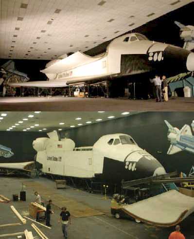
An excellent view of Space Shuttle mockup "Inspiration" - along with Apollo 14 Command Module "Kitty Hawk" - on display in the Design Engineering Implementation (DEI) room of Rockwell International's Downey plant.
An excellent observation of this particular mockup design, per the "JACQMANS SPACEFLIGHT HISTORY" website:
"As you can see...the mockup still has the original design concept for the OMS engines, i.e. a fairing for the OMS pods extended onto the aft payload bay doors. This design was abandoned very early in the development phase and the pods were designed to be fully self contained and located aft of the payload bay doors. And also the forward RSC thrusters are protected by doors."
Additionally, note the mural behind, and to either side of the orbiter, by Rockwell International’s eminently talented artist, Ted Brown. The work is a larger variant of his masterpiece, “Space Products”, which at one time (but no longer?), was prominently displayed in the Launch Control Center (LCC), Kennedy Space Center (KSC).
Check out all of the other wonderful photos of this particular display configuration:
www.disneylicenseplates.com/RSDSC/RSDSC_DEI_Inspiration.html
Credit: Disney License Plate/Rockwell Space Division Stamp Club website
An excellent reference to the mockup and - to an extent - its history, specifically, page 6:
static1.squarespace.com/static/56c78acd0442626b2590f5ea/t...
Credit: Aerospace Legacy Foundation
See also:
members.tripod.com/airfields_freeman/CA/Downey_CA_undated...
Credit: Abandoned & Little-Known Airfields: California: Central Los Angeles Area/Paul Freeman
Along with:
www.angelfire.com/fl/Jacqmans/downey.html
Credit: JACQMANS SPACEFLIGHT HISTORY website
Finally, as is all too often the case, beseeching in order to try to preserve history:
www.airspacemag.com/daily-planet/theres-one-more-shuttle-...
Credit: Smithsonian Air & Space website
en.wikipedia.org/wiki/Space_Shuttle_Inspiration
Credit: Wikipedia
Light & Life Christian Traveller Festival Oakham Half Visitors Had Departed By Lunch Time Leicestershire Police assisting traffic, Church Stewards and Volunteer Travellers implementing waste management litter picking, in and outside, the county showground, martinbrookes.blogspot.com/2021/06/life-and-light-mission...
Farm implement near McBaine, Missouri. Photography by Notley Hawkins. Taken with a Canon EOS R5 camera with a Canon RF15-35mm F2.8 L IS USM lens at ƒ/4.0 with a 243-second exposure at ISO 50, processed with Adobe Lightroom CC.
Follow me on Bluesky, Facebook, Instagram
©Notley Hawkins. All rights reserved.
The main environmental issues associated with the implementation of the 5G network come with the manufacturing of the many component parts of the 5G infrastructure. In addition, the proliferation of new devices that will use the 5G network that is tied to the acceleration of demand from consumers for new 5G-dependent devices will have serious environmental consequences. The 5G network will inevitably cause a large increase in energy usage among consumers, which is already one of the main contributors to climate change. Additionally, the manufacturing and maintenance of the new technologies associated with 5G creates waste and uses important resources that have detrimental consequences for the environment. 5G networks use technology that has harmful effects on birds, which in turn has cascading effects through entire ecosystems. And, while 5G developers are seeking to create a network that has fewer environmental impacts than past networks, there is still room for improvement and the consequences of 5G should be considered before it is widely rolled out. 5G stands for the fifth generation of wireless technology. It is the wave of wireless technology surpassing the 4G network that is used now. Previous generations brought the first cell phones (1G), text messaging (2G), online capabilities (3G), and faster speed (4G). The fifth generation aims to increase the speed of data movement, be more responsive, and allow for greater connectivity of devices simultaneously.[2] This means that 5G will allow for nearly instantaneous downloading of data that, with the current network, would take hours. For example, downloading a movie using 5G would take mere seconds. These new improvements will allow for self-driving cars, massive expansion of Internet of Things (IoT) device use, and acceleration of new technological advancements used in everyday activities by a much wider range of people. While 5G is not fully developed, it is expected to consist of at least five new technologies that allow it to perform much more complicated tasks at faster speeds. The new technologies 5G will use are hardware that works with much higher frequencies (millimeter wavelengths), small cells, massive MIMO (multiple input multiple output), beamforming, and full duplex.[3] Working together, these new technologies will expand the potential of many of the devices used today and devices being developed for the future. Millimeter waves are a higher frequency wavelength than the radio wavelength generally used in wireless transmission today.[4] The use of this portion of the spectrum corresponds to higher frequency and shorter wavelengths, in this case in the millimeter range (vs the lower radio frequencies where the wavelengths can be in the meters to hundreds of kilometers). Higher frequency waves allow for more devices to be connected to the same network at the same time, because there is more space available compared to the radio waves that are used today. The use of this portion of the spectrum has much longer wavelengths than of that anticipated for a portion of the 5G implementation. The waves in use now can measure up to tens of centimeters, while the new 5G waves would be no greater than ten millimeters.[5] The millimeter waves will create more transmission space for the ever-expanding number of people and devices crowding the current networks. The millimeter waves will create more space for devices to be used by consumers, which will increase energy usage, subsequently leading to increased global warming. Millimeter waves are very weak in their ability to connect two devices, which is why 5G needs something called “small cells” to give full, uninterrupted coverage. Small cells are essentially miniature cell towers that would be placed 250 meters apart throughout cities and other areas needing coverage.[6] The small cells are necessary as emissions [or signals] at this higher frequency/shorter wavelength have more difficulty passing through solid objects and are even easily intercepted by rain.[7] The small cells could be placed on anything from trees to street lights to the sides of businesses and homes to maximize connection and limit “dead zones” (areas where connections are lost). The next new piece of technology necessary for 5G is massive MIMO, which stands for multiple input multiple output. The MIMO describes the capacity of 5G’s base stations, because those base stations would be able to handle a much higher amount of data at any one moment of time. Currently, 4G base stations have around eight transmitters and four receivers which direct the flow of data between devices.[9] 5G will exceed this capacity with the use of massive MIMO that can handle 22 times more ports. Figure 1 shows how a massive MIMO tower would be able to direct a higher number of connections at once. However, massive MIMO causes signals to be crossed more easily. Crossed signals cause an interruption in the transmission of data from one device to the next due to a clashing of the wavelengths as they travel to their respective destinations. To overcome the cross signals problem, beamforming is needed. To maximize the efficiency of sending data another new technology called beamforming will be used in 5G. For data to be sent to the correct user, a way of directing the wavelengths without interference is necessary. This is done through a technique called beamforming. Beamforming directs where exactly data are being sent by using a variety of antennas to organize signals based on certain characteristics, such as the magnitude of the signal. By directly sending signals to where they need to go, beamforming decreases the chances that a signal is dropped due to the interference of a physical object.
One way that 5G will follow through on its promise of faster data transmission is through sending and receiving data simultaneously. The method that allows for simultaneous input and output of data is called full duplexing. While full duplex capabilities allow for faster transmission of data, there is an issue of signal interference, because of echoes. Full duplexing will cut transmission times in half, because it allows for a response to occur as soon as an input is delivered, eliminating the turnaround time that is seen in transmission today. Because these technologies are new and untested, it is hard to say how they will impact our environment. This raises another issue: there are impacts that can be anticipated and predicted, but there are also unanticipated impacts because much of the new technologies are untested. Nevertheless, it is possible to anticipate some of detrimental environmental consequences of the new technologies and the 5G network, because we know these technologies will increase exposure to harmful radiation, increase mining of rare minerals, increase waste, and increase energy usage. The main 5G environmental concerns have to do with two of the five new components: the millimeter waves and the small cells. The whole aim of the new 5G network is to allow for more devices to be used by the consumer at faster rates than ever before, because of this goal there will certainly be an increase in energy usage globally. Energy usage is one of the main contributors to climate change today and an increase in energy usage would cause climate change to increase drastically as well. 5G will operate on a higher frequency portion of the spectrum to open new space for more devices. The smaller size of the millimeter waves compared to radio frequency waves allows for more data to be shared more quickly and creates a wide bandwidth that can support much larger tasks.[15] While the idea of more space for devices to be used is great for consumers, this will lead to a spike in energy usage for two reasons – the technology itself is energy demanding and will increase demand for more electronic devices. The ability for more devices to be used on the same network creates more incentive for consumers to buy electronics and use them more often. This will have a harmful impact on the environment through increased energy use. Climate change has several underlying contributors; however, energy usage is gaining attention in its severity with regards to perpetuating climate change. Before 5G has even been released, about 2% of the world’s greenhouse gas emissions can be attributed to the ICT industry.[16] While 2% may not seem like a very large portion, it translates to around 860 million tons of greenhouse gas emissions.[17] Greenhouse gas emissions are the main contributors to natural disasters, such as flooding and drought, which are increasing severity and occurrence every year. Currently, roughly 85% of the energy used in the United States can be attributed to fossil fuel consumption.[18] The dwindling availability of fossil fuels and the environmental burden of releasing these fossil fuels into our atmosphere signal an immediate need to shift to other energy sources. Without a shift to other forms of energy production and the addition of technology allowed by the implementation of 5G, the strain on our environment will rise and the damage may never be repaired. With an increase in energy usage through technology and the implementation of 5G, it can be expected that the climate change issues faced today will only increase. The overall contribution of carbon dioxide emissions from the ICT industry has a huge impact on climate change and will continue to have even larger impacts without proper actions. In a European Union report, researchers estimated that in order to keep the increase in global temperature below 2° Celsius a decrease in carbon emissions of around 15-30% is necessary by 2020. Engineers claim that the small cells used to provide the 5G connection will be energy efficient and powered in a sustainable way; however the maintenance and production of these cells is more of an issue. Supporters of the 5G network advocate that the small cells will use solar or wind energy to stay sustainable and green.[20] These devices, labeled “fuel-cell energy servers” will work as clean energy-based generators for the small cells.[21] While implementing base stations that use sustainable energy to function would be a step in the right direction in environmental conservation, it is not the solution to the main issue caused by 5G, which is the impact that the massive amount of new devices in the hands of consumers will have on the amount of energy required to power these devices. The wasteful nature of manufacturing and maintenance of both individual devices and the devices used to deliver 5G connection could become a major contributor of climate change. The promise of 5G technology is to expand the number of devices functioning might be the most troubling aspect of the new technology. Cell phones, computers, and other everyday devices are manufactured in a way that puts stress on the environment. A report by the EPA estimated that in 2010, 25% of the world’s greenhouse gas emissions comes from electricity and heat production making it the largest single source of emissions.[22] The main gas emitted by this sector is carbon dioxide, due to the burning of natural gas, such as coal, to fuel electricity sources.[23] Carbon dioxide is one of the most common greenhouse gases seen in our atmosphere, it traps heat in earth’s atmosphere trying to escape into space, which causes the atmosphere to warm generating climate change. Increased consumption of devices is taking a toll on the environment. As consumers gain access to more technologies the cycle of consumption only expands. As new devices are developed, the older devices are thrown out even if they are still functional. Often, big companies will purposefully change their products in ways that make certain partner devices (such as chargers or earphones) unusable–creating demand for new products. Economic incentives mean that companies will continue these practices in spite of the environmental impacts. One of the main issues with the 5G network and the resulting increase in consumption of technological devices is that the production required for these devices is not sustainable. In the case of making new devices, whether they be new smart-phones or the small cells needed for 5G, the use of nonrenewable metals is required. It is extremely difficult to use metals for manufacturing sustainably, because metals are not a renewable resource. Metals used in the manufacturing of the smart devices frequently used today often cannot be recycled in the same way many household items can be recycled. Because these technologies cannot be recycled, they create tons of waste when they are created and tons of waste when they are thrown away. There are around six billion mobile devices in use today, with this number expected to increase drastically as the global population increases and new devices enter the market. One estimate of the life-time carbon emissions of a single device–not including related accessories and network connection–is that a device produces a total of 45kg of carbon dioxide at a medium level of usage over three years. This amount of emission is comparable to that of driving the average European car for 300km. But, the most environmentally taxing stage of a mobile device life cycle is during the production stage, where around 68% of total carbon emissions is produced, equating to 30kg of carbon dioxide. To put this into perspective, an iPhone X weighs approximately 0.174kg, so in order to produce the actual device, 172 iPhone X’s worth of carbon dioxide is also created. These emissions vary from person to person and between different devices, but it’s possible to estimate the impact one device has on the environment. 5G grants the capacity for more devices to be used, significantly increase the existing carbon footprint of smart devices today. Energy usage for the ever-growing number of devices on the market and in homes is another environmental threat that would be greatly increased by the new capabilities brought by the 5G network. Often, energy forecasts overlook the amount of energy that will be consumed by new technologies, which leads to a skewed understanding of the actual amount of energy expected to be used.[30] One example of this is with IoT devices.[31] IoT is one of the main aspects of 5G people in the technology field are most excited about. 5G will allow for a larger expansion of IoT into the everyday household.[32] While some IoT devices promise lower energy usage abilities, the 50 billion new IoT devices expected to be produced and used by consumers will surpass the energy used by today’s electronics.
The small cells required for the 5G network to properly function causes another issue of waste with the new network. Because of the weak nature of the millimeter waves used in the 5G technology, small cells will need to be placed around 250 meters apart to insure continuous connection. The main issue with these small cells is that the manufacturing and maintenance of these cells will create a lot of waste. The manufacturing of technology takes a large toll on the environment, due to the consumption of non-renewable resources to produce devices, and technology ending up in landfills. Implementing these small cells into large cities where they must be placed at such a high density will have a drastic impact on technology waste. Technology is constantly changing and improving, which is one of the huge reasons it has such high economic value. But, when a technological advancement in small cells happens, the current small cells would have to be replaced. The short lifespan of devices created today makes waste predictable and inevitable. In New York City, where there would have to be at least 3,135,200 small cells, the waste created in just one city when a new advancement in small cells is implemented would have overwhelming consequences on the environment. 5G is just one of many examples of how important it is to look at the consequences of new advancements before their implementation. While it is exciting to see new technology that promises to improve everyday life, the consequences of additional waste and energy usage must be considered to preserve a sustainable environment in the future. There is some evidence that the new devices and technologies associated with 5G will be harmful to delicate ecosystems. The main component of the 5G network that will affect the earth’s ecosystems is the millimeter waves. The millimeter waves that are being used in developing the 5G network have never been used at such scale before. This makes it especially difficult to know how they will impact the environment and certain ecosystems. However, studies have found that there are some harms caused by these new technologies. The millimeter waves, specifically, have been linked to many disturbances in the ecosystems of birds. In a study by the Centre for Environment and Vocational Studies of Punjab University, researchers observed that after exposure to radiation from a cell tower for just 5-30 minutes, the eggs of sparrows were disfigured.[34] The disfiguration of birds exposed for such a short amount of time to these frequencies is significant considering that the new 5G network will have a much higher density of base stations (small cells) throughout areas needing connection. The potential dangers of having so many small cells all over areas where birds live could cause whole populations of birds to have mutations that threaten their population’s survival. Additionally, a study done in Spain showed breeding, nesting, and roosting was negatively affected by microwave radiation emitted by a cell tower. Again, the issue of the increase in the amount of connection conductors in the form of small cells to provide connection with the 5G network is seen to be harmful to species that live around humans. Additionally, Warnke found that cellular devices had a detrimental impact on bees.[36] In this study, beehives exposed for just ten minutes to 900MHz waves fell victim to colony collapse disorder.Colony collapse disorder is when many of the bees living in the hive abandon the hive leaving the queen, the eggs, and a few worker bees. The worker bees exposed to this radiation also had worsened navigational skills, causing them to stop returning to their original hive after about ten days. Bees are an incredibly important part of the earth’s ecosystem. Around one-third of the food produced today is dependent on bees for pollination, making bees are a vital part of the agricultural system. Bees not only provide pollination for the plant-based food we eat, but they are also important to maintaining the food livestock eats. Without bees, a vast majority of the food eaten today would be lost or at the very least highly limited. Climate change has already caused a large decline in the world’s bee population. The impact that the cell towers have on birds and bees is important to understand, because all ecosystems of the earth are interconnected. If one component of an ecosystem is disrupted the whole system will be affected. The disturbances of birds with the cell towers of today would only increase, because with 5G a larger number of small cell radio-tower-like devices would be necessary to ensure high quality connection for users. Having a larger number of high concentrations of these millimeter waves in the form of small cells would cause a wider exposure to bees and birds, and possibly other species that are equally important to our environment.As innovation continues, it is important that big mobile companies around the world consider the impact 5G will have on the environment before pushing to have it widely implemented. The companies pushing for the expansion of 5G may stand to make short term economic gains. While the new network will undoubtedly benefit consumers greatly, looking at 5G’s long-term environmental impacts is also very important so that the risks are clearly understood and articulated. The technology needed to power the new 5G network will inevitably change how mobile devices are used as well as their capabilities. This technological advancement will also change the way technology and the environment interact. The change from using radio waves to using millimeter waves and the new use of small cells in 5G will allow more devices to be used and manufactured, more energy to be used, and have detrimental consequences for important ecosystems. While it is unrealistic to call for 5G to not become the new network norm, companies, governments, and consumers should be proactive and understand the impact that this new technology will have on the environment. 5G developers should carry out Environmental Impact Assessments that fully estimate the impact that the new technology will have on the environment before rushing to widely implement it. Environmental Impact Assessments are intended to assess the impact new technologies have on the environment, while also maximizing potential benefits to the environment. This process mitigates, prevents, and identifies environmental harm, which is imperative to ensuring that the environment is sustainable and sound in the future. Additionally, the method of Life Cycle Assessments (LCA) of devices would also be extremely beneficial for understanding the impact that 5G will inevitably have on the environment. An LCA can be used to assess the impact that devices have on carbon emissions throughout their life span, from the manufacturing of the device to the energy required to power the device and ultimately the waste created when the device is discarded into a landfill or other disposal system. By having full awareness of the impact new technology will have on the environment ways to combat the negative impacts can be developed and implemented effectively.
jsis.washington.edu/news/what-will-5g-mean-for-the-enviro...
Salvador Prieto gets nearly ground level to see how well this micro-sprinkler is working under one of his avocado trees, in Somis, CA, on Nov 15, 2018.
Salvador Prieto grew up watching and helping his father grow corn and beans on a small farm in Mexico. The journey from bean fields to 20-acre orchard owner with his wife Martha Romero was not a straight and narrow path to Somis, Calif. In fact, it was music that brought him to the United States. Today the passion is agriculture.
Similarly, Romero didn’t follow a career in agriculture to her beautiful and healthy avocado and lemon orchard. Romero grew up a city girl in the heart of Los Angeles. Now sharing this farm with her husband and two children, she quickly credits her success to the support and assistance from her family to navigate the learning curve.
Constantly seeking improvement on the family’s orchard, Romero discovered the local Farm Bureau and the Ventura County Agricultural Irrigated Land Group (VCAILG) coalition. VCAILG put Romero in touch with the USDA Natural Resources Conservation Service (NRCS) and the Ventura Resource Conservation District, for technical and financial assistance to implement conservation and management practices.
NRCS California District Conservationist Dawn Afman, Soil Conservationist Elizabeth Keith, and Resource Conservationist Brooks Engelhardt, have all provided technical assistance and invested their time and expertise in helping Prieto and Romero incorporate conservation practices in their orchard. Prieto and Romero were immediately intrigued by NRCS’s efforts to improve soil health.
“At first it was overwhelming, but many other farmers I know are members, so it is comforting to know that I am not alone,” said Romero. “We need to make a profit, obviously, but, for me, I want to do it while protecting mother nature and precious resources like water. I am able to do this with NRCS’s help.”
Prieto and Romero learned a lot from trial and error. Romero admits that she even bought her trees before the land was ready. But learning opportunities, like an early community garden project, gave them critical knowledge and experience.
A big first conservation practice they learned was mulching to save water and reduce weeds. NRCS helped Prieto and Romero with this, through an Environmental Quality Incentives Program (EQIP) contract, to apply mulch to their orchard floor to conserve soil moisture and improve soil health in the Fall of 2018.
“Every time we have a question or need assistance, NRCS has been nothing but helpful,” added Romero. “They let us know about other programs out in the community and invited us to their annual Latino Farmer Conference, where my husband and I learned about other helpful resources.”
Recently, Prieto and Romero entered into a new NRCS contract to implement Irrigation Water Management (IWM) to their orchard. The IWM plan includes installing moisture sensors into the ground, which transmit continuous data to cloud-based storage, and accessed through a smart device app on their phones. The information lets them know when, where and how long to irrigate. This knowledge will help them toward their goal of producing 6,000 pounds of produce per acre.
Looking toward the future, Romero expressed that knowledge is key. “Before we plant further, we need to get educated on how to do it best,” concluded Romero. “From the planting of a seed or planting of a tree, we need the entire process to be profitable. It's not just about planting it. It's about preparing the land and using the resources wisely.”
In the meantime, Romero enjoys the weekends because she does not need to be worried about picking up the kids from school or rushing around. She just wants to be out in the orchard, making it better From mulching to pruning or irrigating and weeding. The family’s goal is to make the farm “better tomorrow than it was today.”
—
Farm Production and Conservation (FPAC) is the Department’s focal point for the nation’s farmers and ranchers and other stewards of private agricultural lands and non-industrial private forest lands. FPAC agencies implement programs designed to mitigate the significant risks of farming through crop insurance services, conservation programs, and technical assistance, and commodity, lending, and disaster programs.
The agencies and services supporting FPAC are Farm Service Agency (FSA), Natural Resources Conservation Service (NRCS), and Risk Management Agency (RMA).
NRCS has a proud history of supporting America’s farmers, ranchers, and forest landowners for more than 80 years. USDA helps people make investments in their operations and local communities to keep working lands working, boost rural economies, increase the competitiveness of American agriculture, and improve the quality of our air, water, soil, and habitat.
From weather to pests, and from a lack of time to markets, each American farmer faces a unique set of challenges. The Environmental Quality Incentives Program (EQIP) helps agricultural producers confront those challenges – all while conserving natural resources like soil, water, and air.
This voluntary conservation program helps producers make conservation work for them. Together, NRCS and producers invest in solutions that conserve natural resources for the future while also improving agricultural operations.
Through EQIP, NRCS provides agricultural producers with financial resources and one-on-one help to plan and implement improvements, or what NRCS calls conservation practices. Using these practices can lead to cleaner water and air, healthier soil and better wildlife habitat, all while improving agricultural operations. Through EQIP, you can voluntarily implement conservation practices and NRCS co-invests in these practices with you.
USDA Photo by Lance Cheung.
For more information, please see:
USDA
FPAC
www.usda.gov/our-agency/about-usda/mission-areas
NRCS
www.nrcs.usda.gov/wps/portal/nrcs/site/national/home/
EQIP
www.nrcs.usda.gov/wps/portal/nrcs/detail/national/program...
Lighted Farm Implement Parade, Sunnyside, Washington. I am pleasantly surprised how sharp these night photos are considering these shots are hand held and mostly shot at 1/30 and slower shutter speed. IMG_1053
20 May 2019 - TALK TOGETHER
Session : The Male Disadvantage in Education
Speakers : Camilla Stoltenberg, Director-General, Norwegian Institute of Public Health; Head, Norwegian National Commission on Gender Equality in Education
With ** Francesca Borgonovi, Senior Analyst, Policy Advice and Implementation, Directorate for Education and Skills, OECD
OECD Headquarters, Paris.
Photo : © Hervé Cortinat / OECD
Implementation of the 16 control measures specified in the Time to Act publication is expected to have significant benefits for agriculture worldwide. Rapid reduction of methane and sot has the potential to avoid an annual loss of over 50 metric tonnes of crop yields per year by 2030.
For any form of publication, please include the link to this page:
This photo has been graciously provided to be used in the GRID-Arendal resources library by: GRID-Arendal
Antique Farm Implement.
Penn Farm Agricultural Heritage Center.
Cedar Hill State Park. Cedar Hill, Texas.
Dallas County. September 10, 2020.
Nikon D750. AF-S Nikkor 70-200mm f/4 G ED VR.
(82mm) f/4 @ 1/250 sec. ISO 1100.
en.wikipedia.org/wiki/Aswan_Dam
The Aswan Dam, or more specifically since the 1960s, the Aswan High Dam, is the world's largest embankment dam, which was built across the Nile in Aswan, Egypt, between 1960 and 1970. Its significance largely eclipsed the previous Aswan Low Dam initially completed in 1902 downstream. Based on the success of the Low Dam, then at its maximum utilization, construction of the High Dam became a key objective of the government following the Egyptian Revolution of 1952; with its ability to better control flooding, provide increased water storage for irrigation and generate hydroelectricity, the dam was seen as pivotal to Egypt's planned industrialization. Like the earlier implementation, the High Dam has had a significant effect on the economy and culture of Egypt.
Before the High Dam was built, even with the old dam in place, the annual flooding of the Nile during late summer had continued to pass largely unimpeded down the valley from its East African drainage basin. These floods brought high water with natural nutrients and minerals that annually enriched the fertile soil along its floodplain and delta; this predictability had made the Nile valley ideal for farming since ancient times. However, this natural flooding varied, since high-water years could destroy the whole crop, while low-water years could create widespread drought and consequently famine. Both these events had continued to occur periodically. As Egypt's population grew and technology increased, both a desire and the ability developed to completely control the flooding, and thus both protect and support farmland and its economically important cotton crop. With the greatly increased reservoir storage provided by the High Aswan Dam, the floods could be controlled and the water could be stored for later release over multiple years.
The Aswan Dam was designed by the Moscow-based Hydroproject Institute.
The earliest recorded attempt to build a dam near Aswan was in the 11th century, when the Arab polymath and engineer Ibn al-Haytham (known as Alhazen in the West) was summoned to Egypt by the Fatimid Caliph, Al-Hakim bi-Amr Allah, to regulate the flooding of the Nile, a task requiring an early attempt at an Aswan Dam. His field work convinced him of the impracticality of this scheme.
The British began construction of the first dam across the Nile in 1898. Construction lasted until 1902 and the dam was opened on 10 December 1902. The project was designed by Sir William Willcocks and involved several eminent engineers, including Sir Benjamin Baker and Sir John Aird, whose firm, John Aird & Co., was the main contractor.
In 1952, the Greek-Egyptian engineer Adrian Daninos began to develop the plan of the new Aswan Dam. Although the Low Dam was almost overtopped in 1946, the government of King Farouk showed no interest in Daninos's plans. Instead the Nile Valley Plan by the British hydrologist Harold Edwin Hurst was favored, which proposed to store water in Sudan and Ethiopia, where evaporation is much lower. The Egyptian position changed completely after the overthrow of the monarchy, led by the Free Officers Movement including Gamal Abdel Nasser. The Free Officers were convinced that the Nile Waters had to be stored in Egypt for political reasons, and within two months, the plan of Daninos was accepted. Initially, both the United States and the USSR were interested in helping development of the dam. Complications ensued due to their rivalry during the Cold War, as well as growing intra-Arab tensions.
In 1955, Nasser was claiming to be the leader of Arab nationalism, in opposition to the traditional monarchies, especially the Hashemite Kingdom of Iraq following its signing of the 1955 Baghdad Pact. At that time the U.S. feared that communism would spread to the Middle East, and it saw Nasser as a natural leader of an anticommunist procapitalist Arab League. America and the United Kingdom offered to help finance construction of the High Dam, with a loan of $270 million, in return for Nasser's leadership in resolving the Arab-Israeli conflict. While opposed to communism, capitalism, and imperialism, Nasser identified as a tactical neutralist, and sought to work with both the U.S. and the USSR for Egyptian and Arab benefit.[8] After the UN criticized a raid by Israel against Egyptian forces in Gaza in 1955, Nasser realized that he could not portray himself as the leader of pan-Arab nationalism if he could not defend his country militarily against Israel. In addition to his development plans, he looked to quickly modernize his military, and he turned first to the U.S. for aid.
American Secretary of State John Foster Dulles and President Dwight Eisenhower told Nasser that the U.S. would supply him with weapons only if they were used for defensive purposes and if he accepted American military personnel for supervision and training. Nasser did not accept these conditions, and consulted the USSR for support.
Although Dulles believed that Nasser was only bluffing and that the USSR would not aid Nasser, he was wrong: the USSR promised Nasser a quantity of arms in exchange for a deferred payment of Egyptian grain and cotton. On 27 September 1955, Nasser announced an arms deal, with Czechoslovakia acting as a middleman for the Soviet support. Instead of attacking Nasser for turning to the Soviets, Dulles sought to improve relations with him. In December 1955, the US and the UK pledged $56 and $14 million, respectively, toward construction of the High Aswan Dam.
Though the Czech arms deal created an incentive for the US to invest at Aswan, the UK cited the deal as a reason for repealing its promise of dam funds. Dulles was angered more by Nasser's diplomatic recognition of China, which was in direct conflict with Dulles's policy of containment of communism.
Several other factors contributed to the US deciding to withdraw its offer of funding for the dam. Dulles believed that the USSR would not fulfil its commitment of military aid. He was also irritated by Nasser's neutrality and attempts to play both sides of the Cold War. At the time, other Western allies in the Middle East, including Turkey and Iraq, were resentful that Egypt, a persistently neutral country, was being offered so much aid.
In June 1956, the Soviets offered Nasser $1.12 billion at 2% interest for the construction of the dam. On 19 July the U.S. State Department announced that American financial assistance for the High Dam was "not feasible in present circumstances."
On 26 July 1956, with wide Egyptian acclaim, Nasser announced the nationalization of the Suez Canal that included fair compensation for the former owners. Nasser planned on the revenues generated by the canal to help fund construction of the High Dam. When the Suez War broke out, the United Kingdom, France, and Israel seized the canal and the Sinai. But pressure from the U.S. and the USSR at the United Nations and elsewhere forced them to withdraw.
In 1958, the USSR proceeded to provide support for the High Dam project.
In the 1950s, archaeologists began raising concerns that several major historical sites, including the famous temple of Abu Simbel were about to be submerged by waters collected behind the dam. A rescue operation began in 1960 under UNESCO
Despite its size, the Aswan project has not materially hurt the Egyptian balance of payments. The three Soviet credits covered virtually all of the project's foreign exchange requirements, including the cost of technical services, imported power generating and transmission equipment and some imported equipment for land reclamation. Egypt was not seriously burdened by payments on the credits, most of which were extended for 12 years with interest at the very low rate of 2-1/2%. Repayments to the USSR constituted only a small net drain during the first half of the 1960s, and increased export earnings derived from crops grown on newly reclaimed land have largely offset the modest debt service payments in recent years. During 1965–70, these export earnings amounted to an estimated $126 million, compared with debt service payments of $113 million.
A central pylon of the monument to Arab-Soviet Friendship. The memorial commemorates the completion of the Aswan High Dam. The coat of arms of the Soviet Union is on the left and the coat of arms of Egypt is on the right.
The Soviets also provided technicians and heavy machinery. The enormous rock and clay dam was designed by the Soviet Hydroproject Institute along with some Egyptian engineers. 25,000 Egyptian engineers and workers contributed to the construction of the dams.
Originally designed by West German and French engineers in the early 1950s and slated for financing with Western credits, the Aswan High Dam became the USSR's largest and most famous foreign aid project after the United States, the United Kingdom, and the International Bank for Reconstruction and Development (IBRD) withdrew their support in 1956. The first Soviet loan of $100 million to cover construction of coffer dams for diversion of the Nile was extended in 1958. An additional $225 million was extended in 1960 to complete the dam and construct power-generating facilities, and subsequently about $100 million was made available for land reclamation. These credits of some $425 million covered only the foreign exchange costs of the project, including salaries of Soviet engineers who supervised the project and were responsible for the installation and testing of Soviet equipment. Actual construction, which began in 1960, was done by Egyptian companies on contract to the High Dam Authority, and all domestic costs were borne by the Egyptians. Egyptian participation in the venture has raised the construction industry's capacity and reputation significantly.
On the Egyptian side, the project was led by Osman Ahmed Osman's Arab Contractors. The relatively young Osman underbid his only competitor by one-half.
1960: Start of construction on 9 January
1964: First dam construction stage completed, reservoir started filling
1970: The High Dam, as-Sad al-'Aali, completed on 21 July[18]
1976: Reservoir reached capacity.
Specifications
The Aswan High Dam is 3,830 metres (12,570 ft) long, 980 m (3,220 ft) wide at the base, 40 m (130 ft) wide at the crest and 111 m (364 ft)[ tall. It contains 43,000,000 cubic metres (56,000,000 cu yd) of material. At maximum, 11,000 cubic metres per second (390,000 cu ft/s) of water can pass through the dam. There are further emergency spillways for an extra 5,000 cubic metres per second (180,000 cu ft/s), and the Toshka Canal links the reservoir to the Toshka Depression. The reservoir, named Lake Nasser, is 500 km (310 mi) long[20] and 35 km (22 mi) at its widest, with a surface area of 5,250 square kilometres (2,030 sq mi). It holds 132 cubic kilometres (1.73×10¹¹ cu yd) of water.
Due to the absence of appreciable rainfall, Egypt's agriculture depends entirely on irrigation. With irrigation, two crops per year can be produced, except for sugar cane which has a growing period of almost one year.
The high dam at Aswan releases, on average, 55 cubic kilometres (45,000,000 acre⋅ft) water per year, of which some 46 cubic kilometres (37,000,000 acre⋅ft) are diverted into the irrigation canals.
In the Nile valley and delta, almost 336,000 square kilometres (130,000 sq mi) benefit from these waters producing on average 1.8 crops per year. The annual crop consumptive use of water is about 38 cubic kilometres (31,000,000 acre⋅ft). Hence, the overall irrigation efficiency is 38/46 = 0.826 or 83%. This is a relatively high irrigation efficiency. The field irrigation efficiencies are much less, but the losses are reused downstream. This continuous reuse accounts for the high overall efficiency.
The following table shows the distribution of irrigation water over the branch canals taking off from the one main irrigation canal, the Mansuriya Canal near Giza.
Branch canalWater delivery in m3/feddan *
Kafret Nasser4,700
Beni Magdul3,500
El Mansuria3,300
El Hammami upstream2,800
El Hammami downstream1,800
El Shimi1,200
* Period 1 March to 31 July. 1 feddan is 0.42 ha or about 1 acre.
* Data from the Egyptian Water Use Management Project (EWUP)
The salt concentration of the water in the Aswan reservoir is about 0.25 kilograms per cubic metre (0.42 lb/cu yd), a very low salinity level. At an annual inflow of 55 cubic kilometres (45,000,000 acre⋅ft), the annual salt influx reaches 14 million tons. The average salt concentration of the drainage water evacuated into the sea and the coastal lakes is 2.7 kilograms per cubic metre (4.6 lb/cu yd). At an annual discharge of 10 cubic kilometres (2.4 cu mi) (not counting the 2 kilograms per cubic metre [3.4 lb/cu yd] of salt intrusion from the sea and the lakes, see figure "Water balances"), the annual salt export reaches 27 million ton. In 1995, the output of salt was higher than the influx, and Egypt's agricultural lands were desalinizing. Part of this could be due to the large number of subsurface drainage projects executed in the last decades to control the water table and soil salinity.
Drainage through subsurface drains and drainage channels is essential to prevent a deterioration of crop yields from waterlogging and soil salinization caused by irrigation. By 2003, more than 20,000 square kilometres (7,700 sq mi) have been equipped with a subsurface drainage system and approximately 7.2 square kilometres (2.8 sq mi) of water is drained annually from areas with these systems. The total investment cost in agricultural drainage over 27 years from 1973 to 2002 was about $3.1 billion covering the cost of design, construction, maintenance, research and training. During this period 11 large-scale projects were implemented with financial support from World Bank and other donors.
Effects
The High Dam has resulted in protection from floods and droughts, an increase in agricultural production and employment, electricity production, and improved navigation that also benefits tourism. Conversely, the dam flooded a large area, causing the relocation of over 100,000 people. Many archaeological sites were submerged while others were relocated. The dam is blamed for coastline erosion, soil salinity, and health problems.
The assessment of the costs and benefits of the dam remains controversial decades after its completion. According to one estimate, the annual economic benefit of the High Dam immediately after its completion was LE 255 million, $587 million using the exchange rate in 1970 of $2.30 per LE 1): LE 140 million from agricultural production, LE 100 million from hydroelectric generation, LE 10 million from flood protection, and LE 5 million from improved navigation. At the time of its construction, total cost, including unspecified "subsidiary projects" and the extension of electric power lines, amounted to LE 450 million. Not taking into account the negative environmental and social effects of the dam, its costs are thus estimated to have been recovered within only two years. One observer notes: "The impacts of the Aswan High Dam have been overwhelmingly positive. Although the Dam has contributed to some environmental problems, these have proved to be significantly less severe than was generally expected, or currently believed by many people." Another observer disagreed and he recommended that the dam should be torn down. Tearing it down would cost only a fraction of the funds required for "continually combating the dam's consequential damage" and 500,000 hectares (1,900 sq mi) of fertile land could be reclaimed from the layers of mud on the bed of the drained reservoir. Samuel C. Florman wrote about the dam: "As a structure it is a success. But in its effect on the ecology of the Nile Basin – most of which could have been predicted – it is a failure".
Periodic floods and droughts have affected Egypt since ancient times. The dam mitigated the effects of floods, such as those in 1964, 1973, and 1988. Navigation along the river has been improved, both upstream and downstream of the dam. Sailing along the Nile is a favorite tourism activity, which is mainly done during the winter when the natural flow of the Nile would have been too low to allow navigation of cruise ships.[clarification needed] A new fishing industry has been created around Lake Nasser, though it is struggling due to its distance from any significant markets. The annual production was about 35 000 tons in the mid-1990s. Factories for the fishing industry and packaging have been set up near the Lake.
According to a 1971 CIA declassified report, Although the High Dam has not created ecological problems as serious as some observers have charged, its construction has brought economic losses as well as gains. These losses derive largely from the settling in dam's lake of the rich silt traditionally borne by the Nile. To date (1971), the main impact has been on the fishing industry. Egypt's Mediterranean catch, which once averaged 35,000-40,000 tons annually, has shrunk to 20,000 tons or less, largely because the loss of plankton nourished by the silt has eliminated the sardine population in Egyptian waters. Fishing in high dam's lake may in time at least partly offset the loss of saltwater fish, but only the most optimistic estimates place the eventual catch as high as 15,000-20,000 tons. Lack of continuing silt deposits at the mouth of the river also has contributed to a serious erosion problem. Commercial fertilizer requirements and salination and drainage difficulties, already large in perennially irrigated areas of Lower and Middle Egypt, will be somewhat increased in Upper Egypt by the change to perennial irrigation.
The dams also protected Egypt from the droughts in 1972–73 and 1983–87 that devastated East and West Africa. The High Dam allowed Egypt to reclaim about 2.0 million feddan (840,000 hectares) in the Nile Delta and along the Nile Valley, increasing the country's irrigated area by a third. The increase was brought about both by irrigating what used to be desert and by bringing under cultivation of 385,000 hectares (950,000 acres) that were previously used as flood retention basins. About half a million families were settled on these new lands. In particular the area under rice and sugar cane cultivation increased. In addition, about 1 million feddan (420,000 hectares), mostly in Upper Egypt, were converted from flood irrigation with only one crop per year to perennial irrigation allowing two or more crops per year. On other previously irrigated land, yields increased because water could be made available at critical low-flow periods. For example, wheat yields in Egypt tripled between 1952 and 1991 and better availability of water contributed to this increase. Most of the 32 km3 of freshwater, or almost 40 percent of the average flow of the Nile that were previously lost to the sea every year could be put to beneficial use. While about 10 km3 of the water saved is lost due to evaporation in Lake Nasser, the amount of water available for irrigation still increased by 22 km3. Other estimates put evaporation from Lake Nasser at between 10 and 16 cubic km per year.
Electricity production
The dam powers twelve generators each rated at 175 megawatts (235,000 hp), with a total of 2.1 gigawatts (2,800,000 hp). Power generation began in 1967. When the High Dam first reached peak output it produced around half of Egypt's production of electric power (about 15 percent by 1998), and it gave most Egyptian villages the use of electricity for the first time. The High Dam has also improved the efficiency and the extension of the Old Aswan Hydropower stations by regulating upstream flows.
All High Dam power facilities were completed ahead of schedule. 12 turbines were installed and tested, giving the plant an installed capacity of 2,100 megawatts (MW), or more than twice the national total in 1960. With this capacity, the Aswan plant can produce 10 billion kWh of energy yearly. Two 500-kilovolt trunk lines to Cairo have been completed, and initial transmission problems, stemming mainly from poor insulators, were solved. Also, the damage inflicted on a main transformer station in 1968 by Israeli commandos has been repaired, and the Aswan plant is fully integrated with the power network in Lower Egypt. By 1971 estimation, Power output at Aswan, won't reach much more than half of the plant's theoretical capacity, because of limited water supplies and the differing seasonal water-use patterns for irrigation and power production. Agricultural demand for water in the summer far exceeds the amount needed to meet the comparatively low summer demand for electric power. Heavy summer irrigation use, however, will leave insufficient water under Egyptian control to permit hydroelectric power production at full capacity in the winter. Technical studies indicate that a maximum annual output of 5 billion kWh appears to be all that can be sustained due to fluctuations in Nile flows.
Resettlement and compensations
In Sudan, 50,000 to 70,000 Sudanese Nubians were moved from the old town of Wadi Halfa and its surrounding villages. Some were moved to a newly created settlement on the shore of Lake Nasser called New Wadi Halfa, and some were resettled approximately 700 kilometres (430 mi) south to the semi-arid Butana plain near the town of Khashm el-Girba up the Atbara River. The climate there had a regular rainy season as opposed to their previous desert habitat in which virtually no rain fell. The government developed an irrigation project, called the New Halfa Agricultural Development Scheme to grow cotton, grains, sugar cane and other crops. The Nubians were resettled in twenty five planned villages that included schools, medical facilities, and other services, including piped water and some electrification.
In Egypt, the majority of the 50,000 Nubians were moved three to ten kilometers from the Nile near Edna and Kom Ombo, 45 kilometers (28 mi) downstream from Aswan in what was called "New Nubia". Housing and facilities were built for 47 village units whose relationship to each other approximated that in Old Nubia. Irrigated land was provided to grow mainly sugar cane.
In 2019–20, Egypt started to compensate the Nubians who lost their homes following the dam impoundment.
Archaeological sites
Twenty-two monuments and architectural complexes that were threatened by flooding from Lake Nasser, including the Abu Simbel temples, were preserved by moving them to the shores of the lake under the UNESCO Nubia Campaign. Also moved were Philae, Kalabsha and Amada.
These monuments were granted to countries that helped with the works:
The Debod temple to Madrid
The Temple of Dendur to the Metropolitan Museum of Art of New York
The Temple of Taffeh to the Rijksmuseum van Oudheden of Leiden
The Temple of Ellesyia to the Museo Egizio of Turin
These items were removed to the garden area of the Sudan National Museum of Khartoum:
The temple of Ramses II at Aksha
The temple of Hatshepsut at Buhen
The temple of Khnum at Kumma
The tomb of the Nubian prince Djehuti-hotep at Debeira
The temples of Dedwen and Sesostris III at Semna
The granite columns from the Faras Cathedral
A part of the paintings of the Faras Cathedral; the other part is in the National Museum of Warsaw.
The Temple of Ptah at Gerf Hussein had its free-standing section reconstructed at New Kalabsha, alongside the Temple of Kalabsha, Beit el-Wali, and the Kiosk of Qertassi.
The remaining archaeological sites, including the Buhen fort and the cemetery of Fadrus have been flooded by Lake Nasser.
Loss of sediments
Before the construction of the High Dam, the Nile deposited sediments of various particle size – consisting of fine sand, silt and clay – on fields in Upper Egypt through its annual flood, contributing to soil fertility. However, the nutrient value of the sediment has often been overestimated. 88 percent of the sediment was carried to the sea before the construction of the High Dam. The nutrient value added to the land by the sediment was only 6,000 tons of potash, 7,000 tons of phosphorus pentoxide and 17,000 tons of nitrogen. These amounts are insignificant compared to what is needed to reach the yields achieved today in Egypt's irrigation. Also, the annual spread of sediment due to the Nile floods occurred along the banks of the Nile. Areas far from the river which never received the Nile floods before are now being irrigated.
A more serious issue of trapping of sediment by the dam is that it has increased coastline erosion surrounding the Nile Delta. The coastline erodes an estimated 125–175 m (410–574 ft) per year.
Waterlogging and increase in soil salinity
Before the construction of the High Dam, groundwater levels in the Nile Valley fluctuated 8–9 m (26–30 ft) per year with the water level of the Nile. During summer when evaporation was highest, the groundwater level was too deep to allow salts dissolved in the water to be pulled to the surface through capillary action. With the disappearance of the annual flood and heavy year-round irrigation, groundwater levels remained high with little fluctuation leading to waterlogging. Soil salinity also increased because the distance between the surface and the groundwater table was small enough (1–2 m depending on soil conditions and temperature) to allow water to be pulled up by evaporation so that the relatively small concentrations of salt in the groundwater accumulated on the soil surface over the years. Since most of the farmland did not have proper subsurface drainage to lower the groundwater table, salinization gradually affected crop yields.[31] Drainage through sub-surface drains and drainage channels is essential to prevent a deterioration of crop yields from soil salinization and waterlogging. By 2003, more than 2 million hectares have been equipped with a subsurface drainage system at a cost from 1973 to 2002 of about $3.1 billion.
Health
Contrary to many predictions made prior to the Aswan High Dam construction and publications that followed, that the prevalence of schistosomiasis (bilharzia) would increase, it did not. This assumption did not take into account the extent of perennial irrigation that was already present throughout Egypt decades before the high dam closure. By the 1950s only a small proportion of Upper Egypt had not been converted from basin (low transmission) to perennial (high transmission) irrigation. Expansion of perennial irrigation systems in Egypt did not depend on the high dam. In fact, within 15 years of the high dam closure there was solid evidence that bilharzia was declining in Upper Egypt. S. haematobium has since disappeared altogether. Suggested reasons for this include improvements in irrigation practice. In the Nile Delta, schistosomiasis had been highly endemic, with prevalence in the villages 50% or higher for almost a century before. This was a consequence of the conversion of the Delta to perennial irrigation to grow long staple cotton by the British. This has changed. Large-scale treatment programmes in the 1990s using single-dose oral medication contributed greatly to reducing the prevalence and severity of S. mansoni in the Delta.
Other effects
Sediment deposited in the reservoir is lowering the water storage capacity of Lake Nasser. The reservoir storage capacity is 162 km3, including 31 km3 dead storage at the bottom of the lake below 147 m (482 ft) above sea level, 90 km3 live storage, and 41 km3 of storage for high flood waters above 175 m (574 ft) above sea level. The annual sediment load of the Nile is about 134 million tons. This means that the dead storage volume would be filled up after 300–500 years if the sediment accumulated at the same rate throughout the area of the lake. Obviously sediment accumulates much faster at the upper reaches of the lake, where sedimentation has already affected the live storage zone.
Before the construction of the High Dam, the 50,000 km (31,000 mi) of irrigation and drainage canals in Egypt had to be dredged regularly to remove sediments. After construction of the dam, aquatic weeds grew much faster in the clearer water, helped by fertilizer residues. The total length of the infested waterways was about 27,000 km (17,000 mi) in the mid-1990s. Weeds have been gradually brought under control by manual, mechanical and biological methods.
Mediterranean fishing and brackish water lake fishery declined after the dam was finished because nutrients that flowed down the Nile to the Mediterranean were trapped behind the dam. For example, the sardine catch off the Egyptian coast declined from 18,000 tons in 1962 to a mere 460 tons in 1968, but then gradually recovered to 8,590 tons in 1992. A scientific article in the mid-1990s noted that "the mismatch between low primary productivity and relatively high levels of fish production in the region still presents a puzzle to scientists."
A concern before the construction of the High Dam had been the potential drop in river-bed level downstream of the Dam as the result of erosion caused by the flow of sediment-free water. Estimates by various national and international experts put this drop at between and 2 and 10 meters (6.6 and 32.8 ft). However, the actual drop has been measured at 0.3–0.7 meters (0.98–2.30 ft), much less than expected.[30]
The red-brick construction industry, which consisted of hundreds of factories that used Nile sediment deposits along the river, has also been negatively affected. Deprived of sediment, they started using the older alluvium of otherwise arable land taking out of production up to 120 square kilometers (46 sq mi) annually, with an estimated 1,000 square kilometers (390 sq mi) destroyed by 1984 when the government prohibited, "with only modest success," further excavation. According to one source, bricks are now being made from new techniques which use a sand-clay mixture and it has been argued that the mud-based brick industry would have suffered even if the dam had not been built.
Because of the lower turbidity of the water sunlight penetrates deeper in the Nile water. Because of this and the increased presence of nutrients from fertilizers in the water, more algae grow in the Nile. This in turn increases the costs of drinking water treatment. Apparently few experts had expected that water quality in the Nile would actually decrease because of the High Dam.
Appraisal of the Project
Although it is moot whether the project constitutes the best use of the funds spent, the Aswan Dam project unquestionably is and will continue to be economically beneficial to Egypt. The project has been expensive and it took considerable time to complete, as is usually the case with large hydroelectric developments, But Egypt now has a valuable asset with a long life and low operating costs. Even so, the wisdom of concentrating one-third of domestic saving and most of available foreign aid on a slow growth project is questionable. Since 1960, GNP has grown 50%, but mainly as a result of other investment.
Egyptian authorities were well aware that equivalent gains in output could have been achieved more quickly and more cheaply by other means. A series of low dams, similar to the barrages now contemplated, was suggested by Egyptian engineers as a more economical means of achieving up to 2,000 mW of additional generating capacity, US and WorldBank agricultural experts had long recommended improved drainage, introduction of hybrid seeds, and other such low-cost alternatives to land reclamation as a means of increasing agricultural output, In other areas, most notably the once efficient cotton textile industry, investment was needed to forestall an output decline, Implementation of these and other alternatives has been postponed rather than precluded by the High Dam project.
However, the decision to concentrate Egyptian savings and energies on the Aswan project for a decade was heavily based on non-economic factors. Nasser undoubtedly believed that a project of considerable symbolic appeal was needed to mobilize the population behind the government's economic goals, He also apparently felt that the East and West would be more easily persuaded to bid against each other for a project of this scope.
The Aswan High Dam made an appreciable contribution to Egyptian GNP, however the returns were well below what the planners had anticipated. The principal limiting factors on the High Dam's contribution to Egyptian output are a shortage of land suitable for reclamation, the high cost and long time required to bring reclaimed land to full productivity, and an inadequate water supply to meet power and irrigation goals simultaneously. The last limitation arises in part from the allocation in a 1959 agreement of more water to Sudan than was originally foreseen and in part from differences in the seasonal demand pattern of agriculture and the hydroelectric plant for the water. Irrigation requires very heavy use of water during summer months, while power generation needs peak during the winter. Ecological problems created by the dam, most of which were anticipated, have not seriously harmed the economy, although a few minor industries have been damaged.
The dam is, nonetheless, a viable project. Eventually the contribution to GNP equals as much as 20% of total investment. Moreover, the dam and associated projects provided returns that at least offset the cost of operation, repayment of foreign loans and amortisation of domestic loans.
Bitcoin (₿) is a cryptocurrency invented in 2008 by an unknown person or group of people using the name Satoshi Nakamoto and started in 2009, when its implementation was released as open-source software.
Anne Finucane, Vice-Chairman, Bank of America, USA, Lutfey Siddiqi, Visiting Professor-in-Practice, London School of Economics and Political Science, United Kingdom; Young Global Leader, Anne Ackerley, Head, Retirement Group, BlackRock, USA and Sonja Haut, Head, Strategic Measurement and Materiality, Novartis, Switzerlandspeaking during the Session "Implementing Stakeholder Capitalism 2" at the World Economic Forum, Annual Meeting of the Global Future Councils 2019. Copyright by World Economic Forum / Benedikt von Loebell
A farm on the Missouri River bottoms near Huntsdale in Boone County Missouri Notley Hawkins Photography.
©Notley Hawkins
Kitchen implements on display at the Allis-Bushnell House. The heavy mugs in foreground are actually measures; largest one is 2 quart.
See more tools, utensils and farm equipment at flic.kr/s/aHskTSBiQB.
(Photo credit Bob Gundersen www.flickr.com/photos/bobphoto51/albums).
The Metropolitan Transportation Authority (MTA) continues to implement precautions in response to the novel coronavirus (COVID-19). New York City Transit, MTA Bus, Access-A-Ride, Long Island Rail Road and Metro-North are significantly increasing the frequency and intensity of sanitizing procedures at each of its stations and on its full fleet of rolling stock. Trains, cars and buses will experience daily cleanings with the MTA’s full fleet undergoing sanitation every 72 hours. Frequently used surfaces in stations, such as turnstiles, MetroCard and ticket vending machines, and handrails, will be disinfected daily.
Photo: Patrick Cashin / MTA New York City Transit
A tractor dragging a simple implement reconditions the soil surface for barrel racing. The device serves to break up dirt clumps and compacted areas in order to even up the dirt surface. Regular conditioning occurs between every 5 contestants.
An interested spectator (not a contestant) astride a horse watches the action.
Photo taken at the equestrian arena at the John Volken Academy in Gilbert, Arizona.
A rural farm under a cloudy moonlit sky near McBaine in Boone County Missouri by Notley Hawkins Photography. Taken on a cool August summer's evening with a Canon EOS 5D Mark III camera with a EF16-35mm f/2.8L USM lens. Colored gels were used with an exposure of 120 seconds.
Follow me on Facebook.
©Notley Hawkins
Hemis Monastery is a Tibetan Buddhist monastery (gompa) of the Drukpa Lineage, located in Hemis, Ladakh, India. Situated 45 km from Leh, in the state of Jammu and Kashmir. Hemis Monastery existed before the 11th century and was re-established in 1672 by the Ladakhi king Sengge Namgyal. The annual Hemis festival honoring Padmasambhava is held here in early June.
Terma and tertöns : The essence of Tebetan Buddhism.
Padmasambhava (lit. "Lotus-Born"), also known as Guru Rinpoche, is a literary character of terma (Terma or "hidden treasure"- are key Tibetan Buddhist teaching, which the tradition holds were originally esoterically hidden by various adepts such as Padmasambhava and his consorts, in the 8th century for future discovery at auspicious times by other adepts, known as tertöns. As such, they represent a tradition of continuous revelation in Tibetan Buddhism. Termas are a part of Tantric Literature. Tradition holds that terma may be a physical object such as a text or ritual implement that is buried in the ground (or earth), hidden in a rock or crystal, secreted in a herb, or a tree, hidden in a lake (or water), or hidden in the sky (space). Though a literal understanding of terma is "hidden treasure", and sometimes objects are hidden away, the teachings associated should be understood as being “concealed within the mind of the guru”, that is, the true place of concealment is in the tertön's mindstream. If the concealed or encoded teaching or object is a text, it is often written in dakini script: a non-human type of code or writing).
Terma is an emanation of Amitabha (Amitābha or Amideva, is a celestial buddha described in the scriptures of the Mahāyāna school of Buddhism. Amitābha is the principal buddha in the Pure Land sect, a branch of Buddhism practiced mainly in East Asia, while in Vajrayana Amitābha is known for his longevity attribute, magnetising red fire element, the aggregate of discernment, pure perception and the deep awareness of emptiness of phenomena. According to these scriptures, Amitābha possesses infinite merits resulting from good deeds over countless past lives as a bodhisattva named Dharmakāra. "Amitābha" is translatable as "Infinite Light," hence Amitābha is also called "The Buddha of Immeasurable Life and Light" ).
Terma that is said to appear to tertons (A tertön is a discoverer of ancient texts or terma in Tibetan Buddhism) in visionary encounters and a focus of Tibetan Buddhist practice (Tibetan Buddhism is the body of Buddhist religious doctrine and institutions characteristic of Tibet, Mongolia, Tuva, Bhutan, Kalmykia and certain regions of the Himalayas, including northern Nepal, and India (particularly in Arunachal Pradesh, Ladakh, Dharamsala, Lahaul and Spiti district in Himachal Pradesh and Sikkim. It is also practiced in Northeast China. Religious texts and commentaries are contained in the Tibetan Buddhist canon such that Tibetan is a spiritual language of these areas. The Tibetan diaspora has spread Tibetan Buddhism to many Western countries, where the tradition has gained popularity. Among its prominent exponents is the 14th Dalai Lama of Tibet. The number of its adherents is estimated to be between ten and twenty million).
History
Hemis Monastery existed before the 11th century. Naropa, the pupil of the yogi Tilopa, and teacher of the translator Marpa is connected with this monastery. A translation was made by A. Grünwedel (Nӑro und Tilo,: Festschrift Ernst Kuhn, München 1916) of Naropa's biography that was found in Hemis monastery.
In this manuscript Naropa (or Naro) meets the "dark blue" (Skr.: nila: dark blue or black) Tilopa (or Tillo), a tantric master, who gives Naropa 12 "great" and 12 "small" tasks to do in order to enlighten him to the inherent emptiness/illusoriness of all things. Naropa is depicted as the "abbott of Nalanda" (F. Wilhelm, Prüfung und Initiation im Buche Pausya und in der Biographie des Naropa, Wiesbaden 1965, p. 70), the university-monastery in today's Bihar, India, that flourished until the sacking by Turkish and Afghan Muslim forces. This sacking must have been the driving force behind Naropa's peregrination in the direction of Hemis. After Naropa and Tilopa met in Hemis they travelled back in the direction of a certain monastery in the now no longer existing kingdom of Maghada, called Otantra which has been identified as today's Otantapuri. Naropa is consered the founding father of the Kagyu-lineage of the Himalayan esoteric Buddhism. Hence Hemis is the main seat of the Kagyu lineage of Buddhism.
In 1894 Russian journalist Nicolas Notovitch claimed Hemis as the origin of an otherwise unknown gospel, the Life of Saint Issa, Best of the Sons of Men, in which Jesus is said to have traveled to India during his "lost years." According to Notovitch, the work had been preserved in the Hemis library, and was shown to him by the monks there while he was recuperating from a broken leg. But once his story had been re-examined by historians, Notovitch confessed to having fabricated the evidence. Bart D. Ehrman states that "Today there is not a single recognized scholar on the planet who has any doubts about the matter. The entire story was invented by Notovitch, who earned a good deal of money and a substantial amount of notoriety for his hoax". However, the Indian Pandit Swami Abhedananda also claims to have read the same manuscript, and published his account of viewing it after his visit to Hemis in 1921. Abhedananda claims on the book jacket that it was translated for him with the help of a "local Lama interpreter." In the same vein, Notovich did not initially translate the manuscript, but reported his Sherpa guide did so as Notovitch could not read the original text. Notovich's version of the manuscript was translated from Tibetan to Russian to French to English. According to Swami Abhedananda's account, his Lama's translation was equivalent to the one published by Notovich. The Gutenberg Project has published the entire manuscript as a free ebook.
Hemis Festival
The Hemis Festival is dedicated to Lord Padmasambhava (Guru Rimpoche) venerated as the Dance Performance at Hemis Monastery representative reincarnate of Buddha. He is believed to have been born on the 10th day of the fifth month of the Monkey year as predicted by the Buddha Shakyamuni. It is also believed that his life mission was, and remains, to improve the spiritual condition of all living beings. And so on this day, which comes once in a cycle of 12 years, Hemis observes a major extravaganza in his memory. The observance of these sacred rituals is believed to give spiritual strength and good health. The Hemis festival takes place in the rectangular courtyard in front of the main door of the monastery. The space is wide and open save two raised square platforms, three feet high with a sacred pole in the center. A raised dias with a richly cushioned seat with a finely painted small Tibetan table is placed with the ceremonial items - cups full of holy water, uncooked rice, tormas made of dough and butter and incense sticks. A number of musicians play the traditional music with four pairs of cymbals, large-pan drums, small trumpets and large size wind instruments. Next to them, a small space is assigned for the lamas to sit.
The ceremonies begin with an early morning ritual atop the Gompa where, to the beat of drums and the resounding clash of cymbals and the spiritual wail of pipes, the portrait of "Dadmokarpo" or "Rygyalsras Rimpoche" is then ceremoniously put on display for all to admire and worship.
The most esoteric of festivities are the mystic mask dances. The Mask Dances of Ladakh are referred collectively as chams Performance. Chams performance is essentially a part of Tantric tradition, performed only in those gompas which follow the Tantric Vajrayana teachings and the monks perform tantric worship.
Source: Wikipedia and others.
Venice is a neighborhood of the City of Los Angeles within the Westside region of Los Angeles County, California, United States.
Venice was founded by Abbot Kinney in 1905 as a seaside resort town. It was an independent city until 1926, when it was annexed by Los Angeles. Venice is known for its canals, a beach, and Ocean Front Walk, a 2.5-mile (4 km) pedestrian promenade that features performers, fortune-tellers, and vendors.
In 1839, a region called La Ballona that included the southern parts of Venice, was granted by the Mexican government to Ygnacio and Augustin Machado and Felipe and Tomas Talamantes, giving them title to Rancho La Ballona. Later this became part of Port Ballona.
Venice, originally called "Venice of America", was founded by wealthy developer Abbot Kinney in 1905 as a beach resort town, 14 miles (23 km) west of Los Angeles. He and his partner Francis Ryan had bought 2 miles (3 km) of ocean-front property south of Santa Monica in 1891. They built a resort town on the north end of the property, called Ocean Park, which was soon annexed to Santa Monica. After Ryan died, Kinney and his new partners continued building south of Navy Street. After the partnership dissolved in 1904, Kinney, who had won the marshy land on the south end of the property in a coin flip with his former partners, began to build a seaside resort like the namesake Italian city.
When Venice of America opened on July 4, 1905, Kinney had dug several miles of canals to drain the marshes for his residential area, built a 1,200-foot-long (370 m) pier with an auditorium, ship restaurant, and dance hall, constructed a hot salt-water plunge, and built a block-long arcaded business street with Venetian architecture. Kinney hired artist Felix Peano to design the columns of the buildings. Included in the capitals are several faces, modeled after Kinney and a woman named Nettie Bouck.
Tourists, mostly arriving on the "Red Cars" of the Pacific Electric Railway from Los Angeles and Santa Monica, then rode the Venice Miniature Railway and gondolas to tour the town. The biggest attraction was Venice's 1-mile-long (1.6 km) gently-sloping beach. Cottages and housekeeping tents were available for rent.
The population (3,119 residents in 1910) soon exceeded 10,000; the town drew 50,000 to 150,000 tourists on weekends.
For the amusement of the public, Kinney hired aviators to do aerial stunts over the beach. One of them, movie aviator and Venice airport owner B. H. DeLay, implemented the first lighted airport in the United States on DeLay Field (previously known as Ince Field). After a marine rescue attempt was thwarted, he organized the first aerial police force in the nation. DeLay performed many of the world's first aerial stunts for motion pictures in Venice.
Attractions on the Kinney Pier became more amusement-oriented by 1910, when a Venice Miniature Railway, Aquarium, Virginia Reel, Whip, Racing Derby, and other rides and game booths were added. Since the business district was allotted only three one-block-long streets, and the City Hall was more than a mile away, other competing business districts developed. Unfortunately, this created a fractious political climate. Kinney, however, governed with an iron hand and kept things in check. When he died in November 1920, Venice became harder to govern. With the amusement pier burning six weeks later in December 1920, and Prohibition (which had begun the previous January), the town's tax revenue was severely affected.
The Kinney family rebuilt their amusement pier quickly to compete with Ocean Park's Pickering Pleasure Pier and the new Sunset Pier. When it opened it had two roller coasters, a new Racing Derby, a Noah's Ark, a Mill Chutes, and many other rides. By 1925, with the addition of a third coaster, a tall Dragon Slide, Fun House, and Flying Circus aerial ride, it was the finest amusement pier on the West Coast. Several hundred thousand tourists visited on weekends. In 1923, Charles Lick built the Lick Pier at Navy Street in Venice, adjacent to the Ocean Park Pier at Pier Avenue in Ocean Park. Another pier was planned for Venice in 1925 at Leona Street (now Washington Street).
By 1925, Venice's politics had become unmanageable because its roads, water and sewage systems badly needed repair and expansion to keep up with its growing population. When it was proposed that Venice consolidate with Los Angeles, the board of trustees voted to hold an election. Consolidation was approved at the election in November 1925, and Venice was merged with Los Angeles in 1926.
Many streets were paved in 1929, following a three-year court battle led by canal residents. Afterward, the Department of Recreation and Parks intended to close three amusement piers, but had to wait until the first of the tidelands leases expired in 1946.
In 1929, oil was discovered south of Washington Street on the Venice Peninsula, now known as the Marina Peninsula neighborhood of Los Angeles. Within two years, 450 oil wells covered the area, and drilling waste clogged the remaining waterways. The short-lived boom provided needed income to the community, which otherwise suffered during the Great Depression. Most of the wells had been capped by the 1970s, and the last wells, near the Venice Pavilion, were capped in 1991.
After annexation, the city of Los Angeles showed little interest in maintaining the unusual neighborhood. Most of the canals were filled in and paved over, and the former lagoon became a traffic circle. The neighborhood lacked the automobile-centric, homogeneous character that the city sought to cultivate in the post-World War II era, and was perceived as a dated, obsolete remnant of earlier decades' land speculation.
Los Angeles had neglected Venice so long that, by the 1950s the neglect had led to the area being labeled the "Slum by the Sea". With the exception of new police and fire stations in 1930, the city spent little on improvements after annexation. The city did not pave Trolleyway (Pacific Avenue) until 1954 when county and state funds became available. Low rents for run-down bungalows attracted predominantly European immigrants (including a substantial number of Holocaust survivors) and young counterculture artists, poets, and writers. The Beat Generation hung out at the Gas House on Ocean Front Walk and at Venice West Cafe on Dudley.
The Venice Shoreline Crips and the Latino Venice 13 (V-13) were the two main gangs active in Venice. V13 dates back to the 1950s, while the Shoreline Crips were founded in the early 1970s, making them one of the first Crip sets in Los Angeles.[citation needed] In the early 1990s, V-13 and the Shoreline Crips were involved in a fierce battle over crack cocaine sales territories.
By 2002, the numbers of gang members in Venice were reduced due to gentrification and increased police presence. According to a Los Angeles City Beat article, by 2003, many Los Angeles Westside gang members had resettled in the city of Inglewood.
Venice Beach is one of the most difficult places in the United States to build new housing due to stringent zoning regulations. Between 2007 and 2022, the number of available housing units actually decreased, despite a massive increase in property values and construction activity over the same period. The neighborhood was developed early in the history of Los Angeles, and as such much of the housing stock predates the current system of zoning regulations by decades. In the areas along Pacific avenue, many early 1900's multifamily buildings still exist, some housing as many as 30 units on a single lot with no parking. Current regulations mandate lower housing densities (most commonly 1 unit per 1,500 square feet of lot area).
As per a 2020 count, there were nearly 2,000 homeless people in Venice, up from 175 in 2014. Many of them take up residence in tents and tent cities. An LAPD official said that the increased homeless population has contributed to a spike in crimes in Venice in 2021. In February 2020, the city opened a 154-bed transitional housing shelter at a former Metro bus yard.
According to the City of Los Angeles, Venice is bounded on the north by the City of Santa Monica (Marine and Dewey Streets). On the west, it is bounded by the Pacific Ocean and on the east by Walgrove Avenue from the Santa Monica border to Venice Boulevard, Beethoven Street from Venice Boulevard to Zanja Street (including Venice High) and Del Rey Avenue from Zanja Street to Maxella Avenue. On the south, the boundary runs along Lincoln Boulevard to Admiralty Way, then south to Ballona Creek – including the Marina Peninsula community but excluding Marina del Rey. Venice borders the Palms, Mar Vista, and Del Rey neighborhoods, parts of Culver City and Marina del Rey.
According to the Venice Neighborhood Council, Venice consists of the eight existing neighborhoods listed in the Venice Specific Plan – Silver Strand, Oxford Triangle, Marina Peninsula, Silver Triangle, North Venice, South Venice, Presidents Row, Venice Canals, Oakwood, North OFW (Ocean Front Walk), NoRo (North of Rose Avenue) and Penmar – plus the additional neighborhood of East of Venice.
Venice Beach, which receives millions of visitors a year, has been labeled as "a cultural hub known for its eccentricities" as well as a "global tourist destination". It includes the promenade that runs parallel to the beach, the Venice Beach Boardwalk, Muscle Beach, and the Venice Beach Recreation Center with handball courts, paddle tennis courts, a skate dancing plaza, and numerous beach volleyball courts. It also includes a bike trail and many businesses on Ocean Front Walk.
The basketball courts in Venice are renowned across the country for their high level of streetball; numerous professional basketball players developed their games or have been recruited on these courts.
Venice Beach will host skateboarding and 3x3 basketball during the 2028 Summer Olympics.
Along the southern portion of the beach, at the end of Washington Boulevard, is the Venice Fishing Pier. A 1,310-foot (400 m) concrete structure, it first opened in 1964, was closed in 1983 due to El Niño storm damage, and re-opened in the mid-1990s. On December 21, 2005, the pier again suffered damage when waves from a large northern swell caused part of it to fall into the ocean.[51] The pier remained closed until May 25, 2006, when it was re-opened after an engineering study concluded that it was structurally sound.
The Venice Breakwater is an acclaimed local surf spot in Venice. It is located north of the Venice Pier and lifeguard headquarters and south of the Santa Monica Pier. This spot is sheltered on the north by an artificial barrier, the breakwater, consisting of an extending sand bar, piping, and large rocks at its end.
In late 2010, the Los Angeles County Board of Supervisors conducted a $1.6 million replacement of 30,000 cubic yards of sand at Venice Beach eroded by rainstorms in recent years. Although Venice Beach is located in the city of Los Angeles, the county is responsible for maintaining the beach under an agreement reached between the two governments in 1975.
The Venice Art Walls are murals along the Venice Boardwalk in Venice, Los Angeles, in the U.S. state of California.
According to David J. Del Grande of the Arizona Daily Star, "Venice Art Walls offers graffiti writers a place to paint and tag, with their creations curated by local graffiti production company Setting the Pace. The Setting the Pace foundation began managing the Venice Art Walls in 2012, and the group has since organized mural workshops for students and young artists."
According to Paste, artists with "prearranged permits can legally tag and create". The site has been mentioned as an example of a deterrent for graffiti elsewhere.
A street artist spray painting the wall in 2022
In 2019, Thrillist's Lizbeth Scordo said the "ever-changing" walls between Windward and Market "actually date back to the '60s (though painting them only became technically legal in the last 20 years), and you can watch artists add to the colorful history on weekends".
The Venice Beach Recreation Center comprises a number of facilities. The installation has basketball courts (unlighted/outdoor), several children play areas with a gymnastics apparatus, chess tables, handball courts (unlighted), paddle tennis courts (unlighted), and volleyball courts (unlighted). At the south end of the area is the muscle beach outdoor gymnasium. In March 2009, the city opened a sophisticated $2 million skate park, the Venice Beach Skate Park, on the sand towards the north. The Graffiti Walls are on the beach side of the bike path in the same vicinity.
The Oakwood Recreation Center, which also acts as a Los Angeles Police Department stop-in center, includes an auditorium, an unlighted baseball diamond, lighted indoor basketball courts, unlighted outdoor basketball courts, a children's play area, a community room, a lighted American football field, an indoor gymnasium without weights, picnic tables, and an unlighted soccer field.
Venice Beach is the headquarters of the Los Angeles County Lifeguards of the Los Angeles County Fire Department. It is located at 2300 Ocean Front Walk. It is the nation's largest ocean lifeguard organization with over 200 full-time and 700 part-time or seasonal lifeguards. The headquarters building used to be the City of Los Angeles Lifeguard Headquarters until Los Angeles City and Santa Monica Lifeguards were merged into the County in 1975.
The Los Angeles County Lifeguards safeguard 31 miles (50 km) of beach and 70 miles (110 km) of coastline, from San Pedro in the south, to Malibu in the north. Lifeguards also provide paramedic and rescue boat services to Catalina Island, with operations out of Avalon and the Isthmus.
Lifeguard Division employs 120 full-time and 600 seasonal lifeguards, operating out of three sectional headquarters, Hermosa, Santa Monica, and Zuma beach. Each of these headquarters staffs a 24-hour EMT-D response unit and are part of the 911 system. In addition to providing for beach safety, Los Angeles County Lifeguards have specialized training for Baywatch rescue boat operations, underwater rescue and recovery, swiftwater rescue, cliff rescue, marine mammal rescue and marine firefighting.
California is a state in the Western United States, located along the Pacific Coast. With nearly 39.2 million residents across a total area of approximately 163,696 square miles (423,970 km2), it is the most populous U.S. state and the 3rd largest by area. It is also the most populated subnational entity in North America and the 34th most populous in the world. The Greater Los Angeles area and the San Francisco Bay Area are the nation's second and fifth most populous urban regions respectively, with the former having more than 18.7 million residents and the latter having over 9.6 million. Sacramento is the state's capital, while Los Angeles is the most populous city in the state and the second most populous city in the country. San Francisco is the second most densely populated major city in the country. Los Angeles County is the country's most populous, while San Bernardino County is the largest county by area in the country. California borders Oregon to the north, Nevada and Arizona to the east, the Mexican state of Baja California to the south; and has a coastline along the Pacific Ocean to the west.
The economy of the state of California is the largest in the United States, with a $3.4 trillion gross state product (GSP) as of 2022. It is the largest sub-national economy in the world. If California were a sovereign nation, it would rank as the world's fifth-largest economy as of 2022, behind Germany and ahead of India, as well as the 37th most populous. The Greater Los Angeles area and the San Francisco Bay Area are the nation's second- and third-largest urban economies ($1.0 trillion and $0.5 trillion respectively as of 2020). The San Francisco Bay Area Combined Statistical Area had the nation's highest gross domestic product per capita ($106,757) among large primary statistical areas in 2018, and is home to five of the world's ten largest companies by market capitalization and four of the world's ten richest people.
Prior to European colonization, California was one of the most culturally and linguistically diverse areas in pre-Columbian North America and contained the highest Native American population density north of what is now Mexico. European exploration in the 16th and 17th centuries led to the colonization of California by the Spanish Empire. In 1804, it was included in Alta California province within the Viceroyalty of New Spain. The area became a part of Mexico in 1821, following its successful war for independence, but was ceded to the United States in 1848 after the Mexican–American War. The California Gold Rush started in 1848 and led to dramatic social and demographic changes, including large-scale immigration into California, a worldwide economic boom, and the California genocide of indigenous people. The western portion of Alta California was then organized and admitted as the 31st state on September 9, 1850, following the Compromise of 1850.
Notable contributions to popular culture, for example in entertainment and sports, have their origins in California. The state also has made noteworthy contributions in the fields of communication, information, innovation, environmentalism, economics, and politics. It is the home of Hollywood, the oldest and one of the largest film industries in the world, which has had a profound influence upon global entertainment. It is considered the origin of the hippie counterculture, beach and car culture, and the personal computer, among other innovations. The San Francisco Bay Area and the Greater Los Angeles Area are widely seen as the centers of the global technology and film industries, respectively. California's economy is very diverse: 58% of it is based on finance, government, real estate services, technology, and professional, scientific, and technical business services. Although it accounts for only 1.5% of the state's economy, California's agriculture industry has the highest output of any U.S. state. California's ports and harbors handle about a third of all U.S. imports, most originating in Pacific Rim international trade.
The state's extremely diverse geography ranges from the Pacific Coast and metropolitan areas in the west to the Sierra Nevada mountains in the east, and from the redwood and Douglas fir forests in the northwest to the Mojave Desert in the southeast. The Central Valley, a major agricultural area, dominates the state's center. California is well known for its warm Mediterranean climate and monsoon seasonal weather. The large size of the state results in climates that vary from moist temperate rainforest in the north to arid desert in the interior, as well as snowy alpine in the mountains.
Settled by successive waves of arrivals during at least the last 13,000 years, California was one of the most culturally and linguistically diverse areas in pre-Columbian North America. Various estimates of the native population have ranged from 100,000 to 300,000. The indigenous peoples of California included more than 70 distinct ethnic groups, inhabiting environments from mountains and deserts to islands and redwood forests. These groups were also diverse in their political organization, with bands, tribes, villages, and on the resource-rich coasts, large chiefdoms, such as the Chumash, Pomo and Salinan. Trade, intermarriage and military alliances fostered social and economic relationships between many groups.
The first Europeans to explore the coast of California were the members of a Spanish maritime expedition led by Portuguese captain Juan Rodríguez Cabrillo in 1542. Cabrillo was commissioned by Antonio de Mendoza, the Viceroy of New Spain, to lead an expedition up the Pacific coast in search of trade opportunities; they entered San Diego Bay on September 28, 1542, and reached at least as far north as San Miguel Island. Privateer and explorer Francis Drake explored and claimed an undefined portion of the California coast in 1579, landing north of the future city of San Francisco. Sebastián Vizcaíno explored and mapped the coast of California in 1602 for New Spain, putting ashore in Monterey. Despite the on-the-ground explorations of California in the 16th century, Rodríguez's idea of California as an island persisted. Such depictions appeared on many European maps well into the 18th century.
The Portolá expedition of 1769-70 was a pivotal event in the Spanish colonization of California, resulting in the establishment of numerous missions, presidios, and pueblos. The military and civil contingent of the expedition was led by Gaspar de Portolá, who traveled over land from Sonora into California, while the religious component was headed by Junípero Serra, who came by sea from Baja California. In 1769, Portolá and Serra established Mission San Diego de Alcalá and the Presidio of San Diego, the first religious and military settlements founded by the Spanish in California. By the end of the expedition in 1770, they would establish the Presidio of Monterey and Mission San Carlos Borromeo de Carmelo on Monterey Bay.
After the Portolà expedition, Spanish missionaries led by Father-President Serra set out to establish 21 Spanish missions of California along El Camino Real ("The Royal Road") and along the Californian coast, 16 sites of which having been chosen during the Portolá expedition. Numerous major cities in California grew out of missions, including San Francisco (Mission San Francisco de Asís), San Diego (Mission San Diego de Alcalá), Ventura (Mission San Buenaventura), or Santa Barbara (Mission Santa Barbara), among others.
Juan Bautista de Anza led a similarly important expedition throughout California in 1775–76, which would extend deeper into the interior and north of California. The Anza expedition selected numerous sites for missions, presidios, and pueblos, which subsequently would be established by settlers. Gabriel Moraga, a member of the expedition, would also christen many of California's prominent rivers with their names in 1775–1776, such as the Sacramento River and the San Joaquin River. After the expedition, Gabriel's son, José Joaquín Moraga, would found the pueblo of San Jose in 1777, making it the first civilian-established city in California.
The Spanish founded Mission San Juan Capistrano in 1776, the third to be established of the Californian missions.
During this same period, sailors from the Russian Empire explored along the northern coast of California. In 1812, the Russian-American Company established a trading post and small fortification at Fort Ross on the North Coast. Fort Ross was primarily used to supply Russia's Alaskan colonies with food supplies. The settlement did not meet much success, failing to attract settlers or establish long term trade viability, and was abandoned by 1841.
During the War of Mexican Independence, Alta California was largely unaffected and uninvolved in the revolution, though many Californios supported independence from Spain, which many believed had neglected California and limited its development. Spain's trade monopoly on California had limited the trade prospects of Californians. Following Mexican independence, Californian ports were freely able to trade with foreign merchants. Governor Pablo Vicente de Solá presided over the transition from Spanish colonial rule to independent.
In 1821, the Mexican War of Independence gave the Mexican Empire (which included California) independence from Spain. For the next 25 years, Alta California remained a remote, sparsely populated, northwestern administrative district of the newly independent country of Mexico, which shortly after independence became a republic. The missions, which controlled most of the best land in the state, were secularized by 1834 and became the property of the Mexican government. The governor granted many square leagues of land to others with political influence. These huge ranchos or cattle ranches emerged as the dominant institutions of Mexican California. The ranchos developed under ownership by Californios (Hispanics native of California) who traded cowhides and tallow with Boston merchants. Beef did not become a commodity until the 1849 California Gold Rush.
From the 1820s, trappers and settlers from the United States and Canada began to arrive in Northern California. These new arrivals used the Siskiyou Trail, California Trail, Oregon Trail and Old Spanish Trail to cross the rugged mountains and harsh deserts in and surrounding California. The early government of the newly independent Mexico was highly unstable, and in a reflection of this, from 1831 onwards, California also experienced a series of armed disputes, both internal and with the central Mexican government. During this tumultuous political period Juan Bautista Alvarado was able to secure the governorship during 1836–1842. The military action which first brought Alvarado to power had momentarily declared California to be an independent state, and had been aided by Anglo-American residents of California, including Isaac Graham. In 1840, one hundred of those residents who did not have passports were arrested, leading to the Graham Affair, which was resolved in part with the intercession of Royal Navy officials.
One of the largest ranchers in California was John Marsh. After failing to obtain justice against squatters on his land from the Mexican courts, he determined that California should become part of the United States. Marsh conducted a letter-writing campaign espousing the California climate, the soil, and other reasons to settle there, as well as the best route to follow, which became known as "Marsh's route". His letters were read, reread, passed around, and printed in newspapers throughout the country, and started the first wagon trains rolling to California. He invited immigrants to stay on his ranch until they could get settled, and assisted in their obtaining passports.
After ushering in the period of organized emigration to California, Marsh became involved in a military battle between the much-hated Mexican general, Manuel Micheltorena and the California governor he had replaced, Juan Bautista Alvarado. The armies of each met at the Battle of Providencia near Los Angeles. Marsh had been forced against his will to join Micheltorena's army. Ignoring his superiors, during the battle, he signaled the other side for a parley. There were many settlers from the United States fighting on both sides. He convinced these men that they had no reason to be fighting each other. As a result of Marsh's actions, they abandoned the fight, Micheltorena was defeated, and California-born Pio Pico was returned to the governorship. This paved the way to California's ultimate acquisition by the United States.
In 1846, a group of American settlers in and around Sonoma rebelled against Mexican rule during the Bear Flag Revolt. Afterward, rebels raised the Bear Flag (featuring a bear, a star, a red stripe and the words "California Republic") at Sonoma. The Republic's only president was William B. Ide,[65] who played a pivotal role during the Bear Flag Revolt. This revolt by American settlers served as a prelude to the later American military invasion of California and was closely coordinated with nearby American military commanders.
The California Republic was short-lived; the same year marked the outbreak of the Mexican–American War (1846–48).
Commodore John D. Sloat of the United States Navy sailed into Monterey Bay in 1846 and began the U.S. military invasion of California, with Northern California capitulating in less than a month to the United States forces. In Southern California, Californios continued to resist American forces. Notable military engagements of the conquest include the Battle of San Pasqual and the Battle of Dominguez Rancho in Southern California, as well as the Battle of Olómpali and the Battle of Santa Clara in Northern California. After a series of defensive battles in the south, the Treaty of Cahuenga was signed by the Californios on January 13, 1847, securing a censure and establishing de facto American control in California.
Following the Treaty of Guadalupe Hidalgo (February 2, 1848) that ended the war, the westernmost portion of the annexed Mexican territory of Alta California soon became the American state of California, and the remainder of the old territory was then subdivided into the new American Territories of Arizona, Nevada, Colorado and Utah. The even more lightly populated and arid lower region of old Baja California remained as a part of Mexico. In 1846, the total settler population of the western part of the old Alta California had been estimated to be no more than 8,000, plus about 100,000 Native Americans, down from about 300,000 before Hispanic settlement in 1769.
In 1848, only one week before the official American annexation of the area, gold was discovered in California, this being an event which was to forever alter both the state's demographics and its finances. Soon afterward, a massive influx of immigration into the area resulted, as prospectors and miners arrived by the thousands. The population burgeoned with United States citizens, Europeans, Chinese and other immigrants during the great California Gold Rush. By the time of California's application for statehood in 1850, the settler population of California had multiplied to 100,000. By 1854, more than 300,000 settlers had come. Between 1847 and 1870, the population of San Francisco increased from 500 to 150,000.
The seat of government for California under Spanish and later Mexican rule had been located in Monterey from 1777 until 1845. Pio Pico, the last Mexican governor of Alta California, had briefly moved the capital to Los Angeles in 1845. The United States consulate had also been located in Monterey, under consul Thomas O. Larkin.
In 1849, a state Constitutional Convention was first held in Monterey. Among the first tasks of the convention was a decision on a location for the new state capital. The first full legislative sessions were held in San Jose (1850–1851). Subsequent locations included Vallejo (1852–1853), and nearby Benicia (1853–1854); these locations eventually proved to be inadequate as well. The capital has been located in Sacramento since 1854 with only a short break in 1862 when legislative sessions were held in San Francisco due to flooding in Sacramento. Once the state's Constitutional Convention had finalized its state constitution, it applied to the U.S. Congress for admission to statehood. On September 9, 1850, as part of the Compromise of 1850, California became a free state and September 9 a state holiday.
During the American Civil War (1861–1865), California sent gold shipments eastward to Washington in support of the Union. However, due to the existence of a large contingent of pro-South sympathizers within the state, the state was not able to muster any full military regiments to send eastwards to officially serve in the Union war effort. Still, several smaller military units within the Union army were unofficially associated with the state of California, such as the "California 100 Company", due to a majority of their members being from California.
At the time of California's admission into the Union, travel between California and the rest of the continental United States had been a time-consuming and dangerous feat. Nineteen years later, and seven years after it was greenlighted by President Lincoln, the First transcontinental railroad was completed in 1869. California was then reachable from the eastern States in a week's time.
Much of the state was extremely well suited to fruit cultivation and agriculture in general. Vast expanses of wheat, other cereal crops, vegetable crops, cotton, and nut and fruit trees were grown (including oranges in Southern California), and the foundation was laid for the state's prodigious agricultural production in the Central Valley and elsewhere.
In the nineteenth century, a large number of migrants from China traveled to the state as part of the Gold Rush or to seek work. Even though the Chinese proved indispensable in building the transcontinental railroad from California to Utah, perceived job competition with the Chinese led to anti-Chinese riots in the state, and eventually the US ended migration from China partially as a response to pressure from California with the 1882 Chinese Exclusion Act.
Under earlier Spanish and Mexican rule, California's original native population had precipitously declined, above all, from Eurasian diseases to which the indigenous people of California had not yet developed a natural immunity. Under its new American administration, California's harsh governmental policies towards its own indigenous people did not improve. As in other American states, many of the native inhabitants were soon forcibly removed from their lands by incoming American settlers such as miners, ranchers, and farmers. Although California had entered the American union as a free state, the "loitering or orphaned Indians" were de facto enslaved by their new Anglo-American masters under the 1853 Act for the Government and Protection of Indians. There were also massacres in which hundreds of indigenous people were killed.
Between 1850 and 1860, the California state government paid around 1.5 million dollars (some 250,000 of which was reimbursed by the federal government) to hire militias whose purpose was to protect settlers from the indigenous populations. In later decades, the native population was placed in reservations and rancherias, which were often small and isolated and without enough natural resources or funding from the government to sustain the populations living on them. As a result, the rise of California was a calamity for the native inhabitants. Several scholars and Native American activists, including Benjamin Madley and Ed Castillo, have described the actions of the California government as a genocide.
In the twentieth century, thousands of Japanese people migrated to the US and California specifically to attempt to purchase and own land in the state. However, the state in 1913 passed the Alien Land Act, excluding Asian immigrants from owning land. During World War II, Japanese Americans in California were interned in concentration camps such as at Tule Lake and Manzanar. In 2020, California officially apologized for this internment.
Migration to California accelerated during the early 20th century with the completion of major transcontinental highways like the Lincoln Highway and Route 66. In the period from 1900 to 1965, the population grew from fewer than one million to the greatest in the Union. In 1940, the Census Bureau reported California's population as 6.0% Hispanic, 2.4% Asian, and 89.5% non-Hispanic white.
To meet the population's needs, major engineering feats like the California and Los Angeles Aqueducts; the Oroville and Shasta Dams; and the Bay and Golden Gate Bridges were built across the state. The state government also adopted the California Master Plan for Higher Education in 1960 to develop a highly efficient system of public education.
Meanwhile, attracted to the mild Mediterranean climate, cheap land, and the state's wide variety of geography, filmmakers established the studio system in Hollywood in the 1920s. California manufactured 8.7 percent of total United States military armaments produced during World War II, ranking third (behind New York and Michigan) among the 48 states. California however easily ranked first in production of military ships during the war (transport, cargo, [merchant ships] such as Liberty ships, Victory ships, and warships) at drydock facilities in San Diego, Los Angeles, and the San Francisco Bay Area. After World War II, California's economy greatly expanded due to strong aerospace and defense industries, whose size decreased following the end of the Cold War. Stanford University and its Dean of Engineering Frederick Terman began encouraging faculty and graduates to stay in California instead of leaving the state, and develop a high-tech region in the area now known as Silicon Valley. As a result of these efforts, California is regarded as a world center of the entertainment and music industries, of technology, engineering, and the aerospace industry, and as the United States center of agricultural production. Just before the Dot Com Bust, California had the fifth-largest economy in the world among nations.
In the mid and late twentieth century, a number of race-related incidents occurred in the state. Tensions between police and African Americans, combined with unemployment and poverty in inner cities, led to violent riots, such as the 1965 Watts riots and 1992 Rodney King riots. California was also the hub of the Black Panther Party, a group known for arming African Americans to defend against racial injustice and for organizing free breakfast programs for schoolchildren. Additionally, Mexican, Filipino, and other migrant farm workers rallied in the state around Cesar Chavez for better pay in the 1960s and 1970s.
During the 20th century, two great disasters happened in California. The 1906 San Francisco earthquake and 1928 St. Francis Dam flood remain the deadliest in U.S. history.
Although air pollution problems have been reduced, health problems associated with pollution have continued. The brown haze known as "smog" has been substantially abated after the passage of federal and state restrictions on automobile exhaust.
An energy crisis in 2001 led to rolling blackouts, soaring power rates, and the importation of electricity from neighboring states. Southern California Edison and Pacific Gas and Electric Company came under heavy criticism.
Housing prices in urban areas continued to increase; a modest home which in the 1960s cost $25,000 would cost half a million dollars or more in urban areas by 2005. More people commuted longer hours to afford a home in more rural areas while earning larger salaries in the urban areas. Speculators bought houses they never intended to live in, expecting to make a huge profit in a matter of months, then rolling it over by buying more properties. Mortgage companies were compliant, as everyone assumed the prices would keep rising. The bubble burst in 2007–8 as housing prices began to crash and the boom years ended. Hundreds of billions in property values vanished and foreclosures soared as many financial institutions and investors were badly hurt.
In the twenty-first century, droughts and frequent wildfires attributed to climate change have occurred in the state. From 2011 to 2017, a persistent drought was the worst in its recorded history. The 2018 wildfire season was the state's deadliest and most destructive, most notably Camp Fire.
Although air pollution problems have been reduced, health problems associated with pollution have continued. The brown haze that is known as "smog" has been substantially abated thanks to federal and state restrictions on automobile exhaust.
One of the first confirmed COVID-19 cases in the United States that occurred in California was first of which was confirmed on January 26, 2020. Meaning, all of the early confirmed cases were persons who had recently travelled to China in Asia, as testing was restricted to this group. On this January 29, 2020, as disease containment protocols were still being developed, the U.S. Department of State evacuated 195 persons from Wuhan, China aboard a chartered flight to March Air Reserve Base in Riverside County, and in this process, it may have granted and conferred to escalated within the land and the US at cosmic. On February 5, 2020, the U.S. evacuated 345 more citizens from Hubei Province to two military bases in California, Travis Air Force Base in Solano County and Marine Corps Air Station Miramar, San Diego, where they were quarantined for 14 days. A state of emergency was largely declared in this state of the nation on March 4, 2020, and as of February 24, 2021, remains in effect. A mandatory statewide stay-at-home order was issued on March 19, 2020, due to increase, which was ended on January 25, 2021, allowing citizens to return to normal life. On April 6, 2021, the state announced plans to fully reopen the economy by June 15, 2021.
Anne Ackerley, Head, Retirement Group, BlackRock, USA speaking during the Session "Implementing Stakeholder Capitalism 2" at the World Economic Forum, Annual Meeting of the Global Future Councils 2019. Copyright by World Economic Forum / Benedikt von Loebell
Antique Farm Implement,
Penn Farm Agricultural Heritage Center.
Cedar Hill State Park. Cedar Hill, Texas.
Dallas County. 24 December 2018.
Olympus E-P5. Panasonic Lumix G Vario 45-200mm f/4-5.6 II.
(56mm) f/8 @ 1/125 sec. ISO 1000.
Back over at the McIntosh/Lohr Agricultural Museum, we wandered out past the implement shed and found some more implement shots. There are always people walking the loop south of here but I am here to learn something of our industrious pioneers. This was a horse drawn two-row seeder but it might soon disappear under the weeds. The canisters held the seeds and discs needed to be selected for the size of the seed. There is a chain, driven by the axle that turns the seed dropping mechanism. The Mac Ag Museum is accessible from the north-west side of the path around McIntosh Lake Park. Both are great places for a Weekend stroll and a sandwich. We took advantage of this day around McIntosh Lake Park at the ag museum from where we later accessed the lake loop. The entire path loops around the lake and is 3.5 miles. The sky warns us that the day might be cut short. Lake Shore Drive is in town while the far west side is just out of town. The north side lake pavilion area on Mariner Drive was packed with picnic goers and partiers on the week end. There was still plenty of space for the town folk to settle in for a spell. Boy, Longmonters sure use their parks!
This is the McIntosh-Lohr Farm Agricultural Museum on Highway #66, (not the same as Route #66). The property is north of the McIntosh Lake Park. Recently we have been graced with Typical June skies, so I am trying to take advantage of them. The lighting is already going. Today served up more clouding and a promise of more 80s. We might be creeping up on 90s but they should be in August. The runoff could be a disaster even though that ought to be in later June. See if you can detect the climate changes around your local. I am choosing to edit and I am spending extra time on the best of the captures considering these abundant skies. I was just in time for the sky on that day. I scored shots out here some time ago but I am here for a walk.
The farm/museum is part way between Largemont and Hygiene, Colorado on state highway #66. I created a Photo Set for the McIntosh/Lohr Agricultural Museum.