View allAll Photos Tagged engineeringmarvel
San Franciscans have strong opinions about just about everything, especially their iconic landmark. One thing they can all agree on? It’s a good thing the Navy didn’t get their way when it came to the bridge’s design. Naval officials wanted a massive concrete span with caution-yellow stripes, but thankfully, the elegant Art Deco design by architects Gertrude and Irving Murrow and engineer Joseph B. Strauss won out. And the rest, as they say, is history! – San Francisco, CA, USA
Image taken from iPhone looking through the lens of a Swiss microscope of a dime-sized mechanical Hamilton watch.
A midday perspective of the Burj Khalifa, the world's tallest building, piercing the clear blue Dubai skyline. This image captures the architectural brilliance and massive scale of the skyscraper rising above Downtown Dubai.
Rocketdyne produced seven serialized high-fidelity F-1 engine mock-ups. Although non-functional, they were used for early engineering purposes. Most are/were? mounted on test (i.e., non-flight) Saturn V first stages.
In this photograph, the second of these, FM-101 (the first being FM-100), was featured in a paper written by D. E. Aldrich & D. J. Sanchini of the Rocketdyne Division of North American Aviation. See:
heroicrelics.org/info/f-1/fm-101/fm-101.jpg
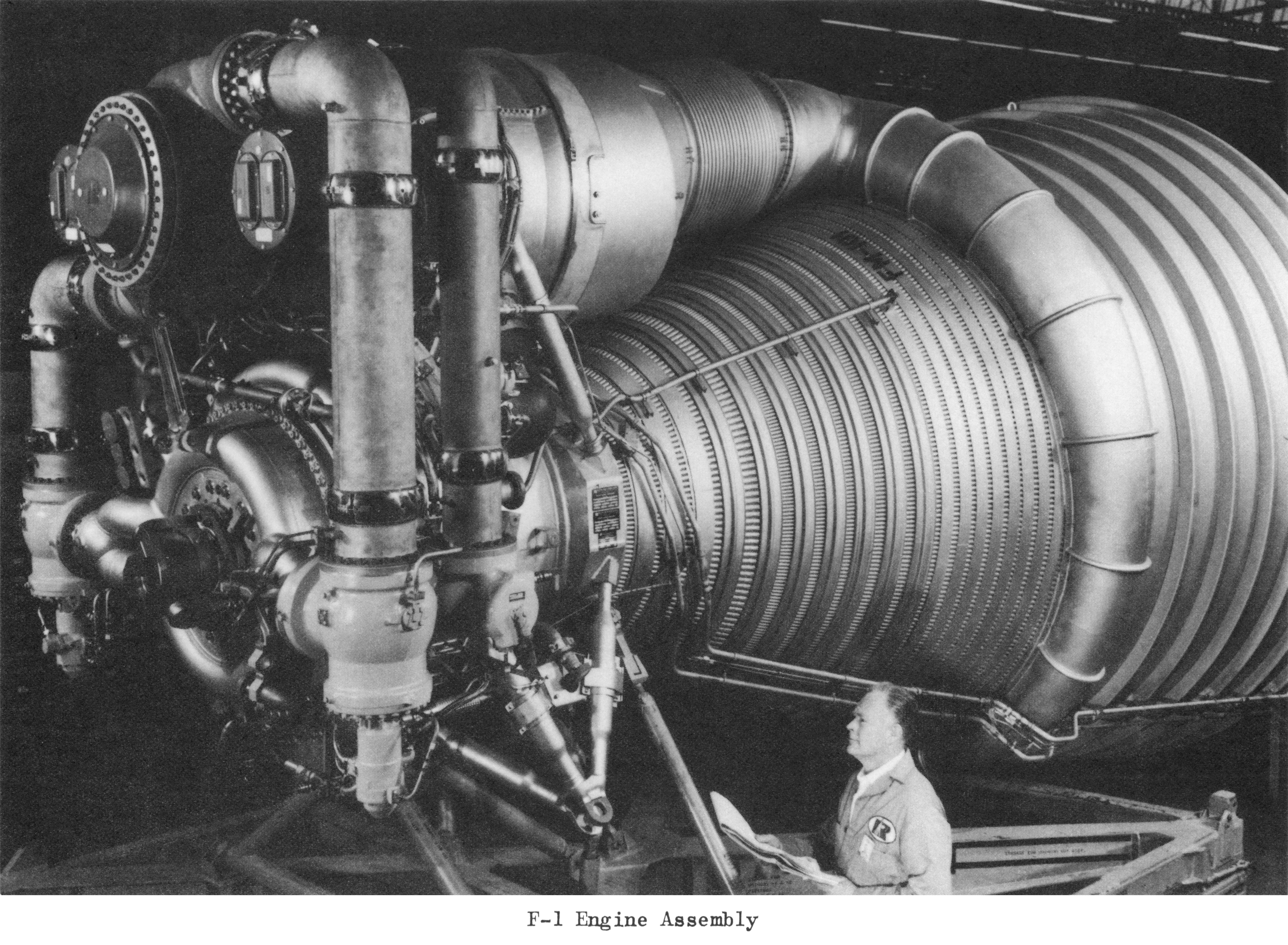
“I don't know exactly when FM-101 (or any of these engine mock-ups) were manufactured, but they certainly reflect an early design:
- There is no provision for thermal insulation.
- There is no interface panel.
- The fuel high-pressure ducts are straight, rather than the "U"-shaped ducts which characterized later production engines.
- The LOX dome has twin-elbow inlets.
F-1 engine mock-up FM-103 is on display in the Kennedy Space Center Rocket Garden (where, oddly enough, it is completely painted silver).”
The direct copy/paste above is in quotations, along with my paraphrasing from Mike Jetzer’s superlative “HEROIC RELICS” website, which he gleaned from Alan Lawrie’s book “Saturn” and a paper, “Saturn V Booster – The F-1 Engine”, by D. E. Aldrich, located in the Saturn V Collection, Dept. of Archives/Special Collections, M. Louis Salmon Library, University of Alabama in Huntsville, at:
heroicrelics.org/info/f-1/fm-101.html
I’m hoping the above is no longer the case, and that FM-103 was moved out of the elements into the Apollo/Saturn V Center.
Or:
evergreene.com/projects/ksc-f-1-engine-prototype/
Credit: EVERGREENE Architectural Arts website
As if the above wasn't enough, see/read also...wow:
heroicrelics.org/info/f-1/f-1-config-changes.html
Also credit: Mike Jetzer/"HEROIC RELICS" website
Wait…one more. Look at the multiple monstrous card catalog cabinets behind the F-1! Commensurate with the size of the the engine.
A clever photograph taken August 26, 1967, during rollout of the Apollo 4/SA-501 launch vehicle.
Note the repainted & noticeably whiter “t-shaped” area extending upward/outward from the ‘vertical’ black roll pattern stripe between the “USA” lettering of the S-IC (first) stage.
Excellent reading regarding the aforementioned, along with a lot of other wonderful content at Wes Oleszewski’s delightful website:
gwsbooks.blogspot.com/2015/04/saturn-vs-vanishing-stripes...
Credit: Wes Oleszewski/”Growing Up With Spaceflight” website
“The first flight test of the Apollo/Saturn V space vehicle is being prepared for launching from the National Aeronautics and Space Administration’s John F. Kennedy Space Center, Fla., Complex 39A. The mission is designated Apollo 4. The Apollo/Saturn V is the most powerful space vehicle developed in the United States space program. It is 363 feet tall and its first-stage engines produce 7,500,00 pounds of thrust at liftoff. Weight fully fueled is 6,220,025 pounds. The Saturn V launch vehicle will place 278,699 pounds in a 101-nautical-mile (117-statute mile) Earth orbit. The command module will reenter the atmosphere, land, and be recovered in the Pacific Ocean about 622 miles northwest of Hawaii. Objectives of the Earth-orbital unmanned mission are to obtain flight information on launch vehicle and spacecraft structural integrity and compatibility, flight loads, stage separation, subsystem operation, emergency detection subsystem operation and to evaluate the Apollo command module (CM) heat shield under conditions encountered on return from a Moon mission.”
A rarely seen perspective, of any Saturn V, depicting either rollout/rollback of the Mobile Service Structure (MSS). Either activity meriting the gentleman documenting it with his tripod-mounted 16mm?/35mm? motion picture camera. He may be a contractor, although I can’t identify the lettering or logo on the back of his jacket. Looks to be a capital 'R", and the third letter possibly a lowercase 'c', which would suggest Rocketdyne; however, that would've been all caps, and that's not the Rocketdyne logo on the left. Finally, the fact he’s wearing a jacket/windbreaker may support it being MSS rollback.
All of that, during the first “all-up” test of the entire rocket that was to safely launch humans, with the goal of landing – also safely – on the moon. And then, returning the crew – safely – back to the earth.
THIS PHOTOGRAPH & MACHINES IS/ARE FROM LATE 1967.
I SAY AGAIN, 1967.
Where were you in 1967?
‘WERE’ you in 1967?
I’m guessing most of you ‘were NOT’.
www.nasa.gov/feature/55-years-ago-apollo-4-the-first-flig...
Zou De Hef de mooiste brug van Nederland kunnen zijn? Overdag is de brug al mooi, maar 's avonds, wanneer het prachtige stuk industrieel erfgoed wordt verlicht door de nieuwe LED lichtinstallatie, is de brug pas écht een feest voor het oog. Helemaal met een enorme plas ernaast, met mooie reflecties.
Heffy
This bridge, called De Hef, is one of the most beautiful bridges in the Netherlands, in my opinion. During the day it's already very pretty, but at night, illuminated by its new LED lighting installation, it's truly a sight to behold. And when there's also a huge puddle next to the bridge, offering nice reflections, the party can begin.
“LRV-2 Deploy from LM Simulator using FLT no. 3 SSE. REF. no. Boeing 1-4081.”
What’s SSE you ask? Even if you didn’t:
“1.9. SPACE SUPPORT EQUIPMENT (SSE)
The Space Support Equipment (SSE) consists of two basic subsystems of hardware, the structural support subsystem and the deployment hardware subsystem. The function of the structural support subsystem is to structurally support the LRV in the LM during launch boost, earth-lunar transit and landing. The function of the deployment hardware subsystems is to deploy the LRV from the LM to the lunar surface after landing.”
Above per/at:
www.hq.nasa.gov/alsj/LRV_OpsNAS8-25145Pt1.pdf
Credit: ALSJ website
And, based on the above, one can deduce that - despite being MSFC issued - the photograph was taken at the Boeing Company’s Kent, WA facility, prior to shipment to KSC. That’s the only place the SSE associated with “FLT no. 3”, aka LRV-3/Apollo 17, would be “externally/pre-installation” available
Also, check out the deformed front left wheel…damn…along with the cool shadow cast by the left rear wheel on the wall/partition. A great visual demonstrating its ingenious “transparent” mesh design. Finally, the sequence of previous? LRV deployment photos posted, visible on the far left. Now, if I could only identify the Great American in the image.
During our voyage on the ColorLine from Kiel, Germany to Oslo, Norway, we were enthralled by the magnificent Great Belt Bridge as we sailed beneath it. Stretching across the Great Belt strait, this engineering marvel seamlessly connects the Danish islands of Zealand and Funen. As one of the world's longest suspension bridges, with a remarkable length of approximately 18.2 kilometers, the Great Belt Bridge stands as a testament to intricate design and precise engineering. Onboard the ship, we joined fellow travelers in capturing this awe-inspiring sight, as they excitedly snapped pictures of the bridge's immense size and remarkable structure - Great Belt Strait, Denmark.
I captured this scene of the Adur Viaduct (aka the Shoreham Flyover) near Shoreham, West Sussex, UK, on a changeable day. I walked around under the viaduct for a while until I found two opposing slip roads arcing away from each other.
In het weekend, een week na de eerste dienstregelingsrit, reed de 52 8139 twee ritten. Op 11 april met de blauwe trein voor een genootschap die iets te vieren had en op 12 april de gebruikelijke zondagse dienstregeling.
Vertrek uit Eerbeek, met links de Eerbeekse ladingmal. Hier zat vroeger het wissel naar het straatspoor van de papierfabriek van Huiskamp en Sanders.
This photo is composed from three sets of five stack focus images stitched together into a macro panorama. Fifteen shots - one for each jewel in the watch.
À Dinan, deux époques se superposent au-dessus de la Rance : le vieux pont médiéval en pierre, couvert de mousse et chargé d’histoire, et le viaduc monumental du XIXe siècle, témoignage de la modernité ferroviaire. Entre les deux, le reflet de l’eau renforce le contraste entre passé et présent. Cette photo illustre à la perfection ce qui fait le charme de Dinan : une cité bretonne suspendue entre mémoire médiévale et héritage industriel, où chaque pierre raconte une histoire.
Architectural Elegance gazing up into the geometric grandeur of Tokyo Station's restored dome. A symphony of radial beams, ornate moldings, and classical windows converge towards the central skylight. This monochrome capture emphasizes the interplay of light and shadow, highlighting the timeless craftsmanship of early 20th-century design
This is a thirty-six shot focus stacked image. Still refining this process, but fascinated by the machinery in these mechanical devices.
The gears, brushed metal, and jewels shown here in this intricate mechanical marvel is from a dime-sized women's Swiss Bulova watch.
Northern Ireland Railways General Motors class 111, 8112, makes its epic trip down from York Road depot to Dublin Connolly, seen above passing Clontarf Road Dart Station.
Northern Ireland Railways are attending the upcoming CIE Inchicore open day on Saturday 7th May 2022, celebrating the Iarnród Éireann Inchicore 175th Anniversary.
NIR are also sending down a modern 3 car CAF set.
I captured this photograph on a visit to the sound mirrors at Dungeness, Kent, UK. I like how this abstract shot captures the intricate textures of the aged material and shows the engineered curvature against a soft, natural light.
The Dungeness sound mirrors, remnants of an early acoustic defence system designed to alert against enemy aircraft, now stand as silent testaments to pre-WWII ingenuity. More details available on the official RSPB website at www.rspb.org.uk/days-out/reserves/dungeness.
“Searchlights at the Kennedy Space Center's Launch Complex 39A Illuminate the 363-loot high Saturn V space vehicle during final preparation for the launch of Apollo 8 Astronauts Frank Borman, James Lovell and William Anders on a planned lunar orbital mission. The open-ended flight is designed to verify spacecraft systems and crew operations at lunar distances. The Astronauts are to orbit the moon 10 times and splash down 147 hours after liftoff in the Pacific Ocean, 1,000 miles south of Hawaii. Apollo 8 marks the first manned flight of the National Aeronautics and Space Administration's Saturn V space vehicle.”
To me…then - now - always...the most beautiful & majestic machine designed & built to propel humans to the moon.
This was 1968. I'll bet most of you weren't even on this planet yet.
The photograph is in beautiful condition, with the slightest hint of three-ring binder dents along the right edge.
O submarino-museu Barracuda, atracado em Cacilhas, Almada, é um exemplar da classe Albacora que serviu a Marinha Portuguesa de 1968 a 2010, completando mais de 300 missões e percorrendo cerca de 800 milhas náuticas. O seu painel de controlo, acessível ao público, integra válvulas e comandos essenciais para a gestão manual dos sistemas críticos, como a imersão e emersão, garantindo a segurança durante operações subaquáticas no Atlântico. No interior, destaca-se a sala de comando, onde a tripulação de 55 elementos geria a navegação, com instrumentos que permitiam o controlo de profundidade e direção, além de monitorização vital através de indicadores analógicos para pressão, velocidade e posição. Este espaço técnico oferece aos visitantes uma visão única da rotina e da engenharia a bordo de um submarino histórico, refletindo o funcionamento autónomo da embarcação ao longo das suas quatro décadas de serviço.
The Barracuda submarine museum, docked in Cacilhas, Almada, is an example of the Albacora class that served the Portuguese Navy from 1968 to 2010, completing more than 300 missions and traveling around 800 nautical miles. Its control panel, accessible to the public, includes valves and controls essential for the manual management of critical systems, such as immersion and emergence, ensuring safety during underwater operations in the Atlantic. Inside, the command room stands out, where the 55-member crew managed navigation, with instruments that allowed depth and direction control, as well as vital monitoring through analog indicators for pressure, speed, and position. This technical space offers visitors a unique insight into the routine and engineering aboard a historic submarine, reflecting the vessel's autonomous operation throughout its four decades of service.
Whatever one thinks about oil exploration on the North Slope of Alaska, the Alaska Pipeline is surely one of the engineering marvels of the 20th century.
According to Wikipedia, "The Trans-Alaska Pipeline System (TAPS) includes the trans-Alaska crude-oil pipeline, 12 pump stations, several hundred miles of feeder pipelines, and the Valdez Marine Terminal. TAPS is one of the world's largest pipeline systems. It is commonly called the Alaska pipeline, trans-Alaska pipeline, or Alyeska pipeline, (or the pipeline as referred to in Alaska), but those terms technically apply only to the 800 miles (1,287 km) of the pipeline with the diameter of 48 inches (122 cm) that conveys oil from Prudhoe Bay, to Valdez, Alaska. The crude oil pipeline is privately owned by the Alyeska Pipeline Service Company.
This view is looking north on an otherwise wet and muddy day north of the Arctic Circle. The scarred strip to the west of the highway is where crews had buried a fiber optic cable (cables?) paralleling the entire length of the highway, presumably extending to Deadhorse (Prudhoe Bay).
Circa 1962/63 North American Aviation (NAA) artist’s concept of the (then) Saturn C-5/Advanced Saturn launch vehicle on the pad.
One of countless gorgeous works by Gary Meyer, this one featured in NAA’s ca. 1963 film, “The Apollo Mission”:
archive.org/details/Jeff_Quitney_me/20171201-The+Apollo+M...
Credit: Jeff Quitney (THANK YOU Good Sir!!!), and the WONDERFUL Internet Archive website
Note the prominent strake on the Command Module. I'll easily overlook the missing RCS quad on the Service Module. 😉
The subsequent 1966/67 version:
wehackthemoon.com/tech/awesome-saturn-v-rocket-science-ma...
wehackthemoon.com/sites/default/files/styles/hero_extra_l...
Both above credit: "HACK THE MOON", MIT/Draper Laboratories website
Pushpin imprints/damage & other handling defects do not detract. Still of excellent gloss.
This photo consists of thirty separate focus stacked images of a woman's Swiss watch sitting on a reflective, black sheet of acrylic.
Captured earlier this year while on a visit to Scotland and certainly one I wanted to capture for sometime...
This was late into Blue Hour and a 3 stop Kase filter was used.
Certainly strange things happen around the bridge at night including a Parrot that was stuck in a tree...
A geometric perspective of the Marina Bay Sands SkyPark, looking up at the world's longest public cantilevered platform. Located 200 meters above the city, this engineering masterpiece by Moshe Safdie seamlessly integrates luxury architecture with a "City in a Garden" philosophy.
[Explored]
Industrial scene featuring towering refinery structures and steel platforms rising against a turbulent sky.
El primer cop que vaig anar a Holanda, anant per l'autopista vaig veure el pal d'un veler que passava per sobre nostre, em va costar un moment entendre que passava, però després d'estar uns dies per allà veus que no és estrany. És un país ple de canals d'aigua per tot arreu, no sé que és primer si la carretera o el canal, però sigui com sigui, fan uns ponts per als canals d'aigua i la carretera per sota, és molt curiós de veure.
Tenia clar que quan tornés voldria mirar de fer alguna foto, i en aquest cas amb el dron ho tenia fàcil per poder mostrar-ho des d'un punt de vista interessant, a més just quan estava fent les fotos vaig tenir la sort que passés un vaixell.
Dades EXIF: 1/20s f2.8 ISO100 24mm
@djiglobal Mini 2
#aquaductveluwemeer #netherlands #engineeringmarvel #traveltips #architecture #amazingarchitecture #landscapephotograph #landscape #landscape_captures #travelphotographer #travelphotography #landscape #landscapephotography #rogervivephoto #paisaje #travelphotography #djimini2 #djimavicmini #aerialphotography #landscapedrone #dronephotography #droneshot
Introducing the Punakha Suspension Bridge, a renowned landmark near the Punakha Dzong in Bhutan. Spanning the Mo Chhu River, this impressive bridge connects Punakha town with the revered dzong. With a length of over 160 meters, it stands as one of the longest suspension bridges in Bhutan. As I captured this photo, I marveled at the bridge's sturdy design, picturesque setting, and the serene river flowing beneath it - Punakha Suspension Bridge, Punakha, Bhutan
During our voyage on the ColorLine from Kiel, Germany to Oslo, Norway, we were enthralled by the magnificent Great Belt Bridge as we sailed beneath it. Stretching across the Great Belt strait, this engineering marvel seamlessly connects the Danish islands of Zealand and Funen. As one of the world's longest suspension bridges, with a remarkable length of approximately 18.2 kilometers, the Great Belt Bridge stands as a testament to intricate design and precise engineering. Onboard the ship, we joined fellow travelers in capturing this awe-inspiring sight, as they excitedly snapped pictures of the bridge's immense size and remarkable structure - Great Belt Strait, Denmark.