View allAll Photos Tagged engineeringmarvel
Whatever one thinks about oil exploration on the North Slope of Alaska, the Alaska Pipeline is surely one of the engineering marvels of the 20th century. Much of it is built above ground on earthquake-proof supports like those that can be seen here.
According to Wikipedia, "The Trans-Alaska Pipeline System (TAPS) includes the trans-Alaska crude-oil pipeline, 12 pump stations, several hundred miles of feeder pipelines, and the Valdez Marine Terminal. TAPS is one of the world's largest pipeline systems. It is commonly called the Alaska pipeline, trans-Alaska pipeline, or Alyeska pipeline, (or the pipeline as referred to in Alaska), but those terms technically apply only to the 800 miles (1,287 km) of the pipeline with the diameter of 48 inches (122 cm) that conveys oil from Prudhoe Bay, to Valdez, Alaska. The crude oil pipeline is privately owned by the Alyeska Pipeline Service Company…From Pump Station 1 it takes an average of 11.9 days for oil to travel the entire length of the pipeline to Valdez, a speed of 3.7 miles per hour (6.0 km/h)."
Meanwhile, where all that power comes from....
The engine room of a former London MCW Metrobus with a Gardner 6LXB engine coupled to a Voith D851.3 3-speed automatic gearbox.
London Transport
M394 / GYE394W
Discover the architectural marvel of the Ex-Sham Shui Po Service Reservoir in Hong Kong. This underground reservoir, with its stunning arches and stone columns, showcases historical engineering prowess. Once a vital water supply structure, it now stands as a testament to the city's rich heritage and ingenuity.
Built in 1904, the Ex-Sham Shui Po Service Reservoir had a storage capacity of 9,900 cubic metres. It ceased operations in 1970 and was rediscovered in 2020 after being decommissioned for several decades.
“The Apollo 16 Saturn V space vehicle stands alone after the Mobile Service Structure was removed from Pad A at Launch Complex 39 today during the “wet” or fueled portion of the Countdown Demonstration Test. The week-long CDDT is conducted as a dress rehearsal for the actual countdown. During CDDT, all major spacecraft systems and ground support equipment are verified in preparation for the launch of astronauts John W. Young, Thomas K. Mattingly II and Charles M. Duke, Jr., to the Moon, scheduled for no earlier than April 16, 1972. The astronauts participated in the “dry” or unfueled portion of the CDDT, monitoring spacecraft systems in the same manner as they will on launch day.”
Note the multiple remotely operated cameras, mounted at the different levels, along the left side of the LUT. Also, the parked (and railed) triangular flame deflector in the immediate background.
I’ve said it before, and I’ll say it again – because it’s true - the image quality, resolution & ‘richness’ of so many of these vintage black & white NASA photographs is exquisite. Although maybe a little heavy on the contrast, this is gorgeous. I mean…just look at the resolvable detail…further facilitated by my considerate & generous 1200 dpi scan.
Not to mention, this is a rarely seen “head & shoulders portrait” perspective of Apollo 16 on the pad.
Beneath the bright Arctic sky, the Saltstraumen tidal current twists and turns with timeless force, carving whirlpools and eddies that mesmerize travelers and locals alike. Spanning this mighty natural wonder stands the Saltstraumbrua, a bridge connecting more than land—it links stories of fishermen, traders, and wanderers who for centuries have crossed these waters.
Saltstraumen is often called the world’s strongest tidal current, where up to 400 million cubic meters of seawater rush through the narrow strait every six hours. The shifting tides have shaped both landscape and livelihoods, offering abundant fishing grounds and a living reminder of the raw power of nature.
Here, history flows with the current: Viking boats once braved these waters, their presence echoing in the eternal rhythm of sea and stone.
Fun fact: Saltstraumen is so powerful that its whirlpools can reach up to 10 meters in diameter and 5 meters deep—strong enough to pull down small boats if they dare venture too close.
In General Electric we thrust.
After an amazing flight down from Frankfurt to Palma, due to remote parking with no airbridge gates suitable for the Queen, a quick walkaround the tarmac thanks to patient ground handling crew.
The giant General Electric GEnx-2B67 engine, usually fitted to both the Boeing 747-800 & 787.
***
The Boeing 747 flight from Frankfurt :
LH 1158 - Frankfurt Airport (FRA) 12:35 - Palma De Mallorca (PMI) 14:40 - 02h05m
LH 1159 - Palma De Mallorca (PMI) 16:10 - Frankfurt Airport (FRA) 18:30 - 02h20m
** this flight had an extra touch of excitement as Lufthansa's Boeing 747 in retro livery did the honours - D-ABYT **
The Munich Airbus A350-900 flight :
LH 1796 - Munich Airport (MUC) 10:50 - Palma De Mallorca (PMI) 13:00 - 02h10m
LH 1797 - Palma De Mallorca (PMI) 14:30 - Munich Airport (MUC) 16:36 - 02h05m
these flights were operated by D-AIXL.
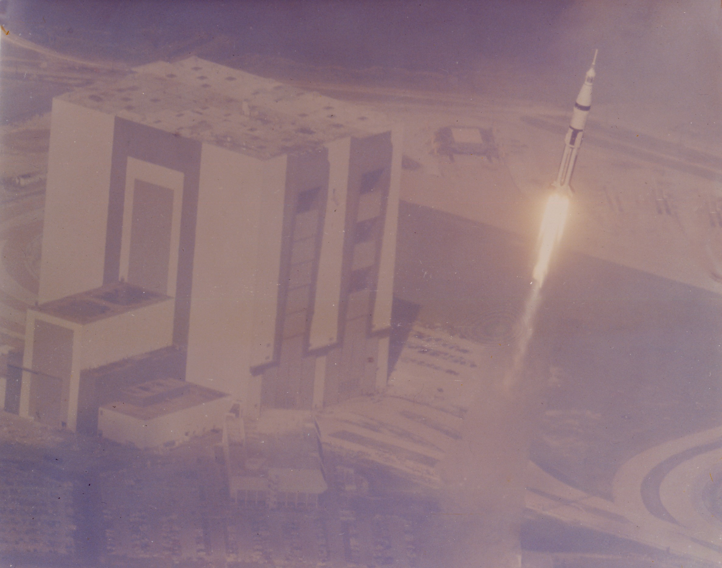
“A C-135 aircraft flying at more than 35,000 feet photographed today’s launch of the Apollo 7 space vehicle carrying astronauts Walter M. Schirra, Jr. Donn F. Eisele and Walter Cunningham.”
Multiple minor handling defects do not detract, with the photo still having retained nice gloss.
Due to the amazing perspective, the following interesting discussions are available:
www.collectspace.com/ubb/Forum24/HTML/009143.html
www.collectspace.com/ubb/Forum27/HTML/001430.html
Both above credit: collectSPACE website
www.nasa.gov/wp-content/uploads/static/history/alsj/a410/...
Credit: J.L. Pickering/Project Apollo Archive website
And, last, but not least:
“This photograph of the Apollo 7 launch was taken from the perspective of a Boeing NKC-135 flying at more than 35,000 feet (11,000 m) and carrying an Airborne Lightweight Optical Tracking System camera pod. This extreme angle makes it appear as if the Saturn IB rocket has launched from beside the Vehicle Assembly Building, while its actual launch was from LC-34, 7 miles (11 km) to the southeast. The aircraft which took this photograph was a support aircraft in the ARIA fleet; it is a Boeing NKC-135A-BN, USAF registration number 55-3123, construction number 17239.”
en.m.wikipedia.org/wiki/File:ALOTS-AP7-enh.jpg
Credit: Wikipedia
Although not mentioned in any of the above linked discussions, note the parked crawler transporter, visible between the VAB and ascending Saturn IB.
Last, but not least:
youtu.be/WIH5PjZMSVw?si=rrnYkrFCuGZPVINX
Credit: Retro Space HD (J. L. Pickering)/YouTube
In het paasweekend was het weer zover: de Veluwsche Stoomtrein Maatschappij reed weer de eerste publiekelijke ritten over de koningslijn. Op 6 april reden we mee met machinist Coen Hesp. 'S ochtends werd de 52 8139-9 opgestookt om de paasrit tussen Beekbergen-Apeldoorn en Beekbergen-Eerbeek te rijden. De trein rijdt door het prachtige Veluwse landschap en de paashaas ging mee! Stap in en reis mee met de VSM!
De laatste slag vanuit Apeldoorn werd op de gevoelige plaat vastgelegd bij overweg de Els in Lieren.
Upon Me Travels; "The Legendary Bosphorus bridge"
The Bosphorus Bridge, known officially as the 15 July Martyrs Bridge and unofficially as the First Bridge, is one of the three suspension bridges spanning the Bosphorus strait in Istanbul, Turkey, thus connecting Europe and Asia (alongside Fatih Sultan Mehmet Bridge and Yavuz Sultan Selim Bridge). The bridge extends between Ortaköy (in Europe) and Beylerbeyi (in Asia).
The U.S. Air Force’s B-2 stealth bomber is a key component of the nation’s long-range strike arsenal, and one of the most survivable aircraft in the world. Its unique stealth characteristics allow it to penetrate the most sophisticated enemy defenses.
B-2 Technical Details
‧ Type: Strategic, long-range heavy bomber with low-observable technology and all-altitude capability to penetrate the most sophisticated air defenses in nuclear and conventional missions
‧ Power Plant: Four General Electric F118-GE-100 turbofans, each 17,300 lbs. thrust.
‧ Crew: Two (pilot and mission commander)
‧ Combat Ceiling: 50,000 feet
‧ Range: 6,000 nautical miles (unrefueled) 10,000 nautical miles with one refueling
‧ Maximum Gross Takeoff Weight: 336,500 lbs.
And...10 Cool Facts about the B-2
B-2 Technical Details
1 – It's an Engineering Marvel – To bring the B-2 to life, Northrop Grumman had to invent all components from scratch. That list included tools, a software laboratory, composite materials, special test equipment, and 3-D modeling and computer systems. Related manufacturing processes were also created.
2 – Why it’s No. #1 – When the U.S. must go to war, the B-2 is there on the first night. The B-2 went into enemy territory on Night One in support of Operation Allied Force (Serbia); Operation Enduring Freedom (Afghanistan); Operation Iraqi Freedom (Iraq) and twice in Libya in support of Operation Odyssey Dawn and Operation Odyssey Lightning. The B-2, one of the most survivable aircraft in the world, is the only aircraft to combine long-range, stealth and a heavy payload on a single platform.
3 – Legendary Combat Debut – The B-2 saw its first operational use during Operation Allied Force. Two B-2s flew more than 31 hours from Whiteman Air Force Base in Missouri to Kosovo. They attacked multiple targets, then flew directly back. The B-2s flew less than 1 percent of the total missions, yet destroyed 33 percent of the targets during the first eight weeks of conflict.
4 – Beast Mode: Longest Aerial Combat Mission in History – The B-2 holds the record for longest air combat mission in history. In 2001, the Spirit of America and five other B-2s were the first to enter Afghan airspace for a record setting 44-hour mission. The aircraft’s performance is even more impressive in that the B-2 made a quick pit stop for a 45-minute crew and service change with engines still running. It then flew back to Missouri for another 30-hour flight for a total of more than 70 consecutive hours.
5 – Red Carpet Realness – When Hollywood needs a “super bomber” to make a cameo and fight off a giant monster or an alien invasion, the red carpet is rolled out for the B-2. With an unmistakable silhouette and flying wing design, it’s easily one of the most recognized aircraft in the world. It has appeared in movies including “Independence Day,” “Armageddon,” “Iron Man 2,” “Cloverfield,” “Airplanes,” “Rampage” and, most recently, “Captain Marvel.”
6 – The Team Today – Northrop Grumman continues to upgrade and enhance the B-2’s capabilities, and service every B-2 aircraft. From the extensive programmed depot maintenance that ranges from the complete restoration of the jet’s exterior surfaces to software engineering, testing and development. Our employees also lead vehicle engineering, logistics and product support for the aircraft.
7 – Dimensions – The B-2 is 69 feet long, 17 feet high and has a wingspan of 172 feet, half the length of a football field.
8 – High Subsonic – The B-2 can reach a high subsonic speed and can also reach an altitude of more 50,000 feet.
9 – Intercontinental Range – The B-2 can travel 6,000 nautical miles without refueling and 10,000 nautical miles with only one refueling. It can reach any point in the world within hours.
10 – Payload – A B-2 can carry a payload of 20 tons.
Technical Information (or Nerdy Stuff):
Camera - Nikon D5200 (handheld)
Lens – Nikkor 18-300mm Zoom
ISO – 100
Aperture – f/5.6
Exposure – 1/400 second
Focal Length – 300mm
The original RAW file was processed with Adobe Camera Raw and final adjustments were made with Photoshop CS6.
"For I know the plans I have for you,” declares the LORD, “plans to prosper you and not to harm you, plans to give you hope and a future." ~Jeremiah 29:11
The best way to view my photostream is through Flickriver with the link below:
This Hamilton Watch close up is comprised of twenty six focus stacked images. The details from the anodized gold surrounding the jewels to the brushed steal finish and brassy gears is amazing to me.
Nestled amidst the lush landscapes of Ann Arbor, Michigan, the Barton Dam stands as a testament to early 20th-century engineering and a beacon of natural beauty. Constructed in 1912-1913, this impressive structure not only plays a crucial role in hydroelectric power generation but also in providing the city with essential water supply. The dam, with its serene backdrop of the Huron River, creates a picturesque scene that changes with the seasons, offering a multitude of colors and atmospheres throughout the year.
The Harbor Freeway Interchange is the largest and tallest freeway interchange in Southern California. This massive 5-stack interchange connects the Century Freeway (I-105) with the Harbor Freeway (I-110). Nestled between its soaring ramps is a 3-level train and bus depot.
An extraordinarily clear day in Southern California.
Los Angeles.
Standing at the edge of the Ubaye Gorges, confronted by this vertiginous chasm carved deep into the limestone, I was struck by the audacious beauty of Pont du Châtelet spanning this natural abyss. This moment captured the eternal dialogue between human ingenuity and nature's raw power.
My intention was to convey the sheer drama of this geological theater - these towering walls sculpted by millennia of erosion, painted in warm ochre and orange hues by the afternoon light. The bridge becomes both a compositional anchor and a symbol of our determination to traverse even the most challenging terrain. I chose this vertical framing to emphasize the vertiginous depth and the courage required to build such a crossing.
What fascinated me was how this scene represents the intersection of adventure and engineering - the bridge enabling passage through what would otherwise be an impassable barrier, yet doing so with respect for the landscape's dramatic character. The warm light filtering down into the gorge reveals every texture and stratification in the rock, telling the geological story of this remarkable corner of the Southern Alps.
I have spent a week and well over four dozen attempts to get a decent photograph of this mechanical marvel. In the end, it took the Canon MP-E 65mm f/2.8 1-5x Macro, a macro rail, and the Canon Ring Lite MR-14EX II, all of which I am still learning.
From Wikipedia:
Going-to-the-Sun Road is a scenic mountain road in the Rocky Mountains of the western United States, in Glacier National Park in Montana. The Sun Road, as it is sometimes abbreviated in National Park Service documents, is the only road that traverses the park crossing the Continental Divide through Logan Pass at an elevation of 6,646 feet (2,026 m), which is the highest point on the road. Construction began in 1921 and was completed in 1932 with formal dedication in the following summer on July 15, 1933.
The road is the first to have been registered in all of the following categories: National Historic Place, National Historic Landmark and Historic Civil Engineering Landmark. The length of the road is approximately 50 miles and spans the width of the park between the east and west entrance stations. The National Historic Landmark Nomination records a slightly shorter distance of 48.7 miles which is measured from the first main intersection just outside the park's west entrance to Divide Creek in St. Mary on the east side of the park.
The road is one of the most difficult roads in North America to snowplow in the spring. Up to 80 feet of snow can lie on top of Logan Pass, and more just east of the pass where the deepest snowfield has long been referred to as the Big Drift. The road takes about ten weeks to plow, even with equipment that can move 4000 tons of snow in an hour. The snowplow crew can clear as little as 500 feet of the road per day. On the east side of the continental divide, there are few guardrails due to heavy snows and the resultant late winter avalanches that have repeatedly destroyed every protective barrier ever constructed. The road is generally open from early June to mid October, with its late opening on July 13, 2011 marking the record for the latest opening since the inaugural date of July 15, 1933.
The two lane Going-to-the-Sun Road is quite narrow and winding with hairpin turns, especially west of Logan Pass. Consequently, vehicle lengths over the highest portions of the roadway are limited to no longer than 21 feet and no wider than 8 feet between Avalanche Creek and Rising Sun picnic areas which are located many miles below Logan Pass, on the west and east sides of the Pass, respectively. Vehicles over 10 feet in height may not have sufficient clearance due to rock overhangs when driving west between Logan Pass and the hairpin turn called the Loop.
Prior to the construction of the road, visitors would need to spend several days travelling through the central part of the park, an area which can now be traversed within a few hours, excluding any stops for sightseeing or construction. The speed limits are 45 mph in the lower elevations and 25 mph in the steeper and winding alpine sections.
Thanks for the comments.
Please don't use this image on websites, blogs or other media without my explicit written permission.
©VR Danduprolu: All rights reserved.
The photo shows the Sky Bridge 721 in the Czech Republic, viewed from a nearby mountain slope. The long suspension bridge structure rises above the dense spruce forest of the Jeseníky Mountains, surrounded by dramatic clouds and soft sunlight breaking through. A winding mountain trail leads toward the ridge, emphasizing the scale and height of the landscape. The atmosphere is moody and serene, capturing the blend of human engineering and untouched nature.
A wonderful & awe-inspiring perspective view of the Skylab Saturn V launch vehicle, possibly/probably during rollout to Launch Complex 39A, April 16, 1973.
“APOLLO 4 ON PAD AT DAWN – Early morning view of Pad A, Launch Complex 39, Kennedy Space Center, showing the Apollo 4 (Spacecraft 017/Saturn 501) unmanned, earth-orbital space mission ready for launch. The huge 363-ft. tall Apollo/Saturn V space vehicle was launched at 7:00:01 a.m. (EST), November 9, 1967.”
When I acquired this photograph, at first glance I thought it was a fake it looked so good. It’s the real deal though, yay! Although the scan looks great, it really doesn’t do it justice. Seriously, no hype, it’s stunning.
About the moon though…see one of the below linked photos.
“APOLLO 11 ON PAD------High-angle view of Pad A, Launch Complex 39, Kennedy Space Center, showing the 363-foot tall Apollo 11 (Spacecraft 107/Lunar Module 5/Saturn 506) space vehicle on pad. This photograph was taken during Apollo 11 Countdown Demonstration Test (CDDT) activity. Apollo 11 is scheduled as the first lunar landing mission. The crew will be Astronauts Neil A. Armstrong, commander; Michael Collins, command module pilot; and Edwin E. Aldrin Jr., lunar module pilot. This view is looking down the Apollo 11 stack toward the ground from the mobile launch tower.”
Minor breaks in the border, bumped corners and remnant (barely perceptible) staple holes (also in the border) do not detract from the overal image.
As the sun sets over the Tagus River, Lisbon’s Ponte 25 de Abril transforms from a feat of engineering into a work of art. Beneath its soaring red trusses, light and shadow play across the urban fabric—weathered walls, brick warehouses, and the occasional splash of graffiti. This view, taken from the Alcântara district, captures the essence of modern Lisbon: a city where history and industry meet beneath the hum of progress.
Completed in 1966 and originally named Ponte Salazar, the bridge was renamed after the Carnation Revolution of April 25, 1974, which restored democracy to Portugal. Its resemblance to San Francisco’s Golden Gate Bridge isn’t coincidental—both were built by the same American firm, the American Bridge Company. Yet while the visual echo is undeniable, Lisbon’s bridge has its own character. Its steel structure stretches elegantly across the Tagus, connecting the capital to Almada and symbolizing a nation moving forward while honoring its turbulent past.
Standing beneath it, one feels the monumental scale of the construction. The rhythm of the supporting columns and the geometric pattern of the girders create a visual cadence—part architecture, part music. The concrete piers catch the last warm light of day, glowing amber against the fading blue sky. Below, the remnants of Alcântara’s industrial quarter tell another story: of warehouses reborn as cafés, galleries, and event spaces. It’s a perfect example of adaptive reuse, where the city reclaims its industrial heritage and transforms it into cultural vitality.
The juxtaposition is striking. The old brick façade, weathered by salt air and time, holds its ground beneath the sleek lines of twentieth-century infrastructure. This layering of eras—historic reuse beneath modern engineering—defines Lisbon’s architectural identity. The bridge doesn’t overshadow the neighborhood; it frames it. Its vast underbelly becomes a canopy of shadow and sound, humming with the vibration of trains and traffic above, yet oddly serene below.
Photographically, the view is irresistible. The converging lines of the bridge draw the eye toward infinity, while the earthy textures of the foreground root the image in the tangible world. The soft pastel sky reflects Lisbon’s unique Atlantic light—a phenomenon that has inspired painters, poets, and photographers for generations. It’s no wonder this spot, once overlooked, has become one of the city’s most photographed sites.
In many ways, the 25 de Abril Bridge is more than infrastructure—it’s Lisbon’s emblem of endurance. It unites art and engineering, the old and the new, the river and the sky. Standing here as the city glows beneath it, one can’t help but feel that this is where Lisbon breathes most deeply: between the quiet dignity of its past and the boundless energy of its future.
“This false color photograph of Neptune was made from Voyager 2 images taken through three filters: blue, green, and a filter that passes light at a wavelength that is absorbed by methane gas. Thus, regions that appear white or bright red are those that reflect sunlight before it passes through a large quantity of methane. The image reveals the presence of a ubiquitous haze that covers Neptune in a semitransparent layer. Near the center of the disk, sunlight passes through the haze and deeper into the atmosphere, where some wavelengths are absorbed by methane gas, causing the center of the image to appear less red. Near the edge of the planet, the haze scatters sunlight at higher altitude, above most of the methane, causing the bright red edge around the planet. By measuring haze brightness at several wavelengths, scientists are able to estimate the thickness of the haze and its ability to scatter sunlight. The image is among the last full-disk photos that Voyager 2 took before beginning its endless journey into interstellar space. The Voyager Mission is conducted by JPL for NASA's Office of Space Science and Applications.”
photojournal.jpl.nasa.gov/catalog/PIA00057
Credit: JPL Photojournal website
The eye-like dark spot, aka ‘Dark Spot 2”, would appear (to me) to be at the same latitude as this subsequent vortex:
www.nasa.gov/feature/goddard/2016/hubble-imagery-confirms...
Thanks for the comments. Please don't use this image on websites, blogs or other media without my explicit written permission. copyright all rights reserved.
This dime-sized women's watch from Bulova tried my patience. It took over a dozen attempts to get this result, and each attempt had at least 40 images. This final photo is comprised of 40 focus stacked images. I used Helicon to automate the focusing, and Photoshop to bring the images together.
“Artist drawing of Apollo mission”
Don Mackey at his absolute finest. I scanned it at 1200 dpi, so, feel free to revel in the exquisite craftsmanship & detail.
This is the first collaborative work I’ve ever seen by Mr. Mackey! He therefore shares the rightful accolades (which he likely never received) with Jack Waldrop.
Speaking of Mr. Waldrop…possibly this “Jack” Waldrop:
“Florida Today (Cocoa, FL) - 6 Sep 1991
ROCKLEDGE - Dugan Jackson "Jack" Waldrop, 53, a technical illustrator, died Monday, Sept 2, in Birmingham, Ala.
Mr. Waldrop, a native of Birmingham, was a Brevard County resident for 27 years. He was employed by McDonnell Douglas during the Apollo program.
Survivors include his son, D. Jack Waldrop of Cocoa; daughters, Delaine Parrish of Cocoa and Donna Richards of Melbourne; mother, Nora Merritt of Alabaster, Ala; brothers, Andrew Waldrop, Scott Waldrop and Charles Waldrop, all of Alabama; and six grandchildren.
Services were Wednesday in Birmingham. His ashes will be scattered at sea. Donations may be made to the Alabama Animal Adoption Clinic, 2808 Crescent Circle, Birmingham, Ala 35209.
www.findagrave.com/memorial/204464341/duggan-jackson-waldrop
Credit: “Find a Grave” website
22 Jan 1938 – 2 Sep 1991 (aged 53)
Taken much too soon. RIP Mr. Waldrop.
Shot from the base of the Golden Gate Bridge near Fort Point in San Francisco, this image captures the soaring elegance and intricate design of one of America’s most iconic engineering achievements. The composition focuses on one of the massive uprights and truss elements supporting the southern end of the bridge, where its International Orange steel meets the textured concrete foundations of the historic military fort.
Rather than the typical panoramic sweep of the bridge, this image leans into architectural abstraction, emphasizing geometry, tension, and texture. The result is a deeply tactile photograph where the riveted latticework and diagonal bracing intersect in a web of strength and order. The lines draw the eye upward, mirroring the viewer’s awe as they stand dwarfed by the bridge’s immensity.
The Golden Gate Bridge opened in 1937, designed by engineer Joseph Strauss, with contributions from Leon Moisseiff, Irving Morrow, and Charles Alton Ellis. Its southern anchorage sits just above Fort Point, an 1850s-era coastal defense structure built during the Gold Rush. From this vantage, the juxtaposition of New Deal–era infrastructure and Civil War–era masonry creates a visual and historical dialogue between two eras of fortification—military and civic.
The upright seen here is one of two colossal towers on the San Francisco side. Painted in the bridge’s trademark International Orange, the steel beams rise from the concrete caisson embedded deep into the bedrock below the Golden Gate Strait. The color was chosen not only for aesthetics but for visibility in fog, a feature the city is famous for. In this image, that misty marine atmosphere is hinted at in the soft, pale sky that contrasts the warmth of the steel.
Beneath the bridge, Fort Point National Historic Site draws photographers, historians, and architecture lovers alike. It’s one of the few places in the city where you can get this close to the literal underpinnings of the Golden Gate. The symmetry of the steel structure against the rough concrete of the fort’s walls adds a grounding element—an interplay between delicate lattice and monolithic mass.
This photo is a celebration of structural honesty. Every bolt, beam, and brace serves a purpose—and together, they elevate utilitarian design to something poetic. Even the weathered concrete, stained by salt and age, adds authenticity and narrative depth.
Perfect for fans of civil engineering, industrial design, and architectural photography, this image offers a fresh perspective on a structure so often seen from afar. It invites the viewer to study the beauty in the details—how every piece fits, every angle supports, and every decision made almost a century ago still holds fast.
Built 1973 - 1976 Architects - WZMH Architects .... The CN Tower is a 1,815 feet / 553 metre high concrete communications and observation tower in Downtown Toronto, Ontario, Canada. It was completed in 1976, becoming the world's tallest free-standing structure and world's tallest tower at the time. It held both records for 34 years until the completion of Burj Khalifa and Canton Tower in 2010. It is now the 3rd tallest tower in the world and remains the tallest free-standing structure in the Western Hemisphere, a signature icon of Toronto's skyline, attracting more than two million international visitors annually. Its name "CN" originally referred to Canadian National, the railway company that built the tower. In 1995, the CN Tower was declared one of the modern Seven Wonders of the World by the American Society of Civil Engineers. It also belongs to the World Federation of Great Towers, where it holds second-place ranking ....
If only time would pile up. In all the running around, you could turn a corner and come across a confluence of hours and days. But no, time does not stack up. At it's best and at it's worst, time is a balancing act.
“The helmet visor of Astronaut Bruce McCandless, II, mission specialist, reflects the outside of the forward bulkhead (cabin area) of the shuttle Challenger during his extravehicular activity (EVA). He is wearing the extravehicular mobility unit (EMU), the manned maneuvering unit (MMU), and two cameras - a 35mm attached to his MMU and a TV camera on his helmet.”
More specifically, the stunning image was captured through one of Challenger’s two overhead windows, seen reflected in the visor.
Not a single decent resolution of this image seems to be available - anywhere. But, yet again, the decremented, ‘zombie’ KSC website continues to be more productive than anything ‘current’, and yielded the above, with the usual low-resolution associated image.
Although I’m grateful, it’s pathetic that that’s IT:
science.ksc.nasa.gov/mirrors/images/images/pao/STS41B/100...
science.ksc.nasa.gov/mirrors/images/images/pao/STS41B/100...
For shits & grins, I peeled the above URLs back to the parent website. There, a clickable link with the following is available:
“This sever will be Permanently Shutdown the week of March 1, 2022”. Clicking on that takes one here:
science.ksc.nasa.gov/whats-new.html
Although expected, it's still sad, disappointing, pathetic, infuriating…and a bunch of other ‘bad’ adjectives, to include historically negligent, even ‘criminal’.
HOWEVER, graciously, at reasonable resolution, if you don’t mind THEIR digital watermarks, it can be viewed at either of these fine ‘establishments’:
www.gettyimages.co.uk/detail/news-photo/member-of-the-cre...
Additionally, the good folks at the following site offer the image, at roughly half the resolution of mine, for $499.00. However, there currently appears to be a "special" offer of $450...that's like a WHOLE 10% off! What a neighborly offer. Shameless, greedy & arrogant burglary in broad daylight. They know they're filling a gap left by others - who shall remain NAmelesS, Aargh:
www.alamy.com/nasa-astronaut-space-walk-in-earths-orbit-u...
"We have a lift-off and it's lighting up the area, it's just like daylight here at Kennedy Space Center as the Saturn V is moving off the pad..."
Service Arm No. 8/Service Module (inflight) - nearest the camera - can be seen swinging away from the Saturn V SA-512 launch vehicle at ignition & release. The launch of Apollo 17 occurred at 12:33 a.m. EST, December 7, 1972.
If other NASA documentation of this particular view/perspective are to be believed (NEVER a good idea BTW), the LUT-mounted automatic camera that recorded this was mounted at the 360-foot level. Surprisingly, in this case, it may – against all odds – be correct.
Per the wonderful “APOLLO MANIACS” website:
“Arm No. 8: Service Module (inflight):
- Level 300-320: vehicle station 3721.552
- Provides air conditioning, exhaust, cooling, electrical, pneumatic interface. A pneumatic/mechanical lanyard system is used to pull in the umbilical connector. Furthermore, a mechanical system assists. It takes up to 9.0 seconds to disconnect the arm.”
At:
Skylab 1 (I refuse to drink the “2” Kool-Aid) - the launch vehicle of the first crewed mission - on the pad at LC-39B with the Mobile Service Structure nearby.
Although a well-composed photo, it is, disappointingly, but not surprisingly, reversed. Based on that, the lighting is that of dusk.
I believe taken the same evening:
www.facebook.com/photo/?fbid=800444442439089&set=gm.1...
Credit: Mitchell Rothman/”Manned Space History” FB group
“Bruce McCandless practices with the trunnion pin attachment device (TPAD) and manned maneuvering unit (MMU) docking with the shuttle pallet satellite (SPAS-01A).”
Above associated with the image, from/at:
nara.getarchive.net/media/41b-44-2702-sts-41b-bruce-mccan...
Credit: NARA & DVIDS PUBLIC DOMAIN ARCHIVE website
Also & better, from other photos (linked to below) of the same activity:
“Close-up view of Astronaut Bruce McCandless II, STS 41-B Mission Specialist, as he performs a test involving the Trunion Pin Attachment Device (TPAD) he carries and the Shuttle Pallet Satellite (SPAS-01A) in front of him. In this photo, he is about to attach the TPAD to the SPAS-01A. He is wearing one of the experimental Manned Maneuvering Units (MMU) developed for this mission.”
And/or:
“Astronaut Bruce McCandless, using the Manned Maneuvering Unit (MMU) in its first flight tests, prepares to perform a docking maneuver during flight 41-B of the Space Shuttle Challenger. Using a docking adapter called a TPAD (Trunion Pin Attachment Device), McCandless docked with a pin on the Shuttle pallet satellite. This procedure was a rehearsal for the upcoming Solar Max repair mission.”
If it were ‘properly’ oriented, that is, from the perspective of the shuttle flight deck, from which/where the photograph I assume was taken, McCandless should be facing ‘downward’. However, this rarely seen image is so damned cool, I chose to orient it in a more familiar/comfortable perspective, to better take in its multitude of coolness.
The insect-like ‘antennae’:
twitter.com/kiwibacon/status/1359158862998368262?s=46&...
Credit: Steve Rice/Twitter
Note also the "flat-top" appearance of McCandless' helmet, due to it actually being the housing of the solid state color TV camera...attached to the top of the helmet. The camera was manufactured by Fairchild Weston Systems Inc., of Syosset, N.Y.
Finally, note the "EV1" labeling of the carabiner just above McCandless' left forearm & whatever is just below his right forearm. Apparently, during the EVAs, McCandless' call-sign during air-to-ground transmissions was "EV-1" & Stewart’s was "EV-2." How that translates to labeling of equipment - I don't know. Maybe they were individually configured/adjusted for ease/convenience of use by the respective Astronaut.
The two pointless observations above are from the following informative document:
spacepresskit.files.wordpress.com/2012/08/sts-41b.pdf
Credit: Nick Deakin/"Space Presskits" website
Standing face-to-face with the detector felt surreal. It’s this incredible portal capturing traces of particles from collisions that mimic the birth of the universe. At 100 metres below Geneva, surrounded by wires and glowing lights, I couldn’t help but feel like I’d stepped into the heart of a science fiction story come to life.
“On September 1, 1974 Major James V. Sullivan, 37 (pilot) and Major Noel F. Widdifield, 33 (Reconnaissance Systems Officer), flashed across the starting line (radar gates in New York) at approximately 80,000 feet and speed in excess of 2,000 miles per hour. Exactly 1 hour 54 minutes and 56.4 seconds later, they had set a new world speed record from New York to London, England. The average speed was 1,807 statute mph over the 3,461 statute mile course, slowing to refuel one time from a specially modified KC-135 refueling tanker. The aircraft was placed on static display at the Farnborough Air Show for one week. It marked the first time the secret plane had been on public display outside of the United States. Clarence L. "Kelly" Johnson, the aircraft’s designer, was on hand for the event. He remarked, "It (the SR-71) has exceeded all my expectations."
The above is much better than anything I could’ve come up with. At:
See also:
Both above credit: "SR-71 Blackbirds" website
New York to London:
- 1 hour
- 54 minutes
- 56.4 seconds
Excellent, with additional wonderful photos:
www.key.aero/article/mach-3-men
One of those wonderful photos. From a different viewpoint, and a moment before my posted photo. Fantastic:
fullfatthings-keyaero.b-cdn.net/sites/keyaero/files/impor...
Credit: "KEY.AERO" website
Mind boggling.
A striking photograph of probably the most brutally stunning, drop-dead gorgeous operational aircraft - EVER.
Doesn’t that look like a Harrier - on the tarmac? - in the background to the right? Maybe the other aircraft that are also visible?
So, if the above is correct, then the aircraft basically had a ‘running start’. Then was the ‘finish line’ analogous, thus ‘running’ through such radar gates IVO Farnborough? London Heathrow?
The aircraft resides at the Smithsonian National Air and Space Museum’s Steven F. Udvar-Hazy Center.
Built 1973 - 1976 Architects - WZMH Architects .... The CN Tower is a 1,815 feet / 553 metre high concrete communications and observation tower in Downtown Toronto, Ontario, Canada. It was completed in 1976, becoming the world's tallest free-standing structure and world's tallest tower at the time. It held both records for 34 years until the completion of Burj Khalifa and Canton Tower in 2010. It is now the 3rd tallest tower in the world and remains the tallest free-standing structure in the Western Hemisphere, a signature icon of Toronto's skyline, attracting more than two million international visitors annually. Its name "CN" originally referred to Canadian National, the railway company that built the tower. In 1995, the CN Tower was declared one of the modern Seven Wonders of the World by the American Society of Civil Engineers. It also belongs to the World Federation of Great Towers, where it holds second-place ranking ....
A serene, picturesque, almost Zen-like view of the Apollo 14 launch vehicle gliding down (the) crawler…way, on the first leg of its date with destiny - our orbed maiden, November 9, 1970. The upper portion of the poised, ever ready Mobile Service Structure (MSS) can be seen above & beyond the foreground flora on the right. If I were to take a closer look, there’s probably a dragonfly on the wing somewhere in the composition.
I think the destination, LC-39A, is what’s immediately to the left of the tracked behemoth…marked by what looks like the skyline of the gun-metal flat gray city on the (concrete) hill…mound actually. Some of you might know what I’m pathetically going for here.