View allAll Photos Tagged Yavapai
To say the Grand Canyon is immense would be a huge understatement. With an area that encompasses over 1.2 million acres, a length of 277 miles and about a mile deep, it is impossible to capture its magnificence in a single photograph. When you do try to photograph it, you must pick small microcosms of the landscape and have the best light possible. That is why photographing it in the early morning and at sunset is a must to get a decent shot. Photographing the canyon during the rest of the day only results in terrible haze (at least that has been my experience). With that in mind, I camped out at Yavapai Point during the last hour of sun and tried to get the light on the point and the background as clear as possible to show the crevices and shadows.
Yavapai Point, near the Geology Museum, is an excellent place to experience sunset and we watched the first full moon of 2023 rising above the clouds. The January full moon is often called the Wolf Moon, because some believe wolves howl more frequently during the long nights of winter.
There is no one best place for watching sunrise or sunset along the rim of Grand Canyon; just good places and better places. Find a viewpoint that offers views both east and west.
This year's Sunrise/Sunset + Full Moon Times: go.nps.gov/sunset (5106)
The South Rim received a total of 64 inches (157 cm) during January 2023, and that's an additional 50 inches (127 cm) more snow than in a "normal" January!
NPS photo/M. Quinn
These cowboys are waiting for a calf to blast out of the shoot followed by 2 ropers trying to take him down. The Yavapai Nation Native American Rodeo is located at Fort McDowell 40 miles NE of Phoenix, Arizona. The oldest running rodeo in Arizona is in Prescott. In 1888 it was the first rodeo to charge admission. I love to shoot the behind the scenes action but also love to watch the bystanders faces!
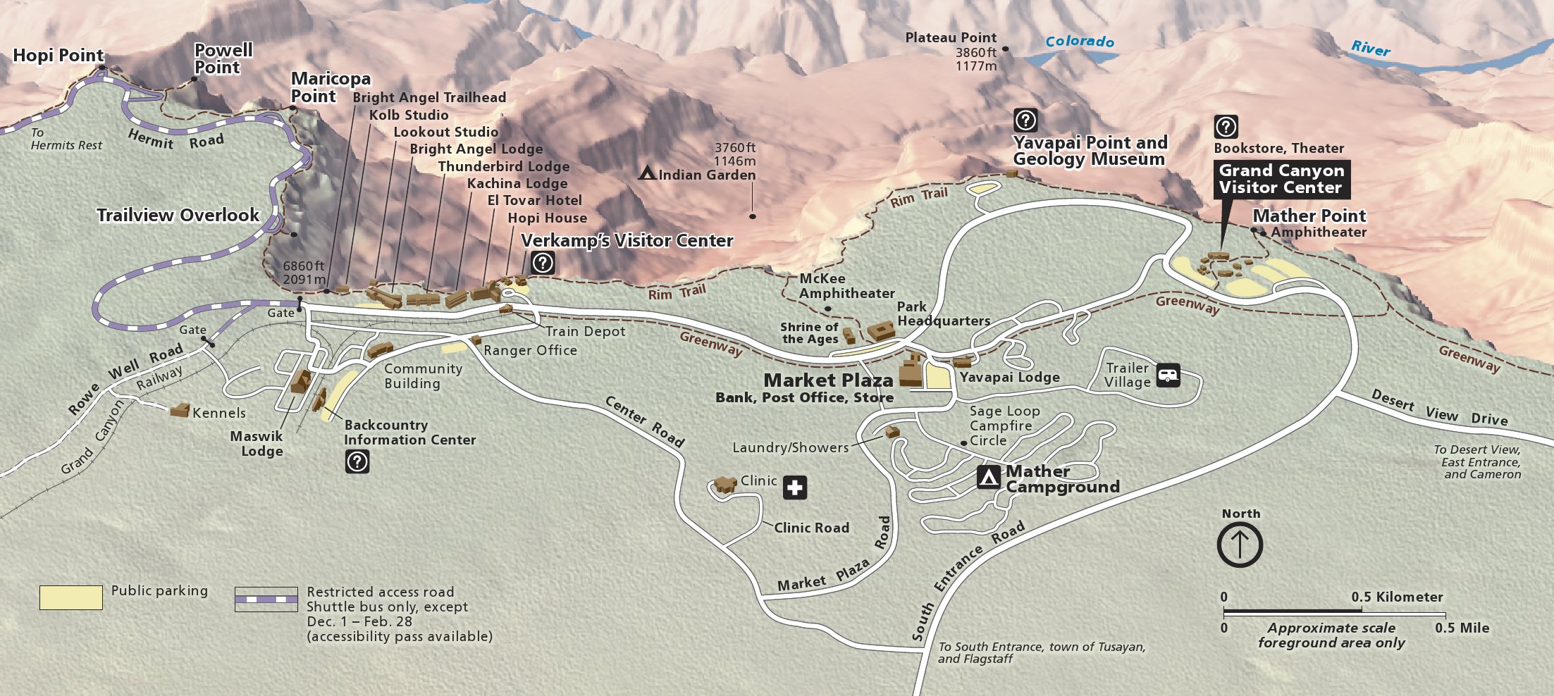
Yavapai Point is the northernmost overlook at the South Rim of the Grand Canyon. Offers panoramic views of the canyon, including the Colorado River and Phantom Ranch. You can see Plateau Point, which is reachable by a branch of the Bright Angel Trail.
From my first evening in the Grand Canyon. I will never forget the first time I laid eyes on this wonder. It's amazing how small it makes one feel. My favorite time of day throughout our stay in the park was, of course, the time right after and just before sunset when the colors in the canyon were truly visible.
The Grand Canyon (Hopi: Ongtupqa; Yavapai: Wi:kaʼi:la, Spanish: Gran Cañón), is a steep-sided canyon carved by the Colorado River in the state of Arizona in the United States. It is contained within and managed by Grand Canyon National Park, the Hualapai Tribal Nation, the Havasupai Tribe and the Navajo Nation. President Theodore Roosevelt was a major proponent of preservation of the Grand Canyon area, and visited it on numerous occasions to hunt and enjoy the scenery.
The Grand Canyon is 277 miles (446 km) long, up to 18 miles (29 km) wide and attains a depth of over a mile (6,000 feet or 1,800 meters). Nearly two billion years of Earth's geological history have been exposed as the Colorado River and its tributaries cut their channels through layer after layer of rock while the Colorado Plateau was uplifted. While the specific geologic processes and timing that formed the Grand Canyon are the subject of debate by geologists, recent evidence suggests that the Colorado River established its course through the canyon at least 17 million years ago. Since that time, the Colorado River continued to erode and form the canyon to its present-day configuration.
For thousands of years, the area has been continuously inhabited by Native Americans who built settlements within the canyon and its many caves. The Pueblo people considered the Grand Canyon ("Ongtupqa" in the Hopi language) a holy site, and made pilgrimages to it. The first European known to have viewed the Grand Canyon was García López de Cárdenas from Spain, who arrived in 1540.
The Grand Canyon is a fissure in the Colorado Plateau that exposes uplifted Proterozoic and Paleozoic strata, and is also one of the 19 distinct physiographic sections of the Colorado Plateau province. It is not the deepest canyon in the world (Kali Gandaki Gorge in Nepal is far deeper), however, the Grand Canyon is known for its visually overwhelming size and its intricate and colorful landscape. Geologically it is significant because of the thick sequence of ancient rocks that are beautifully preserved and exposed in the walls of the canyon. These rock layers record much of the early geologic history of the North American continent.
2025 - Google Gemini
This is a artificial generated photo of
a Yavapai Humane Society Humane Law Enforcement Police Department vehicle if they existed.
Taken at Yavapai point at sunset. Two people walked the clifs to the edge and picking up the last light of the day...just what i needed to give scaling to this very impressive landscape. A long lens for playing with the perspective.
Enjoy...
------------------------------------------------------------
Technical Details;
Camera; Canon EOS 1D mkII
Lens; Canon 70-200m/m 2.8L USM
Exposure; 1/125 sec
Aperture; f5.6
Filter; none
ISO; 100 RAW
Tripod; Manfrotto
------------------------------------------------------------
Image is under Copyright by Henk Meijer.
Contact me by email if you want to buy or use my photographs.
Spent the afternoon at the Yavapai Nation 41st Orme Dam Victory Days Pow Wow. Captured the Gourd dancing event.
All Rights Reserved. Unauthorized use under penalty of international law.
Taken at Yavapai point at sunrise. To many people there at this early hour and all making to much noise, so i moved further along the rim far away from the crowds and enjoyed the silence of first light hitting the canyon peaks. Within 10 min the clouds came in and they were pushed upwards by the heat of the canyon floor...amazing sight.
Enjoy...
-------------------------------------------------------------------------------------------------------
Technical Details;
Camera; Canon EOS 1D mkII
Lens; Canon 17-35m/m 2.8L USM
Exposure; 1/40 sec
Aperture; f16
Filter; Polarizer
ISO 100 RAW
Tripod; Manfrotto
-------------------------------------------------------------------------------------------------------
Image is under Copyright by Henk Meijer.
Contact me by email if you want to buy or use my photographs.
Grand Canyon National Park, Arizona
Last night I blended three exposures via Luminosity Masks into the completed photo you see here. This is a process I rarely use as 99% of my work are from single exposures but it can be very effective in situations like this with strong backlighting which could result in flare and/or too much contrast if using filters.
Yavapai Point - South Rim
Long exposures during twilight (between dawn and sunrise) bring out different and magnificent colors not evident after sunrise. This was an 8 second exposure at 5:19AM (Arizona time). Sunrise was at about 5:45.
Having been expecting crowds, I got to the Point at 0615 in order to get a good spot. As it turned out, nobody else appeared for another 30 minutes and then only a handful or so.
I took this shot at somewhere within the first hour or so with the sun still at a relatively low angle, producing a super range of shadows. The view is looking north-west from Yavapai Point with what I think is the Isis Temple just right of centre, In the background is the North Rim on the far side of the canyon.
In the skies above, clouds are gathering and lenticular clouds formed not long afterwards for a short period. There was a stiff wind from the east all day, the precursor to incoming stormy weather that reduced visibility to just less than 50m the following day.
Note the snow on the rock at left. There was 5-10 cm on the South Rim - the North Rim (which sits some 300m higher) was still closed due to much deeper snow.
Scanned from a negative.
Jerome is a town in the Black Hills of Yavapai County, in the State of Arizona. Founded in the late 19th century on Cleopatra Hill, overlooking the Verde Valley, it is more than 5,000 feet (1,500 m) above sea level. It is about 100 miles (160 km) north of Phoenix along State Route 89A between Sedona and Prescott. Supported in its heyday by rich copper mines, it was home to more than 10,000 people in the 1920s. As of the 2010 census, its population was 444.
Jerome is the largest Ghost Town in America!
Snowfall at the Grand Canyon, seen from near Yavapai Point. The Grand Canyon is at its most beautiful under a layer of snow.
This was just about the last shot of my morning at Yavapai Point before I headed off to warm up and get some breakfast.
I had begun at 0615 in order to get a good spot ahead of what I thought would be large crowds. As it turned out, nobody else appeared for 30 minutes and then only a handful or so thereafter. This was taken shortly before my departure at 0830.
The view is looking slightly west of due north with Isis Temple in the centre of the shot. The sunlight and shadows give a lot to look at. In the foreground, some 870m below my vantage point, can be seen much of the trail from Havasupai Gardens out across the Tonto Platform to Plateau Point.
In the skies above, lenticular clouds are breaking up. There was a stiff wind from the east all day, the precursor to incoming stormy weather that reduced visibility to less than 50m the following day.
Scanned from a negative.
I spent the weekend chasing storms up at the Grand Canyon. Or should I say the storms were chasing me...lol?? It was a very active monsoon weather pattern during my visit, that's for sure. Here's a big, beautiful lightning bolt I captured from Yavapai Point on the South Rim.
I'm posting two views of the same scene in different light. Which one do you prefer? Here, the snow rim is in direct sun.
The Verde River (Yavapai: Haka'he:la) is a major tributary of the Salt River in the U.S. state of Arizona. It is about 170 miles long and carries a mean flow of 602 cubic feet per second (17.0 m3/s) at its mouth. It is one of the largest perennial streams in Arizona.
The river begins below the dam at Sullivan Lake, fed by Big Chino Wash and Williamson Valley Wash in Yavapai County. The Verde flows freely for 125 miles through private, state, tribal and United States Forest Service lands, specifically the Prescott National Forest, Coconino National Forest and Tonto National Forest, before encountering the first of two dams that make Horseshoe Lake and Bartlett Lake. The cities of Camp Verde, Clarkdale and Cottonwood are the main population centers along the river. The Verde River and the Salt River converge on the Salt River Pima-Maricopa Indian Community. The Salt River flows into the Gila River west of Phoenix.
In 1984, the United States Congress designated 40.5 miles of the Verde River as Wild and Scenic through the National Wild and Scenic River program. The Scenic portion begins at Beasley Flats and extends downstream about 19 miles to the northern boundary of the Mazatzal Wilderness. The Wild portion extends from there to the mouth of Red Creek, about 22 miles further downstream.
In 1986, a 6-mile stretch of the river was identified by the state of Arizona as a critical natural resource. This reach of the Verde River and its associated riparian zone, between the town of Clarkdale (near Tuzigoot National Monument) and the Bridgeport State Route 89A Bridge, became part of the Arizona State Parks system. The park, called the Verde River Greenway State Natural Area, encompasses 480 acres (190 ha).[8] Dead Horse Ranch State Park, near Cottonwood, is adjacent to the Greenway.
At Drake, Arizona, its canyon is termed "Hell Canyon", and it is spanned by the Hell Canyon Bridge, a road bridge built in 1923 and listed on the National Register of Historic Places.
*Algae, Sandy Bottom, & Springs Colored Looking Waters on this day at the Verde River.
Yavapai Point, just east of the Geology Museum, is an excellent place to experience sunset. From this overlook, we watched the first full moon of 2023 rising above the clouds. The January full moon is often called the wolf moon, because some believe wolves howl more frequently during the long nights of winter.
There is no one best place for watching sunrise or sunset along the rim of Grand Canyon; just good places and better places. Find a viewpoint that offers views both east and west.
This year's Sunrise/Sunset + Full Moon Times: go.nps.gov/sunset (5106).
The South Rim received a total of 64 inches (157 cm) during January 2023, and that's an additional 50 inches (127 cm) more snow than in a "normal" January!
Alt txt = 4 people behind railings at a snow-covered scenic overlook on the edge of a vast canyon landscape during a colorful sunset. A blanket of winter clouds, tinted yellow by sunset light, is suspended above the distant horizon.
NPS photo/M. Quinn
Jerome is a town in the Black Hills of Yavapai County in the U.S. state of Arizona. Founded in the late 19th century on Cleopatra Hill overlooking the Verde Valley, it is more than 5,000 feet (1,500 m) above sea level. It is about 100 miles (160 km) north of Phoenix along State Route 89A between Sedona and Prescott. Supported in its heyday by rich copper mines, it was home to more than 10,000 people in the 1920s. As of the 2010 census, its population was 444
(Borrowed from Wikipedia)
Seen at Yavapai Point on the South Rim of Grand Canyon National Park. After taking a whole series of sunset pictures, this one turned out the best. What colors!! (08-09-30-2346)
Posted: (200 to 600 comment threads in 100+ Comments Group)(Above & Beyond Luminous Gallery)(Galaxy 5+, 10+ & Hall of Fame)(SOE3 SS)
The original post office for Cornville, AZ has been brought back to life and is obviously being well cared for.
Verde Valley, Yavapai County, Arizona
part of the Montezuma Castle National Monument
snippets from Wikipedia: Montezuma Well is a natural limestone sinkhole through which some 1,500,000 US gallons of water emerge each day from an underground spring. The Well measures 386 feet (118 m) in diameter from rim to rim and contains a near-constant volume of spring water even in times of severe drought, amounting to approximately 15,000,000 US gallons. As with Montezuma Castle, the label "Montezuma" is a misnomer: the Aztec emperor Montezuma had no connection to the site or the early indigenous peoples that occupied the area.
Archaeological evidence suggests that humans have lived in the Verde Valley for at least 10,000 years. The ruins of several prehistoric dwellings are scattered in and around the rim of the Well. Their erstwhile inhabitants belonged to several indigenous American cultures that are believed to have occupied the Verde Valley between 700 and 1425 CE, the foremost of which being a cultural group archaeologists have termed the Southern Sinagua.
The Yavapai people consider the Well a deeply sacred site, as they believe it is the place through which they emerged into the world.
Grand Canyon Sunset, Maricopa Point viewed from Yavapai.
At the centre of the picture you can make out 2 or 3 people standing on a ledge and to the right of them a group of turkey vultures riding the thermals.
Full set of photos from this 2010 road trip available at www.thody.net/photos/
The Grand Canyon (Hopi: Ongtupqa; Yavapai: Wi:kaʼi:la, Navajo: Tsékooh Hatsoh, Spanish: Gran Cañón) is a steep-sided canyon carved by the Colorado River in the state of Arizona in the United States. It is contained within and managed by Grand Canyon National Park, the Kaibab National Forest, Grand Canyon-Parashant National Monument, the Hualapai Tribal Nation, the Havasupai people and the Navajo Nation. President Theodore Roosevelt was a major proponent of preservation of the Grand Canyon area, and visited it on numerous occasions to hunt and enjoy the scenery.
The Grand Canyon is 277 miles (446 km) long, up to 18 miles (29 km) wide and attains a depth of over a mile (6,093 feet or 1,857 meters). Nearly two billion years of Earth's geological history have been exposed as the Colorado River and its tributaries cut their channels through layer after layer of rock while the Colorado Plateau was uplifted. While some aspects about the history of incision of the canyon are debated by geologists, several recent studies support the hypothesis that the Colorado River established its course through the area about 5 to 6 million years ago.Since that time, the Colorado River has driven the down-cutting of the tributaries and retreat of the cliffs, simultaneously deepening and widening the canyon.
For thousands of years, the area has been continuously inhabited by Native Americans, who built settlements within the canyon and its many caves. The Pueblo people considered
the Grand Canyon a holy site, and made pilgrimages to it.The first European known to have viewed the Grand Canyon was García López de Cárdenas from Spain, who arrived in 1540
en.wikipedia.org/wiki/Grand_Canyon
www.nps.gov/grca/learn/news/upload/sr-pocket-map.pdf
npmaps.com/wp-content/uploads/grand-canyon-south-rim-deta...
Cottonwood, AZ (Yavapai County)
Bing’s Burger Station is located in historic Old Town Cottonwood and officially opened its doors in August 2009. Bing’s is located in an early 1940s service station. Originally the service station began its life as a Atlantic Richfield station, but over the years it also served as a Mobil station and a Chevron station. (1)
References (1) Bing's Burgers bingsburgers.com/history.html
Yavapai Point sunset after the snow storm. After the snow storm had cleared it was a beautiful scene with the remnants of the clouds capturing the afternoon light. The contrast of colours with the snow was special to experience.
The Little Daisy Mine and The Douglas Mansion is in Jerome located in the Black Hills of Yavapai County in the State of Arizona U.S.A.
The Little Daisy Mine was owned and operated by James S. Douglas. The copper mine operated until 1935 then was bought by Phelps who closed the copper mine in 1938.
The 8700 sq/ft Mansion was built in 1916 by James S. Douglas.
©Copyright Notice
This photograph and all those within my photostream are protected by copyright. They may not be reproduced, copied, transmitted or manipulated without my written permission.