View allAll Photos Tagged Yavapai
If anyone's getting sick of dead trees and snowy mountains, here's one I pulled out of the archives. Taken 2 years ago on my first trip to the Grand Canyon. I cropped about a third of it out to emphasize the light on the peaks.
Yavapai Point, Grand Canyon, Arizona
Standing between a juniper on the left and a piñon pine on the right we gaze across the chasm of the Grand Canyon to its north rim. It's roughly 10 miles (16 kilometers) to the other side. The Colorado River can be glimpsed in the lower center of the photo.
Explored August 10, 2019
© 2015 James Duckworth Photography - All Rights Reserved - Please do not download and use this image without written permission. It is protected by copyright.
Yavapai Point, located near the Village on the South Rim of the Grand Canyon, was the setting for this sunrise. The point extends out into the canyon, providing excellent views of the canyon looking to the east. So it's a great location for viewing sunrise. That fact is well known to many visitors to the canyon, since the audience for this sunrise was quite large. The rising sun provided great color in the clouds on the horizon, but those same clouds prevented the sun from showing its face. All things considered, there were some beautiful moments on this cold March morning at the Grand Canyon.
.
.
...
Spent the afternoon at the Yavapai Nation 41st Orme Dam Victory Days Pow Wow. Captured the Gourd dancing event.
2022-11-19 15-11-02_141c
All Rights Reserved. Unauthorized use under penalty of international law.
Yavapai County, Arizona, USA.
The use of any of my photos, of any file size, for any purpose, is subject to approval by me. Contact me for permission. Image files are available upon request. My email address is available at my Flickr profile page. Or send me a FlickrMail.
Arizona
Four Peaks (Yavapai: Wi:khoba[4]) is a prominent landmark on the eastern skyline of Phoenix. Part of the Mazatzal Mountains, it is located in the Four Peaks Wilderness.[5] on the Tonto National Forest, 40 miles (64 km) east-northeast of Phoenix. In winter, Four Peaks offers much of the Phoenix metro area a view of snow-covered peaks. Four Peaks is the site of an amethyst mine that produces top-grade amethyst.
The name Four Peaks is a reference to the four distinct peaks of a north–south ridge forming the massif's summit. The northernmost peak is named Brown's Peak and is the tallest of the four at 7,659 feet (2,334 m).[2] It is the highest point in Maricopa County. The remaining summits are unnamed, and from north to south are 7,644 feet (2,330 m),[6] 7,574 feet (2,309 m)[7] and 7,526 feet (2,294 m)[8] in elevation.
From Wikipedia
UNESCO World Heritage List
whc.unesco.org/en/list/75/gallery/The Grand Canyon
(Hopi: Ongtupqa; Yavapai: Wi:kaʼi:la, Navajo: Tsékooh Hatsoh, Spanish: Gran Cañón) is a steep-sided canyon carved by the Colorado River in the state of Arizona in the United States. It is contained within and managed by Grand Canyon National Park, the Kaibab National Forest, Grand Canyon-Parashant National Monument, the Hualapai Tribal Nation, the Havasupai people and the Navajo Nation. President Theodore Roosevelt was a major proponent of preservation of the Grand Canyon area, and visited it on numerous occasions to hunt and enjoy the scenery.
The Grand Canyon is 277 miles (446 km) long, up to 18 miles (29 km) wide and attains a depth of over a mile (6,093 feet or 1,857 meters). Nearly two billion years of Earth's geological history have been exposed as the Colorado River and its tributaries cut their channels through layer after layer of rock while the Colorado Plateau was uplifted. While some aspects about the history of incision of the canyon are debated by geologists, several recent studies support the hypothesis that the Colorado River established its course through the area about 5 to 6 million years ago.Since that time, the Colorado River has driven the down-cutting of the tributaries and retreat of the cliffs, simultaneously deepening and widening the canyon.
For thousands of years, the area has been continuously inhabited by Native Americans, who built settlements within the canyon and its many caves. The Pueblo people considered
the Grand Canyon a holy site, and made pilgrimages to it.The first European known to have viewed the Grand Canyon was García López de Cárdenas from Spain, who arrived in 1540
en.wikipedia.org/wiki/Grand_Canyon
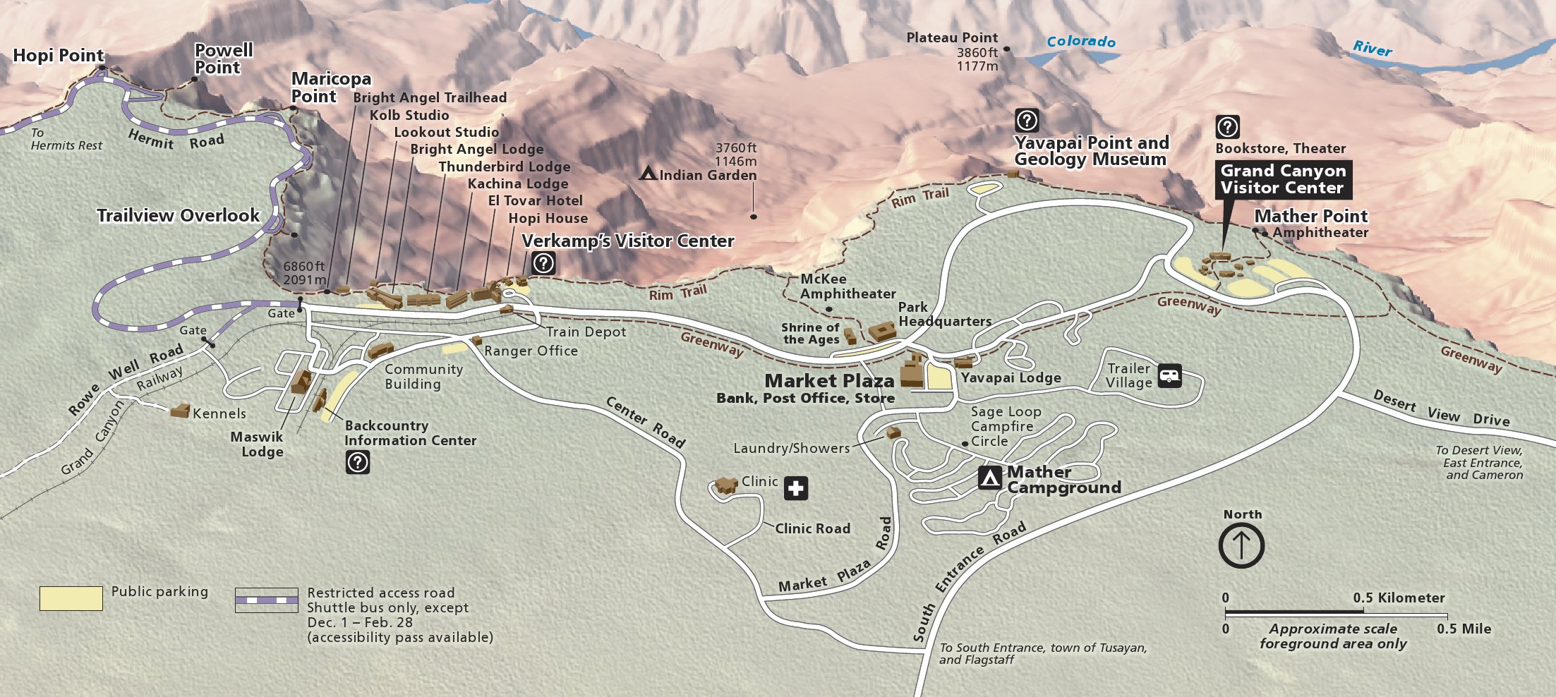
www.nps.gov/grca/learn/news/upload/sr-pocket-map.pdf
npmaps.com/wp-content/uploads/grand-canyon-south-rim-deta...
The Grand Canyon (Hopi: Ongtupqa; Yavapai: Wi:kaʼi:la, Spanish: Gran Cañón) is a steep-sided canyon carved by the Colorado River in the state of Arizona in the United States. It is contained within and managed by Grand Canyon National Park, the Kaibab National Forest, Grand Canyon-Parashant National Monument, the Hualapai Tribal Nation, the Havasupai people and the Navajo Nation. President Theodore Roosevelt was a major proponent of preservation of the Grand Canyon area, and visited it on numerous occasions to hunt and enjoy the scenery.
The Grand Canyon is 446 km long, up to 29 km wide and attains a depth of over a 1,857 meters. Nearly two billion years of Earth's geological history have been exposed as the Colorado River and its tributaries cut their channels through layer after layer of rock while the Colorado Plateau was uplifted. While some aspects about the history of incision of the canyon are debated by geologists, several recent studies support the hypothesis that the Colorado River established its course through the area about 5 or 6 million years ago. Since that time, the Colorado River has driven the down-cutting of the tributaries and retreat of the cliffs, simultaneously deepening and widening the canyon.
For thousands of years, the area has been continuously inhabited by Native Americans, who built settlements within the canyon and its many caves. The Pueblo people considered the Grand Canyon ("Ongtupqa" in the Hopi language) a holy site, and made pilgrimages to it. The first European known to have viewed the Grand Canyon was García López de Cárdenas from Spain, who arrived in 1540.
.
Last Thursday drove out to Phoenix for a three day therapy educational workshop. It was a superb workshop, topped off with getting up to the Grand Canyon yesterday for sunrise.
It was cold, about 25ºF, about -4ºC. And then there was the wind. No idea what the wind chill was. Almost lost the tripod and camera with the strong gusts. I found a ledge to hunker down against that blocked the worst of the wind. I was glad I had thought to bring all my winter gear.
This was catching the earliest light, with the sun almost behind me.
Drove back home to ABQ today. It was a great week.
June 10, 2019 near Yavapai Point, looking away from the sunset, which was casting these pretty pink colors into the canyon. (I don't know who the couple is in the photo...)
(Pic: me)
Our first sunset from just west of Yavapai Point on the South Rim. Haze is a big problem here ... plus there was a fire east of the canyon ... but we still were in awe. In a few days we'd be camping on the North Rim directly across (middle) from here.
This photo was taken at the site of the Chapel of The Holy Cross of Cathedral Rock with a view of a mansion in the foreground in the City of Sedona wich straddles the counties of Coconino and Yavapai in Arizona U.S.A.
©Copyright Notice
This photograph and all those within my photostream are protected by copyright. They may not be reproduced, copied, transmitted or manipulated without my written permission.
Prescott, Yavapai County, Arizona. The historic Hotel Vendome, claimed by many to have a haunted parlor.
Ha! I'm embracing the lens flare (and probably dust on the lens) at Yavapai Point overlook at Grand Canyon National Park, Arizona.
.
Here we are at fence friday, and I have discovered that I have essentially only one photo that includes a fence from my morning at the canyon!
I had been at the canyon for over three hours by this time, and finally was starting to walk from Yavapai Point eastward toward Mather Point.
There were a couple fences, but not many. There had been a fence right at the Yavapai Point promontory, and then here.
My original thought here was to catch the bench for bench monday, but I'll use a photo from one of the other cameras for that.
I hope your Fence Friday is Grand...
Cottonwood, Yavapai County, Arizona. Give me a junk, er, ah, a "treasure shop" and I could spend hours poking around. This one in Cottonwood is a picker's mother lode.
From near Yavapai Point on the rim of the Grand Canyon, the morning sun broke through the rainclouds.
Another in my Castles America series. Submitted for your approval: The Yavapai County Courthouse, circa 1916, in Prescott, AZ. Locals refer to it as the Back to the Future courthouse. Barry Goldwater announced his 1964 Presidential run from these courthouse steps.
After an exhausting hike, I decided to go to the closest point for sunset, which was Yavapai Point. The view was great, and so were the clouds. It got pretty crowded here though.
I used my 3 TS-E lenses for all my shots on this trip. About 2/3 were taken with the 24mm, the majority of the rest were with the 45mm, and a few were 90mm. I was very happy with all three lenses.
Tribute to Hollywood along Route 66 in Seligman, Yavapai County, Arizona. This mural became an instant favorite.
.
I had mentioned with my previous two posts, how strongly the wind had been blowing. I had gotten to the canyon about 0630. This was three hours later, the wind was calming somewhat.
You can still see from this infrared a bit of what it had been like.
This is just west of the Geology Museum at Yavapai Point along the south rim. The museum has excellent views east and west along the canyon and quite a bit of geological and historical information. Alas, I was wearing waaay too much clothing to stay in there long, and came back outside to avoid over heating and sweating.
best viewed full screen
This is a view from Yavapai Point on the Grand Canyon's South Rim in the middle of the day, but with enough clouds and shadow to give some definition. The Plateau Point Trail can be seen clearly on the Tonto Platform in the left of the view. The gulch to the immediate right of that contains the Bright Angel Trail which descends all the way to the Colorado River.
In the centre of the image is a bright flash of green foliage. Those trees shelter Phantom Ranch, the only lodging to be found below the canyon's rim. Adjacent to the Bright Angel Campground, it sits at the bottom of the North Kaibab Trail, which goes up to the North Rim on the far horizon.
Just to the right of that the Colorado River can just be seen again. Crossing the river on the far right of that glimpse is the Black Suspension Bridge (which can just be made out on the original size). The bridge connects the North and South Kaibab Trails. All the materials for the bridge had to be walked down from the rim, including each of the 550-foot long, one-ton suspension cables.
Although the image shows no sign of the stuff, there was some 10cm of snow on the South Rim and the North Rim, 300m higher, was closed due to heavy snow. But the following day, when I was at Phantom Ranch, the temperature was 72˚F!
A UNESCO World Heritage Site. Scanned from a negative.
The Grand Canyon (Hopi: Ongtupqa; Yavapai: Wi:kaʼi:la, Navajo: Tsékooh Hatsoh, Spanish: Gran Cañón) is a steep-sided canyon carved by the Colorado River in the state of Arizona in the United States. It is contained within and managed by Grand Canyon National Park, the Kaibab National Forest, Grand Canyon-Parashant National Monument, the Hualapai Tribal Nation, the Havasupai people and the Navajo Nation. President Theodore Roosevelt was a major proponent of preservation of the Grand Canyon area, and visited it on numerous occasions to hunt and enjoy the scenery.
The Grand Canyon is 277 miles (446 km) long, up to 18 miles (29 km) wide and attains a depth of over a mile (6,093 feet or 1,857 meters). Nearly two billion years of Earth's geological history have been exposed as the Colorado River and its tributaries cut their channels through layer after layer of rock while the Colorado Plateau was uplifted. While some aspects about the history of incision of the canyon are debated by geologists, several recent studies support the hypothesis that the Colorado River established its course through the area about 5 to 6 million years ago.Since that time, the Colorado River has driven the down-cutting of the tributaries and retreat of the cliffs, simultaneously deepening and widening the canyon.
For thousands of years, the area has been continuously inhabited by Native Americans, who built settlements within the canyon and its many caves. The Pueblo people considered
the Grand Canyon a holy site, and made pilgrimages to it.The first European known to have viewed the Grand Canyon was García López de Cárdenas from Spain, who arrived in 1540
en.wikipedia.org/wiki/Grand_Canyon
www.nps.gov/grca/learn/news/upload/sr-pocket-map.pdf
npmaps.com/grand-canyon/
npmaps.com/wp-content/uploads/grand-canyon-south-rim-deta...
This shot (three of five) was taken on the 4th of July as we waited for the sunset. Just before this picture was taken the sun had appeared above the cloud and provided a beautiful scene and then the sun was obscured by a thick cloud layer. I was still holding out hope that the sun might pop out under that lower sliver of sky below the cloud. Fortunately, the the sunset and corresponding twilight that came after this was so spectacular that people spontaneously applauded. Who needed fireworks, we had a natural light show!!
Taken near the Grand Canyon National Park South Rim Yavapai Geology Museum at Yavapai Point.
Saguaro Cactus and a gnarly desert canyon in the Hieroglyphic mountains - Yavapai County, Arizona
Ϙ View Large / Lightbox +
© All Rights Reserved
On a recent 30-day road trip to the west coast, we explored the South Rim of the Grand Canyon in Arizona for 3 days. This was captured one [very] chilly morning in December (12/21/2014) as we watched the canyon transform from complete darkness to shades of orange and gold while the clouds became pink and the sky blue from the sun slowly rising in the east. Arriving super early before sunrise at Yavapai Point, or any one of the view points in the Grand Canyon, even in the middle of a cold winter, has its rewards. It was our first experience, and it won't be our last!
Copyright © 2015 M. Blanca Eyre
All rights reserved.