View allAll Photos Tagged Yavapai
Saguaro Cactus and a gnarly desert canyon in the Hieroglyphic mountains - Yavapai County, Arizona
Ϙ View Large / Lightbox +
© All Rights Reserved
On a recent 30-day road trip to the west coast, we explored the South Rim of the Grand Canyon in Arizona for 3 days. This was captured one [very] chilly morning in December (12/21/2014) as we watched the canyon transform from complete darkness to shades of orange and gold while the clouds became pink and the sky blue from the sun slowly rising in the east. Arriving super early before sunrise at Yavapai Point, or any one of the view points in the Grand Canyon, even in the middle of a cold winter, has its rewards. It was our first experience, and it won't be our last!
Copyright © 2015 M. Blanca Eyre
All rights reserved.
Spent the afternoon at the Yavapai Nation 41st Orme Dam Victory Days Pow Wow. Captured the Gourd dancing event.
All Rights Reserved. Unauthorized use under penalty of international law.
South Rim - Sunrise at Yavapai Point
Südrand - Sonnenaufgang am Yavapai Point
Grand Canyon National Park is the United States' 15th oldest national park. Named a UNESCO World Heritage Site in 1979, the park is located in northwestern Arizona. The park's central feature is the Grand Canyon, a gorge of the Colorado River, which is often considered one of the Seven Natural Wonders of the World. The park covers 1,217,262 acres (1,901.972 sq mi; 492,608 ha; 4,926.08 km2) of unincorporated area in Coconino and Mohave counties. As of 2015, the park received more than five and a half million recreational visitors, which is the second highest count of all U.S. national parks after Great Smoky Mountains National Park.
(Wikipedia)
Im Grand-Canyon-Nationalpark liegt der größte Teil des Grand Canyon [grænd ˈkænjən], einer steilen, etwa 450 Kilometer langen Schlucht im Norden des US-Bundesstaats Arizona, die während Jahrmillionen vom Colorado River ins Gestein des Colorado-Plateaus gegraben wurde.
Der Canyon zählt zu den großen Naturwundern auf der Erde und wird jedes Jahr von rund fünf Millionen Menschen besucht.
(Wikipedia)
I loved the colour in this I had to post it despite the very wet lens and all the rain spots (it was raining pretty well when taking this)
We got up at 3:30am to get ready; then, we drove a whole hour into the park to catch this sunrise at Yavapai Point. It sure was a well worth effort to witness the majestic light shining through the canyon. And, of course, we were not the only ones there...
Have a glorious day, everyone...
Montezuma Castle National Monument near Camp Verde, Yavapai County, Arizona. It was used by Pre-Columbian Sinagua Indians and was believed to have been built around 1400 AD. This dwelling consisted of 20 rooms and probably housed around 50 people. It is near Beaver Creek. The National Park Service has not allowed anyone inside (other than a few scientists) since 1950.
This one made it to Explore! Thank you!
Earlier this week I finally had the pleasure of watching the sun rise over the Grand Canyon. It's difficult to truly capture the absolutely majestic quality of this National Park, simply because it literally appears to go on as far as your eyes can see. It's around 10 miles wide (on average), 277 miles long, and about a mile deep. I decided to go with using my ultra-wide lens so that I could try and capture more of the scene, given I had so much to frame with.
The Grand Canyon (Hopi: Ongtupqa; Yavapai: Navajo: Tsékooh Hatsoh, Spanish: Gran Cañón) is a steep-sided canyon carved by the Colorado River in the state of Arizona in the United States. It is contained within and managed by Grand Canyon National Park, the Kaibab National Forest, Grand Canyon-Parashant National Monument, the Hualapai Tribal Nation, the Havasupai people and the Navajo Nation. President Theodore Roosevelt was a major proponent of preservation of the Grand Canyon area, and visited it on numerous occasions to hunt and enjoy the scenery.
The Grand Canyon is 277 miles (446 km) long, up to 18 miles (29 km) wide and attains a depth of over a mile (6,093 feet or 1,857 meters). Nearly two billion years of Earth's geological history have been exposed as the Colorado River and its tributaries cut their channels through layer after layer of rock while the Colorado Plateau was uplifted. While some aspects about the history of incision of the canyon are debated by geologists, several recent studies support the hypothesis that the Colorado River established its course through the area about 5 to 6 million years ago.Since that time, the Colorado River has driven the down-cutting of the tributaries and retreat of the cliffs, simultaneously deepening and widening the canyon.
For thousands of years, the area has been continuously inhabited by Native Americans, who built settlements within the canyon and its many caves. The Pueblo people considered
the Grand Canyon a holy site, and made pilgrimages to it.The first European known to have viewed the Grand Canyon was García López de Cárdenas from Spain, who arrived in 1540
en.wikipedia.org/wiki/Grand_Canyon
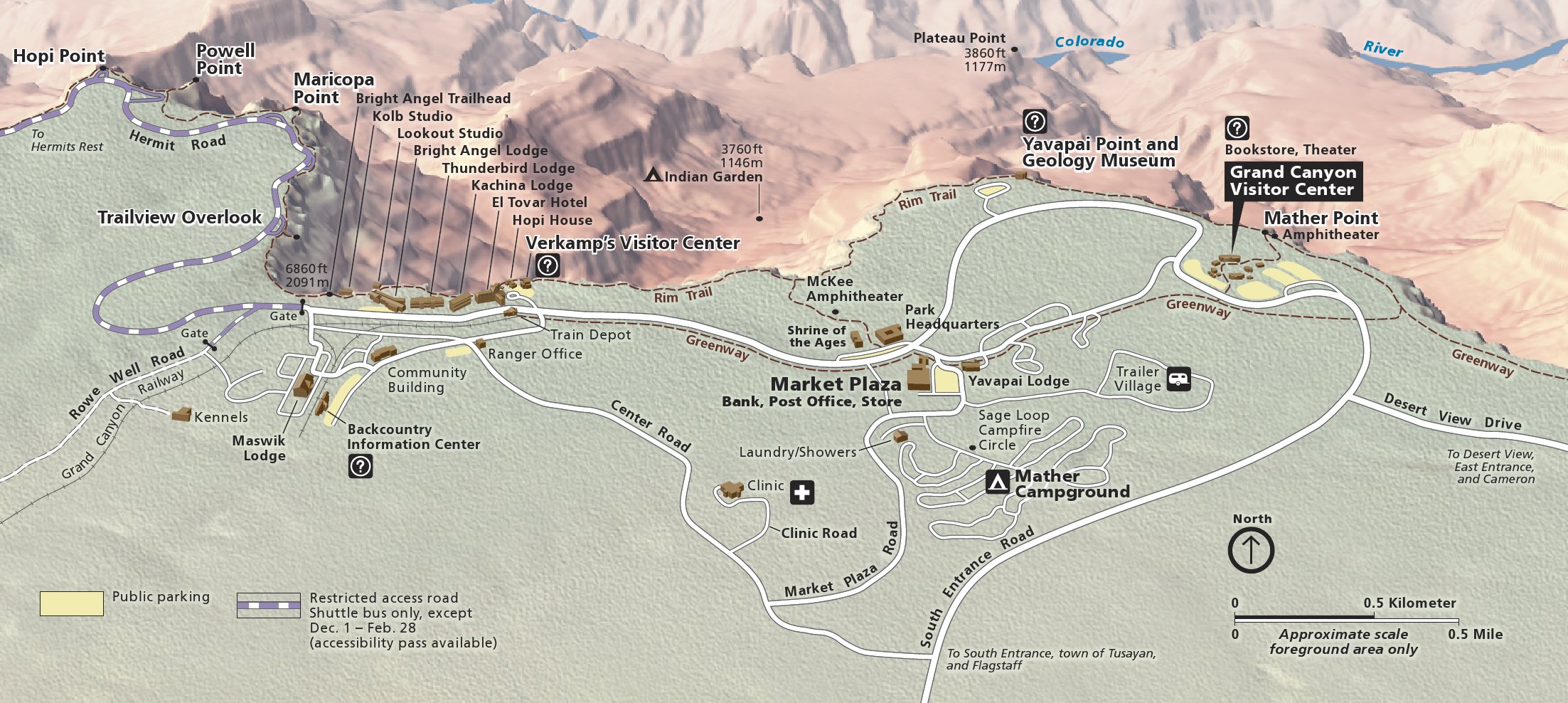
www.nps.gov/grca/learn/news/upload/sr-pocket-map.pdf
npmaps.com/wp-content/uploads/grand-canyon-south-rim-deta...
Grand Canyon Photo Album:
www.flickr.com/photos/feridun_f_alkaya/albums/72157674348...
The Grand Canyon (Hopi: Ongtupqa; Yavapai: Wi:kaʼi:la, Navajo: Tsékooh Hatsoh, Spanish: Gran Cañón) is a steep-sided canyon carved by the Colorado River in the state of Arizona in the United States. It is contained within and managed by Grand Canyon National Park, the Kaibab National Forest, Grand Canyon-Parashant National Monument, the Hualapai Tribal Nation, the Havasupai people and the Navajo Nation. President Theodore Roosevelt was a major proponent of preservation of the Grand Canyon area, and visited it on numerous occasions to hunt and enjoy the scenery.
The Grand Canyon is 277 miles (446 km) long, up to 18 miles (29 km) wide and attains a depth of over a mile (6,093 feet or 1,857 meters). Nearly two billion years of Earth's geological history have been exposed as the Colorado River and its tributaries cut their channels through layer after layer of rock while the Colorado Plateau was uplifted. While some aspects about the history of incision of the canyon are debated by geologists, several recent studies support the hypothesis that the Colorado River established its course through the area about 5 to 6 million years ago.Since that time, the Colorado River has driven the down-cutting of the tributaries and retreat of the cliffs, simultaneously deepening and widening the canyon.
For thousands of years, the area has been continuously inhabited by Native Americans, who built settlements within the canyon and its many caves. The Pueblo people considered
the Grand Canyon a holy site, and made pilgrimages to it.The first European known to have viewed the Grand Canyon was García López de Cárdenas from Spain, who arrived in 1540
en.wikipedia.org/wiki/Grand_Canyon
www.nps.gov/grca/learn/news/upload/sr-pocket-map.pdf
npmaps.com/grand-canyon/
npmaps.com/wp-content/uploads/grand-canyon-south-rim-deta...
"It is remarkable how soon the world fades into complete oblivion and this rock-bound solitude is the only existence which seems real." —Winfred H. Dixon, 1924
Colors in the sky this evening seemed to reflect the vermilion of canyon cliffs and peaks. Saturday, August 28, 2021
Description: sightseers behind metal railings at a scenic overlook are viewing the scenery as orange sunset light illuminates the clouds above a vast canyon landscape of peaks and cliffs. NPS/M. Quinn.
South Rim - Sunset at Yavapai Point
Südrand - Sonnenuntergang am Yavapai Point
You can see the first part of the South Kaibab Trail from here.
Von hier kann man den ersten Teil des South Kaibab Pfads sehen.
Grand Canyon National Park is the United States' 15th oldest national park. Named a UNESCO World Heritage Site in 1979, the park is located in northwestern Arizona. The park's central feature is the Grand Canyon, a gorge of the Colorado River, which is often considered one of the Seven Natural Wonders of the World. The park covers 1,217,262 acres (1,901.972 sq mi; 492,608 ha; 4,926.08 km2) of unincorporated area in Coconino and Mohave counties. As of 2015, the park received more than five and a half million recreational visitors, which is the second highest count of all U.S. national parks after Great Smoky Mountains National Park.
(Wikipedia)
Im Grand-Canyon-Nationalpark liegt der größte Teil des Grand Canyon [grænd ˈkænjən], einer steilen, etwa 450 Kilometer langen Schlucht im Norden des US-Bundesstaats Arizona, die während Jahrmillionen vom Colorado River ins Gestein des Colorado-Plateaus gegraben wurde.
Der Canyon zählt zu den großen Naturwundern auf der Erde und wird jedes Jahr von rund fünf Millionen Menschen besucht.
(Wikipedia)
The McDowell Mountain Range (Yavapai: Wi:kajasa) is located about twenty miles north-east of downtown Phoenix, Arizona, and may be seen from most places throughout the city. The range is composed of miocene deposits left nearly five million years ago. The McDowells share borders with the cities of Fountain Hills, Scottsdale, and Maricopa County. The city of Scottsdale has made its share of the McDowells a preserve, and has set up a wide trail network in partnership with the McDowell Sonoran Conservancy. The McDowell Sonoran Conservancy was established in 1991. The highest peak in the McDowells is East End, at 4,069 feet (1,240 m).
This mountain range also serves as a sacred marker to the Yavapai people. The boundaries of the range are generally defined by Saddleback Mountain in the South and Granite Mountain as the Northern boundary. The McDowells also comprise popular landmarks such as Pinnacle Peak and Tom's Thumb. Although technically a stand-alone, Mt. McDowell (referred to as Red Mountain by Phoenix residents), not to be confused with McDowell Peak, is sometimes listed on maps as a part of the McDowell Mountains.
PS: Back in UK today after a very busy work trip to Arizona with no time for flickr :( but managed to get a few pics at least. Just catching up with all your lovely work as I recover from the jetlag!
.
By this time in the morning, I had moved farther west along the south rim and was now standing on the promontory seen in the first photo I'd posted from that morning. It was still really cold and windy so I had the promontory basically to myself.
You can see my shadow in the upper left on the next point west.
Strawberry Hedgehog Cactus in bloom - Verde Valley, Yavapai County, Arizona
+ Looks Best >>> Large On Black <<<
© All Rights Reserved
Details best viewed in Original Size
This panorama of a small section of the Grand Canyon was constructed using Photoshop Elements to stitch together horizontally three landscape-oriented images captured from Yavapai Point just a few minutes before sunset.
On the right side of this image one can see Vishnu Temple which can also be seen easily from the North Rim of the canyon. A comparison of both views shows that the North Rim is considerably higher than the South Rim (by over 1,000 feet or over 300m).
Same day sunset but watched towards west. Nearly silhouette lighting contrasts stretched peaks such as Isis Temple, Tower of set, Temple of Ra, etc. There is still delicate texture hiding in the shadow.
Grand Canyon National Park, Arizona. This is a re-edit of a previously-posted image. I think I like this version better. Comments welcome.
Grand Canyon is one of the most majestic place I've ever witnessed. We have a similiar Canyon in Hawaii, the Waimea Canyon on the island of Kauai, and it is little league compared to the grand spectacle of this place. I was determined to get a sunrise shot before leaving this place. I chose Yavapai Point by default because it is the closest and safest location from the south entrance to the park as I do not want to fall off a cliff in total darkness on unfamiliar territory. 1620 x 1080 version available for viewing. Mahalo
Lens: Canon 17-40L 4.0
Camera: Canon EOS 5D Mark II
Exposure: 3.2 sec
Aperture: f/20
Focal Length: 21 mm
ISO Speed: 100
Filter(s): Lee 0.9 Hard Grad ND
Thanks everyone for making this my second time on Flickr Explore. I started shooting a DSLR 9 months ago and hopefully as time goes on, my skills and techniques will improve.
Yavapai Point, Grand Canyon National Park, Arizona, United States of America.
Moments before sunrise.
Yavapai Point on the South Rim. Each afternoon the clouds would gather and sometimes there'd be a few downpours. The first evening we got soaked while wandering to and from the visitor centre, but this evening we got lucky.
The Grand Canyon (Hopi: Ongtupqa; Yavapai: Wi:kaʼi:la, Spanish: Gran Cañón) is a steep-sided canyon carved by the Colorado River in the state of Arizona in the United States. It is contained within and managed by Grand Canyon National Park, the Kaibab National Forest, Grand Canyon-Parashant National Monument, the Hualapai Tribal Nation, the Havasupai people and the Navajo Nation. President Theodore Roosevelt was a major proponent of preservation of the Grand Canyon area, and visited it on numerous occasions to hunt and enjoy the scenery.
The Grand Canyon is 446 km long, up to 29 km wide and attains a depth of over a 1,857 meters. Nearly two billion years of Earth's geological history have been exposed as the Colorado River and its tributaries cut their channels through layer after layer of rock while the Colorado Plateau was uplifted. While some aspects about the history of incision of the canyon are debated by geologists, several recent studies support the hypothesis that the Colorado River established its course through the area about 5 or 6 million years ago. Since that time, the Colorado River has driven the down-cutting of the tributaries and retreat of the cliffs, simultaneously deepening and widening the canyon.
For thousands of years, the area has been continuously inhabited by Native Americans, who built settlements within the canyon and its many caves. The Pueblo people considered the Grand Canyon ("Ongtupqa" in the Hopi language) a holy site, and made pilgrimages to it. The first European known to have viewed the Grand Canyon was García López de Cárdenas from Spain, who arrived in 1540.