View allAll Photos Tagged Relocation
© All rights reserved
Cow horses are bred with a desire to work cattle. This is my buckskin, Sam, aka "Scarface".
This is another picture that needed a little something to make it more interesting than how it came out of my camera. You can tell more if you enlarge it.
34092 "City of Wells" approaches Ingrow West with the 16:30 from Keighley on the 30th August 1987. Note the turnout leading nowhere in the foreground. This was before Ingrow West was developed as a mini-steam centre by the relocated Dinting operation.
Liberty Fair Mall of Martinsville, VA opened in 1989. The mall was anchored by Leggett (later Belk), Sears, JCPenney (which relocated from nearby Patrick Henry Mall, became an Outlet Store in 1999 and later rebranded as JC's 5 Star Outlet) and Walmart. By 1997 the Walmart had relocated and became Office Max, Kroger and Goody's (closed in 2009). Sears closed in 2012 and the JCPenney announced the closure of all of its outlet stores in October 2013. The mall was de-malled in 2014 and renamed The Village of Martinsville.
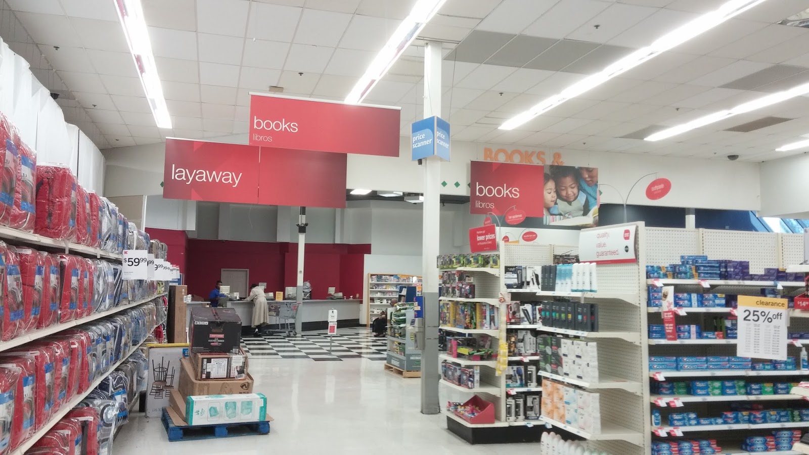
WEEK 17 – Barnes & Noble Ole Miss Relocation, Set I
As we leave the bookstore, here’s a look at its entrance from inside the Union. Certainly very customized to Ole Miss! The image seemed a little dark, so I edited it to try to brighten it. Once I happened upon this effect, though, I had to stick with it (I especially like how it brings out the wood paneling on the right!), so I don’t know how successful I was in my mission :P Anyway, for what the note on the door says, see my photo note.
Barnes & Noble at Ole Miss (inside the Ole Miss Student Union; now closed) // 419 Student Union Drive, University, MS 38677
(c) 2017 Retail Retell
These places are public so these photos are too, but just as I tell where they came from, I'd appreciate if you'd say who :)
~*Photography Originally Taken By: www.CrossTrips.Com Under God*~
The United States Coast Guard (USCG) is a branch of the United States armed forces and one of seven uniformed services. In addition to being a military branch at all times, it is unique among the armed forces in that it is also a maritime law enforcement agency (with jurisdiction both domestically and in international waters) and a federal regulatory agency. It is an agency of the United States Department of Homeland Security.
As one of the five armed forces and the smallest armed service of the United States, its stated mission is to protect the public, the environment, and the United States economic and security interests in any maritime region in which those interests may be at risk, including international waters and America's coasts, ports, and inland waterways.
The Coast Guard has many statutory missions, which are listed below in this article.
Overview
Description
The Coast Guard, in its literature, describes itself as "a military, maritime, multi-mission service within the Department of Homeland Security dedicated to protecting the safety and security of America." It differs from the other armed services of the US in that the other four armed services are components of the Department of Defense.
In addition, the Coast Guard has separate legal authority than the other four armed services. The Coast Guard operates under Title 10 of the United States Code and its other organic authorities, e.g., Titles 6, 14, 19, 33, 46, etc., simultaneously. Because of its legal authority, the Coast Guard can conduct military operations under the Department of Defense or directly for the President in accordance with 14 USC 1-3, and Title 10.
Role
The United States Coast Guard has a broad and important role in homeland security, law enforcement, search and rescue, marine environmental pollution response, and the maintenance of river, intracoastal and offshore aids to navigation (ATON). Founded by Alexander Hamilton as the Revenue Cutter Service on August 4, 1790, it lays claim to being the United States' oldest continuous seagoing service. As of October 2006, the Coast Guard has approximately 46,000 men and women on active duty, 8,100 reservists, 7,000 full time civilian employees and 30,000 active auxiliarists.[1]
While most military services are either at war or training for war, the Coast Guard is deployed every day. When not in war, the Coast Guard has duties that include maritime law enforcement, maintaining aids to navigation, marine safety, and both military and civilian search and rescue—all in addition to its typical homeland security and military duties, such as port security.
The service's decentralized organization and readiness for missions that can occur at any time on any day, is often lauded for making it highly effective, extremely agile and very adaptable in a broad range of emergencies. In a 2005 article in TIME Magazine following Hurricane Katrina, the author wrote, "the Coast Guard's most valuable contribution to [a military effort when catastrophe hits] may be as a model of flexibility, and most of all, spirit." Wil Milam, a rescue swimmer from Alaska told the magazine, "In the Navy, it was all about the mission. Practicing for war, training for war. In the Coast Guard, it was, take care of our people and the mission will take care of itself."[2]
The Coast Guard's motto is Semper Paratus, meaning "Always Ready". The service has participated in every U.S. conflict from 1790 through to today, including landing US troops on D-Day and on the Pacific Islands in World War II, in extensive patrols and shore bombardment during the Vietnam War, and multiple roles in Operation Iraqi Freedom. Maritime interception operations, coastal security, transportation security, and law enforcement detachments are its major roles in Iraq.
The formal name for a member of the Coast Guard is "Coast Guardsman", irrespective of gender. An informal name is "Coastie." "Team Coast Guard" refers to the three branches of the Coast Guard as a whole: the regulars, the Coast Guard Reserve, and the civilian volunteers of the Coast Guard Auxiliary.
Search and Rescue
See National Search and Rescue Committee
Search and Rescue (SAR) is one of the Coast Guard's oldest missions. The National Search and Rescue Plan[3] designates the United States Coast Guard as the federal agency responsible for maritime SAR operations, and the United States Air Force as the federal agency responsible for inland SAR. Both agencies maintain Rescue Coordination Centers to coordinate this effort, and have responsibility for both military and civilian search and rescue.
* USCG Rescue Coordination Centers
National Response Center
Operated by the U.S. Coast Guard, the National Response Center (NRC) is the sole U.S. Government point of contact for reporting environmental spills, contamination, and pollution
The primary function of the National Response Center (NRC) is to serve as the sole national point of contact for reporting all oil, chemical, radiological, biological, and etiological discharges into the environment anywhere in the United States and its territories. In addition to gathering and distributing spill data for Federal On-Scene Coordinators and serving as the communications and operations center for the National Response Team, the NRC maintains agreements with a variety of federal entities to make additional notifications regarding incidents meeting established trigger criteria. The NRC also takes Terrorist/Suspicious Activity Reports and Maritime Security Breach Reports. Details on the NRC organization and specific responsibilities can be found in the National Oil and Hazardous Substances Pollution Contingency Plan.[4]
* U.S. National Response Team
Authority as an armed service
The five uniformed services that make up the Armed Forces are defined in 10 U.S.C. § 101(a)(4):
“ The term “armed forces” means the Army, Navy, Air Force, Marine Corps, and Coast Guard. ”
The Coast Guard is further defined by 14 U.S.C. § 1:
“ The Coast Guard as established January 28, 1915, shall be a military service and a branch of the armed forces of the United States at all times. The Coast Guard shall be a service in the Department of Homeland Security, except when operating as a service in the Navy. ”
Coast Guard organization and operation is as set forth in Title 33 of the Code of Federal Regulations.
On February 25, 2003, the Coast Guard was placed under the Department of Homeland Security. The Coast Guard reports directly to the Secretary of Homeland Security. However, under 14 U.S.C. § 3 as amended by section 211 of the Coast Guard and Maritime Transportation Act of 2006, upon the declaration of war and when Congress so directs in the declaration, or when the President directs, the Coast Guard operates under the Department of Defense as a service in the Department of the Navy. 14 U.S.C. § 2 authorizes the Coast Guard to enforce federal law. Further, the Coast Guard is exempt from and not subject to the restrictions of the Posse Comitatus Act which restrict the law enforcement activities of the other four military services within United States territory.
On October 17, 2007, the Coast Guard joined with the U.S. Navy and U.S. Marine Corps to adopt a new maritime strategy called A Cooperative Strategy for 21st Century Seapower that raised the notion of prevention of war to the same philosophical level as the conduct of war.[5] This new strategy charted a course for the Navy, Coast Guard and Marine Corps to work collectively with each other and international partners to prevent regional crises, manmade or natural, from occurring or reacting quickly should one occur to avoid negative impacts to the United States. During the launch of the new U.S. maritime strategy at the International Seapower Symposium at the U.S. Naval War College, 2007, Coast Guard Commandant Admiral Thad Allen said the new maritime strategy reinforced the time-honored missions the service carried out in this U.S. since 1790. "It reinforces the Coast Guard maritime strategy of safety, security and stewardship, and it reflects not only the global reach of our maritime services but the need to integrate and synchronize and act with our coalition and international partners to not only win wars ... but to prevent wars," Allen said.
Authority as a law enforcement agency
14 U.S.C. § 89 is the principal source of Coast Guard enforcement authority.
14 U.S.C. § 143 and 19 U.S.C. § 1401 empower US Coast Guard Active and Reserves members as customs officers. This places them under 19 U.S.C. § 1589a, which grants customs officers general law enforcement authority, including the authority to:
(1) carry a firearm;
(2) execute and serve any order, warrant, subpoena, summons, or other process issued under the authority of the United States;
(3) make an arrest without a warrant for any offense against the United States committed in the officer's presence or for a felony, cognizable under the laws of the United States committed outside the officer's presence if the officer has reasonable grounds to believe that the person to be arrested has committed or is committing a felony; and
(4) perform any other law enforcement duty that the Secretary of the Treasury may designate.
The U.S. Government Accountability Office Report to the House of Representatives, Committee on the Judiciary on its 2006 Survey of Federal Civilian Law Enforcement Functions and Authorities identified the U.S. Coast Guard as one of 104 federal components employed which employed law enforcement officers.[7] The Report also included a summary table of the authorities of the U.S. Coast Guard's 192 special agents and 3,780 maritime law enforcement boarding officers.[8]
Coast Guardsmen have the legal authority to carry their service-issued firearms on and off base, thus giving them greater flexibility when being called to service. This is not always done, however, in practice; at many Coast Guard stations, commanders prefer to have all service-issued weapons in armories. Still, one court has held that Coast Guard boarding officers are qualified law enforcement officers authorized to carry personal firearms off-duty for self-defense.[9]
As members of a military service, Coast Guardsmen on active and reserve service are subject to the Uniform Code of Military Justice and receive the same pay and allowances as members of the same pay grades in the other uniformed services.
History
Main article: History of the United States Coast Guard
Marines holding a sign thanking the US Coast Guard after the battle of Guam.
Marines holding a sign thanking the US Coast Guard after the battle of Guam.
The roots of the Coast Guard lie in the United States Revenue Cutter Service established by Alexander Hamilton under the Department of the Treasury on August 4, 1790. Until the re-establishment of the United States Navy in 1798, the Revenue Cutter Service was the only naval force of the early U.S. It was established to collect taxes from a brand new nation of patriot smugglers. When the officers were out at sea, they were told to crack down on piracy; while they were at it, they might as well rescue anyone in distress.[10]
"First Fleet" is a term occasionally used as an informal reference to the US Coast Guard, although as far as one can detect the United States has never in fact officially used this designation with reference either to the Coast Guard or any element of the US Navy. The informal appellation honors the fact that between 1790 and 1798, there was no United States Navy and the cutters which were the predecessor of the US Coast Guard were the only warships protecting the coast, trade, and maritime interests of the new republic.[11]
The modern Coast Guard can be said to date to 1915, when the Revenue Cutter Service merged with the United States Life-Saving Service and Congress formalized the existence of the new organization. In 1939, the U.S. Lighthouse Service was brought under its purview. In 1942, the Bureau of Marine Inspection and Navigation was transferred to the Coast Guard. In 1967, the Coast Guard moved from the Department of the Treasury to the newly formed Department of Transportation, an arrangement that lasted until it was placed under the Department of Homeland Security in 2003 as part of legislation designed to more efficiently protect American interests following the terrorist attacks of September 11, 2001.
In times of war, the Coast Guard or individual components of it can operate as a service of the Department of the Navy. This arrangement has a broad historical basis, as the Guard has been involved in wars as diverse as the War of 1812, the Mexican-American War, and the American Civil War, in which the cutter Harriet Lane fired the first naval shots attempting to relieve besieged Fort Sumter. The last time the Coast Guard operated as a whole under the Navy was in World War II. More often, military and combat units within the Coast Guard will operate under Navy operational control while other Coast Guard units will remain under the Department of Homeland Security.
Organization
Main article: Organization of the United States Coast Guard
The headquarters of the Coast Guard is at 2100 Second Street, SW, in Washington, D.C. In 2005, the Coast Guard announced tentative plans to relocate to the grounds of the former St. Elizabeths Hospital in Washington. That project is currently on hold because of environmental, historical, and congressional concerns. As of July 2006, there are several possible locations being considered, including the current headquarters location.
Personnel
Commissioned Officer Corps
There are many routes by which individuals can become commissioned officers in the US Coast Guard. The most common are:
United States Coast Guard Academy
Main article: United States Coast Guard Academy
The United States Coast Guard Academy is located on the Thames River in New London, Connecticut. It is the only military academy to which no Congressional or presidential appointments are made. All cadets enter by open competition utilizing SAT scores, high school grades, extracurricular activities, and other criteria. About 225 cadets are commissioned ensigns each year. Graduates of the Academy are obligated to serve five years on active duty. Most graduates (about 70%) are assigned to duty aboard a Coast Guard cutter after graduation, either as Deck Watch Officers (DWO) or as Student Engineers. Smaller numbers are assigned to flight training (about 10% of the class) or to shore duty at Coast Guard Sectors, Districts, or Area headquarters unit.
Officer Candidate School
In addition to the Academy, prospective officers may enter the Coast Guard through the Officer Candidate School (OCS) at the Coast Guard Academy in New London, Connecticut. OCS is a rigorous 17-week course of instruction which prepares candidates to serve effectively as officers in the United States Coast Guard. In addition to indoctrinating students into a military life-style, OCS also provides a wide range of highly technical information necessary for performing the duties of a Coast Guard officer.
Graduates of the program typically receive a commission in the Coast Guard at the rank of Ensign, but some with advanced graduate degrees can enter as Lieutenant (junior grade) or Lieutenant. Graduating OCS officers entering Active Duty are required to serve a minimum of three years, while graduating Reserve officers are required to serve four years. Graduates may be assigned to a ship, flight training, to a staff job, or to an operations ashore billet. However, first assignments are based on the needs of the Coast Guard. Personal desires and performance at OCS are considered. All graduates must be available for worldwide assignment.
In addition to United States citizens, foreign cadets and candidates also attend Coast Guard officer training. OCS represents the source of the majority of commissions in the Coast Guard, and is the primary channel through which enlisted ranks can ascend to the officer corps.
Direct Commission Officer Program
The Coast Guard's Direct Commission Officer course is administered by Officer Candidate School. Depending on the specific program and background of the individual, the course is three, four or five weeks long. The first week of the five-week course is an indoctrination week. The DCO program is designed to commission officers with highly specialized professional training or certain kinds of previous military experience. For example, lawyers entering as JAGs, doctors, intelligence officers, and others can earn commissions through the DCO program. (Chaplains are provided to the Coast Guard by the US Navy.)
College Student Pre-Comissioning Initiative (CSPI)
The College Student Pre-Commissioning Initiative (CSPI) is a scholarship program for college sophomores. This program provides students with valuable leadership, management, law enforcement, navigation and marine science skills and training. It also provides full payment of school tuition, fees, textbooks, a salary, medical insurance and other benefits during a student's junior and senior year of college. The CSPI program guarantees training at Officer Candidate School (OCS) upon successful completion of all program requirements. Each student is expected to complete his/her degree and all Coast Guard training requirements. Following the completion of OCS and commission as a Coast Guard officer, each student will be required to serve on active duty (full time) as an officer for 3 years.
Benefits: Full tuition, books and fees paid for two years, monthly salary of approximately $2,000, medical and life insurance, 30 days paid vacation per year, leadership training.
ROTC
Unlike the other armed services, the Coast Guard does not sponsor an ROTC program. It does, however, sponsor one Junior ROTC ("JROTC") program at the MAST Academy.
Chief Warrant Officers
Highly qualified enlisted personnel from E-6 through E-9, and with a minimum of eight years of experience, can compete each year for appointment as a Chief Warrant Officer (or CWO). Successful candidates are chosen by a board and then commissioned as Chief Warrant Officers (CWO-2) in one of sixteen specialties. Over time Chief Warrant Officers may be promoted to CWO-3 and CWO-4. The ranks of Warrant Officer (WO-1) and CWO-5 are not currently used in the Coast Guard. Chief Warrant Officers may also compete for the Chief Warrant Officer to Lieutenant program. If selected, the officer will be promoted to Lieutenant (O-3E). The "E" designates over four years active duty service as a Warrant Officer or Enlisted member and entitles the member to a higher rate of pay than other lieutenants.
Enlisted
Newly enlisted personnel are sent to 8 weeks of Basic Training at the Coast Guard Training Center Cape May in Cape May, New Jersey.
The current nine Recruit Training Objectives are:
* Self-discipline
* Military skills
* Marksmanship
* Vocational skills and academics
* Military bearing
* Physical fitness and wellness
* Water survival and swim qualifications
* Esprit de corps
* Core values (Honor, Respect, and Devotion to Duty)
Service Schools
Following graduation, most members are sent to their first unit while they await orders to attend advanced training in Class "A" Schools, in their chosen rating, the naval term for Military Occupational Specialty (MOS). Members who earned high ASVAB scores or who were otherwise guaranteed an "A" School of choice while enlisting can go directly to their "A" School upon graduation from Boot Camp.
[edit] The Coast Guard Maritime Law Enforcement Academy
The Coast Guard Maritime Law Enforcement Academy is located at the Federal Law Enforcement Training Center (FLETC) in Charleston, South Carolina, following relocation and merger of the former Law Enforcement School at Yorktown, Virginia, and the former Boarding Team Member School at Petaluma, California.
The Academy presents five courses:
* Boarding officer
* Boarding team member, which is a small part of the boarding officer course
* Radiation detection course, which is a level II operator coruse
* Vessel inspection class for enforcing Captain of the Port orders.
Training ranges from criminal law and the use of force to boarding team member certification to the use of radiation detection equipment. Much of the training is live, using handguns with laser inserts or firing non-lethal rounds.[12]
[edit] Petty Officers
Petty officers follow career development paths very similar to those of US Navy petty officers.
[edit] Chief Petty Officers
Enlisted Coast Guard members who have reached the pay grade of E-7, or Chief Petty Officer, must attend the U.S. Coast Guard Chief Petty Officer Academy at Training Center Petaluma in Petaluma, California, or an equivalent Department of Defense school, in order to be advanced to pay grade E-8. United States Air Force master sergeants, as well as international students representing their respective maritime services, are also eligible to attend the Academy. The basic themes of this school are:
* Professionalism
* Leadership
* Communications
* Systems thinking and lifelong learning
Equipment
The equipment of the USCG consists of thousands of vehicles (boats, ships, helicopters, fixed-winged aircraft, automobiles), communication systems (radio equipment, radio networks, radar, data networks), weapons, infrastructure such as United States Coast Guard Air Stations and local Small Boat Stations, each in a large variety.
Main article: Equipment of the United States Coast Guard
Symbols
Core values
The Coast Guard, like the other armed services of the United States, has a set of core values which serve as basic ethical guidelines to Coast Guard members. As listed in the recruit pamphlet, The Helmsman,[13] they are:
* Honor: Absolute integrity is our standard. A Coast Guardsman demonstrates honor in all things: never lying, cheating, or stealing. We do the right thing because it is the right thing to do—all the time.
* Respect: We value the dignity and worth of people: whether a stranded boater, an immigrant, or a fellow Coast Guard member; we honor, protect, and assist.
* Devotion to Duty: A Coast Guard member is dedicated to five maritime security roles: Maritime Safety, Maritime Law Enforcement, Marine Environmental Protection, Maritime Mobility and National Defense. We are loyal and accountable to the public trust. We welcome responsibility.
Coast Guard Ensign
The Coast Guard Ensign (flag) was first flown by the Revenue Cutter Service in 1799 to distinguish revenue cutters from merchant ships. The order stated the Ensign would be "16 perpendicular stripes, alternate red and white, the union of the ensign to be the arms of the United States in a dark blue on a white field." (There were 16 states in the United States at the time).
The purpose of the flag is to allow ship captains to easily recognize those vessels having legal authority to stop and board them. This flag is flown only as a symbol of law enforcement authority and is never carried as a parade standard.
Coast Guard Standard
The Coast Guard Standard is used in parades and carries the battle honors of the U.S. Coast Guard. It was derived from the jack of the Coast Guard ensign which used to fly from the stern of revenue cutters. The emblem is a blue eagle from the coat of arms of the United States on a white field. Above the eagle are the words "UNITED STATES COAST GUARD;" below the eagle is the motto, "SEMPER PARATUS" and the inscription "1790."
Racing Stripe
The Racing Stripe was designed in 1964 by the industrial design office of Raymond Loewy Associates to give the Coast Guard a distinctive, modern image and was first used in 1967. The symbol is a narrow blue bar, a narrow white stripe between, and a broad red[15] bar with the Coast Guard shield centered. The stripes are canted at a 64 degree angle, coincidentally the year the Racing Stripe was designed. The Stripe has been adopted for the use of other coast guards, such as the Canadian Coast Guard, the Italian Guardia Costiera, the Indian Coast Guard, and the Australian Customs Service. Auxiliary vessels maintained by the Coast Guard also carry the Stripe in inverted colors.
[edit] Semper Paratus
The official march of the Coast Guard is "Semper Paratus" (Latin for "Always Ready"). An audio clip can be found at [3].
Missions
The Coast Guard carries out five basic roles, which are further subdivided into eleven statutory missions. The five roles are:
* Maritime safety (including search and rescue)
* Maritime mobility
* maritime security
* National defense
* Protection of natural resources
The eleven statutory missions, found in section 888 of the Homeland Security Act are:
* Ports, Waterways and Coastal Security (PWCS)
* Counter Drug Law Enforcement
* Migrant Interdiction
* Other Law Enforcement (foreign fisheries)
* Living Marine Resources (domestic fisheries)
* Marine (maritime) Safety
* Marine (maritime) Environmental Protection
* Ice Operations
* Aids to Navigation (ATON)
* Defense Readiness
* Marine (maritime) Environmental Response
The OMEGA navigation system and the LORAN-C transmitters outside the USA were also run by the United States Coast Guard. The U.S. Coast Guard Omega Stations at Lamoure, North Dakota and Kāne'ohe, Hawai'i (Oahu) were both formally decommissioned and shut down on September 30, 1997.
[edit] Uniforms
In 1972, the current Coast Guard dress blue uniform was introduced for wear by both officers and enlisted personnel; the transition was completed during 1974. (Previously, a U.S. Navy-style uniform with Coast Guard insignia was worn.) Relatively similar in appearance to the old-style U.S. Air Force uniforms, the uniform consists of a blue four-pocket single breasted jacket and trousers in a slightly darker shade. A light-blue button-up shirt with a pointed collar, two front button-flap pockets, "enhanced" shoulder boards for officers, and pin-on collar insignia for Chief Petty Officers and enlisted personnel is worn when in shirt-sleeve order (known as "Tropical Blue Long"). It is similar to the World War II-era uniforms worn by Coast Guard Surfmen. Officer rank insignia parallels that of the U.S. Navy but with the gold Navy "line" star being replaced with the gold Coast Guard Shield and with the Navy blue background color replaced by Coast Guard blue. Enlisted rank insignia is also similar to the Navy with the Coast Guard shield replacing the eagle on collar and cap devices. Group Rate marks (stripes) for junior enlisted members (E-3 and below) also follow U. S. Navy convention with white for seaman, red for fireman, and green for airman. In a departure from the U. S. Navy conventions, all petty Officers E-6 and below wear red chevrons and all Chief Petty Officers wear gold. Unlike the US Navy, officers and CPO's do not wear khaki; all personnel wear the same color uniform. See USCG Uniform Regulations [4] for current regulations.
Coast Guard officers also have a white dress uniform, typically used for formal parade and change-of-command ceremonies. Chief Petty Officers, Petty Officers, and enlisted rates wear the standard Service Dress Blue uniform for all such ceremonies, except with a white shirt (replacing the standard light-blue). A white belt may be worn for honor guards. A mess dress uniform is worn by members for formal (black tie) evening ceremonies.
The current working uniform of a majority of Coast Guard members is the Operational Dress Uniform (ODU). The ODU is similar to the Battle Dress Uniform of other armed services, both in function and style. However, the ODU is in a solid dark blue with no camouflage patterns and does not have lower pockets on the blouse. The ODU is worn with steel-toed boots in most circumstances, but low-cut black or brown boat shoes may be prescribed for certain situations. The former dark blue working uniform has been withdrawn from use by the Coast Guard but may be worn by Auxiliarists until no longer serviceable. There is a second phase of Operational Dress Uniforms currently in the trial phases. This prototype resembles the current Battle Dress blouse, which is worn on the outside, rather than tucked in.
Coast Guard members serving in expeditionary combat units such as Port Security Units, Law Enforcement Detachments, and others, wear working operational uniforms that resemble Battle Dress uniforms, complete with "woodland" or "desert" camouflage colors. These units typically serve under, or with, the other armed services in combat theaters, necessitating similar uniforms.
Enlisted Coast Guardsmen wear the combination covers for full dress, a garrison cover for Class "B," wear, and a baseball-style cover either embroidered with "U.S. Coast Guard" in gold block lettering or the name of their ship, unit or station in gold, for the ODU uniform. Male and female company commanders (the Coast Guard equivalent of Marine Corps drill instructors) at Training Center Cape May wear the traditional "Smokey the Bear" campaign hat.
A recent issue of the Reservist magazine was devoted to a detailed and easy to understand graphical description of all the authorized uniforms.
[edit] Issues
The Coast Guard faces several issues in the near future.
Lack of coverage affects many areas with high maritime traffic. For example, local officials in Scituate, Massachusetts, have complained that there is no permanent Coast Guard station, and the presence of the Coast Guard in winter is vital. One reason for this lack of coverage is the relatively high cost of building storm-proof buildings on coastal property; the Cape Hatteras station was abandoned in 2005 after winter storms wiped out the 12-foot (3.7 m) sand dune serving as its protection from the ocean. Faced with these issues the Coast Guard has contracted with General Dynamics C4 System to provide a complete replacment of their 1970's era radio equipment. Rescue 21 is the United States Coast Guard’s advanced command, control and communications system. Created to improve the ability to assist mariners in distress and save lives and property at sea, the system is currently being installed in stages across the United States. The nation's existing maritime search and rescue (SAR) communications system has been in operation since the early 1970s. Difficult to maintain, increasingly unreliable and prone to coverage gaps, this antiquated system no longer meets the safety needs of America's growing marine traffic. In addition, it is incapable of supporting the Coast Guard's new mission requirements for homeland security, which require close cooperation with Department of Defense agencies as well as federal, state and local law enforcement authorities. Modernizing this system enhances the safety and protection of America's waterways.
Lack of strength to meet its assigned missions is being met by a legislated increase in authorized strength from 39,000 to 45,000. In addition, the volunteer Auxiliary is being called to take up more non-combatant missions. However, volunteer coverage does have limits.
Aging vessels are another problem, with the Coast Guard still operating some of the oldest naval vessels in the world. In 2005, the Coast Guard terminated contracts to upgrade the 110-foot (33.5 m) Island Class Cutters to 123-foot (37.5 m) cutters because of warping and distortion of the hulls. In late 2006, Admiral Thad Allen, Commandant of the Coast Guard, decommissioned all eight 123-foot (37 m) cutters due to dangerous conditions created by the lengthening of the hull- to include compromised watertight integrity. The Coast Guard has, as a result of the failed 110 ft (34 m) conversion, revised production schedules for the Fast Response Cutter (FRC). Of the navies and coast guards of the world's 40 largest navies, the U.S. Coast Guard's is the 38th oldest.[16]
Live fire exercises by Coast Guard boat and cutter crews in the U.S. waters of the Great Lakes attracted attention in the U.S. and Canada. The Coast Guard had proposed the establishment of 34 locations around the Great Lakes where live fire training using vessel-mounted machine guns were to be conducted periodically throughout the year. The Coast Guard said that these exercises are a critical part of proper crew training in support of the service's multiple missions on the Great Lakes, including law enforcement and anti-terrorism. Those that raised concerns about the firing exercises commented about safety concerns and that the impact on commercial shipping, tourism, recreational boating and the environment may be greater than what the Coast Guard had stated. The Coast Guard took public comment and conducted a series of nine public meetings on this issue. After receiving more than 1,000 comments, mostly opposing the Coast Guard's plan, the Coast Guard announced that they were withdrawing their proposal for target practice on the Great Lakes, although a revised proposal may be made in the future.[17][18][19][20][21]
[edit] Deployable Operations Group (DOG)
The Deployable Operations Group is a recently formed Coast Guard command. The DOG brings numerous existing deployable law enforcement, tactical and response units under a single command headed by a rear admiral. The planning for such a unit began after the terrorist attacks of September 11, 2001, and culminated with its formation on July 20th, 2007. The unit will contain several hundred highly trained Coast Guardsmen. Its missions will include maritime law enforcement, anti-terrorism, port security, and pollution response. Full operational capability is planned by summer 2008.[22]
[edit] Coast Guard Auxiliary
Main article: United States Coast Guard Auxiliary
The United States Coast Guard Auxiliary is the uniformed volunteer component of the United States Coast Guard, established on June 23, 1939. It works within the Coast Guard in carrying out its noncombatant and non-law enforcement missions. As of November 18, 2007 there were 30,074 active Auxiliarists. The Coast Guard has assigned primary responsibility for most recreational boating safety tasks to the Auxiliary, including public boating safety education and voluntary vessel safety checks. In recent history prior to 1997, Auxiliarists were limited to those tasks and on-water patrols supporting recreational boating safety.
In 1997, however, new legislation authorized the Auxiliary to participate in any and all Coast Guard missions except military combat and law enforcement. 33 CFR 5.31 states that: Members of the Auxiliary, when assigned to specific duties shall, unless otherwise limited by the Commandant, be vested with the same power and authority, in execution of such duties, as members of the regular Coast Guard assigned to similar duties.
Auxiliarists may support the law enforcement mission of the Coast Guard but do not directly participate in it. Auxiliarists and their vessels are not allowed to carry any weapons while serving in any Auxiliary capacity; however, they may serve as scouts, alerting regular Coast Guard units. Auxiliarists use their own vessels (i.e. boats) and aircraft, in carrying out Coast Guard missions, or apply specialized skills such as Web page design or radio watchstanding to assist the Coast Guard. When appropriately trained and qualified, they may serve upon Coast Guard vessels.
Auxiliarists undergo one of several levels of background check. For most duties, including those related to recreational boating safety, a simple identity check is sufficient. For some duties in which an Auxiliarist provides direct augmentation of Coast Guard forces, such as tasks related to port security, a more in-depth background check is required. Occasionally an Auxiliarist will need to obtain a security clearance through the Coast Guard in order to have access to classified information in the course of assigned tasking.
The basic unit of the Auxiliary is the Flotilla, which has at least 10 members and may have as many as 100. Five Flotillas in a geographical area form a Division. There are several divisions in each Coast Guard District. The Auxiliary has a leadership and management structure of elected officers, including Flotilla Commanders, Division Captains, and District Commodores, Atlantic and Pacific Area Commodores, and a national Commodore. However, legally, each Auxiliarist has the same 'rank', Auxiliarist.
In 2005, the Coast Guard transitioned to a geographical Sector organization. Correspondingly, a position of 'Sector Auxiliary Coordinator' was established. The Sector Auxiliary Coordinator is responsible for service by Auxiliarists directly to a Sector, including augmentation of Coast Guard Active Duty and Reserve forces when requested. Such augmentation is also referred to as force multiplication.
Auxiliarists wear the similar uniforms as Coast Guard officers with modified officers' insignia based on their office: the stripes on uniforms are silver, and metal insignia bear a red or blue "A" in the center. Unlike their counterparts in the Civil Air Patrol, Auxiliarists come under direct orders of the Coast Guard.
[edit] Coast Guard Reserve
Main article: United States Coast Guard Reserve
The United States Coast Guard Reserve is the military reserve force of the Coast Guard. The Coast Guard Reserve was founded on February 19, 1941. Like most military reserve units, Coast Guard reservists normally train on a schedule of one weekend a month and an additional 15 days each summer, although many work other days of the week, and often more frequently than just two days a month. Unlike the other armed services, many Coast Guard reservists possess the same training and qualifications as their active duty counterparts, and as such, can be found augmenting active duty Coast Guard units every day, rather than just serving in a unit made up exclusively of reservists.
During the Vietnam War and shortly thereafter, the Coast Guard considered abandoning the Reserve program, but the force was instead reoriented into force augmentation, where its principal focus was not just reserve operations, but to add to the readiness and mission execution of every day active duty personnel.
Since September 11, 2001, over 8,500 Reservists have been activated and served on tours of active duty. Coast Guard Port Security Units are entirely staffed with Reservists, except for five to seven active duty personnel. Additionally, most of the staffing the Coast Guard provides to Naval Coastal Warfare units are reservists.
The Reserve is managed by the Director of Reserve and Training, RDML Cynthia A. Coogan.
[edit] Medals and honors
See also: Awards and decorations of the United States military
One Coast Guardsman, Douglas Albert Munro, has earned the Medal of Honor, the highest military award of the United States.[23]
Six Coast Guardsmen have earned the Navy Cross and numerous men and women have earned the Distinguished Flying Cross.
The highest peacetime decoration awarded within the Coast Guard is the Homeland Security Distinguished Service Medal; prior to the transfer of the Coast Guard to the Department of Homeland Security, the highest peacetime decoration was the Department of Transportation Distinguished Service Medal. The highest unit award available is the Presidential Unit Citation.
In wartime, members of the Coast Guard are eligible to receive the U.S. Navy version of the Medal of Honor. A Coast Guard Medal of Honor is authorized but has not yet been developed or issued.
In May 2006, at the Change of Command ceremony when Admiral Thad Allen took over as Commandant, President George W. Bush awarded the entire Coast Guard, including the Coast Guard Auxiliary, the Coast Guard Presidential Unit Citation with hurricane device, for its efforts after Hurricane Katrina.
[edit] Organizations
[edit] Ancient Order of the Pterodactyl
Those who have piloted or flown in U.S. Coast Guard aircraft under official flight orders may join the Ancient Order of the Pterodactyl ("Flying Since the World was Flat").
[edit] USCGA Alumni Association
The United States Coast Guard Academy Alumni Association is devoted to providing service to and promoting fellowship among all U.S. Coast Guard Academy alumni and members of the Association.
Membership Types: Academy graduates and those who have attended the Academy are eligible for Regular membership; all others interested in the Academy and its Corps of Cadets are eligible for Associate membership. (Website)
[edit] Coast Guard CW Operators Association
The Coast Guard CW Operators Association (CGCWOA) is a membership organization comprised primarily of former members of the United States Coast Guard who held the enlisted rating of Radioman (RM) or Telecommunications Specialist (TC), and who employed International Morse Code (CW) in their routine communications duties on Coast Guard cutters and at shore stations. (Website)
[edit] Publications
The Coast Guard maintains a library of publications for public use as well as publications for Coast Guard and Auxiliary use.
Coast Guard, COMDTPUB P5720.2, is the regular publication for Coast Guardsmen.
[edit] Notable Coast Guardsmen and others associated with the USCG
Source: U.S. Coast Guard
* Derroll Adams, folk musician
* Nick Adams, actor
* Beau Bridges, actor
* Lloyd Bridges, actor
* Sid Caesar, comedian
* Lou Carnesecca, basketball coach, St. John's University
* Howard Coble, U.S. Congressman, North Carolina
* Chris Cooper, actor
* Richard Cromwell, actor
* Walter Cronkite, newscaster
* William D. Delahunt, U.S. Congressman, Massachusetts
* Jack Dempsey, professional boxer
* Buddy Ebsen (1908–2003), actor, comedian, dancer
* Blake Edwards, writer, director, producer
* Edwin D. Eshleman (1920-1985), former U.S. Congressman, Pennsylvania
* Arthur Fiedler, conductor
* Arthur A. Fontaine, captain, college sailing national champion, ISCA Hall of Fame
* Charles Gibson, newscaster
* Arthur Godfrey, entertainer
* Otto Graham, professional football player and coach
* Alex Haley, author of Roots and Coast Guard chief journalist
* Weldon Hill, pseudonym of William R. Scott, author of novel Onionhead, based on his World War II Coast Guard service
* William Hopper, actor
* Tab Hunter, actor
* Harvey E. Johnson, Jr., Vice Admiral, Deputy Director FEMA
* Steve Knight, Vocalist for Flipsyde
* Duke Paoa Kahanamoku, athlete, actor
* Jack Kramer, tennis professional
* Jacob Lawrence, artist
* Victor Mature, actor
* Douglas Munro, the only Coast Guardsman to be awarded the Medal of Honor
* Frank Murkowski, former governor and former U.S. Senator, Alaska
* Sam Nunn, former U.S. Senator, Georgia
* Arnold Palmer, professional golfer
* Ed Parker, martial artist
* Claiborne Pell, former U.S. Senator, Rhode Island
* Cesar Romero, actor
* Sloan Wilson, writer
* Dorothy C. Stratton first director of the SPARS
* Gene Taylor, U.S. Congressman, Mississippi
* Ted Turner, businessman
* Rudy Vallee, entertainer
* Tom Waits, musician and actor
* Thornton Wilder, writer
* Gig Young, actor
* Popeye, Cartoon character, had tattoos and uniforms signifying he was in the USCG. "Popeye the Sailor Meets Ali Baba and the Forty Thieves" shows him under a USCG sign.
[edit] Popular culture
The Coast Guard has been featured in several television series, such as Baywatch, CSI: Miami, and Deadliest Catch; and in film. A comedy, Onionhead, portrayed Andy Griffith as a Coast Guard recruit. The 2000 film The Perfect Storm depicted the rescue operations of the USCGC Tamaroa (WMEC-166) as one of its subplots. Special Counter-Drugs helicopters known as HITRONs are seen in action on Bad Boys II. In the 2005 family comedy Yours, Mine, and Ours, Dennis Quaid plays a fictional U.S. Coast Guard Academy superintendent who marries a character played by Rene Russo and together have 18 children. The 2006 film The Guardian, starring Kevin Costner and Ashton Kutcher, was based on the training and operation of Coast Guard Rescue Swimmers. Additionally, a Coast Guard cutter and its commander and crew figured prominently in Tom Clancy's book Clear and Present Danger. The 2008 fourth season of the television series Lost erroneously depicted air crash survivors being transported to Hawaii in a Coast Guard HC-130 aircraft, however since the survivors had landed on the Indonesian island of Sumba (In the Indian Ocean thousands of miles from any Coast Guard district), arrangements for their repatriation would have been the business of the US State Department.
I hadn't seen them for almost 10 days.......but tonight I watched as
mom herded the two pups back to their first den (under my deck!)
This handsome pup has really grown!
The University of Bristol Botanic Gardens, in Stoke Bishop, Bristol, Avon.
The University of Bristol established a botanic garden in 1882 at Royal Fort House adjacent to Tyndall Avenue. It was laid out by Adolf Leipner. This site was later known as the Hiatt Baker Garden.
In 1959 the site of the Botanic Garden was used to build the university's Senate House. The botanic collection was moved to the spacious gardens of Bracken Hill beside North Road, Leigh Woods, near the Clifton Suspension Bridge. The Bracken Hill house and gardens had been established in 1886 by Melville Wills, a noted benefactor to Bristol University.
Bracken Hill house and some of the gardens continued to be used by the plant pathology and other services of the government's National Agricultural Advisory Service (NAAS), advising farmers and growers from Herefordshire and Dorset to Lands End during and after World War II when UK-grown crops were vital to minimise rationing. See, for instance, the cereal and vegetable diseases work of Lawrence Ogilvie at Bracken Hill. The NAAS staff, laboratories and offices had moved there from the Long Ashton Research Station also to the west of Bristol.
In 2005 the botanic collections were relocated to The Holmes, a site in Stoke Bishop opposite Churchill Hall. The Holmes had been built in 1879 and had a 1.77 hectares (4.4 acres) ornamental garden. It had been used by United States Army staff during the preparations for the Normandy landings during World War II. The new garden designed by Land Use Consultants advised by Peter Crane, was the first University Botanic Garden built in the UK in the 21st century.
The garden has 640 square metres (6,900 sq ft) of greenhouses divided into cool, warm-temperate, sub-tropic and tropical zones which house plants from the evolution collection. The tropical zone includes a raised pool with aquatic plants including the water lily Victoria cruziana.
The displays include 4500 plant species. These are divided into collections of evolution, Mediterranean, local-flora, rare-native, and finally useful plants. The useful-plant displays include herb gardens with western, Chinese and herbal medicine, including species used in Ayurvedic and Southern African medicine. Displays of plants from the Mediterranean climate region include those from several continents. Plant evolution is illustrated by several displays.
The local-flora and rare-native collection includes the unusual species found in the Avon Gorge, Mendip Hills, Somerset Levels and surrounding areas. These plants include the Bristol Onion, Cheddar Pink and various species of Whitebeam.
Information Source:
climbing up the old concrete walkway up the bluffs reveals the remains of the once proud McKinley Elementary School. The school was built in 1910 and served students till the late 1970's.It is now privately owned and decaying....
The school has a unique location along the wooded bluffs in East Moline,IL.
Happy (school) fence Friday...!
c1975 Taken with a Mamiya C220 Professional & 80mm f2.8 Mamiya-Sekor on Ektachrome 64 slide.
Shenandoah National Park
Shenandoah National Park /'??n?n?do??/ (often /'?æn?n?do??/) is an American national park that encompasses part of the Blue Ridge Mountains in the Commonwealth of Virginia. The park is long and narrow, with the Shenandoah River and its broad valley to the west, and the rolling hills of the Virginia Piedmont to the east. Skyline Drive is the main park road, generally traversing along the ridgeline of the mountains. Almost 40% of the park's land—79,579 acres (124.3 sq mi; 322.0 km2)—has been designated as wilderness areas and is protected as part of the National Wilderness Preservation System. The highest peak is Hawksbill Mountain at 4,051 feet (1,235 m).
Creation of the park
Legislation to create a national park in the Appalachian mountains was first introduced by freshman Virginia congressman Henry D. Flood in 1901, but despite the support of President Theodore Roosevelt, failed to pass. The first national park was Yellowstone, in Wyoming, Montana, and Idaho. It was signed into law in 1872. Yosemite National Park was created in 1890. When Congress created the National Park Service (NPS) in 1916, additional parks had maintained the western pattern (Crater Lake in 1902, Wind Cave in 1903, Mesa Verde in 1906, then Denali in 1917). Grand Canyon, Zion and Acadia were all created in 1919 during the administration of Virginia-born president Woodrow Wilson. Acadia finally broke the western mold, becoming the first eastern national park. It was also based on donations from wealthy private landowners. Stephen Mather, the first NPS director, saw a need for a national park in the southern states, and solicited proposals in his 1923 year-end report. In May 1925, Congress and President Calvin Coolidge authorized the NPS to acquire a minimum of 250,000 acres (390.6 sq mi; 1,011.7 km2) and a maximum of 521,000 acres (814.1 sq mi; 2,108.4 km2) to form Shenandoah National Park, and also authorized creation of Great Smoky Mountains National Park. However, the legislation also required that no federal funds would be used to acquire the land. Thus, Virginia needed to raise private funds, and could also authorize state funds and use its eminent domain (condemnation) power to acquire the land to create Shenandoah National Park.
Virginia's Democratic gubernatorial candidate (and the late Congressman Flood's nephew), Harry F. Byrd supported the creation of Shenandoah National Park, as did his friend William E. Carson, a businessman who had become Virginia's first chairman of the Commission on Conservation and Development.[11][12] Development of the western national parks had assisted tourism, which produced jobs, which Byrd and local politicians supported. The land that became Shenandoah park was scenic, mountainous, and had also lost about half of its trees to the Chestnut blight (which was incurable and affected trees as they reached maturity). However, it had been held as private property for over a century, so many farms and orchards existed. After Byrd became governor and convinced the legislature to appropriate $1 million for land acquisition and other work, Carson and his teams (including surveyors and his brother Kit who was Byrd's law partner) tried to figure out who owned the land. They found that it consisted of more than 5,000 parcels, some of them inhabited by tenant farmers or squatters (who were ineligible to receive compensation). Some landowners, including wealthy resort owner George Freeman Pollock and Luray Realtor and developer L. Ferdinand Zerkel, had long wanted the park created and had formed the Northern Virginia Park Association to win over the national park selection committee.[13][14] However, many local families who had lived in the area for generations (especially people over 60 years old) did not want to sell their land, and some refused to sell at any price. Carson promised that if they sold to the commonwealth, they could still live on their homesteads for the rest of their lives. Carson also lobbied the new president, Herbert Hoover, who bought land to establish a vacation fishing camp near the headwaters of the Rapidan River (and would ultimately donate it to the park as he left office; it remains as Rapidan Camp).
A small family cemetery along Skyline Drive
The commonwealth of Virginia slowly acquired the land through eminent domain, and then gave it to the U.S. federal government to establish the national park. Carson's brother suggested that Virginia's legislature authorize condemnation by counties (followed by arbitration for individual parcels) rather than condemn each parcel. Some families accepted the payments because they needed the money and wanted to escape the subsistence lifestyle. Nearly 90 percent of the inhabitants worked the land for a living: selling timber, charcoal, or crops. They had previously been able to earn money to buy supplies by harvesting the now-rare chestnuts, by working during the apple and peach harvest season (but the drought of 1930 devastated those crops and killed many fruit trees), by selling handmade textiles and crafts (displaced by factories) and moonshine (illegal after Prohibition started).
However, Carson and the politicians did not seek citizen input early in the process, nor convince residents that they could live better in a tourist economy. Instead, they started with an advertising campaign to raise the funds, and courthouse property evaluations and surveys. Upon Mather's death in 1929, the new NPS director, Horace M. Albright also decided that the federal agency would only accept vacant land, so even elderly residents would be forced to leave. Thus, many families and entire communities were forced to vacate portions of the Blue Ridge Mountains in eight Virginia counties. Although the Skyline Drive right-of-way was purchased from owners without condemnation, the costs of the acreage purchased trebled over initial estimates and the acreage decreased to what Carson called a "fish-bone" shape and others a "shoestring".[15] Although Byrd and Carson convinced Congress to reduce the minimum size of Shenandoah Park to just over 160,000 acres (250.0 sq mi; 647.5 km2) to eliminate some high-priced lands, in 1933 newly elected President Franklin D. Roosevelt decided to also create the Blue Ridge Parkway to connect to then-under-construction Skyline Drive on the Shenandoah National Park ridgeline, which required additional condemnations.
When many families continued to refuse to sell their land in 1932 and 1933, proponents changed tactics. Freeman hired social worker Miriam Sizer to teach at a summer school he had set up near one of his workers' communities and asked her to write a report about the conditions in which they lived. Although later discredited, the report depicted the local population as very poor and inbred and was soon used to support forcible evictions and burning of former cabins so residents would not sneak back. University of Chicago sociologists Fay-Cooper Cole and Mandel Sherman described how the small valley communities or hollows had existed "without contact with law or government" for centuries, which some analogized to a popular comic strip Li'l Abner and his fictional community, Dogpatch. In 1933, Sherman and journalist Thomas Henry published Hollow Folk[16] drawing pitying eyes to local conditions and "hillbillies."[17][18][19] As in many rural areas of the time, most remote homesteads in the Shenandoah lacked electricity and often running water, as well as access to schools and health facilities during many months. However, Hoover had hired experienced rural teacher Christine Vest to teach near his summer home (and who believed the other reports exaggerated, as did Episcopal missionary teachers in other Blue Ridge areas).[20]
View from the summit of Hawksbill Mountain
Carson had had ambitions to become governor in 1929 and 1933, but Byrd instead selected George C. Peery of Virginia's southwestern region to succeed easterner Pollard.[21] After winning the election, Peery and Carson's successor would establish Virginia's state park system, although plans to relocate reluctant residents kept changing and basically failed. Carson had hoped to head that new state agency, but was not selected because of his growing differences with Byrd, over fees owed his brother and especially over the evictions that began in late 1933 against his advice but pursuant to new federal policies and that garnered much negative publicity.
Most of the reluctant families came from the park's central counties (Madison, Page, and Rappahannock), not the northern counties nearest Byrd's and Carson's bases, or from the southern end where residents could see tourism's benefits at Thomas Jefferson's Monticello since the 1920s, as well as the jobs available in the Shenandoah and new Blue Ridge projects. In 1931 and 1932, residents were allowed to petition the state agency to stay another year to gather crops, etc. However, some refused to cooperate to any extent, others wanted to continue to use resources now protected (including timber or homes and gardens vacated by others), and many found the permit process arbitrary. Businessman Robert H. Via filed suit against the condemnations in 1934 but did not prevail (and ended up moving to Pennsylvania and never cashed his condemnation check).
Carson announced his resignation from his unpaid job effective in December 1934. As one of his final acts, Carson wrote the new NPS director, Arno B. Cammerer, urging that 60 people over 60 years of age whose plots were not visible from the new Skyline Drive not be evicted. When evictions kept creating negative publicity in 1935, photographer Arthur Rothstein coordinated with the Hollow Folk authors and then went to document the conditions they claimed.[17]
View from Skyline Drive
The creation of the park had immediate benefits to some Virginians. During the Great Depression, many young men received training and jobs through the Civilian Conservation Corps (CCC). The first CCC camp in Virginia was established in the George Washington National Forest near Luray, and Governor Pollard quickly filled his initial quota of 5,000 workers. About 1,000 men and boys worked on Skyline Drive, and about 100,000 worked in Virginia during the agency's existence.[22][23] In Shenandoah Park, CCC crews removed many of the dead chestnut trees whose skeletons marred views in the new park, as well as constructed trails and facilities. Tourism revenues also skyrocketed. On the other hand, CCC crews were assigned to burn and destroy some cabins in the park, to prevent residents from coming back. Also, U.S. Secretary of the Interior Harold Ickes who had jurisdiction over the NPS and partial jurisdiction over the CCC, tried to use his authority to force Byrd to cooperate on other New Deal projects.
Shenandoah National Park was finally established on December 26, 1935, and soon construction began on the Blue Ridge Parkway that Byrd wanted.[24] President Franklin Delano Roosevelt formally opened Shenandoah National Park on July 3, 1936. Eventually, about 40 people (on the "Ickes list") were allowed to live out their lives on land that became the park. One of them was George Freeman Pollock, whose residence Killahevlin was later listed on the National Register, and whose Skyland Resort reopened under a concessionaire in 1937. Carson also donated significant land; a mountain in the park is now named in his honor and signs acknowledge his contributions. The last grandmother resident was Annie Lee Bradley Shenk. NPS employees had watched and cared for her since 1950; she died in 1979 at age 92. Most others left quietly. 85-year-old Hezekiah Lam explained, "I ain't so crazy about leavin' these hills but I never believed in bein' ag'in (against) the Government. I signed everythin' they asked me."[25]
relocated to the south side of Frankenmuth, a very old iron bridge built by Joliet Bridge and Iron Co. 1907
216a 1 - _TAC4511 - lr
The covered bridge was built in 1872 over Little Raccoon Creek. It was rehabilitated in 1936. In the 2011, the bridge was moved to the nearby grounds of the Buckeye Furnace State Memorial and placed on blocks. In 2019, when the photograph was taken, the bridge was in fairly decent shape, however, it appeared that no decision had been made concerning its future. The bridge was listed on the National Register of Historic Places.
My snake relocation calls are picking up. This is the largest Gopher snake that I have relocated this year so far.. This is the lid to the relocation bucket that I am holding
Albers, Clem,, photographer.
Lone Pine, Calif. Apr. 1942. Evacuees of Japanese ancestry arriving by train and awaiting buses for Manzanar, a War Relocation Authority center
[1 April 1942]
1 photograph : gelatin silver print ; mount 24 x 30 cm.
Notes:
Photograph shows an unidentified Japanese American mother, grandmother, and boys waiting with suitcases and duffel bags at Lone Pine train station before being incarcerated at Manzanar Relocation Center, Manzanar, California, during World War II.
Title transcribed from item.
No. A-298.
Photographer and date from negative in the National Archives.
Photograph from U.S. War Relocation Authority.
Farm Security Administration and Office of War Information Collection (Library of Congress).
Subjects:
Manzanar War Relocation Center--1940-1950.
United States.--Wartime Civil Control Administration--1940-1950.
Japanese Americans--Forced removal and internment, 1942-1945
World War, 1939-1945--Japanese Americans--California--Lone Pine.
Japanese Americans--Women--1940-1950.
Japanese Americans--Children--1940-1950.
Families--1940-1950.
Luggage--1940-1950.
Railroad stations--1940-1950.
Arrivals & departures--1940-1950.
Format: Photographic prints--1940-1950.
Rights Info: No known restrictions on publication.
Repository: Library of Congress, Prints and Photographs Division, Washington, D.C. 20540 USA, hdl.loc.gov/loc.pnp/pp.print
Part Of: Farm Security Administration - Office of War Information Photograph Collection (Library of Congress) (DLC) 2002708960
Higher resolution image is available (Persistent URL): hdl.loc.gov/loc.pnp/ppmsca.73157
Call Number: LOT 1801 [item]
For the back half of today’s descriptions, we’re just quickly catching up on some extra Tupelo Tuesday Morning-related images, sort of an epilogue to that series from earlier this semester. Up first, this image showing the previous Tuesday Morning in town, prior to the chain’s relocation; as you can see, even before the end of July it was getting ready for its next gig as a seasonal Spirit Halloween store for the fall of 2018! I’m pretty sure Spirit Halloween has actually operated out of this particular shopping center before, but in the past they used the vacant Hancock Fabrics anchor instead. Unsure if the TM was bigger, or they just liked it better.
Spirit Halloween (temporary) // 994 Commonwealth Boulevard, Tupelo, MS 38804
(c) 2018 Retail Retell
These places are public so these photos are too, but just as I tell where they came from, I'd appreciate if you'd say who :)
Remodel, Week 16
(cont.) Welp, as of the following week, I got my answer: it was a temporary relocation of the pharmacy! l_dawg2000 (and/or my mom; can’t remember who got to me first XD ) actually informed me of this, as I wasn’t in town that weekend. (He’s also already posted his own picture of it, which you can see here.) But the next weekend, I made sure to get my own photo of the tiny structure, even if I had to do it very quickly while we were in the checkout line! (As a result, please pardon the person visible on the right of the photograph :P )
For being a temporary pharmacy, this setup looks very complex… as it should, I suppose, considering that those are dozens of customers’ prescriptions and records they have to keep protected within that cramped little space. If you zoom in through the windows, you can see that this mini-pharmacy box even has its own drop ceiling and lighting, which is even more impressive! (I’d bet that that also makes it even more claustrophobic in there for the poor employees, though…) The only downsides to this temporary setup (besides the aforementioned issue of space) are the facts that when it gets busy, customers waiting in line will now interfere with the flow of shoppers exiting the checkouts, and, as those yellow signs at the pickup counter read, they’re only able to do prescription checkouts right now (no other services).
And in the interim, what’s becoming of the old pharmacy, you ask? Well, I’ll show you! Stay tuned for Part 2 of this update tomorrow… :)
(c) 2017 Retail Retell
These places are public so these photos are too, but just as I tell where they came from, I'd appreciate if you'd say who :)
WEEK 45 – Southaven Burlington Relocation: Old Store, Set II
One last shot of the interior of the old store, as we prepare to exit. I told you I had a much better shot of the red feature wall along the front end! :) I'm pretty happy with how this turned out, too, in that it captured both the Burlington logo and the “Welcome to Southaven” message without cutting either of them off. I was not able to manage a similar shot of the new (identical) feature wall at the relocated store for my upcoming photoset from there, but maybe one day in the future I will!
Note how the checkout setup here is a queue, very similar to TJMaxx... I can't remember if that was in place before, or added in with, the installation of this feature wall. Queue checkouts aren't really my favorite (honestly, I like the “self” variety! :P ), but I must admit they do seem to do the job well. What's your take?
(c) 2017 Retail Retell
These places are public so these photos are too, but just as I tell where they came from, I'd appreciate if you'd say who :)
WEEK 1 – Memphis Kmart Closing, I
Prior to the liquidation, books occupied the former café space, but for the closing sale they had been consolidated out here in front of the former pharmacy. Something else I'm kicking myself for: if I had seen that copy of Jimmy Fallon's “Your Baby's First Word Will Be Dada,” I definitely would've bought it!
(c) 2017 Retail Retell
These places are public so these photos are too, but just as I tell where they came from, I'd appreciate if you'd say who :)
The $12.4 million dollar Penn Central Mall opened in 1984 with a crowd of over 11,000 eager shoppers on hand. The mall structure was designed and developed between 1983 and 1984 using $3.4 million in Urban Development Action Grants. The grants included $800,000 for the relocation of 60 businesses and homes affected by construction of the mall. The remainder, $2.6 million, went towards construction of the mall.
Other funding sources include a $6.6 million loan, and $2 million from local investors and direct contributions through the sale of bricks located in the mall center court. Sernett’s Department Store built a brand new $1.2 million department store on the malls west side where HyVee sits today.
Sernett’s and JC Penney where the first two anchors to sign on onto the mall and K-Mart would soon anchor the malls southern side with a large new Class C store. The community development group lobbied hard for the mall, and when it opened in 1985, occupancy was over 70 percent.
It has been reported that Oskaloosa’s Sernett’s department store was one of the most successful locations in the chain. It was one of the few profitable stores when the Sernett family decided to close their faltering department store businesses.
Follow me on Instagram @RuralRetail
Sources:
oskynews.org/penn-central-mall-vision-and-history/
oskynews.org/penn-central-mall-vision-and-history-part-2/
oskynews.org/penn-central-mall-vision-and-history-part-3-...
The cemetery at Skew Street was established in 1825 with the relocation of the Moreton Bay Penal Settlement to Brisbane. It operated until the North Brisbane Burial Ground opened in 1843. During that time 265 people died in Brisbane and most were buried in the cemetery. The cemetery land was converted to freehold and auctioned in 1875. The Helidon Spa Water Company operated a factory on the land and several cottages were built. The construction of Eagle Terrace and Skew Street in the late 1800s and construction of the Grey Street Bridge in the 1920s will have had some impact on the site.
In May 1825 Lieutenant Henry Miller moved the Moreton Bay Settlement from the Redcliffe Peninsula to its present site on the northern bank of the Brisbane River. This was an elevated location with water holes and cooling breezes. The southern bank was a cliff of rock, suitable for building material, and a fertile flood plain. The settlers faced hardship and privation and the paucity of resources combined with thick sub-tropical vegetation made settlement difficult. Between 1826 and 1829, the number of prisoners in the settlement rose from 200 to 1000 and the plight of the convicts whose labour was to establish the settlement was dire.
The site of Brisbane Town was an on-going cause of disquiet, with Commandant Logan proposing that the settlement be moved to Stradbroke Island. However, the difficulties of crossing the bay saw this plan abandoned. Logan continued to seek alternative sites, establishing a number of outstations including Eagle Farm and Oxley Creek. Despite the continued uncertainty about the future of Brisbane Town, building had continued under Commandant Logan, who is given credit for laying out the earliest permanent foundations. Logan was responsible for the building of Brisbane's only surviving convict-constructed buildings, the Commissariat Store and the Tower Mill.
Convict numbers fell 75 percent between 1831 and 1838 by which time the area under cultivation shrank from 200 hectares to only 29. On 10 February 1842 Governor Gipps declared Moreton Bay open for Free Settlement.
The cemetery was established early in the convict period and operated until the opening of the North Brisbane Burial Grounds at Milton in 1843. During the 18 years of its operation there were 265 recorded deaths in Brisbane, including 220 convicts. Most of these people were buried in the First Brisbane Burial Ground. Probably the most famous person buried in the cemetery was the surveyor G. W. Stapylton who it was believed was killed by Aborigines near Mt Lindsay in May 1840. Two Aborigines were later hanged for this murder at the Tower Mill.
Following the closure of the cemetery in 1843 the area remained as unalienated crown land and in 1848 the Moreton Bay Courier described the cemetery:
It is a disgraceful fact that, notwithstanding the repeated complaints in this journal of the exposed condition of the old burial ground, it is now as bad as ever. The temporary fencing which was placed around has almost entirely disappeared.
Four years later it was described:
Six years ago, nearly a hundred tablets, headstones, &c., stood in the old burial ground: now a bare dozen can be counted, and many of these are dilapidated or overturned. The fence is torn down, carried away or burnt..What hands have taken so many monumental stones away none can tell.
Between 1864 and 1875 Skew Street was constructed through the cemetery land to provide vehicle access between Roma Street and North Quay. It had not been constructed by October 1864 as the Surveyor General wrote to the Secretary of Lands on 21 October 1864 that:
The arrangement of the portion including the cemetery be deferred until some future time when the relatives and friends of those who have been interred in the cemetery may be less likely to object to the locality being appropriated as a public thoroughfare.
In October 1875 the cemetery land was divided into 7 town allotments varying in size from 12 perches to 27.5 perches and sold at public auction as Section 41. The sale of the land was specifically to raise funds for the provision of drainage facilities within Brisbane. The purchasers were F. Giles, J. Carmody, Dr J. Waugh and H. Morwitch. Section 41 was described as:
The triangular reserve (formerly a burial ground) between the North Quay, Eagle Cliff (or Terrace), and Skew Street (running from opposite the old entrance to the gaol to the North Quay)
Dr John Waugh arrived in Brisbane in the early 1860s and originally practiced in Stanley Street but later moved his practice to the brick cottage he constructed on this newly acquired land. He was president of the Royal Geographical Society of Queensland for many years.
In 1881 at least three burials were exhumed from the cemetery and removed with their monuments to the Toowong Cemetery. These were all the remains of children who had died at the convict settlement. They were William Roberts, 5 years 2 months old son of Charles Roberts of the Commissariat Department who died in 1831, Peter Macauley, 15 years and 8 months old son of Private Peter Macauley of the 17th Regiment of Foot who died in 1832, and Jane Pittard the 12 month old daughter of Colour Sergeant John Pittard of the 57th Regiment of Foot who died in 1833.
By the 1890s the Helidon Spa Water Company had established a factory on the allotments at the North Quay end of Section 41. Construction of the Grey Street Bridge in the 1920s resulted in resumption of properties and the realignment of roadways at the northern access to the bridge.
E. E. McCormick Place is named after E.E. McCormick in appreciation of his assistance in the acquisition of the area by the council for park purposes.
Source: Queensland Heritage Register & Brisbane City Council Library Services.
Troy, PA. August 2019.
------------------------------------------------------------------------------------------
If you would like to use THIS picture in any sort of media elsewhere (such as newspaper or article), please send me a Flickrmail or send me an email at natehenderson6@gmail.com
I don't normally handle wildlife but this fella seemed pretty vulnerable hanging out at a busy park. So a fter a few quick shots we tried to discretely relocate him to a safer spot.
They're not by any means under the Federal witness protection program but the floral MOCs have been moved to a much safer spot on the wall at the top of the stairs together with other sets built on display. Wasn't even looking for them when I got in the store but one of the staff who recognized me pointed out their new location. They'll remain on display as long as the original Flower Box remains on display at the LEGO House.
The station is from Rowley near Consett built orginally in 1867. It became the first building to be relocated at the Beamish site . In 1976 the then Poet Laureate Sir John Betjeman opened it
Up at the front of the store, another change that took place was the relocation of the recycling bins from a spot along the front end itself to this new alcove right beside the restrooms. Previously, this space had been home to three community display boards that, evidently, the store decided to remove.
Personally, I like this location for the recycling bins better, both in that they're closer to the doors and in that their previous location was, in my opinion, kinda awkward (even more so now, given that the manager's office they were up against is now a family restroom). Too bad I didn't get to make much use of their new spot, seeing as how we had finally received curbside recycling service by this time! :P
(c) 2018 Retail Retell
These places are public so these photos are too, but just as I tell where they came from, I'd appreciate if you'd say who :)
Virginia House
Virginia House was formerly an English manor house that was relocated to Richmond in 1925. The home is now owned and operated by the Virginia Historical Society.
Virginia House was completed a few months before the stock market crash of 1929. Designed by Alexander and Virginia Weddell, the home is situated on a hillside overlooking the historic James River and was constructed from the materials of a sixteenth century English manor house. Although Virginia House was a blend of three romantic English Tudor designs, it was for its time a thoroughly modern home complete with seven full baths, central heat, modern kitchen, and commodious closets.
Mrs. Weddell's appreciation of style is evident as the visitor moves through rooms decorated with English and Spanish antiques, silk draperies, Oriental carpets, and fine silver and china. The nearly eight acres of gardens and grounds that Virginia House rests on were designed by Charles Gillette and provide a rich backdrop to the house throughout the year. The house has been preserved much as it was when the Weddells resided there.
Source: www.vahistorical.org/your-visit/virginia-house
Origins of Virginia House
The Priory of the Augustinian Order of the Holy Sepulcher of Jerusalem was established by Henry de Newburgh, first earl of Warwick, in 1109. The building that housed the order was completed sometime around 1119. Warwick was the seat of all the Holy Sepulcher houses in Britain and enjoyed a golden age for close to a century.
When Henry VIII broke from the Catholic Church in 1536, he confiscated the priory at Warwick. The hundreds of monasteries and nunneries that were closed throughout Britain in the sixteenth century were sold to the king's favorites. The first owner of the priory was Thomas Hawkins, alias Fisher, a fishmonger, who acquired the building and lands during the short reign of Edward VI. Fisher later purchased much of the land surrounding the priory and eventually dismantled most of the monastic buildings and built a house he called "Hawk's Nest," set in a landscaped park. It was at his Tudor manor house that Fisher entertained the newly crowned Elizabeth I. The curvilinear Dutch gables were added to the front façade around 1620, during the reign of James I. The fortunes of the priory at Warwick rose and fell with its subsequent owners, among whom were Henry Wise, royal gardener to Queen Anne, who acquired the house in 1709. The Lloyd banking family bought the priory in the mid-nineteenth century but were forced to sell it in the early part of the twentieth century.
In 1925, Alexander and Virginia Weddell bought the priory at a demolition sale. The Weddells had the house dismantled and rebuilt part of it in Richmond, Virginia, where they hoped the west wing would serve as a museum for the Virginia Historical Society. They planned that the remainder of the house would one day serve as the society's headquarters. With these plans in mind, in 1929 the Weddells deeded Virginia House to the VHS and maintained a lifetime tenancy for themselves.
Packing and shipping
The company that was to demolish the priory felt the stones would crumble in the process, so they decided to make a small explosion in the middle of the building and send only those stones that survived the blast to America. To their amazement, most of the stones fell intact. The more fragile ornaments were packed in boxes with sand to cushion them. The ship bringing the stones to America had to turn back to port as it was taking on water. Consequently, when the stones arrived in Richmond they were soaked in seawater and had to be washed and dried. The first group of stones arrived in Richmond in the spring of 1926. The stones were stored and sorted in a barn on the corner of Massie and Canterbury roads in Windsor Farms over a period of six months.
Construction and design
The west wing of the house is, on the exterior, a replica of Sulgrave Manor, a submanorial house in Northamptonshire, England, belonging at one time to Lawrence Washington, an ancestor of America's first president, George Washington. The center section of the house is a reproduction of the priory in Warwickshire, England. This priory section exhibits the curvilinear gables that the English adopted from the Low Countries in the early seventeenth century. The strapwork design seen on the parapets and on the exterior and interior balustrades was also imported from the Low Countries. Wormleighton Manor, a Spencer-Churchill family estate in England, was the model for the east wing. The architect of Virginia House was Henry Grant Morse, who was primarily a designer of public buildings. Morse traveled in the English countryside with Mr. and Mrs. Weddell as they looked for a model for the house they hoped to build in Windsor Farms.
William Lawrence Bottomley designed the loggia, incorporating columns imported from Spain on the south side. The painted ceiling in the loggia came in part from a sixteenth-century house that once stood on the site of Knole in England. A frieze of old tiles on the walls of the loggia illustrates the early use of gunpowder. The roof of the loggia is a belvedere from which the visitor can have a view of the gardens of Virginia House and the historic James River beyond. Beyond the loggia, the east wall of the west wing bears mason's marks from various periods, some surviving perhaps from the original priory. A porch, built after the completion of the main house, extends from Mrs. Weddell's bedroom. Mrs. Weddell would retreat to her porch on hot summer nights to catch the breezes from the river and, in the morning, she and Mr. Weddell would have breakfast served to them there.
House museum
Virginia House was completed in 1928, and in 1929 it was presented to the Virginia Historical Society with the Weddells retaining lifetime tenancy. Virginia House became the sole responsibility of the VHS in 1948 after Ambassador and Mrs. Weddell, and Mrs. Weddell's personal maid Violet Andrews, were killed in a train crash on New Year's Day.
Today Virginia House is owned and operated by the Virginia Historical Society. The museum and gardens are open by appointment only. The site is also available for meetings and special events.
Source: www.vahistorical.org/your-visit/virginia-house/house
Many of the Nubians you’ll find living at either Nubian village were relocated here during the latter half of the twentieth century as construction of the High Dam in Aswan neared completion. The construction of the dam essentially meant that the Nubian communities had no option but to move
Taken @Aswan, Egypt
Remodel, Week 5
(cont.) ...and on that note, a fair amount of the merchandise that used to be housed over near the bakery has already found itself relocated to make room for the produce walk-in cooler. As you can see here, prepackaged bread, as well as (on the other side of this shelving) prepackaged muffins, bagels, and tortillas, have all been temporarily placed between the meat department's coffin coolers and the beer aisle, which runs perpendicular to said coolers. In the background of this photo, you can get a better, more zoomed-out indication of just how large the produce cooler will be. Also, for reference, here's a shot taken from over at the bakery, looking toward the spot where I was standing for this pic.
(c) 2017 Retail Retell
These places are public so these photos are too, but just as I tell where they came from, I'd appreciate if you'd say who :)
WEEK 51 – Barnes & Noble Ole Miss Relocation Revisited (I)
I have this strange tendency to upload photos from Oxford anytime EXCEPT when I’m actually in town. Which, you know, is a majority of the year, so it’s pretty talented that I do this. I did the same thing this exact time last year, as a matter of fact (you might recall my Oxford Walmart album update). This time we’re doing another album update, as Albertsons Florida Blog correctly guessed on Tuesday, and as is clear from the photo you’re looking at above this spiel: the next chapter in the Ole Miss Barnes & Noble campus bookstore saga. (cont.)
Barnes & Noble at Ole Miss (inside the University of Mississippi's Jackson Avenue Center/former Oxford Mall; now closed) // 1111 Jackson Avenue W, Oxford, MS 38655
(c) 2019 Retail Retell
These places are public so these photos are too, but just as I tell where they came from, I'd appreciate if you'd say who :)
NS H53 emerges from Enola Yard on their way back to Northumberland, PA with SD40E trio 6311, 6303 and 6327 for power.
About a year ago I agreed with some friends/fellow local bio-mocers to do an Ordeal of Fire collab, where we'd revamp the 2.0 heroes and fire villains and present them at a lego event come August. Due to our relatively small group size and set availability, I ended up taking responsibility for three of the figures, first of which being Nex here.
Nex' helmet and colours gave me lumberjack vibes, so I leaned into that color scheme. I imagine Nex' role as a strongman who can clear obstacles and manipulate the environment with heavy tools. I was planning to give him more tools than a chainsaw, but lost motivation after the event was over and had to relocate my legos. I kinda hoped to narrow his shoulders a little as well, but on a glance that would've proven difficult with how they're set up.
I was also working triple shift at the time, so being tired, mocblock and mental pressure kinda held me from photoing these mocs. These are rather late, and I apologize to my collaborators.
Early 17th Century farmhouse relocated from Llangennith in Gower and rebuilt at St Fagans Museum, Cardiff. It is interesting to be able to view the underside of woven straw matting below roof thatch.
Exposure: 120 seconds, f/4, ISO 100
Camera: Mamiya m645j
Film: Cross processed 120 Fujichrome Astia 100f (scan of print)
Date: 11 March 2006
Location: Hurricane Barrier, Providence, RI
Notes:
Sort of last-minute, Judyboy, Skazama, LaRizzoloca and I revisited a spot we have been a few times before.
You can see a group pool here of all our shots on Flickr from the night or a slick slideshow here. It may take a week or so for all the shots to be posted.
WEEK 51 – Barnes & Noble Ole Miss Relocation Revisited (I)
Hope y’all got all that, haha! And as if that wasn’t enough backstory, I probably should fill you in quickly on the mall situation again, too. The Oxford Mall used to be a two-anchor deal, with JCPenney and Wal-Mart… except when Wal-Mart built a new Supercenter down the road, well, that was the beginning of the end for the mall. Some plans to renovate it were thrown out there, and in an attempt to bring those to life the middle of the mall was demolished and turned into a new Malco Theatre, but ultimately the mall stayed in a stasis and Ole Miss purchased the property to use for extra square footage and – most importantly – parking. Currently, only the right half of the mall has been converted into offshoot campus space, but with JCPenney's departure in July 2017, I’m sure it’s only a matter of time before the left half of the mall is touched, too.
The only retail space that Ole Miss has left intact at the mall – now christened the “Jackson Avenue Center” – is this space at the very front of the right-side mall entry corridor, originally home to Ole South Cafeteria and, more notably, Campus Book Mart, which opened here in 1995 and lasted until 2015, when it relocated to a separate location down the street. Likely, CBM’s relocation was a result of landlord Ole Miss kicking them out, so that they could put their own university bookstore in this space during the Student Union remodel. But that’s just conjecture.
(c) 2019 Retail Retell
These places are public so these photos are too, but just as I tell where they came from, I'd appreciate if you'd say who :)
Set to relocate to the former Dressbarn and Cato Fashions (by combining the two vacant storefronts) in the Lycoming Crossings shopping center.
Muncy, PA. October 2020.
------------------------------------------------------------------------------------------
If you would like to use THIS picture in any sort of media elsewhere (such as newspaper or article), please send me a Flickrmail or send me an email at natehenderson6@gmail.com
Relocated "Forever Marilyn" statue after it was returned to Palm Springs in 2021, Palm Springs, California.
It would seem that Covid caused KAY to stay at Lycoming Mall longer that it had planned.
Pennsdale (Muncy), PA. February 2020.
------------------------------------------------------------------------------------------
If you would like to use THIS picture in any sort of media elsewhere (such as newspaper or article), please send me a Flickrmail or send me an email at natehenderson6@gmail.com
For once I'm at something of a loss for this one. It started life as one thing and by the end had morphed into something quite different. It started life as a simple piece of A4 paper but by the time it was done was this concoction of cardboard, glue, stencils, spraypaint, stamped lettering and something of a dark heart vibe.
The gentleman in the piece is clearly something of a vagabond as it would appear he has cleared out all the bank accounts and made a hasty international departure to an uncertain destination. And all he left behind was a short note. The no-good piece of dirt. If I ever get my hands on him...
Cheers
id-iom
Pekin duck, or Long Island duck (Anas platyrhynchos domestica, or Anas peking), is a breed of domesticated duck used primarily for egg and meat production. It was bred from the Mallard in China. The ancestors of those ducks originated from the canals which linked waterways in Nanjing and originally had small bodies and black feathers. With the relocation of the Chinese capital to Beijing, supply barge traffic increased in the area which would often spill grain on which the ducks fed. Over time, the ducks slowly increased in size and grew white feathers. By the Five Dynasties, the new species of duck had been domesticated by Chinese farmers.
In 1873 nine ducks were exported from China to Long Island, New York in the United States and the animals and their meat are sometimes referred to as "Long Island duckling". It is the most popular commercial duck breed in the United States, although some farming has since relocated to Indiana from Suffolk County, New York. Around 95% of duck meat consumed in the United States is Pekin duck.
California.
The Abu Simbel temples are two massive rock temples at Abu Simbel (أبو سمبل in Arabic), a village in Nubia, southern Egypt, near the border with Sudan. They are situated on the western bank of Lake Nasser, about 230 km southwest of Aswan (about 300 km by road). The complex is part of the UNESCO World Heritage Site known as the "Nubian Monuments," which run from Abu Simbel downriver to Philae (near Aswan). The twin temples were originally carved out of the mountainside during the reign of Pharaoh Ramesses II in the 13th century BC, as a lasting monument to himself and his queen Nefertari, to commemorate his victory at the Battle of Kadesh. Their huge external rock relief figures have become iconic.
The complex was relocated in its entirety in 1968, on an artificial hill made from a domed structure, high above the Aswan High Dam reservoir. The relocation of the temples was necessary to prevent them from being submerged during the creation of Lake Nasser, the massive artificial water reservoir formed after the building of the Aswan High Dam on the Nile River.
Michael Warren, "After Image", 1984-1986, in spanish chestnut.
Warren originally made this work for Castletown Cox, Co. Kilkenny based on a smaller version exhibited in ROSC ’84 and now in the Dublin City Gallery the Hugh Lane. The work reveals his interestin balance and shows marked evidence of the way in which the sculptor allows the material to age naturally. Warren is one of Ireland’s most acclaimed and international artists.
_X4A3598