View allAll Photos Tagged Maps
Maps from my first visit to London in 2000.
Drawn with felt pen on tracing paper, copic markers to underside of tracing paper then stuck on (crookedly!) to white paper and into a black paper photo album.
Hmmm... I like these maps very much - the use of colour and the 3D components are more successful that most of the maps that I do these days....but back then I had more time for these things ...no that was definitely not the case! I was more careful!! And just for the record I traced these maps.
BTW... I am doing more trip preps than I can or will post....
A potential zone fare system for the Washington Metro.
For more information see greatergreaterwashington.org/post/9261
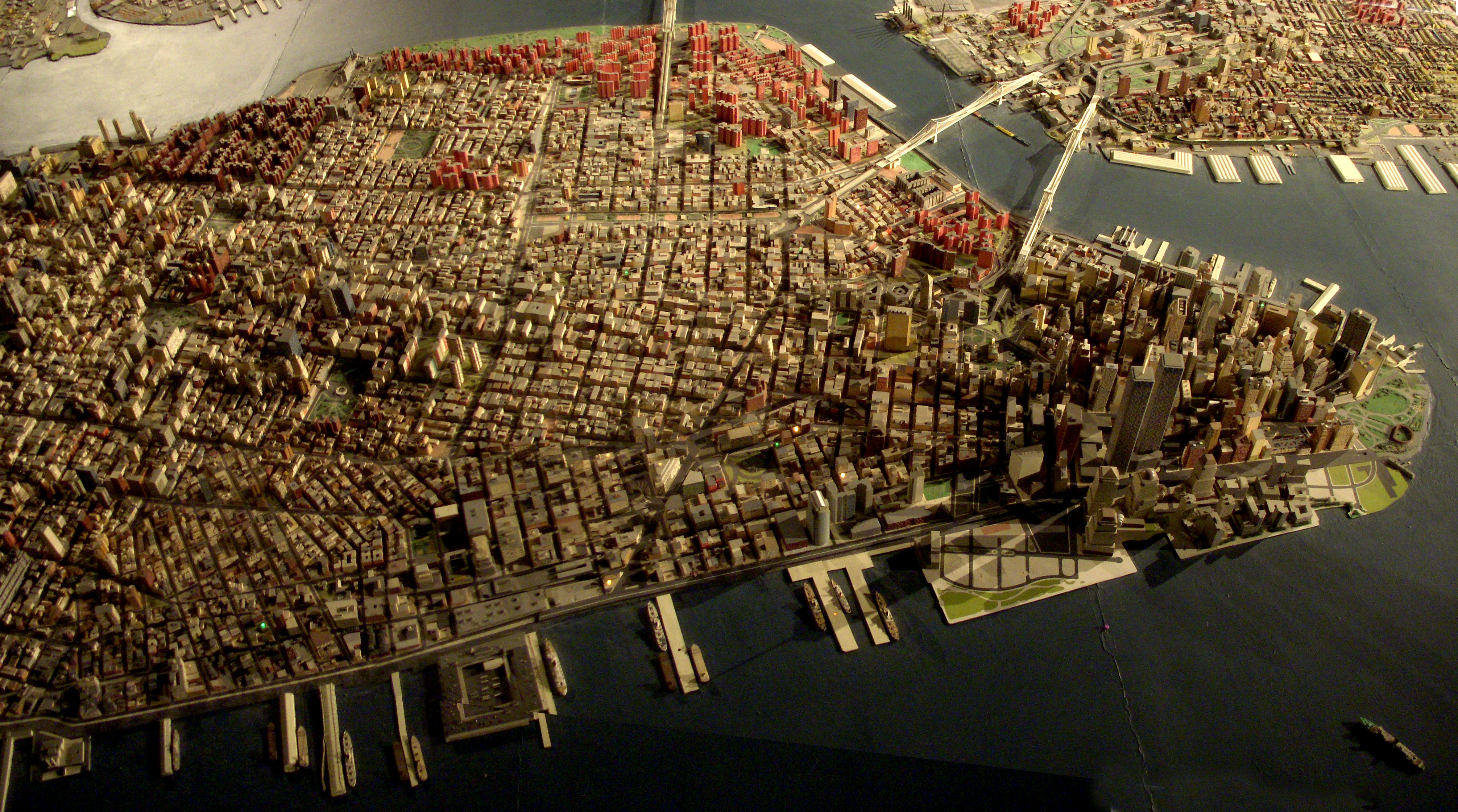
Giant map of NYC in the Queens Museum of Art. I uploaded this full size panorama of downtown Manhattan so my neighbors can have fun finding their own apartment building.
Robert Moses had 'The Panorama of the City of New York' built for the 1964 World's Fair, but it has been updated, and supposedly has every building built before 1992. Originally you flew over it on a simulate helicopter ride. Now there is a ramp that spirals around it from the first to second floor of the museum.
Where in Winchester is this map displayed? It can be found somewhere in the area shown on the map, as can all the photos I've posted to GWW so far.
Frankfurt is a large metro area with a lot of commuters, so it has a fairly substantial public transportation system. Indeed, its probably one of the most comprehensive ones I've used in recent history. The system includes subway (U-bahn), commuter trains (S-bahn), trolleys, buses, regional trains, and the like, all with a common fare system. If anything, I found myself with too many options for getting from one place to another.
What's interesting is that unlike a lot of systems these days, Frankfurt's system is mostly star-shaped: the majority of routes go to or through one location: Hauptbahnhof, which has 24 street level rail platforms, a similar number one level down, several trolley lines out front, and a major U-bahn station. A large number of S-Bahn trains head east from the station below ground in a large tunnel called the CityTunnel, which snakes around downtown and ends up at Lokalbahnhof , a station over the Main in Sachsenhauser.
weihner plan of wroclaw from 1562, the medieval and renaissance city. Collection of the University Library of Wroclaw.
Remember that one illustrated map I uploaded a while back? Well, I found out that that was the back to the Cities Service Map series (its cover was torn off so I didn't know that there was a cool cover to it). Here is what the front of those maps look like. I did the eBay thing and found the best quality map that was available: Kansas.
I suggest doing the "All sizes" thing or just click here.
I was astounded by Bill Rankin's map of Chicago's racial and ethnic divides and wanted to see what other cities looked like mapped the same way. To match his map, Red is White, Blue is Black, Green is Asian, Orange is Hispanic, Gray is Other, and each dot is 25 people. Data from Census 2000. Base map © OpenStreetMap, CC-BY-SA
I've uploaded the image on the right a few times already. That image is of my map of the current Kmart stores in Florida, which currently stands at a total of 41 stores. For the first part of the upcoming AFB on flickr photoseries, we're going to be taking a look at the most recent Florida Kmart casualty - the closing of the West Palm Beach Kmart. The closing of the West Palm Kmart began on May 20, 2016, and that store's closing should be entering it's final days by now, if it hasn't closed for good already. I visited the West Palm Kmart on May 18, 2016, two days before the closure began. For the record, I had no idea the store was going to close when I made the trip down there. The timing was a complete coincidence. However during my visit there were a few signs of an upcoming closure in the works, which I will discuss in more detail as I get into those photos.
As I was looking for some information on Kmart not too long ago, I stumbled upon a list of licensing data from the State of Florida from 1996. Their list included information on the locations of every Kmart in the state in that year. So using that data, and filling in a few gaps with some other stores I knew of that closed prior to 1996, I complied a list and map of every Kmart (that I know of) to have existed in Florida over the years. You can see that map on the left. According to my count, there have been at least 184 Kmart stores to have operated in Florida over the years (that count includes original stores and their replacements). As of today, over three quarters of the Kmarts to have operated in Florida have since closed. However, I think the comparison between the two maps speaks the loudest over any statistical figures.
If you would like to view an interactive version of the map of all Kmarts to have operated in Florida, please click here. To view an interactive version of the map of current Kmart stores in Florida, please click here.
Please comment below if those links don't work or if you know of a former Kmart location that I may have missed.
Title: Tabula Asiae III [Black & Capian Sea Region]
Map Maker: Sebastian Munster
Place / Date: Basle / 1542
Description:
Excellent example of Munster's Ptolemaic map of the region between the Black Sea and Caspian Sea extending south to include all of Armenia Maior and part of Armenia Minoris.
Munster's map shows Noahs Arc in the Caspian Sea, believed to have come to rest in a mountain in Armenia according to the map. Shows Armenia Maior, Iberia, Albania, Colchis, Porte Albanie, the Euphratis River, the Tigris, Assyriae, and many other place names in the cradle of civilization. The map is unchanged from the 1540 edition.
Munster's Geographia was a cartographic landmark, including not only Ptolemaic maps, but also a number of landmark modern maps, including the first separate maps of the 4 continents, the first map of England and the earliest obtainable map of Scandinavia. Munster dominated cartographic publication during the mid-16th Century. Munster is generally regarded as one of the three most important map makers of the 16th Century, along with Ortelius and Mercator. Munster was a linguist and mathematician, who initially taught Hebrew in Heidelberg. He issued his first mapping of Germany in 1529, after which he issued a call geographical information about Germany to scholars throughout the country. The response was better than hoped for, and included substantial foreign material, which supplied him with up to date, if not necessarily accurate maps for the issuance of his Geographia in 1540.
Armenia on antique maps
I am reposting this map from the University of Texas so I can comment on it, because every time I look at it I see something new that's weird about it.
It is supposedly from 1913, but it looks like the street map must be earlier since the Civic Center is still in the pre-1906 configuration and street names like Ridley and Kate persist.
Montgomery Street continues straight south to 16th and Connecticut!
16th Street continues west over Corona Heights to connect to Irving!
18th Street also makes it as far west as Stanyan.
The "Right of Way for the Southern and Western Pacific Railroad" runs across Candlestick Point and into the bay, like a prototype for the Hunters Point Freeway.
Market Street continues southwest over the hills and includes what is now Sloat.
Army (Cesar Chavez) is called New Market in Noe Valley.
The Bayview/Hunter's Point streets all have different names.
The Mission grid extending west to Fowler and south to 34th Street, and the Lake Merced grid, are contrary to reality too, but those aren't unique to this map.
Source: McGraw Electric Railway Manual: The Red Book of American Electric Railway Investments, the University of Texas Libraries.
This map goes along with this post, which was an attempt to inventory all the independant shops and businesses in my area of central Austin.
This is a map of Seoul with some of the places we visited.
Below are my steps to create the map:
1. Using Google Earth, I plotted the location of each attraction.
2. I printed the map and traced over it with white paper and a pencil. I drew in the river and placed an "x" for each attraction.
3. I inked-in the river and drew the landmarks. For all inking, I used a Fine Black Sharpie Pen.
4. Next I lettered each landmark.
5. After erasing all of the pencil marks, I scanned the map and added a couple of elements (Miso, and the Nanta drawing) using Paint. I also added "Han River" as I forgot to letter this by hand.
6. I printed the map onto parchment paper. Once scanned back in to my computer, I e-mailed it to myself so I could complete the editing using my iPad.
7. On my iPad, I added the Torn Brick effect and Rough Edge border.
8. Finally, I added my watermark using the iWatermark app. The watermark is a stone stamp that was created in Korea. The Korean letters phonetically spell my first name, Douglas.
Victoria (parfois appelé port de Victoria) est la capitale des Seychelles et n'est pas fluctué sur le côté nord-est de Mahé , l'île principale de l'archipel. La ville a d'abord été établie comme étant le siège de la British coloniale gouvernement. En 2009, la population de la région métropolitaine de Victoria (y compris les banlieues) était de 25 000 la population totale du pays de 87 972. Victoria est desservie par l'aéroport international des Seychelles , achevée en 1971.
This was my big summer project this year! A full map of the continental United States all in patchwork and embroidered! You can see more pictures at:
In the Four Corners region, drawings like this are often maps. This is a different cultural area (Wyoming), but I assume that it too is a map of something, or a guide to something.
I have now added the photo of the map sign to the map. I can't remember where this was actually taken so I just plonked it down in the middle somewhere.
Area to the immediate east of Church Stretton, Shropshire.
Playing around with Maperitive and open data - contours and hill shading using Ordnance Survey Land-form Panorama, mapping from OpenStreetMap.
Map from an official guide published by the Cape Town City Council in 1950. Note the railway line crossing the bottom of Adderley str. Most probably also the line that went to Sea Point.
This is a close up of an old map I carry around while exploring Honolulu's Chinatown.
I've linked a few of my pinhole photographs taken in this area [click on notes in map above].
More photos in my Chinatown series.
Map courtesy: University of Hawaiʻi at Mānoa Library, Map Collection
Sanborn Fire Insurance Map, Honolulu, 1914, sheet 37 [cropped].