View allAll Photos Tagged Is
Frici is no joke, throwing high speed tuck no handers out of ramps with no cover are pretty scary.
Taken in Dunaújváros, Hungary, on the first day of the OG Real Street Tour 2011.
Camera and strobist info: Hasselblad 503CX w. 80mm Zeiss Planar at f5.6, ISO50. Lumedyne Action Pack at 200Ws camera right, cononmk DL4.0 at 200Ws camera left.
Headland is a civil parish in the Borough of Hartlepool, County Durham, England. The parish covers the old part of Hartlepool and nearby villages.
History
The Heugh Battery, one of three constructed to protect the port of Hartlepool in 1860, is located in the area along with a museum.
The area made national headlines in July 1994 in connection with the murder of Rosie Palmer, a local toddler.
On 19 March 2002 the Time Team searched for an Anglo-Saxon monastery.
Dominating the skyline is the impressive architectural structure that is St Hilda’s Church. Remnant of Hartlepool’s Saxon heritage and undoubtedly the crowning glory of the Headland, this church is a must-see attraction. After her stay in Hartlepool, the Abbess of the church progressed along the coast to Whitby and this spiritual journey can be explored through ‘The Way of St Hild’ walking trail.
A great way to explore the historic Headland is by finding and following the Headland Story Trail. The trail features 18 different information boards, each telling a story of the areas fascinating heritage from tales of shipwreck to the legend of the Hartlepool monkey. A truly interactive and fun walking experience!
Other landmarks of note include the impressive Town Wall, dating from the 14th century. This grade I listed, scheduled ancient monument still guards the Headland, and was originally built to keep out the twin threats of raiding Scots and the rigours of the North Sea.
The Borough Hall is another striking building and dates back to 1865. This gorgeous entertainment venue hosts an action-packed events programme so be sure to keep an eye out for all upcoming events here.
Dive into the town’s military history at The Heugh Battery Museum – this restored coastal defence battery protected the town throughout both World Wars. An enchanting historical sight with the original barrack room, underground magazines, coastal artillery and observation tower, the exhibits tell the story of those who lost their lives and the brave men who defended the area. Refresh with a light bite or sweet treat at the Poppy Café, located within the museum.
Visit the Headland War Memorial to see the magnificent ‘Winged Victory’ – a stunning statue that tributes those who lost their lives during the two world wars.
At the very north of the Headland you will find Spion Kop Cemetery – this historic cemetery supports a species-rich dune grassland and offers fantastic views of the coastline.
Every summer Headland Carnival attracts lively visitors to the area. Packed with thrilling rides, amusing games and live entertainment this week of jam-packed fun is great for all the family.
Hartlepool is a seaside and port town in County Durham, England. It is governed by a unitary authority borough named after the town. The borough is part of the devolved Tees Valley area. With an estimated population of 87,995, it is the second-largest settlement (after Darlington) in County Durham.
The old town was founded in the 7th century, around the monastery of Hartlepool Abbey on a headland. As the village grew into a town in the Middle Ages, its harbour served as the County Palatine of Durham's official port. The new town of West Hartlepool was created in 1835 after a new port was built and railway links from the South Durham coal fields (to the west) and from Stockton-on-Tees (to the south) were created. A parliamentary constituency covering both the old town and West Hartlepool was created in 1867 called The Hartlepools. The two towns were formally merged into a single borough called Hartlepool in 1967. Following the merger, the name of the constituency was changed from The Hartlepools to just Hartlepool in 1974. The modern town centre and main railway station are both at what was West Hartlepool; the old town is now generally known as the Headland.
Industrialisation in northern England and the start of a shipbuilding industry in the later part of the 19th century meant it was a target for the Imperial German Navy at the beginning of the First World War. A bombardment of 1,150 shells on 16 December 1914 resulted in the death of 117 people in the town. A severe decline in heavy industries and shipbuilding following the Second World War caused periods of high unemployment until the 1990s when major investment projects and the redevelopment of the docks area into a marina saw a rise in the town's prospects. The town also has a seaside resort called Seaton Carew.
History
The place name derives from Old English heort ("hart"), referring to stags seen, and pōl (pool), a pool of drinking water which they were known to use. Records of the place-name from early sources confirm this:
649: Heretu, or Hereteu.
1017: Herterpol, or Hertelpolle.
1182: Hierdepol.
Town on the heugh
A Northumbrian settlement developed in the 7th century around an abbey founded in 640 by Saint Aidan (an Irish and Christian priest) upon a headland overlooking a natural harbour and the North Sea. The monastery became powerful under St Hilda, who served as its abbess from 649 to 657. The 8th-century Northumbrian chronicler Bede referred to the spot on which today's town is sited as "the place where deer come to drink", and in this period the Headland was named by the Angles as Heruteu (Stag Island). Archaeological evidence has been found below the current high tide mark that indicates that an ancient post-glacial forest by the sea existed in the area at the time.
The Abbey fell into decline in the early 8th century, and it was probably destroyed during a sea raid by Vikings on the settlement in the 9th century. In March 2000, the archaeological investigation television programme Time Team located the foundations of the lost monastery in the grounds of St Hilda's Church. In the early 11th century, the name had evolved into Herterpol.
Hartness
Normans and for centuries known as the Jewel of Herterpol.
During the Norman Conquest, the De Brus family gained over-lordship of the land surrounding Hartlepool. William the Conqueror subsequently ordered the construction of Durham Castle, and the villages under their rule were mentioned in records in 1153 when Robert de Brus, 1st Lord of Annandale became Lord of Hartness. The town's first charter was received before 1185, for which it gained its first mayor, an annual two-week fair and a weekly market. The Norman Conquest affected the settlement's name to form the Middle English Hart-le-pool ("The Pool of the Stags").
By the Middle Ages, Hartlepool was growing into an important (though still small) market town. One of the reasons for its escalating wealth was that its harbour was serving as the official port of the County Palatine of Durham. The main industry of the town at this time was fishing, and Hartlepool in this period established itself as one of the primary ports upon England's Eastern coast.
In 1306, Robert the Bruce was crowned King of Scotland, and became the last Lord of Hartness. Angered, King Edward I confiscated the title to Hartlepool, and began to improve the town's military defences in expectation of war. In 1315, before they were completed, a Scottish army under Sir James Douglas attacked, captured and looted the town.
In the late 15th century, a pier was constructed to assist in the harbour's workload.
Garrison
Hartlepool was once again militarily occupied by a Scottish incursion, this time in alliance with the Parliamentary Army during the English Civil War, which after 18 months was relieved by an English Parliamentarian garrison.
In 1795, Hartlepool artillery emplacements and defences were constructed in the town as a defensive measure against the threat of French attack from seaborne Napoleonic forces. During the Crimean War, two coastal batteries were constructed close together in the town to guard against the threat of seaborne attacks from the Imperial Russian Navy. They were entitled the Lighthouse Battery (1855) and the Heugh Battery (1859).
Hartlepool in the 18th century became known as a town with medicinal springs, particularly the Chalybeate Spa near the Westgate. The poet Thomas Gray visited the town in July 1765 to "take the waters", and wrote to his friend William Mason:
I have been for two days to taste the water, and do assure you that nothing could be salter and bitterer and nastier and better for you... I am delighted with the place; there are the finest walks and rocks and caverns.
A few weeks later, he wrote in greater detail to James Brown:
The rocks, the sea and the weather there more than made up to me the want of bread and the want of water, two capital defects, but of which I learned from the inhabitants not to be sensible. They live on the refuse of their own fish-market, with a few potatoes, and a reasonable quantity of Geneva [gin] six days in the week, and I have nowhere seen a taller, more robust or healthy race: every house full of ruddy broad-faced children. Nobody dies but of drowning or old-age: nobody poor but from drunkenness or mere laziness.
Town by the strand
By the early nineteenth century, Hartlepool was still a small town of around 900 people, with a declining port. In 1823, the council and Board of Trade decided that the town needed new industry, so the decision was made to propose a new railway to make Hartlepool a coal port, shipping out minerals from the Durham coalfield. It was in this endeavour that Isambard Kingdom Brunel visited the town in December 1831, and wrote: "A curiously isolated old fishing town – a remarkably fine race of men. Went to the top of the church tower for a view."
But the plan faced local competition from new docks. 25 kilometres (16 mi) to the north, the Marquis of Londonderry had approved the creation of the new Seaham Harbour (opened 31 July 1831), while to the south the Clarence Railway connected Stockton-on-Tees and Billingham to a new port at Port Clarence (opened 1833). Further south again, in 1831 the Stockton and Darlington Railway had extended into the new port of Middlesbrough.
The council agreed the formation of the Hartlepool Dock and Railway Company (HD&RCo) to extend the existing port by developing new docks, and link to both local collieries and the developing railway network in the south. In 1833, it was agreed that Christopher Tennant of Yarm establish the HD&RCo, having previously opened the Clarence Railway (CR). Tennant's plan was that the HD&RCo would fund the creation of a new railway, the Stockton and Hartlepool Railway, which would take over the loss-making CR and extended it north to the new dock, thereby linking to the Durham coalfield.
After Tennant died, in 1839, the running of the HD&RCo was taken over by Stockton-on-Tees solicitor, Ralph Ward Jackson. But Jackson became frustrated at the planning restrictions placed on the old Hartlepool dock and surrounding area for access, so bought land which was mainly sand dunes to the south-west, and established West Hartlepool. Because Jackson was so successful at shipping coal from West Hartlepool through his West Hartlepool Dock and Railway Company and, as technology developed, ships grew in size and scale, the new town would eventually dwarf the old town.
The 8-acre (3.2-hectare) West Hartlepool Harbour and Dock opened on 1 June 1847. On 1 June 1852, the 14-acre (5.7-hectare) Jackson Dock opened on the same day that a railway opened connecting West Hartlepool to Leeds, Manchester and Liverpool. This allowed the shipping of coal and wool products eastwards, and the shipping of fresh fish and raw fleeces westwards, enabling another growth spurt in the town. This in turn resulted in the opening of the Swainson Dock on 3 June 1856, named after Ward Jackson's father-in-law. In 1878, the William Gray & Co shipyard in West Hartlepool achieved the distinction of launching the largest tonnage of any shipyard in the world, a feat to be repeated on a number of occasions. By 1881, old Hartlepool's population had grown from 993 to 12,361, but West Hartlepool had a population of 28,000.
Ward Jackson Park
Ward Jackson helped to plan the layout of West Hartlepool and was responsible for the first public buildings. He was also involved in the education and the welfare of the inhabitants. In the end, he was a victim of his own ambition to promote the town: accusations of shady financial dealings, and years of legal battles, left him in near-poverty. He spent the last few years of his life in London, far away from the town he had created.
World Wars
In Hartlepool near Heugh Battery, a plaque in Redheugh Gardens War Memorial "marks the place where the first ...(German shell) struck... (and) the first soldier was killed on British soil by enemy action in the Great War 1914–1918."
The area became heavily industrialised with an ironworks (established in 1838) and shipyards in the docks (established in the 1870s). By 1913, no fewer than 43 ship-owning companies were located in the town, with the responsibility for 236 ships. This made it a key target for Germany in the First World War. One of the first German offensives against Britain was a raid and bombardment by the Imperial German Navy on the morning of 16 December 1914,
Hartlepool was hit with a total of 1150 shells, killing 117 people. Two coastal defence batteries at Hartlepool returned fire, launching 143 shells, and damaging three German ships: SMS Seydlitz, SMS Moltke and SMS Blücher. The Hartlepool engagement lasted roughly 50 minutes, and the coastal artillery defence was supported by the Royal Navy in the form of four destroyers, two light cruisers and a submarine, none of which had any significant impact on the German attackers.
Private Theophilus Jones of the 18th Battalion Durham Light Infantry, who fell as a result of this bombardment, is sometimes described as the first military casualty on British soil by enemy fire. This event (the death of the first soldiers on British soil) is commemorated by the 1921 Redheugh Gardens War Memorial together with a plaque unveiled on the same day (seven years and one day after the East Coast Raid) at the spot on the Headland (the memorial by Philip Bennison illustrates four soldiers on one of four cartouches and the plaque, donated by a member of the public, refers to the 'first soldier' but gives no name). A living history group, the Hartlepool Military Heritage Memorial Society, portray men of that unit for educational and memorial purposes.
Hartlepudlians voluntarily subscribed more money per head to the war effort than any other town in Britain.
On 4 January 1922, a fire starting in a timber yard left 80 people homeless and caused over £1,000,000 of damage. Hartlepool suffered badly in the Great Depression of the 1930s and endured high unemployment.
Unemployment decreased during the Second World War, with shipbuilding and steel-making industries enjoying a renaissance. Most of its output for the war effort were "Empire Ships". German bombers raided the town 43 times, though, compared to the previous war, civilian losses were lighter with 26 deaths recorded by Hartlepool Municipal Borough[19] and 49 by West Hartlepool Borough. During the Second World War, RAF Greatham (also known as RAF West Hartlepool) was located on the South British Steel Corporation Works.
The merge
In 1891, the two towns had a combined population of 64,000. By 1900, the two Hartlepools were, together, one of the three busiest ports in England.
The modern town represents a joining of "Old Hartlepool", locally known as the "Headland", and West Hartlepool. As already mentioned, what was West Hartlepool became the larger town and both were formally unified in 1967. Today the term "West Hartlepool" is rarely heard outside the context of sport, but one of the town's Rugby Union teams still retains the name.
The name of the town's professional football club reflected both boroughs; when it was formed in 1908, following the success of West Hartlepool in winning the FA Amateur Cup in 1905, it was called "Hartlepools United" in the hope of attracting support from both towns. When the boroughs combined in 1967, the club renamed itself "Hartlepool" before re-renaming itself Hartlepool United in the 1970s. Many fans of the club still refer to the team as "Pools"
Fall out
After the war, industry went into a severe decline. Blanchland, the last ship to be constructed in Hartlepool, left the slips in 1961. In 1967, Betty James wrote how "if I had the luck to live anywhere in the North East [of England]...I would live near Hartlepool. If I had the luck". There was a boost to the retail sector in 1970 when Middleton Grange Shopping Centre was opened by Princess Anne, with over 130 new shops including Marks & Spencer and Woolworths.
Before the shopping centre was opened, the old town centre was located around Lynn Street, but most of the shops and the market had moved to a new shopping centre by 1974. Most of Lynn Street had by then been demolished to make way for a new housing estate. Only the north end of the street remains, now called Lynn Street North. This is where the Hartlepool Borough Council depot was based (alongside the Focus DIY store) until it moved to the marina in August 2006.
In 1977, the British Steel Corporation announced the closure of its Hartlepool steelworks with the loss of 1500 jobs. In the 1980s, the area was afflicted with extremely high levels of unemployment, at its peak consisting of 30 per cent of the town's working-age population, the highest in the United Kingdom. 630 jobs at British Steel were lost in 1983, and a total of 10,000 jobs were lost from the town in the economic de-industrialization of England's former Northern manufacturing heartlands. Between 1983 and 1999, the town lacked a cinema and areas of it became afflicted with the societal hallmarks of endemic economic poverty: urban decay, high crime levels, drug and alcohol dependency being prevalent.
Rise and the future
Docks near the centre were redeveloped and reopened by Queen Elizabeth II in 1993 as a marina with the accompanying National Museum of the Royal Navy opened in 1994, then known as the Hartlepool Historic Quay.
A development corporation is under consultation until August 2022 to organise projects, with the town's fund given to the town and other funds. Plans would be (if the corporation is formed) focused on the railway station, waterfront (including the Royal Navy Museum and a new leisure centre) and Church Street. Northern School of Art also has funds for a TV and film studios.
Governance
There is one main tier of local government covering Hartlepool, at unitary authority level: Hartlepool Borough Council. There is a civil parish covering Headland, which forms an additional tier of local government for that area; most of the rest of the urban area is an unparished area. The borough council is a constituent member of the Tees Valley Combined Authority, led by the directly elected Tees Valley Mayor. The borough council is based at the Civic Centre on Victoria Road.
Hartlepool was historically a township in the ancient parish of Hart. Hartlepool was also an ancient borough, having been granted a charter by King John in 1200. The borough was reformed to become a municipal borough in 1850. The council built Hartlepool Borough Hall to serve as its headquarters, being completed in 1866.
West Hartlepool was laid out on land outside Hartlepool's historic borough boundaries, in the neighbouring parish of Stranton. A body of improvement commissioners was established to administer the new town in 1854. The commissioners were superseded in 1887, when West Hartlepool was also incorporated as a municipal borough. The new borough council built itself a headquarters at the Municipal Buildings on Church Square, which was completed in 1889. An events venue and public hall on Raby Road called West Hartlepool Town Hall was subsequently completed in 1897. In 1902 West Hartlepool was elevated to become a county borough, making it independent from Durham County Council. The old Hartlepool Borough Council amalgamated with West Hartlepool Borough Council in 1967 to form a county borough called Hartlepool.
In 1974 the borough was enlarged to take in eight neighbouring parishes, and was transferred to the new county of Cleveland. Cleveland was abolished in 1996 following the Banham Review, which gave unitary authority status to its four districts, including Hartlepool. The borough was restored to County Durham for ceremonial purposes under the Lieutenancies Act 1997, but as a unitary authority it is independent from Durham County Council.
Emergency services
Hartlepool falls within the jurisdiction of Cleveland Fire Brigade and Cleveland Police. Before 1974, it was under the jurisdiction of the Durham Constabulary and Durham Fire Brigade. Hartlepool has two fire stations: a full-time station at Stranton and a retained station on the Headland.
Economy
Hartlepool's economy has historically been linked with the maritime industry, something which is still at the heart of local business. Hartlepool Dock is owned and run by PD Ports. Engineering related jobs employ around 1700 people. Tata Steel Europe employ around 350 people in the manufacture of steel tubes, predominantly for the oil industry. South of the town on the banks of the Tees, Able UK operates the Teesside Environmental Reclamation and Recycling Centre (TERRC), a large scale marine recycling facility and dry dock. Adjacent to the east of TERRC is the Hartlepool nuclear power station, an advanced gas-cooled reactor (AGR) type nuclear power plant opened in the 1980s. It is the single largest employer in the town, employing 1 per cent of the town's working age people.
The chemicals industry is important to the local economy. Companies include Huntsman Corporation, who produce titanium dioxide for use in paints, Omya, Baker Hughes and Frutarom.
Tourism was worth £48 million to the town in 2009; this figure excludes the impact of the Tall Ships 2010. Hartlepool's historic links to the maritime industry are centred on the Maritime Experience, and the supporting exhibits PS Wingfield Castle and HMS Trincomalee.
Camerons Brewery was founded in 1852 and currently employs around 145 people. It is one of the largest breweries in the UK. Following a series of take-overs, it came under the control of the Castle Eden Brewery in 2001 who merged the two breweries, closing down the Castle Eden plant. It brews a range of cask and bottled beers, including Strongarm, a 4% abv bitter. The brewery is heavily engaged in contract brewing such beers as Kronenbourg 1664, John Smith's and Foster's.
Orchid Drinks of Hartlepool were formed in 1992 after a management buy out of the soft drinks arm of Camerons. They manufactured Purdey's and Amé. Following a £67 million takeover by Britvic, the site was closed down in 2009.
Middleton Grange Shopping Centre is the main shopping location. 2800 people are employed in retail. The ten major retail companies in the town are Tesco, Morrisons, Asda, Next, Argos, Marks & Spencer, Aldi, Boots and Matalan. Aside from the local sports clubs, other local entertainment venues include a VUE Cinema and Mecca Bingo.
Companies that have moved operations to the town for the offshore wind farm include Siemens and Van Oord.
Culture and community
Festivals and Fairs
Since November 2014 the Headland has hosted the annual Wintertide Festival, which is a weekend long event that starts with a community parade on the Friday and culminating in a finale performance and fireworks display on the Sunday.
Tall Ships' Races
On 28 June 2006 Hartlepool celebrated after winning its bid to host The Tall Ships' Races. The town welcomed up to 125 tall ships in 2010, after being chosen by race organiser Sail Training International to be the finishing point for the race. Hartlepool greeted the ships, which sailed from Kristiansand in Norway on the second and final leg of the race. Hartlepool also hosted the race in July 2023.
Museums, art galleries and libraries
Hartlepool Art Gallery is located in Church Square within Christ Church, a restored Victorian church, built in 1854 and designed by the architect Edward Buckton Lamb (1806–1869). The gallery's temporary exhibitions change frequently and feature works from local artists and the permanent Fine Art Collection, which was established by Sir William Gray. The gallery also houses the Hartlepool tourist information centre.
The Heugh Battery Museum is located on the Headland. It was one of three batteries erected to protect Hartlepool's port in 1860. The battery was closed in 1956 and is now in the care of the Heugh Gun Battery Trust and home to an artillery collection.
Hartlepool is home to a National Museum of the Royal Navy (more specifically the NMRN Hartlepool). Previously known simply as The Historic Quay and Hartlepool's Maritime Experience, the museum is a re-creation of an 18th-century seaport with the exhibition centre-piece being a sailing frigate, HMS Trincomalee. The complex also includes the Museum of Hartlepool.
Willows was the Hartlepool mansion of the influential Sir William Gray of William Gray & Company and he gifted it to the town in 1920, after which it was converted to be the town's first museum and art gallery. Fondly known locally as "The Gray" it was closed as a museum in 1994 and now houses the local authority's culture department.
There are six libraries in Hartlepool, the primary one being the Community Hub Central Library. Others are Throston Grange Library, Community Hub North Library, Seaton Carew Library, Owton Manor Library and Headland Branch Library.
Sea
Hartlepool has been a major seaport virtually since it was founded, and has a long fishing heritage. During the industrial revolution massive new docks were created on the southern side of the channel running below the Headland, which gave rise to the town of West Hartlepool.
Now owned by PD Ports, the docks are still in use today and still capable of handling large vessels. However, a large portion of the former dockland was converted into a marina capable of berthing 500 vessels. Hartlepool Marina is home to a wide variety of pleasure and working craft, with passage to and from the sea through a lock.
Hartlepool also has a permanent RNLI lifeboat station.
Education
Secondary
Hartlepool has five secondary schools:
Dyke House Academy
English Martyrs School and Sixth Form College
High Tunstall College of Science
Manor Community Academy
St Hild's Church of England School
The town had planned to receive funding from central government to improve school buildings and facilities as a part of the Building Schools for the Future programme, but this was cancelled because of government spending cuts.
College
Hartlepool College of Further Education is an educational establishment located in the centre of the town, and existed in various forms for over a century. Its former 1960s campus was replaced by a £52million custom-designed building, it was approved in principle in July 2008, opened in September 2011.
Hartlepool also has Hartlepool Sixth Form College. It was a former grammar and comprehensive school, the college provides a number of AS and A2 Level student courses. The English Martyrs School and Sixth Form College also offers AS, A2 and other BTEC qualification to 16- to 18-year-olds from Hartlepool and beyond.
A campus of The Northern School of Art is a specialist art and design college and higher education, located adjacent to the art gallery on Church Square. The college has a further site in Middlesbrough that facilitates further education.
Territorial Army
Situated in the New Armoury Centre, Easington Road are the following units.
Royal Marines Reserve
90 (North Riding) Signal Squadron
Religion
They are multiple Church of England and Roman Catholic Churches in the town. St Hilda's Church is a notable church of the town, it was built on Hartlepool Abbey and sits upon a high point of the Headland. The churches of the Church of England's St Paul and Roman Catholic's St Joseph are next to each other on St Paul's Road. Nasir Mosque on Brougham Terrace is the sole purpose-built mosque in the town.
Sport
Football
Hartlepool United is the town's professional football club and they play at Victoria Park. The club's most notable moment was in 2005 when, with 8 minutes left in the 2005 Football League One play-off final, the team conceded a penalty, allowing Sheffield Wednesday to equalise and eventually beat Hartlepool to a place in the Championship. The club currently play in the National League.
Supporters of the club bear the nickname of Monkey Hangers. This is based upon a legend that during the Napoleonic wars a monkey, which had been a ship's mascot, was taken for a French spy and hanged. Hartlepool has also produced football presenter Jeff Stelling, who has a renowned partnership with Chris Kamara who was born in nearby Middlesbrough. Jeff Stelling is a keen supporter of Hartlepool and often refers to them when presenting Sky Sports News. It is also the birthplace and childhood home of Pete Donaldson, one of the co-hosts of the Football Ramble podcast as well as co-host of the Abroad in Japan podcast, and a prominent radio DJ.
The town also has a semi-professional football club called FC Hartlepool who play in Northern League Division Two.
Rugby union
Hartlepool is something of an anomaly in England having historically maintained a disproportionate number of clubs in a town of only c.90,000 inhabitants. These include(d) West Hartlepool, Hartlepool Rovers, Hartlepool Athletic RFC, Hartlepool Boys Brigade Old Boys RFC (BBOB), Seaton Carew RUFC (formerly Hartlepool Grammar School Old Boys), West Hartlepool Technical Day School Old Boys RUFC (TDSOB or Tech) and Hartlepool Old Boys' RFC (Hartlepool). Starting in 1904 clubs within eight miles (thirteen kilometres) of the headland were eligible to compete for the Pyman Cup which has been contested regularly since and that the Hartlepool & District Union continue to organise.
Perhaps the best known club outside the town is West Hartlepool R.F.C. who in 1992 achieved promotion to what is now the Premiership competing in 1992–93, 1994–95, 1995–96 and 1996–97 seasons. This success came at a price as soon after West was then hit by bankruptcy and controversially sold their Brierton Lane stadium and pitch to former sponsor Yuills Homes. There then followed a succession of relegations before the club stabilised in the Durham/Northumberland leagues. West and Rovers continue to play one another in a popular Boxing Day fixture which traditionally draws a large crowd.
Hartlepool Rovers, formed in 1879, who played at the Old Friarage in the Headland area of Hartlepool before moving to West View Road. In the 1890s Rovers supplied numerous county, divisional and international players. The club itself hosted many high-profile matches including the inaugural Barbarians F.C. match in 1890, the New Zealand Maoris in 1888 and the legendary All Blacks who played against a combined Hartlepool Club team in 1905. In the 1911–12 season, Hartlepool Rovers broke the world record for the number of points scored in a season racking up 860 points including 122 tries, 87 conversions, five penalties and eleven drop goals.
Although they ceased competing in the RFU leagues in 2008–09, West Hartlepool TDSOB (Tech) continues to support town and County rugby with several of the town's other clubs having played at Grayfields when their own pitches were unavailable. Grayfields has also hosted a number of Durham County cup finals as well as County Under 16, Under 18 and Under 20 age group games.
Olympics
Boxing
At the 2012 Summer Olympics, 21-year-old Savannah Marshall, who attended English Martyrs School and Sixth Form College in the town of Hartlepool, competed in the Women's boxing tournament of the 2012 Olympic Games. She was defeated 12–6 by Marina Volnova of Kazakhstan in her opening, quarter-final bout. Savannah Marshall is now a professional boxer, currently unbeaten as a pro and on 31 October 2020 in her 9th professional fight Marshall became the WBO female middleweight champion with a TKO victory over opponent Hannah Rankin at Wembley Arena.
Swimming
In August 2012 Jemma Lowe, a British record holder who attended High Tunstall College of Science in the town of Hartlepool, competed in the 2012 Olympic Games. She finished sixth in the 200-metre butterfly final with a time of 58.06 seconds. She was also a member of the eighth-place British team in the 400m Medley relay.
Monkeys
Hartlepool is known for allegedly executing a monkey during the Napoleonic Wars. According to legend, fishermen from Hartlepool watched a French warship founder off the coast, and the only survivor was a monkey, which was dressed in French military uniform, presumably to amuse the officers on the ship. The fishermen assumed that this must be what Frenchmen looked like and, after a brief trial, summarily executed the monkey.
Historians have pointed to the prior existence of a Scottish folk song called "And the Boddamers hung the Monkey-O". It describes how a monkey survived a shipwreck off the village of Boddam near Peterhead in Aberdeenshire. Because the villagers could only claim salvage rights if there were no survivors from the wreck, they allegedly hanged the monkey. There is also an English folk song detailing the later event called, appropriately enough, "The Hartlepool Monkey". In the English version the monkey is hanged as a French spy.
"Monkey hanger" and Chimp Choker are common terms of (semi-friendly) abuse aimed at "Poolies", often from footballing rivals Darlington. The mascot of Hartlepool United F.C. is H'Angus the monkey. The man in the monkey costume, Stuart Drummond, stood for the post of mayor in 2002 as H'angus the monkey, and campaigned on a platform which included free bananas for schoolchildren. To widespread surprise, he won, becoming the first directly elected mayor of Hartlepool, winning 7,400 votes with a 52% share of the vote and a turnout of 30%. He was re-elected by a landslide in 2005, winning 16,912 on a turnout of 51% – 10,000 votes more than his nearest rival, the Labour Party candidate.
The monkey legend is also linked with two of the town's sports clubs, Hartlepool Rovers RFC, which uses the hanging monkey as the club logo. Hartlepool (Old Boys) RFC use a hanging monkey kicking a rugby ball as their tie crest.
Notable residents
Michael Brown, former Premier League footballer
Edward Clarke, artist
Brian Clough, football manager who lived in the Fens estate in town while manager of Hartlepools United
John Darwin, convicted fraudster who faked his own death
Pete Donaldson, London radio DJ and podcast host
Janick Gers, guitarist from British heavy metal band Iron Maiden
Courtney Hadwin, singer
Jack Howe, former England international footballer
Liam Howe, music producer and songwriter for several artists and member of the band Sneaker Pimps
Saxon Huxley, WWE NXT UK wrestler
Andy Linighan, former Arsenal footballer who scored the winning goal in the 1993 FA Cup Final
Savannah Marshall, professional boxer
Stephanie Aird, comedian and television personality
Jim Parker, composer
Guy Pearce, film actor who lived in the town when he was younger as his mother was from the town
Narbi Price, artist
Jack Rowell, coached the England international rugby team and led them to the semi-final of the 1995 Rugby World Cup
Wayne Sleep, dancer and actor who spent his childhood in the town.
Reg Smythe, cartoonist who created Andy Capp
Jeremy Spencer, guitarist who was in the original Fleetwood Mac line-up
Jeff Stelling, TV presenter, famous for hosting Gillette Soccer Saturday
David Eagle, Folk singer and stand-up comedian,
Local media
Hartlepool Life - local free newspaper
Hartlepool Mail – local newspaper
BBC Radio Tees – BBC local radio station
Radio Hartlepool – Community radio station serving the town
Hartlepool Post – on-line publication
Local television news programmes are BBC Look North and ITV News Tyne Tees.
Town twinning
Hartlepool is twinned with:
France Sète, France
Germany Hückelhoven, Germany (since 1973)
United States Muskegon, Michigan
Malta Sliema, Malta
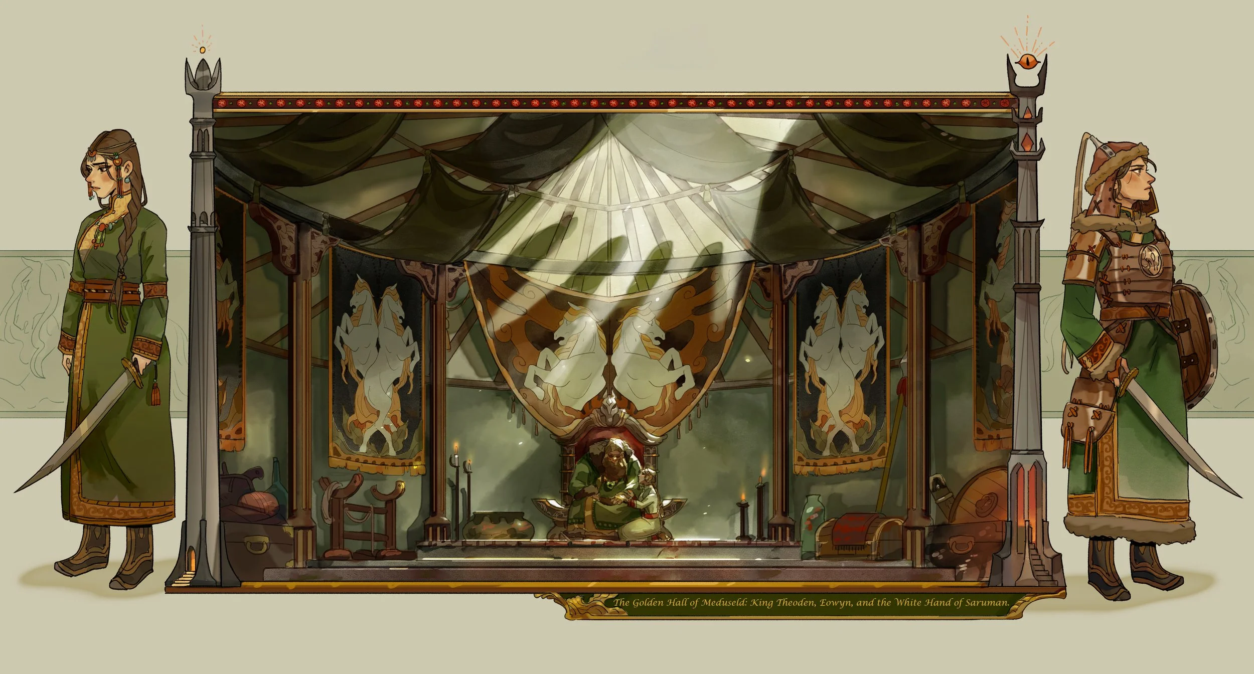
"What is the House of Eorl but a thatched barn where brigands drink in the reek, and their brats roll on the floor among the dogs?" - Saruman the Many-Coloured
An attempt to enter two different competitions in one swoop; The 12x12 category of the Summer Joust, and the Open round of the Middle Earth Lego Olympics.
A little echo to my Eowyn build of previous years: flic.kr/p/2oYPf29
As in previous years, I'm taking inspiration from Leia Ham's LOTR: Middle Kingdom series:
images.squarespace-cdn.com/content/v1/584a5cdbff7c5026f7c...
Castle Beach Fire Department is proud to present the brand new Hazmat 1. Built on a 2017 Spartan Gladiator cab with SVI bodywork, this rig was delivered on May 6, 2017 and replaces the 2016 Seagrave Marauder II Hazmat rig that was totaled in an accident. As the role of the Hazardous Materials Team evolves, so did the apparatus. Differences in the new rig as compared to the previous Seagrave include the addition of a slide-out compartment, which added space for command personnel. While it appears that the rig has less compartmentation than the previous rig, the rig contains the same amount of equipment and still has extra space for new technologies, thanks to the awesome work of the manufacturer! This apparatus can serve multiple roles on the scene such as a command center, rehab area, mobile laboratory, and a changing area.
Technical specs:
2017 Spartan Gladiator 24" raised roof/SVI Hazmat
Code 3 Lighting
Federal Signal Q2B Siren
Motorola Spectra Siren
Grover Air horns
NightScan PowerLite
Radios and command equipment
Detection cameras (heat sensitive, infrared)
Wilburt Telescoping Pneumatic Mast
Pelco Command Camera System
Climatronics Tecmet II weather station
Battery operated Holmatro extraction tools
Vanair Pro Air Compressor
Harrison On-Board generator
Flow Sciences model FS2009 bench hood
Gas Chromatography/Mass Spectrometer
Extensive library of MSDS handbooks
CO monitors
Level A and B entry suits
Testing equipment and meters
60 minute air bottles
Leak and spill kits for chlorine and other dangerous chemicals
Sparkless power-tools
Decontamination equipment
Oil Absorbents
Recovery drums
Emulsifiers
Immersion suits
Credit:
Zak O for the compartments
Spartan ERV and SVI for inspiration
Inspired by:
LAFD USAR 88, 2017 Pierce Arrow XT
Elizabeth, NJ FD Rescue 1
Houston, TX Rescue 10
Denver HAMER 1
Seattle Hazmat 1
FDNY Hazmat 1
This is an illuminated and illustrated copy of the Ḫamse (quintet) of the Ottoman Turkish poet and scholar ʿAṭāʾullāh bin Yaḥyá ʿAṭāʾī (d. 1044 AH / 1634 CE). Although different in content, this work takes its inspiration from the famous Persian Khamsah of Niẓāmī Ganjavī (d. 605 AH / 1209 CE) and the Khamsah of Amīr Khusraw Dihlavī (d. 725 AH / 1325 CE). This Ottoman copy of ʿAṭāʾī's work ends with a portion of his Dīvān (fols. 142b-151b) instead of the fifth poem (mesnevi), Ḥilyet ül-efkār. The text, written in nastaʿlīq script, was copied by Ḫeyrullah Ḫeyrī Çāvuşzade in 1133 AH / 1721 CE. There are thirty-eight illustrations, and illuminated incipits introduce the different poems (fols. 1b, 22b, 63b, 107b, and 142b). The brown leather binding is original to the manuscript.
This illustration depicts the Ottoman fleet, led by Hüseyn Paşa, setting out from the Black Sea against the Polish army.
To explore fully digitized manuscripts with a virtual page-turning application, please visit Walters Ex Libris.
This is a closeup from the same series I posted from last night. This time I used a program for toning the image to imitate a black and white selenium toned print.. then pulled back the effect quite a bit, before removing the effect totally in the middle section and the top seeds, using a large sized application of Photoshop's Art History brush. You can still see the desaturated look of the toning around the edges, which helps the fully colorful middle feel all the richer and alive.
Cleo is mad at me because I took her to the vet for her annual vaccination. Now she is punishing me by being an ungrateful sourpuss ! I tried to enlighten her mood with some extra delicious prawns but that didn't really work ! So apparently all I can do is wait until my cat is prepared to talk to me again. Might take several days because Miss Cleo is a master of psychological warfare !
This is an old cigar box a friend gave me many years ago.
I have used it to hold various items.
On the top, bottom left is says: Hand Made. In the circle on the top it says: NOYO MONTERREY de JOSE GENER. Under the circle it says: EXCALIBUR. In the upper right it says :Limited Edition.
On the front it says: No. IV. Under that is says: EXCLUSIVE ENGLISH CLARO WRAPS GROWN FROM VINTAGE HAVANA SEED.
On the side it says: No. IV ENGLISH CLARO.
On the bottom it says : NET CONTENTS 20 CIGARS
IMPORTED MADE BY HAND: Danby Pallcio
Made by hand in Spanish Honduras
++++++ Form Wikipedia +++++
Kalaw (Burmese: ကလောမြို့; Shan: ၵလေႃး [ka lɔ]) is a hill town in the Shan State of Myanmar. It is located in Kalaw Township in Taunggyi District.
Kalaw
ကလောမြို့
Kalaw 21.jpg
Kalaw is located in Myanmar
Kalaw
Location in Myanmar
Coordinates: 20°38′N 96°34′E
Country Myanmar
Division Shan State
Districts Taunggyi District
Township Kalaw Township
Population (2005)
• Religions Buddhism
Time zone MST (UTC+6.30)
OverviewEdit
The town was popular with the British during colonial rule. Kalaw is the main setting of the novel "The Art of Hearing Heartbeats" by Jan-Philipp Sendker.
The hill station is located at an elevation of 1320 metres, 50 km from the Inle lake. Kalaw is famous for hiking and trekking.[1]
Kalaw Train station sign altitude.
Myanmar (Burmese pronunciation: [mjəmà]),[nb 1][8] officially the Republic of the Union of Myanmar and also known as Burma, is a sovereign state in Southeast Asia. Myanmar is bordered by India and Bangladesh to its west, Thailand and Laos to its east and China to its north and northeast. To its south, about one third of Myanmar's total perimeter of 5,876 km (3,651 mi) forms an uninterrupted coastline of 1,930 km (1,200 mi) along the Bay of Bengal and the Andaman Sea. The country's 2014 census counted the population to be 51 million people.[9] As of 2017, the population is about 54 million.[10] Myanmar is 676,578 square kilometers (261,228 square miles) in size. Its capital city is Naypyidaw, and its largest city and former capital is Yangon (Rangoon).[1] Myanmar has been a member of the Association of Southeast Asian Nations (ASEAN) since 1997.
Early civilisations in Myanmar included the Tibeto-Burman-speaking Pyu city-states in Upper Burma and the Mon kingdoms in Lower Burma.[11] In the 9th century, the Bamar people entered the upper Irrawaddy valley and, following the establishment of the Pagan Kingdom in the 1050s, the Burmese language, culture and Theravada Buddhism slowly became dominant in the country. The Pagan Kingdom fell due to the Mongol invasions and several warring states emerged. In the 16th century, reunified by the Taungoo Dynasty, the country was for a brief period the largest empire in the history of Mainland Southeast Asia.[12] The early 19th century Konbaung Dynasty ruled over an area that included modern Myanmar and briefly controlled Manipur and Assam as well. The British took over the administration of Myanmar after three Anglo-Burmese Wars in the 19th century and the country became a British colony. Myanmar was granted independence in 1948, as a democratic nation. Following a coup d'état in 1962, it became a military dictatorship.
For most of its independent years, the country has been engrossed in rampant ethnic strife and its myriad ethnic groups have been involved in one of the world's longest-running ongoing civil wars. During this time, the United Nations and several other organisations have reported consistent and systematic human rights violations in the country.[13] In 2011, the military junta was officially dissolved following a 2010 general election, and a nominally civilian government was installed. This, along with the release of Aung San Suu Kyi and political prisoners, has improved the country's human rights record and foreign relations, and has led to the easing of trade and other economic sanctions.[14] There is, however, continuing criticism of the government's treatment of ethnic minorities, its response to the ethnic insurgency, and religious clashes.[15] In the landmark 2015 election, Aung San Suu Kyi's party won a majority in both houses. However, the Burmese military remains a powerful force in politics.
Myanmar is a country rich in jade and gems, oil, natural gas and other mineral resources. In 2013, its GDP (nominal) stood at US$56.7 billion and its GDP (PPP) at US$221.5 billion.[6] The income gap in Myanmar is among the widest in the world, as a large proportion of the economy is controlled by supporters of the former military government.[16] As of 2016, Myanmar ranks 145 out of 188 countries in human development, according to the Human Development Index.[7]
Etymology
Main article: Names of Myanmar
In 1989, the military government officially changed the English translations of many names dating back to Burma's colonial period or earlier, including that of the country itself: "Burma" became "Myanmar". The renaming remains a contested issue.[17] Many political and ethnic opposition groups and countries continue to use "Burma" because they do not recognise the legitimacy of the ruling military government or its authority to rename the country.[18]
In April 2016, soon after taking office, Aung San Suu Kyi clarified that foreigners are free to use either name, "because there is nothing in the constitution of our country that says that you must use any term in particular".[19]
The country's official full name is the "Republic of the Union of Myanmar" (ပြည်ထောင်စုသမ္မတ မြန်မာနိုင်ငံတော်, Pyidaunzu Thanmăda Myăma Nainngandaw, pronounced [pjìdàʊɴzṵ θàɴməda̰ mjəmà nàɪɴŋàɴdɔ̀]). Countries that do not officially recognise that name use the long form "Union of Burma" instead.[20]
In English, the country is popularly known as either "Burma" or "Myanmar" /ˈmjɑːnˌmɑːr/ (About this sound listen).[8] Both these names are derived from the name of the majority Burmese Bamar ethnic group. Myanmar is considered to be the literary form of the name of the group, while Burma is derived from "Bamar", the colloquial form of the group's name.[17] Depending on the register used, the pronunciation would be Bama (pronounced [bəmà]) or Myamah (pronounced [mjəmà]).[17] The name Burma has been in use in English since the 18th century.
Burma continues to be used in English by the governments of many countries, such as Canada and the United Kingdom.[21][22] Official United States policy retains Burma as the country's name, although the State Department's website lists the country as "Burma (Myanmar)" and Barack Obama has referred to the country by both names.[23] The Czech Republic officially uses Myanmar, although its Ministry of Foreign Affairs mentions both Myanmar and Burma on its website.[24] The United Nations uses Myanmar, as do the Association of Southeast Asian Nations, Australia,[25] Russia, Germany,[26] China, India, Bangladesh, Norway,[27] Japan[21] and Switzerland.[28]
Most English-speaking international news media refer to the country by the name Myanmar, including the BBC,[29] CNN,[30] Al Jazeera,[31] Reuters,[32] RT (Russia Today) and the Australian Broadcasting Corporation (ABC)/Radio Australia.[33]
Myanmar is known with a name deriving from Burma as opposed to Myanmar in Spanish, Italian, Romanian, and Greek – Birmania being the local version of Burma in the Spanish language, for example. Myanmar used to be known as "Birmânia" in Portuguese, and as "Birmanie" in French.[34] As in the past, French-language media today consistently use Birmanie.,[35][36]
History
Main article: History of Myanmar
Prehistory
Main articles: Prehistory of Myanmar and Migration period of ancient Burma
Pyu city-states c. 8th century; Pagan is shown for comparison only and is not contemporary.
Archaeological evidence shows that Homo erectus lived in the region now known as Myanmar as early as 750,000 years ago, with no more erectus finds after 75,000 years ago.[37] The first evidence of Homo sapiens is dated to about 11,000 BC, in a Stone Age culture called the Anyathian with discoveries of stone tools in central Myanmar. Evidence of neolithic age domestication of plants and animals and the use of polished stone tools dating to sometime between 10,000 and 6,000 BC has been discovered in the form of cave paintings in Padah-Lin Caves.[38]
The Bronze Age arrived circa 1500 BC when people in the region were turning copper into bronze, growing rice and domesticating poultry and pigs; they were among the first people in the world to do so.[39] Human remains and artefacts from this era were discovered in Monywa District in the Sagaing Division.[40] The Iron Age began around 500 BC with the emergence of iron-working settlements in an area south of present-day Mandalay.[41] Evidence also shows the presence of rice-growing settlements of large villages and small towns that traded with their surroundings as far as China between 500 BC and 200 AD.[42] Iron Age Burmese cultures also had influences from outside sources such as India and Thailand, as seen in their funerary practices concerning child burials. This indicates some form of communication between groups in Myanmar and other places, possibly through trade.[43]
Early city-states
Main articles: Pyu city-states and Mon kingdoms
Around the second century BC the first-known city-states emerged in central Myanmar. The city-states were founded as part of the southward migration by the Tibeto-Burman-speaking Pyu city-states, the earliest inhabitants of Myanmar of whom records are extant, from present-day Yunnan.[44] The Pyu culture was heavily influenced by trade with India, importing Buddhism as well as other cultural, architectural and political concepts, which would have an enduring influence on later Burmese culture and political organisation.[45]
By the 9th century, several city-states had sprouted across the land: the Pyu in the central dry zone, Mon along the southern coastline and Arakanese along the western littoral. The balance was upset when the Pyu came under repeated attacks from Nanzhao between the 750s and the 830s. In the mid-to-late 9th century the Bamar people founded a small settlement at Bagan. It was one of several competing city-states until the late 10th century when it grew in authority and grandeur.[46]
Imperial Burma
Main articles: Pagan Kingdom, Taungoo Dynasty, and Konbaung Dynasty
See also: Ava Kingdom, Hanthawaddy Kingdom, Kingdom of Mrauk U, and Shan States
Pagodas and kyaungs in present-day Bagan, the capital of the Pagan Kingdom.
Pagan gradually grew to absorb its surrounding states until the 1050s–1060s when Anawrahta founded the Pagan Kingdom, the first ever unification of the Irrawaddy valley and its periphery. In the 12th and 13th centuries, the Pagan Empire and the Khmer Empire were two main powers in mainland Southeast Asia.[47] The Burmese language and culture gradually became dominant in the upper Irrawaddy valley, eclipsing the Pyu, Mon and Pali norms by the late 12th century.[48]
Theravada Buddhism slowly began to spread to the village level, although Tantric, Mahayana, Hinduism, and folk religion remained heavily entrenched. Pagan's rulers and wealthy built over 10,000 Buddhist temples in the Pagan capital zone alone. Repeated Mongol invasions (1277–1301) toppled the four-century-old kingdom in 1287.[48]
Temples at Mrauk U.
Pagan's collapse was followed by 250 years of political fragmentation that lasted well into the 16th century. Like the Burmans four centuries earlier, Shan migrants who arrived with the Mongol invasions stayed behind. Several competing Shan States came to dominate the entire northwestern to eastern arc surrounding the Irrawaddy valley. The valley too was beset with petty states until the late 14th century when two sizeable powers, Ava Kingdom and Hanthawaddy Kingdom, emerged. In the west, a politically fragmented Arakan was under competing influences of its stronger neighbours until the Kingdom of Mrauk U unified the Arakan coastline for the first time in 1437.
Early on, Ava fought wars of unification (1385–1424) but could never quite reassemble the lost empire. Having held off Ava, Hanthawaddy entered its golden age, and Arakan went on to become a power in its own right for the next 350 years. In contrast, constant warfare left Ava greatly weakened, and it slowly disintegrated from 1481 onward. In 1527, the Confederation of Shan States conquered Ava itself, and ruled Upper Myanmar until 1555.
Like the Pagan Empire, Ava, Hanthawaddy and the Shan states were all multi-ethnic polities. Despite the wars, cultural synchronisation continued. This period is considered a golden age for Burmese culture. Burmese literature "grew more confident, popular, and stylistically diverse", and the second generation of Burmese law codes as well as the earliest pan-Burma chronicles emerged.[49] Hanthawaddy monarchs introduced religious reforms that later spread to the rest of the country.[50] Many splendid temples of Mrauk U were built during this period.
Taungoo and colonialism
Bayinnaung's Empire in 1580.
Political unification returned in the mid-16th century, due to the efforts of Taungoo, a former vassal state of Ava. Taungoo's young, ambitious king Tabinshwehti defeated the more powerful Hanthawaddy in the Toungoo–Hanthawaddy War (1534–41). His successor Bayinnaung went on to conquer a vast swath of mainland Southeast Asia including the Shan states, Lan Na, Manipur, Mong Mao, the Ayutthaya Kingdom, Lan Xang and southern Arakan. However, the largest empire in the history of Southeast Asia unravelled soon after Bayinnaung's death in 1581, completely collapsing by 1599. Ayutthaya seized Tenasserim and Lan Na, and Portuguese mercenaries established Portuguese rule at Thanlyin (Syriam).
The dynasty regrouped and defeated the Portuguese in 1613 and Siam in 1614. It restored a smaller, more manageable kingdom, encompassing Lower Myanmar, Upper Myanmar, Shan states, Lan Na and upper Tenasserim. The Restored Toungoo kings created a legal and political framework whose basic features would continue well into the 19th century. The crown completely replaced the hereditary chieftainships with appointed governorships in the entire Irrawaddy valley, and greatly reduced the hereditary rights of Shan chiefs. Its trade and secular administrative reforms built a prosperous economy for more than 80 years. From the 1720s onward, the kingdom was beset with repeated Meithei raids into Upper Myanmar and a nagging rebellion in Lan Na. In 1740, the Mon of Lower Myanmar founded the Restored Hanthawaddy Kingdom. Hanthawaddy forces sacked Ava in 1752, ending the 266-year-old Toungoo Dynasty.
A British 1825 lithograph of Shwedagon Pagoda shows British occupation during the First Anglo-Burmese War.
After the fall of Ava, the Konbaung–Hanthawaddy War involved one resistance group under Alaungpaya defeating the Restored Hanthawaddy, and by 1759, he had reunited all of Myanmar and Manipur, and driven out the French and the British, who had provided arms to Hanthawaddy. By 1770, Alaungpaya's heirs had subdued much of Laos (1765) and fought and won the Burmese–Siamese War (1765–67) against Ayutthaya and the Sino-Burmese War (1765–69) against Qing China (1765–1769).[51]
With Burma preoccupied by the Chinese threat, Ayutthaya recovered its territories by 1770, and went on to capture Lan Na by 1776. Burma and Siam went to war until 1855, but all resulted in a stalemate, exchanging Tenasserim (to Burma) and Lan Na (to Ayutthaya). Faced with a powerful China and a resurgent Ayutthaya in the east, King Bodawpaya turned west, acquiring Arakan (1785), Manipur (1814) and Assam (1817). It was the second-largest empire in Burmese history but also one with a long ill-defined border with British India.[52]
The breadth of this empire was short lived. Burma lost Arakan, Manipur, Assam and Tenasserim to the British in the First Anglo-Burmese War (1824–1826). In 1852, the British easily seized Lower Burma in the Second Anglo-Burmese War. King Mindon Min tried to modernise the kingdom, and in 1875 narrowly avoided annexation by ceding the Karenni States. The British, alarmed by the consolidation of French Indochina, annexed the remainder of the country in the Third Anglo-Burmese War in 1885.
Konbaung kings extended Restored Toungoo's administrative reforms, and achieved unprecedented levels of internal control and external expansion. For the first time in history, the Burmese language and culture came to predominate the entire Irrawaddy valley. The evolution and growth of Burmese literature and theatre continued, aided by an extremely high adult male literacy rate for the era (half of all males and 5% of females).[53] Nonetheless, the extent and pace of reforms were uneven and ultimately proved insufficient to stem the advance of British colonialism.
British Burma (1824–1948)
Main articles: British rule in Burma and Burma Campaign
Burma in British India
The landing of British forces in Mandalay after the last of the Anglo-Burmese Wars, which resulted in the abdication of the last Burmese monarch, King Thibaw Min.
British troops firing a mortar on the Mawchi road, July 1944.
The eighteenth century saw Burmese rulers, whose country had not previously been of particular interest to European traders, seek to maintain their traditional influence in the western areas of Assam, Manipur and Arakan. Pressing them, however, was the British East India Company, which was expanding its interests eastwards over the same territory. Over the next sixty years, diplomacy, raids, treaties and compromises continued until, after three Anglo-Burmese Wars (1824–1885), Britain proclaimed control over most of Burma.[54] British rule brought social, economic, cultural and administrative changes.
With the fall of Mandalay, all of Burma came under British rule, being annexed on 1 January 1886. Throughout the colonial era, many Indians arrived as soldiers, civil servants, construction workers and traders and, along with the Anglo-Burmese community, dominated commercial and civil life in Burma. Rangoon became the capital of British Burma and an important port between Calcutta and Singapore.
Burmese resentment was strong and was vented in violent riots that paralysed Yangon (Rangoon) on occasion all the way until the 1930s.[55] Some of the discontent was caused by a disrespect for Burmese culture and traditions such as the British refusal to remove shoes when they entered pagodas. Buddhist monks became the vanguards of the independence movement. U Wisara, an activist monk, died in prison after a 166-day hunger strike to protest against a rule that forbade him to wear his Buddhist robes while imprisoned.[56]
Separation of British Burma from British India
On 1 April 1937, Burma became a separately administered colony of Great Britain and Ba Maw the first Prime Minister and Premier of Burma. Ba Maw was an outspoken advocate for Burmese self-rule and he opposed the participation of Great Britain, and by extension Burma, in World War II. He resigned from the Legislative Assembly and was arrested for sedition. In 1940, before Japan formally entered the Second World War, Aung San formed the Burma Independence Army in Japan.
A major battleground, Burma was devastated during World War II. By March 1942, within months after they entered the war, Japanese troops had advanced on Rangoon and the British administration had collapsed. A Burmese Executive Administration headed by Ba Maw was established by the Japanese in August 1942. Wingate's British Chindits were formed into long-range penetration groups trained to operate deep behind Japanese lines.[57] A similar American unit, Merrill's Marauders, followed the Chindits into the Burmese jungle in 1943.[58] Beginning in late 1944, allied troops launched a series of offensives that led to the end of Japanese rule in July 1945. The battles were intense with much of Burma laid waste by the fighting. Overall, the Japanese lost some 150,000 men in Burma. Only 1,700 prisoners were taken.[59]
Although many Burmese fought initially for the Japanese as part of the Burma Independence Army, many Burmese, mostly from the ethnic minorities, served in the British Burma Army.[60] The Burma National Army and the Arakan National Army fought with the Japanese from 1942 to 1944 but switched allegiance to the Allied side in 1945. Under Japanese occupation, 170,000 to 250,000 civilians died.[61]
Following World War II, Aung San negotiated the Panglong Agreement with ethnic leaders that guaranteed the independence of Myanmar as a unified state. Aung Zan Wai, Pe Khin, Bo Hmu Aung, Sir Maung Gyi, Dr. Sein Mya Maung, Myoma U Than Kywe were among the negotiators of the historical Panglong Conference negotiated with Bamar leader General Aung San and other ethnic leaders in 1947. In 1947, Aung San became Deputy Chairman of the Executive Council of Myanmar, a transitional government. But in July 1947, political rivals[62] assassinated Aung San and several cabinet members.[63]
Independence (1948–1962)
Main article: Post-independence Burma, 1948–62
British governor Hubert Elvin Rance and Sao Shwe Thaik at the flag raising ceremony on 4 January 1948 (Independence Day of Burma).
On 4 January 1948, the nation became an independent republic, named the Union of Burma, with Sao Shwe Thaik as its first President and U Nu as its first Prime Minister. Unlike most other former British colonies and overseas territories, Burma did not become a member of the Commonwealth. A bicameral parliament was formed, consisting of a Chamber of Deputies and a Chamber of Nationalities,[64] and multi-party elections were held in 1951–1952, 1956 and 1960.
The geographical area Burma encompasses today can be traced to the Panglong Agreement, which combined Burma Proper, which consisted of Lower Burma and Upper Burma, and the Frontier Areas, which had been administered separately by the British.[65]
In 1961, U Thant, then the Union of Burma's Permanent Representative to the United Nations and former Secretary to the Prime Minister, was elected Secretary-General of the United Nations, a position he held for ten years.[66] Among the Burmese to work at the UN when he was Secretary-General was a young Aung San Suu Kyi (daughter of Aung San), who went on to become winner of the 1991 Nobel Peace Prize.
When the non-Burman ethnic groups pushed for autonomy or federalism, alongside having a weak civilian government at the centre, the military leadership staged a coup d’état in 1962. Though incorporated in the 1947 Constitution, successive military governments construed the use of the term ‘federalism’ as being anti-national, anti-unity and pro-disintegration.[67]
Military rule (1962–2011)
On 2 March 1962, the military led by General Ne Win took control of Burma through a coup d'état, and the government has been under direct or indirect control by the military since then. Between 1962 and 1974, Myanmar was ruled by a revolutionary council headed by the general. Almost all aspects of society (business, media, production) were nationalised or brought under government control under the Burmese Way to Socialism,[68] which combined Soviet-style nationalisation and central planning.
A new constitution of the Socialist Republic of the Union of Burma was adopted in 1974. Until 1988, the country was ruled as a one-party system, with the General and other military officers resigning and ruling through the Burma Socialist Programme Party (BSPP).[69] During this period, Myanmar became one of the world's most impoverished countries.[70]
Protesters gathering in central Rangoon, 1988.
There were sporadic protests against military rule during the Ne Win years and these were almost always violently suppressed. On 7 July 1962, the government broke up demonstrations at Rangoon University, killing 15 students.[68] In 1974, the military violently suppressed anti-government protests at the funeral of U Thant. Student protests in 1975, 1976, and 1977 were quickly suppressed by overwhelming force.[69]
In 1988, unrest over economic mismanagement and political oppression by the government led to widespread pro-democracy demonstrations throughout the country known as the 8888 Uprising. Security forces killed thousands of demonstrators, and General Saw Maung staged a coup d'état and formed the State Law and Order Restoration Council (SLORC). In 1989, SLORC declared martial law after widespread protests. The military government finalised plans for People's Assembly elections on 31 May 1989.[71] SLORC changed the country's official English name from the "Socialist Republic of the Union of Burma" to the "Union of Myanmar" in 1989.
In May 1990, the government held free elections for the first time in almost 30 years and the National League for Democracy (NLD), the party of Aung San Suu Kyi, won 392 out of a total 492 seats (i.e., 80% of the seats). However, the military junta refused to cede power[72] and continued to rule the nation as SLORC until 1997, and then as the State Peace and Development Council (SPDC) until its dissolution in March 2011.
Protesters in Yangon during the 2007 Saffron Revolution with a banner that reads non-violence: national movement in Burmese. In the background is Shwedagon Pagoda.
On 23 June 1997, Myanmar was admitted into the Association of Southeast Asian Nations (ASEAN). On 27 March 2006, the military junta, which had moved the national capital from Yangon to a site near Pyinmana in November 2005, officially named the new capital Naypyidaw, meaning "city of the kings".[73]
Cyclone Nargis in southern Myanmar, May 2008.
In August 2007, an increase in the price of diesel and petrol led to the Saffron Revolution led by Buddhist monks that were dealt with harshly by the government.[74] The government cracked down on them on 26 September 2007. The crackdown was harsh, with reports of barricades at the Shwedagon Pagoda and monks killed. There were also rumours of disagreement within the Burmese armed forces, but none was confirmed. The military crackdown against unarmed protesters was widely condemned as part of the international reactions to the Saffron Revolution and led to an increase in economic sanctions against the Burmese Government.
In May 2008, Cyclone Nargis caused extensive damage in the densely populated, rice-farming delta of the Irrawaddy Division.[75] It was the worst natural disaster in Burmese history with reports of an estimated 200,000 people dead or missing, damage totalled to 10 billion US dollars, and as many as 1 million left homeless.[76] In the critical days following this disaster, Myanmar's isolationist government was accused of hindering United Nations recovery efforts.[77] Humanitarian aid was requested but concerns about foreign military or intelligence presence in the country delayed the entry of United States military planes delivering medicine, food, and other supplies.[78]
In early August 2009, a conflict known as the Kokang incident broke out in Shan State in northern Myanmar. For several weeks, junta troops fought against ethnic minorities including the Han Chinese,[79] Wa, and Kachin.[80][81] During 8–12 August, the first days of the conflict, as many as 10,000 Burmese civilians fled to Yunnan province in neighbouring China.[80][81][82]
Civil wars
Main articles: Internal conflict in Myanmar, Kachin Conflict, Karen conflict, and 2015 Kokang offensive
Civil wars have been a constant feature of Myanmar's socio-political landscape since the attainment of independence in 1948. These wars are predominantly struggles for ethnic and sub-national autonomy, with the areas surrounding the ethnically Bamar central districts of the country serving as the primary geographical setting of conflict. Foreign journalists and visitors require a special travel permit to visit the areas in which Myanmar's civil wars continue.[83]
In October 2012, the ongoing conflicts in Myanmar included the Kachin conflict,[84] between the Pro-Christian Kachin Independence Army and the government;[85] a civil war between the Rohingya Muslims, and the government and non-government groups in Rakhine State;[86] and a conflict between the Shan,[87] Lahu, and Karen[88][89] minority groups, and the government in the eastern half of the country. In addition, al-Qaeda signalled an intention to become involved in Myanmar. In a video released on 3 September 2014, mainly addressed to India, the militant group's leader Ayman al-Zawahiri said al-Qaeda had not forgotten the Muslims of Myanmar and that the group was doing "what they can to rescue you".[90] In response, the military raised its level of alertness, while the Burmese Muslim Association issued a statement saying Muslims would not tolerate any threat to their motherland.[91]
Armed conflict between ethnic Chinese rebels and the Myanmar Armed Forces have resulted in the Kokang offensive in February 2015. The conflict had forced 40,000 to 50,000 civilians to flee their homes and seek shelter on the Chinese side of the border.[92] During the incident, the government of China was accused of giving military assistance to the ethnic Chinese rebels. Burmese officials have been historically "manipulated" and pressured by the Chinese government throughout Burmese modern history to create closer and binding ties with China, creating a Chinese satellite state in Southeast Asia.[93] However, uncertainties exist as clashes between Burmese troops and local insurgent groups continue.
Democratic reforms
Main article: 2011–12 Burmese political reforms
The goal of the Burmese constitutional referendum of 2008, held on 10 May 2008, is the creation of a "discipline-flourishing democracy". As part of the referendum process, the name of the country was changed from the "Union of Myanmar" to the "Republic of the Union of Myanmar", and general elections were held under the new constitution in 2010. Observer accounts of the 2010 election describe the event as mostly peaceful; however, allegations of polling station irregularities were raised, and the United Nations (UN) and a number of Western countries condemned the elections as fraudulent.[94]
U.S. President Barack Obama and Secretary of State Hillary Clinton with Aung San Suu Kyi and her staff at her home in Yangon, 2012
The military-backed Union Solidarity and Development Party declared victory in the 2010 elections, stating that it had been favoured by 80 percent of the votes; however, the claim was disputed by numerous pro-democracy opposition groups who asserted that the military regime had engaged in rampant fraud.[95][96] One report documented 77 percent as the official turnout rate of the election.[95] The military junta was dissolved on 30 March 2011.
Opinions differ whether the transition to liberal democracy is underway. According to some reports, the military's presence continues as the label "disciplined democracy" suggests. This label asserts that the Burmese military is allowing certain civil liberties while clandestinely institutionalising itself further into Burmese politics. Such an assertion assumes that reforms only occurred when the military was able to safeguard its own interests through the transition—here, "transition" does not refer to a transition to a liberal democracy, but transition to a quasi-military rule.[97]
Since the 2010 election, the government has embarked on a series of reforms to direct the country towards liberal democracy, a mixed economy, and reconciliation, although doubts persist about the motives that underpin such reforms. The series of reforms includes the release of pro-democracy leader Aung San Suu Kyi from house arrest, the establishment of the National Human Rights Commission, the granting of general amnesties for more than 200 political prisoners, new labour laws that permit labour unions and strikes, a relaxation of press censorship, and the regulation of currency practices.[98]
The impact of the post-election reforms has been observed in numerous areas, including ASEAN's approval of Myanmar's bid for the position of ASEAN chair in 2014;[99] the visit by United States Secretary of State Hillary Clinton in December 2011 for the encouragement of further progress, which was the first visit by a Secretary of State in more than fifty years,[100] during which Clinton met with the Burmese president and former military commander Thein Sein, as well as opposition leader Aung San Suu Kyi;[101] and the participation of Aung San Suu Kyi's National League for Democracy (NLD) party in the 2012 by-elections, facilitated by the government's abolition of the laws that previously barred the NLD.[102] As of July 2013, about 100[103][104] political prisoners remain imprisoned, while conflict between the Burmese Army and local insurgent groups continues.
Map of Myanmar and its divisions, including Shan State, Kachin State, Rakhine State and Karen State.
In 1 April 2012 by-elections, the NLD won 43 of the 45 available seats; previously an illegal organisation, the NLD had not won a single seat under new constitution. The 2012 by-elections were also the first time that international representatives were allowed to monitor the voting process in Myanmar.[105]
2015 general elections
Main article: Myanmar general election, 2015
General elections were held on 8 November 2015. These were the first openly contested elections held in Myanmar since 1990. The results gave the National League for Democracy an absolute majority of seats in both chambers of the national parliament, enough to ensure that its candidate would become president, while NLD leader Aung San Suu Kyi is constitutionally barred from the presidency.[106]
The new parliament convened on 1 February 2016[107] and, on 15 March 2016, Htin Kyaw was elected as the first non-military president since the military coup of 1962.[108] On 6 April 2016, Aung San Suu Kyi assumed the newly created role of State Counsellor, a role akin to a Prime Minister.
Geography
Main article: Geography of Myanmar
A map of Myanmar
Myanmar map of Köppen climate classification.
Myanmar has a total area of 678,500 square kilometres (262,000 sq mi). It lies between latitudes 9° and 29°N, and longitudes 92° and 102°E. As of February 2011, Myanmar consisted of 14 states and regions, 67 districts, 330 townships, 64 sub-townships, 377 towns, 2,914 Wards, 14,220 village tracts and 68,290 villages.
Myanmar is bordered in the northwest by the Chittagong Division of Bangladesh and the Mizoram, Manipur, Nagaland and Arunachal Pradesh states of India. Its north and northeast border is with the Tibet Autonomous Region and Yunnan province for a Sino-Myanmar border total of 2,185 km (1,358 mi). It is bounded by Laos and Thailand to the southeast. Myanmar has 1,930 km (1,200 mi) of contiguous coastline along the Bay of Bengal and Andaman Sea to the southwest and the south, which forms one quarter of its total perimeter.[20]
In the north, the Hengduan Mountains form the border with China. Hkakabo Razi, located in Kachin State, at an elevation of 5,881 metres (19,295 ft), is the highest point in Myanmar.[109] Many mountain ranges, such as the Rakhine Yoma, the Bago Yoma, the Shan Hills and the Tenasserim Hills exist within Myanmar, all of which run north-to-south from the Himalayas.[110]
The mountain chains divide Myanmar's three river systems, which are the Irrawaddy, Salween (Thanlwin), and the Sittaung rivers.[111] The Irrawaddy River, Myanmar's longest river, nearly 2,170 kilometres (1,348 mi) long, flows into the Gulf of Martaban. Fertile plains exist in the valleys between the mountain chains.[110] The majority of Myanmar's population lives in the Irrawaddy valley, which is situated between the Rakhine Yoma and the Shan Plateau.
Administrative divisions
Main article: Administrative divisions of Myanmar
A clickable map of Burma/Myanmar exhibiting its first-level administrative divisions.
About this image
Myanmar is divided into seven states (ပြည်နယ်) and seven regions (တိုင်းဒေသကြီး), formerly called divisions.[112] Regions are predominantly Bamar (that is, mainly inhabited by the dominant ethnic group). States, in essence, are regions that are home to particular ethnic minorities. The administrative divisions are further subdivided into districts, which are further subdivided into townships, wards, and villages.
Climate
Main article: Climate of Myanmar
The limestone landscape of Mon State.
Much of the country lies between the Tropic of Cancer and the Equator. It lies in the monsoon region of Asia, with its coastal regions receiving over 5,000 mm (196.9 in) of rain annually. Annual rainfall in the delta region is approximately 2,500 mm (98.4 in), while average annual rainfall in the Dry Zone in central Myanmar is less than 1,000 mm (39.4 in). The Northern regions of Myanmar are the coolest, with average temperatures of 21 °C (70 °F). Coastal and delta regions have an average maximum temperature of 32 °C (89.6 °F).[111]
Environment
Further information: Deforestation in Myanmar
Myanmar continues to perform badly in the global Environmental Performance Index (EPI) with an overall ranking of 153 out of 180 countries in 2016; among the worst in the South Asian region, only ahead of Bangladesh and Afghanistan. The EPI was established in 2001 by the World Economic Forum as a global gauge to measure how well individual countries perform in implementing the United Nations' Sustainable Development Goals. The environmental areas where Myanmar performs worst (ie. highest ranking) are air quality (174), health impacts of environmental issues (143) and biodiversity and habitat (142). Myanmar performs best (ie. lowest ranking) in environmental impacts of fisheries (21), but with declining fish stocks. Despite several issues, Myanmar also ranks 64 and scores very good (ie. a high percentage of 93.73%) in environmental effects of the agricultural industry because of an excellent management of the nitrogen cycle.[114][115]
Wildlife
Myanmar's slow economic growth has contributed to the preservation of much of its environment and ecosystems. Forests, including dense tropical growth and valuable teak in lower Myanmar, cover over 49% of the country, including areas of acacia, bamboo, ironwood and Magnolia champaca. Coconut and betel palm and rubber have been introduced. In the highlands of the north, oak, pine and various rhododendrons cover much of the land.[116]
Heavy logging since the new 1995 forestry law went into effect has seriously reduced forest acreage and wildlife habitat.[117] The lands along the coast support all varieties of tropical fruits and once had large areas of mangroves although much of the protective mangroves have disappeared. In much of central Myanmar (the Dry Zone), vegetation is sparse and stunted.
Typical jungle animals, particularly tigers, occur sparsely in Myanmar. In upper Myanmar, there are rhinoceros, wild water buffalo, clouded leopard, wild boars, deer, antelope, and elephants, which are also tamed or bred in captivity for use as work animals, particularly in the lumber industry. Smaller mammals are also numerous, ranging from gibbons and monkeys to flying foxes. The abundance of birds is notable with over 800 species, including parrots, myna, peafowl, red junglefowl, weaverbirds, crows, herons, and barn owl. Among reptile species there are crocodiles, geckos, cobras, Burmese pythons, and turtles. Hundreds of species of freshwater fish are wide-ranging, plentiful and are very important food sources.[118] For a list of protected areas, see List of protected areas of Myanmar.
Government and politics
Main article: Politics of Myanmar
Assembly of the Union (Pyidaungsu Hluttaw)
The constitution of Myanmar, its third since independence, was drafted by its military rulers and published in September 2008. The country is governed as a parliamentary system with a bicameral legislature (with an executive President accountable to the legislature), with 25% of the legislators appointed by the military and the rest elected in general elections.
366 2024 - The Future is Now - Day 80 March 20 - This junk store in town is really fun to wonder through!
This is Pullman Yard, an old freight train warehouse that is now locked down and inaccessible. That being said, it seems to be frequented by graffiti artists, druggies, the random photographer, movie crews, and odd couples on odd dates... Hit it up with a fellow Flickr buddy one Saturday afternoon. I left the entrance permit at home but I swear I had it...
It is funny how even the most manufactured artificial place can get retaken by nature if you just give it time. This is all still indoors, but this warehouse is now owned by the graffiti artists and plants.
This is a build up of sewerage waste that gets pumped into the estuary at the Avon-Heathcote river outlets. Never thought i'd say it, but, there is some beauty in shit!!! This smells so bad but makes for a great picture. I'm not in a hurry to tread through this again!!
It is a little less than 15" tall and very cute. When I realized that, through a variety of family plans, I was going to spend Christmas Day alone, I decided I would take my little tiny Christmas Tree with me and go to a favorite spot. I love covered bridges; so that Is what I did. I put my little tree in all different nooks and crannies of the bridge and the approach to the bridge from each side.
One time, after carefully observing that no one was about to drive through, and by the way it is an active bridge as far as pretty regular traffic; I decided to place it smack dab in the middle of the entrance to the bridge. Did it ever look tiny in that position! When I looked over my pictures later, I could barely see it. That just made me laugh, and all in all I had a very happy day.
I'm going to put the above description/explanation with each picture that involves my very colorful and very tiny little Christmas tree. That way, no matter which picture of it they look at, there will be something to explain what is going on.
(DSCN4453TinyXmasTreenotstoptraffbutproudflickr122916)
The red building in front is the Pierhead Building and is a Grade 1 listed building and stands as one of the City of Cardiff's most familiar landmarks. Built in 1897 as the headquarters for the Bute Dock Company. The Bute Dock Company was later renamed the Cardiff Railway Company. The Pierhead became the administrative office for the Port of Cardiff in 1947 and was re-opened in May 2001 as a visitor and education centre for the National Assembly. On 1 March 2010, the building re-opened for a second time to the public as a Welsh history museum. Cardiff Bay's export of iron ore and coal exports made Cardiff one of the busiest ports in the world exporting coal from the South Wales Valleys to the rest of the world, helping to power the industrial age. The coal mining industry helped fund the building of Cardiff into the Capital city of Wales and helped the Third Marquis of Bute, who owned the docks, become the richest man in the world. As Cardiff exports grew, so did its population; dockworkers and sailors from across the world settled in neighbourhoods close to the docks, known as Tiger Bay. After the 2nd World War most of the industry closed down and the area became derelict. But, in 1999, Cardiff Bay was redeveloped which included the building of the Cardiff Bay Barrage.
The building on the right is The Senedd (Senate or Parliament) which was opened by the Queen on 1 March 2006 (St David's Day) at the cost of £69 million. It is the main public building of the National Assembly. The Senedd is completely transparent at the public level and sits on a slate plinth. It a sustainable building, built of traditional Welsh materials such as slate and Welsh oak. It is also sustainable in the way it is heated with a earth exchange system uses heat from the bottom of the old dock, on which the Senedd stands. Glinting in the sun in the background is the iconic Wales Millennium Centre. Also in the shot are 2 police boats used to patrol Cardiff Bay during the NATO Summit. Cardiff Bay on the 07.09.2014
Brougham Castle is located about 3 kilometres south-east of Penrith. It was founded in the 13th century by Robert I de Vieuxpont. The site near the confluence of the Eamont and Lowther rivers had already been chosen by the Romans for a fort called Brocavum.
The Vieuxponts were a powerful family of landowners in the north-west of England. When Roger de Clifford married the granddaughter of Robert Vieuxponts in 1269, Brougham Castle fell to the Clifford family.
With the start of the Scottish Wars of Independence in 1296, Brougham Castle became an important military base and impressive stone walls and a large stone gatehouse were added. When the 2nd Baron de Clifford was executed as a traitor in 1322 the family's estates became the property of King Edward II, but were returned when Edward III came to the throne. The region was often threatened by the Scots and in 1388 they captured and plundered the castle.
The castle was passed down through the Clifford family but got neglected in the 17th and 18th century. By the 1750s, Brougham Castle served only as a source of building stone for the village of Brougham.
The 14.28 Felixstowe Town - Ipswich is seen soon after departing from Trimley and passes evidence of the clearance work taking place in advance of the new loop being added. Winter rains have left an unusually inundated field here.
The next service to Felixstowe was terminated at Westerfield and sent back to Ipswich following the failure of 66 595 on 4M89 at Levington which resulted in a 90 minute wait in the cold for the next train back home!
Ariccia (Latin: Aricia) is a town and comune in the Province of Rome, central Italy. It is in the Alban Hills of the Lazio (Latium) region and could be considered an extension of Rome's southeastern suburbs. One of the Castelli Romani towns, Ariccia is located in the regional park known as the "Parco Regionale dei Castelli Romani".
Ariccia is the center of a region that was extremely important in Roman and pre-Roman mythology and religion because of its association with the goddess Diana and the god Virbius. Legend also recalls that it served as a temporary burial place of the Greek hero Orestes (Servius on Aeneid, ii. 116). Ariccia was one of the oldest cities of ancient Latium, and as the leader of the Latin League was a serious contender against Rome during the early days of the Roman Republic.
In modern times, Ariccia has become famous for its porchetta, pork that is slowly roasted with herbs and wild fennel, and it has been known since historical times for its wine. The comune of Ariccia includes the frazioni of Vallericcia and Fontana di Papa. It is bounded by the communes of Albano Laziale, Castel Gandolfo, Genzano di Roma and Marino Laziale.
DO NOT use my pictures without my written permission, these images are under copyright. Contact me if you want to buy or use them. CarloAlessioCozzolino© All rights reserved
Operating the shuttle service between Windsor & Eton Central and Slough is First Great Western Class 165, 165020.
Windsor & Eton Central station is both one of two terminal stations at the royal town of Windsor, but is one of the most beautiful on the UK network, especially considering that a majority of the structure is now devoted to a shopping centre, with trains now pushed to the very extremity of the longest platform!
Windsor & Eton Central is located almost directly across the street from Windsor Castle, and in the past was the primary entrance point for the royals when they travelled to the town by the Royal Train. The other station in the town is Windsor & Eton Riverside, located on the opposite side of the Castle on the banks of the River Thames.
The station was originally opened on the 8th October, 1849, on the completion of the 2.5 mile Great Western Railway branch line from Slough. Construction however was not as smooth as it could have been, thanks largely to considerable opposition from the powers at Eton College who were convinced that the proximity of a railway would lead the Eton boys astray.
An extension of the branch was planned in 1871–72 to connect to the south via Dedworth and Ascot. It was planned to diverge west from the viaduct, just to the south of the river bridge. Despite reaching an advanced stage of design, and with some property purchased plus the construction of a possible station building, the plans were never completed and were abandoned completely by 1914.
Since its opening, the station's name has been changed twice, first to Windsor & Eton in 1904, then to Windsor & Eton Central in 1949. The structure once consisted of five platforms, two island platforms and a single bay platform, as well as an extensive goods yard, with the track access coming from a 2,035-yard brick viaduct and Windsor Railway Bridge, Brunel's oldest surviving railway bridge. The original building was little more than a glorified train shed, but was completely rebuilt by the GWR for Queen Victoria's Diamond Jubilee, with a much grander frontage and an interior reminiscent of Paddington.
Rationalisation of the railways during the 1960's and 70's however took its toll on this once mighty station. The grand trains for various destinations across the Great Western network were replaced by a humdrum collection of DMU services to Slough, and the station itself fell into neglect. Removal of freight services saw the Goods Yard removed and replaced with a coach station in the 60's, whilst in November 1968, Platforms 3 & 4 were taken out of use, followed a year later by Platform 2, these being built on to create a car park. The longest platform (Platform 1) remained in use, but was truncated away from the station building in 1982 when British Railways and Madame Tussauds restored the structure to create the 'Royalty and Railways' exhibition. It was later renamed Royalty and Empire, and recalled the Diamond Jubilee of Queen Victoria in 1897, using displays of wax models and an audio-visual show featuring Audio-Anamatronic figures, the first of their kind seen in Europe at that time. The former ticket office was used as the entrance, and a replica Royal Train was created with a full-size replica steam locomotive GWR 3031 Class named The Queen was built at Steamtown, Carnforth, and this was combined with an ex-South Eastern and Chatham Railway tender and fittings from a GWR tender. This was accompanied by two carriages used to form a replica of the Royal Train. Directly behind the loco was No. 229, a replica coach mounted on an ex-British Railways BG Full Brake underframe and containing waxwork figures of various members of the Royal Family. The second coach was the original Royal Day Saloon No. 9002 that was rescued for the exhibition from a cliff top in Aberporth, Wales.
The exhibition closed in the late 1990's and almost all of the exhibits were taken away. The locomotive The Queen was too expensive to remove, so, rather than being cut up, it was incorporated as a feature of a restaurant on the concourse, and can still be seen today. The remainder of the train was removed however, with the tender cut up for scrap, and Royal Saloon No.9002 preserved at the Museum of the Great Western Railway. It is not known what happened to the replica coach. In 1997 the station was rebuilt again after AXA bought the structure to convert it into a large shopping centre, the current incarnation of the station. Shops and other venues now occupy the former platforms and trackwork, whilst the platform was once again truncated further until now it can only accommodate no more than a three-car train.
Services provided at Windsor & Eton Central are usually no more than a 20 minute shuttle service to Slough, operated primarily by Class 165 and 166 Thames Turbo units of First Great Western.
February's Alphabet Fun
::
This was also going to be my official photo for the SoulPancake project this week ("eat something that makes you gag") but I have to admit, a dead scorpion just kinda tastes like dirty popcorn hulls. Not gross. Certainly my hair stood on end when, out of the corner of my eye, I saw the little guy on his dish waiting for his photo op, but once he became a mere prop -- a fiddly one at that -- and I was getting annoyed with trying to get a decent shot of it and having my lips look sex-aay at the same time, even the visceral runawayrunaway feeling left me.
So...back to the drawing board on that one...
(Oh, and my lip colour ["V is for vermillion!"] is pure carminic acid -- which is made from the ground up shells of cochineal bugs...so it's not going to be bugs...)
::
molly, day 131
This is a Santa Fe (ATSF) depot along the BNSF Transcon in Vaughn, New Mexico. This building is now used as a Maintenance of Way facility for BNSF, and headquarters for track and signal employees.
In 1905, Vaughn, NM was where the Atchison, Topeka & Santa Fe (ATSF) and El Paso & Southern Railroads intersected, the only place in New Mexico where two major railways crossed. It was also a division point for the railroad, with a roundhouse, multiple tracks, and a railroad office. After the arrival of the automobile, it became the town where three US Highways--54, 60, and 285--met.
Vaughn got its name from Major G.W. Vaughn, who was a civil engineer for the ATSF. The two-story depot, a roundhouse, and a Harvey House Hotel were built in 1908.
Serpent Camel Eye of the Sphinx Tiger is a 2021 American contemporary Oriental film directed by Madame Kunst and shot entirely on iPhone. It was released independently on YouTube. In 2022, "Serpent Etc" was included as part of the Parallel Play film screening at Burnt Oak Gallery in California.
watch Serpent Camel Eye Of The Sphinx Tiger: Un Film Oriental (2021) on YouTube!
Original Artists’ Statement
We wanted to make places that don’t exist, with rich iconographies pointing to nowhere. An indeterminate zone (“The Orient”) through which identity can fracture like refracted light. It’s a made up place where there is no there - yet the impacts of orientalism are felt materially, pooling around people and places of need to Other their struggles. This flattening of identity gives calm to the colonial gaze, as dehumanization creates objects and empathy gets in the way of control. Were they just terrorists asking for it, or just objectified massage workers. The gaze doesn’t ask. We wanted to meet and return this gaze to the spectator. Perform the liminalities of self made and imposed identities. Serpent Camel Eye of the Sphinx Tiger.
2021
ANZAC Day is held on the anniversary of the Australian and New Zealand Army Corps’ landing at Gallipoli, Turkey (now Türkiye) on 25 April 1915. The story of ANZAC Day is one of courage and endurance in the face of trauma and tragedy; what was anticipated to be a quick mission to remove Turkey from WWI turned into a battle that caused thousands of casualties on both sides over eight months.
youtu.be/xD8ANMUlK34?feature=shared
When I was a young man I carried my pack
And I lived the free life of a rover
From the murrays green basin to the dusty outback
I waltzed my matilda all over
Then in nineteen fifteen my country said son
It's time to stop rambling 'cause there's work to be
Done
So they gave me a tin hat and they gave me a gun
And they sent me away to the war
And the band played Waltzing Matilda
As we sailed away from the quay
And amidst all the tears and the shouts and the
Cheers
We sailed off to Gallipoli
How well I remember that terrible day
When the blood stained the sand and the water
And how in that hell that they called suvla bay
We were butchered like lambs at the slaughter
Johnny Turk he was ready, he primed himself well
He showered us with bullets, he rained us with
Shells
And in five minutes flat he'd blown us all to hell
Nearly blew us right back to Australia
But the band played waltzing Matilda
As we stopped to bury our slain
And we buried ours and the Turks buried theirs
Then it started all over again
Now those who were living did their best to survive
In that mad world of blood, death and fire
And for seven long weeks I kept myself alive
While the corpses around me piled higher
Then a big Turkish shell knocked me arse over tit
And when I woke up in my hospital bed
And saw what it had done, Christ I wished I was
Dead
Never knew there were worse things than dying
And no more I'll go waltzing Matilda
To the green bushes so far and near
For to hump tent and pegs, a man needs two legs
No more waltzing Matilda for me
So they collected the cripples, the wounded and
Maimed
And they shipped us back home to Australia
The legless, the armless, the blind and insane
Those proud wounded heroes of suvla
And as our ship pulled into circular quay
I looked at the place where me legs used to be
And thank Christ there was nobody waiting for me
To grieve and to mourn and to pity
And the band played Waltzing Matilda
As they carried us down the gangway
But nobody cheered, they just stood and stared
And they turned all their faces away
And now every April I sit on my porch
And I watch the parade pass before me
I see my old comrades, how proudly they march
Reliving the or their dreams of past glory
i see the old men, all twisted and torn
The forgotten heroes of a forgotten war
And the young people ask me, "what are they
Marching for?"
And I ask myself the same question
And the band plays Waltzing Matilda
And the old men still answer to the call
But year after year their numbers get fewer
Some day no one will march there at all
Waltzing Matilda, Waltzing Matilda
Who'll go a-Waltzing Matilda with me?
This is Huka Falls on an over cast morning in april. It's a but fuzzy due to being near the rapids near the bottom and shooting with a holga.
The Light fade in the bottom corner is due a "Fat Roll", All thanks to a take up spool that was just that bit too small...
finally!
she is a little upset after being held hostage with the evil customs people pretty much all of last week.
but Sara was awesome and totally helped me and Jengibre out, and we dodged the ransom.
we will forever be grateful.
thank you <3
:) This is me! A self-portrait.
I'm angry PicMonkey put limits on their free editing now >.< . I gotta start using my Photoshop!
Follow me on Instagram: @brileighmcd
In 2019 is het 75 jaar geleden dat Operation Market Garden plaatsvond. Bij Ede is een grasveld ingericht als tijdelijk vliegveld zoals dat in 1944 was. Diverse historische warbirds, waaronder de Westland Lysander, diverse Mustangs, Hurricanes en Spitfires en een Buchon 109 waren aanwezig. Ook de B-25 van de KLuHV en B-17 Sally B zouden meedoen, maar beide waren helaas verhinderd. Het was deze dag schitterend weer met veel zon, helaas net aan de verkeerde kant waardoor veel tegen het licht in gefotografeerd moest worden. Maar desondanks een prachtige airshow waar we, als deze weer wordt herhaald, zeker bij aanwezig zullen zijn.
2019 marks 75 years since Operation Market Garden took place. At Ede, a lawn has been set up as a temporary airport as it was in 1944. Various historical warbirds, including the Westland Lysander, various Mustangs, Hurricanes and Spitfires and a Buchon 109 were present. The B-25 of the KLuHV and B-17 Sally B would also participate, but both were unfortunately unable to attend. The weather during this day was beautiful with a lot of sun. Unfortunately just on the wrong side, which meant that a lot had to be photographed against the light. But nevertheless a beautiful air show where we will be present if it is repeated again.
Weekend photoshoot in the fall forest done two weeks ago. I really enjoy the new IS shape, so I wanted to do this just to explore it some more.
I also have a new homepage since last time I posted here: www.bilbilder.se
Facebook is still unchanged: www.facebook.com/bilbilder
This is a lovely rural site, friendly staff, friendly locals, not outrageously expensive and a nice place to fill up. The lady who runs the place makes the best flapjack I have ever tasted, now there's a recommendation!
Richard has a photo of this place taken in 2015 when it looked exactly the same, see below. As he says, it looks like a former Shell site. He didn't have that annoying speck of dust on his lens though! There's an image of the garage from 2011 on Geograph.org where the pole sign had a different design but still looked like a former Shell sign.
www.geograph.org.uk/photo/3099898
I went back to this place a couple of days later to buy more flapjack and to take some more photos, they will follow in a few week's time!
www.google.co.uk/maps/@55.0055366,-2.1783829,3a,75y,130.4...
Note, I took this photo on the way back later in the day when the speck of dust had been discovered and removed!
Valley Forge, Pennsylvania is best known as the home to General George Washington's Continental Army for the winters of 1777-1778. Back in those days, large scale combat wasn't conducted during the winter since snow and cold weather presented a logistical nightmare so armies would build up large camps where they could spend the winter. Despite popular belief, the winters during these years weren't especially harsh (the belief that they were is mostly due to America's romanticism of this period). The winters however were full of disease which plagued the troops who were in extremely close proximity to one another. During those two winters at Valley Forge, the Continental Army trained and became an even stronger unit.
I had visited Valley Forge once before (shortly after I graduated high school) but for some reason didn't remember it well. Walking around the park in the summer's high heat and ridiculous humidity was worth it. It's a beautiful place that's fully of amazing history.
ABOUT THE SERIES
In June 2010 Michelle and I traveled to Philadelphia (and surrounding areas) for a summer vacation and to visit her extended family. I'd been to Philadelphia twice before, once in eighth grade and once during college but I only remember bits and pieces of each previous trip. The trip during college was during the 2010 Republican National Convention (I wasn't there for the convention) and I remember the entire city resembling a police state with police everywhere due to all the protests.
Anyway, it was great to return to the city and see some of the surrounding areas I hadn't explored before. We visited during a heatwave (90 degree heat with intense humidity which apparently is a little unusual in June but typical in August) but it was well worth the trip.
Voronezh is a city and the administrative centre of Voronezh Oblast in southwestern Russia straddling the Voronezh River, located 12 kilometers (7.5 mi) from where it flows into the Don River. The city sits on the Southeastern Railway, which connects western Russia with the Urals and Siberia, the Caucasus and Ukraine, and the M4 highway (Moscow–Voronezh–Rostov-on-Don–Novorossiysk). In recent years the city has experienced rapid population growth, rising in 2021 to 1,057,681, up from 889,680 recorded in the 2010 Census, making it the 14th-most populous city in the country.
For many years, the hypothesis of the Soviet historian Vladimir Zagorovsky dominated: he produced the toponym "Voronezh" from the hypothetical Slavic personal name Voroneg. This man allegedly gave the name of a small town in the Chernigov Principality (now the village of Voronizh in Ukraine). Later, in the 11th or 12th century, the settlers were able to "transfer" this name to the Don region, where they named the second city Voronezh, and the river got its name from the city. However, now many researchers criticize the hypothesis, since in reality neither the name of Voroneg nor the second city was revealed, and usually the names of Russian cities repeated the names of the rivers, but not vice versa.
A comprehensive scientific analysis was conducted in 2015–2016 by the historian Pavel Popov. His conclusion: "Voronezh" is a probable Slavic macrotoponym associated with outstanding signs of nature, has a root voron- (from the proto-Slavic vorn) in the meaning of "black, dark" and the suffix -ezh (-azh, -ozh). It was not “transferred” and in the 8th - 9th centuries it marked a vast territory covered with black forests (oak forests) - from the mouth of the Voronezh river to the Voronozhsky annalistic forests in the middle and upper reaches of the river, and in the west to the Don (many forests were cut down). The historian believes that the main "city" of the early town-planning complex could repeat the name of the region – Voronezh. Now the hillfort is located in the administrative part of the modern city, in the Voronezh upland oak forest. This is one of Europe's largest ancient Slavic hillforts, the area of which – more than 9 hectares – 13 times the area of the main settlement in Kyiv before the baptism of Rus.
In it is assumed that the word "Voronezh" means bluing - a technique to increase the corrosion resistance of iron products. This explanation fits well with the proximity to the ancient city of Voronezh of a large iron deposit and the city of Stary Oskol. As well as the name of Voroneț Monastery known for its blue shade.
Folk etymology claims the name comes from combining the Russian words for raven (ворон) and hedgehog (еж) into Воронеж. According to this explanation two Slavic tribes named after the animals used this combination to name the river which later in turn provided the name for a settlement. There is not believed to be any scientific support for this explanation.
In the 16th century, the Middle Don basin, including the Voronezh river, was gradually conquered by Muscovy from the Nogai Horde (a successor state of the Golden Horde), and the current city of Voronezh was established in 1585 by Feodor I as a fort protecting the Muravsky Trail trade route against the slave raids of the Nogai and Crimean Tatars. The city was named after the river.
17th to 19th centuries
In the 17th century, Voronezh gradually evolved into a sizable town. Weronecz is shown on the Worona river in Resania in Joan Blaeu's map of 1645. Peter the Great built a dockyard in Voronezh where the Azov Flotilla was constructed for the Azov campaigns in 1695 and 1696. This fleet, the first ever built in Russia, included the first Russian ship of the line, Goto Predestinatsia. The Orthodox diocese of Voronezh was instituted in 1682 and its first bishop, Mitrofan of Voronezh, was later proclaimed the town's patron saint.
Owing to the Voronezh Admiralty Wharf, for a short time, Voronezh became the largest city of South Russia and the economic center of a large and fertile region. In 1711, it was made the seat of the Azov Governorate, which eventually morphed into the Voronezh Governorate.
In the 19th century, Voronezh was a center of the Central Black Earth Region. Manufacturing industry (mills, tallow-melting, butter-making, soap, leather, and other works) as well as bread, cattle, suet, and the hair trade developed in the town. A railway connected Voronezh with Moscow in 1868 and Rostov-on-Don in 1871.
This is just terrible. I rarely get time to draw or do any "art" anymore. I am not complaining, my life has been very busy and fun mostly. Some challenges too. But I've been wanting to draw some Zentangles and I finally had time today and I think it is terrible. I did it without "strings" thinking it would be easier to be "free" with the patterns, and it is just ugly. All the ones I see online or in books are so beautiful and just flow together nicely.
"Truth is Beauty is the second sculpture in a three-part series featuring singer/dancer Deja Solis, the first of which was Bliss Dance (2010). For Truth is Beauty, Deja stands on her toes, head back, arms raised, in an expression of radical self-acceptance and love. She can do this because she is safe.
With the female body exposed and demystified you will see past what has been objectified and used to disempower: it’s the feeling, energy, strength, power… the person that remains.
These sculptures featuring women safe in the present to express themselves, are meant to help raise consciousness around violence against women, begin a healing process to make room for women’s voices, and ultimately result in a balance of energy that will allow women and men to thrive…
My intent is that these sculptures express this healing energy and inspire us to take action; to finally say enough is enough!" - from www.burningman.com/installations/art_honor.html#680
..taken last night.
the subject "egg" idea from my prince.(korny,haha)
"i made my own scene up there."
*BF and i celebrated our 45th monthsary yesterday.
this one is for him.=)
Here is my baby. He'll be flying the coop soon and leave me an empty-nester. Sigh. It's exciting but kinda sad too. A whole new chapter for us all.
580EX II into a 24" double diffused softbox slightly camera right and above. Triggered HSS via Yongnuo transmitters.
My oh my, it is a mylonite
This fault contact of the Pre-Cambrian gneiss and the late Tertiary to early Quaternary Death Valley sediments is located at the head of the little side canyon shown in the last photograph.
Ignoring the paltry 3 or 4 million years since the sediments on the right were deposited, this contact represents a difference of about 1.7 billion years often written as 1,700 my. It also contains lots of faults besides my own photographic shortcomings. It is the Badwater Turtleback fault surface.
The young sediments on the right have been moving to the right in rotated fault blocks toward the deep Badwater basin. These normal faults all sole out and merge along the contact and the Badwater Turtle fault.
The gneiss here is special with the recrystalized rock showing ductile flowing deformation. We call this kind of gneiss a myolinite.
The deformation is also special here because it abrubtly changes at the lower right hand of the banded black and white rock (the myolinitic gneiss). To the left, the white pegmatites have been squeezed horizontally while in the lower right they are squeezed vertically. If you look very closely at this area, you can see a thin meandering white line that marks the boundary between these two zones. This could be a fault that was later deformed or it may just be an irregularity in the mylonite.
A current theory has some of the deformation in these rocks occuring late, only about 10 million years ago when these rocks were buried more than ten miles deep. The first phase of extension was occuring then and this deformation may represent the deep strain of the extension where the brittle deformation of the overlying fault slowly merges with ductile deformation of the myolinite due to the depth of burial of the rocks.
I took this hike to try and see the gneiss close up. I had no idea that this side canyon contained so many interesting outcrops. It was my own one day exploration complete with unexpected surprises which often accompany exploration.
S0A8942
De Familistère is een enorm woonblok in Guise (Frankrijk). Dit bouwwerk is typisch voor het utopisch socialisme.
De Familistère is een creatie van Jean-Baptiste André Godin. Het is geïnspireerd door het werk van Charles Fourier en een uitwerking van de door hem ontworpen Phalanstère, een commune waarin arbeiders gezamenlijk leven, werken en recreëren. Fourier ging ervan uit dat mensen zich kunnen ontplooien wanneer zij op alle belangrijke vlakken van het leven hun 'hartstochten' (lees: voorkeuren) kunnen volgen op ieder moment van de dag. Communebewoners zouden elkaar dan op natuurlijke wijze kunnen aanvullen.
Fouriers ideeën vonden in zijn tijd weinig navolging; behalve de Familistère is een nederzetting in de Verenigde Staten bekend, gesticht door zijn leerling Victor Considérant. Wel heeft het commune-idee postgevat bij linkse bewegingen aan het eind van de 19de en het begin van de 20ste eeuw, bijvoorbeeld de commune Walden waar Frederik van Eeden aan deelnam.
A Ghost's Attempt. We can't be visible coz we are shy! but sometimes we dare! and thats one of it!
Be ready for next part!
Ist Part here : www.flickr.com/photos/san_shad/3989790571/
One of the main Surma / Suri customs is stick fighting. This ritual and sport is called Donga or Sagenai (Saginay). Donga is both the name of the sport and the stick, whereas sagenai is the name of the stick-fighting session. Stick fighting is central in Suri culture. In most cases, stick fighting is a way for warriors to find girlfriends, it can also be a way to settle conflicts. On this occasion men show their courage, their virility and their resistance to pain, to the young women. The fights are held between Suri villages, and begin with 20 to 30 people on each side, and can end up with hundreds of warriors involved. Suri are famous for stick fighting, but they are not the only ones to respect such a custom, as the neighbor tribe, the Mursi, also practice these traditional fights. The day before the sagenai, fighters have to purge themselves. They do it by drinking a special preparation, called dokai, which is made of the bark of a special tree, which is mixed with water. After taking it, warriors make themselves vomiting the drink. The water is supposed to bring with it many of the body’s impurities. After this ritual they don’t eat until the following morning. Warriors walk kilometers to come fighting at Sagenai, which takes place in a clearing. They stop when crossing a river in order to wash themselves, before decorating their bodies for the fight. They decorate themselves by sliding the fingers full of clay on the warrior’s bodies. This dressing up and decoration is meant to show their beauty and virility and thus catch the women’s attention. The phallic shape ending the sticks contributes to that virile demonstration. Fighters arrive on the Donga field all together, carrying the strongest man,dancing and singing. Some fighters wear colourful headdresses sometimes with feathers on it, and also knee-protectors. But most of them use no protection at all and fight completely naked in order to show their bravery. They also wear strings of decorative coloured beads around their necks given by the girls and waist, but their genitals are most of the time uncovered and they are barefoot. All of them get a chance to fight one on one, against someone from the other side. In the beginning each fighter looks for an opponent of the same stature, and exchanges a few held back blows with him in order to test him. If both fighters feel they have found a match, they suddendly throw themselves into the fight, hitting ferocious fast strokes with their sticks. If one of the warriors knocked out or puts paid to his opponent, he immediately declares himself the winner. Sagenai consists in qualifying rounds, each winner fighting the winner of a previous fight, until two finalists are left. It is strictly forbidden to hit a man when he is down on the ground. During these fights there are referees present to make sure all rules are being followed. Many stick fights end within the first couple of hits. Nevertheless the fights are really violent, and it is quite usual to see men bleeding. Stick fighting has proven to be dangerous because people have died from being hit in the stomach. Loosing an eye or a leg during the fight is quite common, although it is strictly forbidden for a fighter to kill his opponent, and if a fighter gets killed during the fight, his opponent and all his family are banned from the village for life. For the other locals, especially teenagers, sagenai is a great outing. Girls watch the fights, but it is also the occasion to check out the men, and to meet in order to chat or even gossip. At the end of the fights, the winners point their phallic sticks in direction of the girls they want to date with, if the girl put a necklace around the stick, it means she is willing to date the champion.
© Eric Lafforgue