View allAll Photos Tagged HIGHEST
At the highest and most isolated permanent settlement inhabited in Bosnia & Hercegovina at Bjelasnica a height of 1469 m above sea level.It is deemed to be one of the longest continually inhabited villages in all of Europe.
Mullayanagiri is the highest peak in Karnataka, India. It is located in the Baba Budan Giri Range. With a height of 1930 m (6317 ft.), it is the hightest peak between the Himalayas and the Nilgiris.
This pic was taken during my trek from Mullayanagiri to Bababudangiri..
Highest position on Explore: 489 on Tuesday, May 3, 2016.
©2016 Muktasyaf Ibrahim AnNamir™
Not to be used or reproduced without written permission.
My | Facebook | GettyImages | 500px | deviantART | Instagram | Tumblr | SoundCloud | YouTube |
_______________________________________________
THUMB this up? OR View Original Large?
_______________________________________________
Another series of my 3D Stereophoto. Captured during sunrise hour at Masjid As-Salam, Puchong, Malaysia.
Me:
Thanks for your kind visit and support =)
All comments, criticism and tips for improvements are welcome.
---------------------------------------------------------------------- --------------------------
• Feel free to view my BEST INTERESTING SHOTS according to Flickr: Search here:
---------------------------------------------------------------------- --------------------------
- Search for ISLAM
- Search for MALAYSIA
- Search for 7D
- Search for 350D
- Search for 500D
- Search for KITLENS
- Search for MASJID
- Search for MOSQUE
- Search for HDR
- Search for HANDHELD
- and search for AnNamir ;p
---------------------------------------------------------------------- --------------------------
© & ® 2016 annamir[at]putera.com s-DSC_6909
Explored
Highest position: 307 on Friday, July 11, 2008
Forgot to Add PLEASE VIEW LARGE
This is a photo, and not much done except for a crop
Again something a little different, at least for me. Let me know what you think
Can't believe I found this song
From 1988 by the Gruesomes (no relation)
the biggest protestant church in Germany, the highest church tower of the world, but even more impressive: the angel and the windows
The trigonometry point on the tower here marks the highest point on Slieve Donard and the highest point in the whole of Northern Ireland. Fantastic views! This side of the tower and wall were covered with frost but the other side was clear.
For a photo story of my hike up Slieve Donard:
Highest voltage out of the cloud - lightnings! Probably liable for humans to be able to handle fire... I hope you enjoy this photo.
Thank you for viewing and commenting! Also favoring is very welcome.
Near Moab, Utah. This view is deeper within the Fisher Towers complex. Climbing is popular and difficult on Fisher Towers. On the far right is Titan Towers with the highest elevation gain. Ancient Art, the small, strange formation to the right of the first peak from the left edge, ranks very high in terms of difficulty.
Thank you very much for your views, faves and comments!
Highest Explore Position #259 ~ On December 17th 2008.
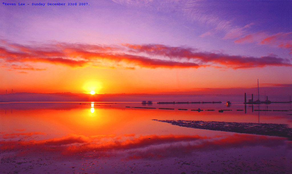
Sunrise over Brest - Brest, Brittany, France - Sunday December 23rd 2007.
Click here to see the Larger image
Click here to see My most interesting images
This is dedicated to my Insane Pink loving chum Cherish ~ www.flickr.com/photos/cherishlovespink/ ~...seeing as she asked nicely..lol..:O)))
The Großglockner is at a height of 3798 m above sea level. A. the highest mountain in Austria. The striking tip of rocks from the green slate facies belongs to the Glockner Group, a mountain range in the central part of the Hohe Tauern, and is considered to be one of the most important peaks in the Eastern Alps. Since the first explorations at the end of the 18th Wikipedia
Height: 3,798 m
First ascent: July 28, 1800
Der Großglockner ist mit einer Höhe von 3798 m ü. A. der höchste Berg Österreichs. Die markante Spitze aus Gesteinen der Grünschieferfazies gehört zur Glocknergruppe, einer Bergkette im mittleren Teil der Hohen Tauern, und gilt als einer der bedeutendsten Gipfel der Ostalpen. Seit den ersten Erkundungen Ende des 18. Wikipedia
Höhe: 3.798 m
Erstbesteigung: 28. Juli 1800
Dent Railway Station - Settle-Carlisle Railway - the highest mainland station in England
The station was first opened for public use on 6th August 1877. It was closed in 1970 and re-opened in 1986 at which time the station was sold by Railtrack.
Apart from being Britain’s highest mainline station at 1150 feet above sea level, it is unusual in that it is situated four miles away and 600 feet higher than the actual village of Dent
Looking down from The Peak, highest point on Hong Kong Island, towards the Skyline of Hong Kong Island.
As early as the 19th century, the Peak attracted prominent European residents because of its panoramic view over the city and its temperate climate compared to the sub-tropical climate in the rest of Hong Kong. The sixth Governor of Hong Kong, Sir Richard MacDonnell had a summer residence built on the Peak circa 1868. Those that built houses named them whimsically, such as The Eyrie, and the Austin Arms. These original residents reached their homes by sedan chairs, which were carried up and down the steep slope of Victoria Peak. This limited development of the Peak until the opening of the Peak Tram funicular in 1888.
The boost to accessibility caused by the opening of the Peak Tram created demand for residences on the Peak. Between 1904 and 1930, the Peak Reservation Ordinance designated the Peak as an exclusive residential area reserved for non-Chinese. They also reserved the Peak Tram for the use of such passengers during peak periods. The Peak remains an upmarket residential area, although residency today is based on wealth.
The Peak is home to many species of birds, most prominently the black kite, and numerous species of butterflies. Wild boar and porcupines are also seen, along with a variety of snakes.
With seven million visitors every year, the Peak is a major tourist attraction of Hong Kong with its views of the city and its waterfront. The viewing deck also has coin-operated telescopes that the visitors can use to enjoy the cityscape. The number of visitors led to the construction of two major leisure and shopping centres, the Peak Tower and the Peak Galleria, situated adjacent to each other.
The Peak Tower incorporates the upper station of the Peak Tram, whilst the Peak Galleria incorporates the bus station used by the Hong Kong public buses and green minibuses on the Peak. The Peak is also accessible by taxi and private car via the circuitous Peak Road, or by walking up the steep Old Peak Road from near the Zoological Botanical Gardens or the Central Green Trail from Hong Kong Park.
Victoria Peak Garden is located on the site of Mountain Lodge, the Governor's old summer residence, and is the closest publicly accessible point to the summit. It can be reached from Victoria Gap by walking up Mount Austin Road, a climb of about 150 metres. Another popular walk is the level loop along Lugard and Harlech Roads, giving good views of the entire Hong Kong Harbour and Kowloon, as well as Lantau and Lamma Islands, encircling the summit at the level of the Peak Tower.
Information Source:
Khinalug is a small village with about 2,000 inhabitants in the Caucasus Mountains in the northeastern part of Azerbaijan. This completely remote village is located 2250 metres above sea level and is considered the highest settlement in Europe and the Caucasus.
The mountain on the background forms the border between Azerbaijan and Dagestan (Russia)
Explored! Highest position: 474th of Thursday, February 22, 2018 (reached this mark on Friday, February 23, 2018).
My hometown, Schoonhoven, has a moat. In early days, it enclosed the old city center, as a protection against intruders. Together with the city walls it was almost impossible to conquer the city.
Nowadays, part of the moat is gone, but a small part of it is still be visible. Even the star-shaped form is visible on maps.
Almost five years ago, the counsil of Schoonhoven agreed to construct a bandstand on the water. It forms a stage for a broad spectrum of music bands. From the adjacent park, you have a perfect view on the bandstand and you can enjoy the atmosphere.
This photo is taken from across the moat, in the direction of the park, the bandstand and the Great St. Bartholomew Church of Schoonhoven.
The highest hostel in Britain. Note the s in the word hostel. There are no luxuries to be found here apart from a hot shower (apparently).
From the website:
"Accessible only on foot or by mountain bike, Britain’s highest hostel is perfect for fell-walkers, adventurous families and lovers of wild and remote places. Skiddaw House is situated at 470m/1550ft on the flanks of Skiddaw and is 3.5 miles from the nearest road. This traditional independent hostel, which is affiliated to the YHA, sits on the Cumbria Way and offers simple, yet comfortable accommodation.
Stay here for a real escape from it all - with no mains electricity, phone signal, TV or internet to detract from the wilderness. Solar panels provide the energy for the lights and plenty of hot water for the showers; heating is provided by wood-burning stoves."
Happy Bench Monday!
The highest mountain in Wales, at an elevation of 1,085 metres (3,560 ft)
The PYG track is one of the busiest routes up, but the views of Snowdon are among the best of any route up.
Explore Highest #429 on October 21, 2009
Best View On Black and Large (updated on my new Photography Portfolio)
This image along with others on my photostream are now available for purchase.
Please check my interestingness page :: HDR Set :: France Set
Please don't use this image on websites, blogs or other media without my explicit permission. Copyright © 2007-2010 Eric Rousset . All rights reserved.
Explore Highest #187 on June 18, 2009
Best View On Black and Large
Please check my interestingness page :: HDR Set :: France Set
Please don't use this image on websites, blogs or other media without my explicit permission. Copyright © 2007-2010 Eric Rousset . All rights reserved.
This is a view from Góry świętokrztyskie's highest mountain Święty Krzyż. Below is "Gołoborze" hill filled with rocks origin from pagan cult before X century.
Highest position on Explore: 329
After months of dormancy, the cyclamen is about to bloom. Thanks to all for the visits, faves, and awards. I will not be commenting for a couple of days as my husband is having surgery to correct a pinched nerve in his neck (at least he's not blaming me for his pain in the neck).