View allAll Photos Tagged ;
Funny position of a mechanic head first in the cockpit of an Alphajet of the Patrouille de France.
I don’t know if the pilot had lost his keys by rolling and looping.
Position amusante d'un mécanicien la tête la première dans le cockpit d'un Alphajet de la Patrouille de France.
Je ne sais pas si à force de faire des tonneaux et des loopings, le pilote avait peut-être perdu ses clés.
Montoir de Bretagne
FRANCE
YouTube | Blog | Workshops | Instagram | Wedding | Patreon | Presets
Can 't find your curlers? Use Coke cans! Model - Ducka, Artists - Lora & Maike. Italy
Thanks to Tobi for lending me his lens! (YT video to come)
Leica SL + 75mm f1.5 Biotar + MrLeica Leica M9 B&W Preset + Godox AD600
Get your FREE copy of my ebook here! - mrleica.com/ebooks/
Trying to catch up my delay ... (which is still very big) ... but I need to post a new photo from time to time ...
Thank you in advance for all your faves and comments. I might answer several WEEKS/MONTHS later. And I might post several photos in the meantime.
Merci d'avance pour tous vos faves et commentaires. Je vous répondrai peut-être dans plusieurs SEMAINES/MOIS. Et je posterai peut-être plusieurs photos entre temps.
Si je le pouvais, j'aimerais partager sur Flickr d'autres photos de cette rando. Mais si je veux publier au moins 1 photo de toutes mes autres randos, ce n'est pas possible avec mon rythme de publication actuel trop faible. Du coup, j'ai publié un album de 72 photos de cette rando sur le site AltitudeRando (où j'ai un compte avec le même pseudo). Voici le lien vers la page de ma sortie, dans laquelle on peut ouvrir l'album de photos (le 2ème lien permet d'ouvrir directement l'album mais je pense qu'il est beaucoup plus susceptible de changer avec le temps que le lien de la sortie) :
www.altituderando.com/rando21732
More photos of this hike (72) there :
www.altituderando.com/spip.php?page=album-photo&id_ra...
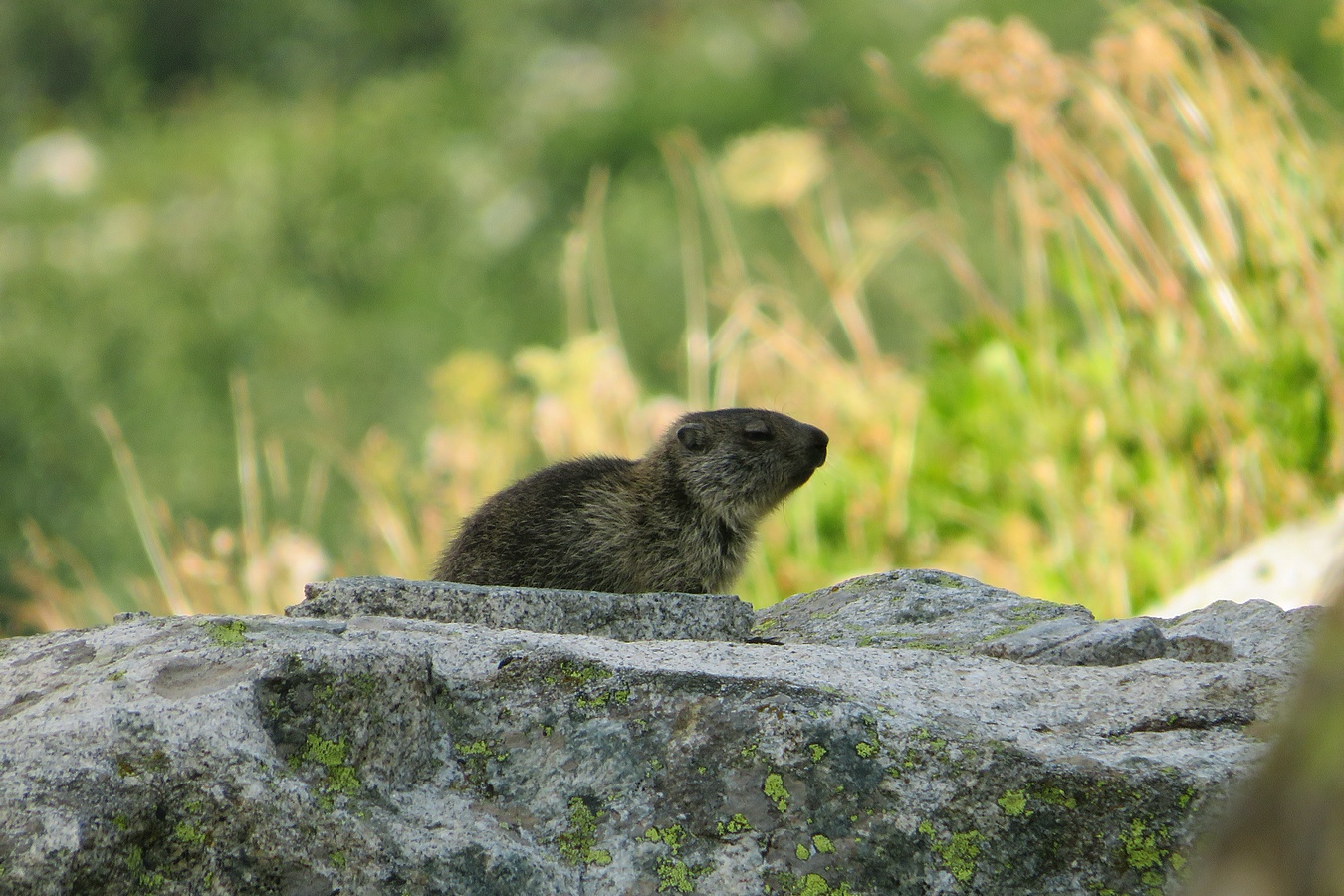
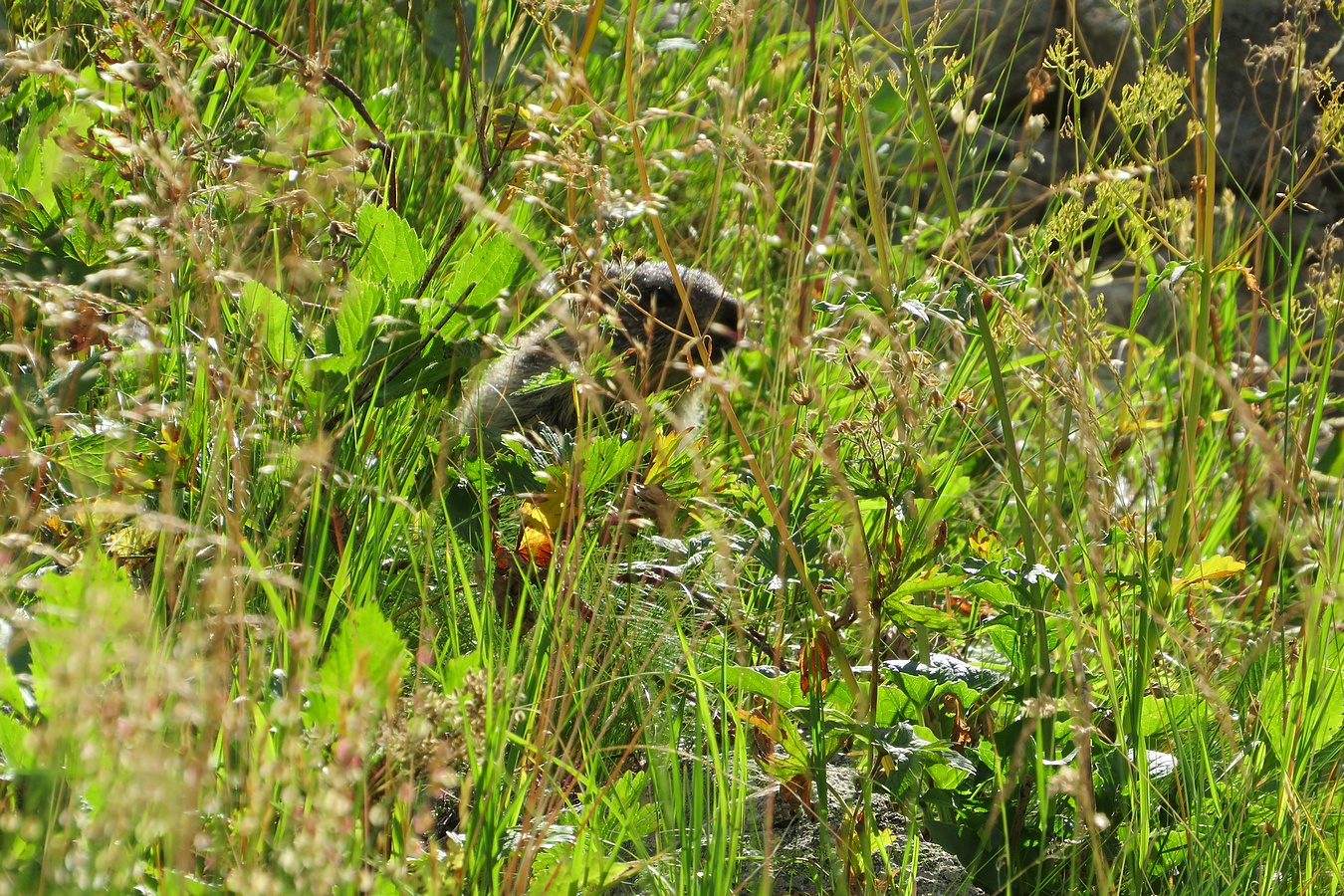
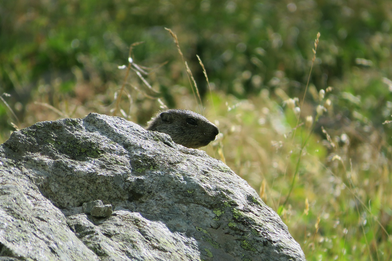
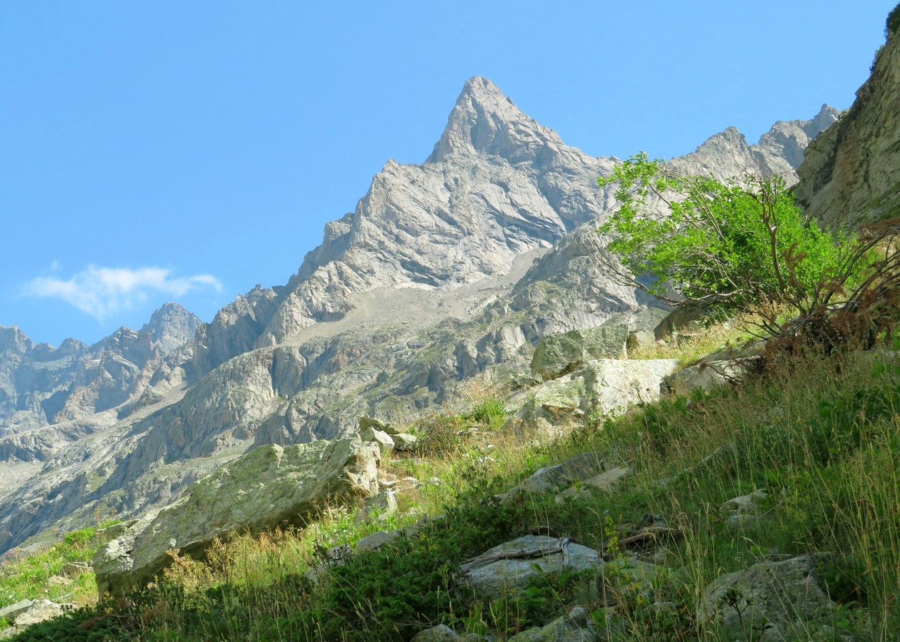
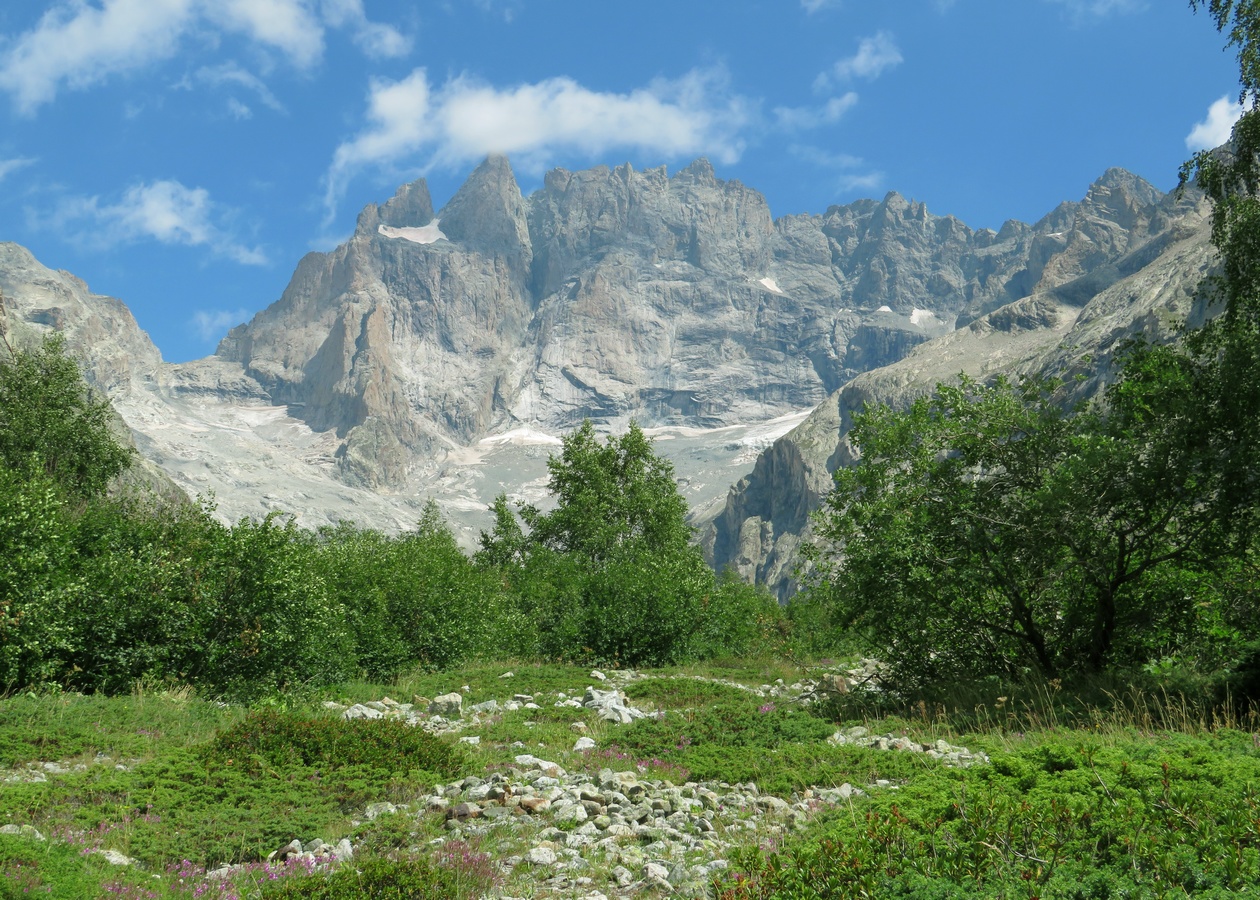
France. Alpes. Département de l'Isère (38). Massif des Écrins. Vallée du Vénéon. Photo prise lors d'une randonnée en aller-retour effectuée en solo, au départ de la Bérarde, jusque vers le Refuge du Châtelleret dans le Vallon des Étançons. C'était mon 13ème jour de rando sur les 18 jours où j'ai pu randonner lors de notre séjour alpin de 3 semaines pendant l'été 2022.
La photo a été prise depuis le Vallon des Étançons en zoomant par-dessus le Vallon de Bonne Pierre.
On y voit 2 sommets de plus de 4000m :
- Le Dôme de Neige des Écrins (4015m) au centre
- Le Pic Lory (4088m) derrière sur sa droite
Quant au point culminant du Massif des Écrins (la Barre des Écrins à 4102m), il est caché derrière car sous ce point de vue, le Dôme et la Barre sont alignés et c'est le Dôme qui se trouve devant.
Cette rando dans le Vallon des Étançons fut assurément une des plus belles de mes 18 randos alpines de l'été 2022. Notamment parce que j'ai pu y voir de nombreux sommets de plus de 3000m, dont plusieurs d'entre eux particulièrement photogéniques, comme ce Dôme de Neige des Écrins sur lequel j'ai flashé. Et puis le parcours m'a permis de voir une grande diversité de décors avec plein d'ingrédients (des torrents, des vallées, des vallons, des cirques, des glaciers, des cascades, des sommets, des cols et des brèches de toutes formes ... bref ... à peu près tout sauf des lacs et des forêts). Et cerise sur le gâteau, j'ai rencontré 2 marmottons pas trop farouches (à moins que ça ne soit le même). J'ai rencontré un 1er marmotton qui se reposait tranquillement sur un rocher. Et un peu plus loin, j'en ai rencontré un 2ème (ou le même) qui jouait à cache-cache dans les herbes puis derrière les rochers. 😊
Pour illustration, voici une sélection de 5 des 72 photos de mon album sur AltitudeRando (3 photos de marmotton, 1 photo du Pic Nord des Cavales en forme de corne de rhinocéros et 1 photo de la Reine Meije qui trône au fond du Vallon des Étançons) :
www.altituderando.com/IMG/jpg/d/f/d/037-etancons-22-219-0...
www.altituderando.com/IMG/jpg/4/2/f/037-etancons-22-219-0...
www.altituderando.com/IMG/jpg/7/4/e/037-etancons-22-219-0...
www.altituderando.com/IMG/jpg/4/6/6/037-etancons-22-219-0...
www.altituderando.com/IMG/jpg/3/5/5/037-etancons-22-219-0...
Easter Sunday morning is a perfect time for wandering around the countryside - everyone is inside, having breakfast, or already finished it and is recuperating. So nobody is outside, nobody and nobody's car will jump into the landscape. Neat!
Taken with Canon EOS 5D Mark II digital camera, with vintage Tamron AF 24–70mm F3.3–5.6 Aspherical autofocus zoom lens. Adjusted levels and cropped, nothing more.
✨ Thank you all for pushing this photo into Explore at #381 at one point in time. Yay!
The GRIVOLA MOUNT, East side, one of the most beautiful peaks of the Gran Paradiso Group. Gimillan locality Arpisson, Cogne Valley, Aosta Valley, ITALY.
The views from anywhere along the summit ridge are spectacular. The northwest side of the ridge is dominated by Cerro Tronador with Volcan Osorno and Puntiagudo clearly visible in Chile in the distance.
From the (Cerro) Tronador volcano in the center to the right:
Cerro Tronador, Argentina & Chile.
3,554 metres / 11,660 feet
Osorno Volcano, Chile.
2,652 m / 8,701 ft
Puntiagudo-Cordón Cenizos Volcano, Chile.
2,493 m / 8,179 ft
Monument Valley, Arizona
John Ford Point, popular filming location for westerns, with the table mountain Merrick Butte in the background.
It was a wonderful early morning in Monument Valley. I took the Scenic Loop Drive for the 3rd time, but it was the first time that I visited the John Ford Point - and I think it was worth while - well knowing that my photograph sells more of a wonderful illusion.
Cowgirl in der Wüste
Monument Valley, Arizona
John Ford Point, beliebter Drehort für Western, mit dem Tafelberg Merrick Butte im Hintergrund.
Es war ein wundervoller früher Morgen im Monument Valley. Ich nahm den Scenic Loop Drive zum 3. Mal, aber es war das erste Mal, dass ich den John Ford Point besuchte - und ich denke, es hat sich gelohnt - wohl wissend, dass mein Foto eher eine wunderbare Illusion verkauft.
This was a super cooperative Moose, more photographs will definitely come from this encounter, the Moose is notorious for picking most noticeable hiding spots, this was located be tracing the footsteps in fresh snow, my first, utilizing newly acquired trapping skills.
Nature is amazing and it has its own ways of rewarding mysterious creatures holding cameras, called photographers.
Calçado and Cristal Peaks covered by fog at the end of the afternoon and without sunset.
We tested the trail to see if it was possible for all of us to climb the peaks at dawn. It was.
We trekked 5.22 km / 3,24 miles in 3:22 hours.
This photo was taken 23 minutes later at the same observation lounge of Tochou (都庁) as the previous photo.
The road marked by taller buildings toward Fujisan is National Route 20, which is also called Koushuu Kaidou (甲州街道) as the trunk road leads to Yamanashi prefecture (山梨県), and Koushuu is its old name.
Shinjuku was originally developed as a post town on Koushuu Kaidou in the Edo era. Shinjuku (新宿) means “new post town.”
View of the Alaska Range, including Mount Foraker (17,400 ft/5304 m), Mount Hunter/Begguya (14,573 ft/4442 m), and Denali (20,310 feet/6190 m), from Talkeetna, Alaska
Having not had the opportunity to see Denali (the tallest peak in North America) on my previous trip to Alaska, it was high on my wish list for this trip. Unfortunately our helicopter flightseeing tour was canceled due to fog, so my hopes rested on a trip up to the town of Talkeetna. After two days of clouds and snow, the weather was not looking promising; as we drove out of Anchorage, the sky remained gray and occasionally spitting icy flakes.
For much of the drive through miles of snow-covered boreal forest, past small communities and long stretches of nothing but snow and trees (and the occasional moose, which thrilled both my daughter and I), the forest blocked the view toward the mountains. As we turned off the highway toward Talkeetna however, the trees began to thin out and I could catch an occasional glimpse of the the Alaska Range, and what I thought was a hint of blue sky. My hopes rose - perhaps there would be a chance to see Denali after all.
Then the road turned and suddenly, ahead of me I could see it, the glorious Alaska Range, bathed in brilliant sunshine, laying just underneath a thick layer of clouds! My next thought was to hope that the clouds would not descend again before I reached the overlook pullout above Talkeetna. Luck was on my side however, as Denali and the other majestic peaks remained in clear view not only from the overlook but long enough to marvel at an unobstructed view from down in the town. (The snowy foreground here is actually the Talkeetna river, frozen and covered with deep snow.)
It was an absolutely breathtaking sight to witness, and I stood there with a mixture of awe and reverence as the view and the moment soaked deeply into my soul. It is a memory that I will carry with me for a long time.
THROWING ROOTS
In the easternmost parts of the humid forest, the cordillera cypress and the coihue grow together.
However, here, the rock that emerges in these shallow soils where only these cypress specimens resist can be seen.
I wish you all a nice weekend, my friends!
At the end of a wonderful hike, we were rewarded with this great panorama!
Mondaufgang und Sonnenuntergang im Canyonlands National Park, Utah
Am Ende einer wundervollen Wanderung wurden wir mit diesem tollen Panorama belohnt!
For me, this is one of the most beautiful places we visited on our tour of the southwest.
Sonnenuntergang am Marlboro Point - Utah
Das ist für mich einer der schönsten Orte, die wir auf unserer Rundreise durch den Südwesten besucht haben
Happy New Year 2023 to all my Flickr friends. May all your dreams come true.
Follow me on Instagram I Twitter
My website www.davidgutierrez.co.uk
Dean Close School Christmas Dinner and Carol service
Picture by Mikal Ludlow Photography
15-12-22
Tel; 07855177205
One last look before going downhill - Un dernier regard avant de descendre
Diapositiva dell'agosto 1989 - Diapositive d'août 1989 -
Press "L"
Quando feci questa foto non potei vedere dettagliatamente le cime fotografate essendo una fotocamera analogica.
Ho così chiesto via mail alla sezione di Chamonix del Club Alpino Francese la cortesia di fornirmi quei dati che mi sono arrivati questa mattina. Ringrazio di cuore il CAF per la disponibilità e la sollecitudine nell'evadere la mia richiesta.
Ho infine provveduto a indicare i nomi delle singole vette nella immagine postata.
When I took this photo I could not see in detail the peaks photographed being an analog camera.
So I asked the Chamonix section of the French Alpine Club via email for the courtesy of providing me with the data that I received this morning. I sincerely thank the CAF for its availability and promptness in processing my request.
Finally, I proceeded to indicate the names of the individual peaks in the posted image.
Milan, 2022
Olympus OM-1n
Olympus 50mm f/1.8 OM F.Zuiko
Ilford HP5 Plus 400
Follow my work:
Odra river covered in morning, autumn fog. In the foreground in the center there is Opatowicki Weir. It connects two islands - the left shore is Opatowicka Island, while the right shore is Wielka Wyspa (The Big Island). On the horizon the city centre buildings can be seen.
_______________________________________________
Photo taken with DJI Mavic 3 using telephoto (161mm f/4.4) lens
Heading north into Penkridge at Prince Field Bridge, Bridge 85 on the Staffordshire to Worcestershire Canal. A great day for nice reflection shots
It was a beautiful morning at Bryce Point in Bryce Canyon National Park. We were there before sunrise and managed to get a few more stargazing before deciding to take a time lapse video to follow the sunlight slowly filling the canyon and displacing the shadows - an intriguing story. And it's good that I have two cameras - so I was able to take some interesting telephoto shots at the same time. The light was just wonderful and the hoodoos started to glow in the first sunlight...
Es war ein wunderschöner Morgen am Bryce Point im Bryce Canyon National Park. Wir waren vor dem Sonnenaufgang dort und konnten noch ein paar Sternenaufnahmen machen, bevor wir uns entschlossen ein Zeitraffer-Video zu machen, um das Sonnenlicht zu verfolgen, wie es den Canyon langsam füllt und die Schatten verdrängt - eine spannende Geschichte. Und gut, dass ich zwei Kameras habe - so konnte ich parallel noch einige interessante Teleaufnahmen machen. Das Licht war einfach wunderbar und die Hoodoos begannen im ersten Sonnenlicht zu glühen...
Willem Claesz. Heda, Still Life with Glasses and Tobacco, oil on panel, 50.8 x 75.6 cm (Center for Netherlandish Art, MFA Boston)
Der Köhlbrand ist ein Mündungsarm der Süderelbe in die Norderelbe. Er ist die Hauptzufahrt zum Containerterminal Altenwerder (CTA). Parallel zum Köhlbrand verläuft die Autobahn A7, eine der Hauptverkehrsadern Deutschlands.
Der Köhlbrand entstand im Laufe des 14. und 15. Jahrhunderts. An seinen Ufern wurde Holzkohle gebrannt, die von dort ansässigen Köhlern an die Schiffer verkauft wurde (daher der Name Köhlbrand).
The Köhlbrand ("coalbrand") is an arm of the Süderelbe into the Norderelbe. It is the main entrance to the container terminal Altenwerder (CTA).
The Köhlbrand originated in the course of the 14. and fifteen centuries. On its banks, charcoal was fired and sold by local coalmen to the shipowners (hence the name “coalbrand”).
Website: www.heiko-roebke-photography.de
Follow me on Instagram I Twitter
My website www.davidgutierrez.co.uk
The art of "floating on a cloud" - Thames Barrier, London, UK
At last the shed (on the right in the pic) is finished. As with any job, the work was broken down into individual tasks, each pretty straight forward with the right tools and skills (and a very patient Marybeth) but they seemed to go on forever! The unbearably hot days did slow progress down a bit, but in the end, it came together and even the doors came out just about perfect. The T1-11 siding just would not cooperate and lay flat, we wound up glueing and clamping just about every board in the pattern which was repeated on the inside of the door with 1 inch rough sawn pine boards. When the glue set we added screws and nails to the front and back. The wood accent on their fronts and shutters came from the old shed siding and even the slate used in the ramp has an interesting story! It's quite possible that some Nobel Prize-winning Chemists got their start or performed their studies on that slate. The slate was acquired during the remodeling of the University of Chicago Chemistry laboratory back in the 1980's, I've held on to it all these years and now it's found a second life. One remaining task is to regrow some grass but I'll need a bit of rain to do that and none forecasted until next week! Oh and just in case you're wondering, the colorful used car flags hang over the chicken coop area to ward off the hawks, they actually work!
Hopefully now I'll have some time to catch up a bit! All the best and other than the hot days, I hope your summer is going well!
An early Sunday morning first light shot of the Pudong Skyline.
© All Rights Reserved - you may not use this image in any form without my prior permission.
A view towards southwest from the Fröttmaninger Müllberg - a former landfill converted to a recreational area.
Featured in the photo are the Olympiaberg, the BMW Headquarters building and the Olympiaturm TV tower.
© All Rights Reserved - you may not use this image in any form without my prior permission.
The dome sits directly above the debating chamber. A mirrored cone at its centre directs light into the Reichstag, increasing the building’s energy efficiency and affording visitors a view of the parliamentary proceedings below. The dome itself can be visited by prior registration and is reached by two large steel ramps that curve up towards it in the form of a double helix.
Unfortunately, on my penultimate visit to Berlin, I was not able to visit the Reichstag dome because I had not registered online in good time. This time I was better prepared and so I was there at 7 p.m. - together with many visitors. The last entry is usually just before 10 p.m., but by 9 p.m. I was all alone in the dome. For whatever reason, nobody was allowed in after 8 p.m. and so I was alone with the security guards and was able to take photos undisturbed for two hours - what a coincidence and luck :-)
If you look closely, you can spot me in the reflection...
Die Kuppel sitzt direkt über dem Plenarsaal. Ein verspiegelter Kegel in seiner Mitte lenkt Licht in den Reichstag, erhöht die Energieeffizienz des Gebäudes und ermöglicht den Besuchern den Blick auf das darunter liegende parlamentarische Geschehen. Die Kuppel selbst kann nach vorheriger Anmeldung besichtigt werden und ist über zwei große Stahlrampen zu erreichen, die sich in Form einer Doppelhelix aufwärts wölben.
Beim vorletzten Besuch in Berlin konnte ich die Reichstagskuppel leider nicht besichtigen, da ich mich nicht rechtzeitig online angemeldet hatte. Dieses Mal war ich besser präpariert und so war ich um 19 Uhr dort - zusammen mit vielen Besuchern. Der letzte Eintritt ist normalerweise kurz vor 22 Uhr, aber bereits um 21 Uhr war ich mutterseelenalleine in der Kuppel. Warum auch immer wurde niemand mehr ab 20 Uhr eingelassen und so war ich dann mit dem Wachpersonal alleine und konnte zwei Stunden lang ungestört Fotos machen - was für ein Zufall und Glück :-)
Wer genau hinschaut, kann mich mich in der Spiegelung entdecken...
photo rights reserved by B℮n
Alicante is a Spanish coastal city located on the Costa Blanca in the Valencian Community. The city is an important port for the export of central Spain and the region with its beautiful sandy beaches attracts many tourists. In Alicante we can find art, culture, seafood and beautiful beaches. Alicante has a beautiful old town with a beautiful boulevard along the coast Explanada de España and lively terraces. The most beautiful sight is the castle of Santa Barbara on Monte Benacantil a hill of 166 meters high. The history of Alicante dates back to 230 BC, when the city was founded under the name Akra Leuk. After that, the city became part of the Roman Empire and in 711 the Moors occupied the city, who also gave the city its current name 'Alicante'. The Moors also laid the foundation for the fortress on top of the Benacantil hill, but after the conquest by the Spaniards this grew into the castle Castillo de Santa Bárbara.
Castillo de Santa Bárbara is located on the 166 meter high mountain Benacantil. Bronze Age, Iberian and Roman artifacts have been found on the slopes of this mountain, but the castle's origins date back to the 9th century at the time of the Muslim rulers, from 711 to 1296. After that time, the castle was taken over by Castilian troops led of Alfonso of Castile. The castle is named after Saint Barbara, on whose feast day the castle was recaptured from the Arabs. From the 18th century, the castle's military role diminished and it was sometimes used as a prison. From 1939, with the end of the Spanish Civil War, it was used as a Francoist concentration camp for Republican prisoners until the end of that year. Castillo de Santa Bárbara remained abandoned until 1963, when it was opened to the public. Plaza de Toros can be seen from the Santa Barbara Castle. The Alicante Bullring is one of the oldest active bullrings in the province of Valencia. Inside you will find the Bullfighting Museum of Alicante. Built in 1847, it had to be renovated in 1884 due to its deterioration. The grandeur of the square and its large capacity give an idea of the importance of bullfighting in Alicante in the 19th and 20th centuries.
Alicante is een Spaanse kuststad gelegen aan de
Costa Blanca in de regio Valencia. De stad is een belangrijke haven voor de export van midden-Spanje en de regio met de mooie zandstranden trekt vele toeristen aan. In Alicante kunnen we kunst, cultuur, seafood en prachtige stranden vinden. Alicante heeft een mooi oude stad met een prachtige boulevard langs de kust Explanada de España en levendige terrasjes. De mooiste bezienswaardigheid is het kasteel van Santa Barbara op de Monte Benacantil heuvel van 166 meter hoogte. De geschiedenis van Alicante gaat terug tot 230 voor Christus, toen de stad werd gesticht onder de naam Akra Leuke. Daarna werd de stad onderdeel van het Romeinse Rijk en in 711 bezetten de Moren de stad, die ook de huidige naam ‘Alicante’ aan de stad gaven. De Moren hebben ook de basis gelegd voor de vesting bovenop de Benacantil-heuvel. Bronstijd, Iberische en Romeinse artefacten zijn gevonden op de hellingen van deze berg, maar de oorsprong van het kasteel dateert uit de 9e eeuw ten tijde van de islamitische overheersers, van 711 tot 1296. Na die tijd werd het kasteel ingenomen door Castiliaanse troepen onder leiding van Alfonso van Castilië. Het kasteel is vernoemd naar de heilige Barbara, op wiens feestdag het kasteel werd heroverd op de Arabieren. Vanaf de 18e eeuw is de militaire rol van het kasteel afgenomen en werd het soms als gevangenis gebruikt. Vanaf 1939, met het einde van de Spaanse Burgeroorlog, werd het tot het einde van dat jaar gebruikt als een Franco-concentratiekamp voor Republikeinse gevangenen. Castillo de Santa Bárbara bleef verlaten tot 1963, toen het voor het publiek werd geopend. Plaza de Toros is te zien vanaf het kasteel van Santa Barbara. De arena van Alicante is een van de oudste actieve arena's in de provencie Valencia. Binnen vind je het Stierenvechtmuseum van Alicante. Gebouwd in 1847, moest het in 1884 worden gerenoveerd vanwege zijn verslechtering. De grootsheid van het plein en zijn grote capaciteit geven een idee van het belang van het stierenvechten in Alicante in de 19e en 20e eeuw.