View allAll Photos Tagged ---
Blick von Sankt Oswald nach Norden vom Rachel zum Lusen (der Rachel ist schon unter Wolken).
Panorama 3 Aufnahmen Querformat f=35mm 50% der Originalgröße
Serie en el último comentario
*********************************************
Estas fotos de la serie pertenecen a tres lugares de Caminha, un bonito pueblo portugués en la desembocadura del río Miño.
La Mata Nacional de Camarido, el mayor pinar atlántico portugués, al norte del río Duero.
Fué mandado plantar por el Rey Don Dinís en el siglo XIV, al borde mismo de la playa.
Basicamente es de pino bravo y ha sido repoblado en el año 2011 con 18.000 nuevos árboles tales como pino manso, roble, alcornoque, fresno, sauce.......para rejuvenecer y diversificar un bosque tan antiguo.
Es un LIC (Lugar de Interés Comunitario)
La Praia de Moledo, unida a la Praia de Camarido o Praia da Foz do Minho, un arenal con bandera azul comunitaria muy expuesto a vientos y oleajes atlánticos, de una enorme belleza salvaje.....estupenda para practicar surf y windsurf.
La Capela de Santo Antão en el monte que domina Caminha, estribaciones de la Serra de Arga, con un mirador increible sobre toda la desembocadura del Río Miño.
Resaltar que este monte ha ardido completamente este verano, da mucha tristeza verlo asi........
*********************************************
Explored #1 on 2013/11/01
A poetic interplay of blazing red maple contrasted with the deep green woodland, a rather rare combination. The color intensified under a thinly-veiled sun for just a fleeting moment, allowing a perfect exposure to showcase the color depth of foliage. No HDR or saturation adjustment were needed.
www.photoboxgallery.com/VickyWB/photo?photo_id=4058238562...
One of my many attempts to photograph the ubiquitous Buachaille Etive Mor; no doubt that this is the most photographed mountain in Scotland! We were very lucky with the stunning sunset, but again there are quality issues due to low light, and again I was really wishing for a DSLR! Soon... Thank you all for all of your faves, comments and constructive criticism - feedback really helps and is really appreciated!
"I guess I've always lived upside down when I want things I can't have."
- Tom Waits
texture by darkwood67 thanks
happy autumn and
happy sliders sunday, my flickrino friends!
♥
AKEMI!!!
La primera muñeca diseñada por Sheryl Designs que es distribuida por Groove INC!
Ya disponible en todo el mundo!
Estas son las primeras fotos del producto final que por fin puedo subir oficialmente.
Dentro de un tiempo os subiré las fotos de proceso de creación más las fotos artisticas que hice de la que fue el prototipo inicial.
Espero que os guste!
AKEMI!!!
The first doll designed by Sheryl Designs that is being distributed by Groove INC!
Available now worldwide!
This are the first photos of the final product I can finally upload officially.
In the future I will upload some making of photos and some othe artistic shots I took from what once was the inicial prototype.
I hope you like it!
(little learners... is what we'are. thanks you ALL for yesterday. HAPPY week ahead)
☆
☆
♪♫♪♫ - Tomorrow
☆
☆
tramonto su Genova , vista da poco sotto le pendici del Monte Moro .
immediatamente a sinistra si notano i quartieri di Quinto e Quarto , poco oltre la chiesa sul mare indica il borgo di boccadasse , quindi a seguire verso il centro dello scatto il grande quartiere di Albaro , il centro e il porto . a congiungere tutti i quartieri la scriscia luminosa delineata dallo stradone "Corso Europa" .
The Niederwalddenkmal is a monument located in the Niederwald Landscape park, near Rüdesheim am Rhein in Hesse, Germany. (Additional photos see in my comment.)
The monument was constructed to commemorate the foundation of the German Empire after the end of Franco-Prussian War. The first stone was laid on September 16, 1871, by Wilhelm I. The sculptor was Johannes Schilling, and the architect was Karl Weisbach. The total cost of the work is estimated at one million gold marks. It was inaugurated on September 28, 1883. The 38 metres (125 ft) tall monument represents the union of all Germans.
The monument's main inscription is engraved in the pedestal where the Germania statue is located: "ZUM ANDENKEN AN DIE EINMUETHIGE SIEGREICHE ERHEBUNG DES DEUTSCHEN VOLKES UND AN DIE WIEDERAUFRICHTUNG DES DEUTSCHEN REICHES 1870-1871." ("In memory of the unanimous victorious uprising of the German People and of the reinstitution of the German Empire 1870-1871"). The original idea by sculptor Johannes Schilling of the victory of the united German People was later adulterated into a more hostile interpretation against the "archenemy" France.
The Niederwald is a broad hill on the right bank of the Rhine, between that river and the Wisper, opposite Bingen am Rhein. The hill forms the southwestern apex of the Taunus range. Its summit is clothed with dense forests of oak and beech. Its southern and western sides, which descend sharply to Rüdesheim am Rhein and Assmannshausen on the Rhine, are covered with vineyards, and produce some of the finest wines of the district. The monument is located at the edge of the forest, on the crest of the hill above Rüdesheim.
Rüdesheim is a winemaking town in the Rhine Gorge and thereby part of the UNESCO World Heritage Site. It lies in the Rheingau-Taunus-Kreis district in the Regierungsbezirk of Darmstadt in Hesse, Germany. It is officially known as Rüdesheim am Rhein, which distinguishes it from Rüdesheim an der Nahe. (Wikipedia)
Much better in Large On Black
© 2013 Ursula Sander - All rights reserved.
Explored Oct 19, 2013 Best position #45
Bømlo - the island I'm from out there, on the western coast of Norway. Seen from a wonderful hike when we crossed the neighboring island Stord.
The same view 6 years earlier: www.flickr.com/photos/ranveig/10491355705/
I have more photos from this beautiful area here:
www.flickr.com/photos/ranveig/sets/72157636588107116/
-----------------------------------------------------------------------
Feel free to follow my facebook photo page:
www.facebook.com/ranveigmariephotography/
Or my Instagram:
Desde el portezuelo entre el volcán Chillán Viejo y el cerro Pirigallo, mirando al sur.
Región del Biobío, Chile central.
© 2013 Frank van Dongen
FB | 500px | FLICKEFLU | WERKAANDEMUUR | My Website | Getty Images
++++++++++++++++++++++++++++++++++++++++++++++++++++++++
1930 Ford Model A Roadster
Production 1927–1931, 4,849,340 made
Assembly plants Dearborn, Michigan,Windsor, Ontario,Buenos Aires, Argentina, Cologne, Germany, Copenhagen Denmark, Cork, Ireland, Trafford Park, England, Geelong Australia
and Saint Paul Minnesota.
Body styles A – Chassis, Convertible Sedan (A-400), Business Coupe, Coupe,Deluxe Coupe, Sport Coupe, Standard Coupe, Deluxe Coupe, Standard Fordor Sedan - Murray, Standard Fordor Sedan - Briggs, Deluxe Fordor Sedan - Murray, Deluxe Fordor Sedan Briggs, Leatherback Fordor Sedan,Standard Fordor Sedan – Slant windshield, Mail Truck,Panel Truck, Phaeton 2-door Phaeton 4-door, Deluxe Service Pickup, Roadster Pickup,Cabriolet, Pickup, Deluxe Pickup,Standard Roadster, Deluxe Roadster, Sport Roadster, Station Wagon,Taxi Cab, Town Car,Town Car Delivery, Standard Tudor Sedan, Deluxe Tudor Sedan, Victoria, Wood Panel Delivery and Station wagon .
I Make it 34 body types and I have not included the AA or the AF models!
Related Ford Model AF and Ford Model AA
Powertrain Engine 201 CID (3.3 L) L-head-4 I4
Transmission 3-speed sliding gear manual
Dimensions
Wheelbase 103.5 in (2,629 mm)[1]
Length 165 in (4,191 mm)
Width 67 in (1,702 mm)
Curb weight 2,265 lb (1,027 kg
en.wikipedia.org/wiki/Ford_Model_A_(1927%E2%80%931931)
Juncalillo es un pequeño caserio perteneciente al municipio de Galdar.
Juncalillo is an small hamlet in the municipality of Galdar.
El Teide es un volcán situado en la isla de Tenerife,Islas Canarias (España). Con una altitud de 3.718 metros sobre el nivel del mar y 7.500 metros sobre el lecho oceánico, es el pico más alto de España, La altitud del Teide convierte además a la isla de Tenerife en la décima isla más alta de todo el mundo.
The Teide is a volcano located on the island of Tenerife, Canary Islands (Spain). With an altitude of 3,718 meters above sea level and 7,500 feet above the ocean floor, is the highest peak in Spain; Mount Teide altitude also makes the island of Tenerife in the tenth highest island in the world.
The Dark Hedges, Armoy, Ballymoney, County Antrim, Northern Ireland
This beautiful avenue of beech trees was planted by the Stuart family in the eighteenth century. It was intended as a compelling landscape feature to impress visitors as they approached the entrance to their home, Gracehill House. Two centuries later, the trees remain a magnificent sight and have become known as the Dark Hedges
Hope you enjoy! Please Favourite & Follow to view my newest upcoming works, Thank you
Pajaros de Barro ♪ ♫ Manolo Garcia
**************************************
Mi recomendación a la que encabeza siempre los linchamientos desde hace ya años....... chica siento mucho que la vida no te haya repartido suficientes galletitas de la suerte, pero eso no es razón para tenerme esa inquina que raya en lo patológico......cuida ese sentimiento, porque unido a la envidia es lo que envenena la piel, no la edad :-)
Y que sepas que puedes seguir, no me haces daño.......tengo una vida muy satisfactoria fuera de Flickr y tú lo sabes....
Recuerda que no hace daño quién quiere, sino quién puede.
**************************************
Mis contactos ni preocuparos por este tema, tengo la sana costumbre de no implicar a nadie en mis asuntos.
Espero que os gusten las hojas, son de aguacate :-)
A car arrives illuminating Vista House, the Aurora Gang of photographers (see note) strewn across the parking area, nicely balancing the street lights on the left, and showing just how bright the aurora really was. Although bright, visually I could not detect any color. Thanks to an aurora alert text from Greg-O/Gregory Pepion described by Soft Serve News as "in 20 minutes, the Geomagnetic Activity level (Kp number) will be 7 -- at STORM LEVEL! (It is On!!)" I headed out to Vista House and got my first taste of aurora. - Thanks Greg! NB17613
The large spider is the female. The tiny spider at the top of the photo is the male. He has an arachnid inferiority complex. ;)
First day of Arachtober and I'm already dipping into the archives.
Taken on a late summer day in Altamonte Springs, Florida.
Canon Rebel XSi and Canon EF 100-400mm f/4.5-5.6L IS USM
Visita mi WEB
Podeis seguirme en mi FACEBOOK, estais todos invitados!!!
Esta es una de las imágenes que pudimos realizar durante el North Photo Tour en Costa Quebrada.Sirva para agradecer estos dias en tan magnífica compañía, buen rollo y predisposición de los participantes para aprender y compartir esta experiencia única en un lugar tan bello, con el apoyo didáctico de Javier Alonso Torre y Joserra Irusta, que so lo curraron de lo lindo, tambien para ellos mi agradecimiento.
Hoy no habrá comentario técnico de la imagen, he preferido dejaros dos RAWs de la misma (podeis verlos en los comentarios de la foto), la primera según salió de la cámara (balance de blancos en AUTO), la segunda con mi balance personal. Es increible como un simple ajuste en el raw puede reavivar una imagen y dotarla de carácter.
La imagen que os muestro tiene unos sencillos pasos de edición que creo que mejoran el resultado final, contraste, tratamiento de las altas luces, enfoque para la web...
Solo quiero avalar mi teoría de que en ciertas ocasiones la edición aporta un plus a la foto siempre que se tenga una razón para hacerlo y con un criterio.
P.D: "Por fín conseguí meter el ciervo en el encuadre" ; ))
Los datos exif los podreis encontrar en la WEB.
“Seagulls: Mine. Mine. Mine. Mine.
Nigel: Oh would you just shut up? You're rats with wings.”
- Finding Nemo
hello, hi, hola, i'm off to catch up with your wonderful photostreams
back from a flickr break and a short vacation in FL-
thank you to my BBFF Extraordinare Shelby
for much fun in the sun, when do we do it again? ;-P~
how are the pandas, my flickrinos?
textures by [http://www.flickr.com/photos/malagash/] & [http://www.flickr.com/photos/41043877@N06/] thanks!
happy sliders sunday!
♥
Parts of this photo may not be pin sharp, but it's a great high view along Sackville Street (now O'Connell Street) in Dublin, with lots of details to feast on…
Photographer: Almost certainly Robert French of Lawrence Photographic Studios, Dublin
Date: Between 1903 and early 1908
NLI Ref.: L_CAB_06672
© all rights reserved by B℮n
Please take your time... to View it large on black
The Marnixstraat is a street in Amsterdam, located along the western border of the Jordaan district in the center. The Marnixkade, parallel to the Marnixstraat, on the eastern bank of the Singel canal opposite the Nassaukade. The Eerste Marnixdwarsstraat above is located between Marnixstraat and Marnixkade. The street was named in 1872 to Filips van Marnix 1540 to 1598. The previous street, name was the Schans. The Canta are little red handicapped cars that are so normal in our streets, we don't even see them anymore. Just like we don't notice the Graffiti anymore. Graffiti is from the Italian word graffiato scratched. Graffiti is applied in art history to works of art produced by scratching a design into a surface. The term, graffiti, referred to the inscriptions, figure drawings, and such, found on the walls of ancient sepulchers or ruins, as in the Catacombs of Rome or at Pompeii. Use of the word has evolved to include any graphics applied to surfaces in a manner that constitutes vandalism. The Romans Classic also wrote on their walls and monuments. These were mostly political statements and announcements of gladiatorial games. It was not only the Greeks and Romans who produced graffiti: the Mayan site of Tikal in Guatemala also contains ancient examples. Viking graffiti survive in Rome. I think the graffiti above is probably not Vikings, perhaps a swedish kitchen cabinet from Ikea?
Photo inspired by my friend Mr. Akbar. He's a street art photographer with more than 10.000 photos. He doesn't make the graffiti himself but takes photos of it. Have a visit to his stream and just look and enjoy graffiti or hate them.
De Marnixstraat is een straat in Amsterdam, langs de westelijke grens van de Jordaan in stadsdeel Centrum.De Marnixkade ligt, parallel aan de Marnixstraat, op de oostelijke oever van de Singelgracht tegenover de Nassaukade. De Eerste Marnixdwarsstraat hierboven ligt tussen de Marnixstraat en de Marnixkade. De straat werd in 1872 vernoemd naar Filips van Marnix 1540-1598, heer van Sint Aldegonde. De straat, die voordien de Schans heette, werd na 1850 aangelegd op de plaats van de tussen 1820 en 1840 geslechte stadswallen. Het gedeelte van de Schans tussen Leidseplein en Frederiksplein werd in 1872 Weteringschans genoemd en het gedeelte tussen Frederiksplein en Nieuwe Vaart werd de Sarphatistraat. De Canta's zijn die vaak rode gehandicaptenwagentjes die zo normaal zijn in ons straatbeeld, dat je ze niet eens meer ziet. De Graffiti valt ons ook niet eens meer op. Het woord graffiti betekent ingekraste tekeningen en is de meervoudsvorm van het Italiaanse woord graffito, verwant aan graffio schram. Graffiti zijn van alle tijden. Er is zelfs een spreekwoord over: gekken en dwazen schrijven hun namen op muren en glazen. Het volk van de Vandalen was bekend om zijn graffiti. De Romeinen uit de klassieke oudheid schreven ook op hun muren en monumenten. Dit waren vooral politieke uitspraken en aankondigingen van gladiatorenspelen, bijvoorbeeld in Pompei. In Rome zijn er graffiti gevonden die de Vikingen daar hebben aangebracht. De Cro-magnonmens maakten tekeningen in rotsen. Ook de Egyptenaren stonden bekend om hun graffiti, de hiërogliefen. De graffiti hierboven is waarschijnlijk niet van Vikingen, misschien een zweeds kastje van Ikea?
© 2013 Frank van Dongen
FB | 500px | FLICKEFLU | WERKAANDEMUUR | My Website | Getty Images
++++++++++++++++++++++++++++++++++++++++++++++++++++++
The clouds cleared out just in time for this long-exposure nightscape image taken during one of my night photography workshops in Arches National Park. And with no moonlight, just a little reflected light pollution from the little town of Moab, Utah, the lighting was amazing! So with swirling milky way skies over the Three Gossips (on the left), we set up for a some great long-exposure images...
There is a lot more to this post...
See the rest and get free wallpaper from www.coloradocaptures.com/milky-way-swirls-over-arches-par...
_________________________________________________________________
Official Website | Night Photography Training | Learning Center Blog | Google+ | Facebook | FAA
Deeplinks : 1 - 2 - 3 - 4 - 5 - 6 - 7 - 8 - 9 - 10
------------------------------------
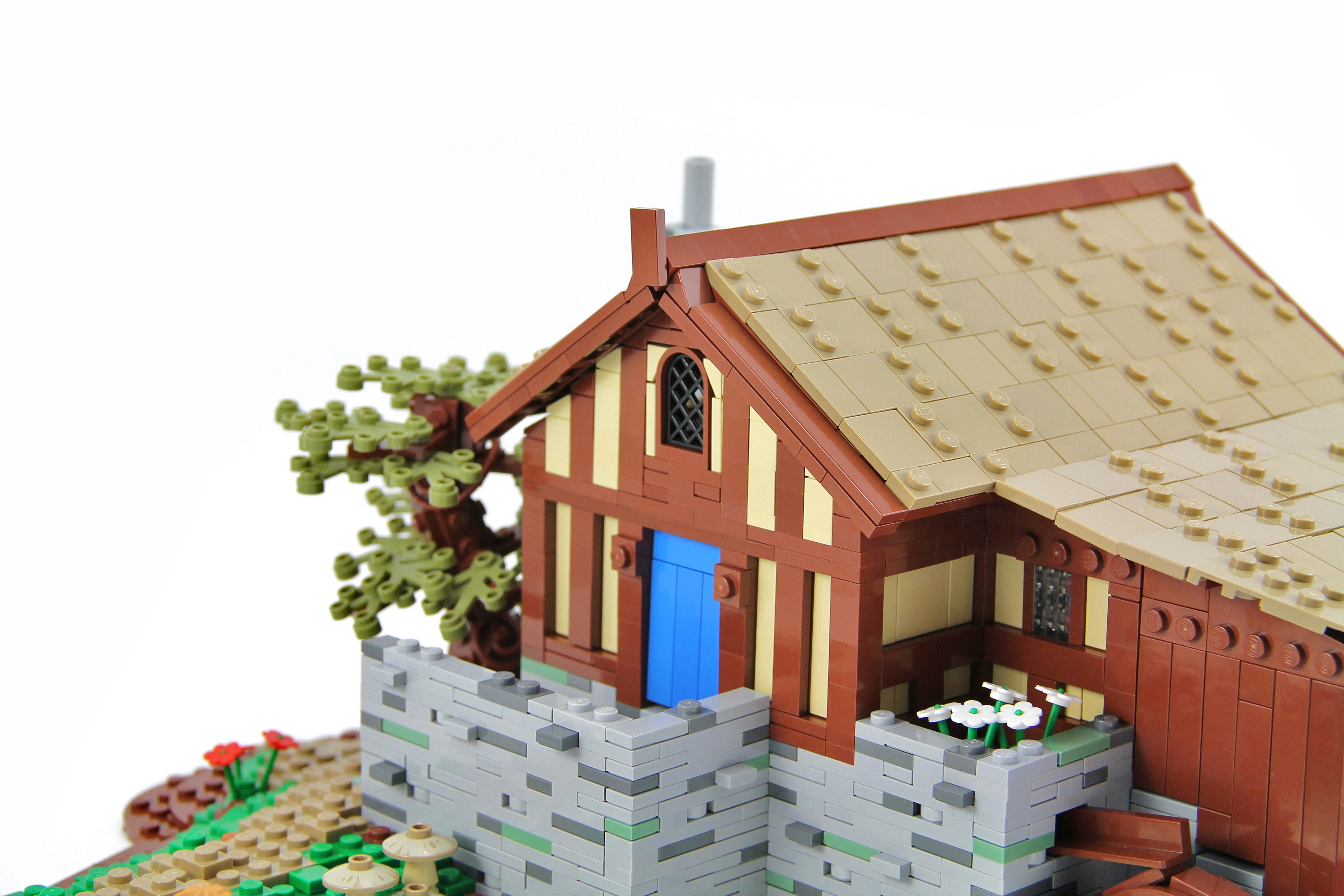
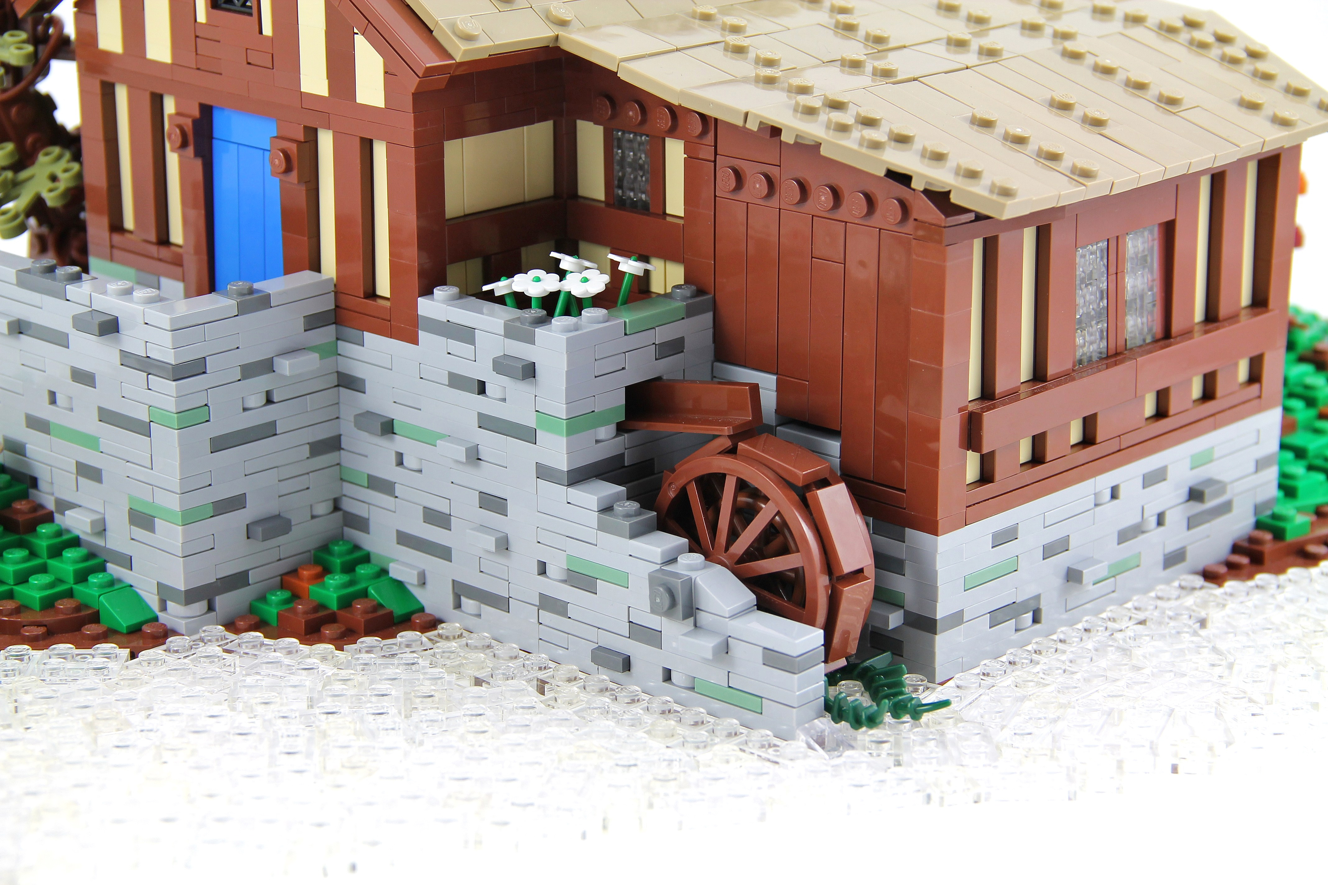
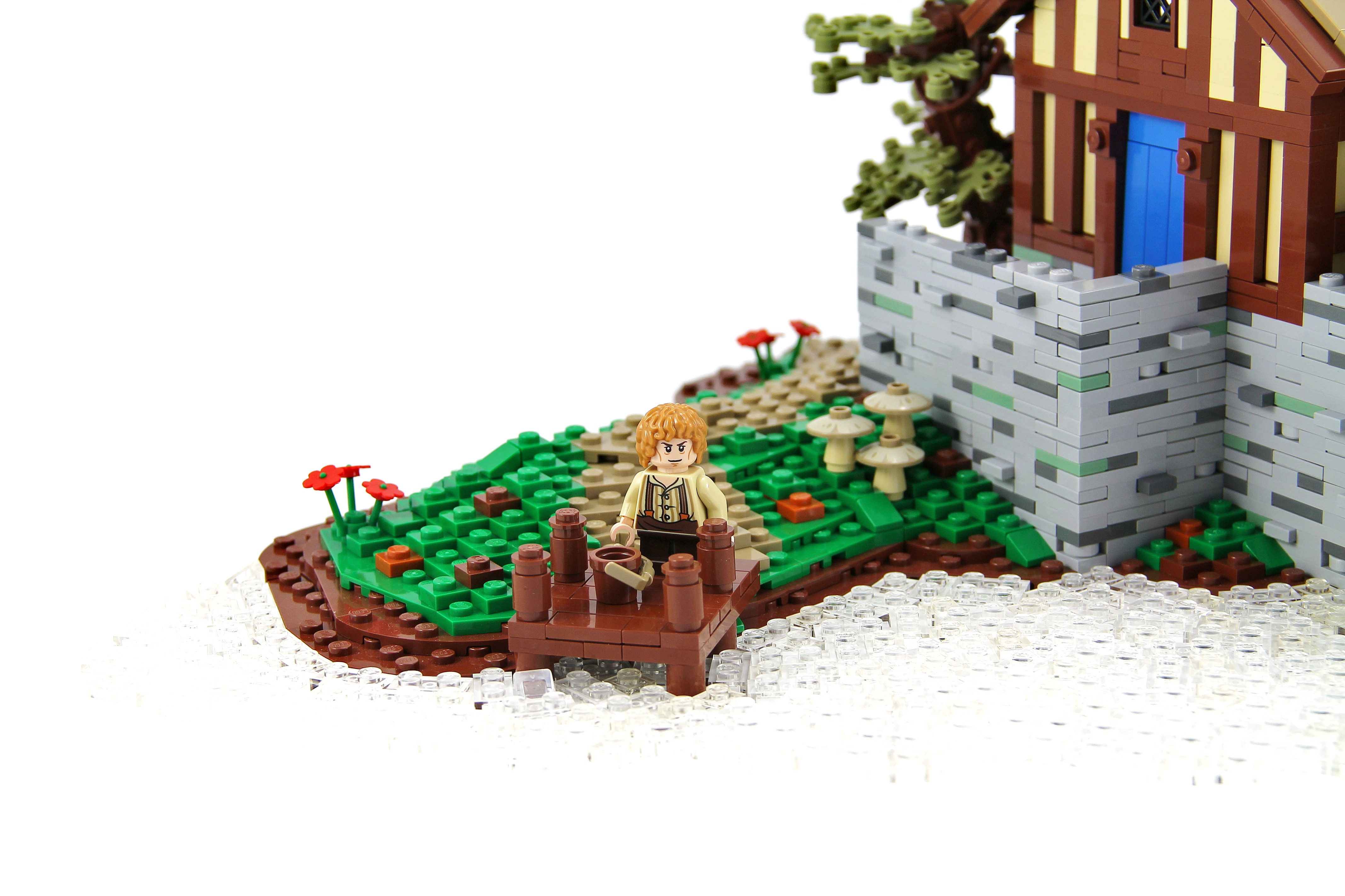
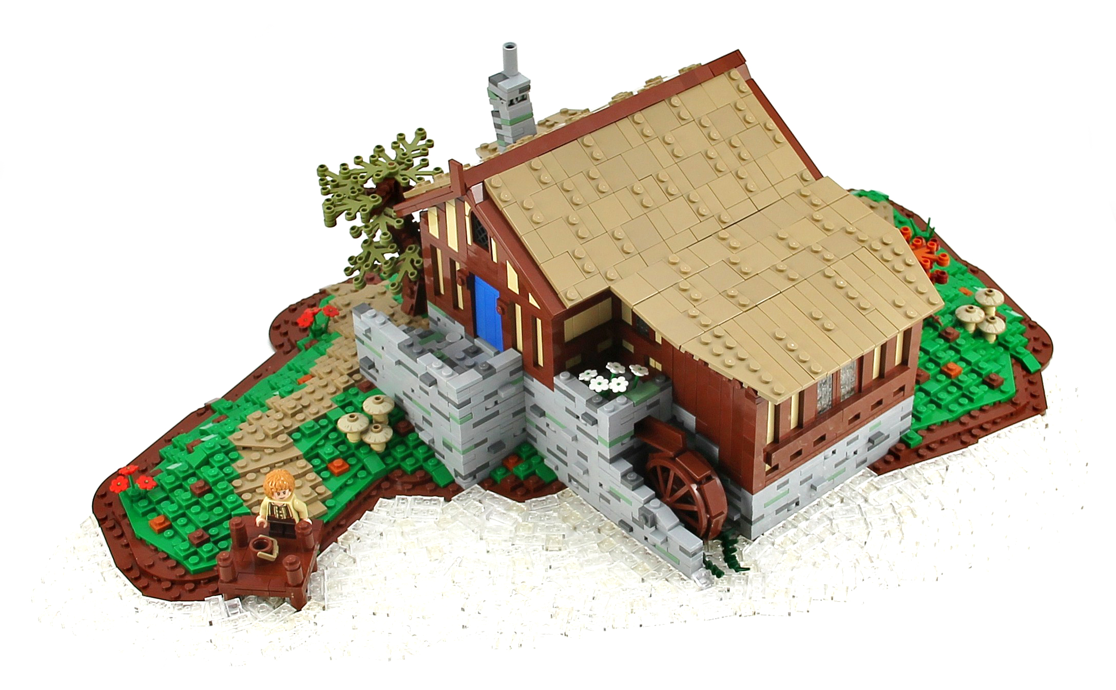
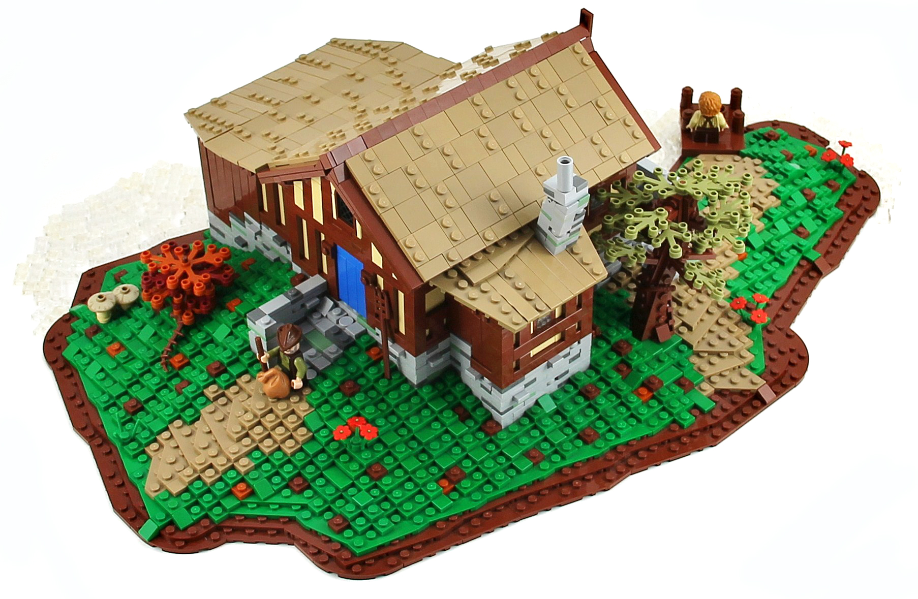
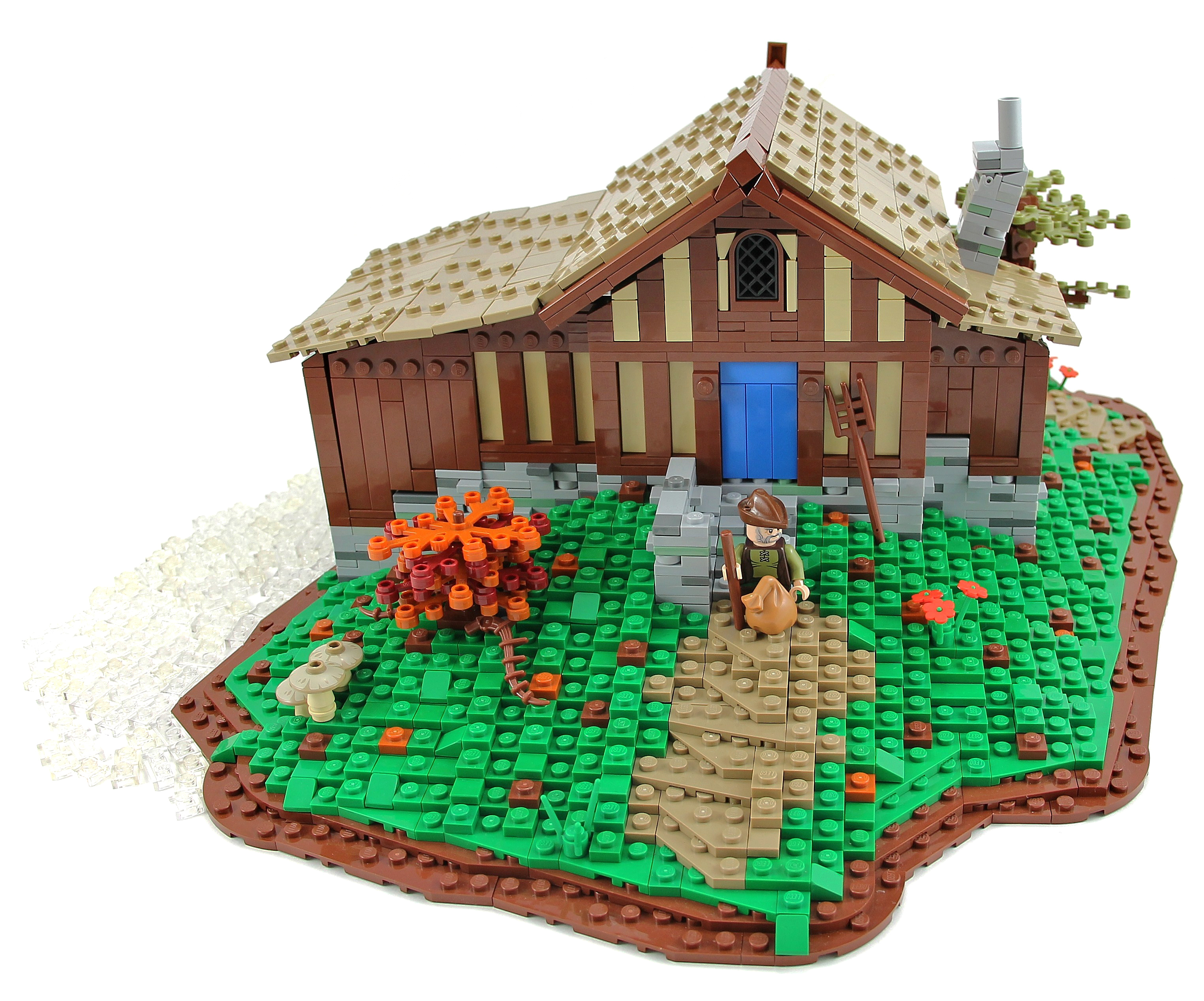
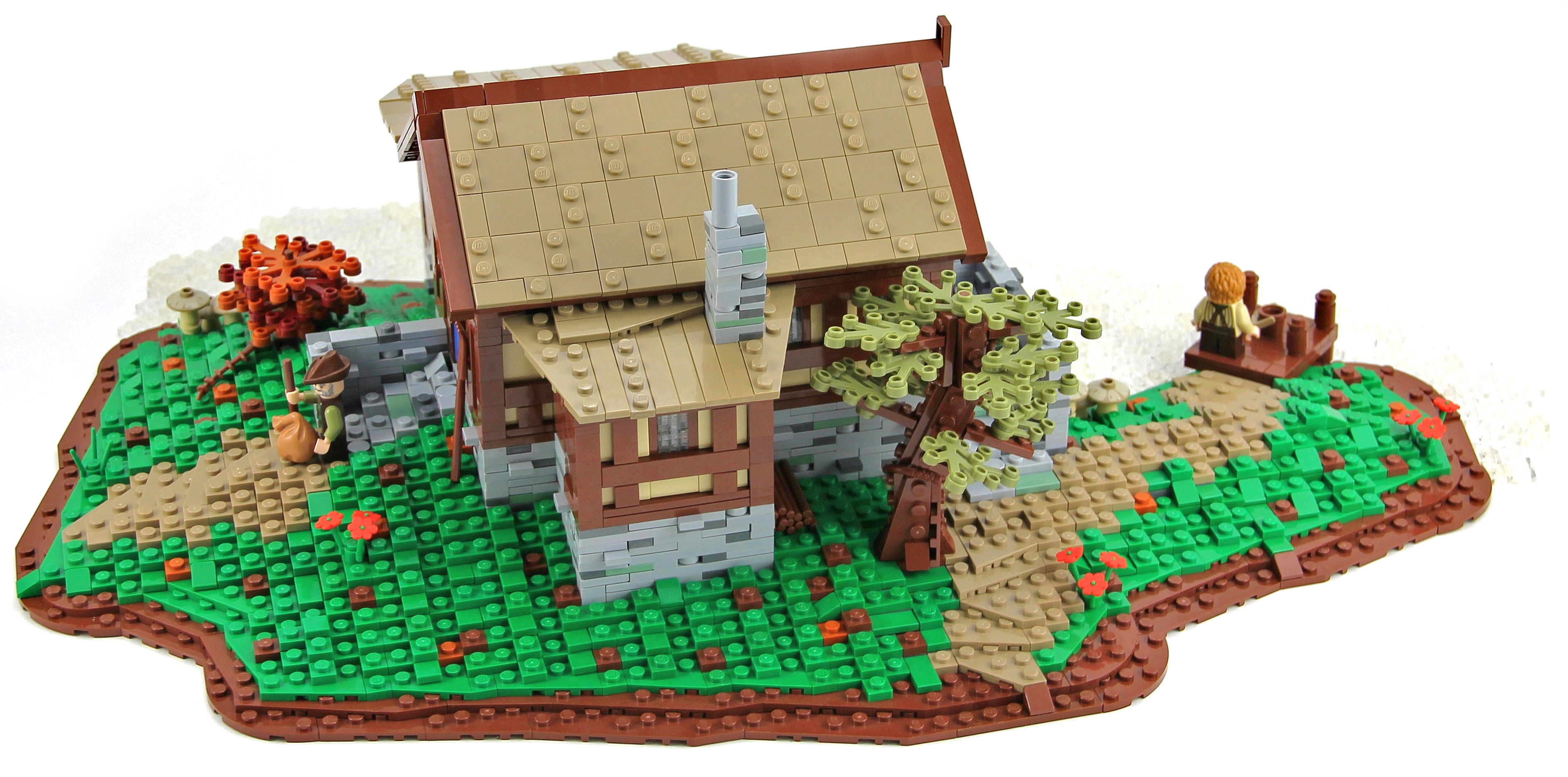
"The Old Mill was the watermill of Hobbiton, owned and run by the Sandyman Family. The Old Mill was a corn mill powered by a large water wheel. It lay directly adjacent to the bridge across the Water and next to the Old Grange as well."
This is the water mill that can be seen in the Lord of the Rings: The Fellowship of the Ring when Gandalf arrives in Hobbiton for Bilbo's birthday and crosses the bridge. I hope you will enjoy it, I apologize in advance for the photo, I didn't managed, unfortunately, to capture the water.
Credit to Pif500 for the wall technique :)
Cars and vans being transported across the country by train, taken from the footbridge at Claremorris Railway Station in Co. Mayo.
Photographer: James P. O'Dea
Date: September 1950
NLI Ref.: ODEA 4/42
Created for:
Kreative People ♣ Blue Theme ♣ contest #18
The Award Tree Challenge 110 ~ Awesome Sunsets
_____________________________________
there is a big, a big hard sun
my textures and one by SkeletalMess thank you!
Happy Sliders Sunday everyone!
♥
The Burg Gutenfels (also known as castle Kaub) is a castle 110m above the town of Kaub in Rhineland-Palatinate, Germany. It was build in 1220. It was used with Pfalzgrafenstein Castle in the middle of the Rhein and the fortified city of Kaub on the far side to provide an impenetrable toll zone for the Holy Roman Emperor until Prussia purchased the area (1866) and ended this toll in 1867. The Castle is in part of the Rhine Gorge, a UNESCO World Heritage Site added in 2002.
Kaub (old spelling: Caub) is a town in Germany, state Rhineland-Palatinate, district Rhein-Lahn-Kreis. It is part of the municipality (Verbandsgemeinde) Loreley. It is located on the right bank of the Rhine, approx. 50 km west from Wiesbaden.
It has a Roman Catholic and an Evangelical church, and a statue of General Blücher. The trade mainly consists of the wines of the district. (Wikipedia)
Much better in Large On Black
© 2013 Ursula Sander - All rights reserved.
I haven't been seeing many butterflies in my yard for most of the summer but things have been picking up lately. This beautiful butterfly was feeding in the pentas in my yard in Central Florida.
Canon Rebel XSi and Canon EF 100-400mm f/4.5-5.6L IS USM
One of my goals for 2013 was to take some long exposure night photos and to get some shots of lightning. So here is another experimental shot. This was the first night I ever tried talking lightning photos...
This photo was taken from the observation walkway on "city key", Sarasota Florida across from the Sarasota Sailing Squadron, close to the Mote Marine Aquarium facing toward Coon Key.St. Armands Circle is to the right. The tall building in the center is Plymouth Harbor, a local retirement community.
Thanks for taking a look. As always comments and constructive advice is always appreciated.
Mike
Exif data
Camera.......................Nikon D600
Exposure....................20
Aperture......................f/4.5
Focal Length..............55 mm
ISO Speed..................100
Here's a little slice of a fantasy ocean :)
This is an entry for Iron Builder against the Erickson Brothers, utilizing the green flexible spike as mermaid fins, corals, and palm trees.
... in the signal box presumably. It would be lovely to get a name and a use for all of these things.
Photographer: James P. O'Dea
Date: October 1938
NLI Ref.: ODEA 1/31
The Grand Canal (Italian: Canal Grande, Venetian: Canałasso) is a canal in Venice, Italy. It forms one of the major water-traffic corridors in the city. Public transport is provided by water buses (Italian: vaporetti) and private water taxis, and many tourists explore the canal by gondola. At one end, the canal leads into the lagoon near the Santa Lucia railway station and the other end leads into Saint Mark Basin; in between, it makes a large reverse-S shape through the central districts (sestieri) of Venice. It is 3,800 m long, 30–90 m wide, with an average depth of five meters (16.5 ft).
Because most of the city's traffic goes along the Canal rather than across it, only one bridge crossed the canal until the 19th century, the Rialto Bridge. There are currently three more bridges, the Ponte degli Scalzi, the Ponte dell'Accademia, and the recent, controversial Ponte della Costituzione, designed by Santiago Calatrava, connecting the train station to Piazzale Roma, one of the few places in Venice where buses and cars can enter. As was usual in the past, people can still take a ferry ride across the canal at several points by standing up on the deck of a simple gondola called a traghetto, although this service is less common than even a decade ago. Most of the palaces emerge from water without pavement. Consequently, one can only tour past the fronts of the buildings on the grand canal by boat.
en.wikipedia.org/wiki/Grand Canal, Venice
The Ca' da Mosto is a thirteenth-century palace in Venice, northern Italy, the oldest building on the Grand Canal. It is in the Veneto-Byzantine style, with high narrow arches and distinctive capitals. The features of the palace show its beginnings as a casa-fondaco, the home and workplace of its original merchant owner. A second floor was added at the beginning of the sixteenth century, and a third in the nineteenth. The palace takes its name from the Venetian explorer Alvise da Ca' da Mosto, who was born in the palace in 1432. It stayed in the da Mosto family until 1603, when Chiara da Mosto left her entire estate to Leonardo Donà dalle Rose, a nephew of her second husband, rather than her da Mosto relatives, with whom she had fallen out. Between the 16th and the 18th centuries the Ca' da Mosto housed the well-known Albergo Leon Bianco (the White Lion Hotel). In 1769 and 1775 the Holy Roman Emperor and son of Maria Theresa, Joseph II, lived here during his stay in Venice.
en.wikipedia.org/wiki/Ca' da Mosto
The Chiesa dei Santi Apostoli di Cristo (English: Church of the Holy Apostles of Christ), commonly called San Apostoli, is a 7th-century Roman Catholic church located in the Cannaregio sestiere of the Italian city of Venice. It is one of the oldest churches in the city and has undergone numerous changes since its foundation. The present building is the result of a major reconstruction project which was undertaken in 1575. The church is notable particularly for the Cornaro Chapel, an important example of Early Renaissance architecture, added by Mauro Codussi during the 1490s. The chapel is the burial place of several members of the powerful Cornaro family, including Catherine Cornaro, Queen of Cyprus. The church houses several works of art including pieces by Giambattista Tiepolo and Paolo Veronese.
en.wikipedia.org/wiki/Santi Apostoli, Venice
Palazzo dei Camerlenghi is a Renaissance palace in Venice, northern Italy, located in the sestiere (quarter) of San Polo. It faces the Canal Grande, near the Rialto Bridge. The palace was built from 1525 to 1528 under design by Guglielmo dei Grigi, who was inspired by the style of Mauro Codussi and Pietro Lombardo. It was the seat of several financial magistrates, including the Camerlenghi whom it takes its name from, the Consuls of the Traders and the Supra-Consuls of the Traders. Due to this function, the lower floor was used as a jail for the insolvents: the location nearby the crowded Rialto Bridge served as an admonition for the people passing there. The palace currently houses the regional seat of the Italian Comptroller and Auditor General. The palace has a pentagonal plan which follows the shore of the Canal Grande, with three floors. It has tall windows with centrings, divided by false columns and decorated with friezes. There were once polyhcrome marble and porphyry slabs, now lost. Due to the Venetian tradition that, when leaving the position, a magistrate would leave a religious-themed painting and a portrait in his former seat, the Palazzo dei Camerlenghi housed numerous artworks. These were dispersed during the French occupation; some returned to Venice, but are now in other locations.
Saidosho Station, Fukuoka, JR Kyushu, Hita-Hikosan line,
July 2013
JR九州、日田彦山線、採銅所駅
Carl Zeiss Makro-Planar T* 2/50 ZE
¡gracias Angel, por esa gran caminata en tu maravillosa ciudad, besos, los extrañamos mucho!
textures by [http://www.flickr.com/photos/13796443@N05/] & [http://www.flickr.com/photos/skeletalmess/] thanks!
happy fence friday everyone, have a fabulous long weekend!
♥
Dear contacts and visitors,
I'm offering this photo in a larger resolution [1680x1050px] for you to use as a desktop wallpaper or facebook cover if you wish!
If you re-blog the photo please be kind and leave a link to the original! Thank you!
Previous desktop offer - www.flickr.com/photos/jup3nep/8613630858/
A cloud is a visible mass of liquid droplets or frozen crystals made of water or various chemicals suspended in the atmosphere above the surface of a planetary body. These suspended particles are also known as aerosols. Clouds in Earth's atmosphere are studied in the cloud physics branch of meteorology. Two processes, possibly acting together, can lead to air becoming saturated; cooling the air or adding water vapor to the air. In general, precipitation will fall to the surface; an exception is virga, which evaporates before reaching the surface.
The international cloud classification system is based on the fact clouds can show free-convective upward growth like cumulus, appear in non-convective layered sheets such as stratus, or take the form of thin fibrous wisps, as in the case of cirrus. Prefixes are used in connection with clouds: strato- for low clouds with limited convection that form mostly in layers, nimbo- for thick layered clouds that can produce moderate to heavy precipitation, alto- for middle clouds, and cirro- for high clouds.
While a majority of clouds form in Earth's troposphere, there are occasions when clouds in the stratosphere and mesosphere can be observed. These three main layers of the atmosphere where clouds may be seen are collectively known as the homosphere. Above this lies the thermosphere and exosphere, which together make up the heterosphere that marks the transition to outer space. Clouds have been observed on other planets and moons within the Solar System, but, due to their different temperature characteristics, they are composed of other substances such as methane, ammonia, and sulfuric acid.
You can read more on clouds on Wiki - en.wikipedia.org/wiki/Cloud