View allAll Photos Tagged oldmap
an experiment,more in comments. not very sure if i really like it but its somehing different to my usual stuff. i had something totally different planned for this shoot but this is what came out.
andd oh my gooood! tomorrow i'll be officially out of high school . tomorrow there is a ceremony where they are going to give me my certificate and on friday its prom/graduation.
im excited but sad at the same time. so many thoughts come to my mind.
check out my new online portfolio :) monicacs.carbonmade.com/
I think I have found where this garage was - but it all looks so different in the present day it's hard to be totally sure. Certainly Oldmaps shows a garage with exactly this footprint at 1297 Warwick Road. There isn't a garage there in the present day although there are several very nearby. There's a Texaco and an Esso either side of the road just fractionally away from this site and there are other buildings that look like they could have been a garage once. If I am right this is approximately the same view in the present day.
www.google.co.uk/maps/@52.4428815,-1.8120861,3a,75y,198.3...
I love the romance of vintage travelling -- old motor cars, battered leather luggage, touring maps and seaside postcards. Captured with a shallow DOF for a soft, romantic look. Processed with a vintage effect to tone in with the subject matter.
The words “north” and “south” are two striking concepts. We all know the North and South Pole. They are also two of the most important direction indicators for navigating. And for something completely different ... North and South have also become a household name in television through the epic series with the popular Patrick Swayze. Finally, the words north and south are also used linguistically to indicate major contradictions; similar to alpha and omega. So in short: there is much to do about these words. And in Amsterdam that is no different...
The North-South line already appeared in the Stadsspoor Plan in 1968. At the time, the city council decided to start building the current East line first. But due to great social resistance (the well-known Nieuwmarkttrellen) and large budget overruns, the word “metro” became a big taboo in Amsterdam. That is why the Amstelveen line has always been called a tram and not a metro.
At the end of the 1980s, the municipality researched the feasibility of a North-South line once more. The traffic issues in the city’s centre became more and more acute. So, after many debates in the city council, in the House of Representatives and a failed municipal referendum, the decision to construct the North-South line was taken in 1999/2000.
The North-South line opening was originally foreseen in 2011. But due to many setbacks, that eventually became July 21, 2018. Then the 9.7 kilometre line, of which 7.1 kilometres underground, was opened. This made it possible to travel from the North station to the South station in approximately 15 minutes.
The fact that there was so much delay also had its advantage. Already in 1996 the architects of Benthem Crouwel Architects started designing the line’s stations. Thanks to the fact that there have been design updates up to a late stage, the most modern, state-of-the-art materials and techniques were used throughout the entire process. That is why nothing in these stations feels outdated.
Every station on the line is unique. The architecture is determined by the location in the city and the available space in the subsurface. At the same time, all stations are based on the same architectural concept: the shortest possible connection between the underground platform and the street. Very concretely: that means a constant flow of movement to get from the platform to the street and vice versa. Plus travelers must be able to find their way intuitively. Elegant and long escalators play an important role in this. In May 2013, a municipal advisory committee selected an artwork by Harmen Liemburg to be installed at this station. It’s a drawing based on old maps and the various birds that live in and around Amsterdam. The new streets in the immediate vicinity of the station were named after major train and subway stations in other European capitals: Gare du Nord, King's Cross and Termini.
Technical stuff
This panoramic shot consists of 12 individual photos shot in one row. With this rather high number I created some margin to play with the curvatures in buildings structural lines. I rendered the pano with PS CC. This resulted in an image (; with a 15930x6337 of 1.6 GB) that had a lot of nonresponding lines in the roof of the building. This proofed to be a rather big challenge to correct. I needed roughly 5 hours in PS to remedy the major flaws. Further post-production included balancing the lighting conditions, warping the image straight and cropping it (to enhance the symmetry). Finally, I added copyright signs. The latter is, alas, there to stay due to the fact that my photos were frequently copied. So, don't bother commenting on that.
-----------------------------------------------------------------------------------------------
Visit my groups:
Centro Storico Catanese
Visit my website:
-----------------------------------------------------------------------------------------------
Le mie foto sono coperte da copyright - chiedere esplicitamente il mio permesso scritto prima di usarle su siti web, blog o supporti
© Tutti i diritti riservati.
-----------------------------------------------------------------------------------------------
My photos are copyrighted - ask my explicit written permission before using them on websites, blogs or other media
© All rights reserved.
There's a treasure trove of historic imagery in this 1859 illustration by John Bachmann.
I've added Notes on the photo describing some of below...
1) The Statue of Liberty didn't exist, but you can see the eleven-point star shaped fortification surrounding Fort Hood on Bedloe's Island. (later Liberty Island).
2) The Central Railroad of NJ hadn't yet filled in almost a quarter of New York Harbor. The distance between Bedloe's Island and the natural shoreline of Jersey City was enormous compared to today. What is now Liberty State Park consisted of water in New York Harbor.
3) The future location of both Port Newark as well as Newark-Liberty airport in the center-right distance was an enormous swamp.
4) The Meadowlands in the center-left distance was also an enormous swamp without any buildings or highways. Just a few railroad lines went through it. The Meadowlands are the remnants of a giant glacial lake which once covered that area.
5) The Snake Hill outcropping in the Meadowlands wasn't sliced through by the NJ Turnpike.
6) A complete lack of bridges over Newark Bay.
7) The square empty blocks in the Harsimus neighborhood in Jersey City were freshly land-filled swampy estuaries using NYC garbage and construction debris by the Erie Railroad to build its railyards with access to the Hudson River.
8) Greenville still retained its natural shoreline before massive landfill to create the Greenville rail yards.
9) Bayonne still retained its natural shoreline before massive landfill to create the Naval Reservation and Bayonne Supply Depot just north of Constable Hook.
10) No Pulaski Skyway or Bayonne Bridge. (people used ferries).
This is a map I made for a Boston Magazine article on what projects should Boston undertake after the Big Dig. I suggest expanding the subway system.
For more check out my site futurembta.com
This map is found in " via dei fori imperiali, Rome". The little white dot is the Roman empire in its beginings. To the right is ILLIRIA (Albania).
When I saw these Bic pens in a supermarket in 1995, I immediately bought five packs of them. Somehow I knew that they would become my writing utensil of choice if I was ever to live my dream of traveling the world. I was a sucker for old maps and this was the first pen I had seen that actually had maps on them. (I believe the series was called "The New World")
Six years later, I opened the packaging and brought a couple of them on a 14-country journey through Europe, the first of many backpacking journeys to come.
I've never seen these pens since that day in the supermarket, so I have to find other Bics of the same size to refill them. Unfortunately, throughout the years of travel, I have lost quite a few. I have only three left.
I have used the pens in my web design quite a few times. Here's an example.
L’île d’Aeaea où vit Circé n’est pas localisée mais une hypothèse la situe au mont Circeo en Italie, qui a été une presqu’île. Ceci explique cela pour le choix de la carte.
Le roman est un réel enchantement. La narratrice est profondément humaine, bien que déesse, et sa voix s’écoule, si vraie, si proche, que la mythologie prend des accents de réalité, que son île et la mer prennent vie.
On croise dans ce roman nombre de figures bien connues de la mythologie grecque comme Dédale, Ulysse et d’autres et quelques libertés finales m’ont fait frissonner(mais vraiment). Les romans font ça, parfois. Ils nous emportent.
#fanart #oldmap #hommage #bookcharacter #illustration #acrylicportrait #bookportrait #portraitpainting #vintagemap #painting #characterart #mythologiegrecque #mythologyart #colorpencil #map #italy #circeo
Download the largest size and use your photo viewer to zoom in and hover around. There's an amazing amount of detail in this view!!
Shadows are fixed and they're all going in the same direction. I also changed the lighting a bit and I'm very happy to say that it's finally done.
A page from the wonderfully detailed Bacon's Atlas of London & Suburbs, this being dated from c1912 by one of the 'special maps' bound in at the front of the atlas. The bulk of London is covered in a series of map sheets at 4" to the mile and is very detailed giving a clear indication of the pre-WW1 city, in its full Victorian and Edwardian splendour but before the massive inter-war expansion into 'Metroland' and similar suburbs.
Bacon's was formed by one George Washington Bacon (1830–1922), an American who set up business in London producing atlases and maps of the capital in about 1870 after a series of business failures. G W Bacon prospered and in c1900 were acquired by the Scottish publishers and cartographers W.& A.K. Johnston of whom they became a subsidiary.
This supplementary sheet, 1A, has been added to the atlas to show Edgware and the surrounding area, probably as dvelopment was starting to creep out this far into Middlesex thanks to the railways (the Metropolitan and the London & North Western Railway appear in the SE corner - the now closed GNR Edgware branch terminates in the village centre) and the tram route that was extended out to Edgware along what was to become the A5. The Stanmore station that is shown is, of course, that of the LNWR, the branch that was closed in the 1960s and not the branch of the Metropolitan that was to be constructed in the 1930s and that would irrevocably alter these open fields. Apart from the villages of Kenton and Edgware the main feature seems to be the local sewage farm!
This is a public domain file downloaded from Wikimedia. Credits to The James Ford Bell Library, University of Minnesota. Thank you for sharing this amazing map.
Carta Marina of the Nordic areas is made by Olaus Magnus. Text : A Marine map and Description of the Northern Lands and of their Marvels, most carefully drawn up at Venice in the year 1539 through the generous assistance of the Most Honourable Lord Hieronymo Quirino. You can see a huge version 5 MB of this map at Wikimedia:
upload.wikimedia.org/wikipedia/commons/e/ea/Carta_Marina....
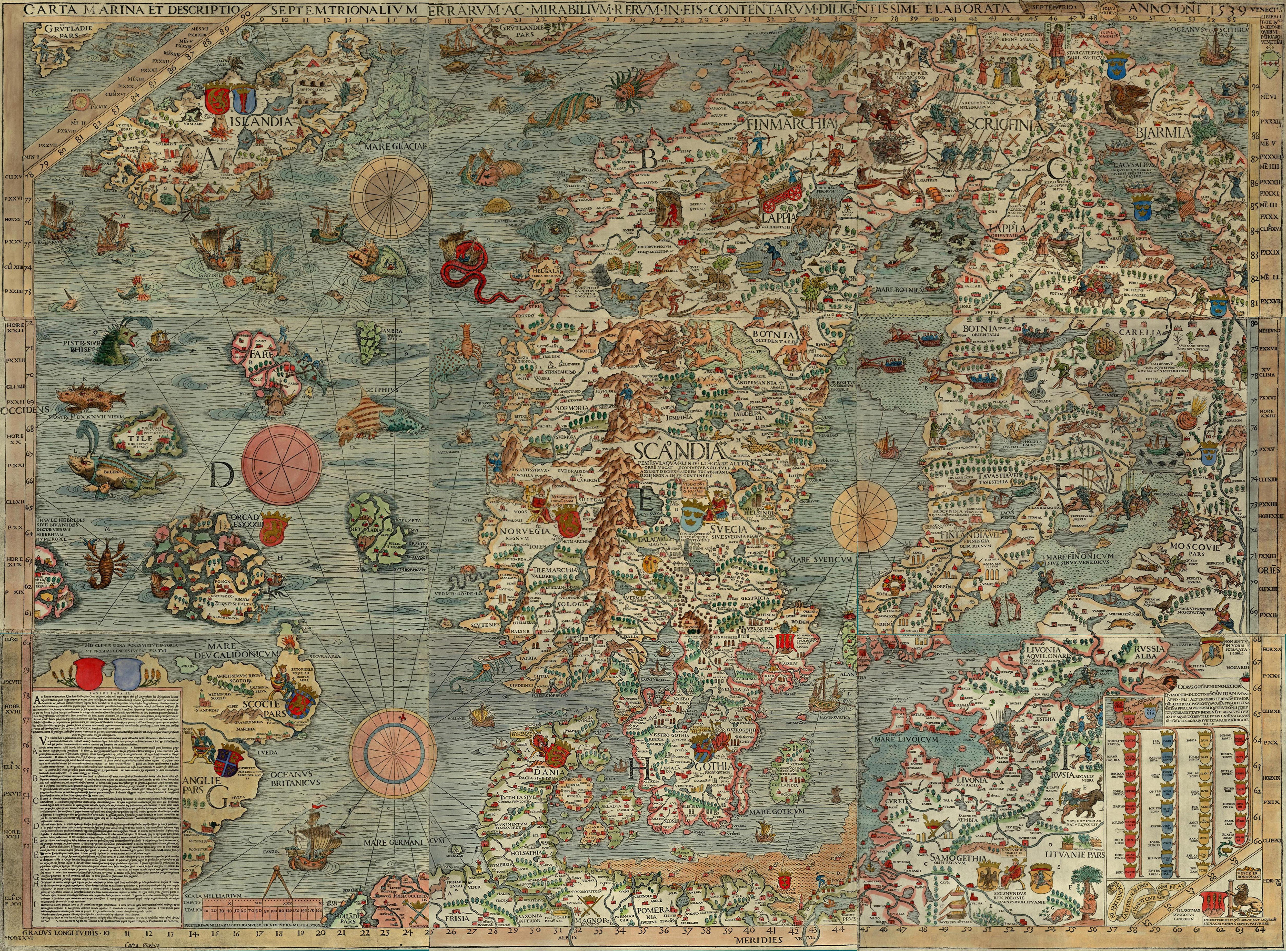
Areas included in the map is Iceland, Orkney, Faeroe Islands, Denmark, Norway, Sweden, Finland, North-western Russia, Estonia, Latvia and Lithuania.
Se nærmere på dette utrolige kartet, du kan se det i en stor 5 MB versjon hvis du klikker på Wikimedia lenken over. Du kan også se det i saamiblog.blogspot.com/
Guy Gavriel Kay écrit de la Fantasy historique : on reconnait les lieux et les époques mais quelques éléments fantastiques ouvrent des portes inattendues. Meshag et ses loups en font partie.
Les romans de cet auteur sont un enchantement pour qui aime les études fouillées de personnages, prendre son temps et explorer un monde. Il y a bien quelques moments épiques mais ce n’est pas le coeur de ses récits. Ce qui me va parfaitement !
#fanart #oldmap #hommage #bookcharacter #illustration #underheaven #acrylicportrait #bookportrait #portraitpainting #wolf #vintagemap #painting
Collection of old maps scanned from books and other print sources Download them all at Photoshop Roadmap.
Close-up of my old map of Italy. Unfortunately, Coronavirus not only killed our easter vacation in "Il Bel Paese" this year, but also our summer vacation. Well, we just have to make the best out of the situation and enjoy our home country, even that it is a bit cold here in the northern parts of Europe.
Again a shot with my new 24/1.4 GM lens, not so open this time since the Siena name needs to be in focus.
[ website | instagram | istock | getty images ]
Download the largest size and use your photo viewer to zoom in and hover around. There's an amazing amount of detail in this view.
Maps - Specially Prepared for STANLEY GIBBONS LTD, 391 Strand, London, W.C. 2., G.W. Bacon Co. Ltd. ~ 1936 1954 K_2
now I know, the 'heart muscle' arrived at its destination... :)
yesterday a neighbor walked up the road and delivered a parcel from London (post car can still not come up the road) -- meadowsweet will help my aching joints...
thanks so much!
Title: Historical World Map (East)
Artist: Iacobo Altovito 1665
Manufacturer: Ravensburger 152490
Piece Count: 500 Pieces (Set of 2, East and West)
Dimensions: 18V x 18L (50 x 50 cm)
Time: 3.5 Hours
This puzzle set came with 2x500 piece puzzles. One is the western hemisphere and the other is eastern.
***The set of 2 is for sale or trade***
This Tourist Map of Tokyo was published by the Japan Tourist Bureau in 1918.
Outstanding features of this English-language map:
- The map is aligned with west on top. This is the classic configuration for Tokyo, pointing towards Fuji.
- Old Edo-Tokyo at its peak, about to be destroyed by the 1923 earhquake.
- Old districts of the then City of Tokyo. The names still exist, but they're just neighborhoods that have been subsumed into other cities.
- Streetcar lines!
- Tons of points of interest.
- "Price 20 Sen" That's .2 yen.
Be sure to view in full size.
Scanned from the original map. On the back are lists of general information about Tokyo and Japan, as well as several suggested touring itineraries based on number of days.
"You need a room with no view so imagination can meet memory in the dark.."
--Annie Dillard (from "A Writing Life")
"Say you have seen something. You have seen an ordinary bit of what is real, the infinite fabric of time that eternity shoots through, and time's soft-skinned people working and dying under slowly shifting stars. Then what?"
-- from Annie Dillard's essay, "This is the Life"
looks better like this: flagrantdisregard.com/flickr/onblack.php?id=74937213&...
Part of the set, Alterations & Digital Collages
-----------------------------------------------------------------------------------------------
Visit my groups:
Centro Storico Catanese
Visit my website:
-----------------------------------------------------------------------------------------------
Le mie foto sono coperte da copyright - chiedere esplicitamente il mio permesso scritto prima di usarle su siti web, blog o supporti
© Tutti i diritti riservati.
-----------------------------------------------------------------------------------------------
My photos are copyrighted - ask my explicit written permission before using them on websites, blogs or other media
© All rights reserved.
Collection of old maps scanned from books and other print sources Download them all at Photoshop Roadmap.
Old map of South Asia in 1912. Contributors Edward Stanford Ltd, in 1912. A map of the countries between Constantinople and Calcutta : including Turkey in Asia, Persia, Afghanistan and Turkestan. Published in London.
Title: Vue panoramique de l'exposition universelle de 1900 à Paris. Creator Lucien Baylac. No known restrictions on publication.
Collection of old maps scanned from books and other print sources Download them all at Photoshop Roadmap.
Hommage à la série policière moyen-âgeuse d'Ariana Franklin : la confidente des morts. Ce roman est intéressant pour l'intrigue mais vaut surtout pour ses excellent personnages !
Map by Geographia Maps. Published after WWII - The Philippines were independent, but 'French Indochina' was not, thus an estimated publication date of sometime between 1945 and 1953. The borders are not shown here, but French Indochina was divided into 5 provinces - Laos, Cambodia, Cochin China, Annam, and Tonkin (or Tonking). The last 3 were always considered to be "Vietnam," and would be consolidated as such upon independence, though the civil war would temporarily divide the nation again into North and South. Cochin China, meanwhile, which is the region of Vietnam south of Saigon (now Ho Chi Minh City), was historically part of Cambodia, until the late 1700s or early 1800s or so. The historic royal capial of Laos - Luangprabang (or Luang Prabang) would be supplanted by Vientiane (or Vientianne) as the modern capital in the 20th century.