View allAll Photos Tagged map
Map detailing the location of events of the wedding day for a PA/NJ wedding
I painted the original and gave it as a shower gift.
A map of the Market Street Railway Company's City Wide Service. This projection seems to be fairly common in early to mid century maps of San Francisco- for example, there's this map of proposed freeways.
Taken at the San Francisco Railway Museum.
22. Albishorn-Bikerennen des Skiclub Hausen erneut mit Urs Huber als Sieger und neuem Streckenrekord von 23.06 Minuten.
Foto Martin Platter
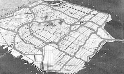
A 1-mile square view of baltimore reveals the highly rigid grid system, along with the cut through of alleyways that define the feel of neighborhoods like Fells Point, Canton, and Patterson Park
Software: Adobe Illustrator
Identifier: 100087
Type: Wood Engraving
Height: 12.7 cm
Width: 10.1 cm
Artist:
Book: The Architectural History of the University of Cambridge and of the Colleges of Cambridge and Eton, Willis & Clark
Location: Drawer C25
Notes:
GRC-Clubabend, organisiert von Robi unter dem Motto Wilder Westen, am Freitagabend, 17. November 2017 im Dukes, Sihlbrugg.
Foto Martin Platter
For a school project, my son made two 3D standard heroclix size maps which can be combined into one large map. This is the combined map. Hot wheels cars can be added to the roadway to provide detail as well as objects for the game.
Item Number: 0MAPS-z61.
Document Title: U.S. Dept of Agriculture Bureau of Soils, Fertilizer Investigations Pacific Coast, Lower California Kelp Map Scale 1" = 1.5 Miles.
Project: MAPS; Maps; 14 Miscellaneous Projects.
Artist/Creator: U.S. Dep't. of Agriculture.
Location: FREDERICK LAW OLMSTED NHS, BROOKLINE, MA.
Category: PLAN.
Purpose: none.
Physical Characteristics: [Dimensions]28 x 22; [Technique]lith pos; [Support]paper.
Dates: 1912.
Notes: Color Key, Legend. Frank K. Cameron, In Charge, Mapped by W.C. Crandall. reff. USGS. Chart No. 1149. San Jose Point to San Antonio Peak. Sheet No. 55..
.
Please Credit: Courtesy of the United States Department of the Interior, National Park Service, Frederick Law Olmsted National Historic Site..
James Diggle Cheap Car & Auto Insurance Dallas TX recommend you can start with taking a quote from at least 5 cheap auto insurance companies in Dallas Texas before you decide to choose your provider. We can help you do all this with just one short call and 5 simple questions answered. All you need to do is enter your zip code and we will automatically transfer your call to the cheapest car insurance provider in your area. Call our local Dallas number 469-778-4402 now to get Cheap Auto Insurance in Dallas TX.
Address:- 440 W Front St, Dallas, TX 75149
Phone Number:- 469-778-4402
Website:- http://cheapcarinsurancedallastx.com/
Zoom into this map at maps.bpl.org.
Publisher: Cincinnati Daily Gazette
Date: 1862
Location: Tennessee
Dimension 16x16cm
Scale: Scale not given
Call Number: G3961.S5 1862 .M36x