View allAll Photos Tagged Extended
www.messersmith.name/wordpress/2011/12/02/arizona-miscell...
Since I have been on an extended R&R leave since mid-March, I have made some observations. I'll take advantage of my pile of miscellaneous Arizona images to waste your valuable time with my folksy anecdotes and unsolicited opinions. I'll begin with the notion that while one is recovering from a trauma is probably the worst opportunity for getting some rest. While I was moving, gypsy-like, from place to place grieving for the loss of Eunie and wondering with alarm what the future might bring I was not feeling rested. It's no small wonder that life seemed so utterly intense and constantly disturbing. Recreation consisted of anything which would distract me for a while from my distress. Only time and change of circumstance broke this pattern of misery.
So, when is a good time to kick back? Well, I'm as healed as I'll ever be and grief has subsided to the level of an incipient toothache. I am once again married to a woman I love dearly and who is the best kind of friend one can have. I have a home again. I'm not broke, but still viciously frugal, a good combination for these times. I'm still on R&R until I start my new job in January. So, I reckon that I should be relaxing and recreating, eh? That would probably be so were it not for one thing. My wife is "retired". What I want to know is how can there still be so much stuff to do, none of it is trivial, it seems? The primary necessary activity appears to be something called "shopping." I confess that I do not get it.
When I need something I tend to go directly to the place where I can buy it. I go inside. I find what I want. I make a bee line to the nearest checkout station and make my purchase, being careful to keep my vision averted from the thousands of oh-so-tempting impulse items lurking in every spot where one's eyes might fall. This thrifty and, I dare say, wise technique bears no resemblance to the ways of a "shopper."
I'm learning that a shopper must properly "scan" the store, possibly making multiple rounds of every aisle, taking in the "scope" of the offerings, noting "newness" (sometimes "freshness") and "cool." Shoppers operate on a plane of awareness that is incomprehensible to me. I expend a good deal of psychic fuel avoiding being enticed by things which may arouse my desire to purchase them. Looking at things which tug at my consumer heartstrings makes me slightly nauseous, as if I'm experience the onset of buyer's remorse before I even hand over the cash.
I am particularly annoyed by stores which sell exclusively to women, but provide not so much as a chair accompanied by a rack of magazines (NOT ladies' magazines) for a man to sit comfortably while the spouse enjoys a leisurely couple of hours examining every item for tastiness. This is foolishness on the part of the store managers. I would be far less likely to distract Grace from her ecstasy if I were not tagging along behind her rolling my eyes every fifteen seconds. I will give it to her that she seldom spends much. It appears that shopping is mostly for entertainment.
Okay, enough of that.
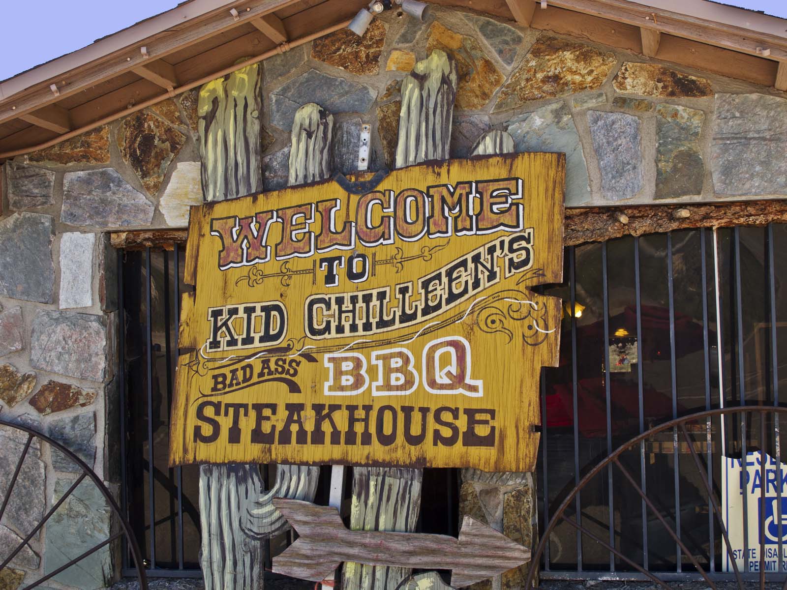
Arizona has more than its share of strange little restaurants. In Black Canyon City there is an odd restaurant called Kid Chilleen's. The sign outside proclaims the quality of its BBQ:
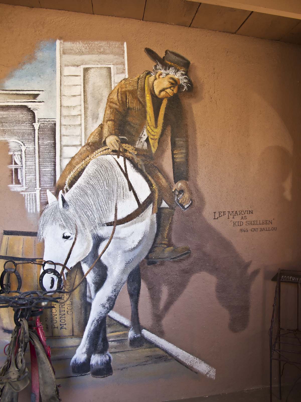
Kid Chilleen's Steakhouse is family owned and operated by the whole Chilleen Family, including Daughter Aleah, Son Scott and daughter Cheyenne. Many of the recipes used were handed down from Jeannine Chilleen, Scott's Grandmother. The clever use of the family name's similarity to that of the character Kid Shelleen played by Lee Marvin in the 1965 movie Cat Ballo.
Inside you are greeted by a wall painting which depicts one iconic scene from the movie:
Among the many quaint western themed items are several Cougar skins:
I felt sorry for the cougars.
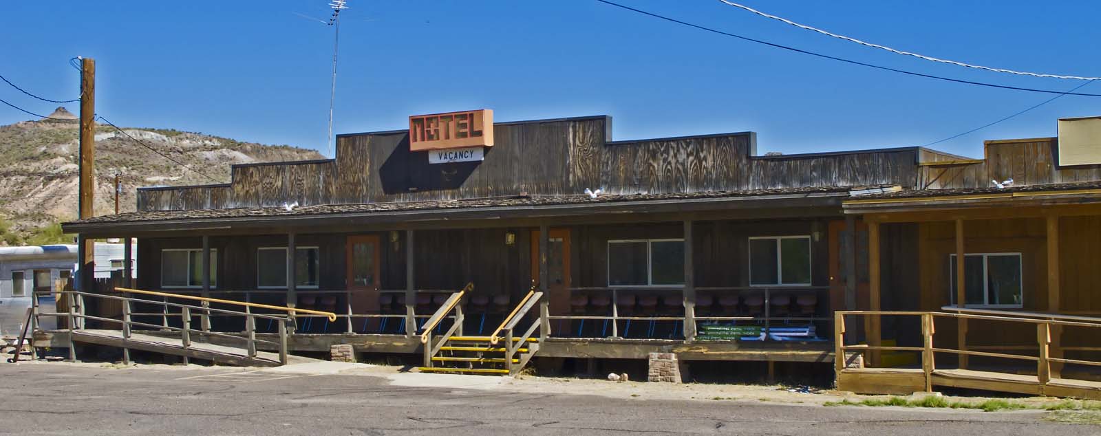
Next to the restaurant is the saddest little motel I've ever seen. I assume that it's not a joke:
I didn't inquire about a room.
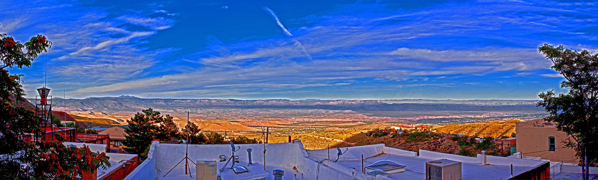
I shot multiple frames at the same exposure settings to get this panoramic view from the Haunted Hamburger Restaurant in Jerome, Arizona:
The work in progress was boring me, so I used some High Dynamic Range techniques to turn it into funky art. The Haunted Hamburger has, of course, a story. You can read about it here. The food is better than the story.
I began to play with the image of grace which I got on the day of our first snow.
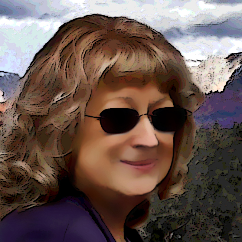
I've been fooling around with cartoon techniques for a few years. I haven't found any automated process which satisfies me. Someday I hope I'll stumble on just the right combination of filters. The process I used here worked nicely for this shot.
Nearly done now.
I got this shot at afternoon twilight from near the "vortex" at the Sedona Airport:
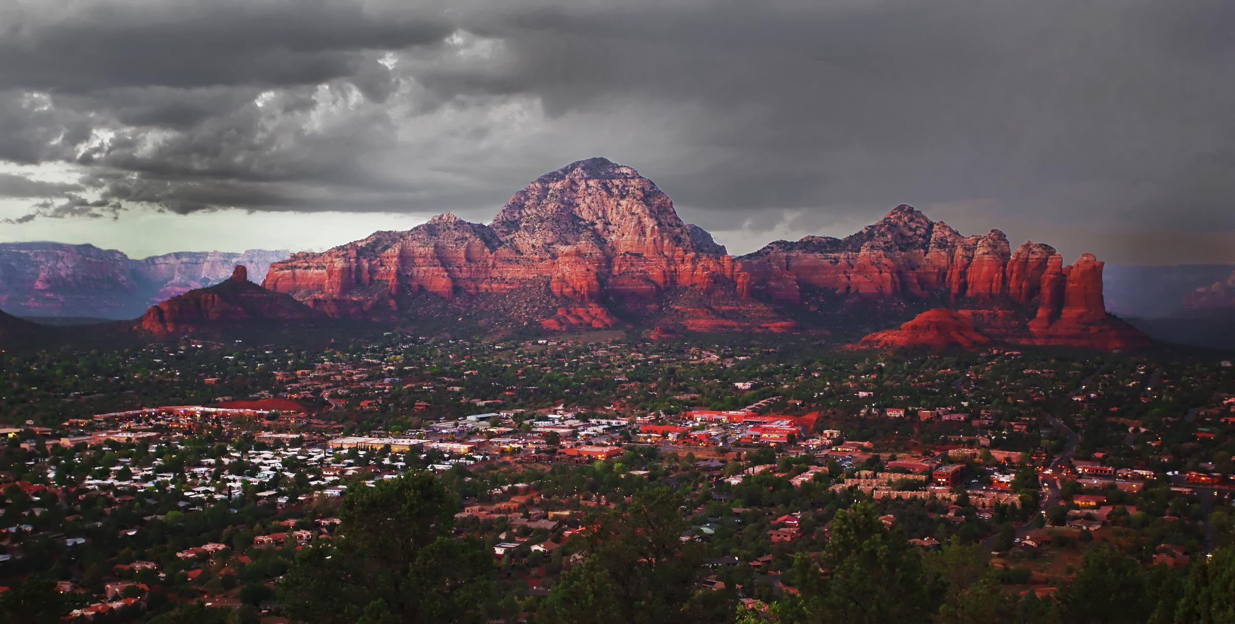
Too bad I can't show you the full resolution image. You can see the individual lights in Sedona.
I'm hoping they'll be fruitful and multiply.
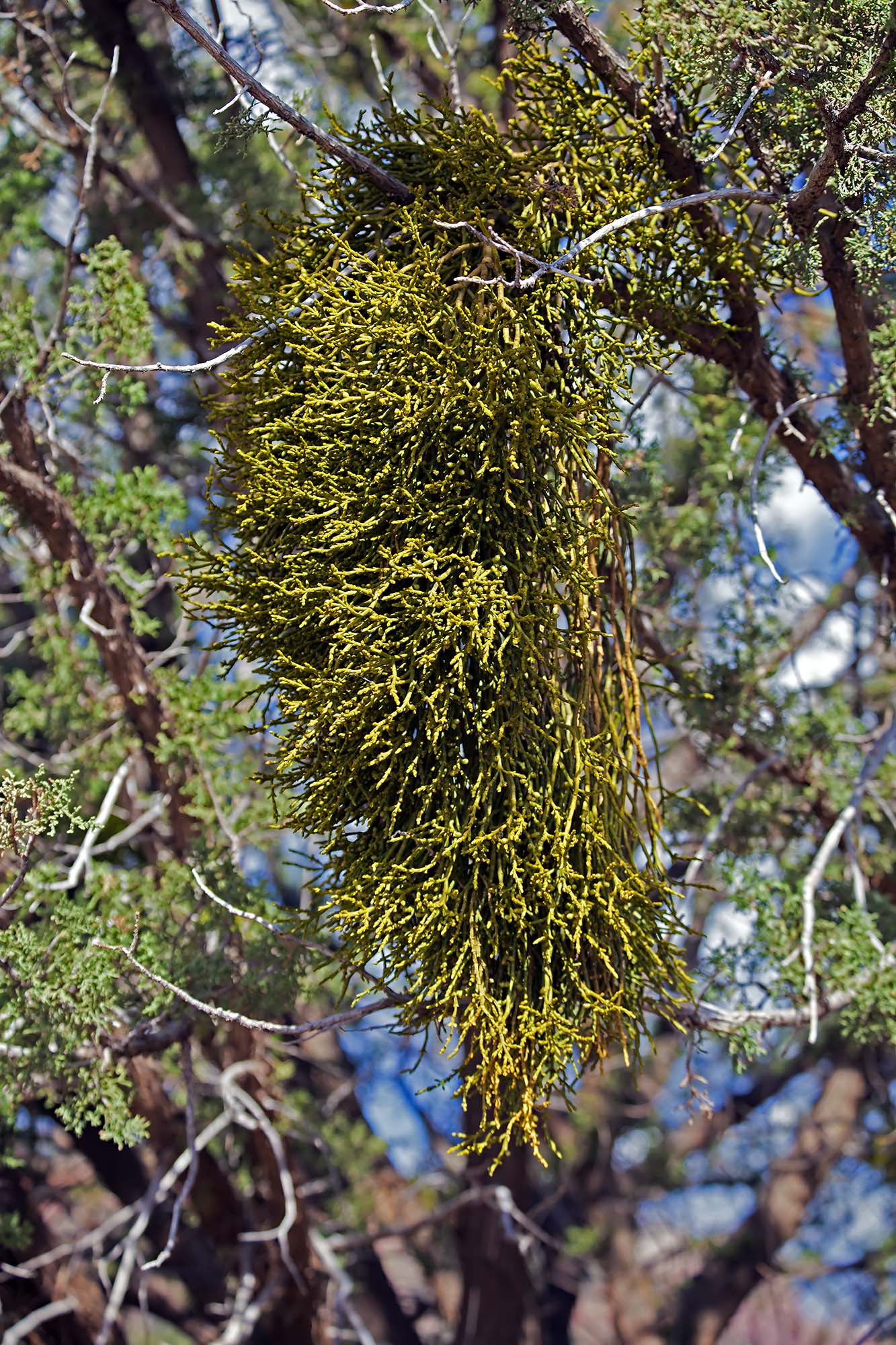
And this, kiddies, is Mistletoe (Phoradendron flavescens):
I always thought that mistletoe was an exotic plant dragged out from some mystical place for Christmas decoration. It seems that it more like a weed.
If all goes as planned I'll begin a four day trek back to Madang tomorrow morning. I'll be there for six weeks to sell Faded Glory and all of the rest of my possessions there. There will be some great bargains for Madang residents. I have some very sad things to do in Madang, but I can always think of my goal - to get back to Grace and Sedona, my new wife and my new home. Visiting Eunie's grave and saying goodbye to many friends will be difficult, but moving on is as necessary as breathing for me.
Southerness is a small, compact coastal village in Dumfries and Galloway, Scotland. Southerness is located approximately 2 mi (3.2 km) south of the A710 between Caulkerbush and Kirkbean. The town today is mainly a tourist village and has for many years had a large number of static caravans, some private and many rented to holiday makers. The local bus services to and from Dalbeattie and Dumfries are more frequent during the summer season.
Southerness has a large, shallow, sandy beaches on both sides of the rocky next to the village and to the west extend out to the vast Mersehead Sands exposed at low tide. The only landmark is its Southerness lighthouse which was built in 1749 and is one of the oldest lighthouses in Scotland. The lighthouse stands approximately 56 feet (17 m) tall and was decommissioned in the 1930s.
One of the two golf courses was redesigned in 1947 by course manager Mackenzie Ross.
The village has to the north a magnificent backdrop of the "marilyn" Criffel, and to the south the sandy (please note the quick sand) bay of Gillfoot. On clear days the views stretch across the Solway Firth to the Lakeland fells.
Tourist facilities
18-hole golf course
JJ's fish and chip shop
Paul Jones Hotel
19th Hole bar
Mermaid Bar
The Venue
The Minimarket
Evening entertainment "during the high season"
Two ParkDean caravan parks
LightHouse Leisure is a family run park with about 200 caravans. It also has the Mermaid Bar on site where bingo is offered most evenings during the season, and a swimming pool with tanning booth. LightHouse Leisure is about a 2-minute walk away from the beach and lighthouse of Southerness.
Southerness Holiday Park is owned by Parkdean Resorts. There is a new multi-purpose swimming pool, built in 2011, with flumes, a toddlers' pool, and a 25-metre swimming pool. The site also has a nature trail.
The Solway Firth (Scottish Gaelic: Tràchd Romhra) is a firth that forms part of the border between England and Scotland, between Cumbria (including the Solway Plain) and Dumfries and Galloway. It stretches from St Bees Head, just south of Whitehaven in Cumbria, to the Mull of Galloway, on the western end of Dumfries and Galloway. The Isle of Man is also very near to the firth. The firth comprises part of the Irish Sea.
The firth's coastline is characterised by lowland hills and small mountains. It is a mainly rural area, with mostly small villages and settlements (such as Powfoot). Fishing, hill farming, and some arable farming play a large part in the local economy, although tourism is increasing.
The northern part of the English coast of the Solway Firth was designated as an Area of Outstanding Natural Beauty, known as the Solway Coast, in 1964. Construction of the Robin Rigg Wind Farm in the firth began in 2007.
Within the firth, there are some salt flats and mud flats that can be dangerous, due to their frequently shifting patches of quicksand.
There are over 290 square kilometres (110 sq mi) of Sites of Special Scientific Interest (SSSIs) in the area of the firth (one of which is Salta Moss), as well as national nature reserves — at Caerlaverock and in Cumbria. On the Cumbrian side, much of the coastline has been designated an Area of Outstanding Natural Beauty (AONB). The Solway Coast’s AONB has two separate sections: the first runs westward from just north of Carlisle to Skinburness; the second runs south from the hamlet of Beckfoot, past Mawbray and Allonby, to Crosscanonby.
In 2013, the honeycomb worm and blue mussel were designated as targets of conservation efforts, and Allonby Bay (an inlet of the Solway Firth) was put forward as a candidate for a Marine Conservation Zone.
A 53-mile (85 km) long-distance walking route, the Annandale Way, runs through Annandale, from the source of the River Annan, in the Moffat Hills, to the Solway Firth; it was opened in September 2009.
Unlike other parts of the west coast of Scotland, the Solway Firth has only a few islands. They are:
Hestan Island
Rough Island
Little Ross
The so-called Isle of Whithorn (which is actually a peninsula).
The Islands of Fleet
The Solway Firth is the estuary of the River Eden and the River Esk.
The name 'Solway' (recorded as Sulewad in 1218) is of Scandinavian origin, and was originally the name of a ford across the mud flats at Eskmouth. The first element of the name is probably from the Old Norse word súl 'pillar', referring to the Lochmaben Stane, though it may instead be from súla, meaning 'solan goose'. Súl and súla both have long vowels, but the early spellings of Solway indicate a short vowel in the first element. This may be due to the shortening of an originally long vowel in the Middle English period but may also represent an original short vowel. If this is the case, the first element may be *sulr, an unrecorded word cognate with Old English sol 'muddy, pool', or a derivative of sulla, meaning 'to swill'.
The second element of the name is from the Old Norse vað, meaning 'ford' (which is cognate with the modern English word wade).
The area had three fords: the Annan or Bowness Wath, the Dornock Wath (once called the Sandywathe), and the main one —the Solewath (also called the Solewath or the Sulewad).
A wooden lighthouse was built in 1841 at Barnkirk Point (grid reference NY 1903 6425). It was destroyed by fire in 1960.
On 9 March 1876, a 79-ton French lugger St. Pierre, was stranded - and finally declared lost - on Blackshaw Bank, an ill-defined feature which extends for a considerable distance on both sides of the channel of the River Nith.
Between 1869 and 1921, the estuary was crossed by the Solway Junction Railway on a 1780 m (5850 ft) iron viaduct. The line was built to carry iron ore from the Whitehaven area to Lanarkshire and was financed and operated by the Caledonian Railway of Scotland. After the railway, which was not a financial success, ceased operating in 1921, the railway bridge became a popular footpath, enabling residents of Scotland to easily cross into England, where alcoholic drink was legally available seven days a week. (Scotland was dry on Sundays at the time.) The viaduct was demolished between 1931 and 1933.
The Ministry of Defence had by 1999 fired more than 6,350 depleted uranium rounds into the Solway Firth from its testing range at Dundrennan Range.
The Solway Firth has been used as the location for films. For example, the 1973 film The Wicker Man was filmed around Kirkcudbright and Burrow Head on the Wigtownshire coast.
In July 2019, the American metal band Slipknot released a song called “Solway Firth” that is named after the firth.
Dumfries and Galloway is one of the 32 unitary council areas of Scotland, located in the western part of the Southern Uplands. It is bordered by East Ayrshire, South Ayrshire, and South Lanarkshire to the north; Scottish Borders to the north-east; the English ceremonial county of Cumbria, the Solway Firth, and the Irish Sea to the south, and the North Channel to the west. The administrative centre and largest settlement is the town of Dumfries. The second largest town is Stranraer, located 76 miles (122 km) to the west of Dumfries on the North Channel coast.
Dumfries and Galloway corresponds to the historic shires of Dumfriesshire, Kirkcudbrightshire, and Wigtownshire, the last two of which are collectively known as Galloway. The three counties were combined in 1975 to form a single region, with four districts within it. The districts were abolished in 1996, since when Dumfries and Galloway has been a unitary local authority. For lieutenancy purposes, the area is divided into three lieutenancy areas called Dumfries, Wigtown, and the Stewartry of Kirkcudbright, broadly corresponding to the three historic counties.
The Dumfries and Galloway Council region is composed of counties and their sub-areas. From east to west:
Dumfriesshire County
the sub-area of Dumfriesshire – Annandale
the sub-area of Dumfriesshire – Eskdale
the sub-area of Dumfriesshire – Nithsdale
Kirkcudbrightshire County
the sub-area of Kirkcudbrightshire – Stewartry (archaically, Desnes)
Wigtownshire County
the sub-area of Wigtownshire – Machars (archaically, Farines)--divided into census areas (civil parish areas)
the sub-area of Wigtownshire – Rhins of Galloway divided into census areas (civil parish areas)
The term Dumfries and Galloway has been used since at least the 19th century – by 1911 the three counties had a united sheriffdom under that name. Dumfries and Galloway covers the majority of the western area of the Southern Uplands,[1] it also hosts Scotland's most Southerly point, at the Mull of Galloway in the west of the region.
Water systems and transport routes
The region has a number of south running water systems which break through the Southern Uplands creating the main road, and rail, arteries north–south through the region and breaking the hills up into a number of ranges.
River Cree valley carries the A714 north-westward from Newton Stewart to Girvan and Water of Minnoch valley which lies just west of the Galloway Hills carries a minor road northward through Glentrool village into South Ayrshire. This road leaves the A714 at Bargrennan.
Water of Ken and River Dee form a corridor through the hills called the Glenkens which carries the A713 road from Castle Douglas to Ayr. The Galloway Hills lie to the west of this route through the hills and the Carsphairn and Scaur Hills lie to the east.
River Nith rises between Dalmellington and New Cumnock in Ayrshire and runs east then south down Nithsdale to Dumfries. Nithsdale carries both the A76 road and the rail line from Dumfries to Kilmarnock. It separates the Carsphairn and Scaur Hills from the Lowther Hills which lie east of the Nith.
River Annan combines with Evan Water and the River Clyde to form one of the principal routes into central Scotland from England – through Annandale and Clydesdale – carrying the M74 and the west coast railway line. This gap through the hills separates the Lowthers from the Moffat Hills.
River Esk enters the Solway Firth just south of Gretna having travelled south from Langholm and Eskdalemuir. The A7 travels up Eskdale as far as Langholm and from Langholm carries on up the valley of Ewes Water to Teviothead where it starts to follow the River Teviot to Hawick. Eskdale itself heads north west from Langholm through Bentpath and Eskdalemuir to Ettrick and Selkirk.
The A701 branches off the M74 at Beattock, goes through the town of Moffat, climbs to Annanhead above the Devil's Beef Tub (at the source of the River Annan) before passing the source of the River Tweed and carrying on to Edinburgh. Until fairly recent times the ancient route to Edinburgh travelled right up Annandale to the Beef Tub before climbing steeply to Annanhead. The present road ascends northward on a ridge parallel to Annandale but to the west of it which makes for a much easier ascent.
From Moffat the A708 heads north east along the valley of Moffat Water (Moffatdale) on its way to Selkirk. Moffatdale separates the Moffat hills (to the north) from the Ettrick hills to the south.
There are three National scenic areas within this region.
Nith Estuary: this area follows the River Nith southward from just south of Dumfries into the Solway Firth. Dumfries itself has a rich history going back over 800 years as a Royal Burgh (1186). It is particularly remembered as the place where Robert the Bruce murdered the Red Comyn in 1306 before being crowned King of Scotland – and where Robert Burns spent his last years. His mausoleum is in St Michael's graveyard. Going down the east bank is the village of Glencaple, Caerlaverock Castle, Caerlaverock Wild Fowl Trust, an ancient Roman fort on Ward Law Hill and nearby in Ruthwell is the Ruthwell Cross and the Brow Well where Robert Burns "took the waters" and bathed in the Solway just before his death. On the west bank, there are several walks and cycle routes in Mabie Forest, Kirkconnell Flow for the naturalist, the National Museum of Costume just outside New Abbey and Sweetheart Abbey within the village. Criffel (569 metres) offers the hill walker a reasonably modest walk with views across the Solway to the Lake District. The house of John Paul Jones founder of the American Navy is also open to visitors near Kirkbean.
East Stewartry Coast: this takes in the coast line from Balcary Point eastward across Auchencairn Bay and the Rough Firth past Sandyhills to Mersehead. There are several coastal villages within this area – Auchencairn, Kippford, Colvend, Rockcliffe, and Portling. There is also a round tower at Orchardton and the islands of Hestan Isle and Rough Island can be reached at low tide outside the breeding season for birds. Mersehead is a wildfowl reserve. The area has a number of coastal paths.
Fleet Valley: this area takes in Fleet Bay with its holiday destinations of Auchenlarie, Mossyard Bay, Cardoness, Sandgreen and Carrick Shore. The area also includes the town of Gatehouse of Fleet and the historic villages of Anworth and Girthon – there is a castle at Cardoness in the care of Historic Scotland.
The region is known as a stronghold for several rare and protected species of amphibian, such as the Natterjack toad and the Great crested newt. There are also RSPB Nature Reserves at the Mull of Galloway, Wood of Cree (Galloway Forest Park), Ken Dee Marshes (near Loch Ken) and Mereshead (near Dalbeattie on the Solway Firth)
There are five 7Stanes mountain biking centres in Dumfries and Galloway at Dalbeattie, Mabie, Ae, Glentrool and Kirroughtree. The Sustrans Route 7 long distance cycle route also runs through the region. There is excellent hill walking in the Moffat Hills, Lowther Hills the Carsphairn and Scaur Hills and Galloway Hills. The Southern Upland Way coast to coast walk passes through Dumfries and Galloway and the 53-mile long Annandale Way travels from the Solway Firth into the Moffat hills near the Devil's Beef Tub. There is also fresh water sailing on Castle Loch at Lochmaben and at various places on Loch Ken Loch Ken also offers waterskiing and wakeboarding. The Solway Firth coastline offers fishing, caravaning and camping, walking and sailing.
Dumfries and Galloway is well known for its arts and cultural activities as well as its natural environment.[citation needed]
The major festivals include the region-wide Dumfries & Galloway Arts Festival, and Spring Fling Open Studios. Other festivals include Big Burns Supper in Dumfries and the Wigtown Book Festival in Wigtown – Scotland's national book town.
Places of interest
Galloway and List of Category A listed buildings in Dumfries and Galloway
Annandale distillery - Scotch Whisky
Bladnoch Distillery & Visitor Centre - Scotch Whisky
Caerlaverock Castle – Historic Scotland
Caerlaverock NNR (national nature reserve)
WWT Caerlaverock – a reserve of the Wildfowl and Wetlands Trust
Cardoness Castle
Castle of St John, Stranraer
Corsewall Lighthouse, privately owned
Drumlanrig Castle
HM Factory, Gretna, Eastriggs – site of a munitions factory during World War I
Galloway Forest Park, Forestry and Land Scotland
Galloway Hydro Electric Scheme, Scottish Power
Glenlair – home of 19th century physicist James Clerk Maxwell
Glenluce Abbey
Hallhill Covenanter Martyrs Memorial - near Kirkpatrick Irongray Church.
Isle of Whithorn Castle
Kenmure Castle – a seat of the Clan Gordon
Loch Ken
MacLellan's Castle, Kirkcudbright
Motte of Urr
Mull of Galloway – RSPB/ South Rhins Community Development Trust
Ruthwell Cross
Samye Ling Tibetan Monastery
Southern Upland Way – long distance footpath
Sweetheart Abbey, New Abbey
Threave Castle
Prior to 1975, the area that is now Dumfries and Galloway was administered as three separate counties: Dumfriesshire, Kirkcudbrightshire, and Wigtownshire. The counties of Scotland originated as sheriffdoms, which were established from the twelfth century, consisting of a group of parishes over which a sheriff had jurisdiction. An elected county council was established for each county in 1890 under the Local Government (Scotland) Act 1889.
The three county councils were abolished in 1975 under the Local Government (Scotland) Act 1973, which established a two-tier structure of local government across Scotland comprising upper-tier regions and lower-tier districts. A region called Dumfries and Galloway was created covering the area of the three counties, which were abolished as administrative areas. The region contained four districts:
Annandale and Eskdale, covering the eastern part of Dumfriesshire.
Nithsdale, covering the western part of Dumfriesshire and a small part of Kirkcudbrightshire.
Stewartry, covering most of Kirkcudbrightshire.
Wigtown, covering all of Wigtownshire and a small part of Kirkcudbrightshire.
Further local government reform in 1996 under the Local Government etc. (Scotland) Act 1994 saw the area's four districts abolished, with the Dumfries and Galloway Council taking over the functions they had previously performed. The council continues to use the areas of the four abolished districts as committee areas. The four former districts are also used to define the area's three lieutenancy areas, with Nithsdale and Annandale and Eskdale together forming the Dumfries lieutenancy, the Stewartry district corresponding to the Stewartry of Kirkcudbright lieutenancy, and the Wigtown district corresponding to the Wigtown lieutenancy.
The council headquarters is at the Council Offices at 113 English Street in Dumfries, which had been built in 1914 as the headquarters for the old Dumfriesshire County Council, previously being called "County Buildings".
The first election to the Dumfries and Galloway Regional Council was held in 1974, initially operating as a shadow authority alongside the outgoing authorities until the new system came into force on 16 May 1975. A shadow authority was again elected in 1995 ahead of the reforms which came into force on 1 April 1996. Political control of the council since 1975 has been as follows:
Since 2007 the council has been required to designate a leader of the council. The leader may also act as the convener, chairing council meetings, or the council may choose to appoint a different councillor to be convener. Prior to 2007 the council sometimes chose to appoint a leader, and sometimes did not. The leaders since 2007 have been:
On the right is a normal LEGO brick, on the left one with extended studs.
It's a Samsonite retooled brick.
You can still see the marks on the side of the studs.
Samsonite did not have the best reputation when it came to LEGO....
I couldn't help myself Karen - this technique begged to be expanded... A little wreath for a Christmas card. Straight stitches and lace bits before the paint/plaster, silk ribbon and beads after. I'm working now on a little tree-shape...
Canon EF 100-400mm @ F/8.0
Some more testing with the new Canon EOS Rebel T3i that just went on sale today in Canada. These are all full sized images to companion my blog.
A fellow photographer and I took some time today to also compare the 100-400L vs a 70-200 F/2.8L IS USM II + the new 2X III extender. More on my blog here: frontallobbings.blogspot.com/2011/02/canon-ef-100-400mm-v...
Built between 1906 and 1907, the Leongatha Post and Telegraph Office is located in the very bustling heart of the South Gippsland town of Leongatha at 4 McCartin Street. It is axially sited at the end of Blair Street in the town's commercial centre. It is sited on the most prominent intersection in town, with strong visual relationships to the courthouse to the north and Remembrance Building and old Shire Offices to the south, as well as the Mechanics’ Institute and McCartin Hotel, also very close by.
Designed by J. B. Cohen of the Victorian Public Works Department in 1906, the successful winner of the construction tender was local builder Neil Falconer, who quoted its erection of the post office for just over £1058.00. The building was completed and opened to the public in February 1907. The building originally included a residential quarters for the postmaster, but this was converted to house the local telephone exchange in the 1930s. The mailroom was extended in 1914, resulting in a projecting bay from the north elevation. The building remains in use today as a post office (owned and operated by Australia Post), although the telephone exchange has been relocated to a new building constructed to the rear of the site.
The Leongatha Post and Telegraph Office is a timber building constructed in Federation Queen Anne style architecture. It features a hipped, corrugated iron roof, oriented north and south, with half-hips to the sides. The front elevation features two projecting gables, both stepped and bracketed with roughcast infill, above the main office and the main entry. The original Art Nouveau lettering "Post & Telegraph Office" remains below the roughcast panel. The entry beneath the porch features red brick piers and square timber posts with neck moulds, standing on a low balustrade (originally tuck-pointed). It also has tessellated floor tiles and bluestone steps. The west side roof extends to form a side porch, featuring paired, turned timber posts. The front windows still retain their Art Nouveau stained glass upper panels, featuring stylised tulips in brilliant vermillion.
The Leongatha Post and Telegraph Office is one of a small group of post offices, along with those in Terang (1903), Sorrento (1904), Korumburra (1904) and Woodend (1905), to be constructed for the Commonwealth by the Victorian government in the early years after Federation. These buildings were all designed and constructed by the Victorian Public Works Department under the supervisor of its chief architect, J. H. Marsden, even though postal and telegraphic services were among the powers transferred to the Commonwealth from the states in 1901. After the early months of 1907, no further post offices were built in Victoria until 1909, when a concerted building campaign was commenced by the Commonwealth, which erected postal buildings at Canterbury, Hawthorn, Brunswick, and Beulah. Others followed in 1910, at Casterton, Birchip, Box Hill, Clifton Hill, Port Melbourne, Sandringham, Rupanyup, Violet Town and Willaura. More than a dozen or so more had been completed prior to the outbreak of World War I.
Today the Leongatha Post and Telegraph Office is one of the oldest still functioning post offices built for the Commonwealth after Federation in 1901.
Leongatha is a town in the foothills of the Strzelecki Ranges, South Gippsland Shire, Victoria, Australia, located 135 kilometres south-east of Melbourne. The town is the civic, commercial, industrial, religious, educational and sporting centre of the region. The Murray Goulburn Co-operative Co. Limited, is a farmers' co-operative which trades in Australia under the Devondale label, and has a dairy processing plant just north of the town producing milk-based products for Australian and overseas markets. First settlement of the area by Europeans occurred in 1845. The Post Office opened as Koorooman on 1 October 1887 and renamed Leongatha in 1891 when a township was established on the arrival of the railway. The Daffodil Festival is held annually in September. Competitions are held and many daffodil varieties are on display. A garden competition is also held and there are many beautiful examples throughout the provincial town. The South Gippsland Railway runs historical diesel locomotives and railcars between the market and dairy towns of Nyora and Leongatha, passing through Korumburra.
A brief visit before the arrival of Flying Scotsman, and the church was open!
--------------------------------------------
There are few churches in Kent that display transepts without a central tower. When in the fifteenth century a tower was built it was added to the west end of the existing nave. Two excellent hagioscopes are cut through either side of the chancel arch, whilst the south transept contains some eighteenth-century monuments by the celebrated sculptor Michael Rysbrack. The most famous memorial at Chartham is the brass to Sir Robert de Septvans (d. 1306), one of the oldest and largest memorial brasses in the country, showing the cross-legged knight with flowing locks. The chancel windows show excellent medieval tracery which has preserved much of its late thirteenth-century glass.
www.kentchurches.info/church.asp?p=Chartham
--------------------------------------------
CHARTHAM,
CALLED in Domesday, Certeham, lies the next parish eastward from Chilham. The greatest part of it is in the hundred of Felborough, and some small part of it, viz. the manor of Horton, in the hundred of Bridge and Petham.
THE PARISH of Chartham is pleasantly situated, a great part of it in the sertile vale of pastures through which the river Stour takes its course, between a continued series or range of losty hills, over which this parish extends; the high road from Canterbury to Ashford leads through it, mostly on high ground, from which there is a most pleasing view of the vale and river beneath, as well as of the oppo site hills, whose summits are cloathed with the rich foliage of the contiguous woods. Though the soil in the valley is rich pasture, yet the hills are poor and barren, those rising from the vale are chalk, further on they are a cludgy red earth, mixed with slints, much covered with coppice woods, and a great deal of rough land, with broom and heath among it, bordering on a dreary country. The parish is large, and is supposed to be about twelve miles in circumterence. It contains about ninety-seven houses, and five hundred inhabitants. The village of Chartham is situated close on the side of the river Stour, the houses of it are mostly built round a green, called Charthamgreen, having the church and parsonage on the south side of it. On this green was till within these few years, a large mansion house most of which being burnt down, the remains have since been known by the name of Burnt house. It was formerly the residence of the Kingsfords, several of whom lie buried in this church, whose arms were, Two bends, ermine. At length William Kingsford, esq. in 1768, sold it to William Waller, who alienated it in 1786 to Mr. Robert Turner, as he did again to Allen Grebell, esq. who sold it in 1795 to Mr. John Gold, the present owner of it. Near it is a handsome modern-built house, formerly the property and residence of Dr. John-Maximilian Delangle, rector of this parish and prebendary of Canterbury, and from him usually named the Delangle house. He died possessed of it in 1729. It was late the property of John Wotton, esq. who died in August, 1798, and devised it to Mary, the wife of Benjamin Andrews, gent. of Stouting, for her life; and after her decease to Thomas Wotton, gent. of the Tile-lodge farm, in Sturry, and his heirs for ever. On the river Stour here, is a paper-mill, belonging to the dean and chapter of Canterbury. In 1763, William Pearson, the lessee by will, gave this leasehold estate to his wife Sarah for life, remainder to his son Thomas Pearson, his executors, &c. Sarah Pearson renewed the lease in her own name in 1765. In 1766 Thomas Pearson sold the lease to his brother James Pearson absolutely, after the death of their mother, and of the said Thomas pearson, and Elizabeth his wife, or any after-taken wife, without issue of the said Thomas. In 1767 the said Thomas Pearson and Elizabeth, sold all their interest in the premises to David Ogilvy. In the same year the said Thomas and James assigned the premises to the said Ogilvy, by way of mortgage, redeemable by James if Thomas died without issue. In 1768 James became a bankrupt. In 1789, Sarah and James being both dead, Ogilvy renewed the lease in his name. In 1792 Ogilvy, Thomas Pearson, and the surviving assigness, under James Pearson's commission, assigned the premises absolutely, to Edward Pain, paper-maker, of Chartham, (son of Leeds Pain, deceased) who now holds the lease, and occupies the estate.
That part of this village on the opposite side of the river Stour, is called Rattington, being in the borough of that name. The northern part of this parish is mostly high ground, and covered with woods, extending almost up to the high Boughton road to London, through which the boundaries of it are very uncertain, from the different growths of the high wood in them; and there have been several contests relating to the bounds in this part of the parish, on account of the payment of tithes to the rector of Chartham; the lands without the bounds of it on the north side being exempt from all tithes whatever, as being within the king's antient forest of Blean, now usually called the ville of Dunkirk. Among them are the two hamlets, called Chartham hatch and Bovehatch, vulgarly Bowhatch; and near the former a large hoath, the soil of which is sand and gravel, and, from the poorness of it, but of little value. This hoath, as well as the lands near it, called Highwood, both claim, as I am informed, an exemption from paying tithes, as part of the manor of Densted.
Among the woods at the north-west boundaries of the parish, is a house and grounds called the Fishponds, which, though now gone to ruin, were formerly made and kept at a large expence, by Samuel Parker, gent. the grandson of Dr. Parker, bishop of Oxford, and rector of this church, who resided here. It is now in the joint possession of Mrs. Bridges, of Canterbury, and William Hammond, esq. of St. Alban's, in this county.
About a mile west from Densted, in the northwest part of this parish, is a stream of water, called the Cranburne, which is a strong chalybeate. It rises among the woods on the south side of the high London road, running through the fifth-ponds beforementioned, and thence into the river Stour, near Whitehall, a little below Tonford.
On the opposite side of the valley, close to the river Stour, is the hamlet of Shalmsford-street, built on the Ashford high road, and the bridge of the same name, of stone, with five arches, repaired at the expence of the hundred of Felborough, over which the abovementioned road leads; and at a small distance above it is a very antient corn-mill, called Shalmsford-mill, formerly belonging to the prior and convent of Christchurch, and now to the dean and chapter of Canterbury. There are two more hamlets on the hills of the southern parts of this parish, one at Mystole, and the other at Upperdowne, near it, behing which this parish reaches some distance among the woods, till it joins Godmersham and Petham.
There is a fair annually held at Chartham on St. Peter's day, June 29.
Plan of Chartham Downs
On the chalky downs, called Chartham Downs, adjoining the south side of the Ashford road, about four miles from Canterbury, being high and dry ground, with a declivity towards the river Stour; there are a great number of tumuli, or barrows near, one hundred perhaps of different sizes near each other, this spot being described in the antient deeds of the adjoining estates by the name of Danes banks. Several of them have at times been opened, and the remains of bodies, both male and female, with various articles of trainkets, &c. have been found in them. Beyond these, on the contiguous plain, called Swadling downs, still more southward, there are three or four lines of intrenchments which cross the whole downs from east to west, at different places, and there is a little intrenchment in the road, under Denge wood, a little eastward above Julliberies grave.
Various have been the conjectures of the origin of these barrows, some have supposed them to have been those of the Britons, slain in the decisive battle with Cæsar, under Cassivelawn, others that this place was the spot appropriated for the burial of the Roman garrison at Canterbury, whilst others suppose them to have belonged to the Danes, who might be opposed here in their attempts to pass the river Stour, in their further progress into this island.
In the year 1668, in the sinking of a new well at Chartham, there was found, about seventeen feet deep, a parcel of strange and monstrous bones, together with four teeth, perfect and sound, but in a manner petrified and turned into stone, each as big as the first of a man. These are supposed by learned and judicious persons, who have seen and considered them to be the bones of some large marine animal, which had perished there; and it has been by some conjectured, (fn. 1) that the long vale, of twenty miles or more, through which the river Stour runs, was formerly an arm of the sea (the river, as they conceive, being named Stour from astuarium); and lastly, that the sea having by degrees filled up this vale with earth, sand, and coze, and other matter, ceased to discharge itself this way when it broke through the isthmus between Dover and Calais. Others have an opinion, that they were the bones of elephants, abundance of which were brought over into Britain by the emperor Claudius, who landed near Sandwich, who therefore might probably come this way in his march to the Thames, the shape of these teeth agreeing with a late description of the grinders of an elephant, and their depth under ground being probably accounted for by the continual washing down of the earth from the hills.
IN THE YEAR 871, duke Elfred gave to archbishop Ethelred, and the monks of Christ-church, the parish of Chartham, towards their cloathing, as appears by his charter then made, or rather codicil; and this gift of it was confirmed to them in the year 1052, by king Edward the Confessor; and it continued in their possession at the time of taking the general survey of Domesday, in the year 1084, in which it is thus entered, under the title of Terra Monachorum Archiepi, i. e. lands of the monks of the archbishop, as all lands belonging to that monastery were.
In Feleberg hundred, the archbishop himself holds Certeham. It was taxed at four sulings. The arable land is fourteen carucates. In demesne there are two, and sixty villeins, with fifteen cottagers, having fifteen carucates and an half. There is a church and one servant, and five mills and an half of seventy shillings, and thirty acres of meadow, and wood for the pannage of twenty-five bogs. In the time of king Edward the Confessor, and when he received it, it was worth twelve pounds, now twenty pounds, and yet it pays thirty pounds.
The possessions of the priory here were after this augmented by Wibert, who became prior in 1153, who restored to it the great wood of Chartham, con taining forty acres, which the tenants had long withheld. After which, in the reign of king Edward I. THIS MANOR OF CHARTHAM, with its appurtenances, was valued at thirty-four pounds, (fn. 2) at which time there appears to have been a vincyard here, plentifully furnished with vines, belonging to the priory, as there were at several of their other manors; and in the 25th year of the same reign Robert Winchelsea, archbishop of Canterbury, having fallen under the king's displeasure, dismissed most of his family, and lived privately here at Chartham with one or two priests, and went almost every Sunday and holiday to preach in several of the adjoining churches.
King Edward II. by his charter in his 10th year, granted and confirmed to the prior of Christ-church, free-warren in all his demesne lands in this manor among others, which he or any of his predecessors had acquired since the time of his grandfather, so that the same were not within the bounds of his forest.
The buildings on this manor were much augmented and repaired both by prior Chillenden, about the year 1400, and by prior Goldston, who about the year 1500 rebuilt the prior's stables here and his other apartments with brick. This manor continued part of the possessions of the priory till its dissolution in the 31st year of Henry VIII. when it was surrendered into the king's hands, with whom this manor did not continue long, for the king settled it, among other premises, in his 33d year, on his new-erected dean and chapter of Canterbury, part of whose inheritance it still continues.
A court leet and court baron are regularly held for this manor by the dean and chapter, but the courtlodge and demesnes of the manor are demised by them on a beneficial lease. At the time of the dissolution, anno 30 Henry VIII. Thomas Thwayts was lessee of it. John Baker, esq. of St. Stephen's, near Canterbury, is the present lessee.
THE DEANRY is a large antient seat, situated adjoining to the court-lodge, being part of those possessions belonging to the late priory of Christ-church, in Canterbury, and was formerly the capital mansion of their manor here, being made use of most probably as a place of residence and retirement for the prior himself; and it was most probably to this house that archbishop Winchelsea retired, as has been mentioned before, in king Edward the 1st.'s reign, whilst under that king's displeasure. In which state it remained till the dissolution, when it came, with the adjoining meadows belonging to it, among the rest of the possessions of the priory in this parish, into the hands of the crown, and was next year settled by the king on his new-erected dean and chapter of Canterbury; after which it seems to have been allotted to and made use of in like manner as it was by the priors before, by the deans of Canterbury, for their country residence; in particular dean Bargrave resided much at this mansion, in the windows of which his arms, with the quarterings of his family alliances, in several shields, remained till within these few years. The consusion of the times which immediately followed his death, preventing the residence of any dean here, this mansion seems to have fallen into the hands of the chapter, who soon afterwards leased it out, with a reservation of a part of the yearly rent to the dean and his successors; and it has continued under the like demises to the present time, though there have been several attempts made by succeeding deans to recover the possession of it to themselves. The Whitfields were for some length of time lessees of it, afterwards the Lefroys, then Mr. Lance, and after him Mr. Coast, who greatly augmented and improved this mansion, and resided in it till he sold his interest in it to John Thomson, esq. and he conveyed it in 1797 to William Gilbee, esq. the present lessee of it.
There was a large chapel belonging to this mansion, which was taken down in 1572.
DENSTED is a manor, situated among the woods in the northern part of this parish, next to Harbledown, in the ville of its own name, part of which extends into that parish likewise. It was antiently part of the estate of the family of Crevequer, and was given in the 47th year of Henry III. by Hamo de Crevequer, to the priory of Leeds, founded by one of his ancestors, which gift was confirmed, together with the tithes of Densted, to the priory at several different times, by the several archbishops, and by the priors and convent of Christ-church, (fn. 3) and the revenue of it was increased here in the 8th year of king Richard II. when Robert Bovehatch being convicted of felony, was found to have held some lands at Densted, which upon forfeiture, were granted by the king to it. The prior and convent continued owners of this manor, with those other lands here, and in king Henry the VIIIth.'s reign, demised it for ninety-nine years to Paul Sidnor, (fn. 4) in which state it remained till their dissolution in the 32d year of that reign, when it came, with the rest of their possessions, into the king's hands, who granted it in his 37th year, with all the tenements called Densted, belonging to this manor, to John Tufton, esq. to hold in capite by knight's service, who, about the 3d year of king Edward VI. alienated his interest in it to Richard Argall, whose descendant John Argall sold it, about the beginning of king James I.'s reign, to Sir John Collimore, of Canterbury, who in 1620, conveyed it to trustees, to be sold for the payment of his debts; and they conveyed it to Thomas Steed, esq. who in the reign of king Charles I. passed it away to Sir Thomas Swan, of Southfleet; in whose descendants it continued, till at length the widow of Sir William Swan, at her death, devised it, among his other estates, alike between his and her own relations, one of whom marrying John Comyns, esq. afterwards knighted, and chief baron of the exchequer, he became in her right possessed of this manor, being descended from the Comyns's, of Dagenham, in Essex, in which county he resided, and bore for his arms, Azure, a chevron, ermine, between three garbs, or. On his death in 1740, he devised it to his eldest nephew and heir John Comyns, esq. of Highlands, in Essex, (son of his brother Richard, serjeant-at law) who died possessed of it in 1760, leaving by his second wife, an only son, Richard-John Comyns, esq. whose heirs conveyed it by sale to Thomas Lane, esq. one of the masters of chancery, who died possessed of it in 1773, on which it descended to his two sons Thomas and William, and the former having purchased the latter's interest in it, died, leaving his widow surviving, who is now in the possession of this estate for her life; but the reversion of it in see, after her death, is vested in the younger brother above-mentioned, Mr. William Lane, gent. of London.
A court baron is held for this manor.
The lands belonging to this manor consist of about four hundred acres; the whole of which, excepting seven acres in Highwood which are titheable, is subject only to a composition yearly to the rector of Chartham, in lieu of all tithes whatever.
HOWFIELD is a manor in this parish, lying in the north-east part of it, adjoining to Toniford. It was formerly spelt in antient records both Haghefelde and Hugeveld, and was part of the possessions of the priory of St. Gregory, most probably at its foundation in 1084. However that be, this manor was confirmed to it, among the rest of its possessions, by the name of Haghefelde, together with the mill of Toniford, by archbishop Hubert, who died in 1206; (fn. 5) and in this state it remained till the reign of Henry VIII. when, by the act passed in the 27th year of it, this priory was suppressed among other religious houses, whose revenues did not amount to the clear yearly value of two hundred pounds, Christopher Hales, esq. afterwards knighted, and attorney-general, being then lessee of this manor, under a lease for ninety-nine years, from the prior and convent; and he had that year a grant from the king of it in see, with all privileges and immunities belonging to it, to hold by fealty only. Sir Christopher Hales was likewise master of the rolls, being the son of Thomas Hales, A.M. second son of Henry Hales, of Hales-place, whose eldest son John was ancestor of the Hales's, of the Dungeon, in Canterbury, Tenterden, and other parts of this county. He left three daughters his coheirs, who became jointly entitled to this manor, with a tenement called Bovehoth, and other lands in Chartham. At length the whole interest of it, on a division of their estates, was assigned to the youngest daughter Mary, who entitled her husband Alexander Colepeper, esq. to it. He left an only daughter by her, Anne, who carried it in marriage to Sir John Culpeper, of Wigsell, and he alienated it to the family of Vane, or Fane, in which it was in the year 1638, and in the year following Mary, countess dowager of Westmoreland, widow of Sir Francis Fane, earl of Westmoreland, joined with her son Mildmay, earl of Westmoreland, in the sale of it to William Man, esq. of Canterbury, afterwards knighted, whose ancestors had been settled there from the beginning of king Henry VIII.'s reign. They bore for their arms, Or, a chevron, ermines, between three lions, rampant guardant, sable; and there were of this name of Man, who were aldermen of the ward of Westgate in that city, as early as king Edward III.'s reign. (fn. 6) He in 1688, with his son William Man, esq. conveyed it to John Denew, gent. of Canterbury, whose ancestors were antiently written De New, and bore for their arms, Or, five chevronels, azure; whose grandson John Denew, esq. dying in 1750, s.p. devised it by will to his wife Elizabeth, and she at her death in 1761, gave it to one of her late husband's sisters and coheirs, Elizabeth, married to Mr. Edward Roberts, of Christ's hospital, London; their eldest son Mr. Edward Roberts died possessed of it in 1779, leaving three sons, Edward, George, and William, when it devolved to his eldest son Edward-William Roberts, who sold it in 1796 to George Gipps, esq. of Harbledown, M.P. for Canterbury, who is the present owner of it.
The demesne lands of this manor claimed and enjoyed an exemption from all manner of tithes till almost within memory; but by degrees tithes have been taken from most of them, and at present there are not more than twenty acres from which none are taken.
SHALMSFORD-STREET is a hamlet in this parish, built on each side of the Ashford road, near the river Stour, and the bridge which takes its name from it, at the western boundary of this parish. It was antiently called Essamelesford, and in the time of the Saxons was the estate of one Alret, who seems to have lost the possession of it after the battle of Hastings; for the Conqueror gave it, among many other possessions, to Odo, bishop of Baieux, his half brother, under the general title of whose lands it is thus entered in the record of Domesday:
In Ferleberg hundred, Herfrid holds of the see of the bishop, Essamelesford. It was taxed at half a suling. The arable land is one carucate. In demesne there is one carucate, and three villeins, with one borderer having one carucate. There are three servants, and eight acres of meadow. In the time of king Edward the Confessor it was valued at sixty shillings, and afterwards forty shillings, now sixty shillings. Alret held it of king Edward.
Four years after the taking of the above survey, the bishop of Baieux was disgraced, and all his lands and possessions were confiscated to the king's use. Soon after which this estate seems to have been separated into two manors, one of which was called from its situation.
THE MANOR OF SHALMSFORD-STREET, and afterwards, from its possessors, the mansion of Bolles, a family who had large possessions at Chilham and the adjoining parishes. At length, after they were become extinct here, which was not till about the beginning of the reign of queen Elizabeth, this manor came into the name of Cracknal, and from that in the reign of king James I. to Michel, one of whose descendants leaving two daughters and coheirs, one of them married Nicholas Page, and the other Thomas George; and they made a division of this estate, in which some houses and part of the lands were allotted to Thomas George, whose son Edward dying s.p. they came to Mr. John George, of Canterbury, who sold them to Mr. Wm. Baldock, of Canterbury, and he now owns them; but the manor, manor-house, and the rest of the demesne lands were allotted to Mr. Nicholas Page, and devolved to his son Mr. Thomas Page. He died in 1796, and devised them to Mr. Ralph Fox, who now owns them and resides here. The court baron for this manor has been long disused.
ON THE OPPOSITE SIDE of the road, about twenty rods from the bridge, stood an antient seat, which was taken down about thirty-five years ago, though there is a malt house remaining on the scite of it, which has evident marks of antiquity, and of its having been once made use of as part of the offices belonging to it. In the windows of the old house were several coats of arms, that most frequent being the coat and crest of Filmer, with a crescent for difference. This seat, with the lands belonging to it, was for a great length of time owned by the Mantles, and continued so till Mary Mantle carried it in marriage to Mr. Stephen Church, of Goodnestone, the present owner of it.
THE MANOR OF SHALMSFORD BRIDGE was the other part of the bishop of Baieux's estate here, described as above in Domesday, and was that part of it which was by far of the most eminent account, and was so called not only to distinguish it from that lastmentioned, but from its situation near the bridge of this name over the river Stour, on the opposite or west side of it next to Chilham, in which parish much of the lands belonging to it lie. It was antiently accounted a member of the manor of Throwley in this county, as appears by the inquisition taken after the death of Hamo de Gatton, owner of that manor in the 20th year of king Edward I. when Roger de Shamelesford was found to hold it as such of him by knight's service. His descendant William de Shalmelesford, who possessed it in the beginning of the reign of Edward II. leaving an only daughter and heir Anne, she carried it in marriage to John Petit, who resided here, and died before the 20th year of the next reign of king Edward III. bearing for his arms, Gules, a chevron, between three leopards faces, argent. In his descendants, who resided at Shalmesford, this manor continued down to Thomas Petit, esq. of Canterbury, who died possessed of it in 1625, (fn. 7) leaving his three sisters his coheirs, who became entitled to this manor in undivided thirds. They were married afterwards, Catherine to Michael Belke; Elizabeth to Giles Master, of Woodchurch; and Dorothy first to William Master, secondly to John Merryweather, and thirdly to Parker, of Northfleet. Michael Belke above-mentioned, whose ancestors were originally of Coperham-Sole, in Sheldwich, having purchased another third of this manor, became entitled to two thirds of it, which continued in his descendants down to Dr. Thomas Belke, prebendary of Canterbury, who died in 1712, and his heirs sold them to Mr. Hatch, of that city, who was befor possessed of the other third part of this manor, which he had under his father Mr. John Hatch's will, who had purchased it of one of the descendants of Mr. Thomas Petyt, before-mentioned, and thus became entitled to the whole property of it. He died in 1761, and by will devised it to his great nephew, Mr. John Garling Hatch, of Chartham, who sold it to Mr. Joseph Saddleton. He died in 1795 intestate, leaving Elizabeth his widow, and Joseph their only son, who are the present owners of it.
Mystole is a handsome well-built seat, situated on the green of that name, in the south-west part of this parish, about a mile and an half from the church of Chartham. It was built by John Bungey, prebendary of Canterbury, who was rector of this church, and married Margaret Parker, the archbishop's niece, by whom he had several sons and daughters. He bore for his arms, Azure, a lion, passant-guardant, or, between three bezants, (fn. 8) and dying here possessed of it in 1596, was buried in this church. His eldest son Jonas Bungey succeeded him here, and in his descendants it continued till it was at length sold to Sir John Fagge, of Wiston, in Sussex, who was created a baronet on Dec. 11, 1660. But before this purchase, there were those of this name settled in this parish, as appears by their wills, and the marriage register-book in the Prerogative-office, Canterbury, as early as the year 1534, in both which they are stiled gentlemen. He left a numerous family, of whom only three sons survived; Sir Robert, his successor in title; Charles, who will be mentioned hereaster; and Thomas, ancestor of John Meres Fagge, esq. late of Brenset. Sir John Fagge died in 1700, and by will devised this seat of Mystole, with his other estates in this and the adjoining parishes, to his second son Charles Fagge, esq. of Canterbury, before-mentioned, who continued to bear the family arms, being Gules, two bends, vaire. His only surviving son Charles Fagge, esq. resided here, and married Elizabeth, youngest daughter of William Turner, esq. of the White Friars, Canterbury. His son Sir William Fagge, bart. resided at Mystole, and married Elizabeth, daughter of Abraham Le Grand, gent. of Canterbury, who died in 1785. He died in 1791, having had one son John, and two daughters, Helen, married to the Rev. Mr. Williams, prebendary of Canterbury, but since removed to Winchester; and Sarah to Edwin Humphry Sandys, gent. of Canterbury. He was succeeded by his only son the Rev. Sir John Fagge, bart. who married in 1789 Anne, only daughter and heir of Daniel Newman, esq. of Canterbury, barrister-at law, and recorder of Maidstone. He now resides at Mystole, of which he is the present possessor.
HORTON MANOR, sometime written Horton Parva, to distinguish it from others of the same name in this county, is a manor in that part of this parish which lies within the hundred of Bridge and Petham. It has by some been supposed to have been once a parish of itself, but without any reason; for it was from the earliest times always esteemed as a part of the parish of Chartham.
At the time of taking the survey of Domesday, about the year 1080, this manor was part of the possessions of Odo, bishop of Baieux, the Conqueror's half-brother, under the general title of whose lands it is thus entered in it, being then accounted within the bounds of the adjoining hundred of Felborough:
In Ferleberge hundred, Ansfrid holds of the bishop, Hortone. It was taxed at half a suling. The arable land is one carucote. There is in demesne . . . . and thirteen villeins having half a carucate. There is one servant, and two mills of one marc of silver, and eight acres of mea dow, and one hundred acres of coppice wood. In the time of king Edward the Confessor it was worth forty shillings, afterwards thirty shillings, now one hundred shillings, Godric held it of king Edward.
On the bishop's disgrace, about four years afterwards, this manor, among the rest of his possessions, was confiscated to the crown, and was granted thence to the family of Crevequer, of whom it was held by that of Northwood, of Northwood, in this county. John de Northwood died possessed of it in the 14th year of Edward II. In whose descendants it continued down to Roger de Northwood, whose widow Agnes entitled her second husband Christopher Shuckborough, esq. of Warwickshire, to the possession of it, and they afterwards resided here. He bore for his arms, A chevron, between three mullets, pierced. She died in the 6th year of king Henry IV. anno 1404, and he alienated it three years afterwards to Gregory Ballard, whose descendant Thomas Ballard, kept his shrievalty here anno 31 Henry VI. and dying in 1465, lies buried in St. Catherine's church, near the Tower. Robert Ballard was found by inquisition anno 14 king Henry VII. to hold at his death this manor of the king, as of his honor of the castle of Dover, by the service of one sparrow-hawk yearly. They bore for their arms, Sable, a griffin rampant segreant, ermine, armed and membered, or. At length it descended down to Nicholas Ballard, who in the 4th year of Philip and Mary, passed it away to Roger Trollop, esq. and he sold it, in the 2d year of queen Elizabeth, to Sir Edward Warner, then lieutenant of the tower, who died possessed of it in the 8th year of that reign, holding it of the king in capite by knight's service. Robert Warner, esq. was his brother and next heir, and sold it, in the 16th year of that reign, to Sir Roger Manwood, (fn. 9) chief baron of the exchequer, whose son Sir Peter Manwood, K.B. in the reign of king James I. alienated it to Christopher Toldervye, esq. who resided here, and dying in 1618, s.p. was buried in Ash church, near Sandwich, bearing for his arms, Azure, a fess, or, in chief, two cross croslets of the second. By his will he devised it to his brother John Toldervye, gent. of London; on whose death likewise s.p. it devolved by the limitations in the above will to Jane his eldest sister, then married to Sir Robert Darell, of Calehill, who in her right became entitled to it, and from him it has at length descended down to Henry Darell, esq. of Calehill, the present owner of this manor.
The chapel belonging to this manor is still standing, at a small distance south-west from the house. It had more than ordinary privileges belonging to it, having every one the same as the mother church, excepting that of burial, and its offices. It consists of one isle and a chancel, with a thick wall at the west end, rising above the roof, and shaped like a pointed turret, in which are two apertures for the hanging of two bells. It has been many years disused as a chapel, and made use of as a barn.
This chapel, like many others of the same sort, was built for the use of the family residing in the mansion of the manor, which being, as well as the ceremonies of the religion of those times, very numerous, rendered it most inconvenient for them to attend at the parish church, at so great a distance, in all kind of seasons and weather. But after the reformation, when great part of such ceremonies ceased, and the alteration of the times not only lessened the number of domestics, but even the residence of families, by degrees, at these mansions; these chapels became of little use, and being maintained at the sole charge of the owners of the estates on which they were built, they chose rather to relinquish the privilege of them, than continue at the expence of repairs, and finding a priest to officiate in them.
In the reign of king Richard II. there was a great contest between John Beckford, rector of Chartham, and Christopher Shuckborough, lord of this manor, concerning the celebration of divine offices in this chapel; which was heard and determined in 1380, before the archbishop's official, that all divine offices might be celebrated in it, exceptis tantum defunctorum sepulturis et exequiis. These were more than ordinary privileges; it being usual, even in chapels which had the right of sepulture granted to them, to oblige the inhabitants to baptize and marry, and the women to have their purifications at the mother church.
There is a composition of 6l. 14s. paid by the occupier of this manor, to the rector of Chartham, in lieu of all tithes whatever arising from it.
Charities.
THERE are no charitiesor alms houses belonging to this parish, excepting the legacy by the will of Thomas Petit, esq. of Canterbury, in 1626. to this parish, Chilham, and St. George's, Canterbury, jointly for the benefit of young married people for ever; a full account of which has been given before, under Chilham, p. 141.
There is a school lately set up in this parish, for the teaching of children reading, writing, and arithmetic.
The poor constantly relieved are about forty-five, casually 60.
CHARTHAM is within the ECCLESIASTICAL JURISDICTION of the diocese of Canterbury, and deanry of Bridge.
The church, which is dedicated to St. Mary, is a large, handsome building, of one isle and a chancel, with a cross isle or transept. It has a tower steeple at the west end, in which are five bells and a clock. Besides other monuments and memorials in this church, there are in the chancel memorials for the Kingsfords; for Margaret, daughter of Sir Samuel Peyton, knight and baronet, wife of Thomas Osbern, esq. obt. 1655; for Jane, daughter of Arthur Barham, esq. wife of Thomas Osbern, esq. obt. 1657; several for the dis ferent rectors, and a monument for Dr. Delangle, 1724; a large grave-stone with the figure of a man in his armour, cross-legged, with his sword and spurs, in full proportion, inlaid in brass, with his surcoat of arms, viz. Three wheat-skreens, or fans, being for one of the Septvans family; and on the north side is an antient tomb, under an arch hollowed in the wall. In the north cross isle is a grave-stone, which has been very lately robbed of its brasses, excepting the impalements of one coat, being the arms of Clifford. It had on it the figure of a woman, with an inscription for Jane Eveas, daughter of Lewys Clifforht Squyre, obt. 1530. The chancel is very handsome, and there has been some good painted glass in the windows of it, of which there are yet some small remains. In the south chancel the family of Fagge lie buried; in it there is a monument for the late Sir William and his lady, and a most superb monument of excellent sculpture and imagery, having the figures, in full proportion of Sir William Young, bart. and his lady; Sarah, sister of Sir William Fagge before-mentioned, who died in 1746, æt. 18, in the same year in which she was married. He died in the West-Indies in 1788, and was brought over and buried beside her, and the above-mentioned monument which had laid by in the church ever since her death was repaired and placed here.
The church of Chartham was part of the antient possessions of the see of Canterbury, and continues so at this time, his grace the archbishop being the present patron of it.
In a terrier of 1615, it appears there was then here a parsonage-house, barn, gardens, and meadow, in all about two acres; certain closes containing thirty-eight acres, and a little piece of wood-land adjoining to it; some of which glebe-land has since that time been lost, the rector now enjoying nor more than thirty acres of it.
Part of the parsonage-house seems very antient, being built of flint, with ashlar-stone windows and door cases, of antient gothic form. It was formerly much larger, part of it having been pulled down, by a faculty, a few years ago.
An account of the lands in this parish, which claim an exemption of tithes, has already been given before, under the description of the respective lands, as well as of the chapel of Horton, and the composition for tithes from that manor.
¶This rectory is valued in the king's books at 41l. 5s. 10d. and the yearly tenths at 4l. 2s. 7d. In 1640 it was valued at one hundred and twenty pounds. Communicants three hundred. It is now worth about three hundred and fifty pounds per annum.
HDR using a Canon 7D and Tokina 11-16mm F2.8 lens. AEB +/-3 total of 7 exposures at F8. Processed with Photomatix.
High-dynamic-range imaging (HDRI) is a high dynamic range (HDR) technique used in imaging and photography to reproduce a greater dynamic range of luminosity than is possible with standard digital imaging or photographic techniques. The aim is to present a similar range of luminance to that experienced through the human visual system. The human eye, through adaptation of the iris and other methods, adjusts constantly to adapt to a broad range of luminance present in the environment. The brain continuously interprets this information so that a viewer can see in a wide range of light conditions.
HDR images can represent a greater range of luminance levels than can be achieved using more 'traditional' methods, such as many real-world scenes containing very bright, direct sunlight to extreme shade, or very faint nebulae. This is often achieved by capturing and then combining several different, narrower range, exposures of the same subject matter. Non-HDR cameras take photographs with a limited exposure range, referred to as LDR, resulting in the loss of detail in highlights or shadows.
The two primary types of HDR images are computer renderings and images resulting from merging multiple low-dynamic-range (LDR) or standard-dynamic-range (SDR) photographs. HDR images can also be acquired using special image sensors, such as an oversampled binary image sensor.
Due to the limitations of printing and display contrast, the extended luminosity range of an HDR image has to be compressed to be made visible. The method of rendering an HDR image to a standard monitor or printing device is called tone mapping. This method reduces the overall contrast of an HDR image to facilitate display on devices or printouts with lower dynamic range, and can be applied to produce images with preserved local contrast (or exaggerated for artistic effect).
In photography, dynamic range is measured in exposure value (EV) differences (known as stops). An increase of one EV, or 'one stop', represents a doubling of the amount of light. Conversely, a decrease of one EV represents a halving of the amount of light. Therefore, revealing detail in the darkest of shadows requires high exposures, while preserving detail in very bright situations requires very low exposures. Most cameras cannot provide this range of exposure values within a single exposure, due to their low dynamic range. High-dynamic-range photographs are generally achieved by capturing multiple standard-exposure images, often using exposure bracketing, and then later merging them into a single HDR image, usually within a photo manipulation program). Digital images are often encoded in a camera's raw image format, because 8-bit JPEG encoding does not offer a wide enough range of values to allow fine transitions (and regarding HDR, later introduces undesirable effects due to lossy compression).
Any camera that allows manual exposure control can make images for HDR work, although one equipped with auto exposure bracketing (AEB) is far better suited. Images from film cameras are less suitable as they often must first be digitized, so that they can later be processed using software HDR methods.
In most imaging devices, the degree of exposure to light applied to the active element (be it film or CCD) can be altered in one of two ways: by either increasing/decreasing the size of the aperture or by increasing/decreasing the time of each exposure. Exposure variation in an HDR set is only done by altering the exposure time and not the aperture size; this is because altering the aperture size also affects the depth of field and so the resultant multiple images would be quite different, preventing their final combination into a single HDR image.
An important limitation for HDR photography is that any movement between successive images will impede or prevent success in combining them afterwards. Also, as one must create several images (often three or five and sometimes more) to obtain the desired luminance range, such a full 'set' of images takes extra time. HDR photographers have developed calculation methods and techniques to partially overcome these problems, but the use of a sturdy tripod is, at least, advised.
Some cameras have an auto exposure bracketing (AEB) feature with a far greater dynamic range than others, from the 3 EV of the Canon EOS 40D, to the 18 EV of the Canon EOS-1D Mark II. As the popularity of this imaging method grows, several camera manufactures are now offering built-in HDR features. For example, the Pentax K-7 DSLR has an HDR mode that captures an HDR image and outputs (only) a tone mapped JPEG file. The Canon PowerShot G12, Canon PowerShot S95 and Canon PowerShot S100 offer similar features in a smaller format.. Nikon's approach is called 'Active D-Lighting' which applies exposure compensation and tone mapping to the image as it comes from the sensor, with the accent being on retaing a realistic effect . Some smartphones provide HDR modes, and most mobile platforms have apps that provide HDR picture taking.
Camera characteristics such as gamma curves, sensor resolution, noise, photometric calibration and color calibration affect resulting high-dynamic-range images.
Color film negatives and slides consist of multiple film layers that respond to light differently. As a consequence, transparent originals (especially positive slides) feature a very high dynamic range
Tone mapping
Tone mapping reduces the dynamic range, or contrast ratio, of an entire image while retaining localized contrast. Although it is a distinct operation, tone mapping is often applied to HDRI files by the same software package.
Several software applications are available on the PC, Mac and Linux platforms for producing HDR files and tone mapped images. Notable titles include
Adobe Photoshop
Aurora HDR
Dynamic Photo HDR
HDR Efex Pro
HDR PhotoStudio
Luminance HDR
MagicRaw
Oloneo PhotoEngine
Photomatix Pro
PTGui
Information stored in high-dynamic-range images typically corresponds to the physical values of luminance or radiance that can be observed in the real world. This is different from traditional digital images, which represent colors as they should appear on a monitor or a paper print. Therefore, HDR image formats are often called scene-referred, in contrast to traditional digital images, which are device-referred or output-referred. Furthermore, traditional images are usually encoded for the human visual system (maximizing the visual information stored in the fixed number of bits), which is usually called gamma encoding or gamma correction. The values stored for HDR images are often gamma compressed (power law) or logarithmically encoded, or floating-point linear values, since fixed-point linear encodings are increasingly inefficient over higher dynamic ranges.
HDR images often don't use fixed ranges per color channel—other than traditional images—to represent many more colors over a much wider dynamic range. For that purpose, they don't use integer values to represent the single color channels (e.g., 0-255 in an 8 bit per pixel interval for red, green and blue) but instead use a floating point representation. Common are 16-bit (half precision) or 32-bit floating point numbers to represent HDR pixels. However, when the appropriate transfer function is used, HDR pixels for some applications can be represented with a color depth that has as few as 10–12 bits for luminance and 8 bits for chrominance without introducing any visible quantization artifacts.
History of HDR photography
The idea of using several exposures to adequately reproduce a too-extreme range of luminance was pioneered as early as the 1850s by Gustave Le Gray to render seascapes showing both the sky and the sea. Such rendering was impossible at the time using standard methods, as the luminosity range was too extreme. Le Gray used one negative for the sky, and another one with a longer exposure for the sea, and combined the two into one picture in positive.
Mid 20th century
Manual tone mapping was accomplished by dodging and burning – selectively increasing or decreasing the exposure of regions of the photograph to yield better tonality reproduction. This was effective because the dynamic range of the negative is significantly higher than would be available on the finished positive paper print when that is exposed via the negative in a uniform manner. An excellent example is the photograph Schweitzer at the Lamp by W. Eugene Smith, from his 1954 photo essay A Man of Mercy on Dr. Albert Schweitzer and his humanitarian work in French Equatorial Africa. The image took 5 days to reproduce the tonal range of the scene, which ranges from a bright lamp (relative to the scene) to a dark shadow.
Ansel Adams elevated dodging and burning to an art form. Many of his famous prints were manipulated in the darkroom with these two methods. Adams wrote a comprehensive book on producing prints called The Print, which prominently features dodging and burning, in the context of his Zone System.
With the advent of color photography, tone mapping in the darkroom was no longer possible due to the specific timing needed during the developing process of color film. Photographers looked to film manufacturers to design new film stocks with improved response, or continued to shoot in black and white to use tone mapping methods.
Color film capable of directly recording high-dynamic-range images was developed by Charles Wyckoff and EG&G "in the course of a contract with the Department of the Air Force". This XR film had three emulsion layers, an upper layer having an ASA speed rating of 400, a middle layer with an intermediate rating, and a lower layer with an ASA rating of 0.004. The film was processed in a manner similar to color films, and each layer produced a different color. The dynamic range of this extended range film has been estimated as 1:108. It has been used to photograph nuclear explosions, for astronomical photography, for spectrographic research, and for medical imaging. Wyckoff's detailed pictures of nuclear explosions appeared on the cover of Life magazine in the mid-1950s.
Late 20th century
Georges Cornuéjols and licensees of his patents (Brdi, Hymatom) introduced the principle of HDR video image, in 1986, by interposing a matricial LCD screen in front of the camera's image sensor, increasing the sensors dynamic by five stops. The concept of neighborhood tone mapping was applied to video cameras by a group from the Technion in Israel led by Dr. Oliver Hilsenrath and Prof. Y.Y.Zeevi who filed for a patent on this concept in 1988.
In February and April 1990, Georges Cornuéjols introduced the first real-time HDR camera that combined two images captured by a sensor3435 or simultaneously3637 by two sensors of the camera. This process is known as bracketing used for a video stream.
In 1991, the first commercial video camera was introduced that performed real-time capturing of multiple images with different exposures, and producing an HDR video image, by Hymatom, licensee of Georges Cornuéjols.
Also in 1991, Georges Cornuéjols introduced the HDR+ image principle by non-linear accumulation of images to increase the sensitivity of the camera: for low-light environments, several successive images are accumulated, thus increasing the signal to noise ratio.
In 1993, another commercial medical camera producing an HDR video image, by the Technion.
Modern HDR imaging uses a completely different approach, based on making a high-dynamic-range luminance or light map using only global image operations (across the entire image), and then tone mapping the result. Global HDR was first introduced in 19931 resulting in a mathematical theory of differently exposed pictures of the same subject matter that was published in 1995 by Steve Mann and Rosalind Picard.
On October 28, 1998, Ben Sarao created one of the first nighttime HDR+G (High Dynamic Range + Graphic image)of STS-95 on the launch pad at NASA's Kennedy Space Center. It consisted of four film images of the shuttle at night that were digitally composited with additional digital graphic elements. The image was first exhibited at NASA Headquarters Great Hall, Washington DC in 1999 and then published in Hasselblad Forum, Issue 3 1993, Volume 35 ISSN 0282-5449.
The advent of consumer digital cameras produced a new demand for HDR imaging to improve the light response of digital camera sensors, which had a much smaller dynamic range than film. Steve Mann developed and patented the global-HDR method for producing digital images having extended dynamic range at the MIT Media Laboratory. Mann's method involved a two-step procedure: (1) generate one floating point image array by global-only image operations (operations that affect all pixels identically, without regard to their local neighborhoods); and then (2) convert this image array, using local neighborhood processing (tone-remapping, etc.), into an HDR image. The image array generated by the first step of Mann's process is called a lightspace image, lightspace picture, or radiance map. Another benefit of global-HDR imaging is that it provides access to the intermediate light or radiance map, which has been used for computer vision, and other image processing operations.
21st century
In 2005, Adobe Systems introduced several new features in Photoshop CS2 including Merge to HDR, 32 bit floating point image support, and HDR tone mapping.
On June 30, 2016, Microsoft added support for the digital compositing of HDR images to Windows 10 using the Universal Windows Platform.
HDR sensors
Modern CMOS image sensors can often capture a high dynamic range from a single exposure. The wide dynamic range of the captured image is non-linearly compressed into a smaller dynamic range electronic representation. However, with proper processing, the information from a single exposure can be used to create an HDR image.
Such HDR imaging is used in extreme dynamic range applications like welding or automotive work. Some other cameras designed for use in security applications can automatically provide two or more images for each frame, with changing exposure. For example, a sensor for 30fps video will give out 60fps with the odd frames at a short exposure time and the even frames at a longer exposure time. Some of the sensor may even combine the two images on-chip so that a wider dynamic range without in-pixel compression is directly available to the user for display or processing.
Valentino Park, the biggest park in Turin central area. This park is situated along the Po river and in its area you can find the Valentino Castle, and the Medieval Village (Borgo Medievale).
Its origins ...
This celebrated park extends along the left bank of the river Po at the foot of the hills, between the King Umberto I and Princess Isabella bridges. It is very close to the centre of town, and about one kilometre from the Porta Nuova main railway station.
It no longer is Turin vastest park, as its some 500,000 square metre area now ranks second after the 840,000 square metre Pellerina Park, Italy's most extended urban green area.
The origins of its name are rather uncertain. The first document bearing the name Valentinium is dated 1275; some trace it back to Saint Valentine, as the remains of this young 13th Century martyr Saint had been preserved in a crystal container in the Church of Saint Vitus on the hill facing the Valentino Park since the 18th Century before being transferred here following on the destruction of a small church close to today's green area.
Some experts claim that the 14th of February (Saint Valentine's today) was celebrated in a peculiar mixture of religious remembrances and mundane entertainment with a party in which each lady called her Cavalier Valentino.
The park was opened in 1630 on a project by Carlo Cognengo di Castellamonte and later completed by the designer's son Amedeo in 1660. In 1864 it was partially redesigned by French designer Barillet with a better layout of avenues and lanes, little woods, artificial dales, a small riding-track and a mini-lake, later dried out and used as skating rink during the Winter season.
The great International Exhibitions of 1884, 1898, 19021, 1922, and 1928 were held in the park grounds. A pleasantly flowered dale crossed by streams and full of flowers beds, with a nearby rock garden was created for the 1961 Exhibition. The rose garden was created in 1965 and was later enlarged for the Flor 62 Flower Show.
The park contains a host of prestigious buildings:
The Botanical Gardens
This is the seat of the Department of Vegetal Biology of Turin University. It was enlarged in 1894 with the addition of the Arboretum.
The Gardens are one of the main study centres of Italian botany. The herbarium contains some 700,000 specimens (the second largest collection after the one at Florence).
The story of the plant life studied here is contained in the 65 volumes of the Iconografia Taurinensis, that includes 7640 water-coloured tables made between 1752 and 1868. The green houses, gardens and alboretum, scientific laboratories and its rich library of 500,000 volumes together with Italy's most important collection of 700 specialised publications make Turin's Botanical Gardens rank among the most internationally famous.
The Castle
It is no doubt the whole park's most famous building. Its origins date from the early 26th Century. Emanuele Filiberto of Savoy acquired it in 1564. Later Carlo Emanuele I (the Iron Head's son) bequeathed it to Marie Christine of France (the Madama Reale) who used it as her favourite residence and lived there at length with her court.
The Castle was completely refurbished from 1621 to 1669, first by Carlo di Castellamonte and later by his son Amedeo. The building presents two different façades: the main one towards Turin has the same architectural features as French 17th castles and contains elements of the Italian building baroque style; the other facing the river Po is brickwork. The halls, particularly the Central Hall and the Hunting Room on the first floor (accessed by two stairways) preserve traces of the old 17th Century splendour, with rich stuccoes and allegorical memorial frescoes. The pavement of the large courtyard is chiaroscuro stonework and contains its original design motifs.
Battles were fought around the Castle, agreements and armistices stipulated and alliances signed. Its vaults record the most salient dates of Piedmont's history, as those at Palazzo Madama. Today it is the seat of Turin Polytechnic's Faculty of Architecture.
Medieval Castle and Village
This magnificent complex consists of the Medieval Village and the fortified Stronghold or Castle. It rises close to the Principessa Isabella bridge and is also accessed by a boat service from the Murazzi. Its crenellated walls, many-towered castle, drawbridge, fortified houses, narrow streets and lively artisan shops are a faithful replica of a 15th Century Village.
It was built for the 1884 Turin International Exhibition mostly on designs by the eclectic Alfredo d'Andrade, a naturalised Italian Portuguese artist, a great connoisseur of the Piedmontese Middle Ages and restorer of many castles and abbeys in Piedmont.
The Torino Esposizioni and Underground Pavilion Complex
This is a venue for prestigious events. It was the seat for the International Motor and Industrial Vehicles Shows until 1990 (when they were transferred to the Lingotto Exhibition grounds). The complex also houses the Teatro Nuovo and the Ice Palace.
Società Promotrice delle Belle Arti
The Society was founded in 1842. It lies to the right of the Castello del Valentino and is used for temporary art exhibitions.
Villa Glicini
Villa Glicini is the headquarters of the Turin Fencing Club, founded in 1879. Many international foil, sabre and sword fencing competitions are held here annually. Italy's first Society of Gymnastics was founded here in 1884.
Parco del Valentino
Il Parco del Valentino (in piemontese Ël Valentin) è un famoso parco pubblico cittadino di Torino, situato lungo le rive del Po. Posizionato, come Torino, in diagonale da Nord-Est a Sud-Ovest ha come confini: ad Est il corso del fiume Po, a Nord-Est Corso Vittorio Emanuele II, dove formalmente terminano i Murazzi, a Nord-Ovest Corso Massimo D'Azeglio. A Sud si restringe, seguendo Via Francesco Petrarca e il suo continuo Corso Sclopis, e continuando lungo il corso del fiume Po e di Corso Unità d'Italia con una lingua che si perde verso Moncalieri. Ha un'estensione di 421.000 m2.
È sicuramente il parco cittadino più conosciuto del capoluogo piemontese ed è stato assunto a simbolo della città al pari della Mole Antonelliana.
L'origine del nome non è conosciuta con precisione: alcuni ipotizzano che sia di origine romana; altri che sia stata originata dal fatto che nel luogo sorgesse in tempi antichi una cappella intitolata a San Valentino.
Statua di Cesare Battisti
Il nucleo iniziale del Parco trae le sue origini dal Castello del Valentino, che prese il nome dal Parco. Venne iniziato nel XVI secolo, ma solo nell'XIX iniziarono i lavori che in seguito hanno plasmato il Parco vero e proprio, secondo il progetto romantico del paesaggista francese Barrillet-Dechamps.
In occasione dell'Esposizione Generale Italiana del 1884 venne realizzato il cosiddetto borgo medievale, ovvero la ricostruzione di uno scorcio completo dei principali caratteri stilistici ed architettonici delle opere piemontesi e della Val d'Aosta del Medioevo, con tanto di Rocca visitabile.
Mentre nel borgo medievale sono allestite periodiche mostre, nel Parco sono state realizzate nel corso degli anni numerose mostre floreali (come Flor 1961, allestita in occasione del centenario dell'Unità d'Italia), di cui restano a ricordo ampie aiuole fiorite, il Giardino roccioso ed il Giardino montano, con cascatelle, fontane e piccoli corsi d'acqua.
Da visitare anche la fontana del Ceppi (inaugurata nel 1898), detta dei "Dodici Mesi", grande vasca rococò circondata da statue rappresentanti i dodici mesi dell'anno.
Negli ultimi anni il Parco è stato fortemente riqualificato ed è meta, al tramonto, di molti appassionati di jogging e bicicletta.
The A10 motorway extends 160 kms along Italy’s 'Flower Riviera' (Riviera dei Fiori) in Liguria from the French border to Genova. This autostrada might be the only stretch of roadway on earth to have more than 100 tunnels. The route is also filled with dozens of such towering viaducts, several of them are 90 meters in height. These include the Viadotto Taggia (90 meters high), which you can see here, Viadotto Crovetto (90 meters high) and Valle Latte (90 meters high). Other high viaducts along the A10 include the Viadotto Sasso (80 meters high), the Viadotto Borghetto and a viaduct near Casa Serena.
Bagh-e Shazdeh (Shazdeh Garden), Kerman, Iran.
The garden is a fine example of Persian gardens that take advantage of suitable natural climate.
The garden was built originally for Mohammad Hasan Khan Qajar Sardari Iravani ca.1850 and was extended ca.1870 by Abdolhamid Mirza Naserodollehand during the eleven years of his governorship in the Qajar dynasty. The construction was left unfinished, due to the death of Abdolhamid Mirza in the early 1890s.
Built in the traditional style in the late 1900s, the Garden consists of pools in a terraced fashion. It is rumored that upon hearing the news of the Governor’s death, the masons immediately abandoned their work and as a result the main entrance still shows some unfinished areas. Its location was selected strategically as it was placed on the way between the Bam Citadel and Kerman.
Other than the main residential building, at its entrance the Garden also consists of a two-storied building for which the second floor was used as living quarters and for receiving guests. Other smaller utility rooms are situated along the sides of the Garden. Amongst them a few side entrances also connect the Garden to the outside.
Water fountains can be seen over the land flowing from the upper ends toward lower ends on a water cascade style at Shazdeh Garden. These fountains look very beautiful and have been provided impetus by the natural incline of the place.
Wow!! We have completed our fifth week of camp. Even though it was extremely hot, the campers had plenty of water breaks and extended swim periods. This week’s theme was “Everything Yellow.” On Wednesday to celebrate our theme, and the Big Camps theme of “The Sun Always Shines at Willow Grove, many of the children wore yellow to camp. The best part of this week was when The Willows performed for the Big Camp the “Pledge of
Allegiance” and sang a very special song created by Emily from Puppet Theater. The new Willows Song is sung to the tune of “I’m a Little Teapot.”
In Camper Creations, the children made Minion picture frames that
featured the children enjoying Waterworld or swimming. In Ceramics, the
Willows painted their clay flip flops the colors of the sun: yellow, orange and
red. All your children’s creations will be coming home in the next couple of
weeks.
About Willow Grove Day Camp
Willow Grove Day Camp provides summer fun for kids who live in Willow Grove, Abington, Blue Bell, Hatboro, Horsham, Huntingdon Valley, Lafayette Hill, Philadelphia, Plymouth Meeting, Southampton and the surrounding areas. For more information on Willow Grove Day Camp and the services they provide please visit: www.willowgrovedaycamp.com.
Photos by Lisa Schaffer Photography (www.skylerbug.com)
To cut a very long story short, the palace and garden complex on known as Alhambra, situated on a hill above Granada, wa started in 1238 with fortifications by Muhammad I, ibn al-Ahmar. Sons Muhammad II and III extended the first complex, with the Partal being added during the latter's reign from 1302-9. Yusuf I reigned about 10 years later; he and his grandson Muhammad V were responsible for the subsequent buildings we encounter today: the Nasrid palaces (Palacios Nazaries) - Mexuar, Comares, and finally de los Leones.
Wow!! We have completed our fifth week of camp. Even though it was extremely hot, the campers had plenty of water breaks and extended swim periods. This week’s theme was “Everything Yellow.” On Wednesday to celebrate our theme, and the Big Camps theme of “The Sun Always Shines at Willow Grove, many of the children wore yellow to camp. The best part of this week was when The Willows performed for the Big Camp the “Pledge of
Allegiance” and sang a very special song created by Emily from Puppet Theater. The new Willows Song is sung to the tune of “I’m a Little Teapot.”
In Camper Creations, the children made Minion picture frames that
featured the children enjoying Waterworld or swimming. In Ceramics, the
Willows painted their clay flip flops the colors of the sun: yellow, orange and
red. All your children’s creations will be coming home in the next couple of
weeks.
About Willow Grove Day Camp
Willow Grove Day Camp provides summer fun for kids who live in Willow Grove, Abington, Blue Bell, Hatboro, Horsham, Huntingdon Valley, Lafayette Hill, Philadelphia, Plymouth Meeting, Southampton and the surrounding areas. For more information on Willow Grove Day Camp and the services they provide please visit: www.willowgrovedaycamp.com.
Photos by Lisa Schaffer Photography (www.skylerbug.com)
Basically an extended sedan delivery used as a poor man's hearse. Good metal; make it an exotic rod or restore it for your funeral home. Neil Young where are you?
It has been many years since I last visited here. I tried over the winter, but found the church locked on a Saturday morning.
A common occurrence for an urban church.
But, in town for a haircut and meeting with a good friend, Mary, walking past at half eleven I saw the door open and the congregation filing out, so with just one camera and the 50mm lens, I went round snapping.
One really positive highlight is that they seem to have got rid of the dreadful lighting, meaning natural light now floods in and shows the multiple Victorian details standing out as vibrant as when they were first done.
At some point, a longer, more detailed revisit is called for, but for now, the highlights!
------------------------------------------
A superb location in a leafy churchyard away from the busy shopping centre, and yet much more of a town church than that of a seaside resort. It was originally a thirteenth-century building, but so much has happened to it that today we are left with the impression of a Victorian interior. Excellent stained glass by Kempe, mosaics by Carpenter and paintings by Hemming show the enthusiasm of Canon Woodward, vicar from 1851 to 1898. His efforts encouraged others to donate money to beautify the building in an almost continuous restoration that lasted right into the twentieth century They were spurred on by the discovery, in 1885, of the bones of St Eanswythe, in a lead casket which had been set into the sanctuary wall. She had founded a convent in the town in the seventh century and died at the age of twenty-six.
www.kentchurches.info/church.asp?p=Folkestone+1
-------------------------------------------
FOLKESTONE.
THE parish of Folkestone, which gives name to this hundred, was antiently bounded towards the south by the sea, but now by the town and liberty of Folkestone, which has long since been made a corporation, and exempt from the jurisdiction of the hundred. The district of which liberty is a long narrow slip of land, having the town within it, and extending the whole length of the parish, between the sea shore and that part of the parish still within the jurisdiction of the hundred, and county magistrates, which is by far the greatest part of it.
THE PARISH, which is about three miles across each way, is situated exceedingly pleasant and healthy. The high chalk, or down hills uniclosed, and well covered with pasture, cross the northern part of it, and from a sine romantic scene. Northward of these, this part of the parish is from its high situation, called the uphill of Folkestone; in this part is Tirlingham, the antient mansion of which has been some years since pulled down, and a modern farm-house erected in its stead; near it is Hearn forstal, on which is a good house, late belonging to Mr. Nicholas Rolse, but now of Mr. Richard Marsh; over this forstal the high road leads from Folkestone to Canterbury. The centre of the parish is in the beautiful and fertile vale called Folkestone vale, which has downs, meadows, brooks, marshes, arable land, and every thing in small parcels, which is sound in much larger regions; being interspersed with houses and cottages, and well watered by several fresh streams; besides which, at Ford forstall, about a mile northward from the town, there rises a strong chalybeat spring. This part of the parish, by far the greatest part of it, as far as the high road from Dover, through it, towards Hythe, is within the jurisdiction of the hundred of Folkestone, and the justices of the county. The small part on the opposite, or southern side of that road is within the liberty of the town or corporation of Folkestone, where the quarry or sand hills, on the broken side of one of which, the town is situated, are its southern maritime boundaries. These hills begin close under the chalk or down hills, in the eastern part of this parish, close to the sea at Eastware bay, and extend westward along the sea shore almost as far as Sandgate castle, where they stretch inland towards the north, leaving a small space between them and the shore. So that this parish there crossing one of them, extends below it, a small space in the bottom as far as that castle, these quarry, or sand hills, keeping on their course north-west, from the northern boundary of Romney Marsh, and then the southern boundary of the Weald, both which they overlook, extending pretty nearly in a parallel line with the chalk or down hills.
The prospect over this delightful vale of Folkestone from the hill, on the road from Dover as you descend to the town, is very beautiful indeed for the pastures and various fertility of the vale in the centre, beyond it the church and town of Hythe, Romney Marsh, and the high promontory of Beachy head, boldly stretching into the sea. On the right the chain of losty down hills, covered with verdure, and cattle seeding on them; on the lest the town of Folkestone, on the knole of a hill, close to the sea, with its scattered environs, at this distance a pleasing object, and beyond it the azure sea unbounded to the sight, except by the above-mentioned promontory, altogether from as pleasing a prospect as any in this county.
FOLKESTONE was a place of note in the time of the Romans, and afterwards in that of the Saxons, as will be more particularly noticed hereafter, under the description of the town itself. By what name it was called by the Romans, is uncertain; by the Saxons it was written Folcestane, and in the record of Domesday, Fulchestan. In the year 927 king Athelstane, son of king Edward the elder, and grandson of king Alfred, gave Folkstane, situated, as is mentioned in the grant of it, on the sea shore, where there had been a monastery, or abbey of holy virgins, in which St. Eanswith was buried, which had been destroyed by the Danes, to the church of Canterbury, with the privilege of holding it L. S. A. (fn. 1) But it Seems afterwards to have been taken from it, for king Knute, in 1038, is recorded to have restored to that church, the parish of Folkstane, which had been given to it as above-mentioned; but upon condition, that it should never be alienated by the archbishop, without the licence both of the king and the monks. Whether they joined in the alienation of it, or it was taken from them by force, is uncertain; but the church of Canterbury was not in possession of this place at the time of taking the survey of Domesday, in 1080, being the 14th year of the Conqueror's reign, at which time it was part of the possessions of the bishop of Baieux, the conqueror's half-brother, under the general description of whose lands it is thus entered in it:
In Limowart lest, in Fulcbestan hundred, William de Acris holds Fulchestan. In the time of king Edward the Consessor, it was taxed at forty sulings, and now at thirty-nine. The arable land is one hundred and twenty carucates. In demesne there are two hundred and nine villeins, and four times twenty, and three borderes. Among all they have forty-five carcates. There are five churches, from which the archbishop has fifty-five shillings. There are three servants, and seven mills of nine pounds and twelve shillings. There are one hundred acres of meadow. Wood for the pannage of forty bogs. Earl Godwin held this manor.
Of this manor, Hugo, son of William, holds nine sulings of the land of the villeins, and there he has in demesne four carucates and an half, and thirty-eight villeins, with seventeen borderes, who have sixteen carucates. There are three churches, and one mill and an half, of sixteen shillings and five-pence, and one saltpit of thirty pence. Wood for the pannage of six bogs. It is worth twenty pounds.
Walter de Appeuile holds of this manor three yokes and twelve acres of land, and there he has one carucate in demesne, and three villeins, with one borderer. It is worth thirty shillings.
Alured holds one suling and forty acres of land, and there he has in demesne two carucates, with six borderers, and twelve acres of meadow. It is worth four pounds.
Walter, son of Engelbert, holds half a suling and forty acres, and there he has in demesne one carucate, with seven borderers, and five acres of meadow. It is worth thirty shillings.
Wesman holds one suling, and there he has in demesne one carucate, and two villeins, with seven borderers having one carucate and an half. It is worth four pounds.
Alured Dapiser holds one suling and one yoke and six acres of land, and there he has in demesne one carucate, with eleven borderers. It is worth fifty shillings.
Eudo holds half a suling, and there he has in demesne one carucate, with four borderers, and three acres of meadow. It is worth twenty shillings.
Bernard de St. Owen, four sulings, and there he has in demesne three carucates, and six villeins, with eleven borderes, having two carucates. There are four servants, and two mills of twenty-four shillings, and twenty acres of meadow. Wood for the pannage of two bogs.
Of one denne, and of the land which is given from these suling to ferm, there goes out three pounds. In the whole it is worth nine pounds.
Baldric holds half a suling, and there he has one carucate, and two villeins, with six borderers having one carucate, and one mill of thirty pence. It is worth thirty shillings.
Richard holds fifty-eight acres of land, and there he has one carucate, with five borderers. It is worth ten shillings.
All Fulchestan, in the time of king Edward the Consessor, was worth one hundred and ten pounds, when he received it forty pounds, now what he has in demesne is worth one hundred pounds; what the knights hold abovementioned together, is worth forty-five pounds and ten shillings.
¶It plainly appears that this entry in Domesday does not only relate to the lands within this parish, but to those in the adjoining parishes within the hundred, the whole of which, most probably, were held of the bishop of Baieux, but to which of them each part refers in particular, is at this time impossible to point out. About four years after the taking of the above survey, the bishop was disgraced, and all his possessions consiscated to the crown. After which, Nigell de Muneville, a descendant of William de Arcis, mentioned before in Domesday, appears to have become possessed of the lordship of Folkestone, and as such in 1095, being the 9th year of king William Rusus, removed the priory of Folkestone from the bail of the castle to the place where it afterwards continued. His son William dying in his life-time s. p, Matilda his sole daughter and heir was given in marriage with the whole of her inheritance, by king Henry I. to Ruallanus de Albrincis, or Averenches, whose descendant Sir William de Albrincis, was become possessed of this lordship at the latter end of that reign; and in the 3d year of the next reign of king Stephen, he confirmed the gifts of his ancestors above-mentioned to the priory here. He appears to have been one of those knights, who had each a portion of lands, which they held for the de sence of Dover castle, being bound by the tenure of those lands to provide a certain number of soldiers, who should continually perform watch and ward within it, according to their particular allotment of time; but such portions of these lands as were not actually in their own possession were granted out by them to others, to hold by knight's service, and they were to be ready for the like service at command, upon any necessity whatever, and they were bound likewife, each knight to desend a certain tower in the castle; that desended by Sir William de Albrincis being called from him, Averenches tower, and afterwards Clinton tower, from the future owners of those lands. (fn. 2) Among those lands held by Sir William de Albrincis for this purpose was Folkestone, and he held them of the king in capitle by barony. These lands together made up the barony of Averenches, or Folkestone, as it was afterwards called, from this place being made the chief of the barony, caput baroniæ, as it was stiled in Latin; thus The Manor of Folkestone, frequently called in after times An Honor, (fn. 3) and the mansion of it the castle, from its becoming the chief seat or residence of the lords paramount of this barony, continued to be so held by his descendants, whose names were in Latin records frequently speit Albrincis, but in French Avereng and Averenches, and in after times in English ones, Evering; in them it continued till Matilda, daughter and heir of William de Albrincis, carried it in marriage to Hamo de Crevequer, who, in the 20th year of that reign, had possession given him of her inheritance. He died in the 47th year of that reign, possessed of the manor of Folkestone, held in capite, and by rent for the liberty of the hundred, and ward of Dover castle. Robert his grandson, dying s. p. his four sisters became his heirs, and upon the division of their inheritance, and partition of this barony, John de Sandwich, in right of his wife Agnes, the eldest sister, became entitled to this manor and lordship of Folkestone, being the chief seat of the barony, a preference given to her by law, by reason of her eldership; and from this he has been by some called Baron of Folkestone, as has his son Sir John de Sandwich, who left an only daughter and heir Julian, who carried this manor in marriage to Sir John de Segrave, who bore for his arms, Sable, three garbs, argent. He died in the 17th year of Edward III. who, as well as his son, of the same name, received summons to parliament, though whether as barons of Folkestone, as they are both by some called, I know not. Sir John de Segrave, the son, died possessed of this manor anno 23 Edward III. soon after which it appears to have passed into the family of Clinton, for William de Clinton, earl of Huntingdon, who bore for his arms, Argent, crusulee, situchee, sable, upon a chief, azure, two mullets, or, pierced gules; which coat differed from that of his elder brother's only in the croslets, which were not borne by any other of this family till long afterwards, (fn. 4) died possessed of it in the 28th year of that reign, at which time the mansion of this manor bore the name of the castle. He died s. p. leaving his nephew Sir John de Clinton, son of John de Clinton, of Maxtoke, in Warwickshire, his heir, who was afterwards summoned to parliament anno 42 Edward III. and was a man of great bravery and wisdom, and much employed in state affairs. He died possessed of this manor, with the view of frank-pledge, a moiety of the hundred of Folkestone, and THE MANOR OF WALTON, which, though now first mentioned, appears to have had the same owners as the manor of Folkestone, from the earliest account of it. He married Idonea, eldest daughter of Jeffry, lord Say, and at length the eldest coheir of that family, and was succeeded in these manors by his grandson William, lord Clinton, who, anno 6 Henry IV. had possession granted of his share of the lands of William de Say, as coheir to him in right of his grandmother Idonea, upon which he bore the title of lord Clinton and Saye, which latter however he afterwards relinquished, though he still bore for his arms, Qnarterly, Clinton and Saye, with two greybounds for his supporters. After which the manor of Folkestone, otherwise called Folkestone Clinton, and Walton, continued to be held in capite by knight's service, by his descendants lords Clinton, till Edward, lord Clinton and Saye, which title he then bore, together with Elizabeth his wife, in the 30th year of Henry VIII. conveyed these manors, with other premises in this parish, to Thomas Cromwell lord Cromwell, afterwards created earl of Essex, on whose attainder two years afterwards they reverted again to the crown, at which time the lordship of Folkestone was stiled an honor; whence they were granted in the fourth year of Edward VI. to the former possessor of them, Edward, lord Clinton and Saye, to hold in capite, for the meritorious services he had performed. In which year, then bearing the title of lord Clinton and Saye, he was declared lord high admiral, and of the privy council, besides other favours conferred on him; and among other lands, he had a grant of these manors, as abovementioned, which he next year, anno 5 Edward VI. reconveyed back to the crown, in exchange for other premises. (fn. 5) He was afterwards installed knight of the garter, by the title of Earl of Lincoln and Baron of Clinton and Saye; and in the last year of that reign, constable of the tower of London. Though in the 1st year of queen Mary he lost all his great offices for a small time, yet he had in recompence of his integrity and former services, a grant from her that year, of several manors and estates in this parish, as well as elsewhere, and among others, of these manors of Folkestone and Walton, together with the castle and park of Folkestone, to hold in capite; all which he, the next year, passed away by sale to Mr. Henry Herdson, citizen and alderman of London, who lest several sons, of whom Thomas succeeded him in this estate, in whose time the antient park of Folkestone seems to have been disparked. His son Mr. Francis Herdson alienated his interst in these manors and premises to his uncle Mr. John Herdson, who resided at the manor of Tyrlingham, in this parish, and dying in 1622, was buried in the chancel of Hawking church, where his monument remains; and there is another sumptuous one besides erected for him in the south isle of Folkestone church. They bore for their arms, Argent, a cross sable, between four fleurs de lis, gules. He died s. p. and by will devised these manors, with his other estates in this parish and neighbourhood, to his nephew Basill, second son of his sister Abigail, by Charles Dixwell, esq. Basill Dixwell, esq. afterwards resided at Tyrlingham, a part of the estate devised to him by his uncle, where, in the 3d year of king Charles I. he kept his shrievalty, with great honor and hospitality; after which he was knighted, and in 1627, anno 3 Charles I. created a baronet; but having rebuilt the mansion of Brome, in Barham, he removed thither before his death. On his decease unmarried, the title of baronet became extinct; but he devised these manors, with the rest of his estates, to his nephew Mark Dixwell, son of his elder brother William Dixwell, of Coton, in Warwickshire, who afterwards resided at Brome. He married Elizabeth, sister and heir of William Read, esq. of Folkestone, by whom he had Basill Dixwell, esq. of Brome, who in 1660, anno 12 Charles II. was created a baronet. His son Sir Basill Dixwell, bart. of Brome, about the year 1697, alientated these manors, with the park-house and grounds, and other estates in this parish and neighbourhood, to Jacob Desbouverie, esq. of LondonHe was descended from Laurence de Bouverie, de la Bouverie, or Des Bouveries, of an antient and honorable extraction in Flanders, (fn. 6) who renouncing the tenets of the Romish religion came into England in the year 1567, anno 10 Elizabeth, and seems to have settled first at Canterbury. He was a younger son of Le Sieur des Bouveries, of the chateau de Bouverie, near Lisle, in Flanders, where the eldest branch of this family did not long since possess a considerable estate, bearing for their arms, Gules, a bend, vaire. Edward, his eldest son, was an eminet Turkey merchant, was knighted by king James II. and died at his seat at Cheshunt, in Hertfordshire, in 1694. He had seven sons and four daughters; of the former, William, the eldest, was likewife an eminent Turkey merchant, and was, anno 12 queen Anne, created a baronet, and died in 1717. Jacob, the third son, was purchaser of these manors; and Christopher, the seventh son, was knighted, and seated at Chart Sutton, in this county, under which a further account of him may be seen; (fn. 7) and Anne, the second daughter, married Sir Philip Boteler, bart. Jacob Desbouverie afterwards resided at Tyrlingham, and dying unmarried in 1722, by his will devised these manors, with his other estates here, to his nephew Sir Edward Desbouverie, bart. the eldest brother son of Sir William Desbouverie, bart. his elder brother, who died possessed of them in 1736, s. p. on which his title, with these and all his other estates, came to his next surviving brother and heir Sir Jacob Desbouverie, bart. who anno 10 George II. procured an act to enable himself and his descendants to use the name of Bouverie only, and was by patent, on June 29, 1747, created baron of Longford, in Wiltshire, and viscount Folkestone, of Folkestone. He was twice married; first to Mary, daughter and sole heir of Bartholomew Clarke, esq. of Hardingstone, in Northamptonshire, by whom he had several sons and daughters, of whom William, the eldest son, succeeded him in titles and estates; Edward is now of Delapre abbey, near Northamptonshire; Anne married George, a younger son of the lord chancellor Talbot; Charlotte; Mary married Anthony, earl of Shastesbury; and Harriot married Sir James Tilney Long, bart. of Wiltshire. By Elizabeth his second wife, daughter of Robert, lord Romney, he had Philip, who has taken the name of Pusey, and possesses, as heir to his mother Elizabeth, dowager viscountess Folkestone, who died in 1782, several manors and estates in the western part of this county. He died in 1761, and was buried in the family vault at Britford, near Salisbury, being succeeded in title and estates by his eldest son by his first wife, William, viscount Folkestone, who was on Sept. 28, anno 5 king George III. created Earl of Radnor, and Baron Pleydell Bouverie, of Coleshill, in Berkshire. He died in 1776, having been three times married; first, to Harriot, only daughter and heir of Sir Mark Stuart Pleydell, bart. of Colefhill, in Berkshire. By her, who died in 1750, and was buried at Britford, though there is an elegant monument erected for her at Coleshill, he had Hacob, his successor in titles and estates, born in 1750. He married secondly, Rebecca, daughter of John Alleyne, esq. of Barbadoes, by whom he had four sons; William-Henry, who married Bridget, daughter of James, earl of Morton; Bartholomew, who married MaryWyndham, daughter of James Everard Arundell, third son of Henry, lord Arundell, of Wardour; and Edward, who married first Catherine Murray, eldest daughter of John, earl of Dunmore; and secondly, Arabella, daughter of admiral Sir Chaloner Ogle. His third wife was Anne, relict of Anthony Duncombe, lord Faversham, and daughter of Sir Thomas Hales, bart. of Bekesborne, by whom he had two daughters, who both died young. He was succeeded in titles and estates by his eldest son, the right hon. Jacob Pleydell Bouverie, earl of Radnor, who is the present possessor of these manors of Folkestone and Walton, with the park-house and disparked grounds adjacent to it, formerly the antient park of Folkestone, the warren, and other manors and estates in this parish and neighbourhood.
FOLKESTONE is within the ECCLESIASTICAL JURISDICTION of the diocese of Canterbury, and deanry of Dover.
The church, which is dedicated to St. Mary and St. Eanswith, consists of three isles and three chancels, having a square tower, with a beacon turret in the middle of it, in which there is a clock, and a peal of eight bells, put up in it in 1779. This church is built of sand-stone; the high chancel, which has been lately ceiled, seems by far the most antient part of it. Under an arch in the north wall is a tomb, with the effigies of a man, having a dog at his feet, very an tient, probably for one of the family of Fienes, constables of Dover castle and wardens of the five ports; and among many other monuments and inscriptions, within the altar-rails, are monuments for the Reades, of Folkestone, arms, Azure, a griffin, or, quartering gules, a pheon between three leopards faces, or; for William Langhorne, A.M. minister, obt. 1772. In the south chancel is a most elegant monument, having the effigies of two men kneeling at two desks, and an inscription for J. Herdson, esq. who lies buried in Hawkinge church, obt. 1622. In the south isle a tomb for J. Pragels, esq. obt. 1676, arms, A castle triple towered, between two portcullises; on a chief, a sinister hand gauntled, between two stirrups. In the middle isle a brass plate for Joane, wife of Thomas Harvey, mother of seven sons (one of which was the physician) and two daughters. In the north wall of the south isle were deposited the remains of St. Eanswith, in a stone coffin; and under that isle is a large charnelhouse, in which are deposited the great quantity of bones already taken notice of before. Philipott, p. 96, says, the Bakers, of Caldham, had a peculiar chancel belonging to them in this church, near the vestrydoor, over the charnel-house, which seems to have been that building mentioned by John Baker, of Folkestone, who by his will in 1464, ordered, that his executors should make a new work, called an isle, with a window in it, with the parishioners advice; which work should be built between the vestry there and the great window. John Tong, of Folkestone, who was buried in this church, by will in 1534, ordered that certain men of the parish should be enfeoffed in six acres of land, called Mervyle, to the use of the mass of Jhesu, in this church.
On Dec. 19, 1705, the west end of this church, for the length of two arches out of the five, was blown down by the violence of the wind; upon which the curate and parishioners petitioned archbishop Tillot son, for leave to shorten the church, by rebuilding only one of the fallen arches, which was granted. But by this, the church, which was before insufficient to contain the parishioners, is rendered much more inconvenient to them for that purpose. By the act passed anno 6 George III. for the preservation of the town and church from the ravages of the sea as already noticed before. After such works are finished, &c. the rates are to be applied towards their repair, and to the keeping in repair, and the support and preservation of this church.
¶This church was first built by Nigell de Muneville, lord of Folkestone at the latter end of king Henry I. or the beginning of king Stephen's reign, when he removed the priory from the precinct of the castle to it in 1137, and he gave this new church and the patronage of it to the monks of Lolley, in Normandy, for their establishing a cell, or alien priory here, as has been already mentioned, to which this new church afterwards served as the conventual church of it. The profits of it were very early appropriated to the use of this priory, that is, before the 8th of king Richard II. anno 1384, the duty of it being served by a vicar, whose portion was settled in 1448, at the yearly pension of 10l. 0s. 2½d. to be paid by the prior, in lieu of all other profits whatsoever. In which state this appropriation and vicarage remained till the surrendry of the priory, in the 27th year of king Henry VIII. when they came, with the rest of the possessions of it, into the king's hands, who in his 31st year demised the vicarage and parish church of Folkestone, with all its rights, profits, and emoluments, for a term of years, to Thomas, lord Cromwell, who assigned his interest in it to Anthony Allcher, esq. but the fee of both remained in the crown till the 4th year of king Edward VI. when they were granted, with the manor, priory, and other premises here, to Edward, lord Clinton and Saye, to hold in capite; who the next year conveyed them back again to the crown, in exchange for other premises, (fn. 23) where the patronage of the vicarage did not remain long; for in 1558, anno 6 queen Mary, the queen granted it, among several others, to the archbishop. But the church or parsonage appropriate of Folkestone remained longer in the crown, and till queen Elizabeth, in her 3d year, granted it in exchange, among other premises, to archbishop Parker, being then in lease to lord Clinton, at the rent of 57l. 2s. 11d. at which rate it was valued to the archbishop, in which manner it has continued to be leased out ever since, and it now, with the patronage of the vicarage, remains parcel of the possessions of the see of Canterbury; the family of Breams were formerly lessees of it, from whom the interest of the lease came to the Taylors, of Bifrons, and was sold by the late Rev. Edward Taylor, of Bisrons, to the right hon. Jacob, earl of Radnor, the present lessee of it.
I have passed Marylebone many time, either in a taxi or underneath on the Tube, and have always meant to go in. And with a morning spent in the area last month, I walked over Euston Road to find all three doors open, and a good number of people coming and going.
From the outside it could be a City Wren church, inside it has lots of space and a fine painted chancel.
------------------------------------------
St Marylebone Parish Church is a place of active and engaged Christian witness, set at the very heart of central London. With a history stretching back nearly 900 years, those of us who worship here continue seek to offer God worship that has long been renowned for musical and liturgical excellence and to serve the diverse community in which we are set.
For more than 30 years, St Marylebone, just a few metres from Harley Street, has pioneered the work of Christian healing and, as well as being home to the internationally respected St Marylebone Healing and Counselling Centre, which offers low-cost analytical psychotherapy and spiritual direction, the Crypt at St Marylebone also houses an innovative NHS doctor’s surgery - the Marylebone Health Centre. Our work is enhanced by maintaining close and active links with some of medicine’s Royal Colleges and through our provision of chaplaincy to The London Clinic and King Edward VII’s Hospital.
St Marylebone has a flourishing Young Church, which complements our two schools: The St Marylebone Church of England School, an Outstanding Academy, National Teaching School and Maths Hub, and The St Marylebone Church of England Bridge School, a Free Special School working with secondary school age students who have speech, language and communication difficulties. Alongside our two schools St Marylebone works closely with the Royal Academy of Music and the University of Westminster, providing chaplaincy services to both, and also with Regent’s University.
As a parish church in the Diocese of London, we share a vision of a Church for this great world city that is Christ-centred and outward looking. By God’s grace we seek to be more confident in speaking and living the Gospel of Jesus Christ, more compassionate in serving others with the love of God the Father and more creative in reaching new people and places in the power of the Spirit.
Construction of the present church was first considered in 1770. A site was given in Paddington Street and plans were prepared by Sir William Chambers, Architect to the King, but the scheme was abandoned and the land purchased for a burial ground. In 1810-11 the present site was secured, and it was intended that this building should be another Chapel of Ease supporting the work of the nearby Parish Church.
Plans were prepared by Thomas Hardwick, who was a pupil of Sir William Chambers, and the foundation stone was laid on 5 July 1813. Later, it was decided to enlarge the building and make it the Parish Church; the present tower was erected, the front widened, and the gigantic Corinthian-columned Portico built. A vaulted crypt extended under the whole area of the church, with extensive catacombs under the west side.
These catacombs were bricked up in 1853, and in the mid-1980s, with due authority, the coffins were removed from the crypt for reinternment at Brookwood Cemetery in Surrey and the crypt was transformed into the present-day Healing and Counselling Centre, Sacrament Chapel, Jerusalem Chapel and NHS Marylebone Health Centre.
The present parish church, opened in February 1817, is the fourth known parish church building to serve this parish.
The first, established sometime in the early 12th century, was dedicated to St John the Evangelist and was the parish church of the manors of Tyburn and Lisson (Lillestone); it stood on what is now Oxford Street, on a site near Stratford Place. Indeed, it is thought that the open courtyard of Stratford Place is the graveyard of the first parish church.
By 1400, St John's had fallen into disrepair and was demolished; a new parish church was built opposite Tyburn Manor House (now the site of the Duchess of Devonshire Wing of The London Clinic). The site of this parish church and its successor church (is now the Old Church Memorial Garden at the north end of Marylebone High Street); Francis Bacon was married in this Church on the 11th May 1606.
In 1740, a new parish church was built on the same site and here you will find buried one of the founders of Methodism, Charles Wesley, along with other members of his family. He is commemorated by an obelisk memorial. Here it was that Lord Byron was christened, and here Lord Nelson attended services and, on the 3rd May 1803, brought his daughter by Lady Hamilton (who had herself been married here) to be baptised. This parish church was associated with many famous figures and the interior was used by William Hogarth for the ‘Marriage of the Rake’ in his ‘Rake’s Progress’ cycle of paintings. Some of the many memorials that crowded its walls, including a memorial to the cupbearer to Ann of Denmark and Queen Henrietta Maria, may be seen in the present parish church’s stairways, to which they were transferred when the old parish church was demolished (following damage in World War II) in 1949. Other people connected with this building include: James Figg, James Gibbs, Edmond Hoyle, John Rysbrack, John Allen, James Ferugson, Alan Ramsay, Stephen Storace, the dukes of Portland and Caroline Watson.
The present parish church was originally built (at a cost of some £80,000.00) without its fine Roman Renaissance style frescoed apse; this was added in 1884 by Thomas Harris. The original position of the altar was in what is now the Choir, just below the cross built into the ceiling. This altar (before which Robert Browning married Elizabeth Barrett in 1846) can be seen in the Holy Family Chapel. Above it hangs the painting of the Holy Family donated to the new parish church by Benjamin West, PRA (1738 -1820).
The parish church of 1817 is reputed to have sat 3,000 people and, above the present gallery, a second gallery (the remains of which can be seen either side of the organ) wrapped around three sides of the building.
The present organ, one of the finest recital instruments in the country, was built by Rieger Orgelbau of Austria and was commissioned in July 1987; it was a joint venture between the parish church and the neighbouring Royal Academy of Music. The organ pipes, which can be seen at the ends of the first floor galleries, belong to earlier instruments.
Charles Dickens and his family lived for many years next door to the parish church in Devonshire Terrace. He brought his son here to be baptised and the ceremony is described in his novel Dombey and Son.
Bomb damage sustained during World War II destroyed the stained glass windows and also the Georgian roof. Fragments of the destroyed windows were collected and set in the windows you see today.
The fine crystal chandeliers were relocated here in 1968 from the old Council Chamber in St Marylebone Town Hall when the Borough of St Marylebone merged with other metropolitan boroughs of Middlesex to form the City of Westminster.
A fine collection of memorials adorn the walls of the parish church; many of them belonging to colonial administrators and governors and members of the East India Company
St Marylebone Parish Church has always had a fine musical tradition and today the professional choir of ten voices is supported by the Director of Music, the Assistant Director of Music and an Organ Scholar. Sir John Stainer wrote his Oratorio Crucifixion for the choir in 1886 and it has been performed every year since.
The Browning Room, which commemorates the marriage of the poets Robert Browning and Elizabeth Barrett here on 12th September 1846, has a stained glass window gifted by The Browning Society of Winnipeg. Two fine brass bas reliefs of the poets can also be found in this room.
The fine apse, the mahogany benches and choir stalls together with the gilded English baroque decorative scheme all date from the mid-1880s and were designed by Thomas Hardwick. Work begun in 1884 and a memorial stone laid by Mrs Gladstone can be seen on the outside wall of the apse. The decoration of the apse was carried out by Edward Armitage, RA; his decorative scheme once included murals between the great windows on the gallery level but these were painted over in the late 1940s.
A Christian place of worship has served his part of central London for 900 years. Every London parish church north of Oxford Street, to the east of the Edgware Road and to the west of Cleveland Street, has been ‘planted’ by the Rector and Wardens of this parish. In 2016, the Heritage Lottery Fund awarded the parish church a grant of nearly £4 million to help complete an ambitious programme of works that will repair the ravages of time, extend the crypt and help tell the story of St Marylebone from rural hamlet to urban metropolis. St Marylebone, by God’s Grace, continues its work of Changing Lives and Shaping Community.
The Revd Canon Stephen Evans, Rector
www.stmarylebone.org/index.php?option=com_content&vie...
------------------------------------------
St Marylebone Parish Church is an Anglican church on the Marylebone Road in London. It was built to the designs of Thomas Hardwick in 1813–17. The present site is the third used by the parish for its church. The first was further south, near Oxford Street. The church there was demolished in 1400 and a new one erected further north. This was completely rebuilt in 1740–42, and converted into a chapel-of-ease when Hardwick's church was constructed. The Marylebone area takes its name from the church. Located behind the church is St Marylebone School, a Church of England school for girls.
The first church for the parish was built in the vicinity of the present Marble Arch c.1200, and dedicated to St John the Evangelist.
A new, small church built on the same site opened in April 1742. It was an oblong brick building with a small bell tower at the west end. The interior had galleries on three sides. Some monuments from the previous church were preserved in the new building.In 1818 it became a chapel-of-ease to the new parish church which superseded it .[4] It was demolished in 1949, and its site, at the northern end of Marylebone High Street is now a public garden.[5]
Charles Wesley lived and worked in the area and sent for the church's rector John Harley and told him "Sir, whatever the world may say of me, I have lived, and I die, a member of the Church of England. I pray you to bury me in your churchyard."[citation needed] On his death, his body was carried to the church by eight clergymen of the Church of England and a memorial stone to him stands in the gardens in High Street, close to his burial spot. One of his sons, Samuel, was later organist of the present church.
It was also in this building that Lord Byron was baptised in 1788, Nelson's daughter Horatia was baptised (Nelson was a worshipper here), and Richard Brinsley Sheridan was married to Elizabeth Ann Linley. This is also the church in which the diplomat Sir William Hamilton married Emma Hart (Amy Lyon), later the lover of Admiral Horatio Nelson.[citation needed] The architect James Gibbs was buried there in 1751.[6] The crypt was the burial place of members of the Bentinck family, including William Cavendish-Bentinck, 3rd Duke of Portland (died 1809)
Construction of a new church was first considered in 1770, with plans prepared by Sir William Chambers and leadership given by the 3rd and 4th Dukes of Portland (owners of much of the area, by now a wealthy residential area to the west of London that had outgrown the previous church), but the scheme was abandoned and the land donated for it in Paddington Street purchased for a burial ground.
In 1810–11[citation needed] a site was secured to build a chapel-of-ease on the south side of the new road near Nottingham Place.[8] facing Regent's Park.[9] Plans were drawn up by Chambers's pupil Thomas Hardwick [10] and the foundation stone was laid on 5 July 1813. When construction was almost complete, it was decided that this new building should serve as the parish church, and so alterations were made to the design. On the north front, towards the new road, a Corinthian portico with eight columns (six columns wide, and two deep at the sides), based on that of the Pantheon in Rome, replaced the intended four-column Ionic portico surmounted by a group of figures. A steeple was built, instead of a planned cupola.[11] No changes were made to the design of the interior, but plans to build houses on part of the site were abandoned.[12]
Entrance to the church from the north is through three doorways beneath the portico, each leading into a vestibule.[13] There are arched windows above the outer doorways. A blank panel above the central one was intended to house a bas-relief depicting Christ's entry into Jerusalem. Hardwick's church was basically rectangular in plan, with two small extensions behind the entrance front, and two wings placed diagonally flanking the far end (the liturgical east),[14] which originally housed private galleries equipped with chairs, tables and fireplaces.[15][16] Two tiers of galleries, supported on iron columns ran around three sides of the church.[17] The organ case was immediately above the altar screen; in the centre of the organ case was an arched opening with a "transparent painting" by Benjamin West, of the angel appearing to the shepherds. Other church furniture included a large pulpit and reading desk and high box pews.
The steeple, placed over the central vestibule, rises around 75 feet (23 m) above the roof (and thus about 120 feet (37 m) above the ground).[18] It is in three storeys;the first, square in plan, contains a clock, the second circular in plan, has twelve Corinthian columns supporting an entablature, while the third is in the form of a miniature temple raised on three steps and surrounded by eight caryatids, with arched openings between them. The whole structure is topped by a dome and weathervane.[19]
The vaulted crypt, extending under the whole church, with extensive catacombs under the west side was used for burials until being bricked up in 1853. Since 1987, following the reinterment of the 850 coffins it previously contained at Brookwood Cemetery in Surrey, it has housed a healing and counselling centre.
The church was completed in 1817, at an overall cost of £80,000.
A local resident was Charles Dickens (1812–1870), in Devonshire Terrace, whose son was baptised in this church (a ceremony fictionalised in "Dombey and Son"). Robert Browning and Elizabeth Barrett were married in this phase of the church in 1846 (their marriage certificate is preserved in the church archives). The church was also used in location filming for the 1957 film recounting their story, The Barretts of Wimpole Street.[20]
Composer Sir John Stainer wrote an oratorio specifically for the choir at St Marylebone; The Crucifixion was first performed in the church on 24 February 1887, which was the day after Ash Wednesday. It has been performed annually at the church ever since, usually on Good Friday.
The Darjeeling Himalayan Railway, also known as the "Toy Train", is a 2 ft (610 mm) narrow gauge railway that runs between New Jalpaiguri and Darjeeling in the Indian state of West Bengal, India. Built between 1879 and 1881, the railway is about 78 kilometres) long. Its elevation level varies from about 100 metres at New Jalpaiguri to about 2,200 metres at Darjeeling. Four modern diesel locomotives handle most of the scheduled services; however the daily Kurseong-Darjeeling return service and the daily tourist trains from Darjeeling to Ghum (India's highest railway station) are handled by the vintage British-built B Class steam locomotives. The railway, along with the Nilgiri Mountain Railway and the Kalka-Shimla Railway, is listed as the Mountain Railways of India World Heritage Site. The headquarters of the railway is in the town of Kurseong. Operations between Siliguri and Kurseong have been temporarily suspended since 2010 following a Landslide at Tindharia.
HISTORY
A broad gauge railway connected Calcutta (now Kolkata) and Siliguri in 1878. Siliguri, at the base of the Himalayas, was connected to Darjeeling by a cart road (the present day Hill Cart Road) on which "Tonga services" (carriage services) were available. Franklin Prestage, an agent of Eastern Bengal Railway Company approached the government with a proposal of laying a steam tramway from Siliguri to Darjeeling. The proposal was accepted in 1879 following the positive report of a committee formed by Sir Ashley Eden, the Lieutenant Governor of Bengal. Construction started the same year.
Gillanders Arbuthnot & Co. constructed the railway. The stretch from Siliguri to Kurseong was opened on 23 August 1880, while the official opening of the line up to Darjeeling was on 4 July 1881. Several engineering adjustments were made later in order to ease the gradient of the rails. Despite natural calamities, such as an earthquake in 1897 and a major cyclone in 1899, the DHR continued to improve with new extension lines being built in response to growing passenger and freight traffic. However, the DHR started to face competition from bus services that started operating over the Hill Cart Road, offering a shorter journey time. During World War II, the DHR played a vital role transporting military personnel and supplies to the numerous camps around Ghum and Darjeeling.
After the independence of India, the DHR was absorbed into Indian Railways and became a part of the Northeast Frontier Railway zone in 1958. In 1962, the line was realigned at Siliguri and extended by nearly 6 km to New Jalpaiguri (NJP) to meet the new broad gauge line there. DHR remained closed for 18 months during the hostile period of Gorkhaland Movement in 1988-89.
The line closed in 2011 due to a 6.8 Magnitude earthquake. The line is currently loss-making and in 2015, Rajah Banerjee, a local tea estate owner, has called for privatisation to encourage investment, which was fiercely resisted by unions.
WORLD HERITAGE SITE
DHR was declared a World Heritage site by UNESCO in 1999, only the second railway to have this honour bestowed upon it, the first one being Semmering Railway of Austria in 1998. To be nominated as World Heritage site on the World Heritage List, the particular site or property needs to fulfill a certain set of criteria, which are expressed in the UNESCO World Heritage Convention and its corresponding Operational Guidelines. The site must be of outstanding universal value and meet at least one out of ten selection criteria. The protection, management, authenticity and integrity of properties are also important considerations.
CRITERIA FOR SELECTION
The DHR is justified by the following criteria:
Criterion ii The Darjeeling Himalayan Railway is an outstanding example of the influence of an innovative transportation system on the social and economic development of a multi-cultural region, which was to serve as a model for similar developments in many parts of the world.
Criterion iv The development of railways in the 19th century had a profound influence on social and economic developments in many parts of the world. This process is illustrated in an exceptional and seminal fashion by the Darjeeling Himalayan Railway.
AUTHENTICITY AND INTEGITY
Since 1881, the original route has been retained in a remarkable condition. Only minimal interventions of an evolutionary nature, such as the reduction of loops, have been carried out. Most of the original steam locomotives are still in use. Like Tea and the Ghurka culture, the DHR has become not only an essential feature of the landscape but also an enduring part of the identity of Darjeeling.
MANAGEMENT AND LEGAL STATUS
The DHR and all its movable and immovable assets, including the authentic railway stations, the line, and the track vehicles, belong to the Government of India entrusted to the Ministry of Railways. The Northeast Frontier Railway documented all the elements of the DHR in a comprehensive register. Apart from that, it handles the day-to-day maintenance and management. But moreover, several programs, divisions and departments of the Indian Railways are responsible for operating, maintaining and repairing the DHR. This includes technical as well as non-technical work. In principle, the only two legal protection mechanisms that apply to the conservation of the DHR are the provisions of the 1989 Railway Act and that it is a public property which is state-owned and therefore protected
THE ROUTE
The railway line basically follows the Hill Cart Road which is partially the same as National Highway 55. Usually, the track is simply on the road side. In case of landslides both track and road might be affected. As long parts of the road are flanked with buildings, the railway line often rather resembles urban tramway tracks than an overland line.
To warn residents and car drivers about the approaching train, engines are equipped with very loud horns that even drown horns of Indian trucks and buses. Trains honk almost without pause.
LOOPS AND Z-REVERSE
One of the main difficulties faced by the DHR was the steepness of the climb. Features called loops and Z-Reverses were designed as an integral part of the system at different points along the route to achieve a comfortable gradient for the stretches in between them. When the train moves forwards, reverses and then moves forward again, climbing a slope each time while doing so, it gains height along the side of the hill.
LOCOMOTIVES
CURRENT
STEAM
All the steam locomotives currently in use on the railway are of the "B" Class, a design built by Sharp, Stewart and Company and later the North British Locomotive Company, between 1889 and 1925. A total of 34 were built, but by 2005 only 12 remained on the railway and in use (or under repair).
In 2002, No. 787 was rebuilt with oil firing. This was originally installed to work on the same principle as that used on Nilgiri Mountain Railway No.37395. A diesel-powered generator was fitted to operate the oil burner and an electrically-driven feed pump, and a diesel-powered compressor was fitted to power the braking system. Additionally, the locomotive was fitted with a feedwater heater. The overall result was a dramatic change in the appearance of the locomotive. However, the trials of the locomotive were disappointing and it never entered regular service. In early 2011, it was in Tindharia Works awaiting reconversion to coal-firing.
In March 2001, No.794 was transferred to the Matheran Hill Railway to allow a "Joy Train" (steam-hauled tourist train) to be operated on that railway. It did not, however, enter service there until May 2002.
DIESEL
Four diesel locomotives are in use: Nos. 601-2, 604 and 605 of the NDM6 class transferred from the Matheran Hill Railway.
Past
In 1910 the railway purchased the third Garratt locomotive built, a D Class 0-4-0+0-4-0.
Only one DHR steam locomotive has been taken out of India, No.778 (originally No.19). After many years out of use at the Hesston Steam Railway, it was sold to an enthusiast in the UK and restored to working order. It is now based on a private railway (The Beeches Light Railway) in Oxfordshire but has run on the Ffestiniog Railway, the Launceston Steam Railway and the Leighton Buzzard Light Railway.
IN POPULAR CULTURE
The Darjeeling Himalayan Railway has long been viewed with affection and enthusiasm by travellers to the region and the Earl of Ronaldshay gave the following description of a journey in the early 1920s:
"Siliguri is palpably a place of meeting... The discovery that here the metre gauge system ends and the two foot gauge of the Darjeeling-Himalayan railway begins, confirms what all these things hint at... One steps into a railway carriage which might easily be mistaken for a toy, and the whimsical idea seizes hold of one that one has accidentally stumbled into Lilliput. With a noisy fuss out of all proportion to its size the engine gives a jerk - and starts... No special mechanical device such as a rack is employed - unless, indeed, one can so describe the squat and stolid hill-man who sits perched over the forward buffers of the engine and scatters sand on the rails when the wheels of the engine lose their grip of the metals and race, with the noise of a giant spring running down when the control has been removed. Sometimes we cross our own track after completing the circuit of a cone, at others we zigzag backwards and forwards; but always we climb at a steady gradient - so steady that if one embarks in a trolley at Ghum, the highest point on the line, the initial push supplies all the energy necessary to carry one to the bottom."
The trip up to Darjeeling on railway has changed little since that time, and continues to delight travellers and rail enthusiasts, so much so that it has its own preservation and support group, the Darjeeling Himalayan Railway Society.
Several films have portrayed the railway. Especially popular was the song Mere sapno ki rani from the film Aradhana where the protagonist Rajesh Khanna tries to woo heroine Sharmila Tagore who was riding in the train. Other notable films include Barfi!, Parineeta and Raju Ban Gaya Gentleman. The Darjeeling Limited, a film directed by Wes Anderson, features a trip by three brothers on a fictional long-distance train based loosely on the Darjeeling Himalayan Railway.
TELEVISION
The BBC made a series of three documentaries dealing with Indian Hill Railways, shown in February 2010. The first film covers the Darjeeling-Himalayan Railway, the second the Nilgiri Mountain Railway and the third the Kalka-Shimla Railway. The films were directed by Tarun Bhartiya, Hugo Smith and Nick Mattingly and produced by Gerry Troyna. The series won the UK Royal Television Society Award in June 2010. Wes Anderson's film The Darjeeling Limited also showcases three brothers riding the Darjeeling Himalayan Railway.
WIKIPEDIA
HDR. Canon 40D. Tokina 11-16mm lens. AEB +/-2 total of 9 exposures processed with Photomatix. Post processing with PSE 6.
High-dynamic-range imaging (HDRI) is a high dynamic range (HDR) technique used in imaging and photography to reproduce a greater dynamic range of luminosity than is possible with standard digital imaging or photographic techniques. The aim is to present a similar range of luminance to that experienced through the human visual system. The human eye, through adaptation of the iris and other methods, adjusts constantly to adapt to a broad range of luminance present in the environment. The brain continuously interprets this information so that a viewer can see in a wide range of light conditions.
HDR images can represent a greater range of luminance levels than can be achieved using more 'traditional' methods, such as many real-world scenes containing very bright, direct sunlight to extreme shade, or very faint nebulae. This is often achieved by capturing and then combining several different, narrower range, exposures of the same subject matter. Non-HDR cameras take photographs with a limited exposure range, referred to as LDR, resulting in the loss of detail in highlights or shadows.
The two primary types of HDR images are computer renderings and images resulting from merging multiple low-dynamic-range (LDR) or standard-dynamic-range (SDR) photographs. HDR images can also be acquired using special image sensors, such as an oversampled binary image sensor.
Due to the limitations of printing and display contrast, the extended luminosity range of an HDR image has to be compressed to be made visible. The method of rendering an HDR image to a standard monitor or printing device is called tone mapping. This method reduces the overall contrast of an HDR image to facilitate display on devices or printouts with lower dynamic range, and can be applied to produce images with preserved local contrast (or exaggerated for artistic effect).
In photography, dynamic range is measured in exposure value (EV) differences (known as stops). An increase of one EV, or 'one stop', represents a doubling of the amount of light. Conversely, a decrease of one EV represents a halving of the amount of light. Therefore, revealing detail in the darkest of shadows requires high exposures, while preserving detail in very bright situations requires very low exposures. Most cameras cannot provide this range of exposure values within a single exposure, due to their low dynamic range. High-dynamic-range photographs are generally achieved by capturing multiple standard-exposure images, often using exposure bracketing, and then later merging them into a single HDR image, usually within a photo manipulation program). Digital images are often encoded in a camera's raw image format, because 8-bit JPEG encoding does not offer a wide enough range of values to allow fine transitions (and regarding HDR, later introduces undesirable effects due to lossy compression).
Any camera that allows manual exposure control can make images for HDR work, although one equipped with auto exposure bracketing (AEB) is far better suited. Images from film cameras are less suitable as they often must first be digitized, so that they can later be processed using software HDR methods.
In most imaging devices, the degree of exposure to light applied to the active element (be it film or CCD) can be altered in one of two ways: by either increasing/decreasing the size of the aperture or by increasing/decreasing the time of each exposure. Exposure variation in an HDR set is only done by altering the exposure time and not the aperture size; this is because altering the aperture size also affects the depth of field and so the resultant multiple images would be quite different, preventing their final combination into a single HDR image.
An important limitation for HDR photography is that any movement between successive images will impede or prevent success in combining them afterwards. Also, as one must create several images (often three or five and sometimes more) to obtain the desired luminance range, such a full 'set' of images takes extra time. HDR photographers have developed calculation methods and techniques to partially overcome these problems, but the use of a sturdy tripod is, at least, advised.
Some cameras have an auto exposure bracketing (AEB) feature with a far greater dynamic range than others, from the 3 EV of the Canon EOS 40D, to the 18 EV of the Canon EOS-1D Mark II. As the popularity of this imaging method grows, several camera manufactures are now offering built-in HDR features. For example, the Pentax K-7 DSLR has an HDR mode that captures an HDR image and outputs (only) a tone mapped JPEG file. The Canon PowerShot G12, Canon PowerShot S95 and Canon PowerShot S100 offer similar features in a smaller format.. Nikon's approach is called 'Active D-Lighting' which applies exposure compensation and tone mapping to the image as it comes from the sensor, with the accent being on retaing a realistic effect . Some smartphones provide HDR modes, and most mobile platforms have apps that provide HDR picture taking.
Camera characteristics such as gamma curves, sensor resolution, noise, photometric calibration and color calibration affect resulting high-dynamic-range images.
Color film negatives and slides consist of multiple film layers that respond to light differently. As a consequence, transparent originals (especially positive slides) feature a very high dynamic range
Tone mapping
Tone mapping reduces the dynamic range, or contrast ratio, of an entire image while retaining localized contrast. Although it is a distinct operation, tone mapping is often applied to HDRI files by the same software package.
Several software applications are available on the PC, Mac and Linux platforms for producing HDR files and tone mapped images. Notable titles include
Adobe Photoshop
Aurora HDR
Dynamic Photo HDR
HDR Efex Pro
HDR PhotoStudio
Luminance HDR
MagicRaw
Oloneo PhotoEngine
Photomatix Pro
PTGui
Information stored in high-dynamic-range images typically corresponds to the physical values of luminance or radiance that can be observed in the real world. This is different from traditional digital images, which represent colors as they should appear on a monitor or a paper print. Therefore, HDR image formats are often called scene-referred, in contrast to traditional digital images, which are device-referred or output-referred. Furthermore, traditional images are usually encoded for the human visual system (maximizing the visual information stored in the fixed number of bits), which is usually called gamma encoding or gamma correction. The values stored for HDR images are often gamma compressed (power law) or logarithmically encoded, or floating-point linear values, since fixed-point linear encodings are increasingly inefficient over higher dynamic ranges.
HDR images often don't use fixed ranges per color channel—other than traditional images—to represent many more colors over a much wider dynamic range. For that purpose, they don't use integer values to represent the single color channels (e.g., 0-255 in an 8 bit per pixel interval for red, green and blue) but instead use a floating point representation. Common are 16-bit (half precision) or 32-bit floating point numbers to represent HDR pixels. However, when the appropriate transfer function is used, HDR pixels for some applications can be represented with a color depth that has as few as 10–12 bits for luminance and 8 bits for chrominance without introducing any visible quantization artifacts.
History of HDR photography
The idea of using several exposures to adequately reproduce a too-extreme range of luminance was pioneered as early as the 1850s by Gustave Le Gray to render seascapes showing both the sky and the sea. Such rendering was impossible at the time using standard methods, as the luminosity range was too extreme. Le Gray used one negative for the sky, and another one with a longer exposure for the sea, and combined the two into one picture in positive.
Mid 20th century
Manual tone mapping was accomplished by dodging and burning – selectively increasing or decreasing the exposure of regions of the photograph to yield better tonality reproduction. This was effective because the dynamic range of the negative is significantly higher than would be available on the finished positive paper print when that is exposed via the negative in a uniform manner. An excellent example is the photograph Schweitzer at the Lamp by W. Eugene Smith, from his 1954 photo essay A Man of Mercy on Dr. Albert Schweitzer and his humanitarian work in French Equatorial Africa. The image took 5 days to reproduce the tonal range of the scene, which ranges from a bright lamp (relative to the scene) to a dark shadow.
Ansel Adams elevated dodging and burning to an art form. Many of his famous prints were manipulated in the darkroom with these two methods. Adams wrote a comprehensive book on producing prints called The Print, which prominently features dodging and burning, in the context of his Zone System.
With the advent of color photography, tone mapping in the darkroom was no longer possible due to the specific timing needed during the developing process of color film. Photographers looked to film manufacturers to design new film stocks with improved response, or continued to shoot in black and white to use tone mapping methods.
Color film capable of directly recording high-dynamic-range images was developed by Charles Wyckoff and EG&G "in the course of a contract with the Department of the Air Force". This XR film had three emulsion layers, an upper layer having an ASA speed rating of 400, a middle layer with an intermediate rating, and a lower layer with an ASA rating of 0.004. The film was processed in a manner similar to color films, and each layer produced a different color. The dynamic range of this extended range film has been estimated as 1:108. It has been used to photograph nuclear explosions, for astronomical photography, for spectrographic research, and for medical imaging. Wyckoff's detailed pictures of nuclear explosions appeared on the cover of Life magazine in the mid-1950s.
Late 20th century
Georges Cornuéjols and licensees of his patents (Brdi, Hymatom) introduced the principle of HDR video image, in 1986, by interposing a matricial LCD screen in front of the camera's image sensor, increasing the sensors dynamic by five stops. The concept of neighborhood tone mapping was applied to video cameras by a group from the Technion in Israel led by Dr. Oliver Hilsenrath and Prof. Y.Y.Zeevi who filed for a patent on this concept in 1988.
In February and April 1990, Georges Cornuéjols introduced the first real-time HDR camera that combined two images captured by a sensor3435 or simultaneously3637 by two sensors of the camera. This process is known as bracketing used for a video stream.
In 1991, the first commercial video camera was introduced that performed real-time capturing of multiple images with different exposures, and producing an HDR video image, by Hymatom, licensee of Georges Cornuéjols.
Also in 1991, Georges Cornuéjols introduced the HDR+ image principle by non-linear accumulation of images to increase the sensitivity of the camera: for low-light environments, several successive images are accumulated, thus increasing the signal to noise ratio.
In 1993, another commercial medical camera producing an HDR video image, by the Technion.
Modern HDR imaging uses a completely different approach, based on making a high-dynamic-range luminance or light map using only global image operations (across the entire image), and then tone mapping the result. Global HDR was first introduced in 19931 resulting in a mathematical theory of differently exposed pictures of the same subject matter that was published in 1995 by Steve Mann and Rosalind Picard.
On October 28, 1998, Ben Sarao created one of the first nighttime HDR+G (High Dynamic Range + Graphic image)of STS-95 on the launch pad at NASA's Kennedy Space Center. It consisted of four film images of the shuttle at night that were digitally composited with additional digital graphic elements. The image was first exhibited at NASA Headquarters Great Hall, Washington DC in 1999 and then published in Hasselblad Forum, Issue 3 1993, Volume 35 ISSN 0282-5449.
The advent of consumer digital cameras produced a new demand for HDR imaging to improve the light response of digital camera sensors, which had a much smaller dynamic range than film. Steve Mann developed and patented the global-HDR method for producing digital images having extended dynamic range at the MIT Media Laboratory. Mann's method involved a two-step procedure: (1) generate one floating point image array by global-only image operations (operations that affect all pixels identically, without regard to their local neighborhoods); and then (2) convert this image array, using local neighborhood processing (tone-remapping, etc.), into an HDR image. The image array generated by the first step of Mann's process is called a lightspace image, lightspace picture, or radiance map. Another benefit of global-HDR imaging is that it provides access to the intermediate light or radiance map, which has been used for computer vision, and other image processing operations.
21st century
In 2005, Adobe Systems introduced several new features in Photoshop CS2 including Merge to HDR, 32 bit floating point image support, and HDR tone mapping.
On June 30, 2016, Microsoft added support for the digital compositing of HDR images to Windows 10 using the Universal Windows Platform.
HDR sensors
Modern CMOS image sensors can often capture a high dynamic range from a single exposure. The wide dynamic range of the captured image is non-linearly compressed into a smaller dynamic range electronic representation. However, with proper processing, the information from a single exposure can be used to create an HDR image.
Such HDR imaging is used in extreme dynamic range applications like welding or automotive work. Some other cameras designed for use in security applications can automatically provide two or more images for each frame, with changing exposure. For example, a sensor for 30fps video will give out 60fps with the odd frames at a short exposure time and the even frames at a longer exposure time. Some of the sensor may even combine the two images on-chip so that a wider dynamic range without in-pixel compression is directly available to the user for display or processing.
I went out for lunch one day at work, and this was parked across the street, my first Ghost Extended Wheel Base!
CAMP ZAMA, Japan — Hundreds of American and Japanese service members, civilians and their families gathered under the partly sunny sky over Camp Zama to celebrate the conclusion of Army Birthday Week with a culmination of sports, competitions and ceremonies conducted June 17, 2016.
The fifth and final day of outdoor activities opened with a command-wide fun run hosted by Army Maj. Gen. James F. Pasquarette, commanding general, U.S. Army Japan (USARJ). Pasquarette’s open invitation permitted the men and women in uniform to bring their friends and loved ones. The result produced an amusing mixture of organized ranks and files of service members running in cadence with a colorful cast of spouses, children, baby strollers and small dogs trotting along the flanks.
Regardless their age, size, speed, creed or breed, every participant ended the two-mile route soaked from head to toe compliments of the Camp Zama Directorate of Emergency Services’ firetruck salute.
Later that morning, the community gathered at the Camp Zama High School stadium to join or cheer their respective units in the Camp Zama Army Birthday Week Championship finals. Hundreds of spectators set their eyes on the track to watch some of the post’s fastest sprinters attempt to break their personal best in the 100-meter dash. The attendees’ gaze then shifted to the field to witness a friendly soccer match between Camp Zama’s U.S. Soccer Team and the Japan Ground Self-Defense Force’s Central Readiness Force (CRF). The 30-minute see-saw battle ended with a 3-2 penalty shootout that clenched victory for the red, white and blue.
Between the match the U.S. Army and CRF’s strongest troops squared off in a best-of-three tug-of-war competition at the 50-yard line. After the U.S. team literally pulled a win in the final round, the troops gave way for the children of Camp Zama to take a tug on the rope.
The physical prowess and playful banter among the teams gave way to solemn pride as Pasquarette led 14 Soldiers in reciting the Oath of Enlistment during a mass reenlistment ceremony that honored their decision to voluntarily extend their service to their country and the United States Army.
The festivities concluded with an award presentation that recognized the winners of the 2016 USARJ Army Sports Week Competition. U.S. Army Aviation Battalion took first place, while the 78th Signal Battalion and the U.S. Army Medical Activity-Japan earned second and third place, respectively.
Pasquarette and Army Command Sgt. Maj. Richard R. Clark, command sergeant major, USARJ, also recognized other notable individuals and organizations that recently demonstrated the honor and pride of the Camp Zama community.
Fara McKinley, president of the Zama Community Spouses Association, received an award for her association’s donation of water bottles for the competitors and spectators. USARJ also recognized Shinobu Matsui, general manager of the Camp Zama Army and Air Force Exchange Service (AAFES), for earning the Director/CEO Cup, the highest honor for operational excellence among all AAFES chains in the “Small Exchange” category.
Pasquarette and Clark also presented certificates, medals or trophies to the U.S. Army Japan Band for winning the 2016 Music Performance Team of the Year award, Army Sgt. Drew Ayers and Army Spc. Lucas Patron for their selection as the 2016 USARJ Best Warrior Noncommissioned Officer and Soldier of the Year, and Sheyenne Sullivan for her exemplary performance in her assistance to displaced evacuees effected by April’s earthquakes in Kumamoto, Japan.
U.S. Army photo by Sgt. John L. Carkeet IV, U.S. Army Japan
The Extendable Scrubber helps you clean hard to reach areas such as shower walls, garden tubs and around the toilet. Plus, its head seamlessly detaches for close-up jobs requiring extra leverage.
For more information please visit: www.rubbermaid.com/Category/Pages/SubCategoryLanding.aspx...
The original Mall based on a Y shaped layout was opened in 1995 and had five levels. The extended plan as of 2006 includes a Carrefour hypermarket in a building on the other side of a small road with a multistory car park building alongside it and a detached mosque. [1] The Hypermarket and the car park building are connected to an extension of the original mall by a large bridge with shops in the second and third floor. This extension is build alongside the right side of the original "Y". It alone rises with the bridge to a third floor of shops, while the top of the Carrefour building consists of furnished apartments.
The public parts of the partly subterranean "Ground Floor 1" of the original "Y" contain a car park, a "Youngsters entertainment Center" with a Go-Kart arena and shops including a Spa for Ladies in its immediate extension.
The ground floor has a bank and a restaurant under the Carrefour with the rest left as car park. The main building with its extension offer all their space to shops arranged along a system of parallel ways in the branches of the "Y" in the old part and along the outer walls of the new extension. The old part has a stairwell and a large court with a fountain while the new extension has three stairwells which also serve for daylighting the mall under tent like roofs. The basic anchor shops on this level are four or more family and ladies fashion shops. While the more than forty fashion shops take up for most of the space on this level, the second largest group with more than thirty mostly smaller shops is made up of gold, jewelry and watch shops.
The first floor has a furniture store and a large jewellery store (Paris Gallery) as anchor stores in the extension, while the anchors of the old part are two department stores, a fashion store, an electronic store and an outlet of a well known book store chain.
The second floor contains the Carrefour on the whole level of its building. In the new extension a large perfume and cosmetics department (Paris Gallery) and maybe some family fashion stores function as anchor stores. Besides mosque areas this level is mainly dedicated to restaurants, coffee shops and fast meals sections in the old part of the building.
The third floor has a large family entertainment center called "Fun Oasis" similar to a theme park. while the rest is dedicated to more restaurants, snack shops and other eating facilities.
Thanks to:
"Word 10 heavy." No tail markings on this aircraft - it appears to have been recently transferred from the 305th AMW in New Jersey.
Windsor Exchange - note that there is a "staff present" light for the remote locations - presumably connected to the doors of the remote buildings.
#920 - 365 2010 Day 189: A view along the South Downs from Truleigh Hill to Wolstonbury Hill.
The day was hot and sharp, and my initial processing of this image went for the Velvia look ... but then I got carried away!
The E-M1 is the second model in Olympus's OM-D series and extends the range further into semi-pro/enthusiast territory. There are two main distinctions that set the E-M1 apart from its little brother (the E-M5) - a more sophisticated autofocus system and a 'buttons for everything' design approach. As such the two models will coexist, with the E-M1 sitting at the very top of Olympus's lineup.
Read more on digital-camera-club.com/olympus-om-d-em-1-compact-system-...
Monastic foundation
The priory of St. Mary of Newstead, a house of Augustinian Canons, was founded by King Henry II of England about the year 1170,[1] as one of many penances he paid following the murder of Thomas Becket.[2] Contrary to its current name, Newstead was never an abbey: it was a priory.
In the late 13th century, the priory was rebuilt and extended. It was extended again in the 15th-century, when the Dorter, Great Hall and Prior's Lodgings were added.[1] The priory was designed to be home to at least 13 monks, although there appear to have been only 12 (including the Prior) at the time of the dissolution.[1]
The Valor Ecclesiasticus of 1534 gave the clear annual value of this priory as £167 16s. 11½d. The considerable deductions included 20s. given to the poor on Maundy Thursday in commemoration of Henry II, the founder, and a portion of food and drink similar to that of a canon given to some poor person every day, valued at 60s. a year.
Despite the annual value of Newstead being clearly below the £200 assigned as the limit for the suppression of the lesser monasteries, this priory obtained the doubtful privilege of exemption, on payment to the Crown of the heavy fine of £233 6s. 8d in 1537.
The surrender of the house was accomplished on 21 July 1539. The signatures attached were those of John Blake, prior, Richard Kychun, sub-prior, John Bredon, cellarer, and nine other canons, Robert Sisson, John Derfelde, William Dotton, William Bathley, Christopher Motheram, Geoffrey Acryth, Richard Hardwyke, Henry Tingker, and Leonard Alynson.
The prior obtained a pension of £26 13s. 4d., the sub-prior £6, and the rest of the ten canons who signed the surrender sums varying from £5 6s. 8d. to £3 6s. 8d.
The lake was dredged in the late eighteenth century and the lectern, thrown into the Abbey fishpond by the monks to save it during the Dissolution of the Monasteries, was discovered. In 1805 it was given to Southwell Minster by Archdeacon Kaye where it still resides.
Priors of Newstead
Eustace, 1216
Richard, 1216
Robert, 1234
William (late cellarer), 1241
William, 1267
John de Lexinton, resigned 1288
Richard de Hallam, 1288
Richard de Grange, 1293
William de Thurgarton, 1324
Hugh de Colingham, 1349
William de Colingham, resigned 1356
John de Wylesthorp, resigned 1366
William de Allerton, 1366
John de Hucknall, 1406
William Bakewell, 1417
Thomas Carleton, resigned 1424
Robert Cutwolfe, resigned 1424
William Misterton, 1455
John Durham, 1461
Thomas Gunthorp, 1467
William Sandale, 1504
John Blake, 1526[3]
Sir John Byron of Colwick in Nottinghamshire was granted Newstead Abbey by Henry VIII of England on 26 May 1540 and started its conversion into a country house. He was succeeded by his son Sir John Byron of Clayton Hall. Many additions were made to the original building. The 13th century ecclesiastical buildings were largely ruined during the dissolution of the monasteries. It then passed to John Byron, an MP and Royalist commander, who was created a baron in 1643. He died childless in France and ownership transferred to his brother Richard Byron. Richard's son William was a minor poet and was succeeded in 1695 by his son William Byron, 4th Baron Byron. Early in the 18th century, the 4th Lord Byron landscaped the gardens extensively, and amassed a hugely admired collection of artistic masterpieces.
During the ownership of William, 5th Baron Byron, the Abbey suffered a downturn in fortunes. As a young man, William lavished money on the estate, building picturesque Gothic follies and staging glamorous mock navy battles on the lake.[4] Continuing to take out loans and pursue his pleasures of horse-racing, gambling, and going to the theatre, he found himself financially reliant on a scheme of marrying off his only surviving son and heir to a wealthy heiress. The plan fell apart when his heir eloped with his cousin Juliana Byron, daughter of William's brother John Byron.
Though late 18th-century gossip attested that he ruined the estate, felled trees, and killed deer while hellbent on revenge, this is not the case – he simply had no money to pay his debts, and stripped the Abbey and estate of its artistic treasures, furniture, and even its trees, to quickly raise cash.[5] Though he made thousands of pounds it was not enough to pay back the loans he had been taking out since his thirties, and there was no hope of restoring the Abbey to its former glory.
As well as outliving all four of his children William also outlived his only grandson, who was killed by cannon fire in 1794 while fighting in Corsica at the age of 22. The 5th Lord died on 21 May 1798, at the age of 75.[6] Later, 19th-century myths attest that on his death, the great numbers of crickets he kept at Newstead left the estate in swarms. The title and Newstead Abbey were then left to his great-nephew, George Gordon Byron, then aged 10, who became the 6th Baron Byron and later the famous and notorious poet.
Lord Byron
The young Lord Byron soon arrived at Newstead and was greatly impressed by the estate. The scale of the estate contributed to Byron's extravagant taste and sense of his own importance. However, no less impressive was the scale of problems at Newstead, where the yearly income had fallen to just £800 and many repairs were needed. He and his mother soon moved to the nearby town of Southwell and neither lived permanently at Newstead for any extended period. His view of the decayed Newstead became one of the romantic ruin, a metaphor for his family's fall:
Thro' thy battlements, Newstead, the hollow winds whistle;
Thou, the hall of my fathers, art gone to decay.
The estate was leased to the 23-year-old Henry Edward Yelverton, 19th Baron Grey de Ruthyn, from January 1803. The lease was for £50 a year for the Abbey and Park for five years, until Byron came of age. Byron stayed for some time in 1803 with Lord Grey, before they fell out badly.
In 1808, Lord Grey left at the end of his lease and Byron returned to live at Newstead and began extensive and expensive renovations. His works were mainly decorative, however, rather than structural, so that rain and damp obscured his changes within just a few years.
Byron had a beloved Newfoundland dog named Boatswain, who died of rabies in 1808. Boatswain was buried at Newstead Abbey and has a monument larger than his master's. The inscription, from Byron's poem Epitaph to a Dog, has become one of his best-known works:
The poem Epitaph to a Dog as inscribed on Boatswain's monument
Near this Spot
Are deposited the Remains
of one
Who possessed Beauty
Without Vanity,
Strength without Insolence,
Courage without Ferosity,
And all the Virtues of Man
without his Vices.
This Praise, which would be unmeaning flattery
If inscribed over Human Ashes,
Is but a just tribute to the Memory of
"Boatswain," a Dog
Who was born at Newfoundland,
May, 1803,
And died at Newstead Abbey
Nov. 18, 1808.
Byron had wanted to be buried with Boatswain, although he would ultimately be buried in the family vault at the nearby Church of St Mary Magdalene, Hucknall.
He was determined to stay at Newstead—"Newstead and I stand or fall together"—and he hoped to raise a mortgage on the property, but his advisor John Hanson urged a sale. This would be a preoccupation for many years and was certainly not resolved when Byron left for his Mediterranean travels in 1809. Upon his return to England in 1811, Byron stayed in London, not returning to see his mother who had been living in Newstead. She died, leaving him distraught at his own negligence of her. He lived again at the Abbey for a time but was soon drawn to life in London.
For the next few years, Byron made several attempts to sell the Abbey. It was put up at auction in 1812 but failed to reach a satisfactory price. A buyer was found, however, who offered £140,000, which was accepted. By spring 1813, though, the buyer, Thomas Claughton, had only paid £5,000 of the agreed down-payment. Byron was in debt and had continued to spend money on the expectation that the house would be sold. Negotiations began to degenerate and Byron accused Claughton of robbing the wine cellar. By August 1814, it was clear that the sale had fallen through, and Claughton forfeited what he had paid of the deposit. Byron was now without settled financial means and proposed marriage to the heiress Anne Isabella Milbanke. Claughton did return with new proposals involving a reduced price and further delays. Byron turned him down.
Letitia Elizabeth Landon's poem Lines Suggested on Visiting Newstead Abbey accompanies an engraving of Newstead Abbey after a painting by Thomas Allom (Fisher's Drawing Room Scrap Book, 1839). This poem is mainly a reflection on Byron and what it means to be a poet. Miss Landon may have visited Newstead Abbey on one of her visits to her uncle in Aberford, Yorkshire.
Newstead Abbey (1975)
In July 1815, Newstead was once again put up for auction but failed to reach its reserve, bought in at 95,000 guineas. It was only during Byron's exile in Italy, in 1818, that a buyer was found.[7] Thomas Wildman, who had been at Harrow School with Byron and was heir to Jamaican plantations, paid £94,500, easing Byron's financial troubles considerably.
Wildman too spent a great deal of money on the Abbey and its contents, restoring it to some greatness. The architect John Shaw Sr. designed new parts of the abbey for Wildman.
William Frederick Webb
In 1861, William Frederick Webb, African explorer, bought the Abbey from Wildman's widow. People including David Livingstone, Abdullah Susi, James Chuma and Jacob Wainwright all visited the Abbey at different times during the period Webb lived there.[8] Under Webb, the chapel was redecorated, but the rest of the house remained largely unaltered. After his death in 1899, the estate passed to each of his surviving children and finally to his grandson Charles Ian Fraser. Fraser sold Newstead to local philanthropist Sir Julien Cahn, who presented it to Nottingham Corporation in 1931.
Today
Newstead Abbey in June 2015.
The Abbey is owned by Nottingham City Council and houses a museum containing Byron memorabilia. It plays host to weddings and other events.
Aurora Aksnes (born 15.6.1996), is a Norwegian singer, songwriter and record producer. Born in Stavanger and raised in the towns of Høle and Os, she began writing her first songs and learning dance at the age of six. After some of her songs were uploaded online and became popular in Norway, she signed a recording contract with Petroleum Records, Decca and Glassnote Records in 2014. Aurora gained recognition with her debut extended play (EP), Running with the Wolves (2015), which contained the sleeper hit "Runaway". Later that year, she provided the backing track for the John Lewis Christmas advert, singing a cover of the Oasis song "Half the World Away".
Aurora's debut studio album, All My Demons Greeting Me as a Friend (2016) received generally positive reviews, charting in various European countries and earning platinum certification two times in Norway. Her second EP Infections of a Different Kind (Step 1) (2018) was the first part of a two-part album, while the second part was her second studio album, A Different Kind of Human (Step 2) (2019). Her third studio album The Gods We Can Touch was released on 21 January 2022.
Her music is primarily electropop, folk, and art pop with vocals referred to as "ethereal". She only played piano at the beginning of her career, but later involved herself in percussion and other aspects of music production. In addition to her solo work, Aurora has collaborated with and co-written songs for other artists, including Icarus, Askjell, Lena, Travis and the Chemical Brothers. She has also contributed to soundtracks for several films and television series, including Girls, Frozen II and Wolfwalkers.
She calls herself a "forest person" due to being surrounded by nature and her love to "climb trees", and being "isolated and hidden".[15] She has also shown interest in the ocean since she lived close to the sea, and her parents have a sailboat.[15][16] When she attended school, her sisters—Miranda (currently her makeup artist) and Viktoria Aksnes (currently her costume designer)—worried that she might be bullied due to her eccentric personality and style of dress.[17] Contrary to this, Aurora's classmates asked for more time than she was willing to give, and she instead preferred to spend time in the forest.[18] She also claimed that withdrawing into natural spaces gave her time to philosophize and discover the "power" of her own mind.[19] As a child, she was afraid of people who sought to hug her and disliked such a gesture in general: "I used to be terrified of people who wanted to hug me", she said. "I did not like to be hugged as a child. And I used to be terrified of one of my teachers at school, but then I met him a few months ago, and it was really nice. It’s weird how things change."[20]
At age nine, when she had a better handle of the English language, she began writing songs.[13] She has mentioned being influenced at that time by artists like Leonard Cohen, Bob Dylan, Enya, and the Chemical Brothers.[24][25]
According to Aurora, the first song she ever finished writing was titled "The Lonely Man".[33] Her first work before embarking on her music career was washing a pizza restaurant using a hose.[33] Songs from her early works were written in this early stage of her life.[34][35] Another of her early compositions was "I Had a Dream", which referred to how hard the world can be.[25][23] Although she considered it a "really long and boring song about world peace" she performed it once at her high school's leaving ceremony. The recording of her song "Puppet" (which was originally made as a Christmas gift for her parents) and a video filmed by a classmate of her school performance were uploaded online without her permission (which made her angry),[13][36] and was quickly discovered by a representative of the agency of Artists Made Management, a Norwegian management company, who invited Aurora to visit their office for a meeting in early 2013.[37][38] Aurora initially denied the proposal: "At first I thought no", she recalls, "but then my mum said I should think about the idea of sharing my music with the world because maybe there's someone out there who desperately needs it. And that could actually be a good thing".[36] In a few hours, both songs received thousands of visits in Norway, which earned Aurora some recognition in her country, in addition to a fan base on Facebook.[38][21][39]
2012–2016: Running with the Wolves and All My Demons Greeting Me as a Friend
Aurora self-released the song "Puppet" as her debut single in December 2012 under her birth name.[40] Aurora then set about working on her songwriting for around a year before giving her "first proper live performance" at Nabovarsel Minifestival in Bergen. About similar performances to that one she said: "I don’t think I was born to be an entertainer, I used to really be afraid of playing live on-stage. Obviously it’s terrifying! But now I’ve learned to, and I’ve learned to not focus on myself, cause it’s not about me. Now I only think about giving everyone the best experience. A magic moment."[20][41] Her second single, "Awakening", followed in March 2014, which became the first one released under the stage name Aurora.[42] Her third single "Under Stars" was the first one signed to her labels Glassnote Records and Decca Records, released in November 2014. Both songs established her as a "Promising Artist" of 2015 and attracted the attention of critics in Europe and the United States, especially for the artist's voice. Her next single "Runaway" was released in February 2015, which gained attention from singers Katy Perry and Troye Sivan.
Her next single, "Running with the Wolves" was released in April 2015, and its music video was released two months later. The song gained attention from BBC Radio station.[49] It was released alongside the announcement of the release of her debut EP Running with the Wolves.[50] Released in May 2015 on digital platforms, the EP received positive reviews from online music blogs and national press. To promote the EP, she appeared at summer festivals such as Way Out West, Wilderness, and Green Man Festival. Aurora's next single, "Murder Song (5, 4, 3, 2, 1)", was released in September 2015 and has received continued support in the national press, on national radio, and popular online music blogs.[51] Aurora also performed at the 2015 Nobel Peace Prize Concert,[52] saying that she and her family "have been following it from the living room at home for many years", and "it is an incredibly beautiful thing to be a part of."[53] Her presentation was praised by the concert's host Jay Leno.[54] She has played a sold-out headline show in London and supported Of Monsters and Men at Brixton Academy in November 2015.[55] Aurora recorded a cover of the Oasis song "Half the World Away" for the 2015 John Lewis Christmas advert.[56] Her next single, titled "Conqueror", was released in January 2016, and a music video was released the following month. Before the single release, the song appeared in the soundtrack of the videogame FIFA 16.[57]
In early 2016, Aurora featured on British band Icarus' song "Home" and released a cover of David Bowie's "Life on Mars" for the HBO Girls television series.[58][59][60] After a prolific start with her first musical productions, she released her debut album All My Demons Greeting Me as a Friend in March 2016,[61] receiving generally positive reviews from critics. After releasing the album, Aurora embarked on an international concert tour beginning in Australia that lasted more than a year.[62]
On 14 March 2016, Aurora made her American television debut on The Tonight Show Starring Jimmy Fallon, performing "Conqueror", which was later performed on Conan.[63] On 25 July 2016 she performed her cover of "Life on Mars" on The Howard Stern Show. The following night on 26 July, she performed "I Went Too Far" on The Late Show with Stephen Colbert, which was later released as the album's fifth single. The album's sixth and final single "Winter Bird" was released on 20 December. Aurora became the first in a series of emerging artists to partner with YouTube for a creative content distribution program,[64] she also starred in her own short documentary directed by Isaac Ravishankara and produced by The Fader, titled "Nothing is Eternal."[65]
2017–2019: Infections of a Different Kind and A Different Kind of Human[edit]
When All My Demons Greeting Me as a Friend debuted, Aurora said that it was "the first album of many" she was planning to release.[66] As of 12 May 2016, after coming back from her European tour, the singer announced that she was ready to begin writing and producing more material, which will form her second studio album. She stated in a Facebook event that she has fifteen demo songs and has written a thousand songs/poems. Her next project consisted of covering the song "Scarborough Fair" for the Brazilian telenovela Deus Salve o Rei and filming the opening sequence for it.[67] Between April and August 2018, the singer released two singles, "Queendom" and "Forgotten Love",[68][69] which would be included in the first half of a two-part album divided into "steps".[70] Aurora recorded the album during her stay in France in January of that year, and the production included the producers Askjell Solstrand, Roy Kerr and Tim Bran, with Aurora herself also involved in this aspect.[15] Some of that new material was anticipated in live performances, including festivals like Lollapalooza and Coachella.[71][72]
While maintaining some of the themes and stories of the previous album, this production would mark the first time that Aurora has incorporated themes of politics and sexuality into her music.[73] Most of the new inspiration came from the interaction that she had with her fans during her first tour.[74] The music video for "Queendom" saw its release in May 2018, which presented themes of inclusivity and empowerment of "the underdog", particularly her LGBT fans. In the video, Aurora kisses one of her female dancers to convey that "every type of love is accepted and embraced" in her "queendom".[75]
On 28 September 2018, the singer released the first half of her second album on EP format,[70] under the title Infections of a Different Kind (Step 1). The EP features eight songs,[76] and the title itself comes from the eighth track included on it, which Aurora declared as "the most important song I've ever written".[77] A Different Kind of Human (Step 2) followed on 7 June 2019, with lead singles "Animal" and "The River".
On 12 April 2019, Aurora contributed with co-writing and vocals in the songs "Eve of Destruction", "Bango", and "The Universe Sent Me" for the Chemical Brothers' ninth album No Geography.[78] On 4 November 2019, the soundtrack to the Disney film Frozen II was released, with Aurora providing backing vocals on the song "Into the Unknown". On 9 February 2020, she performed the song on stage as part of the 92nd Academy Awards alongside Idina Menzel and nine singers that dubbed the song in their respective languages.[79] She released her solo version of "Into the Unknown" as a standalone single on 3 March 2020.[80]
Aurora released the single "Exist for Love" in May 2020, which was presented as her first love song ever with a self-directed music video.[81] The song was made during the COVID-19 lockdown in collaboration with Isobel Waller-Bridge, who composed the string arrangements.[81] It was the first glimpse into what she described as "a new era" in her career, with the upcoming release of a new album.[82] Under the musical direction of Gaute Tønder, she recorded the title track of the Christmas miniseries Stjernestøv [no] for Norwegian public broadcaster NRK; such contribution was made known in mid-November of the same year.[83] She also provided her vocals on the songs "Vinterens Gåte" and "Det Ev Ei Rosa Sprunge" (Norwegian version of the German song "Es ist ein Ros entsprungen"), from the album Juleroser by Herborg Kråkevik, in which the Bergen Philharmonic Orchestra and other Norwegian artists.[84] She also re-recorded her track "Running with the Wolves" for the animated fantasy and adventure film Wolfwalkers.[85]
In early 2021, she released five compilation EPs in celebration of her song "Runaway" receiving over 100 million streams on Spotify: For the Humans Who Take Long Walks in the Forest, Music for the Free Spirits, Stories, For the Metal People and Music for the Fellow Witches Out There throughout February.[86] On 7 July 2021, Aurora released the single "Cure for Me" as the lead single for the forthcoming album.[87] On 14 October, "Giving in to the Love" was released as the album's third single, and The Gods We Can Touch was announced for release on 21 January 2022.[88] Aurora featured in Sub Urban's song "Paramour", released on 19 November as a single for the latter's upcoming debut album.[89] She also released the song "Midas Touch for the soundtrack of the third season of the Amazon Prime Video Hanna series. To promote The Gods We Can Touch, she announced a concert tour throughout the United States and Europe (with Sub Urban, Sei Selina and Metteson as supporting acts) in 2022.[90] "Heathens" was released on 3 December 2021 as the album's fourth single, and a virtual concert film was announced, which released exclusively to Moment House on 25 January 2022, a week later after the album's release.[91][92] A collaborative event with the video game Sky: Children of the Light was released on 17 October 2022, which included a virtual concert that premiered on 8 December after The Game Awards 2022 and reoccurred from 9 December until 2 January 2023.