View allAll Photos Tagged Equidistant
Encuadre, donde priman las formas geométricas triangular cuando no un rombo, compuesta por la encina, que a su vez reparte peso a un lado de la foto junto a una roca en su lado izquierdo y en la parte inferior dos hileras de rocas paralelas que llevan hacia la encina. En cada tercio un elemento compositivo.
Sponsor: Led Lenser.
The first substantial snow of 2019-20!
The viewpoint is a fairly anonymous point equidistant from Elterwater village, Loughrigg Tarn and High Close youth hostel; its main distinction is this view of the Langdale Pikes behind an attractive stand of conifers.
The summits are Harrison Stickle, reaching 736 m on the right, 6.4 km from here, and Loft Crag (670 m), 6.6 km away. Dungeon Ghyll lies between them.
I made the obvious guess that Bowfell is partly obscured by snowy cloud on the left of the background, but the angle's wrong; that must be Great End (910 m), 12 km away.
4737
Claudette at work...
Visit: en.wikipedia.org/wiki/Peggys_Cove,_Nova_Scotia
Peggys Point Lighthouse (also known as Peggy's Cove Lighthouse) is in Peggys Cove and is an iconic Canadian image. It is one of the busiest tourist attractions in Nova Scotia and is a prime attraction on the Lighthouse Trail scenic drive. The lighthouse marks the eastern entrance of St. Margarets Bay and is officially known as the Peggys Point Lighthouse.
Peggys Cove is a classic red-and-white lighthouse still operated by the Canadian Coast Guard. The light station is situated on an extensive granite outcrop at Peggys Point, immediately south of the village and its cove. This lighthouse is one of the most-photographed structures in Atlantic Canada and one of the most recognizable lighthouses in the world.
Visitors may explore the granite outcrop on Peggys Point around the lighthouse; despite numerous signs warning of unpredictable surf (including one on a bronze plaque on the lighthouse itself), several visitors each year are swept off the rocks by waves, sometimes drowning.
Peggys Cove is 43 kilometers (26 miles) southwest of downtown Halifax and comprises one of the numerous small fishing communities located around the perimeter of the Chebucto Peninsula. The community is named after the cove of the same name, a name also shared with Peggy's Point, immediately to the east of the cove. The village marks the eastern point of St. Margaret's Bay.(Wikipedia)
Visit: en.wikipedia.org/wiki/Swissair_Flight_111
Swissair Flight 111
Swissair Flight 111 (SR111, SWR111) was a Swissair McDonnell Douglas MD-11 on a scheduled airline flight from John F. Kennedy International Airport in New York City, United States to Cointrin International Airport in Geneva, Switzerland. This flight was also a codeshare flight with Delta Air Lines.
On Wednesday, 2 September 1998, the aircraft used for the flight, registered HB-IWF, crashed into the Atlantic Ocean southwest of Halifax International Airport at the entrance to St. Margarets Bay, Nova Scotia. The crash site was 8 kilometres (5.0 mi) from shore, roughly equidistant from the tiny fishing and tourist communities of Peggys Cove and Bayswater. All 229 people on board died—the highest death toll of any aviation accident involving a McDonnell Douglas MD-11 and the second-highest of any air disaster to occur in Canada, after Arrow Air Flight 1285. This is one of only two hull losses of the passenger configured MD-11, along with China Airlines Flight 642.
The initial search and rescue response, crash recovery operation, and resulting investigation by the Government of Canada took over four years and cost CAD 57 million (at that time approximately US$38 million). The Transportation Safety Board of Canada's (TSB) official report of their investigation stated that flammable material used in the aircraft's structure allowed a fire to spread beyond the control of the crew, resulting in a loss of control and the crash of the aircraft.
Swissair Flight 111 was known as the "UN shuttle" due to its popularity with United Nations officials; the flight often carried business executives, scientists, and researchers
Aircraft
The aircraft, a McDonnell Douglas MD-11, serial number 48448 registered HB-IWF, was manufactured in 1991 and Swissair was its only operator. It bore the title of Vaud, in honor of the Swiss canton of the same name. The airframe had a total of 36,041 hours. The three engines were Pratt & Whitney 4462s. The cabin was configured with 241 seats (12 six-abreast first-, 49 seven-abreast business-, and 180 nine-abreast economy-class). First- and business-class seats were equipped with an in seat in-flight entertainment system, installed at some point after initial entry into service. (Wikipedia)
© Copyright
This photo and all those in my Photostream are protected by copyright. No one may reproduce, copy, transmit or manipulate them without my written permission.
from Long Street in Wotton-under-Edge - a town on the historic Cotswold Way.
Wotton is a charming country town, steeped in history, nestled in the southern Cotswold Hills, equidistant from Gloucester and Bristol, Cheltenham, Cirencester and Bath,
Ladner, BC Canada
One of the best ways to get a feeling for the Fraser Estuary is from a small boat such as a canoe or kayak. Although the Fraser River powers its way through the estuary in three main channels, there are numerous backwaters where the current is not as strong nor the wakes from passing tugboats and freighters as intimidating. Try launching at Deas Slough and explore the nearby Ladner Marsh area.
The heart of the slough is equidistant from either Ferry Road or Deas Island Park. If you want to expand your journey beyond the slough, investigate the secluded channels of Ladner Marsh and the South Arm Marshes Wildlife Management Area that begins west of the Ferry Road boat launch and includes all of the delta between Deas and Westham Islands.
This image is best viewed in Large screen.
Thank-you for your visit, and please know that any faves or comments are always greatly appreciated!
Sonja
Santa Pau, La Garrotxa, Girona, España.
Santa Pau es una villa y municipio de la comarca de la Garrotxa.
Esta en el sureste de la llanura de Olot, en plena zona volcánica, en medio del valle entre las cordilleras de Sant Julià del Mont i Serra de Finestres y a 496 m sobre el nivel del mar. Cuenta con una única vía de comunicación: la carretera de Olot a Banyoles, y se encuentra a una distancia de 150 km de Barcelona, a 50 Km de Girona y a 9 km de Olot.
En línea recta equidista a 45 Km de la Bahía de Roses y del pico del Canigó, y tanto el uno como el otro son visibles en días claros desde diversos lugares del término municipal. Esto da un carácter mixto de prepirineo y prelitoral a su climatología y por tanto también al tipo de vegetación.
El 81% del territorio municipal forma parte del Parque Natural de la Zona Volcánica de la Garrotxa, y dentro este lugar hay puntos de interés especial como el Volcán de Santa Margarita, el volcán Croscat y los gredales volcánicas, la Fageda d'en Jordà o el salto de agua de Can Batlle.
Santa Pau is a town and municipality in the Garrotxa region.
It is in the southeast of the Olot plain, in the middle of the volcanic area, in the middle of the valley between the Sant Julià del Mont i Serra de Finestres mountain ranges and 496 m above sea level. It has a single communication route: the road from Olot to Banyoles, and it is located at a distance of 150 km from Barcelona, 50 km from Girona and 9 km from Olot.
In an equidistant straight line 45 km from the Bay of Roses and the Canigó peak, and both are visible on clear days from various places in the municipality. This gives a mixed pre-Pyrenean and pre-coastal character to its climate and therefore also to the type of vegetation.
81% of the municipal territory is part of the Garrotxa Volcanic Zone Natural Park, and within this place there are points of special interest such as the Santa Margarita Volcano, the Croscat volcano and the volcanic gredales, the Fageda d'en Jordà or the waterfall of Can Batlle.
i just liked the way they were lined up like the trees in the foggy background, equidistant and disappearing into the fog.
more on the blog.
____________________________
County Line School, Ottawa County, Kansas
As always with these landscapes, best viewed in lightbox, i.e., click on expand arrows at upper right.
As the name implies, it actually sits just a few meters east of the Lincoln County border--equidistant between the tiny towns of Beverly (pop. 135) and Tescott (pop. 265), just north of KS Hwy 18. I've passed by the place numerous times on my way to visit my sister in Lincoln, KS, and stopped on three separate occasions to take photos. I've always thought it a very attractive little building and I have no idea why someone hasn't turned it into a home. Unlike most of these old schools, this one has a full basement (tornados). At my last visit, a few years ago, the floors were still solid, but that won't be the case forever. Before too long, it will be dangerous to go inside due to the possibility of falling through the floor. The walls appear to be as solid as the day it was built, so a redo is very much a possibility.
I had scoured the internet for a name and other info years ago and came up empty, but just now I finally found that name and when it opened (1920) and the decade it closed (the 1960's). I found just one source so that info should be taken with a grain of salt, though the name seems a sure bet.
There is a road that passes just 20 meters or so in front of this school (which is the county line), but I decided to erase it to give it an even greater sense of isolation. The road is N. 310th Road, also known as "Linchell Road."
Once I used this as a site for a nude shoot. On this day, for obvious reasons, that was not an option.
Olite (en euskera, de manera cooficial, Erriberri) es un municipio y una ciudad española de la Comunidad Foral Navarra. Dista unos 42 km de la capital de la comunidad, Pamplona, unos 51 km de Tudela, unos 40 km de Sangüesa y unos 46 km de Estella. Tafalla está a solo 7 km. Es la cabeza de la merindad del mismo nombre, que corresponde con el mismo territorio del Partido judicial de Tafalla, por lo que, en conjunto, hace de Olite la capital de merindad más equidistante de todas las demás. Su población en 2017 fue de 3927 habitantes.
Olite (in Basque, co-officially, Erriberri) is a municipality and a Spanish city of the Navarra Foral Community. It is about 42 km from the capital of the community, Pamplona, about 51 km from Tudela, about 40 km from Sangüesa and about 46 km from Estella. Tafalla is only 7 km away. It is the head of the merindad of the same name, which corresponds to the same territory of the judicial district of Tafalla, so, as a whole, it makes Olite the most equidistant capital of the province of all the others. Its population in 2017 was 3,927 inhabitants.
Best viewed in large
View as a Slide Show Please
flickriver.com/photos/velurajah/popular-interesting/
www.flickr.com/gp/velurajah/pp84gZ
Phra Nakhon Si Ayutthaya District, Phra Nakhon Si Ayutthaya Province.Thailand Phra Nakhon Si Ayutthaya District, Phra Nakhon Si Ayutthaya Province.
Phra Nakhon Si Ayutthaya District, Phra Nakhon Si Ayutthaya Province., founded in 1350, was the second capital of the Siamese Kingdom. It flourished from the 14th to the 18th centuries, during which time it grew to be one of the world’s largest and most cosmopolitan urban areas and a center of global diplomacy and commerce. Ayutthaya was strategically located on an island surrounded by three rivers connecting the city to the sea. This site was chosen because it was located above the tidal bore of the Gulf of Siam as it existed at that time, thus preventing the attack of the city by the sea-going warships of other nations. The location also helped to protect the city from seasonal flooding.
The city was attacked and razed by the Burmese army in 1767 who burned the city to the ground and forced the inhabitants to abandon the city. The city was never rebuilt in the same location and remains known today as an extensive archaeological site.
At present, it is located in Phra Nakhon Si Ayutthaya District, Phra Nakhon Si Ayutthaya Province. The total area of the World Heritage property is 289 ha.
Once an important center of global diplomacy and commerce, Ayutthaya is now an archaeological ruin, characterized by the remains of tall prang (reliquary towers) and Buddhist monasteries of monumental proportions, which give an idea of the city’s past size and the splendor of its architecture.
Well-known from contemporary sources and maps, Ayutthaya was laid out according to a systematic and rigid city planning grid, consisting of roads, canals, and moats around all the principal structures. The scheme took maximum advantage of the city’s position in the midst of three rivers and had a hydraulic system for water management which was technologically extremely advanced and unique in the world.
The city was ideally situated at the head of the Gulf of Siam, equidistant between India and China and well upstream to be protected from Arab and European powers who were expanding their influence in the region even as Ayutthaya was itself consolidating and extending its own power to fill the vacuum left by the fall of Angkor. As a result, Ayutthaya became a center of economics and trade at the regional and global levels and an important connecting point between the East and the West. The Royal Court of Ayutthaya exchanged ambassadors far and wide, including with the French Court at Versailles and the Mughal Court in Delhi, as well as with imperial courts of Japan and China. Foreigners served in the employ of the government and also lived in the city as private individuals. Downstream from the Ayutthaya Royal Palace, there were enclaves of foreign traders and missionaries, each building in their own architectural style. Foreign influences were many in the city and can still be seen in the surviving art and in the architectural ruins.
The Ayutthaya school of art showcases the ingenuity and the creativity of the Ayutthaya civilization as well as its ability to assimilate a multitude of foreign influences. The large palaces and the Buddhist monasteries constructed in the capital, for example at Wat Mahathat and Wat Phra Si Sanphet, are testimony to both the economic vitality and technological prowess of their builders, as well as to the appeal of the intellectual tradition they embodied. All buildings were elegantly decorated with the highest quality of crafts and mural paintings, which consisted of an eclectic mixture of traditional styles surviving from Sukhothai, inherited from Angkor, and borrowed from the 17th and 18th-century art styles of Japan, China, India, Persia, and Europe, creating a rich and unique expression of cosmopolitan culture and laying the foundation for the fusion of styles of art and architecture popular throughout the succeeding Rattanakosin Era and onwards.
Indeed, when the capital of the restored kingdom was moved downstream and a new city built at Bangkok, there was a conscious attempt to recreate the urban template and architectural form of Ayutthaya. Many of the surviving architects and builders from Ayutthaya were brought in to work on building the new capital. This pattern of urban replication is in keeping with the urban planning concept in which cities of the world consciously try to emulate the perfection of the mythical city of Ayodhaya. In Thai, the official name for the new capital at Bangkok retains “Ayutthaya” as part of its formal title.
Criterion (iii): The Historic City of Ayutthaya bears excellent witness to the period of development of a true national Thai art.
Koh Yao Noi and Koh Yao Yai are a pair of large islands in the middle of Phang Nga Bay, equidistant to Phuket and the Krabi mainland. While the pace of development is accelerating on Koh Yao Noi in particular, the islands remain a quiet refuge that feels far removed from the crowds of Phuket.
In 2002, Koh Yao Noi gained worldwide attention after receiving the World Legacy Award for Destination Stewardship from Conservation International and National Geographic Traveler magazine for the eco-friendly homestay programs offered by its local residents.
Schloss Schwetzingen, or Schwetzingen Castle is a palace in the German state (Bundesland) of Baden-Württemberg. Schwetzingen was the summer residence of the Electors Palatine Karl III Philip and Charles Theodore. It is situated in Schwetzingen, roughly equidistant from the electors' seats at Heidelberg and Mannheim, and is most notable for its spacious and ornate gardens. Other than these exceptionally well preserved gardens and the castle proper, the compound also features the Schlosstheater Schwetzingen, the principal venue for the annual Schwetzingen Festival. (Wikipedia)
To learn more click here
The palace gardens are breathtaking!
Olite (en euskera, de manera cooficial, Erriberri) es un municipio y una ciudad española de la Comunidad Foral Navarra. Dista unos 42 km de la capital de la comunidad, Pamplona, unos 51 km de Tudela, unos 40 km de Sangüesa y unos 46 km de Estella. Tafalla está a solo 7 km. Es la cabeza de la merindad del mismo nombre, que corresponde con el mismo territorio del Partido judicial de Tafalla, por lo que, en conjunto, hace de Olite la capital de merindad más equidistante de todas las demás. Su población en 2017 fue de 3927 habitantes.
Olite (in Basque, co-officially, Erriberri) is a municipality and a Spanish city of the Navarra Foral Community. It is about 42 km from the capital of the community, Pamplona, about 51 km from Tudela, about 40 km from Sangüesa and about 46 km from Estella. Tafalla is only 7 km away. It is the head of the merindad of the same name, which corresponds to the same territory of the judicial district of Tafalla, so, as a whole, it makes Olite the most equidistant capital of the province of all the others. Its population in 2017 was 3,927 inhabitants.
9568-2
I kid you not, the fish was that big…😉
Visit: en.wikipedia.org/wiki/P
eggys_Cove,_Nova_Scotia
Peggys Point Lighthouse (also known as Peggy's Cove Lighthouse) is in Peggys Cove and is an iconic Canadian image. It is one of the busiest tourist attractions in Nova Scotia and is a prime attraction on the Lighthouse Trail scenic drive. The lighthouse marks the eastern entrance of St. Margarets Bay and is officially known as the Peggys Point Lighthouse.
Peggys Cove is a classic red-and-white lighthouse still operated by the Canadian Coast Guard. The light station is situated on an extensive granite outcrop at Peggys Point, immediately south of the village and its cove. This lighthouse is one of the most-photographed structures in Atlantic Canada and one of the most recognizable lighthouses in the world.
Visitors may explore the granite outcrop on Peggys Point around the lighthouse; despite numerous signs warning of unpredictable surf (including one on a bronze plaque on the lighthouse itself), several visitors each year are swept off the rocks by waves, sometimes drowning.
Peggys Cove is 43 kilometers (26 miles) southwest of downtown Halifax and comprises one of the numerous small fishing communities located around the perimeter of the Chebucto Peninsula. The community is named after the cove of the same name, a name also shared with Peggy's Point, immediately to the east of the cove. The village marks the eastern point of St. Margaret's Bay.(Wikipedia)
Visit: en.wikipedia.org/wiki/Swissair_Flight_111
Swissair Flight 111
Swissair Flight 111 (SR111, SWR111) was a Swissair McDonnell Douglas MD-11 on a scheduled airline flight from John F. Kennedy International Airport in New York City, United States to Cointrin International Airport in Geneva, Switzerland. This flight was also a codeshare flight with Delta Air Lines.
On Wednesday, 2 September 1998, the aircraft used for the flight, registered HB-IWF, crashed into the Atlantic Ocean southwest of Halifax International Airport at the entrance to St. Margarets Bay, Nova Scotia. The crash site was 8 kilometres (5.0 mi) from shore, roughly equidistant from the tiny fishing and tourist communities of Peggys Cove and Bayswater. All 229 people on board died—the highest death toll of any aviation accident involving a McDonnell Douglas MD-11 and the second-highest of any air disaster to occur in Canada, after Arrow Air Flight 1285. This is one of only two hull losses of the passenger configured MD-11, along with China Airlines Flight 642.
The initial search and rescue response, crash recovery operation, and resulting investigation by the Government of Canada took over four years and cost CAD 57 million (at that time approximately US$38 million). The Transportation Safety Board of Canada's (TSB) official report of their investigation stated that flammable material used in the aircraft's structure allowed a fire to spread beyond the control of the crew, resulting in a loss of control and the crash of the aircraft.
Swissair Flight 111 was known as the "UN shuttle" due to its popularity with United Nations officials; the flight often carried business executives, scientists, and researchers
Aircraft
The aircraft, a McDonnell Douglas MD-11, serial number 48448 registered HB-IWF, was manufactured in 1991 and Swissair was its only operator. It bore the title of Vaud, in honor of the Swiss canton of the same name. The airframe had a total of 36,041 hours. The three engines were Pratt & Whitney 4462s. The cabin was configured with 241 seats (12 six-abreast first-, 49 seven-abreast business-, and 180 nine-abreast economy-class). First- and business-class seats were equipped with an in seat in-flight entertainment system, installed at some point after initial entry into service. (Wikipedia)
© Copyright
This photo and all those in my Photostream are protected by copyright. No one may reproduce, copy, transmit or manipulate them without my written permission.
Too close for comfort! Only half of the demu has cleared the DVT of the receding 09.30 Norwich - Liverpool Street as it heads north along the GEML to initially Norwich. The 90 had departed Manningtree a minute after the Thumper had passed Colchester and I knew it would therefore be close. They both appeared for the first time roughly equidistant but fortunately the greater speed of the Skoda meant at least I saw something of the one train I went out for today!
Koh Yao Noi and Koh Yao Yai are a pair of large islands in the middle of Phang Nga Bay, equidistant to Phuket and the Krabi mainland. While the pace of development is accelerating on Koh Yao Noi in particular, the islands remain a quiet refuge that feels far removed from the crowds of Phuket.
In 2002, Koh Yao Noi gained worldwide attention after receiving the World Legacy Award for Destination Stewardship from Conservation International and National Geographic Traveler magazine for the eco-friendly homestay programs offered by its local residents.
Combining Metaphysics Beautiful Principles Asserting Truths.
Vollständige einflussreiche Philosophie imitativen Gedanken Probleme vorgestellt Bestimmungen,
расширенные условия, определенные превосходства сервировки показано, иллюстрирующую оценки,
líderes engañosos breves conocimiento entusiasta propiedades físicas condenas apropiadas,
ανθρωπολογική συμφέροντα που χαρακτηρίζουν αρχές σύνθετα καταστροφή προηγούμενες επιδράσεις μορφές,
مصادر جود مواربة قوة مبدع المختلفة الاهتمامات المتغيرة نقاط محسوسة,
vertus artistiques arithmétique équidistantes quantités continues proportions intermédiaires impliquant des normes,
constituintes combinações de espécies princípios causais partes primárias descrições de harmonia usadas,
comhábhair aisteach dhaoradh teangacha a thabhairt isteach meafair gnáth dithyramb óráid fileata,
convergenti meravigliosi piaceri che suggeriscono costruzioni complesse episodi narrativi versi eroici,
不可能な追加不可避な状況結果の間違い耐えられない声仮定の残り物.
Steve..Hammond.
Ladner, BC Canada
One of the best ways to get a feeling for the Fraser Estuary is from a small boat such as a canoe or kayak. Although the Fraser River powers its way through the estuary in three main channels, there are numerous backwaters where the current is not as strong nor the wakes from passing tugboats and freighters as intimidating. Try launching at Deas Slough and explore the nearby Ladner Marsh area.
The heart of the slough is equidistant from either Ferry Road or Deas Island Park. If you want to expand your journey beyond the slough, investigate the secluded channels of Ladner Marsh and the South Arm Marshes Wildlife Management Area that begins west of the Ferry Road boat launch and includes all of the delta between Deas and Westham Islands.
This image is best viewed in Large screen.
Thank-you for your visit, and please know that any faves or comments are always greatly appreciated!
Sonja
4359
Visit: en.wikipedia.org/wiki/Peggys_Cove,_Nova_Scotia
Peggys Point Lighthouse (also known as Peggy's Cove Lighthouse) is in Peggys Cove and is an iconic Canadian image. It is one of the busiest tourist attractions in Nova Scotia and is a prime attraction on the Lighthouse Trail scenic drive. The lighthouse marks the eastern entrance of St. Margarets Bay and is officially known as the Peggys Point Lighthouse.
Peggys Cove is a classic red-and-white lighthouse still operated by the Canadian Coast Guard. The light station is situated on an extensive granite outcrop at Peggys Point, immediately south of the village and its cove. This lighthouse is one of the most-photographed structures in Atlantic Canada and one of the most recognizable lighthouses in the world.
Visitors may explore the granite outcrop on Peggys Point around the lighthouse; despite numerous signs warning of unpredictable surf (including one on a bronze plaque on the lighthouse itself), several visitors each year are swept off the rocks by waves, sometimes drowning.
Peggys Cove is 43 kilometers (26 miles) southwest of downtown Halifax and comprises one of the numerous small fishing communities located around the perimeter of the Chebucto Peninsula. The community is named after the cove of the same name, a name also shared with Peggy's Point, immediately to the east of the cove. The village marks the eastern point of St. Margaret's Bay.(Wikipedia)
Visit: en.wikipedia.org/wiki/Swissair_Flight_111
Swissair Flight 111
Swissair Flight 111 (SR111, SWR111) was a Swissair McDonnell Douglas MD-11 on a scheduled airline flight from John F. Kennedy International Airport in New York City, United States to Cointrin International Airport in Geneva, Switzerland. This flight was also a codeshare flight with Delta Air Lines.
On Wednesday, 2 September 1998, the aircraft used for the flight, registered HB-IWF, crashed into the Atlantic Ocean southwest of Halifax International Airport at the entrance to St. Margarets Bay, Nova Scotia. The crash site was 8 kilometres (5.0 mi) from shore, roughly equidistant from the tiny fishing and tourist communities of Peggys Cove and Bayswater. All 229 people on board died—the highest death toll of any aviation accident involving a McDonnell Douglas MD-11 and the second-highest of any air disaster to occur in Canada, after Arrow Air Flight 1285. This is one of only two hull losses of the passenger configured MD-11, along with China Airlines Flight 642.
The initial search and rescue response, crash recovery operation, and resulting investigation by the Government of Canada took over four years and cost CAD 57 million (at that time approximately US$38 million). The Transportation Safety Board of Canada's (TSB) official report of their investigation stated that flammable material used in the aircraft's structure allowed a fire to spread beyond the control of the crew, resulting in a loss of control and the crash of the aircraft.
Swissair Flight 111 was known as the "UN shuttle" due to its popularity with United Nations officials; the flight often carried business executives, scientists, and researchers
Aircraft
The aircraft, a McDonnell Douglas MD-11, serial number 48448 registered HB-IWF, was manufactured in 1991 and Swissair was its only operator. It bore the title of Vaud, in honor of the Swiss canton of the same name. The airframe had a total of 36,041 hours. The three engines were Pratt & Whitney 4462s. The cabin was configured with 241 seats (12 six-abreast first-, 49 seven-abreast business-, and 180 nine-abreast economy-class). First- and business-class seats were equipped with an in seat in-flight entertainment system, installed at some point after initial entry into service. (Wikipedia)
© Copyright
This photo and all those in my Photostream are protected by copyright. No one may reproduce, copy, transmit or manipulate them without my written permission.
The Swan Hotel, a historic establishment in Kingsclere, has been rebranded as the Bel & The Dragon, bringing together a blend of traditional charm and modern comfort. This picturesque inn, with over 400 years of history, is nestled between the scenic chalk hills and springs of Hampshire, offering guests a unique and characterful experience. The Bel & The Dragon boasts nine beautifully appointed en-suite bedrooms, an attractive bar, restaurant, and terrace, making it an ideal setting for a memorable stay or a special celebration. With a focus on fine wines and British cuisine, the inn provides a cosy yet refined atmosphere for both locals and travellers alike. The nearby attractions of Watership Down and Highclere Castle add to the allure, inviting visitors to explore the rich heritage and natural beauty of the area. Whether it's for a romantic getaway, a family trip, or a business meeting, the Bel & The Dragon promises an unforgettable experience steeped in history and elegance.
The hotel is in Swan Street which is part of the B3051 which is a notable B-road, stretching approximately 17.4 kilometres through the scenic countryside of north Hampshire. It begins in the quaint village of Overton, marked by narrow streets and traditional traffic lights at the intersection with the B3400. Heading north, it crosses the West of England Main Line near Overton Station, offering a glimpse of the region's railway heritage. The road then winds through a series of picturesque landscapes, including the summit at White Hill, before reaching the historic village of Kingsclere. Here, the B3051 intersects with the A339 bypass via a staggered crossroads. Continuing its journey, the road ascends Little Knowl Hill and passes through Ashford Hill, eventually turning east towards Brimpton Common and entering Berkshire. Its terminus is at Heath End, where it meets the A340 at a roundabout. The B3051's route is steeped in local history and provides a vital link between the communities it serves, showcasing the rural charm of the English countryside.
Kingsclere is a charming village steeped in history, nestled in the Hampshire countryside of England. It boasts a rich past that dates back to the times of King Alfred, who mentioned the village in his will between 872 and 888. The name 'Kingsclere' itself suggests royal connections, with 'clere' possibly meaning 'bright' or 'clearing'. This picturesque village is not only known for its historical significance but also for its vibrant community and beautiful rural landscapes. It serves as a tranquil escape, approximately equidistant from the bustling towns of Basingstoke and Newbury, offering a peaceful retreat with easy access to modern amenities. Kingsclere's heritage is proudly displayed in its architecture, like the Norman-era St. Mary's church, and in local legends, such as the tale of King John's encounter with a bedbug at a local inn. Today, Kingsclere continues to thrive, balancing its historical roots with a forward-looking spirit, as seen in the initiatives by Kingsclere Estates Ltd. to support sustainable ventures and create opportunities for growth in the region.
www.belandthedragon-kingsclere.co.uk/
Olite - Erribem (Navarra)
Olite (en euskera, de manera cooficial, Erriberri) es un municipio y una ciudad española de la Comunidad Foral Navarra. Dista unos 42 km de la capital de la comunidad, Pamplona, unos 51 km de Tudela, unos 40 km de Sangüesa y unos 46 km de Estella. Tafalla está a solo 7 km. Es la cabeza de la merindad del mismo nombre, que corresponde con el mismo territorio del Partido judicial de Tafalla, por lo que, en conjunto, hace de Olite la capital de merindad más equidistante de todas las demás. Su población en 2017 fue de 3927 habitantes.
Olite (in Basque, co-officially, Erriberri) is a municipality and a Spanish city of the Navarra Foral Community. It is about 42 km from the capital of the community, Pamplona, about 51 km from Tudela, about 40 km from Sangüesa and about 46 km from Estella. Tafalla is only 7 km away. It is the head of the merindad of the same name, which corresponds to the same territory of the judicial district of Tafalla, so, as a whole, it makes Olite the most equidistant capital of the province of all the others. Its population in 2017 was 3,927 inhabitants.
Daffs in shade and a small green bush equidistant between me and the daffs being lit by the morning sun.
Hope you are all staying safe.
This is a combination of two hours' worth of data for the once-only visiting and fast-travelling comet with the comet repositioned int he centre of the field of view - comet and stars have been stacked separately and recombined. Two faint distant galaxies can also be picked out on the upper left and lower right almost equidistant from the comet, which itself is only at magnitude 11 in this image. There are at least three more faint galaxies also scattered around in the background.
Peter
Equipment used:
Atik460EX mono CCD, 0.75 reducer, 130mm triplet APO refractor, EQ8 mount.
Compliments of the season to the Flickr railway community and thanks too, particularly to those of you who comment on my work.
This years festive image comes from 28 February 2018 during a period that would become known as “The Beast from the East”. Here 66090 is about to depart the British Gypsum sidings at Kirkby Thore with 6E95, the 1044 Newbiggin – Hull Docks empty gypsum bogie box wagons.
Myself and Richie B decided it would be a good idea to go and photograph the S&C line by driving on single track roads that were under 20 cm of snow that had not seen a snowplough or gritter! We had to guess where the road was by hoping it was equidistant from the hedges on either side. Although we knew those roads quite well when they were visible, it was quite disorienting in a white out. God only knows where we would’ve been without OS maps on Richie’s phone telling us our location and we only slithered uncontrollably down a hill the once.
Built in 1896 at no. 82 Library Place.
"Princeton was founded before the American Revolutionary War. It is the home of Princeton University, which bears its name and moved to the community in 1756 from its previous location in Newark. Although its association with the university is primarily what makes Princeton a college town, other important institutions in the area include the Institute for Advanced Study, Westminster Choir College, Princeton Plasma Physics Laboratory, Princeton Theological Seminary, Opinion Research Corporation, Bristol-Myers Squibb, Siemens Corporate Research, SRI International, FMC Corporation, The Robert Wood Johnson Foundation, Amrep, Church and Dwight, Berlitz International, and Dow Jones & Company.
Princeton is roughly equidistant from New York City and Philadelphia. It is close to many major highways that serve both cities (e.g., Interstate 95 and U.S. Route 1), and receives major television and radio broadcasts from each. It is also close to Trenton, New Jersey's capital city, New Brunswick and Edison." - info from Wikipedia.
The fall of 2022 I did my 3rd major cycling tour. I began my adventure in Montreal, Canada and finished in Savannah, GA. This tour took me through the oldest parts of Quebec and the 13 original US states. During this adventure I cycled 7,126 km over the course of 2.5 months and took more than 68,000 photos. As with my previous tours, a major focus was to photograph historic architecture.
Now on Instagram.
An early morning blue hour view of two of New York City's most recognizable bridges, the Manhattan and Brooklyn. Center frame lies the Big Apple's newest icon, One World Trade Center — well, most of it, as it's still under construction. Can't wait until that bad boy is finished.
I had a plan in my mind's eye to get this comp before I set foot in Dumbo. I knew I could get both bridges in, and I knew using the 14mm, I'd be able to get all of this old grungy broken pier junk in the foreground; it was but a hope that I'd fit One World Trade Center in (I thought maybe the bridge would obstruct it). Even better was when I saw it was equidistant from the two bridge towers in the distance.
Built in 1882 for the president of the Princeton Theological Seminary. It was designed by architect Richard Morris Hunt.
"Princeton was founded before the American Revolutionary War. It is the home of Princeton University, which bears its name and moved to the community in 1756 from its previous location in Newark. Although its association with the university is primarily what makes Princeton a college town, other important institutions in the area include the Institute for Advanced Study, Westminster Choir College, Princeton Plasma Physics Laboratory, Princeton Theological Seminary, Opinion Research Corporation, Bristol-Myers Squibb, Siemens Corporate Research, SRI International, FMC Corporation, The Robert Wood Johnson Foundation, Amrep, Church and Dwight, Berlitz International, and Dow Jones & Company.
Princeton is roughly equidistant from New York City and Philadelphia. It is close to many major highways that serve both cities (e.g., Interstate 95 and U.S. Route 1), and receives major television and radio broadcasts from each. It is also close to Trenton, New Jersey's capital city, New Brunswick and Edison." - info from Wikipedia.
The fall of 2022 I did my 3rd major cycling tour. I began my adventure in Montreal, Canada and finished in Savannah, GA. This tour took me through the oldest parts of Quebec and the 13 original US states. During this adventure I cycled 7,126 km over the course of 2.5 months and took more than 68,000 photos. As with my previous tours, a major focus was to photograph historic architecture.
Now on Instagram.
Euroa. Population 3,000.
This attractive Victorian towns is also part of the Goulburn River valley district. It is situation on Sevens Creek which is a tributary of the Goulburn River. The town was named from the local aboriginal word meaning joyful. You will find joy in the wonderful red brick architectural inheritance from the 19th century if this interests you. The central part of the town was surveyed in 1850 and settled in 1854. In the early days the town’s wealth came from the surrounding sheep properties and the first three leasehold runs were established in 1838 by the Faithfull, Templeton and Kirkland families. Once the town was established life here was civilised but not exciting for most, until Ned Kelly robbed the bank here in 1878! The buildings indicate the wealth and civility of Euroa. The railway from Melbourne reached the town in 1873 and business boomed. Euroa is situated equidistantly between Melbourne and Albury. Among the many heritage buildings in the main and railway streets area are the railway station (built around 1878); the former grand but faded Colonial Bank built in 1889; the impressive façade of the Euroa Hotel built in 1884; the outstanding and differently styled National Bank on the corner of Binney St ( the main street) built in 1885 ; Blairgowrie House in the main street built in 1890 as chemist shop and residence; the Post Office built in 1890 ; the unusual Art Nouveau style Courthouse built in 1890 and the former Methodist Church built in 1897. At the very end of the main street you can see the squat Anglican Church built in 1884. In the street parallel to the main street is the red brick Euroa flourmill built in 1873 with a new Art Nouveau façade added in 1903. The flourmill closed in 1917. Just along from the flourmill is the Catholic Church which was erected in 1887 (replacing an earlier church built in 1866).
Elbasan castle is a 15th-century fortress in the city of Elbasan, Albania. The castle was initially composed of 26 equidistant 9-metre (30 ft) high towers. Part of Via Egnatia passes through the castle. Sinan Pasha's Turkish bath is within the walls of the castle. It is a well-preserved attraction built in the early 19th century.
Ladner, BC Canada
One of the best ways to get a feeling for the Fraser Estuary is from a small boat such as a canoe or kayak. Although the Fraser River powers its way through the estuary in three main channels, there are numerous backwaters where the current is not as strong nor the wakes from passing tugboats and freighters as intimidating. Try launching at Deas Slough and explore the nearby Ladner Marsh area.
The heart of the slough is equidistant from either Ferry Road or Deas Island Park. If you want to expand your journey beyond the slough, investigate the secluded channels of Ladner Marsh and the South Arm Marshes Wildlife Management Area that begins west of the Ferry Road boat launch and includes all of the delta between Deas and Westham Islands.
This image is best viewed in Large screen.
Thank-you for your visit, and please know that any faves or comments are always greatly appreciated!
Sonja
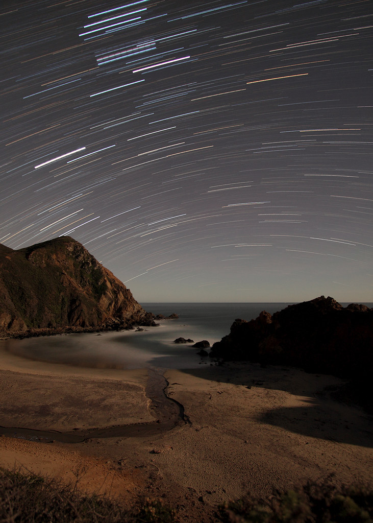
10 four minute exposures at f/3.5, ISO 400, 10mm focal length were combined to produce this image. Shot from 9:33 PM to 10:57 PM, PT. As you may be able to tell, this is a view to the South-southwest from the Northern Hemisphere. You can compare how a Western and Northern view differ in the resulting star trails (the Western view is from near this location, the Northern view is from a completely different location.
If you look carefully, you can spot three equidistant, equally bright stars in the upper left - those are the stars in Orion's belt.
Details on how I made this are available on my website.
All lighting provided by stars and moonlight.
Looks good bigger.
*Explored: Dec 24, 2009 #353*
© Copyright 2009, Steven Christenson
All Rights Reserved.
NOTE: These photos were taken at an event of the Night Photography group.
The Roding Valley Lake is a flooded former gravel pit next to the River Roding in Essex, more or less equidistant between Loughton, Buckhurst Hill and Chigwell.
The gravel was used in the construction of the nearby M11 motorway in the 1970s.
Alice Springs (Eastern Arrernte: Mparntwe) is the third-largest town in the Northern Territory of Australia. Known as Stuart until 31 August 1933, the name Alice Springs was given by surveyor William Whitfield Mills after Alice, Lady Todd (née Alice Gillam Bell), wife of the telegraph pioneer Sir Charles Todd. Now colloquially known as The Alice or simply Alice, the town is situated roughly in Australia's geographic centre. It is nearly equidistant from Adelaide and Darwin.
The area is known as Mparntwe to its original inhabitants, the Arrernte, who have lived in the Central Australian desert in and around what is now Alice Springs for tens of thousands of years.
Alice Springs had an urban population of 26,534 in June 2018, having declined an average of 1.16% per year the preceding five years. The town's population accounts for approximately 10 per cent of the population of the Northern Territory.
The town straddles the usually dry Todd River on the northern side of the MacDonnell Ranges. The surrounding region is known as Central Australia, or the Red Centre, an arid environment consisting of several different deserts. Temperatures in Alice Springs can vary, with an average maximum in summer of 35.6 °C (96.1 °F) and an average minimum in winter of 5.1 °C (41.2 °F).
Olite (en euskera, de manera cooficial, Erriberri) es un municipio y una ciudad española de la Comunidad Foral Navarra. Dista unos 42 km de la capital de la comunidad, Pamplona, unos 51 km de Tudela, unos 40 km de Sangüesa y unos 46 km de Estella. Tafalla está a solo 7 km. Es la cabeza de la merindad del mismo nombre, que corresponde con el mismo territorio del Partido judicial de Tafalla, por lo que, en conjunto, hace de Olite la capital de merindad más equidistante de todas las demás. Su población en 2017 fue de 3927 habitantes.
Olite (in Basque, co-officially, Erriberri) is a municipality and a Spanish city of the Navarra Foral Community. It is about 42 km from the capital of the community, Pamplona, about 51 km from Tudela, about 40 km from Sangüesa and about 46 km from Estella. Tafalla is only 7 km away. It is the head of the merindad of the same name, which corresponds to the same territory of the judicial district of Tafalla, so, as a whole, it makes Olite the most equidistant capital of the province of all the others. Its population in 2017 was 3,927 inhabitants.
(Honourable Mention in the 2012 International Photography Awards landscape category, as part of my 'Sand, Sea & Silence' set of five photographs)
(Published in What Digital Camera, May 2013)
There's no denying what a draw out of season, desolate and seemingly remote beaches are to a black and white photographer. Stripped not only of colour but also the trappings of the tourist season, locations like this one take on a certain air that the hordes of flip-flop wearing, ice cream eating, deck chair lazing people will never experience.
Back in the summer I dropped in on this beach a couple of times. Well, I at least tried to. The first occasion I was deterred by the logistics of trying to combine three equidistant points on the sand to place my tripod without spearing a sun bather. The second I couldn't even park - I cruised by at the speed allowed by the rest of the queing traffic (approx. 1mph), and proceeded to get caught up in a horrendous one way system courtesy of numerous inter-connected road works. What council plans road works in a seaside town in the middle of summer?!
Compare this then to a couple of weeks ago when the only people I saw here were either other photographers, or quite mad. Or possibly both. One thing's certain though, you're much more likely to find me with my camera on a beach come January dressed in jeans, boots and a wooly hat than in July wearing sun glasses and shorts.
Winter is for moody, introspective mono. Summer is for polaroids.
Euroa. Population 3,000.
This attractive Victorian towns is also part of the Goulburn River valley district. It is situation on Sevens Creek which is a tributary of the Goulburn River. The town was named from the local aboriginal word meaning joyful. You will find joy in the wonderful red brick architectural inheritance from the 19th century if this interests you. The central part of the town was surveyed in 1850 and settled in 1854. In the early days the town’s wealth came from the surrounding sheep properties and the first three leasehold runs were established in 1838 by the Faithfull, Templeton and Kirkland families. Once the town was established life here was civilised but not exciting for most, until Ned Kelly robbed the bank here in 1878! The buildings indicate the wealth and civility of Euroa. The railway from Melbourne reached the town in 1873 and business boomed. Euroa is situated equidistantly between Melbourne and Albury. Among the many heritage buildings in the main and railway streets area are the railway station (built around 1878); the former grand but faded Colonial Bank built in 1889; the impressive façade of the Euroa Hotel built in 1884; the outstanding and differently styled National Bank on the corner of Binney St ( the main street) built in 1885 ; Blairgowrie House in the main street built in 1890 as chemist shop and residence; the Post Office built in 1890 ; the unusual Art Nouveau style Courthouse built in 1890 and the former Methodist Church built in 1897. At the very end of the main street you can see the squat Anglican Church built in 1884. In the street parallel to the main street is the red brick Euroa flourmill built in 1873 with a new Art Nouveau façade added in 1903. The flourmill closed in 1917. Just along from the flourmill is the Catholic Church which was erected in 1887 (replacing an earlier church built in 1866).
Diyarbakır '22
I am of the opinion that these three towers northeast of the Evil Beden Tower mark the area known in Roman times as the tripyrgion. We don't have much information about the site's location, but the name in Greek means "three towers" and these three towers are grouped very closely together. The siege of 502/3 was focused on the north of the city where the land was flat and level, with this area in the center/verging on south-west being unsuitable for intensive siege operations due to cliffs. The tripyrgion was manned by monks of the monastery of St. John Urtaye, which was located in the northwest of Amida (Roman Diyarbakır), who would likely have been stationed nearby their old home. The tripyrgion was an isolated area, which this is, had three towers grouped together, which these three towers certainly are, and had a stream or some sort of waterwork nearby that allowed smugglers to enter the city, which this area apparently once had. I'm not alone in this conclusion: this is approximately where this excellent article on the siege places it: Warfare and Tragedy
The reason the tripyrgion matters is that this was where the Persians broke through in their siege of 503. On January 10, after an 80-day siege, the Persians were able to capture the tripyrgion and open the gates to let the army in. This stretch of wall is equidistant from Urfa Gate and Evil Beden Tower (each four towers each way). It's impossible to see from Urfa Gate since the wall curves randomly inwards here, which would have delayed response time. Evil Beden Tower could see what was happening (indeed, they have the best view of any tower on the wall) but they are a projecting point and any effort from there to retake the stretch of wall would be easily seen from the tripyrgion.
The cause of the disaster was apparently that the monks had gotten drunk on the cold winter night. When an observant Persian marzban noticed that nobody was firing at his patrols they snuck in through an underground waterway and slaughtered the monks. And then the city. Supposedly 80,000 people were killed in the sack. That's not impossible - there are 100,000 people living within the Roman walls today, although they rely on vital infrastructure found in the new city - but it would make Amida one of the largest cities in the Roman Empire and be 2-3 times their estimated population. Even with refugees fleeing from the countryside (which there certainly were, the monks being a prime example) it's hard to believe the city had that many people. It's also hard to imagine how the Romans could have counted the dead - the Persians occupied the city for the next year so if the bodies remained stacked in two piles outside the north gate there must have been nothing but bones left by the time they regained it by treaty.
Santa Pau, La Garrotxa, Girona, España.
Santa Pau es una villa y municipio de la comarca de la Garrotxa.
Esta en el sureste de la llanura de Olot, en plena zona volcánica, en medio del valle entre las cordilleras de Sant Julià del Mont i Serra de Finestres y a 496 m sobre el nivel del mar. Cuenta con una única vía de comunicación: la carretera de Olot a Banyoles, y se encuentra a una distancia de 150 km de Barcelona, a 50 Km de Girona y a 9 km de Olot.
En línea recta equidista a 45 Km de la Bahía de Roses y del pico del Canigó, y tanto el uno como el otro son visibles en días claros desde diversos lugares del término municipal. Esto da un carácter mixto de prepirineo y prelitoral a su climatología y por tanto también al tipo de vegetación.
El 81% del territorio municipal forma parte del Parque Natural de la Zona Volcánica de la Garrotxa, y dentro este lugar hay puntos de interés especial como el Volcán de Santa Margarita, el volcán Croscat y los gredales volcánicas, la Fageda d'en Jordà o el salto de agua de Can Batlle.
Santa Pau is a town and municipality in the Garrotxa region.
It is in the southeast of the Olot plain, in the middle of the volcanic area, in the middle of the valley between the Sant Julià del Mont i Serra de Finestres mountain ranges and 496 m above sea level. It has a single communication route: the road from Olot to Banyoles, and it is located at a distance of 150 km from Barcelona, 50 km from Girona and 9 km from Olot.
In an equidistant straight line 45 km from the Bay of Roses and the Canigó peak, and both are visible on clear days from various places in the municipality. This gives a mixed pre-Pyrenean and pre-coastal character to its climate and therefore also to the type of vegetation.
81% of the municipal territory is part of the Garrotxa Volcanic Zone Natural Park, and within this place there are points of special interest such as the Santa Margarita Volcano, the Croscat volcano and the volcanic gredales, the Fageda d'en Jordà or the waterfall of Can Batlle.
Visit: en.wikipedia.org/wiki/Peggys_Cove,_Nova_Scotia
Peggys Point Lighthouse (also known as Peggy's Cove Lighthouse) is in Peggys Cove and is an iconic Canadian image. It is one of the busiest tourist attractions in Nova Scotia and is a prime attraction on the Lighthouse Trail scenic drive. The lighthouse marks the eastern entrance of St. Margarets Bay and is officially known as the Peggys Point Lighthouse.
Peggys Cove is a classic red-and-white lighthouse still operated by the Canadian Coast Guard. The light station is situated on an extensive granite outcrop at Peggys Point, immediately south of the village and its cove. This lighthouse is one of the most-photographed structures in Atlantic Canada and one of the most recognizable lighthouses in the world.
Visitors may explore the granite outcrop on Peggys Point around the lighthouse; despite numerous signs warning of unpredictable surf (including one on a bronze plaque on the lighthouse itself), several visitors each year are swept off the rocks by waves, sometimes drowning.
Peggys Cove is 43 kilometers (26 miles) southwest of downtown Halifax and comprises one of the numerous small fishing communities located around the perimeter of the Chebucto Peninsula. The community is named after the cove of the same name, a name also shared with Peggy's Point, immediately to the east of the cove. The village marks the eastern point of St. Margaret's Bay.(Wikipedia)
Visit: en.wikipedia.org/wiki/Swissair_Flight_111
Swissair Flight 111
Swissair Flight 111 (SR111, SWR111) was a Swissair McDonnell Douglas MD-11 on a scheduled airline flight from John F. Kennedy International Airport in New York City, United States to Cointrin International Airport in Geneva, Switzerland. This flight was also a codeshare flight with Delta Air Lines.
On Wednesday, 2 September 1998, the aircraft used for the flight, registered HB-IWF, crashed into the Atlantic Ocean southwest of Halifax International Airport at the entrance to St. Margarets Bay, Nova Scotia. The crash site was 8 kilometres (5.0 mi) from shore, roughly equidistant from the tiny fishing and tourist communities of Peggys Cove and Bayswater. All 229 people on board died—the highest death toll of any aviation accident involving a McDonnell Douglas MD-11 and the second-highest of any air disaster to occur in Canada, after Arrow Air Flight 1285. This is one of only two hull losses of the passenger configured MD-11, along with China Airlines Flight 642.
The initial search and rescue response, crash recovery operation, and resulting investigation by the Government of Canada took over four years and cost CAD 57 million (at that time approximately US$38 million). The Transportation Safety Board of Canada's (TSB) official report of their investigation stated that flammable material used in the aircraft's structure allowed a fire to spread beyond the control of the crew, resulting in a loss of control and the crash of the aircraft.
Swissair Flight 111 was known as the "UN shuttle" due to its popularity with United Nations officials; the flight often carried business executives, scientists, and researchers
Aircraft
The aircraft, a McDonnell Douglas MD-11, serial number 48448 registered HB-IWF, was manufactured in 1991 and Swissair was its only operator. It bore the title of Vaud, in honor of the Swiss canton of the same name. The airframe had a total of 36,041 hours. The three engines were Pratt & Whitney 4462s. The cabin was configured with 241 seats (12 six-abreast first-, 49 seven-abreast business-, and 180 nine-abreast economy-class). First- and business-class seats were equipped with an in seat in-flight entertainment system, installed at some point after initial entry into service. (Wikipedia)
© Copyright
This photo and all those in my Photostream are protected by copyright. No one may reproduce, copy, transmit or manipulate them without my written permission.
"Alexander Hall. The original building of the Princeton Theological Seminary, patterned after Nassau Hall, and designed by John McComb, Jr. Built in 1814.
Princeton Theological Seminary (PTSem), officially The Theological Seminary of the Presbyterian Church, is a private school of theology in Princeton, New Jersey. Founded in 1812 under the auspices of Archibald Alexander, the General Assembly of the Presbyterian Church (USA), and the College of New Jersey (now Princeton University), it is the second-oldest seminary in the United States. It is also the largest of ten seminaries associated with the Presbyterian Church.
Princeton Seminary has long been influential in theological studies, with many leading biblical scholars, theologians, and clergy among its faculty and alumni. In addition, it operates one of the largest theological libraries in the world and maintains a number of special collections, including the Karl Barth Research Collection in the Center for Barth Studies. The seminary also manages an endowment of $1.13 billion, making it the third-wealthiest institution of higher learning in the state of New Jersey—after Princeton University and Rutgers University.
In the 1980s, Princeton Seminary enrolled about 900 students but today, the Seminary enrolls approximately 333 students. While around 26 percent of them are candidates for ministry specifically in the Presbyterian Church, the majority are completing such candidature in other denominations, pursuing careers in academia across a number of different disciplines, or receiving training for other, non-theological fields altogether.
Seminarians hold academic reciprocity with Princeton University as well as the Westminster Choir College of Rider University, New Brunswick Theological Seminary, Jewish Theological Seminary, and the School of Social Work at Rutgers University. The institution also has an ongoing relationship with the Center of Theological Inquiry.
Princeton was founded before the American Revolutionary War. It is the home of Princeton University, which bears its name and moved to the community in 1756 from its previous location in Newark. Although its association with the university is primarily what makes Princeton a college town, other important institutions in the area include the Institute for Advanced Study, Westminster Choir College, Princeton Plasma Physics Laboratory, Princeton Theological Seminary, Opinion Research Corporation, Bristol-Myers Squibb, Siemens Corporate Research, SRI International, FMC Corporation, The Robert Wood Johnson Foundation, Amrep, Church and Dwight, Berlitz International, and Dow Jones & Company.
Princeton is roughly equidistant from New York City and Philadelphia. It is close to many major highways that serve both cities (e.g., Interstate 95 and U.S. Route 1), and receives major television and radio broadcasts from each. It is also close to Trenton, New Jersey's capital city, New Brunswick and Edison." - info from Wikipedia." - info from Wikipedia.
The fall of 2022 I did my 3rd major cycling tour. I began my adventure in Montreal, Canada and finished in Savannah, GA. This tour took me through the oldest parts of Quebec and the 13 original US states. During this adventure I cycled 7,126 km over the course of 2.5 months and took more than 68,000 photos. As with my previous tours, a major focus was to photograph historic architecture.
Now on Instagram.
Become a patron to my photography on Patreon.
This is Islam's fourth most holiest site
en.wikipedia.org/wiki/Mosque_of_Uqba
The Great Mosque of Kairouan (جامع القيروان الأكبر), also known as the Mosque of Uqba (Arabic: جامع عقبة), is one of the most important mosques in Tunisia, situated in the UNESCO World Heritage town of Kairouan.
Built by the Arab general Uqba ibn Nafi from 670 AD (the year 50 according to the Islamic calendar) at the founding of the city of Kairouan, the mosque is spread over a surface area of 9,000 square metres and it is one of the oldest places of worship in the Islamic world, as well as a model for all later mosques in the Maghreb.[1] The Great Mosque of Kairouan is one of the most impressive and largest Islamic monuments in North Africa,[2] its perimeter is almost equal to 405 metres (1,328 feet). This vast space contains a hypostyle prayer hall, a huge marble-paved courtyard and a massive square minaret. In addition to its spiritual prestige,[3] the Mosque of Uqba is one of the masterpieces of both architecture and Islamic art.[4][5][6]
Under the Aghlabids (9th century), huge works gave the mosque its present aspect.[7] The fame of the Mosque of Uqba and of the other holy sites at Kairouan helped the city to develop and repopulate increasingly. The university, consisting of scholars who taught in the mosque, was a centre of education both in Islamic thought and in the secular sciences.[8] Its role can be compared to that of the University of Paris in the Middle Ages.[9] With the decline of the city of Kairouan from the mid 11th century, the centre of intellectual thought moved to the University of Ez-Zitouna in Tunis.
Location and general aspect
Located in the north-east of the medina of Kairouan, the mosque is in the intramural district of Houmat al-Jami (literally "area of the Great Mosque").[11] This location corresponded originally to the heart of the urban fabric of the city founded by Uqba ibn Nafi.
But because of the specific nature of the land, crossed by several tributaries of the wadis, the urban development of the city stretched southwards. Then there are the upheavals of Kairouan following Hilalian's invasions in 449 AH (or 1057 AD) and which led to the decline of the city. For all these reasons, the mosque (which occupies the same place since its founding in 670) is not any more situated in the center of the medina, and is thereby positioned on the extremity, near the walls.
The building is a vast irregular quadrilateral, longer (with 127.60 meters) from the eastern side than on the opposite side (with 125.20 meters) and less wide (with 72.70 meters) on the north side (in the middle of which stands the minaret) that the opposite side (with 78 meters). It covers a total area of 9000 m2.
From the outside, the Great Mosque of Kairouan is a fortress-like building, which required as much by its massive ocher walls of 1.90 meters thick composed of well-worked stones, courses of rubble stone and courses of baked bricks,[12] as the square angle towers measuring 4.25 meters on each side and the solid and projecting buttresses that support and bind. More than a defensive role, the buttresses and towers full serve more to enhance the stability of the mosque built on a soil subject to compaction.[13] Although a seemingly harsh, the external facades, punctuated with powerful buttresses and towering porches, some of which are surmounted by cupolas, give to the sanctuary a striking aspect characterized by majestic sobriety.
History
Evolution
At the foundation of Kairouan in 670, the Arab general and conqueror Uqba Ibn Nafi (himself the founder of the city) chose the site of his mosque in the center of the city, near the headquarters of the governor. Around 690, shortly after its construction, the mosque was destroyed[15] during the occupation of Kairouan by the Berbers, originally conducted by Kusaila. It was rebuilt by the Ghassanid general Hasan ibn al-Nu'man in 703.[16] With the gradual increase of the population of Kairouan and the consequent increase in the number of faithful, Hisham ibn Abd al-Malik, Umayyad Caliph in Damascus, charged his governor Bishr ibn Safwan to carry out development work in the city which include the renovation and expansion of the mosque around the years 724–728.[17] In view of its expansion, he pulled down the mosque and rebuilt it with the exception of the mihrab. It was under his auspices that the construction of the minaret began.[18] In 774, a new reconstruction accompanied by modifications and embellishments[19] took place under the direction of the Abbasid governor Yazid Ibn Hatim.[20]
Plan architect of the building.
Under the rule of Aghlabid sovereigns, Kairouan was at its apogee, and the mosque profited from this period of stability and prosperity. In 836, Ziadet-Allah I reconstructed the mosque once more:[21] this is when the building acquired, at least in its entirety, the appearance we see today.[22][23] At the same time, the mihrab's ribbed dome on squinches was raised.[24] Around 862-863, Abul Ibrahim enlarged the oratory, with three bays to the north, and added the cupola over the arched portico which precedes the prayer hall.[25] In 875 Ibrahim II built another three bays, thereby reducing the size of the courtyard which was further limited on the three other sides by the addition of double galleries.[26]
The current state of the mosque can be traced back to the reign of Aghlabids—no element is earlier than the ninth century besides the mihrab—except for some partial restorations and a few later additions made in 1025 during the reign of Zirids,[27] 1248 and 1293-1294 under the reign of Hafsids,[28] 1618 at the time of mouradites beys,[29] in the late nineteenth and early twentieth century. In 1967, major restoration works, executed during five years and conducted under the direction of the National Institute of Archeology and Art, were achieved throughout the monument, and were ended with an official reopening of the mosque during the celebration of Mawlid of 1972.[30]
Host stories
Several centuries after its founding, the Great Mosque of Kairouan is the subject of numerous descriptions by Arab historians and geographers in the Middle Ages. The stories concern mainly the different phases of construction and expansion of the sanctuary, and the successive contributions of many princes to the interior decoration (mihrab, minbar, ceilings, etc.). Among the authors who have written on the subject and whose stories have survived[31] are Al-Bakri (Andalusian geographer and historian who died in 1094 and who devoted a sufficiently detailed account of the history of the mosque in his book Description of Septentrional Africa), Al-Nuwayri (historian who died in Egypt, 1332) and Ibn Nagi (scholar and historian of Kairouan who died around 1435).
On additions and embellishments made to the building by the Aghlabid sovereign Abul Ibrahim, Ibn Nagi gives the following account :
« He built in the mosque of Kairouan the cupola that rises over the entrance to the central nave, together with the two colonnades which flank it from both sides, and the galleries were paved by him. He then made the mihrab. »[22]
Among the Western travelers, poets and writers who visited Kairouan, some of them leave impressions and testimonies sometimes tinged with emotion or admiration on the mosque. From the eighteenth century, the French doctor and naturalist John Andrew Peyssonnel, conducting a study trip to 1724, during the reign of sovereign Al-Husayn Bey I, underlines the reputation of the mosque as a deemed center of religious and secular studies :
« The Great Mosque is dedicated to Uqba, where there is a famous college where we will study the remotest corners of this kingdom : are taught reading and writing of Arabic grammar, laws and religion. There are large rents for the maintenance of teachers. »[32]
At the same time,the doctor and Anglican priest Thomas Shaw (1692–1751),[33] touring the Tunis Regency and passes through Kairouan in 1727, described the mosque as that : " which is considered the most beautiful and the most sacred of Berberian territories ", evoking for example : " an almost unbelievable number of granite columns ".[34]
At the end of the nineteenth century, the French writer Guy de Maupassant expresses in his book La vie errante (The Wandering Life), his fascination with the majestic architecture of the Great Mosque of Kairouan as well as the effect created by countless columns : " The unique harmony of this temple consists in the proportion and the number of these slender shafts upholding the building, filling, peopling, and making it what it is, create its grace and greatness. Their colorful multitude gives the eye the impression of unlimited ".[35] Early in the twentieth century, the Austrian poet Rainer Maria Rilke describes his admiration for the impressive minaret :
« Is there a more beautiful than this still preserved old tower, the minaret, in Islamic architecture ? In the history of Art, its three-storey minaret is considered such a masterpiece and a model among the most prestigious monuments of Muslim architecture. »
Architecture and decoration
Exterior
Enclosure
Today, the enclosure of the Great Mosque of Kairouan is pierced by nine gates (six opening on the courtyard, two opening on the prayer hall and a ninth allows access to the maqsura) some of them, such as Bab Al-Ma (Gate of water) located on the western facade, are preceded by salient porches flanked by buttresses and surmounted by ribbed domes based on square tholobate which are porting squinches with three vaults.[12][37] However, Arab geographers and historians of the Middle Ages Al-Muqaddasi and Al-Bakri reported the existence, around the tenth and eleventh centuries, of about ten gates named differently from today. This reflects the fact that, unlike the rest of the mosque, the enclosure has undergone significant changes to ensure the stability of the building (adding many buttresses). Thus, some entries have been sealed, while others were kept.[12]
During the thirteenth century, new gates were opened, the most remarkable, Bab Lalla Rihana dated from 1293, is located on the eastern wall of the enclosure.[12] The monumental entrance, work of the Hafsid sovereign Abu Hafs `Umar ibn Yahya (reign from 1284 to 1295),[38] is entered in a salient square, flanked by ancient columns supporting Horseshoe arches and covered by a dome on squinches.[12] The front facade of the porch has a large horseshoe arch relied on two marble columns and surmounted by a frieze adorned with a blind arcade, all crowned by serrated merlons (in a sawtooth arrangement).[39] Despite its construction at the end of the thirteenth century, Bab Lalla Rihana blends well with all of the building mainly dating from the ninth century.[39]
Enclosure and gates of the Mosque of Uqba
Courtyard
The courtyard is a vast trapezoidal area whose interior dimensions are approximately 65 by 50 meters.[40] It is surrounded on all its four sides by a portico with double rows of arches, opened by slightly horseshoe arches supported by columns in various marbles, in granite or in porphyry, reused from Roman, Early Christian or Byzantine monuments particularly from Carthage.[14] Access to the courtyard by six side entrances dating from the ninth and thirteenth centuries.
The portico on the south side of the courtyard, near the prayer hall, includes in its middle a large dressed stone pointed horseshoe arch which rests on ancient columns of white veined marble with Corinthian capitals. This porch of seven meters high is topped with a square base upon which rests a semi-spherical ribbed dome ; the latter is ribbed with sharp-edged ribs. The intermediary area, the dodecagonal drum of the dome, is pierced by sixteen small rectangular windows set into rounded niches.[41] The great central arch of the south portico, is flanked on each side by six rhythmically arranged horseshoe arches, which fall on twin columns backed by pillars.[42] Overall, the proportions and general layout of the facade of the south portico, with its thirteen arches of which that in the middle constitutes a sort of triumphal arch crowned with a cupola, form an ensemble with " a powerful air of majesty ", according to the French historian and sociologist Paul Sebag (1919–2004).[43]
Courtyard area and porticoes
Details of the courtyard
The combination formed by the courtyard and the galleries that surround it covers an immense area whose dimensions are about 90 meters long and 72 meters in width.[44] The northern part of the courtyard is paved with flagstones while the rest of the floor is almost entirely composed of white marble slabs. Near its center is an horizontal sundial, bearing an inscription in naskhi engraved on the marble dating from 1258 AH (which corresponds to the year 1843) and which is accessed by a little staircase ; it determines the time of prayers. The rainwater collector or impluvium, probably the work of the Muradid Bey Mohamed Bey al-Mouradi (1686–1696), is an ingenious system that ensures the capture (with the slightly sloping surface of the courtyard) then filtering stormwater at a central basin furnished with horseshoe arches sculpted in white marble.[45] Freed from its impurities, the water flows into an underground cistern supported by seven meters high pillars. In the courtyard there are also several water wells some of which are placed side by side. Their edges, obtained from the lower parts of ancient cored columns,[46] support the string grooves back the buckets.
Minaret
A square stone tower rises high above a wall.
The minaret, which occupies the center of the northern facade of the complex's enclosure, is 31.5 meters tall and is seated on a square base of 10.7 meters on each side.[47] It is located inside the enclosure and does not have direct access from the outside. It consists of three tapering levels, the last of which is topped with a small ribbed dome that was most probably built later than the rest of the tower.[48] The first and second stories are surmounted by rounded merlons which are pierced by arrowslits. The minaret served as a watchtower, as well as to call the faithful to prayer.[48]
The door giving access to the minaret is framed by a lintel and jambs made of recycled carved friezes of antique origin.[49] There are stone blocks from the Roman period that bear Latin inscriptions. Their use probably dates to the work done under the Umayyad governor Bishr ibn Safwan in about 725 AD, and they have been reused at the base of the tower.[49] The greater part of the minaret dates from the time of the Aghlabid princes in the ninth century. It consists of regular layers of carefully cut rubble stone, thus giving the work a stylistically admirable homogeneity and unity.[50]
The interior includes a staircase of 129 steps, surmounted by a barrel vault, which gives access to the terraces and the first tier of the minaret. The courtyard facade (or south facade) of the tower is pierced with windows that provide light and ventilation,[51] while the other three facades—facing north, east and west—are pierced with small openings in the form of arrowslits.[47] The minaret, in its present aspect, dates largely from the early ninth century, about 836 AD. It is the oldest minaret in the Muslim world,[52][53] and it is also the world's oldest minaret still standing.[54]
Due to its age and its architectural features, the minaret of the Great Mosque of Kairouan is the prototype for all the minarets of the western Islamic world : it served as a model in both North Africa and in Andalusia.[55] Despite its massive form and austere decoration, it nevertheless presents a harmonious structure and a majestic appearance.[51][56]
Minaret
Domes
The Mosque has several domes, the largest being over the mihrab and the entrance to the prayer hall from the courtyard. The dome of the mihrab is based on an octagonal drum with slightly concave sides, raised on a square base, decorated on each of its three southern, Easter and western faces with five flat-bottomed niches surmounted by five semi-circular arches,[24][57] the niche in the middle is cut by a lobed oculus enrolled in a circular frame. This dome, whose construction goes back to the first half of the ninth century (towards 836), is one of the oldest and most remarkable domes in the western Islamic world.[58]
Interior
Prayer hall
The prayer hall is located on the southern side of the courtyard ; and is accessed by 17 carved wooden doors. A portico with double row of arches precede the spacious prayer hall, which takes the shape of a rectangle of 70.6 meters in width and 37.5 meters depth.[59]
The hypostyle hall is divided into 17 aisles of eight bays, the central nave is wider, as well as the bay along the wall of the qibla.[60] They cross with right angle in front of the mihrab, this device, named "T shape", which is also found in two Iraqi mosques in Samarra (around 847) has been adopted in many North African and Andalusian mosques where it became a feature.[61]
The central nave, a sort of triumphal alley which leads to the mihrab,[62] is significantly higher and wider than the other sixteen aisles of the prayer hall. It is bordered on each side of a double row of arches rested on twin columns and surmounted by a carved plaster decoration consisting of floral and geometric patterns.[63]
Enlightened by impressive chandeliers which are applied in countless small glass lamps,[64] the nave opens into the south portico of the courtyard by a monumental delicately carved wooden door, made in 1828 under the reign of the Husainids.[65] This sumptuous door, which has four leaves richly carved with geometric motifs embossed on the bottom of foliages and interlacing stars, is decorated at the typanum by a stylized vase from which emerge winding stems and leaves.[66] The other doors of the prayer hall, some of which date from the time of the Hafsids,[67] are distinguished by their decoration which consists essentially of geometric patterns (hexagonal, octagonal, rectangular patterns, etc.).[59]
Columns and ceiling
In the prayer hall, the 414 columns of marble, granite or porphyry[68] (among more than 500 columns in the whole mosque),[69] taken from ancient sites in the country such as Sbeïtla, Carthage, Hadrumetum and Chemtou,[59] support the horseshoe arches. A legend says they could not count them without going blind.[70] The capitals resting on the column shafts offer a wide variety of shapes and styles (Corinthian, Ionic, Composite, etc..).[59] Some capitals were carved for the mosque, but others come from Roman or Byzantine buildings (dating from the second to sixth century) and were reused. According to the German archaeologist Christian Ewert, the special arrangement of reused columns and capitals surrounding the mihrab obeys to a well-defined program and would draw symbolically the plan of the Dome of the Rock.[71] The shafts of the columns are carved in marble of different colors and different backgrounds. Those in white marble come from Italy,[59] some shafts located in the area of the mihrab are in red Porphyry imported from Egypt,[72] while those made of greenish or pink marble are from quarries of Chemtou, in the north-west of current Tunisia.[59] Although the shafts are of varying heights, the columns are ingeniously arranged to support fallen arches harmoniously. The height difference is compensated by the development of variable bases, capitals and crossbeams ; a number of these crossbeams are in cedar wood.[59] The wooden rods, which usually sink to the base of the transom, connect the columns together and maintain the spacing of the arches, thus enhancing the stability of all structures which support the ceiling of the prayer hall.[73]
The covering of the prayer hall consists of painted ceilings decorated with vegetal motifs and two domes : one raised at the beginning of the central nave and the other in front of the mihrab. The latter, which its hemispherical cap is cut by 24 concave grooves radiating around the top,[74] is based on ridged horns shaped shell and a drum pierced by eight circular windows which are inserted between sixteen niches grouped by two.[57][75] The niches are covered with carved stone panels, finely adorned with characteristic geometric, vegetal and floral patterns of the Aghlabid decorative repertoire : shells, cusped arches, rosettes, vine-leaf, etc.[57] From the outside, the dome of the mihrab is based on an octagonal drum with slightly concave sides, raised on a square base, decorated on each of its three southern, Easter and western faces with five flat-bottomed niches surmounted by five semi-circular arches,[24][57] the niche in the middle is cut by a lobed oculus enrolled in a circular frame.
The painted ceilings are a unique ensemble of planks, beams and brackets, illustrating almost thousand years of the history of painting on wood in Tunisia. Wooden brackets offer a wide variety of style and decor in the shape of a crow or a grasshopper with wings or fixed, they are characterized by a setting that combines floral painted or carved, with grooves. The oldest boards date back to the Aghlabid period (ninth century) and are decorated with scrolls and rosettes on a red background consists of squares with concave sides in which are inscribed four-petaled flowers in green and blue, and those performed by the Zirid Dynasty (eleventh century) are characterized by inscriptions in black kufic writing with gold rim and the uprights of the letters end with lobed florets, all on a brown background adorned with simple floral patterns.
The boards painted under the Hafsid period (during the thirteenth century) offers a floral decor consists of white and blue arches entwined with lobed green. The latest, dated the seventeenth and eighteenth centuries (mostly dating from the time of the Muradid Beys), are distinguished by an epigraphic decoration consists of long black and red texts on olive green background to those painted from 1618 to 1619, under the reign of Murad I Bey (1613-1631), while those back to the eighteenth century have inscriptions in white naskhi script on an orange background.[76]
Mihrab and minbar
Close view of the mihrab, whose current state dates from the ninth century
The mihrab, which indicates the Qibla (direction of Mecca), in front of which stands the imam during the prayer, is located in the middle of the southern wall of the prayer hall. It is formed by an oven-shaped niche framed by two marble columns and topped by a painted wooden half-cupola. The niche of the mihrab is two meters long, 4.5 meters high and 1.6 meters deep.[77]
The mosque's mihrab, whose decor is a remarkable witness of Muslim art in the early centuries of Islam, is distinguished by its harmonious composition and the quality of its ornaments. Considered as the oldest example of concave mihrab, it dates in its present state to 862-863 AD.[78]
Upper Part of The Mihrab
It is surrounded at its upper part by 139 lusterware tiles (with a metallic sheen), each one is 21.1 centimeters square and they are arranged on the diagonal in a chessboard pattern. Divided into two groups, they are dated from the beginning of the second half of the ninth century but it is not determined with certainty whether they were made in Baghdad or in Kairouan by a Baghdadi artisan, the controversy over the origin of this precious collection agitates the specialists. These tiles are mainly decorated with floral and plant motifs (stylized flowers, palm leaves and asymmetrical leaves on bottom hatch and checkered) belong to two series : one polychrome characterized by a greater richness of tones ranging from light gold to light, dark or ocher yellow, and from brick-red to brown lacquer, the other monochrome is a beautiful luster that goes from smoked gold to green gold. The coating around them is decorated with blue plant motifs dating from the eighteenth century or the first half of the nineteenth century. The horseshoe arch of the mihrab, stilted and broken at the top, rest on two columns of red marble with yellow veins, which surmounted with Byzantine style capitals that carry two crossbeams carved with floral patterns, each one is decorated with a Kufic inscription in relief.
Detail of the marble cladding
The wall of the mihrab is covered with 28 panels of white marble, carved and pierced, which have a wide variety of plant and geometric patterns including the stylized grape leaf, the flower and the shell. Behind the openwork hint, there is an oldest niche on which several assumptions were formulated. If one refers to the story of Al-Bakri, an Andalusian historian and geographer of the eleventh century, it is the mihrab which would be done by Uqba Ibn Nafi, the founder of Kairouan, whereas Lucien Golvin shares the view that it is not an old mihrab but hardly a begun construction which may serve to support marble panels and either goes back to work of Ziadet Allah I (817-838) or to those of Abul Ibrahim around the years 862-863.[79] Above the marble cladding, the mihrab niche is crowned with a half dome-shaped vault made of manchineel bentwood. Covered with a thick coating completely painted, the concavity of the arch is decorated with intertwined scrolls enveloping stylized five-lobed vine leaves, three-lobed florets and sharp clusters, all in yellow on midnight blue background.[80]
The minbar, situated on the right of the mihrab, is used by the imam during the Friday or Eids sermons, is a staircase-shaped pulpit with an upper seat, reached by eleven steps, and measuring 3.93 meters length to 3.31 meters in height. Dated from the ninth century (about 862) and erected under the reign of the sixth Aghlabid ruler Abul Ibrahim (856-863), it is made in teak wood imported from India.[81] Among all the pulpits of the Muslim world, it is certainly the oldest example of minbar still preserved today.[82] Probably made by cabinetmakers of Kairouan (some researchers also refer to Baghdad), it consists of an assembly of more than 300 finely carved wood pieces with an exceptional ornamental wealth (vegetal and geometric patterns refer to the Umayyad and Abbasid models), among which about 90 rectangular panels carved with plenty of pine cones, grape leaves, thin and flexible stems, lanceolate fruits and various geometric shapes (squares, diamonds, stars, etc.). The upper edge of the minbar ramp is adorned with a rich and graceful vegetal decoration composed of alternately arranged foliated scrolls, each one containing a spread vine-leaf and a cluster of grapes. In the early twentieth century, the minbar had a painstaking restoration. Although more than eleven centuries of existence, all panels, with the exception of nine, are originals and are in a good state of conservation, the fineness of the execution of the minbar makes it a great masterpiece of Islamic wood carving referring to Paul Sebag.[83] This old chair of the ninth century is still in its original location, next to the mihrab.
Maqsura
The maqsura, located near the minbar, consists of a fence bounding a private enclosure that allows the sovereign and his senior officials to follow the solemn prayer of Friday without mingling with the faithful. Jewel of the art of woodwork produced during the reign of the Zirid prince Al-Muizz ibn Badis and dated from the first half of the eleventh century, it is considered the oldest still in place in the Islamic world. It is a cedar wood fence finely sculpted and carved on three sides with various geometric motifs measuring 2.8 meters tall, eight meters long and six meters wide.[84] Its main adornment is a frieze that crowns calligraphy, the latter surmounted by a line of pointed openwork merlons, features an inscription in flowery kufic character carved on the background of interlacing plants. Carefully executed in relief, it represents one of the most beautiful epigraphic bands of Islamic art.[84]
The library is near located, accessible by a door which the jambs and the lintel are carved in marble, adorned with a frieze of floral decoration. The library window is marked by an elegant setting that has two columns flanking the opening, which is a horseshoe arch topped by six blind arches and crowned by a series of berms sawtooth.[85]
Artworks
The Mosque of Uqba, one of the few religious buildings of Islam has remained intact almost all of its architectural and decorative elements, is due to the richness of its repertoire which is a veritable museum of Islamic decorative art and architecture. Most of the works on which rests the reputation of the mosque are still conserved in situ while a certain number of them have joined the collections of the Raqqada National Museum of Islamic Art ; Raqqada is located about ten kilometers southwest of Kairouan.
From the library of the mosque comes a large collection of calligraphic scrolls and manuscripts, the oldest dating back to the second half of the ninth century. This valuable collection, observed from the late nineteenth century by the French orientalists Octave Houdas and René Basset who mention in their report on their scientific mission in Tunisia published in the Journal of African correspondence in 1882, comprises according to the inventory established at the time of the Hafsids (circa 1293-1294) several Qur'ans and books of fiqh that concern mainly the Maliki fiqh and its sources. These are the oldest fund of Maliki legal literature to have survived.[86]
Among the finest works of this series, the pages of the Blue Qur'an, currently exhibited at Raqqada National Museum of Islamic Art, from a famous Qur'an in the second half of the fourth century of the Hegira (the tenth century) most of which is preserved in Tunisia and the rest scattered in museums and private collections worldwide. Featuring kufic character suras are written in gold on vellum dyed with indigo, they are distinguished by a compact graph with no marks for vowels. The beginning of each surah is indicated by a band consisting of a golden stylized leafy foliage, dotted with red and blue, while the verses are separated by silver rosettes. Other scrolls and calligraphic Qur'ans, as that known as the Hadinah's Qur'an, copied and illuminated by the calligrapher Ali ibn Ahmad al-Warraq for the governess of the Zirid prince Al-Muizz ibn Badis at about 1020 AD, were also in the library before being transferred to Raqqada museum. This collection is a unique source for studying the history and evolution of calligraphy of medieval manuscripts in the Maghreb, covering the period from the ninth to the eleventh century.
Other works of art such as the crowns of light (circular chandeliers) made in cast bronze, dating from the Fatimid-Zirid period (around tenth-early eleventh century), originally belonged to the furniture of the mosque. These polycandelons, now scattered in various Tunisian museums including Raqqada, consist of three chains supporting a perforated brass plate, which has a central circular ring around which radiate 18 equidistant poles connected by many horseshoe arches and equipped for each of two landmarks flared. The three chains, connected by a suspension ring, are each fixed to the plate by an almond-shaped finial. The crowns of light are marked by Byzantine influence to which the Kairouanese artisan brought the specificities of Islamic decorative repertoire (geometric and floral motifs).[
Role in Muslim civilization
At the time of its greatest splendor, between the ninth and eleventh centuries AD, Kairouan was one of the greatest centers of Islamic civilization and its reputation as a hotbed of scholarship covered the entire Maghreb. During this period, the Great Mosque of Kairouan was both a place of prayer and a center for teaching Islamic sciences under the Maliki current. One may conceivably compare its role to that of the University of Paris during the Middle Ages.
In addition to studies on the deepening of religious thought and Maliki jurisprudence, the mosque also hosted various courses in secular subjects such as mathematics, astronomy, medicine and botany. The transmission of knowledge was assured by prominent scholars and theologians which included Sahnun ibn Sa'id and Asad ibn al-Furat, eminent jurists who contributed greatly to the dissemination of the Maliki thought, Ishaq ibn Imran and Ibn al-Jazzar in medicine, Abu Sahl al-Kairouani and Abd al-Monim al-Kindi in mathematics. Thus the mosque, headquarters of a prestigious university with a large library containing a large number of scientific and theological works, was the most remarkable intellectual and cultural center in North Africa during the ninth, tenth and eleventh centuries
Zwiggelte
"The Westerbork Synthesis Radio Telescope (WSRT) is an aperture synthesis interferometer built on the site of the former World War II Nazi detention and transit camp Westerbork, north of the village of Westerbork, Midden-Drenthe, in the northeastern Netherlands.
The WRST comprises fourteen 25-metre radio telescopes deployed in a linear array arranged on a 2.7 kilometres (1.7 mi) East-West line, of which 10 are in a fixed equidistant position, 2 are nearby on a 300 m rail track, and 2 are located a kilometer eastwards on another 200 m rail track. It has a similar arrangement to other radio telescopes such as the One-Mile Telescope, Australia Telescope Compact Array and the Ryle Telescope. Its Equatorial mount is what sets it apart from most other radio telescopes, most of which have an Altazimuth mount. This makes it specifically useful for specific types of science, like polarized emission research as the detectors maintain a constant orientation on the sky during an observation. Ten of the telescopes are on fixed mountings while the remaining two dishes are movable along two rail tracks. The telescope was completed in 1970 and underwent a major upgrade between 1995 – 2000." (Wikipedia)
Source & more information: en.wikipedia.org/wiki/Westerbork_Synthesis_Radio_Telescope
Dawn in the tallgrass prairie of western Minnesota. The trick here was to line up the three stems so that there were equidistant from my film plane - parallel plane focusing allowed me to keep them all relatively sharp despite a wide f-stop. I needed the wide f-stop because there was a ripple of wind necessitating the fastest shutter speed I could manage - and this was in the days of slow slide film (ISO 50).
Scanned from the original Fujichrome Velvia slide. Don't use this image on websites, blogs, or other media without explicit permission ©2002 James R. Page - all rights reserved.
"No hace mucho tiempo, al entrar en una oficina secundaria de la administración nacional, vi a un humilde escribiente cuyo cabello empezaba a encanecer, gravemente ocupado en trazar rayas equidistantes en un pliego de papel. Como tuve que esperar, pude observarlo. Cada vez que concluía una línea, dejaba la regla a un lado, sujetándola para que no rodara, con un pan de goma, levantaba la pluma e inclinando la cabeza como el pintor que después de un golpe de pincel se aleja para ver el efecto, sonreía con satisfacción. Luego, como fascinado por el paralelismo de sus rayas, tomaba de nuevo la regla, la pasaba por la manga de una levita raída, cuyo tejido osteológico recibía con agrado ese apunte de negrura, la colocaba sobre el papel y con una presión de mano, serena e igual, trazaba una nueva paralela con idéntico éxito. Ese hombre, allá en los años de colegio, me había un día asombrado por la precisión y claridad con que expuso, tiza en mano, el binomio de Newton."
Del libro "Juvenilia", de Miguel Cané.
"Not so long ago, into a secondary National Administration Office, I saw a humble clerk whose hair was beginning to turn gray, gravely occupied with tracing equidistant stripes on a sheet of paper. As I had to wait, I could observe. Each time he finished a line, he left the rule aside, holding it so it would not roll, with a rubber eraser, lifted the pen and tilted his head like the painter who, after a brushstroke, moves away to see the effect, smiled with satisfaction. Then, fascinated by the parallelism of his stripes, he took the rule again, passed it by the sleeve of a threadbare coat, whose osteological fabric welcomed this note of blackness, placed it on the paper and with a hand pressure, serene and equal, drew up a new parallel stripe with identical success. This man, back in the years of school, had astonished me with the precision and clarity with which he exposed, chalk in hand, Newton's binomial theorem."
From the book "Juvenilia", by Miguel Cané.
52 Still Lifes 39/52: Stripes | Rayas
© Luxgnos Photography / Brian Callahan 2011 All rights reserved.
"The labor of a human being is not a commodity or an article of commerce."
Clayton Anti-Trust Act 1914
"Whenever there is a conflict between human rights and property rights, human rights must prevail."
Abraham Lincoln
Labor day is not just for parties and festivals, but a time to remember the brave leaders and men and women of the labor movement who walked the lines, took the beatings and did the work that ended child labor, started the path toward employment equality for women, gave us the 8 hour day, 40 hour week, overtime, paid vacations, health care and the great United States middle class. Too many heros to mention but here are some favorites:
Eugene Debs
Saul Alinsky
Mother Jones
Walter Reuther
John Lewis
Joe Hill
Woody Guthrie
Cesar Chavez
Reverend Martin Luther King Jr.
Studs Terkel
The Labor Legacy Landmark
With its shining arch rising 63 feet above the ground, the Labor Legacy Landmark, "Transcending," draws attention to itself as one of the newest additions to the Detroit skyline. The piece, commissioned by the Michigan Labor Legacy Project and funded solely through donations from union members without the aid of public or corporate money, is designed to celebrate the history and contributions of labor. The only such monument in the United States, the Labor Legacy Landmark is the work of local sculptors David Barr and Sergio De Giusti.
Barr, a teacher of sculpture and an internationally acclaimed artist, created the "Four Corners Project," in which he placed four carved marble tetrahedrons at equidistant sites around the globe, in effect creating the largest sculpture ever made. The Italian-born De Giusti is best known for his representative relief works, on display at public institutions throughout the state and around the world. One of De Giusti's works,a nine-foot bronze freestanding relief, is prominently displayed at the main plaza of the Blue Cross Blue Shield Building.
Barr, whose work is primarily abstract and symbolic, sought out the collaboration with De Giusti in order to add a more intimate dimension to the project. Both men envisioned something other than the funereal, European tradition of famous leaders commemorated by solemn statues. Instead, they set out to create a space - an environment where viewers can enjoy art as they come to understand and appreciate the struggles of labor.
From afar, (the piece can be seen from Canada) the work's great stainless steel arch is its most visible aspect. The notched, rounded arch resembles the ubiquitous symbol of labor - the gear and serves as a testament to labor's spirit of exuberance and defiance.
"Transcending's" circular form also stands in contrast to the city's grid-like design as a symbol of inclusion. The bottom of the gear appears to merge into the earth. Barr says, "The world drives industry and labor, and industry and labor drive the world."
The arch rests on a circular, raised dais, and is partially encircled by seven granite boulders all split symmetrically in two. According to De Giusti "Stones have a great presence and have always been used to commemorate events. They are markers of a people and a generation." Brought from Vermont, the stones suggest a strong linkage to the past and their permanence creates a link towards our future.
The boulders' polished surfaces are adorned with De Giusti's bronze reliefs which depict the sacrifices and achievements of labor. His method of presenting objects pushing through and receding into the flat surface of the relief, suggests the embedding of fossils in stone. In direct sunlight, the bronze shines like a geode from within the split rock.
The piece also includes a twisting marble path. A tile at the beginning of the path is engraved with the words, "Labor's achievements are America's strength," and subsequent tiles enumerate those achievements - "Free public education," "Human rights," "Equality for women." Other tiles feature historical labor-related quotes such as "Without struggle there is no progress" (attributed to Frederick Douglas), and Martin Luther King's words, "The arc of history bends toward justice."
De Giusti's reliefs line the path at it spirals inward. At the spiral's center are two boulders - one displaying chains and the other displaying hands - directly below the apex of Barr's arch. A look straight upwards reveals that the arch is divided by a narrow gap at the top. This separation symbolizes how far labor has come and how far it still has to go. At night the arch is made whole by lights projecting from the two disconnected ends.
When the piece was still in the proposal stage, then-Mayor Dennis Archer told the Detroit Free Press, "What the labor movement is doing is reminding everybody who builds buildings that public art also has a place in the betterment of a city." In "Transcending" Barr and De Giusti have created not only an important piece of art but also a significant historical and educational setting designed to connect viewers to the past and inspire them to affect their future. - Nick Sousanis
#abfav_yellow
Art Nouveau is a decorative style in the visual arts, interior design, and architecture that flourished from 1890 to 1910. It is characterised by organic, sinuous patterns and ornamentations based usually on twisting plant forms.
Here I 'shaped' Tulips in a circle...
A circle is a simple shape of Euclidean geometry consisting of those points in a plane which are equidistant from a given point called the center.
A circle as a metaphor and structure for defining a system of communication and interaction...
Inner-circles, outer-circles...
It seems to me that everything comes in 'circles'... It was Spring once more...
Just a meditative day!
THANKS for ALL your comments and visits, so appreciated, M, (*_*)
For more of my other work or if you want to purchase, visit here: www.indigo2photography.com
Please do not use or COPY any of my images on websites, blogs or any other media without my explicit permission. © All rights reserved
Peggy's Cove, Nova Scotia, Canada
Swissair Flight 111 was a scheduled international passenger flight from John F. Kennedy International Airport in New York City, United States, to Cointrin International Airport in Geneva, Switzerland. This flight was also a codeshare flight with Delta Air Lines. On 2 September 1998, the McDonnell Douglas MD-11 performing this flight, registration HB-IWF, crashed into the Atlantic Ocean southwest of Halifax International Airport at the entrance to St. Margarets Bay, Nova Scotia. The crash site was 8 kilometres (5 mi; 4 nmi) from shore, roughly equidistant from the tiny fishing and tourist communities of Peggy's Cove and Bayswater. All 229 passengers and crew on board the MD-11 were killed, making the crash the deadliest McDonnell Douglas MD-11 accident in aviation history.
Peoples of Peggy's Cove help the Rescue Teams on site with Fishing Boats and comfortedthe families.
Layer upon layer of crossbedded Navajo sandstone in multiple shades of earth tones makes this scene a geological storybook. There are at least a dozen ranks of crossbeds in this view. If geology is not your cup of tea, I hope you enjoy the colors and patterns.
This was a scene from my hike around Caterpillar Mesa last fall, looking west from an overview of the Paria Puppets. Secret Pocket is hidden around a corner in there; do you see it? No? That's why it's secret.
Names are mine, not official designations. Foreshortening from the telephoto makes the layers look equidistant. Actually, the layers at upper right are almost a half mile farther away.
La Plaza del Congreso és una plaça ubicada a la ciutat de Buenos Aires, delimitada per les avingudes Entre Ríos, Rivadavia, Hipólito Yrigoyen i el carrer Virrey Cevallos. Mal anomenada Plaza de los Dos Congresos, la confusió es deu al fet que el monument que s'hi troba rep aquest nom en honor a l'Assemblea de l'any XIII i al Congrés de Tucumán.
És part d'un conjunt de tres places ubicades a la mateixa zona, al costat de la Plaça Lorea i la Plaça Mariano Moreno. La construcció d'aquestes places va ser una creació urbanística al voltant de les festes del centenari de la Revolució de Maig, i responia al pensament higienista de finals del segle XIX que encertadament buscava llocs ventilats i assolejats a les grans ciutats.
Està ubicada al barri porteño de Montserrat.
El monumento de los Dos Congresos està executat en pedra de Nancy i les seves figures són de bronze patinat. Obra dels belgues D'Huique i Jules Lagae, va ser inaugurat el 9 de juliol de 1914.
Està envoltat per una escalinata que dóna accés a la plataforma, en la qual s'erigeix el monument coronat per una estàtua que representa La República amb un ram de llorer en una mà i recolzant l'altra a la guia d'una arada. troben les serps dels mals i una altra figura que representa el treball. Als costats hi ha les figures complementàries que representen l'Assemblea de l'Any XIII i el Congrés de Tucumán.
La plataforma oriental es troba envoltada per una font amb grans sortidors, els raigs d'aigua dels quals solen ser il·luminats de nit, entre els quals apareixen escultures de cavalls envoltades per còndors de bronze i rondes equidistants de nens que representen la Pau. La font s'estén cap a l'est, i representa el Riu de la Plata. Quatre esglaons més amunt hi ha un altre estany amb dues figures de bronze, que representen els afluents del riu, el riu Uruguai i el riu Paraná. L'estany està envoltat d'escultures d'animals de la fauna nacional i al centre sorgeix un conjunt escultòric construït en bronze.
Aquesta foto ha jugat a A place from Flickr.