View allAll Photos Tagged ~
Created for Sliders Sunday
thank you [http://www.flickr.com/photos/lenabem-anna/] for the wonderful textures
happy sliders sunday !
enjoy your upcoming week, my flickrinos!
♥
It was first when I open this up in elements that I saw how the rails, my kids, wife and the lamps makes a perfect triangle. Pure luck. I was just firing in all directions as you have to do when dealing with kids, animals or sailboats:p
And the hand looks pretty halloweenish. haha..
Blick von Sankt Oswald nach Norden vom Rachel zum Lusen (der Rachel ist schon unter Wolken).
Panorama 3 Aufnahmen Querformat f=35mm 50% der Originalgröße
Serie en el último comentario
*********************************************
Estas fotos de la serie pertenecen a tres lugares de Caminha, un bonito pueblo portugués en la desembocadura del río Miño.
La Mata Nacional de Camarido, el mayor pinar atlántico portugués, al norte del río Duero.
Fué mandado plantar por el Rey Don Dinís en el siglo XIV, al borde mismo de la playa.
Basicamente es de pino bravo y ha sido repoblado en el año 2011 con 18.000 nuevos árboles tales como pino manso, roble, alcornoque, fresno, sauce.......para rejuvenecer y diversificar un bosque tan antiguo.
Es un LIC (Lugar de Interés Comunitario)
La Praia de Moledo, unida a la Praia de Camarido o Praia da Foz do Minho, un arenal con bandera azul comunitaria muy expuesto a vientos y oleajes atlánticos, de una enorme belleza salvaje.....estupenda para practicar surf y windsurf.
La Capela de Santo Antão en el monte que domina Caminha, estribaciones de la Serra de Arga, con un mirador increible sobre toda la desembocadura del Río Miño.
Resaltar que este monte ha ardido completamente este verano, da mucha tristeza verlo asi........
*********************************************
Londra (GB) - Sony α A850 + Konica Minolta 17-35mm f/2.8-4
© All rights reserved. Use without permission is illegal.
www.photoboxgallery.com/VickyWB/photo?photo_id=4058238562...
One of my many attempts to photograph the ubiquitous Buachaille Etive Mor; no doubt that this is the most photographed mountain in Scotland! We were very lucky with the stunning sunset, but again there are quality issues due to low light, and again I was really wishing for a DSLR! Soon... Thank you all for all of your faves, comments and constructive criticism - feedback really helps and is really appreciated!
Para o mundo admirar.
O Brasil do meu amor,
Terra de Nosso Senhor.
Brasil!... Brasil! Prá mim ... Prá mim!... ♫
No video vemos uma das mais belas interpretações de "Aquarela do Brasil", de um coral da distante Eslovenia, numa beleza que vem de um carinho em cantar numa harmonia tão bela e com a preocupação inclusive em uma pronuncia quase perfeita e sem sotaque.
Foto: Pão de Açucar - Sugar Loaf - Rio de Janeiro - Brasil
Video: ♪ Aquarela do Brasil ♪ - Perpetuun Jazzile & BR6
Conforme a Lei 9.610/98, é proibida a reprodução total ou parcial ou divulgação comercial ou não sem a autorização prévia e expressa do autor (artigo 29). ® Todos os direitos reservados.
According to Law 9.610/98, it is prohibited the partial or total commercial reproduction without the previous written authorization of the author (article 29). ® All rights are reserved.
"I guess I've always lived upside down when I want things I can't have."
- Tom Waits
texture by darkwood67 thanks
happy autumn and
happy sliders sunday, my flickrino friends!
♥
© all rights reserved by B℮n
Please take your time... to View it large on black
The Waterkeringpad is a walking route between Amsterdam Central Station and Huizen and consists of eight sections. Check all sections here and information. The route follows the dike along the former Zuiderzee now the IJ Lake and the Gooimeer. A unique experience, walking on the dike! Before 1500 the Diemerzeedijk between Maxis and Muiden was made from clay and construction waste. From mid-fifteenth century, the old sea wall was a retaining wall of wooden poles. Between 1732 and 1744 it was replaced by a stone slope which could better absorb the powerful waves. The Waterkeringpad is a 36 kilometer long trail. We are walking section no.4 from Maxis to Muiden. At the harbor mouth Muiden has beautiful views of the IJ Lake. You can see in the distance the island Pampus. Across the harbor is the Muiderslot. Right behind the dike, the West Battery Muiden. Which was built in 1799 and is part of the Defence Line of Amsterdam. After 1870 the fort lost its military function and not improved for the New Dutch Waterline between 1880 and 1885. Because large parts of the Netherlands are below sealevel, the dutch have been fighting the water for as long as we can remember. However, water isn’t the only enemy of our country. In times of war water became a welcome ally and the nation’s best line of defence. The dutch caused intentional inundation using Hollands biggest secret weapon: the Dutch Waterline. After World War II the Waterline no longer played a prominent role and was quitly forgotten.The Nieuwe Hollandse Waterlinie is on the tentative list of UNESCO’s World Heritage. The New Dutch Waterline forts are, for the most part, closed during the winter months because of the bats that nest there. However, from April through September many special guided tours of the forts are possible. The dike offers beautiful views over the IJ Lake. Also the Dutch painter Rembrandt van Rijn did made many drawings along the Diemerzeedijk. It's a walking path with lots of history.
The Waterkeringpad is a walking route between Amsterdam Central Station and Huizen and consists of eight sections. It's a 36 kilometer trail and the dike offers beautiful views over the IJ Lake. On the route you will experience the importance of safe dikes and enjoy the nature around you with special historical and impressive objects that have to do with the dam. The West Battery is located on the west bank of Muiden. In 1427 the Fortress Muiden was a strategic military location. Especially the construction of the sea lock was an important tool in the defense of the Netherlands. Pampus is an artificial island and late 19th Century sea fort located in the IJmeer near Amsterdam. The fort is on a man-made island situated on what was the Pampus shallows or sandbank in the former Zuiderzee.
Het Waterkeringpad is een wandelroute tussen Amsterdam Centraal Station en Huizen en bestaat uit acht trajecten. Bekijk hier al de trajecten en info. De route volgt de waterkering langs de voormalige Zuiderzee nu het IJmeer en het Gooimeer. Een unieke ervaring, wandelen over de dijk! Vóór 1500 bestond de Diemerzeedijk tussen Maxis en Muiden uit klei en bouwafval. Vanaf midden vijftiende eeuw kreeg de oude zeedijk een beschoeiing van houten palen. Tussen 1732 en 1744 maakte hout plaats voor een flauw aflopende stenen glooiing. Die kon krachtige golfslag beter opvangen. Het Waterkeringpad is een 36 kilometer lange wandelroute. Wij wandelen traject nr.4 van Maxis naar Muiden. Bij de havenmond van Muiden heeft u prachtig uitzicht op het IJmeer. Je kunt in de verte het eiland Pampus zien liggen. Aan de overkant van de haven ligt het Muiderslot.
Pal achter de dijk staat de Westbatterij Muiden. Die is gebouwd in 1799 en verloor na 1870 kennelijk zijn militaire functie, want tijdens de algemene verbeteringsronde van de forten in de Waterlinie tussen 1880 en 1885, werd het niet meer aangepast. De Nieuwe Hollandse Waterlinie was een verdedigingslinie. Water was het verdedigingswapen. Als de vijand eraan kwam, konden stroken weiland tussen Muiden en de Biesbosch onder water gezet worden. Het land werd daardoor moeilijk begaanbaar voor de vijand. De linie deed dienst van 1815 tot ongeveer 1940. Tegenwoordig houdt het waterschap met de Steenen Beer het water in de Naardertrekvaart en omliggende polders op peil. De dijk biedt mooie panorama's over het IJmeer. Eén van de plaatsen langs de Diemerzeedijk die door Rembrandt en zijn leerlingen herhaaldelijk en van verschillende kanten in beeld is gebracht, is Outersdorp. Outersdorp was een piepkleine buurtschap van drie boerderijen. Hier zijn een stuk of vijftien tekeningen van. Kortom een bijzonder pad met veel geschiedenis.
tramonto su Genova , vista da poco sotto le pendici del Monte Moro .
immediatamente a sinistra si notano i quartieri di Quinto e Quarto , poco oltre la chiesa sul mare indica il borgo di boccadasse , quindi a seguire verso il centro dello scatto il grande quartiere di Albaro , il centro e il porto . a congiungere tutti i quartieri la scriscia luminosa delineata dallo stradone "Corso Europa" .
La suite c'est ici > www.flickr.com/groups/domaine-oiseaux/discuss/72157635481...
-
Notre association > www.lesamisdudomainedesoiseaux.fr
-
Explored Oct 19, 2013 Best position #45
Bømlo - the island I'm from out there, on the western coast of Norway. Seen from a wonderful hike when we crossed the neighboring island Stord.
The same view 6 years earlier: www.flickr.com/photos/ranveig/10491355705/
I have more photos from this beautiful area here:
www.flickr.com/photos/ranveig/sets/72157636588107116/
-----------------------------------------------------------------------
Feel free to follow my facebook photo page:
www.facebook.com/ranveigmariephotography/
Or my Instagram:
Desde el portezuelo entre el volcán Chillán Viejo y el cerro Pirigallo, mirando al sur.
Región del Biobío, Chile central.
The Munson-Williams-Proctor Arts Institute (MWPAI) is a regional fine arts center founded in 1919 .
The museum of art has a substantial permanent collection of internationally recognized works. They are exhibited in the Munson-Williams-Proctor Arts Institute Museum of Art Building. It is an International-style building designed by architect Philip Johnson and completed in 1960. A model of the building was exhibited in the United States Pavilion at the Brussels' World's Fair of 1958.
ArchitectJohnson, Philip
Architectural style ~ International-style
NRHP Reference #10000029
October is Breast Cancer Awareness Month
Please don't forget to get your mammograms,
one saved my life, yours could be next!
Once a year, get it done!
texture by les brumes thanks
happy wednesday everyone, take care!
♥
The Dark Hedges, Armoy, Ballymoney, County Antrim, Northern Ireland
This beautiful avenue of beech trees was planted by the Stuart family in the eighteenth century. It was intended as a compelling landscape feature to impress visitors as they approached the entrance to their home, Gracehill House. Two centuries later, the trees remain a magnificent sight and have become known as the Dark Hedges
Hope you enjoy! Please Favourite & Follow to view my newest upcoming works, Thank you
Boney II, a cloudy evening with little wind...
www.youtube.com/watch?v=k9ERaXiIB7w
Location N.Koutali, Lemnos island, Hellas.
Nikon D300s, Samyang 8mm f 1:3.5 CS
5 RAW shots (1EV increments), f/8, Aperture priority, ISO 200.
(The accurate colour profile of this image is best viewed in google chrome)
**This image is protected by copyright and it is not for use on any site, blog or forum without my explicit permission.**
A person, who values the beauty of nature and ambient the world is far richer and happier than those, who did not notices this.
Thank you to everyone who stopped to watch, leave a comment, award, an invitation to the group! :)
Thanks to those who gave just smile and admiration and those who remained
dissatisfied! :)
La chaîne de Belledonne , pittoresque et sauvage , orne la ville de Grenoble d ' une des plus belles parures des Alpes iséroises. Cette sierra brune et blanche offre des paysages sans frontières....
.
Musique : " Yo m'enamori d ' un aire " By Arianna Savall.
.
Croix de Belledonne (2926m) - Massif de Belledonne- Isère - France
Thanks to an aurora alert text from Greg-O/Gregory Pepion described by Soft Serve News as "in 20 minutes, the Geomagnetic Activity level (Kp number) will be 7 -- at STORM LEVEL! (It is On!!)" I headed out to Vista House - where there were about a dozen other photographers lined up across the parking area - to see and photograph what for me was my first glimpse of an aurora. Visually no color was visible (see image in first comment below) but this quick test exposure easily showed the red and green aurora brightly. I've adjusted the white balance of the clouds and the fog laying in the Gorge to be neutral gray allowing the red and green of the aurora to easily be distinguished from them. Just to the right of the Vista House you can see some vertical banding in both the green and red layers of aurora. About 20 minutes later the fog laying in the Gorge moved in obscuring the sky off and on until finally it was no longer visible. - Thanks Greg! NB17607
Parts of this photo may not be pin sharp, but it's a great high view along Sackville Street (now O'Connell Street) in Dublin, with lots of details to feast on…
Photographer: Almost certainly Robert French of Lawrence Photographic Studios, Dublin
Date: Between 1903 and early 1908
NLI Ref.: L_CAB_06672
© all rights reserved by B℮n
Please take your time... to View it large on black
The Marnixstraat is a street in Amsterdam, located along the western border of the Jordaan district in the center. The Marnixkade, parallel to the Marnixstraat, on the eastern bank of the Singel canal opposite the Nassaukade. The Eerste Marnixdwarsstraat above is located between Marnixstraat and Marnixkade. The street was named in 1872 to Filips van Marnix 1540 to 1598. The previous street, name was the Schans. The Canta are little red handicapped cars that are so normal in our streets, we don't even see them anymore. Just like we don't notice the Graffiti anymore. Graffiti is from the Italian word graffiato scratched. Graffiti is applied in art history to works of art produced by scratching a design into a surface. The term, graffiti, referred to the inscriptions, figure drawings, and such, found on the walls of ancient sepulchers or ruins, as in the Catacombs of Rome or at Pompeii. Use of the word has evolved to include any graphics applied to surfaces in a manner that constitutes vandalism. The Romans Classic also wrote on their walls and monuments. These were mostly political statements and announcements of gladiatorial games. It was not only the Greeks and Romans who produced graffiti: the Mayan site of Tikal in Guatemala also contains ancient examples. Viking graffiti survive in Rome. I think the graffiti above is probably not Vikings, perhaps a swedish kitchen cabinet from Ikea?
Photo inspired by my friend Mr. Akbar. He's a street art photographer with more than 10.000 photos. He doesn't make the graffiti himself but takes photos of it. Have a visit to his stream and just look and enjoy graffiti or hate them.
De Marnixstraat is een straat in Amsterdam, langs de westelijke grens van de Jordaan in stadsdeel Centrum.De Marnixkade ligt, parallel aan de Marnixstraat, op de oostelijke oever van de Singelgracht tegenover de Nassaukade. De Eerste Marnixdwarsstraat hierboven ligt tussen de Marnixstraat en de Marnixkade. De straat werd in 1872 vernoemd naar Filips van Marnix 1540-1598, heer van Sint Aldegonde. De straat, die voordien de Schans heette, werd na 1850 aangelegd op de plaats van de tussen 1820 en 1840 geslechte stadswallen. Het gedeelte van de Schans tussen Leidseplein en Frederiksplein werd in 1872 Weteringschans genoemd en het gedeelte tussen Frederiksplein en Nieuwe Vaart werd de Sarphatistraat. De Canta's zijn die vaak rode gehandicaptenwagentjes die zo normaal zijn in ons straatbeeld, dat je ze niet eens meer ziet. De Graffiti valt ons ook niet eens meer op. Het woord graffiti betekent ingekraste tekeningen en is de meervoudsvorm van het Italiaanse woord graffito, verwant aan graffio schram. Graffiti zijn van alle tijden. Er is zelfs een spreekwoord over: gekken en dwazen schrijven hun namen op muren en glazen. Het volk van de Vandalen was bekend om zijn graffiti. De Romeinen uit de klassieke oudheid schreven ook op hun muren en monumenten. Dit waren vooral politieke uitspraken en aankondigingen van gladiatorenspelen, bijvoorbeeld in Pompei. In Rome zijn er graffiti gevonden die de Vikingen daar hebben aangebracht. De Cro-magnonmens maakten tekeningen in rotsen. Ook de Egyptenaren stonden bekend om hun graffiti, de hiërogliefen. De graffiti hierboven is waarschijnlijk niet van Vikingen, misschien een zweeds kastje van Ikea?
© 2013 Frank van Dongen
FB | 500px | FLICKEFLU | WERKAANDEMUUR | My Website | Getty Images
++++++++++++++++++++++++++++++++++++++++++++++++++++++
Deeplinks : 1 - 2 - 3 - 4 - 5 - 6 - 7 - 8 - 9 - 10
------------------------------------
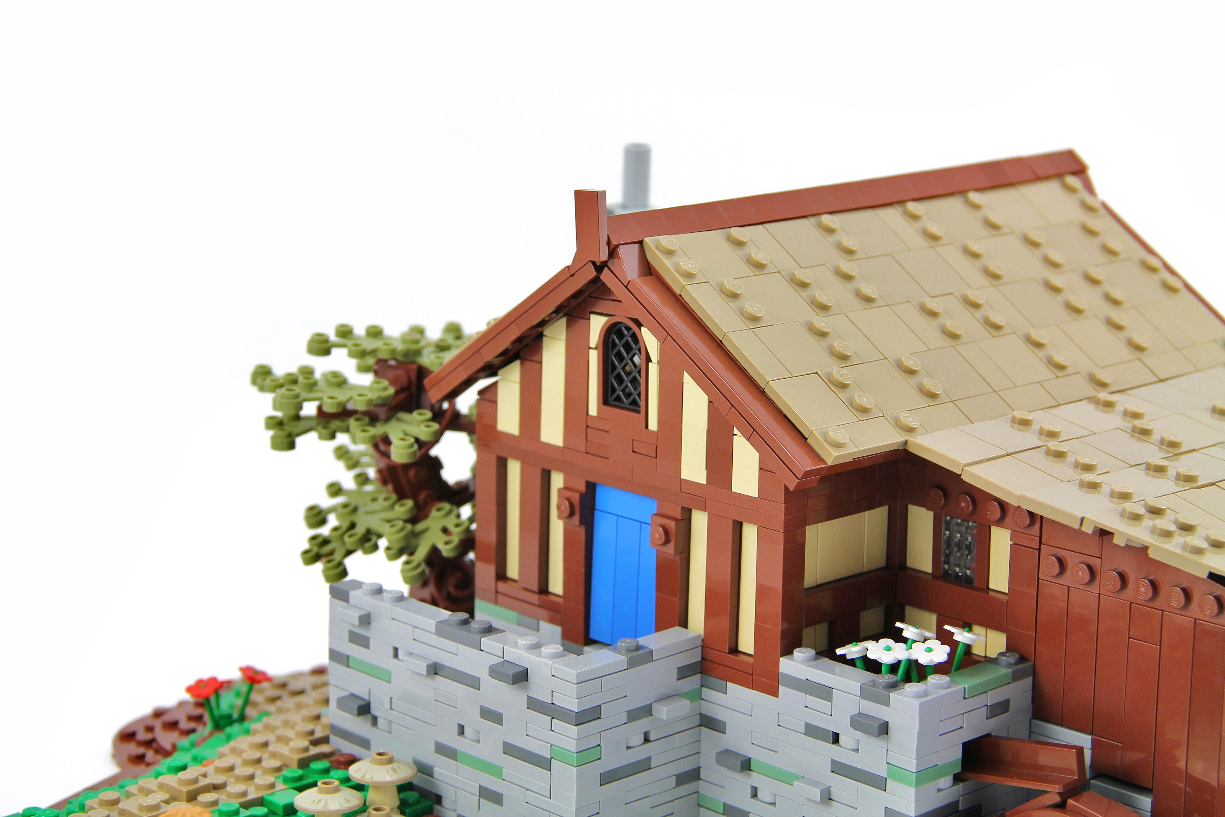
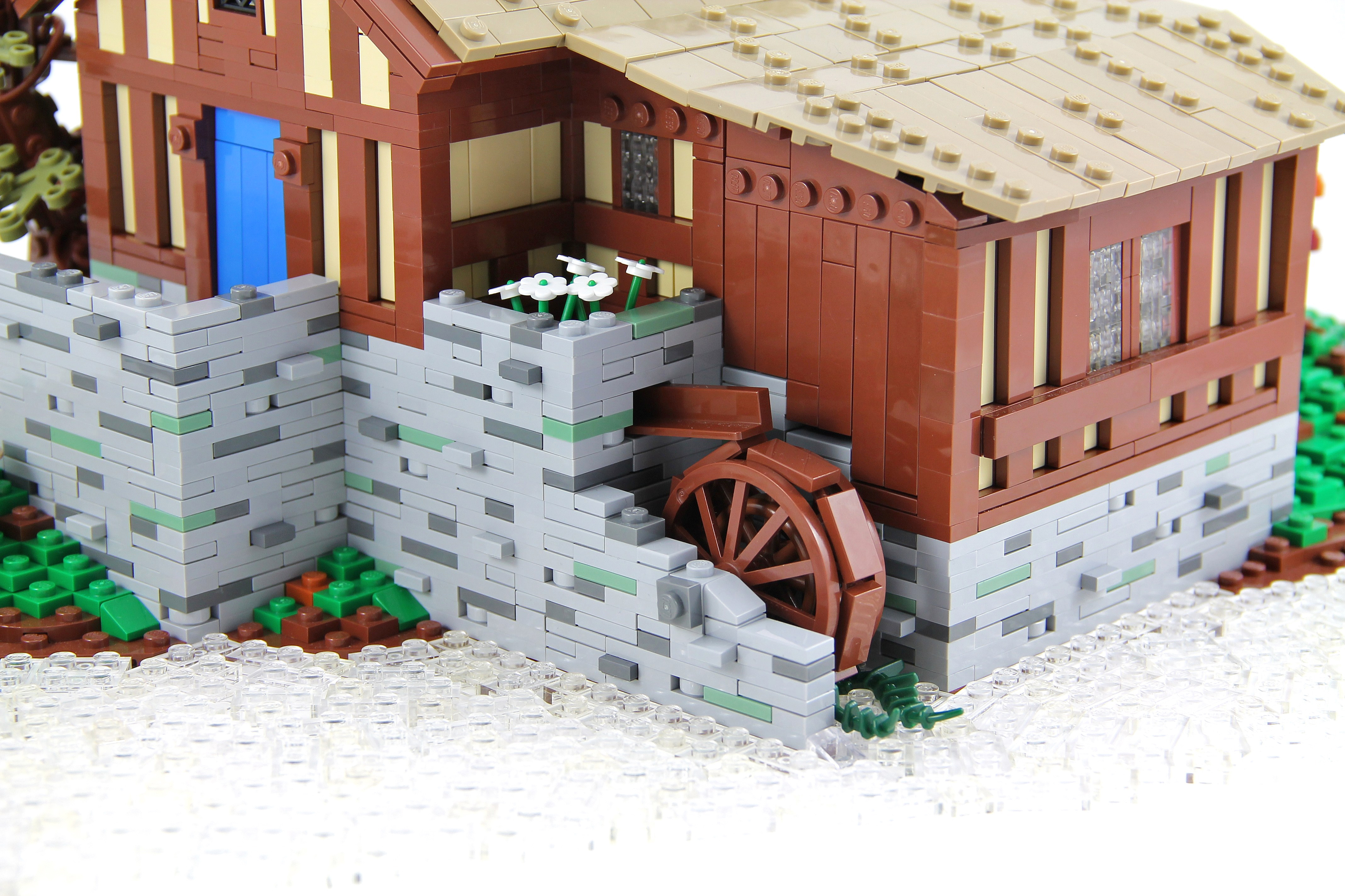
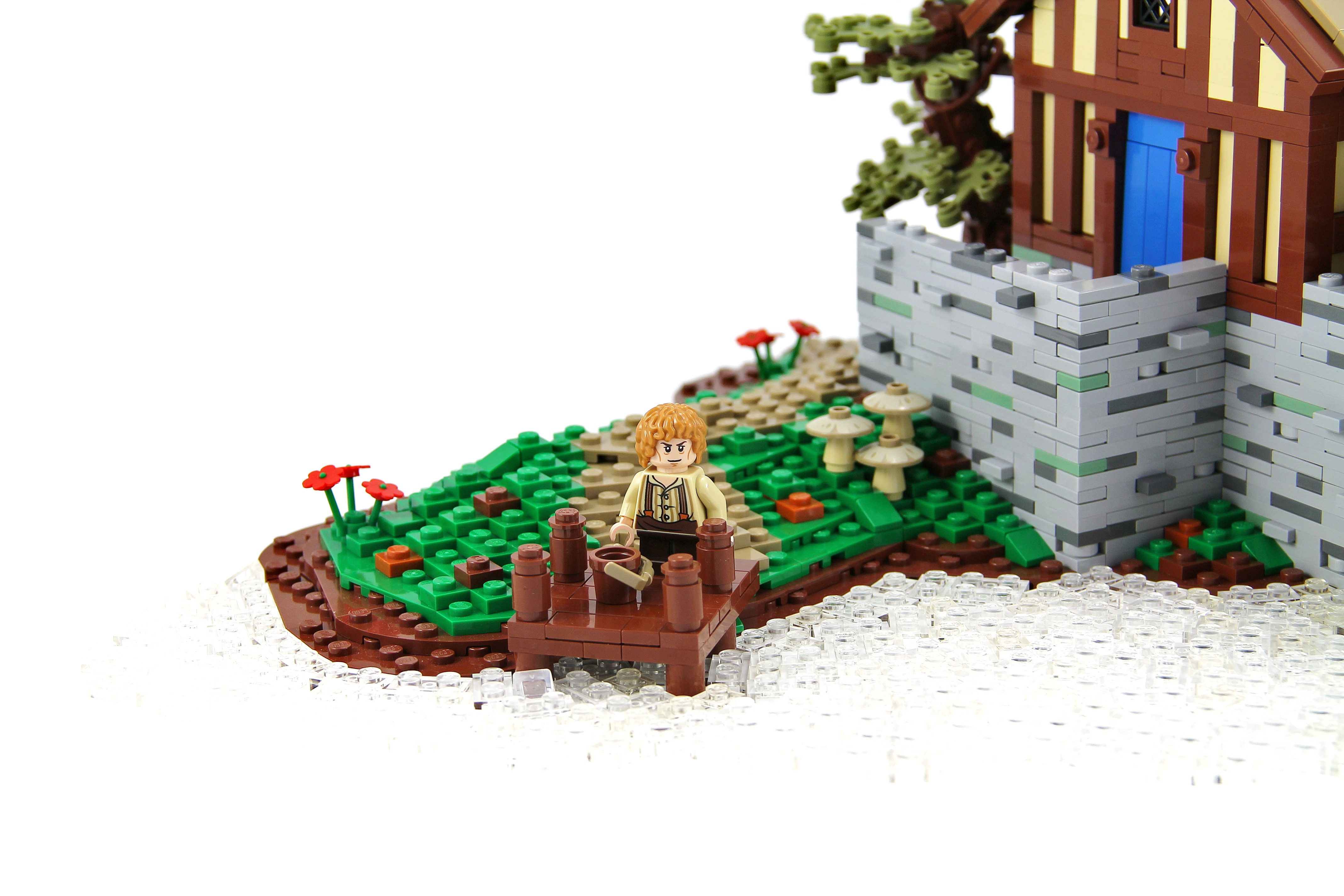
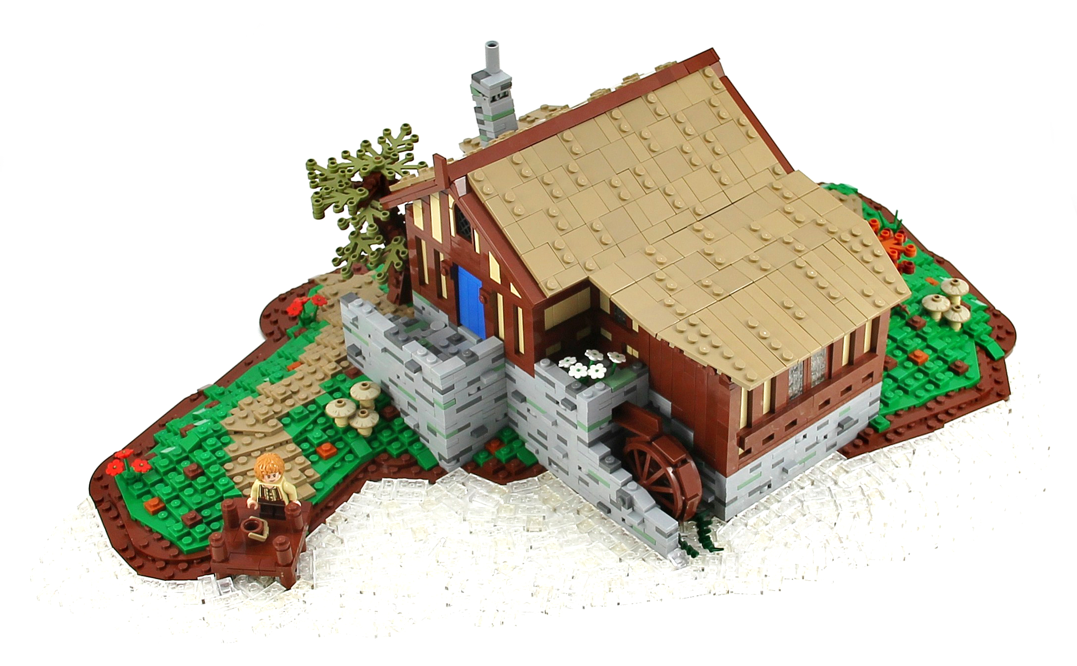
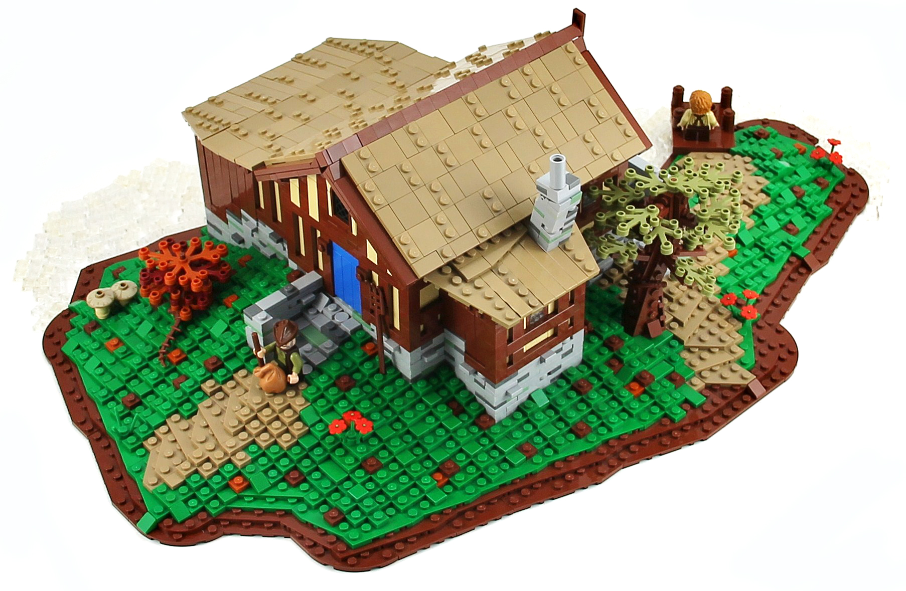
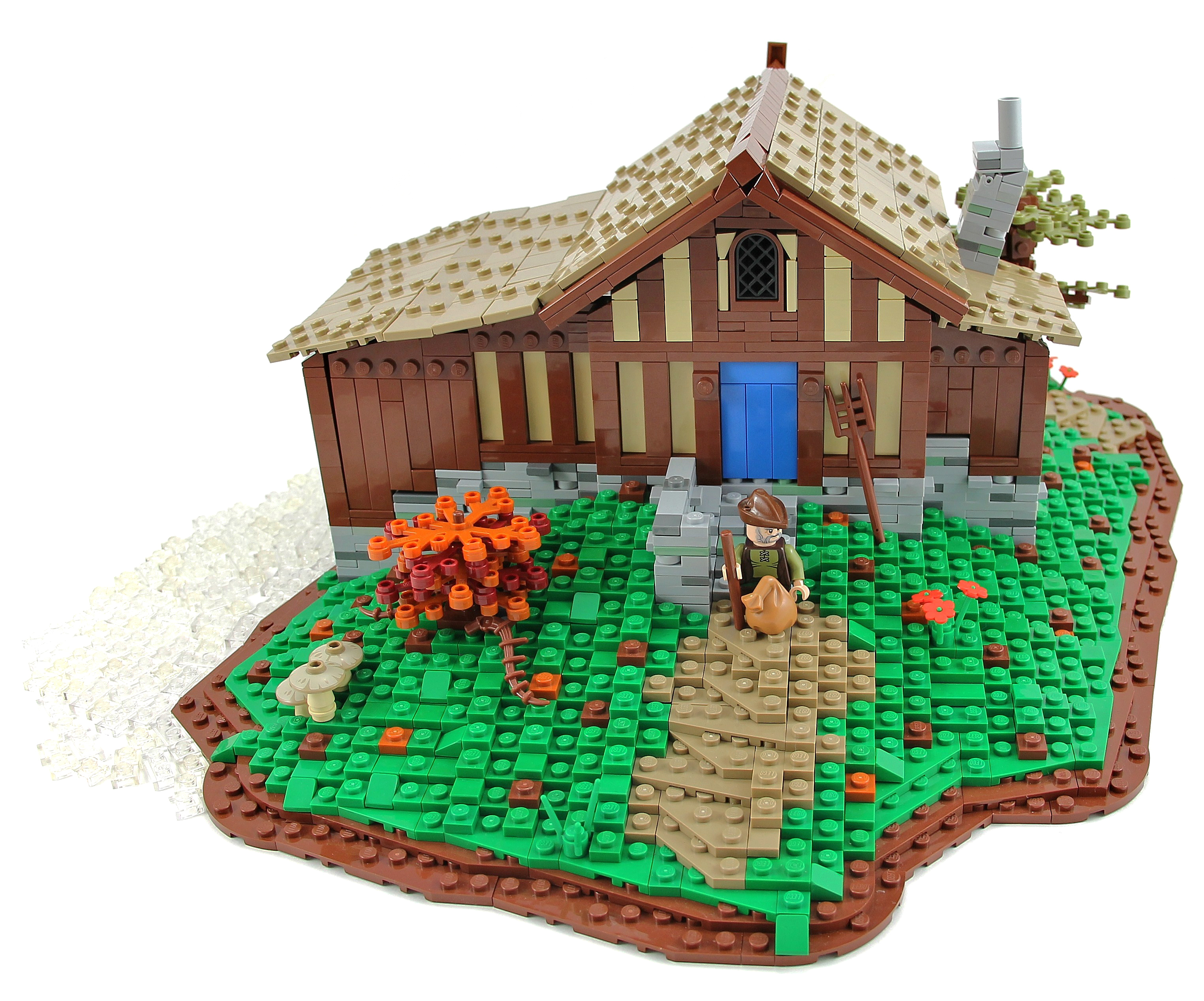
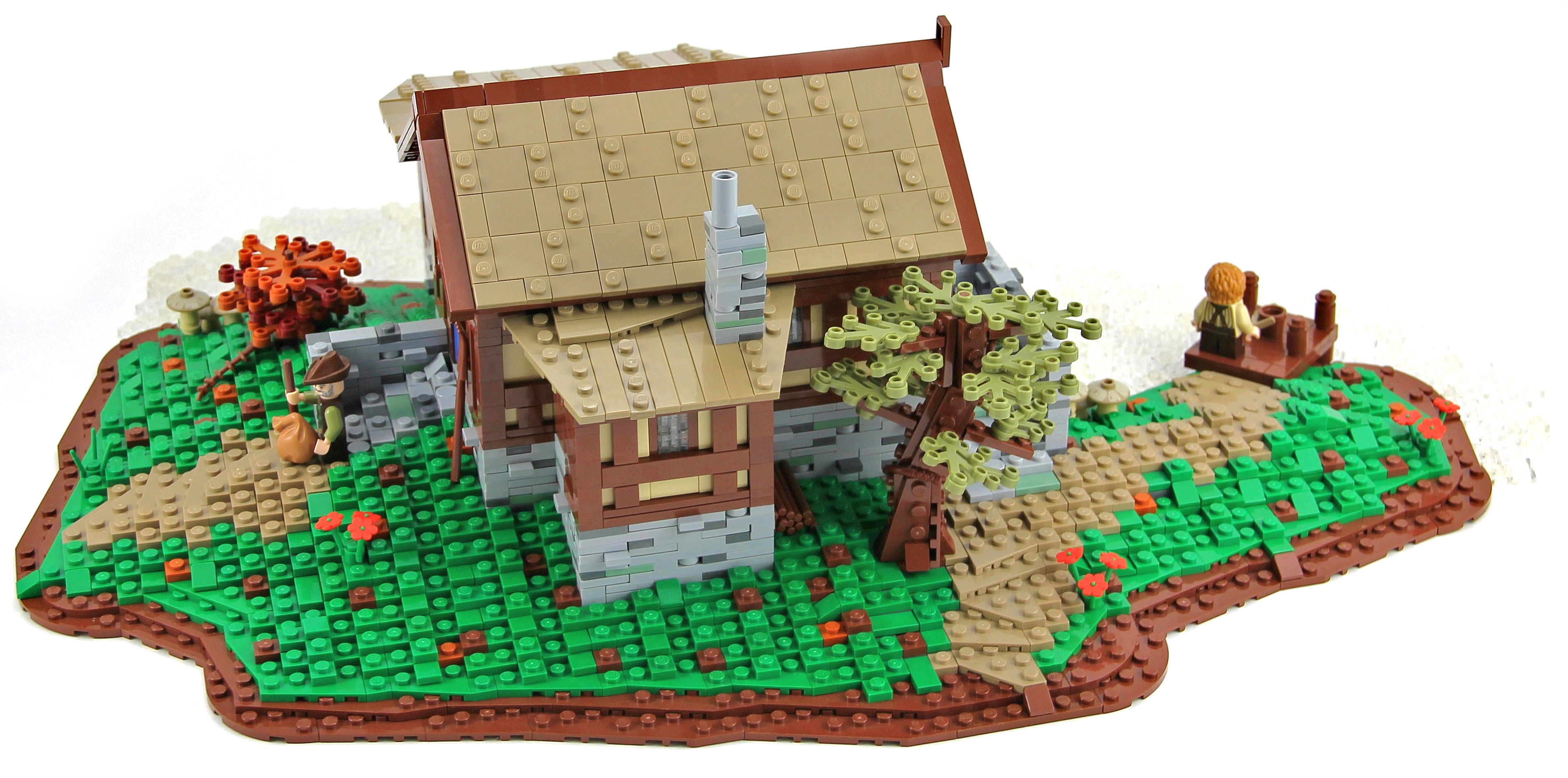
"The Old Mill was the watermill of Hobbiton, owned and run by the Sandyman Family. The Old Mill was a corn mill powered by a large water wheel. It lay directly adjacent to the bridge across the Water and next to the Old Grange as well."
This is the water mill that can be seen in the Lord of the Rings: The Fellowship of the Ring when Gandalf arrives in Hobbiton for Bilbo's birthday and crosses the bridge. I hope you will enjoy it, I apologize in advance for the photo, I didn't managed, unfortunately, to capture the water.
Credit to Pif500 for the wall technique :)
Cars and vans being transported across the country by train, taken from the footbridge at Claremorris Railway Station in Co. Mayo.
Photographer: James P. O'Dea
Date: September 1950
NLI Ref.: ODEA 4/42
Het begin van de Hondsbossche zeewering.
Strand/beach Schoorl / Camperduin - Noord Holland
++++++++++++++++++++++++++++++++++++++++
© 2013 Frank van Dongen
FB | 500px | FLICKEFLU | WERKAANDEMUUR | My Website | Getty Images
++++++++++++++++++++++++++++++++++++++++++++++++++++++
Schoorl / Camperduin - Noord Holland
++++++++++++++++++++++++++++++++++++++++++++++++++++++
© 2013 Frank van Dongen
FB | 500px | FLICKEFLU | WERKAANDEMUUR | My Website | Getty Images
++++++++++++++++++++++++++++++++++++++++++++++++++++++
Created for:
Kreative People ♣ Blue Theme ♣ contest #18
The Award Tree Challenge 110 ~ Awesome Sunsets
_____________________________________
there is a big, a big hard sun
my textures and one by SkeletalMess thank you!
Happy Sliders Sunday everyone!
♥
Photographs taken during an organised Omnibus Society tour to the ADL Falkirk factory on Saturday 7th September 2013
One of my goals for 2013 was to take some long exposure night photos and to get some shots of lightning. So here is another experimental shot. This was the first night I ever tried talking lightning photos...
This photo was taken from the observation walkway on "city key", Sarasota Florida across from the Sarasota Sailing Squadron, close to the Mote Marine Aquarium facing toward Coon Key.St. Armands Circle is to the right. The tall building in the center is Plymouth Harbor, a local retirement community.
Thanks for taking a look. As always comments and constructive advice is always appreciated.
Mike
Exif data
Camera.......................Nikon D600
Exposure....................20
Aperture......................f/4.5
Focal Length..............55 mm
ISO Speed..................100
Here's a little slice of a fantasy ocean :)
This is an entry for Iron Builder against the Erickson Brothers, utilizing the green flexible spike as mermaid fins, corals, and palm trees.
++++++++++++++++++++++++++++++++++++++++++++++++++++++
© 2013 Frank van Dongen
FB | 500px | FLICKEFLU | WERKAANDEMUUR | My Website | Getty Images
++++++++++++++++++++++++++++++++++++++++++++++++++++++
Photography can take some time...
This was a GPS-based hiking route that took me almost 4 hours for 12 kilometers...from Bergen aan Zee via the Kerf (a kind of whole in the dunes) near Schoorl back to Bergen aan Zee. GPS file on request.
Van Bergen aan Zee, via de Kerf bij Schoorl, door de duinen terug naar Bergen aan Zee.
Een wandeling van bijna 12 km; afgelegd in 3:43 uur...(fotografie kost wat tijd...)
GPS route op aanvraag (Garmin) :-)
... in the signal box presumably. It would be lovely to get a name and a use for all of these things.
Photographer: James P. O'Dea
Date: October 1938
NLI Ref.: ODEA 1/31
The Grand Canal (Italian: Canal Grande, Venetian: Canałasso) is a canal in Venice, Italy. It forms one of the major water-traffic corridors in the city. Public transport is provided by water buses (Italian: vaporetti) and private water taxis, and many tourists explore the canal by gondola. At one end, the canal leads into the lagoon near the Santa Lucia railway station and the other end leads into Saint Mark Basin; in between, it makes a large reverse-S shape through the central districts (sestieri) of Venice. It is 3,800 m long, 30–90 m wide, with an average depth of five meters (16.5 ft).
Because most of the city's traffic goes along the Canal rather than across it, only one bridge crossed the canal until the 19th century, the Rialto Bridge. There are currently three more bridges, the Ponte degli Scalzi, the Ponte dell'Accademia, and the recent, controversial Ponte della Costituzione, designed by Santiago Calatrava, connecting the train station to Piazzale Roma, one of the few places in Venice where buses and cars can enter. As was usual in the past, people can still take a ferry ride across the canal at several points by standing up on the deck of a simple gondola called a traghetto, although this service is less common than even a decade ago. Most of the palaces emerge from water without pavement. Consequently, one can only tour past the fronts of the buildings on the grand canal by boat.
en.wikipedia.org/wiki/Grand Canal, Venice
The Ca' da Mosto is a thirteenth-century palace in Venice, northern Italy, the oldest building on the Grand Canal. It is in the Veneto-Byzantine style, with high narrow arches and distinctive capitals. The features of the palace show its beginnings as a casa-fondaco, the home and workplace of its original merchant owner. A second floor was added at the beginning of the sixteenth century, and a third in the nineteenth. The palace takes its name from the Venetian explorer Alvise da Ca' da Mosto, who was born in the palace in 1432. It stayed in the da Mosto family until 1603, when Chiara da Mosto left her entire estate to Leonardo Donà dalle Rose, a nephew of her second husband, rather than her da Mosto relatives, with whom she had fallen out. Between the 16th and the 18th centuries the Ca' da Mosto housed the well-known Albergo Leon Bianco (the White Lion Hotel). In 1769 and 1775 the Holy Roman Emperor and son of Maria Theresa, Joseph II, lived here during his stay in Venice.
en.wikipedia.org/wiki/Ca' da Mosto
The Chiesa dei Santi Apostoli di Cristo (English: Church of the Holy Apostles of Christ), commonly called San Apostoli, is a 7th-century Roman Catholic church located in the Cannaregio sestiere of the Italian city of Venice. It is one of the oldest churches in the city and has undergone numerous changes since its foundation. The present building is the result of a major reconstruction project which was undertaken in 1575. The church is notable particularly for the Cornaro Chapel, an important example of Early Renaissance architecture, added by Mauro Codussi during the 1490s. The chapel is the burial place of several members of the powerful Cornaro family, including Catherine Cornaro, Queen of Cyprus. The church houses several works of art including pieces by Giambattista Tiepolo and Paolo Veronese.
en.wikipedia.org/wiki/Santi Apostoli, Venice
Palazzo dei Camerlenghi is a Renaissance palace in Venice, northern Italy, located in the sestiere (quarter) of San Polo. It faces the Canal Grande, near the Rialto Bridge. The palace was built from 1525 to 1528 under design by Guglielmo dei Grigi, who was inspired by the style of Mauro Codussi and Pietro Lombardo. It was the seat of several financial magistrates, including the Camerlenghi whom it takes its name from, the Consuls of the Traders and the Supra-Consuls of the Traders. Due to this function, the lower floor was used as a jail for the insolvents: the location nearby the crowded Rialto Bridge served as an admonition for the people passing there. The palace currently houses the regional seat of the Italian Comptroller and Auditor General. The palace has a pentagonal plan which follows the shore of the Canal Grande, with three floors. It has tall windows with centrings, divided by false columns and decorated with friezes. There were once polyhcrome marble and porphyry slabs, now lost. Due to the Venetian tradition that, when leaving the position, a magistrate would leave a religious-themed painting and a portrait in his former seat, the Palazzo dei Camerlenghi housed numerous artworks. These were dispersed during the French occupation; some returned to Venice, but are now in other locations.