View allAll Photos Tagged precisely
Today's random guest in Sofia and more precisely in trolleybus depot Nadezhda - Ikarus 250.59 from Ukraine. It is private owned by people who use it to travel around Europe. Documentarily it's production year is 1987th, but the owner told us that the bus had been in factory storage for at least 2 years (it's windows are produced in 1984th and 1985th).
The elegant Christmas Tree installed in front of Torre Picasso, precisely in the center of Pablo Picasso Square.
I liked the spheric balls framing the tree, therefore I though it could be a great perspective.
I hope you like this picture.
Press "L or Z" to enlarge the picture.
Enjoy a great Thursday!
________________________________
El Árbol de Navidad en la Plaza de Pablo Picasso, Centro Financiero de Azca, Madrid, España
El elegante árbol de Navidad instalado frente a la Torre Picasso, justo en el centro de la Plaza Pablo Picasso.
Me gustaron las esferas metálicas que enmarcaban el árbol, así que pensé que podría ser una perspectiva genial.
Espero que os guste esta foto.
Pulsa "Z o L" para agrandar la foto.
¡Pasad un buen jueves!
© all rights reserved
Please take your time... and enjoy it large on black
The general term ice age or, more precisely, glacial age denotes a geological period of long-term reduction in the temperature of the Earth's surface and atmosphere, resulting in an expansion of continental ice sheets, polar ice sheets and alpine glaciers. There have been at least four major ice ages in the Earth's past. Outside these periods, the Earth seems to have been ice-free even in high latitudes. There is evidence that greenhouse gas levels fell at the start of ice ages and rose during the retreat of the ice sheets, but it is difficult to establish cause and effect. Greenhouse gas levels may also have been affected by other factors which have been proposed as causes of ice ages, such as the movement of continents and vulcanism. Although the last glacial period ended more than 8,000 years ago, its effects can still be felt today. For example, the moving ice carved out landscape in Canada, Greenland, northern Eurasia and Antarctica. The erratic boulders, till, drumlins, eskers, fjords, kettle lakes, moraines, cirques, horns, etc., are typical features left behind by the glaciers.
Photo taken inside a hummock taken at the IJsselmeer (IJmeer) near Amsterdam. A hummock is a boss or rounded knoll of ice rising above the general level of an ice-field, Hummocky ice is caused by slow and unequal pressure in the main body of the packed ice, and by unequal structure and temperature at a later period. Blue ice occurs when snow falls on the ice. The blue color is actually created for the same reason that water is blue, that is, its slight absorption of red light due to an overtone of the infrared OH stretching mode of the water molecule.
Een ijstijd of glaciatie is een geologisch tijdvak waarin ijskappen voorkomen. In het Engels wordt dit een periode van ice-house genoemd, als tegenhanger van een ijskaploze periode, de greenhouse ("broeikas"). Aangezien er gletsjers liggen op bijvoorbeeld Groenland of Antarctica, leven we tegenwoordig in een ijstijd. Men neemt aan dat dit in de gehele geologische geschiedenis van de Aarde minstens vijfmaal het geval is geweest, waarvan eenmaal zelfs zo sterk dat de ijskappen van de polen vrijwel tot aan de evenaar waren opgerukt. Ook zijn er periodes dat er aanzienlijke opwarming optrad waarbij die ijskappen grotendeels waren weggesmolten. Het klimaat op Aarde wordt beïnvloed door vele factoren, zoals de intensiteit van de zonnestraling, de ligging van de continenten, de continentverplaatsingen, vulkanisme, de zeestromen, de bedekking van het land door vegetatie, het weerkaatsingsvermogen van het aardoppervlak en vele kleine andere factoren. Met behulp van klimaatmodellen wordt door wetenschappers een reconstructie van het klimaat en de klimaatveranderingen in het verleden gemaakt. Alhoewel er een zekere consensus bestaat onder wetenschappers, zijn er nog vele onzekerheden en tegenstrijdigheden in dit onderzoek.
Hierboven een foto van kruiend ijs. Zoetwatermeren kunnen spectaculair bevriezen. Grotere meren zoals het IJsselmeer (IJmeer) hierboven hebben bijna altijd wel golven, en dit werkt directe bevriezing van het wateroppervlak tegen. Eerst vormen zich kleine ijsschotsen, die naar de kust drijven onder invloed van de wind. Deze schotsen vormen zo een ijsveld op het water dat de golven dempt, en uiteindelijk vriezen alle schotsen aan elkaar vast tot een massa. Voordat dit gebeurt schuren de schotsen voortdurend langs elkaar heen en schrapen zo stukjes ijs van elkaar af; elke schots krijgt zo een witte rand. Zulk ijs is dus totaal niet geschikt om op te schaatsen. Wanneer grotere delen van het meer bevriezen beginnen de platen, die soms een paar vierkante kilometer groot zijn, langzaam tegen elkaar te bewegen onder invloed van de wind en stroming. Dit heeft kruiend ijs tot gevolg: de ijsschotsen worden met kracht gebroken en op elkaar gestapeld langs de dijken langs het meer. Dit hoeft niet alleen bij dun ijs te gebeuren; soms kruit het ijs bij een dikte van meer dan 20 cm. De stapels ijs worden dan hoog, en het geluid is oorverdovend.
The genus Protea was named in 1735 by Carl Linnaeus after the Greek god Proteus, who could change his form at will because they have such a wide variety of forms. Linnaeus's genus was formed by merging a number of genera previously published by Herman Boerhaave, although precisely which of Boerhaave's genera were included in Linnaeus's Protea varied with each of Linnaeus's publications.
Most proteas occur south of the Limpopo River. However, Protea kilimanjaro is found in the chaparral zone of Mount Kenya National Park. 92% of the species occurs only in the Cape Floristic Region, a narrow belt of mountainous coastal land from Clanwilliam to Grahamstown, South Africa. The extraordinary richness and diversity of species characteristic of the Cape Flora are thought to be caused in part by the diverse landscape where populations can become isolated from each other and in time develop into separate species.
Proteas attracted the attention of botanists visiting the Cape of Good Hope in the 17th century. Many species were introduced to Europe in the 18th century, enjoying a unique popularity at the time amongst botanists. #7DWF
Astronomers using NASA’s Hubble Space Telescope have for the first time precisely measured the distance to one of the oldest objects in the universe, a collection of stars born shortly after the big bang.
This new, refined distance yardstick provides an independent estimate for the age of the universe. The new measurement also will help astronomers improve models of stellar evolution. Star clusters are the key ingredient in stellar models because the stars in each grouping are at the same distance, have the same age, and have the same chemical composition. They therefore constitute a single stellar population to study.
Image Credit: NASA, ESA, and T. Brown and S. Casertano (STScI) ; Acknowledgement: NASA, ESA, and J. Anderson (STScI)
This isn't a gentle transition
A metamodernist discussion by artist JJFBbennett
We are standing precisely at the convergence of two irreconcilable truths. On the left, look at that thick, violent churning of deep purple impasto paint. It is heavy, chaotic, and entirely insular—a tactile representation of our existential noise, a modern anxiety built layer upon layer with a heavy palette knife. Then look to the right. The world abruptly fractures into a grand, romantic landscape of rolling green valleys beneath a soaring sunset. It’s a beautifully naive, sincere longing for a peaceful reality that feels almost mythological.
But the metamodern spirit doesn't allow us the luxury of choosing one over the other.
This isn't just illumination; it’s an intervention. It’s the realisation that the cynical chaos we inherit and the sincere beauty we yearn for are ultimately warmed by the exact same fire. The light doesn't resolve the disparity—it shatters the illusion that they were ever truly separate.
Metamodernism,Art Philosophy,Life Transitions,Digital Surrealism,
Blogger:
www.jjfbbennett.com/2026/07/my-psychological-landscape-sp...
YouTube: www.youtube.com/@jjfbbennett
Wall painting: a donkey driver leads the donkey to the granaries (2118-1980 B.C. First Intermediate Period) Tomb of Iti and Neferu - Gebelein/Northern Necropolis - tempera on straw and mud plaster. Egyptian Museum, Turin
Iti, capo delle truppe del Re” e “Tesoriere del Re” e di Neferu, la bellissima sposa. Proprio questo significa il nome della donna: Bella!
Le pitture sono un racconto di vita quotidiana; create con la tecnica a tempera, furono staccate dalla sede originaria con la tecnica dello strappo e ricomposte qui, in questa tomba: sono, dunque, originali e non delle copie. Ve n’è una che raffigura il sacrificio di un bue in cui sono riportati anche i minimi particolari per renderli visibili. Anche nella scena del trasporto del grano ai silos, l’asino è riportato in ogni particolare; trasporta due sacchi, ma quello su fianco sinistro è ribaltato … questo per consentire al sacerdote funerario di renderlo reale con il suo rituale magico.
Sono riprodotte numerose scene di vita quotidiana, come quella della mungitura in cui la mucca accarezza il vitellino e sono presenti scene di offerte ai proprietari della tomba da parte di un domestico ritratto in dimensioni minori: pane e altri prodotti alimentari costituiscono l’offerta principale per l’anima dei defunti, ma anche e per le divinità.
Iti, the chief of the King's troops" and "Treasurer of the King" and Neferu, the beautiful bride. This is precisely what the woman's name means: Beautiful!
The paintings are a tale of everyday life; created with the tempera technique, they were detached from their original location by the technique of tearing and reassembled here, in this tomb: they are, therefore, originals and not copies. There is one depicting the sacrifice of an ox in which even the smallest details are given to make them visible. Even in the scene of transporting grain to the silos, the donkey is reported in every detail; it carries two sacks, but the one on its left side is upturned ... this is to allow the funerary priest to make it real with his magic ritual.
Numerous scenes of daily life are reproduced, such as the milking scene in which the cow caresses the calf, and there are scenes of offerings to the owners of the tomb by a servant portrayed in smaller dimensions: bread and other foodstuffs constitute the main offering for the soul of the deceased, but also and for the deities.
37371 comes off the Romsey branch at precisely 09:40 and heads for (I guess) Fawley on a cold and misty February morning.
Oil trains used to frequent Eastleigh on a regular basis but, alas, underground pipelines have made this traffic a thing of the past.
37371 remained in traffic until November 1999. She was cut up at the CDRC at Wigan Springs during June 2001. RIP.
Das Leberblümchen, genauer Gewöhnliches Leberblümchen, auch Dreilappiges Leberblümchen genannt, ist eine Pflanzenart innerhalb der Familie der Hahnenfußgewächse.
The Leberblümchen, more precisely common Leberblümchen, also Dreilappiges Leberblümchen mentioned, is a plant type within the family of the Hahnenfußgewächse
Operations image of the week:
In order to precisely deliver the Schiaparelli landing demonstrator module to the martian surface and then insert ExoMars/TGO into orbit around the Red Planet, it’s necessary to pin down the spacecraft’s location to within just a few hundred metres at a distance of more than 150 million km.
To achieve this amazing level of accuracy, ESA experts are making use of ‘quasars’ – the most luminous objects in the Universe – as ‘calibrators’ in a technique known as Delta-Differential One-Way Ranging, or delta-DOR.
Until recently, quasars were only poorly understood. These objects can emit 1000 times the energy of our entire Milky Way galaxy from a volume that it not much bigger than our Solar System, making them fearfully powerful.
They are fuelled by supermassive black holes – which are many, many times more massive than our Sun – feeding on matter at the centre of their host galaxies. In addition to their extreme luminosity, their extreme distance means that, seen from Earth, they appear to be fixed in the sky and their positions can be mapped with high precision, making them very useful as reference points for spacecraft navigation.
In the delta-DOR technique, radio signals from ExoMars/TGO are being received by two widely separated deep-space ground stations, one, say, at New Norcia, Western Australia, and one at Cebreros, Spain, and the difference in the times of signal arrival is precisely measured.
Next, errors due to current conditions in Earth’s atmosphere (which affect all radio signals passing through) are derived by simultaneously tracking radio signals from a quasar. Engineers can apply these as corrections to the signal received from ExoMars/TGO, delivering a significantly more accurate fix on its position.
On Wednesday this week, ESA ground stations began the first of many delta-DOR observations that will be used to precisely locate ExoMars/TGO, using quasar P1514-24, seen inset in an image of ESA's deep-space tracking station at Malargüe, Argentina, above.
Delta-DOR observations will be increasingly performed as the journey to Mars enters the crucial phases, enabling flight dynamics teams to generate precise instructions for thruster burns and separation timing and to assess manoeuvre performance.
“In October, in the final critical week before Mars arrival, teams will be conducting two delta-DOR observations daily,” says Mattia Mercolino, responsible for delta-DOR activities at ESOC, ESA’s operations centre in Darmstadt, Germany.
“It’s an excellent example of critical, real-time teamwork between the flight dynamics experts, the ground station operators, the ExoMars mission controllers and our delta-DOR team, and it would be much more difficult to get to Mars without this expertise.”
How precisely will we know ExoMars/TGO’s location?
“The current set of delta-DOR observations will enable us to locate the spacecraft to less than 1000 m when it’s near Mars, a distance of slightly more than 150 million km from Earth,” says Mattia.
“This is comparable to detecting from the location of an object in Singapore from Darmstadt, to about 5 cm precision.”
“In future, with currently planned technology improvements, we should be able to get the accuracy down to just 150 m at 150 million km.”
Credit: Estrack image: ESA/D. Pazos – Quasar P1514-24 inset image: Rami Rekola, Univerity of Turku, 2001
More precisely evening light on Hamilton Falls off the High Sierra Trail in an area named Valhalla in Sequoia National Parks. Yes there is more than extremely big trees and Mt Whitney in the park. This was the view from our Day 1 camp site on my recent backpacking trip. Traveling light is a necessity for this old body, so the I-Phone had to suffice. While this may not be Viking heaven, it is home to more waterfalls than can be counted! Amazing trip.
Adéu a l'estiu!
" L’estiu se’n va. Com sempre, com cada any, ens deixa; però la seva partença no ens commou, puix que no dubtem de la seva tornada, i per bé que el seu abandonament ens fa sentir un xic la melangia de l’hivern que s’apropa, xaruc, però constant, ens duu també la fruïció de l’època més bella de tot l’any: la tardor.
Els qui creuen que la tardor és lletja són uns pobres infeliços que no saben copsar la boniquesa autumnal.
I rondinen perquè a l’estiu fa calor, i perquè a l’hivern fa fred, i perquè el sol pica molt, i perquè ara plou, i no saben veure en res ni un bri de felicitat; d’aquesta gran felicitat, que radica justament en les petites coses.
A mi m’agrada la tardor...."
- Mercè Rodoreda (Barcelona, 1908 - Girona, 1983) -
www.ara.cat/opinio/Adeu-lestiu_0_1654634521.html
Platja dels Griells / L'Estartit (Costa Brava) CAT.
-----------------------------------------------
Summer is leaving!
Goodbye to summer!
"Summer is leaving. As always, as every year, it leaves us; but its departure does not move us, since we do not doubt its return, and although its abandonment makes us feel a little melancholy of the winter that is approaching, cold, but constant, it also brings us the enjoyment of the most beautiful time of the whole year: autumn.
Those who think that autumn is ugly are poor people who do not know how to grasp the beauty of autumn.
And they wander because it's hot in the summer, and because it's cold in the winter, and because the sun is very hot, and because now it's raining, and they don't know how to see even a shred of happiness in anything; of this great happiness, which lies precisely in the little things.
I like autumn..."
- Mercè Rodoreda (Barcelona, 1908 - Girona, 1983) -
www.ara.cat/opinio/Adeu-lestiu_0_1654634521.html
Platja dels Griells / L'Estartit (Costa Brava) CAT.
The Aqueduct of Segovia (or more precisely, the aqueduct bridge) is a Roman aqueduct and one of the most significant and best-preserved ancient monuments left on the Iberian Peninsula. It is located in Spain and is the foremost symbol of Segovia, as evidenced by its presence on the city's coat of arms.
Clouds are dumb. There are precisely 1 1/2 locations along the BNSF Topeka Sub that are good to shoot afternoon eastbounds in good light, and this spot in Lawrence is one of them. Unfortunately, what I CANNOT control are clouds. Literally moments before the train arrived, the clouds descended, and got us this. It's not bad, but...
Regardless of the clouds, I'm happy for the opportunity to have seen the train here, and to photograph it along the way.
Video of this train can be found here: youtu.be/_cpmaQGFqH0?si=25IF9d5mvTFudhdB
© all rights reserved
Please take your time... and enjoy it large on black
The general term ice age or, more precisely, glacial age denotes a geological period of long-term reduction in the temperature of the Earth's surface and atmosphere, resulting in an expansion of continental ice sheets, polar ice sheets and alpine glaciers. There have been at least four major ice ages in the Earth's past. Outside these periods, the Earth seems to have been ice-free even in high latitudes. There is evidence that greenhouse gas levels fell at the start of ice ages and rose during the retreat of the ice sheets, but it is difficult to establish cause and effect. Greenhouse gas levels may also have been affected by other factors which have been proposed as causes of ice ages, such as the movement of continents and vulcanism. Although the last glacial period ended more than 8,000 years ago, its effects can still be felt today. For example, the moving ice carved out landscape in Canada, Greenland, northern Eurasia and Antarctica. The erratic boulders, till, drumlins, eskers, fjords, kettle lakes, moraines, cirques, horns, etc., are typical features left behind by the glaciers. The Dutch IJsselmeer lake is covered with icerocks hummocks, caused by the cold weather of the passed days. At some places even higher than 6 meter!
Photo taken inside a hummock taken at the IJsselmeer (IJmeer) near Amsterdam. A hummock is a boss or rounded knoll of ice rising above the general level of an ice-field, Hummocky ice is caused by slow and unequal pressure in the main body of the packed ice, and by unequal structure and temperature at a later period. Blue ice occurs when snow falls on the ice. The blue color is actually created for the same reason that water is blue, that is, its slight absorption of red light due to an overtone of the infrared OH stretching mode of the water molecule.
Een ijstijd of glaciatie is een geologisch tijdvak waarin ijskappen voorkomen. In het Engels wordt dit een periode van ice-house genoemd, als tegenhanger van een ijskaploze periode, de greenhouse ("broeikas"). Aangezien er gletsjers liggen op bijvoorbeeld Groenland of Antarctica, leven we tegenwoordig in een ijstijd. Men neemt aan dat dit in de gehele geologische geschiedenis van de Aarde minstens vijfmaal het geval is geweest, waarvan eenmaal zelfs zo sterk dat de ijskappen van de polen vrijwel tot aan de evenaar waren opgerukt. Ook zijn er periodes dat er aanzienlijke opwarming optrad waarbij die ijskappen grotendeels waren weggesmolten. Het klimaat op Aarde wordt beïnvloed door vele factoren, zoals de intensiteit van de zonnestraling, de ligging van de continenten, de continentverplaatsingen, vulkanisme, de zeestromen, de bedekking van het land door vegetatie, het weerkaatsingsvermogen van het aardoppervlak en vele kleine andere factoren. Met behulp van klimaatmodellen wordt door wetenschappers een reconstructie van het klimaat en de klimaatveranderingen in het verleden gemaakt. Alhoewel er een zekere consensus bestaat onder wetenschappers, zijn er nog vele onzekerheden en tegenstrijdigheden in dit onderzoek.
Hierboven een foto van kruiend ijs. Zoetwatermeren kunnen spectaculair bevriezen. Grotere meren zoals het IJsselmeer (IJmeer) hierboven hebben bijna altijd wel golven, en dit werkt directe bevriezing van het wateroppervlak tegen. Eerst vormen zich kleine ijsschotsen, die naar de kust drijven onder invloed van de wind. Deze schotsen vormen zo een ijsveld op het water dat de golven dempt, en uiteindelijk vriezen alle schotsen aan elkaar vast tot een massa. Voordat dit gebeurt schuren de schotsen voortdurend langs elkaar heen en schrapen zo stukjes ijs van elkaar af; elke schots krijgt zo een witte rand. Zulk ijs is dus totaal niet geschikt om op te schaatsen. Wanneer grotere delen van het meer bevriezen beginnen de platen, die soms een paar vierkante kilometer groot zijn, langzaam tegen elkaar te bewegen onder invloed van de wind en stroming. Dit heeft kruiend ijs tot gevolg: de ijsschotsen worden met kracht gebroken en op elkaar gestapeld langs de dijken langs het meer. Dit hoeft niet alleen bij dun ijs te gebeuren; soms kruit het ijs bij een dikte van meer dan 20 cm. De stapels ijs worden dan hoog, en het geluid is oorverdovend. Dit weekend gingen honderden mensen het IJsselmeer op om het indrukwekkende kruiende ijs te bekijken. Op sommige plekken klommen de mensen zes meter omhoog.
The Golden Gate bridge has been painted, since its construction, in orange, and more precisely in international orange. The choice of this color is due to Irving Morrow, who nevertheless met with strong criticism from officials, who found the idea ridiculous. The other paintings proposed, namely steel gray (close to that of the neighboring Bay Bridge), the aluminum color were not selected, Morrow judging that orange fit perfectly with the various elements of the bay. The United States Navy had even proposed to paint the bridge yellow, with black stripes to facilitate visibility from ships crossing the bay, but Morrow never gave up his original idea, and the bridge was painted orange, which is one of his most characteristic features
.
Le pont du Golden Gate est peint, depuis sa construction, en orange, et plus précisément en orange international. Le choix de cette couleur est dû à Irving Morrow, qui rencontra pourtant de vives critiques de la part des officiels, qui trouvaient l'idée ridicule. Les autres peintures proposées, à savoir le gris acier (proche de celui du Bay Bridge voisin), la couleur aluminium ne furent pas retenues, Morrow jugeant que l'orange s'accordait parfaitement avec les divers éléments de la baie. L'United States Navy avait même proposé de peindre le pont en jaune, avec des rayures noires pour faciliter la visibilité depuis des navires traversant la baie, mais Morrow ne renonça jamais à son idée première, et le pont fut peint en orange, ce qui constitue d'ailleurs l'un de ses traits les plus caractéristiques
The trail quite slippery and muddy at the beginning then dry climbs steadily up Raemura through dense forests, patches of huge ferns and enormous expanses of naturalised Stachytarpheta cayennensis, Blue Rat's-tail. I respectfully use the designations of the wonderfully informative website of Cook Islands Biodiversity and Natural Heritage (I'd have myself written Stachytarpheta jamaicensis and Snakeweed...). The pretty blue flowers were being visited by many long-wing butterflies and also lots of - I think - feral Honeybees, Apis mellifera.
Those Honeybees are not at all native to these islands. The Biodiversity website says that they were first described for Rarotonga by a versatile Scottish missionary, William Wyatt Gill (1828-1896), who visited here for five months in 1858. He must have had an eye for nature. When precisely European Honeybees were introduced to this island is unclear. But I wouldn't be surprised if that was done by earlier missionaries. The first Honeybees in northern New Zealand were in two hives that another missionary's wife, Mary Bumby (1811-1862) had with her when she arrived there from Europe via Sydney in 1839. Apiculture was stimulated for cultural and agricultural reasons by these missionaries. See my earlier www.flickr.com/photos/87453322@N00/11043460916/in/photoli....
It may be conjectured that Honeybees were introduced here in Rarotonga similarly perhaps already in the late 1820s.
The inset is a view of the Eastern Mountains from the highest slope of Raemura before you get to its rock face.
Today after the Moonrise at night, precisely at 10-29-50 pm, over the Sea at Tiruvanmiyur - Chennai, India.
______________________________________________________________________ _______________
Copyright © learning.photography.
All rights reserved. All images contained in this Photostream remain the property of learning.photography and is protected by applicable Copyright Law. Any images from this Photostream may not be reproduced, copied, or used in any way without my written permission.
Thanks for your Visit, Comments, Favs and Awards !
Where Rank is specified underneath any Explored Photo, that means that is the highest Rank achieved in Explore.
No private group or multiple group invites please !
Those who have not uploaded any photograph yet, or have uploaded a very few photographs, should not mark me Contacts or comment on my photo. I may block them.
______________________________________________________________________ _______________
Main Exif data
Camera - Canon EOS 7D
Lens - EF-S18-135mm f/3.5-5.6 IS
Exposure - 25
Aperture - f/4.0
Focal Length - 26 mm
ISO Speed - 100
Exposure Bias - 0 EV
Norwegen / Buskerud - Hallingskarvet-Nationalpark
Sunset - On the way back from Prestholtskarvet. You can see Prestholtseter down there.
Sonnenuntergang - Auf dem Weg zurück vom Prestholtskarvet. Dort unten ist die Prestholtseter zu sehen.
Hallingskarvet National Park (Norwegian: Hallingskarvet nasjonalpark) is a national park in central Norway that was established by the government on 22 December 2006. The park is located in the municipalities of Hol (Buskerud county), Ulvik and Aurland (both in Vestland county). More precisely, the park comprises the Hallingskarv plateau and the high mountain areas to the west of it. It includes the Vargebreen glacier as well as the valleys of Såtedalen, Lengjedalen, Ynglesdalen, and parts of Raggsteindalen.
The national park covers 450 square kilometres (170 sq mi) of the Hallingskarvet mountain range and hosts large stocks of wild reindeer, an important factor in the establishment of the park. The highest point in the national park is Folarskardnuten which reaches an elevation of 1,933 metres (6,342 ft) above sea level.
The landscape of Hallingskarvet was shaped by multiple ice ages. The park shows the geological history and the connection between this history and the variation in the species living there. It includes areas of special value and which are home to threatened or vulnerable species such as Draba cacuminum (whitlow-grass) and Botrychium lanceolatum (lance-leaf grapefern).
The Bergen Line runs along the southern boundary of the park. There is no road access to the southern side of the park, so Finse Station, a stop on the railway line, is one of the few ways that people can access this part of the park. The Norwegian County Road 50 runs near the northern boundary of the park.
Protection and use
The main objective of this national park is to preserve a large, unique, and largely untouched area in order to protect the landscape and the biome with its ecosystem, species and populations of, amongst others, the wild reindeer. The protection is designed to safeguard a characteristic element needed to understand the geological history of the Norwegian landscape. It is also designed to protect valuable elements of the cultural heritage.
The park is open to the traditional forms of outdoor activities which require little or no technical means.
Name
The first element is halling (inhabitant of the Hallingdal valley) and the last is the finite form of skarv (mountain or mountainous area without vegetation).
(Wikipedia)
Prestholtseter a farm cafe based on traditions. Prestholtseter is located by Hallingskarvet at 1242 m, by Hallingskarvet National Park. It is a popular destination both summer and winter. The café offers waffles, buns, the local specialties "lefsekling" (thin, sheet bread), "Rummebrød" (thin cakes made with sour cream), cakes, omelets, buns and rolls. In summer you can also get cured meats and tasty sour cream porridge By Prestholtseter you will find great hiking in the summer and cross country tracks in the winter. In summer you can hike on dirt roads or paths, either flat or the Prestholt stairs up to the top of Hallingskarvet Mountain. In summer the road goes all the way to Prestholtseter (toll road). In winter there are ski trails that are groomed daily, from Havsdalen and from Ustaoset. Prestholtseter offers catering for groups from 15 -100 people for dinner or lunch. A nice layer at the base of Hallingskarvet provides a unique and beautiful setting for the event. Prestholtseter was built in 1904 and has been in the family Uthus since. In the beginning it was a pure summer farm, where they sold products that they produced themselves. Opning hours 2017: Winter season: Starts week 7, 2017. The road usually opens around July 1st.
(visitnorway.com)
Der Hallingskarvet-Nationalpark (norwegisch Hallingskarvet nasjonalpark) ist ein südnorwegischer Nationalpark. Er umfasst das Hallingskarvet-Hochplateau und erstreckt sich über das Gebiet der Gemeinden Hol (Provinz Buskerud), Ulvik und Aurland (Provinz Vestland) gehört.
Gegründet wurde der Park am 22. Dezember 2006, um die dortige große, unverwechselbare und nahezu unberührte Bergregion, die Artenvielfalt von Flora und Fauna und die dort heimischen Bergrentiere zu schützen. Der Park grenzt an das Naturschutzgebiet Skaupsjøen/Hardangerjøkulen und das Biotop Finse.
Im Süden des Parkes führen sowohl die Bergenbahn als auch die Reichsstraße 7 vorbei.
Geologie, Landschaft und Geografie
Der Nationalpark umfasst größtenteils das Hallingskarvethochplateau, welches aufgrund der Kaledonischen Orogenese entstand. Das vorherrschende Gesteinsmaterial der Bergkette ist präkambrisches Pluton.
Der höchste Berg ist der Folarskardnuten mit 1.933 m. Im Hallingskarvet befindet sich auch Norwegens höchster See, der Flakavatnet, welcher auf 1.453 m Höhe liegt.
Flora
Die Pflanzenwelt gestaltet sich mit über 300 verschiedenen Arten sehr vielfältig. Die am weitesten verbreiteten Pflanzen sind der Weiße Silberwurz, Knöllchen-Knöterich und Herbst-Löwenzahn. In den höheren Lagen kommen vor allem Dreiblatt-Binsen, Polarsimsen, Moosheide und Gletscher-Hahnenfuß vor.
Fauna
Im Park gibt es an größeren Säugetieren Bergrentiere, Elche, Rehe, Polarfüchse und Schneehasen. Nördlich des Parks leben zudem Vielfraße.
Die größten Greifvögel sind Steinadler, Gerfalke, Turmfalke und Raufußbussard. Der Kolkrabe ist im Hallingskarvet ebenfalls heimisch.
Kulturerbe
Im Nationalpark wurden verschiedene Jagdutensilien gefunden, die auf eine prähistorische/historische Nutzung der Berge als Jagd- und/oder Siedlungsgebiet schließen lassen.
Im 17. bis 19. Jahrhundert lag der Park entlang einer wichtigen Handelsroute. Einfache Übernachtungshütten, sog. lægre, zeugen noch heute davon. Im Jahre 1880 ließ der englische Graf Lord Garvagh eine steinerne Jagdhütte, die Lordehytta, errichten, um in der näheren Umgebung auf Rentierjagd zu gehen.
Verwaltung und Tourismus
Der Norwegische Wanderverein unterhält im Park die Hütten Finsehytta im Süden und Geiterygghytta im Norden. Private Unterkünfte gibt es im Raggsteindalen und bei Haugastøl. Zwischen den Hütten gibt es markierte Wanderwege.
Zwischen Finse und Ustaoset verläuft ein Stück des Skarverennet durch den Park. Im Süden des Parks verläuft zudem der Rallarvegen.
(Wikipedia)
Closed for the Season, wait a minute it's summer, just precisely when is ice cream in season?
Feeling a little less than myself I realized it had been a few weeks since I had shot a Polaroid image. The light this evening and a closed ice cream stand was just what the doctor ordered. Yes I feel much better now.
Film: Polaroid Time Zero exp. 11/06
This batch of expired TZ is close to perfect in color rendition, a truly beautiful film.
Camera: Polaroid Alpha1 SE
Image by: Leslie Lazenby
14 June 2013, Route 12, Fostoria, OH
Dear ChatGPT, where exactly did I take this photo?
"This is a beautiful scene, and I think I can identify it quite precisely. You almost certainly took this photograph at or very near the grounds of Emerald Lake Lodge on the shore of Emerald Lake in Canada's Yoho National Park.
Several clues point to this location:
1. The striking turquoise water is characteristic of Emerald Lake.
2. The conifer forest and limestone mountains are typical of Yoho National Park.
3. The foreground contains a cultivated garden of columbines (Aquilegia) and delphiniums, which closely resembles the landscaped flower beds around Emerald Lake Lodge.
4. The mountain profile across the lake, together with the narrow view down the valley, matches the vistas seen from the lodge area on the southwestern shore.
My best estimate is that you were standing on or just behind the lakeshore near the main lodge buildings, looking roughly northeast across Emerald Lake. Given the flowers in bloom, the photo was probably taken in mid- to late summer (July or early August).
It's a lovely composition. The combination of the lodge gardens, subalpine forest and that extraordinary glacial water colour is quintessential Yoho."
Clever AI. It's 100% correct! I took this photo on the 11th of August 2011. :)
Is it a coincidence that the appearance of this spider precisely matches that of the raft of insect (probably Hemipteran) eggs on a bamboo leaf? The eggs themselves are very common locally across all vegetation, but could the spider genuinely have evolved to take refuge amidst them? And why? True bug eggs are regularly and uniquely parasitised by certain species of parasitoid wasps, so is this an ambush set to suit a fussy palate (or at least a guaranteed feed)?
Pu'er, Yunnan, China
In mid-September 2024, Jupiter, the king of the planets, stood regally within the constellation Taurus. From a precisely chosen vantage point, this image captures the gas giant perfectly aligned above Aiguille du Dru, one of the most iconic spires in the Chamonix Valley. Aiguille means "needle" in French, an apt name for this dramatic peak that calls to mind medieval philosophers debating how many angels can dance on a needle's point. I may not have the answer to that, but this image proves there's certainly space for a king.
As any monarch should be, Jupiter is surrounded by his celestial court. Moving clockwise from the left, you’ll spot the Flaming Star Nebula, the California Nebula, the Pleiades, and the Hyades star clusters. Wisps of dark molecular clouds from our Milky Way weave through the scene, along with several more distant clusters - and even Uranus, hidden among the stars for those who know where to look.
EXIF
Canon EOS-R, astro-modified by EOS 4Astro
Canon EF 24-70mm f/2.8 L ll @ 35mm
IDAS NBZ filter with Canon EF-EOS R drop-in adapter
iOptron SkyTracker Pro
Sunwayfoto T2840CK tripod
Planned with PlanIt Pro
Foreground:
Stack of 3x 60s @ ISO3200
Sky:
Panorama of 2 panels each a stack of 7x 90s @ ISO1600, clear filter & 3x 180s @ ISO6400, IDAS NBZ
© Todos os direitos reservados /© All rights are reserved. Do not use, copy or edit any of my photographs without my written permission. THANK YOU
Apenas três letras bastam para compor o seu nome. No entanto, é de todos os nomes o mais DOCE, o mais SUAVE, o mais SUBLIME, o mais BELO, o mais LEMBRADO; é o que mais emoção desperta; é o nome que dizemos quando aprendemos a balbuciar e que ainda lembramos quando, coberto de cabelos brancos, já vemos raiar a aurora do Dia Eterno!
Este NOME é - M Ã E !
Por isso, dedico as minhas flores preferidas a todas as mâes do Mundo e incluo-me nesta homenagem, porque faz hoje,precisamente, 37 anos que recebi essa benção - a de ser MÃE.
♥♥♥♥♥♥♥♥♥♥♥♥♥♥♥♥♥♥♥♥♥♥♥♥♥♥♥♥♥♥♥♥♥♥♥♥♥♥♥♥♥♥♥♥♥♥♥♥♥♥♥♥♥♥♥♥♥♥♥♥♥♥♥♥♥♥♥♥♥♥♥♥♥♥♥♥♥♥♥♥♥♥♥♥♥♥♥♥♥♥
Only three letters are enough to make his name. However, all names is the sweetest, the softest, most sublime, the most beautiful, most remember, is what arouses more emotion, is the name we say when we learn to babble and still remember when, covered with white hair, as we break the dawn of Eternal Day!
This name is - MOTHER!
Therefore, I dedicate my favorite flowers to all mothers in the world and I include myself in this tribute. Precisely 37 years ago I received this blessing - to be MOTHER!
Abandoned garage in the Death Valley National Park, California. Located precisely at the Death Valley Junction in front of the Amargosa cafe.
From my point of view the little egret (Egretta garzetta) , traps generally small fish or medium sized shrimp, etc.
This implies more precisely the attack, but also need large amount of prey.
If you want to know more of my field observations on the common egret:
robertsnowblog.wordpress.com/2016/02/10/the-lady-of-the-m...
La garcettata común (Egretta garzetta) según mis obsevaciones, atrapa en general peces de pequeño o mediano tamaño, quisquillas, etc.
Esto implica mayor precisión del ataque, pero también necesidad de gran cantidad de presas.
Si quieres conocer más de mis observaciones de campo sobre la garceta:
robertsnowblog.wordpress.com/2016/02/10/the-lady-of-the-m...
©ALL RIGHTS RESERVED. My pictures may not be downloaded, copied, published, reproduced, uploaded, edited or used in any way without my written permission.
Protea is both the botanical name and the English common name of a genus of South African flowering plants, sometimes also called sugarbushes (Afrikaans: suikerbos) or Fynbos. In local tradition, the Protea flower represents change and hope.
The genus Protea was named in 1735 by Carl Linnaeus after the Greek god Proteus, who could change his form at will because they have such a wide variety of forms. Linnaeus's genus was formed by merging a number of genera previously published by Herman Boerhaave, although precisely which of Boerhaave's genera were included in Linnaeus's Protea varied with each of Linnaeus's publications.
For this picture I needed a lot of patience since the wind was constantly blowing and hence I wasn't able to precisely focus onto the bellflowers. Anyway, I managed to get a reasonably sharp shot which I quite like. Hope you like it too!
© National Geographic Yourshot (Editor's Favourite, July 2018). Story and assignment: “Not Just a Face."
"To possess the world in the form of images is, precisely, to re-experience the unreality and remoteness of the the real." Susan Sontag, On Photography
An elderly Dani woman with a sharpened fire-hardened digging stick pauses for a moment from work in an elaborate sweet potato garden near her compound high in a remote corner of West Papua's central highlands, 1600m/5200ft above sea level - "Grand Valley" of the Balim River, Irian Jaya, Indonesia.
Mourning and Finger Mutilation
The segments of two fingers on each hand were cut off as a child as a traditional form of sacrificial grieving or mourning for a close relative who had died. Most females above the age of about ten have lost four to six fingers in connection with funerals and efforts at impressing, placating or driving away the ghost of the deceased.
Finger mutilation or the traditional practice of chopping fingers off at the first joint is now officially banned, although it seems likely that this longstanding neolithic cultural practice continues today in a few isolated pockets of the region.
Ethnographic accounts indicate that daily life for a woman in Dani culture is largely limited to a routine of drudgery that appears to have a sullen or depressive effect on most women.
The Gardens
The Grand Valley Dani are accomplished gardeners and pig farmers with a neolithic (late Stone Age) culture and technology. They rely on polished stone adzes and axes, sharpened pig tusks, bamboo knives, and fire-hardened digging sticks - tools that are gradually being replaced with iron and steel.
The gardens involve complex mazes of sophisticated irrigation ditches cut deeply across the fertile grand valley floor. The sweet potato (over 70 varieties) accounts for about 90% of their diet. Digging sticks are used to weed and maintain the gardens. Both men and women spend most of their working lives in the gardens.
First Contact
The indigenous peoples of West Papua migrated from southeast Asia and the Australian continent about 30,000 to 50,000 years ago during the Ice Age when sea levels were lower and distances between islands shorter.
Western "first contact” with the Grand Valley Dani was established in 1938 during American-led botanical and zoological explorations the central highlands, less than sixty years before this photograph was taken.
Today, about 50,000 Dani live in small compound clusters or settlements scattered across the fertile and densely-populated "Grand Valley" of the Balim River (about 40 miles long by 10 miles wide) in West Papua's central highlands.
High resolution Noritsu Koki QSS digital film scan, shot with a compact Pentax point-and-shoot film camera. Film developed in a Sulawesi street-corner shophouse, circa 1996.
© All rights to these photos and descriptions are reserved and protected by international copyright laws. Any use of this work requires my prior written permission.
~~~
Ethnographic efforts at demystifying Dani Neolithic cultural practices and ritualized inter-clan warfare in the region are associated with the early ground-breaking Harvard-Peabody Expedition of 1961-63. They include:
• Anthropologist Karl Heider’s accounts in “The Dugum Dani: A Papuan Culture in the Highlands of West New Guinea,” Aldine Publishing (1970); and “Grand Valley Dani: Peaceful Warriors” (Case Studies in Cultural Anthropology), Wadsworth Publishing (1996).
•Filmmaker Robert Gardner’s classic social documentary, “Dead Birds” (1965).
•Writer Peter Matthiessen’s gripping first-hand accounts in “Under the Mountain Wall: A Chronicle of Two Seasons in Stone Age New Guinea,” Viking Press (1962).
National Geographic | Social Documentary | Lonely Planet
expl#78
Tadpoles with legs, mosquito larvae doing the shuck & jive, insects that precisely jump across floating leaves…
Well, ya know, not precisely red but still red .. Spotted right out the window this morning early - grabbed a few shot before he/she bolted!
upload.wikimedia.org/wikipedia/en/e/e7/The_Brand_New_Test...

“……………………………………”
“…………………………………..”
-----------------------------------------------------------------
click to activate the icon of slideshow: the small triangle inscribed in the small rectangle, at the top right, in the photostream;
or…. Press the “L” button to zoom in the image;
clicca sulla piccola icona per attivare lo slideshow: sulla facciata principale del photostream, in alto a destra c'è un piccolo rettangolo (rappresenta il monitor) con dentro un piccolo triangolo nero;
oppure…. premi il tasto “L” per ingrandire l'immagine;
www.worldphoto.org/sony-world-photography-awards/winners-...
www.fotografidigitali.it/gallery/2726/opere-italiane-segn...
…………………………………………………………………
This story in photographs and words was created last year 2023, in the Sicilian town of Butera, in the province of Caltanissetta, on the occasion of Palm Sunday: it is precisely in this town that a characteristic re-enactment is celebrated with the 12 apostles wearing traditional costumes, of Christ's entry into Jerusalem, for the occasion Christ (his statue) does not use the back of a donkey, as handed down to us by the Holy Gospels, rather he is placed on a singular open car without of doors, and then subsequently more classically the Christ is carried on the shoulder on a float, on this last occasion we witness a unique traditional fact, which I personally had never seen, whoever has to carry the float on the front buys this possibility at auction (a few dozen euros, which will be donated to charity), the two devotees who win them will have the honor of carrying the statue of Christ on their shoulders, metaphorically, the two front bearers will be the first "to enter Jerusalem" (i.e. into the church of Our Lady of Graces, which will be opened on command of Saint Peter, who by banging with his stick on the door will ensure that it is opened allowing the entry of the float with Christ). We then witness a characteristic procession with Christ placed in front (first on the characteristic car, then carried on the shoulder on the float), behind there are always the 12 apostles, wearing the traditional costumes of the procession, all carrying in their hands a stick decorated with flowers (wallflowers), with olive branches, wild mint stems and colored ribbons; eleven of them wear a blue tunic, the apostle John instead wears white, since he is considered the purest, since he did not betray Jesus and followed him to Calvary, the apostle Judas has a bag that preserves the 30 money that he received as a reward "for his betrayal" and a small wooden barrel containing wine, in fact whoever impersonates Judas must behave like a drunkard, a person not very inclined to a spiritual life. Everyone wears a cardboard halo, which is fixed to a lock of hair, causing a few drops of wax to drip onto it from a lit candle; the procession proceeds behind with the priests, the town's devotees and the musical band. A nod to a curious fact that happened to me that day, I had planned to go to Aidone, where on the occasion of Palm Sunday there is a celebration with the "Santuni" (Big Saints), very big wooden and papier-mâché statues depicting the twelve apostles, which is from my town, Taormina, about 129 KM, I had also contacted some local people by telephone to ask for information; I would have liked to go to Butera, but the distance of 160 km (who knows why, at the time it seemed excessive, perhaps the navigator was giving me a much longer route) had made me postpone it until who knows when; that morning, very early, I left to go to Aidone, during the journey, near Enna, the navigator lost the signal, and unbeknownst to me, incredible to say, it reconnected to "my search for the routes of a couple of days before” …taking me, against my will, to Butera: so, while I was taking my photographs during the procession, I thanked and blessed that navigator of mine…who had turned out to be so… enterprising.
………………………………
Questo racconto in fotografie e parole, è stato realizzato l’anno scorso 2023, nel paese siciliano di Butera, in provincia di Caltanissetta, in occasione del giorno della Domenica delle Palme: è proprio in questo paese che si celebra una caratteristica rievocazione con i 12 apostoli che indossano costumi tradizionali, dell’ingresso di Cristo in Gerusalemme, per l’occasione il Cristo (la sua statua) non si avvale del dorso di un asinello, come tramandatoci dai Sacri Vangeli, piuttosto viene posto su di una singolare automobile aperta priva di sportelli, e poi successivamente più classicamente il Cristo viene portato in spalla su di una vara (il fercolo), in quest’ultima occasione si assiste ad un fatto tradizionale unico, che personalmente non avevo mai visto, i due posti anteriori della vara vengono messi all’asta (poche decine di euro, che verranno devolute in beneficenza), i due devoti che se li aggiudicano avranno l’onore di portare la statua del Cristo sulle proprie spalle (questa particolarissima asta viene chiamata “a spadda all'asta”), metaforicamente, i due portatori anteriori, saranno i primi “ad entrare in Gerusalemme” (ovvero dentro la chiesa della Madonna delle Grazie, che verrà aperta su comando di San Pietro, che battendo col proprio bastone sul portone farà si che esso venga aperto consentendo l’ingresso della vara col Cristo). Si assiste quindi ad una caratteristica processione col Cristo posto sul davanti (dapprima sulla caratteristica automobile, poi portato in spalla sulla vara), dietro si trovano sempre i 12 apostoli, che indossano i costumi tradizionali della processione, tutti portano in mano un bastone addobbato con fiori (violaciocche), con rami d’ulivo, steli di menta selvatica e nastri colorati; undici di essi indossano una tunica di colore blu, l’apostolo Giovanni invece veste di bianco, poiché viene considerato il più puro, poiché non tradì Gesù e lo seguì fino al Calvario, l’apostolo Giuda in più ha un sacchetto che conserva i 30 denari che ebbe come ricompensa “per il suo tradimento” ed un piccolo barilotto in legno (o caratello) contenente vino, infatti chi impersona Giuda deve comportarsi come un beone, una persona poco incline ad una vita spirituale. Tutti indossano una aureola di cartone, che viene fissata su di una ciocca di capelli, facendovi colare sopra qualche goccia di cera da una candela accesa, infine dietro procede il corteo con i sacerdoti, i devoti del paese, la banda musicale. Un cenno ad un fatto curioso che mi accadde quel giorno, avevo programmato di andare ad Aidone, dove in occasione della Domenica delle Palme c’è la festa con i “Santuni”, grandi statue in legno e cartapesta raffiguranti i dodici apostoli, che dista dal mio paese, Taormina, circa 129 KM, avevo anche contattato telefonicamente qualche persona locale per chiedere informazioni; mi sarebbe piaciuto andare a Butera, ma la distanza di 160 km (chissà perchè, sul momento mi sembrava eccessiva, forse il navigatore mi dava un percorso molto più lungo) mi aveva fatto rimandare a chissà quando; quella mattina, molto presto, io partii per andare ad Aidone, durante il tragitto, in prossimità di Enna, il navigatore perse il segnale, e si riagganciò a mia insaputa, incredibile a dirsi, alla “mia ricerca sui percorsi di un paio di giorni prima” …portandomi, mio malgrado, a Butera: così, mentre scattavo le mie fotografie durante la processione, ringraziavo e benedicevo quel mio navigatore…che si era rivelato così … intraprendente.
……………………….
©All photographs on this site are copyright: DESPITE STRAIGHT LINES (Paul Williams) 2011 – 2020 & GETTY IMAGES ®
No license is given nor granted in respect of the use of any copyrighted material on this site other than with the express written agreement of DESPITE STRAIGHT LINES (Paul Williams) ©
.
.
I would like to say a huge and heartfelt 'THANK YOU' to GETTY IMAGES, and the 35.000+ Million visitors to my FLICKR site.
***** Selected for sale in the GETTY IMAGES COLLECTION on March 26th 2020
CREATIVE RF gty.im/1214018442 MOMENT ROYALTY FREE COLLECTION**
This photograph became my 4,120th frame to be selected for sale in the Getty Images collection and I am very grateful to them for this wonderful opportunity.
.
.
**** This frame was chosen on March 22nd 2020 to appear on FLICKR EXPLORE (Highest Ranking: #255. This is my 177th photograph to be selected.
I am really thrilled to have a frame picked and most grateful to every one of the 35.500+ Million people who have visited, favourite and commented on this and all of my other photographs here on my FLICKR site. *****
.
.
The COVID-19 Corona virus has taken hoild all over the world, no less so here in the UK where we are now restricted on where we go, bars, clubs, pubs and restaurants closed until further notice, London almost set for s lock down.
In kent, the supermarkets are stripped bare by panic buying, stupidity reigns and the bad side of human nature comes to the fore. In the war we pulled together as a nation because we were nicer, simpler, more friendly people back then and we had nothing, but shared our last everything. Nowadays we are selfish and greedy, looking out for number one and I can't help but feel as the virus spreads, we will see and hear some terrible examples of human nature.
I got out onto quiet sunday morning roads, into the countryside away from people, just myself and Mother Nature, a sunrise that was underwhelming but none the less a treat to my eyes. Fresh air and my thoughts and camera equipment as company.
.
.
.
.
This Thirteen seconds long exposure was taken standing in the River Cray at an altitude of Twenty two metres at 06:38am on Sunday 22nd March 2020, in the golden hour around sunrise, (Sunrise was at precisely 05:56am),off Rectory Lane in the grounds of Foots Cray Meadows, over the River Cray in Bexley, Kent, England.
Nikon D850 Focal length 20mm Shutter speed: Four seconds long exposure. Aperture f/16.0 iso64 Image area FX (36 x 24) NEF RAW L (8256 x 5504). NEF RAW L (14 bit uncompressed) Image size L (8256 x 5504 FX). Focus mode AF-C focus. AF-C Priority Selection: Release. Nikon Back button focusing enabled. AF-S Priority selection: Focus. 3D Tracking watch area: Normal 55 Tracking points.AF-Area mode single point & 73 point switchable. Exposure mode: Aperture priority. Matrix metering. Auto ISO sensitivity control on (Max iso 800/ Miniumum shutter speed 125). White blance on: Auto1. Colour space: RGB. Actve D-lighting: Normal. Vignette control: Normal. Nikon Distortion control: Enabled.
.
.
Nikkor AF-S 16-35mm f/4.0G IF ED VR. Lee SW150 MKII filter holder. Lee 100 77mm adapter ring. Lee SW150 0.9 (3 stops) ND Grad soft resin. Lee SW150 Filters field pouch.Mcoplus professional MB-D850 multi function battery grip 6960.Two Nikon EN-EL15a batteries (Priority to battery in Battery grip). Matin quick release neckstrap. My Memory 128GB Class 10 SDXC 80MB/s card. Lowepro Flipside 400 AW camera bag. Nikon GP-1 GPS module. Hoodman HEYENRG round eyepiece oversized eyecup.Manfrotto 055Xprob Carbon Fiber Tripod 3 Sections. Neewer 9750 Gimbal tripod head with Arca Swiss standard quick release plate. Jessops Tripod bag.
LATITUDE: N 51d 25m 36.06s
LONGITUDE: W 0d 7m 50.46s
ALTITUDE: 22.0m
RAW (TIFF) FILE: 130.00MB NEF: 93.7MB
PROCESSED (JPeg) FILE: 50.00MB
.
.
PROCESSING POWER:
Nikon D850 Firmware versions C 1.10 (9/05/2019) LD Distortion Data 2.018 (18/02/20) LF 1.00
HP 110-352na Desktop PC with AMD Quad-Core A6-5200 APU 64Bit processor. Radeon HD8400 graphics. 8 GB DDR3 Memory with 1TB Data storage. 64-bit Windows 10. Verbatim USB 2.0 1TB desktop hard drive. WD My Passport Ultra 1tb USB3 Portable hard drive. Nikon ViewNX-1 64bit Version 1.4.1 (18/02/2020). Nikon Capture NX-D 64bit Version 1.6.2 (18/02/2020). Nikon Picture Control Utility 2 (Version 2.4.5 (18/02/2020). Nikon Transfer 2 Version 2.13.5. Adobe photoshop Elements 8 Version 8.0 64bit.
or, more precisely, what's left of it.
"The remaining ruins of the abbey are now in the care of Historic Environment Scotland. The remaining intact part of the Abbey is used by the Church of Scotland as the local parish church. The church contains stained glass in the main east window by the Edinburgh company of Ballantyne & Son, plus several modern stained glass windows." (Wikipedia)
Norwegen / Buskerud - Hallingskarvet-Nationalpark
Prestholtskarvet (1859 m)
Hallingskarvet National Park (Norwegian: Hallingskarvet nasjonalpark) is a national park in central Norway that was established by the government on 22 December 2006. The park is located in the municipalities of Hol (Buskerud county), Ulvik and Aurland (both in Vestland county). More precisely, the park comprises the Hallingskarv plateau and the high mountain areas to the west of it. It includes the Vargebreen glacier as well as the valleys of Såtedalen, Lengjedalen, Ynglesdalen, and parts of Raggsteindalen.
The national park covers 450 square kilometres (170 sq mi) of the Hallingskarvet mountain range and hosts large stocks of wild reindeer, an important factor in the establishment of the park. The highest point in the national park is Folarskardnuten which reaches an elevation of 1,933 metres (6,342 ft) above sea level.
The landscape of Hallingskarvet was shaped by multiple ice ages. The park shows the geological history and the connection between this history and the variation in the species living there. It includes areas of special value and which are home to threatened or vulnerable species such as Draba cacuminum (whitlow-grass) and Botrychium lanceolatum (lance-leaf grapefern).
The Bergen Line runs along the southern boundary of the park. There is no road access to the southern side of the park, so Finse Station, a stop on the railway line, is one of the few ways that people can access this part of the park. The Norwegian County Road 50 runs near the northern boundary of the park.
Protection and use
The main objective of this national park is to preserve a large, unique, and largely untouched area in order to protect the landscape and the biome with its ecosystem, species and populations of, amongst others, the wild reindeer. The protection is designed to safeguard a characteristic element needed to understand the geological history of the Norwegian landscape. It is also designed to protect valuable elements of the cultural heritage.
The park is open to the traditional forms of outdoor activities which require little or no technical means.
Name
The first element is halling (inhabitant of the Hallingdal valley) and the last is the finite form of skarv (mountain or mountainous area without vegetation).
(Wikipedia)
Der Hallingskarvet-Nationalpark (norwegisch Hallingskarvet nasjonalpark) ist ein südnorwegischer Nationalpark. Er umfasst das Hallingskarvet-Hochplateau und erstreckt sich über das Gebiet der Gemeinden Hol (Provinz Buskerud), Ulvik und Aurland (Provinz Vestland) gehört.
Gegründet wurde der Park am 22. Dezember 2006, um die dortige große, unverwechselbare und nahezu unberührte Bergregion, die Artenvielfalt von Flora und Fauna und die dort heimischen Bergrentiere zu schützen. Der Park grenzt an das Naturschutzgebiet Skaupsjøen/Hardangerjøkulen und das Biotop Finse.
Im Süden des Parkes führen sowohl die Bergenbahn als auch die Reichsstraße 7 vorbei.
Geologie, Landschaft und Geografie
Der Nationalpark umfasst größtenteils das Hallingskarvethochplateau, welches aufgrund der Kaledonischen Orogenese entstand. Das vorherrschende Gesteinsmaterial der Bergkette ist präkambrisches Pluton.
Der höchste Berg ist der Folarskardnuten mit 1.933 m. Im Hallingskarvet befindet sich auch Norwegens höchster See, der Flakavatnet, welcher auf 1.453 m Höhe liegt.
Flora
Die Pflanzenwelt gestaltet sich mit über 300 verschiedenen Arten sehr vielfältig. Die am weitesten verbreiteten Pflanzen sind der Weiße Silberwurz, Knöllchen-Knöterich und Herbst-Löwenzahn. In den höheren Lagen kommen vor allem Dreiblatt-Binsen, Polarsimsen, Moosheide und Gletscher-Hahnenfuß vor.
Fauna
Im Park gibt es an größeren Säugetieren Bergrentiere, Elche, Rehe, Polarfüchse und Schneehasen. Nördlich des Parks leben zudem Vielfraße.
Die größten Greifvögel sind Steinadler, Gerfalke, Turmfalke und Raufußbussard. Der Kolkrabe ist im Hallingskarvet ebenfalls heimisch.
Kulturerbe
Im Nationalpark wurden verschiedene Jagdutensilien gefunden, die auf eine prähistorische/historische Nutzung der Berge als Jagd- und/oder Siedlungsgebiet schließen lassen.
Im 17. bis 19. Jahrhundert lag der Park entlang einer wichtigen Handelsroute. Einfache Übernachtungshütten, sog. lægre, zeugen noch heute davon. Im Jahre 1880 ließ der englische Graf Lord Garvagh eine steinerne Jagdhütte, die Lordehytta, errichten, um in der näheren Umgebung auf Rentierjagd zu gehen.
Verwaltung und Tourismus
Der Norwegische Wanderverein unterhält im Park die Hütten Finsehytta im Süden und Geiterygghytta im Norden. Private Unterkünfte gibt es im Raggsteindalen und bei Haugastøl. Zwischen den Hütten gibt es markierte Wanderwege.
Zwischen Finse und Ustaoset verläuft ein Stück des Skarverennet durch den Park. Im Süden des Parks verläuft zudem der Rallarvegen.
(Wikipedia)
Lightning flares over Kihei. One of the final few days of our last vacation, and this. After an hour and a half of watching this, I suddenly realized I should have been shooting the lightening.
This was the last strike of the evening - just barely caught it. Try looking up close!
Semi-related: I made up prints of this from Adorama & just got 'em back yesterday. If you like this, you should see the print in a full 11x17" size. The metallic print took my breath away!
© all rights reserved
Please take your time... and enjoy it large on black
The general term ice age or, more precisely, glacial age denotes a geological period of long-term reduction in the temperature of the Earth's surface and atmosphere, resulting in an expansion of continental ice sheets, polar ice sheets and alpine glaciers. There have been at least four major ice ages in the Earth's past. Outside these periods, the Earth seems to have been ice-free even in high latitudes. There is evidence that greenhouse gas levels fell at the start of ice ages and rose during the retreat of the ice sheets, but it is difficult to establish cause and effect (see the notes above on the role of weathering). Greenhouse gas levels may also have been affected by other factors which have been proposed as causes of ice ages, such as the movement of continents and vulcanism. Although the last glacial period ended more than 8,000 years ago, its effects can still be felt today. For example, the moving ice carved out landscape in Canada, Greenland, northern Eurasia and Antarctica. The erratic boulders, till, drumlins, eskers, fjords, kettle lakes, moraines, cirques, horns, etc., are typical features left behind by the glaciers.
Photo of hummocks taken at the IJsselmeer IJmeer near Amsterdam taken at the Oostvaardersdijk. A hummock is a boss or rounded knoll of ice rising above the general level of an ice-field, Hummocky ice is caused by slow and unequal pressure in the main body of the packed ice, and by unequal structure and temperature at a later period. The frozen water of the IJmeer gives a nice scattered glow. The temperature was +2 degrees above zero and the hummocks were melting. Photo taken just before sunset. On the background you can see the skyline of Amsterdam.
Een ijstijd of glaciatie is een geologisch tijdvak waarin ijskappen voorkomen. In het Engels wordt dit een periode van ice-house genoemd, als tegenhanger van een ijskaploze periode, de greenhouse broeikas. Aangezien er gletsjers liggen op bijvoorbeeld Groenland of Antarctica, leven we tegenwoordig in een ijstijd. Men neemt aan dat dit in de gehele geologische geschiedenis van de Aarde minstens vijfmaal het geval is geweest, waarvan eenmaal zelfs zo sterk dat de ijskappen van de polen vrijwel tot aan de evenaar waren opgerukt. Ook zijn er periodes dat er aanzienlijke opwarming optrad waarbij die ijskappen grotendeels waren weggesmolten. Het klimaat op Aarde wordt beïnvloed door vele factoren, zoals de intensiteit van de zonnestraling, de ligging van de continenten, de continentverplaatsingen, vulkanisme, de zeestromen, de bedekking van het land door vegetatie, het weerkaatsingsvermogen van het aardoppervlak en vele kleine andere factoren. Met behulp van klimaatmodellen wordt door wetenschappers een reconstructie van het klimaat en de klimaatveranderingen in het verleden gemaakt. Alhoewel er een zekere consensus bestaat onder wetenschappers, zijn er nog vele onzekerheden en tegenstrijdigheden in dit onderzoek.
Hierboven een foto van kruiend ijs. Zoetwatermeren kunnen spectaculair bevriezen. Grotere meren zoals het IJsselmeer IJmeer hierboven hebben bijna altijd wel golven, en dit werkt directe bevriezing van het wateroppervlak tegen. Eerst vormen zich kleine ijsschotsen, die naar de kust drijven onder invloed van de wind. Deze schotsen vormen zo een ijsveld op het water dat de golven dempt, en uiteindelijk vriezen alle schotsen aan elkaar vast tot een massa. Voordat dit gebeurt schuren de schotsen voortdurend langs elkaar heen en schrapen zo stukjes ijs van elkaar af; elke schots krijgt zo een witte rand. Zulk ijs is dus totaal niet geschikt om op te schaatsen. Wanneer grotere delen van het meer bevriezen beginnen de platen, die soms een paar vierkante kilometer groot zijn, langzaam tegen elkaar te bewegen onder invloed van de wind en stroming. Dit heeft kruiend ijs tot gevolg: de ijsschotsen worden met kracht gebroken en op elkaar gestapeld langs de dijken langs het meer. Dit hoeft niet alleen bij dun ijs te gebeuren; soms kruit het ijs bij een dikte van meer dan 20 cm. De stapels ijs worden dan hoog, en het geluid is oorverdovend.
Carefully carried across the ocean, precisely hung, then accidentally hit by a water-baloon!! My mosaic effort to restore it!
Photo taken by Andreas Rink, slide kindly provided for scanning by Florian Weiß.
München-Riem
1981-08-12 (12 August 1981)
HB-ABD
Nord 262B-11
4
Rhineair
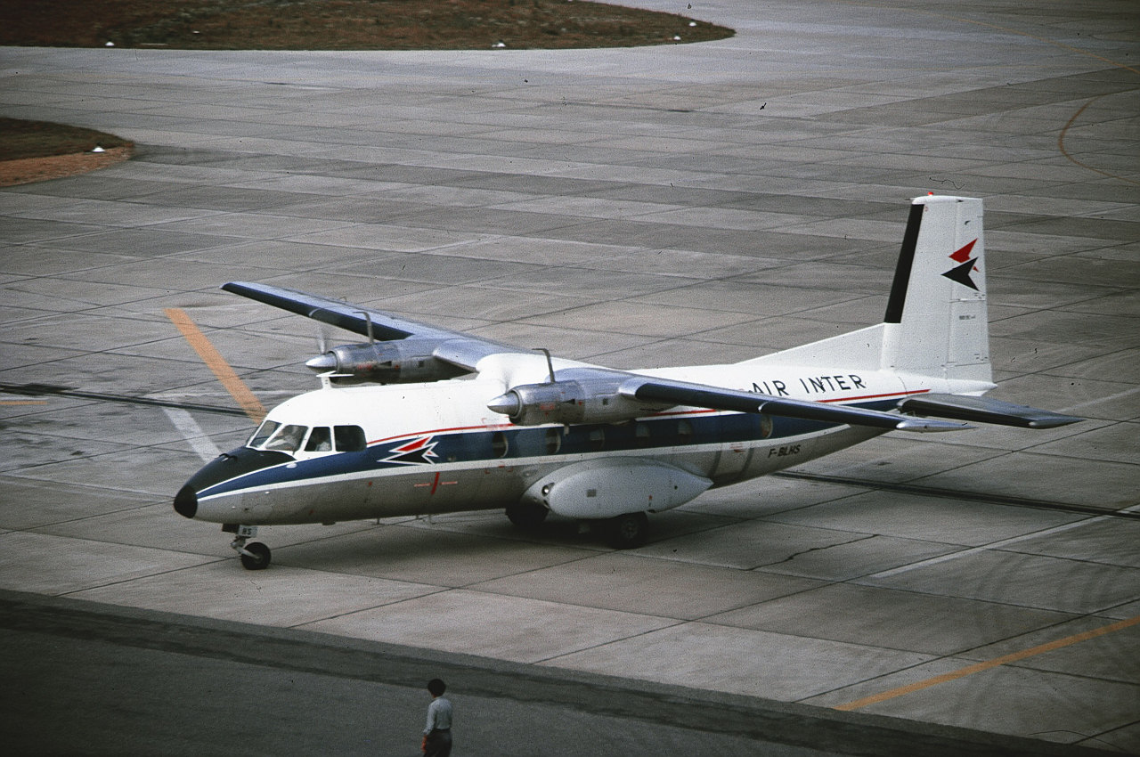
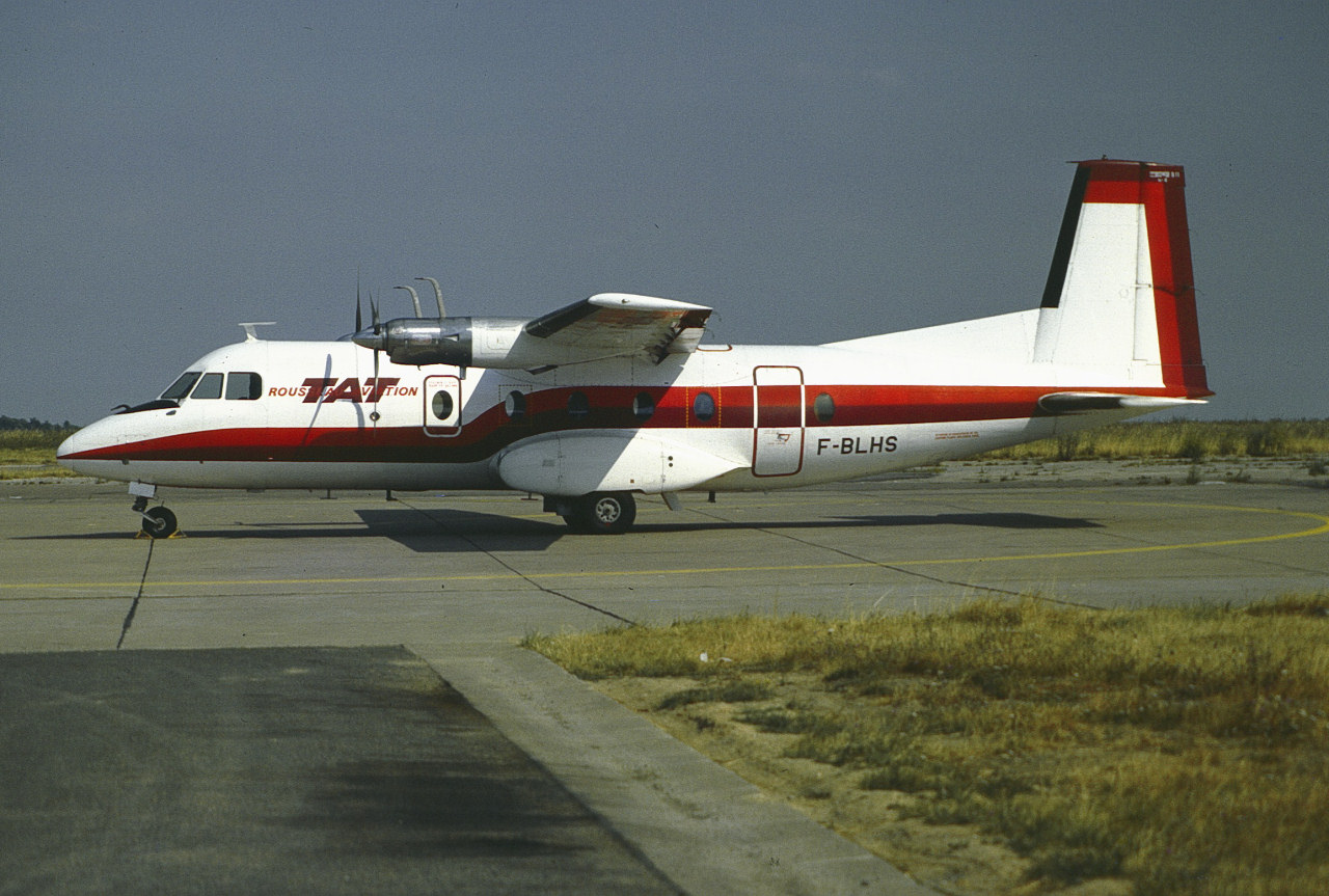
HB-ABD is taxiing to Riem’s runway 25 for take-off. Precisely nine years earlier, on 12 August 1972, this airframe had been noted at the airport as F-BLHS with Rousseau Aviation.
This 1964 built Nord 262B flew with Air Inter from 1964, then Rousseau Aviation, TAT Touraine Air Transport as F-BLHS, Rhineair as HB-ABD, CAL Compagnie Aerienne du Languedoc and Air Littoral as F-GBEI and Trans Service Airlift as 9Q-CCR. (Source: rzjets.net).
Rhineair (the former Air Sea Service) operated scheduled services between Basle and Munich using N262s, but ceased operations in August 1981 (source: airlines-airliners.de). This must have been one of the last flights. The last report I have of HB-ABD at Riem is from 21 August 1981.
Information on Air Sea Service and Rhineair (in German):
www.airlines-airliners.de/airlines/air_sea_service.htm
www.airlines-airliners.de/airlines/rhineair.htm
This airframe as F-BLHS with Air Inter:
www.airlines-airliners.de/airliners/nord262/f_blhs_2.jpg
F-BLHS with Touraine Air Transport (TAT/Rousseau Aviation titles) in ca. 1975:
www.airlines-airliners.de/airliners/nord262/f_blhs.jpg
F-BLHS with Touraine Air Transport at BSL in April 1977:
imgproc.airliners.net/photos/airliners/9/7/1/0108179.jpg

F-BLHS with Touraine Air Transport at ORY in September 1978 (later colours):
www.flickr.com/photos/avi_phot_nrw/48279317887
This airframe as F-GBEI with Compagnie Aerienne du Languedoc (CAL) at CDG in July 1986:
imgproc.airliners.net/photos/airliners/1/5/8/0669851.jpg

F-GBEI with Air Littoral colours/CAL titles in February 1988:
www.flickr.com/photos/steelhead2010/8573481519
Scan from Kodachrome slide.
Doll is Jogging Fleur precisely from 198?.
(there were no dates on the boxes)
Dress made by me. (vintage Barbie belt)
All the furniture belongs to Fleur, except the lamp, courtesy of Sindy (yes, you'll get it back, Dear, I hear you)
"what matters precisely is this; the unspoken at the edge of the spoken." -virginia woolf.
happy tuesday, everyone!
March 25, 2015 - explore, #45.
Giorgio Vasari (Arezzo, 30 July 1511 - Florence, 27 June 1574) fresco, The defeat of the Pisans at the tower of San Vincenzo - Salone dei Cinquecento - Palazzo Vecchio, Florence
Questa sala imponente ha una lunghezza di 54 metri ed una larghezza di 23. Fu costruita nel 1494 da Simone del Pollaiolo, detto il Cronaca, su commissione di Savonarola che, rimpiazzando i Medici alla guida di Firenze, la volle come sede del Consiglio maggiore, appunto di 500 membri.
Il soffitto è realizzato con 39 pannelli costruiti e dipinti da Vasari e dalla sua bottega, rappresentanti "Importanti episodi della vita di Cosimo I", i quartieri della città e la città stessa, con al centro l'apoteosi rappresentante: "Scena di glorificazione come gran duca di Firenze e di Toscana".
Sulle pareti sono realizzati grandi affreschi che descrivono le battaglie ed i successi militari di Firenze su Pisa e Siena
This imposing room has a length of 54 meters and a width of 23. It was built in 1494 by Simone del Pollaiolo, called the Chronicle, on commission of Savonarola who, replacing the Medici at the head of Florence, wanted it as the seat of the Major Council, precisely of 500 members.
The ceiling is realized with 39 panels built and painted by Vasari and his workshop, representing "Important episodes of the life of Cosimo I", the quarters of the city and the city itself, with in the center the apotheosis representing: "Scene of glorification as Grand Duke of Florence and Tuscany".
On the walls there are large frescoes depicting the battles and military successes of Florence on Pisa and Siena.
Hello!!!!!
One shot from the past weekend, me and the "Gang" went to a place in Portugal called Pego do Altar more precisely at Santa Susana village, unfortunately our country is suffering from the dry weather and this is just one example of that, in this image in the very recent past it was full of water and now this is the image that you are seeing.... dry, completely dry ... that is one sad memory ... I did some Drone photoage and some film , please stay tuned to my youtube channel ( www.youtube.com/channel/UC7cq5JYZNqzAAukT1hTwfrg? ) or my web site ( www.jorgecanelas.com ) for the Vlog.
All the best, bye for now ...
Nikon D800
Nikon 16-35 mm f/4 ED VR
LEE Filter ND 0.9 HE
LEE Filter Full ND 0.9 Pro Glass
LEE Filter Field Pouch
LOWEPRO Whistler BP 450 AW
LOWEPRO Drone Guard BP 400
FLM CB30 - L3 PRO
FLM CB 43 FTR
FLM L - Bracket