View allAll Photos Tagged precisely
© all rights reserved
Please take your time... and enjoy it large on black
The general term ice age or, more precisely, glacial age denotes a geological period of long-term reduction in the temperature of the Earth's surface and atmosphere, resulting in an expansion of continental ice sheets, polar ice sheets and alpine glaciers. There have been at least four major ice ages in the Earth's past. Outside these periods, the Earth seems to have been ice-free even in high latitudes. There is evidence that greenhouse gas levels fell at the start of ice ages and rose during the retreat of the ice sheets, but it is difficult to establish cause and effect (see the notes above on the role of weathering). Greenhouse gas levels may also have been affected by other factors which have been proposed as causes of ice ages, such as the movement of continents and vulcanism. Although the last glacial period ended more than 8,000 years ago, its effects can still be felt today. For example, the moving ice carved out landscape in Canada, Greenland, northern Eurasia and Antarctica. The erratic boulders, till, drumlins, eskers, fjords, kettle lakes, moraines, cirques, horns, etc., are typical features left behind by the glaciers.
Photo of hummocks taken at the IJsselmeer IJmeer near Amsterdam taken at the Oostvaardersdijk. A hummock is a boss or rounded knoll of ice rising above the general level of an ice-field, Hummocky ice is caused by slow and unequal pressure in the main body of the packed ice, and by unequal structure and temperature at a later period. The frozen water of the IJmeer gives a nice scattered glow. The temperature was +2 degrees above zero and the hummocks were melting. Photo taken just before sunset. On the background you can see the skyline of Amsterdam.
Een ijstijd of glaciatie is een geologisch tijdvak waarin ijskappen voorkomen. In het Engels wordt dit een periode van ice-house genoemd, als tegenhanger van een ijskaploze periode, de greenhouse broeikas. Aangezien er gletsjers liggen op bijvoorbeeld Groenland of Antarctica, leven we tegenwoordig in een ijstijd. Men neemt aan dat dit in de gehele geologische geschiedenis van de Aarde minstens vijfmaal het geval is geweest, waarvan eenmaal zelfs zo sterk dat de ijskappen van de polen vrijwel tot aan de evenaar waren opgerukt. Ook zijn er periodes dat er aanzienlijke opwarming optrad waarbij die ijskappen grotendeels waren weggesmolten. Het klimaat op Aarde wordt beïnvloed door vele factoren, zoals de intensiteit van de zonnestraling, de ligging van de continenten, de continentverplaatsingen, vulkanisme, de zeestromen, de bedekking van het land door vegetatie, het weerkaatsingsvermogen van het aardoppervlak en vele kleine andere factoren. Met behulp van klimaatmodellen wordt door wetenschappers een reconstructie van het klimaat en de klimaatveranderingen in het verleden gemaakt. Alhoewel er een zekere consensus bestaat onder wetenschappers, zijn er nog vele onzekerheden en tegenstrijdigheden in dit onderzoek.
Hierboven een foto van kruiend ijs. Zoetwatermeren kunnen spectaculair bevriezen. Grotere meren zoals het IJsselmeer IJmeer hierboven hebben bijna altijd wel golven, en dit werkt directe bevriezing van het wateroppervlak tegen. Eerst vormen zich kleine ijsschotsen, die naar de kust drijven onder invloed van de wind. Deze schotsen vormen zo een ijsveld op het water dat de golven dempt, en uiteindelijk vriezen alle schotsen aan elkaar vast tot een massa. Voordat dit gebeurt schuren de schotsen voortdurend langs elkaar heen en schrapen zo stukjes ijs van elkaar af; elke schots krijgt zo een witte rand. Zulk ijs is dus totaal niet geschikt om op te schaatsen. Wanneer grotere delen van het meer bevriezen beginnen de platen, die soms een paar vierkante kilometer groot zijn, langzaam tegen elkaar te bewegen onder invloed van de wind en stroming. Dit heeft kruiend ijs tot gevolg: de ijsschotsen worden met kracht gebroken en op elkaar gestapeld langs de dijken langs het meer. Dit hoeft niet alleen bij dun ijs te gebeuren; soms kruit het ijs bij een dikte van meer dan 20 cm. De stapels ijs worden dan hoog, en het geluid is oorverdovend.
Carefully carried across the ocean, precisely hung, then accidentally hit by a water-baloon!! My mosaic effort to restore it!
Photo taken by Andreas Rink, slide kindly provided for scanning by Florian Weiß.
München-Riem
1981-08-12 (12 August 1981)
HB-ABD
Nord 262B-11
4
Rhineair
HB-ABD is taxiing to Riem’s runway 25 for take-off. Precisely nine years earlier, on 12 August 1972, this airframe had been noted at the airport as F-BLHS with Rousseau Aviation.
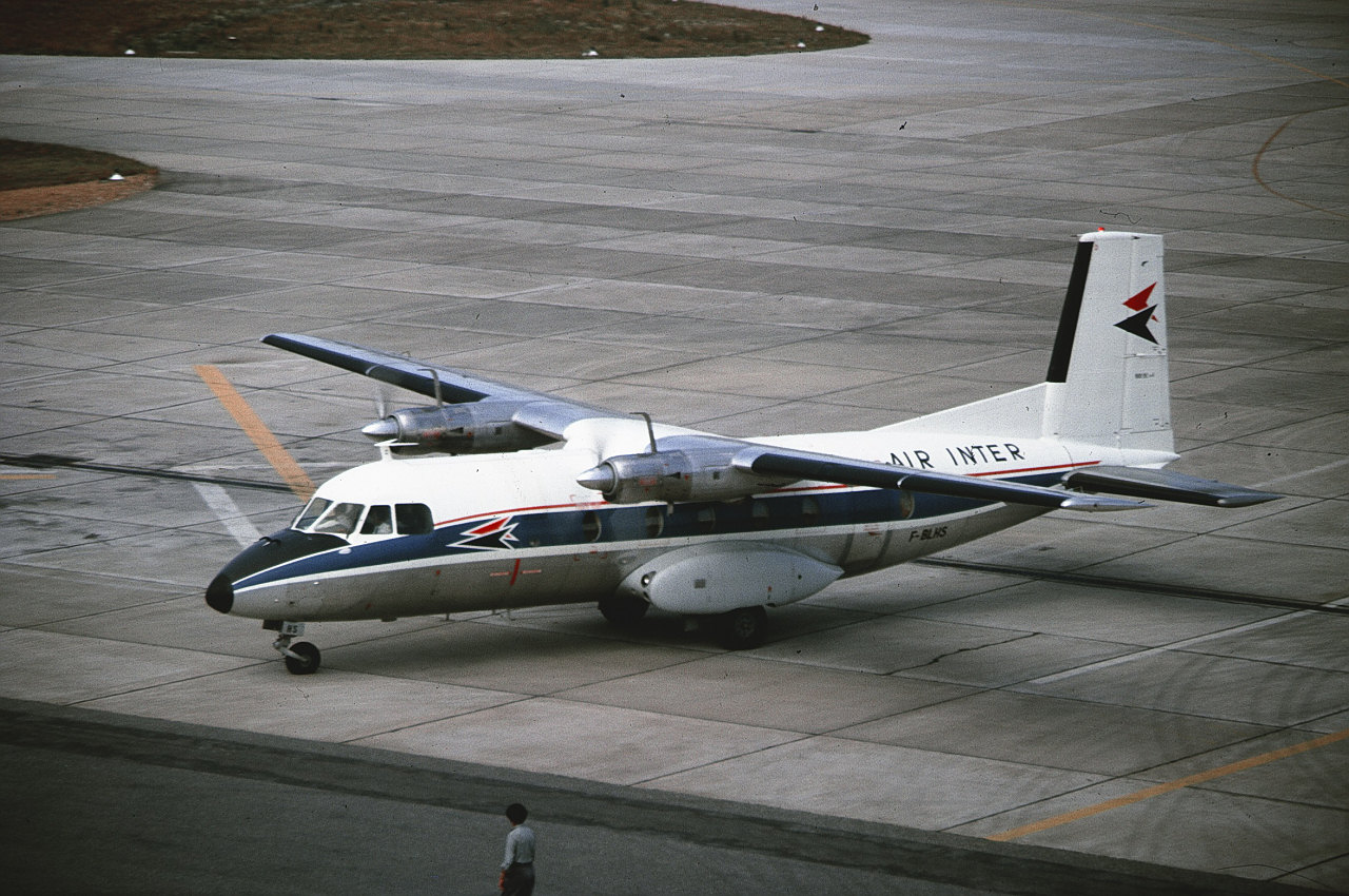
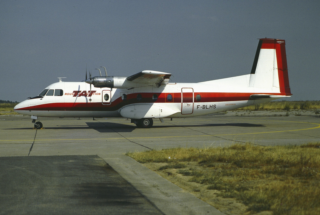
This 1964 built Nord 262B flew with Air Inter from 1964, then Rousseau Aviation, TAT Touraine Air Transport as F-BLHS, Rhineair as HB-ABD, CAL Compagnie Aerienne du Languedoc and Air Littoral as F-GBEI and Trans Service Airlift as 9Q-CCR. (Source: rzjets.net).
Rhineair (the former Air Sea Service) operated scheduled services between Basle and Munich using N262s, but ceased operations in August 1981 (source: airlines-airliners.de). This must have been one of the last flights. The last report I have of HB-ABD at Riem is from 21 August 1981.
Information on Air Sea Service and Rhineair (in German):
www.airlines-airliners.de/airlines/air_sea_service.htm
www.airlines-airliners.de/airlines/rhineair.htm
This airframe as F-BLHS with Air Inter:
www.airlines-airliners.de/airliners/nord262/f_blhs_2.jpg
F-BLHS with Touraine Air Transport (TAT/Rousseau Aviation titles) in ca. 1975:
www.airlines-airliners.de/airliners/nord262/f_blhs.jpg
F-BLHS with Touraine Air Transport at BSL in April 1977:
imgproc.airliners.net/photos/airliners/9/7/1/0108179.jpg

F-BLHS with Touraine Air Transport at ORY in September 1978 (later colours):
www.flickr.com/photos/avi_phot_nrw/48279317887
This airframe as F-GBEI with Compagnie Aerienne du Languedoc (CAL) at CDG in July 1986:
imgproc.airliners.net/photos/airliners/1/5/8/0669851.jpg

F-GBEI with Air Littoral colours/CAL titles in February 1988:
www.flickr.com/photos/steelhead2010/8573481519
Scan from Kodachrome slide.
walet waterfall is located on Mount Salak, Bogor, West Java, Indonesia. Precisely in the area of Ciasihan Village, Pamijahan District.
Doll is Jogging Fleur precisely from 198?.
(there were no dates on the boxes)
Dress made by me. (vintage Barbie belt)
All the furniture belongs to Fleur, except the lamp, courtesy of Sindy (yes, you'll get it back, Dear, I hear you)
"what matters precisely is this; the unspoken at the edge of the spoken." -virginia woolf.
happy tuesday, everyone!
March 25, 2015 - explore, #45.
Giorgio Vasari (Arezzo, 30 July 1511 - Florence, 27 June 1574) fresco, The defeat of the Pisans at the tower of San Vincenzo - Salone dei Cinquecento - Palazzo Vecchio, Florence
Questa sala imponente ha una lunghezza di 54 metri ed una larghezza di 23. Fu costruita nel 1494 da Simone del Pollaiolo, detto il Cronaca, su commissione di Savonarola che, rimpiazzando i Medici alla guida di Firenze, la volle come sede del Consiglio maggiore, appunto di 500 membri.
Il soffitto è realizzato con 39 pannelli costruiti e dipinti da Vasari e dalla sua bottega, rappresentanti "Importanti episodi della vita di Cosimo I", i quartieri della città e la città stessa, con al centro l'apoteosi rappresentante: "Scena di glorificazione come gran duca di Firenze e di Toscana".
Sulle pareti sono realizzati grandi affreschi che descrivono le battaglie ed i successi militari di Firenze su Pisa e Siena
This imposing room has a length of 54 meters and a width of 23. It was built in 1494 by Simone del Pollaiolo, called the Chronicle, on commission of Savonarola who, replacing the Medici at the head of Florence, wanted it as the seat of the Major Council, precisely of 500 members.
The ceiling is realized with 39 panels built and painted by Vasari and his workshop, representing "Important episodes of the life of Cosimo I", the quarters of the city and the city itself, with in the center the apotheosis representing: "Scene of glorification as Grand Duke of Florence and Tuscany".
On the walls there are large frescoes depicting the battles and military successes of Florence on Pisa and Siena.
In the village of Sarnath and precisely in this stupa, Buddha preached his famous sermon:" Sermon in the deer park".
When I went to Germany and more precisely in the city of Stuttgart, I took the opportunity to discover this city that I did not know yet. Today I will introduce you to one of the main squares in Stuttgart, its finance ministry. An imposing and beautiful structure truncated in the middle of greenery. This "palace" was perfectly symmetrical, so I tried to transcribe this one as well as the imposing size of this structure.
--------------------------------------------
Canon EOS 5D Mark III
Canon EF 16-35 mm f/4.0 L IS USM
Tripod Manfrotto MT055XPRO3
Post processing Lightroom and Photoshop.
The birds are clearly representations of the "manutara" (the sootie tern - Onychoprion fuscatus), the species in which all Bird-Man competition is focused.
That's the cave:
PS. I will explain the Bird-man cult better when I arrive at Orongo village which is at the top of the volcano in the sequence of photographs.
_______________________________________________
The legend of the origin of birds on Easter Island has, like all myths, part of the truth. And it is precisely that Motu Nui, together with the nearby islets Motu Iti and Motu Kao Kao, is the place chosen to nest for most of the seabirds that visit the island.
The manutara, the protagonist of our history, also nested until a few years ago on the motu or islets. This bird has been identified with two kinds of tern and specifically with the sootie tern (Onychoprion fuscatus) who came to the island every spring to lay eggs.
The manutara measures about 40 cm, has the upper part of the head black and the neck and chest white. The upper part of the wings and the body is a dark gray color by which it receives its name.
The meaning of Manutara or Manu Tara is “luck bird” in the Rapanui language. A name probably associated with its arrival coinciding with the end of winter and the beginning of a season with a greater abundance of eggs and greater fishing catches. It is possible that these reasons later made him the center of the bird-man ritual.
Unfortunately, the manutara can no longer honor its name because the bird does not visit Rapa Nui anymore due to the changes suffered in recent years in the fragile ecosystem of the island. However, as if the legend wanted to continue, the tern continues to nest in Motu Motiro Hiva, the uninhabited islet of Sala y Gómez, located 415 km northeast of the island and which is currently a protected marine reserve. Perhaps, in the near future, a new Make Make embodied in a marine biologist will introduce the species back into Rapa Nui.
The cave paintings of Ana Kai Tangata:
*Recreation of the paintings of Ana Kai Tangata | Watercolor of Melinka Pictures Hucke for the book Manu Iri:
Along with your incredible walk inside the cave, I also was able to see the rock art practiced by the natives of Rapa Nui. Yes, as you read, the island has spectacular paintings of red, white and black that adorn your wonderful walk with history and culture.
The paintings that I saw there portray the Apizarrado Tern, a bird that flew over the island for a long time and is considered sacred by the natives to this day.
The rest of the figures are related to ships and frigates that according to the researchers could represent the Europeans who landed on the island (when the Europeans first arrived on the island, they were considered gods and messengers from beyond).
The cave crisis:
Although there is no clarity of the cultural origin of this cave or of what the surprising cave paintings that I saw there mean, there is clarity of something: the seepage of seawater has caused these drawings to disappear and are in danger.
Given the above, CONAF and the government of Chile have implemented an emergency plan to maintain and restore this historical treasure. More and more care is taken with those who visit this natural wonder and there are experts working on its conservation so as not to lose this record of the Rapanui culture.
_______________________________________________
Manutara the sacred bird that still lives in the memory of Rapa Nui.
Legend of the origin of the manutara:
Father Sebastián Englert, a Capuchin priest of German origin who lived on Easter Island for more than 30 years, studied its traditions and compiled the myths and legends that their inhabitants told him. Among them is the story of how the birds came to Rapa Nui and says:
“Formerly, when the first settlers arrived in Rapa Nui, there were no birds on the island. At that time there lived a witch or spirit called Hitu in the bay of Hanga Nui, near Tongariki. Hitu had a skull that she kept as treasure in the cavity of a rock. One day, when the sea grew, a great wave dragged the skull and carried it to the coast. Hitu threw herself into the water to retrieve it, but she could not reach it. Although she swam and swam, the skull floated among the waves and moved away.
Thus Hitu continued swimming day and night after the skull. When she was about to give up due to exhaustion, she glimpsed on the horizon the rocks of Motu Motiro Hiva (Sala y Gómez islet). When the skull reached the edge of the islet it became the creator god Make Make. Hitu reached the islet shortly after and both were welcomed by the spirit Haua who lived there because he was destined to care for the numerous seabirds that inhabited the small island.
After a few days off, Make Make ordered Haua to bring him some pairs of birds to take them to Te Pito o Te Henua (which means navel of the world, one of the names by which Easter Island is known). When Make Make arrived on the island, he went to Hanga Nui and climbed the Poike hill where he left the birds free to reproduce, and later returned to his islet.
The following year, Make Make returned to Te Pito o Te Henua to see if the birds had multiplied, but discovered that the inhabitants had eaten all the eggs. Then, furious, he picked up the birds and took them to Vaihú, where he again released them to nest there. But the same thing happened in Vaihú, and the natives ate the eggs again. The following year, Make Make, desperate, took the birds to Vai Atare, a place located on the edge of the crater of the Rano Kau volcano. There finally, the villagers left a nest with only one egg, from which the first manutara bird of the island was born.
But Make Make, to better ensure the breeding of the birds, returned again next year and left the birds on the Motu Nui islet in front of the Rano Kau volcano. There the birds multiplied in large numbers due to the difficult access of the small islet.
Later, Make Make, allowed the islanders to be able to collect the eggs of the birds in a certain period of the year, punishing those who collected them in times not allowed. In order not to provoke the wrath of God, the Ariki (king) and the priests decided to declare the eggs as Tapu (or taboo, that is, forbidden) during the closed periods. This taboo allowed the protection and development of seabirds in Rapa Nui”.
The cult of the manutara:
The importance of birds in the Rapanui culture is manifested through the numerous allusions to birds found in prints, paintings, sculptures and legends throughout its history.
This great relevance makes sense on a remote and isolated island like Rapa Nui, in which there were no large mammals or reptiles, and in which birds were the only living beings close to humans, which also provided an interesting source of protein in shape of meat and eggs, at the same time as feathers and bones to make tools and decorative objects.
Seabirds also indicate the location of shoals of fish when they fly over the surface of the sea in search of food, which was extremely useful to a people who based much of their livelihood on fishing.
It is not strange, therefore, that a religious cult arose around birds. There was a belief that the birds had a mystical relationship with the gods, and especially the seabirds that united the earth, the sea and the sky. Each year they came from “the hereafter”, an unknown land carrying messages from ancestors and spirits.
However, it is unknown exactly how the cult of the manutara was born and the bird man competition. A cult that replaced the veneration of the Moai statues with a new belief whose main ritual was carried out in spring coinciding with the migration of seabirds to nest in Motu Nui.
The city of Petra, capital of the Nabataean Arabs, is one of the most famous archaeological sites in the world.
t is not known precisely when Petra was built, but the city began to prosper as the capital of the Nabataean Empire from the 1st century BC, which grew rich through trade in frankincense, myrrh, and spices.
Petra was later annexed to the Roman Empire and continued to thrive until a large earthquake in 363 AD destroyed much of the city in the 4th century AD.
The earthquake combined with changes in trade routes, eventually led to the downfall of the city which was ultimately abandoned.
Petra is also known as the rose-red city, a name it gets from the wonderful colour of the rock from which many of the city’s structures were carved.
The Nabataeans buried their dead in intricate tombs that were cut out of the mountain sides and the city also had temples, a theater, and following the Roman annexation and later the Byzantine influence, a colonnaded street and churches.
In addition to the magnificent remains of the Nabataean city, human settlement and land use for over 10,000 years can be traced in Petra, where great natural, cultural, archaeological and geological features merge.
On December 6, 1985, Petra was designated a World Heritage Site.
The Hermit Card in the Tarot can be seen as Jigsaw Piece and The Hermit holds a light that can illuminate the place for this Jigsaw Piece to fit in. It maybe that The Hermit always finds a place at least a place to pause awhile before continuing. The light of the Lamp is The Star and expression of the yearning to find and the striving to fulfil self and to be the individual that we can be. Tarot Archetype and Ever Living Avatar came together to do more than putting the best foot forward. In photographing both feet on the ground the not a step further ultimate ideal was found.
© PHH Sykes 2024
phhsykes@gmail.com
Floor painting at the entrance of the U-Bahn station Hauptwache. More precisely at the entrance of the MOMEM (for Museum Of Modern Electronic Music, on account of MOMA being already taken) that opened there earlier this year, replacing the Kindermuseum.
Minolta XD7 and Rokkor-HG 1:2.8 f=35mm, Agfa RSX II developped by the DM Fotoparadies and digitalized using kit zoom with macro rings.
Thank you everyone for your visits, faves and comments, they are always appreciated :)
The Laponian area is a large mountainous wildlife area in the Lapland province in northern Sweden, more precisely in Gällivare Municipality, Arjeplog Municipality and Jokkmokk Municipality. It was made a UNESCO World Heritage Site in 1996; the bulk of it had enjoyed protected status since the early 20th century.
The total area is about 9,400 square kilometres (3,600 sq mi), making it the world's largest unmodified nature area to be still cultured by natives—the natives in this case being the reindeer herding Sami people also known as Lapps (though this term is considered derogatory). Only parts of the area is actually used for pasture by them. With such a large space, the geography of the area varies greatly; it is dominated by mountains, rivers and lakes. Each nature reserve and national park has its distinctive features. The amount of snow in winter and rain in summer is considerable.
95% of the area is protected as national parks or nature reserves. It consists of the national parks Muddus, Sarek, Padjelanta and Stora Sjöfallet, and the nature reserves Sjaunja and Stubba. The remaining 5% are located in the areas of Sulitelma, Tjuoltadalen, and Rapadalen (part of which is in the Sarek park). The village of Porjus is a natural point of entry to the Laponian area and has recently opened an information center.
The Laponia area also contains three major hydropower stations with belonging basins and a big expansion of 100 wind power stations inside the world heritage area is planned.
The highest mountain of the area is Sarektjåhkkå, at 2,089 metres (6,854 ft).
Pretty Dora Falls in Leggett, 50 ft. high precisely. I think this was my favorite of the falls I saw last weekend. I was not expecting such a pretty waterfall here.
Facebook | Blog | Website | Google+
Copyright © Leon Turnbull Photography.
This photo may not be used in any form without prior permission. All rights reserved.
Explore Frontpage
The general term ice age or, more precisely, "glacial age" denotes a geological period of long-term reduction in the temperature of the Earth's surface and atmosphere, resulting in an expansion of continental ice sheets, polar ice sheets and alpine glaciers. There have been at least four major ice ages in the Earth's past. Outside these periods, the Earth seems to have been ice-free even in high latitudes. There is evidence that greenhouse gas levels fell at the start of ice ages and rose during the retreat of the ice sheets, but it is difficult to establish cause and effect (see the notes above on the role of weathering). Greenhouse gas levels may also have been affected by other factors which have been proposed as causes of ice ages, such as the movement of continents and vulcanism. Although the last glacial period ended more than 8,000 years ago, its effects can still be felt today. For example, the moving ice carved out landscape in Canada, Greenland, northern Eurasia and Antarctica. The erratic boulders, till, drumlins, eskers, fjords, kettle lakes, moraines, cirques, horns, etc., are typical features left behind by the glaciers.
This is the Marken lighthouse, given its name due to its shape ('paard' means 'horse' in dutch). The original was built in 1700, then reconstructed on top of the early foundations in 1839. It's still in use today.
Photo of hummocks taken at the lighthouse of Marken. A red airplane flew pretty low around the lighthouse to enjoy the view of the sea of ice. A hummock is a boss or rounded knoll of ice rising above the general level of an ice-field, Hummocky ice is caused by slow and unequal pressure in the main body of the packed ice, and by unequal structure and temperature at a later period.
Een ijstijd of glaciatie is een geologisch tijdvak waarin ijskappen voorkomen. In het Engels wordt dit een periode van ice-house genoemd, als tegenhanger van een ijskaploze periode, de greenhouse ("broeikas"). Aangezien er gletsjers liggen op bijvoorbeeld Groenland of Antarctica, leven we tegenwoordig in een ijstijd. Men neemt aan dat dit in de gehele geologische geschiedenis van de Aarde minstens vijfmaal het geval is geweest, waarvan eenmaal zelfs zo sterk dat de ijskappen van de polen vrijwel tot aan de evenaar waren opgerukt. Ook zijn er periodes dat er aanzienlijke opwarming optrad waarbij die ijskappen grotendeels waren weggesmolten. Het klimaat op Aarde wordt beïnvloed door vele factoren, zoals de intensiteit van de zonnestraling, de ligging van de continenten, de continentverplaatsingen, vulkanisme, de zeestromen, de bedekking van het land door vegetatie, het weerkaatsingsvermogen van het aardoppervlak en vele kleine andere factoren. Met behulp van klimaatmodellen wordt door wetenschappers een reconstructie van het klimaat en de klimaatveranderingen in het verleden gemaakt. Alhoewel er een zekere consensus bestaat onder wetenschappers, zijn er nog vele onzekerheden en tegenstrijdigheden in dit onderzoek.
Hierboven een foto van kruiend ijs. Zoetwatermeren kunnen spectaculair bevriezen. Grotere meren zoals het IJsselmeer (IJmeer) hierboven hebben bijna altijd wel golven, en dit werkt directe bevriezing van het wateroppervlak tegen. Eerst vormen zich kleine ijsschotsen, die naar de kust drijven onder invloed van de wind. Deze schotsen vormen zo een ijsveld op het water dat de golven dempt, en uiteindelijk vriezen alle schotsen aan elkaar vast tot een massa. Voordat dit gebeurt schuren de schotsen voortdurend langs elkaar heen en schrapen zo stukjes ijs van elkaar af; elke schots krijgt zo een witte rand. Zulk ijs is dus totaal niet geschikt om op te schaatsen. Wanneer grotere delen van het meer bevriezen beginnen de platen, die soms een paar vierkante kilometer groot zijn, langzaam tegen elkaar te bewegen onder invloed van de wind en stroming. Dit heeft kruiend ijs tot gevolg: de ijsschotsen worden met kracht gebroken en op elkaar gestapeld langs de dijken langs het meer. Dit hoeft niet alleen bij dun ijs te gebeuren; soms kruit het ijs bij een dikte van meer dan 20 cm. De stapels ijs worden dan hoog, en het geluid is oorverdovend. Het Paard van Marken is een vuurtoren van Marken. De vuurtoren is gebouwd in 1839 en staat op de oostelijke punt van het eiland. De toren heeft een hoogte van 16 meter en een lichtbereik van 16,7 km.
Schweiz / Berner Oberland - Eiger
seen from Fallbodensee
The Eiger (German pronunciation: [ˈaɪ̯ɡɐ]) is a 3,967-metre (13,015 ft) mountain of the Bernese Alps, overlooking Grindelwald and Lauterbrunnen in the Bernese Oberland of Switzerland, just north of the main watershed and border with Valais. It is the easternmost peak of a ridge crest that extends across the Mönch to the Jungfrau at 4,158 m (13,642 ft), constituting one of the most emblematic sights of the Swiss Alps. While the northern side of the mountain rises more than 3,000 m (10,000 ft) above the two valleys of Grindelwald and Lauterbrunnen, the southern side faces the large glaciers of the Jungfrau-Aletsch area, the most glaciated region in the Alps. The most notable feature of the Eiger is its nearly 1,800-metre-high (5,900 ft) north face of rock and ice, named Eiger-Nordwand, Eigerwand or just Nordwand, which is the biggest north face in the Alps.] This huge face towers over the resort of Kleine Scheidegg at its base, on the eponymous pass connecting the two valleys.
The first ascent of the Eiger was made by Swiss guides Christian Almer and Peter Bohren and Irishman Charles Barrington, who climbed the west flank on August 11, 1858. The north face, the "last problem" of the Alps, considered amongst the most challenging and dangerous ascents, was first climbed in 1938 by an Austrian-German expedition.The Eiger has been highly publicized for the many tragedies involving climbing expeditions. Since 1935, at least 64 climbers have died attempting the north face, earning it the German nickname Mordwand, literally "murder(ous) wall"—a pun on its correct title of Nordwand (North Wall).
Although the summit of the Eiger can be reached by experienced climbers only, a railway tunnel runs inside the mountain, and two internal stations provide easy access to viewing-windows carved into the rock face. They are both part of the Jungfrau Railway line, running from Kleine Scheidegg to the Jungfraujoch, between the Mönch and the Jungfrau, at the highest railway station in Europe. The two stations within the Eiger are Eigerwand (behind the north face) and Eismeer (behind the south face), at around 3,000 metres. The Eigerwand station has not been regularly served since 2016.
Etymology
The first mention of Eiger, appearing as "mons Egere", was found in a property sale document of 1252, but there is no clear indication of how exactly the peak gained its name. The three mountains of the ridge are commonly referred to as the Virgin (German: Jungfrau – translates to "virgin" or "maiden"), the Monk (Mönch), and the Ogre (Eiger; the standard German word for ogre is Oger). The name has been linked to the Latin term acer, meaning "sharp" or "pointed".
Geographic setting and description
The Eiger is located above the Lauterbrunnen Valley to the west and Grindelwald to the north in the Bernese Oberland region of the canton of Bern. It forms a renowned mountain range of the Bernese Alps together with its two companions: the Jungfrau (4,158 m (13,642 ft)) about 5.6 kilometres (3.5 mi) southwest of it and the Mönch (4,107 m (13,474 ft)) about in the middle of them. The nearest settlements are Grindelwald, Lauterbrunnen (795 m (2,608 ft)) and Wengen (1,274 m (4,180 ft)). The Eiger has three faces: north (or more precisely NNW), east (or more precisely ESE), and west (or more precisely WSW). The northeastern ridge from the summit to the Ostegg (lit.: eastern corner, 2,709 m (8,888 ft)), called Mittellegi, is the longest on the Eiger. The north face overlooks the gently rising Alpine meadow between Grindelwald (943 m (3,094 ft)) and Kleine Scheidegg (2,061 m (6,762 ft)), a mountain railways junction and a pass, which can be reached from both sides, Grindelwald and Lauterbrunnen/Wengen – by foot or train.
Politically, the Eiger (and its summit) belongs to the Bernese municipalities of Grindelwald and Lauterbrunnen. The Kleine Scheidegg (literally, the small parting corner) connects the Männlichen-Tschuggen range with the western ridge of the Eiger. The Eiger does not properly form part of the main chain of the Bernese Alps, which borders the canton of Valais and forms the watershed between the Rhine and the Rhône, but constitutes a huge limestone buttress, projecting from the crystalline basement of the Mönch across the Eigerjoch. Consequently, all sides of the Eiger feed finally the same river, namely the Lütschine.
Eiger's water is connected through the Weisse Lütschine (the white one) in the Lauterbrunnen Valley on the west side (southwestern face of the Eiger), and through the Schwarze Lütschine (the black one) running through Grindelwald (northwestern face), which meet each other in Zweilütschinen (lit.: the two Lütschinen) where they form the proper Lütschine. The east face is covered by the glacier called Ischmeer, (Bernese German for Ice Sea), which forms one upper part of the fast-retreating Lower Grindelwald Glacier. These glaciers' water forms a short creek, which is also confusingly called the Weisse Lütschine, but enters the black one already in Grindelwald together with the water from the Upper Grindelwald Glacier. Therefore, all the water running down the Eiger converges at the northern foot of the Männlichen (2,342 m (7,684 ft)) in Zweilütschinen (654 m (2,146 ft)), about 10 kilometres (6.2 mi) northwest of the summit, where the Lütschine begins its northern course to Lake Brienz and the Aare (564 m (1,850 ft)).
Although the north face of the Eiger is almost free of ice, significant glaciers lie at the other sides of the mountain. The Eiger Glacier flows on the southwestern side of the Eiger, from the crest connecting it to the Mönch down to 2,400 m (7,900 ft), south of Eigergletscher railway station, and feeds the Weisse Lütschine through the Trümmelbach. On the east side, the Ischmeer–well visible from the windows of Eismeer railway station–flows eastwards from the same crest then turns to the north below the impressive wide Fiescherwand, the north face of the Fiescherhörner triple summit (4,049 m (13,284 ft)) down to about 1,600 m (5,200 ft) of the Lower Grindelwald Glacier system.
The massive composition of the Eiger, Mönch, and Jungfrau constitutes an emblematic sight of the Swiss Alps and is visible from many places on the Swiss Plateau and the Jura Mountains in the northwest. The higher Finsteraarhorn (4,270 m (14,010 ft)) and Aletschhorn (4,190 m (13,750 ft)), which are located about 10 kilometres (6.2 mi) to the south, are generally less visible and situated in the middle of glaciers in less accessible areas. As opposed to the north side, the south and east sides of the range consist of large valley glaciers extending for up to 22 kilometres (14 mi), the largest (beyond the Eiger drainage basin) being those of Grand Aletsch, Fiesch, and Aar Glaciers, and is thus uninhabited. The whole area, the Jungfrau-Aletsch protected area, comprising the highest summits and largest glaciers of the Bernese Alps, was inscribed as a UNESCO World Heritage Site in 2001.
In July 2006, a piece of the Eiger, amounting to approximately 700,000 cubic metres of rock, fell from the east face. As it had been noticeably cleaving for several weeks and fell into an uninhabited area, there were no injuries and no buildings were hit.
Climbing history
While the summit was reached without much difficulty in 1858 by a complex route on the west flank, the battle to climb the north face has captivated the interest of climbers and non-climbers alike. Before it was successfully climbed, most of the attempts on the face ended tragically and the Bernese authorities even banned climbing it and threatened to fine any party that should attempt it again. But the enthusiasm which animated the young talented climbers from Austria and Germany finally vanquished its reputation of unclimbability when a party of four climbers successfully reached the summit in 1938 by what is known as the "1938" or "Heckmair" route.
The climbers that attempted the north face could be easily watched through the telescopes from the Kleine Scheidegg, a pass between Grindelwald and Lauterbrunnen, connected by rail. The contrast between the comfort and civilization of the railway station and the agonies of the young men slowly dying a short yet uncrossable distance away led to intensive coverage by the international media.
After World War II, the north face was climbed twice in 1947, first by a party of two French guides, Louis Lachenal and Lionel Terray, then by a Swiss party consisting of H. Germann, with Hans and Karl Schlunegger.
First ascent
In 1857, a first recorded attempt was made by Christian Almer, Christian Kaufmann, Ulrich Kaufmann guiding the Austrian alpinist Sigismund Porges. They did manage the first ascent of neighboring Mönch instead. Porges, however, successfully made the second ascent of the Eiger in July 1861 with the guides Christian Michel, Hans and Peter Baumann.
The first ascent was made by the western flank on August 11, 1858 by Charles Barrington with guides Christian Almer and Peter Bohren. On the previous afternoon, the party walked up to the Wengernalp hotel. From there they started the ascent of the Eiger at 3:30 a.m. Barrington describes the route much as it is followed today, staying close to the edge of the north face much of the way. They reached the summit at about noon, planted a flag, stayed for some 10 minutes and descended in about four hours. Barrington describes the reaching of the top, saying, "the two guides kindly gave me the place of first man up." After the descent, the party was escorted to the Kleine Scheidegg hotel, where their ascent was confirmed by observation of the flag left on the summit. The owner of the hotel then fired a cannon to celebrate the first ascent. According to Harrer's The White Spider, Barrington was originally planning to make the first ascent of the Matterhorn, but his finances did not allow him to travel there as he was already staying in the Eiger region.
Mittellegi ridge
Although the Mittellegi ridge had already been descended by climbers (since 1885) with the use of ropes in the difficult sections, it remained unclimbed until 1921. On the 10th of September of that year, Japanese climber Yuko Maki, along with Swiss guides Fritz Amatter, Samuel Brawand and Fritz Steuri made the first successful ascent of the ridge. The previous day, the party approached the ridge from the Eismeer railway station of the Jungfrau Railway and bivouacked for the night. They started the climb at about 6:00 a.m. and reached the summit of the Eiger at about 7:15 p.m., after an over 13 hours gruelling ascent. Shortly after, they descended the west flank. They finally reached Eigergletscher railway station at about 3:00 a.m. the next day.
Attempts on the north face
1935
In 1935, two young German climbers from Bavaria, Karl Mehringer and Max Sedlmeyer, arrived at Grindelwald to attempt the ascent of the north face. After waiting some time for the weather to improve, they set off, reaching the height of the Eigerwand station before stopping for their first bivouac. The following day, facing greater difficulties, they gained little height. On the third day, they made hardly any vertical gain. That night, the weather deteriorated, bringing snow and low cloud that shrouded the mountain from the observers below. Avalanches began to sweep the face. Two days later, the weather briefly cleared, and the two men were glimpsed a little higher and about to bivouac for the fifth night, before clouds descended again. A few days later, the weather finally cleared, revealing a completely white north face.: 225 Weeks later, the German World War I ace Ernst Udet went searching for the missing men with his aircraft, eventually spotting one of them frozen to death in what became known as the "Death Bivouac". Sedlmeyer's body was found at the foot of the face the following year by his brothers Heinrich and Martin Meier, who were part of a group looking for the victims of the 1936 climbing disaster. Mehringer's remains were found in 1962 by Swiss climbers below the "Flat Iron" (Bügeleisen) at the lefthand end of the second ice field.
1936
The next year ten young climbers from Austria and Germany came to Grindelwald and camped at the foot of the mountain. Before their attempts started one of them was killed during a training climb, and the weather was so bad during that summer that, after waiting for a change and seeing none on the way, several members of the party gave up. Of the four that remained, two were Bavarians, Andreas Hinterstoisser and Toni Kurz, and two were Austrians, Willy Angerer and Edi Rainer. When the weather improved they made a preliminary exploration of the lowest part of the face. Hinterstoisser fell 37 metres (121 ft) but was not injured. A few days later the four men finally began the ascent of the face. They climbed quickly, but on the next day, after their first bivouac, the weather changed; clouds came down and hid the group to the observers. They did not resume the climb until the following day, when, during a break, the party was seen descending, but the climbers could be seen only intermittently from the ground. The group had no choice but to retreat, since Angerer had suffered serious injuries from falling rock. The party became stuck on the face when they could not recross the difficult Hinterstoisser Traverse, from which they had taken the rope they had first used to climb it. The weather then deteriorated for two days. They were ultimately swept away by an avalanche, which only Kurz survived, hanging on a rope. Three guides started on an extremely perilous rescue attempt. They failed to reach him but came within shouting distance and learned what had happened. Kurz explained the fate of his companions: one had fallen down the face, another was frozen above him, and the third had fractured his skull in falling and was hanging dead on the rope.
In the morning the three guides came back, traversing the face from a hole near the Eigerwand station and risking their lives under incessant avalanches. Toni Kurz was still alive but almost helpless, with one hand and one arm completely frozen. Kurz hauled himself off the cliff after cutting loose the rope that bound him to his dead teammate below and climbed back onto the face. The guides were not able to pass an unclimbable overhang that separated them from Kurz. They managed to give him a rope long enough to reach them by tying two ropes together. While descending, Kurz could not get the knot to pass through his carabiner. He tried for hours to reach his rescuers who were only a few metres below him. Then he began to lose consciousness. One of the guides, climbing on another's shoulders, was able to touch the tip of Kurz's crampons with his ice-axe but could not reach higher. Kurz was unable to descend further and, completely exhausted, died slowly.
1937
An attempt was made in 1937 by Mathias Rebitsch and Ludwig Vörg. Although the attempt was unsuccessful, they were nonetheless the first climbers who returned alive from a serious attempt on the face. They started the climb on 11 August and reached a high point of a few rope lengths above Death Bivouac. A storm then broke and after three days on the wall they had to retreat. This was the first successful withdrawal from a significant height on the wall.
First ascent of the north face
The north face was first climbed on July 24, 1938 by Anderl Heckmair, Ludwig Vörg, Heinrich Harrer and Fritz Kasparek in a German–Austrian party. The party had originally consisted of two independent teams: Harrer (who did not have a pair of crampons on the climb) and Kasparek were joined on the face by Heckmair and Vörg, who had started their ascent a day later and had been helped by the fixed rope that the lead team had left across the Hinterstoisser Traverse. The two groups, led by the experienced Heckmair, decided to join their forces and roped together as a single group of four. Heckmair later wrote: "We, the sons of the older Reich, united with our companions from the Eastern Border to march together to victory."
The expedition was constantly threatened by snow avalanches and climbed as quickly as possible between the falls. On the third day a storm broke and the cold was intense. The four men were caught in an avalanche as they climbed "the Spider," the snow-filled cracks radiating from an ice-field on the upper face, but all possessed sufficient strength to resist being swept off the face. The members successfully reached the summit at four o'clock in the afternoon. They were so exhausted that they only just had the strength to descend by the normal route through a raging blizzard.
Other notable events
1864 (Jul 27): Fourth ascent, and first ascent by a woman, Lucy Walker, who was part of a group of six guides (including Christian Almer and Melchior Anderegg) and five clients, including her brother Horace Walker[
1871: First ascent by the southwest ridge, 14 July (Christian Almer, Christian Bohren, and Ulrich Almer guiding W. A. B. Coolidge and Meta Brevoort).
1890: First ascent in winter, Ulrich Kaufmann and Christian Jossi guiding C. W. Mead and G. F. Woodroffe.
1924: First ski ascent and descent via the Eiger glacier by Englishman Arnold Lunn and the Swiss Fritz Amacher, Walter Amstutz and Willy Richardet.
1932: First ascent of the northeast face ("Lauper route") by Hans Lauper, Alfred Zürcher, Alexander Graven and Josef Knubel
1970: First ski descent over the west flank, by Sylvain Saudan.
1986: Welshman Eric Jones becomes the first person to BASE jump from the Eiger.
1988: Original Route (ED2), north face, Eiger (3970m), Alps, Switzerland, first American solo (nine and a half hours) by Mark Wilford.
1991: First ascent, Metanoia Route, North Face, solo, winter, without bolts, Jeff Lowe.
1992 (18 July): Three BMG/UIAGM/IFMGA clients died in a fall down the West Flank: Willie Dunnachie; Douglas Gaines; and Phillip Davies. They had ascended the mountain via the Mittellegi Ridge.
2006 (14 June): François Bon and Antoine Montant make the first speedflying descent of the Eiger.
2006 (15 July): Approximately 700,000 cubic metres (20 million cubic feet) of rock from the east side collapses. No injuries or damage were reported.
2015 (23 July): A team of British Para-Climbers reached the summit via the West Flank Route. The team included John Churcher, the world's first blind climber to summit the Eiger, sight guided by the team leader Mark McGowan. Colin Gourlay enabled the ascent of other team members, including Al Taylor who has multiple sclerosis, and the young autistic climber Jamie Owen from North Wales. The ascent was filmed by the adventure filmmakers Euan Ryan & Willis Morris of Finalcrux Films.
Books and films
The 1959 book The White Spider by Heinrich Harrer describes the first successful ascent of the Eiger north face.
The Climb Up To Hell, 1962, by Jack Olson, an account of the ill-fated 1957 attempted climb of the north face by an Italian four-man team and the dramatic rescue of the sole survivor mounted by an international all-volunteer group of rescuers.
Eiger Direct, 1966, by Dougal Haston and Peter Gillman, London: Collins, also known as Direttissima; the Eiger Assault
The 1971 novel The Ice Mirror by Charles MacHardy describes the second attempted ascent of the Eiger north face by the main character.
The 1972 novel The Eiger Sanction is an action/thriller novel by Rodney William Whitaker (writing under the pseudonym Trevanian), based around the climbing of the Eiger. This was then made into the 1975 film The Eiger Sanction starring Clint Eastwood and George Kennedy. The Eiger Sanction film crew included very experienced mountaineers (e.g., Mike Hoover, Dougal Haston, and Hamish MacInnes, see Summit, 52, Spring 2010) as consultants, to ensure accuracy in the climbing footage, equipment and techniques.
The Eiger, 1974, by Dougal Haston, London: Cassell
The 1982 book Eiger, Wall of Death by Arthur Roth is an historical account of first ascents of the north face.
The 1982 book Traverse of The Gods by Bob Langley is a World War II spy thriller where a group escaping from Nazi Germany is trapped and the only possible exit route is via the Nordwand.
Eiger, 1983, a documentary film by Leo Dickinson of Eric Jones' 1981 solo ascent of the north face.
Eiger Dreams, 1990, a collection of essays by Jon Krakauer, begins with an account of Krakauer's own attempt to climb the north face.
Eiger: The Vertical Arena (German edition, 1998; English edition, 2000), edited by Daniel Anker, a comprehensive climbing history of the north face authored by 17 climbers, with numerous photographs and illustrations.
The IMAX film The Alps features John Harlin III's climb up the north face in September 2005. Harlin's father, John Harlin II, set out 40 years earlier to attempt a direct route (the direttissima) up the 6,000-foot (1,800 m) face, the so-called "John Harlin route". At 1300 m, his rope broke, and he fell to his death. Composer James Swearingen created a piece named Eiger: Journey to the Summit in his memory.
The 2007 docu/drama film The Beckoning Silence featuring mountaineer Joe Simpson, recounting—with filmed reconstructions—the ill-fated 1936 expedition up the north face of the Eiger and how Heinrich Harrer's book The White Spider inspired him to take up climbing. The film followed Simpson's eponymous 2003 book. Those playing the parts of the original climbing team were Swiss mountain guides Roger Schäli (Toni Kurz), Simon Anthamatten (Andreas Hinterstoisser), Dres Abegglen (Willy Angerer) and Cyrille Berthod (Edi Rainer). The documentary won an Emmy Award the subsequent year.
The 2008 German historical fiction film Nordwand is based on the 1936 attempt to climb the Eiger north face. The film is about the two German climbers, Toni Kurz and Andreas Hinterstoisser, involved in a competition with an Austrian duo to be the first to scale the north face of Eiger.
The 2010 documentary Eiger: Wall of Death by Steve Robinson.
(Wikipedia)
Der Eiger ist ein Berg in den Berner Alpen mit einer Höhe von 3967 m ü. M. Er ist dem Hauptkamm der Berner Alpen etwas nördlich vorgelagert und steht vollständig auf dem Territorium des Schweizer Kantons Bern. Zusammen mit Mönch und Jungfrau, deren Gipfel auf der Grenze zum Kanton Wallis liegen, dominiert der Eiger die Landschaft des zentralen Berner Oberlandes. Die etwa 3000 Meter über dem Tal aufragenden Nordflanken dieser Berge stellen die Schauseite einer der bekanntesten je als ein «Dreigestirn» bezeichneten Gipfel-Dreiergruppen in den Alpen dar.
Insbesondere die Nordwand des Eigers fasziniert sowohl Bergsteiger als auch Alpin-Laien. Durch dramatische Begehungsversuche und gelungene Begehungen dieser Wand wurde der Eiger weltweit bekannt und immer wieder ins Blickfeld der Öffentlichkeit gerückt – nicht zuletzt, da die gesamte Wand von Grindelwald und der Bahnstation Kleine Scheidegg aus einsehbar ist. Die Jungfraubahn mit ihrem Tunnel durch den Eigerfels ist seit ihrer Eröffnung im Jahr 1912 ein Touristenmagnet.
Namensherkunft
Die erste urkundliche Erwähnung des Eigers stammt aus dem Jahre 1252 – dies ist die zweitfrüheste urkundliche Erwähnung eines Schweizer Bergs nach dem Bietschhorn (1233). Am 24. Juli 1252 wurde in einer Verkaufsurkunde zwischen Ita von Wädiswyl und der Propstei Interlaken ein Grundstück mit den Worten «ad montem qui nominatur Egere» (dt.: Bis zum Berg, der Eiger genannt wird) abgegrenzt. Ein halbes Jahrhundert später wird der Eiger in einem Belehnungsbrief erstmals in deutscher Sprache erwähnt: «under Eigere».
Für die Herkunft des Namens gibt es drei gängige Erklärungen. Eine erste ist der althochdeutsche Name Agiger oder Aiger, wie der erste Siedler unterhalb des Eigers geheissen haben soll. Der Berg über dessen Weiden wurde deshalb Aigers Geissberg oder auch nur Geissberg genannt. Hieraus entwickelten sich dann im Laufe der Zeit die direkten Vorgänger der heutigen Bezeichnung. Die Herkunft des Namens könnte auch von dem lateinischen Wort acer kommen, woraus sich im Französischen aigu entwickelte. Beide Worte haben die Bedeutung scharf beziehungsweise spitz – in Anlehnung an die Form des Eigers. Die dritte Erklärung stammt von der früher gebräuchlichen Schreibweise Heiger, was sich aus dem Dialektausdruck «dr hej Ger» entwickelt haben könnte (hej bedeutet hoch, Ger war ein germanischer Wurfspiess). Wiederum wäre hier die Form des Eigers ausschlaggebend für seine Bezeichnung.
Im Zusammenhang mit dem Eiger wird auch des Öfteren die Namensähnlichkeit mit dem Oger, einem menschenähnlichen Unhold, genannt. In Anlehnung an das Dreigestirn «Eiger–Mönch–Jungfrau» gibt es die Erzählung, der Unhold Eiger wolle seine lüsternen Pranken auf die Jungfrau legen, woran er aber vom fröhlichen Mönch gehindert werde. Zu dieser Geschichte sind in Grindelwald alte Karikaturen und neuere Postkarten zu kaufen.
Lage und Umgebung
Der Eiger erhebt sich direkt südwestlich von Grindelwald (Amtsbezirk Interlaken). Die bekannte Nordwand ist genaugenommen eine Nordwestwand. Neben dieser existiert in der berühmten «Eiger-Nordansicht» auch noch die Nordostwand. Sie bildet die Basis für den scharfen Mittellegigrat, der vom Unteren Grindelwaldgletscher zum Gipfel zieht. Auf der gegenüberliegenden Seite begrenzt der Westgrat die Nordwand. Ihm folgt die Westflanke, in welcher sich der Eigergletscher und der Klein Eiger befinden. An diesen schliessen sich der Südwestgrat und noch ein Stück östlicher der Südgrat an, der wiederum die Südostwand begrenzt, welche bis zum Mittellegigrat reicht. Südöstlich des Eigers liegt der Grindelwald-Fieschergletscher.
In der Umgebung des Eigers befinden sich einige Viertausender des Aarmassivs. Im Osten ist er umgeben von Schreckhorn (4078 m ü. M.) und Lauteraarhorn (4042 m ü. M.), im Südosten vom Grossen Fiescherhorn (4049 m ü. M.), und im Südwesten ist der Mönch (4107 m ü. M.) durch das Nördliche und Südliche Eigerjoch vom Eiger getrennt. Zusammen mit dem Mönch und der Jungfrau (4158 m ü. M.) bildet der Eiger das «Dreigestirn», bei dem der Eiger den nordöstlichen und die Jungfrau den südwestlichen Endpunkt bildet. Entgegen der steil abfallenden Nordseite des Berges befindet sich im Süden des Eigers die Hochfläche und Gletscherwelt der Berner Alpen. Seit Ende 2001 gehört der Eiger zum Gebiet des UNESCO-Weltnaturerbes Schweizer Alpen Jungfrau-Aletsch.
Geologie
Der Eiger ist ein Teil des helvetischen Systems, das im Grossraum um den Thunersee die Decken des Alpennordrandes bildet. In einer späten Phase der alpidischen Gebirgsfaltung wurden die helvetischen Kalk-Sedimente von ihrer kristallinen Basis abgeschürft und in Form einer Abscherungsdecke nach Nordwesten verschoben. Während des Faltungsprozesses in der Alpenentstehung brachen die Kalkbänke auf und Kluft- sowie Faltensysteme entstanden, die später mit ausgefälltem Calcit geschlossen wurden. Wichtigste Bestandteile der Sedimente sind der Schrattenkalk der Kreidezeit und der Malmkalk. Als Füll- und Schmiermaterial dienten Mergel und Tonschiefer.
Die klar erkennbare Faltung des Helvetikums mit seinen gebänderten, plattigen Kalkschichten zeigt sich auch am Eiger. Das Massiv des Eigers besteht komplett aus Kalk der helvetischen Zone und schliesst die Flyschschichten und die Molasse des Grindelwaldbeckens steil nach Süden hin ab. Weil der Talkessel von Grindelwald so reich gegliedert ist, finden hier die verschiedensten Tiere einen Lebensraum.[6] Südlich des Eigers schliesst sich das Aarmassiv mit seinem Innertkirchner-Lauterbrunner-Kristallin an. Teilweise hat sich dieses über die Sedimente des Eiger geschoben. Im Bereich des Mönchs treffen die Sedimente auf Altkristallin. Die typischen Gesteine des helvetischen Systems im Bereich des Eigers entstanden während des Jura, dem mittleren Zeitabschnitts des Mesozoikums. Der vorherrschende Kalk ist dabei mit verschiedenen Gesteinen durchmischt. Es zeigen sich Mergel-Kalke und -Schiefer, Ton-Schiefer, Eisenoolith sowie kalkige Sandsteine.
Die Kalkschichten des Eigers lagern auf Gneis und sind um 60–70° nach Norden geneigt. Geprägt wurde die heutige Form des Eigers durch die Eiszeiten. Während der Riss-Kaltzeit reichte die Vergletscherung bis an den Fuss der Nordwand. In der Würm-Kaltzeit war die Mächtigkeit des Eises um 200 Meter geringer. Durch die Bewegung der Gletscher wurde die Erdoberfläche umgestaltet. Vom Eis überlagerte Landschaften wurden abgeschliffen, wohingegen unbedeckte Bereiche durch Verwitterung und andere Formen der Erosion verändert wurden. Mit dem Rückzug des Eises änderten sich auch die Druckverhältnisse im Gestein, was sich durch Entlastungsbewegungen formgebend auswirkte. Prägend für den Eiger und seine Form war die allseitige Umlagerung von Eismassen, welche für einen recht gleichmässigen und markanten Abrieb aller Wände sorgte. Darüber hinaus war die Nordwand durch ihre Exposition den Abtragungsprozessen wie Frostverwitterung mehr ausgesetzt.
Felssturz
2006 ereignete sich am Eiger ein grosser Bergsturz, der öffentliches Interesse auf sich zog. An der Ostseite des Berges, unterhalb des Mittellegigrates, war durch Felsbewegungen ein rund 250 Meter langer Spalt entstanden, der eine Breite von etwa 7 Metern erreichte.Danach senkten sich die äusseren Teile mehrere Zentimeter pro Tag ab. Eine Ursache dieser Felsabspaltung könnte sowohl das massive Eindringen von Schmelzwasser in den Felsen gewesen sein, als auch eine Instabilität des Gesteins durch den Rückgang des Gletschers unterhalb des Felsabbruchs infolge der globalen Erwärmung. Am 13. Juli 2006 um 19:24 Uhr stürzten rund 500'000 Kubikmeter Felsbrocken auf den Unteren Grindelwaldgletscher. Über der Gemeinde Grindelwald schwebte stundenlang eine Staubwolke. Bereits am Nachmittag desselben Tages war die sogenannte «Madonna vom Eiger» zu Tal gestürzt. Hierbei handelte es sich um einen ungefähr 30 Meter hohen schlanken Felsturm mit rund 600 Kubikmeter Volumen.
Seit diesen Ereignissen wird die Felsnase (Gesamtvolumen: ungefähr eine Million Kubikmeter Gestein), aus der die Gesteinsmasse abbrach, von der Universität Lausanne beobachtet. Die Beobachtungen ergaben, dass sich die Nase von Juli 2007 bis August 2008 auf einer nach Osten geneigten Gleitfläche um 15 Meter talwärts bewegte. Zusätzlich kippte die Gesteinsmasse um zwei Grad nach Nordosten. Die Kluft zwischen Berg und Felsbrocken betrug im August 2008 50 Meter. Immer wieder brechen Gesteinsteile ab und stürzen zu Tal. Gebremst und stabilisiert wird die Masse vom Gletschereis, in das die Felsnase gleitet. Dies verhindert, dass die Nase als kompakte Masse zu Tal stürzt. So gilt es als wahrscheinlicher, dass der Gesteinsblock in sich selbst zusammenfallen wird.
(Wikipedia)
As you can easily guess from the name "Little Kozjak Waterfall", it is located not far from the waterfall I showed two days ago. More precisely, it is a few hundred meters downstream from this one.
Although the waterfall was very easy to access, it was arguably the most difficult of those I explored from a photographic point of view.
It started with the fact that I couldn't find him. So I knew where he was, he was loud enough. I also saw where the water disappears down (because that was right next to the trail) and where it comes out at the end of a little maze of rocks (it was, where I made yesterdays photo). But no matter where I climbed, I just didn't see the waterfall itself. Shortly before I was about to give up, I found my way here thanks to some footprints in the mud.
The second challenge was that the water in this chimney was constantly spraying in all directions, including mine. I was thus constantly busy drying my lens while searching for a suitable composition, again with the fear of accidentally knocking my camera into the river.
Taking photos is really exciting.
However, when I look at the result now, I'm happy to say that it all paid off.
Wie man aus dem Namen "Kleiner Kozjak Wasserfall" leicht schließen kann, ist dieser unweit von dem Wasserfall gelegen, den ich vor zwei Tagen gezeigt habe. Genauer gesagt liegt er ein paar hundert Meter stromabwärts von diesem.
Obwohl der Wasserfall sehr einfach zu erreichen war, war er aus fotografischer Sicht wohl der schwierigste von denen, die ich erkundet habe.
Das ging schon damit los, dass ich ihn nicht finden konnte. Also ich wusste wo er ist, er war ja laut genug. Ich hab auch gesehen, wo das Wasser nach unten verschwindet (das war nämlich direkt neben dem Wanderweg) und wo es am Ende eines kleinen Labyrints aus Felsen wieder austritt (das war da, wo ich das gestrige Foto gemacht habe) . Doch ganz gleich wo ich hin geklettert bin, den Wasserfall selbst hab ich einfach nicht gesehen. Kurz bevor ich schon aufgeben wollte, hab ich dann, dank einiger Fußspuren im Matsch hier her gefunden.
Die zweite Herausforderung war, dass das Wasser in diesem Kamin permanent in alle Richtungen spritzte, also auch in meine. Ich war somit ununterbrochen damit beschäftgt meine Linse zu trocknen während ich nach einer geeigneten Komposition gesucht habe, und das erneut mit der Angst dabei versehentlich meine Kamera in den Fluß zu stoßen.
Fotografieren ist schon echt aufregend.
Wenn ich mir jetzt das Ergebnis anschaue stelle ich jedoch mit Freuden fest, dass sich das alles ausgezahlt hat.
more of this on my website at: www,shoot-to-catch.de
beauty of nature
Nature. The most beautiful thing in the world is, precisely, the conjunction of learning and inspiration. Oh, the passion for research and the joy of discovery!
A human being is a part of the whole called by us universe, a part limited in time and space. He experiences himself, his thoughts and feeling as something separated from the rest, a kind of optical delusion of his consciousness. This delusion is a kind of prison for us, restricting us to our personal desires and to affection for a few persons nearest to us. Our task must be to free ourselves from this prison by widening our circle of compassion to embrace all living creatures and the whole of nature in its beauty.
Duesenberg Model J Beverly by Murphy
Due to the fact that I neglected to read the display placard in front of this fine Duesenberg, I cannot say precisely the model year: 1932, 1933, 1934, 1935 or 1936. Regardless, the model years did not vary considerably……..nor did, nor has, the original asking price or today’s “auction price”.
Many of the most beautiful bodies for Duesenberg were created not by private coachbuilders, but by Gordon Miller Buehrig, who was hired in 1929 as Duesenberg’s chief body designer. Buehrig would enjoy one of the richest and most successful careers of any American automotive designer. Following his work for Duesenberg, he would create the 1935 Auburn 851 Speedster for corporate sibling Auburn Automobile Company, as well as the mold-breaking Cord 810 and 812. His work was dashing, ahead of its time, and distinguished by beautifully tailored proportions and an eye for fine detail. He was a natural designer who truly saw cars as art, as evidenced by the title of his autobiography, Rolling Sculpture.
THE BEVERLY
One of Buehrig’s classic designs for the Model J, and among the designer’s proudest creations, was a sedan called the Beverly. Originally created for the Chicago Auto Salon of 1930, it was designed as a formal car for city use; it would have sporty, close-coupled proportions and aircraft-inspired design features, but it would also be suitable for chauffeured use. In addition, it would have a large trunk, should the owner wish to take it outside of the city for extended touring purposes.
The design’s distinguishing features were a dramatic, slanted windshield that was framed on the sides by small, triangular panes and a roofline that “dropped” in a vee between the side windows, with both serving to lighten the otherwise formal appearance of the car. Buehrig claimed that he borrowed the “drop” in the roof from the convertible tops of cars designed by Paris coachbuilders Hibbard & Darrin, but he was able to “crisp” the design by using metal frames and a fixed roof, keeping the lines well defined.
The interior was equally impressive. The rear seat was split into two cozy armchairs, by means of a fixed center armrest. “In the cabinet behind the front seat,” Buehrig noted, “we installed a radio, a glove box, and a rear seat instrument panel. Since the Duesenberg Model J was the only American car capable of 100 miles per hour, I reasoned the rear seat passenger would enjoy a speedometer.”
A total of 10 Beverlys were produced, with eight of them by the Walter M. Murphy Company, of Pasadena, California, and an additional pair by the Rollston Company, of New York City. In typical Duesenberg style, no two were alike, with each commission as unique as its fascinating original owner.
rmsothebys.com/en/auctions/ny13/new-york---art-of-the-aut...
Powertrain
Engine type ————————--————- Lycoming / Duesenberg J Straight 8
Displacement ———————————————- 6.9 l (421 ci)
Power ——————————————— 269 ps (265 bhp / 198 kw) @ 4200 rpm
Torque ———————————————— 507 Nm (374 lb-ft) @ 2000 rpm
Power / liter ——————————————————— 39 ps (38 hp)
Transmission ——————————————— Warner Gear 3 speed Manual
Layout ————————————------—— front engine, rear wheel drivePowertrain
Years —————————————----—————— 1932-1937
Body Style ——————————————————- Sedan
____________________________________________________
The Supercharged SJ Model
The supercharged version, often referred to as "SJ", was reputed to do 104 miles per hour (167 km/h) in second and have a top speed of 135–140 mph (217–225 km/h) in third gear. Zero-to-60 mph (97 km/h) times of around eight seconds and 0–100 mph (0–161 km/h) in 17 seconds were reported for the SJ in spite of the unsynchronized transmissions, at a time when even the best cars of the era were not likely to reach 100 mph (160 km/h). Duesenberg’s generally weighed around two and a half tons; up to three tons was not unusual, considering the wide array of custom coachwork available. The wheelbase was 142.5 in (362 cm).
Source: www.rmw.lv/car/de/model-sj-beverly-by-murphy
Hope you enjoy my friends................
PS: If anyone is questioning why this picture is in the "Pursuing the Posh" Group it is because I was invited. I can tell you one thing ladies, if you were to step into this elegant classic wearing your slinky satin black evening gown, you would be "Pursuing the posh"................
Isn't this a duck pose everyone shoots? Of course it is...since it's about the most interesting thing a duck does when it is on the water. Of course, with a hundred bazillion photos uploaded to Flickr...EVERYTHING is a cliche, so that does sort of negate it a bit.
This is another photo from the first outing with the new camera and long lens. The day was totally grey and colorless, and birds weren't flying, First test had to settle for ducks on the water. And not particularly close to shore.
If you watch duck behavior, you know precisely when this is going to happen, and it is easy to be ready for it, The raw (not RAW) file is virtually colorless, though nicely sharp. A bit of processing, and visual interest is restored. Hope you like it.
The Villa Poppaea is an ancient Roman seaside villa (villa maritima) situated between Naples and Sorrento, in southern Italy. It is also referred to as the Villa Oplontis, or more precisely as Villa A by modern archaeologists.The villa itself is a large structure situated in the ancient Roman town of Oplontis (the modern Torre Annunziata), about ten meters below the modern ground level. Evidence suggests that it was owned by the Emperor Nero, and believed to have been used by his second and rather notorious wife, Poppaea Sabina, as her main residence when she was not in Rome.
Like many of the frescoes that were preserved due to the eruption of Mount Vesuvius, those decorating the walls of the Villa Poppaea are striking both in form and in color. Many of the frescoes are in the “Second Style” (also called the Architectural Style) of ancient Roman painting, dating to ca. 90-25 BCE as classified in 1899 by August Mau. Details include feigned architectural features such as trompe-l'œil windows, doors, and painted columns.
Frescoes in the caldarium depicting Hercules in the Garden of the Hesperides are painted in the "Third Style" (also called the Ornate Style) dating to ca. 25 BCE-40 CE according to Mau. Attention to realistic perspective is abandoned in favor of flatness and elongated architectural forms which “form a kind of shrine" around a central scene, which is often mythological.
Immediately to the west of the triclinium is a large oecus, which was the main living room of a Roman house. Like the caldarium frescoes, the room is also painted in the Second Style. The east wall includes some wonderful details such as a theatre mask and peacock.
Much attention has been paid to the allusions to stage painting (scenae frons) in the Villa Poppaea frescoes, particularly those in Room 23.
These clouds formed before the thunderstorm was coming.
They are actually Asperatus clouds (rare).
However, "Asperatus" is not an official term, more precisely, these clouds are called altocumulus castellanus undulatus opacus
HDR picture
Fast going Woman under a highway, Germany 12/22/17 at 04:18 pm.
About the series (to which the Photo above belongs)
First I would like to mention: Fuck you reality! Fuck you so much and fuck your unbearable pigheadedness!
At least for me a somewhat uncomfortable truth: almost all my photos show trivialities. Nothing of political or general social significance, no dramas, no stories, nothing about love or hatred and hardly anything about people or their relationships. I have not even dealt with the beauty of nature carefully and that would be an obvious topic for a contact-avoiding hobby-photographer.
Most of the photos were shot during walks around my neighborhood. I have arranged them, so that the sequence may cause associations.
Fuck you reality, fuck you so much, I want to be cheated!
About the post-processing
For editing I've used the Lightromm plug-in "Silver Efex Pro 2". More precisely: Preset "Film Noir 3" as a basis (nr. 32), but with some modifications. Apart from other small corrections (eg in contrast or exposure) I removed the artificial grain and the frame of the preset and I added a blue toning for all the photos of the series. And: For almost all photos I used a green or blue color filter.
All it takes is a ray of sunshine, and their green radiates like a cloud of young shoots in the hollow of the garden of the Palais-Royal in Paris. Those Men of Bessines, who have the color of spring renewal, precisely celebrate their 30 spring in as many jets as their naked bodies have orifices and natural cavities: the water gushes out in eleven points, eyes, nostrils, mouth, nipples, sex and buttocks. They are thirty of these « H2B », as their creator, Fabrice Hyber, now has fun nicknaming them, installed under the windows of the Ministry of Culture until May 31, 2022 to celebrate this anniversary, to express their liquid moods in all uninhibited in the large central fountain of the place. (GN nouvelle) It's only after I got back home that I found out that this was a temporary installation and that water gushes out of their bodies at regular intervals.
"Nothing terrifies me as much as staying precisely the same. This cannot be as far as I get to go, there is so much more to become."
~Tyler Knott Gregson
EXPLORE: Feb 13/12 #336
There are situations where time anchors us and other situations where time tests us. Make time your friend. You might as well. And it will keep your molecules vibrating at precisely the right speed. And it will give you little glimpses through the peep-holes you punch through it once in a while.
from my finally finished book, After the Interlude
They are blooming now in the forest :)
Bilberry (Vaccinium myrtillus) is a species of shrub with edible fruit of blue color, more precisely called common bilberry or blue whortleberry. It is found natively in Europe, northern Asia, Greenland, Iceland, Western Canada, and the Western United States. It occurs in the wild on heathlands and acidic soils. Its berry has been long consumed in the Old World. It is related to the widely cultivated North American blueberry. The bilberry fruit is smaller than that of the blueberry and similar in taste. Bilberries are darker in colour, and usually appear near black with a slight shade of blue. While the blueberry's fruit pulp is light green, the bilberry's is red or purple, heavily staining the fingers and lips of consumers eating the raw fruit. Vaccinium myrtillus fruits has been used for nearly 1,000 years in traditional European medicine for treatment of disorders of the gastrointestinal tract and diabetes. In cooking, the bilberry fruit is commonly used for the same purposes as the American blueberry such as pies, cakes, jams, muffins, cookies, sauces, syrups, juices, and candies.
Our Daily Challenge - theme: "Everything that blooms"
----------------------------------------------------------------------------------------
Kwitnące jagody pstryknięte w lesie :)
Borówka czarna (Vaccinium myrtillus) – gatunek rośliny wieloletniej z rodziny wrzosowatych. Ma wiele nazw zwyczajowych, m.in. jagoda, czarna jagoda, czernica. Roślina jest szeroko rozprzestrzeniona w Azji, Europie i Ameryce Północnej na obszarach o klimacie umiarkowanym i arktycznym. W Polsce jest pospolita zarówno na nizinach, jak i w górach. Jest wykorzystywana szeroko jako roślina jadalna i lecznicza. Znaczenie gospodarcze borówki czarnej pozostaje wysokie mimo silnej konkurencji znacznie bardziej plennych borówek północnoamerykańskich, których owoce mają uboższy skład chemiczny od czernicy. Owoce borówki czarnej były od dawna bardzo istotne dla Słowian i ludów północnej Europy. Używano jej owoców jako lekarstwa przy biegunkach i krwawej dyzenterii. Zastosowanie takie utrzymało się w lecznictwie ludowym, przy czym często zalecano je także w większych dawkach przeciw owsikom. Ponadto owoce borówki czarnej oferowane i spożywane są w postaci świeżej, suszonej, mrożonej oraz jako składnik przetworów takich jak dżemy, ciasta, soki oraz ciekłe lub sproszkowane koncentraty, będące suplementem diety. Przetwory z jagód wyróżniają się długą trwałością.
Pittamiglio Castle is a building located in the city of Montevideo ( Uruguay ), more precisely the street Francisco Vidal, between September 21 and the Rambla de Montevideo , at Punta Trouville in Punta Carretas neighborhood. The facade facing the promenade shows a replica of the Victory of Samothrace , representing "the victory of life", which makes the building emblematic of the coast of Montevideo.
It was residence of the architect Humberto Pittamiglio from 1911 to 1966 , who maintained it in permanent construction with the premise that its construction never finished. In the castle are alchemical, Christian , Templar , Rosicrucian and Masonic symbolism , among others. Inside the building there are numerous narrow corridors, doors that lead to nothing, blind windows and rooms with strange shapes. The history of the castle is surrounded by myths and legends, including those that affirm that it housed the Holy Grail between 1944 and 1956, that satanic orgies and rituals were realized there or that its owner left at night to Walk along the boulevard wrapped in a red cape.
Precisely at 1:08 P.M. every day, the ghost of Henry L. Pittock stands at the corner of SW Washington Street. Nobody knows why and Henry isn't talking.
Portland, Oregon 2015
Mainau, Konstanz, Baden-Württemberg, Deutschland.
Mainau es una isla de Alemania, localizada en el Lago de Constanza y más precisamente en la parte noroccidental conocida como lago de Überlingen (Überlinger See). La isla está conectada por el sur con la tierra firme mediante un puente.
Mainau se encuentra comprendida en el territorio comunal de la ciudad de Constanza y de hecho la mejor forma de llegar a la misma es por medio del transporte urbano de esta ciudad, que tiene una línea de autobús con parada en el acceso a la isla. Ésta es un importante destino turístico gracias a su suave clima, merced al cual alberga una vegetación muy rica en especies, incluso subtropicales y tropicales.
La entrada a la isla se hace previo pago, pero su cuidada vegetación, los millones de flores que la decoran (como es evidente, fundamentalmente en los meses de primavera y verano), sus invernaderos de palmas y de mariposas - en el cual estas sobrevuelan libremente a los visitantes y son de gran variedad y grandes tamaños -, su espacio con variados tipos de columpios complejos, y su pequeña zona con diferentes animales, junto a otros detalles, son de un interés objetivo.
De acuerdo con todo lo anterior, el lugar también es denominado La isla de las flores.
Mainau is an island in Germany, located on Lake Constance and more precisely in the northwestern part known as Lake Überlingen (Überlinger See). The island is connected by the south with the mainland by means of a bridge.
Mainau is included in the communal territory of the city of Constanza and in fact the best way to get there is through the urban transport of this city, which has a bus line with stop at the access to the island. This is an important tourist destination thanks to its mild climate, thanks to which it shelters a vegetation very rich in species, even subtropical and tropical.
The entrance to the island is made after payment, but its careful vegetation, the millions of flowers that decorate it (as is evident, mainly in the months of spring and summer), its greenhouses of palms and butterflies - in which they fly over freely to visitors and they are of great variety and size - their space with varied types of complex swings, and their small area with different animals, together with other details, are of an objective interest.
In agreement with all the previous thing, the place also is denominated the island of the flowers.
le ore della Luna...
In the early hours of the Morning when the Light of day still did not show the silhouette of a male specimen of Alpine Chamois - Rupicapra rupicapra - attracted my attention because it stood out in the huge full Moon.
We are in the Heart of the Gran Paradiso National Park at 2,800 m (this year it will turn 100 years old and it is the oldest park in Italy) and precisely in the Cogne Valley...
Follow me
www.instagram.com/troise_carmine_washi/
Dietro ogni scatto ci sono sempre fatiche e attese!
Zaino carico e pesante (quasi sempre) e, quando trasporti la Fotocamera con obiettivo, la Sera avverti un dolore al collo...
Ma le Passioni, è noto, comportano sempre sacrifici!
In Natura non esistono malintesi esistono solo in ciò che l'uomo chiama ragione!
ProteggiAMO tutto questo!
PreoccupiAMOci della Natura il nostro futuro dipende da essa!
Osservare tutto questo è un dono, innAMÒRarsene una ricchezza!
Anche su:
e su JuzaPhoto
www.juzaphoto.com/me.php?p=5040&pg=allphotos&srt=...
________________________________________________
Prendetevi del tempo per Sognare, ogni scatto racconta una lunga storia...
Washi
________________________________________________
Meravigliosa Natura!
Privilèges de Montagne...
Inn AMÒR ati della NATURA anche tu!
Il mio tempo in Montagna!
www.facebook.com/WashiInPuntadiPiedi
La Vallée d'Aoste à ma guise - La Valle d'Aosta a modo mio - Aosta Valley in my own way
Vivre en Montagne, au quotidien, pour satisfaire la Curiosité de la Photographie de la Nature...
Valle d'Aosta - Vallée d'Aoste
(Une Montagne d'émotions...)
Clickalps Photography - Troise Carmine - Washi
I miei Video amatoriali su:
www.youtube.com/user/Washi59/videos
www.linkedin.com/in/troisecarminewashi?trk=nav_responsive...
se
Fotocamere:
Canon 5D Mark lV
Obiettivi:
Canon EF 100-400mm f/4.5-5.6 L IS USM II
Canon EF 24-105mm f/4L IS USM II
Canon EF 16-35mm f/4L IS USM
Canon EF 50mm f/1.4 USM
Canon EF 100mm f/2.8 Macro USM
Treppiede Manfrotto 190 X Prob
Testa Manfrotto a sfera compact nera con attacco rapido 496RC2 con frizione
Piastra a sgancio rapido 200PL
Telecomando infrarossi Canon RC-6
Telecomando Rollei Schermo LCD e Retroilluminazione
in Ombra insieme al Branco...
Raccolgo solo candide e pure Emozioni!
Follow me
www.instagram.com/troise_carmine_washi/
Dietro ogni scatto ci sono sempre fatiche e attese!
Zaino carico e pesante (quasi sempre) e, quando trasporti la Fotocamera con obiettivo, la Sera avverti un dolore al collo...
Ma le Passioni, è noto, comportano sempre sacrifici!
In Natura non esistono malintesi esistono solo in ciò che l'uomo chiama ragione!
ProteggiAMO tutto questo!
PreoccupiAMOci della Natura il nostro futuro dipende da essa!
Osservare tutto questo è un dono, innAMÒRarsene una ricchezza!
Anche su:
e su JuzaPhoto
www.juzaphoto.com/me.php?p=5040&pg=allphotos&srt=...
________________________________________________
Prendetevi del tempo per Sognare, ogni scatto racconta una lunga storia...
Washi
________________________________________________
Meravigliosa Natura!
Privilèges de Montagne...
Inn AMÒR ati della NATURA anche tu!
Il mio tempo in Montagna!
www.facebook.com/WashiInPuntadiPiedi
La Vallée d'Aoste à ma guise - La Valle d'Aosta a modo mio - Aosta Valley in my own way
Vivre en Montagne, au quotidien, pour satisfaire la Curiosité de la Photographie de la Nature...
Valle d'Aosta - Vallée d'Aoste
(Une Montagne d'émotions...)
Clickalps Photography - Troise Carmine - Washi
I miei Video amatoriali su:
www.youtube.com/user/Washi59/videos
www.linkedin.com/in/troisecarminewashi?trk=nav_responsive...
se
Fotocamere:
Canon 5D Mark lV
Obiettivi:
Canon EF 100-400mm f/4.5-5.6 L IS USM II
Canon EF 24-105mm f/4L IS USM II
Canon EF 16-35mm f/4L IS USM
Canon EF 50mm f/1.4 USM
Canon EF 100mm f/2.8 Macro USM
Treppiede Manfrotto 190 X Prob
Testa Manfrotto a sfera compact nera con attacco rapido 496RC2 con frizione
Piastra a sgancio rapido 200PL
Telecomando infrarossi Canon RC-6
Telecomando Rollei Schermo LCD e Retroilluminazione
White Storks
I watched this pair of white storks for some time and their mating ritual was always the same, so I was able to set the distance and detail precisely and focus on the right moment to trigger the camera ...
First, the male leaves the nest and flies into the nearby forest. It collects branches for nest building. Then it flies back to the nest and is already expected and welcomed. Then it gets nagged and finally mates - always the same for more than half an hour. You could have filmed it, but since I'm more of a photographer, I decided to do a little series here.
Have fun watching these wonderful birds.
Ich habe dieses Weißstorchenpaar einige Zeit beobachtet und ihr Paarungsritual spielte sich immer wieder gleich ab und so konnte ich die Entfernung und den Ausschnitt präzise manuell einstellen und mich auf den richtigen Moment für die Auslösung der Kamera konzentrieren...
Zunächst verlässt das Männchen das Nest und fliegt in den nahen Wald. Es sammelt Zweige für den Nestbau. Dann fliegt es zurück ins Nest und wird schon erwartet und begrüßt. Dann wird geschnäbelt und letztendlich paaren sie sich - immer der gleiche Ablauf für mehr als eine halbe Stunde. Man hätte es sicherlich filmen können, doch da ich nun mal eher Fotograf bin, habe ich mich hier für eine kleine Serie entschieden.
Viel Spaß beim Betrachten dieser wunderbaren Vögel.
Double exposure. Or, more precisely, I removed Leia in the middle of one exposure. No photoshopping, as usual.
*
Nights on Planet Earth
"Heaven was originally precisely that: the starry sky, dating back to the earliest Egyptian texts, which include magic spells that enable the soul to be sewn in the body of the great mother, Nut, literally "night," like the seed of a plant, which is also a jewel and a star. The Greek Elysian fields derive from the same celestial topography: the Egyptian "Field of Rushes," the eastern stars at dawn where the soul goes to be purified. That there is another, mirror world, a world of light, and that this world is simply the sky—and a step further, the breath of the sky, the weather, the very air—is a formative belief of great antiquity that has continued to the present day with the godhead becoming brightness itself: dios/theos (Greek); deus/divine/diana (Latin); devas (Sanskrit); daha (Arabic); day (English)."
—Susan Brind Morrow (Wolves and Honey)
1
Gravel paths on hillsides amid moon-drawn vineyards,
click of pearls upon a polished nightstand
soft as rainwater, self-minded stars, oboe music
distant as the grinding of icebergs against the hull
of the self and the soul in the darkness
chanting to the ecstatic chance of existence.
Deep is the water and long is the moonlight
inscribing addresses in quicksilver ink,
building the staircase a lover forever pauses upon.
Deep is the darkness and long is the night,
solid the water and liquid the light. How strange
that they arrive at all, nights on planet earth.
2
Sometimes, not often but repeatedly, the past invades my dreams in the form of a familiar neighborhood I can no longer locate,
a warren of streets lined with dark cafés and unforgettable bars, a place where I can sing by heart every song on every jukebox,
a city that feels the way the skin of an octopus looks pulse-changing from color to color, laminar and fluid and electric,
a city of shadow-draped churches, of busses on dim avenues, or riverlights, or canyonlands, but always a city, and wonderful, and lost.
Sometimes it resembles Amsterdam, students from the ballet school like fanciful gazelles shooting pool in pink tights and soft, shapeless sweaters,
or Madrid at 4AM, arguing the 18th Brumaire with angry Marxists, or Manhattan when the snowfall crowns every trash-can king of its Bowery stoop,
or Chicago, or Dublin, or some ideal city of the imagination, as in a movie you can neither remember entirely nor completely forget,
barracuda-faced men drinking sake like yakuza in a Harukami novel, women sipping champagne or arrack, the rattle of beaded curtains in the back,
the necklaces of Christmas lights reflected in raindrops on windows, the taste of peanuts and their shells crushed to powder underfoot,
always real, always elusive, always a city, and wonderful, and lost. All night I wander alone, searching in vain for the irretrievable.
3
In the night I will drink from a cup of ashes and yellow paint.
In the night I will gossip with the clouds and grow strong.
In the night I will cross rooftops to watch the sea tremble in a dream.
In the night I will assemble my army of golden carpenter ants.
In the night I will walk the towpath among satellites and cosmic dust.
In the night I will cry to the roots of potted plants in empty offices.
In the night I will gather the feathers of pigeons in a honey jar.
In the night I will become an infant before your flag.
*
Source: Poetry (March 2008).
* * *
A fleeting scene that many would walk past without noticing, but I saw how everything could precisely align. One person, one shadow, perfectly framed between the buildings, the red forms, and the open sky. It’s playful, almost surreal, but rooted in something profoundly familiar: an ordinary summer day in Oostende.
What I love about shots like this is how they invite a second look. The geometry, the colour contrasts, the sense of balance all come together to make the everyday feel slightly extraordinary. Photographers often see what others overlook; we pause, notice, and wait for that split second when everything falls into place.
This image sits comfortably in both my 'One Person' and 'Urban Form' series. It’s a moment that feels spontaneous and structured, human and architectural, curious and calm. It’s about looking at the environment differently, and noticing that there’s beauty in the way shapes, architecture, colours, and people can briefly align.
These clouds formed before the thunderstorm was coming.
They are actually Asperatus clouds (rare)
However, "Asperatus" is not an official term, more precisely, these clouds are called altocumulus castellanus undulatus opacus
HDR picture
Precisely in such a difficult and busy period in Israel.
Need to gather the forces & powers for something else..
And yet I pray for the bringing of hearts and peace in Israel and anywhere in the world.
At least I can dream...
Copyrights (c) Nira Dabush.
The album caption says "First snow in Roswell in 50 years". I don't know if that's precisely true, but I do recall that it was a HUGE deal to see snow that far south in New Mexico...
*****************************
Most of the photos in this album were taken nearly 40 years after we first moved to Roswell, as part of some research that I was doing for a novel called Do-Overs, the beginning of which can be found here on my website
www.yourdon.com/personal/fiction/doovers/index.html
and the relevant chapter (concerning Roswell) can be found here:
www.yourdon.com/personal/fiction/doovers/chapters/ch7.html
Before I get into the details, let me make a strong request — if you’re looking at these photos, and if you are getting any enjoyment at all of this brief look at some mundane Americana from 60+ years ago: find a similar episode in your own life, and write it down. Gather the pictures, clean them up, and upload them somewhere on the Internet where they can be found. Trust me: there will come a day when the only person on the planet who actually experienced those events is you. Your own memories may be fuzzy and incomplete; but they will be invaluable to your friends and family members, and to many generations of your descendants.
So, what do I remember about the year that I spent in Roswell? Not much at the moment, though I’m sure more details will occur to me in the days to come — and I’ll add them to these notes, along with additional photos that I’m tweaking and editing now (including some of the drive from Roswell to Riverside, CA where our family moved next), as well as some “real” contemporaneous photos I’ve found in family scrapbooks.
For now, here is a random list of things I remember:
1. I discovered roller skates while I lived here — perhaps aided by the presence of nice, smooth, wide sidewalks throughout this whole area of town. Sometimes my mother sent me on a small shopping expedition to the local grocery store, about two blocks away, to buy a quart of milk or a couple of other minor things. The shorts that I wore had no pockets (I have no idea why), so I put the coins that my mother gave me into my mouth, for safekeeping. That way, I had both hands free in case I tripped and fell … but if I had done so, I probably would have swallowed the coins.
2. For Christmas that year (i.e., Christmas of 1953), I was given a .22-caliber rifle. Even today, it would cause only a shrug in many rural parts of the U.S.; and it was certainly unremarkable in the 1950s. My dad felt that every boy should have a rifle, and should learn how to shoot it, clean it, and take care of it in a responsible fashion. I think his intention was to take me out into the open area outside of Roswell, to shoot at rabbits or gophers; but we ended up shooting at cans and bottles in the local dump.
3. In 1953, Roswell had not acquired any fame or attention for its proximity to the alleged alien landing in 1947. Trust me: if there had been even a hint of a rumor, the young kids in that town would have heard about it. Whatever may (or may not) have happened there . If you have no idea what this is all about, take a look at en.wikipedia.org/wiki/Roswell_UFO_incident
4. For young boys, it was great sport to shoot at moving creatures. Dogs and cats were considered off-limits; and as implied above, we were not allowed to wander the streets with a .22 rifle. But we all had slingshots, and there were an infinite number of lizards in the area. Unfortunately, lizard were far too quick to hit with a relatively inaccurate slingshot (especially if shot with an unevenly-shaped rock; and it was only a year later, in California, that I began shooting marbles). Our greatest success was actually with slower creatures: horned toads, usually referred to as “horny toads,” or just “horns.” Indeed, they were slow enough that you could capture them with bare hands. You probably have no idea what I’m talking about, so take a look at this National Geographic article: animals.nationalgeographic.com/animals/reptiles/horned-toad/