View allAll Photos Tagged nonexistent
TP&W GP50 5010 passes a preserved N&W caboose in Forrest, IL. There's a lot of cool photo props around here, its a shame that traffic is almost nonexistent.
Did you notice the fox?
This is another fantasy city, again inspired by Ísafjörður, Iceland. Though that town only has 2,500, this a mere 200,000 inhabitants.
My technique is quite straight-forward: to create an organically grown city, just draw organically. For this map I only had planned the geographical situation: a peninsula in a fiord with steep slopes and a river. An Icelandic town model in a Norwegian landscape. From there just start on two blank papers. Draw some blocks, smaller neighbourhoods, and extend the city again and again. Without a plan, you avoid anachronisms: The suburb built first did not take later suburbs into account, which had to adept to the settled setting. Also important: determine where the north is: the sun facing slopes should (generally spoken in the northern hemisphere) be more built-up.
Any questions? You're welcome to ask me all about it!
Sea also the "making of" illustration: www.flickr.com/photos/31322479@N04/9166641366/in/photostr...
2013.
we discovered the old marcus dairy bar, just off I-84 near the danbury mall, by accident almost fifteen years ago while shopping at macy's for our first kitchen table. now we make a point to stop there for breakfast or burgers whenever we're in the area.
without fail, we always get faith as our waitress.
the place is a fracture in the space-time continuum. as you walk in the door and take in the bar-counter seating, the orange chrome stools and the waitress with the bright red lipstick, the years peel away and you find yourself in the early sixties. suddenly you want things like milkshakes and patty melts, and you feel inclined to blow a spitball at your husband's scruffy neck. then faith comes over and apologizes for the nonexistent wait.
i order a bacon, egg and cheese and a strawberry milk; florian gets the veggie omelet. faith runs to get us silverware and more coffee, laughs a bit nervously when i ask to take her portrait, and tells us how the developers who want to tear the dairy bar down have put the project on hold. "one good thing to come out of this economy, huh?" she says, pushing seventy and still slinging plates for a living.
we sit and eat; we don't want to leave. see we'd heard the place might close, but we thought we'd check it out just in case. and as we turned the corner, there it still was, the same unremarkable low-slung structure sitting square in the middle of a commericial dairy parking lot. as always, the booths and stools were filled with truckers and families and bikers from all over (the dairy is famous for its sunday morning motorcycle rallies).
i snap more pics as we head out the door, worried i'd never see it again. and then i realized... maybe it'll survive.
cos, you know.
(faith.)
APPROXIMATE RELEASE DATE: 2016-2021
DOLLS IN LINE: Willa; Camille; Ashlynn; Kendall; Emerson
HEAD MOLD: "Willa"
***The girl on the far right is wearing Glitter Girls Ladybug Shimmer.
PERSONAL FUN FACT: For me, I always knew Wellie Wishers were a "when" scenario, not an "if." By that I mean I had immediately connected with the Wellies, but held out for the perfect timing. These dolls debuted in 2016, when I was a full blown American Girl addict. There were so many delightful things to ogle online or in the pages of the catalogue back then. Yet, I still felt drawn to the Wellie Wishers. Admittedly the concept of the line was a tad baffling. Were the doll designers huddled up at a meeting too long, tossing back and forth new ideas for a doll line? Were they cooped up so long that some over caffeinated, under slept business person jumped up and said, "AHA! We can give them wellies and call them...wait for it...WELLIE WISHERS!!!" Why I ask myself constantly. It's not like every outfit has wellies either...as if they possess some magical power that the girls acquire when wearing them. Maybe I'm missing something...I'm not familiar with the background of the dolls. Despite the obvious idea reach, I love the dolls. Even the name is charming (although I can imagine how my dad would twist it to be inappropriate, but I'll spare you). The outdoorsy, cutesy, innocent vibe of these charming dolls is compelling.
Right away, Colleen and I clicked with Kendall and Willa. Emerson was a close third...but Ashlynn and Camille were the "bland" ones. I felt a bond to the dolls because they reminded me a bit of an updated version of the Hopscotch Hill line. In the early 2000s, the Hopscotch Hill gals were the middle aged American Girls. You had Bitty Baby for the young girls, Hopscotch Hill for the early elementary school aged, and of course the 18" dolls for the oldest. The Hopscotch Hill dolls were short lived...and questionably homely. They featured these strange grimacing smiles and jointed bodies (which were notorious for going limp...and the doll hospital stopped repairing them years ago). Don't misinterpret me though...I wanted a Hopscotch Hill doll as a kid (which is why I pounced on Gwen at the local Salvation Army in 2017). I am a lustful doll glutton after all, and American Girl could sell me just about anything if you give them 45 minutes to make a pitch (or if you leave me unattended and bored with a catalogue for 30 minutes). In a strange way, the Wellie Wisher brought me back to my childhood, because they filled in the empty spot that the Hopscotch Hill dolls left behind. Honestly, I expected this line to be a flop, which is part of why I didn't bother putting much thought into getting a Wellie Wisher.
The more time progressed, the more I couldn't resist the lure of the Wellies. They had some of the most eye catching spreads in the catalogue. The photos reminded me of my elaborate outdoor garden setups I'd painstakingly put together as a kid. It also was even harder to resist the dolls when they started appearing at non-American Girl stores. American Girl licensed the Wellies to some other retailers, like Barnes and Noble, Kohl's, Toys 'R' Us, and even Amazon. There were even exclusive outfits only sold at some of these locations. This meant I was likely to encounter one of the cuties in the "wild." I remember before Toys 'R' Us closed, Colleen and I spent WAY too much time ogling the Wellie Wishers. It was the last time we ever went before the store permanently closed its doors. To our disappointment, all the fashion dolls were either not marked down, or not interesting. The Wellies weren't discounted either...but American Girl is strict with things going on sales (like you can't use a store discount on them). There was a moment of strong contemplation...do we buy one? In the end, my rational, responsible side won out. I did not need to splurge $60 on a Wellie Wishers doll and heaven knows how much more on an elaborate wardrobe for her. The time would come...but that occasion wasn't it.
I was pleasantly surprised by how well the Wellies seemed to sell (pun intended). Rather than being discontinued, their little world seemed to develop more and more. I was astonished by how many outfits American Girl cranked out for them. When Colleen and I realized that the Wellies had a matching Star & Snow Dress made for them in 2020, we both desperately wanted a Wellie of our own. What could be cuter than having a Bitty Baby, Truly Me, and Wellie Wishers dolls all wearing MATCHING dresses?!!! I guess fate decided that the time had finally come. If things had played out any other way, I don't think Willa would be standing in this photo before you. It was a dreary Sunday in April...what was supposed to be our second flea market weekend of the year. Since we had done some online shopping that week (cough, Cave Club bonanza), I was hesitant to spend MORE money on dolls. It was cold, dark, and wet from the snow that had melted. We had just gotten a little storm that Friday that left us with four inches of super slushy snow. While it had melted on Saturday, the ground was muddy. I woke up that Sunday morning determined not to go to the flea market. Colleen had also had her second COVID vaccine the day before. We were anticipating that she'd be sick from side effects. However, she felt like her usual ray of sunshine and we were both restless. It's very hard to resist going to the flea market during the first month of the season. The BEST deals are always at the start or end of the season...and we hadn't even reconnected with regular sellers (since the opening week was so slow).
I thought we would go home empty handed as we strolled around the last two aisles of the flea market. Despite the fact that there were a considerable amount of sellers, nobody had anything worthwhile. Then I spotted two friendly faces, and a very distinctive pile of dolls. The elderly couple Colleen and I had been buying from since 2012 had returned!!! They love the flea market as much as we do. It had become a wonderful buyer/seller relationship over the nine years we'd known them. It all started with three "ugly" Bratz dolls they were happy to unload in 2012 (one of them being my first Pretty 'N' Punk Cloe). After that they kept bringing in more and more dolls...and the more we bought, the more deals we got. I was so distracted by "Doll Mountain" that I didn't even look over at the other end of the booth where their more expensive items were usually displayed. It wasn't all that uncommon for this couple to have some sort of American Girl (obviously ones we already had, generic ones we weren't interested in, or overpriced ones). I had already paid for the four fashion dolls when I spotted three Wellie Wishers.
I assumed at a distant glance they'd be expensive. But curiosity compelled me to book it over to the Wellies. It turns out they were just $20 and fully dressed. Well, one of the Willa dolls was missing her boots. I pretended I needed "time" to ponder this purchase. Secretly I'd already made up my mind, but I was feeling guilty about buying two Wellie Wishers because I knew I'd have to get them clothes. You can summarize my personality with "If You Give A Mouse A Cookie." However, my story would go more like this: "If you give Shelly a doll, she'll have to buy her an outfit. Once she has the outfit, she'll have to make her accessories. Once she's done that, the doll will need a friend...." You get the idea...I may or may not have a problem. Anyways, we double backed to the booth after finishing the last aisle and getting some money from the ATM (I was like $5 short). The seller was not surprised that we bought the Wellie Wishers. She knew they'd sell that day since they were affordable and American Girl. She even made sure we snagged the Willa who had her boots (doll on left side of photo). Other than the missing hair accessories, Willa and Camille were complete. Camille had some staining on her face, and part of Willa's wig was coming undone. I had to sew down the prominent weft that was hanging off her head by her hairline. After a bath and laundering their clothes, the gals were good as new...and of course we had to hit up the AG website to get some goodies for them.
All the stars aligned the day we got Willa. If Colleen had side effects from her vaccine, we wouldn't have gone to the flea market. Likewise, if it had rained sooner or if the snow had not melted we would have stayed home. Had we gone later, Willa and Camille might have been sold to someone else! Somehow, I always knew Willa would be one of our first Wellie Wishers. I also had a similar feeling about Camille, despite the fact that I thought she was more boring than the other characters. It's also special that both dolls were bought together. I'm guessing they originated from the same previous home. It was a pleasant addition to the story that we got them from our favorite flea market sellers (who share our passion for said flea market). The best part of the story though was the excuse to finally get my hands on the wonders of the world of the Wellies. These dolls have some of the most whimsical fashions I've ever seen! I also found that Willa and Camille were far more attractive in person than I ever anticipated (and that was with a messed up wig and stained face). Willa is the perfect little sister for my 18" dolls, and a friend for Gwen (who hopes to profit off all the Wellie clothes because she can fit some). Timing really is everything, and I'm so glad that the Wellies joined our dolly family in 2021!
The longer we had Wellies, the more I fell for their fragile, childlike features and whimsical fashions. That's why I was SO excited when five more showed up at my door. It was a little bit before lunchtime one Thursday in February of 2023. I was listening to a Youtube video, while working on a dolly flooring project. I looked up from the table to see the mail truck pulling out of our driveway. I knew that a package must have been delivered, but I was flummoxed. I wasn't expecting anything...so what could have been dropped off? I opened the door to see an ENORMOUS Chewy box sitting on the mat. I was even more baffled...I hadn't ordered anything for the guinea pigs or chinchillas. Then I realized it was a gift, that had simply been packed into a reused Chewy box. Inside there were fifty some odd dolls. FIVE were Wellie Wishers. The doll in the middle of the photo was from the "Wondrous Wellie Wishers Lot" as we dubbed it. She was in the worst condition of the bunch--given her nicked face and messed up wig. Plus, not a single doll had a stitch of clothing on (other than Kendall, who was sporting a non-AG fashion). Although I didn't "need" this duplicated Willa, the thought of turning her out was nonexistent. She was an extremely generous gift, and was in need of TLC. Plus, Wellies are quite small and don't take up too much space. I named this little lady Willow, and found her a "meet" outfit from a lot on Mercari. I didn't "need" another "meet" getup, but I feel weird when my American Girls are missing them (even if they are a duplicate). Her hair went straight after the boil wash--it was so gnarly and dry I had no other choice. Rather than curling it, I kept it sleek for easier maintenance. Plus, it gives Willow her own personality, separate from Willa's. It's funny that the day we bought our first Willa there was a second one at the flea market booth. In the end, we got a second Willa...just not from the same seller!!!
You can tell Willa is a very popular doll...because we ended up with a third. Ironically, the girl on the far right of this photo was also a gift. In July of 2024, my sister and I were surprised with two boxes of dollies! They had been generously sent to us as a surprise. One of the packages contained mostly Barbies. The other, larger one, had bigger scale dolls...like Cabbies and American Girls. This lady needed some work. Her hair was a disaster, she was nude, and she was squalid. Based on the accompanying letter, I believe she was rescued from a thrift store. Wellie Wishers are fortunately very forgiving, so it was easy fixing her up. We opted to name her Wella (keeping the "w" themed name trend going). One day I'd like to get her a "meet" outfit too, but it wasn't a priority when we first got the bin. She too is very special, as she was an incredibly generous gift!
The wind was almost nonexistent this morning and so when I saw this Pacific Black Duck sitting low in the water I had to get the shot. Love the reflection!
"Change means movement. Movement means friction. Only in the frictionless vacuum of a nonexistent abstract world can movement or change occur without that abrasive friction of conflict."
by Saul Alinsky
"Auto Museum Volkswagen - Germany - Wolfsburg"
_______________________________________
The Ford Model T (colloquially known as the Tin Lizzie, T‑Model Ford, Model T, T, Leaping Lena, or flivver) is an automobile that was produced by Ford Motor Company from October 1, 1908, to May 26, 1927. It is generally regarded as the first affordable automobile, the car that opened travel to the common middle-class American; some of this was because of Ford's efficient fabrication, including assembly line production instead of individual hand crafting.
The Ford Model T was named the most influential car of the 20th century in the 1999 Car of the Century competition, ahead of the BMC Mini, Citroën DS, and Volkswagen Type 1. With 16.5 million sold it stands eighth on the top ten list of most sold cars of all time as of 2012.
Although automobiles had already existed for decades, they were still mostly scarce and expensive at the Model T's introduction in 1908. Positioned as reliable, easily maintained mass market transportation, it was a runaway success. In a matter of days after the release, 15,000 orders were placed. The first production Model T was produced on August 12, 1908 and left the factory on September 27, 1908, at the Ford Piquette Avenue Plant in Detroit, Michigan. On May 26, 1927, Henry Ford watched the 15 millionth Model T Ford roll off the assembly line at his factory in Highland Park, Michigan.
There were several cars produced or prototyped by Henry Ford from the founding of the company in 1903 until the Model T was introduced. Although he started with the Model A, there were not 19 production models (A through T); some were only prototypes. The production model immediately before the Model T was the Model S, an upgraded version of the company's largest success to that point, the Model N. The follow-up was the Ford Model A (rather than any Model U). The company publicity said this was because the new car was such a departure from the old that Henry wanted to start all over again with the letter A.
The Model T was Ford's first automobile mass-produced on moving assembly lines with completely interchangeable parts, marketed to the middle class. Henry Ford said of the vehicle:
I will build a car for the great multitude. It will be large enough for the family, but small enough for the individual to run and care for. It will be constructed of the best materials, by the best men to be hired, after the simplest designs that modern engineering can devise. But it will be so low in price that no man making a good salary will be unable to own one – and enjoy with his family the blessing of hours of pleasure in God's great open spaces.
Although credit for the development of the assembly line belongs to Ransom E. Olds with the first mass-produced automobile, the Oldsmobile Curved Dash, beginning in 1901, the tremendous advancements in the efficiency of the system over the life of the Model T can be credited almost entirely to the vision of Ford and his engineers.
CHARACTERISTICS
The Model T was designed by Childe Harold Wills, and Hungarian immigrants Joseph A. Galamb and Eugene Farkas. Henry Love, C. J. Smith, Gus Degner and Peter E. Martin were also part of the team. Production of the Model T began in the third quarter of 1908. Collectors today sometimes classify Model Ts by build years and refer to these as "model years", thus labeling the first Model Ts as 1909 models. This is a retroactive classification scheme; the concept of model years as we conceive it today did not exist at the time. The nominal model designation was "Model T", although design revisions did occur during the car's two decades of production.
ENGINE
The Model T had a front-mounted 2.9 L inline four-cylinder engine, producing 20 hp (15 kW), for a top speed of 64–72 km/h. According to Ford Motor Company, the Model T had fuel economy on the order of 13–21 mpg-US (16–25 mpg-imp; 18–11 L/100 km). The engine was capable of running on gasoline, kerosene, or ethanol, although the decreasing cost of gasoline and the later introduction of Prohibition made ethanol an impractical fuel for most users.
The ignition system used an unusual trembler coil system to drive the spark plugs, as used for stationary gas engines, rather than the expensive magnetos that were used on other cars. This ignition also made the Model T more flexible as to the quality or type of fuel it used. The need for a starting battery and also Ford's use of an unusual AC alternator located inside the flywheel housing encouraged the adoption of electric lighting (standard fitment as of 1915), rather than oil or acetylene lamps, but it also delayed the adoption of electric starting, which was not offered until 1919.
TRANSMISSION AND DRIVE TRAIN
The Model T was a rear-wheel drive vehicle. Its transmission was a planetary gear type billed as "three speed". In today's terms it would be considered a two-speed, because one of the three speeds was reverse.
The Model T's transmission was controlled with three foot pedals and a lever that was mounted to the road side of the driver's seat. The throttle was controlled with a lever on the steering wheel. The left pedal was used to engage the gear. With the floor lever in either the mid position or fully forward and the pedal pressed and held forward the car entered low gear. When held in an intermediate position the car was in neutral. If the left pedal was released, the Model T entered high gear, but only when the lever was fully forward – in any other position the pedal would only move up as far as the central neutral position. This allowed the car to be held in neutral while the driver cranked the engine by hand. The car could thus cruise without the driver having to press any of the pedals. There was no separate clutch pedal.
When the car was in neutral, the middle pedal was used to engage reverse gear, and the right pedal operated the transmission brake – there were no separate brakes on the wheels. The floor lever also controlled the parking brake, which was activated by pulling the lever all the way back. This doubled as an emergency brake.
Although it was uncommon, the drive bands could fall out of adjustment, allowing the car to creep, particularly when cold, adding another hazard to attempting to start the car: a person cranking the engine could be forced backward while still holding the crank as the car crept forward, although it was nominally in neutral. As the car utilized a wet clutch, this condition could also occur in cold weather, when the thickened oil prevents the clutch discs from slipping freely. Power reached the differential through a single universal joint attached to a torque tube which drove the rear axle; some models (typically trucks, but available for cars as well) could be equipped with an optional two-speed Ruckstell rear axle shifted by a floor-mounted lever which provided an underdrive gear for easier hill climbing. All gears were vanadium steel running in an oil bath.
Transmission bands and linings
Two main types of band lining material were used:
Cotton – Cotton woven linings were the original type fitted and specified by Ford. Generally, the cotton lining is "kinder" to the drum surface, with damage to the drum caused only by the retaining rivets scoring the drum surface. Although this in itself did not pose a problem, a dragging band resulting from improper adjustment caused overheating transmission and engine, diminished power, and – in the case of cotton linings – rapid destruction of the band lining.
Wood – Wooden linings were originally offered as a "longer life" accessory part during the life of the Model T. They were a single piece of steam bent cottonwood[citation needed] fitted to the normal Model T transmission band. These bands give a very different feel to the pedals, with much more of a "bite" feel. The sensation is of a definite "grip" of the drum and seemed to noticeably increase the feel, in particular of the brake drum.
SUSPENSION AND WHEELS
Model T suspension employed a transversely mounted semi-elliptical spring for each of the front and rear beam axles which allowed a great deal of wheel movement to cope with the dirt roads of the time.
The front axle was drop forged as a single piece of vanadium steel. Ford twisted many axles through eight full rotations (2880 degrees) and sent them to dealers to be put on display to demonstrate its superiority. The Model T did not have a modern service brake. The right foot pedal applied a band around a drum in the transmission, thus stopping the rear wheels from turning. The previously mentioned parking brake lever operated band brakes acting on the inside of the rear brake drums, which were an integral part of the rear wheel hubs. Optional brakes that acted on the outside of the brake drums were available from aftermarket suppliers.
Wheels were wooden artillery wheels, with steel welded-spoke wheels available in 1926 and 1927.
Tires were pneumatic clincher type, 76 cm in diameter, 8.9 cm wide in the rear, 7.5 cm wide in the front. Clinchers needed much higher pressure than today's tires, typically 60 psi (410 kPa), to prevent them from leaving the rim at speed. Horseshoe nails on the roads, together with the high pressure, made flat tires a common problem.
Balloon tires became available in 1925. They were 53 cm × 11 cm all around. Balloon tires were closer in design to today's tires, with steel wires reinforcing the tire bead, making lower pressure possible – typically 35 psi (240 kPa) – giving a softer ride. The old nomenclature for tire size changed from measuring the outer diameter to measuring the rim diameter so 530 mm (rim diameter) × 110 mm (tire width) wheels has about the same outer diameter as 76 cm clincher tires. All tires in this time period used an inner tube to hold the pressurized air; "tubeless" tires were not generally in use until much later.
Wheelbase was 254 cm and standard tread width was 142 cm; 152 cm tread could be obtained on special order, "for Southern roads", identical to the pre-Civil War track gauge for many railroads in the former Confederacy.
COLORS
By 1918, half of all the cars in the US were Model Ts. However, it was a monolithic bloc; Ford wrote in his autobiography that in 1909 he told his management team that in the future “Any customer can have a car painted any color that he wants so long as it is black”.
However, in the first years of production from 1908 to 1913, the Model T was not available in black but rather only gray, green, blue, and red. Green was available for the touring cars, town cars, coupes, and Landaulets. Gray was only available for the town cars, and red only for the touring cars. By 1912, all cars were being painted midnight blue with black fenders. It was only in 1914 that the "any color so long as it is black" policy was finally implemented. It is often stated that Ford suggested the use of black from 1914 to 1926 due to the cheap cost and durability of black paint. During the lifetime production of the Model T, over 30 types of black paint were used on various parts of the car. These were formulated to satisfy the different means of applying the paint to the various parts, and had distinct drying times, depending on the part, paint, and method of drying.
BODY
Although Ford classified the Model T with a single letter designation throughout its entire life and made no distinction by model years, there were enough significant changes to the body over the production life that the car can be classified into five distinct generations. Among the most immediately visible and identifiable changes were in the hood and cowl areas, although many other modifications were made to the vehicle.
1909–1914 – T1 – Characterized by a nearly straight, five-sided hood, with a flat top containing a center hinge and two side sloping sections containing the folding hinges. The firewall was flat from the windshield down with no distinct cowl.
1915–1916 – T2 – The hood design was nearly the same five sided design with the only obvious change being the addition of louvers to the vertical sides. There was a significant change to the cowl area with the windshield relocated significantly behind the firewall and joined with a compound contoured cowl panel.
1917–1923 – T3 – The hood design was changed to a tapered design with a curved top. the folding hinges were now located at the joint between the flat sides and the curved top. This is sometime referred to as the low hood to distinguish if from the later hoods. The back edge of the hood now met the front edge of the cowl panel so that no part of the flat firewall was visible outside of the hood. This design was used the longest and during the highest production years accounting for about half of the total number of Model T's built.
1923–1925 – T4 – This change was made during the 1923 calendar year so models built earlier in the year have the older design while later vehicles have the newer design. The taper of the hood was increased and the rear section at the firewall is about an inch taller and several inches wider than the previous design. While this is a relatively minor change, the parts between the third and fourth generation are not interchangeable.
1926–1927 – T5 – This design change made the greatest difference in the appearance of the car. The hood was again enlarged with the cowl panel no longer a compound curve and blended much more with the line of the hood. The distance between the firewall and the windshield was also increased significantly. This style is sometimes referred to as the high hood.
The styling on the fifth generation was a preview for the following Model A but the two models are visually quite different as the body on the A was much wider and had curved doors as opposed to the flat doors on the T.
DIVERSE APPLICATIONS
When the Model T was designed and introduced, the infrastructure of the world was quite different from today's. Pavement was a rarity except for sidewalks and a few big-city streets. (The sense of the term "pavement" as equivalent with "sidewalk" comes from that era, when streets and roads were generally dirt and sidewalks were a paved way to walk along them.) Agriculture was the occupation of many people. Power tools were scarce outside factories, as were power sources for them; electrification, like pavement, was found usually only in larger towns. Rural electrification and motorized mechanization were embryonic in some regions and nonexistent in most. Henry Ford oversaw the requirements and design of the Model T based on contemporary realities. Consequently, the Model T was (intentionally) almost as much a tractor and portable engine as it was an automobile. It has always been well regarded for its all-terrain abilities and ruggedness. It could travel a rocky, muddy farm lane, cross a shallow stream, climb a steep hill, and be parked on the other side to have one of its wheels removed and a pulley fastened to the hub for a flat belt to drive a bucksaw, thresher, silo blower, conveyor for filling corn cribs or haylofts, baler, water pump, electrical generator, and many other applications. One unique application of the Model T was shown in the October 1922 issue of Fordson Farmer magazine. It showed a minister who had transformed his Model T into a mobile church, complete with small organ.
During this era, entire automobiles (including thousands of Model Ts) were even hacked apart by their owners and reconfigured into custom machinery permanently dedicated to a purpose, such as homemade tractors and ice saws,. Dozens of aftermarket companies sold prefab kits to facilitate the T's conversion from car to tractor. The Model T had been around for a decade before the Fordson tractor became available (1917–18), and many Ts had been converted for field use. (For example, Harry Ferguson, later famous for his hitches and tractors, worked on Eros Model T tractor conversions before he worked with Fordsons and others.) During the next decade, Model T tractor conversion kits were harder to sell, as the Fordson and then the Farmall (1924), as well as other light and affordable tractors, served the farm market. But during the Depression (1930s), Model T tractor conversion kits had a resurgence, because by then used Model Ts and junkyard parts for them were plentiful and cheap.
Like many popular car engines of the era, the Model T engine was also used on home-built aircraft (such as the Pietenpol Sky Scout) and motorboats.
An armored car variant (called the FT-B) was developed in Poland in 1920.
Many Model Ts were converted into vehicles which could travel across heavy snows with kits on the rear wheels (sometimes with an extra pair of rear-mounted wheels and two sets of continuous track to mount on the now-tandemed rear wheels, essentially making it a half-track) and skis replacing the front wheels. They were popular for rural mail delivery for a time. The common name for these conversions of cars and small trucks was "snowflyers". These vehicles were extremely popular in the northern reaches of Canada where factories were set up to produce them.
A number of companies built Model T–based railcars. In The Great Railway Bazaar, Paul Theroux mentions a rail journey in India on such a railcar. The New Zealand Railways Department's RM class included a few.
PRODUCTION
MASS PRODUCTION
The knowledge and skills needed by a factory worker were reduced to 84 areas. When introduced, the T used the building methods typical at the time, assembly by hand, and production was small. The Ford Piquette Avenue Plant could not keep up with demand for the Model T, and only 11 cars were built there during the first full month of production. More and more machines were used to reduce the complexity within the 84 defined areas. In 1910, after assembling nearly 12,000 Model Ts, Henry Ford moved the company to the new Highland Park complex.
As a result, Ford's cars came off the line in three-minute intervals, much faster than previous methods, reducing production time by a factor of eight (requiring 12.5 hours before, 93 minutes afterwards), while using less manpower. By 1914, the assembly process for the Model T had been so streamlined it took only 93 minutes to assemble a car. That year Ford produced more cars than all other automakers combined. The Model T was a great commercial success, and by the time Henry made his 10 millionth car, 50 percent of all cars in the world were Fords. It was so successful that Ford did not purchase any advertising between 1917 and 1923, instead it became so famous that people now considered it a norm; more than 15 million Model Ts were manufactured, reaching a rate of 9,000 to 10,000 cars a day in 1925, or 2 million annually, more than any other model of its day, at a price of just $260 (or about $3,240 in 2016 dollars). Model T production was finally surpassed by the Volkswagen Beetle on February 17, 1972.
Henry Ford's ideological approach to Model T design was one of getting it right and then keeping it the same; he believed the Model T was all the car a person would, or could, ever need. As other companies offered comfort and styling advantages, at competitive prices, the Model T lost market share. Design changes were not as few as the public perceived, but the idea of an unchanging model was kept intact. Eventually, on May 26, 1927, Ford Motor Company ceased US production and began the changeovers required to produce the Model A. Some of the other Model T factories in the world continued a short while.
Model T engines continued to be produced until August 4, 1941. Almost 170,000 were built after car production stopped, as replacement engines were required to service already produced vehicles. Racers and enthusiasts, forerunners of modern hot rodders, used the Model T's block to build popular and cheap racing engines, including Cragar, Navarro, and famously the Frontenacs ("Fronty Fords") of the Chevrolet brothers, among many others.
The Model T employed some advanced technology, for example, its use of vanadium steel alloy. Its durability was phenomenal, and many Model Ts and their parts remain in running order nearly a century later. Although Henry Ford resisted some kinds of change, he always championed the advancement of materials engineering, and often mechanical engineering and industrial engineering.
In 2002, Ford built a final batch of six Model Ts as part of their 2003 centenary celebrations. These cars were assembled from remaining new components and other parts produced from the original drawings. The last of the six was used for publicity purposes in the UK.
Although Ford no longer manufactures parts for the Model T, many parts are still manufactured through private companies as replicas to service the thousands of Model Ts still in operation today. On May 26, 1927 Henry Ford and his son Edsel, drove the 15 millionth Model T out of the factory. This marked the famous automobile's official last day of production at the main factory.
PRICE AND PRODUCTION
The assembly line system allowed Ford to sell his cars at a price lower than his competitors due to the efficiency of the system. As he continued to fine-tune the system, he was able to keep reducing his costs. As his volume increased, he was able to also lower the prices due to fixed costs being spread over a larger number of vehicles. Other factors affected the price such as material costs and design changes.
The figures below are US production numbers compiled by R.E. Houston, Ford Production Department, August 3, 1927. The figures between 1909 and 1920 are for Ford's fiscal year. From 1909 to 1913, the fiscal year was from October 1 to September 30 the following calendar year with the year number being the year it ended in. For the 1914 fiscal year, the year was October 1, 1913 through July 31, 1914. Starting in August 1914, and through the end of the Model T era, the fiscal year was August 1 through July 31. Beginning with January 1920 the figures are for the calendar year.
RECYCLING
Henry Ford used wood scraps from the production of Model Ts to make charcoal. Originally named Ford Charcoal, the name was changed to Kingsford Charcoal after Ford's brother-in-law E. G. Kingsford brokered the selection of the new charcoal plant site. Lumber for production of the Model T came from the same location, built in 1920 called the Ford Iron Mountain Plant, which incorporated a sawmill where lumber from Ford purchased land in the Upper Peninsula of Michigan was sent to the River Rouge Plant; scrap wood was then returned for charcoal production.
FIRST GLOBAL CAR
The Ford Model T was the first automobile built by various countries simultaneously since they were being produced in Walkerville, Canada and in Trafford Park, Greater Manchester, England starting in 1911 and were later assembled in Germany, Argentina, France, Spain, Denmark, Norway, Belgium, Brazil, Mexico, and Japan, as well as several locations throughout the US. Ford made use of the knock-down kit concept almost from the beginning of the company as freight and production costs from Detroit had Ford assembling vehicles in major metropolitan centers of the US.
The Aeroford was an English automobile manufactured in Bayswater, London, from 1920 to 1925. It was a Model T with distinct hood and grille to make it appear to be a totally different design, what later would have been called badge engineering. The Aeroford sold from £288 in 1920, dropping to £168-214 by 1925. It was available as a two-seater, four-seater, or coupé.
ADVERTISING AND MARKETING
Ford created a massive publicity machine in Detroit to ensure every newspaper carried stories and advertisements about the new product. Ford's network of local dealers made the car ubiquitous in virtually every city in North America. As independent dealers, the franchises grew rich and publicized not just the Ford but the very concept of automobiling; local motor clubs sprang up to help new drivers and to explore the countryside. Ford was always eager to sell to farmers, who looked on the vehicle as a commercial device to help their business. Sales skyrocketed – several years posted around 100 percent gains on the previous year.
CAR CLUBS
Cars built before 1919 are classed as veteran cars and later models as vintage cars. Today, four main clubs exist to support the preservation and restoration of these cars: the Model T Ford Club International, the Model T Ford Club of America[51] and the combined clubs of Australia. With many chapters of clubs around the world, the Model T Ford Club of Victoria[52] has a membership with a considerable number of uniquely Australian cars. (Australia produced its own car bodies, and therefore many differences occurred between the Australian bodied tourers and the US/Canadian cars.) In the UK, the Model T Ford Register of Great Britain celebrated its 50th anniversary in 2010. Many steel Model T parts are still manufactured today, and even fiberglass replicas of their distinctive bodies are produced, which are popular for T-bucket style hot rods (as immortalized in the Jan and Dean surf music song "Bucket T", which was later recorded by The Who). In 1949, more than twenty years after the end of production, 200,000 Model Ts were registered in the United States. In 2008, it was estimated that about 50,000 to 60,000 Ford Model Ts remain roadworthy.
WIKIPEDIA
Though personalized art appeared during World War I, and occasionally grew to incorporate the entire aircraft, most pilots carried a saying or a slogan, or a family crest, or squadron symbol. Some were named, but nose art was not common. During World War II, nose art not only saw its true beginnings, but its heyday.
No one knows exactly who started nose art first--it appeared with both the British and the Germans around the first time, with RAF pilots painting Hitler being kicked or skulls and crossbones on their aircraft, while German nose art was usually a personal symbol, named for a girlfriend or adopting a mascot (such as Adolf Galland using Mickey Mouse, something Walt Disney likely didn't approve of). It would be with the Americans, and a lesser extent the Canadians, that nose art truly became common--and started including its most famous forms, which was usually half-naked or completely naked women. This was not always true, but it often was.
The quality of nose art depended on the squadron or wing artist. Some of it was rather crude, while others were equal to the finest pinup artists in the United States, such as Alberto Vargas. For men thousands of miles away from home and lonely, a curvaceous blonde on a B-17 or a P-51 made that loneliness a bit easier. Others thought naked women were a little crude, and just limited themselves to names, or depicted animals, cartoon characters, or patriotic emblems, or caricatures of the Axis dictators they were fighting.
Generally speaking, there was little censorship, with squadron and group commanders rarely intervening on names or pictures; the pilots themselves practiced self-censorship, with profanity almost unknown, and full-frontal nudity nearly nonexistent. After the loss of a B-17 named "Murder Inc.," which the Germans captured and used to make propaganda, the 8th Air Force, at least, set up a nose art committee that reviewed the nose art of aircraft--but even it rarely wielded its veto. For the most part, nose art was limited only by the crew's imagination and the artist's ability. The British tended to stay away from the lurid nudes of the Americans, though the Canadians adopted them as well. (The Axis also did not use nose art in this fashion, and neither did the Soviets, who usually confined themselves to patriotic slogans on their aircraft, such as "For Stalin!" or "In the Spirit of the Motherland!")
When World War II ended, so did nose art, for the most part. In the peacetime, postwar armed forces, the idea of having naked women were wives and children could see it was not something the postwar USAF or Navy wanted, and when it wasn't scrapped, it was painted over. A few units (especially those away from home and family) still allowed it, but it would take Korea to begin a renaissance of nose art.
"In the Mood" is B-25J 44-29199, which never saw combat; instead, it served as a TB-25N navigation trainer during its postwar USAF service, and retired in 1958. After a decade as a firefighting aircraft, it was restored back to its wartime appearance, and today is part of the collection at the National Museum of World War II Aviation at Colorado Springs, Colorado. 44-29199 is still flyable.
"In the Mood" is today painted in the colors of the 345th Bomb Group, based in New Guinea during World War II. The Varga Girl pinup is very World War II-appropriate (though more than likely the wartime version's negilgee would be see-through). Naturally, it's named for Glenn Miller's 1938 jazz hit, which became very popular during the war.
On July 7, 1919, a group of U.S. military members dedicated Zero Milestone – the point from which all road distances in the country would be measured – just south of the White House lawn in Washington, D.C. The next morning, they helped to define the future of the nation.
Instead of an exploratory rocket or deep-sea submarine, these explorers set out in 42 trucks, five passenger cars and an assortment of motorcycles, ambulances, tank trucks, mobile field kitchens, mobile repair shops and Signal Corps searchlight trucks. During the first three days of driving, they managed just over five miles per hour. This was most troubling because their goal was to explore the condition of American roads by driving across the U.S.
Participating in this exploratory party was U.S. Army Captain Dwight D. Eisenhower. Although he played a critical role in many portions of 20th-century U.S. history, his passion for roads may have carried the most significant impact on the domestic front. This trek, literally and figuratively, caught the nation and the young soldier at a crossroads.
Returning from World War I, Ike was entertaining the idea of leaving the military and accepting a civilian job. His decision to remain proved pivotal for the nation. By the end of the first half of the century, the roadscape – transformed with an interstate highway system while he was president – helped remake the nation and the lives of its occupants.
For Ike, though, roadways represented not only domestic development but also national security. By the early 1900s it become clear to many administrators that petroleum was a strategic resource to the nation’s present and future.
At the start of World War I, the world had an oil glut since there were few practical uses for it beyond kerosene for lighting. When the war was over, the developed world had little doubt that a nation’s future standing in the world was predicated on access to oil. “The Great War” introduced a 19th-century world to modern ideas and technologies, many of which required inexpensive crude.
Oil drilling in Beaumont, Texas in 1901. The U.S. supplied crude to its allies in World War I and relied on domestic production after its entry. AP Photo
Prime movers and national security
During and after World War I, there was a dramatic change in energy production, shifting heavily away from wood and hydropower and toward fossil fuels – coal and, ultimately, petroleum. And in comparison to coal, when utilized in vehicles and ships, petroleum brought flexibility as it could be transported with ease and used in different types of vehicles. That in itself represented a new type of weapon and a basic strategic advantage. Within a few decades of this energy transition, petroleum’s acquisition took on the spirit of an international arms race.
Even more significant, the international corporations that harvested oil throughout the world acquired a level of significance unknown to other industries, earning the encompassing name “Big Oil.” By the 1920s, Big Oil’s product – useless just decades prior – had become the lifeblood of national security to the U.S. and Great Britain. And from the start of this transition, the massive reserves held in the U.S. marked a strategic advantage with the potential to last generations.
As impressive as the U.S.’ domestic oil production was from 1900-1920, however, the real revolution occurred on the international scene, as British, Dutch and French European powers used corporations such as Shell, British Petroleum and others to begin developing oil wherever it occurred.
During this era of colonialism, each nation applied its age-old method of economic development by securing petroleum in less developed portions of the world, including Mexico, the Black Sea area and, ultimately, the Middle East. Redrawing global geography based on resource supply (such as gold, rubber and even human labor or slavery) of course, was not new; doing so specifically for sources of energy was a striking change.
Crude proves itself on the battlefield
“World War I was a war,” writes historian Daniel Yergin, “that was fought between men and machines. And these machines were powered by oil.”
When the war broke out, military strategy was organized around horses and other animals. With one horse on the field for every three men, such primitive modes dominated the fighting in this “transitional conflict.”
Throughout the war, the energy transition took place from horsepower to gas-powered trucks and tanks and, of course, to oil-burning ships and airplanes. Innovations put these new technologies into immediate action on the horrific battlefield of World War I.
It was the British, for instance, who set out to overcome the stalemate of trench warfare by devising an armored vehicle that was powered by the internal combustion engine. Under its code name “tank,” the vehicle was first used in 1916 at the Battle of the Somme. In addition, the British Expeditionary Force that went to France in 1914 was supported by a fleet of 827 motor cars and 15 motorcycles; by war’s end, the British army included 56,000 trucks, 23,000 motorcars and 34,000 motorcycles. These gas-powered vehicles offered superior flexibility on the battlefield.
Government airplane manufactured by Dayton-Wright Airplane Company in 1918. U.S. National Archives
In the air and sea, the strategic change was more obvious. By 1915, Britain had built 250 planes. In this era of the Red Baron and others, primitive airplanes often required that the pilot pack his own sidearm and use it for firing at his opponent. More often, though, the flying devices could be used for delivering explosives in episodes of tactical bombing. German pilots applied this new strategy to severe bombing of England with zeppelins and later with aircraft. Over the course of the war, the use of aircraft expanded remarkably: Britain, 55,000 planes; France, 68,0000 planes; Italy, 20,000; U.S., 15,000; and Germany, 48,000.
With these new uses, wartime petroleum supplies became a critical strategic military issue. Royal Dutch/Shell provided the war effort with much of its supply of crude. In addition, Britain expanded even more deeply in the Middle East. In particular, Britain had quickly come to depend on the Abadan refinery site in Persia, and when Turkey came into the war in 1915 as a partner with Germany, British soldiers defended it from Turkish invasion.
When the Allies expanded to include the U.S. in 1917, petroleum was a weapon on everyone’s mind. The Inter-Allied Petroleum Conference was created to pool, coordinate and control all oil supplies and tanker travel. The U.S. entry into the war made this organization necessary because it had been supplying such a large portion of the Allied effort thus far. Indeed, as the producer of nearly 70 percent of the world’s oil supply, the U.S.’ greatest weapon in the fighting of World War I may have been crude. President Woodrow Wilson appointed the nation’s first energy czar, whose responsibility was to work in close quarters with leaders of the American companies.
Infrastructure as a path to national power
When the young Eisenhower set out on his trek after the war, he deemed the party’s progress over the first two days “not too good” and as slow “as even the slowest troop train.” The roads they traveled across the U.S., Ike described as “average to nonexistent.” He continued:
“In some places, the heavy trucks broke through the surface of the road and we had to tow them out one by one, with the caterpillar tractor. Some days when we had counted on sixty or seventy or a hundred miles, we could do three or four.”
Eisenhower’s party completed its frontier trek and arrived in San Francisco, California on Sept. 6, 1919. Of course, the clearest implication that grew from Eisenhower’s trek was the need for roads. Unstated, however, was the symbolic suggestion that matters of transportation and of petroleum now demanded the involvement of the U.S. military, as it did in many industrialized nations.
The emphasis on roads and, later, particularly on Ike’s interstate system was transformative for the U.S.; however, Eisenhower was overlooking the fundamental shift in which he participated. The imperative was clear: Whether through road-building initiatives or through international diplomacy, the use of petroleum by his nation and others was now a reliance that carried with it implications for national stability and security.
Eisenhower served in the Tank Corps until 1922. Eisenhower Presidential Library, ARC 876971
Seen through this lens of history, petroleum’s road to essentialness in human life begins neither in its ability to propel the Model T nor to give form to the burping plastic Tupperware bowl. The imperative to maintain petroleum supplies begins with its necessity for each nation’s defense. Although petroleum use eventually made consumers’ lives simpler in numerous ways, its use by the military fell into a different category entirely. If the supply was insufficient, the nation’s most basic protections would be compromised.
After World War I in 1919, Eisenhower and his team thought they were determining only the need for roadways – “The old convoy,” he explained, “had started me thinking about good, two lane highways.”
At the same time, though, they were declaring a political commitment by the U.S. And thanks to its immense domestic reserves, the U.S. was late coming to this realization. Yet after the “war to end all wars,” it was a commitment already being acted upon by other nations, notably Germany and Britain, each of whom lacked essential supplies of crude.
theconversation.com/how-world-war-i-ushered-in-the-centur...
Capitol Reef National Park is an American national park in south-central Utah. The park is approximately 60 miles (97 km) long on its north–south axis and just 6 miles (9.7 km) wide on average. The park was established in 1971 to preserve 241,904 acres (377.98 sq mi; 97,895.08 ha; 978.95 km2) of desert landscape and is open all year, with May through September being the highest visitation months.
Partially in Wayne County, Utah, the area was originally named "Wayne Wonderland" in the 1920s by local boosters Ephraim P. Pectol and Joseph S. Hickman. Capitol Reef National Park was designated a national monument on August 2, 1937, by President Franklin D. Roosevelt to protect the area's colorful canyons, ridges, buttes, and monoliths; however, it was not until 1950 that the area officially opened to the public. Road access was improved in 1962 with the construction of State Route 24 through the Fremont River Canyon.
The majority of the nearly 100 mi (160 km) long up-thrust formation called the Waterpocket Fold—a rocky spine extending from Thousand Lake Mountain to Lake Powell—is preserved within the park. Capitol Reef is an especially rugged and spectacular segment of the Waterpocket Fold by the Fremont River. The park was named for its whitish Navajo Sandstone cliffs with dome formations—similar to the white domes often placed on capitol buildings—that run from the Fremont River to Pleasant Creek on the Waterpocket Fold. Locally, reef refers to any rocky barrier to land travel, just as ocean reefs are barriers to sea travel.
Capitol Reef encompasses the Waterpocket Fold, a warp in the earth's crust that is 65 million years old. It is the largest exposed monocline in North America. In this fold, newer and older layers of earth folded over each other in an S-shape. This warp, probably caused by the same colliding continental plates that created the Rocky Mountains, has weathered and eroded over millennia to expose layers of rock and fossils. The park is filled with brilliantly colored sandstone cliffs, gleaming white domes, and contrasting layers of stone and earth.
The area was named for a line of white domes and cliffs of Navajo Sandstone, each of which looks somewhat like the United States Capitol building, that run from the Fremont River to Pleasant Creek on the Waterpocket Fold.
The fold forms a north-to-south barrier that has barely been breached by roads. Early settlers referred to parallel impassable ridges as "reefs", from which the park gets the second half of its name. The first paved road was constructed through the area in 1962. State Route 24 cuts through the park traveling east and west between Canyonlands National Park and Bryce Canyon National Park, but few other paved roads invade the rugged landscape.
The park is filled with canyons, cliffs, towers, domes, and arches. The Fremont River has cut canyons through parts of the Waterpocket Fold, but most of the park is arid desert. A scenic drive shows park visitors some highlights, but it runs only a few miles from the main highway. Hundreds of miles of trails and unpaved roads lead into the equally scenic backcountry.
Fremont-culture Native Americans lived near the perennial Fremont River in the northern part of the Capitol Reef Waterpocket Fold around the year 1000. They irrigated crops of maize and squash and stored their grain in stone granaries (in part made from the numerous black basalt boulders that litter the area). In the 13th century, all of the Native American cultures in this area underwent sudden change, likely due to a long drought. The Fremont settlements and fields were abandoned.
Many years after the Fremont left, Paiutes moved into the area. These Numic-speaking people named the Fremont granaries moki huts and thought they were the homes of a race of tiny people or moki.
In 1872 Almon H. Thompson, a geographer attached to United States Army Major John Wesley Powell's expedition, crossed the Waterpocket Fold while exploring the area. Geologist Clarence Dutton later spent several summers studying the area's geology. None of these expeditions explored the Waterpocket Fold to any great extent.
Following the American Civil War, officials of the Church of Jesus Christ of Latter-day Saints in Salt Lake City sought to establish missions in the remotest niches of the Intermountain West. In 1866, a quasi-military expedition of Mormons in pursuit of natives penetrated the high valleys to the west. In the 1870s, settlers moved into these valleys, eventually establishing Loa, Fremont, Lyman, Bicknell, and Torrey.
Mormons settled the Fremont River valley in the 1880s and established Junction (later renamed Fruita), Caineville, and Aldridge. Fruita prospered, Caineville barely survived, and Aldridge died. In addition to farming, lime was extracted from local limestone, and uranium was extracted early in the 20th century. In 1904 the first claim to a uranium mine in the area was staked. The resulting Oyler Mine in Grand Wash produced uranium ore.
By 1920 no more than ten families at one time were sustained by the fertile flood plain of the Fremont River and the land changed ownership over the years. The area remained isolated. The community was later abandoned and later still some buildings were restored by the National Park Service. Kilns once used to produce lime are still in Sulphur Creek and near the campgrounds on Scenic Drive.
Local Ephraim Portman Pectol organized a "booster club" in Torrey in 1921. Pectol pressed a promotional campaign, furnishing stories to be sent to periodicals and newspapers. In his efforts, he was increasingly aided by his brother-in-law, Joseph S. Hickman, who was the Wayne County High School principal. In 1924, Hickman extended community involvement in the promotional effort by organizing a Wayne County-wide Wayne Wonderland Club. That same year, Hickman was elected to the Utah State Legislature.
In 1933, Pectol was elected to the presidency of the Associated Civics Club of Southern Utah, successor to the Wayne Wonderland Club. The club raised U.S. $150 (equivalent to $3,391 in 2022) to interest a Salt Lake City photographer in taking a series of promotional photographs. For several years, the photographer, J. E. Broaddus, traveled and lectured on "Wayne Wonderland".
In 1933, Pectol was elected to the legislature and almost immediately contacted President Franklin D. Roosevelt and asked for the creation of "Wayne Wonderland National Monument" out of the federal lands comprising the bulk of the Capitol Reef area. Federal agencies began a feasibility study and boundary assessment. Meanwhile, Pectol guided the government investigators on numerous trips and escorted an increasing number of visitors. The lectures of Broaddus were having an effect.
Roosevelt signed a proclamation creating Capitol Reef National Monument on August 2, 1937. In Proclamation 2246, President Roosevelt set aside 37,711 acres (15,261 ha) of the Capitol Reef area. This comprised an area extending about two miles (3 km) north of present State Route 24 and about 10 mi (16 km) south, just past Capitol Gorge. The Great Depression years were lean ones for the National Park Service (NPS), the new administering agency. Funds for the administration of Capitol Reef were nonexistent; it would be a long time before the first rangers would arrive.
Administration of the new monument was placed under the control of Zion National Park. A stone ranger cabin and the Sulphur Creek bridge were built and some road work was performed by the Civilian Conservation Corps and the Works Progress Administration. Historian and printer Charles Kelly came to know NPS officials at Zion well and volunteered to watchdog the park for the NPS. Kelly was officially appointed custodian-without-pay in 1943. He worked as a volunteer until 1950, when the NPS offered him a civil-service appointment as the first superintendent.
During the 1950s Kelly was deeply troubled by NPS management acceding to demands of the U.S. Atomic Energy Commission that Capitol Reef National Monument be opened to uranium prospecting. He felt that the decision had been a mistake and destructive of the long-term national interest. It turned out that there was not enough ore in the monument to be worth mining.
In 1958 Kelly got additional permanent help in protecting the monument and enforcing regulations; Park Ranger Grant Clark transferred from Zion. The year Clark arrived, fifty-six thousand visitors came to the park, and Charlie Kelly retired for the last time.
During the 1960s (under the program name Mission 66), NPS areas nationwide received new facilities to meet the demand of mushrooming park visitation. At Capitol Reef, a 53-site campground at Fruita, staff rental housing, and a new visitor center were built, the latter opening in 1966.
Visitation climbed dramatically after the paved, all-weather State Route 24 was built in 1962 through the Fremont River canyon near Fruita. State Route 24 replaced the narrow Capitol Gorge wagon road about 10 mi (16 km) to the south that frequently washed out. The old road has since been open only to foot traffic. In 1967, 146,598 persons visited the park. The staff was also growing.
During the 1960s, the NPS purchased private land parcels at Fruita and Pleasant Creek. Almost all private property passed into public ownership on a "willing buyer-willing seller" basis.
Preservationists convinced President Lyndon B. Johnson to set aside an enormous area of public lands in 1968, just before he left office. In Presidential Proclamation 3888 an additional 215,056 acres (87,030 ha) were placed under NPS control. By 1970, Capitol Reef National Monument comprised 254,251 acres (102,892 ha) and sprawled southeast from Thousand Lake Mountain almost to the Colorado River. The action was controversial locally, and NPS staffing at the monument was inadequate to properly manage the additional land.
The vast enlargement of the monument and diversification of the scenic resources soon raised another issue: whether Capitol Reef should be a national park, rather than a monument. Two bills were introduced into the United States Congress.
A House bill (H.R. 17152) introduced by Utah Congressman Laurence J. Burton called for a 180,000-acre (72,800 ha) national park and an adjunct 48,000-acre (19,400 ha) national recreation area where multiple use (including grazing) could continue indefinitely. In the United States Senate, meanwhile, Senate bill S. 531 had already passed on July 1, 1970, and provided for a 230,000-acre (93,100 ha) national park alone. The bill called for a 25-year phase-out of grazing.
In September 1970, United States Department of Interior officials told a house subcommittee session that they preferred about 254,000 acres (103,000 ha) be set aside as a national park. They also recommended that the grazing phase-out period be 10 years, rather than 25. They did not favor the adjunct recreation area.
It was not until late 1971 that Congressional action was completed. By then, the 92nd United States Congress was in session and S. 531 had languished. A new bill, S. 29, was introduced in the Senate by Senator Frank E. Moss of Utah and was essentially the same as the defunct S. 531 except that it called for an additional 10,834 acres (4,384 ha) of public lands for a Capitol Reef National Park. In the House, Utah Representative K. Gunn McKay (with Representative Lloyd) had introduced H.R. 9053 to replace the dead H.R. 17152. This time, the House bill dropped the concept of an adjunct Capitol Reef National Recreation Area and adopted the Senate concept of a 25-year limit on continued grazing. The Department of Interior was still recommending a national park of 254,368 acres (102,939 ha) and a 10-year limit for grazing phase-out.
S. 29 passed the Senate in June and was sent to the House, which dropped its own bill and passed the Senate version with an amendment. Because the Senate was not in agreement with the House amendment, differences were worked out in Conference Committee. The Conference Committee issued its report on November 30, 1971, and the bill passed both houses of Congress. The legislation—'An Act to Establish The Capitol Reef National Park in the State of Utah'—became Public Law 92-207 when it was signed by President Richard Nixon on December 18, 1971.
The area including the park was once the edge of a shallow sea that invaded the land in the Permian, creating the Cutler Formation. Only the sandstone of the youngest member of the Cutler Formation, the White Rim, is exposed in the park. The deepening sea left carbonate deposits, forming the limestone of the Kaibab Limestone, the same formation that rims the Grand Canyon to the southwest.
During the Triassic, streams deposited reddish-brown silt that later became the siltstone of the Moenkopi Formation. Uplift and erosion followed. Conglomerate, followed by logs, sand, mud, and wind-transported volcanic ash, then formed the uranium-containing Chinle Formation.
The members of the Glen Canyon Group were all laid down in the middle- to late-Triassic during a time of increasing aridity. They include:
Wingate Sandstone: sand dunes on the shore of an ancient sea
Kayenta Formation: thin-bedded layers of sand deposited by slow-moving streams in channels and across low plains
Navajo Sandstone: huge fossilized sand dunes from a massive Sahara-like desert.
The Golden Throne. Though Capitol Reef is famous for white domes of Navajo Sandstone, this dome's color is a result of a lingering section of yellow Carmel Formation carbonate, which has stained the underlying rock.
The San Rafael Group consists of four Jurassic-period formations, from oldest to youngest:
Carmel Formation: gypsum, sand, and limey silt laid down in what may have been a graben that was periodically flooded by sea water
Entrada Sandstone: sandstone from barrier islands/sand bars in a near-shore environment
Curtis Formation: made from conglomerate, sandstone, and shale
Summerville Formation: reddish-brown mud and white sand deposited in tidal flats.
Streams once again laid down mud and sand in their channels, on lakebeds, and in swampy plains, creating the Morrison Formation. Early in the Cretaceous, similar nonmarine sediments were laid down and became the Dakota Sandstone. Eventually, the Cretaceous Seaway covered the Dakota, depositing the Mancos Shale.
Only small remnants of the Mesaverde Group are found, capping a few mesas in the park's eastern section.
Near the end of the Cretaceous period, a mountain-building event called the Laramide orogeny started to compact and uplift the region, forming the Rocky Mountains and creating monoclines such as the Waterpocket Fold in the park. Ten to fifteen million years ago, the entire region was uplifted much further by the creation of the Colorado Plateau. This uplift was very even. Igneous activity in the form of volcanism and dike and sill intrusion also occurred during this time.
The drainage system in the area was rearranged and steepened, causing streams to downcut faster and sometimes change course. Wetter times during the ice ages of the Pleistocene increased the rate of erosion.
There are more than 840 species of plants that are found in the park and over 40 of those species are classified as rare and endemic.
The closest town to Capitol Reef is Torrey, about 11 mi (18 km) west of the visitor center on Highway 24, slightly west of its intersection with Highway 12. Its 2020 population is less than 300. Torrey has a few motels and restaurants and functions as a gateway town to Capitol Reef National Park. Highway 12, as well as a partially unpaved scenic backway named the Burr Trail, provide access from the west through the Grand Staircase–Escalante National Monument and the town of Boulder.
A variety of activities are available to tourists, both ranger-led and self-guided, including auto touring, hiking, backpacking, camping, bicycling (on paved and unpaved roads only; no trails), horseback riding, canyoneering, and rock climbing. The orchards planted by Mormon pioneers are maintained by the National Park Service. From early March to mid-October, various fruit—cherries, apricots, peaches, pears, or apples—can be harvested by visitors for a fee.
A hiking trail guide is available at the visitor center for both day hikes and backcountry hiking. Backcountry access requires a free permit.
Numerous trails are available for hiking and backpacking in the park, with fifteen in the Fruita District alone. The following trails are some of the most popular in the park:
Cassidy Arch Trail: a very steep, strenuous 3.5 mi (5.6 km) round trip that leads into the Grand Wash to an overlook of the Cassidy Arch.
Hickman Bridge Trail: a 2 mi (3.2 km) round trip leading to the natural bridge.
Frying Pan Trail: an 8.8 mi (14.2 km) round trip that passes the Cassidy Arch, Grand Wash, and Cohab Canyon.
Brimhall Natural Bridge: a popular, though strenuous, 4.5 mi (7.2 km) round trip with views of Brimhall Canyon, the Waterpocket Fold, and Brimhall Natural Bridge.
Halls Creek Narrows: 22 mi (35 km) long and considered strenuous, with many side canyons and creeks; typically hiked as a 2-3 day camping trip.
Visitors may explore several of the main areas of the park by private vehicle:
Scenic Drive: winds through the middle of the park, passing the major points of interest; the road is accessible from the visitor center to approximately 2 mi (3.2 km) into the Capitol Gorge.
Notom-Bullfrog Road: traverses the eastern side of the Waterpocket Fold, along 10 mi (16 km) of paved road, with the remainder unpaved.
Cathedral Road: an unpaved road through the northern areas of the park, that traverses Cathedral Valley, passing the Temples of the Sun and Moon.
The primary camping location is the Fruita campground, with 71 campsites (no water, electrical, or sewer hookups), and restrooms without bathing facilities. The campground also has group sites with picnic areas and restrooms. Two primitive free camping areas are also available.
Canyoneering is growing in popularity in the park. It is a recreational sport that takes one through slot canyons. It involves rappelling and may require swimming and other technical rope work. Day-pass permits are required for canyoneering in the park, and can be obtained for free from the visitor's center or through email. It's key to know that each route requires its own permit. If one is planning on canyoneering for multiple days, passes are required for each day. Overnight camping as part of the canyoneering trip is permitted, but one must request a free backcountry pass from the visitor center.
It is imperative to plan canyoneering trips around the weather. The Colorado Plateau is susceptible to flash flooding during prime rainy months. Because canyoneering takes place through slot canyons, getting caught in a flash flood could be lethal. Take care to consult reliable weather sources. The Weather Atlas shows charts with the monthly average rainfall in inches.
Another risk to be aware of during the summer months is extreme heat. Visitors can find weather warnings on the National Weather Service website. The heat levels are detailed by a color and numerical scale (0-4).
One of the most popular canyoneering routes in Capitol Reef National Park is Cassidy Arch Canyon. A paper by George Huddart, details the park's commitment to working with citizens to maintain the route as well as the vegetation and rocks. The canyon route is approximately 2.3 miles long (0.4 miles of technical work), consisting of 8 different rappels, and takes between 2.5 and 4.5 hours to complete. The first rappel is 140 ft and descends below the famous Cassidy Arch.
Utah is a landlocked state in the Mountain West subregion of the Western United States. It borders Colorado to its east, Wyoming to its northeast, Idaho to its north, Arizona to its south, and Nevada to its west. Utah also touches a corner of New Mexico in the southeast. Of the fifty U.S. states, Utah is the 13th-largest by area; with a population over three million, it is the 30th-most-populous and 11th-least-densely populated. Urban development is mostly concentrated in two areas: the Wasatch Front in the north-central part of the state, which is home to roughly two-thirds of the population and includes the capital city, Salt Lake City; and Washington County in the southwest, with more than 180,000 residents. Most of the western half of Utah lies in the Great Basin.
Utah has been inhabited for thousands of years by various indigenous groups such as the ancient Puebloans, Navajo, and Ute. The Spanish were the first Europeans to arrive in the mid-16th century, though the region's difficult geography and harsh climate made it a peripheral part of New Spain and later Mexico. Even while it was Mexican territory, many of Utah's earliest settlers were American, particularly Mormons fleeing marginalization and persecution from the United States via the Mormon Trail. Following the Mexican–American War in 1848, the region was annexed by the U.S., becoming part of the Utah Territory, which included what is now Colorado and Nevada. Disputes between the dominant Mormon community and the federal government delayed Utah's admission as a state; only after the outlawing of polygamy was it admitted in 1896 as the 45th.
People from Utah are known as Utahns. Slightly over half of all Utahns are Mormons, the vast majority of whom are members of the Church of Jesus Christ of Latter-day Saints (LDS Church), which has its world headquarters in Salt Lake City; Utah is the only state where a majority of the population belongs to a single church. A 2023 paper challenged this perception (claiming only 42% of Utahns are Mormons) however most statistics still show a majority of Utah residents belong to the LDS church; estimates from the LDS church suggests 60.68% of Utah's population belongs to the church whilst some sources put the number as high as 68%. The paper replied that membership count done by the LDS Church is too high for several reasons. The LDS Church greatly influences Utahn culture, politics, and daily life, though since the 1990s the state has become more religiously diverse as well as secular.
Utah has a highly diversified economy, with major sectors including transportation, education, information technology and research, government services, mining, multi-level marketing, and tourism. Utah has been one of the fastest growing states since 2000, with the 2020 U.S. census confirming the fastest population growth in the nation since 2010. St. George was the fastest-growing metropolitan area in the United States from 2000 to 2005. Utah ranks among the overall best states in metrics such as healthcare, governance, education, and infrastructure. It has the 12th-highest median average income and the least income inequality of any U.S. state. Over time and influenced by climate change, droughts in Utah have been increasing in frequency and severity, putting a further strain on Utah's water security and impacting the state's economy.
The History of Utah is an examination of the human history and social activity within the state of Utah located in the western United States.
Archaeological evidence dates the earliest habitation of humans in Utah to about 10,000 to 12,000 years ago. Paleolithic people lived near the Great Basin's swamps and marshes, which had an abundance of fish, birds, and small game animals. Big game, including bison, mammoths and ground sloths, also were attracted to these water sources. Over the centuries, the mega-fauna died, this population was replaced by the Desert Archaic people, who sheltered in caves near the Great Salt Lake. Relying more on gathering than the previous Utah residents, their diet was mainly composed of cattails and other salt tolerant plants such as pickleweed, burro weed and sedge. Red meat appears to have been more of a luxury, although these people used nets and the atlatl to hunt water fowl, ducks, small animals and antelope. Artifacts include nets woven with plant fibers and rabbit skin, woven sandals, gaming sticks, and animal figures made from split-twigs. About 3,500 years ago, lake levels rose and the population of Desert Archaic people appears to have dramatically decreased. The Great Basin may have been almost unoccupied for 1,000 years.
The Fremont culture, named from sites near the Fremont River in Utah, lived in what is now north and western Utah and parts of Nevada, Idaho and Colorado from approximately 600 to 1300 AD. These people lived in areas close to water sources that had been previously occupied by the Desert Archaic people, and may have had some relationship with them. However, their use of new technologies define them as a distinct people. Fremont technologies include:
use of the bow and arrow while hunting,
building pithouse shelters,
growing maize and probably beans and squash,
building above ground granaries of adobe or stone,
creating and decorating low-fired pottery ware,
producing art, including jewelry and rock art such as petroglyphs and pictographs.
The ancient Puebloan culture, also known as the Anasazi, occupied territory adjacent to the Fremont. The ancestral Puebloan culture centered on the present-day Four Corners area of the Southwest United States, including the San Juan River region of Utah. Archaeologists debate when this distinct culture emerged, but cultural development seems to date from about the common era, about 500 years before the Fremont appeared. It is generally accepted that the cultural peak of these people was around the 1200 CE. Ancient Puebloan culture is known for well constructed pithouses and more elaborate adobe and masonry dwellings. They were excellent craftsmen, producing turquoise jewelry and fine pottery. The Puebloan culture was based on agriculture, and the people created and cultivated fields of maize, beans, and squash and domesticated turkeys. They designed and produced elaborate field terracing and irrigation systems. They also built structures, some known as kivas, apparently designed solely for cultural and religious rituals.
These two later cultures were roughly contemporaneous, and appear to have established trading relationships. They also shared enough cultural traits that archaeologists believe the cultures may have common roots in the early American Southwest. However, each remained culturally distinct throughout most of their existence. These two well established cultures appear to have been severely impacted by climatic change and perhaps by the incursion of new people in about 1200 CE. Over the next two centuries, the Fremont and ancient Pueblo people may have moved into the American southwest, finding new homes and farmlands in the river drainages of Arizona, New Mexico and northern Mexico.
In about 1200, Shoshonean speaking peoples entered Utah territory from the west. They may have originated in southern California and moved into the desert environment due to population pressure along the coast. They were an upland people with a hunting and gathering lifestyle utilizing roots and seeds, including the pinyon nut. They were also skillful fishermen, created pottery and raised some crops. When they first arrived in Utah, they lived as small family groups with little tribal organization. Four main Shoshonean peoples inhabited Utah country. The Shoshone in the north and northeast, the Gosiutes in the northwest, the Utes in the central and eastern parts of the region and the Southern Paiutes in the southwest. Initially, there seems to have been very little conflict between these groups.
In the early 16th century, the San Juan River basin in Utah's southeast also saw a new people, the Díne or Navajo, part of a greater group of plains Athabaskan speakers moved into the Southwest from the Great Plains. In addition to the Navajo, this language group contained people that were later known as Apaches, including the Lipan, Jicarilla, and Mescalero Apaches.
Athabaskans were a hunting people who initially followed the bison, and were identified in 16th-century Spanish accounts as "dog nomads". The Athabaskans expanded their range throughout the 17th century, occupying areas the Pueblo peoples had abandoned during prior centuries. The Spanish first specifically mention the "Apachu de Nabajo" (Navaho) in the 1620s, referring to the people in the Chama valley region east of the San Juan River, and north west of Santa Fe. By the 1640s, the term Navaho was applied to these same people. Although the Navajo newcomers established a generally peaceful trading and cultural exchange with the some modern Pueblo peoples to the south, they experienced intermittent warfare with the Shoshonean peoples, particularly the Utes in eastern Utah and western Colorado.
At the time of European expansion, beginning with Spanish explorers traveling from Mexico, five distinct native peoples occupied territory within the Utah area: the Northern Shoshone, the Goshute, the Ute, the Paiute and the Navajo.
The Spanish explorer Francisco Vázquez de Coronado may have crossed into what is now southern Utah in 1540, when he was seeking the legendary Cíbola.
A group led by two Spanish Catholic priests—sometimes called the Domínguez–Escalante expedition—left Santa Fe in 1776, hoping to find a route to the California coast. The expedition traveled as far north as Utah Lake and encountered the native residents. All of what is now Utah was claimed by the Spanish Empire from the 1500s to 1821 as part of New Spain (later as the province Alta California); and subsequently claimed by Mexico from 1821 to 1848. However, Spain and Mexico had little permanent presence in, or control of, the region.
Fur trappers (also known as mountain men) including Jim Bridger, explored some regions of Utah in the early 19th century. The city of Provo was named for one such man, Étienne Provost, who visited the area in 1825. The city of Ogden, Utah is named for a brigade leader of the Hudson's Bay Company, Peter Skene Ogden who trapped in the Weber Valley. In 1846, a year before the arrival of members from the Church of Jesus Christ of latter-day Saints, the ill-fated Donner Party crossed through the Salt Lake valley late in the season, deciding not to stay the winter there but to continue forward to California, and beyond.
Members of the Church of Jesus Christ of Latter-day Saints, commonly known as Mormon pioneers, first came to the Salt Lake Valley on July 24, 1847. At the time, the U.S. had already captured the Mexican territories of Alta California and New Mexico in the Mexican–American War and planned to keep them, but those territories, including the future state of Utah, officially became United States territory upon the signing of the Treaty of Guadalupe Hidalgo, February 2, 1848. The treaty was ratified by the United States Senate on March 10, 1848.
Upon arrival in the Salt Lake Valley, the Mormon pioneers found no permanent settlement of Indians. Other areas along the Wasatch Range were occupied at the time of settlement by the Northwestern Shoshone and adjacent areas by other bands of Shoshone such as the Gosiute. The Northwestern Shoshone lived in the valleys on the eastern shore of Great Salt Lake and in adjacent mountain valleys. Some years after arriving in the Salt Lake Valley Mormons, who went on to colonize many other areas of what is now Utah, were petitioned by Indians for recompense for land taken. The response of Heber C. Kimball, first counselor to Brigham Young, was that the land belonged to "our Father in Heaven and we expect to plow and plant it." A 1945 Supreme Court decision found that the land had been treated by the United States as public domain; no aboriginal title by the Northwestern Shoshone had been recognized by the United States or extinguished by treaty with the United States.
Upon arriving in the Salt Lake Valley, the Mormons had to make a place to live. They created irrigation systems, laid out farms, built houses, churches, and schools. Access to water was crucially important. Almost immediately, Brigham Young set out to identify and claim additional community sites. While it was difficult to find large areas in the Great Basin where water sources were dependable and growing seasons long enough to raise vitally important subsistence crops, satellite communities began to be formed.
Shortly after the first company arrived in the Salt Lake Valley in 1847, the community of Bountiful was settled to the north. In 1848, settlers moved into lands purchased from trapper Miles Goodyear in present-day Ogden. In 1849, Tooele and Provo were founded. Also that year, at the invitation of Ute chief Wakara, settlers moved into the Sanpete Valley in central Utah to establish the community of Manti. Fillmore, Utah, intended to be the capital of the new territory, was established in 1851. In 1855, missionary efforts aimed at western native cultures led to outposts in Fort Lemhi, Idaho, Las Vegas, Nevada and Elk Mountain in east-central Utah.
The experiences of returning members of the Mormon Battalion were also important in establishing new communities. On their journey west, the Mormon soldiers had identified dependable rivers and fertile river valleys in Colorado, Arizona and southern California. In addition, as the men traveled to rejoin their families in the Salt Lake Valley, they moved through southern Nevada and the eastern segments of southern Utah. Jefferson Hunt, a senior Mormon officer of the Battalion, actively searched for settlement sites, minerals, and other resources. His report encouraged 1851 settlement efforts in Iron County, near present-day Cedar City. These southern explorations eventually led to Mormon settlements in St. George, Utah, Las Vegas and San Bernardino, California, as well as communities in southern Arizona.
Prior to establishment of the Oregon and California trails and Mormon settlement, Indians native to the Salt Lake Valley and adjacent areas lived by hunting buffalo and other game, but also gathered grass seed from the bountiful grass of the area as well as roots such as those of the Indian Camas. By the time of settlement, indeed before 1840, the buffalo were gone from the valley, but hunting by settlers and grazing of cattle severely impacted the Indians in the area, and as settlement expanded into nearby river valleys and oases, indigenous tribes experienced increasing difficulty in gathering sufficient food. Brigham Young's counsel was to feed the hungry tribes, and that was done, but it was often not enough. These tensions formed the background to the Bear River massacre committed by California Militia stationed in Salt Lake City during the Civil War. The site of the massacre is just inside Preston, Idaho, but was generally thought to be within Utah at the time.
Statehood was petitioned for in 1849-50 using the name Deseret. The proposed State of Deseret would have been quite large, encompassing all of what is now Utah, and portions of Colorado, Idaho, Nevada, Wyoming, Arizona, Oregon, New Mexico and California. The name of Deseret was favored by the LDS leader Brigham Young as a symbol of industry and was derived from a reference in the Book of Mormon. The petition was rejected by Congress and Utah did not become a state until 1896, following the Utah Constitutional Convention of 1895.
In 1850, the Utah Territory was created with the Compromise of 1850, and Fillmore (named after President Fillmore) was designated the capital. In 1856, Salt Lake City replaced Fillmore as the territorial capital.
The first group of pioneers brought African slaves with them, making Utah the only place in the western United States to have African slavery. Three slaves, Green Flake, Hark Lay, and Oscar Crosby, came west with this first group in 1847. The settlers also began to purchase Indian slaves in the well-established Indian slave trade, as well as enslaving Indian prisoners of war. In 1850, 26 slaves were counted in Salt Lake County. Slavery didn't become officially recognized until 1852, when the Act in Relation to Service and the Act for the relief of Indian Slaves and Prisoners were passed. Slavery was repealed on June 19, 1862, when Congress prohibited slavery in all US territories.
Disputes between the Mormon inhabitants and the federal government intensified after the Church of Jesus Christ of Latter-day Saints' practice of polygamy became known. The polygamous practices of the Mormons, which were made public in 1854, would be one of the major reasons Utah was denied statehood until almost 50 years after the Mormons had entered the area.
After news of their polygamous practices spread, the members of the LDS Church were quickly viewed by some as un-American and rebellious. In 1857, after news of a possible rebellion spread, President James Buchanan sent troops on the Utah expedition to quell the growing unrest and to replace Brigham Young as territorial governor with Alfred Cumming. The expedition was also known as the Utah War.
As fear of invasion grew, Mormon settlers had convinced some Paiute Indians to aid in a Mormon-led attack on 120 immigrants from Arkansas under the guise of Indian aggression. The murder of these settlers became known as the Mountain Meadows massacre. The Mormon leadership had adopted a defensive posture that led to a ban on the selling of grain to outsiders in preparation for an impending war. This chafed pioneers traveling through the region, who were unable to purchase badly needed supplies. A disagreement between some of the Arkansas pioneers and the Mormons in Cedar City led to the secret planning of the massacre by a few Mormon leaders in the area. Some scholars debate the involvement of Brigham Young. Only one man, John D. Lee, was ever convicted of the murders, and he was executed at the massacre site.
Express riders had brought the news 1,000 miles from the Missouri River settlements to Salt Lake City within about two weeks of the army's beginning to march west. Fearing the worst as 2,500 troops (roughly 1/3rd of the army then) led by General Albert Sidney Johnston started west, Brigham Young ordered all residents of Salt Lake City and neighboring communities to prepare their homes for burning and evacuate southward to Utah Valley and southern Utah. Young also sent out a few units of the Nauvoo Legion (numbering roughly 8,000–10,000), to delay the army's advance. The majority he sent into the mountains to prepare defenses or south to prepare for a scorched earth retreat. Although some army wagon supply trains were captured and burned and herds of army horses and cattle run off no serious fighting occurred. Starting late and short on supplies, the United States Army camped during the bitter winter of 1857–58 near a burned out Fort Bridger in Wyoming. Through the negotiations between emissary Thomas L. Kane, Young, Cumming and Johnston, control of Utah territory was peacefully transferred to Cumming, who entered an eerily vacant Salt Lake City in the spring of 1858. By agreement with Young, Johnston established the army at Fort Floyd 40 miles away from Salt Lake City, to the southwest.
Salt Lake City was the last link of the First Transcontinental Telegraph, between Carson City, Nevada and Omaha, Nebraska completed in October 1861. Brigham Young, who had helped expedite construction, was among the first to send a message, along with Abraham Lincoln and other officials. Soon after the telegraph line was completed, the Deseret Telegraph Company built the Deseret line connecting the settlements in the territory with Salt Lake City and, by extension, the rest of the United States.
Because of the American Civil War, federal troops were pulled out of Utah Territory (and their fort auctioned off), leaving the territorial government in federal hands without army backing until General Patrick E. Connor arrived with the 3rd Regiment of California Volunteers in 1862. While in Utah, Connor and his troops soon became discontent with this assignment wanting to head to Virginia where the "real" fighting and glory was occurring. Connor established Fort Douglas just three miles (5 km) east of Salt Lake City and encouraged his bored and often idle soldiers to go out and explore for mineral deposits to bring more non-Mormons into the state. Minerals were discovered in Tooele County, and some miners began to come to the territory. Conner also solved the Shoshone Indian problem in Cache Valley Utah by luring the Shoshone into a midwinter confrontation on January 29, 1863. The armed conflict quickly turned into a rout, discipline among the soldiers broke down, and the Battle of Bear River is today usually referred to by historians as the Bear River Massacre. Between 200 and 400 Shoshone men, women and children were killed, as were 27 soldiers, with over 50 more soldiers wounded or suffering from frostbite.
Beginning in 1865, Utah's Black Hawk War developed into the deadliest conflict in the territory's history. Chief Antonga Black Hawk died in 1870, but fights continued to break out until additional federal troops were sent in to suppress the Ghost Dance of 1872. The war is unique among Indian Wars because it was a three-way conflict, with mounted Timpanogos Utes led by Antonga Black Hawk fighting federal and Utah local militia.
On May 10, 1869, the First transcontinental railroad was completed at Promontory Summit, north of the Great Salt Lake. The railroad brought increasing numbers of people into the state, and several influential businessmen made fortunes in the territory.
Main article: Latter Day Saint polygamy in the late-19th century
During the 1870s and 1880s, federal laws were passed and federal marshals assigned to enforce the laws against polygamy. In the 1890 Manifesto, the LDS Church leadership dropped its approval of polygamy citing divine revelation. When Utah applied for statehood again in 1895, it was accepted. Statehood was officially granted on January 4, 1896.
The Mormon issue made the situation for women the topic of nationwide controversy. In 1870 the Utah Territory, controlled by Mormons, gave women the right to vote. However, in 1887, Congress disenfranchised Utah women with the Edmunds–Tucker Act. In 1867–96, eastern activists promoted women's suffrage in Utah as an experiment, and as a way to eliminate polygamy. They were Presbyterians and other Protestants convinced that Mormonism was a non-Christian cult that grossly mistreated women. The Mormons promoted woman suffrage to counter the negative image of downtrodden Mormon women. With the 1890 Manifesto clearing the way for statehood, in 1895 Utah adopted a constitution restoring the right of women's suffrage. Congress admitted Utah as a state with that constitution in 1896.
Though less numerous than other intermountain states at the time, several lynching murders for alleged misdeeds occurred in Utah territory at the hand of vigilantes. Those documented include the following, with their ethnicity or national origin noted in parentheses if it was provided in the source:
William Torrington in Carson City (then a part of Utah territory), 1859
Thomas Coleman (Black man) in Salt Lake City, 1866
3 unidentified men at Wahsatch, winter of 1868
A Black man in Uintah, 1869
Charles A. Benson in Logan, 1873
Ah Sing (Chinese man) in Corinne, 1874
Thomas Forrest in St. George, 1880
William Harvey (Black man) in Salt Lake City, 1883
John Murphy in Park City, 1883
George Segal (Japanese man) in Ogden, 1884
Joseph Fisher in Eureka, 1886
Robert Marshall (Black man) in Castle Gate, 1925
Other lynchings in Utah territory include multiple instances of mass murder of Native American children, women, and men by White settlers including the Battle Creek massacre (1849), Provo River Massacre (1850), Nephi massacre (1853), and Circleville Massacre (1866).
Beginning in the early 20th century, with the establishment of such national parks as Bryce Canyon National Park and Zion National Park, Utah began to become known for its natural beauty. Southern Utah became a popular filming spot for arid, rugged scenes, and such natural landmarks as Delicate Arch and "the Mittens" of Monument Valley are instantly recognizable to most national residents. During the 1950s, 1960s, and 1970s, with the construction of the Interstate highway system, accessibility to the southern scenic areas was made easier.
Beginning in 1939, with the establishment of Alta Ski Area, Utah has become world-renowned for its skiing. The dry, powdery snow of the Wasatch Range is considered some of the best skiing in the world. Salt Lake City won the bid for the 2002 Winter Olympics in 1995, and this has served as a great boost to the economy. The ski resorts have increased in popularity, and many of the Olympic venues scattered across the Wasatch Front continue to be used for sporting events. This also spurred the development of the light-rail system in the Salt Lake Valley, known as TRAX, and the re-construction of the freeway system around the city.
During the late 20th century, the state grew quickly. In the 1970s, growth was phenomenal in the suburbs. Sandy was one of the fastest-growing cities in the country at that time, and West Valley City is the state's 2nd most populous city. Today, many areas of Utah are seeing phenomenal growth. Northern Davis, southern and western Salt Lake, Summit, eastern Tooele, Utah, Wasatch, and Washington counties are all growing very quickly. Transportation and urbanization are major issues in politics as development consumes agricultural land and wilderness areas.
In 2012, the State of Utah passed the Utah Transfer of Public Lands Act in an attempt to gain control over a substantial portion of federal land in the state from the federal government, based on language in the Utah Enabling Act of 1894. The State does not intend to use force or assert control by limiting access in an attempt to control the disputed lands, but does intend to use a multi-step process of education, negotiation, legislation, and if necessary, litigation as part of its multi-year effort to gain state or private control over the lands after 2014.
Utah families, like most Americans everywhere, did their utmost to assist in the war effort. Tires, meat, butter, sugar, fats, oils, coffee, shoes, boots, gasoline, canned fruits, vegetables, and soups were rationed on a national basis. The school day was shortened and bus routes were reduced to limit the number of resources used stateside and increase what could be sent to soldiers.
Geneva Steel was built to increase the steel production for America during World War II. President Franklin D. Roosevelt had proposed opening a steel mill in Utah in 1936, but the idea was shelved after a couple of months. After the attack on Pearl Harbor, the United States entered the war and the steel plant was put into progress. In April 1944, Geneva shipped its first order, which consisted of over 600 tons of steel plate. Geneva Steel also brought thousands of job opportunities to Utah. The positions were hard to fill as many of Utah's men were overseas fighting. Women began working, filling 25 percent of the jobs.
As a result of Utah's and Geneva Steels contribution during the war, several Liberty Ships were named in honor of Utah including the USS Joseph Smith, USS Brigham Young, USS Provo, and the USS Peter Skene Ogden.
One of the sectors of the beachhead of Normandy Landings was codenamed Utah Beach, and the amphibious landings at the beach were undertaken by United States Army troops.
It is estimated that 1,450 soldiers from Utah were killed in the war.
Los áfidos o pulgones, son insectos muy particulares, de diminutas dimensiones. En los climas templados, tienen ciclos de vida complejos: durante la primavera y verano se reproducen las hembras partenogenéticamente, dando a luz juveniles que son todas hembras. Cuando la densidad de población se acrecienta, entonces dan a luz hembras de una morfología distinta, estas tienen alas para poder desparramar la especie, y no son de tan alta reproductividad como las hembras ápteras.
Solo en el otoño, antes de los fríós invernales que eliminaran a casi todos, se aparean con machos y se reproducen por medio de huevos, los cuales resisiten el frío de las heladas hasta la primavera siguiente.
Es un hecho notorio que en los climas tropicales, la reproducción sexual prácticamente no existe, y lo hacen solo por medio de partenogénesis.
Aparentemente las altas temperaturas inhiben la producción de machos, pero si las temperaturas bajan algunas hembras pueden llegar a producirlos, aún en climas tropicales.
English
The aphids are very particular insects, tiny dimensions. In temperate climates, have complex life cycles: spring and summer, females reproduce parthenogenetically, giving birth to juveniles who are all female. When population density increases, then give birth to females of different morphology, they have wings to spread the species, and are not as high reproducibility and wingless females.
Only in the autumn before the cold winter which would eliminate nearly all, mate with males and reproduce by laying eggs, which resisting the cold of frost until the following spring.
It is well known that in tropical climates, sexual reproduction virtually nonexistent, and do so only through parthenogenesis.
High temperatures apparently inhibit the production of males, but if temperatures drop some females can produce, even in tropical climates.
ive been in miami. (bitch!)
ha. sorry for the language.
anyhoooo, im sorry for not uploading / keeping up with your fabulous pictures! but the internet was nonexistent :[
i took just about a bajillion pictures and will be posting them asap!
btw, loves, i am thinking about quitting 365. i mean, its not like ive actually been keeping up with it. and school is about to start.. we'll see.
<3
explore #393 on august 21, 2009! thank you guys :]
Though personalized art appeared during World War I, and occasionally grew to incorporate the entire aircraft, most pilots carried a saying or a slogan, or a family crest, or squadron symbol. Some were named, but nose art was not common. During World War II, nose art not only saw its true beginnings, but its heyday.
No one knows exactly who started nose art first--it appeared with both the British and the Germans around the first time, with RAF pilots painting Hitler being kicked or skulls and crossbones on their aircraft, while German nose art was usually a personal symbol, named for a girlfriend or adopting a mascot (such as Adolf Galland using Mickey Mouse, something Walt Disney likely didn't approve of). It would be with the Americans, and a lesser extent the Canadians, that nose art truly became common--and started including its most famous forms, which was usually half-naked or completely naked women. This was not always true, but it often was.
The quality of nose art depended on the squadron or wing artist. Some of it was rather crude, while others were equal to the finest pinup artists in the United States, such as Alberto Vargas. For men thousands of miles away from home and lonely, a curvaceous blonde on a B-17 or a P-51 made that loneliness a bit easier. Others thought naked women were a little crude, and just limited themselves to names, or depicted animals, cartoon characters, or patriotic emblems, or caricatures of the Axis dictators they were fighting.
Generally speaking, there was little censorship, with squadron and group commanders rarely intervening on names or pictures; the pilots themselves practiced self-censorship, with profanity almost unknown, and full-frontal nudity nearly nonexistent. After the loss of a B-17 named "Murder Inc.," which the Germans captured and used to make propaganda, the 8th Air Force, at least, set up a nose art committee that reviewed the nose art of aircraft--but even it rarely wielded its veto. For the most part, nose art was limited only by the crew's imagination and the artist's ability. The British tended to stay away from the lurid nudes of the Americans, though the Canadians adopted them as well. (The Axis also did not use nose art in this fashion, and neither did the Soviets, who usually confined themselves to patriotic slogans on their aircraft, such as "For Stalin!" or "In the Spirit of the Motherland!")
When World War II ended, so did nose art, for the most part. In the peacetime, postwar armed forces, the idea of having naked women were wives and children could see it was not something the postwar USAF or Navy wanted, and when it wasn't scrapped, it was painted over. A few units (especially those away from home and family) still allowed it, but it would take Korea to begin a renaissance of nose art.
The real "Nine O Nine" was 42-31909, a B-17G assigned to the 91st Bomb Group at RAF Bassingbourne, UK during World War II; it became famous for completing 132 missions over Europe--quite an achievement when a B-17 was lucky to complete 25 missions. It was scrapped after the war, but when the Collings Foundation restored another B-17G, 44-83575, back to wartime configuration, it was repainted as "Nine O Nine." 44-83575 had its own interesting history, having survived being exposed to several nuclear detonations on the Nevada Test Range and then sitting in the desert for 13 years before it was restored.
"Nine O Nine's" artwork depicts a leperchaun thumbing its nose at the Germans, while riding a bomb; 132 bomb mission marks decorate the nose, along with three swastikas--the real "Nine O Nine" was credited with three kills. A Norden bombsight can be seen in the nose.
Sadly, this would prove to be one of the last pictures taken of this historic aircraft. Almost three months later, on 2 October 2019, 44-83575 crashed in Connecticut, with the deaths of seven out of the 13 people aboard.
Hand-made map (yes, on paper and with red pens) of a non-existent fantasy city on a fictive island. The city/map is called Vaddum, after Wad/Watt/Vad, a unique mudland sea area that stretches along the North Sea's Dutch/German/Danish coast.
Can you find...
- a boulevard that used to be a four-lane highway?
-the world ("upside down")?
-where the former fortresses of the old city are today?
Topography
Vaddum's island is, say, twice the size of Sylt and has a very elongated east-west form. The northern coast consists of sand beaches and dunes; the southern has dikes to protect the farmland from monthly floodings that are so typical to the mudland sea. Vaddum is on the southern coast, where two fresh water streams merge and become salty. The sea here is very prone to the tides, with all the hatched areas being land for 3 hours, than sea for 3 hours, then land again and so on. A storm surge barrier closes when water levels are hazardously high.In the north of the city, a rare southern stretch of dunes seperates the two streams.
Transport
A highway system runs east-west, but is interrrupted by the built-up environment and dunes. A new tunnel and pieces of highway in the north are visible, but is yet to be delivered. Three railways connect Vaddum: to the east, west and north, all terminating at the new ferry dock. Also an urban train connects the university campus and eastern bank's neighbourhoods with the city centre. The ferry dock was initially near the city centre, where passenger ferries keep docking "today"; later, a modern quay at near the southernmost bridge was opened; "nowadays", most ferries dock at the large ferry dam that points into the all tide's shipping lane.
Urban expansions
In the 1870s, after the Dutch "Fortress Act" came into force, the old protective walls were demolished, although some remained as a park (left of the centre). People in the city could expand outwart and did so. In the 1930s, Garden Cities came in the west, while the eastern bank got settled as well. In the 1950 and 1960s, the apartment flat neighbourhood was the quickest and cheapest (and very modernistic) architectural syle, which is visible in the eastern bank. In the 1970 and 1980s, 'colliflower' suburbs of winding streets and hollow (park) centres, were popular (middle left). Then, in the 1990-2000s, large neighbourhoods with fancy patterns came (lower left; middle right; upper left). Now, water rich suburbs for the richer are popular (upper right).
2014.
Scots Illustrator Angus McBride:
~~~~~~~~~~~~~~~~~~~~~~~~~~~~~~~~~~~~~~~~~~~~~~~~~~
www.theguardian.com/news/2007/may/26/guardianobituaries.a...
~~~~~~~~~~~~~~~~~~~~~~~~~~~~~~~~~~~~~~~~~~~~~~~~~~
Brennus or Brennos (Gaulish: Brano "raven") is the name of two Gaulish chieftains, famous in ancient history:
Brennus, chieftain of the Senones, a Gallic tribe originating from the modern areas of France known as Seine-et-Marne, Loiret, and Yonne; in 387 BC, in the Battle of the Allia, he led an army of Cisalpine Gauls in their attack on Rome.
This one . Another Brennus was one of the leaders of the army of Gauls who attempted to invade and settle in the Greek mainland in 278 BC. After a looting spree and after managing to pass Thermopylae by encircling the Greek army and forcing it to retreat he made his way to the rich treasury at Delphi but he was defeated by the re-assembled Greek army. Brennus was heavily injured at the battle of Delphi and may have committed suicide there. This Brennus invaded Greece in 281 BC with a huge war band and was turned back before he could plunder the temple of Apollo at Delphi. At the same time, another Gaulish group of men, women, and children were migrating through Thrace. They had split off from Brennus' people in 279 BC, and had migrated into Thrace under their leaders Leonnorius and Lutarius. These invaders appeared in Asia Minor in 278–277 BC.
John T. Koch, "Brân, Brennos: an instance of Early Gallo-Brittonic history and mythology'", Cambridge Medieval Celtic Studies 20 (Winter 1990:1-20).
______________________________________________
The Athenian Treasury at Delphi would have been one of the more wealthy there for the ancient pilgrims.
www.flickr.com/photos/celtico/23240585430/
Delphi was founded in the 'navel' of the known world by the Greek father god Zeus , he released two eagles that circumnavigated the world, where the two eagles met became the place to talk to their gods via the oracles or pythos. Apollo had a temple here. Before this, the major ancient site, a place of pilgrimage for Greeks
had been the Gates of Hades or the Underworld.
These Gauls (later some became Galatians) reached Delphi, to attack the Temple of Apollo in mid winter.An inscription near the oracle perhaps from older times was 'Know Thyself'.Delphi became the site of a major temple to Phoebus Apollo, as well as the Pythian Games and the famous prehistoric oracle. Even in Roman times, hundreds of votive statues remained, described by Pliny the Younger and seen by Pausanias.
www.livius.org/sources/content/pausanias-guide-to-greece/...
Carved into the temple were three phrases: γνῶθι σεαυτόν (gnōthi seautón = "know thyself") and μηδέν άγαν (mēdén ágan = "nothing in excess"), and Ἑγγύα πάρα δ'ἄτη (eggýa pára d'atē = "make a pledge and mischief is nigh"), In ancient times, the origin of these phrases was attributed to one or more of the Seven Sages of Greece.
Additionally, according to Plutarch's essay on the meaning of the "E at Delphi"—the only literary source for the inscription—there was also inscribed at the temple a large letter E.Among other things epsilon signifies the number 5.
According to one pair of modern scholars, "The actual authorship of the three maxims set up on the Delphian temple may be left uncertain. Most likely they were popular proverbs, which tended later to be attributed to particular sages."
A great actual and mythic battle began, recorded well after Greece was under Rome's dominion.
The Greeks had asked the gods for help to protect their sacred temple and treasury which was a focal point of their lives. Accordingly ,the pleas were 'answered' and there were earthquakes and thunderbolts and even rock slides from nearby Mount Parnassus upon the enemy. Still the Celts or Gauls fought on , a famous earlier story to Alexander the Great when he went north of the Danube briefly and met chieftains of the Gauls or Celts , who implied they were only fearful of the sky falling in....so he might have considered them too reckless rather than brave ...he may have thought they might fear him?
24.media.tumblr.com/tumblr_mcbsidHvJH1qaxacfo1_500.jpg
The Greeks again asked for divine help. During the night, the Celts were said to 'panic' and fight each other. Pausanias, writing over 300 years later in Roman times ,described the mayhem as "causeless terrors are said to come from the god Pan". Eventually the Celts retreated after suffering grievous losses, 26,000 dead, according to the Greek historian Pausanias in later times. Here is Pausanias describing the battle which was fought with symbolic divine aid (or knowledge of a primal fear of the Celts) as mentioned earlier to Alexander the Great of Macedonia :
Pausanias (geographer), Greek traveller, geographer, and writer (Description of Greece) of the 2nd century AD. As a Greek writing under the auspices of the Roman empire, he found himself in an awkward cultural space, between the glories of the Greek past he was so keen to describe and the realities of a Greece beholden to Rome as a dominating imperial force. His work bears the marks of his attempt to navigate that space and establish an identity for Roman Greece.
en.wikipedia.org/wiki/Pausanias_(geographer)
Pausanias has the instincts of an antiquary.
en.wikipedia.org/wiki/Pausanias_%28geographer%29
Ptolemy Keraunos (Greek: Πτολεμαῖος Κεραυνός, died 279 BC) was the arrogant ,murderous King of Macedon from 281 BC to 279 BC. His epithet Keraunos is Greek for "Thunder" or "Thunderbolt". See more on him here:
However, although Keraunos was at the zenith of his power, he did not live long afterwards. In 279 BC he was captured and killed (beheaded) during the wars against the Gauls led by Bolgios ("Lightening" ) who conducted a series of mass raids against Macedon and the rest of Greece.His death brought anarchy to the Greek states, since none of his successors were able to bring stability. This situation lasted about two years, until Antigonos Gonatas defeated the Gauls in the battle near Lysimachia, Thrace, in 277 BC, After this victory he was recognized king of Macedon and his power extended eventually also to south Greece.
en.wikipedia.org/wiki/File:Antigonus_Gonatas_British_Muse...
en.wikipedia.org/wiki/File:AntigonusGonatas.jpg
The Antigonid dynasty was a dynasty of Hellenistic kings descended from Alexander the Great's general Antigonus I Monophthalmus ("the One-eyed"). It was one of four dynasties established by Alexander's successors, the others being the Seleucid dynasty, Ptolemaic dynasty and Attalid dynasty. The last scion of the dynasty, Perseus of Macedon, who reigned between 179-168 BCE, proved unable to stop the advancing Roman legions and Macedon's defeat at the Battle of Pydna signaled the end of the dynasty.
skyelander.orgfree.com/celts4.html
Spanish language source internet illustration on ancient tribal attire.
www.housebarra.com/EP/ep04/15celtclothes.html
Several versions out there, if copyrighted please let me know.
Source is likely to be.... from an interesting book called 'Rome's Enemies 2 Gallic and British Celts', #158 in the Ospreys , Men-At-Arms Series, by Peter Wilcox and Angus MacBride (ISBN: 0850456061), 1985. The paintings, done by McBride, (see his picture here)
www.flickr.com/photos/roondorozhand/3234794396/
are based on literary descriptions and archeological finds and are said to be as accurate as possible at this time. www.flickr.com/photos/ancientgreekmapsandmore/2133688042/
www.youtube.com/watch?v=BZPd2DS5sq4
(NO , Not a~vik~ing, they who came from the north, hundreds of years later).See theTaking of the Temple at Delphi by the Gauls, 1885 by Alphonse Cornet a French Academic Classical artist born 1814 - died 1874.
The earliest directly attested examples of a Celtic language are the Lepontic .Lepontic is an extinct Alpine language that was spoken in parts of Rhaetia and Cisalpine Gaul between 550 and 100 BC. It is generally regarded as a Celtic language, although its exact classification within Celtic, or even within the western Indo-European languages, has been the object of debate...
inscriptions, beginning from the 6th century BC.The Continental Celtic languages were spoken by the people known to Roman and Greek writers as Keltoi,...
are attested only in inscriptions and place-names. Insular Celtic is attested from about the 4th century AD in ogham inscriptions, although it is clearly much earlier. Literary tradition begins with Old Irish from about the 8th century. Coherent texts of Early Irish literature. Early Irish literature-The earliest Irish authors:It is unclear when literacy first came to Ireland. The earliest Irish writings are inscriptions, mostly simple memorials, on stone in the ogham alphabet, the earliest of which date to the fourth century..., such as the Táin Bó Cúailnge (a legendary tale from early Irish literature, often considered an epic, although it is written primarily in prose rather than verse)...(The Cattle Raid of Cooley), survive in 12th-century recensions. According to the theory of Professor John T. Koch is an American academic, historian and linguist who specializes in Celtic studies, especially prehistory and the early Middle Ages....
and others.The Tartessian language, also known as Southwestern or South Lusitanian, is a Paleohispanic language once spoken in the southwest of the Iberian Peninsula: mainly in the south of Portugal , but also in Spain...may have been the earliest directly attested Celtic language with the Tartessian written script used in the inscriptions based on a version of a Phoenician script in use around 825 BC.
GREEK RELIEF writing on tablet 3RD BCE
Decree of the town of Cos, Greece. Inscription on stone about the conquest of Delphi by the Gauls under Brennus in March 278 BCE, followed by news of the expulsion of the Gauls from Delphi in the Archaeological Museum, Istanbul, modern Turkey.
www.lessing-photo.com/dispimg.asp?i=10010366+&cr=1679...
Synonyms: Bryth, Gaul: The Raven King
A Brennos , Brennos of the Senones, first appears as the Celtic or Gaulish hero who led the Celtic sack of Rome. During the third century BCE the Celtic expansion led them to the Po valley in Italy. Fearful of this expansion the Etruscans called , on their adversaries, Rome for assistance. The Romans sent three envoys to meet the Celtic leaders. However, one of the Roman envoys killed a Celtic chief and Rome sent an army of 40 000 to meet these 'barbarians'. When the Celts learned of the Roman army moving towards them, Brennos (most likely a chiefly title rather than a real name, like a Duke, see below) marched the Celts off to meet the Romans. The Celts met the Romans at the River Allia, the Romans panicked at the sight of all those crazed Celts, and many Roman soldiers even drowned in the River in attempt to escape. A few made it back to Rome and informed the Senate about the battle at Allia (the date of the battle, July 18, became known as Alliaensis, and was considered thereafter to be a very bad day to do any public activity). The Roman citizens, rightfully fearing that the Celts were headed toward Rome, fled in a panic (much like the soldiers at Allia). By the time the Celts/ Gauls arrived, Rome had been deserted, with the exception of several elderly patricians. These old patricians were sitting in a courtyard, believing that if they were to sacrifice their lives for Rome in its most dire hour of need, Rome's enemies would then be thrown into panic and confusion, and Rome thereby saved. This nearly worked, but the spell of quietude was broken and Rome was looted and the old men killed. They advanced on the Capitol, but were thwarted by plague and a night-time attack was spoiled by cackling of geese. However, about seven months, later the Romans decided to negotiate and the Celts agreed to leave if the Romans would pay them 1,000 pounds of gold. The Celts were accused of using false weights, upon which Brennos (the Celtic chieftain) is said to have thrown his sword on the scales and loudly declare, "Vea victus", or "woe to the defeated".
www.flickr.com/photos/96490373@N02/14550761807/
cgi.ebay.com/Ancient-Roman-Dictator-Brennus-c1915-Card-/3...
www.flickr.com/photos/summoning_ifrit/4211154813/
The early 4th century BCE a vast group of Gauls sacked the city of Rome. Romans gave it up rather easily, actually. Most fled to neighbouring cities like Veii while the Senate, priests, and what was left of the Roman army migrated to the Capitol - defending and taking refuge in the temples there. The Gauls made easy pickings of what they found in the city. According to Livy:
For several days they had been directing their fury only against bricks and mortar. Rome was a heap of smouldering ruins, but something remained - the armed men in the Citadel, and when the Gauls saw that, in spite of everything, they remained unshaken and would never yield to anything but force, they resolved to attempt an assault. At dawn, therefore, on a given signal the whole vast horde assembled in the Forum; then, roaring out their challenge, they locked shields and moved up the slope of the Capitol." (5.43)
The Romans, however, used the advantage of being at the top of the hill and managed to beat the Gauls back. Yet the Gauls were determined and even though they had destroyed most of the food and supplies in their initial sack of the city, they began a siege on the hill.
During all of this, officials in Veii were determined to get a message through to the Roman Senate - despite the fact that the Senate was under siege. As the old saying goes, 'if there's a will, there's a way', and a young Roman soldier named Pontius Cominus managed to do it. "Floating on a life-buoy down the river to Rome, he took the shortest way to the Capitol up and over a bluff so steep that the Gauls had never thought of watching it." (5.46) But the Gauls did find out about it and figured if he could do it, then they should all be able to do it too.
One starlit night, they made the attempt. Having first sent an unarmed man to reconnoitre the route, they began the climb. It was something of a scramble: at the awkward spots a man would get a purchase for his feet on a comrade below him, then haul him up in his turn - weapons were passed up from hand to hand as the lie of the rocks allowed - until by pushing and pulling on another they reached the top. What is more, they accomplished the climb so quietly that the Romans on guard never heard a sound, and even the dogs - who are normally aroused by the least noise in the night - noticed nothing. It was the geese that saved them - Juno's sacred geese, which in spite of the dearth of provisions had not been killed. The cackling of the birds and the clapping of their wings awoke Marcus Manlius - a distinguished officer who had been consul three years before - and he, seizing his sword and giving the alarm, hurried, without waiting for the support of his bewildered comrades, straight to the point of danger. (5.46)
And that is either Roman spin or real history of how the sacred geese of Juno saved Rome - since after that last attempt, the lack of food forced the Gaul to accept payment from the Romans to leave the city alone.
www.mmdtkw.org/AU0308bJunoMonetaGeese.jpg
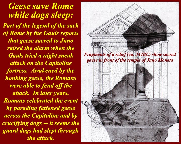
www.mmdtkw.org/AU0308gBrennerPass.jpg
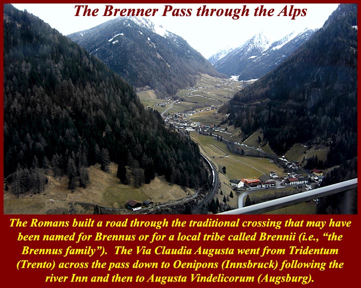
www.mmdtkw.org/AU0308gBrennusFrenchMaritimeSculpture.jpg
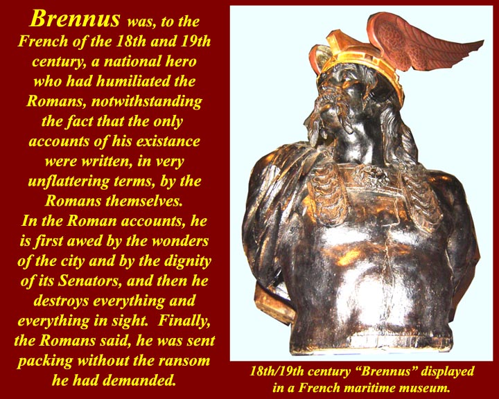
While Brennus I was evil personified to the Romans, he was a hero to transalpine people.
en.wikipedia.org/wiki/Battle_of_the_Allia
"Other Greek and Roman synchronisms have a more obvious historical symbolism, as may be the casewith the Polybian synchronism we saw above, between Dionysius’s siege of
Rhegium and the Gallic sack of Rome."
wxy.seu.edu.cn/humanities/sociology/htmledit/uploadfile/s...
www.unrv.com/empire/gallic-sack-of-rome.php
REFOUNDING THE CITY:
ENNIUS, LIVY, AND VIRGIL
The city of Rome has now been successfully founded in historical time—whether
that time is focalized as Greek or Roman—but we have not yet reached the end of
the story. As everyone knows, the city of Rome kept having to be re-founded, and
the patterns of refoundation drastically reconfigure the trajectory of movement
from myth to history that we have been following so far.188
Ennius’s most explicit surviving allusion to the date of the foundation of the city
in fact comes at the moment when the city had just been virtually destroyed, and
was on the verge of vanishing from history, after the sack by the Gauls in 387/6
b.c.e.189 The context is a speech in which Camillus persuades the Senate not to
move to Veii, but to refound the city instead (154–55 Skutsch):
Septingenti sunt paulo plus aut minus anni
augusto augurio postquam incluta condita Roma est.
It is seven hundred years, a little more or a little less,
since famous Rome was founded by august augury.
How this seven-hundred-year period between Romulus’s foundation and the sack
of Rome by the Gauls actually worked remains a mystery, at least to me.190 Still, we
should not overlook the symbolic significance of this number in its own right. The
importance of the seven-hundred-year period has been very well illustrated in the
fascinating book Die rhetorische Zahl, written by a scholar with the gloriously apt
name of Dreizehnter.191 Dreizehnter does not mention this passage of Ennius, but
he collects a great deal of interesting material about seven hundred years as the life
span of a city or an empire from foundation to extinction, or from foundation to
virtual extinction or only just-escaped extinction. In various traditions that he
examines there were seven hundred years from the foundation to the destruction
of Melos, Carthage, and Macedonia, or from the foundation to the virtual extinc-
(Myth into History I: Foundations of the city)
tion of Sparta.192 What we see in the Ennius passage, in other words, is that the city
was virtually destroyed and came within an ace of fulfilling the seven-hundred year
doom. The point will have been accentuated by Ennius’s book divisions.
Camillus’s speech comes at the end of book 4, and the regal period ended with
book 3, so that up to this point in the Annales we have had only one self-contained
volume of Republican history, and if things had gone differently that might have
been all we had.193
Livy activates the power of this Ennian symbolic numeral, even as he corrects
Ennius’s dating, with his allusion to the seven hundred years of Rome (Pref. 4):
Res est praeterea et immensi operis, ut quae supra septingentesimum annum
repetatur et quae ab exiguis profecta initiis eo creuerit ut iam magnitudine
laboret sua.
In addition, the matter is of immeasurable scope, in that it must be taken back
past the seven hundredth year, and having started from small beginnings has
grown to the stage that it is now laboring under its own size.194
Chaplin has argued that Livy’s preface is constructing recent Roman history as a
death, with a possible rebirth to come:195 the Republic has been destroyed, and the
Romans of Livy’s time are like the Romans of Camillus’s time, faced with the task
of refounding the city after it has only just escaped its seven-hundred-year doom.
In Livy’s treatment of the Roman response to the sack of the city by the Gauls,
we can see him returning to the Ennian theme of rebirth from destruction,
although this time using different significant numbers. Having exploited the numinous
associations of Ennius’s seven hundred years in his preface, Livy now produces
another numinous numeral for the span from foundation to sack, one that
conforms with the modern orthodox chronology. Livy has Camillus deliver a
mighty speech to convince his fellow citizens not to abandon Rome for the site of
Veii (5.51–54).196When Livy’s Camillus echoes Ennius’s by counting off the years
since the foundation, it appears that some kind of great year has gone by. From
Romulus’s foundation down to the sack by the Gauls there have been as many
years as there are days in a year: Trecentensimus sexagensimus quintus annus urbis,
Quirites, agitur (“This is the 365th year of the city, Quirites,” 5.54.5). This is of
course a calculation that fully resonates only after Caesar’s reform of the calendar,
when a Roman year for the first time had 365 days.This counting places
Camillus’s refounding of the city at a pivotal point in time, precisely halfway
(Refounding the City: Ennius, Livy, Virgil . 101)
between the first founding of the city, in 753, and the refounding that faces Livy
and his contemporaries 365 years after Camillus, in the 20s b.c.e.198 Exactly the
same structuring appears to underpin the panorama of Roman history on Virgil’s
Shield of Aeneas, where the barely averted destruction of Rome by the Gauls (Aen.
8.652–62) comes midway in time between the foundation of the city (8.635) and
the barely averted destruction of Rome by Antonius and Cleopatra (8.671–713).199
In all of these authors, city destruction, whether achieved or barely averted,
leads to refoundation and consequent reconfiguring of identity, in a process that
begins with Troy and continues through the fates of Alba Longa, Veii, and Rome
itself.200 As Kraus has shown, when Livy begins his next book after the Gallic sack,
he refounds his narrative along with the city, capitalizing on the annalistic tradition’s
identification of the city and history.201 In an extraordinary moment, the
opening sentences of book 6 tell us that only now is real history beginning. All of
the material in the first five books, Livy now declares, has been “obscure because
of its excessive antiquity” (uetustate nimia obscuras), and because there were few
written records in those early days, while the ones that did exist “for the most part
were destroyed when the city was burnt” (incensa urbe pleraeque interiere, 6.1.2).
Everything up until this point, from Troy to the Gallic sack, is suddenly reconfigured
as prior, prefoundational. In his preface Livy had drawn a line between myth
and history around the time of the Romulean foundation of the city (ante conditam
condendamue urbem, 6), but “the fresh start in 390 redraws the limits of the historically
verifiable.”202We now have a new entry into history, with a newly rebuilt city
and a newly solid evidential base for its written commemoration (6.1.3):
Clariora deinceps certioraque ab secunda origine uelut ab stirpibus laetius
feraciusque renatae urbis gesta domi militiaeque exponentur.
From here there will be a more clear and definite exposition of the domestic
and military history of the city, reborn from a second origin, as if from the
old roots, with a more fertile and fruitful growth.203
Livy here is picking up on the annalistic history of Claudius Quadrigarius, who
had written about fifty years earlier. We know that Claudius began his history with
the sack of Rome by the Gauls, no doubt on the grounds we see alluded to in Livy,
that no history was possible before then, thanks to the destruction of monuments
and archives.204
We have already seen how the Roman tradition picks up demarcations that are
102 . Myth into History I: Foundations of the City
crucial from the Greek tradition—Troy and the first Olympiad—and recasts
them as transitions into a new, Roman, phase of history. The Gallic sack is a vital
addition to this series of watersheds. The first key fixed synchronistic point in
Timaeus and Polybius that makes it possible for Roman history to be properly connected
with Greek history, the Gallic sack is itself made to serve as the “beginning
of history” in Claudius Quadrigarius and Livy book 6.205 The very event that almost
expunged Rome altogether is the one that put the city on the world stage—
just as the destruction of Troy led to the city’s existence in the first place.206
Ovid intuited the power of these associated watersheds of foundation and Gallic
sack, and his subtle deployment of them in the Metamorphoses is proof of their
understood significance. Before he arrives at the foundation of Rome in book 14,
he has a very small number of proleptic references to the as yet nonexistent city.
Book 1 contains two forward references to his own day, with the poem’s first simile
referring to the reign of Augustus (1.199–205), and the story of Apollo and
Daphne likewise anticipating the reign of Augustus, as Apollo prophesies the use
of his sacred laurel to grace Roman triumphs and adorn Augustus’s house (1.560–
63). His only other proleptic references to the city before the foundation in book
14 occur in book 2, and they are both references to the city only just escaping total
catastrophe, catastrophes that would have ensured the city was never part of world
history. One is in a cosmic setting, when the natural site of the city is almost
expunged, as the Tiber is dried up along with other rivers by Phaethon’s chariot
(2.254–59); the other is an allusion to the geese that “were to save the Capitol with
their wakeful cry” (seruaturis uigili Capitolia uoce/ . . . anseribus, 2.538–39).207
Again, in the Fasti, when the gods meet in council to deliberate how to save Rome
from the Gauls, Ovid takes as his template the Ennian council that deliberated over
the foundation of the city: in both cases, Mars expostulates with his father, Jupiter,
and is assured that all will be well.208
It is highly significant that these two events, the city’s foundation and near
destruction by the Gauls, are the only “historical” events commemorated on the
Republican calendar, the Fasti Antiates.209 Calendrical fasti from the Principate
mention all kinds of events, but the Fasti Antiates, the only calendar we have surviving
from the Republic, mark only two historical events: 21 April, the Parilia and
the foundation of the city, and 18 July, the dies Alliensis, the day of the battle of the
Allia, when the Roman army was scattered by the advancing Gauls on their way
to the city, which they entered on the next day.210
The foundation of the city and its near extinction by the Gauls are symbolically
joined events, linked by significant numbers, either 700 or 365, linked by themes of
Refounding the City: Ennius, Livy, Virgil . 103
refoundation and rebirth. The history of the city keeps getting restarted at such
crucial transition moments, when repetitive patterns of quasi-cyclical destruction
and refoundation replay themselves, in a fascinating interplay between a drive for
onward narrative continuity and the threat of eddying, repetitious, circularity.211 It
is poignant to observe the power of this theme still persisting in the fifth century
c.e., when Rutilius Namatianus, six years after the sack of Rome by the Visigoths
in 410 c.e., can hail Rome’s potential to bounce back from disaster, citing its eventual
defeat of Brennus, who led the Gauls to the sack of Rome, and of the Samnites,
Pyrrhus, and Hannibal:212 “You, Rome, are built up,” he claims, “by the very thing
that undoes other powers: the pattern of your rebirth is the ability to grow from
your calamities” (illud te reparat quod cetera regna resoluit:/ordo renascendi est
crescere posse malis, 139–40). Each of these key marker moments in time may become
a new opportunity for the community to reimagine itself, as the epochal moment
produces a new beginning point from which the community may imagine its
progress forward into time, measured against its backward extension into time.213
_______________________________ __________________________
The Gauls in the Italia peninsula .Clusium was reached by the Gauls, who had invaded most of Etruria already, and its people turned to Rome for help. However, the Roman embassy provoked a skirmish and, then, the Gauls marched straight for Rome (July, 387 BC). After the entire Roman army was defeated at the Allia brook (Battle of the Allia), the defenseless Rome was seized by the invaders. The entire Roman army retreated into the deserted Veii whereas most civilians ended at the Etruscan Caere. Nonetheless, a surrounded Roman garrison continued to resist on the Capitoline Hill. The Gauls dwelt within the city, getting their supplies by destroying all nearby towns for plunder.When the Gauls went for Ardea, the exiled Camillus, who was now a private man, organized the local forces for a defense. Particularly, he harangued that, always, the Gauls exterminated their defeated enemies. Camillus found that the Gauls were too distracted, celebrating their latest spoils with much 'crapulence' at their camp. Then, he attacked during a night, defeating the enemy easily with great bloodshed.He is thus considered the second founder of Rome.Camillus was hailed then by all other Roman exiles throughout the region. After he refused a makeshift generalship, a Roman messenger sneaked into the Capitol and, therein, Camillus was officially appointed dictator by the Roman Senators, to confront the Gauls.At the Roman base of Veii, Camillus gathered a 12,000-man army whereas more men joined out of the region. The occupying Gauls were in serious need, under quite poor health conditions. As the Roman Dictator, Camillus negotiated with the Gallic leader Brennus, and the Gauls left Rome, camping nearby at the Gabinian road. A day after this, Camillus confronted them with his refreshed army and the Gauls were forced to withdraw, after seven months of occupation (386 BC).
Camillus sacrificed for the successful return and he ordered the construction of the temple of Aius Locutius. Then, he subdued another claim of the plebeian orators, who importuned further about moving to Veii. After ordering a Senate debate, Camillus argued for staying and the Roman house approved this unanimously. The reconstruction extended for an entire year.
By this one-year office, Camillus was the longest of all Roman dictators. Basically, the Senators had been persuaded by the disturbing social clashes, which could be better managed by Camillus. Instead, Camillus disliked this and, vainly, he requested the dismissal.
Roman dictator (367 BC)
As the Gauls were, again, marching toward Latium, all Romans reunited despite their severe differences. Camillus was named Roman dictator for the fifth time then (367 BC). He organized the defense of Rome actively. By the commands of Camillus, the Roman soldiers were protected particularly against the Gallic main attack, the heavy blow of their swords. Both smooth iron helmets and brass rimed shields were built. Also, long pikes were used, to keep the enemy's swords far.
The Gauls camped at the Anio river, carrying loads of recently gotten plunder. Near them, at the Alban Hills, Camillus discovered their disorganization, which was due to unruly celebrations. Before the dawn, then, the light infantry disarrayed the Gallic defenses and, subsequently, the heavy infantry and the pikemen of the Romans finished their enemy. After the battle, Velitrae surrendered voluntarily to Rome. Back in Rome, Camillus celebrated with another Triumph.
ancientimes.blogspot.co.nz/2007/06/brennus-and-first-sack...
A deadly pestilence struck Rome and it affected most Roman public figures. Camillus was amongst them, passing away in 365 BC.
Source: Plutarch, The Parallel Lives - The Life of Camillus:
In popular culture
Marcus Furius Camillus was played by Massimo Serato in the 1963 film 'Brennus, Enemy of Rome'.
www.flickr.com/photos/ggnyc/1405297848/
BC 400's Celts from the Alps flowed into Italy ....
Herodotus of Halicarnassus reported a merchant from Samos named Colacus was driven off course by tides and winds when trading off the African shore. He landed at the Tartessus (modern River Guadalquivir in southern Spain) where he found tribes of Keltoi working the silver mines
396 BC Celts defeated the Etruscans at Melpum (Melzo, west of Milan)
390 Senones Celts ('the veterans') led by Brennos (Latinate: Brennus) defeated the Romans in Rome (July 19) so badly it took the Romans 200 years to recover from the 'terror Gallicus'. After seven months and a ransom of 100 pounds of gold, the Celts moved along to Picenum on Italy's eastern seaboard.
Ephoros of Cyme reported the Celts occupied an area the size of the Indian sub-continent.
334-335 Alexander of Macedonia met the Celts on the Danube banks to make an agreement: The Celts would not attack his empire while he was off conquering in the east. Only after his death they expanded to Moravia and Thrace .
----------- ----------
Along with Bolgios, Brennos II was the legendary leader of other Celts on their invasion of Macedonia in the second century BCE. Though Bolgios led the invasion of Macedonia , Brennus succeeded in crossing his whole army over the river Sperchios into Greece proper, where he laid seige to the town of Heraclea and, having driven out the garrison there, marched on to Thermopylae where he defeated an army raised by a confederation of Greek cities. Brennus then avanced across Greece, where he decided to go on to Delphi, which was reported as the treasure house of Greece. Brennus and his army of 30,000 set off to attack the temple of Apollo, the ultimate goal of his expedition. Here it is said that Brennos was defeated by earthquakes and thunderbolts that reduced the soldiers to ashes; snow storms, showers of great stones, and "ancient heroes appearing from the heavens". In the midst of this snowstorm, Brennos and his men were attacked near the Parnassus mountains. The Celts were soundly defeated and Brennos was mortally wounded. As he lay dying, he gave the order for all of the wounded to be killed, and all the booty to be burned, as the army would never make it home if they had to carry the wounded warriors and their plunder. After giving the order, Brennos drank some wine and then took his own life. (? Source)
www.maryjones.us/ctexts/classical_pausianas.html
The Description of Greece
Pausanias (fl. 2nd c. CE) XIX.
[5] "I have made some mention of the Gallic invasion of Greece in my description of the Athenian Council Chamber. But I have resolved to give a more detailed account of the Gauls in my description of Delphi, because the greatest of the Greek exploits against the barbarians took place there. The Celts conducted their first foreign expedition under the leadership of Cambaules. Advancing as far as Thrace they lost heart and broke off their march, realizing that they were too few in number to be a match for the Greeks. "...........
10]" When the Gallic horsemen were engaged, the servants remained behind the ranks and proved useful in the following way. Should a horseman or his horse fall, the slave brought him a horse to mount; if the rider was killed, the slave mounted the horse in his master's place; if both rider and horse were killed, there was a mounted man ready. When a rider was wounded, one slave brought back to camp the wounded man, while the other took his vacant place in the ranks.
[11] I believe that the Gauls in adopting these methods copied the Persian regiment of the Ten Thousand, who were called the Immortals. There was, however, this difference. The Persians used to wait until the battle was over before replacing casualties, while the Gauls kept reinforcing the horsemen to their full number during the height of the action. This organization is called in their native speech trimarcisia, for I would have you know that marca3 is the Celtic name for a horse. "
(Addit :we know from Celtic myth this was indigenous to the confederacy of Celtic tribes as on Gundestrup Cauldron ,warrior plate)
[12] "This was the size of the army, and such was the intention of Brennos, when he attacked Greece. The spirit of the Greeks was utterly broken, but the extremity of their terror forced them to defend Greece. They realized that the struggle that faced them would not be one for liberty, as it was when they fought the Persian, and that giving water and earth would not bring them safety. They still remembered the fate of Macedonia, Thrace and Paeonia during the former incursion of the Gauls, and reports were coming in of enormities committed at that very time on the Thessalians. So every man, as well as every state, was convinced that they must either conquer or perish. "
Attalus I (Greek: Ἄτταλος), surnamed Soter (Greek: Σωτὴρ, "Savior"; 269 BC – 197 BC) ruled Pergamon, an Ionian Greek polis (what is now Bergama, Turkey), first as dynast, later as king, from 241 BC to 197 BC. He was the second cousin and the adoptive son of Eumenes I, whom he succeeded, and was the first of the Attalid dynasty to assume the title of king in 238 BC.He was the son of Attalus and his wife Antiochis.
Attalus won an important victory over the Galatians, newly arrived Celtic tribes from Thrace, who had been, for more than a generation, plundering and exacting tribute throughout most of Asia Minor without any serious check. This victory, celebrated by the triumphal monument at Pergamon, famous for its 'Dying Galatian' or 'Gaul' statue , and the liberation from the Gallic "terror" which it represented, earned for Attalus the name of "Soter", and the title of "king". A courageous and capable general and loyal ally of Rome, he played a significant role in the first and second Macedonian Wars, waged against Philip V of Macedon.
Etymologically Brennos is related to Brân and is related to the reconstructed proto-Celtic lexical elements *brano- (raven) -n- (the deicific particle) and os (the masculine ending). Thus Brennos is literally the 'Raven God'. However, the bren part of the name is also the root for one Cymric word for king brenhin and Brennos can be rendered as 'Raven King'. Which also leads to the supposition that 'Brennos', rather than being a proper name is actually an honorific denoting 'battle lord'. Raven gods being tribal leaders in the time of war so a Celtic war leader would take-on the name of such a deity. Indeed, the modern Cymric for king is brenin a word derived from 'Brennos'.
An actual late Iron Age helmet like this has been located in ancient Dacia , Translyvania , now modern Roumania/ Romania the Helmet of Ciumeşti.
www.flickr.com/photos/42003310@N05/4886860352/
As one of the styles depicted on the Celtic Gundestrup Cauldron.
Wilcox and McBride mentioned that their illustration of the iron Gallic warrior's helmet of the middle La Tene period had been reconstructed the on the basis of the Ciumesti helmet.[45]
The Moscow Metro is a metro system serving the Russian capital of Moscow as well as the neighbouring cities of Krasnogorsk, Reutov, Lyubertsy and Kotelniki in Moscow Oblast. Opened in 1935 with one 11-kilometre (6.8 mi) line and 13 stations, it was the first underground railway system in the Soviet Union.
As of 2023, the Moscow Metro, excluding the Moscow Central Circle, the Moscow Central Diameters and the Moscow Monorail, had 294 stations and 514.5 km (319.7 mi) of route length, excluding light rail Monorail, making it the 8th-longest in the world and the longest outside China. It is the third metro system in the world (after Madrid and Beijing), which has two ring lines. The system is mostly underground, with the deepest section 84 metres (276 ft) underground at the Park Pobedy station, one of the world's deepest underground stations. It is the busiest metro system in Europe, the busiest in the world outside Asia, and is considered a tourist attraction in itself.
The Moscow Metro is a world leader in the frequency of train traffic—intervals during peak hours do not exceed 90 seconds. In February 2023, Moscow was the first in the world to reduce the intervals of metro trains to 80 seconds.
Name
The full legal name of the metro has been "Moscow Order of Lenin and Order of the Red Banner of Labor V.I. Lenin Metro" (Московский ордена Ленина и ордена Трудового Красного Знамени метрополитен имени В.И. Ленина) since 1955. This is usually shortened to V.I. Lenin Metro (Метрополитен им. В.И. Ленина). This shorter official name appears on many stations. Although there were proposals to remove Lenin from the official name, it still stands. During the 1990s and 2000s, Lenin's name was excluded from the signage on newly built and reconstructed stations. In 2016, the authorities promised to return the official name of the metro to all the stations' signage.
The first official name of the metro was L. M. Kaganovich Metro (Метрополитен им. Л.М. Кагановича) after Lazar Kaganovich. (see History section). However, when the Metro was awarded the Order of Lenin, it was officially renamed "Moscow Order of Lenin L. M. Kaganovich Metro" (Московский ордена Ленина Метрополитен им. Л. М. Кагановича) in 1947. And when the metro was renamed in 1955, Kaganovich was "given a consolation prize" by renaming the Okhotny Ryad station to "Imeni Kaganovicha". Yet in a matter of only two years, the original Okhotny Ryad name of the station was reinstated.
Logo
The first line of the Moscow Metro was launched in 1935, complete with the first logo, the capital M paired with the text "МЕТРО". There is no accurate information about the author of the logo, so it is often attributed to the architects of the first stations – Samuil Kravets, Ivan Taranov and Nadezhda Bykova. At the opening in 1935, the M letter on the logo had no definite shape.
Today, with at least ten different variations of the shape in use, Moscow Metro still does not have clear brand or logo guidelines. An attempt was made in October 2013 to launch a nationwide brand image competition, only to be closed several hours after its announcement. A similar contest, held independently later that year by the design crowdsourcing company DesignContest, yielded better results, though none were officially accepted by the Metro officials.
Operations
The Moscow Metro, a state-owned enterprise, is 449 km (279 mi) long and consists of 15 lines and 263 stations organized in a spoke-hub distribution paradigm, with the majority of rail lines running radially from the centre of Moscow to the outlying areas. The Koltsevaya Line (line 5) forms a 20-kilometre (12 mi) long circle which enables passenger travel between these diameters, and the new Moscow Central Circle (line 14) and even newer Bolshaya Koltsevaya line (line 11) form a 54-kilometre (34 mi) and 57-kilometre (35 mi) long circles respectively that serve a similar purpose on middle periphery. Most stations and lines are underground, but some lines have at-grade and elevated sections; the Filyovskaya Line, Butovskaya Line and the Central Circle Line are the three lines that are at grade or mostly at grade.
The Moscow Metro uses 1,520 mm (4 ft 11+27⁄32 in) Russian gauge, like other Russian railways, and an underrunning third rail with a supply of 825 Volts DC, except lines 13 and 14, the former being a monorail, and the latter being directly connected to the mainlines with 3000V DC overhead lines, as is typical. The average distance between stations is 1.7 kilometres (1.1 mi); the shortest (502 metres (1,647 ft) long) section is between Vystavochnaya and Mezhdunarodnaya, and the longest (6.62 kilometres (4.11 mi) long) is between Krylatskoye and Strogino. Long distances between stations have the positive effect of a high cruising speed of 41.7 kilometres per hour (25.9 mph).
The Moscow Metro opens at 05:25 and closes at 01:00. The exact opening time varies at different stations according to the arrival of the first train, but all stations simultaneously close their entrances at 01:00 for maintenance, and so do transfer corridors. The minimum interval between trains is 90 seconds during the morning and evening rush hours.
As of 2017, the system had an average daily ridership of 6.99 million passengers. Peak daily ridership of 9.71 million was recorded on 26 December 2014.
Free Wi-Fi has been available on all lines of the Moscow Metro since 2 December 2014.
Lines
A Moscow Metro train passes through Sokolnicheskaya and Koltsevaya lines. View from the driver's cabin
Each line is identified by a name, an alphanumeric index (usually consisting of just a number, and sometimes a letter suffix), and a colour. The colour assigned to each line for display on maps and signs is its colloquial identifier, except for the nondescript greens and blues assigned to the Bolshaya Koltsevaya, the Zamoskvoretskaya, the Lyublinsko-Dmitrovskaya, and Butovskaya lines (lines, 11, 2, 10, and 12, respectively).[citation needed] The upcoming station is announced by a male voice on inbound trains to the city center (on the Circle line, the clockwise trains), and by a female voice on outbound trains (anti-clockwise trains on the Circle line).
The metro has a connection to the Moscow Monorail, a 4.7-kilometre (2.9 mi), six-station monorail line between Timiryazevskaya and VDNKh which opened in January 2008. Prior to the official opening, the monorail had operated in "excursion mode" since 2004.
Also, from 11 August 1969 to 26 October 2019, the Moscow Metro included Kakhovskaya line 3.3 km long with 3 stations, which closed for a long reconstruction. On 7 December 2021, Kakhovskaya is reopened after reconstruction as part of the Bolshaya Koltsevaya line. The renewed Varshavskaya and Kashirskaya stations reopened as part of the Bolshaya Koltsevaya line, which became fully functional on 1 March 2023. Its new stations included Pechatniki, Nagatinsky Zaton and Klenovy Bulvar.
Renamed lines
Sokolnicheskaya line was previously named Kirovsko-Fruzenskaya
Zamoskvoretskaya line was previously named Gorkovsko-Zamoskvoretskaya.
Filyovskaya line was previously named Arbatsko-Filyovskaya.
Tagansko-Krasnopresnenskaya line was previously named Zhdanovsko-Krasnopresnenskaya
History
The first plans for a metro system in Moscow date back to the Russian Empire but were postponed by World War I, the October Revolution and the Russian Civil War. In 1923, the Moscow City Council formed the Underground Railway Design Office at the Moscow Board of Urban Railways. It carried out preliminary studies, and by 1928 had developed a project for the first route from Sokolniki to the city centre. At the same time, an offer was made to the German company Siemens Bauunion to submit its own project for the same route. In June 1931, the decision to begin construction of the Moscow Metro was made by the Central Committee of the Communist Party of the Soviet Union. In January 1932 the plan for the first lines was approved, and on 21 March 1933 the Soviet government approved a plan for 10 lines with a total route length of 80 km (50 mi).
The first lines were built using the Moscow general plan designed by Lazar Kaganovich, along with his project managers (notably Ivan M. Kuznetsov and, later, Isaac Y. Segal) in the 1930s–1950s, and the Metro was named after him until 1955 (Metropoliten im. L.M. Kaganovicha). The Moscow Metro construction engineers consulted with their counterparts from the London Underground, the world's oldest metro system, in 1936: British architect Charles Holden and administrator Frank Pick had been working on the station developments of the Piccadilly Line extension, and Soviet delegates to London were impressed by Holden's thoroughly modern redeployment of classical elements and use of high-quality materials for the circular ticket hall of Piccadilly Circus, and so engaged Pick and Holden as advisors to Moscow's metro system. Partly because of this connection, the design of Gants Hill tube station, which was completed in 1947, is reminiscent of a Moscow Metro station. Indeed, Holden's homage to Moscow has been described as a gesture of gratitude for the USSR's helpful role in The Second World War.
Soviet workers did the labour and the art work, but the main engineering designs, routes, and construction plans were handled by specialists recruited from London Underground. The British called for tunnelling instead of the "cut-and-cover" technique, the use of escalators instead of lifts, the routes and the design of the rolling stock. The paranoia of the NKVD was evident when the secret police arrested numerous British engineers for espionage because they gained an in-depth knowledge of the city's physical layout. Engineers for the Metropolitan-Vickers Electrical Company (Metrovick) were given a show trial and deported in 1933, ending the role of British business in the USSR.
First four stages of construction
The first line was opened to the public on 15 May 1935 at 07:00 am. It was 11 kilometres (6.8 mi) long and included 13 stations. The day was celebrated as a technological and ideological victory for socialism (and, by extension, Stalinism). An estimated 285,000 people rode the Metro at its debut, and its design was greeted with pride; street celebrations included parades, plays and concerts. The Bolshoi Theatre presented a choral performance by 2,200 Metro workers; 55,000 colored posters (lauding the Metro as the busiest and fastest in the world) and 25,000 copies of "Songs of the Joyous Metro Conquerors" were distributed. The Moscow Metro averaged 47 km/h (29 mph) and had a top speed of 80 km/h (50 mph). In comparison, New York City Subway trains averaged a slower 25 miles per hour (40 km/h) and had a top speed of 45 miles per hour (72 km/h). While the celebration was an expression of popular joy it was also an effective propaganda display, legitimizing the Metro and declaring it a success.
The initial line connected Sokolniki to Okhotny Ryad then branching to Park Kultury and Smolenskaya. The latter branch was extended westwards to a new station (Kiyevskaya) in March 1937, the first Metro line crossing the Moskva River over the Smolensky Metro Bridge.
The second stage was completed before the war. In March 1938, the Arbatskaya branch was split and extended to the Kurskaya station (now the dark-blue Arbatsko-Pokrovskaya Line). In September 1938, the Gorkovskaya Line opened between Sokol and Teatralnaya. Here the architecture was based on that of the most popular stations in existence (Krasniye Vorota, Okhotnyi Ryad and Kropotkinskaya); while following the popular art-deco style, it was merged with socialist themes. The first deep-level column station Mayakovskaya was built at the same time.
Building work on the third stage was delayed (but not interrupted) during World War II, and two Metro sections were put into service; Teatralnaya–Avtozavodskaya (three stations, crossing the Moskva River through a deep tunnel) and Kurskaya–Partizanskaya (four stations) were inaugurated in 1943 and 1944 respectively. War motifs replaced socialist visions in the architectural design of these stations. During the Siege of Moscow in the fall and winter of 1941, Metro stations were used as air-raid shelters; the Council of Ministers moved its offices to the Mayakovskaya platforms, where Stalin made public speeches on several occasions. The Chistiye Prudy station was also walled off, and the headquarters of the Air Defence established there.
After the war ended in 1945, construction began on the fourth stage of the Metro, which included the Koltsevaya Line, a deep part of the Arbatsko-Pokrovskaya line from Ploshchad Revolyutsii to Kievskaya and a surface extension to Pervomaiskaya during the early 1950s. The decoration and design characteristic of the Moscow Metro is considered to have reached its zenith in these stations. The Koltsevaya Line was first planned as a line running under the Garden Ring, a wide avenue encircling the borders of Moscow's city centre. The first part of the line – from Park Kultury to Kurskaya (1950) – follows this avenue. Plans were later changed and the northern part of the ring line runs 1–1.5 kilometres (0.62–0.93 mi) outside the Sadovoye Koltso, thus providing service for seven (out of nine) rail terminals. The next part of the Koltsevaya Line opened in 1952 (Kurskaya–Belorusskaya), and in 1954 the ring line was completed.
Stalinist ideals in Metro's history
When the Metro opened in 1935, it immediately became the centrepiece of the transportation system (as opposed to horse-carried barrows still widely used in 1930s Moscow). It also became the prototype, the vision for future Soviet large-scale technologies. The artwork of the 13 original stations became nationally and internationally famous. For example, the Sverdlov Square subway station featured porcelain bas-reliefs depicting the daily life of the Soviet peoples, and the bas-reliefs at the Dynamo Stadium sports complex glorified sports and physical prowess on the powerful new "Homo Sovieticus" (Soviet man). The metro was touted as the symbol of the new social order – a sort of Communist cathedral of engineering modernity.
The Metro was also iconic for showcasing Socialist Realism in public art. The method was influenced by Nikolay Chernyshevsky, Lenin's favorite 19th-century nihilist, who stated that "art is no useful unless it serves politics". This maxim sums up the reasons why the stations combined aesthetics, technology and ideology: any plan which did not incorporate all three areas cohesively was rejected.
Kaganovich was in charge; he designed the subway so that citizens would absorb the values and ethos of Stalinist civilization as they rode. Without this cohesion, the Metro would not reflect Socialist Realism. If the Metro did not utilize Socialist Realism, it would fail to illustrate Stalinist values and transform Soviet citizens into socialists. Anything less than Socialist Realism's grand artistic complexity would fail to inspire a long-lasting, nationalistic attachment to Stalin's new society.
Socialist Realism was in fact a method, not exactly a style.[31]
Bright future and literal brightness in the Metro of Moscow
The Moscow Metro was one of the USSR's most ambitious architectural projects. The metro's artists and architects worked to design a structure that embodied svet (literally "light", figuratively "radiance" or "brilliance") and svetloe budushchee (a well-lit/radiant/bright future). With their reflective marble walls, high ceilings and grand chandeliers, many Moscow Metro stations have been likened to an "artificial underground sun".
This palatial underground environment reminded Metro users their taxes were spent on materializing bright future; also, the design was useful for demonstrating the extra structural strength of the underground works (as in Metro doubling as bunkers, bomb shelters).
The chief lighting engineer was Abram Damsky, a graduate of the Higher State Art-Technical Institute in Moscow. By 1930 he was a chief designer in Moscow's Elektrosvet Factory, and during World War II was sent to the Metrostroi (Metro Construction) Factory as head of the lighting shop.[33] Damsky recognized the importance of efficiency, as well as the potential for light as an expressive form. His team experimented with different materials (most often cast bronze, aluminum, sheet brass, steel, and milk glass) and methods to optimize the technology. Damsky's discourse on "Lamps and Architecture 1930–1950" describes in detail the epic chandeliers installed in the Taganskaya Station and the Kaluzhskaia station (Oktyabrskaya nowadays, not to be confused with contemporary "Kaluzhskaya" station on line 6). The work of Abram Damsky further publicized these ideas hoping people would associate the party with the idea of bright future.
The Kaluzhskaya Station was designed by the architect [Leonid] Poliakov. Poliakov's decision to base his design on a reinterpretation of Russian classical architecture clearly influenced the concept of the lamps, some of which I planned in collaboration with the architect himself. The shape of the lamps was a torch – the torch of victory, as Polyakov put it... The artistic quality and stylistic unity of all the lamps throughout the station's interior made them perhaps the most successful element of the architectural composition. All were made of cast aluminum decorated in a black and gold anodized coating, a technique which the Metrostroi factory had only just mastered.
The Taganskaia Metro Station on the Ring Line was designed in...quite another style by the architects K.S. Ryzhkov and A. Medvedev... Their subject matter dealt with images of war and victory...The overall effect was one of ceremony ... In the platform halls the blue ceramic bodies of the chandeliers played a more modest role, but still emphasised the overall expressiveness of the lamp.
— Abram Damsky, Lamps and Architecture 1930–1950
Industrialization
Stalin's first five-year plan (1928–1932) facilitated rapid industrialization to build a socialist motherland. The plan was ambitious, seeking to reorient an agrarian society towards industrialism. It was Stalin's fanatical energy, large-scale planning, and resource distribution that kept up the pace of industrialization. The first five-year plan was instrumental in the completion of the Moscow Metro; without industrialization, the Soviet Union would not have had the raw materials necessary for the project. For example, steel was a main component of many subway stations. Before industrialization, it would have been impossible for the Soviet Union to produce enough steel to incorporate it into the metro's design; in addition, a steel shortage would have limited the size of the subway system and its technological advancement.
The Moscow Metro furthered the construction of a socialist Soviet Union because the project accorded with Stalin's second five-year plan. The Second Plan focused on urbanization and the development of social services. The Moscow Metro was necessary to cope with the influx of peasants who migrated to the city during the 1930s; Moscow's population had grown from 2.16 million in 1928 to 3.6 million in 1933. The Metro also bolstered Moscow's shaky infrastructure and its communal services, which hitherto were nearly nonexistent.
Mobilization
The Communist Party had the power to mobilize; because the party was a single source of control, it could focus its resources. The most notable example of mobilization in the Soviet Union occurred during World War II. The country also mobilized in order to complete the Moscow Metro with unprecedented speed. One of the main motivation factors of the mobilization was to overtake the West and prove that a socialist metro could surpass capitalist designs. It was especially important to the Soviet Union that socialism succeed industrially, technologically, and artistically in the 1930s, since capitalism was at a low ebb during the Great Depression.
The person in charge of Metro mobilization was Lazar Kaganovich. A prominent Party member, he assumed control of the project as chief overseer. Kaganovich was nicknamed the "Iron Commissar"; he shared Stalin's fanatical energy, dramatic oratory flare, and ability to keep workers building quickly with threats and punishment. He was determined to realise the Moscow Metro, regardless of cost. Without Kaganovich's managerial ability, the Moscow Metro might have met the same fate as the Palace of the Soviets: failure.
This was a comprehensive mobilization; the project drew resources and workers from the entire Soviet Union. In his article, archeologist Mike O'Mahoney describes the scope of the Metro mobilization:
A specialist workforce had been drawn from many different regions, including miners from the Ukrainian and Siberian coalfields and construction workers from the iron and steel mills of Magnitogorsk, the Dniepr hydroelectric power station, and the Turkestan-Siberian railway... materials used in the construction of the metro included iron from Siberian Kuznetsk, timber from northern Russia, cement from the Volga region and the northern Caucasus, bitumen from Baku, and marble and granite from quarries in Karelia, the Crimea, the Caucasus, the Urals, and the Soviet Far East
— Mike O'Mahoney, Archeological Fantasies: Constructing History on the Moscow Metro
Skilled engineers were scarce, and unskilled workers were instrumental to the realization of the metro. The Metrostroi (the organization responsible for the Metro's construction) conducted massive recruitment campaigns. It printed 15,000 copies of Udarnik metrostroia (Metrostroi Shock Worker, its daily newspaper) and 700 other newsletters (some in different languages) to attract unskilled laborers. Kaganovich was closely involved in the recruitment campaign, targeting the Komsomol generation because of its strength and youth.
Later Soviet stations
"Fifth stage" set of stations
The beginning of the Cold War led to the construction of a deep section of the Arbatsko-Pokrovskaya Line. The stations on this line were planned as shelters in the event of nuclear war. After finishing the line in 1953 the upper tracks between Ploshchad Revolyutsii and Kiyevskaya were closed, and later reopened in 1958 as a part of the Filyovskaya Line. The stations, too, were supplied with tight gates and life-sustenance systems to function as proper nuclear shelters.
In the further development of the Metro the term "stages" was not used any more, although sometimes the stations opened in 1957–1959 are referred to as the "fifth stage".
During the late 1950s and throughout the 1960s, the architectural extravagance of new Metro stations was decisively rejected on the orders of Nikita Khrushchev. He had a preference for a utilitarian "minimalism"-like approach to design, similar to Brutalism style. The idea behind the rejection was similar to one used to create Khrushchyovkas: cheap yet easily mass-produced buildings. Stations of his era, as well as most 1970s stations, were simple in design and style, with walls covered with identical square ceramic tiles. Even decorations at the Metro stations almost finished at the time of the ban (such as VDNKh and Alexeyevskaya) got their final decors simplified: VDNKh's arcs/portals, for example, got plain green paint to contrast with well-detailed decorations and pannos around them.
A typical layout of the cheap shallow-dug metro station (which quickly became known as Sorokonozhka – "centipede", from early designs with 40 concrete columns in two rows) was developed for all new stations, and the stations were built to look almost identical, differing from each other only in colours of the marble and ceramic tiles. Most stations were built with simpler, cheap technology; this resulted in utilitarian design being flawed in some ways. Some stations such as adjacent Rechnoi Vokzal and Vodny Stadion or sequiential Leninsky Prospect, Akadmicheskaya, Profsoyuznaya and Novye Cheryomushki would have a similar look due to the extensive use of same-sized white or off-white ceramic tiles with hard-to-feel differences.
Walls with cheap ceramic tiles were susceptible to train-related vibration: some tiles would eventually fall off and break. It was not always possible to replace the missing tiles with the ones of the exact color and tone, which eventually led to variegated parts of the walls.
Metro stations of late USSR
The contrasting style gap between the powerfully decorated stations of Moscow's center and the spartan-looking stations of the 1960s was eventually filled. In the mid-1970s the architectural extravagance was partially restored. However, the newer design of shallow "centipede" stations (now with 26 columns, more widely spaced) continued to dominate. For example, Kaluzhskaya "centipede" station from 1974 (adjacent to Novye Cheryomushki station) features non-flat tiles (with 3D effect utilized), and Medvedkovo from 1978 features complex decorations.
1971 station Kitay-Gorod ("Ploshchad Nogina" at the time) features cross-platform interchange (Line 6 and line 7). Although built without "centipede" design or cheap ceramic tiles, the station utilizes near-grayscale selection of colors. It is to note the "southbound" and "northbound" halls of the station have identical look.
Babushkinskaya station from 1978 is a no-column station (similar to Biblioteka Imeni Lenina from 1935). 1983 Chertanovskaya station has resemblance to Kropotkinskaya (from 1935). Some stations, such as the deep-dug Shabolovskaya (1980), have the near-tunnel walls decorated with metal sheets, not tiles. Tyoply Stan features a theme related to the name and the location of the station ("Tyoply Stan" used to literally mean warm area): its walls are covered in brick-colored ribbed panes, which look like radiators).
Downtown area got such stations as Borovitskaya (1986), with uncovered red bricks and gray, concrete-like colors accompanying a single gold-plated decorative pane known as "Tree of peoples' of USSR" or additional station hall for Tretyakovskaya to house cross-platform interchange system between line 6 and line 8. To this day, Tretyakovskaya metro station consists of two contrasting halls: brutalism-like 1971 hall and custom design hall reminiscent of Tretyakovskaya Galereya from 1986.
Post-USSR stations of the modern Russian Federation
Metro stations of the 1990s and 2000s vary in style, but some of the stations seem to have their own themes:
Ulitsa Akademika Yangelya station used to feature thick orange neon lamp-like sodium lights instead of regular white lights.
Park Pobedy, the deepest station of the Moscow Metro, was built in 2003; it features extensive use of dark orange polished granite.
Slavyansky Bulvar station utilizes a plant-inspired theme (similar to "bionic style").
The sleek variant of aforementioned bionic style is somewhat represented in various Line 10 stations.
Sretensky Bulvar station of line 10 is decorated with paintings of nearby memorials and locations.
Strogino station has a theme of huge eye-shaped boundaries for lights; with "eyes" occupying the station's ceiling.
Troparyovo (2014) features trees made of polished metal. The trees hold the station's diamond-shaped lights. The station, however, is noticeably dim-lit.
Delovoy Tsentr (2016, MCC, overground station) has green tint.
Lomonosovsky Prospekt (Line 8A) is decorated with various equations.
Olkhovaya (2019) uses other plant-inspired themes (ольха noun means alder) with autumn/winter inspired colours.
Kosino (2019) uses high-tech style with the addition of thin LED lights.
Some bleak, bland-looking "centipedes" like Akademicheskaya and Yugo-Zapadnaya have undergone renovations in the 21st century (new blue-striped white walls on Akademicheskaya, aqualine glassy, shiny walls on Yugo-Zapadnaya).
Moscow Central Circle urban railway (Line 14)
A new circle metro line in Moscow was relatively quickly made in the 2010s. The Moscow Central Circle line (Line 14) was opened for use in September 2016 by re-purposing and upgrading the Maloe ZheleznoDorozhnoe Kol'tso. A proposal to convert that freight line into a metropolitan railway with frequent passenger service was announced in 2012. The original tracks had been built in pre-revolutionary Moscow decades before the creation of Moscow Metro; the tracks remained in place in one piece as a non-electrified line until the 21st century. Yet the circle route was never abandoned or cut. New track (along the existing one) was laid and all-new stations were built between 2014 and 2016. MCC's stations got such amenities as vending machines and free water closets.
Line 14 is operated by Russian Railways and uses full-sized trains (an idea, somewhat similar to S-Train). The extra resemblance to an S-Train line is, the 1908 line now connects modern northern residential districts to western and southern downtown area, with a station adjacent to Moscow International Business Center.
There is a noticeable relief of congestion, decrease in usage of formerly overcrowded Koltsevaya line since the introduction of MCC. To make line 14 attractive to frequent Koltsevaya line interchanges users, upgrades over regular comfort of Moscow Metro were made. Use of small laptops/portable video playing devices and food consumption from tupperwares and tubs was also improved for Line 14: the trains have small folding tables in the back of nearly every seat, while the seats are facing one direction like in planes or intercity buses - unlike side-against-side sofas typical for Metro.
Unlike MCD lines (D1, D2 etc.) MCC line accepts "unified" tickets and "Troika" cards just like Moscow Metro and buses of Moscow do. Free transfers are permitted between the MCC and the Moscow Metro if the trip before the transfer is less than 90 minutes. It's made possible by using same "Ediny", literally "unified" tickets instead of printing "paper tickets" used at railroads.
To interchange to line 14 for free, passenger must keep their freshly used ticket after entering Moscow Metro to apply it upon entering any line 14 station (and vice versa, keep their "fresh" ticket to enter underground Metro line after leaving Line 14 for an interchange).
MCD (D lines)
In 2019, new lines of Russian Railways got included in the map of Metro as "line D1" and "line D2". Unlike Line 14, the MCD lines actually form S-Train lines, bypassing the "vokzals", terminus stations of respective intercity railways. Line D3 is planned to be launched in August 2023, while D4 will be launched in September of that year. The schedule for the development of the infrastructure of the Central Transport Hub in 2023 was signed by the Moscow Mayor Sergei Sobyanin and the head of Russian Railways Oleg Belozerov in December 2022.
As for the fees, MCD accepts Moscow's "Troika" cards. Also, every MCD station has printers which print "station X – station Y" tickets on paper. Users of the D lines must keep their tickets until exiting their destination stations: their exit terminals require a valid "... to station Y" ticket's barcode.
Big Circle Line (line 11)
After upgrading the railway from 1908 to a proper Metro line, the development of another circle route was re-launched, now adjusted for the pear-shaped circle route of line #14.
Throughout the late 2010s, Line 11 was extended from short, tiny Kakhovskaya line to a half-circle (from Kakhovskaya to Savyolovskaya). In early 2023, the circle was finished.
Similarly made Shelepikha, Khoroshovskaya, CSKA and Petrovsky Park stations have lots of polished granite and shiny surfaces, in contrast to Soviet "centipedes". Throughout 2018–2021, these stations were connected to line 8A.
Narodnoye Opolcheniye (2021) features lots of straight edges and linear decorations (such as uninterrupted "three stripes" style of the ceiling lights and rectangular columns).
As for the spring of 2023, the whole circle route line is up and running, forming a circle stretching to the southern near-MKAD residential parts of the city (Prospekt Vernadskogo, Tekstilshchiki) as opposed to the MCC's stretching towards the northern districts of Moscow. In other words, it "mirrors" Line 14 rather than forming a perfect circle around the city centre. While being 70 km long, the line is now the longest subway line in the world, 13 kilometres ahead of the previous record holder - the line 10 of Beijing Subway.
Expansions
GIF-animated scheme of Moscow Metro growth (1935-2019)
Since the turn of the 2nd millennium several projects have been completed, and more are underway. The first was the Annino-Butovo extension, which extended the Serpukhovsko-Timiryazevskaya Line from Prazhskaya to Ulitsa Akademika Yangelya in 2000, Annino in 2001 and Bulvar Dmitriya Donskogo in 2002. Its continuation, an elevated Butovskaya Line, was inaugurated in 2003. Vorobyovy Gory station, which initially opened in 1959 and was forced to close in 1983 after the concrete used to build the bridge was found to be defective, was rebuilt and reopened after many years in 2002. Another recent project included building a branch off the Filyovskaya Line to the Moscow International Business Center. This included Vystavochnaya (opened in 2005) and Mezhdunarodnaya (opened in 2006).
The Strogino–Mitino extension began with Park Pobedy in 2003. Its first stations (an expanded Kuntsevskaya and Strogino) opened in January 2008, and Slavyansky Bulvar followed in September. Myakinino, Volokolamskaya and Mitino opened in December 2009. Myakinino station was built by a state-private financial partnership, unique in Moscow Metro history. A new terminus, Pyatnitskoye Shosse, was completed in December 2012.
After many years of construction, the long-awaited Lyublinskaya Line extension was inaugurated with Trubnaya in August 2007 and Sretensky Bulvar in December of that year. In June 2010, it was extended northwards with the Dostoyevskaya and Maryina Roscha stations. In December 2011, the Lyublinskaya Line was expanded southwards by three stations and connected to the Zamoskvoretskaya Line, with the Alma-Atinskaya station opening on the latter in December 2012. The Kalininskaya Line was extended past the Moscow Ring Road in August 2012 with Novokosino station.
In 2011, works began on the Third Interchange Contour that is set to take the pressure off the Koltsevaya Line. Eventually the new line will attain a shape of the second ring with connections to all lines (except Koltsevaya and Butovskaya).
In 2013, the Tagansko-Krasnopresnenskaya Line was extended after several delays to the south-eastern districts of Moscow outside the Ring Road with the opening of Zhulebino and Lermontovsky Prospekt stations. Originally scheduled for 2013, a new segment of the Kalininskaya Line between Park Pobedy and Delovoy Tsentr (separate from the main part) was opened in January 2014, while the underground extension of Butovskaya Line northwards to offer a transfer to the Kaluzhsko-Rizhskaya Line was completed in February. Spartak, a station on the Tagansko-Krasnopresnenskaya Line that remained unfinished for forty years, was finally opened in August 2014. The first stage of the southern extension of the Sokolnicheskaya Line, the Troparyovo station, opened in December 2014.
Current plans
In addition to major metro expansion the Moscow Government and Russian Railways plans to upgrade more commuter railways to a metro-style service, similar to the MCC. New tracks and stations are planned to be built in order to achieve this.
Stations
The deep stations comprise 55 triple-vaulted pylon stations, 19 triple-vaulted column stations, and one single-vault station. The shallow stations comprise 79 spanned column stations (a large portion of them following the "centipede" design), 33 single-vaulted stations (Kharkov technology), and four single-spanned stations. In addition, there are 12 ground-level stations, four elevated stations, and one station (Vorobyovy Gory) on a bridge. Two stations have three tracks, and one has double halls. Seven of the stations have side platforms (only one of which is subterranean). In addition, there were two temporary stations within rail yards.
The stations being constructed under Stalin's regime, in the style of socialist classicism, were meant as underground "palaces of the people". Stations such as Komsomolskaya, Kiyevskaya or Mayakovskaya and others built after 1935 in the second phase of the evolution of the network are tourist landmarks: their photogenic architecture, large chandeliers and detailed decoration are unusual for an urban transport system of the twentieth century.
The stations opened in the 21st century are influenced by an international and more neutral style with improved technical quality.
Rolling stock
Since the beginning, platforms have been at least 155 metres (509 ft) long to accommodate eight-car trains. The only exceptions are on the Filyovskaya Line: Vystavochnaya, Mezhdunarodnaya, Studencheskaya, Kutuzovskaya, Fili, Bagrationovskaya, Filyovsky Park and Pionerskaya, which only allows six-car trains (note that this list includes all ground-level stations on the line, except Kuntsevskaya, which allows normal length trains).
Trains on the Zamoskvoretskaya, Kaluzhsko-Rizhskaya, Tagansko-Krasnopresnenskaya, Kalininskaya, Solntsevskaya, Bolshaya Koltsevaya, Serpukhovsko-Timiryazevskaya, Lyublinsko-Dmitrovskaya and Nekrasovskaya lines have eight cars, on the Sokolnicheskaya line seven or eight cars, on the original Koltsevaya line seven cars, and on the Filyovskaya line six cars. The Arbatsko-Pokrovskaya line also once ran seven-car 81-717 size trains, but now use five-car trains of another type. Butovskaya line uses three-car trains of another type.
Dimensions have varied subtly, but for the most cars fit into the ranges of 19–20 metres (62 ft 4 in – 65 ft 7 in) long and 2.65–2.7 metres (8 ft 8+3⁄8 in – 8 ft 10+1⁄4 in) wide with 4 doors per side. The 81-740/741 Rusich deviates greatly from this, with a 3-car Rusich being roughly 4 normal cars and a 5-car Rusich being 7 normal cars.
Trains in operation
Currently, the Metro only operates 81-style trains.
Rolling stock on several lines was replaced with articulated 81-740/741 Rusich trains, which were originally designed for light rail subway lines. The Butovskaya Line was designed by different standards, and has shorter (96-metre (315 ft) long) platforms. It employs articulated 81-740/741 trains, which consist of three cars (although the line can also use traditional four-car trains).
On the Moscow Monorail, Intamin P30 trains are used, consisting of six short cars. On the Moscow Central Circle, which is a route on the conventional railway line, ES2G Lastochka trains are used, consisting of five cars.
Ticketing
Moscow Metro underground has neither "point A – point B" tariffs nor "zone" tariffs. Instead, it has a fee for a "ride", e.g. for a single-time entry without time or range limit. The exceptions "only confirm the rule": the "diameters" (Dx lines) and the Moscow Central Circle (Line 14) are Russian Railways' lines hence the shared yet not unified tariff system.
As for October 2021, one ride costs 60 rubles (approx. 1 US dollar). Discounts (up to 33%) for individual rides are available upon buying rides "in bulk" (buying multiple-trip tickets (such as twenty-trip or sixty-trip ones)), and children under age seven can travel free (with their parents). Troika "wallet" (a card, similar to Japanese Suica card) also offers some discounts for using the card instead of queueing a line for a ticket. "Rides" on the tickets available for a fixed number of trips, regardless of distance traveled or number of transfers.
An exception in case of MCC e.g. Line 14: for a free interchange, one should interchange to it/from it within 90 minutes after entering the Metro. However, one can ride it for hours and use its amenities without leaving it.
There are tickets without "rides" as well: – a 24-hour "unified" ticket (265 rub in 2022), a 72-hour ticket, a month-long ticket, and a year-long ticket.
Fare enforcement takes place at the points of entry. Once a passenger has entered the Metro system, there are no further ticket checks – one can ride to any number of stations and make transfers within the system freely. Transfers to other public-transport systems (such as bus, tram, trolleybus/"electrobus") are not covered by the very ride used to enter Metro. Transfer to monorail and MCC is a free addition to the ride (available up to 90 minutes after entering a metro station).
In modern Metro, turnstiles accept designated plastic cards ("Troika", "social cards") or disposable-in-design RFID chip cardboard cards. Unlimited cards are also available for students at reduced price (as of 2017, 415 rubles—or about $US6—for a calendar month of unlimited usage) for a one-time cost of 70 rubles. Transport Cards impose a delay for each consecutive use; i.e. the card can not be used for 7 minutes after the user has passed a turnstile.
History of smart ticketing
Soviet era turnstiles simply accepted N kopeck coins.
In the early years of Russian Federation (and with the start of a hyperinflation) plastic tokens were used. Disposable magnetic stripe cards were introduced in 1993 on a trial basis, and used as unlimited monthly tickets between 1996 and 1998. The sale of tokens ended on 1 January 1999, and they stopped being accepted in February 1999; from that time, magnetic cards were used as tickets with a fixed number of rides.
On 1 September 1998, the Moscow Metro became the first metro system in Europe to fully implement "contactless" smart cards, known as Transport Cards. Transport Cards were the card to have unlimited amount of trips for 30, 90 or 365 days, its active lifetime was projected as 3½ years. Defective cards were to be exchanged at no extra cost.
In August 2004, the city government launched the Muscovite's Social Card program. Social Cards are free smart cards issued for the elderly and other groups of citizens officially registered as residents of Moscow or the Moscow region; they offer discounts in shops and pharmacies, and double as credit cards issued by the Bank of Moscow. Social Cards can be used for unlimited free access to the city's public-transport system, including the Moscow Metro; while they do not feature the time delay, they include a photograph and are non-transferable.
Since 2006, several banks have issued credit cards which double as Ultralight cards and are accepted at turnstiles. The fare is passed to the bank and the payment is withdrawn from the owner's bank account at the end of the calendar month, using a discount rate based on the number of trips that month (for up to 70 trips, the cost of each trip is prorated from current Ultralight rates; each additional trip costs 24.14 rubles). Partner banks include the Bank of Moscow, CitiBank, Rosbank, Alfa-Bank and Avangard Bank.
In January 2007, Moscow Metro began replacing limited magnetic cards with contactless disposable tickets based on NXP's MIFARE Ultralight technology. Ultralight tickets are available for a fixed number of trips in 1, 2, 5, 10, 20 and 60-trip denominations (valid for 5 or 90 days from the day of purchase) and as a monthly ticket, only valid for a selected calendar month and limited to 70 trips. The sale of magnetic cards ended on 16 January 2008 and magnetic cards ceased to be accepted in late 2008, making the Moscow metro the world's first major public-transport system to run exclusively on a contactless automatic fare-collection system.
On 2 April 2013, Moscow Transport Department introduced a smartcard-based transport electronic wallet, named Troika. Three more smart cards have been launched:
Ediniy's RFID-chip card, a "disposable"-design cardboard card for all city-owned public transport operated by Mosgortrans and Moscow Metro;
90 minutes card, an unlimited "90-minute" card
and TAT card for surface public transport operated by Mosgortrans.
One can "record" N-ride Ediniy ticket on Troika card as well in order to avoid carrying the easily frayed cardboard card of Ediniy for weeks (e.g. to use Troika's advanced chip). The turnstiles of Moscow Metro have monochrome screens which show such data as "money left" (if Troika is used as a "wallet"), "valid till DD.MM.YYYY" (if a social card is used) or "rides left" (if Ediniy tariff ticket is used).
Along with the tickets, new vending machines were built to sell tickets (1 or 2 rides) and put payments on Troika cards. At that time, the machines were not accepting contactless pay. The same machines now have tiny terminals with keypads for contactless payments (allowing quick payment for Troika card).
In 2013, as a way to promote both the "Olympic Games in Sochi and active lifestyles, Moscow Metro installed a vending machine that gives commuters a free ticket in exchange for doing 30 squats."
Since the first quarter of 2015, all ticket windows (not turnstiles) at stations accept bank cards for fare payment. Passengers are also able to pay for tickets via contactless payment systems, such as PayPass technology. Since 2015, fare gates at stations accept mobile ticketing via a system which the Metro calls Mobilny Bilet (Мобильный билет) which requires NFC-handling smartphone (and a proper SIM-card). The pricing is the same as Troika's. Customers are able to use Mobile Ticket on Moscow's surface transport. The Moscow Metro originally announced plans to launch the mobile ticketing service with Mobile TeleSystems (MTS) in 2010.
In October 2021, the Moscow Metro became the first metro system in the world to offer Face-Pay to their customers. In order to use this system, passengers will need to connect their photo, bank card and metro card to the service through the metro’s mobile app. For this purpose, the metro authorities plan to equip over 900 turnstiles in over 240 stations with biometric scanners. This enables passengers to pay for their ride without taking out their phone, metro or bank card and therefore increasing passenger flow at the station entrances. In 2022, Face-Pay was used over 32 million times over the course of the year.
Notable incidents
1977 bombing
On 8 January 1977, a bomb was reported to have killed 7 and seriously injured 33. It went off in a crowded train between Izmaylovskaya and Pervomayskaya stations. Three Armenians were later arrested, charged and executed in connection with the incident.
1981 station fires
In June 1981, seven bodies were seen being removed from the Oktyabrskaya station during a fire there. A fire was also reported at Prospekt Mira station about that time.
1982 escalator accident
Escalator accident in 1982
A fatal accident occurred on 17 February 1982 due to an escalator collapse at the Aviamotornaya station on the Kalininskaya Line. Eight people were killed and 30 injured due to a pileup caused by faulty emergency brakes.
1996 murder
In 1996, an American-Russian businessman Paul Tatum was murdered at the Kiyevskaya Metro station. He was shot dead by a man carrying a concealed Kalashnikov gun.
2000 bombings
On 8 August 2000, a strong blast in a Metro underpass at Pushkinskaya metro station in the center of Moscow claimed the lives of 12, with 150 injured. A homemade bomb equivalent to 800 grams of TNT had been left in a bag near a kiosk.
2004 bombings
August 2004 Moscow Metro bombing
On 6 February 2004, an explosion wrecked a train between the Avtozavodskaya and Paveletskaya stations on the Zamoskvoretskaya Line, killing 41 and wounding over 100. Chechen terrorists were blamed. A later investigation concluded that a Karachay-Cherkessian resident had carried out a suicide bombing. The same group organized another attack on 31 August 2004, killing 10 and injuring more than 50 others.
2005 Moscow blackout
On 25 May 2005, a citywide blackout halted operation on some lines. The following lines, however, continued operations: Sokolnicheskaya, Zamoskvoretskaya from Avtozavodskaya to Rechnoy Vokzal, Arbatsko-Pokrovskaya, Filyovskaya, Koltsevaya, Kaluzhsko-Rizhskaya from Bitsevskiy Park to Oktyabrskaya-Radialnaya and from Prospekt Mira-Radialnaya to Medvedkovo, Tagansko-Krasnopresnenskaya, Kalininskaya, Serpukhovsko-Timiryazevskaya from Serpukhovskaya to Altufyevo and Lyublinskaya from Chkalovskaya to Dubrovka. There was no service on the Kakhovskaya and Butovskaya lines. The blackout severely affected the Zamoskvoretskaya and Serpukhovsko-Timiryazevskaya lines, where initially all service was disrupted because of trains halted in tunnels in the southern part of city (most affected by the blackout). Later, limited service resumed and passengers stranded in tunnels were evacuated. Some lines were only slightly impacted by the blackout, which mainly affected southern Moscow; the north, east and western parts of the city experienced little or no disruption.
2006 billboard incident
On 19 March 2006, a construction pile from an unauthorized billboard installation was driven through a tunnel roof, hitting a train between the Sokol and Voikovskaya stations on the Zamoskvoretskaya Line. No injuries were reported.
2010 bombing
On 29 March 2010, two bombs exploded on the Sokolnicheskaya Line, killing 40 and injuring 102 others. The first bomb went off at the Lubyanka station on the Sokolnicheskaya Line at 7:56, during the morning rush hour. At least 26 were killed in the first explosion, of which 14 were in the rail car where it took place. A second explosion occurred at the Park Kultury station at 8:38, roughly forty minutes after the first one. Fourteen people were killed in that blast. The Caucasus Emirate later claimed responsibility for the bombings.
2014 pile incident
On 25 January 2014, at 15:37 a construction pile from a Moscow Central Circle construction site was driven through a tunnel roof between Avtozavodskaya and Kolomenskaya stations on the Zamoskvoretskaya Line. The train operator applied emergency brakes, and the train did not crash into the pile. Passengers were evacuated from the tunnel, with no injures reported. The normal line operation resumed the same day at 19:50.
2014 derailment
On 15 July 2014, a train derailed between Park Pobedy and Slavyansky Bulvar on the Arbatsko-Pokrovskaya Line, killing 24 people and injuring dozens more.
Metro-2
Main article: Metro-2
Conspiracy theorists have claimed that a second and deeper metro system code-named "D-6", designed for emergency evacuation of key city personnel in case of nuclear attack during the Cold War, exists under military jurisdiction. It is believed that it consists of a single track connecting the Kremlin, chief HQ (General Staff –Genshtab), Lubyanka (FSB Headquarters), the Ministry of Defense and several other secret installations. There are alleged to be entrances to the system from several civilian buildings, such as the Russian State Library, Moscow State University (MSU) and at least two stations of the regular Metro. It is speculated that these would allow for the evacuation of a small number of randomly chosen civilians, in addition to most of the elite military personnel. A suspected junction between the secret system and the regular Metro is supposedly behind the Sportivnaya station on the Sokolnicheskaya Line. The final section of this system was supposedly completed in 1997.
In popular culture
The Moscow Metro is the central location and namesake for the Metro series, where during a nuclear war, Moscow's inhabitants are driven down into the Moscow Metro, which has been designed as a fallout shelter, with the various stations being turned into makeshift settlements.
In 2012, an art film was released about a catastrophe in the Moscow underground.
Website | Facebook | Twitter | Instagram | YouTube
1/366
Today, I embark upon a personal challenge - to post a photo on social media everyday. In the past year, my posting schedule has been all over the place and occasionally nonexistent. The aim of this challenge is to not only encourage consistency with my posts, but to also keep my creative juices flowing. I'm super excited about this and hope you are, too!
This photo seemed appropriate since today is the start of a new year. With every new year that passes, we are given a blank canvas. What we choose to paint on that canvas defines that year. I snapped this photo of my friend Ricky a few weeks ago during Disneyland's Paint the Night Parade, and felt that it was only fitting to share it today.
Thanks for your views, comments, and favorites!
Hand drawn fantasy city. I design towns and cities that have grown over centuries - they aren't complete new-built places, but 'ever existed places now being drawn'.
This particular city is actually more than one:
-the island's capital Veere (town; west). Originally it was a village but the spa (Kurhaus), sanatorium, beach resort and casino made Formerum grow.
-a real city Veere (east). The city never expanded as its neighbour has been important since the 18th century.
-a radial village on a manmade hill called a wierde or terp, which is very typical for Northern Netherlands and Germany, as the sea submerges the surrounding land at spring-tides (southeast of Veere, near the ferry dock)
-a normal village on the peninsula, seperated by mud-lands.
The town network has been built on the western edge of a Waddeneiland (special type of island in mud-lands in Holland, Germany and Denmark). An shallow inlet, only at high tide filled, separates the northern dunes and the southern polders.
The map has been inspired on(?) the Wadden Islands, in particular the German isles of Norderney, Borkum and Sylt.
In past I made up the names by myself, but I ran out of names, so I borrowed Veere's and Formerum's name.
2011.
There were these large, comfortable armchairs, dark pink velvet ... just big enough, to allow a little girl of maybe 3, 4, 5 years to sit and stand and dangle as she wanted to ... and she was hanging down there for hours, knees bent over one armrest, head dangling close to the ground - and let her mind wander through spheres and spaces and times.
# 7 Think, Think, Think ... lol
As a very small child I could go crazy about questions like "if there is eternity, when did it start, and what was before, when will it end and what will be later ... and what on earth does "eternal" mean" - "if the All is infinite, where does or will it end, and if it doesnt end anywhere and expands constantly, what was there before" ... and I could feel my mind twist and try and become desperate and then again starting to think and to feel.
And I drove my mother crazy, because so many nights, when she brought me to bed, I asked these questions again and again. Never content with the answers "Girl, its just like that" ... "A human mind just cant understand it"
The big armchairs helped a lot, lol ... you would find that little girl there, hanging down, for long times, trying to change perspective and to get a grip on answers.
Imagining how the world would feel, if the floor was in fact the ceiling, and it was just misapprehension, that all and everybody felt, they were walking upright, when in fact everybody was hanging down from the ceiling - just called "floor" by common consensus, based on error :-)
Imagining, that the dreamstate was the true reality - and caused by that, shouldn't anybody, being in dreamland, perceive the so-called reality as the real dream?
Did everybody see the world in the same way? Or was it just learned and consensus, that all described something as "red", but in fact somebody else would see it in a colour, the little girl would have called blue?
What if all was happening simultaneously and time was inexistant, was only a concept? (Oh no, these thoughts came later, lol)
No answers, no answers, no answers ... but the girl dangled happily, her mind tried to expand and to understand and to embrace the inexplicable.
And the little girl always had a deep desire to understand ... and found it extremely difficult to just believe.
For many years, these ideas became less important, they never disappeared completely, but played a minor role. As it is - life moved on, changes, joy, grief, growing up, school, "what do you want to learn, to become and where do you want to live, ?" ... oh, the answer was still "all, everything, everywhere", just spoken inside, lol .... friendships ...loves ...wild times ... studies ... work
And then the questions came back full force, dressed a bit differently now, like: what is the meaning of life, how can I handle the fact of death, what is freedom ... first in the form of just being interested in philosophical and spiritual ideas - afterwards by becoming and being a professional teacher for yoga and meditation - and then again in form of thinking, thinking, thinking, and trying to understand - and still for me it was extremely difficult to believe. I wanted to understand, to get answers, to find peace ...
Often mind churning ... heart churning ... for long times ...
And no longer armchairs large enough for a grown-up as help, lol.
But changing perspective still helps, it is just more an internal change, than hanging upside down, lol.
Feelings detach the thoughts, mind slowly navigates through spaces, times, spheres, is feeling its way now more than thinking its way ... all happens now ... time is nonexistent ... eternity is timeless ... perception is individual ... all is connected ... every path is right ... mind is always moving ... nothing will ever end... everything is always expanding...
Moments of certainty ... stillness ... connection ... and - bliss.
Love stories - so many over the years of my life ... lol ... but its mostly a love story with the little girl, who was thinking so fearlessly and by that laying the ground for all to come ...
Music choice ... which represents for me more than any other music the free-flowing mind (and written only some years after the "dangling and think-time", lol)
Albatross - Fleetwood Mac
www.youtube.com/watch?v=dAefTj7GXwQ
And for all of you, my dearest friends on flickr, a very happy New Year ... full of insights, of joy, of happiness, of dreams, of wishes to be fulfilled, of perspectives changing into gourgeous ones - of courage and power and freedom.
Its such a joy to share with you some parts of me - and - what I never expected to happen - that some of you share parts of your pasts and processes here, this bringseven so much more joy!!!
Thank you for that.
And the warmest regards to all of you from the little girl, still happily dangling from the velvet covered armchair :-))))). Remember, time is non-existant ... lol.
The striped skunk (Mephitis mephitis) is an omnivorous mammal of the skunk family Mephitidae. Found north of Mexico, it is one of the best-known mammals in south Canada and the United States.
The striped skunk can be found in elevations up to 1800 m but rarely above 4000 m. Skunks can be found in a number of habitats, including woodlands, grasslands and agricultural lands.
The striped skunk has a black body with a white stripe along each side of its body; the two stripes join into a broader white area at the nape. Its forehead has a narrow white stripe. Similar in size to a domestic cat. Adults can weigh 1.1 to 6.8 kg, although the average weight is 2.7 to 3.6 kg. The animal's length (excluding the tail) is 33 to 46 cm. Males tend to be around 10% larger than females. The bushy tail is 18 to 25 cm, and sometimes has a white tip.
The striped skunk is omnivorous and has a varied diet. Its diet consists mostly of insects such as beetles, grasshoppers and crickets. It also eats earthworms, snails, crayfish, wasps and ants.
The presence of a striped skunk is often first made apparent by its odor. It has well-developed anal scent glands (characteristic of all skunks) that can emit a highly unpleasant odor when the skunk feels threatened. Most predatory animals of the Americas, such as wolves, foxes and badgers, seldom attack skunks – presumably out of fear of being sprayed. The exception is the great horned owl—the animal's only serious predator—which, like most birds, has a poor-to-nonexistent sense of smell.
This picture was taken in Wildpark Frankenhof in Reken, Münsterland, Germany.
Het gestreept stinkdier of de gestreepte skunk (Mephitis mephitis) is het bekendste stinkdier. Het gestreept stinkdier heeft een zwarte vacht met twee brede strepen over de rug en de staart. Ook de schouders en de kap boven op de kop zijn wit. De hoeveelheid wit varieert per dier: er zijn bijna geheel zwarte stinkdieren en bijna geheel witte. Over de gezicht loopt een dunne, witte streep. De staart is ruig. Het gestreept stinkdier wordt zo groot als een huiskat. Hij wordt 33 à 45 cm lang en 2,7 à 6,3 kg zwaar, met een staartlengte van 18 à 45 cm. Mannetjes zijn iets groter dan vrouwtjes.
Gestreepte stinkdieren zijn omnivoren. Zij hebben een gevarieerd menu, dat bestaat uit insecten, kleine prooidieren, kadavers, vis, schaaldieren, fruit, gras, bladeren, granen en noten. Ongeveer 70 % van hun dieet bestaat uit insecten.
Berucht, maar doeltreffend, is hun verdediging. Met opgeheven staart en stampende voorpoten wordt een aanvaller gewaarschuwd. Trekt deze zich niet terug, dan spuit het stinkdier de inhoud van zijn extreem onaangenaam ruikende anaalklieren tot op drie meter ver recht in het gezicht. De meeste roofdieren mijden daarom stinkdieren.
Deze soort komt voor komt voor in bijna geheel Noord-Amerika, in de zuidelijke helft van Canada, de Verenigde Staten en in noordelijk Mexico, in een groot areaal van verscheidene biotopen: in onder andere woestijnen, bossen, prairies, grasvlakten en buitenwijken kan hij worden aangetroffen.
Deze foto is genomen in Wildpark Frankenhof, in Reken, Münsterland, Duitsland.
________________________
All rights reserved. Copyright © Martien Uiterweerd. All my images are protected under international authors copyright laws and may not be downloaded, reproduced, copied, transmitted or manipulated without my written explicit permission.
________________________
.
.
Radical Christianity
Radical Christianity is a life-style, not just a mindset; radical Christianity is concerned with conquering, not cowering; with sacrifice, not superficiality; with victory, not verbiage; with scoring, not slumming; with penetration, not pandering. Radical Christianity is in first gear, neutral is nonexistent; radical Christianity is courageous but never constrictive constraining or cautious! Radical Christianity moves mountains; crosses Red Seas; pulls down walls; builds walls; walks on water; raises the dead; calms storms; feeds 5000 and walks through closed doors.
It suffers regularly; soars often; sweats daily; saturates everything and spreads everywhere. Radical Christianity calls sin black, hell hot, hypocrisy evil, Satan a liar and judgment sure. It doesn’t back down, sit down or stay down. Radical Christianity doesn't depend on the strokes of others to keep it going. It doesn’t acquiesce in the face of loud opposition, fold under pressure, wince under criticism, tarnish under time, die under duress, fade under technology nor rot under moisture. It doesn’t rust, retreat, renounce, reconsider, return or renege.
Radical Christianity always lifts up Christ; knocks down barriers; marches over objections; overwhelms pessimism; gobbles up cynicism; and tramples down skepticism.
Radical Christianity gives lavishly; prays relentlessly; claims abundantly; works feverishly; preaches powerfully; serves lovingly; perseveres patiently and believes expectantly! Radical Christianity dares to challenge the prevailing standard to make it God’s. It never plays to the grandstands; nor waters down its position; nor adjusts its principles, but rather is a thermostat that controls its surroundings, never a thermometer that merely adjusts to them. It is never big, popular, stylish, convenient, in vogue or in-step with the world. Its adherents are few; its sound clear; its philosophy unpopular and its rewards great. Its disciples aren’t rewarded by this world but are those to whom Christ will say, “Well done!”
--From Open Doors, STANDING STRONG THROUGH THE STORM
November 26
well, it's been a month since my pukipuki cupid2 went missing. for those who didn't see my picture about it before, 2 days after i got her, she disappeared. i fell asleep with her on the end table, woke up the next day and she was gone. tore the house about for days. we assume my brother's cat, who steals EVERYTHING(especially my stuff), stole it and hid it. we checked everywhere, even the trash and places he couldn't get to. couldn't and still can't find her.
i am so unbelievably upset about it, but i think it's time to move on and accept she's gone forever. :'( i probably won't get another one for a while, i wish i didn't have to, part of me doesn't want to "replace" her, and honestly i don't want to drop that money on her again so soon. :/ i have to start saving for months to get her again. :(
*le really really big sigh*
i'm holding funeral services in my heart starting tomorrow, for the rest of my life. donations can be sent to the charity "making stupid cats who steal stuff not thievingly stupid anymore", which is a nonexistent charity i just made up.
i miss you polka, i love you. sorry you went missing.
love, me. <3
Capitol Reef National Park is an American national park in south-central Utah. The park is approximately 60 miles (97 km) long on its north–south axis and just 6 miles (9.7 km) wide on average. The park was established in 1971 to preserve 241,904 acres (377.98 sq mi; 97,895.08 ha; 978.95 km2) of desert landscape and is open all year, with May through September being the highest visitation months.
Partially in Wayne County, Utah, the area was originally named "Wayne Wonderland" in the 1920s by local boosters Ephraim P. Pectol and Joseph S. Hickman. Capitol Reef National Park was designated a national monument on August 2, 1937, by President Franklin D. Roosevelt to protect the area's colorful canyons, ridges, buttes, and monoliths; however, it was not until 1950 that the area officially opened to the public. Road access was improved in 1962 with the construction of State Route 24 through the Fremont River Canyon.
The majority of the nearly 100 mi (160 km) long up-thrust formation called the Waterpocket Fold—a rocky spine extending from Thousand Lake Mountain to Lake Powell—is preserved within the park. Capitol Reef is an especially rugged and spectacular segment of the Waterpocket Fold by the Fremont River. The park was named for its whitish Navajo Sandstone cliffs with dome formations—similar to the white domes often placed on capitol buildings—that run from the Fremont River to Pleasant Creek on the Waterpocket Fold. Locally, reef refers to any rocky barrier to land travel, just as ocean reefs are barriers to sea travel.
Capitol Reef encompasses the Waterpocket Fold, a warp in the earth's crust that is 65 million years old. It is the largest exposed monocline in North America. In this fold, newer and older layers of earth folded over each other in an S-shape. This warp, probably caused by the same colliding continental plates that created the Rocky Mountains, has weathered and eroded over millennia to expose layers of rock and fossils. The park is filled with brilliantly colored sandstone cliffs, gleaming white domes, and contrasting layers of stone and earth.
The area was named for a line of white domes and cliffs of Navajo Sandstone, each of which looks somewhat like the United States Capitol building, that run from the Fremont River to Pleasant Creek on the Waterpocket Fold.
The fold forms a north-to-south barrier that has barely been breached by roads. Early settlers referred to parallel impassable ridges as "reefs", from which the park gets the second half of its name. The first paved road was constructed through the area in 1962. State Route 24 cuts through the park traveling east and west between Canyonlands National Park and Bryce Canyon National Park, but few other paved roads invade the rugged landscape.
The park is filled with canyons, cliffs, towers, domes, and arches. The Fremont River has cut canyons through parts of the Waterpocket Fold, but most of the park is arid desert. A scenic drive shows park visitors some highlights, but it runs only a few miles from the main highway. Hundreds of miles of trails and unpaved roads lead into the equally scenic backcountry.
Fremont-culture Native Americans lived near the perennial Fremont River in the northern part of the Capitol Reef Waterpocket Fold around the year 1000. They irrigated crops of maize and squash and stored their grain in stone granaries (in part made from the numerous black basalt boulders that litter the area). In the 13th century, all of the Native American cultures in this area underwent sudden change, likely due to a long drought. The Fremont settlements and fields were abandoned.
Many years after the Fremont left, Paiutes moved into the area. These Numic-speaking people named the Fremont granaries moki huts and thought they were the homes of a race of tiny people or moki.
In 1872 Almon H. Thompson, a geographer attached to United States Army Major John Wesley Powell's expedition, crossed the Waterpocket Fold while exploring the area. Geologist Clarence Dutton later spent several summers studying the area's geology. None of these expeditions explored the Waterpocket Fold to any great extent.
Following the American Civil War, officials of the Church of Jesus Christ of Latter-day Saints in Salt Lake City sought to establish missions in the remotest niches of the Intermountain West. In 1866, a quasi-military expedition of Mormons in pursuit of natives penetrated the high valleys to the west. In the 1870s, settlers moved into these valleys, eventually establishing Loa, Fremont, Lyman, Bicknell, and Torrey.
Mormons settled the Fremont River valley in the 1880s and established Junction (later renamed Fruita), Caineville, and Aldridge. Fruita prospered, Caineville barely survived, and Aldridge died. In addition to farming, lime was extracted from local limestone, and uranium was extracted early in the 20th century. In 1904 the first claim to a uranium mine in the area was staked. The resulting Oyler Mine in Grand Wash produced uranium ore.
By 1920 no more than ten families at one time were sustained by the fertile flood plain of the Fremont River and the land changed ownership over the years. The area remained isolated. The community was later abandoned and later still some buildings were restored by the National Park Service. Kilns once used to produce lime are still in Sulphur Creek and near the campgrounds on Scenic Drive.
Local Ephraim Portman Pectol organized a "booster club" in Torrey in 1921. Pectol pressed a promotional campaign, furnishing stories to be sent to periodicals and newspapers. In his efforts, he was increasingly aided by his brother-in-law, Joseph S. Hickman, who was the Wayne County High School principal. In 1924, Hickman extended community involvement in the promotional effort by organizing a Wayne County-wide Wayne Wonderland Club. That same year, Hickman was elected to the Utah State Legislature.
In 1933, Pectol was elected to the presidency of the Associated Civics Club of Southern Utah, successor to the Wayne Wonderland Club. The club raised U.S. $150 (equivalent to $3,391 in 2022) to interest a Salt Lake City photographer in taking a series of promotional photographs. For several years, the photographer, J. E. Broaddus, traveled and lectured on "Wayne Wonderland".
In 1933, Pectol was elected to the legislature and almost immediately contacted President Franklin D. Roosevelt and asked for the creation of "Wayne Wonderland National Monument" out of the federal lands comprising the bulk of the Capitol Reef area. Federal agencies began a feasibility study and boundary assessment. Meanwhile, Pectol guided the government investigators on numerous trips and escorted an increasing number of visitors. The lectures of Broaddus were having an effect.
Roosevelt signed a proclamation creating Capitol Reef National Monument on August 2, 1937. In Proclamation 2246, President Roosevelt set aside 37,711 acres (15,261 ha) of the Capitol Reef area. This comprised an area extending about two miles (3 km) north of present State Route 24 and about 10 mi (16 km) south, just past Capitol Gorge. The Great Depression years were lean ones for the National Park Service (NPS), the new administering agency. Funds for the administration of Capitol Reef were nonexistent; it would be a long time before the first rangers would arrive.
Administration of the new monument was placed under the control of Zion National Park. A stone ranger cabin and the Sulphur Creek bridge were built and some road work was performed by the Civilian Conservation Corps and the Works Progress Administration. Historian and printer Charles Kelly came to know NPS officials at Zion well and volunteered to watchdog the park for the NPS. Kelly was officially appointed custodian-without-pay in 1943. He worked as a volunteer until 1950, when the NPS offered him a civil-service appointment as the first superintendent.
During the 1950s Kelly was deeply troubled by NPS management acceding to demands of the U.S. Atomic Energy Commission that Capitol Reef National Monument be opened to uranium prospecting. He felt that the decision had been a mistake and destructive of the long-term national interest. It turned out that there was not enough ore in the monument to be worth mining.
In 1958 Kelly got additional permanent help in protecting the monument and enforcing regulations; Park Ranger Grant Clark transferred from Zion. The year Clark arrived, fifty-six thousand visitors came to the park, and Charlie Kelly retired for the last time.
During the 1960s (under the program name Mission 66), NPS areas nationwide received new facilities to meet the demand of mushrooming park visitation. At Capitol Reef, a 53-site campground at Fruita, staff rental housing, and a new visitor center were built, the latter opening in 1966.
Visitation climbed dramatically after the paved, all-weather State Route 24 was built in 1962 through the Fremont River canyon near Fruita. State Route 24 replaced the narrow Capitol Gorge wagon road about 10 mi (16 km) to the south that frequently washed out. The old road has since been open only to foot traffic. In 1967, 146,598 persons visited the park. The staff was also growing.
During the 1960s, the NPS purchased private land parcels at Fruita and Pleasant Creek. Almost all private property passed into public ownership on a "willing buyer-willing seller" basis.
Preservationists convinced President Lyndon B. Johnson to set aside an enormous area of public lands in 1968, just before he left office. In Presidential Proclamation 3888 an additional 215,056 acres (87,030 ha) were placed under NPS control. By 1970, Capitol Reef National Monument comprised 254,251 acres (102,892 ha) and sprawled southeast from Thousand Lake Mountain almost to the Colorado River. The action was controversial locally, and NPS staffing at the monument was inadequate to properly manage the additional land.
The vast enlargement of the monument and diversification of the scenic resources soon raised another issue: whether Capitol Reef should be a national park, rather than a monument. Two bills were introduced into the United States Congress.
A House bill (H.R. 17152) introduced by Utah Congressman Laurence J. Burton called for a 180,000-acre (72,800 ha) national park and an adjunct 48,000-acre (19,400 ha) national recreation area where multiple use (including grazing) could continue indefinitely. In the United States Senate, meanwhile, Senate bill S. 531 had already passed on July 1, 1970, and provided for a 230,000-acre (93,100 ha) national park alone. The bill called for a 25-year phase-out of grazing.
In September 1970, United States Department of Interior officials told a house subcommittee session that they preferred about 254,000 acres (103,000 ha) be set aside as a national park. They also recommended that the grazing phase-out period be 10 years, rather than 25. They did not favor the adjunct recreation area.
It was not until late 1971 that Congressional action was completed. By then, the 92nd United States Congress was in session and S. 531 had languished. A new bill, S. 29, was introduced in the Senate by Senator Frank E. Moss of Utah and was essentially the same as the defunct S. 531 except that it called for an additional 10,834 acres (4,384 ha) of public lands for a Capitol Reef National Park. In the House, Utah Representative K. Gunn McKay (with Representative Lloyd) had introduced H.R. 9053 to replace the dead H.R. 17152. This time, the House bill dropped the concept of an adjunct Capitol Reef National Recreation Area and adopted the Senate concept of a 25-year limit on continued grazing. The Department of Interior was still recommending a national park of 254,368 acres (102,939 ha) and a 10-year limit for grazing phase-out.
S. 29 passed the Senate in June and was sent to the House, which dropped its own bill and passed the Senate version with an amendment. Because the Senate was not in agreement with the House amendment, differences were worked out in Conference Committee. The Conference Committee issued its report on November 30, 1971, and the bill passed both houses of Congress. The legislation—'An Act to Establish The Capitol Reef National Park in the State of Utah'—became Public Law 92-207 when it was signed by President Richard Nixon on December 18, 1971.
The area including the park was once the edge of a shallow sea that invaded the land in the Permian, creating the Cutler Formation. Only the sandstone of the youngest member of the Cutler Formation, the White Rim, is exposed in the park. The deepening sea left carbonate deposits, forming the limestone of the Kaibab Limestone, the same formation that rims the Grand Canyon to the southwest.
During the Triassic, streams deposited reddish-brown silt that later became the siltstone of the Moenkopi Formation. Uplift and erosion followed. Conglomerate, followed by logs, sand, mud, and wind-transported volcanic ash, then formed the uranium-containing Chinle Formation.
The members of the Glen Canyon Group were all laid down in the middle- to late-Triassic during a time of increasing aridity. They include:
Wingate Sandstone: sand dunes on the shore of an ancient sea
Kayenta Formation: thin-bedded layers of sand deposited by slow-moving streams in channels and across low plains
Navajo Sandstone: huge fossilized sand dunes from a massive Sahara-like desert.
The Golden Throne. Though Capitol Reef is famous for white domes of Navajo Sandstone, this dome's color is a result of a lingering section of yellow Carmel Formation carbonate, which has stained the underlying rock.
The San Rafael Group consists of four Jurassic-period formations, from oldest to youngest:
Carmel Formation: gypsum, sand, and limey silt laid down in what may have been a graben that was periodically flooded by sea water
Entrada Sandstone: sandstone from barrier islands/sand bars in a near-shore environment
Curtis Formation: made from conglomerate, sandstone, and shale
Summerville Formation: reddish-brown mud and white sand deposited in tidal flats.
Streams once again laid down mud and sand in their channels, on lakebeds, and in swampy plains, creating the Morrison Formation. Early in the Cretaceous, similar nonmarine sediments were laid down and became the Dakota Sandstone. Eventually, the Cretaceous Seaway covered the Dakota, depositing the Mancos Shale.
Only small remnants of the Mesaverde Group are found, capping a few mesas in the park's eastern section.
Near the end of the Cretaceous period, a mountain-building event called the Laramide orogeny started to compact and uplift the region, forming the Rocky Mountains and creating monoclines such as the Waterpocket Fold in the park. Ten to fifteen million years ago, the entire region was uplifted much further by the creation of the Colorado Plateau. This uplift was very even. Igneous activity in the form of volcanism and dike and sill intrusion also occurred during this time.
The drainage system in the area was rearranged and steepened, causing streams to downcut faster and sometimes change course. Wetter times during the ice ages of the Pleistocene increased the rate of erosion.
There are more than 840 species of plants that are found in the park and over 40 of those species are classified as rare and endemic.
The closest town to Capitol Reef is Torrey, about 11 mi (18 km) west of the visitor center on Highway 24, slightly west of its intersection with Highway 12. Its 2020 population is less than 300. Torrey has a few motels and restaurants and functions as a gateway town to Capitol Reef National Park. Highway 12, as well as a partially unpaved scenic backway named the Burr Trail, provide access from the west through the Grand Staircase–Escalante National Monument and the town of Boulder.
A variety of activities are available to tourists, both ranger-led and self-guided, including auto touring, hiking, backpacking, camping, bicycling (on paved and unpaved roads only; no trails), horseback riding, canyoneering, and rock climbing. The orchards planted by Mormon pioneers are maintained by the National Park Service. From early March to mid-October, various fruit—cherries, apricots, peaches, pears, or apples—can be harvested by visitors for a fee.
A hiking trail guide is available at the visitor center for both day hikes and backcountry hiking. Backcountry access requires a free permit.
Numerous trails are available for hiking and backpacking in the park, with fifteen in the Fruita District alone. The following trails are some of the most popular in the park:
Cassidy Arch Trail: a very steep, strenuous 3.5 mi (5.6 km) round trip that leads into the Grand Wash to an overlook of the Cassidy Arch.
Hickman Bridge Trail: a 2 mi (3.2 km) round trip leading to the natural bridge.
Frying Pan Trail: an 8.8 mi (14.2 km) round trip that passes the Cassidy Arch, Grand Wash, and Cohab Canyon.
Brimhall Natural Bridge: a popular, though strenuous, 4.5 mi (7.2 km) round trip with views of Brimhall Canyon, the Waterpocket Fold, and Brimhall Natural Bridge.
Halls Creek Narrows: 22 mi (35 km) long and considered strenuous, with many side canyons and creeks; typically hiked as a 2-3 day camping trip.
Visitors may explore several of the main areas of the park by private vehicle:
Scenic Drive: winds through the middle of the park, passing the major points of interest; the road is accessible from the visitor center to approximately 2 mi (3.2 km) into the Capitol Gorge.
Notom-Bullfrog Road: traverses the eastern side of the Waterpocket Fold, along 10 mi (16 km) of paved road, with the remainder unpaved.
Cathedral Road: an unpaved road through the northern areas of the park, that traverses Cathedral Valley, passing the Temples of the Sun and Moon.
The primary camping location is the Fruita campground, with 71 campsites (no water, electrical, or sewer hookups), and restrooms without bathing facilities. The campground also has group sites with picnic areas and restrooms. Two primitive free camping areas are also available.
Canyoneering is growing in popularity in the park. It is a recreational sport that takes one through slot canyons. It involves rappelling and may require swimming and other technical rope work. Day-pass permits are required for canyoneering in the park, and can be obtained for free from the visitor's center or through email. It's key to know that each route requires its own permit. If one is planning on canyoneering for multiple days, passes are required for each day. Overnight camping as part of the canyoneering trip is permitted, but one must request a free backcountry pass from the visitor center.
It is imperative to plan canyoneering trips around the weather. The Colorado Plateau is susceptible to flash flooding during prime rainy months. Because canyoneering takes place through slot canyons, getting caught in a flash flood could be lethal. Take care to consult reliable weather sources. The Weather Atlas shows charts with the monthly average rainfall in inches.
Another risk to be aware of during the summer months is extreme heat. Visitors can find weather warnings on the National Weather Service website. The heat levels are detailed by a color and numerical scale (0-4).
One of the most popular canyoneering routes in Capitol Reef National Park is Cassidy Arch Canyon. A paper by George Huddart, details the park's commitment to working with citizens to maintain the route as well as the vegetation and rocks. The canyon route is approximately 2.3 miles long (0.4 miles of technical work), consisting of 8 different rappels, and takes between 2.5 and 4.5 hours to complete. The first rappel is 140 ft and descends below the famous Cassidy Arch.
Utah is a landlocked state in the Mountain West subregion of the Western United States. It borders Colorado to its east, Wyoming to its northeast, Idaho to its north, Arizona to its south, and Nevada to its west. Utah also touches a corner of New Mexico in the southeast. Of the fifty U.S. states, Utah is the 13th-largest by area; with a population over three million, it is the 30th-most-populous and 11th-least-densely populated. Urban development is mostly concentrated in two areas: the Wasatch Front in the north-central part of the state, which is home to roughly two-thirds of the population and includes the capital city, Salt Lake City; and Washington County in the southwest, with more than 180,000 residents. Most of the western half of Utah lies in the Great Basin.
Utah has been inhabited for thousands of years by various indigenous groups such as the ancient Puebloans, Navajo, and Ute. The Spanish were the first Europeans to arrive in the mid-16th century, though the region's difficult geography and harsh climate made it a peripheral part of New Spain and later Mexico. Even while it was Mexican territory, many of Utah's earliest settlers were American, particularly Mormons fleeing marginalization and persecution from the United States via the Mormon Trail. Following the Mexican–American War in 1848, the region was annexed by the U.S., becoming part of the Utah Territory, which included what is now Colorado and Nevada. Disputes between the dominant Mormon community and the federal government delayed Utah's admission as a state; only after the outlawing of polygamy was it admitted in 1896 as the 45th.
People from Utah are known as Utahns. Slightly over half of all Utahns are Mormons, the vast majority of whom are members of the Church of Jesus Christ of Latter-day Saints (LDS Church), which has its world headquarters in Salt Lake City; Utah is the only state where a majority of the population belongs to a single church. A 2023 paper challenged this perception (claiming only 42% of Utahns are Mormons) however most statistics still show a majority of Utah residents belong to the LDS church; estimates from the LDS church suggests 60.68% of Utah's population belongs to the church whilst some sources put the number as high as 68%. The paper replied that membership count done by the LDS Church is too high for several reasons. The LDS Church greatly influences Utahn culture, politics, and daily life, though since the 1990s the state has become more religiously diverse as well as secular.
Utah has a highly diversified economy, with major sectors including transportation, education, information technology and research, government services, mining, multi-level marketing, and tourism. Utah has been one of the fastest growing states since 2000, with the 2020 U.S. census confirming the fastest population growth in the nation since 2010. St. George was the fastest-growing metropolitan area in the United States from 2000 to 2005. Utah ranks among the overall best states in metrics such as healthcare, governance, education, and infrastructure. It has the 12th-highest median average income and the least income inequality of any U.S. state. Over time and influenced by climate change, droughts in Utah have been increasing in frequency and severity, putting a further strain on Utah's water security and impacting the state's economy.
The History of Utah is an examination of the human history and social activity within the state of Utah located in the western United States.
Archaeological evidence dates the earliest habitation of humans in Utah to about 10,000 to 12,000 years ago. Paleolithic people lived near the Great Basin's swamps and marshes, which had an abundance of fish, birds, and small game animals. Big game, including bison, mammoths and ground sloths, also were attracted to these water sources. Over the centuries, the mega-fauna died, this population was replaced by the Desert Archaic people, who sheltered in caves near the Great Salt Lake. Relying more on gathering than the previous Utah residents, their diet was mainly composed of cattails and other salt tolerant plants such as pickleweed, burro weed and sedge. Red meat appears to have been more of a luxury, although these people used nets and the atlatl to hunt water fowl, ducks, small animals and antelope. Artifacts include nets woven with plant fibers and rabbit skin, woven sandals, gaming sticks, and animal figures made from split-twigs. About 3,500 years ago, lake levels rose and the population of Desert Archaic people appears to have dramatically decreased. The Great Basin may have been almost unoccupied for 1,000 years.
The Fremont culture, named from sites near the Fremont River in Utah, lived in what is now north and western Utah and parts of Nevada, Idaho and Colorado from approximately 600 to 1300 AD. These people lived in areas close to water sources that had been previously occupied by the Desert Archaic people, and may have had some relationship with them. However, their use of new technologies define them as a distinct people. Fremont technologies include:
use of the bow and arrow while hunting,
building pithouse shelters,
growing maize and probably beans and squash,
building above ground granaries of adobe or stone,
creating and decorating low-fired pottery ware,
producing art, including jewelry and rock art such as petroglyphs and pictographs.
The ancient Puebloan culture, also known as the Anasazi, occupied territory adjacent to the Fremont. The ancestral Puebloan culture centered on the present-day Four Corners area of the Southwest United States, including the San Juan River region of Utah. Archaeologists debate when this distinct culture emerged, but cultural development seems to date from about the common era, about 500 years before the Fremont appeared. It is generally accepted that the cultural peak of these people was around the 1200 CE. Ancient Puebloan culture is known for well constructed pithouses and more elaborate adobe and masonry dwellings. They were excellent craftsmen, producing turquoise jewelry and fine pottery. The Puebloan culture was based on agriculture, and the people created and cultivated fields of maize, beans, and squash and domesticated turkeys. They designed and produced elaborate field terracing and irrigation systems. They also built structures, some known as kivas, apparently designed solely for cultural and religious rituals.
These two later cultures were roughly contemporaneous, and appear to have established trading relationships. They also shared enough cultural traits that archaeologists believe the cultures may have common roots in the early American Southwest. However, each remained culturally distinct throughout most of their existence. These two well established cultures appear to have been severely impacted by climatic change and perhaps by the incursion of new people in about 1200 CE. Over the next two centuries, the Fremont and ancient Pueblo people may have moved into the American southwest, finding new homes and farmlands in the river drainages of Arizona, New Mexico and northern Mexico.
In about 1200, Shoshonean speaking peoples entered Utah territory from the west. They may have originated in southern California and moved into the desert environment due to population pressure along the coast. They were an upland people with a hunting and gathering lifestyle utilizing roots and seeds, including the pinyon nut. They were also skillful fishermen, created pottery and raised some crops. When they first arrived in Utah, they lived as small family groups with little tribal organization. Four main Shoshonean peoples inhabited Utah country. The Shoshone in the north and northeast, the Gosiutes in the northwest, the Utes in the central and eastern parts of the region and the Southern Paiutes in the southwest. Initially, there seems to have been very little conflict between these groups.
In the early 16th century, the San Juan River basin in Utah's southeast also saw a new people, the Díne or Navajo, part of a greater group of plains Athabaskan speakers moved into the Southwest from the Great Plains. In addition to the Navajo, this language group contained people that were later known as Apaches, including the Lipan, Jicarilla, and Mescalero Apaches.
Athabaskans were a hunting people who initially followed the bison, and were identified in 16th-century Spanish accounts as "dog nomads". The Athabaskans expanded their range throughout the 17th century, occupying areas the Pueblo peoples had abandoned during prior centuries. The Spanish first specifically mention the "Apachu de Nabajo" (Navaho) in the 1620s, referring to the people in the Chama valley region east of the San Juan River, and north west of Santa Fe. By the 1640s, the term Navaho was applied to these same people. Although the Navajo newcomers established a generally peaceful trading and cultural exchange with the some modern Pueblo peoples to the south, they experienced intermittent warfare with the Shoshonean peoples, particularly the Utes in eastern Utah and western Colorado.
At the time of European expansion, beginning with Spanish explorers traveling from Mexico, five distinct native peoples occupied territory within the Utah area: the Northern Shoshone, the Goshute, the Ute, the Paiute and the Navajo.
The Spanish explorer Francisco Vázquez de Coronado may have crossed into what is now southern Utah in 1540, when he was seeking the legendary Cíbola.
A group led by two Spanish Catholic priests—sometimes called the Domínguez–Escalante expedition—left Santa Fe in 1776, hoping to find a route to the California coast. The expedition traveled as far north as Utah Lake and encountered the native residents. All of what is now Utah was claimed by the Spanish Empire from the 1500s to 1821 as part of New Spain (later as the province Alta California); and subsequently claimed by Mexico from 1821 to 1848. However, Spain and Mexico had little permanent presence in, or control of, the region.
Fur trappers (also known as mountain men) including Jim Bridger, explored some regions of Utah in the early 19th century. The city of Provo was named for one such man, Étienne Provost, who visited the area in 1825. The city of Ogden, Utah is named for a brigade leader of the Hudson's Bay Company, Peter Skene Ogden who trapped in the Weber Valley. In 1846, a year before the arrival of members from the Church of Jesus Christ of latter-day Saints, the ill-fated Donner Party crossed through the Salt Lake valley late in the season, deciding not to stay the winter there but to continue forward to California, and beyond.
Members of the Church of Jesus Christ of Latter-day Saints, commonly known as Mormon pioneers, first came to the Salt Lake Valley on July 24, 1847. At the time, the U.S. had already captured the Mexican territories of Alta California and New Mexico in the Mexican–American War and planned to keep them, but those territories, including the future state of Utah, officially became United States territory upon the signing of the Treaty of Guadalupe Hidalgo, February 2, 1848. The treaty was ratified by the United States Senate on March 10, 1848.
Upon arrival in the Salt Lake Valley, the Mormon pioneers found no permanent settlement of Indians. Other areas along the Wasatch Range were occupied at the time of settlement by the Northwestern Shoshone and adjacent areas by other bands of Shoshone such as the Gosiute. The Northwestern Shoshone lived in the valleys on the eastern shore of Great Salt Lake and in adjacent mountain valleys. Some years after arriving in the Salt Lake Valley Mormons, who went on to colonize many other areas of what is now Utah, were petitioned by Indians for recompense for land taken. The response of Heber C. Kimball, first counselor to Brigham Young, was that the land belonged to "our Father in Heaven and we expect to plow and plant it." A 1945 Supreme Court decision found that the land had been treated by the United States as public domain; no aboriginal title by the Northwestern Shoshone had been recognized by the United States or extinguished by treaty with the United States.
Upon arriving in the Salt Lake Valley, the Mormons had to make a place to live. They created irrigation systems, laid out farms, built houses, churches, and schools. Access to water was crucially important. Almost immediately, Brigham Young set out to identify and claim additional community sites. While it was difficult to find large areas in the Great Basin where water sources were dependable and growing seasons long enough to raise vitally important subsistence crops, satellite communities began to be formed.
Shortly after the first company arrived in the Salt Lake Valley in 1847, the community of Bountiful was settled to the north. In 1848, settlers moved into lands purchased from trapper Miles Goodyear in present-day Ogden. In 1849, Tooele and Provo were founded. Also that year, at the invitation of Ute chief Wakara, settlers moved into the Sanpete Valley in central Utah to establish the community of Manti. Fillmore, Utah, intended to be the capital of the new territory, was established in 1851. In 1855, missionary efforts aimed at western native cultures led to outposts in Fort Lemhi, Idaho, Las Vegas, Nevada and Elk Mountain in east-central Utah.
The experiences of returning members of the Mormon Battalion were also important in establishing new communities. On their journey west, the Mormon soldiers had identified dependable rivers and fertile river valleys in Colorado, Arizona and southern California. In addition, as the men traveled to rejoin their families in the Salt Lake Valley, they moved through southern Nevada and the eastern segments of southern Utah. Jefferson Hunt, a senior Mormon officer of the Battalion, actively searched for settlement sites, minerals, and other resources. His report encouraged 1851 settlement efforts in Iron County, near present-day Cedar City. These southern explorations eventually led to Mormon settlements in St. George, Utah, Las Vegas and San Bernardino, California, as well as communities in southern Arizona.
Prior to establishment of the Oregon and California trails and Mormon settlement, Indians native to the Salt Lake Valley and adjacent areas lived by hunting buffalo and other game, but also gathered grass seed from the bountiful grass of the area as well as roots such as those of the Indian Camas. By the time of settlement, indeed before 1840, the buffalo were gone from the valley, but hunting by settlers and grazing of cattle severely impacted the Indians in the area, and as settlement expanded into nearby river valleys and oases, indigenous tribes experienced increasing difficulty in gathering sufficient food. Brigham Young's counsel was to feed the hungry tribes, and that was done, but it was often not enough. These tensions formed the background to the Bear River massacre committed by California Militia stationed in Salt Lake City during the Civil War. The site of the massacre is just inside Preston, Idaho, but was generally thought to be within Utah at the time.
Statehood was petitioned for in 1849-50 using the name Deseret. The proposed State of Deseret would have been quite large, encompassing all of what is now Utah, and portions of Colorado, Idaho, Nevada, Wyoming, Arizona, Oregon, New Mexico and California. The name of Deseret was favored by the LDS leader Brigham Young as a symbol of industry and was derived from a reference in the Book of Mormon. The petition was rejected by Congress and Utah did not become a state until 1896, following the Utah Constitutional Convention of 1895.
In 1850, the Utah Territory was created with the Compromise of 1850, and Fillmore (named after President Fillmore) was designated the capital. In 1856, Salt Lake City replaced Fillmore as the territorial capital.
The first group of pioneers brought African slaves with them, making Utah the only place in the western United States to have African slavery. Three slaves, Green Flake, Hark Lay, and Oscar Crosby, came west with this first group in 1847. The settlers also began to purchase Indian slaves in the well-established Indian slave trade, as well as enslaving Indian prisoners of war. In 1850, 26 slaves were counted in Salt Lake County. Slavery didn't become officially recognized until 1852, when the Act in Relation to Service and the Act for the relief of Indian Slaves and Prisoners were passed. Slavery was repealed on June 19, 1862, when Congress prohibited slavery in all US territories.
Disputes between the Mormon inhabitants and the federal government intensified after the Church of Jesus Christ of Latter-day Saints' practice of polygamy became known. The polygamous practices of the Mormons, which were made public in 1854, would be one of the major reasons Utah was denied statehood until almost 50 years after the Mormons had entered the area.
After news of their polygamous practices spread, the members of the LDS Church were quickly viewed by some as un-American and rebellious. In 1857, after news of a possible rebellion spread, President James Buchanan sent troops on the Utah expedition to quell the growing unrest and to replace Brigham Young as territorial governor with Alfred Cumming. The expedition was also known as the Utah War.
As fear of invasion grew, Mormon settlers had convinced some Paiute Indians to aid in a Mormon-led attack on 120 immigrants from Arkansas under the guise of Indian aggression. The murder of these settlers became known as the Mountain Meadows massacre. The Mormon leadership had adopted a defensive posture that led to a ban on the selling of grain to outsiders in preparation for an impending war. This chafed pioneers traveling through the region, who were unable to purchase badly needed supplies. A disagreement between some of the Arkansas pioneers and the Mormons in Cedar City led to the secret planning of the massacre by a few Mormon leaders in the area. Some scholars debate the involvement of Brigham Young. Only one man, John D. Lee, was ever convicted of the murders, and he was executed at the massacre site.
Express riders had brought the news 1,000 miles from the Missouri River settlements to Salt Lake City within about two weeks of the army's beginning to march west. Fearing the worst as 2,500 troops (roughly 1/3rd of the army then) led by General Albert Sidney Johnston started west, Brigham Young ordered all residents of Salt Lake City and neighboring communities to prepare their homes for burning and evacuate southward to Utah Valley and southern Utah. Young also sent out a few units of the Nauvoo Legion (numbering roughly 8,000–10,000), to delay the army's advance. The majority he sent into the mountains to prepare defenses or south to prepare for a scorched earth retreat. Although some army wagon supply trains were captured and burned and herds of army horses and cattle run off no serious fighting occurred. Starting late and short on supplies, the United States Army camped during the bitter winter of 1857–58 near a burned out Fort Bridger in Wyoming. Through the negotiations between emissary Thomas L. Kane, Young, Cumming and Johnston, control of Utah territory was peacefully transferred to Cumming, who entered an eerily vacant Salt Lake City in the spring of 1858. By agreement with Young, Johnston established the army at Fort Floyd 40 miles away from Salt Lake City, to the southwest.
Salt Lake City was the last link of the First Transcontinental Telegraph, between Carson City, Nevada and Omaha, Nebraska completed in October 1861. Brigham Young, who had helped expedite construction, was among the first to send a message, along with Abraham Lincoln and other officials. Soon after the telegraph line was completed, the Deseret Telegraph Company built the Deseret line connecting the settlements in the territory with Salt Lake City and, by extension, the rest of the United States.
Because of the American Civil War, federal troops were pulled out of Utah Territory (and their fort auctioned off), leaving the territorial government in federal hands without army backing until General Patrick E. Connor arrived with the 3rd Regiment of California Volunteers in 1862. While in Utah, Connor and his troops soon became discontent with this assignment wanting to head to Virginia where the "real" fighting and glory was occurring. Connor established Fort Douglas just three miles (5 km) east of Salt Lake City and encouraged his bored and often idle soldiers to go out and explore for mineral deposits to bring more non-Mormons into the state. Minerals were discovered in Tooele County, and some miners began to come to the territory. Conner also solved the Shoshone Indian problem in Cache Valley Utah by luring the Shoshone into a midwinter confrontation on January 29, 1863. The armed conflict quickly turned into a rout, discipline among the soldiers broke down, and the Battle of Bear River is today usually referred to by historians as the Bear River Massacre. Between 200 and 400 Shoshone men, women and children were killed, as were 27 soldiers, with over 50 more soldiers wounded or suffering from frostbite.
Beginning in 1865, Utah's Black Hawk War developed into the deadliest conflict in the territory's history. Chief Antonga Black Hawk died in 1870, but fights continued to break out until additional federal troops were sent in to suppress the Ghost Dance of 1872. The war is unique among Indian Wars because it was a three-way conflict, with mounted Timpanogos Utes led by Antonga Black Hawk fighting federal and Utah local militia.
On May 10, 1869, the First transcontinental railroad was completed at Promontory Summit, north of the Great Salt Lake. The railroad brought increasing numbers of people into the state, and several influential businessmen made fortunes in the territory.
Main article: Latter Day Saint polygamy in the late-19th century
During the 1870s and 1880s, federal laws were passed and federal marshals assigned to enforce the laws against polygamy. In the 1890 Manifesto, the LDS Church leadership dropped its approval of polygamy citing divine revelation. When Utah applied for statehood again in 1895, it was accepted. Statehood was officially granted on January 4, 1896.
The Mormon issue made the situation for women the topic of nationwide controversy. In 1870 the Utah Territory, controlled by Mormons, gave women the right to vote. However, in 1887, Congress disenfranchised Utah women with the Edmunds–Tucker Act. In 1867–96, eastern activists promoted women's suffrage in Utah as an experiment, and as a way to eliminate polygamy. They were Presbyterians and other Protestants convinced that Mormonism was a non-Christian cult that grossly mistreated women. The Mormons promoted woman suffrage to counter the negative image of downtrodden Mormon women. With the 1890 Manifesto clearing the way for statehood, in 1895 Utah adopted a constitution restoring the right of women's suffrage. Congress admitted Utah as a state with that constitution in 1896.
Though less numerous than other intermountain states at the time, several lynching murders for alleged misdeeds occurred in Utah territory at the hand of vigilantes. Those documented include the following, with their ethnicity or national origin noted in parentheses if it was provided in the source:
William Torrington in Carson City (then a part of Utah territory), 1859
Thomas Coleman (Black man) in Salt Lake City, 1866
3 unidentified men at Wahsatch, winter of 1868
A Black man in Uintah, 1869
Charles A. Benson in Logan, 1873
Ah Sing (Chinese man) in Corinne, 1874
Thomas Forrest in St. George, 1880
William Harvey (Black man) in Salt Lake City, 1883
John Murphy in Park City, 1883
George Segal (Japanese man) in Ogden, 1884
Joseph Fisher in Eureka, 1886
Robert Marshall (Black man) in Castle Gate, 1925
Other lynchings in Utah territory include multiple instances of mass murder of Native American children, women, and men by White settlers including the Battle Creek massacre (1849), Provo River Massacre (1850), Nephi massacre (1853), and Circleville Massacre (1866).
Beginning in the early 20th century, with the establishment of such national parks as Bryce Canyon National Park and Zion National Park, Utah began to become known for its natural beauty. Southern Utah became a popular filming spot for arid, rugged scenes, and such natural landmarks as Delicate Arch and "the Mittens" of Monument Valley are instantly recognizable to most national residents. During the 1950s, 1960s, and 1970s, with the construction of the Interstate highway system, accessibility to the southern scenic areas was made easier.
Beginning in 1939, with the establishment of Alta Ski Area, Utah has become world-renowned for its skiing. The dry, powdery snow of the Wasatch Range is considered some of the best skiing in the world. Salt Lake City won the bid for the 2002 Winter Olympics in 1995, and this has served as a great boost to the economy. The ski resorts have increased in popularity, and many of the Olympic venues scattered across the Wasatch Front continue to be used for sporting events. This also spurred the development of the light-rail system in the Salt Lake Valley, known as TRAX, and the re-construction of the freeway system around the city.
During the late 20th century, the state grew quickly. In the 1970s, growth was phenomenal in the suburbs. Sandy was one of the fastest-growing cities in the country at that time, and West Valley City is the state's 2nd most populous city. Today, many areas of Utah are seeing phenomenal growth. Northern Davis, southern and western Salt Lake, Summit, eastern Tooele, Utah, Wasatch, and Washington counties are all growing very quickly. Transportation and urbanization are major issues in politics as development consumes agricultural land and wilderness areas.
In 2012, the State of Utah passed the Utah Transfer of Public Lands Act in an attempt to gain control over a substantial portion of federal land in the state from the federal government, based on language in the Utah Enabling Act of 1894. The State does not intend to use force or assert control by limiting access in an attempt to control the disputed lands, but does intend to use a multi-step process of education, negotiation, legislation, and if necessary, litigation as part of its multi-year effort to gain state or private control over the lands after 2014.
Utah families, like most Americans everywhere, did their utmost to assist in the war effort. Tires, meat, butter, sugar, fats, oils, coffee, shoes, boots, gasoline, canned fruits, vegetables, and soups were rationed on a national basis. The school day was shortened and bus routes were reduced to limit the number of resources used stateside and increase what could be sent to soldiers.
Geneva Steel was built to increase the steel production for America during World War II. President Franklin D. Roosevelt had proposed opening a steel mill in Utah in 1936, but the idea was shelved after a couple of months. After the attack on Pearl Harbor, the United States entered the war and the steel plant was put into progress. In April 1944, Geneva shipped its first order, which consisted of over 600 tons of steel plate. Geneva Steel also brought thousands of job opportunities to Utah. The positions were hard to fill as many of Utah's men were overseas fighting. Women began working, filling 25 percent of the jobs.
As a result of Utah's and Geneva Steels contribution during the war, several Liberty Ships were named in honor of Utah including the USS Joseph Smith, USS Brigham Young, USS Provo, and the USS Peter Skene Ogden.
One of the sectors of the beachhead of Normandy Landings was codenamed Utah Beach, and the amphibious landings at the beach were undertaken by United States Army troops.
It is estimated that 1,450 soldiers from Utah were killed in the war.
A look at the simple mechanism for winching up the (nonexistent) string. Included a hand-crank for human-scale use. Decided to build this after watching the documentary Secrets of The Castle.
Taken in much the same spot as the preceding photo in this series, but now rotated a little to the left (and northwest toward the Argos Graben).
Any competent Bronze Age specialist is welcome to shoot it full of holes, but by my crude calculation, the ruins seen here existed as the walls and doorways of functional buildings for considerably less than ten percent of their entire existence. Indeed, they had already been wrecked and roofless for well over a thousand years by the time the Roman Republic turned itself into the Roman Empire.
So it's clear that this cyclopean masonry's highest mission always was to be ruins, albeit scenic ruins, educational ruins, inspirational ruins. Of course, the ancient Mycenaeans had no way to comprehend this. They had no way to know they'd piled up all these chunks of Mesozoic limestone not for their own convenience or glory, but to impress non-Myceneans of later eras who've paid Mycenae a visit expressly because it is a ruin.
In fact, it may be that humankind's greatest achievement is not create vibrant cities or enduring systems of thought and commerce, but to create ruins. We certainly have been good at this so far. And it could be argued that we're better at this than anything else.
This might seem a dark view of things, at least until one realizes what ruins are not. They are not nonexistent. In fact, as noted above, they often exist a lot longer than the cities they came from. One could even regard them in a geological light, as the stable end-state of cities and civilizations. The most civilized world would be that with the largest inventory of ruins.
In the process of becoming ruins, much of the information contained in their original cities has been lost. But so what? That's the way things work on this planet generally. (If you don't believe me, just ask a paleontologist.)
From the rocks on display here, students of Earth science can eluct certain hypotheses and even some facts about the Upper Triassic and Lower Jurassic periods. And archaeologists can uncover all sorts of aspects of Mycenaean architecture and lifeways. Still, more has been lost about the past than we could possibly ever understand.
The amazing thing to discover at some later station in your life is that losing parts of the past is actually okay. It allows new imagined pasts to emerge. It turns out we've been blessed to understand things only partially—even if we arrogantly think we're more conscious than we really are.
To see the other photos and descriptions of this series, visit my
THEME: www.youtube.com/watch?v=tUAcDMHuC2E
Introducing my Self-MOC! This is actually the 12th version (12.4 to be exact) and a character reboot, though, and I have revamped the whole thing again since this version, too. I will post a picture showing some of the previous versions (I don't have pictures of pre-7th versions, except for the very first), just so you can get an idea of the evolution of the character.
---DESCRIPTION---
Nicknamed "Rahksha" due to her Makuta heritage, Nyctoria is somewhat of a Toa: the most accurate way to put it is, she's a protector...of sorts. She has a strong link with the Netherverse, enabling her to draw on its dark power to perform necromancy, as well as harvest souls and summon them as Netherwalkers (inhabitants of the Netherverse) with her scythe. She can also reanimate corpses to serve her by using seals on their Kanohi.
However, the power of the Netherverse always takes it toll, and the user's soul - and therefore body - will decay the more they use it. The only way to maintain oneself is to harvest the souls of others. Hence, Nyctoria hunts down villains to defeat and consume.
While Nyctoria does defend others from Makuta and other threats, she is not altrustic in her motives -- she will just as easily consume innocents if there is no other source available, and rarely helps others unless she perceives them or the target as useful in her quest for revenge against her "father", Teridax -- and by extension, her de facto creator, Mutran.
As an individual, Nyctoria is largely anti-social, apathetic and an on-off misanthrope - hardly surprising considering her origins. That being said, she is not without a sense of justice and empathy, although her concept of morality is nonexistent at worst and dubious at best.
---BIO---
NAME: Nyctoria
ALIASES: Rahksha, Daughter of Teridax, Destral's Shadowborne
SPECIES: Rahkshi/Toa (mutant; Kraata infused with energy from a Nui Stone)
GENDER: Female
KANOHI: N/A
ELEMENT: Shadow
WEAPON: Harvest Scythe - "Slayer's Slave"
I must say that having fished Project 365 makes me feel much more liberated. Posting one photo a day had the desired effect of making me more sensitive to what makes a good picture. With limited time to shoot, I had to instantly recognize an interesting composition, take the photo and make edits to post by end of day. Sometime the shot looked great, other times they were terrible.
Now that I'm not constrained to post one photo a day, I can put a little more thought and effort into each post. I can take all the time editing I want, post text with each photo, and even tag my images. Those are all things that were impossible to do during Project 365.Why? Well, I take a train two hours to get to my job. Work from 8:30 a.m. to 6 p.m. and return home on another 2 hour ride. Needless to say that doesn't leave much for extracurricular activities. Factor in grad school and free time is almost nonexistent.
But that's why I love photography. Unlike my other hobbies (music and martial arts) it's something I can do on my own time and at my own pace. This photo is testament to that. It's an HDR I created from a single exposure. The image was taken while on my way to visit my dad at the hospital. It was around 7 a.m. and the sun was just starting to burn through the dense rainclouds in the sky.
During the fall and winter, South Florida has the perfect climate. This morning was one of the first cool, non-humid days of the season. It made me want to capture this particular sunrise even more, so I pulled over next to the airport, found a spot between these two lines of CSX rail and clicked away.
It took a bit of post production to get the image perfect. I used HDR Expose to merge my shots and process the multiple exposures but that wasn't enough. My sky was still blown out after the fact. I was able to regain the yellow and orange hues I saw that morning with a little of Photoshop magic. Tweaking the -2 and -4 EV versions of my photo gave the desired effect. The result is this, a photograph that looks like what my eyes saw on that amazing morning.
Woot.
So, a bit of a backstory to this photo: It was the first day of the street food festival in Brasov, and well it was really hard to decide in between different things to eat (its awesome food after all). In the end we both got a burger - very exotic, I know. And because my romanian is nonexistent we made a plan on wich burger i would like and which one i definitely wouldnt want.
Long story short: we ended up with the latter. And hell was it good. Thank you mr. murphy, you're quite generous sometimes.
Today, 3 March 2023 is World Wildlife Day.
"Every 3rd of March, wildlife is celebrated all over the world for the UN World Wildlife Day. This date was chosen as it is the birthday of CITES, the Convention on International Trade in Endangered Species of Wild Fauna and Flora, signed in 1973."
Continuing to grab a few more odds and ends of photos from my archives. Then, already saved to a hard drive, I can delete them from my computer to make some much-needed free space.
""Agoutis have five front and three hind toes; the first toe is very small. The tail is very short or nonexistent and hairless. Agoutis may grow to be up to 60 cm (24 in) in length and 4 kg (8.8 lb) in weight. Most species are brown on their backs and whitish or buff on their bellies; the fur may have a glossy appearance and then glimmers in an orange colour. Reports differ as to whether they are diurnal or nocturnal animals.... They can live for as long as 20 years, a remarkably long time for a rodent
In the wild, they are shy animals and flee from humans, while in captivity they may become trusting. In Trinidad, they are renowned for being very fast runners, able to keep hunting dogs occupied with chasing them for hours." From Wikipedia.
"This adventure was only the second holiday of any kind, anywhere, that I have had in something like 30 or 35 years! The other holiday was a wonderful, one-week trip with my dear friends from England, Linda and Tony, when we went down south to Yellowstone National Park and the Grand Tetons in September 2012. I have had maybe half a dozen weekends away, including to Waterton National Park, which have helped keep me going.
Six birding/photographer friends and I decided that we would take this exciting trip together (from 12-21 March 2017), spending the first two or three days on the island of Tobago and then the rest of the time at the Asa Wright Nature Centre on the nearby, much larger island of Trinidad. We decided to take a complete package, so everything was included - accommodation at both places, all our food, and the various walks and day trips that we could choose from. Two of my friends, Anne B. and Brenda, saw to all the planning of flights and accommodations, which was so very much appreciated by the rest of us. I could never have done all this myself! We were so lucky with our flights, as we were just in time to get Black Friday prices, which were 50% off!
What a time we had, seeing so many beautiful and interesting things - and, of course, everything was a lifer for me. Some of these friends had visited Costa Rica before, so were familiar with some of the birds. There was a lot more to see on Trinidad, so we were glad that we chose Tobago to visit first and then spend a longer time at Asa Wright. It was wonderful to be right by the sea, though, at the Blue Waters Inn on the island of Tobago. Just gorgeous.
The Asa Wright Nature Centre, on Trinidad, is such an amazing place! We stayed in cabins up or down hill from the main building. Really, one doesn't need to travel away from the Centre for birding, as so many different species visit the Hummingbird feeders that are right by the huge, open veranda, and the trees of the rain forest high up the mountainous road. The drive up and down this narrow, twisting, pot-holed road was an adventure in itself! Never would I ever do this drive myself - we had a guide who drove us everywhere in a minibus. I had read many accounts of this road, lol! There was enough room for two vehicles to pass each other, and the honking of horns was almost continuous - either to warn any vehicle that might be coming fast around the next bend or as a sign that drivers knew each other. The drive along this road, from the coast to Asa Wright, took just over an hour each way.
I still sometimes think about the great food that was provided every single day at Asa Wright and even the Rum Punch that appeared each evening. I never drink at all, so I wasn't sure if I would even try the Punch - glad I did, though, as it was delicious and refreshing. Breakfast, lunch and dinner were all served buffet-style, with a great variety of dishes from which to choose. To me, pure luxury. So very, very grateful to have been invited to be part of this amazing adventure.
This is a video that I came across on YouTube, taken by Rigdon Currie and Trish Johnson, at many of the same places we visited on Trinidad and Tobago. Not my video, but it made me feel like I was right there still. Posting the link here again, so that I won't lose it."
I also came across the following 27-minute YouTube video of the flora and fauna of Trinidad, filmed by John Patrick Smith in February 2015.
The "Cause" of the First Cause
by Ravi Zacharias, from Has Christianity Failed You?
A story circulated some years ago about Sherlock Holmes and his loyal friend and student Watson, who were together on a camping trip. After a good meal, they lay down for the night and went to sleep. Some hours later, Holmes awoke and nudged his faithful friend awake.
“Watson,” he said, “look up at the sky and tell me what you see.” “I see millions and millions of stars,” Watson replied.
Watson pondered the question and then said, “Astronomically, it tells me that there are millions of galaxies and potentially billions of planets. Astrologically, I observe that Saturn is in Leo. Horologically, I deduce that the time is approximately a quarter past three. Theologically, I can see that God is all-powerful and that we are small and insignificant. Meteorologically, I suspect that we will have a beautiful day tomorrow. What does it tell you?”
Holmes was silent for a minute before speaking. “Watson, you idiot!” he said with a measure of restraint. “Someone has stolen our tent!”
Antony Flew, In his book There Is a God, Flew reflects on an argument regarding the probability of human origin that he had to deal with in his younger days.
The argument runs like this: How long would it take for an infinite number of monkeys pounding on an infinite number of typewriters to compose a sonnet by Shakespeare? (Believe it or not, this argument was based on an experiment conducted by the British National Council of the Arts.) A computer was placed in a cage with six monkeys, and after one month of hammering away at the keys and using the computer as a bathroom, the monkeys produced fifty typed pages — but not one single word.
This is amazing, considering that the shortest word in English could be a one-letter word such as the letter a or I. But a one-letter word is only a word if there is space on either side of it. Flew points out that if one considers that there are thirty keys on a keyboard, the possibility of getting a one-letter word is one in 30 x 30 x 30, which is one in 27,000. If these attempts could not even result in one one-letter word, what is the possibility of getting just the first line of one of Shakespeare’s sonnets, let alone a whole sonnet? Flew quotes scientist and author Gerry Schroeder on the sheer improbability of the random existence of the universe:
If you took the entire universe and converted it to computer chips — forget the monkeys — each one weighing a millionth of a gram, and had each computer chip able to spin out 488 trials at, say, a million times a second; if you turn the entire universe into these microcomputer chips and these chips were spinning a million times a second [producing] random letters, the number of trials you would get since the beginning of time would be 10 to the 90th trials. It would be off again by a factor of 10 to the 600th. You will never get a sonnet by chance — let alone the complete works of Shakespeare. The Universe would have to be 10 to the 600th times larger. Yet the world just thinks the monkeys can do it every time.
For Flew, the sheer improbability that such an intricate design as we have in this universe is the product of mindless evolution is insurmountable; the universe must have purpose and design behind it.
As powerful an argument as statistical improbability is, a simple point I want to make here is that although the specifics may be different, this is not a new argument for the improbability of chance. Antony Flew knows this to be so. But I must add that no dyed-in-the-wool naturalist is likely to suggest that our universe could not have beaten such odds. They will say that just because it is improbable, it doesn’t mean that the universe didn’t happen this way — a view that vehemently resists both human limitation and the humility required to follow reason where it leads. Instead, they will wax eloquent, like Watson, on endless categories of convoluted descriptions of what “might” or “could” have happened, all the while ignoring the most obvious deduction or conclusion before them as to the origin of the universe — that it was a deliberate act of creation by an intelligent being. Stubbornly and deliberately ignoring that “the tent has disappeared,” there is no way for naturalists to account for human relational hungers, so they refuse to recognize that these hungers are validated by the real fact that people relate to other people through a relationship.
To even think we could get a Shakespearean sonnet by accident assumes, first, that we have other sonnets to which we can compare the “accidental” one in order to know that it is indeed a Shakespearean sonnet and, second, that whenever we see intelligibility we assume intelligence. Even if the monkeys could have produced a sonnet by accident, we would still wonder at the intelligence behind the technology of the keys and the development of the alphabet, the aesthetics of this sonnet in comparison with other sonnets, and, to boot, whether the monkeys knew what they were doing.
The numerical impossibility actually defies even the “chance” analogy. And in the origin of the universe, as naturalism tells the story, there are no monkeys to begin with. The monkeys evolved from chemistry and energy after the universe already existed. There are no alphabets to be explained. There is no idea of a sonnet except as nonexistent monkeys pounding on nonexistent keys. All these assumptions are circular.
Let me illustrate this point a little differently through the fascinating story of George Frideric Handel’s composition of Messiah. His career as a composer was on the verge of collapse, and he was naturally discouraged, feeling that he was a failure. The words for Messiah were given to him as a possible oratorio, and he decided to try one last time to compose a great piece of music. When he reached the text for the “Hallelujah Chorus” and began to reflect on the words, he said later that he saw the heavens opened and the great God himself. And as the great chorus reached its climax at the first public presentation of Messiah before the king of England, the king rose to his feet in recognition of the awesome power of the words and music combining to give honor to the One to whom honor is due. The convergence of intelligence, aesthetics, and the inspirational power of a transcending reality in the person of God has the power to bring even kings either to their feet or to their knees.
All of this is dismissed as mere nonsense by the skeptic. Not only does he take that which appears statistically impossible and try to make it actual; he takes the emotion and spiritual expression that is common to the human experience, and is therefore actual, and tries to make it farcical. Is it really possible to deny such a reality as that described by Handel’s experience in writing the music for Messiah without even a twinge of doubt that perhaps there is more to life than science alone?
This intertwining of the disciplines with relationship that is both “intrapersonal” and “interpersonal,” within and without, reveals a distinctiveness that we must recognize as sacred and inviolable. But this is denied repeatedly in naturalism, which insists that we just happen to be here, that we’re all just “dancing to our DNA,” as Richard Dawkins puts it. For the Christian, the awesome nature of the world we are part of does not point to brute science in isolation but to the Creator, a personal God who can and does relate to human beings.
Excerpted from Has Christianity Failed You? by Ravi Zacharias, copyright Ravi Zacharias. Published by Zondervan
Yesterday, I received my souldoll yeon-bee. She is so interesting and expressive even without face up^^ Such an interesting sculpt. I cant wait to paint her..
Her body sculpting is gorgeous and she is much more heavy than minifees, the only thing I dont like is that the hand pose-ability is almost nonexistent.
USS Wisconsin (BB64) at Norfolk, VA on August-10th-2018.
Suntrust Building is in the background.
USS Wisconsin is an Iowa-class battleship, the second ship of the United States Navy to be named in honor of the U.S. state of Wisconsin. She was built at the Philadelphia Naval Shipyard in Philadelphia, Pennsylvania, and launched on 7 December 1943 (the second anniversary of the Pearl Harbor raid), sponsored Margaret Goodland, wife of Governor Walter Goodland of Wisconsin.
During her career, Wisconsin served in the Pacific theater of World War II, where she shelled Japanese fortifications and screened United States aircraft carriers as they conducted air raids against enemy positions. During the Korean War, Wisconsin shelled North Korean targets in support of United Nations and South Korean ground operations, after which she was decommissioned. She was reactivated on 1 August 1986; after a modernization program, she participated in Operation Desert Storm in January and February 1991.
Wisconsin was last decommissioned in September 1991 after a total of 14 years of active service in the fleet, and having earned a total of six battle stars for service in World War II and Korea, as well as a Navy Unit Commendation for service during the January/February 1991 Gulf War. She currently functions as a museum ship operated by Nauticus, The National Maritime Center in Norfolk, Virginia. Wisconsin was stricken from the Naval Vessel Register (NVR) 17 March 2006, and was donated for permanent use as a museum ship. On 15 April 2010, the City of Norfolk officially took over ownership of the ship.
Wisconsin was one of the "fast battleship" designs planned in 1938 by the Preliminary Design Branch at the Bureau of Construction and Repair. She was the third of four completed ships of the Iowa class of battleships. Her keel was laid down on 25 January 1941, at the Philadelphia Navy Yard. She was launched on 7 December 1943, sponsored by Mrs. Goodland, wife of Walter S. Goodland, the Governor of Wisconsin, and commissioned on 16 April 1944, with Captain Earl E. Stone in command.
Wisconsin's main battery consisted of nine 16 in (406 mm)/50 cal Mark 7 guns, which could fire 2,700 lb (1,200 kg) armor-piercing shells some 20 mi (32 km). The secondary battery consisted of 20 5 in (127 mm)/38 cal guns in 10 twin turrets, which could fire at targets up to 10 mi (16 km) away. With the advent of air power and the need to gain and maintain air superiority came a need to protect the growing fleet of allied aircraft carriers; to this end, Wisconsin was fitted with an array of Oerlikon 20 mm and Bofors 40 mm antiaircraft guns to defend allied carriers from enemy airstrikes. When reactivated in 1986, Wisconsin had her 20 mm and 40 mm AA guns removed, and was outfitted with Phalanx CIWS mounts for protection against enemy missiles and aircraft, and armored box launchers and quad cell launchers designed to fire Tomahawk and Harpoon missiles, respectively.Wisconsin and her sister ship Missouri were fitted with thicker transverse bulkhead armor, 14.5 inches (368 mm), compared to 11.3 inches (287 mm) in the first two ships of her class, the Iowa and New Jersey.
Wisconsin is numerically the highest-numbered US battleship built. Although her keel was laid after USS Missouri's, she was commissioned before Missouri's commissioning date. Thus, Wisconsin's construction began after Missouri's, and finished earlier. Iowa and Wisconsin were finally stricken from the Naval Vessel Register on 17 March 2006, making them the last battleships on a navy list in the world.
After the ship's trials and initial training in the Chesapeake Bay, Wisconsin departed Norfolk, Virginia, on 7 July 1944, bound for the British West Indies. Following her shakedown cruise (conducted out of Trinidad), she returned to the builder's yard for alterations and repairs.
On 24 September 1944, Wisconsin sailed for the West Coast, transiting the Panama Canal, and reporting for duty with the Pacific Fleet on 2 October. The battleship later moved to Hawaiian waters for training exercises and then headed for the Western Caroline Islands. Upon reaching the Caroline Island Ulithi, she joined Admiral William F. Halsey's 3rd Fleet on 9 December.
Wisconsin tied up alongside the hulk of Oklahoma at Pearl Harbor in November 1944, prior to her departure to join up with the 3rd Fleet
Due to the time it took needed to build her, Wisconsin missed much of the initial thrust into Japanese-held territory, having arrived at a time when the reconquest of the Philippines was well underway. As a part of that movement, the planners had envisioned landings on the southwest coast of Mindoro, south of Luzon. From that point, American forces could threaten Japanese shipping lanes through the South China Sea. In preparation for the coming invasion of Mindoro, Wisconsin was assigned to protect the 3rd Fleet's Fast Carrier Task Force (TF 38), as they conducted air raids at Manila to soften up Japanese positions.
On 18 December, the ships of TF 38 unexpectedly found themselves in a fight for their lives when Typhoon Cobra overtook the force–seven fleet and six light carriers, eight battleships, 15 cruisers, and about 50 destroyers–during their attempt to refuel at sea. At the time, the ships were operating about 300 mi (480 km) east of Luzon in the Philippine Sea.The carriers had just completed three days of heavy raids against Japanese airfields, suppressing enemy aircraft during the American amphibious operations against Mindoro in the Philippines. The task force met with Captain Jasper T. Acuff and his fueling group 17 December with the intention of refueling all ships in the task force and replacing lost aircraft.Although the sea had been growing rougher all day, the nearby cyclonic disturbance gave relatively little warning of its approach. On 18 December, the small but violent typhoon overtook the task force while many of the ships were attempting to refuel. Many of the ships were caught near the center of the storm and buffeted by extreme seas and hurricane-force winds. Three destroyers, Hull, Monaghan, and Spence, capsized and sank with nearly all hands, while a cruiser, five aircraft carriers, and three destroyers suffered serious damage. About 790 men were lost or killed, with another 80 injured. Fires occurred in three carriers when planes broke loose in their hangars and some 146 planes on various ships were lost or damaged beyond economical repair by fires, impact damage, or being swept overboard. Wisconsin reported two injured sailors as a result of the typhoon,but otherwise proved her seaworthiness as she escaped the storm unscathed.
Wisconsin's next operation was to assist with the occupation of Luzon. Bypassing the southern beaches, American amphibious forces went ashore at Lingayen Gulf, the scene of initial Japanese assaults to take Luzon nearly three years before.
Wisconsin, armed with heavy antiaircraft batteries, performed escort duty for TF 38's fast carriers during air strikes against Formosa, Luzon, and the Nansei Shoto to neutralize Japanese forces there and to cover the unfolding Allied Lingayen Gulf operations. Those strikes, lasting from 3–22 January 1945, included a thrust into the South China Sea, in the hope that major units of the Imperial Japanese Navy could be drawn into battle.
Wisconsin's carrier group launched air strikes between Saigon and Camranh Bay, French Indochina, on 12 January, resulting in severe losses for the enemy. TF 38's warplanes sank 41 ships and heavily damaged docks, storage areas, and aircraft facilities. Formosa, already struck on 3–4 January, was raided again on 9 January, 15 January, and 21 January. Throughout January Wisconsin shielded the carriers as they conducted air raids at Hong Kong, Canton, Hainan Island, the Canton oil refineries, the Hong Kong Naval Station, and Okinawa
Wisconsin was assigned to the 5th Fleet when Admiral Raymond A. Spruance relieved Admiral Halsey as commander of the fleet. She moved northward with the redesignated TF 58 as the carriers headed for the Tokyo area. On 16 February, the task force approached the Japanese coast under cover of adverse weather conditions and achieved complete tactical surprise. As a result, Wisconsin and the other ships shot down 322 enemy planes and destroyed 177 more on the ground. Japanese shipping, both naval and merchant, also suffered drastically, as did hangars and aircraft installations.
Wisconsin and the task force moved to Iwo Jima on 17 February to provide direct support for the landings slated to take place on 19 February. They revisited Tokyo on 25 February and hit the island of Hachino off the coast of Honshū the next day, resulting in heavy damage to ground facilities; additionally, American planes sank five small vessels and destroyed 158 planes.
Wisconsin's task force stood out of Ulithi on 14 March bound for Japan. The mission of that group was to eliminate airborne resistance from the Japanese homeland to American forces off Okinawa. Enemy fleet units at Kure and Kobe, on southern Honshū, reeled under the impact of the explosive blows delivered by TF 58's airmen. On 18–19 March, from a point 100 mi (160 km) southwest of Kyūshū, TF 58 hit enemy airfields on that island; unfortunately, allied antiaircraft fire on 19 March failed to stop an attack on the carrier Franklin. That afternoon, Wisconsin and the task force retired from Kyūshū, screening the blazing and battered flattop, and shooting down 48 attackers.
On 24 March, Wisconsin trained her 16 in (406 mm) guns on targets ashore on Okinawa. Together with the other battleships of the task force, she pounded Japanese positions and installations in preparation for the landings. Japanese resistance, while fierce, was doomed to failure by dwindling numbers of aircraft and trained pilots.[5]
Wisconsin escorting Essex-class aircraft carriers in the Pacific Ocean during World War II. The tail crane was used to recover reconnaissance planes launched by Wisconsin.
While TF 58's planes were dealing with Yamato and her escorts, enemy aircraft attacked the American surface units. Combat air patrol (CAP) shot down 15 enemy planes, and ships' gunfire shot down another three, but not before one kamikaze attack penetrated the CAP and screen to crash on the flight deck of the fleet carrier Hancock. On 11 April, the Japanese renewed their kamikaze attacks; and only drastic maneuvers and heavy barrages of gunfire saved the task force. CAP shot down 17 planes, and ships' gunfire shot down 12. The next day, 151 enemy aircraft attacked TF 58, but Wisconsin, together with other units of the screens for the vital carriers, kept the kamikaze pilots at bay and destroyed them before they could reach their targets. Over the days that ensued, Japanese kamikaze attacks managed to crash into three carriers—Intrepid, Bunker Hill, and Enterprise—on successive days.
By 4 June, a typhoon was swirling through the fleet. Wisconsin rode out the storm unscathed, but three cruisers, two carriers, and a destroyer suffered serious damage. Offensive operations were resumed on 8 June with a final aerial assault on Kyūshū. The Japanese aerial response was virtually nonexistent; 29 planes were located and destroyed. On that day, one of Wisconsin's floatplanes landed and rescued a downed pilot from the carrier Shangri-La.
Wisconsin ultimately put into Leyte Gulf and dropped anchor there on 13 June for repairs and replenishment. Three weeks later, on 1 July, the battleship and her escorts sailed once more for Japanese home waters for carrier air strikes on the enemy's heartland. Nine days later, carrier planes from TF 38 destroyed 72 enemy aircraft on the ground and smashed industrial sites in the Tokyo area. Wisconsin and the other ships made no attempt whatsoever to conceal the location of their armada, due in large part to a weak Japanese response to their presence.
On 16 July, Wisconsin fired her 16 in (406 mm) guns at the steel mills and oil refineries at Muroran, Hokkaido. Two days later, she wrecked industrial facilities in the Hitachi Miro area, on the coast of Honshū-, northeast of Tokyo itself. During that bombardment, British battleships of the British Pacific Fleet contributed their heavy shellfire. By that point in the war, Allied warships such as Wisconsin were able to shell the Japanese homeland almost at will.
TF 38's planes subsequently blasted the Japanese naval base at Yokosuka, and put the former fleet flagship Nagato out of action, one of the two remaining Japanese battleships. Throughout July and into August, Admiral Halsey's airmen visited destruction upon the Japanese, the last instance being against Tokyo on 13 August. Two days later, the Japanese surrendered, ending World War II.
Wisconsin, as part of the occupying force, arrived at Tokyo Bay on 5 September, three days after the formal surrender occurred on board the battleship Missouri. During Wisconsin's brief career in World War II, she had steamed 105,831 mi (170,318 km) since commissioning, shot down three enemy planes, claimed assists on four occasions, and fueled her screening destroyers on some 250 occasions.
Shifting subsequently to Okinawa, the battleship embarked homeward-bound GIs on 22 September 1945, as part of Operation Magic Carpet staged to bring soldiers, sailors, and marines home from the far-flung battlefronts of the Pacific. Departing Okinawa on 23 September, Wisconsin reached Pearl Harbor on 4 October, remaining there for five days before she pushed on for the West Coast on the last leg of her state-side bound voyage. She reached San Francisco on 15 October.
Heading for the East Coast of the United States soon after the start of the new year, 1946, Wisconsin transited the Panama Canal from 11 to 13 January and reached Hampton Roads, Virginia, on 18 January. Following a cruise south to Guantánamo Bay, Cuba, the battleship entered the Norfolk Naval Shipyard for overhaul. After repairs and alterations that consumed the summer, Wisconsin sailed for South American waters.
Over the weeks that ensued, the battleship visited Valparaíso, Chile, from 1–6 November; Callao, Peru, from 9–13 November; Balboa, Canal Zone, from 16 to 20 November; and La Guaira, Venezuela, from 22 to 26 November, before returning to Norfolk on 2 December 1946.
Wisconsin spent nearly all of 1947 as a training ship, taking naval reservists on two-week cruises throughout the year. Those voyages commenced at Bayonne, New Jersey, and saw visits conducted at Guantánamo Bay, Cuba, and the Panama Canal Zone. While underway at sea, the ship would perform various drills and exercises before the cruise would end where it had started, at Bayonne. During June and July 1947, Wisconsin took United States Naval Academy midshipmen on cruises to northern European waters.
In January 1948, Wisconsin reported to the Atlantic Reserve Fleet at Norfolk for inactivation. Placed out of commission, in reserve on 1 July, Wisconsin was assigned to the Norfolk group of the Atlantic Reserve Fleet.
Buck, Wisconsin, and Saint Paul steam in close formation during operations off the Korean coast, 1952
Her sojourn in "mothballs", however, was comparatively brief, due to the North Korean invasion of South Korea in late June 1950. Wisconsin was recommissioned on 3 March 1951 with Captain Thomas Burrowes in command.[5] After shakedown training, the revitalized battleship conducted two midshipmen training cruises, taking the officers-to-be to Edinburgh, Scotland; Lisbon, Portugal; Halifax, Nova Scotia; New York City; and Guantánamo Bay, Cuba, before she returned to Norfolk. While leaving New York, Wisconsin was accidentally grounded on mud flats in New York Harbor, but was freed on 23 August 1951 with no damage to the ship.
Wisconsin departed Norfolk on 25 October, bound for the Pacific. She transited the Panama Canal on 29 October and reached Yokosuka, Japan, on 21 November. There, she relieved New Jersey as flagship for Vice Admiral H. M. Martin, Commander, 7th Fleet.
On 26 November, with Vice Admiral Martin and Rear Admiral F.P. Denebrink, Commander, Service Force, Pacific, embarked, Wisconsin departed Yokosuka for Korean waters to support the fast carrier operations of TF 77. She left the company of the carrier force on 2 December, and screened by the destroyer Wiltsie, provided gunfire support for the Republic of Korea (ROK) Corps in the Kasong-Kosong area. After disembarking Admiral Denebrink on 3 December at Kangnung, the battleship resumed station on the Korean "bombline", providing gunfire support for the American 1st Marine Division. Wisconsin's shelling accounted for a tank, two gun emplacements, and a building.[5] She continued her gunfire support task for the 1st Marine Division and 1st ROK Corps through 6 December, accounting for enemy bunkers, artillery positions, and troop concentrations.[5] On one occasion during that time, the battleship received a request for call-fire support and provided three star-shells for the 1st ROK Corps, illuminating an enemy attack that was consequently repulsed with a considerable number of enemy casualties
After being relieved on the gunline by the heavy cruiser Saint Paul on 6 December, Wisconsin briefly retired from gunfire-support duties. She resumed them, however, in the Kasong-Kosong area on 11 December screened by the destroyer Twining. The following day, 12 December, had the helicopter embarkation on Wisconsin of Rear Admiral H. R. Thurber, Commander, Battleship Division 2 (BatDiv 2), as part of his inspection trip in the Far East.
Wisconsin continued her naval gunfire-support duties on the bombline, shelling enemy bunkers, command posts, artillery positions, and trench systems through 14 December. She departed the "bombline" on that day to render special gunfire support duties in the Kojo area shelling coastal targets in support of United Nations (UN) troops ashore. That same day, Wisconsin returned to the Kasong-Kosong area. On 15 December, she disembarked Admiral Thurber by helicopter. The next day, Wisconsin departed Korean waters, heading for Sasebo to rearm.
Returning to the combat zone on 17 December, Wisconsin embarked United States Senator Homer Ferguson of Michigan on 18 December. That day, the battleship supported the 11th ROK invasion with night illumination fire that enabled the ROK troops to repulse a North Korean assault with heavy enemy casualties.Departing the "bombline" on 19 December, the battleship transferred Ferguson by helicopter to the carrier Valley Forge.
On 20 December, Wisconsin participated in a coordinated air-surface bombardment of Wonsan to neutralize selected targets in its area. The ship shifted its bombardment station to the western end of Wonsan harbor, hitting boats and small craft in the inner swept channel with her 5-inch (127 mm) guns during the afternoon and helping forestall attempts to assault the friendly held islands nearby. Wisconsin then made an antiboat sweep to the north, firing her 5-inch batteries on suspected boat concentrations. She then provided gunfire support to UN troops operating at the bombline until 22 December, when she rejoined the carrier task force.
Wisconsin shells North Korean targets during the Korean War
On 28 December, Cardinal Francis Spellman, on a Korean tour over the Christmas holidays, helicoptered aboard the ship to celebrate Mass for the Catholic members of the crew. He left as he came, off Pohang. On New Year's Eve day, Wisconsin put into Yokosuka.
Wisconsin departed that port on 8 January 1952 and returned to Korean waters. She reached Pusan the following day and entertained the president of South Korea, Syngman Rhee, and his wife, on 10 January. The couple received full military honors as they came on board, which Rhee reciprocated by awarding Vice Admiral Martin the ROK Order of the Military Merit.
Wisconsin returned to the bombline on 11 January, and over the ensuing days, delivered heavy gunfire support for the 1st Marine Division and the 1st ROK Corps. As before, her primary targets were command posts, shelters, bunkers, troop concentrations, and mortar positions. As before, she stood ready to deliver call-fire support as needed, shelling enemy troops in the open on 14 January at the request of the ROK 1st Corps.
Rearming once more at Sasebo, she shortly joined TF 77 off the coast of Korea and resumed support at the bombline on 23 January. Three days later, she shifted again to the Kojo region, to participate in a coordinated air and gun strike. That same day, the battleship returned to the bombline and shelled the command post and communications center for the 15th North Korean Division during call-fire missions for the 1st Marine Division.
Returning to Wonsan at the end of January, Wisconsin bombarded enemy guns at Hodo Pando before she was rearmed at Sasebo. The battleship rejoined TF 77 on 2 February, and the next day blasted railway buildings and marshaling yards at Hodo Pando and Kojo before rejoining TF 77. After replenishment at Yokosuka a few days later, she returned to the Kosong area and resumed gunfire support. During that time, she destroyed railway bridges and a small shipyard while conducting call-fire missions on enemy command posts, bunkers, and personnel shelters, making numerous cuts on enemy trench lines in the process.
On 26 February, Wisconsin arrived at Pusan, where Vice Admiral Shon, the ROK chief of naval operations; United States Ambassador J.J. Muccio; and Rear Admiral Scott-Montcrief, Royal Navy, Commander, Task Group 95.12 (TG 95.12), visited the battleship. Departing that South Korean port the following day, Wisconsin reached Yokosuka on 2 March, and a week later, she shifted to Sasebo to prepare to return to Korean waters.
Wisconsin arrived off Songjin, Korea, on 15 March and concentrated her gunfire on enemy railway transport. Early that morning, she destroyed a communist troop train trapped outside a destroyed tunnel. That afternoon, she received the first direct hit in her history, when one of four shells from a North Korean 152 mm gun battery struck the shield of a starboard 40 mm mount; although little material damage resulted, three men were injured.Wisconsin subsequently destroyed that battery with a full 16-inch (406 mm) salvo before continuing her mission.After again supporting 1st Marine Division with her heavy rifles, the battleship returned to Japan on 19 March.
Relieved as flagship of the 7th Fleet on 1 April by sister ship Iowa, Wisconsin departed Yokosuka, bound for the United States. En route home, she touched briefly at Guam, where she took part in the successful test of the Navy's largest floating dry dock on 4–5 April, the first ever to accommodate an Iowa-class battleship. She continued her homeward-bound voyage via Pearl Harbor and arrived at Long Beach, California, on 19 April before continuing on for Norfolk.
On 9 June, Wisconsin resumed her role as a training ship, taking midshipmen to Greenock, Scotland, Brest, France, and Guantánamo Bay, Cuba, before returning to Norfolk. She departed Hampton Roads on 25 August and participated in the NATO exercise Operation Mainbrace, which was held out of Greenock, Scotland. After her return to Norfolk, Wisconsin underwent an overhaul in the naval shipyard there. Wisconsin remained in the Atlantic fleet throughout 1952 and into 1953, training midshipmen and conducting exercises. After a month of routine maintenance Wisconsin departed Norfolk on 9 September 1953, bound for the Far East.
Sailing via the Panama Canal to Japan, Wisconsin relieved New Jersey as 7th Fleet flagship on 12 October. During the months that followed, Wisconsin visited the Japanese ports of Kobe, Sasebo Navy Yard, Yokosuka, Otaru, and Nagasaki. She spent Christmas at Hong Kong and was ultimately relieved of flagship duties on 1 April 1954 and returned to the United States soon thereafter, reaching Norfolk, via Long Beach and the Panama Canal, on 4 May.
Entering the Norfolk Naval Shipyard on 11 June, Wisconsin underwent a brief overhaul and commenced a midshipman training cruise on 12 July. After revisiting Greenock, Brest, and Guantánamo Bay, the ship returned to the Norfolk Naval Shipyard for repairs. Shortly thereafter, Wisconsin participated in Atlantic Fleet exercises as flagship for the commander, Second Fleet. Departing Norfolk in January 1955, Wisconsin took part in Operation Springboard, during which she visited Port-au-Prince, Haiti. Then, upon returning to Norfolk, the battleship conducted another midshipman's cruise that summer, visiting Edinburgh, Copenhagen, Denmark, and Guantánamo Bay before returning to the United States.
Upon completion of a major overhaul at the New York Naval Shipyard, Wisconsin headed south for refresher training in the Caribbean Sea, later taking part in another Springboard exercise. During that cruise, she again visited Port-au-Prince and added Tampico, Mexico, and Cartagena, Colombia, to her list of ports of call. She returned to Norfolk on the last day of March 1955 for local operations.On 19 October, while operating in the East River in New York Harbor, Wisconsin was accidentally grounded, but the ship was freed in about an hour without any serious damage.
Throughout April 1956 and into May, Wisconsin operated locally off the Virginia Capes. On 6 May, the battleship collided with the destroyer Eaton in a heavy fog; Wisconsin put into Norfolk with extensive damage to her bow, and one week later entered dry dock at the Norfolk Naval Shipyard.A novel experiment sped her repairs and enabled the ship to carry out her scheduled midshipman training cruise that summer. A 120-ton, 68 foot (21 m) section of the bow of Wisconsin's incomplete sister ship Kentucky was transported by barge, in one section, from Newport News Shipbuilding and Drydock Corporation of Newport News, Virginia, across Hampton Roads to the Norfolk Naval Shipyard. Working around the clock, Wisconsin's ship's force and shipyard personnel completed the operation that grafted on the new bow in 16 days. On 28 June 1956, the ship was ready for sea.
The bow of Kentucky was transported in one section, by barge, to repair Wisconsin.
Wisconsin resumed her midshipman training on 9 July 1956. That autumn, Wisconsin participated in Atlantic Fleet exercises off the coast of the Carolinas, returning to port on 8 November 1956. Entering the Norfolk Naval Shipyard a week later, the battleship underwent major repairs that were not finished until 2 January 1957.
After local operations off the Virginia capes on 3–4 January 1957 and from 9–11 January, Wisconsin departed Norfolk on 16 January, reporting to the commander, Fleet Training Group, at Naval Station Guantánamo Bay. Wisconsin served as Admiral Henry Crommelin's flagship during the ensuing shore bombardment practices and other exercises held off the isle of Culebra, Puerto Rico, from 2–4 February. Sailing for Norfolk upon completion of the training period, the battleship arrived on 7 February and resumed local operations off Norfolk. On 27 March, Wisconsin sailed for the Mediterranean Sea, reaching Gibraltar on 6 April, she pushed on that day to rendezvous with TF 60 in the Aegean Sea before reporting to Turkey for the NATO exercise Red Pivot.
Departing Xeros Bay on 14 April, she arrived at Naples four days later, and conducted exercises in the eastern Mediterranean. In the course of those operational training evolutions, she rescued a pilot and crewman who survived the crash of a plane from the aircraft carrier Forrestal.[6] Wisconsin reached Valencia, Spain, on 10 May, and three days later, entertained prominent civilian and military officials of the city.
Departing Valencia on 17 April, Wisconsin reached Norfolk on 27 May. En route, she was called upon to sink a Boeing KC-97F-55-BO Stratofreighter, 51-0258, which had ditched in the Atlantic on 9 May, 550 km (343.8 mi) southeast of the Azores Islands following a double engine failure, and subsequently floated for 10 days.
On 27 May, Rear Admiral L.S. Parks relieved Rear Admiral Crommelin as Commander, BatDiv 2. Departing Norfolk on 19 June, the battleship, over the ensuing weeks, conducted a midshipman training cruise through the Panama Canal to South American waters, and reached Valparaiso on 3 July. Eight days later, the battleship headed back to the Panama Canal and the Atlantic.
After exercises at Guantánamo Bay and off Culebra, Wisconsin reached Norfolk on 5 August and conducted local operations that lasted into September. She then participated in NATO exercises, which took her across the North Atlantic to the British Isles.
Wisconsin's days as an active fleet unit were numbered, and she prepared to make her last cruise. On 4 November, she departed Norfolk with a large group of prominent guests on board. Reaching New York City on 6 November, the battleship disembarked her guests, and on 8 November, headed for Bayonne, New Jersey, to commence a preinactivation overhaul. She was placed out of commission at Bayonne on 8 March 1958, and joined the United States Navy reserve fleet (better known as the "mothball fleet") there, leaving the Navy without an active battleship for the first time since 1895.[5] Subsequently, taken to the Philadelphia Naval Shipyard, Wisconsin remained there with her sister ship Iowa into the 1980s. While berthed in the Philadelphia Naval Yard, an electrical fire damaged the ship and left her as the Iowa-class battleship in the worst material condition prior to her 1980s reactivation.
As part of President Ronald Reagan's Navy Secretary John F. Lehman's effort to create a "600-ship Navy," Wisconsin was reactivated 1 August 1986, a precommissioning unit (PCU) crew established, and the ship moved under tow to the Avondale Shipyard in New Orleans, Louisiana, to commence pre-recommissioning workups. The battleship was then towed from the Avondale Shipyard and arrived at Ingalls Shipbuilding in Pascagoula, Mississippi, on 2 January 1987 to receive weapons system upgrades for her modernization. During the modernization, Wisconsin had all of her remaining 20 mm Oerlikon and 40 mm Bofors antiaircraft guns removed, due to their ineffectiveness against modern jet fighters and enemy antiship missiles; additionally, the two 5 in (127 mm) gun mounts located at midship and in the aft on the port and starboard sides of the battleship were removed.
Wisconsin alongside Saratoga (CV-60) during her 1990–91 Mediterranean cruise
Over the next several months, the ship was upgraded with the most advanced weaponry available. Among the new weapon systems installed were four MK 141 quad cell launchers for 16 RGM-84 Harpoon antiship missiles, eight armored box launcher mounts for 32 BGM-109 Tomahawk missiles, and four of the United States Navy's Phalanx Close-in weapon system 20 mm Gatling guns for defense against enemy antiship missiles and enemy aircraft. Wisconsin also received eight RQ-2 Pioneer unmanned aerial vehicles, remotely controlled drones that replaced the helicopters previously used to spot for her nine 16 in (406 mm) guns.Also included in her modernization were upgrades to radar and fire control systems for her guns and missiles, and improved electronic warfare capabilities. Armed as such, Wisconsin was formally recommissioned on 22 October 1988 in Pascagoula, Mississippi, under the command of Captain Jerry M. Blesch, USN. Assigned to the United States Atlantic Fleet, she was subsequently homeported at Naval Station Norfolk, Virginia, where she became the centerpiece of her own surface action group (SAG), also referred to as a battleship battle group (BBBG).
Wisconsin spent the first part of 1989 conducting training exercises in the Atlantic Ocean and off the coast of Puerto Rico before returning to the Philadelphia Naval Shipyard for a post-recommissioning shakedown that lasted the rest of the year. In mid-1990, the battleship participated in a fleet exercise.
Wisconsin launched a BGM-109 Tomahawk missile against a military target in Iraq during Operation Desert Storm.
On 2 August 1990, Iraq invaded Kuwait. In the middle of the month, President George H. W. Bush, in keeping with the Carter Doctrine, sent the first of several hundred thousand troops, along with a strong force of naval support, to Saudi Arabia and the Persian Gulf area to support a multinational force in a standoff with Iraqi dictator Saddam Hussein. On 7 August, Wisconsin and her battle group were ordered to deploy in defense of Kuwait for Operation Desert Shield, and they arrived in the Persian Gulf on 23 August.[6] On 15 January 1991, Operation Desert Storm commenced operations, and Wisconsin found herself serving alongside her sister Missouri, just as she had done in Korea 40 years previously. Both Wisconsin and Missouri launched Tomahawk missile attacks against Iraq; they were among the first ships to fire cruise missiles during the 1991 Gulf War. Wisconsin served as the Tomahawk Land Attack Missile (TLAM) strike commander for the Persian Gulf, directing the sequence of launches that marked the opening of Operation Desert Storm and firing a total of 24 of her own TLAMs during the first two days of the campaign.] Wisconsin also assumed the responsibility of the local antisurface warfare coordinator for the Northern Persian Gulf Surface Action Group.
Wisconsin fired her big guns on Iraqi positions in then Iraqi-occupied Kuwait during the 1991 Persian Gulf War.
Wisconsin, escorted by Nicholas, relieved Missouri on 6 February, then answered her first combat call for gunfire support since March 1952. The most recently recommissioned battleship sent 11 shells 19 mi (31 km) to destroy an Iraqi artillery battery in southern Kuwait during a mission called in by USMC OV-10 Bronco aircraft. Using an RQ-2 Pioneer UAV as a spotter in combat for the first time, Wisconsin pounded an Iraqi communications compound on 7 February. Her main guns lobbed 24 shells on Iraqi artillery sites, missile facilities, and electronic-warfare sites along the coast. That evening, she targeted naval sites with her 16 in (406 mm) guns, firing 50 rounds, which severely damaged or sank 15 Iraqi boats, and destroyed several piers at the Khawr al-Mufattah marina.[6] In response to calls for fire support from US and coalition forces, Wisconsin's main battery was used again on 9 February, blasting bunkers and artillery sites, and shelling Iraqi troop positions near Khafji after the Iraqis were ousted from the city by Saudi and Qatari armor. On 21 February, one of Wisconsin's UAVs observed several trucks resupplying an Iraqi command post; in response, Wisconsin trained her 16 in (406 mm) guns on the complex, leveling or heavily damaging 10 of the buildings. Wisconsin and Missouri alternated positions on the gun line, using their 16 in (406 mm) guns to destroy enemy targets and soften defenses along the Kuwait coastline for a possible amphibious assault.
A technician moved a Pioneer RPV across the fantail of Wisconsin.
On the night of 23 February, Missouri and Wisconsin turned their big guns on Kuwait's Faylaka Island to support the US-led coalition ground offensive to free Kuwait from the Iraqi occupation forces. The two ships were to conduct a diversionary assault aimed at convincing the Iraqi forces arrayed along the shores of Faylaka Island that coalition forces were preparing to launch an amphibious invasion.As part of this attack, Missouri and Wisconsin were directed to shell known Iraqi defensive positions on the island. Shortly after Missouri completed her shelling of Faylaka Island, Wisconsin, while still over the horizon (and thus out of visual range of the Iraqi forces) launched her RQ-2 Pioneer Unmanned Aerial Vehicle to spot for her 16 in (406 mm) guns. As Wisconsin's drone approached Faylaka Island, the pilot of the drone was instructed to fly the vehicle low over Iraqi positions so that the soldiers would know that they were once again being targeted by a battleship.[20] Iraqi troops on the ground heard the Pioneer's distinctive buzzing sound, and having witnessed the effects of Missouri's artillery strike on their trench line, the Iraqi troops decided to signal their willingness to surrender by waving makeshift white flags, an action dutifully noted aboard Wisconsin. Amused at this sudden development, the men assigned to the drone's aircrew called Wisconsin's commanding officer, Captain David S. Bill III, and asked, "Sir, they want to surrender, what should I do with them?"This surrender to Wisconsin's Pioneer has since become one of the most remembered moments of the Gulf War; the incident was also the first-ever surrender of enemy troops to an unmanned aircraft controlled by a ship.Wisconsin drone also carried out a number of reconnaissance missions on occupied Kuwait before the coalition's ground offensive.
The next day, Wisconsin answered two separate call-fire support missions for coalition forces by suppressing Iraqi troops barricaded in two bunkers. After witnessing the effects of Wisconsin's strike against the Iraqi positions, an elated Saudi marine commander commented over the radio, "I wish we had a battleship in our navy."
With the collapse of the Soviet Union in the early 1990s and the absence of a perceived threat to the United States came drastic cuts in the defense budget. The high cost of maintaining and operating battleships as part of the United States Navy's active fleet became uneconomical; as a result, Wisconsin was decommissioned on 30 September 1991 after 14 total years of active service, and joined the Reserve Fleet at the Philadelphia Naval Shipyard. She was stricken from the Naval Vessel Register (NVR) on 12 January 1995, then on 15 October 1996, she was moved to the Norfolk Naval Shipyard, and on 12 February 1998, she was restored to the Naval Vessel Register. On 7 December 2000, the battleship was towed from Portsmouth, Virginia and berthed adjacent to Nauticus, The National Maritime Center in Norfolk. On 16 April 2001 the battleship's weather decks were opened to the public by the Hampton Roads Naval Museum, a U.S. Navy museum charged with Wisconsin's interpretation and public visitation. The ship was still owned by the Navy and was considered part of the mothball fleet.
Wisconsin was named (along with Iowa) as one of two US Navy battleships to be maintained in the United States Navy reserve fleets in accordance with the National Defense Authorization Act of 1996 as shore-bombardment vessels. However, Wisconsin was then over 60 years old and would have required extensive modernization to return to the fleet since most of her technology dated back to World War II, and the missile and electronic-warfare equipment added to the battleship during her 1988–89 modernization were considered obsolete. In addition, the cost of modernizing the battleships was estimated to be around $500 million for reactivation and $1.5 billion for a full modernization program.
On 17 March 2006, the Secretary of the Navy exercised his authority to strike Iowa and Wisconsin from the NVR, which cleared the way for both ships to be donated for use as museums; however, the U.S. Congress remained "deeply concerned" over the loss of naval surface-gunfire support that the battleships provided, and noted, "...navy efforts to improve upon, much less replace, this capability have been highly problematic."Partially as a consequence, Congress passed Pub.L. 109–163 (text) (PDF), the National Defense Authorization Act 2006, requiring that the battleships be kept and maintained in a state of readiness should they ever be needed again.[Congress had ordered that the following measures be implemented to ensure that Wisconsin could be returned to active duty if needed:
She must not be altered in any way that would impair her military utility.
The battleship must be preserved in her present condition through the continued use of cathodic protection, dehumidification systems, and any other preservation methods as needed.
Spare parts and unique equipment, such as the 16 in (406 mm) gun barrels and projectiles, must be preserved in adequate numbers to support Wisconsin, if reactivated.
The Navy must prepare plans for the rapid reactivation of Wisconsin should she be returned to the Navy in the event of a national emergency.
These conditions closely mirror the original three conditions that the Nation Defense Authorization Act of 1996 laid out for the maintenance of Wisconsin while she was in the mothball fleet.These conditions would be unlikely to impede a plan to turn Wisconsin into a permanent museum ship at her berth in Norfolk.
On 14 December 2009, the US Navy officially transferred Wisconsin to the city of Norfolk, ending the requirement for the ship to be preserved for possible recall to active duty. The US Navy had paid the city of Norfolk $2.8 million between 2000 and 2009 to maintain the ship.A formal ceremony transferring the ship to the city of Norfolk took place on 16 April 2010. Wisconsin was listed on the National Register of Historic Places on 28 March 2012.
Wisconsin earned five battle stars for her World War II service via the Asiatic Pacific Campaign Medal , and one for the Korean War Campaign Metal . The ship also received the Combat Action Ribbon and Navy Unit Commendation for actions in the Korean War and Operation Desert Storm in 1991. She also received over a dozen more awards for World War II, the Korean War, and Operations Desert Shield and Desert Storm including the World Two Victory Medal
Museo Histórico Nacional
Buenos Aires, Argentina
Wikipedia says:
"The defeat of the Spanish was followed by a long civil war between unitarians and federalists, about the organization of the country and the role of Buenos Aires in it."
This painting probably shows civilians fleeing from the chaos of one of the many armed conflicts that took place in Argentina between about 1820 to 1850.
Wikipedia continues:
Argentina was subjected to a series of civil wars during much of the 19th century, as a result of which the form of government that governs that country until today was defined.
The period of the Argentine civil wars extended from 1814 to 1880. In the first of those dates the appearance of the federal party became an alternative to the centralism inherited from the colonial administration.
In 1880, once a general agreement was reached on the liberal government and liberal economy, the federal organization of the government and the Argentine Constitution of 1853, the federalization of the city of Buenos Aires as capital of the Argentine Republic was decided.
In different periods, foreign forces, neighboring countries and European powers participated in the conflicts, which generally supported the centralist side in defense of their commercial and strategic interests.
In the Western historical tradition, civil war is denominated any armed warlike confrontation that takes place in the same country, confrontations of people from the same place, defending two ideologies or different interests. These conflagrations also sometimes involve foreign forces, helping or collaborating with the different sides of it.
Many times, civil wars involve non-regular military forces, formed or organized by people from the civilian population.
In the Argentine case, the difference between regular and irregular forces was much diluted with the passage of time. The irregular forces of cavalry generally took the name of montoneras.
The boundaries between the concepts of "revolution" and "civil war" are often confused. In general, revolutions are short-term clashes-hours or days-that take place at a certain point, usually in the same city.
Civil wars, on the other hand, develop along a more or less extensive territory, with war operations at different points, generally in the open, and last considerably longer.
At least in Argentina, the distances between the cities forced the armies to travel for weeks from one city to another; that is why the war operations lasted at least several weeks.
Some of the civil wars that ravaged Argentina lasted several years, with permanent alignments of the contenders.
For example, the war between Santa Fe and the Directorio lasted about five years, albeit with several interruptions. The campaign of Lavalle against Rosas lasted almost three years, without any interruption or truce.
They are usually classified as "Argentine civil wars" to all the clashes that included displacements of troops outside the cities, or between them.
However, since they are related to civil wars, several revolutions occurred in that period are included in them.
The ambition of the provincial caudillos is usually mentioned as the main cause of civil wars.
While it is possible that some have had the ability to conduct masses of soldiers for the sole interest of their boss, the support of a leader should be interpreted, in general, as identification with the ideas of this, their group interests, or belonging to a group that that leader was supposed to favor.
Among the questions that were settled by means of civil wars, the most important were linked to the pre-eminence of the capital, Buenos Aires, or of different alliances of provinces in a federal or confederation form; the establishment of liberalism or conservatism as a form of government; commercial openness or protectionism; and the constitutional organization that defined all these issues.
In his already classic essay "Study on the Argentine civil wars", Juan Álvarez would reveal that the changes in the economic structure of the Río de la Plata basin after the dissolution of the Viceroyalty of the Río de la Plata meant economic mismatches between the regions , giving an economic preponderance to the province of Buenos Aires, which the others judged excessive and unjust.
This situation would have led to the reaction of the federal caudillos against the centralism of Buenos Aires; that is, against the political expression of that economic preponderance.
There were also confrontations between two or three provinces, in which the causes could be the previous ones, but to which were added the pretension of the governments of one province to meddle in the affairs of another. Or, earlier, the secession of some districts to become autonomous provinces.
Finally, there were several internal civil wars in the provinces, in which the participation of foreign forces was scarce or nonexistent. If they sometimes resolved ideological issues, they were more often factional power struggles.
Unitarians thought that Buenos Aires should lead the less-developed provinces, as the head of a strong centralized government.
Federalists thought instead that the country should be a federation of autonomous provinces, like the states of the United States.
During this period the United Provinces of the Rio de la Plata lacked a head of state, since the unitarian defeat at the Battle of Cepeda had ended the authority of the Supreme Directors and the 1819 Constitution.
There was a new attempt in 1826 to write a constitution, leading to the designation of Bernardino Rivadavia as President of Argentina, but it was rejected by the provinces. Rivadavia resigned due to the poor management at the Cisplatine War, and the 1826 constitution was repealed.
During this time, the Governors of Buenos Aires Province received the power to manage the international relations of the confederation, including war and debt payment.
The dominant figure of this period was the federalist Juan Manuel de Rosas, who is portrayed from different angles by the diverse historiographic flows in Argentina: liberal history usually considers him a dictator, while revisionists support him on the grounds of his defense of national sovereignty.
He ruled the province of Buenos Aires from 1829 to 1852, facing military threats from secession attempts, neighboring countries, and even European nations. Although Rosas was a
Federalist, he kept the customs receipts of Buenos Aires under the exclusive control of the city, whereas the other provinces expected to have a part of the revenue. Rosas considered this a fair measure because only Buenos Aires was paying the external debt generated by the Baring Brothers loan to Rivadavia, the war of independence and the war against Brazil.
He developed a paramilitary force of his own, the Popular Restorer Society, commonly known as "Mazorca" ("Corncob").
Rosas' reluctance to call for a new assembly to write a constitution led General Justo José de Urquiza from Entre Ríos to turn against him. Urquiza defeated Rosas during the battle of Caseros and called for such an assembly.
The Argentine Constitution of 1853 is, with amendments, still in force to this day. The Constitution was not immediately accepted by Buenos Aires, which seceded from the Confederation; it rejoined a few years later. In 1862 Bartolomé Mitre became the first president of the unified country.
Source: es.wikipedia.org/wiki/Guerras_civiles_argentinas
======================
Wikipedia dice:
"La derrota de los españoles fue seguida por una larga guerra civil entre unitarios y federalistas, sobre la organización del país y el papel de Buenos Aires en él".
Esta pintura probablemente muestra civiles que huyen del caos de uno de los muchos conflictos armados que tuvieron lugar en Argentina entre 1820 y 1850.
A continuación, Wikipedia dice:
La Argentina estuvo sometida a una serie de guerras civiles durante gran parte del siglo XIX, como resultado de las cuales se definió la forma de gobierno que rige a ese país hasta la actualidad.
El período de las guerras civiles argentinas se extendió desde 1814 hasta 1880. En la primera de esas fechas se registró la aparición del partido federal como opción al centralismo heredado de la administración colonial.
En 1880, una vez logrado un acuerdo general en torno a la economía liberal y aperturista, la organización federal del gobierno y la Constitución Argentina de 1853, se decidió la federalización de la ciudad de Buenos Aires como capital de la República Argentina.
En diversos períodos participaron en los conflictos fuerzas extranjeras, de países vecinos y de potencias europeas, los cuales apoyaron en general al bando centralista en defensa de sus intereses comerciales y estratégicos.
En la tradición histórica occidental, se denomina guerra civil a cualquier enfrentamiento bélico armado que se desarrolla en un mismo país, enfrentándose entre sí personas de un mismo lugar, defendiendo dos ideologías o intereses distintos. En estas conflagraciones intervienen también a veces fuerzas extranjeras, ayudando o colaborando con los distintos bandos de la misma.
Muchas veces, en las guerras civiles participan fuerzas militares no regulares, formadas u organizadas por personas de la población civil.
En el caso argentino, la diferencia entre fuerzas regulares e irregulares se diluyó mucho con el paso del tiempo. Las fuerzas irregulares de caballería llevaron generalmente el nombre de montoneras.
Los límites entre los conceptos de "revolución" y "guerra civil" suelen confundirse. En general, se llaman revoluciones a enfrentamientos de corta duración —horas o días— y que se desarrollan en un punto determinado, generalmente una misma ciudad.
Las guerras civiles, por el contrario, se desarrollan a lo largo de un territorio más o menos extenso, con operaciones bélicas en distintos puntos, generalmente a campo abierto, y duran considerablemente más tiempo.
Al menos en la Argentina, las distancias entre las ciudades obligaron a los ejércitos al desplazamiento durante semanas de una a otra ciudad; fue por ello que las operaciones de guerra duraron, como mínimo, varias semanas.
Algunas de las guerras civiles que asolaron la Argentina llegaron a durar varios años, con alineaciones permanentes de los contendientes.
Por ejemplo, la guerra entre Santa Fe y el Directorio duró cerca de cinco años, bien que con diversas interrupciones. La campaña de Lavalle contra Rosas duró casi tres años, sin ninguna interrupción ni tregua.
Se suelen clasificar como "guerras civiles argentinas" a todos los enfrentamientos que incluyeron desplazamientos de tropas fuera de las ciudades, o entre las mismas.
No obstante, dado que están relacionadas con las guerras civiles, varias revoluciones ocurridas en ese período están incluidas en las mismas.
Habitualmente se menciona la ambición de los caudillos provinciales como principal causa de las guerras civiles.
Si bien es posible que algunos hayan tenido la habilidad de conducir masas de soldados por el solo interés de su jefe, el apoyo a un líder debe ser interpretado, en general, como la identificación con las ideas de éste, a sus intereses de grupo, o la pertenencia a un grupo al que se supone que ese líder favorecía.
Entre las cuestiones que se dirimieron por medio de guerras civiles, las más importantes estuvieron ligadas a la preeminencia de la capital, Buenos Aires, o de distintas alianzas de provincias en una forma federal o confederación; el establecimiento del liberalismo o del conservadurismo como forma de gobierno; la apertura comercial o el proteccionismo; y la organización constitucional que definiera todas estas cuestiones.
En su ya clásico ensayo "Estudio sobre las guerras civiles argentinas", Juan Álvarez revelaría que los cambios en la estructura económica de la cuenca del Río de la Plata a partir de la disolución del Virreinato del Río de la Plata significaron desfasajes económicos entre las regiones, dando una preponderancia económica a la provincia de Buenos Aires, que las demás juzgaron excesiva e injusta. Esta situación habría llevado a la reacción de los caudillos federales contra el centralismo porteño; es decir, contra la expresión política de esa preponderancia económica.
Hubo también enfrentamientos entre dos o tres provincias, en las que las causas pudieron ser las anteriores, pero a las que se les agregó la pretensión de los gobiernos de una provincia de inmiscuirse en los asuntos de otra. O, más tempranamente, la secesión de algunos distritos para erigirse en provincias autónomas.
Por último, hubo varias guerras civiles internas en las provincias, en que la participación de fuerzas foráneas fue escasa o nula. Si algunas veces dirimieron cuestiones ideológicas, más frecuentemente se trató de luchas por el poder entre facciones.
THEME: www.youtube.com/watch?v=tUAcDMHuC2E
Introducing my Self-MOC! This is actually the 12th version (12.4 to be exact) and a character reboot, though, and I have revamped the whole thing again since this version, too. I will post a picture showing some of the previous versions (I don't have pictures of pre-7th versions, except for the very first), just so you can get an idea of the evolution of the character.
---DESCRIPTION---
Nicknamed "Rahksha" due to her Makuta heritage, Nyctoria is somewhat of a Toa: the most accurate way to put it is, she's a protector...of sorts. She has a strong link with the Netherverse, enabling her to draw on its dark power to perform necromancy, as well as harvest souls and summon them as Netherwalkers (inhabitants of the Netherverse) with her scythe. She can also reanimate corpses to serve her by using seals on their Kanohi.
However, the power of the Netherverse always takes it toll, and the user's soul - and therefore body - will decay the more they use it. The only way to maintain oneself is to harvest the souls of others. Hence, Nyctoria hunts down villains to defeat and consume.
While Nyctoria does defend others from Makuta and other threats, she is not altrustic in her motives -- she will just as easily consume innocents if there is no other source available, and rarely helps others unless she perceives them or the target as useful in her quest for revenge against her "father", Teridax -- and by extension, her de facto creator, Mutran.
As an individual, Nyctoria is largely anti-social, apathetic and an on-off misanthrope - hardly surprising considering her origins. That being said, she is not without a sense of justice and empathy, although her concept of morality is nonexistent at worst and dubious at best.
---BIO---
NAME: Nyctoria
ALIASES: Rahksha, Daughter of Teridax, Destral's Shadowborne
SPECIES: Rahkshi/Toa (mutant; Kraata infused with energy from a Nui Stone)
GENDER: Female
KANOHI: N/A
ELEMENT: Shadow
WEAPON: Harvest Scythe - "Slayer's Slave"
Philadelphia, PA, est. 1682; pop. 1,567,442 (metro 6MM)
• built in 1740 • earliest known photograph is dated 1859 — bldg. was then 119 yrs. old [photo] • Georgian-Colonial trinity design aka "bandbox" • typically, trinity houses had 1 room per floor & were built facing each other in rows of 4 identical bldgs. • in addition to the room on each floor, this house had a walkable attic room & a cellar
• served as both business & residence for shopkeepers & artisans for over 150 yrs. • among the 18th c. occupants were a shoemaker, apothecary & upholsterer Betsy Ross, who is said to have sewn the 1st American flag in this building • estimates of when & how long she lived here have her arriving in 1773 at the earliest & departing as late as 1791
• over time the house changed in appearance [photos] as neighborhood houses were razed & replaced w/larger commercial buildings —Where's Betsy
Betsy Ross
• Elizabeth "Betsy" Griscom (1752-1836) was a fourth-generation American • daughter of Samuel Griscom (1717-1793) & Rebecca James (c. 1730-1793) • 8th of their 17 children • great granddaughter of Quaker carpenter Andrew Griscom (c. 1654-1694), who migrated from England to New Jersey in 1680, 1 yr. before William Penn founded Philadelphia
"She often laughed at the curious fact that she was born on the first day of the week, the first day of the month, the first day of the year, and the first year of the 'new style' [which was] the dividing line between the old way of measuring the years time and the new method under the [Gregorian calendar… She was also] the seventh daughter of a seventh daughter." —C.B. Satterthwaite, great grandson, The Des Moines Register, 07 Jan, 1906
• at age 3 Betsy's family moved to a large home at 4th & Arch • attended a Friends (Quaker) public school • 8 of her siblings died before adulthood • lost her mother, father & sister, Deborah, to the 1793 yellow fever epidemic
• upon completion of her schooling at age 12, her father apprenticed her to upholsterer John Webster • fell in love with fellow apprentice John Ross (1752-1773), son of an Episcopal asst. rector at Christ Church • defying her parents Betsy, age 21, eloped w/John in 1773
• on a November night, Betsy's sister Sarah & her husband Capt. Wm. Donaldson rowed the couple across the Delaware River, heading 5 miles downstream to Gloucestertown, NJ • they were married at family friend William Hugg Jr.'s tavern & inn, known locally as Hugg's
• because her marriage to a non-Quaker was considered an act of "disorderly and undutiful conduct," Betsy was split from her family & read out of meeting, i.e., disowned by her Quaker community • became a member of Christ Church • the Ross's pew No. 12 [photo] was adjacent to Martha & George Washington's No. 56 & near Deborah & Benjamin Franklin's No. 70
• the newlyweds — now trained upholsterers — opened a business • c. 1773 they rented a house, probably at what is today 239 Arch St. although the exact site is still debated by historians • most records point to this house or one next door at No. 241, long since razed
"The identity of the location was always preserved in the family, which agrees with the records in the old Philadelphia directories… from 1785, the first published, to the removal of Betsy Ross and her husband from 239 Arch Street, in 1791" —Betsy Ross grandson George Canby, NY Times, 05 July, 1908
• business slowed during the Revolutionary War as fabric was in short supply • John Ross joined the Pennsylvania militia • mid-Jan., 1776, he was gravely wounded by a powder explosion at an ammunition cache, apparently while standing guard • Betsy nursed him in their home, but he died within days
• in June, 1777, Betsy married girlhood suitor Joseph Ashburn, a privateer who commanded the sailing sloop Swallow • the couple had 2 daughters • the 1st, Aucilla ("Zillah"), died in infancy
• British troops entered Philadelphia on 26 Sep., 1777 after their victory at the Battle of Brandywine • the Ashburn home was forcibly shared with British occupation soldiers as the Continental Army suffered through the killing winter at Valley Forge • the British soldiers nicknamed Betsy "Little Rebel" —US History•org
• Betsy was pregnant with Elizabeth ("Eliza") when Joseph accepted a job offer & shipped out as first mate on the 6-gun brigantine, Patty • returned to be present for the Feb., 1781 birth of their 2nd daughter
• Joseph became master of the 18-gun Lion & took her to sea late in the summer of 1781 • on 31 Aug., his ship was captured off the coast of France by a 44-gun British frigate, the HMS Prudente
• prior to March, 1782, the British refused to designate captured rebels as prisoners of war, thus the captives from the Lion were viewed as traitors, charged with high treason & committed to Plymouth, England's Mill Prison [images] • while incarcerated, Ashburn met fellow prisoner John Claypoole, a longtime friend of the Ross family
• Claypoole, a Continental Army vet, had been wounded at Germantown & consequently discharged • in 1781 he signed on to man the 18-gun Pennsylvania privateer Chevalier de la Luzerne & was captured in April • in the spring of 1782 Ashburn died in prison, leaving Betsy a 2-time war widow at age 30 —Betsy Ross and the Making of America
"In the Night of the 3d of March Mr Joseph Ashburn departed this life after an illness of about a week which he bore with amazing fortitude & resignation" —John Claypoole, Mill Prison
"The story goes that Ashburn, while in Mill Prison, often talked with John Claypoole about his wife, Betty*, and at his death sent farewell messages by him to her. Claypoole, on his arrival in Philadelphia, hastened to deliver these messages, and inside of eight months he married her." —John Claypoole's Memorandum-Book *Betsy is referred to as "Betty" in some 18th, 19th & early 20th c. books & media
• in 1782 Claypoole returned to Philadelphia, called on Betsy & married her the following year • gave up his seafaring career to join her at the Arch St. upholstery shop • though renamed "John Claypoole, upholsterer," to customers the shop remained Betsy's place • the couple had 5 daughters: Clarissa, Susanna, Rachel, Jane & Harriet, who died at 9 months • sometime after Susanna's birth in 1786, the Claypooles moved from Arch St. to a larger house on 2nd
• Betsy returned to her Quaker roots, albeit with the Free (Fighting) Quakers, a group exiled from the main Quaker community when their support for the Revolution was ruled a violation of the faith's peace testimony • the couple became members c. 1785 • image: Betsy Claypoole signature taken from the Meeting House roster
• it is widely believed that when the Free Quaker Meeting House shut down in 1834, it was its last attending members — Elizabeth Claypoole & Samuel Wetherill — who closed the doors
• in 1817, after a long illness, John Claypoole died • Betsy never remarried • after retiring, she moved to the home of her daughter, Susanna • she died on 30 Jan, 1836, age 84
The American Flags
"Flags were a rare sight on land in the British North American colonies," —Wooden Teachout, Capture the Flag: A Political History of American Patriotism
• American flags were seldom used in parades or displayed by private citizens • colors were flown mainly in battle, over government institutions & on ships, where they were essential to identifying other vessels & determining friend or foe
• this changed after America's 1876 Centennial Exposition, which explains why "flags made prior to the Civil War are extremely rare, and flags made before 1820 are practically nonexistent." —Jeff R. Bridgeman, Stars and Stripes, Early American Life, Aug. 2011
• with the onset of the Revolutionary War, a flag for the "United Colonies" was created without the sanction of the Continental Congress • this 1775 flag was known as the Continental Colors, aka Grand Union, Congress Flag, Cambridge Flag
• on 2 Dec., 1775, the 1st Continental Colors flag was hand sewn by milliner Margaret Manny, who had begun making flags & ensigns the previous year
"Everyone knows about Betsy Ross, why do we know nothing about Margaret Manny? Probably for no better reason than that she had fewer articulate friends and relatives to build a story around her." —historian Barbara Tuchman, The First Salute
• the Continental Colors had 13 alternating red & white stripes with the British Union crosses in the canton • was created to replace the use of individual colony flags • prior to the Declaration of Independence, it was probably the most used unofficial flag of the revolution • American Flag Timeline
• the inclusion of the British Jack in the design signals that this flag was intended not for a civil war of secession, but rather a crusade to secure the American colonists' rights as Englishman • prior to the signing of the Declaration of Independence, Gen. George Washington, still hoping for reconciliation with Mother England, would occasionally toast the King —The Forgotten Flag of the American Revolution and What It Means
• on 3 Dec, 1775, the new flag was raised by 1st Lt. John Paul Jones (1747-1792) on the 30-gun Continental Navy frigate USS Alfred [painting], the 1st national ensign to fly on an American fighting vessel —Naval History Blog
• the flag later flew over the signing of the Declaration of Independence & according to tradition (contested by some scholars), it was raised on a ship's mast atop Charlestown's Prospect Hill [painting] during Washington's 1 Jan., 1776 siege of Boston
• spotting the hybrid British/American flag for the first time, confused British observers took it as a signal of submission: “By this time, I presume, they begin to think it strange that we have not made a formal surrender of our lines,” Washington wrote • his psychological weaponry also included an early form of war propaganda
• absent a single government-mandated flag design, a variety of others were used • within a yr. after Prospect hill, the Continental Colors' Union Jack was replaced by a blue field w/13 white stars in various arrangements, e.g., rows, or possibly a circle?
• on 14 June, 1777, now celebrated as Flag Day, the American Flag was born by resolution of the Continental Congress, the country’s 1st flag law • during the Revolutionary period that followed, the stars on most American flags were arranged in rows of 4-5-4 with the number of points on most stars ranging from 4 to 8 • compared to the Continental Colors, the rows of stars made it easier to identify the flag/ship/nationality at sea —The 13 Stars & Stripes
The Story
• about a year before the Flag Resolution of 1777 Betsy Ross, 5-months a widow & struggling to make a ends meet, is said to have received a visit from a Continental Congress flag committee (apparently a secret one as there are no records of its existence)
• according to the well known Betsy Ross story, in late May of 1776 (but possibly 1777) 3 heroes of the revolution — George Ross, the uncle of Betsy's late husband, financier/slave trader Robert Morris & Betsy's pew neighbor Gen. George Washington [portraits] — called on her to discuss a flag for the new nation
• Rachel Fletcher (Betsy's daughter) recalled that "…she was previously well acquainted with Washington, and that he had often been in her house in friendly visits, as well as on business. That she had embroidered ruffles for his shirt bosoms and cuffs, and that it was partly owing to his friendship for her that she was chosen to make the flag." —Rachel's affidavit
• as told by Betsy, Gen. Washington, then head of the Continental Army, showed her a rough design of a flag with 6-pointed stars • she offered suggestions for modifications & stated a preference for 5-pointed stars • when her visitors expressed concern over the difficulty of producing them, she replied, "Nothing easier," which she then proved by cutting a 5-pointed star in a single snip • video: Make a perfect star with ONE cut! (1:15) • Two Conundrums Concerning the Betsy Ross Five-Pointed Star
• changes approved, Washington redrew the flag w/a pencil • Betsy's friend & collaborator William Barrett, a Cherry St. ornamental painter created a water color copy of the drawing for her to work from • 1-2 other seamstresses sewed alternate designs for the committee, but only Betsy's was approved & used
• what is known today as the "Betsy Ross flag" has 13 red & white stripes & a ring of 13, white 5-pointed stars • though the design may have been in use by 1777, vexillologists believe that between 1777-1795, (the yrs. the official flag had 13 stars) most flags displayed stars in rows, which are easier to produce than a circle
• None of the surviving flags from the 18th century exhibit the Betsy Ross pattern • however a few examples are depicted in the art of the era (although period art is notoriously unreliable for flag research)
• the flag depicted in Chas. Willson Peale's 1779 George Washington at the Battle of Princeton is generally considered credible & "may be the only evidence in a painting… that suggests that a circle-pattern flag may have existed in colonial times… Otherwise, you won't see an American flag with a perfect circle of stars made before the 1890s." —Jeff R. Bridgeman, loc. cit.13 Stars in the Betsy Ross Pattern • historically significant the American flags [images]
• though known as an upholsterer, there is no doubt that Betsy made flags, having sewn pennants & ensigns for the Pennsylvania State Navy Board (as did Margaret Manning & Rebecca Young, whose daughter Mary Pickersgill would go on to sew the enormous flag that inspired the U.S. National Anthem, Francis Scott Key's The Star-Spangled Banner)
• a month before Congress passed the Flag Resolution, Betsy was paid 14 pounds, 12 shillings, 2 pence (~$2,300 in 2017 USD) for what must have been a prodigious quantity of Pennsylvania Navy flags • there is no hard evidence that any of these were American flags • "...today we are reasonably convinced that Betsy’s flag was a naval flag, with a simple ‘in line’ arrangement of the stars…" —John B. Harker, Historian & Betsy Ross descendent
• Betsy (Elizabeth Claypool) was now in the business of producing flags & ensigns for the federal govt. • throughout the Jefferson & Madison admins. the skilled needlewoman made flags as large as 18' x 24' for American military installations, with demand peaking during the War of 1812
• for the rest of her life she — in her words — "never knew what it was to want employment" • her oldest daughter, Clarissa Sidney Wilson (1785-1864) [portrait], succeeded her, supplying arsenals, navy yards & the mercantile marine with flags for years —Betsy Ross•org
"In the last years of her life, Ross was neither more nor less important than other aging women who had lived through the Revolution. That she became famous while others were forgotten exposes the interlocking power of family history, local memory, and national politics." —How Betsy Ross Became Famous by Laurel Thatcher Ulrich, Historian
The Legend
"…at a time of great historic import such as that time when the Declaration was signed, people have no leisure to think about the minor events which are taking place. Thus, during the revolution no one thought of Betsy Ross as a national heroine, and it was not, in fact until 1870 that William J. Canby (1825-1890) first brought the story of how the first flag was made into general prominence." —Dr. Lloyd Balderston, great-grandson of Betsy Ross, The Philadelphia Inquirer, 3 Jul, 1908
• there is no record of the the Betsy Ross story prior to 1870 • that year — 34 years after her death — Betsy's 45 yr. old grandson, a title processor named William Jackson Canby, presented a paper titled The History of the Flag of the United States to the Historical Society of Pennsylvania • the document, accompanied by sworn affidavits, was an oral history passed on by descendants of Betsy Ross, including Canby himself who was 11 yrs. old when she died • …more: The Evolution of the American Flag by (Betsy Ross descendants) George Canby (1829-1907), Lloyd Balderston, Ph.D (1863-1933)
• the story was largely ignored until it was mentioned in historian George Henry Preble's 1872 book Our Flag & appeared in the July, 1873 Harper's Monthly [illustration] • with Civil War wounds slowly healing & the 1876 centennial celebration fast approaching, Betsy Ross & the flag entered American consciousness • in the 1880's her story began to appear in textbooks • by the mid 1890s it was often illustrated by an engraving of The Birth of Our Nation’s Flag, an 1893 painting by Charles H. Weisgerber (1856-1932)
• oral tradition has it that in 1892 Weisgerber, a 36 yr. old aspiring artist, was bent on winning a forthcoming art competition • walking along Arch St., he noticed a plaque at No. 239 which identified the bldg. as the site where Betsy Ross sewed the 1st American flag
• inspired, Weisgerber envisioned a scene of Betsy & the 1st flag set in her shop • to fill in details of the story, characters & setting, he drew on period portraits, the testimony of living descendants & the 22 yr. old Canby paper
• with no authentic image of Betsy in existence (according to her relatives), Weisgerber painted a composite taken from images of 4 of her daughters & a granddaughter who was said to closely resemble her • the resulting portrait was critiqued by relatives who had known her & modified accordingly • Weisgerber then created a massive 9' x 12' painting • portrayed the young Widow Ross, saintly matriarch of a new nation, as she presents the 1st American flag to 3 revered American patriarchs
• "the image was [said] …by Mrs. Ross' grandson, George Canby, to be the only correct likeness of [her]" — he was 7 yrs. old when Betsy Ross died —The Times (Philadelphia) 15 Jun 1893
• the flag depicted in the painting — with no evidence to support the authenticity of its design — has since been known as the "Betsy Ross flag," the standard for celebrating the U.S.A.'s birthday each 4th of July
The Apotheosis
• Weisgerber's painting won the $1,000 prize & in 1893 was showcased in the Pennsylvania Building at Chicago’s Columbian Exposition • seen by millions of visitors • contributed to the nascent reverence for Betsy Ross & the flag as sacred symbols of the emerging, quasi-religious American civil religion • politicians, patriotic societies & public sentiment propelled the flag's transformation into an object of veneration, its role expanding well beyond the customary military & govt. functions
On Flag Day, 1894, the Colonial Dames gathered 500 schoolchildren to honor “the adoption by Congress . . . of the flag made by Betsy Ross from the design submitted to her by Gen. Washington” • by 1895, 10 states had laws requiring public schools to display the flag on all school days — Laurel Thatcher Ulrich, loc. cit.
• in 1897 the City of New York bought thousands of lithographs of Weisgerber’s painting for its public schools: “It is thought that the representation which is declared historically correct, together with such lectures as the teachers may deliver, will add much to the pupil’s knowledge and keep alive a proper reverence for the country’s emblem.” —New York Times, 14 Feb, 1897
• in 1885, NYC school principal George T. Balch (1821-1908), a vet. of the Indian & Civil Wars, wrote Salute to the Flag, the U.S.A.'s first pledge of allegiance
"I give my hand and my heart to my country — one nation, one language, one flag."
• the heightened patriotism of the era inspired a movement to organize schoolyard flag raising ceremonies • the American Flag Assn. was founded in 1897 for the "fostering of public sentiment in favor of honoring the flag in our country and preserving it from desecration" • Natl. Flag Day was proclaimed in 1917
• Christian Socialist Francis Bellamy (1855-1931), who worked in the premium dept. of The Youth's Companion magazine, wrote a new U.S. Pledge of Allegiance (1892) for his employer • created as part of the magazine's campaign to sell American flags to public schools • goal was a flag in every classroom • 25,000 schools acquired flags the 1st yr. • though priced "at cost," banner sales proved profitable
• Bellamy also choreographed a salute — the "Bellamy Salute" — to accompany the pledge • because of its similarity to the Nazi heil it was replaced by a right-hand-over-heart gesture during World War II • another Youth's Companion employee, James Upham, headed a flag-centric project designed to engage public schools in the commemoration of the U.S.A.'s 1st Columbus Day (Oct. 1892)
The Verdict
• for nearly a century-and-a-half, historians have debated the available evidence in an attempt to prove that Betsy Ross either did or did not produce the 1st American flag: "There’s no good historical evidence that she did. But that doesn’t mean she didn’t. There’s simply a lack of documentation. Most historians believe the story is apocryphal." —Marc Leepson, author of Flag: An American Biography, The Truth About Betsy Ross
• the identity of the woman who sewed America's 1st flag may never be certain, but there is good reason to believe that its designer may have been Francis Hopkinson (1737-1791) • the NJ representative to the Continental Congress & signer of the Declaration of Independence is the only person entered into the Congressional record for designing the 1st American flag
• it has been speculated that on 14 June, 1777, it was Hopkinson who replaced the British crosses in the Continental Colors with white stars on a blue field • no original sketch of a Hopkinson flag exists, but surviving rough sketches including his design for the Great Seal of the U.S. incorporate elements of 2 of his flag designs —Wikipedia
On 25 May, 1780, Hopkinson wrote to the Continental Board, requesting "a Quarter Cask of the public Wine" as payment for several itemized "patriotic designs" he had completed, most notably, "the flag of the United States of America" • submitted another bill on 24 June for "drawings and devices," including "the Naval Flag of the United States"
• the Treasury Board rejected his request for payment because he "was not the only person consulted on those exhibitions of Fancy" & furthermore was not entitled to compensation as he was already on the government payroll —Did Francis Hopkinson Design Two Flags?, Earl P. Williams, Jr.
• Hopkinson is also considered America's 1st poet-composer • written at age 21, his song My Days have been so Wondrous Free (1759) is regarded as the earliest surviving American secular composition [listen] —UPen•edu
Saving Betsy's House
• by 1859, 239 Arch St. was occupied by the family of German immigrant (Carl) Philip Mund (1822-1883), who operated a tailor's shop on the 1st floor • the landlord, after collecting rent for the first year, never returned • over the succeeding rent-free decades, the Munds operated a variety of businesses in their retail space
• after Canby's 1870 speech identified the location of Betsy Ross's house as Arch between 2nd & 3rd, the Munds — occupants of the block's last standing colonial house — posted a sign: "First Flag of the US Made in this House" • in 1876, as visitors poured into the city for the Philadelphia Centennial Exhibition, the Munds ran an ad for their latest 1st floor business: "Original Flag House, Lager, Wine and Liquors. This is the house where the first United States flag was made by Mrs. John Ross." —Historic Philadelphia
• after Philip Mund died his wife Amelia, who objected to running a saloon, converted the space into a cigar store & candy shop which operated until 1892 — her son Charles then devoted the space to a museum/souvenir shop [photo] —The Betsy Ross House Facts, Myths, and Pictures by G.A. Anderson
• c. 1897 citizens led by Charles Weisgerber organized the American Flag Soc. & Betsy Ross Memorial Assn. • goal was to rescue the house from imminent demolition • intended to purchase it from Charles Mund, restore it to its 18th-c. appearance, preserve the memory of Betsy Ross & honor the American flag
• to raise the funds for purchasing the Betsy Ross "American Flag House," the Association devised a rudimentary multi-level marketing strategy • sold lifetime memberships for 10 cents • each member was encouraged to recruit others & form a group of 30; each group founder received a chromolithographograph of Weisgerber's painting • over 2 million monochrome certificates were sold at ten cents each • the colorful chromoliths were available at addl. cost (frame not included) —Enjoying Philadelphia
• the Association leased the house in 1898, purchased it in 1903 • Weisgerber & his family moved in • lived upstairs, kept the museum & a souvenir shop on the 1st floor • in 1902 they named their newborn son Charles Vexil Domus, Latin for "flag house" [photo] • he would later replace his parents as custodian of the house —G.A. Anderson, loc. cit.
• by 1936 the house was on the verge of ruin • in 1937 Philadelphia Mayor Davis Wilson proposed a restoration by WPA workers • this provoked "a storm of protest" from critics
• Pennsylvania Historical Soc. members wrote off the Betsy Ross story as "hokum" and "the bunk" • the protests from scholars & historians sparked an unwinnable faith vs. reason culture war with patriotic organizations such as the Daughters of the American Revolution & the Patriotic Order Sons of America
• amid the controversy, Philadelphia radio manufacturer & philanthropist A. Atwater Kent (1873-1949) offered to pay up to $25K for the restoration • Historical architect, Richardson Brognard Okie (1875-1945) won the commission
• the design for the restoration was derived from evidence & conjecture • goal was to return the bldg. to its c. 1777 appearance • surviving architectural elements were preserved when possible • materials salvaged from demolished colonial era homes were also used • in 1941, the Association gave the property to the city • the house now stands as one of Philadelphia's most popular tourist attractions
Postscript
• in 1929 Hugg's tavern, where Betsy Griscom defied family & church to marry John Ross, was demolished to make way for the Proprietor's Park swimming pool, which no longer exists • the Revolutionary War-era Hugg-Harrison-Glover House (1764), built on property owned by the Hugg family as early as 1683, was razed in the face of fervent opposition, March, 2017 —Facebook
• 178 yrs. after Betsy's wedding & just 5 blocks from where Hugg's once stood, another American legend was born at the Twin Bar [photo] when Bill Haley (and the Saddlemen) performed there in the early 1950s [poster] • in 1952 Haley's band laid down a cover of Rock the Joint [listen], an historic 1949 recording by Jimmy Preston & His Prestonians [listen] • each of these recordings has been cited as a candidate for the title of first rock 'n' roll song • Gloucester City thus became one of several U.S. sites that claims the title "Cradle of Rock 'n Roll"
Charles H. Weisgerber died in 1932 • his magnum opus, The Birth of the American Flag lay rolled up & hidden away in a barn loft & later in the back of a South Jersey dye-making workshop • his grandson Stuart (son of Vexil Domus) found it — still rolled up — in his mother's basement • its poor condition precluded exhibition: in the 50s, hanging in the old State Museum at Harrisburg, it had been vandalized, then incurred additional damage from repeated unrolling
• Weisgerber sought a Philadelphia home for the massive work but was unsuccessful • after a $40K restoration in 2002 the painting, it's appraised market value just $50K, returned to the State Museum at Harrisburg
• in 1976 the remains of Betsy Ross & 3rd husband John Claypoole were moved from Mount Moriah cemetery, Yeadon, PA, to the garden on the west side of the Betsy Ross House courtyard
024
Fortune Global Forum 2018
October 16th, 2018
Toronto, Canada
3:30 PM
THE NEW GLOBAL CONSUMER: DOING BUSINESS IN A DIGITAL ECONOMY
The digital economy is no longer part of the economy. It is the economy. How can traditional brick-and-mortar firms reinvent themselves, their supply chains, and their marketplaces to avoid the fate of brands once thought of as everlasting but which are now nonexistent? And how are new platforms – from e-commerce to shared services – rewriting the rules of the game? A conversation on how businesses can manage expectations for digitally empowered customers, and how technology is being used to enhance the customer experience.
Alain Bejjani, Chief Executive Officer, Majid al Futtaim
Andrea Stairs, General Manager, Canada and Latin America, eBay
Ning Tang, Founder and CEO, CreditEase
Moderator: Phil Wahba, Senior Writer, Fortune
Photograph by Stuart Isett/Fortune
Philadelphia, PA, est. 1682; pop. 1,567,442 (metro 6MM)
• built in 1740 • earliest known photograph is dated 1859 — bldg. was then 119 yrs. old [photo] • Georgian-Colonial trinity aka "bandbox" design • typically, trinity houses had 1 room per floor & were built facing each other in rows of 4 identical bldgs. • in addition to the room on each floor, this house had a walkable attic room & a cellar
• served as both business & residence for shopkeepers & artisans for over 150 yrs. • among the occupants in the 18th c. were a shoemaker, apothecary & an upholsterer named Betsy Ross, who is said to have sewn the first American flag in this building • estimates of when & how long she lived here have her arriving in 1773 at the earliest & departing as late as 1791
• over time the house changed in appearance [photos] as neighborhood houses were razed & replaced w/larger commercial buildings —Where's Betsy
Betsy Ross
• Elizabeth "Betsy" Griscom (1752-1836) was a fourth-generation American • daughter of Samuel Griscom (1717-1793) & Rebecca James (c. 1730-1793) • the 8th of their 17 children • great granddaughter of Andrew Griscom (c. 1654-1694), a Quaker carpenter who migrated from England to New Jersey in 1680, 1 yr. before William Penn founded Philadelphia
"She often laughed at the curious fact that she was born on the first day of the week, the first day of the month, the first day of the year, and the first year of the 'new style' [which was] the dividing line between the old way of measuring the years time and the new method under the [Gregorian calendar… She was also] the seventh daughter of a seventh daughter." —C.B. Satterthwaite, great grandson, The Des Moines Register, 07 Jan, 1906
• at age 3 Betsy's family moved to a large home at 4th & Arch Sts. • went to a Friends (Quaker) public school • 8 of her siblings died before adulthood • lost her mother, father & sister, Deborah, to the 1793 yellow fever epidemic
• upon completion of her schooling at age 12, her father apprenticed her to upholsterer John Webster • fell in love with fellow apprentice John Ross (1752-1773), son of an Episcopal asst. rector at Christ Church • defying her parents, in 1773 Betsy, age 21, eloped w/John
• Betsy's sister Sarah & her husband Capt. Wm. Donaldson rowed the couple across the Delaware River, heading 5 miles downstream to Gloucestertown, NJ • they were married at family friend William Hugg Jr.'s tavern & inn, known locally as Hugg's …more: The New Jersey Hugg Line
• because her marriage to a non-Quaker was considered an act of "disorderly and undutiful conduct," Betsy was split from her family & read out of meeting, i.e., disowned by her Quaker community • became a member of Christ Church • the Ross's pew No. 12 [photo] was adjacent to Martha & George Washington's No. 56 & not far from Deborah & Benjamin Franklin's No. 70
• the newlyweds — now trained upholsterers — opened their own business • c. 1773 they rented a house, probably at what is today 239 Arch St. although the exact site is still debated by historians • most records point to this house or one next door at No. 241, long since razed
"The identity of the location was always preserved in the family, which agrees with the records in the old Philadelphia directories… from 1785, the first published, to the removal of Betsy Ross and her husband from 239 Arch Street, in 1791" —Betsy Ross grandson George Canby, New York Times, 05 July, 1908
• Benjamin Franklin & Benjamin Chew were among the Rosses' customers • business slowed during the Revolutionary War as fabric was in short supply • John Ross joined the Pennsylvania militia • mid-Jan., 1776, he was gravely wounded by a powder explosion at a Delaware River ammunition cache, apparently while standing guard • Betsy nursed him in their home, but he died within days
• in June, 1777, Betsy married girlhood suitor Joseph Ashburn, a privateer who commanded the sailing sloop Swallow • the couple had 2 daughters • the 1st, Aucilla ("Zillah"), died in infancy
• British troops entered Philadelphia on 26 Sep., 1777 after their victory at the Battle of Brandywine • the Ashburn home was forcibly shared with British occupation soldiers as the Continental Army suffered through the killing winter at Valley Forge • the British soldiers nicknamed Betsy "Little Rebel" —US History•org
• Betsy was pregnant with Elizabeth ("Eliza") when Joseph accepted a job offer & shipped out as first mate on the 6-gun brigantine, Patty • returned to be present for the Feb., 1781 birth of their 2nd daughter
• Joseph became master of the 18-gun Lion & took her to sea late in the summer of 1781 • on 31 Aug., his ship was captured off the coast of France by a 44-gun British frigate, the HMS Prudente
• prior to March, 1782, the British refused to designate captured rebels as prisoners of war, thus the captives from the Lion were viewed as traitors, charged with high treason & committed to Plymouth, England's Mill Prison [images] • while incarcerated, Ashburn met fellow prisoner John Claypoole, a longtime friend of the Ross family
• Claypoole, a Continental Army vet, had been wounded at Germantown & consequently discharged • in 1781 he signed on to man the 18-gun Pennsylvania privateer Chevalier de la Luzerne & was captured in April • in the spring of 1782 Ashburn died in prison, leaving Betsy a 2-time war widow at age 30 —Betsy Ross and the Making of America
"In the Night of the 3d of March Mr Joseph Ashburn departed this life after an illness of about a week which he bore with amazing fortitude & resignation" —John Claypoole, Mill Prison
"The story goes that Ashburn, while in Mill Prison, often talked with John Claypoole about his wife, Betty*, and at his death sent farewell messages by him to her. Claypoole, on his arrival in Philadelphia, hastened to deliver these messages, and inside of eight months he married her." —John Claypoole's Memorandum-Book *Betsy is referred to as "Betty" in some 18th, 19th & early 20th c. books & media
• in 1782 Claypoole returned to Philadelphia, called on Betsy & married her the following year • gave up his seafaring career to join her at the Arch St. upholstery shop • though renamed "John Claypoole, upholsterer," to customers the shop remained Betsy's place • the couple had 5 daughters: Clarissa, Susanna, Rachel, Jane & Harriet, who died at 9 months • sometime after Susanna's birth in 1786, the Claypooles moved from Arch St. to a larger house on 2nd
• Betsy returned to her Quaker roots, albeit with the Free (Fighting) Quakers, a group exiled from the main Quaker community when their support for the Revolution was ruled a violation of the faith's peace testimony • the couple became members c. 1785 • image: Betsy Claypoole signature taken from the Meeting House roster
• it is widely believed that when the Free Quaker Meeting House shut down in 1834, it was its last attending members — Elizabeth Claypoole & Samuel Wetherill — who closed the doors
• in 1817, after a long illness, John Claypoole died • Betsy never remarried • after retiring, she moved to the home of her daughter, Susanna • she died on 30 Jan, 1836, age 84
The American Flags
"Flags were a rare sight on land in the British North American colonies," —Wooden Teachout, Capture the Flag: A Political History of American Patriotism
• American flags were seldom used in parades or displayed by private citizens • colors were flown mainly in battle, over government institutions & on ships, where they were essential to identifying other vessels & determining friend or foe
• this changed after America's 1876 Centennial Exposition, which explains why "flags made prior to the Civil War are extremely rare, and flags made before 1820 are practically nonexistent." —Jeff R. Bridgeman, Stars and Stripes, Early American Life, Aug. 2011
• with the onset of the Revolutionary War, a flag for the "United Colonies" was created without the sanction of the Continental Congress • this 1775 flag was known as the Continental Colors, aka Grand Union, Congress Flag, Cambridge Flag
• on 2 Dec., 1775, the 1st Continental Colors flag was hand sewn by milliner Margaret Manny, who had begun making flags & ensigns the previous year
"Everyone knows about Betsy Ross, why do we know nothing about Margaret Manny? Probably for no better reason than that she had fewer articulate friends and relatives to build a story around her." —historian Barbara Tuchman, The First Salute
• the Continental Colors had 13 alternating red & white stripes with the British Union crosses in the canton • was created to replace the use of individual colony flags • prior to the Declaration of Independence, it was probably the most used unofficial flag of the revolution • American Flag Timeline
• the inclusion of the British Jack in the design signals that this flag was intended not for a civil war of secession, but rather a crusade to secure the American colonists' rights as Englishman • prior to the signing of the Declaration of Independence, Gen. George Washington, still hoping for reconciliation with Mother England, would occasionally toast the King —The Forgotten Flag of the American Revolution and What It Means
• on 3 Dec, 1775, the new flag was raised by 1st Lt. John Paul Jones (1747-1792) on the 30-gun Continental Navy frigate USS Alfred [painting], the 1st national ensign to fly on an American fighting vessel —Naval History Blog
• the flag later flew over the signing of the Declaration of Independence & according to tradition (contested by some scholars), it was raised on a ship's mast atop Charlestown's Prospect Hill [painting] during Washington's 1 Jan., 1776 siege of Boston
• spotting the hybrid British/American flag for the first time, confused British observers took it as a signal of submission: “By this time, I presume, they begin to think it strange that we have not made a formal surrender of our lines,” Washington wrote • his psychological weaponry also included an early form of war propaganda
• absent a single government-mandated flag design, a variety of others were used • within a yr. after Prospect hill, the Continental Colors' Union Jack was replaced by a blue field w/13 white stars in various arrangements, e.g., rows, or possibly a circle?
• on 14 June, 1777, now celebrated as Flag Day, the American Flag was born by resolution of the Continental Congress, the country’s 1st flag law • during the Revolutionary period that followed, the stars on most American flags were arranged in rows of 4-5-4 with the number of points on most stars ranging from 4 to 8 • compared to the Continental Colors, the rows of stars made it easier to identify the flag/ship/nationality at sea —The 13 Stars & Stripes
The Story
• about a year before the Flag Resolution of 1777 Betsy Ross, 5-months a widow & struggling to make a ends meet, is said to have received a visit from a Continental Congress flag committee (apparently a secret one as there are no records of its existence)
• according to the well known Betsy Ross story, in late May of 1776 (but possibly 1777) 3 heroes of the revolution — George Ross, the uncle of Betsy's late husband, financier/slave trader Robert Morris & Betsy's pew neighbor Gen. George Washington [portraits] — called on her to discuss a flag for the new nation
• Rachel Fletcher (Betsy's daughter) recalled that "…she was previously well acquainted with Washington, and that he had often been in her house in friendly visits, as well as on business. That she had embroidered ruffles for his shirt bosoms and cuffs, and that it was partly owing to his friendship for her that she was chosen to make the flag." —Rachel's affidavit
• as told by Betsy, Gen. Washington, then head of the Continental Army, showed her a rough design of a flag with 6-pointed stars • she offered suggestions for modifications & stated a preference for 5-pointed stars • when her visitors expressed concern over the difficulty of producing them, she replied, "Nothing easier," which she then proved by cutting a 5-pointed star in a single snip • video: Make a perfect star with ONE cut! (1:15) • Two Conundrums Concerning the Betsy Ross Five-Pointed Star
• changes approved, Washington redrew the flag w/a pencil • Betsy's friend & collaborator William Barrett, a Cherry St. ornamental painter created a water color copy of the drawing for her to work from • 1-2 other seamstresses sewed alternate designs for the committee, but only Betsy's was approved & used
• what is known today as the "Betsy Ross flag" has 13 red & white stripes & a ring of 13, white 5-pointed stars • though the design may have been in use by 1777, vexillologists believe that between 1777-1795, (the yrs. the official flag had 13 stars) most flags displayed stars in rows, which are easier to produce than a circle
• None of the surviving flags from the 18th century exhibit the Betsy Ross pattern • however a few examples are depicted in the art of the era (although period art is notoriously unreliable for flag research)
• the flag depicted in Chas. Willson Peale's 1779 George Washington at the Battle of Princeton is generally considered credible & "may be the only evidence in a painting… that suggests that a circle-pattern flag may have existed in colonial times… Otherwise, you won't see an American flag with a perfect circle of stars made before the 1890s." —Jeff R. Bridgeman, loc. cit.13 Stars in the Betsy Ross Pattern • historically significant the American flags [images]
• though known as an upholsterer, there is no doubt that Betsy made flags, having sewn pennants & ensigns for the Pennsylvania State Navy Board (as did Margaret Manning & Rebecca Young, whose daughter Mary Pickersgill would go on to sew the enormous flag that inspired the U.S. National Anthem, Francis Scott Key's The Star-Spangled Banner)
• a month before Congress passed the Flag Resolution, Betsy was paid 14 pounds, 12 shillings, 2 pence (~$2,300 in 2017 USD) for what must have been a prodigious quantity of Pennsylvania Navy flags • there is no hard evidence that any of these were American flags • "...today we are reasonably convinced that Betsy’s flag was a naval flag, with a simple ‘in line’ arrangement of the stars…" —John B. Harker, Historian & Betsy Ross descendent
• Betsy (Elizabeth Claypool) was now in the business of producing flags & ensigns for the federal govt. • throughout the Jefferson & Madison admins. the skilled needlewoman made flags as large as 18' x 24' for American military installations, with demand peaking during the War of 1812
• for the rest of her life she — in her words — "never knew what it was to want employment" • her oldest daughter, Clarissa Sidney Wilson (1785-1864) [portrait], succeeded her, supplying arsenals, navy yards & the mercantile marine with flags for years —Betsy Ross•org
"In the last years of her life, Ross was neither more nor less important than other aging women who had lived through the Revolution. That she became famous while others were forgotten exposes the interlocking power of family history, local memory, and national politics." —How Betsy Ross Became Famous by Laurel Thatcher Ulrich, Historian
The Legend
"…at a time of great historic import such as that time when the Declaration was signed, people have no leisure to think about the minor events which are taking place. Thus, during the revolution no one thought of Betsy Ross as a national heroine, and it was not, in fact until 1870 that William J. Canby (1825-1890) first brought the story of how the first flag was made into general prominence." —Dr. Lloyd Balderston, great-grandson of Betsy Ross, The Philadelphia Inquirer, 3 Jul, 1908
• there is no record of the the Betsy Ross story prior to 1870 • that year — 34 years after her death — Betsy's 45 yr. old grandson, a title processor named William Jackson Canby, presented a paper titled The History of the Flag of the United States to the Historical Society of Pennsylvania • the document, accompanied by sworn affidavits, was an oral history passed on by descendants of Betsy Ross, including Canby himself who was 11 yrs. old when she died • …more: The Evolution of the American Flag by (Betsy Ross descendants) George Canby (1829-1907), Lloyd Balderston, Ph.D (1863-1933)
• the story was largely ignored until it was mentioned in historian George Henry Preble's 1872 book Our Flag & appeared in the July, 1873 Harper's Monthly [illustration] • with Civil War wounds slowly healing & the 1876 centennial celebration fast approaching, Betsy Ross & the flag entered American consciousness • in the 1880's her story began to appear in textbooks • by the mid 1890s it was often illustrated by an engraving of The Birth of Our Nation’s Flag, an 1893 painting by Charles H. Weisgerber (1856-1932)
• oral tradition has it that in 1892 Weisgerber, a 36 yr. old aspiring artist, was bent on winning a forthcoming art competition • walking along Arch St., he noticed a plaque at No. 239 which identified the bldg. as the site where Betsy Ross sewed the 1st American flag
• inspired, Weisgerber envisioned a scene of Betsy & the 1st flag set in her shop • to fill in details of the story, characters & setting, he drew on period portraits, the testimony of living descendants & the 22 yr. old Canby paper
• with no authentic image of Betsy in existence (according to her relatives), Weisgerber painted a composite taken from images of 4 of her daughters & a granddaughter who was said to closely resemble her • the resulting portrait was critiqued by relatives who had known her & modified accordingly • Weisgerber then created a massive 9' x 12' painting • portrayed the young Widow Ross, saintly matriarch of a new nation, as she presents the 1st American flag to 3 revered American patriarchs
• "the image was [said] …by Mrs. Ross' grandson, George Canby, to be the only correct likeness of [her]" — he was 7 yrs. old when Betsy Ross died —The Times (Philadelphia) 15 Jun 1893
• the flag depicted in the painting — with no evidence to support the authenticity of its design — has since been known as the "Betsy Ross flag," the standard for celebrating the U.S.A.'s birthday each 4th of July
The Apotheosis
• Weisgerber's painting won the $1,000 prize & in 1893 was showcased in the Pennsylvania Building at Chicago’s Columbian Exposition • seen by millions of visitors • contributed to the nascent reverence for Betsy Ross & the flag as sacred symbols of the emerging, quasi-religious American civil religion • politicians, patriotic societies & public sentiment propelled the flag's transformation into an object of veneration, its role expanding well beyond the customary military & govt. functions
On Flag Day, 1894, the Colonial Dames gathered 500 schoolchildren to honor “the adoption by Congress . . . of the flag made by Betsy Ross from the design submitted to her by Gen. Washington” • by 1895, 10 states had laws requiring public schools to display the flag on all school days — Laurel Thatcher Ulrich, loc. cit.
• in 1897 the City of New York bought thousands of lithographs of Weisgerber’s painting for its public schools: “It is thought that the representation which is declared historically correct, together with such lectures as the teachers may deliver, will add much to the pupil’s knowledge and keep alive a proper reverence for the country’s emblem.” —New York Times, 14 Feb, 1897
• in 1885, NYC school principal George T. Balch (1821-1908), a vet. of the Indian & Civil Wars, wrote Salute to the Flag, the U.S.A.'s first pledge of allegiance
"I give my hand and my heart to my country — one nation, one language, one flag."
• the heightened patriotism of the era inspired a movement to organize schoolyard flag raising ceremonies • the American Flag Assn. was founded in 1897 for the "fostering of public sentiment in favor of honoring the flag in our country and preserving it from desecration" • Natl. Flag Day was proclaimed in 1917
• Christian Socialist Francis Bellamy (1855-1931), who worked in the premium dept. of The Youth's Companion magazine, wrote a new U.S. Pledge of Allegiance (1892) for his employer • created as part of the magazine's campaign to sell American flags to public schools • goal was a flag in every classroom • 25,000 schools acquired flags the 1st yr. • though priced "at cost," banner sales proved profitable
• Bellamy also choreographed a salute — the "Bellamy Salute" — to accompany the pledge • because of its similarity to the Nazi heil it was replaced by a right-hand-over-heart gesture during World War II • another Youth's Companion employee, James Upham, headed a flag-centric project designed to engage public schools in the commemoration of the U.S.A.'s 1st Columbus Day (Oct. 1892)
The Verdict
• for nearly a century-and-a-half, historians have debated the available evidence in an attempt to prove that Betsy Ross either did or did not produce the 1st American flag: "There’s no good historical evidence that she did. But that doesn’t mean she didn’t. There’s simply a lack of documentation. Most historians believe the story is apocryphal." —Marc Leepson, author of Flag: An American Biography, The Truth About Betsy Ross
• the identity of the woman who sewed America's 1st flag may never be certain, but there is good reason to believe that its designer may have been Francis Hopkinson (1737-1791) • the NJ representative to the Continental Congress & signer of the Declaration of Independence is the only person entered into the Congressional record for designing the 1st American flag
• it has been speculated that on 14 June, 1777, it was Hopkinson who replaced the British crosses in the Continental Colors with white stars on a blue field • no original sketch of a Hopkinson flag exists, but surviving rough sketches including his design for the Great Seal of the U.S. incorporate elements of 2 of his flag designs —Wikipedia
On 25 May, 1780, Hopkinson wrote to the Continental Board, requesting "a Quarter Cask of the public Wine" as payment for several itemized "patriotic designs" he had completed, most notably, "the flag of the United States of America" • submitted another bill on 24 June for "drawings and devices," including "the Naval Flag of the United States"
• the Treasury Board rejected his request for payment because he "was not the only person consulted on those exhibitions of Fancy" & furthermore was not entitled to compensation as he was already on the government payroll —Did Francis Hopkinson Design Two Flags?, Earl P. Williams, Jr.
• Hopkinson is also considered America's 1st poet-composer • written at age 21, his song My Days have been so Wondrous Free (1759) is regarded as the earliest surviving American secular composition [listen] —UPen•edu
Saving Betsy's House
• by 1859, 239 Arch St. was occupied by the family of German immigrant (Carl) Philip Mund (1822-1883), who operated a tailor's shop on the 1st floor • the landlord, after collecting rent for the first year, never returned • over the succeeding rent-free decades, the Munds operated a variety of businesses in their retail space
• after Canby's 1870 speech identified the location of Betsy Ross's house as Arch between 2nd & 3rd, the Munds — occupants of the block's last standing colonial house — posted a sign: "First Flag of the US Made in this House" • in 1876, as visitors poured into the city for the Philadelphia Centennial Exhibition, the Munds ran an ad for their latest 1st floor business: "Original Flag House, Lager, Wine and Liquors. This is the house where the first United States flag was made by Mrs. John Ross." —Historic Philadelphia
• after Philip Mund died his wife Amelia, who objected to running a saloon, converted the space into a cigar store & candy shop which operated until 1892 — her son Charles then devoted the space to a museum/souvenir shop [photo] —The Betsy Ross House Facts, Myths, and Pictures by G.A. Anderson
• c. 1897 citizens led by Charles Weisgerber organized the American Flag Soc. & Betsy Ross Memorial Assn. • goal was to rescue the house from imminent demolition • intended to purchase it from Charles Mund, restore it to its 18th-c. appearance, preserve the memory of Betsy Ross & honor the American flag
• to raise the funds for purchasing the Betsy Ross "American Flag House," the Association devised a rudimentary multi-level marketing strategy • sold lifetime memberships for 10 cents • each member was encouraged to recruit others & form a group of 30; each group founder received a chromolithographograph of Weisgerber's painting • over 2 million monochrome certificates were sold at ten cents each • the colorful chromoliths were available at addl. cost (frame not included) —Enjoying Philadelphia
• the Association leased the house in 1898, purchased it in 1903 • Weisgerber & his family moved in • lived upstairs, kept the museum & a souvenir shop on the 1st floor • in 1902 they named their newborn son Charles Vexil Domus, Latin for "flag house" [photo] • he would later replace his parents as custodian of the house —G.A. Anderson, loc. cit.
• by 1936 the house was on the verge of ruin • in 1937 Philadelphia Mayor Davis Wilson proposed a restoration by WPA workers • this provoked "a storm of protest" from critics
• Pennsylvania Historical Soc. members wrote off the Betsy Ross story as "hokum" and "the bunk" • the protests from scholars & historians sparked an unwinnable faith vs. reason culture war with patriotic organizations such as the Daughters of the American Revolution & the Patriotic Order Sons of America
• amid the controversy, Philadelphia radio manufacturer & philanthropist A. Atwater Kent (1873-1949) offered to pay up to $25K for the restoration • Historical architect, Richardson Brognard Okie (1875-1945) won the commission
• the design for the restoration was derived from evidence & conjecture • goal was to return the bldg. to its c. 1777 appearance • surviving architectural elements were preserved when possible • materials salvaged from demolished colonial era homes were also used • in 1941, the Association gave the property to the city • the house now stands as one of Philadelphia's most popular tourist attractions
Postscript
• in 1929 Hugg's tavern, where Betsy Griscom defied family & church to marry John Ross, was demolished to make way for the Proprietor's Park swimming pool, which no longer exists • the Revolutionary War-era Hugg-Harrison-Glover House (1764), built on property owned by the Hugg family as early as 1683, was razed in the face of fervent opposition, March, 2017 —Facebook
• 178 yrs. after Betsy's wedding & just 5 blocks from where Hugg's once stood, another American legend was born at the Twin Bar [photo] when Bill Haley (and the Saddlemen) performed there in the early 1950s [poster] • in 1952 Haley's band laid down a cover of Rock the Joint [listen], an historic 1949 recording by Jimmy Preston & His Prestonians [listen] • each of these recordings has been cited as a candidate for the title of first rock 'n' roll song • Gloucester City thus became one of several U.S. sites that claims the title "Cradle of Rock 'n Roll"
Charles H. Weisgerber died in 1932 • his magnum opus, The Birth of the American Flag lay rolled up & hidden away in a barn loft & later in the back of a South Jersey dye-making workshop • his grandson Stuart (son of Vexil Domus) found it — still rolled up — in his mother's basement • its poor condition precluded exhibition: in the 50s, hanging in the old State Museum at Harrisburg, it had been vandalized, then incurred additional damage from repeated unrolling
• Weisgerber sought a Philadelphia home for the massive work but was unsuccessful • after a $40K restoration in 2002 the painting, it's appraised market value just $50K, returned to the State Museum at Harrisburg
• in 1976 the remains of Betsy Ross & 3rd husband John Claypoole were moved from Mount Moriah cemetery, Yeadon, PA, to the garden on the west side of the Betsy Ross House courtyard
Two car Port Jervis express train #56 heads eastbound by BJ Tower with two engines and two cars. The oddball consist is due to a shortage of equipment. GP40PH-2 4112 is standing in for a nonexistent cab car, while GP40FH-2 4903 is on the west end.
THEME: www.youtube.com/watch?v=tUAcDMHuC2E
Introducing my Self-MOC! This is actually the 12th version (12.4 to be exact) and a character reboot, though, and I have revamped the whole thing again since this version, too. I will post a picture showing some of the previous versions (I don't have pictures of pre-7th versions, except for the very first), just so you can get an idea of the evolution of the character.
---DESCRIPTION---
Nicknamed "Rahksha" due to her Makuta heritage, Nyctoria is somewhat of a Toa: the most accurate way to put it is, she's a protector...of sorts. She has a strong link with the Netherverse, enabling her to draw on its dark power to perform necromancy, as well as harvest souls and summon them as Netherwalkers (inhabitants of the Netherverse) with her scythe. She can also reanimate corpses to serve her by using seals on their Kanohi.
However, the power of the Netherverse always takes it toll, and the user's soul - and therefore body - will decay the more they use it. The only way to maintain oneself is to harvest the souls of others. Hence, Nyctoria hunts down villains to defeat and consume.
While Nyctoria does defend others from Makuta and other threats, she is not altrustic in her motives -- she will just as easily consume innocents if there is no other source available, and rarely helps others unless she perceives them or the target as useful in her quest for revenge against her "father", Teridax -- and by extension, her de facto creator, Mutran.
As an individual, Nyctoria is largely anti-social, apathetic and an on-off misanthrope - hardly surprising considering her origins. That being said, she is not without a sense of justice and empathy, although her concept of morality is nonexistent at worst and dubious at best.
---BIO---
NAME: Nyctoria
ALIASES: Rahksha, Daughter of Teridax, Destral's Shadowborne
SPECIES: Rahkshi/Toa (mutant; Kraata infused with energy from a Nui Stone)
GENDER: Female
KANOHI: N/A
ELEMENT: Shadow
WEAPON: Harvest Scythe - "Slayer's Slave"
“OK, fellas, here’s what we’re gonna do,” Bobby said, giving the two rookie officers instructions.
There had never been a need for an official police captain because the worst offence any recent Metro officer had processed was a parking citation or a leash-less dog. In fact, there wasn’t even an operational jail structure for metro residents – it had been years since anyone had been arrested in the small doll town for criminal offenses. While Don Buzzle was proud to declare himself a public defender, his portfolio of criminal cases was practically nonexistent.
“Officer Craig, you conduct the search warrant. Officer Glick, you help me process Mrs. Rat’s arrest.”
British postcard in the Colourgraph Series, London, no. C. 237. Photo: George Mannell.
Scottish actor John Stuart (1898-1979) was a very popular leading man in British silent films in the 1920s. He appeared in two films directed by Alfred Hitchcock.
John Stuart was born John Alfred Louden Croall in Edinburgh, Scotland in 1898. He began his stage and screen career directly after World War I service in The Black Watch. He made his film debut in the drama The Lights of Home (Fred Paul, 1920). Other silent films were the drama If Four Walls Told (Fred Paul, 1922) starring Lillian Hall-Davis, the comedy The School for Scandal (Bertram Phillips, 1923) with Queenie Thomas, and the comedy We Women (W.P. Kellino, 1925). Stuart was a very popular leading man in British silent films, though it's hard to gauge that popularity since many of his best films of the 1920s, such as A Sporting Double (1923), Constant Hot Water (1924) and Tower of London (1926), are either inaccessible or nonexistent. He appeared in a silent film directed by Alfred Hitchcock. The Pleasure Garden (1925) was Hitchcock’s directorial debut. Based on a novel by Oliver Sandys, the film is about two chorus girls at the Pleasure Garden Theatre in London and their troubled relationships. Glamorous American star Virginia Valli played the lead. The film was shot in Italy and Germany in 1925 and shown to the British press in March 1926. But it was not officially released in the UK until 1927, after Hitchcock's film The Lodger: A Story of the London Fog became a massive hit in February 1927. Stuart worked several times with director Maurice Elvey. Very popular was their World War I drama Mademoiselle from Armentieres (Maurice Elvey, 1926), featuring Estelle Brody. The film opened in London in September 1926 and was still playing in cinemas around the country until well into 1927. It was reportedly the most profitable British film of 1926 and made an instant star of Brody. The two stars were reunited in the drama Hindle Wakes (Maurice Elvey, 1927), which skilful use of location is considered to give the film a documentary realism feel very unusual in British films of the period. Brody and Stuart co-starred again in Mademoiselle Parley Voo (Maurice Elvey, 1928), a sequel to their earlier hit Mademoiselle from Armentieres (1926), and equally successful. Both films refer to the popular First World War song Mademoiselle from Armentières.
John Stuart’s first sound film, Kitty (Victor Saville 1929) was another successful production. Kitty was initially planned and filmed as a silent, but on its original completion Saville decided to reshoot the latter part with sound. As no suitable facilities were yet available in Britain, Saville, Estelle Brody and Stuart travelled to New York to shoot the new sequences at RKO Studios. The film was released in the form of a silent which switched to sound after the half-way point. Stuart’s next film, Atlantic (1929) was one of the first British films made with the soundtrack optically recorded on the film (sound-on-film). Atlantic was directed and produced by Ewald André Dupont. Three versions were made, an English and a German language version, Atlantik, which were shot simultaneously, and later a French version was made. In England, Atlantic was released in both sound and silent prints. The film was originally made as Titanic but after lawsuits it was renamed Atlantic. The White Star Line, which owned the RMS Titanic, was still in operation at the time. The final scene of the film was filmed as a shot of the liner sinking but it was cut at the last minute as it was feared it would upset Titanic survivors. Then Stuart worked for a second time with Alfred Hitchcock, although indirectly. Elstree Calling (1930) is a lavish musical film revue directed by Andre Charlot, Jack Hulbert, Paul Murray, and Hitchcock at Elstree Studios. It was Britain's answer to the Hollywood revues, such as Paramount on Parade (1930) and Hollywood Review of 1929. Stuart was not appearing in the segments directed by Hitchcock. They really worked together again on Number Seventeen (Alfred Hitchcock, 1932), in which Stuart played the lead. The film is about a group of criminals who committed a jewel robbery and put their money in an old house over a railway leading to the English Channel, the film's title being derived from the house's street number. An outsider stumbles onto this plot and intervenes with the help of a neighbour, a police officer's daughter. On its initial release, audiences reacted to Number Seventeen with confusion and disappointment. Stuart then played Sir Henry Baskerville in the mystery The Hound of the Baskervilles (Gareth Gundrey, 1932), based on the novel by Arthur Conan Doyle and scripted by Edgar Wallace. He was the co-star of Brigitte Helm in The Mistress of Atlantis (Georg Wilhelm Pabst, 1932), the English language version of the German-French adventure and fantasy film L'Atlantide/Die Herrin von Atlantis (Georg Wilhelm Pabst, 1932) based on the novel L'Atlantide by Pierre Benoît.
John Stuart starred with Benita Hume in the drama Men of Steel (George King, 1932). It was made at Nettlefold Studios under the so-called quota quickie system for distribution by United Artists. In 1927, The Cinematograph Films Act was designed to stimulate the declining British film industry. It introduced a requirement for British cinemas to show a quota of British films, for a duration of 10 years. The result of the act was the 'quota quickie', a low-cost, poor-quality film commissioned by American distributors operating in the UK purely to satisfy the quota requirements. During the 1930s Stuart appeared in a lot of these films. memorable are the drama The Lost Chord (Maurice Elvey, 1933) with Elizabeth Allan and Jack Hawkins, the comedy This Week of Grace Chord (Maurice Elvey, 1933) starring Gracie Fields and Henry Kendall, and Anglo-Italian aviation drama The Blue Squadron (George King, 1934) with Esmond Knight. Stuart co-starred with Fritz Kortner and Nils Asther in Abdul the Damned (Karl Grune, 1935), set in the Ottoman Empire in the years before the First World War where the Sultan and the Young Turks battle for power. He also worked often with director George Pearson, like in the thriller The Secret Voice (1936), and appeared in several parts of the long-running Old Mother Riley series. During the war years, Stuart’s parts became smaller or better said, he matured into character parts. He played a supporting part in the thriller Headline (John Harlow, 1944) with David Farrar as a crime reporter who searches for a mystery woman (Anne Crawford) who has witnessed a murder. Another example is the Gainsborough melodrama Madonna of the Seven Moons (Arthur Crabtree, 1945) starring Phyllis Calvert, Stewart Granger and Patricia Roc. In 1946 readers of the Daily Mail voted the film their third most popular British movie from 1939 to 1945. During the following decades he played government officials and police inspectors in B-films like the mystery The Ringer (Guy Hamilton, 1952) starring Herbert Lom, and the Science-fiction film Four Sided Triangle (Terence Fisher, 1953). Memorable are the war film Sink the Bismarck! (Lewis Gilbert, 1960) with Kenneth More, the Science-fiction film Village of the Damned (Wolf Rilla, 1960), and the suspense film Paranoiac (Freddie Francis, 1963) from Hammer Films and starring Janette Scott and Oliver Reed. Stuart now only played bit roles. His last part was a cameo in Superman (Richard Donner, 1978). In 1979, John Stuart died in London at the age of 81. He is buried in Brompton Cemetery, London. An accomplished writer, John Stuart penned his autobiography, Caught in the Act, in 1971. His son Jonathan Croall is writing a book about the screen idols of the 1920s, including John Stuart.
Sources: Hal Erickson (AllMovie), Wikipedia and IMDb.
For TOTW: LOVE! I LOVE MY KID!!!!
For tHe VeNt: I hate how she is cooler than me!! haha
Dude.
I am so using my kid as a prop in these photos.
I mean, I’m okay. I have my groovy little fedora hats and my wannabe cool smoking shots and lately my trying to be cute braces.
But the babe?
SHE STEALS THE SHOW.
Look at me here. Who do you stare at in this picture?
THE BABE?!
Look at the jealous loser on the right. I wish I were as cool as her.
Truth be told, here it goes….. I’m on day 186 today of the 365 journey. For those of you are currently in this journey, already completed it, or admittedly EXITED it early, you will know it’s hard (if you do it right).
It’s hard for me because I demand nothing but the next best epic shot everyday. I blog my shots and write my thoughts for the day under each photo. On top of everyday being 10+ hrs of work, taking care of my kids, eating, chilling, having a FUCKING LIFE OUTSIDE OF THIS PROJECT, this is a lot to ask for EVERY FUCKSHIT DAY for an entire year.
That said, today during my lunch break I literally drove around my boring ass town trying to find a cool shot.
Dum de dum drive around boring Alameda trying to find a fun shot.
“You are only a wee bit over half way done cockmuncher and this town is getting old asshole”, says Ryan to himself.
Yet – our young photographer with braces on his teeth wannabe finds this nice lamppost with this cute green ivy in the background. Oh boy let’s do a shot here young man.
I do.
And it sucked.
So when I got home in the evening I am looking at my shots that I took during my lunch break that pretty much… yes … sucked my cock. And I go to the babe:
“We have to go out and take our picture”
She is kind of pissed but generally accepting of this concept as it has ruled her life since last year at this point.
We go BACK to the spot where I attempted a photo by myself. I envisioned a shot with the babe in it that would be MUCH better.
And here you have it. She steals the spotlight once again.
She is so fucking COOL and RAD that I am nonexistent than when we appear in photos together!
Babe.. if you are reading this when you are an adult, I love you, you make me the man I am, thank you for letting me raise you.
June 9th, 2009
*=lapse
My wife and I got up early to go and see Old Faithful in the Upper Geyser Basin of Yellowstone National Park at sunrise. As we drove up we saw the last spurts of Grand Geyser from the road. It was almost completely overcast so sunrise was nonexistent. We knew Castle Geyser was scheduled to erupt sometime in the early morning, so while my wife was wonderful enough to volunteer to trudge through the cold to the Ranger's hut to check the schedule, I froze my fingers taking shots of the river from a nearby bridge. We did see Castle Geyser erupt, and while it was awesome, not as photogenic as other geysers.
Jet lag allowed me to to waken easily at 4am for the first few days in the UK. I checked hopefully for a nonexistent sunrise. I watched the weather religiously, hoping for a cloudless night, it finally happened in the last few days of my trip. I set my alarm and went to sleep hoping for the best. I got dressed and trudged all the way up one flight of stairs to my parents balcony and this was the sight I was rewarded with.