View allAll Photos Tagged maps!
Down to 13 stores compared to 19 in November of last year:
www.flickr.com/photos/walmart3/30356602923/
Background map courtesy of:
mapsof.net/uploads/static-maps/georgia_county_map.png
------------------------------------------------------------------------------------------
If you would like to use THIS picture in any sort of media elsewhere (such as newspaper or article), please send me a Flickrmail or send me an email at natehenderson6@gmail.com.
IT'S HERE!!!
We're just getting rolling now, so I'd suggest highly that you make your way over there if any of you are interested in taking over the world!
The first attack starts Friday the 12th.
Cry HAVOC! And let slip your dogs of war!
Madrid, Spain
Please, do not use this photo without permission
Por Favor no usar esta fotografía sin permiso
A map of the Paris Métro (subway) system in 1973, when I visited Paris. .
I became quite familiar with the Métro map during my first time in Paris, in May 1960. This map has the new "RER" lines, in orange. This map must be 1973, not visits in 1968 or 1979. There were no RER lines in 1968. The Étoile station at the Arc de Triomphe was renamed Étoile-Charles de Gaulle shortly after de Gaulle's death in 1970. You can see (or imagine) de Gaulle's name in very small print. RER lines were given letters as definitions in 1977, and the letters are not on this map.
Paris Métro lines are defined by their end points. A few of the lines in 1960 have been extended, and had new definitions. I remember line 8 as Charenton-Écoles in 1960, but it went well into the suburbs in 1973;
Part of a street map of Leicester, undated but probably from around 1960. Six railway stations are marked, although that of West Bridge had been goods only since 1928! All are now closed except for London Road; Humberstone and Belgrave Road (GNR) were early casualties with normal services ceasing in 1953, although summer Saturday traffic continued until 1962. Humberstone Road on the Midland main line shut up shop in 1968, whilst the great loss that was Leicester Central, followed during the following year.
Also indicated as big red dots are "Midland Red Bus Stations", although I guess that these were mainly city terminal points.
So much attention is focused on Israel, many describe us as the “big baddy’s” – look how big we really are compared to all the Arab countries surrounding us! And the world wants us to give away chunks of that tiny yellow dot on the map...
Hi Spookies & Culties, Here is your "must have these Cult Items" Weekend Shopping List!!
★ Item ★ The Boots are sleek and sexy and would be amazing for any outfit!
★ Rigged For ★ Reborn ★ Maitreya-X ★ Kupra ★ GEN-X Curvy★ Legacy ★ Lara ★
★ Featuring Color Hud w/ 10 light colors & 10 dark colors & 3 metal colors!
★ Remember to always try the DEMOS!★ Check for Body Type & Body MOD Compatibility ★
★ Cult LM ★ maps.secondlife.com/secondlife/Cult%20Coven/129/75/337
★ Cult's Social Media Links ★
Cult Discord: discord.gg/J3PHwBnwFp
Cult Facebook: www.facebook.com/CULTSL
Cult PrimFeed: www.primfeed.com/cult
Cult Flickr: www.flickr.com/photos/cultfashionsl
Cult Flickr Group: www.flickr.com/groups/cultsl/
Cult Inworld Group: secondlife:///app/group/b20930fc-db07-cece-79e7-b100c0154e19/about
Cult Social Card: cultfashion.carrd.co/
Just finished my map for "They draw and travel":
www.theydrawandtravel.com/maps/jaffa-israel-anat-sifri#pa...
Foldout map booklet, front cover. Combination piece serves as a roadmap from airport to Boulder as well as a streetmap of the town. When unfolded, map highlights favorite spots in Boulder the couple wanted their friends & family to see, as well as informational notes regarding the wedding and subsequent reception. Folded map was intended to be convenient enough to carry in one's pocket.
Updated view of the 27 stores still operating within New York
Map background courtesy of:
mapsof.net/uploads/static-maps/new_york_county_map.png----------------------------------------------------------------
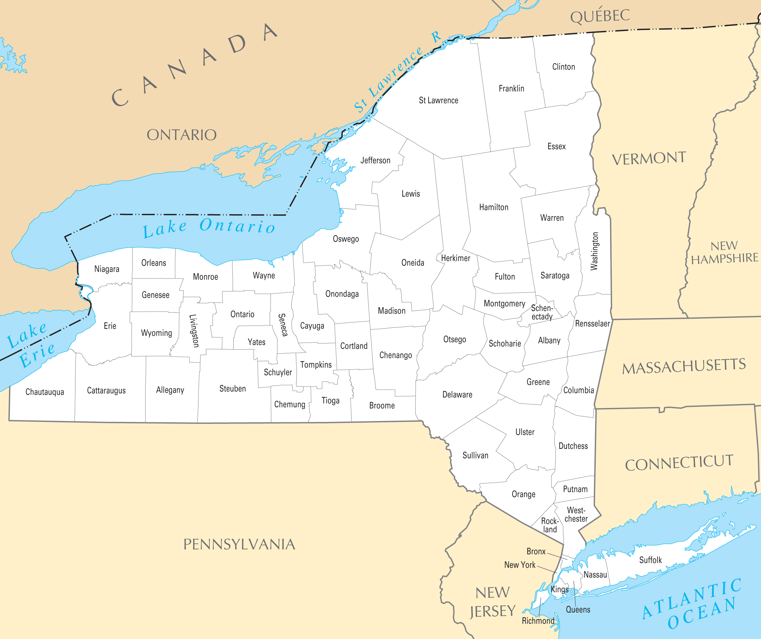
If you would like to use THIS picture in any sort of media elsewhere (such as newspaper or article), please send me a Flickrmail or send me an email at natehenderson6@gmail.com.
Rhizocarpon geographicum, the map lichen. Growing on a rock face in Acadia National Park in Maine.
If you zoom in on the larger pictures, you can see the beautiful and intricate green and black pattern.
It turns out this species of lichen is common all over the globe on sheer rock faces and can be used to date events within 1000 years. The radius of an individual R. geographicum colony increases by about 0.5 to 0.8 mm/year (depending on the altitude)*. That would suggest that these colonies are at least over 100 years old (and hence are starting to fuse together).
*RK Chaujar in Current Science p 1552 (2006)
(1929) This map shows the early development of the airfield. By 1941 the airport would encompass the entire square mile. By the late 1950's and with the advent of early jets the entire field was too small. The land around the airport was completely residential and commercial, so by the early 60's most airlines had migrated north to O'Hare Field.
EN:
Map of Tuscany showing (among other cities) Pisa, Livorno, Lucca, Pistoia, San Gimignano, Siena and Florence. The map is painted on a wall in the small town San Miniato. And, let's be honest, they kinda exaggerated the size of their own town :-)
NL:
Kaart van Toscane met daarop (onder andere) de steden Pisa, Livorno, Lucca, Pistoia, San Gimignano, Siena en Florence. De kaart is op een oude muur geschilderd in het plaatsje San Miniatio. En, laten we eerlijk zijn, de inwoners van San Miniatio hebben de grootte van hun eigen stadje lichtelijk overdreven :-)
For those of you who want to know where I took this shot; check it out in Street View!
In this Ptolemaic world map it is fascinating to follow the known world by looking at its varying specificity and accuracy. Europe is well known, as are parts of Asia and northern Africa, but much of everything else is a cipher. I'm fascinated, for example, that the Indian Ocean was deemed a land-locked sea.
Description: Two page spread containing a tactile map with braille. War Maps, Belgium and North-Eastern France.
Note: Map with tactile elements for use by the blind.
Creator: The National Institute for the Blind, London
Date: undated
Format: book
Digital Identifier: MAPS-00048
Rights: Samuel P. Hayes Research Library, Perkins School for the Blind, Watertown, MA
While exploring my archive I've stumbled on this map of Amman, it was published by "International Media Services", as you see their credentials at the map footer.
It's really a strange thing to find! I don't recall how it came into my archive.. it's like seeing a visualised memory directly in my hands. Anway, the map is really interesting, it shows you the brands, shops, venues and landmarks of Amman two decades ago, I'm sure many of us still remembering few parts of this map, the map of a vivid city who changed a lot.
The map, obviously, was drawn by hand, the artist who done that used some weird orientations, so you find Rainbow street is west of Al-Husseini Mosque and they share the same horizontal level, then you keep going west until you reach Abdoun, a few steps after Abdoun you find yourself in the Queen Alia Airport! Funny..
However, the artist made a good effort to draw the building's facade, I was impressed to see some iconic buildings of Amman drawn in a nice way, it seems like someone did a big research for photos and logos, and delivered them to the artist's hands.
Many brands in this map have been extinct, and many are still surviving, but it still Amman that we love!
All rights reserved by - Muhammad Amit [ goo.gl/m1Pe8h ]
Check - Amit Photography [ goo.gl/jqLb8h ]
Pakage Detail : goo.gl/rDhHK3
Email :- muhammadamit2@gmail.com
Thanks in advance
This map has links to places where we took photos.
The map is best viewed in either large or original format.
Map source, Wikipedia, map author Eric Gaba – Wikimedia Commons user: Sting.
Capital:
Stonewald, founded by Lenard of Roawia himself, is a large city and holds the throne to High Lord Godfrey in Lenards Keep. It has a rather big port mainly to give room to all the fishing boats that roam Everlyns Tears Lake. Laid in the centre it holds a strategic point as a gateway to all corners of Lenfald.
Great cities:
Ainesford, a prosperous town which has gained wealth through its large market, lumbermills and convenient placing almost exactly on the border of Lenfald and Loreos. It is the easiest way to cross the Aines River
Strongborough, is a young city but strong and heavily fortified. It has a rich history and holds one of the most honorable houses in Lenfald. It tracks its lineage back to Vyctor Strong a bastard son of a Lenfel Lady and unknown Garheim Lord. Because he was a bastard he chose to live in exile and gathered a following in the Dragon Scale Mountain Range and eventually built a fortress, later called the Strong Borough, in the Wolfs Fang Pass. The Wolfs Fang pass is essential for passing through the mountains as holds the passage to the Eagles Eye Valley. Strongborough still grants passage to the Valley and has most of its city built on the fertile lands of the Valley itself.
Crakenhaven, a grand port built on the largest islands of the Merkorliss Isles: Norholm. The isles of Merkorliss take their name from the estranged son of Lenard who wanted a kingdom of his own and decided he would expand his realm from the island he conquered with a small army. Not really a strong feat, because simple, primitive tribes used to live on these Islands. After his coming he civilized the tribes and built strong keeps and castles for his men. The house of Merkorliss laid their equivalent of a sword, a trident, at the feet of the King of Lenfald, when he showed up with the entire fleet to lay the city of Crakenhaven to waste. The big market square still holds a statue of the King of Lenfald with the trident of the house of Merkorliss at his feet.
Smaller cities:
Falkenborg, rival city of Ugleheim.
Dragonsmouth, city at the entrance of the Dragon Scale Mountain Range, called so because of the large gate that resembles the grotesque mouth of a Dragon.
Sioc Dubh (Black Frost), port in the north, wealthy town that is the gateway to the mainland for the Merkoliss Isles, named by the tribes that live in the Airgid Corónaigh .
Standfast, the last city of the isles of Merkorliss that was taken by the King, located on Refuge the smaller island of the Merkorliss Isles.
Isil Oro (Moon Rise),port to the south of the Frostpeaks, old Elven port abandoned when the Age of Men began, named so because the port is crescent shaped.
Bladefall, Where it is said the first battle between the Garhim en Lenfel was fought. Its port is frequently visited by Garhim ships.
Durrough, a harbor city which held the last Loreesi outpost in Lenfald. It has been changing factions since long before the Kingdom of Roawia was founded
Elavia/Arragnos, a ruined city in the Strath Armen. It is believed that Huron the Despoiler was born in this city when it was still a village, but he made it into a prosperous town. After Magic was abolished from Roawia and Huron started his descent towards evil it kept growing until a group of Outlaws, thought to be followers of Huron burned the whole city to the ground. It is believed to be haunted and is given the name Arragnos, Dawn in Ashes.
Landmarks:
Everlyns Tears lake, named after Lady Everlyns lost her husband on the banks of the lake defending them from Thirian raiders in the first Era.
Dragon Scale Mountain Range, it is said that the first dragon found his last resting place here and that his scales make up the Mountains.
Armendahls Mountains, realm of Armendahl the Great who expanded his territory from his fortress on Armendahls Peak and held a firm grip on the lands of Lenfald at the end of the first Era and in the beginning of the second Era, before Roawan the Conqueror stood up and united the lands of Roawia.
Airgid Corónaigh, mountains in the north a dangerous and harsh place, only the most hardened of people reside here. It is said that the Garhim and the tribes of the Airgid Corónaigh share ancestory.
Iolar Aill (Eagle Cliff), cliffs that make the shoreline in the north. It is said that this is the last place they saw the Eagle fly before he took off to the Realms Beyond the Sea. The Eagle was the favorite form of Lorthoric, highest of the Elder Gods.
Wandering Woods, forests that hold magical creatures, such as Elves, centaurs, trolls and some say even Dragons. People avoid this part of the woods and therefore no-one knows what truly lives in this dark place.
Strath Armen, the valley to the south of Armendahls Mountains, birthplace of Armendahl the Great and the place where he started his reign over Lenfald.
Lenness, ‘the nose of Lenfald’, the most western cape of Lenfald.
Nan Deorc, the valley that leads from Sioc Dubh through the Airgid Corónaigh.
Aines, the river that functions as a natural border between Loreos and Lenfald, named after the daughter of Lenard, founder of Lenfald. Named after maiden Aines, daughter of Lenard, founder of Lenfald. It is said she used to cross the river at that exact point often to visit her lover who was of Loreosi descent. The river is now often referred to as the Fork, or Aines Fork, a play on the city name and the shape of the river itself.
Isax, the street between the Merkorliss Isles and the mainland of Lenfald.
Fyrla, river that runs from the Dragonscale Mountain Range across the border to Garheim. It is believed that in the beginning of time Godess Fyrla created this river as an escape from her husband Dragor, creator of Dragons, when she discovered he created creatures that could breath fire, her only weakness. She escaped to what is now known as Garheim and created the harsh climate, so that the Dragons could not follow her.
Issala, river that runs from the Airgid Corónaigh to Everlyns Tears. Meaning Icy river in Old Lenfel, the waters of the Issala are always refreshingly cool, even in the warmest of seasons.
Lománsruth, river that runs from Everlyns Tears to the Aines, its name meaning a stream for logs, it is the most important route for timber to the lumbermills in Ainesford.
Dragansruth, river that runs from the Dragonscale Mountains to the Aines, literally meaning Dragon Stream, it runs to a series of hot springs in the Dragonscale mountains which means it has a strong sulfur smell, which gives it the illusion it is on fire.
If you add cities please do it in the comments, so It won't get to crowdy in the map.
Collection of old maps scanned from books and other print sources Download them all at Photoshop Roadmap.