View allAll Photos Tagged cgi

From Wikipedia, the free encyclopedia.Computer-generated imagery (CGI for short) is the application of computer graphics to create or contribute to images in art, printed media, video games, films, television programs, commercials, videos, and simulators. The visual scenes may be dynamic or static, and may be two-dimensional (2D), though the term "CGI" is most commonly used to refer to 3D computer graphics used for creating scenes or special effects in films and television...


Thanks for the favs and comments folks....

I really appreciate the visits. I look forward to visiting many of yours.

Not an AI-generated image.


Made in Substance Painter and 3ds Max.

3D models are made from scratch. Textures are manually added.


©2021 Laurence G.R. | CC BY-NC-ND 4.0

Virgen del Pilar, Zaragoza, Spain


Getty Images / 500px / Flickr Hive Mind / Fluidr / Flickeflu / Rvision


Please don't post on your comments your images or photostreams page or links to blogs, websites or flickriver: it will be deleted

Per favore non aggiungete vostre foto ai commenti, grazie: saranno cancellati
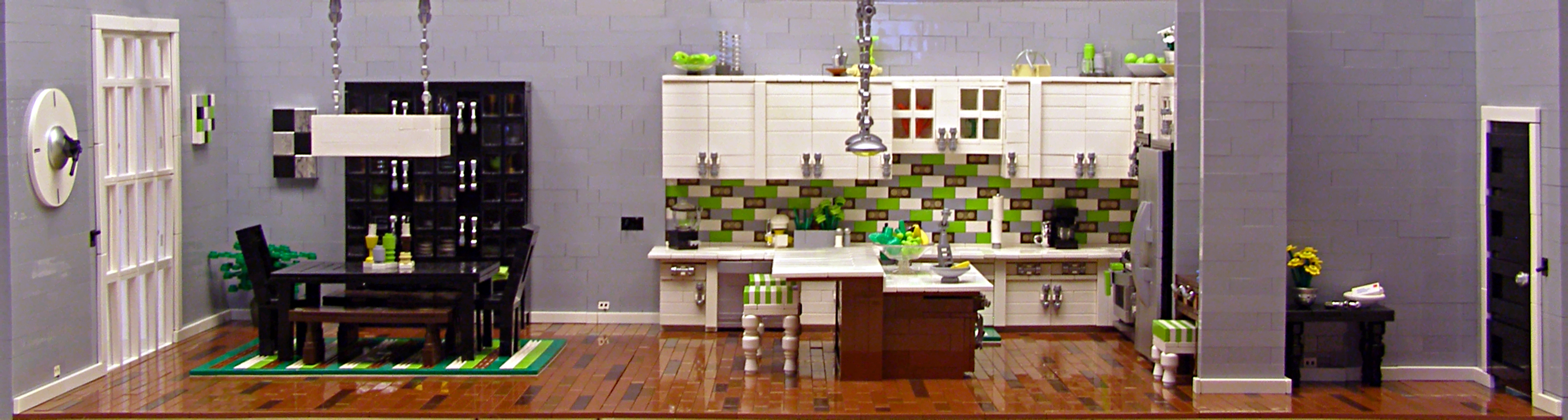
Insomnia CGI ENB + Vivid Weathers

President Clinton announcing IntraHealth’s CGI Commitment: Next-Generation Technology for Frontline Health Workers.


Source: Clinton Global Initiative 2012 Meeting webcast

-[ X is for Xetron failsafe ]-


A 35mm projector failsafe from a defunct manufacturer better known for their xenon-arc 35mm projection lamphouses and consoles. (I was trying to avoid using brand names this year, but that tricky letter X forced my hand.) Failsafes were an important component of projector automation, shutting down the projector in the event of a film break or when the film ran out at the show's end.


This failsafe is a later design with an optical cue detector, used to control house lights, sound, masking, and projector functions. Unlike traditional detectors using strips of foil applied to the film edges to complete low-voltage electric circuits as the strip passes through closely-spaced roller sets, this one uses either reflective foil or, in the case of one theatre chain's system, bar-coded labels tied to specific actions. The foil or labels were applied onto the picture area, a serious downside to this arrangement leading to brief, distracting blemishes projected onto the screen.

"Town hall, free-standing gable roof building on three sides with plastered half-timbered structure protruding on consoles to the west, solid narrow sides, with stepped gables, clock tower with pointed helmet, house Madonna and outside staircase with late Gothic tracery parapet, before 1497 to around 1513, with an eastern, two-story extension with a gable roof and stepped gable, 1514– 1515, with furnishings.


Ochsenfurt (German: [ˈɔksn̩ˌfʊʁt]) is a town in the district of Würzburg, in Bavaria, Germany. Ochsenfurt is located on the left bank of the River Main and has around 11,000 inhabitants. This makes it the largest town in Würzburg district.


Like Oxford, the town of Ochsenfurt is named after a ford where oxen crossed the river.


The town is situated on the left bank of the River Main, 21 kilometres (13 mi) south of Würzburg.


Ochsenfurt was one of the places in Germany where King Richard I of England was detained in 1193 while on his way to England from the Third Crusade.


A monastery, Tückelhausen Charterhouse, dedicated to Saints Lambert, John the Baptist, and George, was founded in 1138 by Otto I, Bishop of Bamberg, as a double canonry of the Premonstratensians. From 1351 it belonged to the Carthusians and was secularised in 1803.


The charterhouse was largely converted for private residential use and since 1991 contains a museum of Carthusian life.


Ochsenfurt also features several Protestant and Roman Catholic churches, among them that of St Michael (Michaelskapelle), a Gothic edifice.


In 1911 there was a considerable trade in wine and agricultural products, other industries being brewing and malting. Ochsenfurt also has one of the largest sugar factories in Germany.


Lower Franconia (German: Unterfranken) is one of seven districts of Bavaria, Germany. The districts of Lower, Middle and Upper Franconia make up the region of Franconia. It consists of nine districts and 308 municipalities (including three cities).


After the founding of the Kingdom of Bavaria the state was totally reorganised and, in 1808, divided into 15 administrative government regions (German: Regierungsbezirke, singular Regierungsbezirk), in Bavaria called Kreise (singular: Kreis). They were created in the fashion of the French departements, quite even in size and population, and named after their main rivers.


In the following years, due to territorial changes (e. g. loss of Tyrol, addition of the Palatinate), the number of Kreise was reduced to 8. One of these was the Untermainkreis (Lower Main District). In 1837 king Ludwig I of Bavaria renamed the Kreise after historical territorial names and tribes of the area. This also involved some border changes or territorial swaps. Thus the name Untermainkreis changed to Lower Franconia and Aschaffenburg, but the city name was dropped in the middle of the 20th century, leaving just Lower Franconia.


From 1933, the regional Nazi Gauleiter, Otto Hellmuth, (who had renamed his party Gau "Mainfranken") insisted on renaming the government district Mainfranken as well. He encountered resistance from Bavarian state authorities but finally succeeded in having the name of the district changed, effective 1 June 1938. After 1945 the name Unterfranken was restored.


Franconia (German: Franken, pronounced [ˈfʁaŋkŋ̍]; Franconian: Franggn [ˈfrɑŋɡŋ̍]; Bavarian: Frankn) is a region of Germany, characterised by its culture and Franconian dialect (German: Fränkisch).


Franconia is made up of the three Regierungsbezirke of Lower, Middle and Upper Franconia in Bavaria, the adjacent, Franconian-speaking, South Thuringia, south of the Thuringian Forest—which constitutes the language boundary between Franconian and Thuringian— and the eastern parts of Heilbronn-Franconia in Baden-Württemberg.


Those parts of the Vogtland lying in Saxony (largest city: Plauen) are sometimes regarded as Franconian as well, because the Vogtlandian dialects are mostly East Franconian. The inhabitants of Saxon Vogtland, however, mostly do not consider themselves as Franconian. On the other hand, the inhabitants of the Hessian-speaking parts of Lower Franconia west of the Spessart (largest city: Aschaffenburg) do consider themselves as Franconian, although not speaking the dialect. Heilbronn-Franconia's largest city of Heilbronn and its surrounding areas are South Franconian-speaking, and therefore only sometimes regarded as Franconian. In Hesse, the east of the Fulda District is Franconian-speaking, and parts of the Oden Forest District are sometimes regarded as Franconian for historical reasons, but a Franconian identity did not develop there.


Franconia's largest city and unofficial capital is Nuremberg, which is contiguous with Erlangen and Fürth, with which it forms the Franconian conurbation with around 1.3 million inhabitants. Other important Franconian cities are Würzburg, Bamberg, Bayreuth, Ansbach and Coburg in Bavaria, Suhl and Meiningen in Thuringia, and Schwäbisch Hall in Baden-Württemberg.


The German word Franken—Franconians—also refers to the ethnic group, which is mainly to be found in this region. They are to be distinguished from the Germanic people of the Franks, and historically formed their easternmost settlement area. The origins of Franconia lie in the settlement of the Franks from the 6th century in the area probably populated until then mainly by the Elbe Germanic people in the Main river area, known from the 9th century as East Francia (Francia Orientalis). In the Middle Ages the region formed much of the eastern part of the Duchy of Franconia and, from 1500, the Franconian Circle. The restructuring of the south German states by Napoleon, after the demise of the Holy Roman Empire, saw most of Franconia awarded to Bavaria." - info from Wikipedia.


Summer 2019 I did a solo cycling tour across Europe through 12 countries over the course of 3 months. I began my adventure in Edinburgh, Scotland and finished in Florence, Italy cycling 8,816 km. During my trip I took 47,000 photos.


Now on Instagram.


Become a patron to my photography on Patreon or donate.

The decision to learn 3D graphic and CGI came to me during the Spring of 2015 when I was looking for inspiration on the sites like Pinterest or Behance. After analyzing pictures of high end commercial photographers and then looking for some further details about how the shot was created I realized just how often is CGI incorporated in image making process. The final output is nowadays not only realistic, but at the same time it has that perfect/polished feel, that was so hard for me to replicate with photography.

This image was my first real attempt to create fully realistic render that I was satisfied enough to publish in my portfolio. The exploding splash in the top part was photographed in the studio, same as small droplets behind the bottle. Everything else was created in 3D software. Inspiration for this image came from official Coca Cola Zero campaign.


PR-CGI Gulfstream G550 Administracao e Participacoes Ltda @ London Luton Airport 26/09/2020

Blender / Cycles

1 3 4 5 6 7 ••• 79 80