View allAll Photos Tagged Unification
The International Charlemagne Prize of Aachen is the oldest and best-known prize awarded for work done in the service of European unification. The prize is named for Charlemagne, the Franconian king revered by his contemporaries as the ‘Father of Europe’. Pope Francis has been awarded the European Charlemagne Prize for 2016 in recognition of his efforts at global peace and cross-cultural understanding, making him only the second pontiff to receive the prestigious annual honour given by the German city of Aachen. The award ceremony will be held in Rome on the 06 of May 2016 in the presence of the Presidents of the European Parliament, Martin Schulz, of the European Commission, Jean-Claude Juncker, and of the European Council, Donald Tusk.
Follow the ceremony live → bit.ly/18C4yEr
More on the Charlemagne Prize: www.karlspreis.de/en/the-
Press release here: bit.ly/1VH9JKl
These photos are free to use under Creative Commons licenses and must be credited: "© European Union 2016 - European Parliament" (Attribution-NonCommercial-NoDerivatives CreativeCommons licenses creativecommons.org/licenses/by-nc-nd/4.0/). If you need higher resolution files do not hesitate to contact us. Please do not forget to send the link or a copy of the publication to us: webcom-flickr(AT)europarl.europa.eu
At the Unification Observatory, Goseong County, Gangwon Province, which is South Korea's northernmost point.
North Korean liquor for sale.
As these border area "Unification Observatories" are most often visited by former North Koreans who want to be as close to their lost hometowns as possible, they often sell North Korean products like these bottles of liquor. Despite the two Koreas being still technically at war, and despite the occasional saber-rattling that continues depending on the whims of the northern leadership (and also on who is in charge of the southern government), inter-Korean trade is significant.
Bog bilberry liquor is extremely precious. Even ordinary North Koreans rarely get to even see it, much less drink it. It is normally reserved for visiting foreign and South Korean dignitaries.
The Flower Liquor on the right clearly shows the country of origin as "DPR Korea."
Victor Emmanuel was a strong military leader who's victories during the Italian Revolution (1815-1871) led to the unification of the many Italian states into one unified state, the Kingdom of Italy. He became the first king of a united Italy since the 6th century and held that title until his death in 1878.
Also known as the Altare della Patria, Altar of the Fatherland, the Monumento Nazionale a Vittorio Emanuele II was built to honor him.
Standing 230 ft high and 443 ft wide, it occupies a large area of the Capitoline Hill. Designed in 1885, it was inaugurated in 1911 and completed in 1925. Designed in the Greco-Roman style, the monument was very controversial. Many ancient Roman structures and artifacts were destroyed to clear the way for construction. Made of the finest white Botticino marble from Brescia, Italy, the best sculptors were employed to execute the designs which include an impressive stairway leading through Corinthian columns, beautiful fountains, and statues.
Two bronze statues of the goddess Victoria riding on quadrigas are seen at the top (the goddess Victoria represents Victory, the quadrigas are chariots drawn by four horses abreast). Symbolizing "winged victory" the one on the right represents freedom, the one on the left unity.
At the foot of the of the equestrian statue of Victor Emmanuel II is the Altare della Patria or Altar of the Motherland. It is the most famous part of the monument. In front of the statue of the goddess Roma is the Tomb of Italy's Unknown Soldier from WWI, completed in 1924. It is flanked by a two-man honor guard and highlighted by an eternal flame. The honor guard is present at all times.
There are two fountains - Le Fontaine dei Due Mari (The Fountains of the Two Seas). The fountain on the left represents the Adriatic, with the lion of San Marco. On the right is the Tyrrhenian, with the wolf of Rome and the siren Partenope, which symbolizes the city of Naples.
The link below shows a progressive timeline of the Unification:
upload.wikimedia.org/wikipedia/commons/0/00/Italian-unifi...
Bulevardul Unirii (Unification Boulevard) is a major thoroughfare in central Bucharest, Romania. It connects Alba Iulia Square with Constitution Square, and also runs through Unification Square. The Constitution Square end features the Palace of the Parliament.
Following the 1977 Vrancea earthquake, Bucharest's city center suffered significant damage, and a large number of historic buildings were demolished to make way for the new Centrul Civic (Civic Center; see systematization and Ceaușima). As part of the project, Bulevardul Unirii was to be Communist Romania's answer to Paris's Avenue des Champs-Élysées, with a length of 3,500 m. Construction began on June 25, 1984. Initially called Bulevardul Victoria Socialismului (Victory of Socialism Boulevard), the road is lined with socialist-realist apartment blocks of North Korean inspiration [Wikipedia.org]
UNIFICATION OF NEPAL
Nepal was unified by King Prithvi Narayan Shah of Gorkha kingdom in the mid-eighteenth century by winning over other kingdoms and moving his capital to Kathmandu.
EARLY RULERS
Nepal's recorded history began with the Kiratis, who arrived in the Kathmandu valley in the 7th or 8th century BCE from the east. Little is known about them, other than their deftness as sheep farmers and fondness for carrying long knives. The Kirats ruled for about 1225 years (800 BCE-300 CE); they had a total of 28 kings during that time. Their first and best remembered king was Yalambar Haang, who is mentioned in the epic Mahabharata.
The first record of the word Nepal is found in ancient Indian annals such as the puranas from the 4th century A.D where an area known as 'Newal' or sometimes as 'Newar' is mentioned, referring to what is now known as the Kathmandu Valley. However, the area of the sovereign state of Nepal has changed from time to time during its history, expanding and shrinking in area since ancient times.
Of the kings originating inside or outside of modern Nepal, a common characteristic of attempting to unify Nepal from mostly west to east, along the southern track of the Himalayas and the northern plain of Ganges, can be identified. No Nepalese ruler has been recorded attempting to cross the Himalayas to expand their states into Tibet or China, and none has been recorded trying to cross the Ganges plain into modern India. For the most part, Nepalese rulers seem to have been focused on the territories that more or less comprise modern-day Nepal, between the region of Kashmir in the west and Bhutan in the east.
Nepal as a political region has been united by different kings of different kingdoms at various times in Nepalese history. Common tradition holds that among the first uniters of Nepal was a king by the name of Mandev, who ultimately controlled territory from the Brahmaputra River in the east to the Gandaki in the west. Recorded details of his unification, however, are scarce, and Mandev's actions and his very existence cannot be definitively confirmed. The same may be said for various early recorded and traditional (i.e. not necessarily recorded) rulers of Nepal, all of whose kingdoms apparently broke up when their dynasties died out. While records and documents of several such rulers do exist, a lack of interest has made their accessibility difficult and limited the number of translations and analyses.
KING PRITHVI NARAYAN SHAH
King Prithvi Narayan Shah (1723-1775) was born in the Shah dynasty of Gorkha on 11 January 1723 (27 Poush 1779 B.S.) After the death of Narabhupal shah on 25th chaitra he became the king of Gorkha. He ascended to the throne of Gorkha kingdom on 3 April 1743. He was interested in politics and diplomacy and had interests in both visiting and conquering other countries since his days as prince. He decided to enlarge his kingdom that was confined to the small Gorkha region of present-day Nepal and had an area of just 2,500 square km (approx. 50 km x 50 km). He defeated major principalities in wars and unified them under his rule starting from the 1740s ending with shifting of his Gorkha Kingdom’s capital from Gorkha region to Kathmandu in 1769. While he was successful at conquering the Kathmandu valley and the Sen kingdoms further east of the Kathmandu valley, his efforts were limited to the west of his homeland. He then attacked and absorbed dozens of other small principalities and gave a new name "Nepal" to his Gorkha kingdom. He was able to conquer some of the 22 principalities or kingdoms, known as the (thebaise raj-ya, and some of the 24 kingdoms (the chaubasi raj-ya), which were two sets of allies west of the King's homeland of Gorkha, in what is now called western Nepal.Soon after he ascended the throne of Gorkha Kingdom, Shah tricked his way into the royal household of Bhaktapur for a number of months. He wanted the rich agricultural soil of the valley, and the strategic point of the Kathmandu valley as a transit point for expanding trade with both Tibet and India. Then he planned the conquest of the valley. To this end, he decided to first capture Nuwakot, which belonged to the state of Kantipur, as a strategic point. He also foresaw that taking over Nuwakot would significantly strengthen the position of his Gorkha nation and weaken the states occupying the Kathmandu Valley. Nuwakot held strategic importance, as there was already a fort there, and it had remained as a connecting pass the valley and Tibet.
NUWAKOT
Prithivi Narayan was a very ambitious king. Along with the invasion of the Gorkha he wanted it to protect it from the Gorkha troops, so he started to unify the small kingdoms to be a single country . One year after becoming King, in 1744 AD, Prithvi Narayan Shah attacked Nuwakot but was repelled because the Gorkha army was not well equipped. In addition, conflicts of interest between the Pandeys and Basnets - two important warrior clans in the Gorkha palace - arose to add domestic political tension. Shah then made Kalu Pande "Mul Kaji (equivalent to Prime Minister)" of his state and thus strengthened his domestic political position. Almost a year later, on 2 October 1744, he attacked Nuwakot again and won, thus expanding the bounds of his Gorkha state.
KIRTIPUR
Kalu Pandey employed a strategy involving a blockade of the Kathmandu Valley, and subsequently took over the surrounding settlements and strategic positions around the valley. In the next two years (during 1745-46) he captured Mahadevpokhari, Pharping, Chitlang, Dharmasthali, Naldrum, Siranchok and Shivapuri. He then focused his attention on Kirtipur and Makawanpur, two palaces which were also strategic military targets. Kirtipur was in an elevated position with a fort surrounded by walls and jungles, an ideal place to make inroads into the valley. Shah thought that if he could take over Kirtipur, occupying the rest of the valley would be much easier. On 4 December 1757 he made his first attack on Kirtipur. In this war he lost his strong general Kalu pandey which was a great loss for gorkha. Kalu Pandey had told him that it was not the right time to attack Kritpur. His body was buried in Kirtipur. Prithvi Narayan Shah himself was nearly killed in the battle. As a result, the Gorkha army, having lost a great deal of morale, was defeated. It is said that as revenge for his two earlier defeats, The Gorkha army was repelled again in August 1765.
After two defeats, the Gorkha army changed its strategy again and surrounded Kirtipur during the harvest season, effectively laying siege to the stronghold. The Gorkha army also took over the nearby Balaju fort. After several months of this blockade, the people of Kirtipur could not even get water to drink and were forced to surrender to the Gorkha army on 17 March 1766. This time the Gorkha army took over Kirtipur without a fight. Prithvi Narayan Shah had his army cut off the noses and lips of all the people of Kirtipur.
Conquest of Southern Nepal and the Kathmandu Valley
As Nuwakot was a key point for Kathmandu’s trade with Tibet, Makawanpur in the south was equally important for trade with India. While the battle to surround Kathmandu was going on in the north, the Gorkha army captured Sindhulikot, Timilakot and Hariharpur in the south and southeast of modern-day Nepal before it entered into the Makawanpurgadhi territories. Makawanpur was captured after only 10 hours of battle in August 1762. In 1763 AD, the Gorkha army conquered seven other villages, including Dhulikhel and Banepa, and expanded the Gorkha state's border line further north. With this, the Kathmandu Valley was completely surrounded and blockaded. After all the four passes (Sanga, Baad, pati and Chandragiri Bhanjyang, also known as Char Bhanjyang) of the Kathmandu Valley were controlled by Prithvi Narayan Shah, the eventual lack of salt, oil, spices, and even clothes led to turmoil in the valley and disaster struck Kathmandu. When the local government failed to pay its soldiers, the morale of its military dwindled.
The king of Kathmandu at the time, Jaya Prakash Malla, then asked for military aid from the British in British India. In August 1767, when the forces of the British India arrived in Sindhuligadhi, the Gorkha military conducted guerrilla attacks against them. Many of the British Indian forces were killed and the rest eventually fled, leaving behind a huge amount of weapons and ammunitions, which were seized by the Gorkha army.
This boosted the morale of the forces of Prithvi Narayan Shah and further demoralized the kings of the Kathmandu Valley, among which was the king of Kantipur. In addition to this, the political situation of the valley, political wrangling inside the palace, and personal enmity had rendered the people of Kantipur very weak because Jaya Prakash Malla, the king of Kantipur, was of a paranoid nature, and his own brother and courtiers became dissatisfied with him. The state of Lalitpur had also faced chaos after the death of its king Yogendra Malla. Six pradhans (courtiers) then took power into their own hands, and put Tej Narsingh Malla on the throne; but the actual power in Lalitpur remained with the pradhans. In Bhaktapur as well, the palace of King Ranjeet Malla was in disarray due to domestic political wrangling. When Ranjeet Malla wanted to declare his two-year-old son as his heir, a queen (not through marriage) opposed it. This forced the king to declare his older illegitimate son as his heir to the throne. This only fueled conflict in the palace, as a result of which the palace was weakened further.
While the three kingdoms of the Kathmandu Valley were engaged in clashes and enmity, Prithvi Narayan Shah used this opportunity to impose an economic blockade against the entire valley region. He closed the trade route to Tibet, which passed through Nuwakot. The Gorkha army marched into the valley. On 25 September 1768, when the people of Kathmandu were celebrating the Festival of Indrajatra, Prithvi Narayan Shah won an easy victory over Kantipur.
Some historians doubt this version of the history written by the conquerors. They say that the valley was overtaken not in September but in cold December. The official version of overwhelmingly large force that captured Kathmandu is considered historically inaccurate. The truth, however, is that the powerful Pradhan courtiers of Kathmandu were promised lucrative positions in the new Kingdom in exchange for their help in killing the beleaguered king. The king realized that he had enemies galore and fled to the neighboring Bhaktapur, leaving the throne empty in Kathmandu. Upon easing his way to the throne of the Kathmandu, the very next day, he ordered the beheading of all of the Pradhan courtiers and their extended society.
Eleven days later (6 October 1768), he conquered Lalitpur. On 14 April 1769, he gained the town of Thimi and seven months later (17 November 1769) he took over Bhaktapur. In this way, the whole Kathmandu Valley came under the control of Prithvi Narayan Shah.
DIPLOMATIC RELATIONS
Prithivi narayan Shah was very effortful to have good relations with different states for making his unification campaign a success. As a representative of his father, he had a pact with Lamjung, the old age enemy. Later he himself signed a treaty with King of Lamjung through the efforts sought be Kalu Pandey. Relations with the Malla Kingdoms was also important. PNS signed separate treaties with Kantipur and Bhaktapur, which are as follow : 1) to circulate the currency of either states in both states. 2) to carry joint trade with Tibet and share the incomes. 3) to enjoy rights to depute a state representative to Tibet. 4) to allow Kantipur to use the territory of Nuwakot for trade with Tibet. (Anush)
ESTABLISHMENT OF A UNITED KINGDOM OF NEPAL
After his conquest of the Kathmandu Valley, Prithvi Narayan Shah conquered other smaller countries south of the valley to keep other smaller fiefdoms near his Gurkha state out of the influence and control of the British rule. After his kingdom spread out from north to south, he made Kantipur the capital of expanded country which was known as Kingdom of Gorkha (Gorkha Samrajya).It was renamed as Kingdom of Nepal in 1930. by King Tribhuvan Bir Bikram Shah.
WIKIPEDIA
Opening Ceremony for Dorasan Unification Platform
October 14, 2015
Dorasan Station, Paju-si, Gyeonggi-do
Ministry of Culture, Sports and Tourism
Korean Culture and Information Service
Korea.net (www.korea.net)
Official Photographer : Jeon Han
This official Republic of Korea photograph is being made available only for publication by news organizations and/or for personal printing by the subject(s) of the photograph. The photograph may not be manipulated in any way. Also, it may not be used in any type of commercial, advertisement, product or promotion that in any way suggests approval or endorsement from the government of the Republic of Korea.
-------------------------------------------------
도라산역 통일플랫폼 개장식
2015-10-14
경기도 파주시 도라산역
문화체육관광부
해외문화홍보원
코리아넷
전한
Buddha "Tongil Daebul"
Shinheungsa Temple Bojeru - Seoraksan
This statue represents the crucial wish of the Korean people for the reunification of the divided country.
Sinheungsa, sometimes spelled Shinheungsa, is a head temple of the Jogye Order of Korean Buddhism. It is situated on the slopes of Seoraksan in Sokcho, Gangwon Province, South Korea.
Sinheungsa is located in Seoraksan National Park, and many tourists hiking Seoraksan up to Ulsanbawi (peak) pass by the temple on the way.
The Great Unification Buddha, a 14.6-meter, 108 ton gilt-bronze Buddha statue, called "Tongil Daebul", sits atop a 4.3-meter high pedestal, of the same material, making the total height 18.9-meter, excluding the lightning rod and nimbus.
The lotus pedestal is flanked with 16 delicately engraved panels and the forehead of Tongil Daebul is adorned with eight 8-centimeter stones of amber, with a single piece of jade in the center that is 10-centimeter in diameter.
Tongil Daebul sits with legs crossed and half-closed eyes in meditation, his lips displaying a perceptible smile. A flowing robe with gentle folds, revealing the right shoulder, drapes the Buddha's robust torso. The hands of Tongil Daebul are positioned in the mudra symbolizing the "enlightened one."
Contained within the hollow statue are three pieces of the Buddha's sari, remains collected after his cremation, donated by the Myanmar government, and the Tripitaka, the original Buddhist scriptures.
This statue represents the crucial wish of the Korean people for the reunification of the divided country.
This Mongolia Mongolei Mongolië travel photography photo was taken by Dutch travel photographer Hans Hendriksen. The celebration of the 800th anniversary of the founding of the Mongolian nation in 2006 represented an incredible travel photography opportunity as Mongolia showed its splendour to the world. Many events were held throughout this year to commemorate the unification of the tribes by Chinggis Khan in the year 1206. The culmination of the festivities was Mongolia's national holiday, "Nadaam", held from 11 to 13 of July 2006. The Nadaam festival is the biggest of the year. It runs for three days in all parts of the country and features the greatest athletes in Mongolia's most popular sports: horse racing, archery, and wrestling. Women participate in all but the wrestling category. The competitions take place on the first two days, and the third day is reserved merry-making! Should you want to buy a high-res file for publication, photo print or poster? Visit www.hanshendriksen.net to find all information about the author and how to order or publish his work.
Este Mongolia Mongolei Mongolie viajes fotografía foto fue tomada por el fotógrafo holandés Hans Hendriksen viaje. La celebración del 800 aniversario de la fundación de la nación mongol en 2006 representó una oportunidad increíble de fotografía de viajes como Mongolia mostraron su esplendor a todo el mundo. Muchos eventos se han celebrado a lo largo de este año para conmemorar la unificación de las tribus por Chinggis Khan en el año 1206. La culminación de los festejos fue la fiesta nacional de Mongolia ", Nadaam", que se celebró del 11 al 13 de julio de 2006. Nadaam El festival es el más grande del año. Se ejecuta por tres días en todas partes del país y cuenta con el mayor en los atletas de Mongolia de deportes más populares: carreras de caballos, tiro con arco, y la lucha. Las mujeres participan en todas las categorías, pero la lucha libre. Las competiciones tienen lugar en los dos primeros días, y el tercer día está reservado alegre toma! Si usted quiere comprar un archivo de alta resolución para su publicación, impresión de fotografías o carteles? www.hanshendriksen.net para encontrar toda la información sobre el autor y la forma de orden o publicar su trabajo.
Это Монголия Mongolei Mongolië поездки фотография фотография была сделана голландской поездок фотограф Ханс Hendriksen. Празднование 800-летия со дня основания монгольской нации в 2006 году представляет собой невероятную возможность поездки фотографии Монголии как показали его величия в мире. Многие мероприятия были проведены на протяжении этого года для того, чтобы отметить объединение племен в Чингис Хана в 1206 году. Кульминация торжества был Монголии национальный праздник ", Nadaam", проходившей с 11 по 13 июля 2006 года. В Nadaam фестиваль является крупнейшим в этом году. Она проходит в течение трех дней во всех районах страны и отличается большим спортсменам в Монголии наиболее популярные виды спорта: конные скачки, стрельба из лука, и борьба. Женщины участвуют во всех, но борьба категории. Соревнования проходят в течение первых двух дней, а на третий день резервируется веселых решений! Если вы хотите купить высоким разрешением файл для публикации, фотографии для печати или плакат? Посетите www.hanshendriksen.net чтобы найти всю информацию об авторе и о том, как к тем или опубликовать его работу.
The Paju Unification Observatory, in addition to housing a North Korean museum, also serves as depository for North Korean periodicals.
This issue of Rodong Shinmun, the official propaganda daily newspaper of the Workers' Party of Korea, is dated 3 October 2007, and covers the major event of the previous day: the arrival of South Korean President Roh Moo-hyun in Pyongyang.
It is notable that Roh Moo-hyun is referred by his title, President, but goes no farther. Not President of the Republic of Korea, not President of South Korea, not President of the Southern Half of the Fatherland, or anything else. While it is clearly mentioned that this is a North-South summit, South Korea simply does not register as a legitimate political entity.
Roh would soon be succeeded by hardline far-right Lee Myung-bak, and Lee's investigations into Roh's alleged corruptions caused Roh to commit suicide in 2009. And Kim Jong-il, definitely looking a lot older and sicker compared to earlier photos, would not last much longer either; he would die of a heart attack in 2011.
n the day jerusalem marks the "day of Unification" (i.e. the occupation of East Jerusalem in 1967) settelers from the nearby area held a facist parade in the streets of East Jerusalem. Raising signs "Jerusalem is for the Jewish", and chanting slogans such as "muhamad's dead", or "death to the arabs". Themarch passed through Arab neighborhoods, while the protestors were dressed in white carring Israeli flags. In reaction Palestinians residing in the area went out to protest peacfully with Israelis, who joined the protest in solidarity with the local residents. The polices reaction to the demonstaration that day, was brutal and oppressive.They arrested nd beat protesters, and used the police horses to scare off the demonstrators by attempting to run over them. All this taking place while he right wing protesters continued to chant "death to the Arabs" and blocked the main street, all palestinian shops and business owners in and around the old city where forced to close for most of a business day by the police so this parade will go though with no interfirence, the business and shp owners did not get any compensation .
Signed at Shore Leave Con July 9, 2005 in Towson, MD. 'Unification' is one of my favorite Next Gen episodes.
This is the new monument, unveiled on the 25th November 2008, to the Edinburgh-born physicist James Clerk Maxwell (1831-1879), hailed as the greatest mathematical physicist since Newton.
The James Clerk Maxwell Statue is by Scottish sculptor Alexander Stoddart, and is located at the east end of George Street, Edinburgh.
Maxwell was responsible for the second great unification in physics, that of electricity and magnetism, after the first unification, by Newton, of terrestrial and celestial mechanics. He also made important contributions to statistical mechanics (see Maxwell's demon).
.
Maxwell was born at 14 India Street, at the other end of Edinburgh's New Town.
His experimentation with colour photography is less well known, but his photograph of a tartan ribbon is considered to have have been the first colour photograph.
This album also in the Collection: "The Physicists"
View this set as a slideshow
I giorni che mancano all'inaugurazione del 150° dell'unità d'Italia.
The days before the inauguration of the 150th anniversary of Italian unification.
One wall of the Potty Mouth room.
"RFT" by Dwell; "Smokin Girl" by Dwell and Unit; "Noni Baloney" by Mr. Prvrt; "Ghosts" by Dwell and Unit; "Dez" by Dwell
This Mongolia Mongolei Mongolië travel photography photo was taken by Dutch travel photographer Hans Hendriksen. The celebration of the 800th anniversary of the founding of the Mongolian nation in 2006 represented an incredible travel photography opportunity as Mongolia showed its splendour to the world. Many events were held throughout this year to commemorate the unification of the tribes by Chinggis Khan in the year 1206. The culmination of the festivities was Mongolia's national holiday, "Nadaam", held from 11 to 13 of July 2006. The Nadaam festival is the biggest of the year. It runs for three days in all parts of the country and features the greatest athletes in Mongolia's most popular sports: horse racing, archery, and wrestling. Women participate in all but the wrestling category. The competitions take place on the first two days, and the third day is reserved merry-making! Should you want to buy a high-res file for publication, photo print or poster? Visit www.hanshendriksen.net to find all information about the author and how to order or publish his work.
Este Mongolia Mongolei Mongolie viajes fotografía foto fue tomada por el fotógrafo holandés Hans Hendriksen viaje. La celebración del 800 aniversario de la fundación de la nación mongol en 2006 representó una oportunidad increíble de fotografía de viajes como Mongolia mostraron su esplendor a todo el mundo. Muchos eventos se han celebrado a lo largo de este año para conmemorar la unificación de las tribus por Chinggis Khan en el año 1206. La culminación de los festejos fue la fiesta nacional de Mongolia ", Nadaam", que se celebró del 11 al 13 de julio de 2006. Nadaam El festival es el más grande del año. Se ejecuta por tres días en todas partes del país y cuenta con el mayor en los atletas de Mongolia de deportes más populares: carreras de caballos, tiro con arco, y la lucha. Las mujeres participan en todas las categorías, pero la lucha libre. Las competiciones tienen lugar en los dos primeros días, y el tercer día está reservado alegre toma! Si usted quiere comprar un archivo de alta resolución para su publicación, impresión de fotografías o carteles? www.hanshendriksen.net para encontrar toda la información sobre el autor y la forma de orden o publicar su trabajo.
Это Монголия Mongolei Mongolië поездки фотография фотография была сделана голландской поездок фотограф Ханс Hendriksen. Празднование 800-летия со дня основания монгольской нации в 2006 году представляет собой невероятную возможность поездки фотографии Монголии как показали его величия в мире. Многие мероприятия были проведены на протяжении этого года для того, чтобы отметить объединение племен в Чингис Хана в 1206 году. Кульминация торжества был Монголии национальный праздник ", Nadaam", проходившей с 11 по 13 июля 2006 года. В Nadaam фестиваль является крупнейшим в этом году. Она проходит в течение трех дней во всех районах страны и отличается большим спортсменам в Монголии наиболее популярные виды спорта: конные скачки, стрельба из лука, и борьба. Женщины участвуют во всех, но борьба категории. Соревнования проходят в течение первых двух дней, а на третий день резервируется веселых решений! Если вы хотите купить высоким разрешением файл для публикации, фотографии для печати или плакат? Посетите www.hanshendriksen.net чтобы найти всю информацию об авторе и о том, как к тем или опубликовать его работу.
UNIFICATION OF NEPAL
Nepal was unified by King Prithvi Narayan Shah of Gorkha kingdom in the mid-eighteenth century by winning over other kingdoms and moving his capital to Kathmandu.
EARLY RULERS
Nepal's recorded history began with the Kiratis, who arrived in the Kathmandu valley in the 7th or 8th century BCE from the east. Little is known about them, other than their deftness as sheep farmers and fondness for carrying long knives. The Kirats ruled for about 1225 years (800 BCE-300 CE); they had a total of 28 kings during that time. Their first and best remembered king was Yalambar Haang, who is mentioned in the epic Mahabharata.
The first record of the word Nepal is found in ancient Indian annals such as the puranas from the 4th century A.D where an area known as 'Newal' or sometimes as 'Newar' is mentioned, referring to what is now known as the Kathmandu Valley. However, the area of the sovereign state of Nepal has changed from time to time during its history, expanding and shrinking in area since ancient times.
Of the kings originating inside or outside of modern Nepal, a common characteristic of attempting to unify Nepal from mostly west to east, along the southern track of the Himalayas and the northern plain of Ganges, can be identified. No Nepalese ruler has been recorded attempting to cross the Himalayas to expand their states into Tibet or China, and none has been recorded trying to cross the Ganges plain into modern India. For the most part, Nepalese rulers seem to have been focused on the territories that more or less comprise modern-day Nepal, between the region of Kashmir in the west and Bhutan in the east.
Nepal as a political region has been united by different kings of different kingdoms at various times in Nepalese history. Common tradition holds that among the first uniters of Nepal was a king by the name of Mandev, who ultimately controlled territory from the Brahmaputra River in the east to the Gandaki in the west. Recorded details of his unification, however, are scarce, and Mandev's actions and his very existence cannot be definitively confirmed. The same may be said for various early recorded and traditional (i.e. not necessarily recorded) rulers of Nepal, all of whose kingdoms apparently broke up when their dynasties died out. While records and documents of several such rulers do exist, a lack of interest has made their accessibility difficult and limited the number of translations and analyses.
KING PRITHVI NARAYAN SHAH
King Prithvi Narayan Shah (1723-1775) was born in the Shah dynasty of Gorkha on 11 January 1723 (27 Poush 1779 B.S.) After the death of Narabhupal shah on 25th chaitra he became the king of Gorkha. He ascended to the throne of Gorkha kingdom on 3 April 1743. He was interested in politics and diplomacy and had interests in both visiting and conquering other countries since his days as prince. He decided to enlarge his kingdom that was confined to the small Gorkha region of present-day Nepal and had an area of just 2,500 square km (approx. 50 km x 50 km). He defeated major principalities in wars and unified them under his rule starting from the 1740s ending with shifting of his Gorkha Kingdom’s capital from Gorkha region to Kathmandu in 1769. While he was successful at conquering the Kathmandu valley and the Sen kingdoms further east of the Kathmandu valley, his efforts were limited to the west of his homeland. He then attacked and absorbed dozens of other small principalities and gave a new name "Nepal" to his Gorkha kingdom. He was able to conquer some of the 22 principalities or kingdoms, known as the (thebaise raj-ya, and some of the 24 kingdoms (the chaubasi raj-ya), which were two sets of allies west of the King's homeland of Gorkha, in what is now called western Nepal.Soon after he ascended the throne of Gorkha Kingdom, Shah tricked his way into the royal household of Bhaktapur for a number of months. He wanted the rich agricultural soil of the valley, and the strategic point of the Kathmandu valley as a transit point for expanding trade with both Tibet and India. Then he planned the conquest of the valley. To this end, he decided to first capture Nuwakot, which belonged to the state of Kantipur, as a strategic point. He also foresaw that taking over Nuwakot would significantly strengthen the position of his Gorkha nation and weaken the states occupying the Kathmandu Valley. Nuwakot held strategic importance, as there was already a fort there, and it had remained as a connecting pass the valley and Tibet.
NUWAKOT
Prithivi Narayan was a very ambitious king. Along with the invasion of the Gorkha he wanted it to protect it from the Gorkha troops, so he started to unify the small kingdoms to be a single country . One year after becoming King, in 1744 AD, Prithvi Narayan Shah attacked Nuwakot but was repelled because the Gorkha army was not well equipped. In addition, conflicts of interest between the Pandeys and Basnets - two important warrior clans in the Gorkha palace - arose to add domestic political tension. Shah then made Kalu Pande "Mul Kaji (equivalent to Prime Minister)" of his state and thus strengthened his domestic political position. Almost a year later, on 2 October 1744, he attacked Nuwakot again and won, thus expanding the bounds of his Gorkha state.
KIRTIPUR
Kalu Pandey employed a strategy involving a blockade of the Kathmandu Valley, and subsequently took over the surrounding settlements and strategic positions around the valley. In the next two years (during 1745-46) he captured Mahadevpokhari, Pharping, Chitlang, Dharmasthali, Naldrum, Siranchok and Shivapuri. He then focused his attention on Kirtipur and Makawanpur, two palaces which were also strategic military targets. Kirtipur was in an elevated position with a fort surrounded by walls and jungles, an ideal place to make inroads into the valley. Shah thought that if he could take over Kirtipur, occupying the rest of the valley would be much easier. On 4 December 1757 he made his first attack on Kirtipur. In this war he lost his strong general Kalu pandey which was a great loss for gorkha. Kalu Pandey had told him that it was not the right time to attack Kritpur. His body was buried in Kirtipur. Prithvi Narayan Shah himself was nearly killed in the battle. As a result, the Gorkha army, having lost a great deal of morale, was defeated. It is said that as revenge for his two earlier defeats, The Gorkha army was repelled again in August 1765.
After two defeats, the Gorkha army changed its strategy again and surrounded Kirtipur during the harvest season, effectively laying siege to the stronghold. The Gorkha army also took over the nearby Balaju fort. After several months of this blockade, the people of Kirtipur could not even get water to drink and were forced to surrender to the Gorkha army on 17 March 1766. This time the Gorkha army took over Kirtipur without a fight. Prithvi Narayan Shah had his army cut off the noses and lips of all the people of Kirtipur.
Conquest of Southern Nepal and the Kathmandu Valley
As Nuwakot was a key point for Kathmandu’s trade with Tibet, Makawanpur in the south was equally important for trade with India. While the battle to surround Kathmandu was going on in the north, the Gorkha army captured Sindhulikot, Timilakot and Hariharpur in the south and southeast of modern-day Nepal before it entered into the Makawanpurgadhi territories. Makawanpur was captured after only 10 hours of battle in August 1762. In 1763 AD, the Gorkha army conquered seven other villages, including Dhulikhel and Banepa, and expanded the Gorkha state's border line further north. With this, the Kathmandu Valley was completely surrounded and blockaded. After all the four passes (Sanga, Baad, pati and Chandragiri Bhanjyang, also known as Char Bhanjyang) of the Kathmandu Valley were controlled by Prithvi Narayan Shah, the eventual lack of salt, oil, spices, and even clothes led to turmoil in the valley and disaster struck Kathmandu. When the local government failed to pay its soldiers, the morale of its military dwindled.
The king of Kathmandu at the time, Jaya Prakash Malla, then asked for military aid from the British in British India. In August 1767, when the forces of the British India arrived in Sindhuligadhi, the Gorkha military conducted guerrilla attacks against them. Many of the British Indian forces were killed and the rest eventually fled, leaving behind a huge amount of weapons and ammunitions, which were seized by the Gorkha army.
This boosted the morale of the forces of Prithvi Narayan Shah and further demoralized the kings of the Kathmandu Valley, among which was the king of Kantipur. In addition to this, the political situation of the valley, political wrangling inside the palace, and personal enmity had rendered the people of Kantipur very weak because Jaya Prakash Malla, the king of Kantipur, was of a paranoid nature, and his own brother and courtiers became dissatisfied with him. The state of Lalitpur had also faced chaos after the death of its king Yogendra Malla. Six pradhans (courtiers) then took power into their own hands, and put Tej Narsingh Malla on the throne; but the actual power in Lalitpur remained with the pradhans. In Bhaktapur as well, the palace of King Ranjeet Malla was in disarray due to domestic political wrangling. When Ranjeet Malla wanted to declare his two-year-old son as his heir, a queen (not through marriage) opposed it. This forced the king to declare his older illegitimate son as his heir to the throne. This only fueled conflict in the palace, as a result of which the palace was weakened further.
While the three kingdoms of the Kathmandu Valley were engaged in clashes and enmity, Prithvi Narayan Shah used this opportunity to impose an economic blockade against the entire valley region. He closed the trade route to Tibet, which passed through Nuwakot. The Gorkha army marched into the valley. On 25 September 1768, when the people of Kathmandu were celebrating the Festival of Indrajatra, Prithvi Narayan Shah won an easy victory over Kantipur.
Some historians doubt this version of the history written by the conquerors. They say that the valley was overtaken not in September but in cold December. The official version of overwhelmingly large force that captured Kathmandu is considered historically inaccurate. The truth, however, is that the powerful Pradhan courtiers of Kathmandu were promised lucrative positions in the new Kingdom in exchange for their help in killing the beleaguered king. The king realized that he had enemies galore and fled to the neighboring Bhaktapur, leaving the throne empty in Kathmandu. Upon easing his way to the throne of the Kathmandu, the very next day, he ordered the beheading of all of the Pradhan courtiers and their extended society.
Eleven days later (6 October 1768), he conquered Lalitpur. On 14 April 1769, he gained the town of Thimi and seven months later (17 November 1769) he took over Bhaktapur. In this way, the whole Kathmandu Valley came under the control of Prithvi Narayan Shah.
DIPLOMATIC RELATIONS
Prithivi narayan Shah was very effortful to have good relations with different states for making his unification campaign a success. As a representative of his father, he had a pact with Lamjung, the old age enemy. Later he himself signed a treaty with King of Lamjung through the efforts sought be Kalu Pandey. Relations with the Malla Kingdoms was also important. PNS signed separate treaties with Kantipur and Bhaktapur, which are as follow : 1) to circulate the currency of either states in both states. 2) to carry joint trade with Tibet and share the incomes. 3) to enjoy rights to depute a state representative to Tibet. 4) to allow Kantipur to use the territory of Nuwakot for trade with Tibet. (Anush)
ESTABLISHMENT OF A UNITED KINGDOM OF NEPAL
After his conquest of the Kathmandu Valley, Prithvi Narayan Shah conquered other smaller countries south of the valley to keep other smaller fiefdoms near his Gurkha state out of the influence and control of the British rule. After his kingdom spread out from north to south, he made Kantipur the capital of expanded country which was known as Kingdom of Gorkha (Gorkha Samrajya).It was renamed as Kingdom of Nepal in 1930. by King Tribhuvan Bir Bikram Shah.
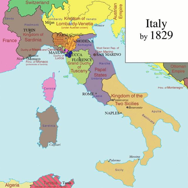
Italian unification (Italian: Unità d'Italia [uniˈta ddiˈtaːlja]), or the Risorgimento ([risordʒiˈmento], meaning "the Resurgence"), was the political and social movement that consolidated different states of the Italian peninsula into the single state of the Kingdom of Italy in the 19th century. The process began in 1815 with the Congress of Vienna and was completed in 1871 when Rome became the capital of the Kingdom of Italy.[1][2] (Wikipedia, 2019)
DMZ Eco-Peace Park Forum
Korea Institute for National Unification
December 3, 2014
Suyu-dong, Gangbuk-gu, Seoul
-Related Article-
-Korea.net-
-English-
DMZ park to become symbol of peace
www.korea.net/NewsFocus/Policies/view?articleId=123456
Ministry of Culture, Sports and Tourism
Korean Culture and Information Service
Korea.net (www.korea.net)
Official Photographer: Jeon Han
This official Republic of Korea photograph is being made available only for publication by news organizations and/or for personal printing by the subject(s) of the photograph. The photograph may not be manipulated in any way. Also, it may not be used in any type of commercial, advertisement, product or promotion that in any way suggests approval or endorsement from the government of the Republic of Korea.
--------------------------------
DMZ세계생태평화공원 학술회의
통일연구원
2014-12-03
강북구 수유동
-관련기사-
코리아넷
“DMZ세계생태평화공원은 평화의 상징”
www.kocis.go.kr/koreanet/view.do?seq=3421&page=1&...
문화체육관광부
해외문화홍보원
코리아넷
전한
North American RA-5C 'Vigilante' (Bu No 156625) at NAS North Island, California, while assigned to Reconnaissance Attack Squadron (RVAH) 7 during 1977-edited-Not part of my personal collection
un-edited-Not part of my personal collection
From Wikipedia, the free encyclopedia
The North American A-5 Vigilante is an American carrier-based supersonic bomber designed and built by North American Aviation for the United States Navy. It set several world records including long distance speed and altitude records. Its service in the nuclear strike role to replace the Douglas A-3 Skywarrior was very short; however, as the RA-5C, it saw extensive service during the Vietnam War in the tactical strike reconnaissance role. Prior to the unification of the Navy designation sequence with the Air Force sequence in 1962, it was designated the A3J Vigilante.
Design and development
In 1953, North American Aviation began a private study for a carrier-based, long-range, all-weather strike bomber, capable of delivering nuclear weapons at supersonic speeds. This proposal, the North American General Purpose Attack Weapon (NAGPAW) concept, was accepted by the United States Navy, with some revisions, in 1955. A contract was awarded on 29 August 1956. Its first flight occurred two years later on 31 August 1958 in Columbus, Ohio.
At the time of its introduction, the Vigilante was one of the largest and by far the most complex aircraft to operate from a United States Navy aircraft carrier. It had a high-mounted swept wing with a boundary-layer control system (blown flaps) to improve low-speed lift. There were no ailerons. Roll control was provided by spoilers in conjunction with differential deflection of the all-moving tail surfaces. The use of aluminum-lithium alloy for wing skins and titanium for critical structures was also unusual. The A-5 had two widely spaced General Electric J79 turbojet engines (the same as used on the McDonnell Douglas F-4 Phantom II fighter), fed by intake ramps and a single large all-moving vertical stabilizer. Preliminary design studies had employed twin vertical fin/rudders. The wings, vertical stabilizer and the nose radome folded for carrier stowage. The Vigilante had a crew of two seated in tandem, a pilot and a bombardier-navigator (BN) (reconnaissance/attack navigator (RAN) on later reconnaissance versions) seated on individual North American HS-1A ejection seats.
Despite being designated by the US Navy as a "heavy", the A-5 was surprisingly agile; without the drag of bombs or missiles, even escorting fighters found that the clean airframe and powerful engines made the Vigilante very fast at high and low altitudes. However, its high approach speed and high angle of attack in the landing configuration made returning to the aircraft carrier a challenge for inexperienced or unwary pilots.
The Vigilante had advanced and complex electronics when it first entered service. It had one of the first "fly-by-wire" systems on an operational aircraft (with mechanical/hydraulic backup) and a computerized AN/ASB-12 nav/attack system incorporating a head-up display ("Pilot's Projected Display Indicator" (PPDI), one of the first), multi-mode radar, radar-equipped inertial navigation system (REINS, based on technologies developed for North American's Navaho missile), closed-circuit television camera under the nose, and an early digital computer known as "Versatile Digital Analyzer" (VERDAN) to run it all.
Given its original design as a carrier-based, supersonic, nuclear heavy attack aircraft, the Vigilante's main armament was carried in a novel "linear bomb bay" between the engines in the rear fuselage, which provided for positive separation of the bomb from the aircraft at supersonic speeds. The single nuclear weapon, commonly the Mk 28 bomb, was attached to two disposable fuel tanks in the cylindrical bay in an assembly known as the "stores train". A set of extendable fins was attached to the aft end of the most rearward fuel tank. These fuel tanks were to be emptied during the flight to the target and then jettisoned with the bomb by an explosive drogue gun. The stores train was propelled rearward at about 50 feet per second (30 knots) relative to the aircraft. It thereafter followed a typical ballistic path.
In practice, the system was not reliable and no live weapons were ever carried in the linear bomb bay. In the RA-5C configuration, the bay was used solely for fuel. On three occasions, the shock of the catapult launch caused the fuel cans to eject onto the deck; this resulted in one aircraft loss.
The Vigilante originally had two wing pylons, intended primarily for drop tanks. The second Vigilante variant, the A3J-2 (A-5B), incorporated internal tanks for an additional 460 gallons of fuel (which added a pronounced dorsal "hump") along with two additional wing hardpoints, for a total of four. In practice the hardpoints were rarely used. Other improvements included blown flaps on the leading edge of the wing and sturdier landing gear.
The reconnaissance version of the Vigilante, the RA-5C, had slightly greater wing area and added a long canoe-shaped fairing under the fuselage for a multi-sensor reconnaissance pack. This added an APD-7 side-looking airborne radar (SLAR), AAS-21 infrared line scanner, and camera packs, as well as improved ECM. An AN/ALQ-61 electronic intelligence system could also be carried. The RA-5C retained the AN/ASB-12 bombing system, and could, in theory, carry weapons, although it never did in service. Later-build RA-5Cs had more powerful J79-10 engines with afterburning thrust of 17,900 lbf (80 kN). The reconnaissance Vigilante weighed almost five tons more than the strike version with almost the same thrust and an only modestly enlarged wing. These changes cost it acceleration and climb rate, though it remained fast in level flight.
The Royal Australian Air Force considered the RA-5C Vigilante as a replacement for its English Electric Canberra. The McDonnell F-4C/RF-4C, Dassault Mirage IVA, and the similar BAC TSR-2 was also considered. However, the TFX (later the F-111C Aardvark) was accepted.
Rep. Pascrell, co-chair of the Congressional Italian-American Delegation, joined a Congressional Delegation to Italy on the occasion of the 150th anniversary of Italian unification. Here, Rep. Pascrell meets with Dr. Miguel Humberto Diaz, U.S. Ambassidor to The Holy See. To the left of Rep. Pascrell are House Democratic Leader Nancy Pelosi (D-CA) and Rep. Rosa DeLauro (D-CT).
UNIFICATION OF NEPAL
Nepal was unified by King Prithvi Narayan Shah of Gorkha kingdom in the mid-eighteenth century by winning over other kingdoms and moving his capital to Kathmandu.
EARLY RULERS
Nepal's recorded history began with the Kiratis, who arrived in the Kathmandu valley in the 7th or 8th century BCE from the east. Little is known about them, other than their deftness as sheep farmers and fondness for carrying long knives. The Kirats ruled for about 1225 years (800 BCE-300 CE); they had a total of 28 kings during that time. Their first and best remembered king was Yalambar Haang, who is mentioned in the epic Mahabharata.
The first record of the word Nepal is found in ancient Indian annals such as the puranas from the 4th century A.D where an area known as 'Newal' or sometimes as 'Newar' is mentioned, referring to what is now known as the Kathmandu Valley. However, the area of the sovereign state of Nepal has changed from time to time during its history, expanding and shrinking in area since ancient times.
Of the kings originating inside or outside of modern Nepal, a common characteristic of attempting to unify Nepal from mostly west to east, along the southern track of the Himalayas and the northern plain of Ganges, can be identified. No Nepalese ruler has been recorded attempting to cross the Himalayas to expand their states into Tibet or China, and none has been recorded trying to cross the Ganges plain into modern India. For the most part, Nepalese rulers seem to have been focused on the territories that more or less comprise modern-day Nepal, between the region of Kashmir in the west and Bhutan in the east.
Nepal as a political region has been united by different kings of different kingdoms at various times in Nepalese history. Common tradition holds that among the first uniters of Nepal was a king by the name of Mandev, who ultimately controlled territory from the Brahmaputra River in the east to the Gandaki in the west. Recorded details of his unification, however, are scarce, and Mandev's actions and his very existence cannot be definitively confirmed. The same may be said for various early recorded and traditional (i.e. not necessarily recorded) rulers of Nepal, all of whose kingdoms apparently broke up when their dynasties died out. While records and documents of several such rulers do exist, a lack of interest has made their accessibility difficult and limited the number of translations and analyses.
KING PRITHVI NARAYAN SHAH
King Prithvi Narayan Shah (1723-1775) was born in the Shah dynasty of Gorkha on 11 January 1723 (27 Poush 1779 B.S.) After the death of Narabhupal shah on 25th chaitra he became the king of Gorkha. He ascended to the throne of Gorkha kingdom on 3 April 1743. He was interested in politics and diplomacy and had interests in both visiting and conquering other countries since his days as prince. He decided to enlarge his kingdom that was confined to the small Gorkha region of present-day Nepal and had an area of just 2,500 square km (approx. 50 km x 50 km). He defeated major principalities in wars and unified them under his rule starting from the 1740s ending with shifting of his Gorkha Kingdom’s capital from Gorkha region to Kathmandu in 1769. While he was successful at conquering the Kathmandu valley and the Sen kingdoms further east of the Kathmandu valley, his efforts were limited to the west of his homeland. He then attacked and absorbed dozens of other small principalities and gave a new name "Nepal" to his Gorkha kingdom. He was able to conquer some of the 22 principalities or kingdoms, known as the (thebaise raj-ya, and some of the 24 kingdoms (the chaubasi raj-ya), which were two sets of allies west of the King's homeland of Gorkha, in what is now called western Nepal.Soon after he ascended the throne of Gorkha Kingdom, Shah tricked his way into the royal household of Bhaktapur for a number of months. He wanted the rich agricultural soil of the valley, and the strategic point of the Kathmandu valley as a transit point for expanding trade with both Tibet and India. Then he planned the conquest of the valley. To this end, he decided to first capture Nuwakot, which belonged to the state of Kantipur, as a strategic point. He also foresaw that taking over Nuwakot would significantly strengthen the position of his Gorkha nation and weaken the states occupying the Kathmandu Valley. Nuwakot held strategic importance, as there was already a fort there, and it had remained as a connecting pass the valley and Tibet.
NUWAKOT
Prithivi Narayan was a very ambitious king. Along with the invasion of the Gorkha he wanted it to protect it from the Gorkha troops, so he started to unify the small kingdoms to be a single country . One year after becoming King, in 1744 AD, Prithvi Narayan Shah attacked Nuwakot but was repelled because the Gorkha army was not well equipped. In addition, conflicts of interest between the Pandeys and Basnets - two important warrior clans in the Gorkha palace - arose to add domestic political tension. Shah then made Kalu Pande "Mul Kaji (equivalent to Prime Minister)" of his state and thus strengthened his domestic political position. Almost a year later, on 2 October 1744, he attacked Nuwakot again and won, thus expanding the bounds of his Gorkha state.
KIRTIPUR
Kalu Pandey employed a strategy involving a blockade of the Kathmandu Valley, and subsequently took over the surrounding settlements and strategic positions around the valley. In the next two years (during 1745-46) he captured Mahadevpokhari, Pharping, Chitlang, Dharmasthali, Naldrum, Siranchok and Shivapuri. He then focused his attention on Kirtipur and Makawanpur, two palaces which were also strategic military targets. Kirtipur was in an elevated position with a fort surrounded by walls and jungles, an ideal place to make inroads into the valley. Shah thought that if he could take over Kirtipur, occupying the rest of the valley would be much easier. On 4 December 1757 he made his first attack on Kirtipur. In this war he lost his strong general Kalu pandey which was a great loss for gorkha. Kalu Pandey had told him that it was not the right time to attack Kritpur. His body was buried in Kirtipur. Prithvi Narayan Shah himself was nearly killed in the battle. As a result, the Gorkha army, having lost a great deal of morale, was defeated. It is said that as revenge for his two earlier defeats, The Gorkha army was repelled again in August 1765.
After two defeats, the Gorkha army changed its strategy again and surrounded Kirtipur during the harvest season, effectively laying siege to the stronghold. The Gorkha army also took over the nearby Balaju fort. After several months of this blockade, the people of Kirtipur could not even get water to drink and were forced to surrender to the Gorkha army on 17 March 1766. This time the Gorkha army took over Kirtipur without a fight. Prithvi Narayan Shah had his army cut off the noses and lips of all the people of Kirtipur.
Conquest of Southern Nepal and the Kathmandu Valley
As Nuwakot was a key point for Kathmandu’s trade with Tibet, Makawanpur in the south was equally important for trade with India. While the battle to surround Kathmandu was going on in the north, the Gorkha army captured Sindhulikot, Timilakot and Hariharpur in the south and southeast of modern-day Nepal before it entered into the Makawanpurgadhi territories. Makawanpur was captured after only 10 hours of battle in August 1762. In 1763 AD, the Gorkha army conquered seven other villages, including Dhulikhel and Banepa, and expanded the Gorkha state's border line further north. With this, the Kathmandu Valley was completely surrounded and blockaded. After all the four passes (Sanga, Baad, pati and Chandragiri Bhanjyang, also known as Char Bhanjyang) of the Kathmandu Valley were controlled by Prithvi Narayan Shah, the eventual lack of salt, oil, spices, and even clothes led to turmoil in the valley and disaster struck Kathmandu. When the local government failed to pay its soldiers, the morale of its military dwindled.
The king of Kathmandu at the time, Jaya Prakash Malla, then asked for military aid from the British in British India. In August 1767, when the forces of the British India arrived in Sindhuligadhi, the Gorkha military conducted guerrilla attacks against them. Many of the British Indian forces were killed and the rest eventually fled, leaving behind a huge amount of weapons and ammunitions, which were seized by the Gorkha army.
This boosted the morale of the forces of Prithvi Narayan Shah and further demoralized the kings of the Kathmandu Valley, among which was the king of Kantipur. In addition to this, the political situation of the valley, political wrangling inside the palace, and personal enmity had rendered the people of Kantipur very weak because Jaya Prakash Malla, the king of Kantipur, was of a paranoid nature, and his own brother and courtiers became dissatisfied with him. The state of Lalitpur had also faced chaos after the death of its king Yogendra Malla. Six pradhans (courtiers) then took power into their own hands, and put Tej Narsingh Malla on the throne; but the actual power in Lalitpur remained with the pradhans. In Bhaktapur as well, the palace of King Ranjeet Malla was in disarray due to domestic political wrangling. When Ranjeet Malla wanted to declare his two-year-old son as his heir, a queen (not through marriage) opposed it. This forced the king to declare his older illegitimate son as his heir to the throne. This only fueled conflict in the palace, as a result of which the palace was weakened further.
While the three kingdoms of the Kathmandu Valley were engaged in clashes and enmity, Prithvi Narayan Shah used this opportunity to impose an economic blockade against the entire valley region. He closed the trade route to Tibet, which passed through Nuwakot. The Gorkha army marched into the valley. On 25 September 1768, when the people of Kathmandu were celebrating the Festival of Indrajatra, Prithvi Narayan Shah won an easy victory over Kantipur.
Some historians doubt this version of the history written by the conquerors. They say that the valley was overtaken not in September but in cold December. The official version of overwhelmingly large force that captured Kathmandu is considered historically inaccurate. The truth, however, is that the powerful Pradhan courtiers of Kathmandu were promised lucrative positions in the new Kingdom in exchange for their help in killing the beleaguered king. The king realized that he had enemies galore and fled to the neighboring Bhaktapur, leaving the throne empty in Kathmandu. Upon easing his way to the throne of the Kathmandu, the very next day, he ordered the beheading of all of the Pradhan courtiers and their extended society.
Eleven days later (6 October 1768), he conquered Lalitpur. On 14 April 1769, he gained the town of Thimi and seven months later (17 November 1769) he took over Bhaktapur. In this way, the whole Kathmandu Valley came under the control of Prithvi Narayan Shah.
DIPLOMATIC RELATIONS
Prithivi narayan Shah was very effortful to have good relations with different states for making his unification campaign a success. As a representative of his father, he had a pact with Lamjung, the old age enemy. Later he himself signed a treaty with King of Lamjung through the efforts sought be Kalu Pandey. Relations with the Malla Kingdoms was also important. PNS signed separate treaties with Kantipur and Bhaktapur, which are as follow : 1) to circulate the currency of either states in both states. 2) to carry joint trade with Tibet and share the incomes. 3) to enjoy rights to depute a state representative to Tibet. 4) to allow Kantipur to use the territory of Nuwakot for trade with Tibet. (Anush)
ESTABLISHMENT OF A UNITED KINGDOM OF NEPAL
After his conquest of the Kathmandu Valley, Prithvi Narayan Shah conquered other smaller countries south of the valley to keep other smaller fiefdoms near his Gurkha state out of the influence and control of the British rule. After his kingdom spread out from north to south, he made Kantipur the capital of expanded country which was known as Kingdom of Gorkha (Gorkha Samrajya).It was renamed as Kingdom of Nepal in 1930. by King Tribhuvan Bir Bikram Shah.
Bulevardul Unirii (Unification Boulevard) is a major thoroughfare in central Bucharest, Romania. It connects Alba Iulia Square with Constitution Square, and also runs through Unification Square. The Constitution Square end features the Palace of the Parliament.
Following the 1977 Vrancea earthquake, Bucharest's city center suffered significant damage, and a large number of historic buildings were demolished to make way for the new Centrul Civic (Civic Center; see systematization and Ceaușima). As part of the project, Bulevardul Unirii was to be Communist Romania's answer to Paris's Avenue des Champs-Élysées, with a length of 3,500 m. Construction began on June 25, 1984. Initially called Bulevardul Victoria Socialismului (Victory of Socialism Boulevard), the road is lined with socialist-realist apartment blocks of North Korean inspiration [Wikipedia.org]
Korea Global Forum 2016
November 14, 2016
Shilla Hotel, Jung-gu, Seoul
Ministry of Culture, Sports and Tourism
Korean Culture and Information Service
Korea.net (www.korea.net)
Official Photographer : Jeon Han
This official Republic of Korea photograph is being made available only for publication by news organizations and/or for personal printing by the subject(s) of the photograph. The photograph may not be manipulated in any way. Also, it may not be used in any type of commercial, advertisement, product or promotion that in any way suggests approval or endorsement from the government of the Republic of Korea.
-------------------------------------------------
한반도국제포럼 2016
2016-11-14
신라호텔
문화체육관광부
해외문화홍보원
코리아넷
전한
AWIB-ISAW: Seti I Temple Reliefs at Abydos (IX)
A relief depicting two deities binding together the sema which represents the unification of upper and lower Egypt. This relief is part of a group of mythological scenes. by Kyera Giannini (2009)
copyright: 2009 Kyera Giannini (used with permission)
photographed place: Abdju (Abydos) [pleiades.stoa.org/places/756512]
Published by the Institute for the Study of the Ancient World as part of the Ancient World Image Bank (AWIB). Further information: [www.nyu.edu/isaw/awib.htm].
This relief is on the side of the throne of one of the colossal statues of Rameses II immediately beside the passageway that leads into his temple at Abu Simbel. It shows his cartouche in the middle, with figures representing upper and lower Egypt symbolically uniting the country.
Compare this to the similar scene from the Colossi of Memnon in Luxor:
www.flickr.com/photos/ckirie/4317805166/in/album-72157623...
The image has been corrected for perspective.
Temple of Rameses II at Abu Simbel, Egypt
The city of Beijing has a long and rich history that dates back over 3,000 years. Prior to the unification of China by the First Emperor in 221 BC, Beijing was for centuries the capital of the ancient states of Ji and Yan. During the first millennia of imperial rule, Beijing was a provincial city in northern China. Its stature grew in the 10th to the 13th centuries when the nomadic Khitan and Jurchen peoples from the steppes expanded southward and made the city a capital of their dynasties, the Liao and Jin. When Kublai Khan made Dadu the capital of the Mongol-led Yuan Dynasty (1279–1368), all of China was ruled from Beijing for the first time. From 1279 onward, with the exception of two interludes from 1368 to 1421 and 1928 to 1949, Beijing would remain as China's capital, serving as the seat of power for the Ming Dynasty (1421–1644), the Manchu-led Qing Dynasty (1644–1912), the early Republic of China (1912–1928) and now the People's Republic of China (1949–present).
The Reichstag, the seat of the German Parliament, is one of Berlin's most historical landmarks. It is close to the Brandenburger Tor and before the unification, it was right next to the wall.
After the founding of the German Empire in 1872, there was a need for a large parliamentary building in Berlin. Paul Wallot designed an imposing neo- renaissance building, 137m long and 97m wide (450x318 ft).The building was constructed between 1884 and 1894, mainly funded with wartime reparation money from France. The famous inscription 'Dem Deutschen Volke' (To the German People) was only added in 1916.
In 1933 fire broke out in the building, destroying much of the Reichstag. It is to date still unclear who started the fire, but the Communists were blamed. It gave a boost to Hitler's Party, the NSDAP, who would soon come to power. The building was damaged even more at the end of the war, when the Soviets entered Berlin. The picture of a Red Army Soldier raising the Soviet flag on the Reichstag is one of the most famous 20th century images and symbolized Germany's defeat.
The central dome and most of the ornamentation were removed during the reconstruction after the war. After the unification the decision was made to move the Bundestag from Bonn back to Berlin.This decision resulted in the latest reconstruction which started in 1995 and was completed in 1999.
The design by Sir Norman Foster added a glass dome over the plenary hall. At first the subject of much controversy, the dome has become one of the city's most recognized landmarks. Since April 1999, the Reichstag is once again the seat of the Bundestag. You can visit the Reichstag and walk all the way to the top of the dome.
AN EGYPTIAN MOSAIC GLASS 'UNIFICATION' BAR AND THREE INLAYS
PTOLEMAIC-ROMAN PERIOD, CIRCA 1ST CENTURY B.C.-1ST CENTURY A.D.
Depicting lotus bundles standing in a pool of water entwined with papyrus stalks around the hieroglyph sema, in turquoise, cobalt blue, yellow and black, in red matrix
bar: 5/8 in. (1.6 cm.) long; inlays: 3/8 in. x 3/8 in. (1 cm. x 1 cm.) each
Groppi, 8
Typical of its time but no longer appealing to public taste, Germany's Niederwald Monument ("Germania") stands on a steep hill above the Rhine river near Rudesheim. It was erected in the years 1877-1883 to symbolize the re-establishment of the German empire that was a direct result of the outcome of the Franco-Prussian War of 1870-71 (the war that led to the unification of Germany under Prussian hegemony as an imperial monarchy).
The main figure (at top of monument) is that of Germania who represents Germany. She holds the imperial crown in her raised right hand and the imperial sword in her left. For many years this monument reflected national pride and the creation of a single German nation but, today within the context of present-day Europe, such warlike feelings appear outmoded. The monument remains, however, an important relic of an epoch and an era...much like the dinosaur of the past.
Bulevardul Unirii (Unification Boulevard) is a major thoroughfare in central Bucharest, Romania. It connects Alba Iulia Square with Constitution Square, and also runs through Unification Square. The Constitution Square end features the Palace of the Parliament.
Following the 1977 Vrancea earthquake, Bucharest's city center suffered significant damage, and a large number of historic buildings were demolished to make way for the new Centrul Civic (Civic Center; see systematization and Ceaușima). As part of the project, Bulevardul Unirii was to be Communist Romania's answer to Paris's Avenue des Champs-Élysées, with a length of 3,500 m. Construction began on June 25, 1984. Initially called Bulevardul Victoria Socialismului (Victory of Socialism Boulevard), the road is lined with socialist-realist apartment blocks of North Korean inspiration [Wikipedia.org]
The Reichstag, the seat of the German Parliament, is one of Berlin's most historic landmarks. It is close to the Brandenburger Gate and before the unification, it was located right next to the Berlin Wall.
The building was constructed between 1884 and 1894, mainly funded with wartime reparation money from France, a result of Prussia's defeat of France in 1871. The famous inscription 'Dem Deutschen Volke' (To the German People) was added later, in 1916, by emperor Wilhelm II. The bronze letters were cast from seized French cannons.
After the war, the Reichstag ended up in West Berlin, right near the Berlin Wall. It was reconstructed between 1958 and 1972 but the central dome and most of the ornamentation were removed. During Berlin's division the West German parliament assembled here once a year as a way to indicate that Bonn was only a temporary capital. After the unification the decision was soon made to move the Bundestag (Germany's Parliament) from Bonn to Berlin. This decision resulted in a renovation which started in 1995 and was completed in 1999.
The design by Sir Norman Foster added a glass dome over the plenary hall. At first the subject of much controversy, the dome has become one of the city's most recognized landmarks.
Since April 1999, the Reichstag is once again the seat of the Bundestag. A part of the Reichstag is open to the public. An elevator brings you to the building's roof and you can even walk all the way to the top of the dome via a spiral walkway.
As you need to book this tour in advance, owing to time constraints and my husband's illness, I was unable to visit this historic and interesting building.
Kim Yusin (595 – 18 August 673) was a general in 7th-century Silla. He led the unification of the Korean peninsula by Silla under the reign of King Muyeol of Silla and King Munmu of Silla. He is said to have been the great-grandchild of King Guhae of Geumgwan Gaya, the last ruler of the Geumgwan Gaya state. This would have given him a very high position in the Silla bone rank system, which governed the political and military status that a person could attain.
Much of what we know about Kim's life comes from the detailed account in the Samguk Sagi, Yeoljeon 1-3, and the much briefer record in the Samguk Yusa, vol. 1.
EARLY YEARS
Kim Yusin was the son of General Kim Seohyeon (the second son of General Kim Mu-ryeok) and Lady Manmyeong, who was a daughter of Kim Sukheuljong (hangul 김숙흘종 hanja 金肅訖宗, King Jinheung of Silla's younger brother). He was born in Gyeyang, Jincheon County in 595, became a Hwarang warrior at just 15 and was an accomplished swordsman and a Gukseon (국선, 國仙; Hwarang leader) by the time he was 18 years old. By the age of 34 (in 629) he had been given total command of the Silla armed forces. Three years later, Kim Yusin's cousin, Princess Deokman, became Queen Seondeok of Silla and kept Kim Yusin as commander in chief of the royal army. During the reign of Queen Seondeok of Silla (632-647), Kim Yusin owned ten thousands private soldiers, won many battles against Baekje and became one of the most powerful men in Silla.
MILITARY ACCOMPLISHMENTS
Kim's first military engagement in command is believed to have occurred around 629 AD, and through it he quickly proved his capabilities as a warrior. Silla was in a constant struggle with its neighbor to the west, Baekje, over territory. There had been gains and losses on both sides, and the struggle lasted for many years. It was during this period that Kim rose through the ranks of the military, rising to the position of general and becoming a skilled field commander.
Baekje and Silla had formed an alliance to counter Goguryeo's power and its intentions to push southwards, and together they launched a successful attack on it, Silla taking the northern territory and Baekje the one south of the Han river. But Silla broke the alliance and attacked Baekje in order to claim both territories for itself. After this betrayal, Baekje allied with Goguryeo. When Goguryeo and Baekje attacked Silla in 655, Silla joined forces with Tang Dynasty China to battle the invaders. Although it is not clear when Kim first became a general, he was certainly commanding the Silla forces by this time. Eventually, with the help of the Silla navy and some 130,000 Tang forces, Kim attacked the Baekje capital, Sabi, in 660, in one of the most famous battles of that century, the Battle of Hwangsanbeol.
The Baekje defenders were commanded by none other than General Gyebaek, although the Baekje forces consisted of about 5,000 men and were no match for Kim's warriors, which numbered about ten times as many. Baekje, which had already been experiencing internal political problems, crumbled. Kim's Silla forces and their Tang allies now moved on Goguryeo from two directions, and in 661 they attacked the seemingly impregnable Goguryeo kingdom, but were repelled. The attack had weakened Goguryeo, though. In 667 another offensive was launched which, in 668, finally destroyed Goguryeo.
Silla still had to subdue various pockets of resistance, but their efforts were then focused on ensuring that their Tang allies did not overstay their welcome on the peninsula. After some difficult conflicts, Silla eventually forced out the Tang troops and united the peninsula under their rule.
LEGENDS
Many stories exist about Kim Yusin. It is told that he once was ordered to subdue a rebel army, but his troops refused to fight as they had seen a large star fall from the sky and took this to be a bad omen. To regain the confidence of his troops, the General used a large kite to carry a fire ball into the sky. The soldiers, seeing the star return to heaven, rallied and defeated the rebels. It is also related how General Kim ingeniously used kites as a means of communication between his troops when they had become divided between islands and the mainland.
Another story relates how, while Silla was allied with the Tang Dynasty against Baekje, an argument broke out between Kim's commander and So Jung-Bang, a Tang general. As the argument escalated into a potentially bloody confrontation, Kim's sword was said to have leaped from its scabbard into his hand. Because the sword of a warrior was believed to be his soul, this occurrence so frightened the Tang general that he immediately apologized to the Silla officers.
HIS FINAL YEARS
Throughout his life Kim Yusin had felt that Baekje, Goguryeo, and Silla should not be separate countries but united. He is regarded as the driving force in the unification of the Korean Peninsula, and is the most famous of all the generals in the unification wars of the Three Kingdoms.
Kim Yusin was rewarded handsomely for his efforts in the campaigns. In 668, King Munmu bestowed upon him the honorary title of Taedaegakgan (태대각간, 太大角干), something like "Supreme Herald of Defense" (literally "greatest-great-trumpet-shield"). He reportedly received a village of over 500 households, and in 669 was given some 142 separate horse farms, spread throughout the kingdom. He died four years later, leaving behind ten children.
Kim Yusin lived to the age of 79 and is considered to be one of the most famous generals and masters of Korean swords in Korean history. He is the focus of numerous stories and legends, and is familiar to most Koreans from a very early age. Following his death on 18 August (the 1st day of the 7th lunar month) 673, General Kim was awarded the honorary title of King Heungmu, and was buried at the foot of Songhwa Mountain, 35.8456477°N 129.1911292°E near Gyeongju in southeastern Korea, in a tomb as splendid as that of kings.
FAMILY
Kim Yusin had two sisters, Kim Bohui and Kim Munhui (Hangul: 김문희, Hanja: 金文姬). Kim Munhui, later known as Queen Munmyeong (Hangul: 문명왕후, Hanja: 文明王后), married Yusin's childhood friend King Muyeol of Silla, who is credited for having led the unification of the Korean peninsula under Silla. Muyeol and Munmyeong were the parents of King Munmu of Silla and Kim Inmun.
Kim Yusin's third wife, Lady Jiso (智炤夫人), was the third daughter of King Muyeol of Silla. Yusin had ten children. His second son, Kim Wonsul, would later play a central role in completing the independence of Silla from the Tang Dynasty.
LEGACY
Kim Yusin is remembered by his people to have been one of the greatest generals in Korean history. His ultimate legacy is the unifying of the Korean nation. One of his ten children, his second son Kim Wonsul, became a general during the time of King Munmu of Silla, and he was essential in unifying Silla.
WIKIPEDIA
Playmates - Star Trek Next Generation "Unification"
* Captain Picard as a Romulan
* Ambassador Spock
* Lt. Cmdr. Data as a Romulan
Malachi posed for this picture for me at Shore Leave Con July 9, 2005. It was early in the morning and his was the first picture I got signed that day.
Opening Ceremony for Dorasan Unification Platform
October 14, 2015
Dorasan Station, Paju-si, Gyeonggi-do
Ministry of Culture, Sports and Tourism
Korean Culture and Information Service
Korea.net (www.korea.net)
Official Photographer : Jeon Han
This official Republic of Korea photograph is being made available only for publication by news organizations and/or for personal printing by the subject(s) of the photograph. The photograph may not be manipulated in any way. Also, it may not be used in any type of commercial, advertisement, product or promotion that in any way suggests approval or endorsement from the government of the Republic of Korea.
-------------------------------------------------
도라산역 통일플랫폼 개장식
2015-10-14
경기도 파주시 도라산역
문화체육관광부
해외문화홍보원
코리아넷
전한
Shinheungsa Temple Bojeru - Seoraksan
Sinheungsa, sometimes spelled Shinheungsa, is a head temple of the Jogye Order of Korean Buddhism. It is situated on the slopes of Seoraksan in Sokcho, Gangwon Province, South Korea.
Sinheungsa is located in Seoraksan National Park, and many tourists hiking Seoraksan up to Ulsanbawi (peak) pass by the temple on the way.
The Great Unification Buddha, a 14.6-meter, 108 ton gilt-bronze Buddha statue, called "Tongil Daebul", sits atop a 4.3-meter high pedestal, of the same material, making the total height 18.9-meter, excluding the lightning rod and nimbus.
The lotus pedestal is flanked with 16 delicately engraved panels and the forehead of Tongil Daebul is adorned with eight 8-centimeter stones of amber, with a single piece of jade in the center that is 10-centimeter in diameter.
Tongil Daebul sits with legs crossed and half-closed eyes in meditation, his lips displaying a perceptible smile. A flowing robe with gentle folds, revealing the right shoulder, drapes the Buddha's robust torso. The hands of Tongil Daebul are positioned in the mudra symbolizing the "enlightened one."
Contained within the hollow statue are three pieces of the Buddha's sari, remains collected after his cremation, donated by the Myanmar government, and the Tripitaka, the original Buddhist scriptures.
This statue represents the crucial wish of the Korean people for the reunification of the divided country.
Pro-unification slogans decorate the stairs of the Jingmei Detention Centre. They contrast with pro-Taiwan slogans on the other side.
Maxwell with his colour wheel, used to demonstrate the composition of white light. His dog Toby is at his feet.
This is the new monument, unveiled on the 25th November 2008, to the Edinburgh-born physicist James Clerk Maxwell (1831-1879), hailed as the greatest mathematical physicist since Newton.
The James Clerk Maxwell Statue is by Scottish sculptor Alexander Stoddart, and is located at the east end of George Street, Edinburgh.
Maxwell was responsible for the second great unification in physics, that of electricity and magnetism, after the first unification, by Newton, of terrestrial and celestial mechanics. He also made important contributions to statistical mechanics (see Maxwell's demon).
.
Maxwell was born at 14 India Street, at the other end of Edinburgh's New Town.
His experimentation with colour photography is less well known, but his photograph of a tartan ribbon is considered to have have been the first colour photograph.
This album also in the Collection: "The Physicists"
View this set as a slideshow
Finding an abstract that shows how I see the world, how I perceive reality, what I want to express is an undescribable pleasure. It doesn't matter what the subject is, the point of this photograph is what it makes you feel, what it stirrs in you, what memories it brings back, if you find meaning in it, if you find it beautiful, interesting, intriguing...
Please visit me at:
Encontrar un abstracto que muestre cómo veo el mundo, percibo la realidad, sea un reflejo de mí... es un placer indescriptible. No importa qué es el sujeto, sino lo que esta fotografía te transmite, lo que te hace recordar, las emociones que te provoca, si encuentras que la imagen es bella, interesante, expresiva.
Por favor, visítame en:
Dynasty II, at or after the death of Intef II
(ca. 2108-2059 B.C.)
Limestone
From Thebes
King Intef II offers beer and milk to the goddess Hathor and the sun god Re. The inscription consists of two hymns, one to Atum, the god of the evening sun, and the other to Hathor, who is called upon to appear in the morning. Intef II Wahankh was the most important of the pre-unification rulers of Dynasty II.
Metropolitan Museum of Art
NYC