View allAll Photos Tagged Testbed
As its entry into the burgeoning business jet market, North American designed the Sabreliner as a private venture, though with an eye towards the military market as well. It was named the Sabreliner because of the similarity of its wing design with the F-86 Sabre fighter, one of North American's iconic aircraft. The prototype NA-265 flew in 1958, and was marketed as the Series 40 for civilian operators, while the USAF bought it as an executive transport and trainer, the T-39A, in 1961.
Sales were decent if not spectacular, though most Sabreliner production went to military customers, specifically the USAF and US Navy. Over 800 were built, and many remain in service; most of those still around are turbofan-powered Model 75s.
This is the only Sabreliner 50 produced: though it was essentially a Sabreliner 60, it was designed from the start as an electronics testbed with a radar nose. The nose was interchangeable with other noses as needed. N50CR would go on to test several radar systems, mainly for commercial aircraft, including electronics to detect wind shear and bad weather, as well as the TCAS II system, designed to prevent midair collisions. By 2013, N50CR had hit the end of its service life, and this unique aircraft was donated to the Evergreen Aviation Museum.
Week 3 of the Hazard Services - Probabilistic Hazard Information (HS-PHI) experiment in the NOAA Hazardous Weather Testbed (HWT) at the National Weather Center in Norman, OK. The HS-PHI experiment is part of the Experimental Warning Program. This is the third year of the HS-PHI experiment in the HWT.The HS-PHI experiment advances the Forecasting A Continuum of Environmental Threats (FACETs) initiative by testing software which allows National Weather Services (NWS) forecasters to issue Probabilistic Hazard Information (PHI) at the severe weather warning time and space scales.
The Multi-Radar Multi-Sensor (MRMS) Hydrometeorology Testbed - Hydro (hereafter denoted as HMT-Hydro) experiment is a part of the United States Weather Research Program (USWRP) through the Hydrometeorology Testbed (HMT) that runs from 24 June to 19 July 2019. During the HMT-Hydro experiment, forecasters and hydrologists from the National Weather Service (NWS) will work with National Severe Storms Laboratory (NSSL) research scientists to explore new technology and techniques to improve the prediction and warning of flash flooding. In particular, NWS participants will evaluate new probabilistic hydrologic modeling concepts and output within the Flooded Locations and Simulated Hydrographs (FLASH) system that could help convey the uncertainty of the flash flood threat. NWS participants will also evaluate high resolution precipitation forecasts from the NSSL Warn-on-Forecast (WoF) project and the addition of these forecasts into the FLASH system. Feedback from participants will allow NSSL research scientists to identify how these high spatio-temporal resolution precipitation forecasts could influence the warning decision making process, including the potential for increased warning lead time. Evaluations of the various probabilistic data sets will provide further understanding on the usability and effectiveness of these products, as well as guide future efforts of the Forecasting A Continuum of Environmental Threats (FACETs) project for flooding hazards. The HMT-Hydro experiment runs in conjunction with the Flash Flood and Intense Rainfall (FFaIR) experiment at the Weather Prediction Center (WPC) to collaborate on the short-term forecasting of flash flooding for both a national and regional scale.
11/2014 - Altoona, PA
Inside the cab of NS 1000, formerly Conrail Q1, the SD45 engine testbed used at the Juniata Shops. Built 6/1968.
#2 control stand is inactive.
Boeing's testbed N757A arriving BWI. Note that this is before the F22 wing was added to the aircraft.
NSH-60B 162337 was a testbed at Patuxent River NAWCAD for many programs and now serves as a gate guard. The cherry blossoms were almost at their peak when I took this photo, although I didn't quite get the composition that I had hoped for.
The Multi-Radar Multi-Sensor (MRMS) Hydrometeorology Testbed - Hydro (hereafter denoted as HMT-Hydro) experiment is a part of the United States Weather Research Program (USWRP) through the Hydrometeorology Testbed (HMT) that runs from 24 June to 19 July 2019. During the HMT-Hydro experiment, forecasters and hydrologists from the National Weather Service (NWS) will work with National Severe Storms Laboratory (NSSL) research scientists to explore new technology and techniques to improve the prediction and warning of flash flooding. In particular, NWS participants will evaluate new probabilistic hydrologic modeling concepts and output within the Flooded Locations and Simulated Hydrographs (FLASH) system that could help convey the uncertainty of the flash flood threat. NWS participants will also evaluate high resolution precipitation forecasts from the NSSL Warn-on-Forecast (WoF) project and the addition of these forecasts into the FLASH system. Feedback from participants will allow NSSL research scientists to identify how these high spatio-temporal resolution precipitation forecasts could influence the warning decision making process, including the potential for increased warning lead time. Evaluations of the various probabilistic data sets will provide further understanding on the usability and effectiveness of these products, as well as guide future efforts of the Forecasting A Continuum of Environmental Threats (FACETs) project for flooding hazards. The HMT-Hydro experiment runs in conjunction with the Flash Flood and Intense Rainfall (FFaIR) experiment at the Weather Prediction Center (WPC) to collaborate on the short-term forecasting of flash flooding for both a national and regional scale.
Telephonics - Beechcraft Model 200T Super King Air - N170RL (c/n BT-28/ ex- BB-1117)
This is the Telephonics flying radar testbed. Note the black radome on the underside of the aircraft.
Project: Tiny TIM (Threats-In-Motion)
Location: NOAA Hazardous Weather Testbed / National Weather Center (Norman, OK)
Date: Feb 15, 2023
Photographer: James Murnan / NOAA NSSL
This experiment brings together NWS forecasters and researchers to evaluate and provide feedback on the concept of allowing warnings to be extended in time and area, a first step towards Threats-In-Motion (TIM) for severe weather warnings for hail, wind, and tornadoes. To facilitate this evaluation, forecasters use Hazard Services Convective to create and manage TIM warnings. The concept and software is tested on several archived cases.
Mojave County, California 21/10/81
N402FS c/n 12841
Delivered to USNavy BuNo 149516
Now on display as a re-configured A-4K at RNZAF Museum, Chrstchurch as NZ6207
See also:
www.airforcemuseum.co.nz/main/McDonnellSkyhawk/
1000aircraftphotos.com/Contributions/Visschedijk/7287L.jpg
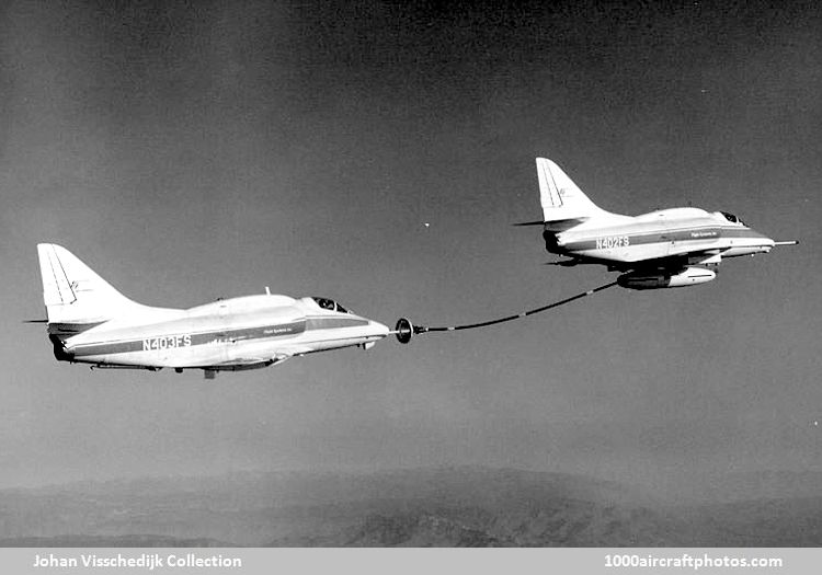
N403FS C/n 12996.
Delivered to USMC BuNo 150586
Now mounted on plinth at MCAS Yuma
See also:
The Multi-Radar Multi-Sensor (MRMS) Hydrometeorology Testbed - Hydro (hereafter denoted as HMT-Hydro) experiment is a part of the United States Weather Research Program (USWRP) through the Hydrometeorology Testbed (HMT) that runs from 24 June to 19 July 2019. During the HMT-Hydro experiment, forecasters and hydrologists from the National Weather Service (NWS) will work with National Severe Storms Laboratory (NSSL) research scientists to explore new technology and techniques to improve the prediction and warning of flash flooding. In particular, NWS participants will evaluate new probabilistic hydrologic modeling concepts and output within the Flooded Locations and Simulated Hydrographs (FLASH) system that could help convey the uncertainty of the flash flood threat. NWS participants will also evaluate high resolution precipitation forecasts from the NSSL Warn-on-Forecast (WoF) project and the addition of these forecasts into the FLASH system. Feedback from participants will allow NSSL research scientists to identify how these high spatio-temporal resolution precipitation forecasts could influence the warning decision making process, including the potential for increased warning lead time. Evaluations of the various probabilistic data sets will provide further understanding on the usability and effectiveness of these products, as well as guide future efforts of the Forecasting A Continuum of Environmental Threats (FACETs) project for flooding hazards. The HMT-Hydro experiment runs in conjunction with the Flash Flood and Intense Rainfall (FFaIR) experiment at the Weather Prediction Center (WPC) to collaborate on the short-term forecasting of flash flooding for both a national and regional scale.
Michigan Balloon Recovery & Satellite Testbed (MBuRST) members release a high altitude balloon.
Photo: Ben Logan, Social Media Guru – Communications and Marketing, Michigan Engineering
Installation / performance
Sphæræ at EAPlab
For the whole month of June the mobile multi-dome structure for immersive and synaesthetic experiences designed by Cocky Eek (FoAM) was the testbed for a range of artists invited by iii to experiment and develop new artworks for the venue, with a main focus on the in-depth exploration of the unique auditive, visual and spatial affordances of Sphæræ.
A number of the artists participating in the residency present their results – ranging from fundamental experimentation to full-fledged new works. You are cordially invited to join this event and experience disorienting acoustic explorations, morphing and breathing architectures and pulsating audiovisual fields piercing Sphæræ’s ethereal atmosphere.
11/2013 - Huntington, WV
Overview of the CSX Huntington Locomotive Shop. The engine by itself is HLS 1, Huntington's testbed unit, an SD45-2 of Clinchfield heritage.
RA-85317, Tupolev Tu-154M-LL, c/n 78A317, Future Aircraft Control Testbed / Gromov Flight Research Institute
Reshade 0.15 Extreme Eyecancer Mod Testbed 0.1A
Blackfire's mod + TOD + Reli2
Ini tweaks + POM enabled
Lite TOD, light shadows, nohud, dof %25-50, adjusted brightess, contrast and gamma + exposure
80º FoV
SMAA (sweetfx+master effect) FXAA (custom settings)
Tonemap
Lensdirt
Vibrance
GPC Dof
Chromatic Aberration
Grain + noise
Letterbox
I don't even know why. I was too busy thinking if I could stack all these effects I didn't stop to think if I should.
Project: Tiny TIM (Threats-In-Motion)
Location: NOAA Hazardous Weather Testbed / National Weather Center (Norman, OK)
Date: Feb 14, 2023
Photographer: James Murnan / NOAA NSSL
This experiment brings together NWS forecasters and researchers to evaluate and provide feedback on the concept of allowing warnings to be extended in time and area, a first step towards Threats-In-Motion (TIM) for severe weather warnings for hail, wind, and tornadoes. To facilitate this evaluation, forecasters use Hazard Services Convective to create and manage TIM warnings. The concept and software is tested on several archived cases.
MRMS HMT Hydro Experiment
The Multi-Radar Multi-Sensor (MRMS) Hydrometeorology Testbed - Hydro (hereafter denoted as HMT-Hydro) experiment is a part of the United States Weather Research Program (USWRP) through the Hydrometeorology Testbed (HMT) that runs from 25 June to 20 July 2018. During the HMT-Hydro experiment, forecasters and hydrologists from the National Weather Service (NWS) will work with National Severe Storms Laboratory (NSSL) research scientists to assess new technology and techniques to improve the prediction and warning of flash flooding. In particular, NWS participants will evaluate new probabilistic hydrologic modeling concepts and output within the Flooded Locations and Simulated Hydrographs (FLASH) system that could help convey the uncertainty of the flash flood threat. NWS participants will also evaluate high resolution precipitation forecasts from the NSSL Warn-on-Forecast (WoF) project and the addition of these forecasts into the FLASH system. Feedback from participants will allow NSSL research scientists to identify how these precipitation forecasts could influence the warning decision making process, including the potential for increased warning lead time. The HMT-Hydro experiment runs in conjunction with the Flash Flood and Intense Rainfall (FFaIR) experiment at the Weather Prediction Center (WPC) to collaborate on the short-term forecasting of flash flooding for both a national and regional scale.
The Multi-Radar Multi-Sensor (MRMS) Hydrometeorology Testbed - Hydro (hereafter denoted as HMT-Hydro) experiment is a part of the United States Weather Research Program (USWRP) through the Hydrometeorology Testbed (HMT) that runs from 24 June to 19 July 2019. During the HMT-Hydro experiment, forecasters and hydrologists from the National Weather Service (NWS) will work with National Severe Storms Laboratory (NSSL) research scientists to explore new technology and techniques to improve the prediction and warning of flash flooding. In particular, NWS participants will evaluate new probabilistic hydrologic modeling concepts and output within the Flooded Locations and Simulated Hydrographs (FLASH) system that could help convey the uncertainty of the flash flood threat. NWS participants will also evaluate high resolution precipitation forecasts from the NSSL Warn-on-Forecast (WoF) project and the addition of these forecasts into the FLASH system. Feedback from participants will allow NSSL research scientists to identify how these high spatio-temporal resolution precipitation forecasts could influence the warning decision making process, including the potential for increased warning lead time. Evaluations of the various probabilistic data sets will provide further understanding on the usability and effectiveness of these products, as well as guide future efforts of the Forecasting A Continuum of Environmental Threats (FACETs) project for flooding hazards. The HMT-Hydro experiment runs in conjunction with the Flash Flood and Intense Rainfall (FFaIR) experiment at the Weather Prediction Center (WPC) to collaborate on the short-term forecasting of flash flooding for both a national and regional scale.
The Multi-Radar Multi-Sensor (MRMS) Hydrometeorology Testbed - Hydro (hereafter denoted as HMT-Hydro) experiment is a part of the United States Weather Research Program (USWRP) through the Hydrometeorology Testbed (HMT) that runs from 24 June to 19 July 2019. During the HMT-Hydro experiment, forecasters and hydrologists from the National Weather Service (NWS) will work with National Severe Storms Laboratory (NSSL) research scientists to explore new technology and techniques to improve the prediction and warning of flash flooding. In particular, NWS participants will evaluate new probabilistic hydrologic modeling concepts and output within the Flooded Locations and Simulated Hydrographs (FLASH) system that could help convey the uncertainty of the flash flood threat. NWS participants will also evaluate high resolution precipitation forecasts from the NSSL Warn-on-Forecast (WoF) project and the addition of these forecasts into the FLASH system. Feedback from participants will allow NSSL research scientists to identify how these high spatio-temporal resolution precipitation forecasts could influence the warning decision making process, including the potential for increased warning lead time. Evaluations of the various probabilistic data sets will provide further understanding on the usability and effectiveness of these products, as well as guide future efforts of the Forecasting A Continuum of Environmental Threats (FACETs) project for flooding hazards. The HMT-Hydro experiment runs in conjunction with the Flash Flood and Intense Rainfall (FFaIR) experiment at the Weather Prediction Center (WPC) to collaborate on the short-term forecasting of flash flooding for both a national and regional scale.
The Multi-Radar Multi-Sensor (MRMS) Hydrometeorology Testbed - Hydro (hereafter denoted as HMT-Hydro) experiment is a part of the United States Weather Research Program (USWRP) through the Hydrometeorology Testbed (HMT) that runs from 24 June to 19 July 2019. During the HMT-Hydro experiment, forecasters and hydrologists from the National Weather Service (NWS) will work with National Severe Storms Laboratory (NSSL) research scientists to explore new technology and techniques to improve the prediction and warning of flash flooding. In particular, NWS participants will evaluate new probabilistic hydrologic modeling concepts and output within the Flooded Locations and Simulated Hydrographs (FLASH) system that could help convey the uncertainty of the flash flood threat. NWS participants will also evaluate high resolution precipitation forecasts from the NSSL Warn-on-Forecast (WoF) project and the addition of these forecasts into the FLASH system. Feedback from participants will allow NSSL research scientists to identify how these high spatio-temporal resolution precipitation forecasts could influence the warning decision making process, including the potential for increased warning lead time. Evaluations of the various probabilistic data sets will provide further understanding on the usability and effectiveness of these products, as well as guide future efforts of the Forecasting A Continuum of Environmental Threats (FACETs) project for flooding hazards. The HMT-Hydro experiment runs in conjunction with the Flash Flood and Intense Rainfall (FFaIR) experiment at the Weather Prediction Center (WPC) to collaborate on the short-term forecasting of flash flooding for both a national and regional scale.
The Multi-Radar Multi-Sensor (MRMS) Hydrometeorology Testbed - Hydro (hereafter denoted as HMT-Hydro) experiment is a part of the United States Weather Research Program (USWRP) through the Hydrometeorology Testbed (HMT) that runs from 24 June to 19 July 2019. During the HMT-Hydro experiment, forecasters and hydrologists from the National Weather Service (NWS) will work with National Severe Storms Laboratory (NSSL) research scientists to explore new technology and techniques to improve the prediction and warning of flash flooding. In particular, NWS participants will evaluate new probabilistic hydrologic modeling concepts and output within the Flooded Locations and Simulated Hydrographs (FLASH) system that could help convey the uncertainty of the flash flood threat. NWS participants will also evaluate high resolution precipitation forecasts from the NSSL Warn-on-Forecast (WoF) project and the addition of these forecasts into the FLASH system. Feedback from participants will allow NSSL research scientists to identify how these high spatio-temporal resolution precipitation forecasts could influence the warning decision making process, including the potential for increased warning lead time. Evaluations of the various probabilistic data sets will provide further understanding on the usability and effectiveness of these products, as well as guide future efforts of the Forecasting A Continuum of Environmental Threats (FACETs) project for flooding hazards. The HMT-Hydro experiment runs in conjunction with the Flash Flood and Intense Rainfall (FFaIR) experiment at the Weather Prediction Center (WPC) to collaborate on the short-term forecasting of flash flooding for both a national and regional scale.
D1628 in its original condition before being used as a testbed for different engines and being renumbered 47601, and then 47901.
Airbus A320-211 Sharklets™
MSN 0001
F-WWBA [Prototype/Testbed]
Airbus S.A.S.
Copyright © 2012 A380spotter. All rights reserved.
MRMS HMT Hydro Experiment
The Multi-Radar Multi-Sensor (MRMS) Hydrometeorology Testbed - Hydro (hereafter denoted as HMT-Hydro) experiment is a part of the United States Weather Research Program (USWRP) through the Hydrometeorology Testbed (HMT) that runs from 25 June to 20 July 2018. During the HMT-Hydro experiment, forecasters and hydrologists from the National Weather Service (NWS) will work with National Severe Storms Laboratory (NSSL) research scientists to assess new technology and techniques to improve the prediction and warning of flash flooding. In particular, NWS participants will evaluate new probabilistic hydrologic modeling concepts and output within the Flooded Locations and Simulated Hydrographs (FLASH) system that could help convey the uncertainty of the flash flood threat. NWS participants will also evaluate high resolution precipitation forecasts from the NSSL Warn-on-Forecast (WoF) project and the addition of these forecasts into the FLASH system. Feedback from participants will allow NSSL research scientists to identify how these precipitation forecasts could influence the warning decision making process, including the potential for increased warning lead time. The HMT-Hydro experiment runs in conjunction with the Flash Flood and Intense Rainfall (FFaIR) experiment at the Weather Prediction Center (WPC) to collaborate on the short-term forecasting of flash flooding for both a national and regional scale.
Project: Tiny TIM (Threats-In-Motion)
Location: NOAA Hazardous Weather Testbed / National Weather Center (Norman, OK)
Date: Feb 14, 2023
Photographer: James Murnan / NOAA NSSL
This experiment brings together NWS forecasters and researchers to evaluate and provide feedback on the concept of allowing warnings to be extended in time and area, a first step towards Threats-In-Motion (TIM) for severe weather warnings for hail, wind, and tornadoes. To facilitate this evaluation, forecasters use Hazard Services Convective to create and manage TIM warnings. The concept and software is tested on several archived cases.
Originally built both as part of a LUG challenge and also as an excuse to prototype a testbed for smaller Bionicle-sized mechsuits, I present to you the Leprechaun guarding a Vault of Gold, a futuristic twist on the classic legend, sometimes associated with St Patrick's Day. This MOC was the winner of the OhioLUG 50 shades of green building challenge for March 2018.
GOES-R / JPSS Convective Applications experiment of the Experimental Warning Program in the NOAA Hazardous Weather Testbed (HWT) at the National Weather Center in Norman, OK. The GOES-R / JPSS experiment will have two components: a) an evaluation of multiple CONUS GOES-R convective applications, including satellite imagery, derived products, and multispectral applications along with GLM lightning; and b) a real-time evaluation of the JPSS sounding product suite NUCAPS.
SAM sur sa table d'operations au NASA Goddard Space Flight Center. SAM (Sample Analysis at Mars) est l'un des dix instruments en activite sur le rover Curiosity, actuellement sur Mars. Les tests en laboratoire sont effectues sur ce testbed, le modele repliquant SAM exactement. Il se trouve normalement enferme dans une chambre martienne. Il est cette semaine en reparations et on en profite pour lui charger des echantillons de meteorite.
En bas a droit de l'instrument, les 6 colonnes chromatographiques :)
Pour echelle, c'est a peu pres la taille d'un four a micro-ondes
Long story about flexure and methods to reduce in a Newtonian, evolving story.
CGEM mount, 50mm FL autoguide camera, 102mm f/5 finder.
Heavy dew, then fog.
More at: www.google.com/webhp#hl=en&output=search&sclient=...
.
Next, try other guider.
Then add another vane to diagonal holder... done 5/11/12, will test next week.
Maybe tighten mirror hold-down (add nylon screws?) at: www.flickr.com/photos/edhiker/4232694030/
.
IMG_1346GSCr 6inF3.8 50mmFL guider
Airbus Industries A321neo
Testbed for the CFM Leap engine is engineless and still stored at Finkenwerder. I wonder what will happen with it...
Week 3 of the Hazard Services - Probabilistic Hazard Information (HS-PHI) experiment in the NOAA Hazardous Weather Testbed (HWT) at the National Weather Center in Norman, OK. The HS-PHI experiment is part of the Experimental Warning Program. This is the third year of the HS-PHI experiment in the HWT.The HS-PHI experiment advances the Forecasting A Continuum of Environmental Threats (FACETs) initiative by testing software which allows National Weather Services (NWS) forecasters to issue Probabilistic Hazard Information (PHI) at the severe weather warning time and space scales.