View allAll Photos Tagged Map
Enter Japan ! >2000 Photos- SlideShow Me !
Osaka 2 Photos
Tokyo 16 Photos
You don't see your city, please add a note (with a link) on the map ! How?
By Andrés Bentancourt
EyeEm | 500px | Flickr | Instagram | Tumblr | Twitter | DeviantArt | Pinterest | Facebook | Contact email
Vintage Travel Map Cool Desktops
Vintage Travel Map Cool Desktops, 1280 x 854, 442 KB, imgkid.com/travel-map-tumblr.shtml
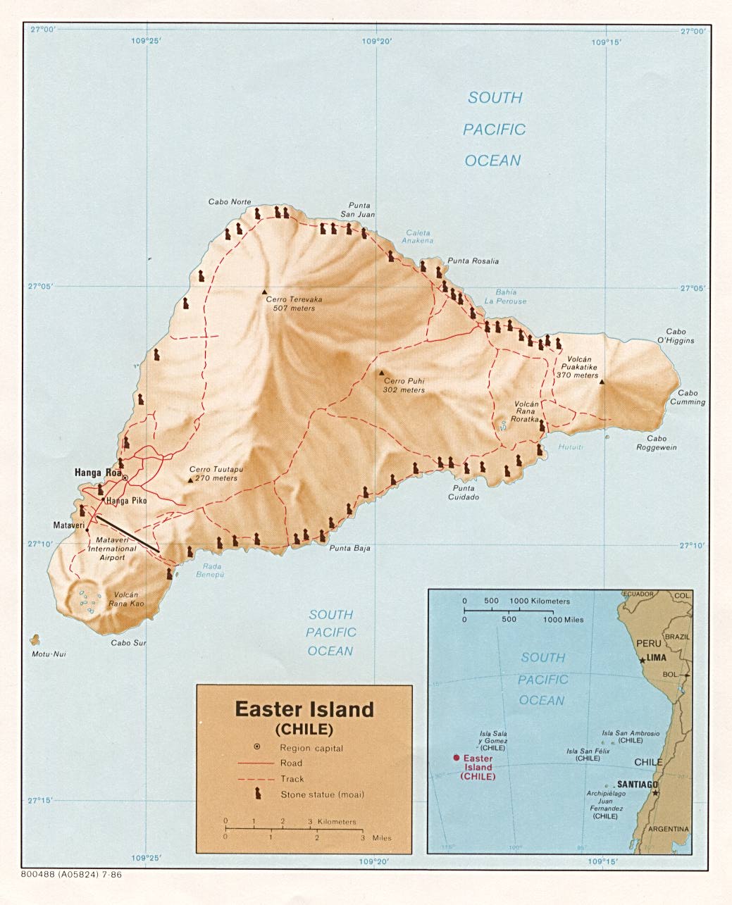
www.lib.utexas.edu/maps/islands_oceans_poles/easterisland...
Easter Island Statue Project Official Website : Moai Inventory
Well, as close as we could get it in Powerpoint. We live about 4 hrs north of Tuscany. Copious notes added following Mr Farrow's suggestion
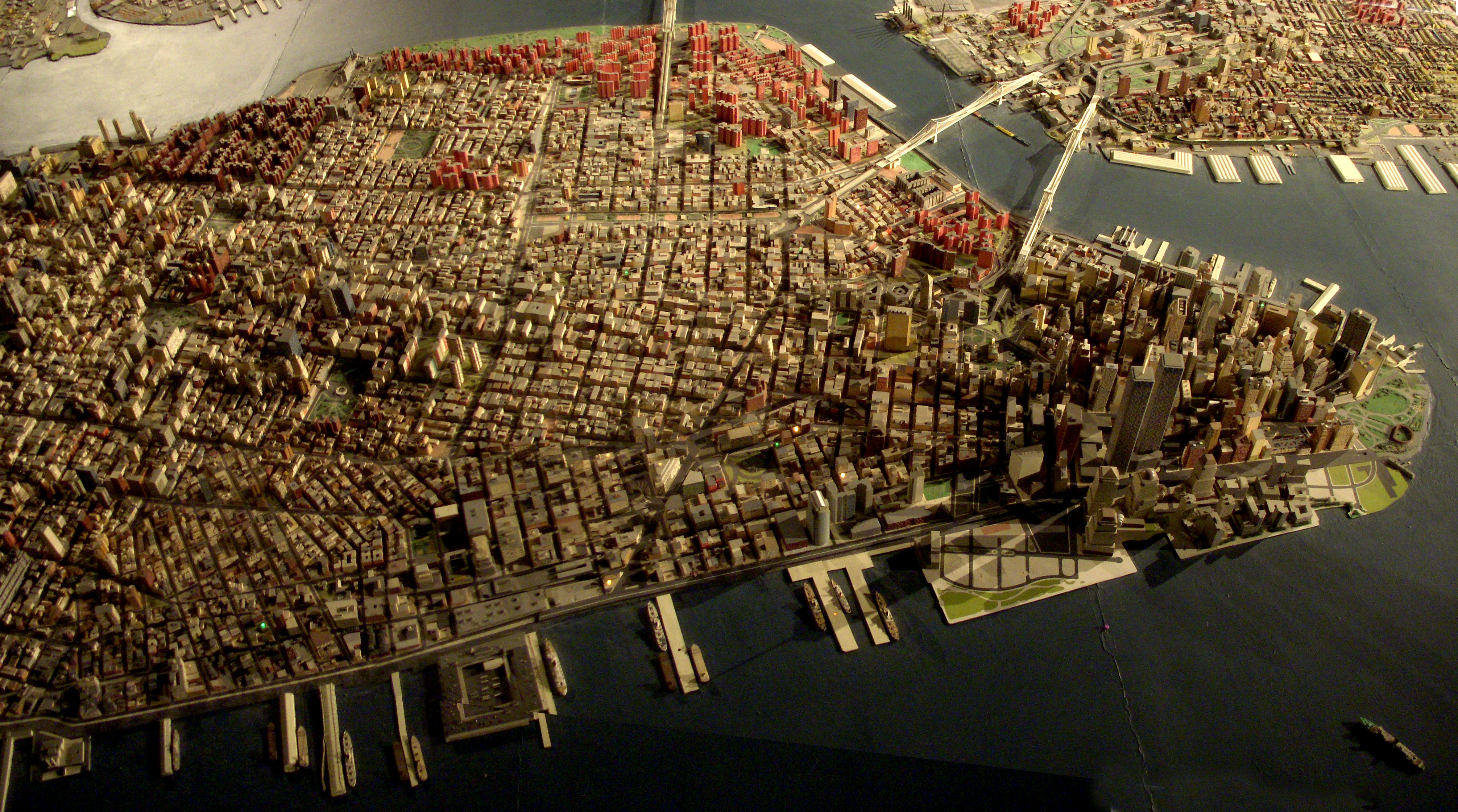
Giant map of NYC in the Queens Museum of Art. I uploaded this full size panorama of downtown Manhattan so my neighbors can have fun finding their own apartment building.
Robert Moses had 'The Panorama of the City of New York' built for the 1964 World's Fair, but it has been updated, and supposedly has every building built before 1992. Originally you flew over it on a simulate helicopter ride. Now there is a ramp that spirals around it from the first to second floor of the museum.
Title: Tabula Asiae III [Black & Capian Sea Region]
Map Maker: Sebastian Munster
Place / Date: Basle / 1542
Description:
Excellent example of Munster's Ptolemaic map of the region between the Black Sea and Caspian Sea extending south to include all of Armenia Maior and part of Armenia Minoris.
Munster's map shows Noahs Arc in the Caspian Sea, believed to have come to rest in a mountain in Armenia according to the map. Shows Armenia Maior, Iberia, Albania, Colchis, Porte Albanie, the Euphratis River, the Tigris, Assyriae, and many other place names in the cradle of civilization. The map is unchanged from the 1540 edition.
Munster's Geographia was a cartographic landmark, including not only Ptolemaic maps, but also a number of landmark modern maps, including the first separate maps of the 4 continents, the first map of England and the earliest obtainable map of Scandinavia. Munster dominated cartographic publication during the mid-16th Century. Munster is generally regarded as one of the three most important map makers of the 16th Century, along with Ortelius and Mercator. Munster was a linguist and mathematician, who initially taught Hebrew in Heidelberg. He issued his first mapping of Germany in 1529, after which he issued a call geographical information about Germany to scholars throughout the country. The response was better than hoped for, and included substantial foreign material, which supplied him with up to date, if not necessarily accurate maps for the issuance of his Geographia in 1540.
Armenia on antique maps
San Marcos is in the south not too far from the Pacific Ocean. Go up the mountain from Choluteca for about an hour until you are about 5 miles from the border with Nicaragua to get to San Marcos de Colon.
Pinboard Map, where over 15 countries were represented by the attendees of the IFVP Big Apple 2013 conference, July 23-26, 2013 in New York City.
Map by Stacy Hall (shall@aarp.org)
Maps from my first visit to London in 2000.
Drawn with felt pen on tracing paper, copic markers to underside of tracing paper then stuck on (crookedly!) to white paper and into a black paper photo album.
Hmmm... I like these maps very much - the use of colour and the 3D components are more successful that most of the maps that I do these days....but back then I had more time for these things ...no that was definitely not the case! I was more careful!! And just for the record I traced these maps.
BTW... I am doing more trip preps than I can or will post....
Remember that one illustrated map I uploaded a while back? Well, I found out that that was the back to the Cities Service Map series (its cover was torn off so I didn't know that there was a cool cover to it). Here is what the front of those maps look like. I did the eBay thing and found the best quality map that was available: Kansas.
I suggest doing the "All sizes" thing or just click here.
weihner plan of wroclaw from 1562, the medieval and renaissance city. Collection of the University Library of Wroclaw.
After painting special badges for several space & science #Tweetups & events in 2013 After painting special badges for several space and science #Tweetups and events in 2013
( www.flickr.com/photos/82679917@N04/collections/7215763548... )
I was asked whether I could design the logo for the oncoming @SpaceUpUK.
* 5-6th July 2014, London *
So here is the timeline of my brainstorming and design process, also showing a collection of existing SpaceUp logos as well as some elements and symbols representing the United Kingdom and #Space.
I introduced my ideas and suggestions to several #SpaceTweeps friends around a visit inside Stonehenge and together we chose the following elements for the final design:
* The Union Jack, which I designed in form of a compass rose to reflect the United Kingdom and Greenwich - "the centre of space and time"
* the London Eye - eye to the world - each of its capsules reflecting #SpaceTweeps from all around the world being closely connected and circling around a central element: their shared love of space
* a telescope - observing how a comet illuminates the #SpaceUp (UP) idea and the United Kingdom (UK)
* several stars and two special constellations:
1) LEO - LION
reflecting the coat of arms of the UK
as well as #LowEarthOrbit ,
the home of #ISS and currently of all people, who are spending time away from earth, enjoying a truly special view of our #BlueDot from space.
Constellation LEO also was already part of our first design idea for badges for the very 1st European #SpaceTweetup ever at DLR / European Astronaut Center (EAC) in Cologne in September 2011 ( www.esa.int/esatv/Videos/2011/09/First_European_SpaceTweetup ) - based on the name of our son #BabySpaceTweep @LightspeedLeo, the youngest "official" participant there ;-)
Since then this element has been part of many of my designs.
The 1st European #SpaceTweetup event brought together a group of #Spaceholix from all over the world and ignited the spark of the European space movement. Since 2011 its participants grew together to a constantly increasing #SpaceFamily, sharing unforgettable events at impressive places.
And yes, there the people bringing the #SpaceUp idea from the US to Europe met and my husband Eico and his fellow-organizers did an awesome job in 2012 and we love to see how the #SpaceUp movement is spreading since @SpaceUpEU took place in Genk/ Belgium and hence I integrated that special connection in my new design.
2) DRACO - DRAGON
reflecting the Welsh dragon
as well as the partially reusable spacecraft developed by @SpaceX, which has docked to #ISS already several times and will deliver cargo regularly and which is up to even more amazing steps.
And - like LEO - a certain DRAGON has special connections to the 1st European #SpaceTweetup as well.
Leo's travelbuddy AKA @PinkLilDragon met its @NASA friend @CamillaSpace again - after their first contact at @SpaceX in Florida during our visit of the original DRAGON capsule a day before we witnessed the launch of #STS135.
Since then these two #SpaceMascots have shared some awesome adventures in many countries.
@PinkLilDragon has shared the stage with moonwalkers, has met more than 100 astronauts, watched rocket launches in Florida and will do so even Baikonur, he was invited to visit the #LHC @CERN and the inner circle of #Stonehenge and thus also has had recurring occurences on different badges as well ;-)
And every single star is also reflecting all the #SpaceTweeps,
who are helping with their ideas, inspiration, support and hard work to make @SpaceUpUK an unforgettable experience for all participants soon.
BTW: This logo is also closely connected to my design, which I created for ESA's competition to name the expedition of Tim Peake in 2015.
www.flickr.com/photos/spaceholix/albums/72157643394229735
My husband and I were so lucky to meet Tim and all the other #Shenanigans already in 2009 shortly after their assignments to fly to #ISS half a decade later during our first visit of #TdLR2009.
Hard to imagine there was a time before @twitter and Facebook...
SPOILER ALERT: I heard if everything goes well, Tim might be joining #SpaceUpUK virtually.
ENJOY - I can't wait to see all your pics and posts soon ;-)
I was astounded by Bill Rankin's map of Chicago's racial and ethnic divides and wanted to see what other cities looked like mapped the same way. To match his map, Red is White, Blue is Black, Green is Asian, Orange is Hispanic, Gray is Other, and each dot is 25 people. Data from Census 2000. Base map © OpenStreetMap, CC-BY-SA
This is a map of Seoul with some of the places we visited.
Below are my steps to create the map:
1. Using Google Earth, I plotted the location of each attraction.
2. I printed the map and traced over it with white paper and a pencil. I drew in the river and placed an "x" for each attraction.
3. I inked-in the river and drew the landmarks. For all inking, I used a Fine Black Sharpie Pen.
4. Next I lettered each landmark.
5. After erasing all of the pencil marks, I scanned the map and added a couple of elements (Miso, and the Nanta drawing) using Paint. I also added "Han River" as I forgot to letter this by hand.
6. I printed the map onto parchment paper. Once scanned back in to my computer, I e-mailed it to myself so I could complete the editing using my iPad.
7. On my iPad, I added the Torn Brick effect and Rough Edge border.
8. Finally, I added my watermark using the iWatermark app. The watermark is a stone stamp that was created in Korea. The Korean letters phonetically spell my first name, Douglas.
This map goes along with this post, which was an attempt to inventory all the independant shops and businesses in my area of central Austin.
Title: Nova Persiae Armeniae Natoliae et Arabiae [shows Cyprus]
Map Maker: Frederick De Wit
Place / Date: Amsterdam / 1680
Description:
Decorative and highly desireable map of the region bounded by the Saudi Peninsula, Red Sea, Nile River, Cyprus, Asia Minor, the Gulf of Aden, Indian Ocean, Armenia, the Caspian Sea, Afganistan and the Indian Ocean, centered on the Persian Gulf. Includes two attractive cartouches, ships at sea and marvelous geographical detail within the map. One of the few available Dutch maps to mention Armenia in the title of the map and one of the most detailed of the region. Gorgeous example.
Armenia on antique maps
Victoria (parfois appelé port de Victoria) est la capitale des Seychelles et n'est pas fluctué sur le côté nord-est de Mahé , l'île principale de l'archipel. La ville a d'abord été établie comme étant le siège de la British coloniale gouvernement. En 2009, la population de la région métropolitaine de Victoria (y compris les banlieues) était de 25 000 la population totale du pays de 87 972. Victoria est desservie par l'aéroport international des Seychelles , achevée en 1971.