View allAll Photos Tagged Map
The route we took around Australia over 8 months or so in a 1975 VW Kombi (Bay Window). Thte van did 18,500 km all in and then got shipped all the way to the UK for more adventures
Title: Tabula Asiae II
Map Maker: Sebastien Munster
Place / Date: Basle / 1540
Description:
Rare first edition of Munster's Ptolemaic map of part of the Ukraine and the region between the Black Sea and Caspian Sea extending south to include all of Armenia Maior and part of Armenia Minoris.
Shows Noahs Arc in the Caspian Sea, believed to have come to rest in a mountain in Armenia according to the map. Shows Armenia Maior, Iberia, Albania, Colchis, Porte Albanie, the Euphratis River, the Tigris, Assyriae, and many other place names in the cradle of civilization.
Armenia on antique maps
地下铁路图及车站清单,让你轻易安排交通。
Beijing City notebook
北京市笔记本
The article in English: kobucha.wordpress.com/2008/06/25/moleskine-beijing-city-n...
中文的文章: www.moleskiner.cn/nikolay-beijing-city-notebook-preview
Our Daily Challenge - Companion
A map and compass always go well together, just missing the actual countryside. At least l will get out on Saturday as we are taking 50 teenagers on their first walk for the Duke of Edinburgh's Award.
This map shows ca. 2020 data of where there are 6 or more through lanes on the U.S. Interstate system. Map data from FHWA's National Network dataset.
My travels around the UK by car for three weeks with my son. June/July 2019 Wales.
Day eight .. Stopping at the Elan Valley Reservoirs before making our way to Aberystwyth for the night.
Radnorshire map in the form of standing stones near the Elan Valley Visitor Centre
An explanatory board at the far end shows that each stone represents a population centre of the former county of Radnorshire, now part of Powys. The stones are set at the correct scale distances apart, and the perimeter, part of which can be seen here as a lighter colour in the grass, is in the shape of Radnorshire.
This was a Millennium Project. The 2000 Radnorshire population of 24,917 shown on the board is little different from its population of 24,651 recorded at the 1831 Census. The largest population centre is Llandrindod Wells (5,024 at the 2001 census).
The Elan Valley Reservoirs are a chain of man-made lakes created from damming the Elan and Claerwen rivers within the Elan Valley in Mid Wales. The reservoirs, which were built by the Birmingham Corporation Water Department, provide clean drinking water for Birmingham in the West Midlands of England. The five lakes are known as the Claerwen, Craig-goch, Pen-y-garreg, Garreg-ddu, and Caban-coch.
Water from the reservoirs is carried by gravity to Frankley Reservoir in Birmingham via the Elan aqueduct. Pumping is not required because the network drops 52 metres (171 ft) along its 73 miles (117 km) length from its source to Frankley. A gradient of 1:2300 maintains a flow of less than 2 miles per hour (3.2 km/h); water takes two and a half to three days to reach Birmingham. The aqueduct, which was started in 1896 and opened in 1906, crosses several valleys and features numerous brick tunnels, pipelines, and valve houses.
Work to build the Elan Valley reservoirs was undertaken because the rapid growth of the industrial city of Birmingham in the late 19th century had led to a lack of available clean water. Numerous outbreaks of disease prompted Birmingham City Council to petition the British government which passed the Birmingham Corporation Water Act in 1892. It allowed the Corporation to acquire by compulsory purchase all the land within the water catchment area of the Elan Valleys. Thousands of navvies and their families lived in the purpose-built Elan Village during the construction of the first four dams at the turn of the 20th century. In 1952, the Claerwen dam was opened by Elizabeth II in one of her first official engagements as monarch.
Drinking water from the Elan Valley is noted for being exceptionally soft, contrasting with water from local supplies in the West Midlands, not served by the Elan aqueduct, which are noted for hardness.
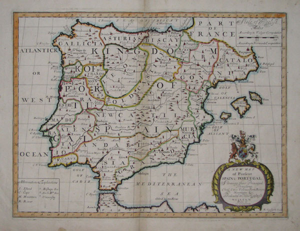
A New Map of Present Spain & Portugal, Shewing their Principal Divisions Chief Cities, Townes, Ports, Rivers, Mountains &c. Dedicated to His Highness William Duke of Gloucester.
R: Spofforth Sculp.
[Oxford, Edward Wells, c.1700.]
Coloured engraving. 380 x 495mm, 15 x 19½".
Map of the Iberian peninsula, engraved by Robert Spofforth and published for " A new sett of maps both of antient and present geography".
[Ref: 15349] £220.00
Divisions of Kingdom of Spain:
- Gallicia.
- Asturias.
- León.
- Old Castile.
- New Castile.
- Andalusia.
- Granada.
- Murcia.
- Bizcay.
- Navarre.
- Aragon.
- Catalonia.
- Valencia.
www.tagzania.com/paste/item/20170
www.panoramio.com/map/#lt=27.373139&ln=88.844376&...
www.pazu.com/travel/asia/map.html
The maps here are neither accurate nor precise, it doesn't reflect the real path that I travelled
John Speed 1552-1629
From a series of 4 reproduced in 1975, the others of Ipswich in the past are; Ogilby 1674, Pennington 1778 and White 1867.
I need to find the other 3 maps, this shows the course of the Orwell through the town.
This trip took months of planning, using reference material form local council plans, contact with urban planners and hours on the internet. In the end we came up with the ultimate Dublin Tour. Pub one being only 7.32 metres from the door of the hotel was an ideal meeting place both before excursions into the city & afterwards. Most routes lead to 'Oliver St John Gogarty's' in Temple bar (Both Nato & the EU rate this as 'probably the finest bar in europe). A couple of pints in 'The Bank' in Dame street (only so we could go to the ATM and a couple in a random pub near some shops. The planning paid off....
Title: Tabula Asiae V
Map Maker: Sebastian Munster
Place / Date: Basel / 1542Description:
Excellent example of Munster's Ptolemaic map of the region between the Black Sea and Caspian Sea extending south to include all of Armenia Maior and part of Armenia Minoris.
Important early map of the region between the Persian Gulf and the Caspian Sea, extending from Armenia and Mesopotamia eastward.
Armenia on antique maps
Description: Tri-fold with relief map of the Panama Canal. Gray's Aero View of the Panama Canal.
Note: Map with tactile elements for use by the blind.
Creator: C. P. Gray, New York
Date: circa 1912
Format: map
Digital Identifier: MAPS-00056
Rights: Samuel P. Hayes Research Library, Perkins School for the Blind, Watertown, MA