View allAll Photos Tagged Map+
Here is Manchester as it was in 1819. This was the year of the Peterloo Massacre. The title panel shows the 'new' Blackfriars Bridge.
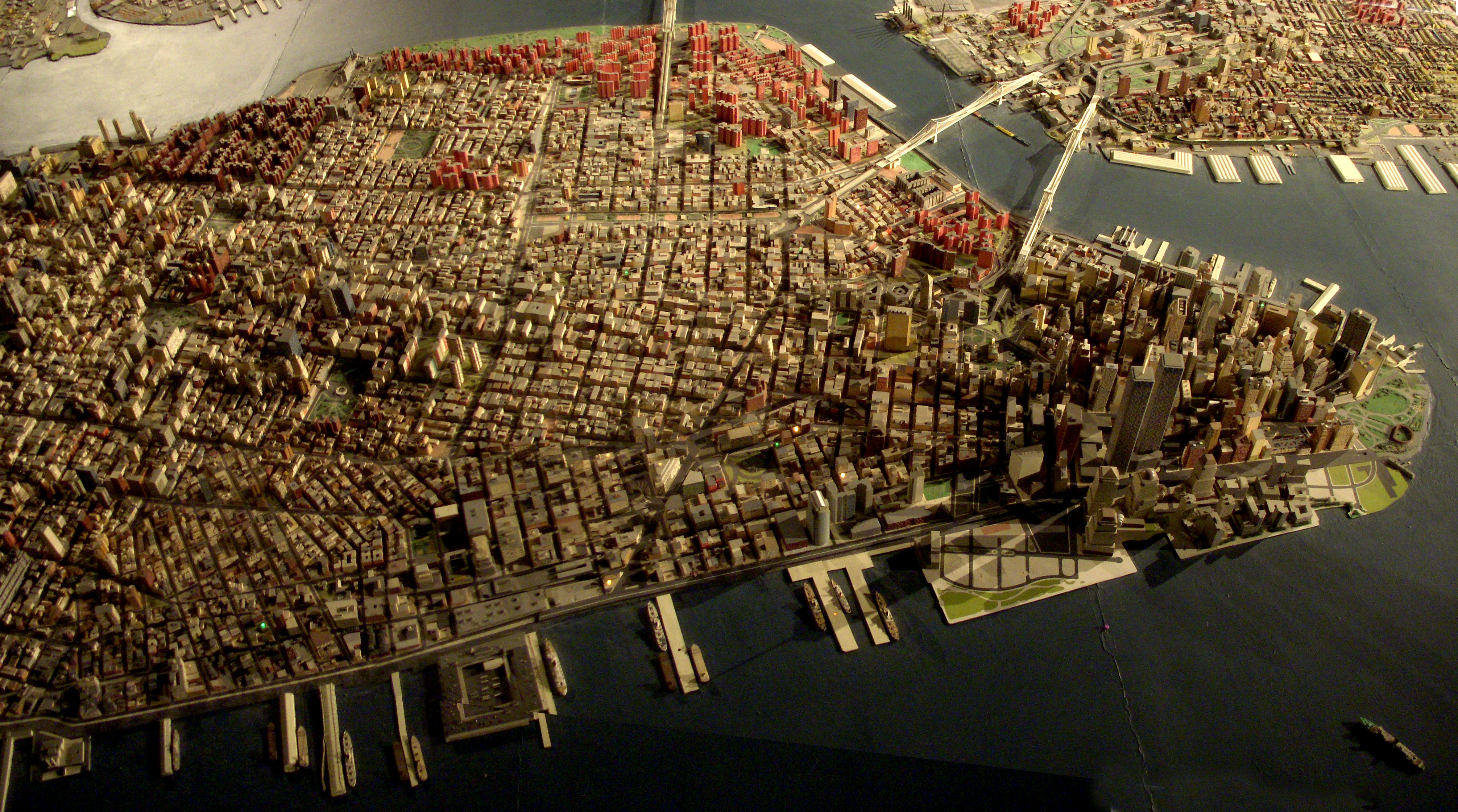
Giant map of NYC in the Queens Museum of Art. I uploaded this full size panorama of downtown Manhattan so my neighbors can have fun finding their own apartment building.
Robert Moses had 'The Panorama of the City of New York' built for the 1964 World's Fair, but it has been updated, and supposedly has every building built before 1992. Originally you flew over it on a simulate helicopter ride. Now there is a ramp that spirals around it from the first to second floor of the museum.
Where in Winchester is this map displayed? It can be found somewhere in the area shown on the map, as can all the photos I've posted to GWW so far.
As it was such a glorious sunny day, this persuaded at the last minute to get out for a shorter, 6.8km, than normal walk. I set out from Cadmore End, through Hanger Wood taking in Fingest returning across the fields enjoying the autumnal views.
More stunning views of the Chilterns - Walkabouts 2025 .... flic.kr/s/aHBqjBXsk2
Remember that one illustrated map I uploaded a while back? Well, I found out that that was the back to the Cities Service Map series (its cover was torn off so I didn't know that there was a cool cover to it). Here is what the front of those maps look like. I did the eBay thing and found the best quality map that was available: Kansas.
I suggest doing the "All sizes" thing or just click here.
I've uploaded the image on the right a few times already. That image is of my map of the current Kmart stores in Florida, which currently stands at a total of 41 stores. For the first part of the upcoming AFB on flickr photoseries, we're going to be taking a look at the most recent Florida Kmart casualty - the closing of the West Palm Beach Kmart. The closing of the West Palm Kmart began on May 20, 2016, and that store's closing should be entering it's final days by now, if it hasn't closed for good already. I visited the West Palm Kmart on May 18, 2016, two days before the closure began. For the record, I had no idea the store was going to close when I made the trip down there. The timing was a complete coincidence. However during my visit there were a few signs of an upcoming closure in the works, which I will discuss in more detail as I get into those photos.
As I was looking for some information on Kmart not too long ago, I stumbled upon a list of licensing data from the State of Florida from 1996. Their list included information on the locations of every Kmart in the state in that year. So using that data, and filling in a few gaps with some other stores I knew of that closed prior to 1996, I complied a list and map of every Kmart (that I know of) to have existed in Florida over the years. You can see that map on the left. According to my count, there have been at least 184 Kmart stores to have operated in Florida over the years (that count includes original stores and their replacements). As of today, over three quarters of the Kmarts to have operated in Florida have since closed. However, I think the comparison between the two maps speaks the loudest over any statistical figures.
If you would like to view an interactive version of the map of all Kmarts to have operated in Florida, please click here. To view an interactive version of the map of current Kmart stores in Florida, please click here.
Please comment below if those links don't work or if you know of a former Kmart location that I may have missed.
I am reposting this map from the University of Texas so I can comment on it, because every time I look at it I see something new that's weird about it.
It is supposedly from 1913, but it looks like the street map must be earlier since the Civic Center is still in the pre-1906 configuration and street names like Ridley and Kate persist.
Montgomery Street continues straight south to 16th and Connecticut!
16th Street continues west over Corona Heights to connect to Irving!
18th Street also makes it as far west as Stanyan.
The "Right of Way for the Southern and Western Pacific Railroad" runs across Candlestick Point and into the bay, like a prototype for the Hunters Point Freeway.
Market Street continues southwest over the hills and includes what is now Sloat.
Army (Cesar Chavez) is called New Market in Noe Valley.
The Bayview/Hunter's Point streets all have different names.
The Mission grid extending west to Fowler and south to 34th Street, and the Lake Merced grid, are contrary to reality too, but those aren't unique to this map.
Source: McGraw Electric Railway Manual: The Red Book of American Electric Railway Investments, the University of Texas Libraries.
This was my big summer project this year! A full map of the continental United States all in patchwork and embroidered! You can see more pictures at:
In the Four Corners region, drawings like this are often maps. This is a different cultural area (Wyoming), but I assume that it too is a map of something, or a guide to something.
Map from an official guide published by the Cape Town City Council in 1950. Note the railway line crossing the bottom of Adderley str. Most probably also the line that went to Sea Point.
Google maps recently added the option to get route directions via walking, biking, mass transit, etc. Very cool. check out the podcast... thegreentax.com
Место отправки - Ковров - maps.google.com/?q=56.3667,41.3333&z=16 от annapanteleva оригинал - www.instagram.com/p/_hhUJpRVKz/
Maps of racial and ethnic divisions in US cities, inspired by Bill Rankin's map of Chicago, updated for Census 2010.
Red is White, Blue is Black, Green is Asian, Orange is Hispanic, Yellow is Other, and each dot is 25 residents.
Data from Census 2010. Base map © OpenStreetMap, CC-BY-SA
Foldout map booklet, step 3. Silkscreen / Lettepress combination. *Design by Cultural Operations & Smokeproof.
The Mitchell Map is a map made by John Mitchell (1711–1768), which was reprinted several times during the second half of the 18th century. The Mitchell Map was used as a primary map source during the Treaty of Paris for defining the boundaries of the newly independent United States. The map remained important for resolving border disputes between the United States and Canada as recently as the 1980s dispute over the Gulf of Maine fisheries The Mitchell Map is the most comprehensive map of eastern North America made during the colonial era. Its size is about 6.5 feet (2.0 m) wide by 4.5 feet (1.4 m) high. This is a cropped section showing what is now Michigan.
It's been a little while since my last long walk so it was a pleasure to be joined by 'soon to be son-in-law' George for a repeat of my last years walk from High Wycombe to Princes Risborough, made all the more interesting by finding a Zebra and taking a wrong turn in Hillock Woods and trying an unspecified short cut across the hillside to get back en-route and then losing our way through a wheat field - by the time we finished we had covered just under 17km
More stunning views of the Chilterns.
Walkabouts 2025 .... flic.kr/s/aHBqjBXsk2
some map found on the internet, including the Ropes Creek, bits of Camden, Woronora (extended to Lucas Heights), and the complete ESR, Northern Beaches, North West, South Western Line, Metro Lines. note that the Olympic Park Line is missing.
The Red Arrow you see there is my block. I'm in Zone B. The Yellow coverage indicated Zone A, which mean its going get flooded, no power,etc.
Pretty much same scenario back in 200 years ago in NYC. So, what's goes around comes around.
Our Daily Challenge - Companion
A map and compass always go well together, just missing the actual countryside. At least l will get out on Saturday as we are taking 50 teenagers on their first walk for the Duke of Edinburgh's Award.
the lovely adrienne asked me to illustrate a BURGER map for the current issue of 'Jamie Magazine' which is all about food. Now i have to visit new york and try out all these crazy burger spots!
Map of Blijdorp Zoo, Rotterdam. Originally (1855) located near Kruiskade. In 1940 relocated to the Blijdorp district in the North of Rotterdam. The zoo was designed by architect Sybold van Ravesteyn. Map circa 1955.
A while back one half of id-iom started using maps as the background for a number of demotivational posters, the other half of id-iom is still working on his maps but hasn’t quite managed to get them finished yet. It seems we’ll have to keep our ears to the ground for them.
Anyway a collector from America got in touch because he needed that certain demotivational message for himself and his family for when things just got a little too much. Originally from the UK he asked us to use maps of where they live now or were born which was easy enough for us. I just hope the whole family aren’t staring at them right now just lounging on a sofa thinking that today is a waste and they should just call it quits. At least until tomorrow that is...
Cheers
id-iom
Virtual Worlds Map with Second Life, OpenSimulator, Interzone, Buildabearville, Home, Club Pony Pals, Barbie Girls, Hello Kitty Online, Amazing Worlds, MeetMe, Twinity, GeoSim, Questville, Le centre du monde, 3Dexplorer, Exitreality, Qwaq, Protosphere, Virtualheroes, Vastpark, Realxtend, Opencroquet, Moondus, Greenphosphor, green, Forterra, Kinset, The Mall Plus, Our Virtual Shopping, Near, Lego, Gaia online, Smeet, Weblin, Empire Of Sports, WhyVille, Novoking, uWorld, Solipsis, Chobots, Handipoints, Zon, Edusim3D, Mingoville, Sherwood dungeon, Daimonin, Football Superstars, Pirates Of the Caribbean, Ultima Online, Everquest, Guild Wars, Dofus, Eve Online, World Of Warcraft, ActiveWorlds, Multiverse, Wonderland, MyCosm, iheardland, HiPiHi, Metaplace, yoowalk, Rocketon, Dizzywood, papermint, Kaneva, There, IMVU, Meez, Vivaty, Smallworlds, My Mini Life, Habbo, OurWorld, Jumpstart, Neopets, Club Penguin, Whirled, Seapals, Tootsville, Zookazoo, 10 wagon
The Arctic char species complex, sensu stricto, represent a key component of the marine and freshwater ecosystems of the north. Chars are stressed by factors such as fisheries, climate change and pollutants. We are possibly altering char biodiversity without documenting it and understanding its relevance. Concerted pan-Arctic biodiversity assessments, sustained research, and coordinated monitoring of chars are required to outline the scope of diversity present and its significance, and the mechanisms responsible for maintaining it and documenting changes. This map displays the global distribution of Arctic char (Salvelinus alpinus) inclusive of all nominate subspecies and closely related 'species' considered to belong to this group in the narrow sense. Taxonomic forms, relationships, species diversity and ecological variation are confused and poorly known for this species complex; other char taxa overlap and extend this range (e.g., forms of Dolly Varden – S. malma). Uncertain distributional limits are indicated by dashed boundaries. Presumptive distribution boundaries of anadromous forms in marine waters are indicated in nearshore areas; anadromy is thought to be restricted to areas south of 75°N. Introduced populations in Europe are indicated in red.
For any form of publication, please include the link to this page:
This photo has been graciously provided to be used in the GRID-Arendal resources library by: Hugo Ahlenius
Map of Manila ca. 1713, by Antonio Fernandez Rojas.
In 1571, Miguel Lopez de Legazpi directed the construction of a fort at the mouth of the river, a church for the religious and one hundred and fifty houses. Intramuros was a four-kilometer pentagonal stretch of land. The head was Fort Santiago, together with the Governor's palace on the north,presiding over the public square.
About two hundred and fifty people mostly military men, dwelt inside the new citadel, a strong and lively city. Thus Intramuros was born.