View allAll Photos Tagged Inclusion
Video available: youtu.be/AyKQHItm8Z4
The Lambda Class Shuttle is one of my favorite spaceship designs with its birdlike look. I like the elegant curves and the transformative wing mechanism, furthermore the landing gear setup with just two legs is exciting!
With the introduction of all the recent new parts I was able to create the round forms and fluent lines of the original studio model.
It is difficult to find exact reference material for this ship, most of the blueprints and imagery, which are available online, are not correct to the original studio models. I've ended up using my own photographs I've managed to take at the amazing Star Wars Identities exhibition.
The model is a scratch build MOC, there are some familiar elements to the LEGO UCS model as well as Dmac's www.flickr.com/photos/dmaclego original design. My main focus was an accurate cockpit design (it’s still not perfect but I like my solution), the inclusion of play features, a full interior completed with PF functions, lights and more.
The model features:
- motorized foldable wings
- boarding ramp
- retractable landing gear
- detailed cockpit and interior
- turning canons
- landing lights
- working sublight engine
It is bigger than the official set with 94 cm in width and 102 cm in hight (on the stand). I've used up to 6000 parts for the model including an PF medium motor and 7 PF lights.
For the scenes I've used secondary builds, the Death Star ll and a midscaled Star Destroyer based on Brickdoctors www.flickr.com/photos/legoarts/ design both of which are adding several hundred parts. For the Endor scene I've used around 10000 parts. Even the planets used for the space scenes are based on LEGO parts (Planet series: Endor and Tatooin for the red Planet).
I'm happy how my build came together, I hope you like it as well! Thanks.
La lucha de la inclusión no solo ocurre en colegios, universidades, empleos, etc. También tácitamente las estructuras que tanto han servido a los ciudadanos, reclaman no morir en la actual sociedad...
Confirmed after I returned home, 6E17 did not run today to GBRf decided to get 69006 and 60096 across to Doncaster by means of today’s 6E09 0720 Liverpool Biomass Tml Gbf to Drax Aes (Gbrf). God alone knows why I choose to trek out to the Starter semaphore at Plumley West on the Mid-Cheshire Line in this weather though. The inclusion of an extra two dead in tow locos added something like 250 tonnes to the consist, meaning that 60056 ‘GREAT GABLE’ could be heard to be working hard as it past the semaphore signal.
I can see that the lineside growth by the Down line is going to be a photographic problem in the coming year.
I made the frame almost 10years ago, and the backgraund probably 3years ago, and the center of the enclosing 20years ago and assembled them this week in the summer heat.
El contenido de estas imágenes no puede ser copiado, distribuido ni publicado por ningún medio, bien sea electrónico o de cualquier otra naturaleza.
Su utilización en otras páginas web sin el consentimiento expreso del autor está PROHIBIDO.
Por favor, envie un mensaje o un correo electrónico para informarse acerca de copias, permisos o inclusión en blogs.
Gracias.
correo electrónico : pppf1982@gmail.com
The content of these images cannot be copied,distributed or published for any media,
electronic or otherwise.
The utilization in other web pages without the express written consent of the author is
PROHIBITED.
Church wall early on a Sunday morning. Niagara Falls, Ontario.
If you like my work click the "Follow" button on Flickr.
Other places to see my work rumimume.blogspot.ca/, Google+ google+, twitter
Mistley in Essex - as was!
For 14 years a wonderful lady has been feeding the swans morning and night and in that time has raised the population from 30 to 200!!
Every day at low tide swans fly in and land on the water just below the quay it WAS the most incredible sight (and photo opportunity!!) Last Wednesday (17th September 2008) the owner of the quay, despite local demonstrations and petitions, finally errected a 10ft fence along the front - stopping any feeding or photos.
The demonstrating locals, who had been parking their cars along the front to try to stop the fence, were finally defeated by the threat of being arrested for agrevated trespass (which could have involved a custodial sentence!).
They are now trying to go through the legal system to have the fence removed, but until they succeed (which could be years) one of the most beautiful natural sights in our area is lost to us all.
SW018
Please don't use this image on websites, blogs or other media without my explicit permission. © All rights reserved
Photo from the Albert Kuhbandner collection, kindly provided by him for inclusion on this page.
München-Riem
1989
9Q-CLI "Mont Ngaliema"
McDonnell Douglas DC-10-30
47886 / 90
Air Zaïre
9Q-CLI had first been seen at Riem in February 1974 together with Air Zaïre B747 N747QC when Zaïrean President Mobutu visited Germany. It was reported again on 10 October and 31 October 1991 (on a cargo flight).
I have no further information about this visit in 1989, but possibly the aircraft came to Munich to pick up money printed at Giesecke & Devrient. (See the photo below in the comments.)
Information from tonymadgehjg.proboards.com:
This aircraft was originally built for ATLANTIS but eventually delivered to AIR ZAIRE (9Q-CLI "Mont Ngalienma") during during 1973. It was leased to AIR TCHAD during 1975 and to SABENA during 1977 and again during 1978. It was then sold to the INDO SUEZ BANK (F-OGQC), leased to AIR ZAIRE and then sold back to the airline (9Q-CLI "Mont Ngaliema") during 1988. The aircraft was withdrawn from service and stored at Tel Aviv, Israel, during 1995.
Finally broken up at TLV in April 2002. (Source: planelogger.com)
Registration details for this airframe:
www.planelogger.com/Aircraft/Registration/9Q-CLI/652062
9Q-CLI together with N747QC at BRU in March 1974:
www.flickr.com/photos/53277566@N06/52038980235
9Q-CLI with Sabena at CDG in October 1977:
imgproc.airliners.net/photos/airliners/3/7/5/0616573.jpg

9Q-CLI with Air Zaire landing at Riem in February 1990 (?):
www.flugzeugbilder.de/a/3/98/1025075274.jpg

Scan from slide (unknown brand).
Obsidian containing spherical inclusions.. Marble Mountain, Ajo, Arizona, USA. 11 February 2018.
'Marble Mountain, on BLM administered land about 20 miles east of Ajo, Arizona, is located in the Sauceda Mountains, an area of extensive past volcanic activity. Occupying the area is a variety of volcanic rocks ejected during violent eruptions of sticky gaseous rhyolite type lava. Some of the rock types produced by these eruptions include rhyolite lava (high silica molten rock flowing out on the surface and forming thick layers when hardening), tuff (a kind of soft yellowish material consisting of glassy shards deposited during explosive pyroclastic ash flows) and obsidian (a non-crystalline volcanic glass formed from certain molten rocks that cool extremely rapidly).
Marble Mountain itself is really a low hill formed mostly from an impure obsidian containing spherical crystalline inclusions. Specific information seems to be lacking as to how these inclusions, or "marbles" were formed, but presumably they formed during the time that the molten obsidian cooled. Here is one theory on marble formation.' cabezaprieta.org/destinations/marble_mountain.php
Photo from the Michael Riedl collection, scan kindly provided by him for inclusion on this page.
München-Riem
December 1989
G-GCAL
McDonnell Douglas DC-10-10
46501 / 2
Novair
This airframe was also reported at Riem as G-BELO with Laker Airways Skytrain on 30 December 1979 (there were probably more visits with Laker during the early 1980s). In the late 1980s it was frequently noted here as G-GCAL first with Cal Air and then with Novair.
Information from airhistory.net - thanks to Alastair T. Gardiner:
This very early DC-10 - airframe no. 2 - originally flew for McDonnell Douglas before being delivered to Laker Airways as G-BELO in June 1977. It went to American Trans Air as N183AT in February 1983 and then Cal Air three years later. It transferred over to Novair in December 1988 and then went to Project Orbis as N220AU in November 1991 as a flying hospital. The frame is now preserved in Tucson at the Pima Air & Space Museum.
Registration details for this airframe:
www.planelogger.com/Aircraft/Registration/G-GCAL/650726
This airframe as N10DC with McDonnell Douglas at LGB in June 1973:
imgproc.airliners.net/photos/airliners/5/9/5/2733595.jpg

This airframe as G-BELO with Laker at LGW in June 1978:
www.flickr.com/photos/105925977@N03/32777870341
This airframe as N183AT with American Trans Air at FRA in June 1985:
www.flickr.com/photos/aero_icarus/51771300755
Another shot of G-GCAL with Cal Air at Riem, from 10 January 1987:
www.airhistory.net/photo/391627/G-GCAL
This airframe as N220AU with Orbis ca. early 2000s (initial colours):
www.flickr.com/photos/154191970@N03/50775068213
N220AU with Orbis at DUB in April 2005 (later colours):
www.flickr.com/photos/53277566@N06/5955863264/in
N220AU with Orbis at LAX in November 2016 (later colours):
www.flickr.com/photos/92009354@N00/30743279811
N220AU at DM AFB Tucson AZ going to Pima Air and Space Museum in November 2016:
www.flickr.com/photos/cactusbillaz/25330529249
N220AU preserved at Pima Air and Space Museum in October 2020:
www.flickr.com/photos/37585658@N00/50501538926
Scan from slide (unknown brand).
Photo taken by Herwart Schneider and kindly provided by him for inclusion on this page.
München-Riem
August 1983
N8416
Boeing 707-323C
20088 / 727
American Trans Air (ATA)
N8416 is coming in to land on Riem’s runway 07.
Information from flickr - thanks to Paul:
New to American Airlines as N8416 in 1968. To American Trans Air in 1982 then to Boeing in 1984. To Transbrasil as PT-TCN in 1985, leased to AeroBrasil in 1991 then to Beta Cargo as PP-BRR in 1997. Withdrawn from use at Sao Paulo-Guarulhos (GRU) in 2006 and scrapped in 2009.
Registration details for this airframe:
www.scramble.nl/database/civil/details/B707_646
This airframe as N8416A with American Airlines at SJU in March 1980:
www.airhistory.net/photo/243921/N8416A
N8416A with American Trans Air at PHL in April 1983:
www.flickr.com/photos/23032926@N05/5234583032
Bob Garrard’s note concerning the registration: During the early '80s ATA had 8 707s in the fleet, all but one had an "A" suffix on the registration. This should be N8416, but had the "A" applied in error. A photo taken a month later shows it correctly.
This airframe as PT-TCN with TransBrasil at GIG in July 1986:
www.flickr.com/photos/150730665@N08/46982409884
PT-TCN with AeroBrasil Cargo at SNN in 1993:
www.flickr.com/photos/shanair/39907737003
PT-TCN with AeroBrasil Cargo at MIA in November 1994 (later colours):
www.flickr.com/photos/guidojet/51120582787
This airframe as PP-BRR with BETA Cargo at POA in April 2001:
cdn.jetphotos.com/full/1/17154_1043432349.jpg

PP-BRR with BETA Cargo at Manaus-Eduardo Gomes in March 2006:
www.flickr.com/photos/pslg05896/31622882481
PP-BRR with BETA Cargo at GRU in October 2007 (later colours):
www.flickr.com/photos/88821481@N00/1646633111
PP-BRR still intact at GRU in December 2011:
cdn.jetphotos.com/full/4/84479_1325726382.jpg

Scan from Kodachrome slide.
Working the 'Yns-Mon' express, 67005 pulls into Stafford on 1Z72 from Swindon to Holyhead. From Crewe, 60103 would take over. This is the first time I've seen a royal skip since the repaint a few weeks ago.
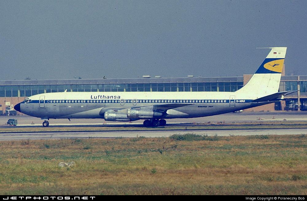
Photo taken by Wilhelm Hell, scan kindly provided by him for inclusion on this page.
München-Riem
September 1983
D-ABUI (1)
Boeing 707-330C
19317/557
German Cargo
Note: D-ABUI (2) was Boeing 767-330/ER c/n 26988 / 562 flying for Condor from January 1995 to March 2023.
D-ABUI was still seen with Lufthansa Cargo at Riem on 18 July 1979 and then first reported with German Cargo on 6 December 1979.
Information from flickr - thanks to Chris (Heathrow Junkie:
D-ABUI c/n 19317 - Boeing 707-330C was delivered new to Lufthansa in June 1967. The aircraft was leased to subsidiary German Cargo in 1979, and then sold to Transbrasil in 1984 as PT-TCM. Still flying in 2004 with BETA Brazilian Express as PP-BSE, the aircraft was unfortunately written off (right hand main gear leg punctured through the wing on take-off from MAO on 23 October 2004).
Detailed history of this airframe:
www.707jet.com/lufthansa-707-fleet/d-abui-msn19317-ln557/
D-ABUI with Lufthansa at PHL in August 1968 (first colours):
cdn.jetphotos.com/full/2/71432_1179600098.jpg
D-ABUI with Lufthansa at FRA in June 1974 (later colours, no "Cargo" titles):
abpic.co.uk/pictures/view/1394624
D-ABUI with German Cargo at Riem in May 1980:
imgproc.airliners.net/photos/airliners/7/5/0/1286057.jpg

This airframe as PP-TCM with Transbrasil at BSL in June 1986:
imgproc.airliners.net/photos/airliners/7/7/0/1406077.jpg

PT-TCM with AeroBrasil Cargo at GRU in March 1996:
www.flickr.com/photos/pslg05896/31623512191
This airframe as PP-BSE with BETA Cargo at SNN in January 1999:
www.flickr.com/photos/24101413@N03/4386157612
PP-BSE with BETA Cargo in November 2002:
www.flickr.com/photos/150730665@N08/47010567454
The remains of PP-BSE at MAO in April 2005:
imgproc.airliners.net/photos/airliners/3/6/3/0830363.jpg

Scan from Kodachrome slide (on Kodak Photo CD).
Photo taken by Manfred Kaffine kindly provided by him for inclusion on this page.
München-Riem
May 1976
B-2410 (1)
Boeing 707-3J6C
20718 / 872
Civil Aviation Administration of China (CAAC)
Note: B-2410 (2) is Airbus A320-214 c/n 2437 flying for China Eastern Airlines since April 2005.
The first CAAC aircraft to visit Riem caused quite a sensation among Munich spotters when it landed at the airport on 14 May 1976. However, from that day on B-2410 would return many times throughout the remaining 1970s and early 1980s.
The aircraft transported live stock (cattle) from Bavaria to China - this must have been part of a large-scale, long-term deal, but I couldn’t find any information about it on the net. The Chinese always sent the same aircraft, and on many of the visits, it was parked on the same stand. Ironically, the cattle transporter would become the last 707 to operate passenger flights in China (source: Daryl Chapman on flickr).
First flight on 5 October 1973 and delivered to CAAC as 2410 on 12 November 1973 (later re-registered as B-2410). To China Southwest Airlines in November 1983. To Flying Dolphin Airlines as B-513L in March 1998, later re-registered A6-ZYD. Seen with Air Gulf Falcon in January 2001 and reported with Dolphin Air in August 2005. Ended up stored at Tripoli-Mitiga (MJI) (Source: planelogger.com).
Registration details for this airframe:
www.planelogger.com/Aircraft/Registration/B-2410/493334
This airframe as 2410 with CAAC at RNT in September 1973 pre-first flight:
www.flickr.com/photos/aero_icarus/13905159907
B-2410 with China Southwest at Guangzhou (CAN/ZGGG) in April 1996:
www.flickr.com/photos/darylchapman/9388013567
This airframe as B-513L with Flying Dolphin at SHJ in March 1998:
cdn.plnspttrs.net/04332/b-513l-untitled-boeing-707-3j6c_P...

This airframe as A6-ZYD at SHJ in October 1999:
www.flickr.com/photos/128485084@N08/47392326201
Scan from Kodak medium format (6 x 6 cm) slide, cropped to 3:2 aspect ratio.
Providing dwellings for 42 families in partnership with BC Housing and Powell River Inclusive Housing Society, Ontario Avenue, Powell River, B.C., Canada.
Nikon D700
Tamron 35-70mm f/3.5-4.5 Adaptall-2
Hip shot, zone focus. Can you zone focus at f2? I pushed the shutter speed up to 1/500s as they were walking, dropped the aperture to wide open and guesses the ISO. Lucky shot.
Photo taken by Herwart Schneider and kindly provided by him for inclusion on this page.
München-Riem
June 1975
TC-61
Lockheed C-130E Hercules
382-4308
Fuerza Aérea Argentina, I Brigada Aérea
TC-61 is parked in front ot the viewing terrace in the rain. Reported at Riem on 10 June 1975, probably the precise date of this shot. Other Argentine Air Force C-130Hs noted at Riem were TC-65 (July 1974) and TC-66 (2 October 1975 and 4 December 1975).
Delivered to Argentina Air Force in November 1968, this was the first Hercules to land at Marambio Air Base on Seymour Island, Antarctica on 11 April 1970. Still going strong more than half a century later, after an extensive update carried out in the late 2010s by Fabrica Argentina de Aviones (FAdeA) at Cordoba - Capitan Omar Gelardi (FMA / SACA) . (Source: Robert Domandl on airliners.net)
TC-61 with Fuerza Aérea Argentina at El Palomar (PAL / SADP) in May 2014:
imgproc.airliners.net/photos/airliners/6/1/0/2447016.jpg

TC-61 with Fuerza Aérea Argentina at FMA in July 2021:
imgproc.airliners.net/photos/airliners/7/1/7/6565717.jpg

Scan from Kodachrome slide.
Canyonlands National Park is an American national park located in southeastern Utah near the town of Moab. The park preserves a colorful landscape eroded into numerous canyons, mesas, and buttes by the Colorado River, the Green River, and their respective tributaries. Legislation creating the park was signed into law by President Lyndon Johnson on September 12, 1964.
The park is divided into four districts: the Island in the Sky, the Needles, the Maze, and the combined rivers—the Green and Colorado—which carved two large canyons into the Colorado Plateau. While these areas share a primitive desert atmosphere, each retains its own character. Author Edward Abbey, a frequent visitor, described the Canyonlands as "the most weird, wonderful, magical place on earth—there is nothing else like it anywhere."
In the early 1950s, Bates Wilson, then superintendent of Arches National Monument, began exploring the area to the south and west of Moab, Utah. After seeing what is now known as the Needles District of Canyonlands National Park, Wilson began advocating for the establishment of a new national park that would include the Needles. Additional explorations by Wilson and others expanded the areas proposed for inclusion into the new national park to include the confluence of Green and Colorado rivers, the Maze District, and Horseshoe Canyon.
In 1961, Secretary of the Interior Stewart Udall was scheduled to address a conference at Grand Canyon National Park. On his flight to the conference, he flew over the Confluence (where the Colorado and Green rivers meet). The view apparently sparked Udall's interest in Wilson's proposal for a new national park in that area and Udall began promoting the establishment of Canyonlands National Park.
Utah Senator Frank Moss first introduced legislation into Congress to create Canyonlands National Park. His legislation attempted to satisfy both nature preservationists' and commercial developers' interests. Over the next four years, his proposal was struck down, debated, revised, and reintroduced to Congress many times before being passed and signed into creation.
In September, 1964, after several years of debate, President Lyndon B. Johnson signed Pub.L. 88–590, which established Canyonlands National Park as a new national park. Bates Wilson became the first superintendent of the new park and is often referred to as the "Father of Canyonlands."
The Colorado River and Green River combine within the park, dividing it into three districts called the Island in the Sky, the Needles, and the Maze. The Colorado River flows through Cataract Canyon below its confluence with the Green River.
The Island in the Sky district is a broad and level mesa in the northern section of the park, between the Colorado and Green rivers. The district has many viewpoints overlooking the White Rim, a sandstone bench 1,200 feet (370 m) below the Island, and the rivers, which are another 1,000 feet (300 m) below the White Rim.
The Needles district is located south of the Island in the Sky, on the east side of the Colorado River. The district is named for the red and white banded rock pinnacles which are a major feature of the area. Various other naturally sculpted rock formations are also within this district, including grabens, potholes, and arches. Unlike Arches National Park, where many arches are accessible by short to moderate hikes, most of the arches in the Needles district lie in backcountry canyons, requiring long hikes or four-wheel drive trips to reach them.
The Ancestral Puebloans inhabited this area and some of their stone and mud dwellings are well-preserved, although the items and tools they used were mostly removed by looters. The Ancestral Puebloans also created rock art in the form of petroglyphs, most notably on Newspaper Rock along the Needles access road.
The Maze district is located west of the Colorado and Green rivers. The Maze is the least accessible section of the park, and one of the most remote and inaccessible areas of the United States.
A geographically detached section of the park located north of the Maze district, Horseshoe Canyon contains panels of rock art made by hunter-gatherers from the Late Archaic Period (2000-1000 BC) pre-dating the Ancestral Puebloans. Originally called Barrier Canyon, Horseshoe's artifacts, dwellings, pictographs, and murals are some of the oldest in America. The images depicting horses date from after 1540 AD, when the Spanish reintroduced horses to America.
Since the 1950s, scientists have been studying an area of 200 acres (81 ha) completely surrounded by cliffs. The cliffs have prevented cattle from ever grazing on the area's 62 acres (25 ha) of grassland. According to the scientists, the site may contain the largest undisturbed grassland in the Four Corners region. Studies have continued biannually since the mid-1990s. The area has been closed to the public since 1993 to maintain the nearly pristine environment.
Mammals that roam this park include black bears, coyotes, skunks, bats, elk, foxes, bobcats, badgers, ring-tailed cats, pronghorns, desert bighorn sheep, and cougars. Desert cottontails, kangaroo rats and mule deer are commonly seen by visitors.
At least 273 species of birds inhabit the park. A variety of hawks and eagles are found, including the Cooper's hawk, the northern goshawk, the sharp-shinned hawk, the red-tailed hawk, the golden and bald eagles, the rough-legged hawk, the Swainson's hawk, and the northern harrier. Several species of owls are found, including the great horned owl, the northern saw-whet owl, the western screech owl, and the Mexican spotted owl. Grebes, woodpeckers, ravens, herons, flycatchers, crows, bluebirds, wrens, warblers, blackbirds, orioles, goldfinches, swallows, sparrows, ducks, quail, grouse, pheasants, hummingbirds, falcons, gulls, and ospreys are some of the other birds that can be found.
Several reptiles can be found, including eleven species of lizards and eight species of snake (including the midget faded rattlesnake). The common kingsnake and prairie rattlesnake have been reported in the park, but not confirmed by the National Park Service.
The park is home to six confirmed amphibian species, including the red-spotted toad, Woodhouse's toad, American bullfrog, northern leopard frog, Great Basin spadefoot toad, and tiger salamander. The canyon tree frog was reported to be in the park in 2000, but was not confirmed during a study in 2004.
Canyonlands National Park contains a wide variety of plant life, including 11 cactus species,[34] 20 moss species, liverworts, grasses and wildflowers. Varieties of trees include netleaf hackberry, Russian olive, Utah juniper, pinyon pine, tamarisk, and Fremont's cottonwood. Shrubs include Mormon tea, blackbrush, four-wing saltbush, cliffrose, littleleaf mountain mahogany, and snakeweed
Cryptobiotic soil is the foundation of life in Canyonlands, providing nitrogen fixation and moisture for plant seeds. One footprint can destroy decades of growth.
According to the Köppen climate classification system, Canyonlands National Park has a cold semi-arid climate ("BSk"). The plant hardiness zones at the Island in the Sky and Needles District Visitor Centers are 7a with an average annual extreme minimum air temperature of 4.0 °F (-15.6 °C) and 2.9 °F (-16.2 °C), respectively.
The National Weather Service has maintained two cooperative weather stations in the park since June 1965. Official data documents the desert climate with less than 10 inches (250 millimetres) of annual rainfall, as well as hot, mostly dry summers and cold, occasionally wet winters. Snowfall is generally light during the winter.
The station in The Neck region reports an average January temperature of 29.6 °F and an average July temperature of 79.3 °F. Average July temperatures range from a high of 90.8 °F (32.7 °C) to a low of 67.9 °F (19.9 °C). There are an average of 45.7 days with highs of 90 °F (32 °C) or higher and an average of 117.3 days with lows of 32 °F (0 °C) or lower. The highest recorded temperature was 105 °F (41 °C) on July 15, 2005, and the lowest recorded temperature was −13 °F (−25 °C) on February 6, 1989. Average annual precipitation is 9.33 inches (237 mm). There are an average of 59 days with measurable precipitation. The wettest year was 1984, with 13.66 in (347 mm), and the driest year was 1989, with 4.63 in (118 mm). The most precipitation in one month was 5.19 in (132 mm) in October 2006. The most precipitation in 24 hours was 1.76 in (45 mm) on April 9, 1978. Average annual snowfall is 22.8 in (58 cm). The most snowfall in one year was 47.4 in (120 cm) in 1975, and the most snowfall in one month was 27.0 in (69 cm) in January 1978.
The station in The Needles region reports an average January temperature of 29.7 °F and an average July temperature of 79.1 °F.[44] Average July temperatures range from a high of 95.4 °F (35.2 °C) to a low of 62.4 °F (16.9 °C). There are an average of 75.4 days with highs of 90 °F (32 °C) or higher and an average of 143.6 days with lows of 32 °F (0 °C) or lower. The highest recorded temperature was 107 °F (42 °C) on July 13, 1971, and the lowest recorded temperature was −16 °F (−27 °C) on January 16, 1971. Average annual precipitation is 8.49 in (216 mm). There are an average of 56 days with measurable precipitation. The wettest year was 1969, with 11.19 in (284 mm), and the driest year was 1989, with 4.25 in (108 mm). The most precipitation in one month was 4.43 in (113 mm) in October 1972. The most precipitation in 24 hours was 1.56 in (40 mm) on September 17, 1999. Average annual snowfall is 14.4 in (37 cm). The most snowfall in one year was 39.3 in (100 cm) in 1975, and the most snowfall in one month was 24.0 in (61 cm) in March 1985.
National parks in the Western US are more affected by climate change than the country as a whole, and the National Park Service has begun research into how exactly this will effect the ecosystem of Canyonlands National Park and the surrounding areas and ways to protect the park for the future. The mean annual temperature of Canyonlands National Park increased by 2.6 °F (1.4 °C) from 1916 to 2018. It is predicted that if current warming trends continue, the average highs in the park during the summer will be over 100 °F (40 °C) by 2100. In addition to warming, the region has begun to see more severe and frequent droughts which causes native grass cover to decrease and a lower flow of the Colorado River. The flows of the Upper Colorado Basin have decreased by 300,000 acre⋅ft (370,000,000 m3) per year, which has led to a decreased amount of sediment carried by the river and rockier rapids which are more frequently impassable to rafters. The area has also begun to see an earlier spring, which will lead to changes in the timing of leaves and flowers blooming and migrational patterns of wildlife that could lead to food shortages for the wildlife, as well as a longer fire season.
The National Park Service is currently closely monitoring the impacts of climate change in Canyonlands National Park in order to create management strategies that will best help conserve the park's landscapes and ecosystems for the long term. Although the National Park Service's original goal was to preserve landscapes as they were before European colonization, they have now switched to a more adaptive management strategy with the ultimate goal of conserving the biodiversity of the park. The NPS is collaborating with other organizations including the US Geological Survey, local indigenous tribes, and nearby universities in order to create a management plan for the national park. Right now, there is a focus on research into which native plants will be most resistant to climate change so that the park can decide on what to prioritize in conservation efforts. The Canyonlands Natural History Association has been giving money to the US Geological Survey to fund this and other climate related research. They gave $30,000 in 2019 and $61,000 in 2020.
A subsiding basin and nearby uplifting mountain range (the Uncompahgre) existed in the area in Pennsylvanian time. Seawater trapped in the subsiding basin created thick evaporite deposits by Mid Pennsylvanian. This, along with eroded material from the nearby mountain range, became the Paradox Formation, itself a part of the Hermosa Group. Paradox salt beds started to flow later in the Pennsylvanian and probably continued to move until the end of the Jurassic. Some scientists believe Upheaval Dome was created from Paradox salt bed movement, creating a salt dome, but more modern studies show that the meteorite theory is more likely to be correct.
A warm shallow sea again flooded the region near the end of the Pennsylvanian. Fossil-rich limestones, sandstones, and shales of the gray-colored Honaker Trail Formation resulted. A period of erosion then ensued, creating a break in the geologic record called an unconformity. Early in the Permian an advancing sea laid down the Halgaito Shale. Coastal lowlands later returned to the area, forming the Elephant Canyon Formation.
Large alluvial fans filled the basin where it met the Uncompahgre Mountains, creating the Cutler red beds of iron-rich arkose sandstone. Underwater sand bars and sand dunes on the coast inter-fingered with the red beds and later became the white-colored cliff-forming Cedar Mesa Sandstone. Brightly colored oxidized muds were then deposited, forming the Organ Rock Shale. Coastal sand dunes and marine sand bars once again became dominant, creating the White Rim Sandstone.
A second unconformity was created after the Permian sea retreated. Flood plains on an expansive lowland covered the eroded surface and mud built up in tidal flats, creating the Moenkopi Formation. Erosion returned, forming a third unconformity. The Chinle Formation was then laid down on top of this eroded surface.
Increasingly dry climates dominated the Triassic. Therefore, sand in the form of sand dunes invaded and became the Wingate Sandstone. For a time climatic conditions became wetter and streams cut channels through the sand dunes, forming the Kayenta Formation. Arid conditions returned to the region with a vengeance; a large desert spread over much of western North America and later became the Navajo Sandstone. A fourth unconformity was created by a period of erosion.
Mud flats returned, forming the Carmel Formation, and the Entrada Sandstone was laid down next. A long period of erosion stripped away most of the San Rafael Group in the area, along with any formations that may have been laid down in the Cretaceous period.
The Laramide orogeny started to uplift the Rocky Mountains 70 million years ago and with it, the Canyonlands region. Erosion intensified and when the Colorado River Canyon reached the salt beds of the Paradox Formation the overlying strata extended toward the river canyon, forming features such as The Grabens. Increased precipitation during the ice ages of the Pleistocene quickened the rate of canyon excavation along with other erosion. Similar types of erosion are ongoing, but occur at a slower rate.
Utah is a landlocked state in the Mountain West subregion of the Western United States. It borders Colorado to its east, Wyoming to its northeast, Idaho to its north, Arizona to its south, and Nevada to its west. Utah also touches a corner of New Mexico in the southeast. Of the fifty U.S. states, Utah is the 13th-largest by area; with a population over three million, it is the 30th-most-populous and 11th-least-densely populated. Urban development is mostly concentrated in two areas: the Wasatch Front in the north-central part of the state, which is home to roughly two-thirds of the population and includes the capital city, Salt Lake City; and Washington County in the southwest, with more than 180,000 residents. Most of the western half of Utah lies in the Great Basin.
Utah has been inhabited for thousands of years by various indigenous groups such as the ancient Puebloans, Navajo, and Ute. The Spanish were the first Europeans to arrive in the mid-16th century, though the region's difficult geography and harsh climate made it a peripheral part of New Spain and later Mexico. Even while it was Mexican territory, many of Utah's earliest settlers were American, particularly Mormons fleeing marginalization and persecution from the United States via the Mormon Trail. Following the Mexican–American War in 1848, the region was annexed by the U.S., becoming part of the Utah Territory, which included what is now Colorado and Nevada. Disputes between the dominant Mormon community and the federal government delayed Utah's admission as a state; only after the outlawing of polygamy was it admitted in 1896 as the 45th.
People from Utah are known as Utahns. Slightly over half of all Utahns are Mormons, the vast majority of whom are members of the Church of Jesus Christ of Latter-day Saints (LDS Church), which has its world headquarters in Salt Lake City; Utah is the only state where a majority of the population belongs to a single church. A 2023 paper challenged this perception (claiming only 42% of Utahns are Mormons) however most statistics still show a majority of Utah residents belong to the LDS church; estimates from the LDS church suggests 60.68% of Utah's population belongs to the church whilst some sources put the number as high as 68%. The paper replied that membership count done by the LDS Church is too high for several reasons. The LDS Church greatly influences Utahn culture, politics, and daily life, though since the 1990s the state has become more religiously diverse as well as secular.
Utah has a highly diversified economy, with major sectors including transportation, education, information technology and research, government services, mining, multi-level marketing, and tourism. Utah has been one of the fastest growing states since 2000, with the 2020 U.S. census confirming the fastest population growth in the nation since 2010. St. George was the fastest-growing metropolitan area in the United States from 2000 to 2005. Utah ranks among the overall best states in metrics such as healthcare, governance, education, and infrastructure. It has the 12th-highest median average income and the least income inequality of any U.S. state. Over time and influenced by climate change, droughts in Utah have been increasing in frequency and severity, putting a further strain on Utah's water security and impacting the state's economy.
The History of Utah is an examination of the human history and social activity within the state of Utah located in the western United States.
Archaeological evidence dates the earliest habitation of humans in Utah to about 10,000 to 12,000 years ago. Paleolithic people lived near the Great Basin's swamps and marshes, which had an abundance of fish, birds, and small game animals. Big game, including bison, mammoths and ground sloths, also were attracted to these water sources. Over the centuries, the mega-fauna died, this population was replaced by the Desert Archaic people, who sheltered in caves near the Great Salt Lake. Relying more on gathering than the previous Utah residents, their diet was mainly composed of cattails and other salt tolerant plants such as pickleweed, burro weed and sedge. Red meat appears to have been more of a luxury, although these people used nets and the atlatl to hunt water fowl, ducks, small animals and antelope. Artifacts include nets woven with plant fibers and rabbit skin, woven sandals, gaming sticks, and animal figures made from split-twigs. About 3,500 years ago, lake levels rose and the population of Desert Archaic people appears to have dramatically decreased. The Great Basin may have been almost unoccupied for 1,000 years.
The Fremont culture, named from sites near the Fremont River in Utah, lived in what is now north and western Utah and parts of Nevada, Idaho and Colorado from approximately 600 to 1300 AD. These people lived in areas close to water sources that had been previously occupied by the Desert Archaic people, and may have had some relationship with them. However, their use of new technologies define them as a distinct people. Fremont technologies include:
use of the bow and arrow while hunting,
building pithouse shelters,
growing maize and probably beans and squash,
building above ground granaries of adobe or stone,
creating and decorating low-fired pottery ware,
producing art, including jewelry and rock art such as petroglyphs and pictographs.
The ancient Puebloan culture, also known as the Anasazi, occupied territory adjacent to the Fremont. The ancestral Puebloan culture centered on the present-day Four Corners area of the Southwest United States, including the San Juan River region of Utah. Archaeologists debate when this distinct culture emerged, but cultural development seems to date from about the common era, about 500 years before the Fremont appeared. It is generally accepted that the cultural peak of these people was around the 1200 CE. Ancient Puebloan culture is known for well constructed pithouses and more elaborate adobe and masonry dwellings. They were excellent craftsmen, producing turquoise jewelry and fine pottery. The Puebloan culture was based on agriculture, and the people created and cultivated fields of maize, beans, and squash and domesticated turkeys. They designed and produced elaborate field terracing and irrigation systems. They also built structures, some known as kivas, apparently designed solely for cultural and religious rituals.
These two later cultures were roughly contemporaneous, and appear to have established trading relationships. They also shared enough cultural traits that archaeologists believe the cultures may have common roots in the early American Southwest. However, each remained culturally distinct throughout most of their existence. These two well established cultures appear to have been severely impacted by climatic change and perhaps by the incursion of new people in about 1200 CE. Over the next two centuries, the Fremont and ancient Pueblo people may have moved into the American southwest, finding new homes and farmlands in the river drainages of Arizona, New Mexico and northern Mexico.
In about 1200, Shoshonean speaking peoples entered Utah territory from the west. They may have originated in southern California and moved into the desert environment due to population pressure along the coast. They were an upland people with a hunting and gathering lifestyle utilizing roots and seeds, including the pinyon nut. They were also skillful fishermen, created pottery and raised some crops. When they first arrived in Utah, they lived as small family groups with little tribal organization. Four main Shoshonean peoples inhabited Utah country. The Shoshone in the north and northeast, the Gosiutes in the northwest, the Utes in the central and eastern parts of the region and the Southern Paiutes in the southwest. Initially, there seems to have been very little conflict between these groups.
In the early 16th century, the San Juan River basin in Utah's southeast also saw a new people, the Díne or Navajo, part of a greater group of plains Athabaskan speakers moved into the Southwest from the Great Plains. In addition to the Navajo, this language group contained people that were later known as Apaches, including the Lipan, Jicarilla, and Mescalero Apaches.
Athabaskans were a hunting people who initially followed the bison, and were identified in 16th-century Spanish accounts as "dog nomads". The Athabaskans expanded their range throughout the 17th century, occupying areas the Pueblo peoples had abandoned during prior centuries. The Spanish first specifically mention the "Apachu de Nabajo" (Navaho) in the 1620s, referring to the people in the Chama valley region east of the San Juan River, and north west of Santa Fe. By the 1640s, the term Navaho was applied to these same people. Although the Navajo newcomers established a generally peaceful trading and cultural exchange with the some modern Pueblo peoples to the south, they experienced intermittent warfare with the Shoshonean peoples, particularly the Utes in eastern Utah and western Colorado.
At the time of European expansion, beginning with Spanish explorers traveling from Mexico, five distinct native peoples occupied territory within the Utah area: the Northern Shoshone, the Goshute, the Ute, the Paiute and the Navajo.
The Spanish explorer Francisco Vázquez de Coronado may have crossed into what is now southern Utah in 1540, when he was seeking the legendary Cíbola.
A group led by two Spanish Catholic priests—sometimes called the Domínguez–Escalante expedition—left Santa Fe in 1776, hoping to find a route to the California coast. The expedition traveled as far north as Utah Lake and encountered the native residents. All of what is now Utah was claimed by the Spanish Empire from the 1500s to 1821 as part of New Spain (later as the province Alta California); and subsequently claimed by Mexico from 1821 to 1848. However, Spain and Mexico had little permanent presence in, or control of, the region.
Fur trappers (also known as mountain men) including Jim Bridger, explored some regions of Utah in the early 19th century. The city of Provo was named for one such man, Étienne Provost, who visited the area in 1825. The city of Ogden, Utah is named for a brigade leader of the Hudson's Bay Company, Peter Skene Ogden who trapped in the Weber Valley. In 1846, a year before the arrival of members from the Church of Jesus Christ of latter-day Saints, the ill-fated Donner Party crossed through the Salt Lake valley late in the season, deciding not to stay the winter there but to continue forward to California, and beyond.
Members of the Church of Jesus Christ of Latter-day Saints, commonly known as Mormon pioneers, first came to the Salt Lake Valley on July 24, 1847. At the time, the U.S. had already captured the Mexican territories of Alta California and New Mexico in the Mexican–American War and planned to keep them, but those territories, including the future state of Utah, officially became United States territory upon the signing of the Treaty of Guadalupe Hidalgo, February 2, 1848. The treaty was ratified by the United States Senate on March 10, 1848.
Upon arrival in the Salt Lake Valley, the Mormon pioneers found no permanent settlement of Indians. Other areas along the Wasatch Range were occupied at the time of settlement by the Northwestern Shoshone and adjacent areas by other bands of Shoshone such as the Gosiute. The Northwestern Shoshone lived in the valleys on the eastern shore of Great Salt Lake and in adjacent mountain valleys. Some years after arriving in the Salt Lake Valley Mormons, who went on to colonize many other areas of what is now Utah, were petitioned by Indians for recompense for land taken. The response of Heber C. Kimball, first counselor to Brigham Young, was that the land belonged to "our Father in Heaven and we expect to plow and plant it." A 1945 Supreme Court decision found that the land had been treated by the United States as public domain; no aboriginal title by the Northwestern Shoshone had been recognized by the United States or extinguished by treaty with the United States.
Upon arriving in the Salt Lake Valley, the Mormons had to make a place to live. They created irrigation systems, laid out farms, built houses, churches, and schools. Access to water was crucially important. Almost immediately, Brigham Young set out to identify and claim additional community sites. While it was difficult to find large areas in the Great Basin where water sources were dependable and growing seasons long enough to raise vitally important subsistence crops, satellite communities began to be formed.
Shortly after the first company arrived in the Salt Lake Valley in 1847, the community of Bountiful was settled to the north. In 1848, settlers moved into lands purchased from trapper Miles Goodyear in present-day Ogden. In 1849, Tooele and Provo were founded. Also that year, at the invitation of Ute chief Wakara, settlers moved into the Sanpete Valley in central Utah to establish the community of Manti. Fillmore, Utah, intended to be the capital of the new territory, was established in 1851. In 1855, missionary efforts aimed at western native cultures led to outposts in Fort Lemhi, Idaho, Las Vegas, Nevada and Elk Mountain in east-central Utah.
The experiences of returning members of the Mormon Battalion were also important in establishing new communities. On their journey west, the Mormon soldiers had identified dependable rivers and fertile river valleys in Colorado, Arizona and southern California. In addition, as the men traveled to rejoin their families in the Salt Lake Valley, they moved through southern Nevada and the eastern segments of southern Utah. Jefferson Hunt, a senior Mormon officer of the Battalion, actively searched for settlement sites, minerals, and other resources. His report encouraged 1851 settlement efforts in Iron County, near present-day Cedar City. These southern explorations eventually led to Mormon settlements in St. George, Utah, Las Vegas and San Bernardino, California, as well as communities in southern Arizona.
Prior to establishment of the Oregon and California trails and Mormon settlement, Indians native to the Salt Lake Valley and adjacent areas lived by hunting buffalo and other game, but also gathered grass seed from the bountiful grass of the area as well as roots such as those of the Indian Camas. By the time of settlement, indeed before 1840, the buffalo were gone from the valley, but hunting by settlers and grazing of cattle severely impacted the Indians in the area, and as settlement expanded into nearby river valleys and oases, indigenous tribes experienced increasing difficulty in gathering sufficient food. Brigham Young's counsel was to feed the hungry tribes, and that was done, but it was often not enough. These tensions formed the background to the Bear River massacre committed by California Militia stationed in Salt Lake City during the Civil War. The site of the massacre is just inside Preston, Idaho, but was generally thought to be within Utah at the time.
Statehood was petitioned for in 1849-50 using the name Deseret. The proposed State of Deseret would have been quite large, encompassing all of what is now Utah, and portions of Colorado, Idaho, Nevada, Wyoming, Arizona, Oregon, New Mexico and California. The name of Deseret was favored by the LDS leader Brigham Young as a symbol of industry and was derived from a reference in the Book of Mormon. The petition was rejected by Congress and Utah did not become a state until 1896, following the Utah Constitutional Convention of 1895.
In 1850, the Utah Territory was created with the Compromise of 1850, and Fillmore (named after President Fillmore) was designated the capital. In 1856, Salt Lake City replaced Fillmore as the territorial capital.
The first group of pioneers brought African slaves with them, making Utah the only place in the western United States to have African slavery. Three slaves, Green Flake, Hark Lay, and Oscar Crosby, came west with this first group in 1847. The settlers also began to purchase Indian slaves in the well-established Indian slave trade, as well as enslaving Indian prisoners of war. In 1850, 26 slaves were counted in Salt Lake County. Slavery didn't become officially recognized until 1852, when the Act in Relation to Service and the Act for the relief of Indian Slaves and Prisoners were passed. Slavery was repealed on June 19, 1862, when Congress prohibited slavery in all US territories.
Disputes between the Mormon inhabitants and the federal government intensified after the Church of Jesus Christ of Latter-day Saints' practice of polygamy became known. The polygamous practices of the Mormons, which were made public in 1854, would be one of the major reasons Utah was denied statehood until almost 50 years after the Mormons had entered the area.
After news of their polygamous practices spread, the members of the LDS Church were quickly viewed by some as un-American and rebellious. In 1857, after news of a possible rebellion spread, President James Buchanan sent troops on the Utah expedition to quell the growing unrest and to replace Brigham Young as territorial governor with Alfred Cumming. The expedition was also known as the Utah War.
As fear of invasion grew, Mormon settlers had convinced some Paiute Indians to aid in a Mormon-led attack on 120 immigrants from Arkansas under the guise of Indian aggression. The murder of these settlers became known as the Mountain Meadows massacre. The Mormon leadership had adopted a defensive posture that led to a ban on the selling of grain to outsiders in preparation for an impending war. This chafed pioneers traveling through the region, who were unable to purchase badly needed supplies. A disagreement between some of the Arkansas pioneers and the Mormons in Cedar City led to the secret planning of the massacre by a few Mormon leaders in the area. Some scholars debate the involvement of Brigham Young. Only one man, John D. Lee, was ever convicted of the murders, and he was executed at the massacre site.
Express riders had brought the news 1,000 miles from the Missouri River settlements to Salt Lake City within about two weeks of the army's beginning to march west. Fearing the worst as 2,500 troops (roughly 1/3rd of the army then) led by General Albert Sidney Johnston started west, Brigham Young ordered all residents of Salt Lake City and neighboring communities to prepare their homes for burning and evacuate southward to Utah Valley and southern Utah. Young also sent out a few units of the Nauvoo Legion (numbering roughly 8,000–10,000), to delay the army's advance. The majority he sent into the mountains to prepare defenses or south to prepare for a scorched earth retreat. Although some army wagon supply trains were captured and burned and herds of army horses and cattle run off no serious fighting occurred. Starting late and short on supplies, the United States Army camped during the bitter winter of 1857–58 near a burned out Fort Bridger in Wyoming. Through the negotiations between emissary Thomas L. Kane, Young, Cumming and Johnston, control of Utah territory was peacefully transferred to Cumming, who entered an eerily vacant Salt Lake City in the spring of 1858. By agreement with Young, Johnston established the army at Fort Floyd 40 miles away from Salt Lake City, to the southwest.
Salt Lake City was the last link of the First Transcontinental Telegraph, between Carson City, Nevada and Omaha, Nebraska completed in October 1861. Brigham Young, who had helped expedite construction, was among the first to send a message, along with Abraham Lincoln and other officials. Soon after the telegraph line was completed, the Deseret Telegraph Company built the Deseret line connecting the settlements in the territory with Salt Lake City and, by extension, the rest of the United States.
Because of the American Civil War, federal troops were pulled out of Utah Territory (and their fort auctioned off), leaving the territorial government in federal hands without army backing until General Patrick E. Connor arrived with the 3rd Regiment of California Volunteers in 1862. While in Utah, Connor and his troops soon became discontent with this assignment wanting to head to Virginia where the "real" fighting and glory was occurring. Connor established Fort Douglas just three miles (5 km) east of Salt Lake City and encouraged his bored and often idle soldiers to go out and explore for mineral deposits to bring more non-Mormons into the state. Minerals were discovered in Tooele County, and some miners began to come to the territory. Conner also solved the Shoshone Indian problem in Cache Valley Utah by luring the Shoshone into a midwinter confrontation on January 29, 1863. The armed conflict quickly turned into a rout, discipline among the soldiers broke down, and the Battle of Bear River is today usually referred to by historians as the Bear River Massacre. Between 200 and 400 Shoshone men, women and children were killed, as were 27 soldiers, with over 50 more soldiers wounded or suffering from frostbite.
Beginning in 1865, Utah's Black Hawk War developed into the deadliest conflict in the territory's history. Chief Antonga Black Hawk died in 1870, but fights continued to break out until additional federal troops were sent in to suppress the Ghost Dance of 1872. The war is unique among Indian Wars because it was a three-way conflict, with mounted Timpanogos Utes led by Antonga Black Hawk fighting federal and Utah local militia.
On May 10, 1869, the First transcontinental railroad was completed at Promontory Summit, north of the Great Salt Lake. The railroad brought increasing numbers of people into the state, and several influential businessmen made fortunes in the territory.
Main article: Latter Day Saint polygamy in the late-19th century
During the 1870s and 1880s, federal laws were passed and federal marshals assigned to enforce the laws against polygamy. In the 1890 Manifesto, the LDS Church leadership dropped its approval of polygamy citing divine revelation. When Utah applied for statehood again in 1895, it was accepted. Statehood was officially granted on January 4, 1896.
The Mormon issue made the situation for women the topic of nationwide controversy. In 1870 the Utah Territory, controlled by Mormons, gave women the right to vote. However, in 1887, Congress disenfranchised Utah women with the Edmunds–Tucker Act. In 1867–96, eastern activists promoted women's suffrage in Utah as an experiment, and as a way to eliminate polygamy. They were Presbyterians and other Protestants convinced that Mormonism was a non-Christian cult that grossly mistreated women. The Mormons promoted woman suffrage to counter the negative image of downtrodden Mormon women. With the 1890 Manifesto clearing the way for statehood, in 1895 Utah adopted a constitution restoring the right of women's suffrage. Congress admitted Utah as a state with that constitution in 1896.
Though less numerous than other intermountain states at the time, several lynching murders for alleged misdeeds occurred in Utah territory at the hand of vigilantes. Those documented include the following, with their ethnicity or national origin noted in parentheses if it was provided in the source:
William Torrington in Carson City (then a part of Utah territory), 1859
Thomas Coleman (Black man) in Salt Lake City, 1866
3 unidentified men at Wahsatch, winter of 1868
A Black man in Uintah, 1869
Charles A. Benson in Logan, 1873
Ah Sing (Chinese man) in Corinne, 1874
Thomas Forrest in St. George, 1880
William Harvey (Black man) in Salt Lake City, 1883
John Murphy in Park City, 1883
George Segal (Japanese man) in Ogden, 1884
Joseph Fisher in Eureka, 1886
Robert Marshall (Black man) in Castle Gate, 1925
Other lynchings in Utah territory include multiple instances of mass murder of Native American children, women, and men by White settlers including the Battle Creek massacre (1849), Provo River Massacre (1850), Nephi massacre (1853), and Circleville Massacre (1866).
Beginning in the early 20th century, with the establishment of such national parks as Bryce Canyon National Park and Zion National Park, Utah began to become known for its natural beauty. Southern Utah became a popular filming spot for arid, rugged scenes, and such natural landmarks as Delicate Arch and "the Mittens" of Monument Valley are instantly recognizable to most national residents. During the 1950s, 1960s, and 1970s, with the construction of the Interstate highway system, accessibility to the southern scenic areas was made easier.
Beginning in 1939, with the establishment of Alta Ski Area, Utah has become world-renowned for its skiing. The dry, powdery snow of the Wasatch Range is considered some of the best skiing in the world. Salt Lake City won the bid for the 2002 Winter Olympics in 1995, and this has served as a great boost to the economy. The ski resorts have increased in popularity, and many of the Olympic venues scattered across the Wasatch Front continue to be used for sporting events. This also spurred the development of the light-rail system in the Salt Lake Valley, known as TRAX, and the re-construction of the freeway system around the city.
During the late 20th century, the state grew quickly. In the 1970s, growth was phenomenal in the suburbs. Sandy was one of the fastest-growing cities in the country at that time, and West Valley City is the state's 2nd most populous city. Today, many areas of Utah are seeing phenomenal growth. Northern Davis, southern and western Salt Lake, Summit, eastern Tooele, Utah, Wasatch, and Washington counties are all growing very quickly. Transportation and urbanization are major issues in politics as development consumes agricultural land and wilderness areas.
In 2012, the State of Utah passed the Utah Transfer of Public Lands Act in an attempt to gain control over a substantial portion of federal land in the state from the federal government, based on language in the Utah Enabling Act of 1894. The State does not intend to use force or assert control by limiting access in an attempt to control the disputed lands, but does intend to use a multi-step process of education, negotiation, legislation, and if necessary, litigation as part of its multi-year effort to gain state or private control over the lands after 2014.
Utah families, like most Americans everywhere, did their utmost to assist in the war effort. Tires, meat, butter, sugar, fats, oils, coffee, shoes, boots, gasoline, canned fruits, vegetables, and soups were rationed on a national basis. The school day was shortened and bus routes were reduced to limit the number of resources used stateside and increase what could be sent to soldiers.
Geneva Steel was built to increase the steel production for America during World War II. President Franklin D. Roosevelt had proposed opening a steel mill in Utah in 1936, but the idea was shelved after a couple of months. After the attack on Pearl Harbor, the United States entered the war and the steel plant was put into progress. In April 1944, Geneva shipped its first order, which consisted of over 600 tons of steel plate. Geneva Steel also brought thousands of job opportunities to Utah. The positions were hard to fill as many of Utah's men were overseas fighting. Women began working, filling 25 percent of the jobs.
As a result of Utah's and Geneva Steels contribution during the war, several Liberty Ships were named in honor of Utah including the USS Joseph Smith, USS Brigham Young, USS Provo, and the USS Peter Skene Ogden.
One of the sectors of the beachhead of Normandy Landings was codenamed Utah Beach, and the amphibious landings at the beach were undertaken by United States Army troops.
It is estimated that 1,450 soldiers from Utah were killed in the war.
"made flickr EXPLORE"
Nature Trail @ Pike Lake, SK, Canada
Amber is the preserved resin of prehistoric trees that grew tens of millions of years ago.
Often classified as a semi-precious stone, this hardened organic substance comes in over 200 shades of colours ranging from off-white to black.
Amber also comes in a variety of transparencies, which is commonly referred to as the objects' turbidity. Appearance is always dependent on environmental factors and no one piece is alike.
Despite such a large range, the most common specimen is a golden-brown and semi-opaque object that will frequently contain inclusions.
Inclusions in amber are classified as anything that is embalmed (preserved) in the hardened resin. Examples include:
* Inorganic matter such as dust particles, rocks and sand
* Microscopic organisms including bacteria
* Botanical matter such as flowers, leaves and bark
* Insects and beetles
* Organic debris such as feathers and hairs
* Small animals such as scorpions and lizards (these are extremely rare)
flickriver.com/photos/javier1949/popular-interesting/
Palacio Longoria - Sociedad General de Autores
Calle Fernando VI, 4 c/v a Pelayo. Madrid
Arquitecto: José Grases Riera Proyecto 1902 Obras 1902-05. Colaborador en la dirección de las obras José López Salaberry. Terminación: Francisco García Nava 1912-1913. Reforma : Carlos Arniches Moltó 1950-1951. Rehabilitación: Proyecto: Ángeles Hernández-Rubio y Santiago Fajardo 992. Obras: Santiago Fajardo: 1993-95.
Declarado Bien de Interés Cultural BIC con la categoría de Monumento en 1996
Seguimos a Oscar da Rocha y Ricardo Muñoz en su excelente trabajo “Madrid modernista: guía de arquitectura”, y al primero de ellos en su magnífica tesis doctoral acerca del Modernismo en Madrid
El palacio de Longoria es, sin duda, el ejemplar más célebre del modernismo madrileño. Mandado edificar por el banquero Javier González Longoria para su vivienda privada y la sede de su negocio. Para ello recurrió al arquitecto José Grases Riera –de origen catalán, aunque afincado en Madrid desde finales del siglo XIX– cuya trayectoria, que incluye el popular Monumento a Alfonso XII en el Retiro, representa una de las mejores manifestaciones del eclecticismo característico de la arquitectura madrileña de aquella época.
Frente a sus obras más tradicionales Grases proyectó un edificio singular y novedoso, que exhibe una profusa decoración modernista inspirada en el art nouveau francés (sinuosidades naturalistas, flores variadas, cabezas femeninas, formas orgánicas diversas, etc.). Este peculiar giro en los fundamentos estilísticos del autor debe vincularse, además de a la influencia de las nuevas modas, a los deseos del propietario. Pero toda la exuberante ornamentación modernista, aplicada como un revestimiento decorativo, prende sobre unos volúmenes que responden a criterios convencionales (esencialmente eclécticos), manifiestos tanto en la planta del edificio (en forma de L con la clásica rotonda en la esquina) como en el sistema constructivo mixto (muros de carga con forjados de vigas y bovedillas) y en la composición de los alzados (simétricos y rematados por un ático en forma de mansarda).
La planta se conforma, sobre un solar en esquina sensiblemente cuadrado, mediante dos cuerpos rectangulares, paralelos a las dos calles, ensamblados por un torreón circular que acoge la gran escalera. El protagonismo visual recae sobre el tratamiento decorativo dado a las fachadas, realizadas en piedra artificial con formas suaves, vegetales y orgánicas que dan una continuidad espacial a las superficies con una decoración que lo invade todo enlazando unos elementos con otros. La fachada principal se retranquea para iluminar los sótanos y queda realzada con la inclusión de un patio inglés cerrado con una bella verja de forja, que tras su última restauración ha recuperado lo mejor de su sugestiva apariencia. La inclusión en el ático de azulejos cerámicos con piezas irregulares, recuerda al “trencadís” creado por Antoni Gaudí. La planta en “L” deja un patio-jardín interior que permite desarrollar una interesante fachada al mismo con una galería porticada sobre soportes en forma de palmeras y pabellones semicirculares en los extremos.
En el interior, se distingue la soberbia escalera principal, una de las más brillantes piezas del modernismo español, cuya admirable combinación de hierro (armadura), bronce (barandillas), mármol (escalones), yeso (relieves) y vidrio (cúpula) sigue la concepción modernista de integración de todas las artes. Trazada a partir de unos diseños extraordinaria calidad, la escalinata configura una espectacular escenografía iluminada cenitalmente por una hermosa vidriera. De traza imperial y perímetro circular se sitúa en la rotonda de la esquina, eje del edificio, y la corona una impresionante cúpula de hierro y vidrio con estructura nervada en estrella que apoya en soportes de hierro. La barandilla es asimismo una sugestiva obra de forja con dinámicos elementos vegetales salpicados con flores y hojas de latón movidos por el característico "golpe de látigo". En una labor de tal magnificencia y complejidad Grases debió contar con la colaboración de artesanos muy cualificados, pero desgraciadamente ignoramos sus nombres.
En cualquier caso el conjunto origina una escenografía espectacular y, sobre todo, plenamente modernista. La escalera es sin duda el elemento art nouveau más ortodoxo de todo el edificio, ya que en ella los distintos materiales reciben un tratamiento decorativo (identificación entre estructura y ornamento), existe una absoluta integración de las artes (arquitectura, metalistería, escultura y vidriería), se desarrolla un espacio dinámico y se crea un ambiente hedonista y totalmente novedoso. En resumen, el Palacio de Longoria es, por su condición ecléctica, el edificio más representativo del modernismo madrileño pero también, por su abundante decoración y su magnífica escalinata, uno de los más excepcionales.
Según nos comenta Oscar da Rocha en su tesis, José Grases Riera (1850-1919, terminó sus estudio de arquitectura el año 1878 en Barcelona) y en agosto de 1902 firmó la memoria y los planos del que habría de ser su trabajo más polémico. Hasta entonces sus obras madrileñas habían estado sometidas a la influencia del eclecticismo neobarroco y afrancesado que podemos apreciar en La Equitativa (1887-1891), El New Club (1899-1902), el Monumento a Alfonso XII (1901-1922) o el Teatro Lírico (1901-1902); edificios todos ellos muy alejados del modernismo exhibido por el Palacio de Longoria. Siempre se ha responsabilizado de tan inesperado cambio estilístico al propietario, Francisco Javier González Longoria, y hasta ahora esta idea sigue siendo plenamente asumible.
González Longoria poseyó el palacio muy poco tiempo. En 1912, por encargo de su nuevo propietario el dentista Florestán Aguilar, el arquitecto municipal Francisco García Nava realiza unas obras de reforma en las que introduce algunos elementos nuevos a fin de destinar el edificio para residencia personal y sede de la Compañía Dental Española. Así, realiza, entre otras obras, la conclusión de las fachadas, especialmente la configuración de las abiertas al jardín. A partir de aquel momento sus interiores se fueron degradando y desapareció la distribución original. Durante el tiempo en que el palacio perteneció a Florestán Aguilar –hasta mediados de los años 40– fueron varias las obras ejecutadas. A la vez que se reformaba el edificio, se encargó la realización de un garaje-cochera. Esta construcción, situada al fondo de la parcela y hoy perdida, podría ser el lugar que durante algún tiempo sirvió de taller al pintor Julio Romero de Torres. En 1919, el arquitecto Francisco Pingarrón Yarritu proyectó un pabellón en la azotea, con fachada al jardín –recientemente sustituido por un ligero volumen de hierro y cristal–, que con poco acierto intentaba respetar el aspecto modernista del conjunto. En 1946, los herederos de Aguilar vendieron el inmueble a Construcciones Civiles, que traslada aquí su sede, y en 1950 lo adquiere la Sociedad General de Autores, su actual propietaria, que encarga al arquitecto Carlos Arniches una radical transformación, realizando el cierre de las galerías de la fachada posterior y modificando por completo la organización y decoración interiores. Únicamente respetó el eje central, con el zaguán de entrada y la gran escalinata que, junto con la interesante escalera de servicio, son las únicas partes internas del edificio que conservan su aspecto original, además de la ejecución de una ampliación sobre un edificio colindante. La misma Sociedad emprendió en la década de 1990 la recuperación del edificio, entonces muy deteriorado, realizando la restauración de las fachadas y la rehabilitación total de los interiores. Se eliminan añadidos superfluos o antiestéticos (construcciones del jardín, pabellón de la terraza, etc.), se recuperan los motivos decorativos (algunos perdidos hacía décadas) y se devuelve a las fachadas el cromatismo uniforme (color siena) que suaviza la sensación de yuxtaposición de los elementos ornamentales sobre los muros –muy evidente cuando tenían tonalidades distintas–. Muy elogiable es el trabajo de recuperación de la escalera de servicio, uno de los escasos ámbitos que perduran del edificio original, en la que hoy se combinan acertadamente elementos antiguos y modernos. Las figuras en relieve de las esquinas y la cerrajería de los antepechos, con un diseño similar al de la verja de cerramiento, pertenecen a la primera decoración. Ahora se complementan con un zócalo de mármol de inspiración modernista y un añadido en la cancela del ascensor –basado en el modelo del antepecho– que respetan totalmente la coherencia del conjunto. Las obras fueron proyectadas por Ángeles Hernández-Rubio y Santiago Fajardo y realizadas bajo dirección de este último arquitecto.
Por todas sus cualidades arquitectónicas y artísticas el edificio fue declarado en 1996 Bien de Interés Cultural con la categoría de Monumento.
A little break of sunshine in the heavy clouds lit these clusters of Mountain laurel flowers and I really liked the framing elments of the ferns. The recent rains left everything wet and covered in droplets.
Zuirokusan Engaku Kōshō Zenji (瑞鹿山円覚興聖禅寺), or Engaku-ji (円覚寺), is one of the most important Zen Buddhist temple complexes in Japan and is ranked second among Kamakura's Five Mountains. It is situated in the city of Kamakura, in Kanagawa prefecture to the south of Tokyo.
Founded in 1282 (Kamakura period, the temple maintains the classical Chinese Zen monastic design, and both the Shariden and the Great Bell (大鐘 Ogane) are designated National Treasures. Engaku-ji is one of the twenty-two historic sites included in Kamakura's proposal for inclusion in UNESCO's World Heritage Sites.
It is located in Kita-Kamakura, very close to Kita-Kamakura Station on the Yokosuka Line, and indeed the railway tracks cut across the formal entrance to the temple compound, which is by a path beside a pond which is crossed by a small bridge.