View allAll Photos Tagged Http
brunoat.com | brunoat.com/gallery
I have seen how there are some people downloading and using some of my pictures without my consent, so, even if I have always allowed everybody to see larger sizes of them, from now on I will only allow that to my contacts. Sorry for any inconvenience. If you are interested in this picture, please contact me, or buy a print here, but do not use my photographs withtout my consent, thanks.
He visto como hay gente descargando y usando sin mi consentimiento mis fotografías. Aunque siempre he permitido ver las fotos a tamaños grandes, desde ahora en adelante esa opción sólo estará disponible para mis contactos. Lamento cualquier molestia. Si te interesa esta fotografía, contacta conmigo, o compra una impresión aquí, pero por favor, no uses mis fotografías sin mi consentimiento, gracias.
--------------------------------------
SPONSORS:
Will be reveled in the blogging post coming soon!
--------------------------------------
Made for LeLUTKA Rune Head 4.0 EvoX
This shape fits the bodies:
- [LEGACY] Meshbody (m) Athletic Edition (1.7)
- -Belleza- Mesh Body Jake
- [ INITHIUM ] KARIO
- [Signature] Davis - Mesh Body - v1.2
- [Signature] Gianni - Mesh Body - v7.3
- [Signature] Gianni X - v7.3
COMPLETE STYLECARD INCLUDED
If you have any doubt feel free to question me in world!
====================
SEE MORE IN:
📌 MY BLOG
📌 X POST
www.spurnpoint.com/Spurn_Point.htm
Spurn is a very unique place in the British Islands. Three and a half miles long and only fifty metres wide in places.
Extending out in to the Humber Estuary from the Yorkshire coast it has always had a big affect to the navigation of all vessels over the years. Help to some and a danger or hindrance to others. This alone makes Spurn a unique place.
Spurn is made up of a series of sand and shingle banks held together with mainly Marram grass and Seabuckthorn. There are a series of sea defence works built by the Victorians and maintained by the Ministry of Defence, till they sold Spurn to the Yorkshire Wildlife Trust in the 1950s. The defences are in a poor state, breaking down and crumbling. This is making Spurn a very fragile place wide open to the ravages of the North Sea.
One of the most striking features of Spurn is the black and white lighthouse near to the end of Spurn. Now just an empty shell not used since it was closed down at dawn on the thirty first of October 1986.
There have been many Lighthouses on Spurn over the years the first recorded at around 1427. The present light was built from 1893 TO 1895. The small tower on the beach on the Estuary side was originally the low light. It was built and put in to operation at around 1852. This light was no longer needed when the present lighthouse was opened in 1895.At a later date the light was removed and it was used as a store for explosives and later as a water tower. The tank can still be seen on the top. When it was operational there was a raised walkway from the shore to the lighthouse so it could be reached at all stages of the tide.
The present lighthouse was built to replace an old lighthouse that was positioned just to the south of the present one. You can still see the round perimeter wall surrounding the old keepers cottages and the base of the old lighthouse which had to be demolished due to it settling on it's foundations making it unsafe.
The only light on Spurn today is a flashing green starboard light on the very end of the point and the fixed green lights marking the end of the Pilots jetty.
Because of Spurns ever moving position there have been many Lighthouses over the years. There is a very good book by George.de.BOAR, called History of the Spurn Lighthouses, produced by the East Yorkshire Local History Society. This is one of a series of books on local history.
www.spurnpoint.com/Around_and_about_at_Spurn.htm
Around and about there are plenty of places to eat and drink. Starting from the north of Spurn at Kilnsea there is the Riverside hotel offering good quality food drink and accommodation. Coming south towards Spurn and still in Kilnsea there is the Crown and Anchor pub. A welcoming place serving bar meals fine beers and offering bed and breakfast at very reasonable rates. At the crossroads before you turn towards Spurn there is the Spurn heritage coast visitors centre. Where there is a small cafe and exhibition. At the entrance Spurn point nature reserve is an information centre and bird observatory selling books pamphlets, etc., and the last toilet on Spurn.
Past the lighthouse is the last car park. Two hundred metres further on you find the Humber Lifeboat and Pilot stations. Near the houses is a Small caravan selling tea, coffee, cold cans, hot and cold food, crisps and sweets.
All are open all year round apart from the heritage centre which is open thought the season.
BIRD WATCHING.
Is a very popular pastime as Spurn is internationally famous for birds. There are up to two hundred species recorded at spurn every year. Some of which are extremely rare. The Marmora's Warbler seen at Spurn In June 1992 was only the third recorded in Britain.
SEA FISHING.
The beaches of Spurn provide some of the best sea fishing in the area, with Cod and Whiting and Flats being caught through the winter and Skate, Flats and Bass through the summer. There is sport to be had all the year.
At the very end of Spurn is deep water ideal for Cod but this only fishes best two hours either side of low water, the tide is to strong at other times. All along the seaward side of Spurn is good for all species of fish at all times though over high water being the better. The riverside of Spurn is very shallow and only produces Flats and the bass over high water.
THE BEACH.
The beaches at Spurn are of soft sand and shingle. Whichever way the wind is blowing you can just pop over the dunes to the outer side. There are fossils and all manners of things to find beach combing. Swimming is not safe any were near the point end as there are very strong tides at up to six knots at times. But in side Spurn around the point car park is perfect at high water. The beach does not shelf to fast and very little tide. You can have the place to your self at times, as Spurn is never really busy weekdays.#
A very popular pastime at Spurn is Fossil hunting. There is a good abundance of fossils to be found in amongst the pebbles and shingle.
The Shark Trust has a very interesting PDF file tell you all about Shark Skate and rays the mermaids purses you find on the beach are egg shells from sharks and Rays. Click the link to down load the Shark Trust Brochure.
WALKING.
Walking or strolling at spurn is very easy, as there are no hills. There are various sign posted paths up and down the point. For the fit a complete walk round the whole point is about 8 miles, taking in all the point round the point end and back to the "warren" information place at the start of Spurn. You will need good footwear, as much of the paths are sand. There is limited access for disabled, but not to the point end, as you have to go via the beach.
You can park your car at the point car park and walk round the point end and back to the car park about a mile, or just stroll around the point were you choose. The only place you are not allowed to go are down the pilot's jetty and the centre square of the Lifeboat houses.
In spring and early summer Spurn is covered with a large amount of wild flowers of all species.
There are common to the not so common; from Orchids to bluebells. I must remind you Spurn is a nature reserve and the picking of all flowers is prohibited. When visiting please enjoy Spurn, as it is a very beautiful place and leave only your footprints.
Horse Riding.
There is riding available nearby at the North Humberside Riding Centre. The stables are ideally located with rides along quiet country lanes, by-ways, plus miles of sandy beach and riverbanks. The cross-country course offers a variety of fences for both the novice and the more experienced rider.
www.spurnbirdobservatory.co.uk/
A Brief History of Spurn Bird Observatory
Following visits to Spurn by several members of the Yorkshire Naturalists' Union in the late 1930's, a communal log for ornithological observations was instituted in 1938. This included a roll-call of species, the beginnings of a recording system, which later became standard in bird observatories. Realising the potential of the Spurn peninsula for the regular observation of bird migration a group of enthusiasts, notably Ralph Chislett, George Ainsworth, John Lord and R.M. Garnett, had the idea of setting up a bird observatory, with the Warren Cottage at the northern end of the peninsula as an ideal headquarters. Unfortunately the outbreak of war forced them to put their plans on hold but shortly after hostilities ceased a lease for Warren Cottage was obtained from the War Department and the observatory was established shortly afterwards under the auspices of the Y.N.U. with the four members mentioned above forming the first committee. A preliminary meeting was held in September 1945 to decide on the site for a Heligoland trap, work on which was begun almost immediately and the first bird (a Blackbird) was ringed on November 17th. The first minuted committee meeting was held on March 9th 1946 and the observatory was opened to visitors at Whitsuntide that year.
Initially coverage was limited to the main migration seasons, being extended to winter weekends in the early 1950's to trap and ring some of the large numbers of Snow Buntings which used to occur at that time of year and gradually coverage was increased (whenever possible) to cover the late spring and summer. In 1959 there was an important development when the Yorkshire Naturalists' Trust (now the Yorkshire Wildlife Trust) became the owners of the peninsula and thus the observatory's landlord. In 1960 a full time warden was appointed by the Trust, and although having no official connection with the observatory the fact of having an observer on the peninsula year-round inevitably helped to improve the ornithological coverage. This was especially the case from 1964 when the current warden, Barry Spence, was appointed, in conjunction with the fact that an interest in birds and their migrations was steadily growing and more bird-watchers were staying at the observatory, often for longer periods.
When the observatory opened there was accommodation for seven visitors in Warren Cottage and facilities included two chemical toilets, the Warren Heligoland trap and an ex-army hut as a ringing hut. Over the next ten years a further five Heligoland traps were constructed along the peninsula, although today only three remain in existence. In 1959 the observatory gained the use of the Annexe, one of two ex W.D. bungalows built at the Warren during the early 1950's, thus increasing the accommodation capacity to seventeen and providing much improved toilet facilities. Over the years the accommodation and facilities have been gradually improved to try to make the visitor's stay at Spurn as comfortable as possible. Other improvements have also taken place, in 1968 part of one of the derelict buildings at the Point was converted into a ringing laboratory ready for the first B.T.O. Ringing Course, held in autumn of that year and in 1971 part of one of the derelict buildings at the Warren was also converted into a ringing laboratory. The other part of this building became a laboratory for the use of students of Leeds University but this also became available to the observatory in the mid 1980's when the University no longer had a use for it. Subsequently it was converted into a self-contained accommodation unit for two, complete with kitchen facilities, and although officially known by the somewhat unimaginative name of Room F (the rooms in the Annexe being known as Rooms A, C, D & E, - whatever happened to Room B?), it was somewhat irreverently christened "Dunbirdin" by regular visitors to Spurn.
In 1965 a sea-watching hut was erected east of the Warren beyond the line of the former railway track. Due to coastal erosion it became necessary to move this in late 1974, when it was hoped that it would last at least as long as it had in its first position. Alas this was not to be, as the rate of erosion increased dramatically in the mid 1970's, necessitating a further move in early December 1977. In that year a clay bank had been built across the field behind Warren Cottage (Clubley's field) to prevent the flooding of arable land by wind-blown sea water, but on January 11th 1978 Spurn suffered its worst flooding ever when a strong to gale-force north-westerly wind combined with a spring tide. In late 1981 due to extensive construction works at Easington a large quantity of boulder clay became available and this was used to build up and extend the bank across Clubley's field, south towards Black Hut and north beyond Big Hedge to join up with an existing bank (which had been built in 1974) behind the scrape. In 1982 the sea-watching hut was repositioned on top of this bank, where it remained until the bank itself was washed away in the early 1990's.
A number of other changes to the observatory recording area began to take place from the early 1970's, including extensive building operations at the Point, commencing in 1974, with the construction of a new jetty for the Humber Pilot boats, new housing for the Spurn Lifeboat crew and the conversion and renovation of various existing buildings for use by the Coastguard and the Pilots. In 1978 following damage to the existing road south of the Warren area a new tarmac road was laid to the west of the original one, this lasted until 1988 when a second "new road" loop had to be laid, followed in 1991 by the construction of the existing loop road running along the Humber shore from just south of the Warren to just beyond Black Hut. The construction of this road resulted in the destruction of the actual Black Hut, although the area still bears the name. In 1981 the lines of wartime concrete anti-tank blocks running from the seashore to the Canal Zone were removed to fill in a breach at the Narrow Neck. This resulted in the southward extension of the Scrape field by the farmer up to Big Hedge and the start of a gradual decline in the condition of this hedge and its attractiveness to birds. In 1982 a local resident excavated a pond for shooting purposes in the wet area adjoining the Canal Zone. This never really proved successful and the land was later purchased by the Y.W.T. and the pond enlarged to become what is now known as Canal Scrape. In 1984 a famous Spurn landmark, the Narrows "Hut", a wooden migration watch shelter which had stood at the Narrow Neck for twenty-three years, was set fire to by person or persons unknown and completely destroyed, it was replaced the following year by a more solid construction made from breeze-blocks.
A period of considerable change began in 1988 when the Spurn peninsula was designated as part of the Spurn Heritage Coast. Projects undertaken include the enlargement of the Canal Scrape mentioned above and the erection of a hide overlooking it, a hide overlooking the Humber wader roost at Chalk Bank, a public sea-watching hide alongside the observatory one, provision of additional car-parking space, the restoration of the short-turf habitat in the Chalk Bank area, provision of footpaths, etc. A major project was the renovation of the Blue Bell in Kilnsea for use as offices, an information centre and a small cafe, which became fully operational in 1995. Another fairly recent project has been the creation of another scrape/pond on Clubley's field.
In 1996 the observatory celebrated its fiftieth anniversary, and for the first time in its history SBO employed a full time seasonal warden. This position has since been expanded and the observatory now enjoys the services of a year- round warden. In 1998, with a view to the future, a small bungalow in Kilnsea was purchased with money bequeathed by the late John Weston, a long time committee member, who regrettably died in 1996. This was followed in 1999 by the purchase of a strip of land adjacent to the property and is now known as the ‘Church Field’, this is planted with a sacrificial crop every year, and has also had several groups of trees planted and a feeding station placed in the north-east corner. Access to this field is available by becoming a member of ‘Friends of Spurn Bird Observatory’, a venture set up in 2003 to eventually help with the building of a new observatory when the old one falls way to the sea.
72/365 - In The Colors - Ben Harper

Tough start of a new week. Bad results in several stupid tests at school lately and a lot of work to finish before intense days of practice tests next week. You see what I'm talking about ?
So after courses me and Loic had to made a new shot for the school project we've been working on all the weekend. The theme is "Do it as..." a (famous or not so) photographer.
The original feelings we had with this work were very great, we found we had to understand the style of a photographer and shot new pictures with this particular style. We also have to redact about this photographer, define his style and explain his pictures.
In fact, that's basically less interesting, we have to purely copy two pictures of a photographer like a xerox and describe "technically" the original pictures.
Whatever, it's been several weeks that I wanted to make a tribute to Dustin Diaz with this theme, cause he has been inspiring for me. But in the end, I was really unmotivated to just copy his work.
Don't think that's the better way to learn something...
I've been working on learning how Dustin does his pictures for few months to inspire my own ones and be able to shoot something decent for this theme.
Finally I decided to change and try some new things, I wanted to make fashion pictures outdoor with the spring feeling, I found great fashion pictures by Ted Grambeau, but that was not really what I wanted to do. I've shot some pics as Ted Grambeau this Sunday with Emmeline, but finally we ended with the Dustin like picture in the subway that I really liked.
With no fashion photographer name found, I decided to get back on my first idea, that's why we had to shot another one this Monday with Loic.
First we went to a lake outside Toulouse with Melissa and Florent where Loic wanted to shoot his theme picture. Found the place interesting and decided to go for a fashion shoot with Melissa for today's shot. After that, we went back to my place to pack the rest of the things we needed for my DD shot and we went to the center to find the right spot.
A lot of hard work. Hope you'll enjoy it cause we don't have that much sleep theese days...
Love to read your comments. Take care, see ya tomorrow.
Link to In The Colors - Ben Harper live music video.
Light :
- 1 flash Canon speedlite 540EZ through 24" square softbox 35mm on the left of Melissa
- 1 flash Canon speedlite 540EZ backlighting
Fired by Cactus V4.
Canon EOS 7D - EF 50mm f/1.4 USM
Sébastien Huruguen
Source: en.wikipedia.org/wiki/Budapest
Budapest is the capital and most populous city of Hungary. It is the tenth-largest city in the European Union by population within city limits and the second-largest city on the river Danube. The estimated population of the city in 2025 is 1,782,240. This includes the city's population and surrounding suburban areas, over a land area of about 525 square kilometres (203 square miles). Budapest, which is both a city and municipality, forms the centre of the Budapest metropolitan area, which has an area of 7,626 square kilometres (2,944 square miles) and a population of 3,019,479. It is a primate city, constituting 33% of the population of Hungary.
The history of Budapest began when an early Celtic settlement transformed into the Roman town of Aquincum, the capital of Lower Pannonia. The Hungarians arrived in the territory in the late 9th century, but the area was pillaged by the Mongols in 1241–42. Re-established Buda became one of the centres of Renaissance humanist culture by the 15th century. The Battle of Mohács, in 1526, was followed by nearly 150 years of Ottoman rule. After the reconquest of Buda in 1686, the region entered a new age of prosperity, with Pest-Buda becoming a global city after the unification of Buda, Óbuda and Pest on 17 November 1873, with the name 'Budapest' given to the new capital. Budapest also became the co-capital of the Austro-Hungarian Empire, a great power that dissolved in 1918, following World War I. The city was the focal point of the Hungarian Revolution of 1848 and the Battle of Budapest in 1945, as well as the Hungarian Revolution of 1956.
Budapest is a global city with strengths in commerce, finance, media, art, fashion, research, technology, education, and entertainment. Budapest is Hungary's financial centre. Budapest hosts the headquarters of the European Institute of Innovation and Technology, the European Police College and the first foreign office of the China Investment Promotion Agency. Over 40 colleges and universities are located in Budapest, including Eötvös Loránd University, Corvinus University, Semmelweis University, University of Veterinary Medicine Budapest and the Budapest University of Technology and Economics. Opened in 1896, the city's subway system, the Budapest Metro, serves 1.27 million, while the Budapest Tram Network serves 1.08 million passengers daily.
The central area of Budapest along the Danube is classified as a UNESCO World Heritage Site and has several notable monuments of classical architecture, including the Hungarian Parliament and the Buda Castle. The city also has around 80 geothermal springs, the largest thermal water cave system, second largest synagogue, and third largest Parliament building in the world. Budapest attracts around 12 million international tourists per year, making it a highly popular destination in Europe.
Additional Foreign Language Tags:
(Hungary) "المجر" "匈牙利" "Hongrie" "Ungarn" "הונגריה" "हंगरी" "ハンガリー" "헝가리" "Венгрия" "Hungría"
(Budapest) "بودابست" "布达佩斯" "בודפשט" "बुडापेस्ट" "ブダペスト" "부다페스트" "Будапешт"
(Europe) Europa "European Union" "أوروبا" "欧洲" "אירופה" "यूरोप" "ヨーロッパ" "유럽" "Европа"
www.thefirearmblog.com/blog/2012/02/21/zeiss-zo-4x30i-com...
Zeiss ZO 6x36i pastebin.com/raw.php?i=jy5Mcsny
Carl Zeiss ZO 4x30i pastebin.com/raw.php?i=nUyrcB1F
Recolours smoothly after a single ungroup, spawns at correct size, no whiteys.
conservationhamilton.ca/hermitage-gatehouse/
en.wikipedia.org/wiki/The_Hermitage_(Hamilton,_Ontario)
Ancaster; Hamilton, Ontario.
emart-emmanuellebaudry.e-monsite.com/
Huis-Clos - Behind the closed door
Une porte fermée, des volets clos... Que s'y passe-t-il derrière ? Quel genre de personnes vivent là ? Qui sont-ils ? L'imaginaire est bien souvent plus fertile que la réalité.
A door closed, its closed shutters ... What it does pass behind? What kind of people live there? Who are they ? The imagination is often more fertile than reality.
vacationrentalsexperts.pennistonemedia.com/top-10-vacatio...
Seeing Historic Marvels
As the oldest British colony, Bermuda has a rich history.
Its people are an exciting blend of African culture, British dignity and the laid-back island lifestyle.
Much of the history of the land has been lost to the resort and tourist scene, but if you know where to look, you can find traces of that history around the islands of Bermuda.
Spend a day exploring the treasures of St. George, for instance, and you will come away with an appreciation for the rich history of this island
via Tumblr ift.tt/1MfrjSC
#leggingsbyjodi #JLDFIT #jojolimon #snakeskin #workout #capris #clothing #fashionweek #figure #wellness #shelifts #fit ift.tt/1MeJcel ift.tt/1Sct7Yz
via Tumblr ift.tt/1SAOBio
from WordPress ift.tt/1Vxsw9h
via Tumblr ift.tt/1S2MTMr
from WordPress ift.tt/1qswzIS
via Tumblr ift.tt/1RYhmIn
from WordPress ift.tt/1WcUWpN
via Tumblr ift.tt/1N99ZJA
from WordPress ift.tt/1SAVyzP
via Tumblr ift.tt/1SQwyYa
from WordPress ift.tt/1UWS415
via Tumblr ift.tt/23crYf0
from WordPress ift.tt/1XhB5Ef
via Tumblr ift.tt/1S32wTV
from WordPress ift.tt/1SB2gWB
via Tumblr ift.tt/208weXE
from WordPress ift.tt/1XhIaoc
via Tumblr ift.tt/1ScUPEz
from WordPress ift.tt/1ScX8Yd
via Tumblr ift.tt/23cGAed
from WordPress ift.tt/1RESOFa
via Tumblr ift.tt/1UXdkE0
from WordPress ift.tt/1PUMjZw
via Tumblr ift.tt/1WdnuiK
from WordPress ift.tt/1Va71fM
via Tumblr ift.tt/1Yfyafq
from WordPress ift.tt/1SBiu1S
via Tumblr ift.tt/1SdeX9x
from WordPress ift.tt/1UXmiBc
Mateo es un bebé de dos meses al que le han diagnosticado leucemia, es nieto de Arturo ... necesita un transplante de médula, es probable que hayáis visto, o leído, algo sobre él en los medios de comunicación, por favor dad un vistazo a estos link
For FGR and I Love the 80s. I've been wanting to use my roller boots in a shot for ages. I couldn't find them last time I did an 80s shot so when I discovered them I stashed them under the bed in readiness... They are mine from back in the eighties. I didn't appreciate how fab they were at the time - but I guess they weren't retro-tastic back then. I wanted a cheapo pair like all my friends and these are proper leather. I really should summon up the courage to go skating!
Model: Saga
Photo: Thomas Ohlsson Photography
www.thomasohlsson.com | 500px | Facebook | Flickr | Instagram
♦ Instructions available at BrickVault ♦
May the 4th 2021 - today is a special day. That's why I'm releasing my first MOC: the Torment Imperial-II Star Destroyer.
Made of 3,015 pieces, 25 inches long (79 studs), weighing 2kg, it's a medium-sized, modular Imperial-II Star Destroyer holding on a single Lego stand. It features all of the recognizable elements of the real studio model: turrets, antennas, hangars, bridge, neck, engines, with close attention to every detail and proportions of the original Imperial-II ship from Episode V: The Empire Strikes Back
My goal was to build the most accurate SD as I could, in a limited scale - a moderately-sized build that could still easily fit on a desk or shelf, and be moved freely. This choice of scale made working on greeble and proportions a real challenge.
Designing took about 70 days, plus 15 days for building / testing, & another 15 days for making instructions and photos. More than 3 months of work, and I'm happy with the result!
► Instructions for the Torment are available at BrickVault !
♛Unorthodox♛
꧁ ⊱ Ayam Hair ꧂
Available in store
★★ ★★
LM
Social Media
♛livia♛
꧁Makena Rings꧂
꧁Makena Nails꧂
LM
Available in Cosmopolitan
♛DM::♛
꧁ Natia Dress ꧂
LM
Available in Cosmopolitan
♛[Arltos]♛
꧁ Matsu ꧂
LM
Available in Cosmopolitan
♛Visera♛
꧁ Backdrop: Seaside Village ꧂
LM
Available in Cosmopolitan
♛Luanes Poses♛
꧁ Vacations time ꧂
LM
Available in Cosmopolitan
Visita mi fotolog - Visit my photolog - http://pedroferrerfotografia.blogspot.com<
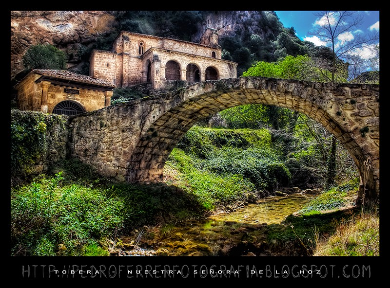
En el Norte de Burgos, la comarca de Las Merindades tiene un paisaje espectacular y pintoresco. En mi serie sobre esta zona de la pasada Semana Santa, visité, además de las cascadas del Valle de Mena y los pueblos de La Bureba, el Valle de Tobalina y el pueblo (ciudad, dicen) de Frías.
Frías es un pueblo muy conocido y explotado turísticamente. Ya lo había visitado varias veces, pero lo que no sabía es que tan sólo unos cientos de metros más arriba, se encuentra su barrio de Tobera, en una estrecha garganta por la que cae el río Molinar en un sinfín de cascadas sonoras, saltando entre las casas de este barrio. En la parte alta de este barrio de Tobera se encuentra, abrigado por una pared vertical de roca, el Santuario de Nuestra Señora de la Hoz, y el Humilladero del Cristo, con un pequeño puente sobre el Molinar.
En próximos días espero subir alguna foto del paisaje que encuentras al descender junto al río entre las casas de Tobera.
Ver en grande - Best view large
Cómo/How I did it
Canon EOS450D + Tokina 12-24
12mm f/8 1/250 ISO200
abril 2009
al atardecer, con el sol en la derecha
Que maravilla es la fotografía digital. En cada viaje, puedes disparar sin más límite que la capacidad de tus tarjetas de memoria, es gratis. Luego, en casa, con calma, procesas aquellas fotos que más te gustan, y siempre te dejas alguna para más adelante, o bien porque no la ves clara o, como es el caso, porque no sabes como "meterle mano" para que quede bien. No pasa nada, sólo ocupa unos megas en tu disco duro, y ya aprenderás como hacerlo más adelante.
Esta fotografia me encanta como composición, pero ha sido muy dificil. La he intentado procesar varias veces pero el cielo estaba bastante quemado y había sombras muy profundas, demasiado contraste.
A partir de un solo raw obtengo 6 exposiciones desde -4 hasta +2ev, hdr, mezcla con capa cero, máscara para arreglar el cielo, pincel en modo subexponer color para aumentar detalle en las sombras del puente y en modo luz intensa para los muros de la ermita, ajuste curvas en color lab para aumentar saturación y máscara de enfoque selectiva en la piedra.
Copyright © 2009 Pedro Ferrer. All Rights Reserved. Todos los derechos reservados.
Please don't use this image on websites, blogs or other media without my explicit permission.
Contact: fieraz@gmail.com
Por favor, no utilices esta imagen en páginas web, blogs u otros medios sin mi permiso explícito.
Contacto: fieraz@gmail.com
Medieval Byzantine Chant.
Title: "Θεαρχίω νεύματι"
.
.
.
photo:
Samurcasesti Monastery, in Ciorogarla village, Ilfov county, near Bucharest
Mănăstirea Samurcășești, comuna Ciorogârla, județul Ilfov, aproape de București
www.monumenteromania.ro/index.php/monumente/detalii/en/Ma...
ro.wikipedia.org/wiki/M%C4%83n%C4%83stirea_Samurc%C4%83%C...
en.flickeflu.com/photos/cliffzener/1
This was taken on a section of Starvationcreek in Oregon's Columbia River Gorge that usually gets passed over.
On my way back to the car (in an attempt to get out of the rain) i decided to take a quick peek and I saw a couple spots that were right up my alley. If you've viewed my photostream you know that these small creek scenes are some of my favorites. To this day I'm trying to figure out exactly why???? Thanks for having a look.
Dates
Taken on October 30, 2010 at 8.31am PDT (edit)
Posted to Flickr November 1, 2010 at 8.39PM PDT (edit)
Exif data
Camera Canon EOS Digital Rebel XTi
Exposure 1.6
Aperture f/7.1
Focal Length 13 mm
ISO Speed 400
Exposure Bias 0 EV
The Straits Mosque, Melaka or Masjid Selat Melaka, is a mosque on the man-made island of Pulau Melaka near Malacca Town in Malacca state, Malaysia. It looks like a floating structure if the water level is high. Construction cost of the mosque is about MYR10 million. The Opening Ceremony was done in 24 November 2006 by the Supreme Ruler of Malaysia ( Yang di-Pertuan Agong) Tuanku Syed Sirajuddin Syed Putra Jamalullail.
From Wikipedia, the free encyclopedia
Library of Congress Blanche Satchel
I claim no rights other than colorizing this image if you wish to use let me know
Title
Blanche Satchel
Contributor Names
Bain News Service, publisher
Created / Published
[no date recorded on caption card]
Format Headings
Glass negatives.
Notes
- Title from unverified data provided by the Bain News Service on the negatives or caption cards.
- Forms part of: George Grantham Bain Collection (Library of Congress).
- General information about the Bain Collection is available at hdl.loc.gov/loc.pnp/pp.ggbain
Medium
1 negative : glass ; 5 x 7 in. or smaller.
Call Number/Physical Location
LC-B2- 6431-5 [P&P]
Repository
Library of Congress Prints and Photographs Division Washington, D.C. 20540 USA hdl.loc.gov/loc.pnp/pp.print
Digital Id
ggbain 38624 //hdl.loc.gov/loc.pnp/ggbain.38624
Control Number
ggb2006014029
Reproduction Number
LC-DIG-ggbain-38624 (digital file from original negative)
Rights Advisory
No known restrictions on publication.
Online Format
image
Description
1 negative : glass ; 5 x 7 in. or smaller.
View this image BIG on black for a better viewing experience!
I'd be really grateful if you could help me expand my Facebook Page by 'Liking' it!
Taipei City is dwarfed as it is viewed from the highest viewing point of Taipei 101, the world's second tallest building. A large storm moves in from the right resulting in a large downpour about 30 minutes after this photo was taken.
Enjoy! :)
Comments + Faves appreciated.
If you are interested in purchasing any images of mine please email me at - olliesmalleyphotography@gmail.com for licensing details.
Enjoy!
...[ Camera ] ... Canon 5D Mark 2.
...[ Lens ] ... Canon 24-105mm f/4L IS USM @ 24mm.
...[ Settings ] ... 3 Shots +1, -1, +1 @ f/11, ISO 100.
...[ Editing ] ... Blended in Photomatix and Edited in LR5.
...[ Filters ] ... None.
...[ Olly's Flickr ]...[Facebook]...[Vimeo - Timelapse]...[500px]...[Prints]...
www.instagram.com/silviapantieri
flickr.com/photos/48390522@N07
www.threads.net/@silviapantieri
•
•
•
#darksoulpoetry #monochrome #monocromatic #bnwdark #blackwhite #bnwmood #blackandwhiteonly #blackandwhitearmy #blackandwhitephotographyoftheday #blackandwhitelovers #vintagephotography #darknature #blackandwhiteportrait #bnwportraits #blackandwhiteportraits #bnwportraiture
#blackandwhiteportraitphotography #bnwportrait #blackandwhiteportraitshot #blackwhiteportrait
#blackandwhiteportraiture #blacknwhiteportraits

PARIS PHOTO 2024 - GRAND PALAIS
Publié sur issuu : Paris Photo 2024, Grand Palais, samedi 09 novembre 2024
et puis, pour les fans, il y a toujours JJ_BT, l'intégrale
le tout , powered by issuu.
the collection as of december '07
not shown: the camera that took the picture - nikon d40
or the digital camera on the macbook or in the cell phone.
brings the tally to something around 56 cameras.
most cameras seen here were thrifted. the majority cost $1 or less.
in cases. and the ones i use are on a shelf.
i don't want to pay for film any more. i don't want to buy $7 batteries to use in cameras that cost $1 a shot.
i know i can get film for all of the cameras [except the polaroid roll film, that's the only one dead. the sx-70 pack can be modified, etc]
if i happen to find polaroid 600 film for a quarter a pack, then hell ya.
in the mean time, i'm goin digital and stockpiling film cameras for fun.
El petit municipi de l'Estany, situat al nord-oest del Bages i en ple altiplà del Moianès, ocupa un indret frescal que es caracteritza per la seva alçada i per una pluviositat més gran que la resta de la comarca. A la població, situada a 870 m., s'hi accedeix sobretot per la carretera que s'enfila cap al nord de Moià. Després d'una àrea de grans pagesies disperses entre boscos i conreus, molt aviat s'entra en un pla ben aprofitat on destaca la població de l'Estany. El nucli de l'Estany, arrecerat al nord per un serrat, s'alça a la vora d'on hi havia un antic estany, dessecat l'any 1570 per ordre de l'abat Carles de Cardona per tal d'escórrer les aigües i evitar així els focus d'epidèmies que comportava. L'estany encara es torna a omplir en època de grans pluges. Les cases són de pedra i constitueixen un bon exemple de poble rural, gairebé muntanyenc. Els visitants van a l'Estany atrets pel seu bon clima i per l'extraordinari monestir romànic de Santa Maria, amb la seva església restaurada, un claustre magnífic amb 72 capitells de temes bíblics, heràldics i florístics, i un petit museu annex on es resumeix la història del cenobi. Altres indrets destacables del municipi són el Puig Rodó i el Puig de la Caritat, i la diversitat de fonts naturals que hi ha. Les festes i tradicions més notables són la Festa Major (8 de setembre), la Fira (8 de desembre) i el Pessebre Vivent.
El pequeño municipio de l'Estany, situado al noroeste del Bages y en pleno altiplano del Moianès, ocupa un lugar fresco que se caracteriza por su altura y por una pluviosidad mayor que el resto de la comarca. En la población, situada a 870 m., se accede sobre todo por la carretera que sube hacia el norte de Moià. Después de un área de grandes campesinas dispersas entre bosques y cultivos, muy pronto se entra en un plan bien aprovechado donde destaca la población de l'Estany. El núcleo de l'Estany, protegido al norte por una loma, se alza a orillas de donde había un antiguo lago, desecado en 1570 por orden del abad Carles de Cardona para escurrir las aguas y evitar así los focos de epidemias que comportaba. El lago aún se vuelve a llenar en época de grandes lluvias. Las casas son de piedra y constituyen un buen ejemplo de pueblo rural, casi montañoso. Los visitantes al Lago atraídos por su buen clima y por el extraordinario monasterio románico de Santa María, con su iglesia restaurada, un claustro magnífico con 72 capiteles de temas bíblicos, heráldicos y florísticos, y un pequeño museo anexo donde se resume la historia del cenobio. Otros lugares destacables del municipio son el Puig Rodó y el Puig de la Caridad, y la diversidad de fuentes naturales que hay. Las fiestas y tradiciones más notables son la Fiesta Mayor (8 de septiembre), la Feria (8 de diciembre) y el Pesebre Viviente.
The small town of Lake, located northwest of Bages and full Moianès plateau, occupies a cool place that is characterized by its height and a higher rainfall than the rest of the region. In the town, located 870 m above is accessed by the road that climbs north of Moia. After a large area of scattered peasant between forests and crops, soon entered into a plan which highlights the best advantage of the lake population. The core of the lake, sheltered on the north by a serrated stands at the edge where there was an ancient lake dried up in 1570 by order of Abbot Charles Cardona to drain water and prevent outbreaks of epidemics entailed. The lake is still refills at times of heavy rainfall. The houses are stone and are a good example of rural village, almost mountainous. The visitors were attracted to the lake for its good climate and the extraordinary Romanesque monastery of Santa Maria, with its restored church, a magnificent cloister with 72 capitals of biblical themes, floristic and arms, and a small museum in which there are summarizes the history of the monastery. Other notable places are the town's Round Puig and Puig de la Caridad, and diversity of natural resources there. The festivities and traditions most notably the Festival (September 8), Fair (December 8) and the Living Nativity.
OK, seeing as a few images of this have crept out already, it's time to officially make this public, for those who can't get along to see it in person. Thanks to Union for the joiner and the webpage, check the link here jackwells.co.uk/bigchum.html to get an idea of the scale and mammoth task of overcoming physical adversity that went into this if you don't now this spot. This was no easy ride and if I had to do it all over again, would I...??
Make It Interesting ~ Challenge #1 (Dinosaurs)
Starter image with thanks to elias_daniel
Premade Background~
girl~Polyvore
Bird~Deviantscrap
You can help the billions of animals across the world who suffer everyday, if you care enough ,
Please Like me @ Facebook
»Higer KLQ6142SQE3L Galaxy DD // Cummins.«
→Tipo de Servicio: ---.-
→Placa Patente: ---.-
→Número de Orden Interno: ---.-
►Datos de Fotografía:
→Lugar: Valparaíso, Región de Valparaíso.-
→Fecha | Hora: 11.Julio.2014 || 16:11 hrs.-
═════════════════════════════════════════════════════════════════════
Si desea la imagen original y sin marcas, favor enviar una solicitud a:
→ e.navarretevelasquez@gmail.com
Facebook | Instagram | Website
It had been a while since I experienced snow in the winter. A recent trip to the Sierras brought back memories of snowy winters spent on the East Coast, helped me recharge my batteries and provided me a much needed chance to dust the cobwebs off of my cameras. The snow covered landscapes were such a joy! In this scene, shot with my DJI Mini 3 pro, I was drawn by the contrast of the white snow on the ground against the warm light of the setting sun shining on the tree tops on the side of the mountains
"... included in a massive 'urban renewal' project, half of the streets (old tong laus) have already been demolished, and the rest should be gone in one year's time... (Here's an article in HK Magazine if you want to know more.)"
Gage Street, Central, Hong Kong