View allAll Photos Tagged Consistent.
Inspired by the consistently sold-out Writing for Film & Television Summer Intensive Program, the Two-Weekend Intensive was designed for aspiring film and television writers with busy weekday schedules. Over the course of two weekends, participants learn a variety of screenwriting tools, techniques, and exercises that closely represent what students learn in the one-year Writing for Film & Television program.
Find out more about VFS’s one-year Writing for Film & Television program at vfs.com/writing.
The Why and What of Taoist Thought
Why Taoist Thought?
One of the best questions I ever asked myself was, “What causes religion in the first place?” The earliest signs of religious activity (and presumably thought) go back at least 40,000 years. Advances in technology over the ages have been consistently followed by ‘advances’ in religious thought and practice. For me, the empirically obvious answer to my question, “why religion,” is this: Religion evolves as a cultural framework to counterbalance cultural stresses which follow in the wake of technological advances.
Examples of this are found in the momentous change that occurred in religious paradigms as the iron age replaced the stone and bronze age, e.g., the birth of Judaism (followed by Christianity and Islam), Buddhism, Zoroaster, Hinduism, Taoism. It is hard to realize now, but iron’s impact on societies back then was as profound as the industrial revolution’s impact was in recent times.
Ideally, religion is a way for people to cope with life’s changing circumstances. Alas, religion often gets caught up in the change and loses sight of its founding fundamentals. A Taoist world-view can be a ‘way’ of last resort to those for whom mainstream religions cease being a helpful way to cope.
Reunite and Return
It is easier to understand how religion (in general) and Taoist thought (in particular) are supposed to work by considering the core problem. The idea that humanity is excluded from an ‘Eden’, of one sort or another, is common among all religions. Indeed, the biblical story of Adam and Eve’s expulsion from Eden shares common ground with the Taoist view. Their problem began when desire drove them to eat from the tree of the knowledge of good and evil, and they became aware of their nakedness. From there, however, Taoist views and most religions part company, especially in regards of what to do. Interestingly, the word religion (i.e., Latin for re-unite) itself conveys the universal question: How to re-unite with pre-knowledge innocence and return to ‘Eden’.
Taoist thought is a way to return to this ‘original self’ as much as practicable. Taoists view words, names, and knowledge of good and evil (without the devil’s role of course), as the principle reason we discern a schism between Nature and ourselves. Civilization tames people by instilling in them cultural ‘norms’ from infancy onward. And let’s face it, taming people (civilizing us) is the only way to get large populations settled into more or less peaceful co-existence. This comes at a price; we actually think that we know, willfully innovate, and so lose a proper sense of awe. I must confess, the older I get, the more I feel like I’m living in a zoo observing (and being one among) the flora and fauna. I say zoo because civilization has so extensively circumscribed human behavior. Fortunately, Taoist thought helps me return. Returning to one’s roots, as the Tao Te Ching puts it.
What is Taoist Thought?
Reading the Tao Te Ching is perhaps the best, if not the only, way to open that door. Hopefully, this site’s many posts will be helpful as well. Just briefly though, I’ll review some of the main points below…
Tao means way in Chinese. Anything said beyond that is tentative, for as the opening verse of the Tao Te Ching states: “The way that can be spoken of is not the constant way. The name that can be named is not the constant name.” So, consider this overview with that in mind:
We react to life according to how we perceive it. If a perception is out of touch with natural reality, we react in unbalanced ways that waste time, energy, and bring about unnecessary chaos and suffering. Taoist thought seeks to solve this problem at its perceptual source. As the Tao Te Ching puts it: “Woe to him who willfully innovates while ignorant of the constant…”
Taoist thought offers us a way to see through the chaos of life, and realize within ourselves this “constant.” How does Taoist thought do this?
Taoist thought rests on the view that reality is complementary; nature is inherently cooperative—not competitive. The Chinese black and white Yin-Yang circle symbolizes this balancing principle. Consider the following excerpts from the Tao Te Ching which illustrate this circular relationship.
“Thus Something and Nothing produce each other.”
“It is on disaster that good fortune perches; It is beneath good fortune that disaster crouches.”
Knowing this circular relationship moderates extremes and allows us to look deeper. As another verse, referring to opposites, states: “These two are the same, but diverge in name as they issue forth. Being the same they are called mysteries, mystery upon mystery—the gateway of the manifold secrets.”
Easing the distinction between opposites helps us sense a deeper reality, as this excerpt shows: “…Untangle the knots; soften the glare; settle the dust. This is known as mysterious sameness.”
Or, even more challenging to our idealized view of life: “The whole world recognizes the beautiful as the beautiful, yet this is only the ugly; the whole world recognizes the good as the good, yet this is only the bad.”
There are a few verses in the Tao Te Ching which attempt to describe the “constant way” more directly. Here are some excerpts:
“As a thing the way is shadowy, indistinct…”
“There is a thing, confusedly formed, born before heaven and earth. Silent and void. It stands alone and does not change…”
“Turning back is how the way moves; weakness is the means the way employs.”
“The way is empty, yet use will not drain it. Deep, it is like the ancestor of the myriad creatures.”
“Darkly visible, it only seems as if it were there. I know not whose son it is. It images the forefather of God.”
If you find this approach promising, examine this site thoroughly for practical ways to implement the principles set forth here.
This is how I feel most mornings!
I'll be taking an indefinite break from portrait work so it'll be a lot of random stuff and not very consistent uploads.
Cheers!
"Last October I had the unenviable task of putting my dog down. She was an old rescue hound that lived a hard life and was just happy to have a safe quiet home to live out her remaining years. After her passing I was in no hurry to get a second dog. Eve was just a sweet little girl and the thought of replacing her seemed blasphemous. That all changed after meeting Rex. Upon opening the door to his foster home Rex walked right up to me, sniffed my face and leaned against me. After that first meeting I knew he would be my next dog and I would be his people.
Rex is easily the biggest Greyhound I have ever seen. A lean 80 pounds and standing 30″ at the withers he is massive. So tall that he can stand on all fours and rest his head on the kitchen counter. He’s also one of the most unique Greyhounds I’ve ever seen with his Roman nose, Tiger Brindle coat, huge ears and mostly missing tail. In his first day in my home he has started to settle in. He loves his people and is a constant shadow following me around the house. He also is not scared of the camera or the shutter noise (this is a big plus in my books). All in all I think he is going to make one amazing companion, even if he does like to sneak food off the counter.
For those looking for a hound I STRONGLY encourage you to visit your local rescue society or animal shelter. Having lived with 4 rescue dogs over my lifetime I can easily say they are the best pets I’ve ever owned. They know and are truly grateful for the second chance they have been given. To quote Mark Twain; “If you pick up a starving dog and make him prosperous, he will not bite you. This is the principal difference between a dog and a man.”"
Pregos idênticos aos usados para crucificar Jesus Cristo na cruz. Os pregos se encontram em uma prateleira de vidro de uma sala ao lado do altar da Igreja Real de São Lourenço (San Lorenzo) em Turim, Itália.
A seguir, texto, em português, da Wikipédia, a enciclopédia livre:
O Sudário de Turim, ou o Santo Sudário é uma peça de linho que mostra a imagem de um homem que aparentemente sofreu traumatismos físicos de maneira consistente com a crucificação. O Sudário está guardado fora das vistas do público na capela da catedral de São João Baptista em Turim, Itália.
O sudário é uma peça rectangular de linho com 4,4 metros de comprimento e 1,1 de largura. O tecido mostra as imagens frontal e dorsal de um homem nu, com as mãos pousadas sobre as partes baixas, consistentes com a projecção ortogonal, sem a projeção referente à parte lateral do corpo humano. As duas imagens apontam em sentidos opostos e unem-se na zona central do pano. O homem representado no sudário tem barba e cabelo comprido pela altura dos ombros, separado por uma risca ao meio. Tem um corpo bem proporcionado e musculado, com cerca de 1,75 de altura. O sudário apresenta ainda diversas nódoas encarnadas que, interpretadas como sangue, sugerem a presença de vários traumatismos
* ferida num dos punhos, de forma circular; o segundo punho está escondido em segundo plano;
* ferida na zona lateral, aparentemente provocada por instrumento cortante;
* conjunto de pequenas feridas em torno da testa; e
* série de feridas lineares nas costas e pernas.
A 28 de Maio de 1898, o fotógrafo italiano Secondo Pia tirou a primeira fotografia ao sudário e constatou que o negativo da fotografia assemelhava-se a uma imagem positiva do homem, o que significava que a imagem do sudário era, em si, um negativo. Esta descoberta lançou o mote para uma discussão científica que ainda hoje permanece aberta: o que representa o sudário?
As primeiras referências a um possível sudário surgem na própria Bíblia. O Evangelho de Mateus (27:59) refere que José de Arimateia envolveu o corpo de Jesus Cristo com "um pano de linho limpo". João (19:38-40) também descreve o evento, e relata que os apóstolos Pedro e João, ao visitar o túmulo de Jesus após a ressurreição, encontraram os lençóis dobrados (Jo 20:6-7). Embora depois desta descrição evangélica o sudário só tenha feito sua aparição definitiva no século XIV, para não mais ser perdido de vista, existem alguns relatos anteriores que contêm indicações bastante consistentes sobre a existência de um tal tecido em tempos mais antigos.
A primeira menção não-evangélica a ele data de 544, quando um pedaço de tecido mostrando uma face que se acreditou ser a de Jesus foi encontrado escondido sob uma ponte em Edessa. Suas primeiras descrições mencionam um pedaço de pano quadrado, mostrando apenas a face, mas São João Damasceno, em sua obra antiiconoclasta "Sobre as imagens sagradas", falando sobre a mesma relíquia, a descreve como uma faixa comprida de tecido, embora disesse que se tratava de uma imagem transferida para o pano quando Jesus ainda estava vivo.
Em 944, quando esta peça foi transferida para Constantinopla, Gregorius Referendarius, arquidiácono de Hagia Sophia pregou um sermão sobre o artefato, que foi dado como perdido até ser redescoberto em 2004 num manuscrito dos arquivos do Vaticano. Neste sermão é feita uma descrição do sudário de Edessa como contendo não só a face, mas uma imagem de corpo inteiro, e cita a presença de manchas de sangue. Outra fonte é o Codex Vossianus Latinus, também no Vaticano, que se refere ao sudário de Edessa como sendo uma impressão de corpo inteiro.
Outra evidência é uma gravura incluída no chamado Manuscrito Húngaro de Preces, datado de 1192, onde a figura mostra o corpo de Jesus sendo preparado para o sepultamento, numa posição consistente com a imagem impressa no sudário de Turim.
Em 1203, o cruzado Robert de Clari afirmou ter visto o sudário em Constantinopla nos seguintes termos: "Lá estava o sudário em que nosso Senhor foi envolto, e que a cada quinta-feira é exposto de modo que todos possam ver a imagem de nosso Senhor nele". Seguindo-se ao saque de Constantinopla, em 1205 Theodoros Angelos, sobrinho de um dos três imperadores bizantinos, escreveu uma carta de protesto ao papa Inocêncio III, onde menciona o roubo de riquezas e relíquias sagradas da capital pelos cruzados, e dizendo que as jóias ficaram com os venezianos e relíquias haviam sido divididas entre os franceses, citando explicitamente o sudário, que segundo ele havia sido levado para Atenas nesta época.
Dali, a partir de testemunhos de época de Geoffrey de Villehardouin e do mesmo Robert de Clari, o sudário teria sido tomado por Otto de la Roche, que se tornou Duque de Atenas. Mas Otto logo o teria transmitido aos Templários, que o teriam levado para a França. Apesar desses indícios de que o sudário de Edessa seja possivelmente o mesmo que o de Turim, o assunto ainda é objeto controvérsia.
Então começa a parte da história do sudário que é bem documentada. Ele aparece publicamente pela primeira vez em 1357, quando a viúva de Geoffroy de Charny, um templário francês, a exibiu na igreja de Lirey. Não foi oferecida nenhuma explicação para a súbita aparição, nem a sua veneração como relíquia foi imediatamente aceite. Henrique de Poitiers, arcebispo de Troyes, apoiado mais tarde pelo rei Carlos VI de França, declarou o sudário como uma impostura e proibiu a sua adoração. A peça conseguiu, no entanto, recolher um número considerável de admiradores que lutaram para a manter em exibição nas igrejas. Em 1389, o bispo Pierre d’Arcis (sucessor de Henrique) denunciou a suposta relíquia como uma fraude fabricada por um pintor talentoso, numa carta a Clemente VII (em Avinhão). D’Arcis menciona que até então tem sido bem sucedido em esconder o pano e revela que a verdade lhe fora confessada pelo próprio artista, que não é identificado. A carta descreve ainda o sudário com grande precisão. Aparentemente, os conselhos do bispo de Troyes não foram ouvidos visto que Clemente VII declarou a relíquia sagrada e ofereceu indulgências a quem peregrinasse para ver o sudário.
Em 1418, o sudário passou a ser propriedade de Umberto de Villersexel, Conde de La Roche, que o removeu para o seu castelo de Montfort, sob o argumento de proteger a peça de um eventual roubo. Depois da sua morte, o pároco de Lirey e a viúva travaram uma batalha jurídica pela custódia da relíquia, ganha pela família. A Condessa de La Roche iniciou então uma tournée com o sudário que incluiu as catedrais de Genebra e Liege. Em 1453, o sudário foi trocado por um castelo (não vendido porque a transacção comercial de relíquias é proibida) com o Duque Luís de Sabóia. A nova aquisição do duque tornou-se na atracção principal da recém construída catedral de Chambery, de acordo com cronistas contemporâneos, envolvida em veludo carmim e guardada num relicário com pregos de prata e chave de ouro.
O sudário foi mais uma vez declarado como relíquia verdadeira pelo Papa Júlio II em 1506. Em 1532, o sudário foi danificado por um incêndio que afectou a sua capela e pela água das tentativas de o controlar. Por volta de 1578 a peça foi transferida para Turim em Itália, onde se encontra até aos dias de hoje na Cappella della Sacra Sindone do Palazzo Reale di Torino. A casa de Sabóia foi a proprietária do sudário até 1983, data da sua doação ao Vaticano. A última exibição da peça foi no ano 2000, a próxima está agendada para 2010. Em 2002, o sudário foi submetido a obras de restauro.
As primeiras análises ao sudário foram realizadas em 1977 por uma equipe de cientistas da Universidade de Turim que usou métodos de microscopia. Os resultados demonstraram que o linho do sudário contém inúmeras gotículas de tinta fabricada a partir de ocre. Entretanto, a hipótese de uma pintura realizada por ação humana foi completamente descartada por experimentos posteriores.
Em 1978, a equipe americana do STURP (Shoud of Turin Research Project) teve acesso ao sudário durante 120 horas. A equipe era composta por 40 cientistas, dos quais apenas 7 católicos e um ateu, Walter C. McCrone, que retirou-se logo no início das investigações. Foram realizados muitos experimentos que envolveram diversas áreas da ciência, como fotografias com diferentes tipos de filme, radiografia de raios X, raio X com fluorescência, espectroscopia, infravermelho e retirada de amostras com fita.
Depois de três anos de análise do STURP, ficou provado que existia sangue humano no sudário e que as gotículas de tinta ocre eram resultado de contaminação. Existiram diversas tentativas de se recriar algo semelhante ao sudário, realizadas durante os séculos, feitas por dezenas de pintores, mas que nunca chegaram a um resultado minimamente próximo ao sudário examinado pelo STURP. Quando questionados sobre se o sudário não era a mortalha de Jesus Cristo, de forma unânime, foi afirmado que nenhum dos resultados dos estudos contradisse a narrativa dos evangelhos. Entretanto, como cientistas, também não podiam afirmar que a mortalha era verdadeira porque essa é uma hipótese não falseável.
Cientistas do STURP também mostraram a completa improbabilidade de aquela ser uma imagem gerada pela ação de um artista, ou seja, é humanamente impossível que o sudário seja uma pintura. A habilidade e equipamentos necessários para gerar uma falsificação daquela natureza são completamente incompatíveis com o período da Idade Média, época em que o sudário apareceu e foi guardado.
As principais conclusões científicas do STURP após cerca de 100.000 horas de pesquisa sobre o artefato foram as seguintes:
a) as marcas do Sudário são um duplo negativo fotográfico do corpo inteiro de um homem. Existe a imagem de frente e de dorso. O sangue do Sudário é positivo;
b) a figura do Sudário, ao contrário de todas as outras figuras bidimensionais já testadas até então, contém dados tridimensionais;
c) o material de cor vermelha do Sudário é sangue;
d) não existe ainda explicação científica de como as imagens do Sudário foram feitas; e
e) o Sudário está historicamente de acordo com os Evangelhos, pois mostra nas imagens as marcas da paixão de Cristo com precisão.
Na época, o STURP não foi autorizado a fazer o teste por datação carbono-14.
A Igreja Católica não emitiu nenhuma opinião acerca da autenticidade desta alegada relíquia. A posição oficial a esta questão é a de que a resposta deve ser uma decisão pessoal do crente. O Papa João Paulo II confessou-se pessoalmente comovido e emocionado com a imagem do sudário, mas afirmou que uma vez que não se trata de uma questão de fé, a Igreja não se pode pronunciar, ao mesmo tempo que convidou as comunidades científicas a continuar a investigação. O grande problema reside na dificuldade de acesso ao sudário, que não é de propriedade da Igreja Católica, mas de uma fundação italiana que alega que novos e constantes testes podem danificar o material da suposta relíquia. A Catholic Encyclopedia, editada pela Igreja Católica, no seu artigo sobre o Sudário de Turim afirma que o sudário está além da capacidade de falsificação de qualquer falsário medieval.
Following, a text, in english, from Wikipedia, the free encyclopedia:
The Shroud of Turin (or Turin Shroud)
The Shroud of Turin (or Turin Shroud) is a linen cloth bearing the image of a man who appears to have been physically traumatized in a manner consistent with crucifixion. It is kept in the royal chapel of the Cathedral of Saint John the Baptist in Turin, Italy. It is believed by many to be the cloth placed on the body of Jesus at the time of his burial.
The image on the shroud is much clearer in black-and-white negative than in its natural sepia color. The striking negative image was first observed on the evening of May 28, 1898, on the reverse photographic plate of amateur photographer Secondo Pia, who was allowed to photograph it while it was being exhibited in the Turin Cathedral. According to Pia, he almost dropped and broke the photographic plate from the shock of seeing an image of a person on it.
The shroud is the subject of intense debate among scientists, people of faith, historians, and writers regarding where, when, and how the shroud and its images were created. From a religious standpoint, in 1958 Pope Pius XII approved of the image in association with the Roman Catholic devotion to the Holy Face of Jesus, celebrated every year on Shrove Tuesday. Some believe the shroud is the cloth that covered Jesus when he was placed in his tomb and that his image was recorded on its fibers at or near the time of his resurrection. Skeptics, on the other hand, contend the shroud is a medieval forgery; others attribute the forming of the image to chemical reactions or other natural processes.
Various tests have been performed on the shroud, yet the debates about its origin continue. Radiocarbon dating in 1988 by three independent teams of scientists yielded results published in Nature indicating that the shroud was made during the Middle Ages, approximately 1300 years after Jesus lived.[4] Claims of bias and error in the testing were raised almost immediately and were addressed by Harry E. Gove.[5] Follow-up analysis published in 2005, for example, claimed that the sample dated by the teams was taken from an area of the shroud that was not a part of the original cloth. The shroud was also damaged by a fire in the Late Middle Ages which could have added carbon material to the cloth, resulting in a higher radiocarbon content and a later calculated age. This analysis itself is questioned by skeptics such as Joe Nickell, who reasons that the conclusions of the author, Raymond Rogers, result from "starting with the desired conclusion and working backward to the evidence".[6] Former Nature editor Philip Ball has said that the idea that Rogers steered his study to a preconceived conclusion is "unfair" and Rogers "has a history of respectable work".
However, the 2008 research at the Oxford Radiocarbon Accelerator Unit may revise the 1260–1390 dating toward which it originally contributed, leading its director Christopher Ramsey to call the scientific community to probe anew the authenticity of the Shroud.[7][8] "With the radiocarbon measurements and with all of the other evidence which we have about the Shroud, there does seem to be a conflict in the interpretation of the different evidence" Gordan said to BBC News in 2008, after the new research emerged.[9] Ramsey had stressed that he would be surprised if the 1988 tests were shown to be far off, let alone "a thousand years wrong", and insisted that he would keep an open mind.
The shroud is rectangular, measuring approximately 4.4 × 1.1 m (14.3 × 3.7 ft). The cloth is woven in a three-to-one herringbone twill composed of flax fibrils. Its most distinctive characteristic is the faint, yellowish image of a front and back view of a naked man with his hands folded across his groin. The two views are aligned along the midplane of the body and point in opposite directions. The front and back views of the head nearly meet at the middle of the cloth. The views are consistent with an orthographic projection of a human body, but see Analysis of the image as the work of an artist.
The "Man of the Shroud" has a beard, moustache, and shoulder-length hair parted in the middle. He is muscular and tall (various experts have measured him as from 1.75 m, or roughly 5 ft 9 in, to 1.88 m, or 6 ft 2 in). For a man of the first century (the time of Jesus' death), or of the Middle Ages (the time of the first uncontested report of the shroud's existence and the proposed time of a possible forgery), these figures present an above-average although not abnormal height. Reddish brown stains that have been said to include whole blood are found on the cloth, showing various wounds that correlate with the yellowish image, the pathophysiology of crucifixion, and the Biblical description of the death of Jesus:
* one wrist bears a large, round wound, apparently from piercing (the second wrist is hidden by the folding of the hands)
* upward gouge in the side penetrating into the thoracic cavity, a post-mortem event as indicated by separate components of red blood cells and serum draining from the lesion
* small punctures around the forehead and scalp
* scores of linear wounds on the torso and legs claimed to be consistent with the distinctive dumbbell wounds of a Roman flagrum.
* swelling of the face from severe beatings
* streams of blood down both arms that include blood dripping from the main flow in response to gravity at an angle that would occur during crucifixion
* no evidence of either leg being fractured
* large puncture wounds in the feet as if pierced by a single spike
Other physical characteristics of the shroud include the presence of large water stains, and from a fire in 1532, burn holes and scorched areas down both sides of the linen due to contact with molten silver that burned through it in places while it was folded. Some small burn holes that apparently are not from the 1532 event are also present. In places, there are permanent creases due to repeated foldings, such as the line that is evident below the chin of the image.
On May 28, 1898, amateur Italian photographer Secondo Pia took the first photograph of the shroud and was startled by the negative in his darkroom.[3] Negatives of the image give the appearance of a positive image, which implies that the shroud image is itself effectively a negative of some kind. Pia was immediately accused of forgery, but was finally vindicated in 1931 when a professional photographer, Giuseppe Enrie, also photographed the shroud and his findings supported Pia
Image analysis by scientists at the Jet Propulsion Laboratory found that rather than being like a photographic negative, the image unexpectedly has the property of decoding into a 3-D image of the man when the darker parts of the image are interpreted to be those features of the man that were closest to the shroud and the lighter areas of the image those features that were farthest. This is not a property that occurs in photography, and researchers could not replicate the effect when they attempted to transfer similar images using techniques of block print, engravings, a hot statue, and bas-relief.
Many people, including author Robin Cook,[42] have put forth the suggestion that the image on the shroud was produced by a side effect of the Resurrection of Jesus, purposely left intact as a rare physical aid to understanding and believing in Jesus' dual nature as man and God. Some have asserted that the shroud collapsed through the glorified body of Jesus, pointing to certain X-ray-like impressions of the teeth and the finger bones. Others assert that radiation streaming from every point of the revivifying body struck and discolored every opposite point of the cloth, forming the complete image through a kind of supernatural pointillism using inverted shades of blue-gray rather than primary colors. However, science has yet to find an example of a reviving body emitting radiation levels significant enough to produce these changes.
There are several reddish stains on the shroud suggesting blood. McCrone (see above) identified these as containing iron oxide, theorizing that its presence was likely due to simple pigment materials used in medieval times. This is in agreement with the results of an Italian commission investigating the shroud in the early 1970s. Serologists among the commission applied several different state-of-the-art blood tests which all gave a negative result for the presence of blood. No test for the presence of color pigments was performed by this commission.[57] Other researchers, including Alan Adler, a chemist specializing in analysis of porphyrins, identified the reddish stains as type AB blood and interpreted the iron oxide as a natural residue of hemoglobin. But the problem with a blood type AB for an authentic shroud is that it is today known that this type of blood is of relative recent origin. There is no evidence of the existence of this blood type before the year AD 700. It is today assumed that the blood type AB came into the existence by immigration and following intermingling of mongoloid people from central Asia with a high frequency of the blood type B to Europe and other areas where people with a relatively high frequency of the blood type A live.
As a depiction of Jesus, the image on the shroud corresponds to that found throughout the history of Christian iconography. For instance, the Pantocrator mosaic at Daphne in Athens is strikingly similar. This suggests that the icons were made while the Image of Edessa was available, with this appearance of Jesus being copied in later artwork, and in particular, on the Shroud. Art historian W.S.A. Dale proposed (before the radiocarbon dating of the Shroud) that the Shroud itself was an icon created in the 11th century for liturgical use. In opposition to this viewpoint, the locations of the piercing wounds in the wrists on the Shroud do not correspond to artistic representations of the crucifixion before close to the present time. In fact, the Shroud was widely dismissed as a forgery in the 14th century for the very reason that the Latin Vulgate Bible stated that the nails had been driven into Jesus' hands and Medieval art invariably depicts the wounds in Jesus' hands.
Although the Vatican newspaper Osservatore Romano covered the story of Secondo Pia's photograph of May 28 1898 in its June 15, 1898 edition, it did so with no comment and thereafter Church officials generally refrained from officially commenting on the photograph for almost half a century.
The first official connection between the image on the shroud and the Catholic Church was made in 1940 based on the formal request by Sister Maria Pierina De Micheli to the curia in Milan to obtain authorization to produce a medal with the image. The authorization was granted and the first medal with the image was offered to Pope Pius XII who approved the medal. The image was then used on what became known as the Holy Face Medal worn by many Catholics, initially as a means of protection during the Second World War. In 1958 Pope Pius XII approved of the image in association with the devotion to the Holy Face of Jesus, and declared its feast to be celebrated every year the day before Ash Wednesday.
In 1983 the Shroud was given to the Holy See by the House of Savoy. However, as with all relics of this kind, the Roman Catholic Church has made no pronouncements claiming whether it is Jesus' burial shroud, or if it is a forgery. As with other approved Catholic devotions, the matter has been left to the personal decision of the faithful, as long as the Church does not issue a future notification to the contrary. In the Church's view, whether the cloth is authentic or not has no bearing whatsoever on the validity of what Jesus taught nor on the saving power of his death and resurrection. The late Pope John Paul II stated in 1998, "Since we're not dealing with a matter of faith, the church can't pronounce itself on such questions. It entrusts to scientists the tasks of continuing to investigate, to reach adequate answers to the questions connected to this shroud." He showed himself to be deeply moved by the image of the shroud and arranged for public showings in 1998 and 2000. In his address at the Turin Cathedral on Sunday May 24 1998 (the occasion of the 100th year of Secondo Pia's May 28 1898 photograph), Pope John Paul II said: "... the Shroud is an image of God's love as well as of human sin" and "...The imprint left by the tortured body of the Crucified One, which attests to the tremendous human capacity for causing pain and death to one's fellow man, stands as an icon of the suffering of the innocent in every age."
Recent developments
On April 6, 2009, the Times of London reported that official Vatican researchers had uncovered evidence that the Shroud had been kept and venerated by the Templars since the 1204 sack of Constantinople. According to the account of one neophyte member of the order, veneration of the Shroud appeared to be part of the initiation ritual. The article also implies that this ceremony may be the source of the 'worship of a bearded figure' that the Templars were accused of at their 14th century trial and suppression.
On April 10, 2009, the Telegraph reported that original Shroud investigator, Ray Rogers, acknowledged the radio carbon dating performed in 1988 was flawed. The sample used for dating may have been taken from a section damaged by fire and repaired in the 16th century, which would not provide an estimate for the original material. Shortly before his death, Rogers said:
"The worst possible sample for carbon dating was taken."
"It consisted of different materials than were used in the shroud itself, so the age we produced was inaccurate."
"...I am coming to the conclusion that it has a very good chance of being the piece of cloth that was used to bury the historic Jesus."
A text, in english, about The Real Chiesa of S. Lorenzo and Turin:
The Real Chiesa of S. Lorenzo, restored on the occasion of the two Ostensionis of the Shroud (happened in 1998 and in 2000), he/she offers to the visitor, is assiduous, the vision is occasional marveled of this jewel of Guarino Guarini.
The Priests of the church of S. Lorenzo wish to each to bring itself, after having tasted how much the creation guariniana offers to the intelligence and the heart, that feelings of architectural and religious harmony that Guarino Guarini, father Teatino, knew how to amalgamate with his genius of architect and with the faith of the believer.
A visitor to the Church of San Lorenzo – a veritable work of art – reaches piazza Castello and sees no façade marking the church. Piazza Castello is a square with a theatre without a façade (Regio), a façade of a palace (Madama) with no corresponding palace, and a church without a façade. One in fact was designed but never built to maintain the architectural harmony of the square.
The church is next to the gates of the royal palace.
On the church front there is a plaque commemorating the dead on the Russian front and above a bell that strikes 10 times at 5.15 p.m. every day.
Why is this Royal Chapel dedicated to San Lorenzo (St. Lawrence)?
In 1557, Emmanuel Philibert, Duke of Savoy, and his cousin Phillip II, King of Spain, were fighting the French at Saint-Quentin in Flanders.
They made a votive offering to build a church in the name of the saint whose feast fell on the day of their eventual victory; that victory came on 10 August, St. Lawrence’s day.
Turin:
Turin, Torino in Italian, is an interesting and often overlooked city in the Piedmont region of Italy. Famous for the Shroud of Turin and Fiat auto plants, Turin has a lot more to offer. From its Baroque cafes and architecture to its arcaded shopping promenades and museums, Turin is a great city for wandering and exploring. Turin hosted the 2006 Winter Olympics and makes a good base for exploring nearby mountains and valleys.
Turin is in the northwest of Italy in the Piemonte region between the Po River and the foothills of the Alps.
Turin is served by a small airport, Citta di Torino - Sandro Pertini, with flights to and from Europe. There is bus service connecting Turin's airport with Turin and the main railway station. A railway links the airport to GTT Dora Railway Station in the northwest of Turin. The closest airport for flights from the United States is in Milan, a little over an hour away by train.
Turin is a major hub on the Italian train line and intercity buses provide transportation to and from Turin.
Turin has an extensive network of trams and buses that run from 5AM until midnight. There are also electric mini-buses in the city center. Bus and tram tickets can be bought in a tabacchi shop. A 28km metropolitan line is due for completion in 2006.
Turin's main railway station is Porta Nuova in central Turin at the Piazza Carlo Felice. The Porta Susa Station is the main station for trains to and from Milan and is connected to central Turin and the main station by bus.
There are tourist offices at the Porta Nuova Railway Station and at the airport. The main office is in Piazza Castello and there is also one in Piazza Solferino.
You can find landromats and internet points in Turin with Lavasciuga.
Turin discount cards: See Turin and Piedmont Card for information about discount passes and the ChocoPass for chocolate tastings.
The Piedmont region has some of the best food in Italy. Over 160 types of cheese and famous wines like Barolo and Barbaresco come from here as do truffles, plentiful in fall. Turin has some outstanding pastries, especially chocolate ones. Chocolate for eating as we know it today (bars and pieces) originated in Turin. The chocolate-hazelnut sauce, gianduja, is a specialty of Turin.
Turin celebrates its patron saint in the Festa di San Giovanni June 24 with events all day and a huge fireworks display at night. Turin's big chocolate festival is in March. Turin has several music and theater festivals in summer and fall. During the Christmas season there is a 2-week street market and on New Year's Eve an open-air conert in the main piazza. The Turin Marathon in April attracts a huge number of international participants.
Turin has many museums. Walking around the city with its arcades, Baroque buildings, and beautiful piazzas can be very enjoyable.
* The Via Po is an interesting walking street with long arcades and many historic palaces and cafes. Start at Piazza Castello.
* Mole Antonelliana, a 167 meter tall tower built between 1798 and 1888, houses an excellent cinema museum. A panoramic lift takes you to the top of the tower for some expansive views of the city.
* Palazzo Carignano is the birthplace of Vittorio Emanuele II in 1820. The Unification of Italy was proclaimed here in 1861. It now houses the Museo del Risorgimento and you can see the royal apartments Royal Armoury, too.
* Museo Egizio is the third most important Egyptian museum in the world. It is housed in a huge baroque palace which also holds the Galleria Sagauda with a large collection of historic paintings.
* Piazza San Carlo, known as the "drawing room of Turin", is a beautiful baroque square with the twin churches of San Carlo and Santa Cristina as well as the above museum.
* Piazza Castello and Palazzo Reale are at the center of Turin. The square is a pedestrian area with benches and small fountains, ringed by beautiful, grand buildings.
* Il Quadrilatero is an interesting maze of backstreets with sprawling markets and splendid churches. This is another good place wo wander.
* Elegant and historic bars and cafes are everywhere in central Turin. Try a bicerin, a local layered drink made with coffee, chocolate, and cream. Cafes in Turin also serve other interesting trendy coffee drinks.
bauhaus building, dessau, germany, 1925-1926, architect: walter gropius
Gropius consistently separated the parts of the Bauhaus building according to their functions and designed each differently. He thereby arranged the different wings asymmetrically – in relation to what is today the Bauhausstraße and the Gropiusallee respectively. In order to appreciate the overall design of the complex, the observer must therefore move around the whole building. There is no central viewpoint.
The glazed, three-storey workshop wing, the block for the vocational school (also three storeys high) with its unostentatious rows of windows, and the five-storey studio building with its conspicuous, projecting balconies are the main elements of the complex. A two-storey bridge which housed, e.g., the administration department and, until 1928, Gropius’s architectural practice, connects the workshop wing with the vocational school. A single-storey building with a hall, stage and refectory, the so-called Festive Area, connects the workshop wing to the studio building. The latter originally featured 28 studio flats for students and junior masters, each measuring 20 m². The ingenious design of the portals between the foyer and the hall and a folding partition between the stage and the refectory, along with the ceiling design and colour design, impart a grandiose spatial coalescence to the sequence of foyer-hall-stage-refectory, shaping the so-called Festive Area. The façade of the students’ dormitory is distinguished in the east by individual balconies and in the south by long balconies that continue around the corner of the building.
The entire complex is rendered and painted mainly in light tones, creating an attractive contrast to the window frames, which are dark. For the interior, the junior master of the mural workshop, Hinnerk Scheper, designed a detailed colour plan that, by differentiating between supporting and masking elements through the use of colour, aimed to accentuate the construction of the building.
From 17th November 2025 until 21st November 2025 is the Dubai Airshow, taking place bi-annually towards the end of year and is consistently one of the most popular with major aircraft manufacturers in attendance.
As ever with major airshows, the 2025 Dubai Airshow drew a lot of rumours regarding who were going to place orders as it does attract numerous airlines and manufacturers. Emirates of course were subject to those rumours and were relatively tightlipped going into the airshow, with the only exception being a rumoured Airbus A350-1000 order.
On the first day of the 2025 Dubai Airshow, it was Emirates and Boeing that made the first announcement... Emirates confirmed that they have ordered an additional 65 Boeing 777-9s which takes the total order book up to 270. What made this order more interesting was that the order for 35 Boeing 777-8s has since disappeared with it likely those orders converted into the larger Boeing 777-9.
What certainly raised eyebrows wasn't just the new order for 65 Boeing 777-9s, but Emirates confirming they were in discussions with Boeing regarding a potential stretch of the Boeing 777X family. At present, the stretch known as the Boeing 777-10 is just a study as described by Emirates, but a stretch has been mooted before but never confirmed.
Right now, focus turns towards Boeing to certify the Boeing 777X, an additional delay was announced back in early-October 2025 with entry into service now expected to take place from 2027 making it over 7 years late when it should have initially entered service from 2020, with certification expected to be completed by late-2026.
Currently, Emirates operates 139 Boeing 777s, which includes 10 Boeing 777-200LRs, 11 Boeing 777Fs and 118 Boeing 777-300ERs. Emirates have 10 Boeing 777Fs, 10 Boeing 777-300ER/SFs and 270 Boeing 777-9s on-order.
Echo Papa Lima is one of 118 Boeing 777-300ERs operated by Emirates, delivered new to the flag-carrier on 15th April 2016 and she is powered by 2 General Electric GE90-115B engines. She briefly carried Hamburger SV decals from May 2016 until June 2016, then carrying Expo 2020 (Sustainability / Green) colours from January 2019 to April 2022.
Boeing 777-31H/ER A6-EPL on final approach into Runway 25L at Frankfurt-Main (FRA) on EK43 from Dubai-International (DXB).
First of all... this is how I look at home when it's getting chilly. lol
25 things meme! I've mentioned a lot of these before, but I have plenty of new friends on flickr recently, so time for a reshare! :)
1.) I'm completely deaf in my right ear. This makes sleeping in noisy areas easier for me than for people with both ears functional. ;)
2.) I experience color synesthesia related to numbers, letters, and some hiragana (called grapheme-color synesthesia). I have experienced this consistently since childhood, but never thought much of it, didn't think it was odd or different. I only discovered it was "different" and what it was called recently. I have never been formally tested for this (but now that I know, I'd like to be), but I can easily relate to all of the information I've looked up, and most of the anecdotes I've read.
3.) I have abnormally small hands and feet for a woman of my physical type, height, and age. Size small gloves, women's size 5~5.5 feet, and size 4.25 ring finger. This is burdensome because I cannot easily find many shoe styles that I like, I also cannot enjoy using "one size its all" items for hands and feet. The only places that sells socks and gloves that fit me properly are children's clothing stores.
4.) I have lived in five different states over the course of my life. Three different in my adult life.
5.) I'm going to Japan for the first time very soon. I've wanted to see Japan for well over 15 years, and never got to go until now.
6.) I'm one of those people who is sufficient and moving forward in life without having gone to college. My wits and "equivalent experience" in my field has served me well in my current career. I am doing about average for other people my same age and gender who are in my field. I am been with my company for about three years, and I am very happy. This job has changed my life in many positive ways, and because of that I'll be forever linked to it, and have fond memories even if I eventually choose a different path later on. :)
7.) I used to be very frugal (my hobbies are cheap, simple, and solitary and I don't put much stock in expensive makeup, waredrobe or fancy foods) and tucked away dutifully into savings... that is, until this doll hobby came along!! lol
8.) Politically I'm some sort of mixture of Independent / Libertarian / Objectivist. If this interests you at all, ask me and we can talk :). The basic idea (for me) is "mine is mine, yours is yours, and we leave each other alone... except for if we decide we would like to help each other by our own free wills, or strike up a deal that benefits us." Socially Liberal, Fiscally Conservative. There's obviously more to it than that, but that's the simplest way to put it.
9.) I'm also labeled as an atheist (this means simply that don't believe in supernatural or unscientific explanations for things, if there is no proof I will not accept an uneducated or "faith based" guess or folk tale as a valid theory or answer). I have always been an atheist, I never prescribed to the notion of a God or gods, apart from a very short period of time in which I was too young to think literally and abstractly (children are incapable of abstract thought until a certain age... and are thus prone to believe what trusted adults tell them until they are able to think for themselves). Luckily as soon as I realized that none of it made any sense my parents said we didn't have to go to church anymore. I think they did it purposefully so that I COULD arrive at the answer on my own, and not simply be told what was right from the outset. I really appreciate that learning experience. :)
10.) I can't stand it when people make judgements based on their personal emotions rather than what is rational. People sometimes dislike this about me, and insist "everyone is different" ... well that is exactly why you should never use your own emotions to make a judgement. BECAUSE everyone is different, and wonderfully individual, it is only fair to collect facts and rational truths, and try to make your decisions using those as best you can.
11.) I'm addicted to caffeine (mostly from drinking coffee/espresso and diet pepsi). I used to be addicted to cigarette smoking as well, but I quit successfully (cold turkey) over three years ago. I actually quit at a very stressful point in my life. I was surprised I was able to do it!
12.) My brain finds a high level of satisfaction in collecting things, especially colorful and/or rare objects. I love to organize my collections, and a psycho-analyst could potentially have a field day analyzing the way the items in my office are arranged on the shelf. For example... you can tell I'm right handed, because most of my items are organized with the more important items at center or to the right... less important items are to the left. My mother said I used to (without being told) sequence and organize m&ms by color before eating them on my highchair tray.
13.) I think Japanese writing is the most attractive language in the world. I find it extremely pleasing to look at. Hindi and Thai are also pretty to look at, but I find Japanese to seem more varied and interesting.
14.) While I love many feminine things, my personality type is extremely masculine. I am unable to relate to and understand other women unless they are willing to sit down and be completely literal, open, and honest with me. I am honestly not able to maneuver around the cloaked language and the manipulative silences and gestures of many of the women I've come to know in my life (and some of the men too). I much prefer the company of men who are open, obvious, blunt, and honest more naturally... I don't think I have met many, if any, women who are like this. Trust me, I am open to finding some, but they are a rare beast.
15.) I dislike people who base their opinion of other's based on jealousy. I used to do that when I was an early teen. Now that I'm older I see that it's ridiculous and lame... and I'm utterly surprised that there are people out there who have never grown out of that.
16.) I have never been a victim (in my opinion, anyway). I have never been told I couldn't do something I set my mind to doing (if anyone said it, I didn't hear it... maybe cause of the deaf in one ear thing? lol). I have never allowed anyone to walk over me, and very few try (because I am a bitch to deal with, it's just not worth trying). If you bite me, I will bite back harder and spit in your wounds. I sometimes feel like I might have made a great lawyer if I cared more about people and was able to hold my tongue better.
17.) When I was younger, before I fell into internet-land, I wanted to be a veterinarian, an animal behaviorist, or a geneticist. If I wasn't in my current field of web development and design, that is the field I wold be striving to get into. In college I was more attracted to languages... but lack of mentors caused me to fall back on what I already had experience in (web). It has served me well, but I could have been doing something "greater." I have the mind for it... perhaps not the ambition or drive though.
18.) I used to play piano. I sucked at it. I wanted to learn drums but was never given the opportunity. Then I wanted to learn bass and haven't yet... and now I want to learn to play the violin. I love music, and desperately want to make my own... but again, my lack of ambition fails me.
19.) I've been planning and designing websites since I was 12~13 years old. My father told me I could have a domain name if I learned to code HTML by myself... which is how this whole thing started. lol I also started teaching myself Japanese at the same time. :) My first paid website design was when I was 16 years old.
20.) Despite loving colorful things, a lot of my clothing is gray or black.
21.) My bodyshape is "tomboy"-ish. I have a decent amount in the chest department, but not very much to speak of in the hips or backside... as a result the only jeans that look attractive on me are made for men. I recently bought a pair of Lucky Brand jeans for men (low rise, mens) and they look shapely, FANTASTIC, and sexy on me. The low rise jeans made for women make me look like a lumpy shapeless, walrus. So ladies... if you hate women's jeans... try shopping in the men's section!
22.) I LOVE WALKING WITH MY IPOD. I can walk or even just pace for hours listening to my ipod and daydreaming.
23.) 80% of the music I listen to is Japanese. It's kind of great to be able to still like a song even if the lyrics are dumb. Most of the time, I can ignore lyrics in Japanese if they suck. If a song in English has shitty lyrics... I might not beable to listen to that song because of it. : /
24.) I'm a hopeless procrastinator. I've gotten better about this as I age.
25.) My next goal in life is to have a baby. I look forward to making the winter holidays for them, as how I got to enjoy when I was little. Fall leaves, wreaths, pumpkins, colorful trees with lights, holly... all that stuff.
I feel like I am forgetting something... aaaaah... I hate when this happens.
I TAG: panda♫pop, Dani, Tia, Cakewalk Queen, ccandy17... unless they already did this recently? lol
edit: dang... I need to learn how to do short, light, less intense ones of these... LOL. I am way too wordy for my own good.
Katie Boulter was wonderfully consistent in her qualifying round 1 match against Jodie Burrage (GBR), winning 61 67 64. She was knocked out in the second round by Sachia Vickery (US) 61 76.
Boulter was given a wild card entry to Wimbledon in 2017, for the singles and ladies' doubles. She had chances against Christina McHale of the USA in the 1st round, and left with her reputation enhanced.
El movimiento okupa es un movimiento consistente en darle uso a terrenos desocupados, como edificios abandonados temporal o permanentemente, con el fin de utilizarlos como tierras de cultivo, vivienda, lugar de reunión o centros con fines sociales y culturales. El principal motivo es denunciar y al mismo tiempo responder a las dificultades económicas que los activistas consideran que existen para hacer efectivo el derecho a una vivienda.
Lesson 4 Indoor Prompt
This was lots of fun but I need a different kind of lamp that throws consistent shadows. These splay when I get the light close enough to give good contrast. Strange, no? Red book is my favorite childhood book. And pie, Sweet images.
323-653-1205
Kathy Nelson, President, Film Music For Universal Music Group & Universal Pictures. Kathleen Checki President, Simply Consistent
Once a while they aren't consistent, but so far, they serve the best burgers in the Bay Area in my humble opinion.
Park Burger is Oakland's gem.
This burger is called "The Niesar", which Park Burger combines fried shallots and blue cheese with their artisanal burger.
If you like my photos, please "follow" or "like my pages below!
|| My Website || Facebook || Instagram || Twitter ||
Thank you for viewing my photograph!
La defensa antiaérea de un país constituye una prioridad para cualquier Ejército. Por ello, el Regimiento de Artillería Antiaérea (RAAA) nº 74, perteneciente al Mando de Artillería Antiaérea (MAAA), realizó, el 24 de octubre, un ejercicio de adiestramiento consistente en el disparo de dos misiles Patriot y cinco misiles Hawk en el Campo de Tiro y Maniobras "Médano del Loro" de Mazagón (Huelva) sobre blancos aéreos Banshee y SCRAB proporcionados por el Instituto Nacional de Técnica Aeroespacial (INTA).
El lanzamiento de un misil Patriot no es algo que ocurra todos los días, de hecho ésta es la cuarta vez que se realiza en nuestro país. Por eso quisieron presenciarlo el jefe de Estado Mayor de la Defensa, almirante general Fernando García Sánchez; el jefe de Estado Mayor del Ejército de Tierra, general de ejército Jaime Domínguez Buj; y el jefe de Fuerzas Terrestres, teniente teneral José I. Medida Cebrián. También les acompañaron el jefe del MAAA, general Juan Vicente Cuesta Moreno, y el jefe del RAAA nº 74, coronel Ignacio Fuente Cobo.
El ejercicio se realizó sobre un supuesto táctico en el que la unidad había recibido la misión de la defensa antiaérea de la población y zona industrial de Huelva. Se desplegaron un total de tres baterías de armas: la 2º y la 4ª del sistema Hawk y la 9ª del sistema Patriot, que se integraban en un Núcleo de Mando y Control constituido por la Batería de Plana Mayor del Grupo I/74, apoyado por la Batería de Servicios y elementos de evaluación y control de la Unidad de Reparaciones (UR) III/74. Primero se lanzaron dos misiles Hawk contra sendos blancos aéreos. El misil, de unos 40 km de alcance, está dotado de un sistema de autoguiado directo semiactivo y de navegación proporcional para dirigirse hacia el objetivo. Desde el Puesto de mando de Batería, se dirige y controla el combate antiaéreo en tiempo real, que incluye la operación en remoto de todos los radares y lanzadores de la Batería así como el propio lanzamiento de los misiles.
Seguidamente se lanzaron dos misiles Patriot. Este sistema, punta de lanza de la Artillería Antiaérea española, supera la capacidad antiaérea del Hawk por su alcance, precisión y letalidad, ya que tiene capacidad para destruir tanto aeronaves convencionales como misiles balísticos y de crucero. Es efectivo contra aviones y helicópteros a distancias superiores a 100 km; tiene capacidad de seguimiento de hasta 100 objetivos simultáneos y de guiado de nueve misiles de vuelo. Desde la Estación de Control de Empeños se gestiona el sistema completo, y pueden controlar hasta 8 lanzadores. Posteriormente se dispararon 3 misiles Hawk contra otros blancos aéreos.
La Batería Patriot está formada por cuatro pelotones de Lanzadores y un Pelotón de Control, que a su vez se compone de tres elementos: una planta de suministro de energía táctica; un radar multifunción, desde el que se ejecutan las tareas de exploración, seguimiento e identificación; y una estación de control de empeños, que es el único elemento tripulado desde el que se dirige, ejecuta y controla la batalla antiaérea en tiempo real.
El objetivo del ejercicio de tiro era certificar la capacidad antimisil del Ejército de Tierra, y completar así la preparación de las tripulaciones de los sistemas de armas Hawk y Patriot, comprobar la fiabilidad de la munición, evaluar el grado de adiestramiento de las unidades y el nivel de instrucción del personal, así como la operatividad del material.
La realización de un ejercicio de este tipo es enormemente compleja por la necesidad de garantizar la seguridad terrestre, naval y aérea a grandes distancias. Esto se consigue por la completa coordinación de los órganos de control de navegación aérea y marítima, con los medios de vigilancia de la Guardia Civil, Armada, INTA, Sistema de Defensa Aérea Nacional y los radares de vigilancia y tiro de la propia unidad.
This statue honors Chief Clinton Rickard, Tuscarora leader in the early 20th century who is best known for his work as the founder of the Indian Defense League. The league fought to maintain Native American sovereignty for area tribes, including the right to travel freely between the United States and Canadian border. These rights had previously been granted to Native tribes as part of the Jay Treaty between the United States and Great Britain in 1794.
Chief Clinton Rickard was a Tuscarora leader and founder of the Indian Defense League in 1926. He was born in 1882 on the Tuscarora Reservation near Sanborn, New York. Even though he lacked a formal education, Chief Rickard became known among many prominent and important influential people as an expert on American Indian legal history. In the early 1900s, he became a leading voice for Native American tribal sovereignty. He worked tirelessly to enforce existing treaties, including the provision that allowed free travel across the United States and Canadian border. The border was never been recognized or acknowledged by the Haudenosaunee people.
Niagara Falls is a city in Niagara County, New York, United States. As of the 2020 census, the city had a total population of 48,671. It is adjacent to the Niagara River, across from the city of Niagara Falls, Ontario, and named after the famed Niagara Falls which they share. The city is within the Buffalo–Niagara Falls metropolitan area and the Western New York region.
While the city was formerly inhabited by Native Americans, Europeans who migrated to the Niagara Falls in the mid-17th century began to open businesses and develop infrastructure. Later in the 18th and 19th centuries, scientists and businessmen began harnessing the power of the Niagara River for electricity and the city began to attract manufacturers and other businesses drawn by the promise of inexpensive hydroelectric power. After the 1960s, however, the city and region witnessed an economic decline, following an attempt at urban renewal under then Mayor Lackey. Consistent with the rest of the Rust Belt as industries left the city, old line affluent families relocated to nearby suburbs and out of town.
Despite the decline in heavy industry, Niagara Falls State Park and the downtown area closest to the falls continue to thrive as a result of tourism. The population, however, has continued to decline from a peak of 102,394 in the 1960s due to the loss of manufacturing jobs in the area.
Before Europeans entered the area, it was dominated by the Neutral Nation of Native Americans. European migration into the area began in the 17th century. The first recorded European to visit the area was Frenchman Robert de la Salle, who built Fort Conti at the mouth of the Niagara River early in 1679, with permission from the Iroquois, as a base for boatbuilding; his ship Le Griffon was built on the upper Niagara River at or near Cayuga Creek in the same year. He was accompanied by Belgian priest Louis Hennepin, who was the first known European to see the falls. The influx of newcomers may have been a catalyst for already hostile native tribes to turn to open warfare in competition for the fur trade.
The City of Niagara Falls was incorporated on March 17, 1892, from the villages of Manchester and Suspension Bridge, which were parts of the Town of Niagara. Thomas Vincent Welch, a member of the charter committee and a New York state assemblyman and a second-generation Irish American, persuaded Governor Roswell P. Flower to sign the bill on St. Patrick's Day. George W. Wright was elected the first mayor of Niagara Falls.
By the end of the 19th century, the city was heavily industrialized, due in part to the power potential offered by the Niagara River. Tourism was considered a secondary niche, while manufacturing of petrochemicals, abrasives, metallurgical products and other materials was the main producer of jobs and attracted a large number of workers, many of whom were immigrants.
Industry and tourism grew steadily throughout the first half of the 20th century due to a high demand for industrial products and the increased mobility of people to travel. Paper, rubber, plastics, petrochemicals, carbon insulators and abrasives were among the city's major industries. This prosperity would end by the late 1960s as aging industrial plants moved to less expensive locations. In addition, the falls were incompatible with modern shipping technology.[further explanation needed]
In 1956, the Schoellkopf Power Plant on the lower river just downstream of the American Falls was critically damaged by the collapse of the Niagara Gorge wall above it. This prompted the planning and construction of one of the largest hydroelectric plants to be built in North America to that time, generating a large influx of workers and families to the area. New York City urban planner Robert Moses built the new power plant in nearby Lewiston, New York. Much of the power generated there fueled growing demands for power in downstate New York and New York City.
The neighborhood of Love Canal gained national media attention in 1978 when toxic waste contamination from a chemical landfill beneath it forced United States President Jimmy Carter to declare a state of emergency, the first such presidential declaration made for a non-natural disaster. Hundreds of residents were evacuated from the area, many of whom were ill because of exposure to chemical waste.
After the Love Canal disaster, the city—which had already been declining in population for nearly two decades—experienced accelerated economic and political difficulties. The costs of manufacturing elsewhere had become less expensive, which led to the closure of several factories. The city's population eventually dropped by more than half of its peak, as workers fled the city in search of jobs elsewhere. Then, much like the nearby city of Buffalo, the city's economy plummeted when a failed urban renewal project destroyed Falls Street and the tourist district.
In 2001, the leadership of Laborers Local 91 was found guilty of extortion, racketeering and other crimes following an exposé by Mike Hudson of the Niagara Falls Reporter. Union boss Michael "Butch" Quarcini died before trial, while the rest of the union leadership was sentenced to prison.
In early 2010, former Niagara Falls Mayor Vincenzo Anello was indicted on federal charges of corruption, alleging the mayor accepted $40,000 in loans from a businessman who was later awarded a no-bid lease on city property. The charges were dropped as part of a plea deal after Anello pleaded guilty to unrelated charges of pension fraud, regarding a pension from the International Brotherhood of Electrical Workers, of which he is a member. He was sentenced to 10 to 16 months in prison.
The city's decline received national exposure from Bloomberg Businessweek in 2010.
On November 30, 2010, the New York State Attorney General entered into an agreement with the city and its police department to create new policies to govern police practices in response to claims of excessive force and police misconduct. The city committed to create policies and procedures to prevent and respond to allegations of excessive force, and to ensure police are properly trained and complaints are properly investigated. Prior claims filed by residents will be evaluated by an independent panel.
In 2020, a public square named Cataract Commons opened on Old Falls Street. It is a public space for outdoor events and activities.
The city has multiple properties on the National Register of Historic Places. It also has three national historic districts, including Chilton Avenue-Orchard Parkway Historic District, Deveaux School Historic District and the Park Place Historic District.
Niagara Falls is at the international boundary between the United States and Canada. The city is within the Buffalo–Niagara Falls metropolitan area and is approximately 16 miles (26 km) from Buffalo, New York.
According to the United States Census Bureau, the city has an area of 16.8 square miles (44 km2), of which 14.1 square miles (37 km2) is land and 2.8 square miles (7.3 km2) (16.37%) is water. The city is built along the Niagara Falls and the Niagara Gorge, which is next to the Niagara River.
Niagara Falls has a humid continental climate (Dfa). The city experiences cold, snowy winters and hot, humid summers. Precipitation is moderate and consistent in all seasons, falling equally or more as snow during the winter. The city has snowier than average winters compared to most cities in the US, however less than many other cities in Upstate New York including nearby Buffalo and Rochester. Thaw cycles with temperatures above 32 °F (0 °C) are a common occurrence. The hottest and coldest temperatures recorded in the decade through 2015 were 97 °F (36 °C) in 2005 and −13 °F (−25 °C) in 2003, respectively. 38% of warm season precipitation falls in the form of a thunderstorm.
Buffalo Avenue – runs along the south end along the Niagara River once home to a vast number of old families with architecturally significant mansions; further east (past John Daly Boulevard) the street is surrounded by a number of industrial sites to 56th Street before returning to a residential area and ending at the Love Canal area at 102nd Street.
Central District
Deveaux – Located in the northwestern corner (west of the North End) along the Niagara River is residential area built in the 1920s to 1940s. Named for Judge Samuel DeVeaux who left his estate to be established as the Deveaux College for Orphans and Destitute Children in 1853 (closed 1971), now the site of DeVeaux Woods State Park and DeVeaux School Historical District.
Downtown – Area around the Falls and home to hotels including Seneca Niagara Resort Casino, Niagara Falls State Park, Niagara Falls Culinary Institute (formerly Rainbow Centre Factory Outlet)
East Side – the area bounded by the gorge on the west, Niagara Street on the south, Ontario Avenue on the North and Main Street (NY Rt 104) on the east.
Hyde Park – Located near the namesake Hyde Park next to Little Italy as well as home to Hyde Park Municipal Golf Course.
LaSalle – Bounded by 80th Street, Niagara Falls Boulevard, Cayuga Drive and LaSalle Expressway was built up in the 1940s to 1960s. Cayuga Island is linked to neighborhood. The actual neighborhood where the Love Canal was to be built.
Little Italy – home to a once predominately Italian community that runs along Pine Avenue from Main Street to Hyde Park Boulevard
Love Canal – Established in the 1950s on land acquired from Hooker Chemical Company. Most of the neighborhood was evacuated in the 1980s after toxic waste was discovered underground. Resettlement began in 1990.[24]
Niagara Street – residential area east of Downtown along Niagara Street (distinct from Niagara Ave.) once home to a predominately German and Polish community.
North End – runs along Highland Avenue in the north end of the city before it merges with Hyde Park Boulevard.
As of the census of 2010, there were 50,193 people, 22,603 households, and 12,495 families residing in the city. The population density was 2,987.7 people per square mile (1,153.5 per square km). There were 26,220 housing units at an average density of 1,560.7 per square mile (602.6/km2). The racial makeup of the city was 70.5% White, 21.6% African American, 1.9% Native American, 1.2% Asian, 0% Pacific Islander, 0.8% from other races, and 3.9% from two or more races. Hispanic or Latino of any race were 3.0% of the population.
There were 22,603 households, out of which 23.9% had children under the age of 18 living with them, 29.8% were married couples living together, 19.7% had a female householder with no husband present, and 44.7% were non-families. 38.1% of all households were made up of individuals, and 13.7% had someone living alone who was 65 years of age or older. The average household size was 2.20 and the average family size was 4.02.
In the city, 22% of the population was under the age of 18, 10.1% aged from 18 to 24, 24.2% from 25 to 44, 28.2% from 45 to 64, and 15.5% were 65 years of age or older. The median age was 39 years. For every 100 females, there were 91.2 males. For every 100 females age 18 and over, there were 94.4 males.
The median income for a household in the city was $26,800, and the median income for a family was $34,377. Males had a median income of $31,672 versus $22,124 for females. 23% of the population was below the poverty line.
Niagara Falls has a number of places of worship, including the Salvation Army, First Assembly of God Church, First Unitarian Universalist Church of Niagara, St. Peter's Episcopal Church, First Presbyterian Church, St. Theresa Roman Catholic Church in Deveaux, and the Reform Jewish Temple Beth El. The Conservative Jewish Temple Beth Israel closed in 2012.
Niagara Falls has struggled with high rates of violent and property crime; FBI crime data indicate that the city has among the highest crime rates in New York state. In response to gun violence, volunteer groups such as Operation SNUG mobilized to promote positive community involvement in the troubled areas of the city.
Comptroller reported that Niagara Falls has "struggled through decades of population losses, rising crime and repeated attempts to reinvent itself from a manufacturing town with some tourism to a major tourist destination." The city became a boomtown with the opening of the New York State Power Authority's hydroelectric Niagara Power Plant in the 1960s; the cheap electricity produced by the plant generated power for a burgeoning manufacturing industry. Along with the rest of Western New York, Niagara Falls suffered a significant economic decline from a decline in industry by the 1970s. Today, the city struggles to compete with Niagara Falls, Ontario; the Canadian side has a greater average annual income, a higher average home price, and lower levels of vacant buildings and blight, as well as a more vibrant economy and better tourism infrastructure. The population of Niagara Falls, New York fell by half from the 1960s to 2012. In contrast, the population of Niagara Falls, Ontario more than tripled. In 2000, the city's median household income was 36% below the national average. In 2012, the city's unemployment rate was significantly higher than the statewide unemployment rate.
Significant sources of economic activity in the region includes the Niagara Falls International Airport, which was renovated in 2009; the Seneca Gaming Corporation's Seneca Niagara Casino & Hotel, which opened in the 2000s respectively; and the nearby Niagara Falls Air Reserve Station.
In late 2001, the State of New York established the USA Niagara Development Corporation, a subsidiary to the State's economic development agency, to focus specifically on facilitating development in the downtown area. However, the organization has been criticized for making little progress and doing little to improve the city's economy.
From 1973 to 2002, the city had a Convention and Civic Center on 4th street. In 2002 the venue was converted into the Seneca Niagara Casino & Hotel. In 2004, a new Niagara Falls Convention Center (NFCC) opened on Old Falls Street. The Old Falls Street venue has 116,000 square feet for exhibitions and meetings, and a 32,200-square-foot event/exhibit hall.
The city is home to the Niagara Falls State Park. The park has several attractions, including Cave of the Winds behind the Bridal Veil Falls, Maid of the Mist, a popular boat tour which operates at the foot of the Rainbow Bridge, Prospect Point and its observation tower, Niagara Discovery Center, Niagara Falls Underground Railroad Heritage Center, and the Aquarium of Niagara.
Several other attractions also near the river, including Whirlpool State Park, De Veaux Woods State Park, Earl W. Brydges Artpark State Park in nearby Lewiston (town), New York, and Fort Niagara State Park in Youngstown, New York.
Attractions in the downtown include the Seneca Niagara Casino & Hotel and Pine Avenue which was historically home to a large Italian American population and is now known as Little Italy for its abundance of shops and quality restaurants.
The Niagara Power of the New York Collegiate Baseball League play at Sal Maglie Stadium. The team is owned by Niagara University. The Cataract City Wolverines of the Gridiron Developmental Football League are a minor league football team based in Niagara Falls. The team played their inaugural season in 2021.
In 2017, the Tier III junior North American 3 Hockey League team, the Lockport Express, relocated to Niagara Falls as the Niagara Falls PowerHawks.
Former sports teams based in Niagara Falls include the Class-A Niagara Falls Sox, the Class-A Niagara Falls Rapids, the Niagara Falls Lancers of the Midwest Football League, and the Western New York Thundersnow of the Premier Basketball League and American Basketball Association.
The City of Niagara Falls functions under a strong mayor-council form of government. The government consists of a mayor, a professional city administrator, and a city council. The current mayor is Robert Restaino.
The city council serves four-year, staggered terms, except in the case of a special election. It is headed by a chairperson, who votes in all items for council action.
On a state level, Niagara Falls is part of the 145th Assembly District of New York State, represented by Republican Angelo Morinello. Niagara Falls is also part of the 62nd Senate District of New York State, represented by Republican Robert Ortt.
On a national level, the city is part of New York's 26th congressional district and is represented by Congressman Brian Higgins. In the United States Senate, the city and the state are represented by senators Charles Schumer and Kirsten Gillibrand.
Founded in 1892 Niagara Falls Police Department provide local law enforcement in the city with 155 sworn officers. This force is not to be mistaken for the Town of Niagara, New York which has a smaller force founded in 1954.
Residents are zoned to the Niagara Falls City School District. Niagara University and Niagara County Community College are the two colleges in Niagara County.
Since Niagara Falls is within the Buffalo–Niagara Falls metropolitan area, the city's media is predominantly served by the city of Buffalo.
The city has two local newspapers, the Niagara Gazette, which is published daily except Tuesday and The Messenger Of Niagara Falls, NY which is published quarterly. The Messenger Of Niagara Falls, NY, which is officially Niagara Falls, New York's, first black-owned and operated news publication, founded October 2018. The Messenger Of Niagara Falls, NY published its inaugural issue April 2019. The Buffalo News is the closest major newspaper in the area. The city also is the home to a weekly tabloid known as the Niagara Falls Reporter.
Three radio stations are licensed to the city of Niagara Falls, including WHLD AM 1270, WEBR AM 1440, and WTOR AM 770.
Niagara Falls is primarily served by the Buffalo Niagara International Airport for regional and domestic flights within the United States. The recently expanded Niagara Falls International Airport serves the city, and many cross border travellers with flights to Myrtle Beach, Fort Lauderdale, Orlando and Punta Gorda. Toronto's Pearson International Airport on the Canadian side is the closest airport offering long-haul international flights for the Niagara region.
The city is served by Amtrak's Maple Leaf and Empire train services, with regular stops at the Niagara Falls Station and Customhouse Interpretive Center at 825 Depot Ave West.
Niagara Frontier Transportation Authority is the public transit provider in the Buffalo metro area, with hubs at the Portage Road and Niagara Falls transportation centers.
Six New York State highways, one three-digit Interstate Highway, one expressway, one U.S. Highway, and one parkways pass through the city of Niagara Falls. New York State Route 31, New York State Route 104, and New York State Route 182 are east–west state roadways within the city, while New York State Route 61, New York State Route 265, and New York State Route 384 are north–south state roadways within the city. The LaSalle Expressway is an east–west highway which terminates near the eastern edge of Niagara Falls and begins in the nearby town of Wheatfield, New York. The Niagara Scenic Parkway is a north–south parkway that formerly ran through the city along the northern edge of the Niagara River. It remains in sections and terminates in Youngstown, New York.
Interstate 190, also referred to as the Niagara Expressway, is a north–south highway and a spur of Interstate 90 which borders the eastern end of the city. The highway enters the city from the town of Niagara and exits at the North Grand Island Bridge. U.S. Route 62, known as Niagara Falls Boulevard, Walnut Avenue, and Ferry Avenue, is signed as a north–south highway. U.S. Route 62 has an east–west orientation, and is partially split between two one-way streets within Niagara Falls. Walnut Avenue carries U.S. Route 62 west to its northern terminus at NY 104, and Ferry Avenue carries U.S. Route 62 east from downtown Niagara Falls. U.S. Route 62 Business, locally known as Pine Avenue, is an east–west route which parallels U.S. Route 62 to the south. Its western terminus is at NY 104, and its eastern terminus is at U.S. Route 62.
Two international bridges connect the city to Niagara Falls, Ontario. The Rainbow Bridge connects the two cities with passenger and pedestrian traffic and overlooks the Niagara Falls, while the Whirlpool Rapids Bridge, which formerly carried the Canadian National Railway, now serves local traffic and Amtrak's Maple Leaf service.
New York, sometimes called New York State, is a state in the Northeastern and Mid-Atlantic regions of the United States. It borders New Jersey and Pennsylvania to its south, New England and the Canadian provinces of Ontario and Quebec to its north, and the Atlantic Ocean to its east. With almost 19.6 million residents, it is the fourth-most populous state in the United States and eighth-most densely populated as of 2023. New York is the 27th-largest U.S. state by area, with a total area of 54,556 square miles (141,300 km2).
New York has a varied geography. The southeastern part of the state, known as Downstate, encompasses New York City, the most populous city in the United States, Long Island, the most populous island in the United States, and the lower Hudson Valley. These areas are the center of the New York metropolitan area, a sprawling urban landmass, and account for approximately two-thirds of the state's population. The much larger Upstate area spreads from the Great Lakes to Lake Champlain, and includes the Adirondack Mountains and the Catskill Mountains (part of the wider Appalachian Mountains). The east–west Mohawk River Valley bisects the more mountainous regions of Upstate, and flows into the north–south Hudson River valley near the state capital of Albany. Western New York, home to the cities of Buffalo and Rochester, is part of the Great Lakes region and borders Lake Ontario and Lake Erie. Central New York is anchored by the city of Syracuse; between the central and western parts of the state, New York is dominated by the Finger Lakes, a popular tourist destination. To the south, along the state border with Pennsylvania, the Southern Tier sits atop the Allegheny Plateau, representing the northernmost reaches of Appalachia.
New York was one of the original Thirteen Colonies that went on to form the United States. The area of present-day New York had been inhabited by tribes of the Algonquians and the Iroquois Confederacy Native Americans for several thousand years by the time the earliest Europeans arrived. Stemming from Henry Hudson's expedition in 1609, the Dutch established the multiethnic colony of New Netherland in 1621. England seized the colony from the Dutch in 1664, renaming it the Province of New York. During the American Revolutionary War, a group of colonists eventually succeeded in establishing independence, and the former colony was officially admitted into the United States in 1788. From the early 19th century, New York's development of its interior, beginning with the construction of the Erie Canal, gave it incomparable advantages over other regions of the United States. The state built its political, cultural, and economic ascendancy over the next century, earning it the nickname of the "Empire State." Although deindustrialization eroded a significant portion of the state's economy in the second half of the 20th century, New York in the 21st century continues to be considered as a global node of creativity and entrepreneurship, social tolerance, and environmental sustainability.
The state attracts visitors from all over the globe, with the highest count of any U.S. state in 2022. Many of its landmarks are well known, including four of the world's ten most-visited tourist attractions in 2013: Times Square, Central Park, Niagara Falls and Grand Central Terminal. New York is home to approximately 200 colleges and universities, including two Ivy League universities, Columbia University and Cornell University, and the expansive State University of New York, which is among the largest university systems in the nation. New York City is home to the headquarters of the United Nations, and it is sometimes described as the world's most important city, the cultural, financial, and media epicenter, and the capital of the world.
The history of New York begins around 10,000 B.C. when the first people arrived. By 1100 A.D. two main cultures had become dominant as the Iroquoian and Algonquian developed. European discovery of New York was led by the Italian Giovanni da Verrazzano in 1524 followed by the first land claim in 1609 by the Dutch. As part of New Netherland, the colony was important in the fur trade and eventually became an agricultural resource thanks to the patroon system. In 1626, the Dutch thought they had bought the island of Manhattan from Native Americans.[1] In 1664, England renamed the colony New York, after the Duke of York and Albany, brother of King Charles II. New York City gained prominence in the 18th century as a major trading port in the Thirteen Colonies.
New York played a pivotal role during the American Revolution and subsequent war. The Stamp Act Congress in 1765 brought together representatives from across the Thirteen Colonies to form a unified response to British policies. The Sons of Liberty were active in New York City to challenge British authority. After a major loss at the Battle of Long Island, the Continental Army suffered a series of additional defeats that forced a retreat from the New York City area, leaving the strategic port and harbor to the British army and navy as their North American base of operations for the rest of the war. The Battle of Saratoga was the turning point of the war in favor of the Americans, convincing France to formally ally with them. New York's constitution was adopted in 1777, and strongly influenced the United States Constitution. New York City was the national capital at various times between 1788 and 1790, where the Bill of Rights was drafted. Albany became the permanent state capital in 1797. In 1787, New York became the eleventh state to ratify the United States Constitution.
New York hosted significant transportation advancements in the 19th century, including the first steamboat line in 1807, the Erie Canal in 1825, and America's first regularly scheduled rail service in 1831. These advancements led to the expanded settlement of western New York and trade ties to the Midwest settlements around the Great Lakes.
Due to New York City's trade ties to the South, there were numerous southern sympathizers in the early days of the American Civil War and the mayor proposed secession. Far from any of the battles, New York ultimately sent the most soldiers and money to support the Union cause. Thereafter, the state helped create the industrial age and consequently was home to some of the first labor unions.
During the 19th century, New York City became the main entry point for European immigrants to the United States, beginning with a wave of Irish during their Great Famine. Millions came through Castle Clinton in Battery Park before Ellis Island opened in 1892 to welcome millions more, increasingly from eastern and southern Europe. The Statue of Liberty opened in 1886 and became a symbol of hope. New York boomed during the Roaring Twenties, before the Wall Street Crash of 1929, and skyscrapers expressed the energy of the city. New York City was the site of successive tallest buildings in the world from 1913 to 1974.
The buildup of defense industries for World War II turned around the state's economy from the Great Depression, as hundreds of thousands worked to defeat the Axis powers. Following the war, the state experienced significant suburbanization around all the major cities, and most central cities shrank. The Thruway system opened in 1956, signaling another era of transportation advances.
Following a period of near-bankruptcy in the late 1970s, New York City renewed its stature as a cultural center, attracted more immigration, and hosted the development of new music styles. The city developed from publishing to become a media capital over the second half of the 20th century, hosting most national news channels and broadcasts. Some of its newspapers became nationally and globally renowned. The state's manufacturing base eroded with the restructuring of industry, and the state transitioned into service industries.
The first peoples of New York are estimated to have arrived around 10,000 BC. Around AD 800, Iroquois ancestors moved into the area from the Appalachian region. The people of the Point Peninsula complex were the predecessors of the Algonquian peoples of New York. By around 1100, the distinct Iroquoian-speaking and Algonquian-speaking cultures that would eventually be encountered by Europeans had developed. The five nations of the Iroquois League developed a powerful confederacy about the 15th century that controlled territory throughout present-day New York, into Pennsylvania around the Great Lakes. For centuries, the Mohawk cultivated maize fields in the lowlands of the Mohawk River, which were later taken over by Dutch settlers at Schenectady, New York when they bought this territory. The Iroquois nations to the west also had well-cultivated areas and orchards.
The Iroquois established dominance over the fur trade throughout their territory, bargaining with European colonists. Other New York tribes were more subject to either European destruction or assimilation within the Iroquoian confederacy. Situated at major Native trade routes in the Northeast and positioned between French and English zones of settlement, the Iroquois were intensely caught up with the onrush of Europeans, which is also to say that the settlers, whether Dutch, French or English, were caught up with the Iroquois as well. Algonquian tribes were less united among their tribes; they typically lived along rivers, streams, or the Atlantic Coast. But, both groups of natives were well-established peoples with highly sophisticated cultural systems; these were little understood or appreciated by the European colonists who encountered them. The natives had "a complex and elaborate native economy that included hunting, gathering, manufacturing, and farming...[and were] a mosaic of Native American tribes, nations, languages, and political associations." The Iroquois usually met at an Onondaga in Northern New York, which changed every century or so, where they would coordinate policies on how to deal with Europeans and strengthen the bond between the Five Nations.
Tribes who have managed to call New York home have been the Iroquois, Mohawk, Mohican, Susquehannock, Petun, Chonnonton, Ontario and Nanticoke.
In 1524, Giovanni da Verrazzano, an Italian explorer in the service of the French crown, explored the Atlantic coast of North America between the Carolinas and Newfoundland, including New York Harbor and Narragansett Bay. On April 17, 1524, Verrazzano entered New York Bay, by way of the Strait now called the Narrows. He described "a vast coastline with a deep delta in which every kind of ship could pass" and he adds: "that it extends inland for a league and opens up to form a beautiful lake. This vast sheet of water swarmed with native boats". He landed on the tip of Manhattan and perhaps on the furthest point of Long Island.
In 1535, Jacques Cartier, a French explorer, became the first European to describe and map the Saint Lawrence River from the Atlantic Ocean, sailing as far upriver as the site of Montreal.
On April 4, 1609, Henry Hudson, in the employ of the Dutch East India Company, departed Amsterdam in command of the ship Halve Maen (Half Moon). On September 3 he reached the estuary of the Hudson River. He sailed up the Hudson River to about Albany near the confluence of the Mohawk River and the Hudson. His voyage was used to establish Dutch claims to the region and to the fur trade that prospered there after a trading post was established at Albany in 1614.
In 1614, the Dutch under the command of Hendrick Christiaensen, built Fort Nassau (now Albany) the first Dutch settlement in North America and the first European settlement in what would become New York. It was replaced by nearby Fort Orange in 1623. In 1625, Fort Amsterdam was built on the southern tip of Manhattan Island to defend the Hudson River. This settlement grew to become the city New Amsterdam.
The British conquered New Netherland in 1664; Lenient terms of surrender most likely kept local resistance to a minimum. The colony and New Amsterdam were both renamed New York (and "Beverwijck" was renamed Albany) after its new proprietor, James II later King of England, Ireland and Scotland, who was at the time Duke of York and Duke of Albany The population of New Netherland at the time of English takeover was 7,000–8,000.
Thousands of poor German farmers, chiefly from the Palatine region of Germany, migrated to upstate districts after 1700. They kept to themselves, married their own, spoke German, attended Lutheran churches, and retained their own customs and foods. They emphasized farm ownership. Some mastered English to become conversant with local legal and business opportunities. They ignored the Indians and tolerated slavery (although few were rich enough to own a slave).
Large manors were developed along the Hudson River by elite colonists during the 18th century, including Livingston, Cortlandt, Philipsburg, and Rensselaerswyck. The manors represented more than half of the colony's undeveloped land. The Province of New York thrived during this time, its economy strengthened by Long Island and Hudson Valley agriculture, in conjunction with trade and artisanal activity at the Port of New York; the colony was a breadbasket and lumberyard for the British sugar colonies in the Caribbean. New York's population grew substantially during this century: from the first colonial census (1698) to the last (1771), the province grew ninefold, from 18,067 to 168,007.
New York in the American Revolution
Further information: John Peter Zenger, Stamp Act Congress, Invasion of Canada (1775), New York and New Jersey campaign, Prisoners of war in the American Revolutionary War, and Intelligence in the American Revolutionary War
New York played a pivotal role in the Revolutionary War. The colony verged on revolt following the Stamp Act of 1765, advancing the New York City–based Sons of Liberty to the forefront of New York politics. The Act exacerbated the depression the province experienced after unsuccessfully invading Canada in 1760. Even though New York City merchants lost out on lucrative military contracts, the group sought common ground between the King and the people; however, compromise became impossible as of April 1775 Battles of Lexington and Concord. In that aftermath the New York Provincial Congress on June 9, 1775, for five pounds sterling for each hundredweight of gunpowder delivered to each county's committee.
Two powerful families had for decades assembled colony-wide coalitions of supporters. With few exceptions, members long associated with the DeLancey faction went along when its leadership decided to support the crown, while members of the Livingston faction became Patriots.
New York's strategic central location and port made it key to controlling the colonies. The British assembled the century's largest fleet: at one point 30,000 British sailors and soldiers anchored off Staten Island. General George Washington barely escaped New York City with his army in November 1776; General Sir William Howe was successful in driving Washington out, but erred by expanding into New Jersey. By January 1777, he retained only a few outposts near New York City. The British held the city for the duration, using it as a base for expeditions against other targets.
In October 1777, American General Horatio Gates won the Battle of Saratoga, later regarded as the war's turning point. Had Gates not held, the rebellion might well have broken down: losing Saratoga would have cost the entire Hudson–Champlain corridor, which would have separated New England from the rest of the colonies and split the future union.
Upon war's end, New York's borders became well–defined: the counties east of Lake Champlain became Vermont and the state's western borders were settled by 1786.
Many Iroquois supported the British (typically fearing future American ambitions). Many were killed during the war; others went into exile with the British. Those remaining lived on twelve reservations; by 1826 only eight reservations remained, all of which survived into the 21st century.
The state adopted its constitution in April 1777, creating a strong executive and strict separation of powers. It strongly influenced the federal constitution a decade later. Debate over the federal constitution in 1787 led to formation of the groups known as Federalists—mainly "downstaters" (those who lived in or near New York City) who supported a strong national government—and Antifederalists—mainly upstaters (those who lived to the city's north and west) who opposed large national institutions. In 1787, Alexander Hamilton, a leading Federalist from New York and signatory to the Constitution, wrote the first essay of the Federalist Papers. He published and wrote most of the series in New York City newspapers in support of the proposed United States Constitution. Antifederalists were not swayed by the arguments, but the state ratified it in 1788.
In 1785, New York City became the national capital and continued as such on and off until 1790; George Washington was inaugurated as the first President of the United States in front of Federal Hall in 1789. The United States Bill of Rights was drafted there, and the United States Supreme Court sat for the first time. From statehood to 1797, the Legislature frequently moved the state capital between Albany, Kingston, Poughkeepsie, and New York City. Thereafter, Albany retained that role.
In the early 19th century, New York became a center for advancement in transportation. In 1807, Robert Fulton initiated a steamboat line from New York to Albany, the first successful enterprise of its kind. By 1815, Albany was the state's turnpike center, which established the city as the hub for pioneers migrating west to Buffalo and the Michigan Territory.
In 1825 the Erie Canal opened, securing the state's economic dominance. Its impact was enormous: one source stated, "Linking the Atlantic Ocean and the Great Lakes, the canal was an act of political will that joined the regions of the state, created a vast economic hinterland for New York City, and established a ready market for agricultural products from the state's interior." In that year western New York transitioned from "frontier" to settled area. By this time, all counties and most municipalities had incorporated, approximately matching the state's is organized today. In 1831, the Mohawk and Hudson Railroad started the country's first successful regularly–scheduled steam railroad service.
Advancing transportation quickly led to settlement of the fertile Mohawk and Gennessee valleys and the Niagara Frontier. Buffalo and Rochester became boomtowns. Significant migration of New England "Yankees" (mainly of English descent) to the central and western parts of the state led to minor conflicts with the more settled "Yorkers" (mainly of German, Dutch, and Scottish descent). More than 15% of the state's 1850 population had been born in New England[citation needed]. The western part of the state grew fastest at this time. By 1840, New York was home to seven of the nation's thirty largest cities.
During this period, towns established academies for education, including for girls. The western area of the state was a center of progressive causes, including support of abolitionism, temperance, and women's rights. Religious enthusiasms flourished and the Latter Day Saint movement was founded in the area by Joseph Smith and his vision. Some supporters of abolition participated in the Underground Railroad, helping fugitive slaves reach freedom in Canada or in New York.
In addition, in the early 1840s the state legislature and Governor William H. Seward expanded rights for free blacks and fugitive slaves in New York: in 1840 the legislature passed laws protecting the rights of African Americans against Southern slave-catchers. One guaranteed alleged fugitive slaves the right of a jury trial in New York to establish whether they were slaves, and another pledged the aid of the state to recover free blacks kidnapped into slavery, (as happened to Solomon Northup of Saratoga Springs in 1841, who did not regain freedom until 1853.) In 1841 Seward signed legislation to repeal a "nine-month law" that allowed slaveholders to bring their slaves into the state for a period of nine months before they were considered free. After this, slaves brought to the state were immediately considered freed, as was the case in some other free states. Seward also signed legislation to establish public education for all children, leaving it up to local jurisdictions as to how that would be supplied (some had segregated schools).
New York culture bloomed in the first half of the 19th century: in 1809 Washington Irving wrote the satirical A History of New York under the pen name Diedrich Knickerbocker, and in 1819 he based Rip Van Winkle and The Legend of Sleepy Hollow in Hudson Valley towns. Thomas Cole's Hudson River School was established in the 1830s by showcasing dramatic landscapes of the Hudson Valley. The first baseball teams formed in New York City in the 1840s, including the New York Knickerbockers. Professional baseball later located its Hall of Fame in Cooperstown. Saratoga Race Course, an annual summer attraction in Saratoga Springs, opened in 1847.
A civil war was not in the best interest of business, because New York had strong ties to the Deep South, both through the port of New York and manufacture of cotton goods in upstate textile mills. Half of New York City's exports were related to cotton before the war. Southern businessmen so frequently traveled to the city that they established favorite hotels and restaurants. Trade was based on moving Southern goods. The city's large Democrat community feared the impact of Abraham Lincoln's election in 1860 and the mayor urged secession of New York.
By the time of the 1861 Battle of Fort Sumter, such political differences decreased and the state quickly met Lincoln's request for soldiers and supplies. More soldiers fought from New York than any other Northern state. While no battles were waged in New York, the state was not immune to Confederate conspiracies, including one to burn various New York cities and another to invade the state via Canada.
In January 1863, Lincoln issued the Emancipation Proclamation, which freed the slaves in states that were still in rebellion against the union. In March 1863, the federal draft law was changed so that male citizens between 20 and 35 and unmarried citizens to age 45 were subject to conscription. Those who could afford to hire a substitute or pay $300 were exempt. Antiwar newspaper editors attacked the law, and many immigrants and their descendants resented being drafted in place of people who could buy their way out. Democratic Party leaders raised the specter of a deluge of freed southern blacks competing with the white working class, then dominated by ethnic Irish and immigrants. On the lottery's first day, July 11, 1863, the first lottery draw was held. On Monday, July 13, 1863, five days of large-scale riots began, which were dominated by ethnic Irish, who targeted blacks in the city, their neighborhoods, and known abolitionist sympathizers. As a result, many blacks left Manhattan permanently, moving to Brooklyn or other areas.
In the following decades, New York strengthened its dominance of the financial and banking industries. Manufacturing continued to rise: Eastman Kodak founded in 1888 in Rochester, General Electric in Schenectady, and Endicott-Johnson Shoe Company in the Triple Cities are some of the well-known companies founded during this period. Buffalo and Niagara Falls attracted numerous factories following the advent of hydroelectric power in the area. With industry blooming, workers began to unite in New York as early as the 1820s. By 1882, the Knights of Labor in New York City had 60,000 members. Trade unions used political influence to limit working hours as early as 1867. At the same time, New York's agricultural output peaked. Focus changed from crop-based to dairy-based agriculture. The cheese industry became established in the Mohawk Valley. By 1881, the state had more than 241,000 farms. In the same period, the area around New York harbor became the world's oyster capital, retaining that title into the early twentieth century.
Immigration increased throughout the latter half of the 19th century. Starting with refugees from the Great Famine of Ireland in the 1840s, New York became a prominent entry point for those seeking a new life in the United States. Between 1855 and 1890, an estimated 8 million immigrants passed through Castle Clinton at Battery Park in Manhattan. Early in this period, most immigrants came from Ireland and Germany. Ellis Island opened in 1892, and between 1880 and 1920, most immigrants were German and Eastern European Jews, Poles, and other Eastern and Southern Europeans, including many Italians. By 1925, New York City's population outnumbered that of London, making it the most populous city in the world. Arguably New York's most identifiable symbol, Liberty Enlightening the World (the Statue of Liberty), a gift from France for the American centennial, was completed in 1886. By the early 20th century, the statue was regarded as the "Mother of Exiles"—a symbol of hope to immigrants.
New York's political pattern changed little after the mid–19th century. New York City and its metropolitan area was already heavily Democrat; Upstate was aligned with the Republican Party and was a center of abolitionist activists. In the 1850s, Democratic Tammany Hall became one of the most powerful and durable political machines in United States history. Boss William Tweed brought the organization to the forefront of city and then state politics in the 1860s. Based on its command of a large population, Tammany maintained influence until at least the 1930s. Outside the city, Republicans were able to influence the redistricting process enough to constrain New York City and capture control of the Legislature in 1894. Both parties have seen national political success: in the 39 presidential elections between 1856 and 2010, Republicans won 19 times and Democrats 20 times.
By 1901, New York was the richest and most populous state. Two years prior, the five boroughs of New York City became one city. Within decades, the city's emblem had become the skyscraper: the Woolworth Building was the tallest building in the world from 1913, surpassed by 40 Wall Street in April 1930, the Chrysler Building in 1930, the Empire State Building in 1931, and the World Trade Center in 1972 before losing the title in 1974.
The state was serviced by over a dozen major railroads and at the start of the 20th century and electric Interurban rail networks began to spring up around Syracuse, Rochester and other cities in New York during this period.
In the late 1890s governor Theodore Roosevelt and fellow Republicans such as Charles Evans Hughes worked with many Democrats such as Al Smith to promote Progressivism. They battled trusts and monopolies (especially in the insurance industry), promoted efficiency, fought waste, and called for more democracy in politics. Democrats focused more on the benefits of progressivism for their own ethnic working class base and for labor unions.
Democratic political machines, especially Tammany Hall in Manhattan, opposed woman suffrage because they feared that the addition of female voters would dilute the control they had established over groups of male voters. By the time of the New York State referendum on women's suffrage in 1917, however, some wives and daughters of Tammany Hall leaders were working for suffrage, leading it to take a neutral position that was crucial to the referendum's passage.
Following a sharp but short-lived Depression at the beginning of the decade, New York enjoyed a booming economy during the Roaring Twenties. New York suffered during the Great Depression, which began with the Wall Street crash on Black Tuesday in 1929. The Securities and Exchange Commission opened in 1934 to regulate the stock market. Franklin Delano Roosevelt was elected governor in 1928, and the state faced upwards of 25% unemployment. His Temporary Emergency Relief Agency, established in 1931, was the first work relief program in the nation and influenced the national Federal Emergency Relief Administration. Roosevelt was elected President in 1932 in part because of his promises to extend New York–style relief programs across the country via his New Deal. In 1932, Lake Placid was host to the III Olympic Winter Games.
As the largest state, New York again supplied the most resources during World War II. New York manufactured 11 percent of total United States military armaments produced during the war and suffered 31,215 casualties. The war affected the state both socially and economically. For example, to overcome discriminatory labor practices, Governor Herbert H. Lehman created the Committee on Discrimination in Employment in 1941 and Governor Thomas E. Dewey signed the Ives-Quinn Act in 1945, banning employment discrimination. The G.I. Bill of 1944, which offered returning soldiers the opportunity of affordable higher education, forced New York to create a public university system since its private universities could not handle the influx; the State University of New York was created by Governor Dewey in 1948.
World War II constituted New York's last great industrial era. At its conclusion, the defense industry shrank and the economy shifted towards producing services rather than goods. Returning soldiers disproportionately displaced female and minority workers who had entered the industrial workforce only when the war left employers no other choice. Companies moved to the south and west, seeking lower taxes and a less costly, non–union workforce. Many workers followed the jobs. The middle class expanded and created suburbs such as the one on Long Island. The automobile accelerated this decentralization; planned communities like Levittown offered affordable middle-class housing.
Larger cities stopped growing around 1950. Growth resumed only in New York City, in the 1980s. Buffalo's population fell by half between 1950 and 2000. Reduced immigration and worker migration led New York State's population to decline for the first time between 1970 and 1980. California and Texas both surpassed it in population.
New York entered its third era of massive transportation projects by building highways, notably the New York State Thruway. The project was unpopular with New York City Democrats, who referred to it as "Dewey's ditch" and the "enemy of schools", because the Thruway disproportionately benefited upstate. The highway was based on the German Autobahn and was unlike anything seen at that point in the United States. It was within 30 miles (50 km) of 90% of the population at its conception. Costing $600 million, the full 427-mile (687 km) project opened in 1956.
Nelson Rockefeller was governor from 1959 to 1973 and changed New York politics. He began as a liberal, but grew more conservative: he limited SUNY's growth, responded aggressively to the Attica Prison riot, and promulgated the uniquely severe Rockefeller Drug Laws. The World Trade Center and other profligate projects nearly drove New York City into bankruptcy in 1975. The state took substantial budgetary control, which eventually led to improved fiscal prudence.
The Executive Mansion was retaken by Democrats in 1974 and remained under Democratic control for 20 years under Hugh Carey and Mario Cuomo. Late–century Democrats became more centrist, including US Senator Daniel Patrick Moynihan (1977–2001) and New York City Mayor Ed Koch (1978–1989), while state Republicans began to align themselves with the more conservative national party. They gained power through the elections of Senator Alfonse D'Amato in 1980, Mayor Rudolph Giuliani in 1993, and Governor George Pataki in 1994. New York remained one of the most liberal states. In 1984, Ronald Reagan was the last Republican to carry the state, although Republican Michael Bloomberg served as New York City mayor in the early 21st century.
In the late 20th century, telecommunication and high technology industries employed many New Yorkers. New York City was especially successful at this transition. Entrepreneurs created many small companies, as industrial firms such as Polaroid withered. This success drew many young professionals into the still–dwindling cities. New York City was the exception and has continued to draw new residents. The energy of the city created attractions and new businesses. Some people believe that changes in policing created a less threatening environment; crime rates dropped, and urban development reduced urban decay.
This in turn led to a surge in culture. New York City became, once again, "the center for all things chic and trendy". Hip-hop and rap music, led by New York City, became the most popular pop genre. Immigration to both the city and state rose. New York City, with a large gay and lesbian community, suffered many deaths from AIDS beginning in the 1980s.
New York City increased its already large share of television programming, home to the network news broadcasts, as well as two of the three major cable news networks. The Wall Street Journal and The New York Times became two of the three "national" newspapers, read throughout the country. New York also increased its dominance of the financial services industry centered on Wall Street, led by banking expansion, a rising stock market, innovations in investment banking, including junk bond trading and accelerated by the savings and loan crisis that decimated competitors elsewhere in New York.
Upstate did not fare as well as downstate; the major industries that began to reinvigorate New York City did not typically spread to other regions. The number of farms in the state had fallen to 30,000 by 1997. City populations continued to decline while suburbs grew in area, but did not increase proportionately in population. High-tech industry grew in cities such as Corning and Rochester. Overall New York entered the new millennium "in a position of economic strength and optimism".
In 2001, New York entered a new era following the 9/11 attacks, the worst terrorist attack ever to take place on American soil. Two of the four hijacked passenger jets crashed into the Twin Towers of the World Trade Center, destroying them, and killing almost 3,000 people. One flew into the Pentagon demolishing the walls. The final one was almost taken back over by the passengers aboard and crashed into an open grassland with 296 out of the 500 people dead. Thousands of New Yorkers volunteered their time to search the ruin for survivors and remains in the following weeks.
Following the attacks, plans were announced to rebuild the World Trade Center site. 7 World Trade Center became the first World Trade Center skyscraper to be rebuilt in five years after the attacks. One World Trade Center, four more office towers, and a memorial to the casualties of the September 11 attacks are under construction as of 2011. One World Trade Center opened on November 3, 2014.
On October 29 and 30, 2012, Hurricane Sandy caused extensive destruction of the state's shorelines, ravaging portions of New York City, Long Island, and southern Westchester with record-high storm surge, with severe flooding and high winds causing power outages for hundreds of thousands of New Yorkers, and leading to gasoline shortages and disruption of mass transit systems. The storm and its profound effects have prompted the discussion of constructing seawalls and other coastal barriers around the shorelines of New York City and Long Island to minimize the risk from another such future event. Such risk is considered highly probable due to global warming and rising sea levels.
A profissional faz uma entrevista detalhada para subsidiar um dos estudos feitos pela instituição, o
coorte de gestantes. Em resposta ao questionário, que inclui perguntas sobre fatores ambientais e
socioeconômicos, Talita relata que teve manchas (exantema), coceiras e outros sintomas compatíveis
com infecção pelo vírus zika: febre, dores musculares e nas articulações, dor de cabeça e nos olhos,
vômito e fadiga.
La trabajadora social hace una entrevista detallada como parte de uno de los estudios realizados por la institución, el cohorte de mujeres embarazadas. En respuesta al cuestionario, que incluye preguntas sobre los factores ambientales y socioeconómicos, Talita informa que tenía manchas (erupción), picor y otros síntomas compatibles con la infección por el virus del Zika: fiebre, dolor muscular y articular, dolor de cabeza y los ojos, vómitos y fatiga.
The social worker performs a detailed interview as part of one of the studies conducted by the institution, the cohort of pregnant women. In response to the questionnaire, which includes questions about environmental and socioeconomic factors, Talita reports that she had rash, itching, fever, muscle, joint and eye pain, headache, vomiting and fatigue, all symptoms consistent with Zika virus infection.
Self Portrait
Hey Flickr!
I'm sure you've seen me make false promises about consistently posting work, well, now I'm back in the swing of things. (for real this time)
I'm actually moving back to North Carolina in 2 weeks, and I'm pretty excited about it. I'm going to try and upload at least everyday, I have a lot to catch all of you up on!!
I've Missed You All <3
North Pier is the most northerly of the three coastal piers in Blackpool, England. Built in the 1860s, it is also the oldest and longest of the three. Although originally intended only
as a promenade, competition forced the pier to widen its attractions to include theatres and bars. Unlike Blackpool's other piers, which attracted the working classes with open air
dancing and amusements, North Pier catered for the "better-class" market, with orchestra concerts and respectable comedians. Until 2011, it was the only Blackpool pier that
consistently charged admission.
The pier is designated by English Heritage as a Grade II listed building, due to its status as the oldest surviving pier created by Eugenius Birch. As of 2012 it is still in regular use,
despite having suffered damage from fires, storms and collisions with boats. Its attractions include bars, a theatre, a carousel and an arcade. One of the oldest remaining Sooty
glove puppets is on display commemorating Harry Corbett buying the original puppet there.
North Pier was built at the seaward end of Talbot Road, where the town's first railway station, Blackpool North, was built. Its name reflects its location as the most northerly of
Blackpool's three piers. It is about 450 yards (410 m) north of Blackpool Tower, which is roughly the midpoint of Blackpool's promenade. The sea front is particularly straight and
flat on this stretch of coastline, and the 1,650 feet (500 m) pier extends at right angles into the Irish Sea, more or less level with the promenade.
History: The construction of Blackpool Pier (eventually North Pier) started in May 1862, in Layton-cum-Warbreck, part of the parish of Bispham. In October 1862 severe storms
suggested that the planned height of the pier was insufficient, and it was increased by 3 feet (0.91 m) North Pier was the second of fourteen piers designed by Eugenius Birch,
and since Margate Pier was destroyed by a storm in 1978, it is the oldest of the remaining examples of his work still in use. It was the first of Birch's piers to be built by Glasgow
engineering firm Richard Laidlaw and Son.
The pier, which cost £11,740 to build, originally consisted of a promenade 1,405 feet (428 m) long and 28 feet (8.5 m) wide, extending to 55 feet (17 m) wide at the pier-head. The
bulk of the pier was constructed from cast iron, with a wooden deck laid on top. The cast iron piles on which the structure rests were inserted using Birch's screw pile process; the
screw-tipped piles were twisted into the sand until they hit bedrock. This made construction much quicker and easier, and guaranteed that the pier had a solid foundation. The
cast iron columns, 12 inches (300 mm) in diameter, were filled with concrete for stability at intervals of 60 feet (18 m), and supported by struts that were on average were slightly
more than 1 inch (25 mm) thick.The pier's promenade deck is lined with wooden benches with ornamental cast iron backs. At intervals along the pier are hexagonal kiosks built
around 1900 in wood and glass with minaret roofs topped with decorative finials. On opening two of the kiosks were occupied by a bookstall and confectionery stall and the
kiosks near the ends of the pier were seated shelters. The pier-head is a combination of 420 tons of cast iron and 340 tons of wrought iron columns; standing 50 feet (15 m)
above the low water line, it sees a regular 35 feet (11 m) change in sea level due to the tide.
The pier was officially opened in a grand ceremony on 21 May 1863, even though the final 50 yards (46 m) had not yet been completed. All the shops in the area were closed
and decorated with flags and streamers for the ceremony, which included a procession and a cannon salute, and was attended by more than 20,000 visitors. Although the town
only had a population of approximately 4,000, more than 200,000 holiday makers regularly stayed there during the summer months; this included 275,000 admissions in 1863,
400,000 in 1864 and 465,000 the following year. The pier was officially opened by Major Preston, and he and 150 officials then travelled to the Clifton Hotel for a celebratory
meal.
The pier was intended primarily for leisure rather than seafaring; for the price of 2d (worth approximately £4.90 in 2012) the pier provided the opportunity for visitors to walk close
to the sea without distractions.This fee was insufficient to deter "trippers'", which led to Major Preston campaigning for a new pier to cater for the 'trippers'. In 1866, the
government agreed that a second pier could be built, despite objections from the Blackpool Pier Company that it was close to their pier and therefore unnecessary
As permitted by the original parliamentary order, a landing jetty was built at the end of North Pier in incremental stages between 1864 and 1867. The full length of the jetty was
474 feet (144 m), and the extensions increased the pier's total length to its current 1,650 feet (500 m). The Blackpool Pier Company used the jetty to operate pleasure steamers
that made trips to the surrounding areas. In 1871 swimming and diving lessons were added to the pier.
In 1874, the pier-head was extended to allow Richard Knill Freeman to incorporate a pavilion, which opened in 1877. The interior decoration led it to be known as the "Indian
Pavilion", and it was Blackpool's primary venue for indoor entertainment until the Winter Gardens opened in 1879.
To differentiate itself from the new pier, North Pier focused on catering for the "better classes", charging for entry and including attractions such as an orchestra and band
concerts, in contrast to the Central Pier (or the "People's pier"), which regularly had music playing and open-air dancing. The pier owners highlighted the difference, charging at
least a shilling (worth approximately £19.90 in 2012) for concerts and ensuring that advertisements for comedians focused on their lack of vulgarity. Sundays were given over to a
church parade.
On 8 October 1892, a storm-damaged vessel, Sirene, hit the southern side of the pier, causing four shops and part of the deck to collapse onto the beach below. Several columns
were also dislodged, and the ship's bowsprit hit the pier entrance. All eleven crew members were rescued when they were hauled onto the pier. Damage to the pier was
estimated to be £5,000 and was promptly repaired.
Nelson's former flagship, HMS Foudroyant, was moored alongside North Pier for an exhibition, but slipped anchor and was wrecked on the shore in a violent storm on 16 June
1897, damaging part of the jetty. The wreck of the ship broke up during December storms.
The pier was closed for the winter during 1895–6 as it unsafe; as a result, the pier was widened as electric lighting was added.
An Arcade Pavilion was added in 1903 at the entrance to the pier and contained a wide range of amusements to suit all tastes. Further alterations were made to the pier in 1932-
3 when the open air stand was replaced with a stage and sun lounge.
In 1936, a pleasure steamer returning from Llandudno crashed into the pier. The collision left a 10 feet (3.0 m) gap, and stranded a number of people at the far end.
The 1874 Indian Pavilion was severely damaged by fire in 1921. It was refurbished, but was then destroyed by a second fire in 1938. In 1939 it was replaced by a theatre, built in
an Art Deco style. At around the same time, the bandstand was removed and replaced with a sun lounge.
In the 1960s, the Merrie England bar and an amusement arcade were constructed at the end of the pier nearest to the shore. The 1939 theatre, which is still in use, narrowly
escaped damage in 1985 when the early stages of a fire were noticed by performer Vince Hill. In the 1980s, a Victorian-styled entrance was built. In 1991 the pier gained the
Carousel bar as an additional attraction, and a small tramway to ease access to the pier-head. By this point, the pier had ceased to have any nautical use, but the jetty section
was adapted for use as a helicopter pad in the late 1980s. Storms on 24 December 1997 destroyed the landing jetty, including the helipad.
The North Pier is one of the few remaining examples of Birch's classic pier architecture and is a Grade II Listed building, the only Blackpool pier to hold that status. It was
recognised as "Pier of the Year" in 2004 by the National Piers Society.
North Pier's attractions include a Gypsy palm reader and an ice cream parlour, the North Pier Theatre, a Victorian tea room, and the Carousel and Merrie England bars. The
arcade, built in the 1960s, has approximately eleven million coins pass through its machines each year.
One of the earliest Sooty bear puppets used by Harry Corbett is on display on the pier. Corbett bought the original Sooty puppet on North Pier for his son, Matthew. When Corbett
took the puppet on BBC's Talent Night programme, he marked the nose and ears with soot so that they would show up on the black and white television, giving the puppet its
name.
The Carousel bar on the pier-head has a Victorian wrought iron canopy, and its outdoor sun-lounge is classified as the largest beer garden in Blackpool. Next to the bar is a two
tier carousel, the "Venetian Carousel", which is protected from sand and spray by a glass wall.
After the fire in 1938, the pavilion was replaced with a 1,564 seat theatre which has since hosted a number of acts including; Frankie Vaughan, Frank Randle, Tessie O'Shea,
Dave Morris, Bernard Delfont, Morecambe and Wise, Paul Daniels, Freddie Starr, Russ Abbott, Bruce Forsyth, Des O'Connor, Joe Longthorne, Lily Savage, Brian Conley and
Hale and Pace.
In 2002 a heritage room with photographs was opened up, the foyer entrance was refurbished and a disabled lift added. By 2005, there was no longer a live organist playing in
the sun lounge although other live entertainment continues. In 2013, the live organist was brought back into the sun lounge.
The pier was built and owned by the Blackpool Pier Company, created with three thousand £5-shares in 1861 (worth approximately £2,990 in 2012). The same firm operated the
pier in 1953, and the company was incorporated in 1965. The Resorts Division of First Leisure, including the pier, was sold to Leisure Parks for £74 million in 1998. In 2009, the
pier was sold to the Six Piers group, which owns Blackpool's other two piers, and hoped to use it as a more tranquil alternative to them. The new owners opened the Victorianthemed
tea room, and built an eight-seat shuttle running the length of the pier.
In April 2011, the pier was sold to a Blackpool family firm, Sedgwick's, the owners of amusement arcades and the big wheel on Blackpool's Central Pier. Peter Sedgwick
explained that he proposed to his wife on North Pier forty years ago, and promised to buy it for her one day. He said that he wants to restore the Victorian heritage of the pier and
re-instate the pier's tram. An admission charge of fifty pence to access the board-walk section of the pier was abolished by the Sedgewicks.
A petition to wind up the Northern Victorian Pier Limited (the company used by the Sedgwick family to manage Blackpool North Pier) was presented on 17 September 2012 by
Carlsberg UK Limited, a creditor of the Company, and this was to be heard at Blackpool County Court on 15 November 2012.
At the 11th hour, an agreement to pay the outstanding balance owed to Carlsberg was made and Peter Sedgwick's company escaped liquidation.
[Wikipedia]
Esglesia Sant Serni, Canillo, Vall d'Orient, Andorra, Pyrenees - (c) Lutz Meyer
More Canillo, Vall d'Orient, Andorra, Pyrenees: Follow the group links at right side.
.......
About this image:
* Full frame format 3x2 quality image
* Usage: Large format prints optional
* Motive is suitable as symbol pic
* "Andorra authentic" edition (20 years 2004-2024)
* "Andorra camis & rutes" active collection
* Advanced metadata functionality on dynamic websites or apps
* for large metadata-controlled business collections: photo-archives, travel agencies, tourism editiorials
We offer 200.000+ photos of Andorra and North of Spain. 20.000+ visable here at Flickr. Its the largest professional image catalog of Andorra: all regions, all cities and villages, all times, all seasons, all weather(s). Consistent for additional advanced programming. For smartphones and web-db. REAL TIME!
It's based on GeoCoded stock-photo images and metadata with 4-5 languages. Prepared for easy systematic organising of very large image portfolios with advanced online / print-publishing as "Culture-GIS" (Geographic Info System).
More information about usage, tips, how-to, conditions: www.flickr.com/people/lutzmeyer/. Get quality, data consistency, stable organisation and PR environments: Professional stockphotos for exciting stories - docu, tales, mystic.
Ask for licence! lutz(at)lutz-meyer.com
(c) Lutz Meyer, all rights reserved. Do not use this photo without license.
The nights have been consistently below zero for the last week or so, and at church this morning I found this single pane glass window with the most unbelievable feather frost I've ever seen.
This is just one of the many jaw-dropping pictures I took of the frost patterns. I'm dumbstruck at the intricate beauty of these natural formations. I can't imagine how they are formed, and I can even scarce believe my eyes themselves as I look at these pictures!
I've uploaded these in full resolution so that you can see them in full detail. Be sure to view "All Sizes" to see the highest resolution version, and spend some time scanning around the frame. The structure is beyond awesome. It leaves me speechless.
Emergence: apparently random molecular motion crystallizes in fantastic fractal patterns on a glass surface under proper conditions. How these patterns emerge is not completely understood.
Kanyakumari, also known as Kanniyakumari, formerly known as Cape Comorin, is a town in Kanyakumari District in the state of Tamil Nadu in India. The name comes from the Devi Kanya Kumari Temple in the region. It is the southernmost tip of peninsular India. Kanyakumari town is the southern tip of the Cardamom Hills, an extension of the Western Ghats range. The nearest town is Nagercoil, the administrative headquarters of Kanyakumari District, 22 km away. Kanyakumari has been a town since Sangam period and is a popular tourist destination.
HISTORY
Ptolemy's geography describes commercial relations between western India and Alexandria, the chief eastern emporium of the Roman Empire. He identified Kanyakumari along with the Gulf of Mannar as a center for pearl fishery. He also identifies Korkai (assumed to be the present day's Tuticorin), a place to the east of Kanyakumari, as an emporium of pearl trade.
Another ancient Greek book, the Periplus of the Erythraean Sea, contains sailing directions for merchants from the Red Sea to the Indus and Malabar, and even indicates that the coast from Barygaza (Baroch) had a general southward direction down to and far beyond Cape Komari.
Kanyakumari District consists of those parts known locally as Nanjil Nadu and Idai Nadu. The names of the villages of the district such as Azhagiapaandipuram, Bhoothapandy, Cholapuram and Kulasekaram reveal that these places were governed by several rulers at different periods of time. Nanjilnadu was under the rule of Pandiyas till the early 10th century and then under Cheras.
The Kalkulam and Vilavancode taluks were under the rule of the Chera Dynasty. When the power of Chola declined due to the rise of Hoysalas and western Chalukyas, the Venad (Travancore) Chieftains (descendants of the central Chera family) took advantage of the situation and gradually established their hold on considerable areas in Nanjilnadu. Veera Kerala Varma, one such chieftain, styled himself as "Nanjil Kuravan". The annexation commenced by Veera Kerala Varma was to a large extent continued by his successors and completed by AD 1115.
For about four centuries, the Venad was ruled by powerful kings who were consistently making incursions into the Pandian territories. As a result, Vijayanagar kings proceeded against Venad. In 1609 Kanyakumari fell into the hands of Viswanatha Nayak of Madurai. Consequent on this, there was no serious threat to Nanjilnadu until 1634. During the regime of Ravi Varma and Marthanda Varma, Venad was disturbed by the internal strife.
Sanda Sahib of Arcot took advantage of this situation and attacked Nanjilnadu. Although Marthanda Varma was victorious in the battle of Colachel and defeated the Dutch armouries who helped the local feudatories, he could not cope with the threat from Sanda Sahib, which forced him to withdraw from the battlefield. After Marthanda Varma, Venad had weak rulers and as a result there was frequent interference by the British (who knew it as Cape Comorin) whose control was completely established over Venad and continued until 1947. From 1947 to 1956, it was under the personal rule of Maharaja of Travancore. During the period between 1956–1961, the administrative system has fallen in line with that of other districts in Tamil Nadu.
MODERN HISTORY
Kanyakumari has been a great centre for art and religion for centuries. It was also an area of great trade and commerce. It was ruled by the Cholas, the Cheras, the Pandyas and the Nayaks. The architectural beauty of the temples in the area are the works of these rulers. Later Kanyakumari became part of the Venad kingdom with its capital at Quilon. The king of Venad, Anizham Thirunal Marthanda Varma, established Travancore by extending his domain further north up to Azhva, during his reign from 1729 to 1758. By this, the present Kanyakumari District came to be known as Southern Travancore. In 1741, Maharaja Marthanda Varma defeated the Dutch East India Company at the famous Battle of Colachel.
Kanyakumari was under the rule of the Pandyan Kings till the downfall of Pandyas, and later by kings of Travancore under the overall suzerainty of the British (as "Cape Comorin") until 1947, when India became independent. Travancore joined the independent Indian Union in 1947. The reign of the Travancore royals came to an end.
In 1949, Kanyakumari became part of the reconstituted Travancore-Cochin State. Around this time, a popular agitation by the Tamil-speaking people of the district for the amalgamation of Kanyakumari District with Tamil Nadu intensified under the leadership of Marshal Nesamony who is called as 'Kumari Thanthai' (Father of Kanyakumari district). Marshal Nesamony was instrumental in the merger of Kanyakumari district with Tamil Nadu (then known as Madras State) in 1956 during the linguistic reorganisation of states.
DEMOGRAPHICS
As of the census of India 2001, Kanniyakumari had a population of 19,739 comprising 9,884 males and 9,855 females, making the sex ratio (number of females per thousand males) of the town to 997. A total of 2,403 people were under six years of age and the child sex ratio (number of females per thousand males under six years of age) stood at 1,024. The town had an average literacy of 88.62%, higher than the national average of 59.5%.There were total of 4,236 households in the town. As of 2001, Kanniyakumari had a total of 5,929 main workers: 11 cultivators, 78 agricultural labourers, 66 in house hold industries and 5,774 other workers. There were a total of 119 marginal workers: 4 marginal cultivators, 3 marginal agricultural labourers, 11 marginal workers in household industries and 101 other marginal workers.
GEOGRAPHY
Kanyakumari is located at 8.08°N 77.57°E. It has an average elevation of 300 metre. Contrary to the popular (and sensational) belief that Kanyakumari lies at the meeting point of three bodies of water, it borders only one: the Laccadive Sea to the south west, south, and to the southeast. It is the confluence of the Western Coastal Plains and Eastern Coastal Plains.
It is located at the southern tip and southernmost point of the Indian Subcontinent. However, the southernmost point of the Republic of India is at Indira Point on Great Nicobar Island, at 6°45’10″N and 93°49’36″E.
Kanyakumari is used geographically to define southern end of the Coromandel Coast region.
TOURISM
This area is very beautiful. Since the early 1970s, tourism has been an industry in the town. Because of this it is one of the few small towns in South India where one can hear many of the different languages of India spoken in the street.
Of late, the promotion of tourism has increased, with increasing emphasis on attractions outside the town, such as the surrounding landscapes, as well as the historical and religious sites found around the district. Ultimately a total of 1.9 million tourists (domestic and foreign) visited Kanyakumari in 2007.
Though there are several places of tourist-interest in the town and district, Kanyakumari is especially popular in India for its spectacular and unique sunrise and sunset, thanks to its being nearly surrounded by waters. On balmy, full-moon evenings (locally called Chitra Pournami), one can also see the moon-rise and sunset at the same time.
PILGRIMAGE
Kanya Kumari is notable for pilgrimage and tourism. The place takes its name from the goddess Devi Kanya Kumari, considered to be a sister of Krishna. Women pray to her for marriage. The goddess is believed to be the one who removes the rigidity of our mind. The temple here is a Shakti Peetha, one of the holiest shrines of the Mother goddess. Also nearby are eleven sacred theertham.
The place was called Kanyashram of the Baalaambika, the deity of the temple. The sea ablution for Pitr Tarpan is done here. This is one of the rare temples in India where Devi (Mother Goddess) is worshipped as a child. The rites and rituals are done in the Kerala Namboothiri method, so there are slight differences in the way of worship compared to the temples of the nearby region. The deity is the goddess of Sanasa, so people from all over India who desire to devote their life as Sanyasin come here and take the deeksha. Swami Vivekananda came to this temple as directed by his Guru Shri Ramakrishna Prarama Hamsa, being a Sanyasin. The temple is very old and is mentioned in ancient Sanskrit literature.
The beach sands are multi-coloured and likened to a mythological story.
There is a shrine for Kalabhairava in the temple. It is said that the backbone area of Sati Devi’s corpse fell here.
The place is famous for Agastyar mala where Sage Agastya lived. He is the founder of Siddha vydya, so there is innumerable medicinal plants available here. He is also considered as the founder of Varma Kalai, a form of martial arts.
Another pilgrimage is Nagaraja Temple, Nagercoil nearby.
At the Thanumalayan Temple in Suchindram, the three main gods of Hindu mythology – Śiva, Brahmā and Viṣṇu – are in one form called Sthanumalayan.
TRANSPORTATION
ROAD
Bus: Kanyakumari, Nagercovil, Midalakadu & Marthandam
RAIL
Important Railway stations : CAPE/Kanniyakumari, Nagercoil, Eraniel & Kuzhithurai.
Important Trains :
12641/Thirukkural Express
12665/Howrah - Kanyakumari Weekly SF Express
22621/Rameswaram - Kanyakumari SF Express
PLACES OF INTEREST
There are many places to visit in Kanyakumari, following list does not comprise all but are some of the notable places.
THIRUVALLUVAR STATUE
The Thiruvalluvar Statue has a height of 29 m and stands upon a 11.5 m rock that represents the 38 chapters of "virtue" in the Thirukkural. The statue standing on the rock represents "wealth" and "pleasures", signifying that wealth and love be earned and enjoyed on the foundation of solid virtue. The combined height of the statue and pedestal is 40.5 m, denoting the 133 chapters in the Thirukkural. It has a total weight of 7000 tons.The statue, with its slight bend around the waist is reminiscent of a dancing pose of the ancient Indian deities like Nataraja. It was sculpted by the Indian sculptor Dr. V. Ganapati Sthapati, who also created the Iraivan Temple. Its opening ceremony was on 1 January 2000. The monument was hit by the Indian Ocean Tsunami on 26 December 2004.
VIVEKANANDA ROCK MEMORIAL
The Vivekananda Rock Memorial is a popular tourist monument in Vavathurai, Kanyakumari, India. The memorial stands on one of two rocks located about 500 metres east of the mainland of Vavathurai, India's southernmost tip. It was built in 1970 in honour of Swami Vivekananda who is said to have attained enlightenment on the rock. According to local legends, it was on this rock that Goddess Kumari performed austerity. A meditation hall (Dhyana Mandapam) is also attached to the memorial for visitors to meditate. The design of the mandapa incorporates different styles of temple architecture from all over India. It houses a statue of Vivekananda. The rocks are surrounded by the Laccadive Sea. The memorial consists of two main structures, the Vivekananda Mandapam and the Shripada Mandapam.
GANDHI MEMORIAL MANDAPAM
The Gandhi Memorial Mandapam has been built on the spot where the urn containing the Mahatma's ashes was kept for public viewing before immersion. Resembling central Indian Hindu temples in form, the memorial was designed in such a way that on Mahatma Gandhi's birthday, 2 October, the first rays of the sun fall on the exact place where his ashes were kept.
TSUNAMI MEMORIAL PARK
Near Kanyakumari's southern shore stands a monument to the memory of those who died in the 2004 Indian Ocean earthquake and tsunami, an underwater megathrust earthquake that claimed around 280 000 lives in many countries, including India, Sri Lanka, Somalia, Thailand, Maldives and Indonesia. People from places near and far visit this monument to pay homage to all those who lost their lives.
BHAGAVATHY AMMAN TEMPLE
Bhagavathy Amman Temple is a 3000-year-old temple dedicated to Goddess Kumari Amman located at Kanyakumari. Kumari Amman is one of the form of Devi, popularly known as “Kumari Bhagavathy Amman”. Kumari Bhagavathy Amman temple is the first Durga temple created by Lord Parasurama and one of the 108 Shakthi Peedas. This temple is situated at the shore of the Laccadive Sea. Kumari temple has been mentioned in Ramayana, Mahabaradha and Purananooru.
AYYA VAIKUNDAR NIZHAL THANGAL
Ayya Vaikundar Nizhal Thangal is a beautiful shrine dedicated to Ayya Vaikundar in Attoor, a small hamlet in Kanyakumari. It is revered shrine for followers of Ayyavazhi, who believe that Ayya Vaikundar is an avatar or incarnation of Lord Narayana. Ayyavazhi, a dharmic belief system, is based on the teachings and life history of Ayya Vaikundar.The highlight of this place is its unique architectural style - Sahasrara (literal meaning white lotus). Historians believe that it is the first temple to boast Sahasrara architecture. Originally, this structure was built in 1988; however, it was reconstructed and inaugurated in the year 2007. The foundation stone of the new thangal was laid in 2005 by the present religious leader of Ayyavazhi - Bala Prajapathi Adikalar.
KAMARAJAR MANI MANTAPA MONUMENT
Kamarajar Mani Mantapa Monument was raised and dedicated to a freedom fighter and Former Chief minister of Tamil Nadu, President of Indian National Congress, Mr Kamarajar. He's also popularly known as Black Gandhi among the masses. Like the Gandhi Mantapa, this place is where Kamarajar's ashes were kept for the public to pay homage before immersion into the sea.
PADMANABHAPURAM PALACE
This granite palace is a fortress and was the residence of the Travancore rulers. It was constructed around 1601 AD. This palace also has a small museum that contains various artifacts from the older times.
TOURIST INFORMATION
The state-owned Poompuhar Shipping Corporation runs ferry services between the town and the Vivekananda Rock Memorial and Thiruvalluvar statue, situated on rocky islets off the coast. The operation of the ferry service began in 1984. Two ferries were used to ferry the tourists until June 2013, after which a new ferry was added to the service on the occasion of 150th birth anniversary of Swamy Vivekananda. Kanyakumari is directly connected by rail with almost all metropolitan cities in India. The nearest airport is Thiruvananthapuram International Airport, 90 km from Kanyakumari Town and 70 km from Nagercoil. Kanyakumari is 744 km from Chennai.
The Tamil Nadu State Transport Corporation runs a circular bus to visit tourist spots. Circular bus route - Kanyakumari to Kanyakumari via Vattakottai, Padmanabhapuram palace, Thottipalam, Pechipparai dam, Thirparappu Falls, Muttom beach and Suchindrum Sthanumalayan temple. The bus will start at 7 a.m. just after sunrise and return to Kanyakumari by 6 p.m. so that tourists can also view sunset on sea. The fare per trip is Rs. 200/- for adults and Rs. 100/- for children.
RELIGIOUS SIGNIFICANCE
According to Hindu legend, Kanya Devi, an avatar of Parvati, was to marry Siva, but as he failed to show up on his wedding day, the rice and other grains meant for the wedding feast remained uncooked and remain unused thereafter. As the legend goes, the uncooked grains turned into stones as time went by. Some believe that the small stones on the shore today, which look like rice, are indeed grains from the wedding that was never solemnised. Kanya Devi is now considered a virgin goddess who blesses pilgrims and tourists who flock the town. According to another Hindu legend, Lord Hanuman dropped a piece of earth as he was carrying a mountain with his life-saving herb, Mrita Sanjivani, from the Himalayas to Lanka (Sri Lanka) during the Rama-Ravana war. This chunk of earth is called Marunthuvazh Malai, literally "hills where medicine lives". This is said to be the reason for the abundance of unique native medicinal plants in the area. Marunthuvazh Malai is located near Kottaram about 7 km from Kanyakumari town on the Kanyakumari-Nagercoil highway. The sage Agasthya, who was himself an expert in medicinal herbs, is believed to have lived around this site in ancient days. Some believe this is why so many medicinal herbs are to be found on these hills near Kanyakumari. A nearby village is named Agastheeswaram after the sage. Today, there is a small ashram on the middle of the Maruthuvazh Malai hill, which tourists visit (after a short trek from the base of the hill), both to visit the Ashram and also to take a glimpse of the sea near Kanyakumari a few kilometres away, and the greenery below.
WIKIPEDIA
Seen on the daily 6K05/1246 departmental, DRS 66432 heads the Carlisle NY to Crewe BH service yet again, having been a regular performer for a while. Balshaw Lane Jn 02/05/18.
Strobist: 2 consistent lights angeled upwards ( light reflecting off the wall ). One acrylic board on the left side of the camera, used to decrease mixed reflection. No Flash Used-
The Background and the reflection are orignal and "not" photoshoped. Only the Name above was added.
(Update) Click on the link below to see the setup:
CATWA Store, Catwa Clip (143, 63, 23) - Moderate
CaTwA Shop has the most Beautiful & unique hairstyles, clothes, mesh heads, and more by Catwa Clip, www.catwa-clip.com
Hair for women,men,womens flexi sculpted hair, hair styles, flexihair, mesh,fades,ombre,animated mesh head, animated heads
The Renault Clio is a supermini car, produced by the French automobile manufacturer Renault. It was launched in 1990, and was in its fourth generation in 2012. The Clio has had substantial critical and commercial success, being consistently one of Europe's top-selling cars since its launch, and it is largely credited with restoring Renault's reputation and stature after a difficult second half of the 1980s. The Clio is one of only two cars, the other being the Volkswagen Golf, to have been voted European Car of the Year twice, in 1991 and 2006.
Clio Williams
In 1993, Renault launched the Clio Williams as a limited edition of 3,800 cars (1,300 more than they needed for homologation purposes) with each car bearing a numbered plaque on the dash. These sold out so quickly that Renault ended up building 1,600 more.
After the first series, due to the demand, Renault built the Williams 2 and 3. Altogether Renault made 12,100 Clio Williams. But because a lot of new road cars were directly converted to race cars and when damaged replaced with another converted road car, the actual number of road cars is significantly lower.
The car was named after the then Renault-powered Formula One team WilliamsF1, though Williams had nothing to do with the design or engineering of this Clio. The modifications to the Clio 16S on which it was based were the work of Renault Sport, Renault's motorsport division. Nevertheless, this car had a Formula One link by being the sport's Safety Car in 1996.
The 2.0 L 16-valve straight-4 engine rated at 147 PS (108 kW) and a top speed of 215 km/h (134 mph) with performance-tuned ride and handling. Renault later released the Williams 2 and Williams 3 special editions, much to the chagrin of those owners who had been assured of the exclusivity of the "original" Williams. One common mistake people can make is thinking that the 2.0 16V (F7R) used in the Williams is simply a bored out 1.8 16V (F7P), whereas, in reality the large engine had different size valves, cams, stroked crank and engine oil cooler. Other differences between the Williams and the Clio 16S it is based on include a wider front track with wishbones similar, but not the same as Renault 19, wider Speedline alloys, uprated (JC5) gearbox, bespoke four-to-one manifold, firmer suspension, and some cosmetic differences on the exterior and interior.[citation needed]
The differences between the three versions of the Williams were largely a reflection of phase changes across the Clio range, e.g. the gradual addition of enhanced safety features and cosmetic variations. Other than this, the Williams 1 and 2 had no sunroof and were painted in 449 Sports Blue. The final Williams 3 was painted in a slightly brighter shade of blue (432 Monaco Blue) and finally gained a sunroof which had long been standard on virtually all previous Clios. The original Williams was the lightest of the three, lacking the electrics necessary for the sunroof or the mirrors, and was the only one to sport a metal plaque stating the build number.
Respected motoring journalists consistently rate the Williams as one of the very best hot hatches ever made, regardless of era. One of its many accolades was 6th place in Evo's Car Of The Decade feature in 2004.
The Renault Clio Williams was and still is a very popular rally car. The basic racing version (Gr.N) had racing suspension, different engine management and a more free flowing exhaust. Power output was around 165 PS (121 kW). Roll cage was made by Matter France. Bucket seats were made by Sabelt.
The Next step up was the Gr.A car, which was fitted with 16″ Speedline 2012 rims (with optional extractors), further improvements on suspension and more tuned engine producing between 205-220 PS. Front brakes were also uprated with 323mm discs and 4 pot Alcon brake calipers.
The final evolution was the Renault Clio Williams Maxi kit-car with wider arches and 17″ Speedline 2012 rims and improved Proflex suspension. Sodemo engine was further tuned to 250-265 PS.
[Text from Wikipedia]
en.wikipedia.org/wiki/Renault_Clio#Clio_Williams
This miniland-scale Lego Renault Clio MkI Williams (1993) has been created for Flickr LUGNuts' 92nd Build Challenge, - "Stuck in the 90's", - all about vehicles from the decade of the 1990s.
This is an incredibly honest ramble with the potential to make you feel greatly uncomfortable, which you are under absolutely no obligation to read. I feel like I consistently take advantage of you because you click on a picture and then WHAM, BAM, THANK YOU MA'AM there's some sort of super deep and emo description. I'm really not looking for sympathy or pity or anything like that.
I'm posting this for me, no doubt, but I also know the incredible feeling of reading someone else's words, or seeing their photo, and realizing that the feelings they just expressed were exactly the same as yours.
It's an incredibly weird feeling, something that is beyond my abilities to express in words, but one of those truly emotional instances of clarity and hope.
And I can only hope that someone reads this and says,
"I am not alone."
or better yet, someone will see this and maybe for the first time say,
"Now I understand. A little."
Or maybe you will say nothing. That's more than perfectly acceptable.
But I'm not asking for pity. I'm not not not.
I hope you understand. I'm so sorry.
I disabled comments because I don't want you to say anything. I just want you to think. Maybe. For 3 seconds.
It's kind of been a weird as fuck week.
One of those weeks where I can feel the weight creeping back on, my jeans a little bit tighter, and where it used to just be this fog at the back of my mind, it's coming to the forefront again. Coming right there up front where you can't really ignore it anymore. Negative city central, and everytime I see myself it's just flaws.
Calories, fat, you fail, you're fat, calories, I shouldn't be eating this, hey fat failure, calories, food, food, fat, fat, fat.
I keep making these mini-goals again. "I just won't eat for the next 2 days and it won't be that bad."
But then I end up failing and eating 14 bagel bites, an entire bag of popcorn, cake, 3 glasses of chocolate milk, pickles, spinach dip and about 16 cookies. In a sitting.
And I am far too exhausted to even purge because I know it's going to be a waste of time because I know I'm just going to do that same damn thing sooner or later.
I feel like such a loser. I feel like a let down to my mother. I feel like she has done so much for me and I do nothing but cause problems in her life.
I feel like I'm all caught up in my head and that I am one of those girls that I hate. Those super self-centered girls who all they care about is themselves.
I feel like I am sabotaging myself.
I feel like I have no right to feel this way.
I feel like almost everything I've ever done in my entire life has been for someone else. And I feel selfish for doing anything differently.
I feel like I am unoriginal and incapable of having an original thought. I feel like words fail me far too often to ever be able to say anything useful.
I feel like the importance of father-daughter relatioships is highly undervalued nowadays, simply because it kind of has to be because of all the single parent families. So to be "proper" we all have to say that it's okay, and it doesn't really matter.
But it does.
I feel like a selfish person for telling you about this.
I feel dread because sooner or later, all these expectations that everybody in my life has of me are going to come crashing down.
I saw a therapist for a while. She was stupid.
She said to do yoga and then everything would be better.
She said that after the second session I didn't need to see her anymore.
So I said, "Okay." Walked out. Never went back.
Didn't tell my mom until a month and a half later, told her that after seeing her for almost 2 months (rather than 2 sessions) I felt I was "cured."
Sunshine, lollipops and rainbows. eff yeah.
I don't know if it ever goes away. Even when you're recovered. I think it might always still be there, at the very back, in a little box, sealed away. But still there. Still very much present.
Anyways, this stupid therapist lady told me, "What happens if you don't meet these expecations of always being the perfect student/daughter/employee ... whatever? Does the world end? No. So stop worrying."
Which kind of makes sense.
But if all you've ever had and ever been is perfect,
and the one that meets and exceeds expecations
then when you suddenly fail,
where does that leave you?
Maybe physically, nobody will die. Maybe the world won't come to a crashing end. Certainly, it won't be the apocalypse.
But if that's how you've been defined, for you entire life, it leaves you without YOU.
Does this make any sense?
I wish that I could squeeze out a little tiny droplet of my thinking, and just for 30 seconds you would understand everything.
Anorexia is trendy. Bulimia is gross.
Apparently that's the new thing among teen girls.
I guess that means I'm gross.
People still bristle when you say you the word therapist.
People think it means you're crazy.
I guess that means I'm crazy.
(gross and crazy, just what every girl wants to be called.)
I need to redefine myself.
I feel trapped within my relationships and therefore unable to do this.
I feel like I am stuck where I am,
but where I am is killing me.
I feel like I need to find independence in something. And do something. By myself. For myself.
(I just figured out why I started 365.)
I feel like a rambling loser.
I just typed this out instead of bringing up what I just ate.
I am so sorry.
So sorry.
So so so so so sorry.
WTF you didn't ask for that.
WTF am I doing.
I will probaby delete this in the morning.
But now I am going to try and go sleep.
Although I probably won't because I will be too worried about being a burden to you.
so umm ...
woot. flowers are pretty.
Courtesy of Etta James
Kathleen Checki, Etta James Personal manager
Simply Consistent Management
simplyconsistent.com/management
"-Etta James."
"-Kathleen Checki."
"-Checki."
"-Simply Consistent."
"Simply Consistent Management."
"-Etta James and her manager Kathleen Checki."
At least I'm consistent - two plants caught my eye on the trip enough for me to get the camera out of the bag and they turned out to be the same!
North Korea at the 1966 FIFA World Cup - In 1966, North Korea won the first round after competing against the Soviet Union, Chile, and Italy. North Korea progressed to the second round, thus making them the first Asian country to have qualified past the first round. However, they lost to Portugal in the quarter-finals. Seven players were consistently fielded during these matches. North Korea was the lowest-ranking team to qualify for the 2010 World Cup and did not pass the group stage after losing in all three group matches. North Korea had four top goalscorers in 1966, and only one goalscorer in the 2010 World Cup. Prior to North Korea's debut in 1966, Korean Empire had entered qualification for the FIFA World Cup in 1930, 1934, and 1938 as part of Japan because Korea was occupied by Japan at that time. In later years, North Korea either withdrew (1970 and 1978), or did not enter or qualify for the World Cup. LINK - i.ebayimg.com/images/g/SY4AAeSwOaZoTp-e/s-l1600.webp
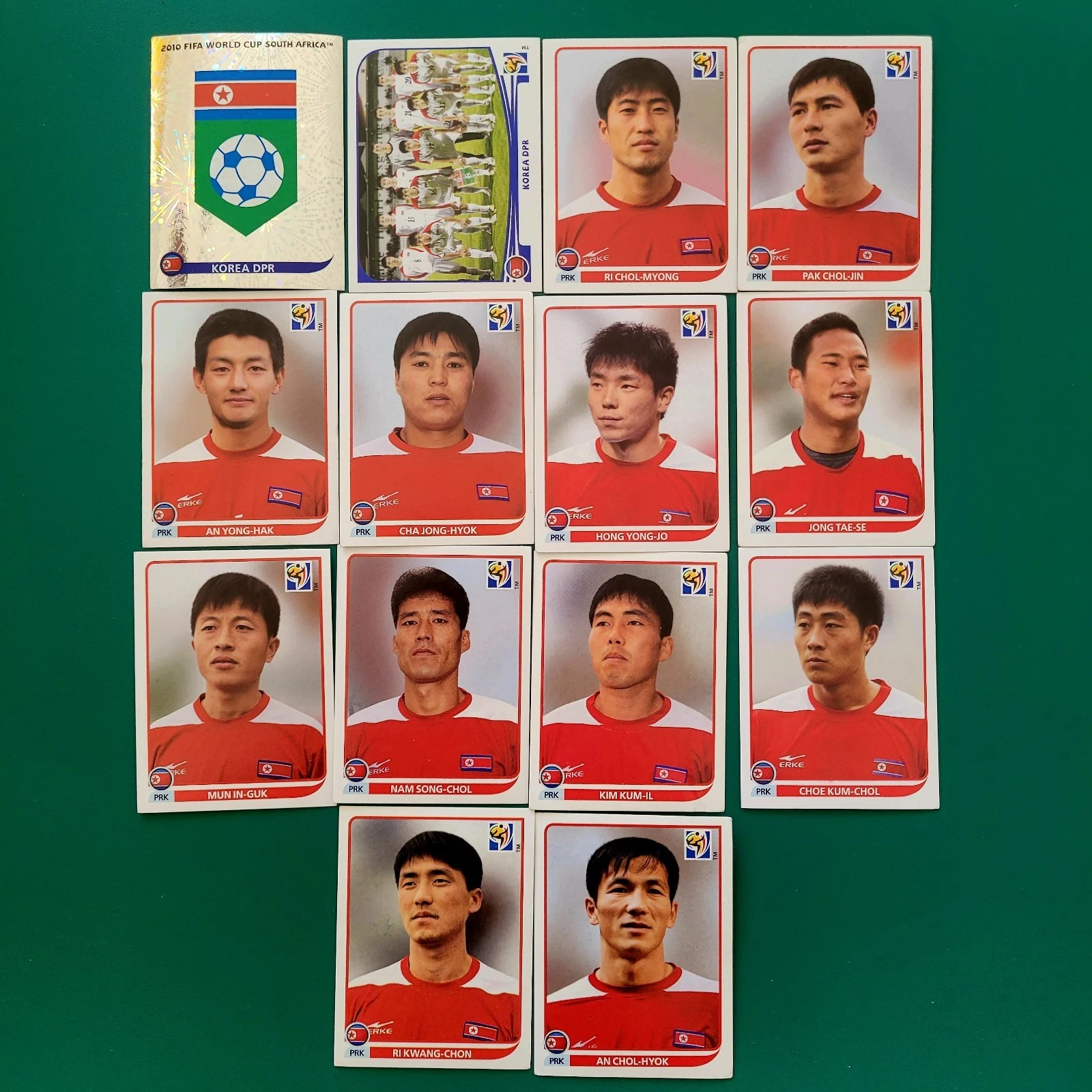
LINK to article - Italy World Cup Rewind: Humiliation at the Hands of North Korea, 1966 - bleacherreport.com/articles/1998811-italy-world-cup-rewin...
LINK to video - North Korea's 1966 World Cup Run | AFC Finners | Football History Documentary - www.youtube.com/watch?v=-J1o5CVldmU&t=332s
1. Im Shung-hwi (Korean: 임성휘; born 3 February 1946), also spelled Im Song Hwi, is a North Korean former football midfielder who played for the national team in the 1966 FIFA World Cup. He also played for February 8 Sports Club. Im was ultimately chosen as one of 22 players for the World Cup team. By that time, he had been capped for the national team a total of 12 times, according to the Evening Telegraph, although the Sunday Mirror reported it to be 18 caps. At the World Cup, the North Korean team played their home games at Ayresome Park in Middlesbrough, England, as part of Group 4 in the tournament which included the Soviet Union, Chile and Italy. Im was considered one of the team's top players in the midfield, and The Guardian described the team's playing style as "basically 4-2-4, with Pak Seung Zin, who must have one of the hardest shots of any of the World Cup finalists, and Im Seung Hwi feeding the wings and creating openings down the middle for Pak Doo Ik." The North Koreans, projected as having little chance of success, lost their first match, 3–0 against the Soviet Union, before tying Chile 1–1. After Chile, the team then played against heavily-favored Italy to determine the qualifier to the next round. In a massive upset, North Korea won 1–0 on a goal by Pak Doo-ik. Im recorded an assist on Pak's goal, having headed the ball to him before he made the winning shot. The team eventually lost 5–3 in the quarterfinals to Portugal; the North Koreans had opened the scoring with a goal by Pak Seung-zin in the first minute, with Im having made the assist. Im ended the World Cup having appeared in all four matches, playing all 360 minutes.
-----------------------------------------------------------------------------------
2. Yang Song-guk (Korean: 양성국; born 19 August 1944) is a North Korean football forward who played for North Korea in the 1966 FIFA World Cup. There he scored against Portugal in the Quarter-finals at Goodison Park. He also played for Kigwancha Pyongyang. He also competed in the men's tournament at the 1976 Summer Olympics.
---------------------------------------------------------------------------------
3. Rim Jung-son, also known as Lim Zoong-sun (림중선; born 16 July 1943). Rim Jung-son is a former centre or right back. He spent his entire career for Moranbong throughout the 1960s and 1970s. He was a member of North Korea national team from 1965 to 1974, participating to the 1966 FIFA World Cup.Considered one of the main defenders of the North Korea team, Rim Jung-son was focused in his defensive task and never left his own half during active play, doing so only during set pieces. He was pretty careful at defending but his timely response in the tackling was his best asset. He was seen tackling successfully the Soviet wingers to stop them from crossing or Chilean players like Prieto and Landa to stop them from reaching the goal. He wasn't a big guy and not notably fast but he wasn't light either and his decent short sprints helped him reach the ball in time for making a tackle. His mentality and will to fight were also strong points. Sporadically in charge of taking free kicks, he delivered a powerful shot that finished over the crossbar against Soviet Union and a pinpoint cross against Chile that was cleared but followed by Pak Sung-jin's goal. Against USSR, in one of the rare occasions he was seen forward, he send a dangerous right-footed cross in the box with an acrobatic volley. Used as centre back in the first two World Cup group matches, he was instead deployed as right back against Italy and Portugal.
------------------------------------------------------------------------------------------
4. Pak Seung-zin (a.k.a. Pak Sung / 박승진 Jin; 11 January 1941 – 5 August 2011) was a North Korean footballer. He represented North Korea at the 1966 FIFA World Cup in England, scoring two goals, against Chile and Portugal. He was the first Asian footballer to score a goal in the World Cup. Career - In his book, The Aquariums of Pyongyang, North Korean defector Kang Chol-hwan claimed that he met Pak in the Yodok concentration camp. He says that Pak and other players on the 1966 team were imprisoned for celebrating the team's victory over Italy in a bar, which was seen as "a sign of bourgeois decadence" by North Korean officials. According to Kang, Pak was in the camp for over 20 years. However, in the documentary film The Game of Their Lives, Pak and the other players were interviewed and denied there had been any retribution.
---------------------------------------------------------------------------------------
5. Han Bong-zin (Korean: 한봉진; born 2 September 1945), also called Han Bong Jin, is a North Korean former football outside forward who played for the national team in the 1966 FIFA World Cup. He also played for 2.8 Sports Team. He later served as the manager of the national team from 1980 to 1981. International career - In 1957, the North Korea national football team was re-organized with the goal of competing at the 1966 FIFA World Cup. In c. 1962, Han was chosen as one of the best 40 players from the North Korean leagues, whose membership reportedly consisted of over 250,000, to be considered for the national team. The 40 players were enlisted into the Army as military officers, under the leadership of colonel and coach Myung Rye-hyun, and went under strict training for the next four years in preparation for the cup. Han and the others trained twice a day starting at 6:00 a.m. and were under other restrictions which included being unmarried, no smoking, no drinking, and (for the last six months) being in bed by 10:00 p.m. Han, an outside right, was ultimately chosen as one of 22 players for the World Cup team. He was the most experienced player on the squad and had a cap total listed by varying sources as 49, 52, or 72 by the time of the competition. Han was considered the best member of the North Korean team and received comparisons to Garrincha for his dribbling and Bobby Charlton for his shooting. The radio station in Pyongyang alleged that he "overshadows the world-renowned Brazilian player" – Pelé. The Evening Telegraph mentioned him as being one of the top two stars of the team and noted that he "demoralised countless defences with his speed and skill, and he is a powerful two-footed kicker.
--------------------------------------------------------------------------------------
6. Pak Doo-ik (Chosungul: 박두익; Hanja: 朴斗翼; born 17 December 1936) is a North Korean former footballer who played as a forward. He scored the goal which knocked out Italy from the group stage of the 1966 FIFA World Cup. Pak Doo-ik was born in Pyongyang. He represented North Korea at the 1966 FIFA World Cup in England, scoring the winning goal in their 1–0 win over Italy at Ayresome Park, Middlesbrough, a game since documented in the film The Game of Their Lives by British filmmaker Daniel Gordon. The result is still considered one of the World Cup's biggest ever upsets, with Italy – holders of a then joint-record two world titles – having been widely expected to face no difficulty in comfortably beating North Korea, who were making their tournament debut. Drawn in a group with Italy, Chile and the USSR, the North Koreans were based in the north-eastern English industrial town of Middlesbrough during the tournament, playing their matches at Ayresome Park stadium. After a 0–3 defeat against the USSR, their courageous and spirited display in an exciting 1–1 draw against Chile won the hearts of the local people. Their surprising win against the powerful Italians further cemented their popularity in the town. Pak, speaking in 2002 on a return to Middlesbrough with the surviving members of the 1966 North Korea team, recalled that "It was the day I learnt football is not all about winning. I learnt that playing football can improve diplomatic relations and promote peace." After the victory, Pak, who was, at the time, a corporal in the North Korean army, was promoted to sergeant. An original ticket to the match is on display among other historical football items at the FIFA World Football Museum in Zurich.
I haven't posted consistent high quality work in a while and that makes me unhappy... Since I just got a new lens I was doing a self portrait test shoot and I realized that I wanted to do a little set/tag and I wanted to call it 'This is Me'. Nothing exactly too brilliant about it. Just wanted to learn more about the people I follow.
Whoever, I tag (and basically whoever sees this) I would love to hear more about you. Maybe do your own set of photos or just one photo telling a little more about yourself. :)
Number 1: This is Me - I'm Not Perfect (Not Even Close)
"It's true, my face is not perfect. There are unwanted scars and bumps that aren't exactly charming. My body resembles a twelve year old boy and I sometimes forget that I haven't taken down my hair from a bun in several weeks. But that's alright because this is me."
bauhaus building, dessau, germany, 1925-1926, architect: walter gropius
Gropius consistently separated the parts of the Bauhaus building according to their functions and designed each differently. He thereby arranged the different wings asymmetrically – in relation to what is today the Bauhausstraße and the Gropiusallee respectively. In order to appreciate the overall design of the complex, the observer must therefore move around the whole building. There is no central viewpoint.
The glazed, three-storey workshop wing, the block for the vocational school (also three storeys high) with its unostentatious rows of windows, and the five-storey studio building with its conspicuous, projecting balconies are the main elements of the complex. A two-storey bridge which housed, e.g., the administration department and, until 1928, Gropius’s architectural practice, connects the workshop wing with the vocational school. A single-storey building with a hall, stage and refectory, the so-called Festive Area, connects the workshop wing to the studio building. The latter originally featured 28 studio flats for students and junior masters, each measuring 20 m². The ingenious design of the portals between the foyer and the hall and a folding partition between the stage and the refectory, along with the ceiling design and colour design, impart a grandiose spatial coalescence to the sequence of foyer-hall-stage-refectory, shaping the so-called Festive Area. The façade of the students’ dormitory is distinguished in the east by individual balconies and in the south by long balconies that continue around the corner of the building.
The entire complex is rendered and painted mainly in light tones, creating an attractive contrast to the window frames, which are dark. For the interior, the junior master of the mural workshop, Hinnerk Scheper, designed a detailed colour plan that, by differentiating between supporting and masking elements through the use of colour, aimed to accentuate the construction of the building.
Katie Boulter was wonderfully consistent in her qualifying round 1 match against Jodie Burrage (GBR), winning 61 67 64. She was knocked out in the second round by Sachia Vickery (US) 61 76.
Boulter was given a wild card entry to Wimbledon in 2017, for the singles and ladies' doubles. She had chances against Christina McHale of the USA in the 1st round, and left with her reputation enhanced.
Found in crevices under rocks. Consistently comes in high in the votes for the ugliest fish.
Take underwater pictures with me at the Evolution Photoganza in the Philippines in September 2013, and enjoy more of my photography & tales of the underwater world in "Sex, Drugs and Scuba Diving".
Baseball Hall of Fame Gold Plaque Postcards - Gold (or yellow) plaque postcards obtained through the National Baseball Hall of Fame Gift Shop, Cooperstown, NY. It’s believed that these Gold / Yellow Plaque Postcards were introduced in 1964 (some contend it was 1965). Curteichcolor reportedly produced these from 1964 to 1977 or 1978, until Dexter Press assumed manufacturing for a short stint. Curteichcolor resumed printing these in 1980, before Mike Roberts took over in 1981.
Warren Spahn - Warren Edward Spahn (April 23, 1921 – November 24, 2003) was an American professional baseball pitcher who played 21 seasons in Major League Baseball. A left-handed pitcher, Spahn played in 1942 and then from 1946 until 1965, most notably for the Boston Braves, who became the Milwaukee Braves after the team moved west before the 1953 season. His baseball career was interrupted by his military service in the United States Army during World War II. With 363 career wins, Spahn holds the major league record for a left-handed pitcher, and has the most by a pitcher who played his entire career in the post-1920 live-ball era. He was a 17-time All-Star who won 20 games or more in 13 seasons, including a 23–7 win–loss record when he was age 42. Spahn won the 1957 Cy Young Award and was a three-time runner-up during the period when only one award was given for both leagues. He won 202 games in the 1950s, the most for all pitchers in the decade. At the time of his retirement in 1965, Spahn held the Major League record for career strikeouts by a left-handed pitcher. Spahn was elected to the Baseball Hall of Fame in his first year of eligibility in 1973, with 82.89% of the vote. The Warren Spahn Award, given annually to the major leagues' best left-handed pitcher, is named in his honor.
Lloyd Waner - Lloyd James Waner (March 16, 1906 – July 22, 1982), nicknamed "Little Poison", was a Major League Baseball center fielder. His small stature at 5 ft 9 in and 132 lb made him one of the smallest players of his era. Along with his brother, Paul Waner, he anchored the Pittsburgh Pirates outfield throughout the 1920s and 1930s. After brief stints with four other teams late in his career, Waner retired as a Pirate. Waner finished with a batting average over .300 in ten seasons. He earned a selection to the MLB All-Star Game in 1938. Lloyd and Paul Waner set the record for career hits by brothers in MLB. He was elected into the National Baseball Hall of Fame by the Veterans Committee in 1967. He worked as a scout for the Pirates and the Baltimore Orioles after retiring as a player.
George Kell - George Clyde Kell (August 23, 1922 – March 24, 2009) was an American professional baseball player and television sports commentator. He played in Major League Baseball as a third baseman from 1943 to 1957, most prominently as a member of the Detroit Tigers where, he became a perennial All-Star player, and won the American League batting championship in 1949. A ten-time All-Star player, Kell hit .300 or higher in nine seasons, producing a career batting average of .306 and led the league’s third basemen in fielding percentage seven times over a major league playing career that spanned 15 seasons. While lacking home run power, Kell was an outstanding contact hitter. He struck out only 287 times in 6,702 at-bats during his career, averaging just 26 strikeouts per 162 games. Kell began his baseball career with the Philadelphia Athletics and later played for the Boston Red Sox, Detroit Tigers, Chicago White Sox and the Baltimore Orioles. After his playing career, Kell became a Detroit Tigers television play by play announcer for 37 years. He was inducted into the National Baseball Hall of Fame in 1983.
Johnny Mize - John Robert Mize (January 7, 1913 – June 2, 1993), nicknamed "Big Jawn" and "the Big Cat", was an American professional baseball player, coach and scout. He played as a first baseman in Major League Baseball for 15 seasons between 1936 and 1953, losing three seasons to military service during World War II. Mize was a ten-time All-Star who played for the St. Louis Cardinals, New York Giants, and the New York Yankees. During his tenure with the Yankees, the team won five consecutive World Series. Mize retired in 1953 with 359 career home runs and a .312 batting average along with 1,118 runs, 2,011 hits, 367 doubles, 83 triples, 1,337 RBI and 856 bases on balls. Defensively, he recorded a .992 fielding percentage as a first baseman. He served as a radio commentator, scout and coach in the major leagues after he retired as a player. He was selected for induction to the Baseball Hall of Fame by the Veterans Committee in 1981. In 2014, he was inducted into the St. Louis Cardinals Hall of Fame Museum.
Bob Lemon - Robert Granville Lemon (September 22, 1920 – January 11, 2000) was an American right-handed pitcher and manager in Major League Baseball. He was elected to the National Baseball Hall of Fame in 1976. Lemon grew up in Long Beach, California where he played high school baseball and was the state player of the year in 1938. At the age of 17, he began a professional baseball career playing in the Cleveland Indians organization, with whom he played for his entire professional career. Lemon was called up to Cleveland's major league team as a utility player in 1941. He then joined the United States Navy during World War II returning to the Indians in 1946. That season was the first that Lemon was a pitcher. The Indians played in the 1948 World Series and were helped by Lemon's two pitching wins as they won the club's first championship since 1920. In the early 1950s, Cleveland had a starting pitching rotation which included Lemon, Bob Feller, Mike Garcia and Early Wynn. During the 1954 season, Lemon had a career-best 23–7 win–loss record and the Indians set a 154-game season AL-record win mark when they won 111 games before they won the American League pennant. He was an All-Star for seven consecutive seasons and recorded seven seasons of 20 or more pitching wins in a nine-year period from 1948 to 1956. Lemon was a manager with the Kansas City Royals, Chicago White Sox, and New York Yankees. He was named Manager of the Year with the White Sox and Yankees. In 1978, he was fired as manager of the White Sox. He was named Yankees manager one month later and he led the team to a 1978 World Series title and a 1981 American League Championship. Lemon became the first AL manager to win a World Series after assuming the managerial role in the middle of a season.
Robin Roberts - Robin Evan Roberts (September 30, 1926 – May 6, 2010) was an American Major League Baseball starting pitcher who pitched primarily for the Philadelphia Phillies (1948–1961). He spent the latter part of his career with the Baltimore Orioles (1962–1965), Houston Astros (1965–66), and Chicago Cubs (1966). Roberts was inducted into the Baseball Hall of Fame in 1976. After retiring from Major League Baseball, he coached the University of South Florida college baseball team for nine seasons, leading them to six conference titles.
Enos Slaughter - Enos Bradsher Slaughter (April 27, 1916 – August 12, 2002), nicknamed "Country", was an American Major League Baseball right fielder. He played for 19 seasons on four major league teams from 1938 to 1942 and 1946 to 1959. He is noted primarily for his playing for the St. Louis Cardinals and famously scored the winning run in Game 7 of the 1946 World Series for the Cardinals. A ten-time All-Star, he has been elected to both the National Baseball Hall of Fame and St. Louis Cardinals Hall of Fame.
Happy Chandler - Albert Benjamin "Happy" Chandler Sr. (July 14, 1898 – June 15, 1991) was an American politician from Kentucky. He represented Kentucky in the U.S. Senate and served as its 44th and 49th governor. Aside from his political positions, he also served as the second commissioner of baseball from 1945 to 1951 and was inducted into the Baseball Hall of Fame in 1982. His grandson, Ben Chandler, later served as representative for Kentucky's Sixth District.
Billy Herman - William Jennings Bryan Herman (July 7, 1909 – September 5, 1992) was an American second baseman and manager in Major League Baseball during the 1930s and 1940s. He reached the World Series four times (1932, 1935, 1938, 1941) but lost each time. Known for his stellar defense and consistent batting, Herman still holds many National League defensive records for second basemen and was inducted into the National Baseball Hall of Fame in 1975.
Billy Williams - Billy Leo Williams (born June 15, 1938) is an American former left fielder and coach in Major League Baseball who played from 1959 to 1976, almost entirely for the Chicago Cubs. A six-time All-Star, Williams was named the 1961 National League Rookie of the Year after hitting 25 home runs with 86 runs batted in. A model of consistent production, he went on to provide the Cubs with at least 20 home runs and 80 RBI every year through 1973, batting over .300, hitting 30 home runs and scoring 100 runs five times each. Along with Ernie Banks and Ron Santo, Williams was one of the central figures in improving the Cubs' fortunes in the late 1960s after the club had spent 20 years in the bottom half of the league standings. His 853 RBI and 2,799 total bases in the 1960s were the most by any left-handed hitter in the major leagues. When he retired, Williams' 426 career home runs and 4,599 total bases each ranked eighth in major league history among left-handed hitters; his 302 home runs as a left fielder trailed only Ralph Kiner in NL history. His 392 home runs, 2,510 hits, 1,353 RBI and 4,262 total bases with the Cubs are all team records for left-handed hitters, as were his 402 doubles until Mark Grace passed him in 1999. He led NL left fielders in assists and double plays four times each, and in putouts and fielding percentage three times each; at the end of his career, he ranked fifth in NL history in games in left field (1,737), and fourth in fielding percentage (.974), sixth in putouts (2,811) and total chances (3,005), and ninth in assists (116) in the NL after 1900. He later became a coach with the Cubs for nearly two decades. Williams was inducted into the National Baseball Hall of Fame in 1987 and was selected as a member of the Cubs All-Century Team in 1999.
I don't consistently post this each year... I should. I like to look back.
Anyway, a card was missing when I took this. Sorry to the person that sent the card. I have since added it to the display.
Really looking forward to ticking off more National Parks.
Singapore Zoo ranks consistently (after San Diego Zoo) as one of the best in the world.
Endemic to the island of Madagascar, ring-tailed lemurs are said to have a cat-like appearance, but with those eye-rings, they remind me more of racoons.
For the story, please visit: www.ursulasweeklywanders.com/travel/teeth-claws-and-colou...
Source: en.wikipedia.org/wiki/Stuttgart
Stuttgart (Swabian: Schduagert) is the capital and largest city of the German state of Baden-Württemberg. Stuttgart is located on the Neckar river in a fertile valley known locally as the "Stuttgart Cauldron." It lies an hour from the Swabian Jura and the Black Forest. Its urban area has a population of 609,219, making it the sixth largest city in Germany. 2.7 million people live in the city's administrative region and another 5.3 million people in its metropolitan area, making it the fourth largest metropolitan area in Germany. The city and metropolitan area are consistently ranked among the top 20 European metropolitan areas by GDP; Mercer listed Stuttgart as 21st on its 2015 list of cities by quality of living, innovation agency 2thinknow ranked the city 24th globally out of 442 cities and the Globalization and World Cities Research Network ranked the city as a Beta-status world city in their 2014 survey.
Since the 6th millennium BC, the Stuttgart area has been an important agricultural area and has been host to a number of cultures seeking to utilize the rich soil of the Neckar valley. The Roman Empire conquered the area in 83 AD and built a massive castrum near Bad Cannstatt, making it the most important regional centre for several centuries. Stuttgart's roots were truly laid in the 10th century with its founding by Liudolf, Duke of Swabia, as a stud farm for his warhorses. Initially overshadowed by nearby Cannstatt, the town grew steadily and was granted a charter in 1320. The fortunes of Stuttgart turned with those of the House of Württemberg, and they made it the capital of their county, duchy, and kingdom from the 15th century to 1918. Stuttgart prospered despite setbacks in the Thirty Years' War and devastating air raids by the Allies on the city and its automobile production during World War II. However, by 1952, the city had bounced back and it became the major economic, industrial, tourism and publishing centre it is today.
Stuttgart is also a transport junction, and possesses the sixth-largest airport in Germany. Several major companies are headquartered in Stuttgart, including Porsche, Bosch, Mercedes-Benz, Daimler AG, and Dinkelacker.
Stuttgart is unusual in the scheme of German cities. It is spread across a variety of hills (some of them covered in vineyards), valleys (especially around the Neckar river and the Stuttgart basin) and parks. This often surprises visitors who associate the city with its reputation as the "cradle of the automobile". The city's tourism slogan is "Stuttgart offers more". Under current plans to improve transport links to the international infrastructure (as part of the Stuttgart 21 project), the city unveiled a new logo and slogan in March 2008 describing itself as "Das neue Herz Europas" ("The new Heart of Europe"). For business, it describes itself as "Where business meets the future". In July 2010, Stuttgart unveiled a new city logo, designed to entice more business people to stay in the city and enjoy breaks in the area.
Stuttgart is a city with a high number of immigrants. According to Dorling Kindersley's Eyewitness Travel Guide to Germany, "In the city of Stuttgart, every third inhabitant is a foreigner." 40% of Stuttgart's residents, and 64% of the population below the age of five, are of immigrant background.
Source: en.wikipedia.org/wiki/Fernsehturm_Stuttgart
Fernsehturm Stuttgart (English: Stuttgart TV Tower) is a 216.61 m (710.7 ft) telecommunications tower in Stuttgart, Germany. It was the first telecommunications tower in the world constructed from reinforced concrete, and it is the prototype for many such towers worldwide. Although controversial at first, it quickly became a well known landmark of Stuttgart and a tourist attraction.
The University of Aarhus, which dates from 1931, is a unique and coherent university campus with consistent architecture, homogenous use of yellow brickwork and adaptation to the landscape. The university has won renown and praise as an integrated complex which unites the best aspects of functionalism with solid Danish traditions in form and materials.
The competition for the university was won by the architects Kay Fisker, C. F. Møller og Povl Stegmann in 1931. Stegman left the partnership in 1937, Fisker in 1942 and C. F. Møller Architects has been in charge of the continued architectural development and building design of the university until today.
The University of Aarhus, with its extensive park in central Aarhus, includes teaching rooms, offices, libraries, workshops and student accommodation. The university has a distinct homogeneous building style and utilises the natural contours of the landscape. The campus has emerged around a distinct moraine gorge and the buildings for the departments and faculties are placed on the slopes, from the main buildings alongside the ring road to the center of the city at Nørreport. All throughout the campus, the buildings are variations of the same clear-cut prismatic volume with pitched roofs, oriented orthogonally to form individual architectural clusters sharing the same vocabulary. The way the buildings emerge from the landscape makes them seem to grow from it, rather than being superimposed on the site.
The original scheme for the campus park was made by the famous Danish landscape architect C. Th. Sørensen. Until the death of C. Th. Sørensens in 1979 the development of the park areas were conducted in a close cooperation between C. Th. Sørensen, C. F. Møller and the local park authorities. Since 1979 C. F. Møller Architects - in cooperation with the staff at the university - has continued the intentions of the original scheme for the park, and today the park is a beautiful, green area and an immense contribution to both the university and the city in general.
In 2001, C. F. Møller Architects prepared a new masterplan for the long and short term development of the university. Although the university has been extended continuously for more than 75 years, the original masterplan and design principles have been maintained, and have proven a simple yet versatile tool to create a timeless and coherent architectural expression adaptable to changing programs. Today, the university is officially recognized as a Danish national architectural treasure and is internationally renowned as an excellent example of early modern university campus planning.
Pregos idênticos à aqueles usados para crucuficar Jesus Cristo na cruz. Os pregos se encontram em uma prateleira de vidro de uma sala ao lado do altar da Igreja Real de São Lourenço (San Lorenzo) em Turim, Itália.
A seguir, texto, em português, da Wikipédia, a enciclopédia livre:
O Sudário de Turim, ou o Santo Sudário é uma peça de linho que mostra a imagem de um homem que aparentemente sofreu traumatismos físicos de maneira consistente com a crucificação. O Sudário está guardado fora das vistas do público na capela da catedral de São João Baptista em Turim, Itália.
O sudário é uma peça rectangular de linho com 4,4 metros de comprimento e 1,1 de largura. O tecido mostra as imagens frontal e dorsal de um homem nu, com as mãos pousadas sobre as partes baixas, consistentes com a projecção ortogonal, sem a projeção referente à parte lateral do corpo humano. As duas imagens apontam em sentidos opostos e unem-se na zona central do pano. O homem representado no sudário tem barba e cabelo comprido pela altura dos ombros, separado por uma risca ao meio. Tem um corpo bem proporcionado e musculado, com cerca de 1,75 de altura. O sudário apresenta ainda diversas nódoas encarnadas que, interpretadas como sangue, sugerem a presença de vários traumatismos
* ferida num dos punhos, de forma circular; o segundo punho está escondido em segundo plano;
* ferida na zona lateral, aparentemente provocada por instrumento cortante;
* conjunto de pequenas feridas em torno da testa; e
* série de feridas lineares nas costas e pernas.
A 28 de Maio de 1898, o fotógrafo italiano Secondo Pia tirou a primeira fotografia ao sudário e constatou que o negativo da fotografia assemelhava-se a uma imagem positiva do homem, o que significava que a imagem do sudário era, em si, um negativo. Esta descoberta lançou o mote para uma discussão científica que ainda hoje permanece aberta: o que representa o sudário?
As primeiras referências a um possível sudário surgem na própria Bíblia. O Evangelho de Mateus (27:59) refere que José de Arimateia envolveu o corpo de Jesus Cristo com "um pano de linho limpo". João (19:38-40) também descreve o evento, e relata que os apóstolos Pedro e João, ao visitar o túmulo de Jesus após a ressurreição, encontraram os lençóis dobrados (Jo 20:6-7). Embora depois desta descrição evangélica o sudário só tenha feito sua aparição definitiva no século XIV, para não mais ser perdido de vista, existem alguns relatos anteriores que contêm indicações bastante consistentes sobre a existência de um tal tecido em tempos mais antigos.
A primeira menção não-evangélica a ele data de 544, quando um pedaço de tecido mostrando uma face que se acreditou ser a de Jesus foi encontrado escondido sob uma ponte em Edessa. Suas primeiras descrições mencionam um pedaço de pano quadrado, mostrando apenas a face, mas São João Damasceno, em sua obra antiiconoclasta "Sobre as imagens sagradas", falando sobre a mesma relíquia, a descreve como uma faixa comprida de tecido, embora disesse que se tratava de uma imagem transferida para o pano quando Jesus ainda estava vivo.
Em 944, quando esta peça foi transferida para Constantinopla, Gregorius Referendarius, arquidiácono de Hagia Sophia pregou um sermão sobre o artefato, que foi dado como perdido até ser redescoberto em 2004 num manuscrito dos arquivos do Vaticano. Neste sermão é feita uma descrição do sudário de Edessa como contendo não só a face, mas uma imagem de corpo inteiro, e cita a presença de manchas de sangue. Outra fonte é o Codex Vossianus Latinus, também no Vaticano, que se refere ao sudário de Edessa como sendo uma impressão de corpo inteiro.
Outra evidência é uma gravura incluída no chamado Manuscrito Húngaro de Preces, datado de 1192, onde a figura mostra o corpo de Jesus sendo preparado para o sepultamento, numa posição consistente com a imagem impressa no sudário de Turim.
Em 1203, o cruzado Robert de Clari afirmou ter visto o sudário em Constantinopla nos seguintes termos: "Lá estava o sudário em que nosso Senhor foi envolto, e que a cada quinta-feira é exposto de modo que todos possam ver a imagem de nosso Senhor nele". Seguindo-se ao saque de Constantinopla, em 1205 Theodoros Angelos, sobrinho de um dos três imperadores bizantinos, escreveu uma carta de protesto ao papa Inocêncio III, onde menciona o roubo de riquezas e relíquias sagradas da capital pelos cruzados, e dizendo que as jóias ficaram com os venezianos e relíquias haviam sido divididas entre os franceses, citando explicitamente o sudário, que segundo ele havia sido levado para Atenas nesta época.
Dali, a partir de testemunhos de época de Geoffrey de Villehardouin e do mesmo Robert de Clari, o sudário teria sido tomado por Otto de la Roche, que se tornou Duque de Atenas. Mas Otto logo o teria transmitido aos Templários, que o teriam levado para a França. Apesar desses indícios de que o sudário de Edessa seja possivelmente o mesmo que o de Turim, o assunto ainda é objeto controvérsia.
Então começa a parte da história do sudário que é bem documentada. Ele aparece publicamente pela primeira vez em 1357, quando a viúva de Geoffroy de Charny, um templário francês, a exibiu na igreja de Lirey. Não foi oferecida nenhuma explicação para a súbita aparição, nem a sua veneração como relíquia foi imediatamente aceite. Henrique de Poitiers, arcebispo de Troyes, apoiado mais tarde pelo rei Carlos VI de França, declarou o sudário como uma impostura e proibiu a sua adoração. A peça conseguiu, no entanto, recolher um número considerável de admiradores que lutaram para a manter em exibição nas igrejas. Em 1389, o bispo Pierre d’Arcis (sucessor de Henrique) denunciou a suposta relíquia como uma fraude fabricada por um pintor talentoso, numa carta a Clemente VII (em Avinhão). D’Arcis menciona que até então tem sido bem sucedido em esconder o pano e revela que a verdade lhe fora confessada pelo próprio artista, que não é identificado. A carta descreve ainda o sudário com grande precisão. Aparentemente, os conselhos do bispo de Troyes não foram ouvidos visto que Clemente VII declarou a relíquia sagrada e ofereceu indulgências a quem peregrinasse para ver o sudário.
Em 1418, o sudário passou a ser propriedade de Umberto de Villersexel, Conde de La Roche, que o removeu para o seu castelo de Montfort, sob o argumento de proteger a peça de um eventual roubo. Depois da sua morte, o pároco de Lirey e a viúva travaram uma batalha jurídica pela custódia da relíquia, ganha pela família. A Condessa de La Roche iniciou então uma tournée com o sudário que incluiu as catedrais de Genebra e Liege. Em 1453, o sudário foi trocado por um castelo (não vendido porque a transacção comercial de relíquias é proibida) com o Duque Luís de Sabóia. A nova aquisição do duque tornou-se na atracção principal da recém construída catedral de Chambery, de acordo com cronistas contemporâneos, envolvida em veludo carmim e guardada num relicário com pregos de prata e chave de ouro.
O sudário foi mais uma vez declarado como relíquia verdadeira pelo Papa Júlio II em 1506. Em 1532, o sudário foi danificado por um incêndio que afectou a sua capela e pela água das tentativas de o controlar. Por volta de 1578 a peça foi transferida para Turim em Itália, onde se encontra até aos dias de hoje na Cappella della Sacra Sindone do Palazzo Reale di Torino. A casa de Sabóia foi a proprietária do sudário até 1983, data da sua doação ao Vaticano. A última exibição da peça foi no ano 2000, a próxima está agendada para 2010. Em 2002, o sudário foi submetido a obras de restauro.
As primeiras análises ao sudário foram realizadas em 1977 por uma equipe de cientistas da Universidade de Turim que usou métodos de microscopia. Os resultados demonstraram que o linho do sudário contém inúmeras gotículas de tinta fabricada a partir de ocre. Entretanto, a hipótese de uma pintura realizada por ação humana foi completamente descartada por experimentos posteriores.
Em 1978, a equipe americana do STURP (Shoud of Turin Research Project) teve acesso ao sudário durante 120 horas. A equipe era composta por 40 cientistas, dos quais apenas 7 católicos e um ateu, Walter C. McCrone, que retirou-se logo no início das investigações. Foram realizados muitos experimentos que envolveram diversas áreas da ciência, como fotografias com diferentes tipos de filme, radiografia de raios X, raio X com fluorescência, espectroscopia, infravermelho e retirada de amostras com fita.
Depois de três anos de análise do STURP, ficou provado que existia sangue humano no sudário e que as gotículas de tinta ocre eram resultado de contaminação. Existiram diversas tentativas de se recriar algo semelhante ao sudário, realizadas durante os séculos, feitas por dezenas de pintores, mas que nunca chegaram a um resultado minimamente próximo ao sudário examinado pelo STURP. Quando questionados sobre se o sudário não era a mortalha de Jesus Cristo, de forma unânime, foi afirmado que nenhum dos resultados dos estudos contradisse a narrativa dos evangelhos. Entretanto, como cientistas, também não podiam afirmar que a mortalha era verdadeira porque essa é uma hipótese não falseável.
Cientistas do STURP também mostraram a completa improbabilidade de aquela ser uma imagem gerada pela ação de um artista, ou seja, é humanamente impossível que o sudário seja uma pintura. A habilidade e equipamentos necessários para gerar uma falsificação daquela natureza são completamente incompatíveis com o período da Idade Média, época em que o sudário apareceu e foi guardado.
As principais conclusões científicas do STURP após cerca de 100.000 horas de pesquisa sobre o artefato foram as seguintes:
a) as marcas do Sudário são um duplo negativo fotográfico do corpo inteiro de um homem. Existe a imagem de frente e de dorso. O sangue do Sudário é positivo;
b) a figura do Sudário, ao contrário de todas as outras figuras bidimensionais já testadas até então, contém dados tridimensionais;
c) o material de cor vermelha do Sudário é sangue;
d) não existe ainda explicação científica de como as imagens do Sudário foram feitas; e
e) o Sudário está historicamente de acordo com os Evangelhos, pois mostra nas imagens as marcas da paixão de Cristo com precisão.
Na época, o STURP não foi autorizado a fazer o teste por datação carbono-14.
A Igreja Católica não emitiu nenhuma opinião acerca da autenticidade desta alegada relíquia. A posição oficial a esta questão é a de que a resposta deve ser uma decisão pessoal do crente. O Papa João Paulo II confessou-se pessoalmente comovido e emocionado com a imagem do sudário, mas afirmou que uma vez que não se trata de uma questão de fé, a Igreja não se pode pronunciar, ao mesmo tempo que convidou as comunidades científicas a continuar a investigação. O grande problema reside na dificuldade de acesso ao sudário, que não é de propriedade da Igreja Católica, mas de uma fundação italiana que alega que novos e constantes testes podem danificar o material da suposta relíquia. A Catholic Encyclopedia, editada pela Igreja Católica, no seu artigo sobre o Sudário de Turim afirma que o sudário está além da capacidade de falsificação de qualquer falsário medieval.
Following, a text, in english, from Wikipedia, the free encyclopedia:
The Shroud of Turin (or Turin Shroud)
The Shroud of Turin (or Turin Shroud) is a linen cloth bearing the image of a man who appears to have been physically traumatized in a manner consistent with crucifixion. It is kept in the royal chapel of the Cathedral of Saint John the Baptist in Turin, Italy. It is believed by many to be the cloth placed on the body of Jesus at the time of his burial.
The image on the shroud is much clearer in black-and-white negative than in its natural sepia color. The striking negative image was first observed on the evening of May 28, 1898, on the reverse photographic plate of amateur photographer Secondo Pia, who was allowed to photograph it while it was being exhibited in the Turin Cathedral. According to Pia, he almost dropped and broke the photographic plate from the shock of seeing an image of a person on it.
The shroud is the subject of intense debate among scientists, people of faith, historians, and writers regarding where, when, and how the shroud and its images were created. From a religious standpoint, in 1958 Pope Pius XII approved of the image in association with the Roman Catholic devotion to the Holy Face of Jesus, celebrated every year on Shrove Tuesday. Some believe the shroud is the cloth that covered Jesus when he was placed in his tomb and that his image was recorded on its fibers at or near the time of his resurrection. Skeptics, on the other hand, contend the shroud is a medieval forgery; others attribute the forming of the image to chemical reactions or other natural processes.
Various tests have been performed on the shroud, yet the debates about its origin continue. Radiocarbon dating in 1988 by three independent teams of scientists yielded results published in Nature indicating that the shroud was made during the Middle Ages, approximately 1300 years after Jesus lived.[4] Claims of bias and error in the testing were raised almost immediately and were addressed by Harry E. Gove.[5] Follow-up analysis published in 2005, for example, claimed that the sample dated by the teams was taken from an area of the shroud that was not a part of the original cloth. The shroud was also damaged by a fire in the Late Middle Ages which could have added carbon material to the cloth, resulting in a higher radiocarbon content and a later calculated age. This analysis itself is questioned by skeptics such as Joe Nickell, who reasons that the conclusions of the author, Raymond Rogers, result from "starting with the desired conclusion and working backward to the evidence".[6] Former Nature editor Philip Ball has said that the idea that Rogers steered his study to a preconceived conclusion is "unfair" and Rogers "has a history of respectable work".
However, the 2008 research at the Oxford Radiocarbon Accelerator Unit may revise the 1260–1390 dating toward which it originally contributed, leading its director Christopher Ramsey to call the scientific community to probe anew the authenticity of the Shroud.[7][8] "With the radiocarbon measurements and with all of the other evidence which we have about the Shroud, there does seem to be a conflict in the interpretation of the different evidence" Gordan said to BBC News in 2008, after the new research emerged.[9] Ramsey had stressed that he would be surprised if the 1988 tests were shown to be far off, let alone "a thousand years wrong", and insisted that he would keep an open mind.
The shroud is rectangular, measuring approximately 4.4 × 1.1 m (14.3 × 3.7 ft). The cloth is woven in a three-to-one herringbone twill composed of flax fibrils. Its most distinctive characteristic is the faint, yellowish image of a front and back view of a naked man with his hands folded across his groin. The two views are aligned along the midplane of the body and point in opposite directions. The front and back views of the head nearly meet at the middle of the cloth. The views are consistent with an orthographic projection of a human body, but see Analysis of the image as the work of an artist.
The "Man of the Shroud" has a beard, moustache, and shoulder-length hair parted in the middle. He is muscular and tall (various experts have measured him as from 1.75 m, or roughly 5 ft 9 in, to 1.88 m, or 6 ft 2 in). For a man of the first century (the time of Jesus' death), or of the Middle Ages (the time of the first uncontested report of the shroud's existence and the proposed time of a possible forgery), these figures present an above-average although not abnormal height. Reddish brown stains that have been said to include whole blood are found on the cloth, showing various wounds that correlate with the yellowish image, the pathophysiology of crucifixion, and the Biblical description of the death of Jesus:
* one wrist bears a large, round wound, apparently from piercing (the second wrist is hidden by the folding of the hands)
* upward gouge in the side penetrating into the thoracic cavity, a post-mortem event as indicated by separate components of red blood cells and serum draining from the lesion
* small punctures around the forehead and scalp
* scores of linear wounds on the torso and legs claimed to be consistent with the distinctive dumbbell wounds of a Roman flagrum.
* swelling of the face from severe beatings
* streams of blood down both arms that include blood dripping from the main flow in response to gravity at an angle that would occur during crucifixion
* no evidence of either leg being fractured
* large puncture wounds in the feet as if pierced by a single spike
Other physical characteristics of the shroud include the presence of large water stains, and from a fire in 1532, burn holes and scorched areas down both sides of the linen due to contact with molten silver that burned through it in places while it was folded. Some small burn holes that apparently are not from the 1532 event are also present. In places, there are permanent creases due to repeated foldings, such as the line that is evident below the chin of the image.
On May 28, 1898, amateur Italian photographer Secondo Pia took the first photograph of the shroud and was startled by the negative in his darkroom.[3] Negatives of the image give the appearance of a positive image, which implies that the shroud image is itself effectively a negative of some kind. Pia was immediately accused of forgery, but was finally vindicated in 1931 when a professional photographer, Giuseppe Enrie, also photographed the shroud and his findings supported Pia
Image analysis by scientists at the Jet Propulsion Laboratory found that rather than being like a photographic negative, the image unexpectedly has the property of decoding into a 3-D image of the man when the darker parts of the image are interpreted to be those features of the man that were closest to the shroud and the lighter areas of the image those features that were farthest. This is not a property that occurs in photography, and researchers could not replicate the effect when they attempted to transfer similar images using techniques of block print, engravings, a hot statue, and bas-relief.
Many people, including author Robin Cook,[42] have put forth the suggestion that the image on the shroud was produced by a side effect of the Resurrection of Jesus, purposely left intact as a rare physical aid to understanding and believing in Jesus' dual nature as man and God. Some have asserted that the shroud collapsed through the glorified body of Jesus, pointing to certain X-ray-like impressions of the teeth and the finger bones. Others assert that radiation streaming from every point of the revivifying body struck and discolored every opposite point of the cloth, forming the complete image through a kind of supernatural pointillism using inverted shades of blue-gray rather than primary colors. However, science has yet to find an example of a reviving body emitting radiation levels significant enough to produce these changes.
There are several reddish stains on the shroud suggesting blood. McCrone (see above) identified these as containing iron oxide, theorizing that its presence was likely due to simple pigment materials used in medieval times. This is in agreement with the results of an Italian commission investigating the shroud in the early 1970s. Serologists among the commission applied several different state-of-the-art blood tests which all gave a negative result for the presence of blood. No test for the presence of color pigments was performed by this commission.[57] Other researchers, including Alan Adler, a chemist specializing in analysis of porphyrins, identified the reddish stains as type AB blood and interpreted the iron oxide as a natural residue of hemoglobin. But the problem with a blood type AB for an authentic shroud is that it is today known that this type of blood is of relative recent origin. There is no evidence of the existence of this blood type before the year AD 700. It is today assumed that the blood type AB came into the existence by immigration and following intermingling of mongoloid people from central Asia with a high frequency of the blood type B to Europe and other areas where people with a relatively high frequency of the blood type A live.
As a depiction of Jesus, the image on the shroud corresponds to that found throughout the history of Christian iconography. For instance, the Pantocrator mosaic at Daphne in Athens is strikingly similar. This suggests that the icons were made while the Image of Edessa was available, with this appearance of Jesus being copied in later artwork, and in particular, on the Shroud. Art historian W.S.A. Dale proposed (before the radiocarbon dating of the Shroud) that the Shroud itself was an icon created in the 11th century for liturgical use. In opposition to this viewpoint, the locations of the piercing wounds in the wrists on the Shroud do not correspond to artistic representations of the crucifixion before close to the present time. In fact, the Shroud was widely dismissed as a forgery in the 14th century for the very reason that the Latin Vulgate Bible stated that the nails had been driven into Jesus' hands and Medieval art invariably depicts the wounds in Jesus' hands.
Although the Vatican newspaper Osservatore Romano covered the story of Secondo Pia's photograph of May 28 1898 in its June 15, 1898 edition, it did so with no comment and thereafter Church officials generally refrained from officially commenting on the photograph for almost half a century.
The first official connection between the image on the shroud and the Catholic Church was made in 1940 based on the formal request by Sister Maria Pierina De Micheli to the curia in Milan to obtain authorization to produce a medal with the image. The authorization was granted and the first medal with the image was offered to Pope Pius XII who approved the medal. The image was then used on what became known as the Holy Face Medal worn by many Catholics, initially as a means of protection during the Second World War. In 1958 Pope Pius XII approved of the image in association with the devotion to the Holy Face of Jesus, and declared its feast to be celebrated every year the day before Ash Wednesday.
In 1983 the Shroud was given to the Holy See by the House of Savoy. However, as with all relics of this kind, the Roman Catholic Church has made no pronouncements claiming whether it is Jesus' burial shroud, or if it is a forgery. As with other approved Catholic devotions, the matter has been left to the personal decision of the faithful, as long as the Church does not issue a future notification to the contrary. In the Church's view, whether the cloth is authentic or not has no bearing whatsoever on the validity of what Jesus taught nor on the saving power of his death and resurrection. The late Pope John Paul II stated in 1998, "Since we're not dealing with a matter of faith, the church can't pronounce itself on such questions. It entrusts to scientists the tasks of continuing to investigate, to reach adequate answers to the questions connected to this shroud." He showed himself to be deeply moved by the image of the shroud and arranged for public showings in 1998 and 2000. In his address at the Turin Cathedral on Sunday May 24 1998 (the occasion of the 100th year of Secondo Pia's May 28 1898 photograph), Pope John Paul II said: "... the Shroud is an image of God's love as well as of human sin" and "...The imprint left by the tortured body of the Crucified One, which attests to the tremendous human capacity for causing pain and death to one's fellow man, stands as an icon of the suffering of the innocent in every age."
Recent developments
On April 6, 2009, the Times of London reported that official Vatican researchers had uncovered evidence that the Shroud had been kept and venerated by the Templars since the 1204 sack of Constantinople. According to the account of one neophyte member of the order, veneration of the Shroud appeared to be part of the initiation ritual. The article also implies that this ceremony may be the source of the 'worship of a bearded figure' that the Templars were accused of at their 14th century trial and suppression.
On April 10, 2009, the Telegraph reported that original Shroud investigator, Ray Rogers, acknowledged the radio carbon dating performed in 1988 was flawed. The sample used for dating may have been taken from a section damaged by fire and repaired in the 16th century, which would not provide an estimate for the original material. Shortly before his death, Rogers said:
"The worst possible sample for carbon dating was taken."
"It consisted of different materials than were used in the shroud itself, so the age we produced was inaccurate."
"...I am coming to the conclusion that it has a very good chance of being the piece of cloth that was used to bury the historic Jesus."
A text, in english, about The Real Chiesa of S. Lorenzo and Turin:
The Real Chiesa of S. Lorenzo, restored on the occasion of the two Ostensionis of the Shroud (happened in 1998 and in 2000), he/she offers to the visitor, is assiduous, the vision is occasional marveled of this jewel of Guarino Guarini.
The Priests of the church of S. Lorenzo wish to each to bring itself, after having tasted how much the creation guariniana offers to the intelligence and the heart, that feelings of architectural and religious harmony that Guarino Guarini, father Teatino, knew how to amalgamate with his genius of architect and with the faith of the believer.
A visitor to the Church of San Lorenzo – a veritable work of art – reaches piazza Castello and sees no façade marking the church. Piazza Castello is a square with a theatre without a façade (Regio), a façade of a palace (Madama) with no corresponding palace, and a church without a façade. One in fact was designed but never built to maintain the architectural harmony of the square.
The church is next to the gates of the royal palace.
On the church front there is a plaque commemorating the dead on the Russian front and above a bell that strikes 10 times at 5.15 p.m. every day.
Why is this Royal Chapel dedicated to San Lorenzo (St. Lawrence)?
In 1557, Emmanuel Philibert, Duke of Savoy, and his cousin Phillip II, King of Spain, were fighting the French at Saint-Quentin in Flanders.
They made a votive offering to build a church in the name of the saint whose feast fell on the day of their eventual victory; that victory came on 10 August, St. Lawrence’s day.
Turin:
Turin, Torino in Italian, is an interesting and often overlooked city in the Piedmont region of Italy. Famous for the Shroud of Turin and Fiat auto plants, Turin has a lot more to offer. From its Baroque cafes and architecture to its arcaded shopping promenades and museums, Turin is a great city for wandering and exploring. Turin hosted the 2006 Winter Olympics and makes a good base for exploring nearby mountains and valleys.
Turin is in the northwest of Italy in the Piemonte region between the Po River and the foothills of the Alps.
Turin is served by a small airport, Citta di Torino - Sandro Pertini, with flights to and from Europe. There is bus service connecting Turin's airport with Turin and the main railway station. A railway links the airport to GTT Dora Railway Station in the northwest of Turin. The closest airport for flights from the United States is in Milan, a little over an hour away by train.
Turin is a major hub on the Italian train line and intercity buses provide transportation to and from Turin.
Turin has an extensive network of trams and buses that run from 5AM until midnight. There are also electric mini-buses in the city center. Bus and tram tickets can be bought in a tabacchi shop. A 28km metropolitan line is due for completion in 2006.
Turin's main railway station is Porta Nuova in central Turin at the Piazza Carlo Felice. The Porta Susa Station is the main station for trains to and from Milan and is connected to central Turin and the main station by bus.
There are tourist offices at the Porta Nuova Railway Station and at the airport. The main office is in Piazza Castello and there is also one in Piazza Solferino.
You can find landromats and internet points in Turin with Lavasciuga.
Turin discount cards: See Turin and Piedmont Card for information about discount passes and the ChocoPass for chocolate tastings.
The Piedmont region has some of the best food in Italy. Over 160 types of cheese and famous wines like Barolo and Barbaresco come from here as do truffles, plentiful in fall. Turin has some outstanding pastries, especially chocolate ones. Chocolate for eating as we know it today (bars and pieces) originated in Turin. The chocolate-hazelnut sauce, gianduja, is a specialty of Turin.
Turin celebrates its patron saint in the Festa di San Giovanni June 24 with events all day and a huge fireworks display at night. Turin's big chocolate festival is in March. Turin has several music and theater festivals in summer and fall. During the Christmas season there is a 2-week street market and on New Year's Eve an open-air conert in the main piazza. The Turin Marathon in April attracts a huge number of international participants.
Turin has many museums. Walking around the city with its arcades, Baroque buildings, and beautiful piazzas can be very enjoyable.
* The Via Po is an interesting walking street with long arcades and many historic palaces and cafes. Start at Piazza Castello.
* Mole Antonelliana, a 167 meter tall tower built between 1798 and 1888, houses an excellent cinema museum. A panoramic lift takes you to the top of the tower for some expansive views of the city.
* Palazzo Carignano is the birthplace of Vittorio Emanuele II in 1820. The Unification of Italy was proclaimed here in 1861. It now houses the Museo del Risorgimento and you can see the royal apartments Royal Armoury, too.
* Museo Egizio is the third most important Egyptian museum in the world. It is housed in a huge baroque palace which also holds the Galleria Sagauda with a large collection of historic paintings.
* Piazza San Carlo, known as the "drawing room of Turin", is a beautiful baroque square with the twin churches of San Carlo and Santa Cristina as well as the above museum.
* Piazza Castello and Palazzo Reale are at the center of Turin. The square is a pedestrian area with benches and small fountains, ringed by beautiful, grand buildings.
* Il Quadrilatero is an interesting maze of backstreets with sprawling markets and splendid churches. This is another good place wo wander.
* Elegant and historic bars and cafes are everywhere in central Turin. Try a bicerin, a local layered drink made with coffee, chocolate, and cream. Cafes in Turin also serve other interesting trendy coffee drinks.
A consistent performer nowadays on the 246 is this ex South Coast Olympian. With the ever increasing push to low floor operations, one wonders how long these Olympians hve left at Cumnock, the last stronghold of them with Western.
Walk Your Pet Month is in January, a time to encourage consistent exercise for pets to combat winter laziness, fight pet obesity, boost physical and mental health, and strengthen bonds, with benefits like better joint health, less stress, and improved behavior, though it's important to check with a vet and gear up for cold weather.
Prompt: create a digital fine art, ultra-realistic, award winning painting of a young woman with red hair walks through a snowy forest at sunset with her West Highland White Terrier puppy, surrounded by snowflakes, their backs are to the viewer, 4k resolution, 3D text center top "Walk Your Pet Month", square aspect ratio,
This digital fine art was created using OpenAI Sora AI and Photoshop
The use of a pattern at airfields is for air safety. By using a consistent flight pattern pilots will know from where to expect other air traffic, and be able to see it and avoid it. Pilots flying under visual flight rules (VFR) may not be separated by air traffic control, so this consistent predictable pattern is a vital way to keep things orderly. At tower-controlled airports air traffic control (ATC) may provide traffic advisories for VFR flights on
a work-load permitting basis.
Cleo De Nile might be my favorite character from anything, or in the top 5 at least, and it's largely been because she was so fully formed via the MH narrative while consistently putting out stellar showing in the doll department. Both of these elements converged in her Gloom & Bloom doll, a splurge alongside Jinafire's doll from the line via the last of my remaining tax return, that not only gave us a beautiful doll but gave us an intimate look into what makes her tick. Finally more people saw what I always did - a complex ghoul - but reading about her and how heavily it affected her character even now was a great reminder to me that my own story was not only rich but worthy of being respected & a large part of what makes me me. Thanks ghoul!!
–--------
In an effort to honor both my year & my 2015 top 5 I have each a solo shot & will talk about what the memory with each has taught me ✨ 💖 ✨
The lesser of the Lufthansa Group carriers, Brussels Airlines is an airline that has consistently received fewer investment compared to other carriers within the group. Even so, Brussels Airlines has been updating their fleet within the past 5 years ranging from both their short-haul and long-haul aircraft.
Late-2023 saw Brussels Airlines receiving their first brand new aircraft since their creation in early-2007; Brussels Airlines took delivery of 5 brand new Airbus A320neos which has allowed the carrier to replace their ageing Airbus A319/A320s. At present, Brussels Airlines are not expected in the near term to receive more Airbus A320neos although this could change with Lufthansa Group's large Airbus A320neo family order book.
Amongst the 5 Airbus A320neos, there is a 40% chance of seeing their Airbus A320neos in special colours, whilst the first example features a different variation of their standard livery promoting Less CO₂. Less Fuel. Less Noise. which has appeared on other Lufthansa Group Airbus A320neos, the second aircraft receives a new version of Tomorrowland colours. The remaining 3 Airbus A320neos feature their standard livery.
On a daily basis, Brussels Airlines operates 4 daily flights from their main Brussels-Zaventem hub to London Heathrow, all 4 flights being scheduled to utilise Airbus A320neos.
Currently, Brussels Airlines operates 36 Airbus A320 family aircraft, which includes 15 Airbus A319s, 16 Airbus A320s and 5 Airbus A320neos.
Sierra Bravo Delta is one of 5 Airbus A320neos operated by Brussels Airlines, delivered new to the flag-carrier on 12th June 2024 and she is powered by 2 CFM International LEAP-1A26 engines.
Airbus A320-251N OO-SBD on final approach into Runway 27R at London Heathrow (LHR) on SN2095 from Brussels-Zaventem (BRU).