View allAll Photos Tagged wiki
en.wikipedia.org/wiki/Cape_St._Vincent
Cape St. Vincent (Portuguese: Cabo de São Vicente, Portuguese pronunciation: [ˈkabu dɨ sɐ̃w̃ viˈsẽtɨ]), next to the Sagres Point, on the so-called Costa Vicentina (Vincentine Coast), is a headland in the municipality of Sagres, in the Algarve, southern Portugal.
Description
This cape is the southwesternmost point in Portugal. It forms the southwestern end of the E9 European Coastal Path, which runs for 5,000 km (3,100 mi) to Narva-Jõesuu in Estonia. Approximately six kilometers from the village of Sagres, the cape is a landmark for a ship traveling to or from the Mediterranean. The cliffs rise nearly vertically from the Atlantic to a height of 75 meters. The cape is a site of exuberant marine life and a high concentration of birds nesting on the cliffs, such as the rare Bonelli's eagle, peregrine falcons, kites, rock thrushes, rock pigeons, storks and herons.
History
Cape St. Vincent was already sacred ground in Neolithic times, as standing menhirs in the neighborhood attest. The ancient Greeks called it Ophiussa (Land of Serpents), inhabited by the Oestriminis and dedicated here a temple to Heracles. The Romans called it Promontorium Sacrum (or Holy Promontory). They considered it a magical place where the sunset was much larger than anywhere else. They believed the sun sank here hissing into the ocean, marking the edge of their world.
According to legend, the name of this cape is linked to the story of a martyred fourth-century Iberian deacon St. Vincent whose body was brought ashore here. A shrine was erected over his grave; according to the Arab geographer Al-Idrisi, it was always guarded by ravens and is therefore named by him كنيسة الغراب (Kanīsah al-Ghurāb, meaning "Church of the Raven"). King Afonso Henriques (1139–1185) had the body of the saint exhumed in 1173 and brought it by ship to Lisbon, still accompanied by the ravens. This transfer of the relics is depicted on the coat of arms of Lisbon. The area around the cape was plundered several times by pirates from France and Holland and, in 1587, by Sir Francis Drake. All existing buildings—including the Vila do Infante of Henry the Navigator--fell into ruins because of the Lisbon earthquake of 1755. The Franciscan friars who cared for the shrine stayed on until 1834, when all monasteries were disbanded in Portugal.
Several naval battles were fought in the vicinity of this cape:
•The French Admiral Anne Hilarion de Tourville defeated a large Anglo-Dutch naval fleet commanded by George Rooke escorting a convoy of between 400 and 500 English and Dutch merchant ships on 27 June 1693. The "Smyrna fleet" disaster, as it came to be known, saw 94 of the richly-laden merchant ships either captured or sunk; this event led to the dismissal of two English admirals whose convoy escort had turned back off Ushant, France.
•In 1780, this cape was the site of the Battle of Cape St. Vincent (between Britain and Spain).
•Admiral Jervis with Commodore Nelson defeated the Spanish fleet in 1797 at a second Battle of Cape St. Vincent on 14 February 1797.
•In 1833, a Loyalist Portuguese fleet defeated the Miguelites during Portugal's Liberal Wars.
Lighthouse
The present lighthouse was built over the ruins of a 16th century Franciscan convent in 1846. The statues of St. Vincent and St. Francis Xavier had been moved to the nearby church of Nossa Senhora da Graça on Point Sagres.
This lighthouse, guarding one of the world's busiest shipping lanes, is among the most powerful in Europe (the most powerful being on the French island of Ushant, off the coast of Brittany); its two 1,000 W lamps can be seen as far as 60 kilometers away.
2007 earthquake
On 12 February 2007, an earthquake of magnitude 5.8 on the Richter scale struck about 160 kilometers east of the cape.
en.wikipedia.org/wiki/Yellow-legged_Gull
The Yellow-legged Gull (Larus michahellis), sometimes referred to as Western Yellow-legged Gull (to distinguish it from eastern populations of yellow-legged large white-headed gulls), is a large gull of Europe, the Middle East and North Africa, which has only recently achieved wide recognition as a distinct species. It was formerly treated as a subspecies of either the Caspian Gull L. cachinnans, or more broadly as a subspecies of the Herring Gull L. argentatus. It is named after the German zoologist Karl Michahelles
Classification
It is now generally accepted that the Yellow-legged Gull is a full species, but until recently there was much disagreement. For example, British Birds magazine split Yellow-legged Gull from Herring Gull in 1993 but included the Caspian Gull in the former,[2] but the BOU in Great Britain retained the Yellow-legged Gull as a subspecies of the Herring Gull until 2007.[3] DNA research however suggests that Yellow-legged Gull is actually closest to Great Black-backed Gull L. marinus and Armenian Gull L. armenicus, while Caspian Gull is closer to Herring Gull and Lesser Black-backed Gull L. fuscus, rather than being each other's closest relatives.[4][5]
There are two subspecies of the Yellow-legged Gull:[5]
Larus michahellis michahellis Naumann, 1840. Mediterranean.
Larus michahellis atlantis (Dwight, 1922), syn. Larus fuscus atlantis Dwight, 1922. Macaronesia (Canary Islands, Madeira, Azores).
Birds breeding on the Atlantic coasts of Morocco, Portugal and Galicia (and spreading north from there) are usually also included here, but are sometimes considered to be a third subspecies L. m. lusitanius. Atlantic Ocean birds have darker wings and back by comparison with Mediterranean birds, creating a more pronounced contrast to the white parts.
Distribution
The breeding range is centred around the Mediterranean Sea. In North Africa it is common in Morocco, Algeria and Tunisia and increasing in places. Recent breeding has occurred in Libya and Egypt. In the Middle East a few breed in Israel and Syria with larger numbers in Cyprus and Turkey. In Europe there are colonies all along the Mediterranean coast, and also on the Atlantic islands and coasts north to Brittany and west to the Azores. It also breeds on the west side of the Black Sea; here it overlaps with the Caspian Gull but there is a difference in habitat, with the Yellow-legged Gull preferring sea cliffs and Caspian Gull on flatter shores. In recent decades birds have spread north into central and western Europe. One to four pairs have attempted to breed in southern England since 1995 (sometimes hybrid pairs with Lesser Black-backed Gulls), though colonisation has been very slow.[6]
Many birds remain in the same area all year round but others migrate to spend the winter in mild areas of western Europe or head south as far as Senegal, the Gambia and the Red Sea. There is also extensive northward post-breeding dispersal in the late summer, with numbers in southern England high from July to October.[7] It is reported as a vagrant to northeastern North America[8] and Nigeria.
Description
Adults are similar to Herring Gulls but have yellow legs. They have a grey back, slightly darker than Herring Gulls but lighter than Lesser Black-backed Gulls. They are much whiter-headed in autumn, and have more extensively black wing tips with few white spots, just as Lesser Black-backed. They have a red spot on the bill as adults, like the entire complex. There is a red ring around the eye like in the Lesser Black-backed Gull but unlike in the Herring Gull which has a dark yellow ring.
First-year birds have a paler head, rump and underparts than those of the Herring Gull, more closely resembling first-year Great Black-backed Gulls in plumage. They have a dark bill and eyes, pinkish grey legs, dark flight feathers and a well-defined black band on the tail. They become lighter in the underparts and lose the upperpart pattern subsequently. By their second winter, birds are essentially feathered like adults, save for the patterned feathers remaining on the wing coverts. However, their bill tips are black, their eyes still dark, and the legs are a light yellow flesh colour.
The call is a loud laugh which is deeper and more nasal than the call of the Herring Gull.
Diet
They are omnivores like most Larus gulls, and they will scavenge on rubbish tips and elsewhere, as well as seeking suitable prey in fields or on the coast, or robbing smaller gulls and other seabirds of their catches.
Reproduction
Yellow-legged Gulls usually breed in colonies. Eggs, usually three, are laid from mid March to early May and are defended vigorously by this large gull. The nest is a sometimes sparse mound of vegetation built on the ground or on cliff ledges. In some places such as Gibraltar they have started nesting on buildings. The eggs are incubated for 27–31 days and the young birds fledge after 35–40 days.
Source: en.wikipedia.org/wiki/Custer_State_Park
Custer State Park is a South Dakota State Park and wildlife reserve in the Black Hills, United States. The park is South Dakota's largest and first state park, named after Lt. Colonel George Armstrong Custer. The park covers an area of over 71,000 acres (287 km2) of varied terrain including rolling prairie grasslands and rugged mountains.
The park is home to a herd of 1,500 bison. Elk, coyotes, mule deer, white tailed deer, mountain goats, prairie dogs, bighorn sheep, river otters, pronghorn, cougars, and feral burros also inhabit the park. The park is known for its scenery, its scenic drives (Needles Highway and the wildlife loop), with views of the bison herd and prairie dog towns. This park is easily accessible by road from Rapid City. Other nearby attractions are Wind Cave National Park, Mount Rushmore, Jewel Cave National Monument, Crazy Horse Memorial, and Badlands National Park.
Source: gfp.sd.gov/parks/detail/custer-state-park/
The granite peaks and rolling plains are calling. The clear mountain waters are inviting and the open ranges are waiting to be discovered. Bring your family to Custer State Park and let yourself run wild.
Encompassing 71,000 acres in the Black Hills, Custer State Park is home to abundant wildlife and adventure; camping, hiking, biking, swimming, fishing, or relaxing, there’s something here for everyone.
Feeding and disturbing park wildlife is against park regulations. While the animals within the park are used to visitors and vehicles, they are still wild animals. Please remain in your vehicle or stay at least 100 yards from bison, elk, and other animals.
Pets must be on a leash no longer than 10 feet and are not allowed in any park buildings or on designated swim beaches. Please clean up after your pet and do not leave it unattended. Service animals are welcome.
Firearms must be unloaded and cased unless during a hunting season with the proper license. Concealed carry is allowed with the appropriate permit.
Additional Foreign Language Tags:
(United States) "الولايات المتحدة" "Vereinigte Staaten" "アメリカ" "美国" "미국" "Estados Unidos" "États-Unis"
(South Dakota) "داكوتا الجنوبية" "南达科他州" "Dakota du Sud" "दक्षिण डकोटा" "サウスダコタ" "사우스다코타" "Южная Дакота" "Dakota del Sur"
(Custer State Park) "حديقة كستر الحكومية" "卡斯特州立公园" "Parc d’État de Custer" "कस्टर स्टेट पार्क" "カスター州立公園" "커스터 주립공원" "Государственный парк Кастер" "Parque Estatal Custer"
Source: en.wikipedia.org/wiki/Grand_Canyon
The Grand Canyon is a steep-sided canyon carved by the Colorado River in Arizona, United States. The Grand Canyon is 277 miles (446 km) long, up to 18 miles (29 km) wide and attains a depth of over a mile (6,093 feet or 1,857 meters).
The canyon and adjacent rim are contained within Grand Canyon National Park, the Kaibab National Forest, Grand Canyon–Parashant National Monument, the Hualapai Indian Reservation, the Havasupai Indian Reservation and the Navajo Nation. The surrounding area is contained within the Baaj Nwaavjo I'tah Kukveni – Ancestral Footprints of the Grand Canyon National Monument. President Theodore Roosevelt was a major proponent of the preservation of the Grand Canyon area and visited it on numerous occasions to hunt and enjoy the scenery.
Nearly two billion years of Earth's geological history have been exposed as the Colorado River and its tributaries cut their channels through layer after layer of rock while the Colorado Plateau was uplifted. While some aspects about the history of incision of the canyon are debated by geologists, several recent studies support the hypothesis that the Colorado River established its course through the area about 5 to 6 million years ago. Since that time, the Colorado River has driven the down-cutting of the tributaries and retreat of the cliffs, simultaneously deepening and widening the canyon.
For thousands of years, the area has been continuously inhabited by Native Americans, who built settlements within the canyon and its many caves. The Pueblo people considered the Grand Canyon a holy site, and made pilgrimages to it. The first European known to have viewed the Grand Canyon was García López de Cárdenas from Spain, who arrived in 1540.
Source: en.wikipedia.org/wiki/Grand_Canyon_National_Park
Grand Canyon National Park is a national park of the United States located in northwestern Arizona, the 15th site to have been named as a national park. The park's central feature is the Grand Canyon, a gorge of the Colorado River, which is often considered one of the Wonders of the World. The park, which covers 1,217,262 acres (1,901.972 sq mi; 4,926.08 km2) of unincorporated area in Coconino and Mohave counties, received more than 4.7 million recreational visitors in 2023. The Grand Canyon was designated a World Heritage Site by UNESCO in 1979. The park celebrated its 100th anniversary on February 26, 2019.
Source: www.nps.gov/grca/index.htm
Entirely within the state of Arizona, the park encompasses 278 miles (447 km) of the Colorado River and adjacent uplands. Located on the ancestral homelands of 11 present day Tribal Communities, Grand Canyon is one of the most spectacular examples of erosion anywhere in the world—a mile deep canyon unmatched in the incomparable vistas it offers visitors from both north and south rims.
Additional Foreign Language Tags:
(United States) "الولايات المتحدة" "Vereinigte Staaten" "アメリカ" "米国" "美国" "미국" "Estados Unidos" "États-Unis" "ארצות הברית" "संयुक्त राज्य" "США"
(Arizona) "أريزونا" "亚利桑那州" "אריזונה" "एरिजोना" "アリゾナ州" "애리조나" "Аризона"
(Grand Canyon) "جراند كانيون" "大峡谷" "גרנד קניון" "ग्रांड कैन्यन" "グランドキャニオン" "그랜드 캐니언" "Гранд-Каньон" "Gran Cañón"
en.wikipedia.org/wiki/Atlantic_Ocean
The Atlantic Ocean is the second-largest of the world's oceanic divisions. With a total area of about 106,400,000 square kilometres (41,100,000 sq mi),[1] it covers approximately 20% of the Earth's surface and about 26% of its water surface area. The first part of its name refers to Atlas of Greek mythology, making the Atlantic the "Sea of Atlas".
The oldest known mention of "Atlantic" is in The Histories of Herodotus around 450 BC (Hdt. 1.202.4): Atlantis thalassa (Greek: Ἀτλαντὶς θάλασσα; English: Sea of Atlas); see also: Atlas Mountains. The term Ethiopic Ocean, derived from Ethiopia, was applied to the southern Atlantic ocean as late as the mid-19th century.[2] Before Europeans discovered other oceans, the term "ocean" itself was synonymous with the waters beyond the Strait of Gibraltar that we now know as the Atlantic. The early Greeks believed this ocean to be a gigantic river encircling the world.
The Atlantic Ocean occupies an elongated, S-shaped basin extending longitudinally between Eurasia and Africa to the east, and the Americas to the west. As one component of the interconnected global ocean, it is connected in the north to the Arctic Ocean (which is sometimes considered a sea of the Atlantic), to the Pacific Ocean in the southwest, the Indian Ocean in the southeast, and the Southern Ocean in the south. (Other definitions describe the Atlantic as extending southward to Antarctica.) The equator subdivides it into the North Atlantic Ocean and South Atlantic Ocean.
Geography
The Atlantic Ocean is bounded on the west by North and South America. It connects to the Arctic Ocean through the Denmark Strait, Greenland Sea, Norwegian Sea and Barents Sea. To the east, the boundaries of the ocean proper are Europe; the Strait of Gibraltar (where it connects with the Mediterranean Sea–one of its marginal seas–and, in turn, the Black Sea, both of which also touch upon Asia) and Africa.
In the southeast, the Atlantic merges into the Indian Ocean. The 20° East meridian, running south from Cape Agulhas to Antarctica defines its border. Some authorities show it extending south to Antarctica, while others show it bounded at the 60° parallel by the Southern Ocean.[3]
In the southwest, the Drake Passage connects it to the Pacific Ocean. The man-made Panama Canal links the Atlantic and Pacific. Besides those mentioned, other large bodies of water adjacent to the Atlantic are the Caribbean Sea; the Gulf of Mexico; Hudson Bay; the Arctic Ocean; the Mediterranean Sea; the North Sea; the Baltic Sea and the Celtic Sea.
Covering approximately 22% of Earth's surface, the Atlantic is second in size to the Pacific. With its adjacent seas, it occupies an area of about 106,400,000 square kilometres (41,100,000 sq mi);[1] without them, it has an area of 82,400,000 square kilometres (31,800,000 sq mi). The land that drains into the Atlantic covers four times that of either the Pacific or Indian oceans. The volume of the Atlantic with its adjacent seas is 354,700,000 cubic kilometers (85,100,000 cu mi) and without them 323,600,000 cubic kilometres (77,640,000 cu mi).
The average depth of the Atlantic, with its adjacent seas, is 3,339 metres (1,826 fathoms; 10,950 ft); without them it is 3,926 metres (2,147 fathoms; 12,880 ft). The greatest depth, Milwaukee Deep with 8,380 metres (4,580 fathoms; 27,500 ft), is in the Puerto Rico Trench. The Atlantic's width varies from 1,538 nautical miles (2,848 km; 1,770 mi) between Brazil and Sierra Leone to over 3,450 nautical miles (6,400 km; 4,000 mi) in the south
Cultural significance
Transatlantic travel played a major role in the expansion of Western civilization into the Americas. It is the Atlantic that separates the "Old World" from the "New World". In modern times, some idioms refer to the ocean in a humorously diminutive way as the Pond, describing both the geographical and cultural divide between North America and Europe, in particular between the English-speaking nations of both continents. Many British people refer to the United States and Canada as "across the pond", and vice versa
Ocean bottom
The principal feature of the bathymetry (bottom topography) is a submarine mountain range called the Mid-Atlantic Ridge.[5] It extends from Iceland in the north to approximately 58° South latitude, reaching a maximum width of about 860 nautical miles (1,590 km; 990 mi). A great rift valley also extends along the ridge over most of its length. The depth of water at the apex of the ridge is less than 2,700 metres (1,500 fathoms; 8,900 ft) in most places, while the bottom of the ridge is three times as deep. Several peaks rise above the water and form islands.[6] The South Atlantic Ocean has an additional submarine ridge, the Walvis Ridge.[7]
The Mid-Atlantic Ridge separates the Atlantic Ocean into two large troughs with depths from 3,700–5,500 metres (2,000–3,000 fathoms; 12,000–18,000 ft). Transverse ridges running between the continents and the Mid-Atlantic Ridge divide the ocean floor into numerous basins. Some of the larger basins are the Blake, Guiana, North American, Cape Verde, and Canaries basins in the North Atlantic. The largest South Atlantic basins are the Angola, Cape, Argentina, and Brazil basins.
The deep ocean floor is thought to be fairly flat with occasional deeps, abyssal plains, trenches, seamounts, basins, plateaus, canyons, and some guyots. Various shelves along the margins of the continents constitute about 11% of the bottom topography with few deep channels cut across the continental rise.
Ocean floor trenches and seamounts:
•Puerto Rico Trench, in the North Atlantic, is the deepest trench at 8,605 metres (4,705 fathoms; 28,230 ft)[8]
•Laurentian Abyss is found off the eastern coast of Canada
•South Sandwich Trench reaches a depth of 8,428 metres (4,608 fathoms; 27,650 ft)
•Romanche Trench is located near the equator and reaches a depth of about 7,454 metres (4,076 fathoms; 24,460 ft).
Ocean sediments are composed of:
•Terrigenous deposits with land origins, consisting of sand, mud, and rock particles formed by erosion, weathering, and volcanic activity on land washed to sea. These materials are found mostly on the continental shelves and are thickest near large river mouths or off desert coasts.
•Pelagic deposits, which contain the remains of organisms that sink to the ocean floor, include red clays and Globigerina, pteropod, and siliceous oozes. Covering most of the ocean floor and ranging in thickness from 60–3,300 metres (33–1,800 fathoms; 200–11,000 ft) they are thickest in the convergence belts, notably at the Hamilton Ridge and in upwelling zones.
•Authigenic deposits consist of such materials as manganese nodules. They occur where sedimentation proceeds slowly or where currents sort the deposits, such as in the Hewett Curve.
Water characteristics
On average, the Atlantic is the saltiest major ocean; surface water salinity in the open ocean ranges from 33 to 37 parts per thousand (3.3 – 3.7%) by mass and varies with latitude and season. Evaporation, precipitation, river inflow and sea ice melting influence surface salinity values. Although the lowest salinity values are just north of the equator (because of heavy tropical rainfall), in general the lowest values are in the high latitudes and along coasts where large rivers enter. Maximum salinity values occur at about 25° north and south, in subtropical regions with low rainfall and high evaporation.
Surface water temperatures, which vary with latitude, current systems, and season and reflect the latitudinal distribution of solar energy, range from below −2 °C (28 °F). Maximum temperatures occur north of the equator, and minimum values are found in the polar regions. In the middle latitudes, the area of maximum temperature variations, values may vary by 7–8 °C (12–15 °F).
The Atlantic Ocean consists of four major water masses. The North and South Atlantic central waters make up the surface. The sub-Antarctic intermediate water extends to depths of 1,000 metres (550 fathoms; 3,300 ft). The North Atlantic Deep Water reaches depths of as much as 4,000 metres (2,200 fathoms; 13,000 ft). The Antarctic Bottom Water occupies ocean basins at depths greater than 4,000 metres.
Within the North Atlantic, ocean currents isolate the Sargasso Sea, a large elongated body of water, with above average salinity. The Sargasso Sea contains large amounts of seaweed and is also the spawning ground for both the European eel and the American eel.
The Coriolis effect circulates North Atlantic water in a clockwise direction, whereas South Atlantic water circulates counter-clockwise. The south tides in the Atlantic Ocean are semi-diurnal; that is, two high tides occur during each 24 lunar hours. In latitudes above 40° North some east-west oscillation occurs.
Climate
Climate is influenced by the temperatures of the surface waters and water currents as well as winds. Because of the ocean's great capacity to store and release heat, maritime climates are more moderate and have less extreme seasonal variations than inland climates. Precipitation can be approximated from coastal weather data and air temperature from water temperatures.
The oceans are the major source of the atmospheric moisture that is obtained through evaporation. Climatic zones vary with latitude; the warmest zones stretch across the Atlantic north of the equator. The coldest zones are in high latitudes, with the coldest regions corresponding to the areas covered by sea ice. Ocean currents influence climate by transporting warm and cold waters to other regions. The winds that are cooled or warmed when blowing over these currents influence adjacent land areas.
The Gulf Stream and its northern extension towards Europe, the North Atlantic Drift, for example, warms the atmosphere of the British Isles and north-western Europe and influences weather and climate as far south as the northern Mediterranean. The cold water currents contribute to heavy fog off the coast of eastern Canada (the Grand Banks of Newfoundland area) and Africa's north-western coast. In general, winds transport moisture and air over land areas. Hurricanes develop in the southern part of the North Atlantic Ocean. More local particular weather examples could be found in examples such as the; Azores High, Benguela Current, Nor'easter.
History
The Atlantic Ocean appears to be the second youngest of the five oceans. It did not exist prior to 130 million years ago, when the continents that formed from the breakup of the ancestral super continent Pangaea were drifting apart from seafloor spreading. The Atlantic has been extensively explored since the earliest settlements along its shores.
The Vikings, the Portuguese, and the Spaniards were the most famous among early explorers. After Columbus, European exploration rapidly accelerated, and many new trade routes were established.
As a result, the Atlantic became and remains the major artery between Europe and the Americas (known as transatlantic trade). Scientific explorations include the Challenger expedition, the German Meteor expedition, Columbia University's Lamont-Doherty Earth Observatory and the United States Navy Hydrographic Office.
Notable crossings
Ra II, a ship built from papyrus, was successfully sailed across the Atlantic by Thor Heyerdahl proving that it was possible to cross the Atlantic from Africa using such boats in early epochs of history.
•Around 980 – 982, Eric the Red discovered Greenland, geographically and geologically a part of the Americas.
•In 985 or 986, Bjarni Herjólfsson was the first European to sight the Americas. He did not go ashore, though.
•In the year 1000, the Icelander Leif Ericson was the first European to set foot on North American soil, corresponding to today's Eastern coast of Canada, i. e. the province of Newfoundland and Labrador, including the area of land named "Vinland" by Ericson. The Norse discovery was documented in the 13th century Icelandic Sagas and was corroborated by recent L'Anse aux Meadows archeological evidence.
•Around 1010, Thorfinnr Karlsefni led an attempted Viking settlement in North America with 160 settlers, but was later driven off by the natives. His son Snorri Thorfinnsson was the first American born (somewhere between 1010 and 1013) to European (Icelandic) immigrant parents.
•In 1419 and 1427, Portuguese navigators reached Madeira and Azores, respectively.
•From 1415 to 1488, Portuguese navigators sailed along the Western African coast, reaching the Cape of Good Hope.
•In 1492, Christopher Columbus landed on the island of San Salvador in The Bahamas.
•In 1497, John Cabot landed at Bonavista Newfoundland and Labrador.
•In 1500, Pedro Álvares Cabral reached Brazil.
•In 1524, Italian explorer Giovanni da Verrazzano discovered the United States of America's east coast.
•In 1534, Jacques Cartier entered the Gulf of St. Lawrence and reached the mouth of the St. Lawrence River.
•In 1583, Sir Humphrey Gilbert claimed Newfoundland for the English Crown.
•In 1764 William Harrison (the son of John Harrison) sailed aboard the HMS Tartar, with the H-4 time piece. The voyage became the basis for the invention of the global system of Longitude.
•In 1858, Cyrus West Field laid the first transatlantic telegraph cable (it quickly failed).
•In 1865 Brunel's ship the SS Great Eastern laid the first successful transatlantic telegraph cable .
•In 1870 the small City of Ragusa (Dubrovnik) became the first small Lifeboat to cross the Atlantic from Cork to Boston with two men crew, John Charles Buckley and Nikola Primorac (di Costa), only.[9]
•In 1896 Frank Samuelsen and George Harbo from Norway became the first people to ever row across the Atlantic Ocean.
•On April 15, 1912 the RMS Titanic sank after hitting an iceberg with a loss of more than 1,500 lives.[10]
•1914–1918, the First Battle of the Atlantic took place.
•In 1919, the American NC-4 became the first seaplane to cross the Atlantic (though it made a couple of landings on islands and the sea along the way, and taxied several hundred miles).
•Later in 1919, a British aeroplane piloted by Alcock and Brown made the first non-stop transatlantic flight, from Newfoundland to Ireland.
•In 1921, the British were the first to cross the North Atlantic in an airship.
•In 1922, Sacadura Cabral and Gago Coutinho were the first to cross the South Atlantic in an airship.
•In 1927, Charles Lindbergh made the first solo non-stop transatlantic flight in an aircraft (between New York City and Paris).
•In 1931, Bert Hinkler made the first solo non-stop transatlantic flight across the South Atlantic in an aircraft.
•In 1932, Amelia Earhart became the first female to make a solo flight across the Atlantic
•1939–1945, the Second Battle of the Atlantic. Nearly 3,700 Allied ships were sunk at a cost of 783 German U-boats.[11]
•In 1952, Ann Davison was the first woman to single-handedly sail the Atlantic Ocean.
•In 1965, Robert Manry crossed the Atlantic from the U.S. to England non-stop in a 13.5 foot (4.05 meters) sailboat named "Tinkerbell".[12] Several others also crossed the Atlantic in very small sailboats in the 1960s, none of them non-stop, though.
•In 1969 and 1970 Thor Heyerdahl launched expeditions to cross the Atlantic in boats built from papyrus. He succeeded in crossing the Atlantic from Morocco to Barbados after a two-month voyage of 6,100 km with Ra II in 1970, thus conclusively proving that boats such as the Ra could have sailed with the Canary Current across the Atlantic in prehistoric times.[13]
•In 1975, Fons Oerlemans crossed the Atlantic in 82 days, starting from Safi (Morocco) to Trinidad and Tobago, on a selfmade raft.
•In 1980, Gérard d'Aboville was the first man to cross the Atlantic Ocean rowing solo.
•In 1984, Five Argentines sail in a 10-meter-long raft made from tree trunks named Atlantis from Canary Islands and after 52 days 3,000 miles (4,800 km) journey arrived to Venezuela in an attempt to prove travelers from Africa may have crossed the Atlantic before Christopher Columbus.[14][15]
•In 1994, Guy Delage was the first man to allegedly swim across the Atlantic Ocean (with the help of a kick board, from Cape Verde to Barbados).
•In 1998, Benoît Lecomte was the first man to swim across the northern Atlantic Ocean without a kick board, stopping for only one week in the Azores.
•In 1999, after rowing for 81 days and 4,767 kilometres (2,962 mi), Tori Murden became the first woman to cross the Atlantic Ocean by rowboat alone when she reached Guadeloupe from the Canary Islands.
Ethiopic Ocean
The Aethiopian Sea, Ethiopic Ocean or Ethiopian Ocean (Okeanos Aithiopos), is an old name for what is now called the South Atlantic Ocean, which is separated from the North Atlantic Ocean by a narrow region between Natal, Brazil and Monrovia, Liberia. The use of this term illustrates a past trend towards referring to the whole continent of Africa by the name Aethiopia. The modern nation of Ethiopia, in northeast Africa, is nowhere near the Ethiopic Ocean, which would be said to lie off the west coast of Africa. The term Ethiopian Ocean sometimes appeared until the mid-19th century.[
Economy
The Atlantic has contributed significantly to the development and economy of surrounding countries. Besides major transatlantic transportation and communication routes, the Atlantic offers abundant petroleum deposits in the sedimentary rocks of the continental shelves. The Atlantic hosts the world's richest fishing resources, especially in the waters covering the shelves. The major fish are cod, haddock, hake, herring, and mackerel.
The most productive areas include Newfoundland's Grand Banks, the Nova Scotia shelf, Georges Bank off Cape Cod, the Bahama Banks, the waters around Iceland, the Irish Sea, the Dogger Bank of the North Sea, and the Falkland Banks. Eel, lobster, and whales appear in great quantities. Various international treaties attempt to reduce pollution caused by environmental threats such as oil spills, marine debris, and the incineration of toxic wastes at sea.
Terrain
From October to June the surface is usually covered with sea ice in the Labrador Sea, Denmark Strait, and Baltic Sea. A clockwise warm-water gyre occupies the northern Atlantic, and a counter-clockwise warm-water gyre appears in the southern Atlantic. The Mid-Atlantic Ridge, a rugged north-south centerline for the entire Atlantic basin, first discovered by the Challenger Expedition dominates the ocean floor. This was formed by the vulcanism that also formed the ocean floor and the islands rising from it.
The Atlantic has irregular coasts indented by numerous bays, gulfs, and seas. These include the Norwegian Sea, Baltic Sea, North Sea, Labrador Sea, Black Sea, Gulf of Saint Lawrence, Bay of Fundy, Gulf of Maine, Mediterranean Sea, Gulf of Mexico, and Caribbean Sea.
Islands include Newfoundland (including hundreds of surrounding islands), Greenland, Iceland, Faroe Islands, Great Britain (including numerous surrounding islands), Ireland, Rockall, Sable Island, Azores, St. Pierre and Miquelon, Madeira, Bermuda, Canary Islands, Caribbean, Cape Verde, São Tomé and Príncipe, Annobón Province, Fernando de Noronha, Rocas Atoll, Ascension Island, Saint Helena, Trindade and Martim Vaz, Tristan da Cunha, Gough Island (Also known as Diego Alvarez), Falkland Islands, Tierra del Fuego, South Georgia Island, South Sandwich Islands, and Bouvet Island.
Natural resources
The Atlantic harbors petroleum and gas fields, fish, marine mammals (seals and whales), sand and gravel aggregates, placer deposits, polymetallic nodules, and precious stones.
Natural hazards
Icebergs are common from February to August in the Davis Strait, Denmark Strait, and the northwestern Atlantic and have been spotted as far south as Bermuda and Madeira. Ships are subject to superstructure icing in the extreme north from October to May. Persistent fog can be a maritime hazard from May to September, as can hurricanes north of the equator (May to December).
The United States' southeast coast has a long history of shipwrecks due to its many shoals and reefs. The Virginia and North Carolina coasts were particularly dangerous.
The Bermuda Triangle is popularly believed to be the site of numerous aviation and shipping incidents because of unexplained and supposedly mysterious causes, but Coast Guard records do not support this belief.
Hurricanes are also a natural hazard in the Atlantic, but mainly in the northern part of the ocean, rarely tropical cyclones form in the southern parts. Hurricanes usually form between June 1 and November 30 of every year. The most notable hurricane in the Atlantic would be Hurricane Katrina in the 2005 season
Current environmental issues
Endangered marine species include the manatee, seals, sea lions, turtles, and whales. Drift net fishing can kill dolphins, albatrosses and other seabirds (petrels, auks), hastening the fish stock decline and contributing to international disputes.[16] Municipal pollution comes from the eastern United States, southern Brazil, and eastern Argentina; oil pollution in the Caribbean Sea, Gulf of Mexico, Lake Maracaibo, Mediterranean Sea, and North Sea; and industrial waste and municipal sewage pollution in the Baltic Sea, North Sea, and Mediterranean Sea.
In 2005, there was some concern that warm northern European currents were slowing down, but no scientific consensus formed from that evidence.[17]
On June 7, 2006, Florida's wildlife commission voted to take the manatee off the state's endangered species list. Some environmentalists worry that this could erode safeguards for the popular sea creature.
Marine pollution
Marine pollution is a generic term for the entry into the ocean of potentially hazardous chemicals or particles. The biggest culprits are rivers and with them many agriculture fertilizer chemicals as well as livestock and human waste. The excess of oxygen-depleting chemicals leads to hypoxia and the creation of a dead zone.[18]
Marine debris, which is also known as marine litter, describes human-created waste floating in a body of water. Oceanic debris tends to accumulate at the center of gyres and coastlines, frequently washing aground where it is known as beach litter
Bordering countries and territories
The states (territories in italics) with a coastline on the Atlantic Ocean (excluding the Baltic and Mediterranean Seas) are:
Europe
• Belgium
• Denmark
• Germany
• Spain
• France
• Faroe Islands
• Guernsey
• Isle of Man
• Ireland
• Iceland
• Jersey
• Netherlands
• Norway
• Portugal
• Sweden
• United Kingdom
Africa
• Morocco
• Angola
• Benin
• Bouvet Island
• Côte d'Ivoire
• Cameroon
• Democratic Republic of the Congo
• Republic of the Congo
• Cape Verde
• Western Sahara (claimed by Morocco)
• Spain (Canary Islands)
• Gabon
• Ghana
• Guinea
• Gambia
• Guinea-Bissau
• Equatorial Guinea
• Liberia
• Mauritania
• Namibia
• Nigeria
• Senegal
• Saint Helena, Ascension and Tristan da Cunha
• Sierra Leone
• São Tomé and Príncipe
•
South America
• Argentina
• Brazil
• Chile
• Colombia
• Falkland Islands
• France (French Guiana)
• Guyana
• South Georgia and the South Sandwich Islands
• Suriname
• Uruguay
• Venezuela
Caribbean
• Aruba
• Anguilla
• Antigua and Barbuda
• Bahamas
• Saint Barthélemy
• Barbados
• Cuba
• Curaçao
• Cayman Islands
• Dominica
• Dominican Republic
• France (Martinique and Guadeloupe)
• Grenada
• Haiti
• Jamaica
• Saint Lucia
• Saint Martin
• Montserrat
• Netherlands (Caribbean Netherlands)
• Puerto Rico
• Saint Kitts and Nevis
• Sint Maarten
• Turks and Caicos Islands
• Trinidad and Tobago
• Saint Vincent and the Grenadines
• British Virgin Islands
• United States Virgin Islands
Central and North America
• Belize
• Bermuda
• Canada
• Costa Rica
• Greenland
• Guatemala
• Honduras
• Mexico
• Nicaragua
• Panama
• Saint Pierre and Miquelon
• United States
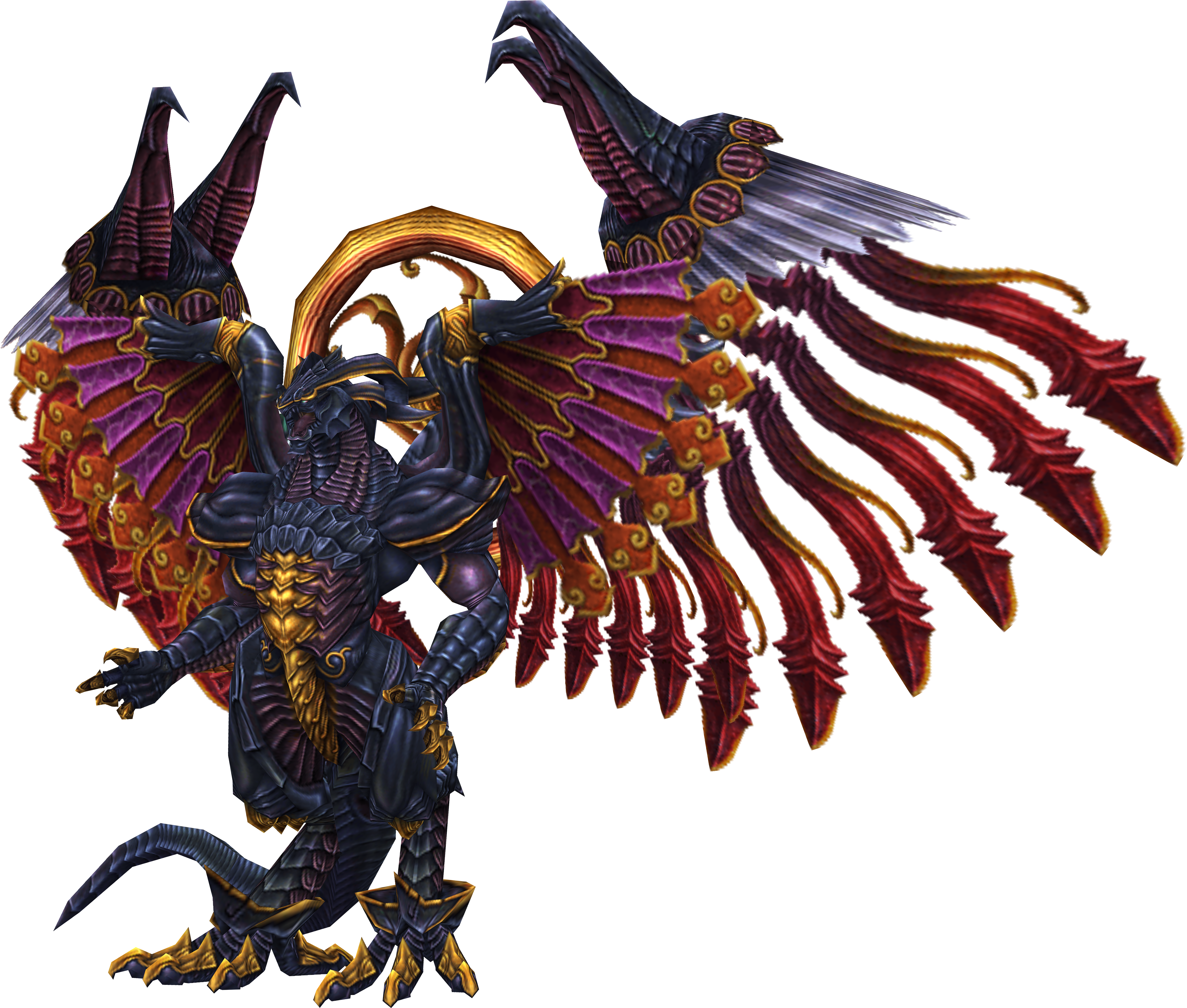
Today marks the 17th anniversary of Final Fantasy X. So the game is now just as old as Tidus and Yuna are when they embark on their journey to save Spira.
This build has been a passion project of mine for quite some time now. In fact, ever since I first played with LEGO as a kid I wanted to build a dragon. Because dragons are just friggin awesome :D
Additionally I always wanted to build something from Final Fantasy and especially something from FFX. The world of Spira is doomed and depressed and yet all its characters and creatures are colourful and magical. Something about this dissonance resonates with me, which is one of the reasons why I love the designs of FFX so much. And none of the creatures in the Final Fantasy universe is as well-known and beloved as the mighty Bahamut.
The FFX version of Bahamut is particularly unique. He has four wings instead of two and the bright colours and the gold give a nice contrast to his dark blue body.
I've known for years that this is the version of Bahamut I want to recreate and I am very excited to finally be able to show him.
Because the colours used for him are completely different than the ones I used in my MOCs before, I first collected different shades to find the right ones. Becoming familiar with the purple and gold and learning their limitations took quite a long time. I built a few prototypes for his head over the years and in November last year I had the feeling I found the right one.
So I printed out a picture of the body to scale to my LEGO head and immediately realised that this MOC would be much bigger than I initially thought :D
In fact: This became my biggest built so far with more than 10.000 LEGO bricks used. He is over 0,6 meters high and has a wingspan of almost 1 meter.
Also, he is entirely built with only LEGO bricks.
I worked on him for the past 6 months, which is why I only managed to make a few other small builds in that time.
I hope it was worth the wait and you guys enjoy the result! :)
Loened Fall
fr.wikipedia.org/wiki/Loened_Fall
Nikon D90
50mm 1,8 AFD (75mm Dx)
Iso 2000
F/3,2
1/400
According To The Alchemy Machine
Yokohama (横浜市 ,Yokohama-shi?) is the capital city of Kanagawa Prefecture. It lies on Tokyo Bay, south of Tokyo, in the Kantō region of the main island of Honshū. It is a major commercial hub of the Greater Tokyo Area. Read More...
Taken at Port of Yokohama
from Wikipedia.Big Boy ...
Union Pacific Railroad (UP) introduced the Challenger-type (4-6-6-4) locomotives in 1936 on its main line across Wyoming. For most of the way, the maximum grade is 0.82% in either direction, but the climb eastward from Ogden, Utah, into the Wasatch Range (Wahsatch, on the railroad) reached 1.14%. Hauling a 3,600-short ton (3,300 t) freight train demanded doubleheading and helper operations, and adding and removing the helper engines from a train slowed operations.
The answer was to design a new locomotive, but for such locomotives to be worthwhile they had to be faster and more powerful than slow mountain luggers like the earlier compound 2-8-8-0s that UP tried after World War I. To avoid locomotive changes, the new class would need to pull long trains at sustained speed—60 miles per hour (100 km/h)—once past the mountain grades. (The 1950s Wyoming Div timetables allowed them 50 mph or less, passenger or freight.)
Led by Otto Jabelmann, the UP's design team worked with Alco to re-examine the Challengers, which had been designed by A.H. Fetters. They found that the goals could be achieved by making several changes to the Challenger design, including enlarging the firebox to about 235 by 96 inches (6.0 m × 2.4 m) (about 155 sq ft/14.4 m2), lengthening the boiler, adding four driving wheels and reducing the size of the driving wheels from 69 to 68 in (1.753 to 1.727 m).
The Big Boys are articulated, like the Mallet locomotive design. They were designed for stability at 60 miles per hour (100 km/h). They were built with a heavy margin of reliability and safety, as they normally operated well below that speed in freight service. Peak horsepower was reached at about 35 mph (56 km/h); optimal tractive effort, at about 10 mph (16 km/h).
Without the tender, the Big Boy had the largest engine body of all reciprocating steam locomotives.
~~~~
For a bit of the background ...
* This engine, #4017, is at the National Railroad Museum, Green Bay, Wisconsin
at maps.yahoo.com/#mvt=m&lat=44.4646609686101&lon=-8
* en.wikipedia.org/wiki/Union_Pacific_Big_Boy
* To really appreciate the length of this locomotive and its 4-8-8-4 wheel arrangement...www.steamlocomotive.com/bigboy/
en.wikipedia.org/wiki/Philippi
Philippi (/fɪˈlɪpaɪ, ˈfɪləˌpaɪ/; Greek: Φίλιπποι, Philippoi) was a city in eastern Macedonia, established by Philip II in 356 BC and abandoned in the 14th century after the Ottoman conquest. The present municipality Filippoi is located near the ruins of the ancient city and it is part of the region of East Macedonia and Thrace in Kavalla Greece.
History
Philippi was established by the king of Macedon, Philip II, on the site of the Thasian colony of Krinides or Crenides (Κρηνἱδες, "Fountains"), near the head of the Aegean Sea at the foot of Mt. Orbelos about 8 miles north-west of Kavalla, on the northern border of the marsh that in Antiquity covered the entire plain separating it from the Pangaion hills to the south of Greece.
The objective of founding the town was to take control of the neighbouring gold mines and to establish a garrison at a strategic passage: the site controlled the route between Amphipolis and Neapolis, part of the great royal route which crosses Macedonia from the east to the west and which was reconstructed later by the Roman Empire as the Via Egnatia. Philip II endowed the new city with important fortifications, which partially blocked the passage between the swamp and Mt. Orbelos, and sent colonists to occupy it. Philip also had the marsh partially drained, as is attested by the writer Theophrastus. Philippi preserved its autonomy within the kingdom of Macedon and had its own political institutions (the Assembly of the demos). The discovery of new gold mines near the city, at Asyla, contributed to the wealth of the kingdom and Philip established a mint there. The city was finally fully integrated into the kingdom under Philip V.
The city remained. It contained 2,000 people. When the Romans destroyed the Antigonid dynasty of Macedon in 168 BC and divided it into four separate states (merides), it was Amphipolis and not Philippi that became the capital of the eastern Macedonian state.
Almost nothing is known about the city in this period, aside from the walls, the Greek theatre, the foundations of a house under the Roman forum and a little temple dedicated to a hero cult. This monument covers the tomb of a certain Exekestos, is possibly situated on the agora and is dedicated to the κτίστης (ktistès), the foundation hero of the city.
The Roman era
The city reappears in the sources during the Roman civil war that followed the assassination of Julius Caesar. His heirs Mark Antony and Octavian confronted the assassins of Caesar, Marcus Junius Brutus and Gaius Cassius Longinus, at the Battle of Philippi on the plain to the west of the city during October in 42 BC. Antony and Octavian were victorious in this final battle against the partisans of the Republic. They released some of their veteran soldiers, probably from legion XXVIII and colonized them in the city, which was refounded as Colonia Victrix Philippensium. In 30 BC, Octavian became Roman emperor, reorganized the colony, and established more settlers there, veterans possibly from the Praetorian Guard and other Italians. The city was renamed Colonia Iulia Philippensis, and then Colonia Augusta Iulia Philippensis after January, 27 BC, when Octavian received the title Augustus from the Roman Senate.
Following this second renaming, and perhaps after the first, the territory of Philippi was centuriated (divided into squares of land) and distributed to the colonists. The city kept its Macedonian walls, and its general plan was modified only partially by the construction of a forum, a little to the east of the site of Greek agora. It was a "miniature Rome," under the municipal law of Rome and governed by two military officers, the duumviri, who were appointed directly from Rome.
The colony recognized its dependence on the mines that brought it its privileged position on the Via Egnatia. This wealth was shown by the many monuments that were particularly imposing considering the relatively small size of the urban area: the forum, laid out in two terraces on both sides of the main road, was constructed in several phases between the reigns of Claudius and Antoninus Pius, and the theatre was enlarged and expanded in order to hold Roman games. There is an abundance of Latin inscriptions testifying to the prosperity of the city.
The early Christian era
According to the New Testament, in AD 49 or 50, the city was visited by the apostle Paul (Acts 16:9-10). From the Acts of the Apostles (Acts 16:12) and the letter to the Philippians (Philippians 1:1), early Christians concluded that Paul had founded their community. Accompanied by Silas, Timothy and possibly Luke, the author of the Acts of the Apostles, Paul is believed to have preached for the first time on European soil in Philippi (Acts 16:12-40). According to the New Testament, Paul visited the city on two other occasions, in 56 and 57. The Epistle to the Philippians dates from around 61-62 and is believed to show the immediate effects of Paul's instruction.
The development of Christianity in Philippi is indicated by a letter from Polycarp of Smyrna addressed to the community in Philippi around AD 160 and by funerary inscriptions.
The first church described in the city is a small building that was probably originally a small prayer house. This Basilica of Paul, identified by a mosaic inscription on the pavement, is dated around 343 from a mention by the bishop Porphyrios, who was present at the Council of Serdica that year.
The prosperity of the city in the 5th and 6th centuries was attributed to Paul and to his ministry.[citation needed] As in other cities, many new ecclesiastical buildings were constructed at this time. Seven different churches were constructed in Philippi between the mid-4th century and the end of the 6th, some of which competed in size and decoration with the most beautiful buildings in Thessalonica, or those of Constantinople. The relationship of the plan and of the architectural decoration of Basilica B with Hagia Sophia and Saint Irene in Constantinople accorded a privileged place to this church in the history of early Christian art. The complex cathedral which took the place of the Basilica of Paul at the end of the 5th century, constructed around an octagonal church, also rivaled the churches of Constantinople.
In the same age, the fortifications of the city were rebuilt in order to better defend against the growing instability in the Balkans. In 473 CE, the city was besieged by the Ostrogoths, who were unable to take it but burned down the surrounding villages.
The Byzantine and Ottoman era
Already weakened by the Slavic invasions at the end of the 6th century, which ruined the agrarian economy of Macedonia and probably also by the Plague of Justinian in 547, the city was almost totally destroyed by an earthquake around 619, from which it never recovered. There was a small amount of activity there in the 7th century, but the city was now hardly more than a village.
The Byzantine Empire possibly maintained a garrison there, but in 838 the city was taken by the Bulgars under kavhan Isbul, who celebrated their victory with a monumental inscription on the stylobate in Basilica B, now partially in ruins. The site of Philippi was so strategically sound that the Byzantines attempted very soon to recapture it ca. 850. Several seals of civil servants and other Byzantine officials, dated to the first half of the 9th century, prove the presence of Byzantine armies in the city.
Around 969, Emperor Nicephorus II Phocas rebuilt the fortifications on the acropolis and in part of the city. These gradually helped weaken Bulgar power and strengthen the Byzantine presence in the area. In 1077, Bishop Basil Kartzimopoulos rebuilt part of the defenses inside the city. The city began to prosper once more, as witnessed by the Arab geographer Al Idrisi, who mentions it as a centre of business and wine production around 1150.
After a brief occupation by the Franks after the Fourth Crusade and the capture of Constantinople in 1204, the city was captured by the Serbs. Still, it remained a notable fortification on the route of the ancient Via Egnatia; in 1354, the pretender to the Byzantine throne, Matthew Cantacuzenus, was captured there by the Serbs.
The city was abandoned at an unknown date, but when the French traveller Pierre Belon visited it in the 16th century, there were nothing but ruins, used by the Turks as a quarry. The name of the city was preserved at first by a Turkish village on the nearby plain, Philibedjik (Filibecik, "Little Filibe" in Turkish), which has since disappeared and then by a Greek village in the mountains.
Archaeological excavation of the site
Noted or briefly described by 16th century travellers, the first archaeological description of the city was made in 1856 by Perrot, then in 1861 by Léon Heuzey and Henri Daumet in their famous Mission archéologique de Macédoine.[1] The first excavations did not begin until the summer of 1914, and were soon interrupted by the First World War. The excavations, carried out by the École française d'Athènes, were renewed in 1920 and continued until 1937. During this time the Greek theatre, the forum, Basilicas A and B, the baths and the walls were excavated. After the Second World War, Greek archaeologists returned to the site. From 1958 to 1978, the Société Archéologique, then the Service archéologique and the University of Thessalonica uncovered the bishop's quarter and the octagonal church, large private residences, a new basilica near the Museum and two others in the necropolis to the east of the city.
In the Bible
According to the New Testament, in AD 49 or 50 the apostle Paul visited the city, guided there by a vision (Acts 16:9-10). Accompanied by Silas, Timothy and possibly Luke, the author of the Acts of the Apostles, Paul preached for the first time on European soil in Philippi (Acts 16:12-40) and baptized Lydia, a purple dye merchant, in a river to the west of the city. While in Philippi, his exorcism of a demon from a slave girl caused a great uproar in the city, which led to the arrest of Paul and Silas and a public beating (Acts 16:16-24). An earthquake caused their prison to be opened. When the jailer awoke, he prepared to kill himself, thinking all the prisoners had escaped and knowing that he would be severely punished. Paul stopped him, indicating that all the prisoners were in fact still there. The jailer then became one of the first Christians in Europe (Acts 16:25-40).
Paul visited the city at least on two other occasions, in 56 and 57. The Epistle to the Philippians dates from around 61-62 and shows the immediate effects of Paul's instruction.
en.wikipedia.org/wiki/Pioneer_Courthouse_Square
COPYRIGHT © David F. Panno - ALL RIGHTS RESERVED - Content is not to be redistributed, shared or modified.
20160625_183_Oregon_LR6COPY-Edit-1.TIF
for Our Daily Challenge topic - 'Stripes'
I think I will have some bigger, more exciting stripes to post this afternoon.
en.wikipedia.org/wiki/Llandudno
Llandudno (/θlænˈdɪdnoʊ/ or /lænˈdɪdnoʊ/; Welsh pronunciation: [ɬanˈdɪdnɔ])[1] is a seaside resort, town and community in Conwy County Borough, Wales, located on the Creuddyn peninsula. In the 2011 UK census, the community, which includes Penrhyn Bay and Penrhynside, had a population of 20,710.[2] The town's name is derived from its patron saint, Saint Tudno.
Llandudno, "Queen of the Welsh Resorts", a title first applied as early as 1864,[3] is now the largest seaside resort in Wales, and lies on a flat isthmus of sand between the Welsh mainland and the Great Orme. Historically a part of Caernarfonshire, Llandudno was formerly in the district of Aberconwy within Gwynedd.
History
The town of Llandudno developed from Stone Age, Bronze Age and Iron Age settlements over many hundreds of years on the slopes of the limestone headland, known to seafarers as the Great Orme and to landsmen as the Creuddyn Peninsula. The origins in recorded history are with the Manor of Gogarth conveyed by King Edward I to Annan, Bishop of Bangor in 1284. The manor comprised three townships, Y Gogarth in the south-west, Y Cyngreawdr in the north (with the parish church of St Tudno) and Yn Wyddfid in the south-east.
Great Orme[edit]
Mostly owned by Mostyn Estates. Home to several large herds of wild Kashmiri goats originally descended from several goats given by Queen Victoria to Lord Mostyn. The summit of the Great Orme stands at 679 feet (209 M). The Summit Hotel which is now a tourist attraction was once the home of world middleweight champion boxer Randolph Turpin.
A haven for flora and fauna with some rare species such as peregrine falcons and a species of wild cotoneaster (cambricus) which can only be found on the Great Orme. The sheer limestone cliffs of the Great Orme provide ideal nesting conditions for a wide variety of sea birds, including cormorants, shags, guillemots, razorbills, puffins, kittiwakes, fulmars and numerous gulls.
This great limestone headland has many attractions including the Great Orme Tramway and a cable car system that takes tourists effortlessly to the summit.
Development
By 1847 the town had grown to a thousand people, served by the new church of St George, built in 1840. The great majority of the men worked in the copper mines with others employed in fishing and subsistence agriculture.
In 1848, Owen Williams, an architect and surveyor from Liverpool, presented Lord Mostyn with plans to develop the marsh lands behind Llandudno Bay as a holiday resort. These were enthusiastically pursued by Lord Mostyn. The influence of the Mostyn Estate and its agents over the years was to become paramount in the development of Llandudno and especially after the appointment of George Felton as surveyor and architect in 1857. During the years 1857 to 1877 much of central Llandudno was developed under Felton's supervision. George Felton also undertook architectural design work including the design and execution of Holy Trinity Church in Mostyn Street.
Transport
The town is just off the North Wales Coast railway line which was opened as the Chester and Holyhead Railway in 1848, became part of the London and North Western Railway in 1859, and part of the London, Midland and Scottish Railway in 1923. Llandudno was specifically built as a mid-Victorian era holiday destination and is served by a branch railway line opened in 1858 from Llandudno Junction with stations at Deganwy and Llandudno.
Present
Modern Llandudno takes its name from the ancient parish of Saint Tudno but also encompasses several neighbouring townships and districts including Craig-y-Don, Llanrhos and Penrhyn Bay. Also nearby is the small town and marina of Deganwy and these last four are in the traditional parish of Llanrhos. The ancient geographical boundaries of the Llandudno area are complex. Although they are on the eastern side of the River Conwy (the natural boundary between north-west and north-east Wales), the ancient parishes of Llandudno, Llanrhos and Llangystennin (which includes Llandudno Junction) were in the medieval commote of Creuddyn in the Kingdom of Gwynedd, and afterwards part of Caernarfonshire. Today, Deganwy and Llandudno Junction are part of the town community of Conwy even though they are across the river and only linked to Conwy by a causeway and bridge.
Attractions
Llandudno Bay and the North Shore
This wide sweep of sand, shingle and rock extends two miles in a graceful curve between the headlands of the Great Orme and the Little Orme.
For most of the length of Llandudno's North Shore there is a wide curving Victorian promenade, open to pedestrians and cyclists, and separated from the roadway by a strip of garden. The road, collectively known as The Parade, has a different name for each block and it is on these parades and crescents that many of Llandudno's hotels are built.
Near the centre of the bay is the Venue Cymru. The Llandudno Sailing Club and a roundabout mark the end of this section of The Parade and beyond are more hotels and guest houses but they are in the township of Craig-y-Don.
At Nant-y-Gamar Road, the Parade becomes Colwyn Road with the fields of Bodafon Hall Farm on the landward side but with the promenade continuing until it ends in a large paddling pool for children and finally at Craigside on the lower slopes of the Little Orme.
Llandudno Pier
The award-winning pier is on the North Shore. Built in 1878, at 2,295 feet (700 m) the pier is the longest in Wales and is a Grade II listed building.
Looking back towards the town from the end of the pier, on a clear day one can see the mountains of Snowdonia rising over the town. A curious major extension of the pier in 1884 was in a landwards direction along the side of what was the Baths Hotel (now where the Grand Hotel stands) to provide a new entrance with the Llandudno Pier Pavilion Theatre at the North Parade end of the promenade, thus increasing the pier's length to 2,295 feet (700 m). Attractions on the pier include a bar, a cafe, amusement arcades, children's fairground rides and an assortment of shops & kiosks.
In the summer, Professor Codman's Punch and Judy show (established in 1860) can be found on the promenade near the entrance to the pier.
Happy Valley
The Happy Valley, a former quarry, was the gift of Lord Mostyn to the town in celebration of the Golden Jubilee of Queen Victoria in 1887. The area was landscaped and developed as gardens, two miniature golf courses, a putting green, a popular open air theatre and extensive lawns. The ceremonies connected with the Welsh National Eisteddfod were held there in 1896 and again in 1963. In June 1969, the Great Orme Cabin Lift, a modern alternative to the tramway, was opened with its base station adjacent to the open air theatre. The distance to the summit is just over one mile (1.6 km) and the four-seater cabins travel at six m.p.h. on a continuous steel cable over two miles (3 km) long. It is the longest single stage cabin lift in Britain and the longest span between pylons is over 1,000 feet (300 m). The popularity of the 'Happy Valley Entertainers' open air theatre having declined, the theatre closed in 1985 and likewise the two miniature golf courses closed and were converted in 1987 to create a 280 metres (920 ft) artificial ski slope and toboggan run. The gardens were extensively restored as part of the resort's millennium celebrations and remain a major attraction.
Marine Drive
The first route round the perimeter of the Great Orme was a footpath constructed in 1858 by Reginald Cust, a trustee of the Mostyn Estate. In 1872 the Great Ormes Head Marine Drive Co. Ltd. was formed to turn the path into a carriage road. Following bankruptcy, a second company completed the road in 1878. The contractors for the scheme were Messrs Hughes, Morris, Davies, a consortium led by Richard Hughes of Madoc Street, Llandudno.[4] The road was bought by Llandudno Urban District Council in 1897.[5] The 4 miles (6.4 km) one way drive starts at the foot of the Happy Valley. After about 1.5 miles (2.4 km) a side road leads to St. Tudno's Church, the Great Orme Bronze Age Copper Mine and the summit of the Great Orme. Continuing on the Marine Drive one passes the Great Orme Lighthouse (now a small hotel) and, shortly afterwards on the right, the Rest and Be Thankful Cafe and information centre. Below the Marine Drive at its western end is the site of the wartime Coast Artillery School (1940-1945) now a scheduled ancient monument
West Shore
The West Shore is the quiet beach on the estuary of the River Conwy. It was here at Pen Morfa that Alice Liddell (of Alice in Wonderland fame) spent the long summer holidays of her childhood from 1862 to 1871. There are a few hotels and quiet residential streets. The West Shore is linked to the North Shore by Gloddaeth Avenue and Gloddaeth Street, a wide dual carriageway.
Mostyn Street
Running behind the promenade is Mostyn Street leading to Mostyn Broadway and then Mostyn Avenue. These are the main shopping streets of Llandudno and Craig-y-Don. Mostyn Street accommodates the high street shops, the major high street banks and building societies, two churches, amusement arcades and the town's public library. The last is the starting point for the Town Trail,[6] a carefully planned walk that facilitates viewing Llandudno in a historical perspective.
Victorian Extravaganza
Every year in May bank holiday weekend, Llandudno has a three-day Victorian Carnival[7] and Mostyn Street becomes a funfair. Madoc Street and Gloddaeth Street and the Promenade become part of the route each day of a mid-day carnival parade. The Bodafon Farm fields become the location of a Festival of Transport[8] for the weekend.
Venue Cymru
The North Wales Theatre, Arena and Conference Centre, built in 1994, extended in 2006 and renamed "Venue Cymru" is located near the centre of the promenade on Penrhyn Crescent. It is noted for its productions of opera, orchestral concerts, ballet, musical theatre, drama, circus, ice shows and pantomimes.
landudno Lifeboat
Llandudno is unique within the United Kingdom in that its lifeboat station is located inland, allowing it to launch with equal facility from either the West Shore or the North Shore as needed. Llandudno's active volunteer crews are called out more than ever with the rapidly increasing numbers of small pleasure craft sailing in coastal waters. The Llandudno Lifeboat is normally on display on the promenade every Sunday and bank holiday Monday from May until October. 2014 A planning application submitted for a new Lifeboat station, with a larger boat, to be built close to the paddling pool on North Shore.
Places of worship
The ancient parish church dedicated to Saint Tudno stands in a hollow near the northern point of the Great Orme and two miles (3 km) from the present town. It was established as an oratory by Tudno, a 6th-century monk, but the present church dates from the 12th century and it is still used on summer Sunday mornings. It was the Anglican parish church of Llandudno until that status was transferred first to St George’s (now closed) and later to Holy Trinity Church in Mostyn Street.
The principal Christian Churches of Llandudno are members of Cytûn (churches together) and include the Church in Wales (Holy Trinity and also Saint Paul's at Craig-y-Don), the Roman Catholic Church of Our Lady Star of the Sea, Saint John’s Methodist Church, Gloddaeth United Church (Presbyterian), Assemblies of God (Pentecostal), Llandudno Baptist Church, St. David's Methodist Church at Craig-y-Don, the Coptic Orthodox Church of Saint Mary and Saint Abasikhiron, and Eglwys Unedig Gymraeg Llandudno (the United Welsh Church of Llandudno).
A member of the local Methodist community is the Revd Roger Roberts, now Lord Roberts of Llandudno, Liberal Democrat Spokesman for International Development in the House of Lords.
Llandudno is home to a Jewish centre in Church Walks, which serves the local Jewish population - one of few in North Wales. The town also boasts a Coptic church (The Coptic Orthodox Church of St Mary and St Abasikhiron on Trinity Avenue) as well as a Buddhist centre, Kalpa Bhadra, on Mostyn Avenue in Craig-y-Don.
Area features
Bodysgallen Hall is a manor house nearby to the south near the village of Llanrhos. This listed historical building derives primarily from the 17th century, and has several later additions. Bodysgallen was constructed as a tower house in the Middle Ages to serve as defensive support for nearby Conwy Castle.
Links with Wormhout and Mametz
Llandudno is twinned with the Flemish town of Wormhout 10 miles (16 km) from Dunkirk. It was there that many members of the Llandudno-based 69th Territorial Regiment were ambushed and taken prisoner. Later, at nearby Esquelbecq on 28 May 1940, the prisoners were shot.[9]
The 1st (North Wales) Brigade was Headquartered in Llandudno in December 1914 and included a battalion of the (Royal Welch Fusiliers), which had been raised and trained in Llandudno. During the 1914–18 war this Brigade, a major part of the 38th Welsh Division, took part in the Battle of the Somme and the Brigade was ordered to take Mametz Wood. Two days of fighting brought about the total destruction of Mametz village by shelling. After the war, the people of Llandudno (including returning survivors from the 38th Welsh Division) contributed generously to the fund for the reconstruction of the village of Mametz.
Cultural connections
Llandudno hosted the Welsh National Eisteddfod in 1864, 1896 and 1963, and from 26–31 May 2008 welcomed the Urdd National Eisteddfod to Gloddaeth Isaf Farm, Penrhyn Bay. The town also hosted the Liverpool Olympic Festival in 1865 and 1866.
Matthew Arnold gives a vivid and lengthy description of 1860s Llandudno – and of the ancient tales of Taliesin and Maelgwn Gwynedd that are associated with the local landscape — in the first sections of the preface[11] to On the Study of Celtic Literature (1867).
Elisabeth of Wied, the Queen consort of Romania and also known as writer Carmen Sylva, stayed in Llandudno for five weeks in 1890. On taking her leave, she described Wales as "a beautiful haven of peace".[12] Translated into Welsh as "hardd, hafan, hedd" it became the town's official motto.
Other famous people with links to Llandudno include the Victorian statesman John Bright and multi-capped Welsh international footballers Neville Southall, Neil Eardley and Joey Jones. Australian ex-Prime Minister Billy Hughes attended school in Llandudno. Gordon Borrie QC (Baron Borrie), Director General of the Office of Fair Trading from 1976 to 1992, was educated at the town's John Bright Grammar School when he lived there as a wartime evacuee.
The international art gallery, Oriel Mostyn is situated in Vaughan Street next to the post office. It was built in 1902 to house the art collection of Lady Augusta Mostyn. It was requisitioned in 1914 for use as an army drill hall and later became a warehouse before being returned to use as an art gallery in 1979. Following a major revamp the gallery was renamed simply 'Mostyn' in 2010.
In January 1984 Brookside character Petra Taylor (Alexandra Pigg) committed suicide in Llandudno.
While I was reading in bed this morning Wiki got up and did things. When I get up she was in her basket.
Taken on the slopes of Midsummer Hill in Malvern. I feared and loved this place as a kid. In spring the woods are beautiful, carpeted with bluebells but in autumn and winter they're dark, mysterious. Didn't help that I heard all sorts of stories about this hill - iron age hill forts, burial mounds (both found on the hill), battles, druids, oh and "big black cats" supposedly spied out here. All stories were told by my father, usually as the light dropped on winter afternoons and told over his shoulder as he and his plucky terrier, Bede strode ahead, leaving me panting in their wake, fully expecting to see a ghost or be eaten by a panther any second.
Clearly, I didn't get eaten by a marauding panther but I still find these woods magical, like the setting for a dark fairytale... enchanting but kind of spooky!! At least I have my knight in shining armour fur now! I'm sure Barney would protect me from whatever lurks in the wood ;-) He certainly showed no fear of the looming trees and kindly cleared the area of all rabbits, squirrels and pheasants for me during our walk yesterday! Kept disappearing into the fog and I'd just hear the odd crash, or distant alarm call from a panicked bird as Barney explored. As it was so foggy and there were so many hunting opportunities, I didn't get a chance to take many photos of Barn but when he climbed a fallen tree, I saw an opportunity and really liked this shot.
Thanks for all the kind words last week about my being (very nearly) a yr cancer free! I had my hospital appointment on Wed and it went well :) I saw one of the consultants who operated on me last yr but hasn't seen me much since and he was really happy with my progress with speaking and recovery etc. He was slightly concerned I'm still so tired but thyroid problems are common after radiotherapy on the neck, so we're going to look into that... Hope everyone has a good weekend. Oh, and for Dilly fans out there, I should be uploading a few soon ;-)
en.wikipedia.org/wiki/Dadu_District
Dadu (Urdu: ضلع دادو) is a district of Sindh Province, Pakistan. Dadu district was created in 1933 by the British Indian administration by merging Kotri and Kohistan tehsils from Karachi district and Mehar, Khairpur Nathan Shah, Dadu, Johi and Sehwan tehsils from Larkana district. The population of the district is 1,688,810 according to 1998 census report. The rural and urban population of the district constitutes 79% and 21% of the total population respectively. The area of district is 19,070 square kilometres divided in seven talukas yielding population density of 88.6 persons per square kilometre. The average household size of the district is 5.5 persons, which is higher in urban areas at 6.3 as compared to that in rural areas at 5.3 implying more congestion in urban areas. More than 73% of the housing units in Dadu district are single room houses. The average annual rainfall in the district is about 120 millimetres. The total area under forest is district Dadu is 217,000 hectares yielding timber and firewood. . In 2004 another district by the name of Jamshoro was carved out of District Dadu which comprised Taluka Kotri, Taluka Sehwan and Taluka Jamshoro which is the headquarter of the new district.
Tribes & ClansThe majority of the population is Muslim. It includes: Jatoi, Malik(Sindhi), Narejo, Soomro, Jamali, Palh, Khushk, Kalhoro, Dawachh, Channah, Panhwar, Solangi, Qazi, Syed, Shah, Mirani, Babar, Mallah, Vighio, Mirbahar, Chandio, Pahi baloch, Brohi, Shahani, Gabol, Lund, Khero, Magsi, Bozdar, Leghari, Unar Bahota, Dahiri, Charan, Babar, Memon, Abbasi, Bhatti, Joyo and others. Many of these tribes have a great role in the Politics of Pakistan.
Notable People in Dadu District
Liaquat Ali Khan Jatoi - Former Chief Minister of Sindh, Ex Federal Minster
Mr. Justice Ghulam Nabi Soomro - Hon'ble Justice, High Court of Sindh, Presently Chairman of Sindh Services Tribunal
Haji Zaffar Ali Khan Leghari - Ex MPA
Rafiq Ahmad Jamali - State Minister for Food
Pir Mazhar-Ul-Haq - Provincial Minister for Education, Sindh
Demographics
Following are the demographic indicators of the district as per the 1998 census of Pakistan (including Jamshoro District which was a part of Dadu at that time):
Religion:
Islam: 97.49%
Hinduism: 2.05%
Christianity: 0.37%
Ahmaddiya: 0.08%
Others: 0.02%
Hindus and Christians are mainly concentrated in the urban areas.
Languages:
Sindhi: 50.0%
Seraiki: 43.33%
Urdu: 2.56%
Punjabi:1.88%
Pashto:1.17%
Baluchi:0.42%
Others:0.28%
Urdu speakers are mainly concentrated in the urban areas.
Talukas/TehsilsMehar Taluka
Khairpur Nathan Shah Taluka
Dadu Taluka
Johi Taluka
Places of interest
Gorakh Hill - First Ever Hill Station in Sindh
Manchar Lake - Largest Ever Lake in Pakistan and one of the Largest Lakes in Asia
Source: en.wikipedia.org/wiki/Toronto
Toronto is the provincial capital of Ontario. With a recorded population of 2,731,571 in 2016, it is the most populous city in Canada and the fourth most populous city in North America. The city is the anchor of the Golden Horseshoe, an urban agglomeration of 9,245,438 people (as of 2016) surrounding the western end of Lake Ontario, while the Greater Toronto Area (GTA) proper had a 2016 population of 6,417,516. Toronto is an international centre of business, finance, arts, and culture, and is recognized as one of the most multicultural and cosmopolitan cities in the world.
People have travelled through and inhabited the Toronto area, located on a broad sloping plateau interspersed with rivers, deep ravines, and urban forest, for more than 10,000 years. After the broadly disputed Toronto Purchase, when the Mississauga surrendered the area to the British Crown, the British established the town of York in 1793 and later designated it as the capital of Upper Canada. During the War of 1812, the town was the site of the Battle of York and suffered heavy damage by American troops. York was renamed and incorporated in 1834 as the city of Toronto. It was designated as the capital of the province of Ontario in 1867 during Canadian Confederation. The city proper has since expanded past its original borders through both annexation and amalgamation to its current area of 630.2 km2 (243.3 sq mi).
The diverse population of Toronto reflects its current and historical role as an important destination for immigrants to Canada. More than 50 percent of residents belong to a visible minority population group, and over 200 distinct ethnic origins are represented among its inhabitants. While the majority of Torontonians speak English as their primary language, over 160 languages are spoken in the city.
Toronto is a prominent centre for music, theatre, motion picture production, and television production, and is home to the headquarters of Canada's major national broadcast networks and media outlets. Its varied cultural institutions, which include numerous museums and galleries, festivals and public events, entertainment districts, national historic sites, and sports activities, attract over 43 million tourists each year. Toronto is known for its many skyscrapers and high-rise buildings, in particular the tallest free-standing structure in the Western Hemisphere, the CN Tower.
The city is home to the Toronto Stock Exchange, the headquarters of Canada's five largest banks, and the headquarters of many large Canadian and multinational corporations. Its economy is highly diversified with strengths in technology, design, financial services, life sciences, education, arts, fashion, aerospace, environmental innovation, food services, and tourism.
Source: en.wikipedia.org/wiki/Barcelona
Barcelona is a city in Spain. It is the capital and largest city of the autonomous community of Catalonia, as well as the second most populous municipality of Spain. With a population of 1.6 million within city limits, its urban area extends to numerous neighbouring municipalities within the Province of Barcelona and is home to around 4.8 million people, making it the sixth most populous urban area in the European Union after Paris, London, Madrid, the Ruhr area and Milan. It is one of the largest metropolises on the Mediterranean Sea, located on the coast between the mouths of the rivers Llobregat and Besòs, and bounded to the west by the Serra de Collserola mountain range, the tallest peak of which is 512 metres (1,680 feet) high.
Founded as a Roman city, in the Middle Ages Barcelona became the capital of the County of Barcelona. After merging with the Kingdom of Aragon, Barcelona continued to be an important city in the Crown of Aragon as an economic and administrative centre of this Crown and the capital of the Principality of Catalonia. Barcelona has a rich cultural heritage and is today an important cultural centre and a major tourist destination. Particularly renowned are the architectural works of Antoni Gaudí and Lluís Domènech i Montaner, which have been designated UNESCO World Heritage Sites. The headquarters of the Union for the Mediterranean are located in Barcelona. The city is known for hosting the 1992 Summer Olympics as well as world-class conferences and expositions and also many international sport tournaments.
Barcelona is one of the world's leading tourist, economic, trade fair and cultural centres, and its influence in commerce, education, entertainment, media, fashion, science, and the arts all contribute to its status as one of the world's major global cities. It is a major cultural and economic centre in southwestern Europe, 24th in the world (before Zürich, after Frankfurt) and a financial centre. In 2008 it was the fourth most economically powerful city by GDP in the European Union and 35th in the world with GDP amounting to €177 billion. In 2012 Barcelona had a GDP of $170 billion; and it was leading Spain in employment rate in that moment.
In 2009 the city was ranked Europe's third and one of the world's most successful as a city brand. In the same year the city was ranked Europe's fourth best city for business and fastest improving European city, with growth improved by 17% per year, and the city has been experiencing strong and renewed growth for the past three years. Since 2011 Barcelona has been a leading smart city in Europe. Barcelona is a transport hub, with the Port of Barcelona being one of Europe's principal seaports and busiest European passenger port, an international airport, Barcelona–El Prat Airport, which handles over 50 million passengers per year, an extensive motorway network, and a high-speed rail line with a link to France and the rest of Europe.
Source: en.wikipedia.org/wiki/Arc_de_Triomf
The Arc de Triomf or Arco de Triunfo in Spanish, is a triumphal arch in the city of Barcelona in Catalonia, Spain. It was built by architect Josep Vilaseca i Casanovas as the main access gate for the 1888 Barcelona World Fair. The arch crosses over the wide central promenade of the Passeig de Lluís Companys, leading to the Ciutadella Park that now occupies the site of the world fair. It is located at the northern end of the promenade, facing the Passeig de Sant Joan.
Source: en.wikipedia.org/wiki/Scott_Air_Force_Base
Scott Air Force Base (IATA: BLV, ICAO: KBLV, FAA LID: BLV) is a United States Air Force base in St. Clair County, Illinois, near Belleville and O'Fallon, 17 miles east-southeast of downtown St. Louis. Scott Field was one of thirty-two Air Service training camps established after the United States entered World War I in April 1917. It is headquarters of Air Mobility Command (AMC), and is also the headquarters of the U.S. Transportation Command, a Unified Combatant Command that coordinates transportation across all the services.
The base is operated by the 375th Air Mobility Wing (375 AMW) and is also home to the Air Force Reserve Command's 932d Airlift Wing (932 AW) and the Illinois Air National Guard's 126th Air Refueling Wing (126 ARW), the latter two units being operationally gained by AMC.
The base currently employs 13,000 people, 5,100 civilians with 5,500 active-duty Air Force, and an additional 2,400 Air National Guard and Reserve personnel. It was announced in June 2014 that two new cybersecurity squadrons will be added to the three currently on base.
Its airfield is also used by civilian aircraft, with civilian operations at the base referring to the facility as MidAmerica St. Louis Airport. MidAmerica has operated as a Joint Use Airport since beginning operations in November 1997. Allegiant Air, the only commercial airline with scheduled flights at the airport, pulled out of the airport on January 3, 2009, but now has multiple nonstop destinations.
Additional Foreign Language Tags:
(United States) "الولايات المتحدة" "Vereinigte Staaten" "アメリカ" "美国" "미국" "Estados Unidos" "États-Unis"
(Illinois) "الينوي" "伊利诺伊州" "इलिनोइस" "イリノイ" "일리노이" "Иллинойс"
(Scott Air Force Base) "قاعدة سكوت الجوية" "斯科特空军基地" "Base aérienne de Scott" "स्कॉट एयर फोर्स बेस" "スコット空軍基地" "스콧 공군 기지" "База ВВС Скотт" "Base de la Fuerza Aérea Scott"
en.wikipedia.org/wiki/Reichstag_building
The Reichstag building (German: Reichstagsgebäude; officially: Plenarbereich Reichstagsgebäude) is a historical edifice in Berlin, Germany, constructed to house the Imperial Diet (German: Reichstag), of the German Empire. It was opened in 1894 and housed the Diet until 1933, when it was severely damaged in a fire. After World War II, the building fell into disuse; the parliament of the German Democratic Republic (the Volkskammer) met in the Palast der Republik in East Berlin, while the parliament of the Federal Republic of Germany (the Bundestag) met in the Bundeshaus in Bonn.
The ruined building was made safe against the elements and partially refurbished in the 1960s, but no attempt at full restoration was made until after German reunification on 3 October 1990, when it underwent a reconstruction led by architect Norman Foster. After its completion in 1999, it once again became the meeting place of the German parliament: the modern Bundestag.
The term Reichstag, when used to connote a diet, dates back to the Holy Roman Empire. The building was built for the Diet of the German Empire, which was succeeded by the Reichstag of the Weimar Republic. The latter would become the Reichstag of Nazi Germany, which left the building (and ceased to act as a parliament) after the 1933 fire and never returned; the term Reichstag has not been used by German parliaments since World War II. In today's usage, the German word Reichstag (Imperial Diet Building) refers mainly to the building, while Bundestag (Federal Diet) refers to the institution.
History of the building
Construction of the building began well after the unification of Germany in 1871. Previously, the parliament had assembled in several other buildings in Leipziger Straße in Berlin but these were generally considered too small, so in 1872 an architectural contest with 103 participating architects was carried out to erect a new building. After a short survey of possible sites, a parliamentary committee recommended the east side of the Königsplatz (today, Platz der Republik), which however was occupied by the palace of a Polish-Prussian aristocrat, Athanasius Raczyński.
Work did not start until ten years later though, owing to various problems with purchasing the property and arguments between Wilhelm I, Otto von Bismarck, and the members of the Reichstag about how the construction should be performed. After lengthy negotiations, the Raczyński Palace was purchased and demolished, making way for the new building.
In 1882, another architectural contest was held, with 200 architects participating. This time the winner, the Frankfurt architect Paul Wallot, would actually see his Neo-Baroque project executed. The direct model for Wallot's design was Philadelphia's Memorial Hall, the main building of the 1876 United States Centennial Exhibition.[1] The Reichstag's decorative sculptures, reliefs, and inscriptions were by sculptor Otto Lessing. On 29 June 1884, the foundation stone was finally laid by Wilhelm I, at the east side of the Königsplatz. Before construction was completed by Philipp Holzmann A.G. in 1894,[2] Wilhelm I died (in 1888, the Year of Three Emperors). His eventual successor, Wilhelm II, took a more jaundiced view of parliamentary democracy than his grandfather. The original building was acclaimed for the construction of an original cupola of steel and glass, considered an engineering feat at the time. But its mixture of architectural styles drew widespread criticism.[3]
In 1916 the iconic words Dem Deutschen Volke ("[To] the German people") were carved above the main façade of the building, much to the displeasure of Wilhelm II who had tried to block the adding of the inscription for its democratic significance. After World War I had ended and Wilhelm had abdicated, during the revolutionary days of 1918, Philipp Scheidemann proclaimed the institution of a republic from one of the balconies of the Reichstag building on 9 November. The building continued to be the seat of the parliament of the Weimar Republic (1919–1933), which was still called the Reichstag.
Third Reich
The building caught fire on 27 February 1933, under circumstances still not entirely known (see Reichstag fire). This gave a pretext for the Nazis to suspend most rights provided for by the 1919 Weimar Constitution in the Reichstag Fire Decree in an effort to weed out communists and increase state security throughout Germany.
During the 12 years of National Socialist rule, the Reichstag building was not used for parliamentary sessions. Instead, the few times that the Reichstag convened at all, it did so in the Krolloper building, a former opera house opposite the Reichstag building. This applies particularly to the session of 23 March 1933, in which the Reichstag disposed of its powers in favour of the Nazi government in the Enabling Act, another step in the so-called Gleichschaltung ("coordination"). The main meeting hall of the building (which was unusable after the fire) was instead used for propaganda presentations and, during World War II, for military purposes. It was also considered for conversion to a flak tower but was found to be structurally unsuitable.
The building, having never been fully repaired since the fire, was further damaged by air raids. During the Battle of Berlin in 1945, it became one of the central targets for the Red Army to capture due to its perceived symbolic significance. Today, visitors to the building can still see Soviet graffiti on smoky walls inside as well as on part of the roof, which was preserved during the reconstructions after reunification.
Yevgeny Khaldei took the famous picture, Raising a flag over the Reichstag, on 2 May 1945. The picture symbolizes the victory of USSR over nazism.
Cold War
When the Cold War emerged, the building was physically within West Berlin, but only a few metres from the border of East Berlin, which ran around the back of the building and in 1961 was closed by the Berlin Wall. During the Berlin blockade, an enormous number of West Berliners assembled before the building on 9 September 1948, and Mayor Ernst Reuter held a famous speech that ended with "Ihr Völker der Welt, schaut auf diese Stadt!" ("You peoples of the world, look upon this city!")
After the war, the building was essentially a ruin. In addition, there was no real use for it, since the seat of government of West Germany had been established in Bonn in 1949. Still, in 1956, after some debate, it was decided that the Reichstag should not be torn down, but be restored instead. However, the cupola of the original building, which had also been heavily damaged in the war, was demolished. Another architectural contest was held, and the winner, Paul Baumgarten, reconstructed the building from 1961–1964, but utterly removing all sumptuous heraldic statues, monuments, decorations and the like that harked back to the mythology of the German past from the inside, but also the largest ones on the outside of the building. In effect, he created a plain building inside the historic Reichstag, retaining only the outer walls stripped of most of their statues and decoration.
The artistic and practical value of his work was the subject of much debate after German reunification. Under the provisions set forth for Berlin by the Allies in the 1971 Four Power Agreement on Berlin, the Bundestag, the parliament of West Germany of that time, was not allowed to assemble formally in West Berlin (even though East Germany was in violation of this provision since it had declared East Berlin its capital). Until 1990, the building was thus used only for occasional representative meetings, and one-off events. It was also used for a widely lauded permanent exhibition about German history called Fragen an die deutsche Geschichte (Questions about German history).
Reunification
The official German reunification ceremony on 3 October 1990, was held at the Reichstag building, including Chancellor Helmut Kohl, President Richard von Weizsäcker, former Chancellor Willy Brandt and many others. The event included huge firework displays[citation needed]. One day later, the parliament of the united Germany would assemble in an act of symbolism in the Reichstag building.
However, at that time, the role of Berlin had not yet been decided upon. Only after a fierce debate, considered by many as one of the most memorable sessions of parliament, did the Bundestag conclude, on 20 June 1991, with quite a slim majority in favour of both government and parliament returning to Berlin from Bonn.
In 1992, Norman Foster won yet another architectural contest for the reconstruction of the building. His winning concept looked very different from what was later executed. Notably, the original design did not include a cupola.
Before reconstruction began, the Reichstag was wrapped by the Bulgarian-American artist Christo and his wife Jeanne-Claude in 1995, attracting millions of visitors.[4] The project was financed by the artists through the sale of preparatory drawings and collages, as well as early works of the 1950s and 1960s.
During the reconstruction, the building was first almost completely gutted, taking out everything except the outer walls, including all changes made by Baumgarten in the 1960s. Respect for the historic aspects of the building was one of the conditions stipulated to the architects, so traces of historical events were to be retained in a visible state. Among them were graffiti left by Soviet soldiers after the final battle for Berlin in April–May 1945. Written in Cyrillic script, they include such slogans as "Hitler kaputt" and names of individual soldiers. However, graffiti with racist or sexist themes were removed, in agreement with Russian diplomats at the time.
The reconstruction was completed in 1999, with the Bundestag convening there officially for the first time on 19 April of that year.[5] The Reichstag is now the second most visited attraction in Germany, not least because of the huge glass dome that was erected on the roof as a gesture to the original 1894 cupola, giving an impressive view over the city, especially at night.
Dome
The large glass dome at the very top of the Reichstag has a 360-degree view of the surrounding Berlin cityscape. The main hall of the parliament below can also be seen from inside the dome, and natural light from above radiates down to the parliament floor. A large sun shield tracks the movement of the sun electronically and blocks direct sunlight which would not only cause large solar gain, but dazzle those below. Construction work was finished in 1999 and the seat of parliament was transferred to the Bundestag in April of that year. The dome is open to visitors by prior registration.[
Source: en.wikipedia.org/wiki/Stuttgart
Stuttgart (Swabian: Schduagert) is the capital and largest city of the German state of Baden-Württemberg. Stuttgart is located on the Neckar river in a fertile valley known locally as the "Stuttgart Cauldron." It lies an hour from the Swabian Jura and the Black Forest. Its urban area has a population of 609,219, making it the sixth largest city in Germany. 2.7 million people live in the city's administrative region and another 5.3 million people in its metropolitan area, making it the fourth largest metropolitan area in Germany. The city and metropolitan area are consistently ranked among the top 20 European metropolitan areas by GDP; Mercer listed Stuttgart as 21st on its 2015 list of cities by quality of living, innovation agency 2thinknow ranked the city 24th globally out of 442 cities and the Globalization and World Cities Research Network ranked the city as a Beta-status world city in their 2014 survey.
Since the 6th millennium BC, the Stuttgart area has been an important agricultural area and has been host to a number of cultures seeking to utilize the rich soil of the Neckar valley. The Roman Empire conquered the area in 83 AD and built a massive castrum near Bad Cannstatt, making it the most important regional centre for several centuries. Stuttgart's roots were truly laid in the 10th century with its founding by Liudolf, Duke of Swabia, as a stud farm for his warhorses. Initially overshadowed by nearby Cannstatt, the town grew steadily and was granted a charter in 1320. The fortunes of Stuttgart turned with those of the House of Württemberg, and they made it the capital of their county, duchy, and kingdom from the 15th century to 1918. Stuttgart prospered despite setbacks in the Thirty Years' War and devastating air raids by the Allies on the city and its automobile production during World War II. However, by 1952, the city had bounced back and it became the major economic, industrial, tourism and publishing centre it is today.
Stuttgart is also a transport junction, and possesses the sixth-largest airport in Germany. Several major companies are headquartered in Stuttgart, including Porsche, Bosch, Mercedes-Benz, Daimler AG, and Dinkelacker.
Stuttgart is unusual in the scheme of German cities. It is spread across a variety of hills (some of them covered in vineyards), valleys (especially around the Neckar river and the Stuttgart basin) and parks. This often surprises visitors who associate the city with its reputation as the "cradle of the automobile". The city's tourism slogan is "Stuttgart offers more". Under current plans to improve transport links to the international infrastructure (as part of the Stuttgart 21 project), the city unveiled a new logo and slogan in March 2008 describing itself as "Das neue Herz Europas" ("The new Heart of Europe"). For business, it describes itself as "Where business meets the future". In July 2010, Stuttgart unveiled a new city logo, designed to entice more business people to stay in the city and enjoy breaks in the area.
Stuttgart is a city with a high number of immigrants. According to Dorling Kindersley's Eyewitness Travel Guide to Germany, "In the city of Stuttgart, every third inhabitant is a foreigner." 40% of Stuttgart's residents, and 64% of the population below the age of five, are of immigrant background.
Source: en.wikipedia.org/wiki/Fernsehturm_Stuttgart
Fernsehturm Stuttgart (English: Stuttgart TV Tower) is a 216.61 m (710.7 ft) telecommunications tower in Stuttgart, Germany. It was the first telecommunications tower in the world constructed from reinforced concrete, and it is the prototype for many such towers worldwide. Although controversial at first, it quickly became a well known landmark of Stuttgart and a tourist attraction.
Source: en.wikipedia.org/wiki/Hollywood_Walk_of_Fame
The Hollywood Walk of Fame comprises more than 2,600 five-pointed terrazzo and brass stars embedded in the sidewalks along 15 blocks of Hollywood Boulevard and three blocks of Vine Street in Hollywood, California. The stars are permanent public monuments to achievement in the entertainment industry, bearing the names of a mix of musicians, actors, directors, producers, musical and theatrical groups, fictional characters, and others. The Walk of Fame is administered by the Hollywood Chamber of Commerce and maintained by the self-financing Hollywood Historic Trust. It is a popular tourist destination, with a reported 10 million visitors in 2003.
Wiki's little pointed ears, the tip of her tail, the teddy bear's ears, all looking sort of poetic this morning.
My 395th image to make it into Explore. Thank You !.
en.wikipedia.org/wiki/Old_Sarum
Old Sarum (Latin: Sorbiodunum) is the site of the earliest settlement of Salisbury, in England. The site contains evidence of human habitation as early as 3000 BC. Old Sarum is mentioned in some of the earliest records in the country. It is located on a hill about two miles north of modern Salisbury adjacent to the A345 road.
Old Sarum was originally an Iron age hill fort strategically placed on the conjunction of two trade routes and the River Avon. The hill fort is broadly oval in shape, 400 metres (1,300 ft) in length and 360 metres (1,180 ft) in width, it consists of a double bank and intermediate ditch with an entrance on the eastern side. The site was used by the Romans, becoming the town of Sorviodunum. The Saxons used the site as a stronghold against marauding Vikings, and the Normans built a stone curtain wall around the Iron age perimeter and a centrally placed castle on a motte protected by a deep dry moat. A royal palace was built within the castle for King Henry I and subsequently used by Plantagenet monarchs. A Norman cathedral and bishop's residence were built at the western end of the town.
In 1219, the cathedral was demolished in favour of the new one built near the river and the townspeople moved down to the new city, then called New Salisbury or New Sarum. The castle fell out of use and was sold for materials by King Henry VIII.
By the 19th century, the settlement was officially uninhabited and yet still had formal parliamentary representation, making it the most notorious of the rotten boroughs that existed before the Reform Act 1832.
It is now an English Heritage property and open to the public.
Early history
Archaeological remains of rough stone tools suggest people have occupied the hilltop area of Old Sarum since Neolithic times (around 3000 BC).[1] There is evidence that early hunters and, later, farming communities occupied the site. A protective hill fort was constructed by the local inhabitants during the British Iron Age (around 500 BC) by creating enormous banks and ditches surrounding the hill. Numerous other hillforts of the same period can be found locally, including Figsbury Ring to the east and Vespasian's Camp to the north. The archaeologist Sir R.C. Hoare described it as "a city of high note in the remotest periods by the several barrows near it, and its proximity to the two largest stone circles in England, namely, Stonehenge and Avebury."[2]
The Romans who occupied Britain between AD 43 and AD 410, held the site as a military station, strategically placed near the convergence of five important roads. The hill fort was marked on Roman roadmaps by the name of Sorviodunum. The name is believed to be derived from the Celtic language name for 'the fortress by a gentle river'.[3] In the Chronicle of the Britons,[4] the place is referred to as Kaer Gradawc.
In 552, Cynric King of Wessex, was said to have captured the place. Under the Anglo Saxons, it ranked among the most considerable towns of the West Kingdom, and it gained ecclesiastical establishments soon after the conversion of the Saxons to Christianity.[5] In the early part of the ninth century, it was a frequent residence of Egbert of Wessex, and, in 960, King Edgar assembled a national council there to plan a defence against the Danes in the north.[6]
Norman expansion
A motte and bailey castle was built in around 1069, three years after the Norman conquest, and the town was renamed. It is listed in the Domesday Book as Sarisburia, from which the names Sarum and Salisbury are derived.[3] In 1086, William the Conqueror convened the prelates, nobles, sheriffs and knights of his dominions at Old Sarum to pay him homage.[7] It is probable that part of the Domesday Book was also written at this time. Two other national councils were held there; one by William Rufus, in 1096, and another by Henry I in 1116.
Palace ruins
The construction of a cathedral and bishop's palace occurred between 1075 and 1092, during the time of Bishop Osmund. However, only five days after the cathedral was consecrated, a storm destroyed the tower roof. The final completion of the cathedral was left to the third bishop of Old Sarum, Roger of Salisbury, chancellor to King Henry I. He also oversaw the construction, between 1130–1139, of a stone Royal Palace on the castle motte.
A contemporary observer, Peter of Blois (c.1135–1203) described Old Sarum as "barren, dry, and solitary, exposed to the rage of the wind; and the church (stands) as a captive on the hill where it was built, like the ark of God shut up in the profane house of Baal."[8] Henry II of England held his wife, Eleanor of Aquitaine, prisoner at Old Sarum.
Decline
By 1219, the limitations of space on the hilltop site had become cause for concern, with the cathedral and castle in close proximity and their respective chiefs in regular conflict. When Bishop Poore's men were held out of the hill-fort by the King's men, Poore formally requested the cathedral's relocation.
The site of a new cathedral was consecrated later that year, and in 1220 the bishop started construction on the banks of the Avon. A new settlement grew up around it, called New Salisbury or New Sarum — eventually just known as Salisbury. By 1217, the inhabitants of Old Sarum had removed their residence, and constructed their new habitations with the materials they razed from their old. As one city increased in population and extent, so the other almost as rapidly decayed.
From the reign of Edward II in the 14th century, the borough of Old Sarum elected two members to the House of Commons, despite the fact that from at least the 17th century it had no resident voters at all. One of the members in the 18th century was William Pitt the Elder. In 1831 it had eleven voters, all of whom were landowners who lived elsewhere. This made Old Sarum the most notorious of the rotten boroughs. The Reform Act 1832 completely disfranchised Old Sarum.
en.wikipedia.org/wiki/Kohistan_District_(Pakistan)
Kohistan (کوہستان in Persian, meaning "Country of the Hills") has two distinct meanings in Pakistan. In Persian "istaan" means "land of". In its usual modern sense Kohistan District is an administrative district within Pakistan's North West Frontier Province covering an area of 7,492 sq.kilometres; it had a population of 472,570 at the 1998 Census. In a broader historic and geographic sense, Kohistan is used for a region that stretches from the border with Azad Kashmir in the east to Afghanistan's Nuristan province in the west.
Kohistan has a rich local history as a crossroads between Central, South and Southwestern Asia. Predominantly inhabited by Dardic and Pashtun tribes since ancient times, Kohistan has been invaded and contested by Persians, Greeks, Scythians, Kushans, Turks, Afghans, Mughals, and the British.
The Kohistan of the Indus Valley, which is also called Shinkari, "the country of the Shins "by the people themselves is inhabited by what are apparently the remains of a number of tribes of cognate race, whose progenitors once inhabited the valleys skirting the Punjab, and possibly extended to the north and north west have been hitherto confounded under the name of Dards - a name which practically, has no real signification.[1]
The District is represented in the provincial assembly by three elected MPAs who represent the following constituencies: [2]
•PF-61 (Kohistan-1)
•PF-62 (Kohistan-2)
•PF-63 (Kohistan-3)
Kohistan District is divided into 3 Tehsils (subdivisions):
•Palas
•Pattan
•Dassu
The capital of Kohistan is Dassu.
Kohistan is a sparsely populated district of the North-West Frontier Province of Pakistan. Located in an area where the Eurasian landplate and Indian subcontinent meet and collide, Kohistan is susceptible to earthquake activity such as the Kashmir earthquake of 2005.
Lush green forests, meadows and streams as well as massive mountains and hills literally make Kohistan resemble the Scottish Highlands of Britain. The Indus River divides Kohistan into two parts with the eastern portion referred to as the Indus Kohistan and the western portion referred to as Swat Kohistan. The Karakoram Highway passes through Kohistan on its way to Gilgit. Most of the cities on the Karakoram Highway in Kohistan are not more than 600m high from sea level.
Kohistan is one of the most isolated and the most deprived district not only in Hazara Division but in the entire North West Frontier Province (NWFP). Swat is situated to its west, Chilas, Darial and Tangir on the northern side and Naran, Kaghan and Alai valley surround Kohistan from the southern and eastern sides. It is located in the heart of the Himalayas from 34.40 to 30.35 degrees altitude and from 75.30 to 50.72 degrees longitude. It is connected with Dir via the Badawi Pass.
The River Indus flows through Kohistan and divides it socially and culturally. Kohistan is one of the least developed districts in the country and its national significance is the Karakurum Highway. This road is the main source of trade, transportation and link between Pakistan and China. The ancient Silk Road has long been a thoroughfare for tourists, traders and conquerors from Central Asia and in the past, business delegations would use this passage to travel up to Europe and Little Asia (Kochak).
Kohistan is where the Hindukush, Karakuram and Himalayan mountain systems meet and serve as a natural boundary for environmental regions in the chains of the Himalayas, Karakoram and Hindu Kush mountains. This uniqueness of the mountains system also results in rich flora and fauna and therefore gives home to unique species such as the Western Tragopan pheasant and the Snow Leopard.
The weather of the region tends to be relatively mild with rain, snow and cold temperatures in the winter and mildly hot summers. Kohistan comprises mountains and the hilly agricultural regions. The low altitude (below 900m) in Kohistan get very hot in summer and extremely cold in winter season. In the higher regions, weather remains pleasant in summer. Due to the intensive snowfall, travelling to and from the valleys can remain restricted in winter.
Most Kohistanis rely upon animal husbandry for sustenance and income and tend to use cows, sheep, goats for milk and meat. In addition, the timber industry is on the rise, while many local men travel to find work in Peshawar, Islamabad, Lahore, and Karachi.
The people in Kohistan largely depend on livestock for their livelihood and this is also the reason for their seasonal migration to sub-alpine and alpine pastures of Kohistan and neighbouring valleys and districts. Agriculture development is comparatively poor with only one crop growing in high altitudes and two in the lower areas. Cultivation of crops such as barley and rice has almost been given up.
People usually keep buffaloes, cows, sheep, goats and bullocks. Milk of these animals is not usually sold, but by-products of milk such as butter, are. Other by-products such as wool and skin are utilized for house-consumption and are also sold in the market.
Cash income is rare and people resort to the sale of timber, such as Deodar, Pine, Spruce, Acacia and Oak. Sale of medicinal herbs is also common though there is no check, which impact the seasonal removal of these plants has on the overall population of the species or on the health of the ecosystem.
Besides this, people are also involved in the sale of fuel-wood, farm products such as walnuts and walnut bark (vernacular: dindasa). Honey is also sold in local and provincial markets. In winter season, the local men go to urban areas in search of work.
Kohistan's population is estimated to be over 500,000 and is spread across the various towns and villages. Kohistan is predominantly home to various Dardic peoples including the Shina, Kohistani, Torwalis, as well as minority Hindko-speaking Pashtuns in the central, northern, and eastern sections. Pashtun tribes like Swatis and Afghan refugees can be mainly found in the western part of the district. The people mainly speak Indo-Iranian languages and share various similar cultural traits including the religion of Islam with the majority adhering to the Sunni sect while large minorities of Shia and Ismaili Muslims are also to be found throughout the area.
According to the Census of 1981, the population of the district of Kohistan was 465,237; by 1998 this grew to 472,570. The average literacy rate is around two percent, but the actual literacy rate based on field data shows that this rate is three times more.
History provides evidence that civilization in Kohistan matured quite early as compared to adjacent areas were people were worshipping fire (i.e. Zorastrian), plants and other objects. Islam is the most recent religion dating back only 350 years.
The geographic location, lush green valleys adorned with rich flora and fauna were the biggest attractions for external invaders. It was also the only passage between China and South East Asia the area remained under constant attacks by Tibetans, Sikhs, Hindus. This constant invasion resulted in one of the most distinctive societies and cultures in the region. “The Rebellion Culture” is the main characteristic of Kohistan and the people of Kohistan are still following the same culture.
The literacy rate is amongst the lowest in Pakistan and hovers around 10%, but education is slowly expanding due to government efforts. After the arrival of Pakistan Army for relief operation for earthquake of October 2005, the education system of has got a sudden boost-up and most of the schools are working. The Army's commanding Officer of the area Lt Col Sibghat Ullah took responsibility of one school in Pattan ([Army Garrison School , Pattan]) which has become a role model for the complete district.
In total there are 4x Army supported schools established in District Kohistan which includes Army School for Girls, Shalkanabad (Palas), Army School for boys, Keyal and Community Model School for girls at Pattan.
After the departure of Pakistan Army from the area, the standard of the school could not be maintained by the local authorities and thus standards declined.
Source: en.wikipedia.org/wiki/Normandy
Normandy (French: Normandie, Norman: Normaundie, from Old French Normanz, plural of Normant, originally from the word for "northman" in several Scandinavian languages) is one of the 18 regions of France, roughly referring to the historical Duchy of Normandy.
Normandy is divided into five administrative departments: Calvados, Eure, Manche, Orne, and Seine-Maritime. It covers 30,627 square kilometres (11,825 sq mi), comprising roughly 5% of the territory of metropolitan France. Its population of 3.37 million accounts for around 5% of the population of France. The inhabitants of Normandy are known as Normans, and the region is the historic homeland of the Norman language.
The historical region of Normandy comprised the present-day region of Normandy, as well as small areas now part of the departments of Mayenne and Sarthe. The Channel Islands (French: Îles Anglo-Normandes) are also historically part of Normandy; they cover 194 km² and comprise two bailiwicks: Guernsey and Jersey, which are British Crown dependencies over which Queen Elizabeth II reigns as Duke of Normandy.
Normandy's name comes from the settlement of the territory by mainly Danish and Norwegian Vikings ("Northmen") from the 9th century, and confirmed by treaty in the 10th century between King Charles III of France and the Viking jarl Rollo. For a century and a half following the Norman conquest of England in 1066, Normandy and England were linked by Norman and Frankish rulers.
Source: en.wikipedia.org/wiki/Normandy_landings
The Normandy landings were the landing operations on Tuesday, 6 June 1944 of the Allied invasion of Normandy in Operation Overlord during World War II. Codenamed Operation Neptune and often referred to as D-Day, it was the largest seaborne invasion in history. The operation began the liberation of German-occupied France (and later Europe) from Nazi control, and laid the foundations of the Allied victory on the Western Front.
Planning for the operation began in 1943. In the months leading up to the invasion, the Allies conducted a substantial military deception, codenamed Operation Bodyguard, to mislead the Germans as to the date and location of the main Allied landings. The weather on D-Day was far from ideal and the operation had to be delayed 24 hours; a further postponement would have meant a delay of at least two weeks as the invasion planners had requirements for the phase of the moon, the tides, and the time of day that meant only a few days each month were deemed suitable. Adolf Hitler placed German Field Marshal Erwin Rommel in command of German forces and of developing fortifications along the Atlantic Wall in anticipation of an Allied invasion.
The amphibious landings were preceded by extensive aerial and naval bombardment and an airborne assault—the landing of 24,000 US, British, and Canadian airborne troops shortly after midnight. Allied infantry and armoured divisions began landing on the coast of France at 06:30. The target 50-mile (80 km) stretch of the Normandy coast was divided into five sectors: Utah, Omaha, Gold, Juno and Sword. Strong winds blew the landing craft east of their intended positions, particularly at Utah and Omaha. The men landed under heavy fire from gun emplacements overlooking the beaches, and the shore was mined and covered with obstacles such as wooden stakes, metal tripods, and barbed wire, making the work of the beach-clearing teams difficult and dangerous. Casualties were heaviest at Omaha, with its high cliffs. At Gold, Juno, and Sword, several fortified towns were cleared in house-to-house fighting, and two major gun emplacements at Gold were disabled, using specialised tanks.
The Allies failed to achieve any of their goals on the first day. Carentan, St. Lô, and Bayeux remained in German hands, and Caen, a major objective, was not captured until 21 July. Only two of the beaches (Juno and Gold) were linked on the first day, and all five beachheads were not connected until 12 June; however, the operation gained a foothold which the Allies gradually expanded over the coming months. German casualties on D-Day have been estimated at 4,000 to 9,000 men. Allied casualties were at least 10,000, with 4,414 confirmed dead.
Museums, memorials, and war cemeteries in the area now host many visitors each year.
Source: en.wikipedia.org/wiki/Longues-sur-Mer_battery
The Longues-sur-Mer battery (in German: Marineküstenbatterie (MKB) Longues-sur-Mer) was a World War II German artillery battery constructed near the French village of Longues-sur-Mer in Normandy. The battery was sited on a 60 m (200 ft) cliff overlooking the sea and formed a part of Germany's Atlantic Wall coastal fortifications. It was located between the Allied landing beaches of Gold and Omaha and shelled both beaches on D-Day (6 June 1944). The battery was captured on June 7 and played no further part in the Normandy campaign.
The battery is the only one in Normandy to retain all its original guns in situ and was listed an historical monument in October 2001. It remains in a good state of conservation.
Source: en.wikipedia.org/wiki/Lisbon
Lisbon (Portuguese: Lisboa) is the capital and the largest city of Portugal, with an estimated population of 505,526 within its administrative limits in an area of 100.05 km2. Its urban area extends beyond the city's administrative limits with a population of around 2.8 million people, being the 11th-most populous urban area in the European Union. About 3 million people live in the Lisbon Metropolitan Area (which represents approximately 27% of the country's population). It is mainland Europe's westernmost capital city and the only one along the Atlantic coast. Lisbon lies in the western Iberian Peninsula on the Atlantic Ocean and the River Tagus. The westernmost areas of its metro area form the westernmost point of Continental Europe, which is known as Cabo da Roca, located in the Sintra Mountains.
Lisbon is recognized as an alpha-level global city by the Globalization and World Cities (GaWC) Study Group because of its importance in finance, commerce, media, entertainment, arts, international trade, education and tourism. Lisbon is the only Portuguese city besides Porto to be recognized as a global city. It is one of the major economic centres on the continent, with a growing financial sector and one of the largest container ports on Europe's Atlantic coast. Additionally, Humberto Delgado Airport served 26.7 million passengers in 2017, being the busiest airport in Portugal, the 3rd busiest in the Iberian Peninsula and the 20th busiest in Europe, and the motorway network and the high-speed rail system of Alfa Pendular links the main cities of Portugal (such as Braga, Porto and Coimbra) to Lisbon. The city is the 9th-most-visited city in Southern Europe, after Rome, Istanbul, Barcelona, Milan, Venice, Madrid, Florence and Athens, with 3,320,300 tourists in 2017. The Lisbon region contributes with a higher GDP PPP per capita than any other region in Portugal. Its GDP amounts to 96.3 billion USD and thus $32,434 per capita. The city occupies the 40th place of highest gross earnings in the world. Most of the headquarters of multinational corporations in Portugal are located in the Lisbon area. It is also the political centre of the country, as its seat of Government and residence of the Head of State.
Lisbon is one of the oldest cities in the world, and one of the oldest in Western Europe, predating other modern European capitals such as London, Paris, and Rome by centuries. Julius Caesar made it a municipium called Felicitas Julia, adding to the name Olissipo. Ruled by a series of Germanic tribes from the 5th century, it was captured by the Moors in the 8th century. In 1147, the Crusaders under Afonso Henriques reconquered the city and since then it has been a major political, economic and cultural centre of Portugal. Unlike most capital cities, Lisbon's status as the capital of Portugal has never been granted or confirmed officially – by statute or in written form. Its position as the capital has formed through constitutional convention, making its position as de facto capital a part of the Constitution of Portugal.
Source: en.wikipedia.org/wiki/Rossio_Square
Rossio Square is the popular name of the Pedro IV Square (Portuguese: Praça de D. Pedro IV) in the city of Lisbon, in Portugal. It is located in the Pombaline Downtown of Lisbon and has been one of its main squares since the Middle Ages. It has been the setting of popular revolts and celebrations, bullfights and executions, and is now a preferred meeting place of Lisbon natives and tourists alike.
The current name of the Rossio pays homage to Pedro IV, King of Portugal. The Column of Pedro IV is in the middle of the square.
Built by Brown, Boveri & Cie., it operated in BR mainline service until 1960
----
en.wikipedia.org/wiki/British_Rail_18000
PA227471 Anx2 Q90 1400h
Source: en.wikipedia.org/wiki/Wangfujing
Wangfujing (Chinese: 王府井; pinyin: Wángfǔjǐng; literally: "Prince's Mansion Well") is one of the most famous shopping streets of Beijing, China, located in Dongcheng District. The majority of the main area is pedestrianised and very popular shopping place for both tourists and residents of the capital. Since the middle of the Ming Dynasty there have been commercial activities in this place. In the Qing Dynasty, ten aristocratic estates and princess residence were built here, soon after when a well full of sweet water was discovered, thereby giving the street its name "Wang Fu" (princely residence), "Jing" (well). Many exotic foods are served on Wangfujing snack street.
Source: en.wikipedia.org/wiki/St._Joseph%27s_Church,_Beijing
St. Joseph's Church (simplified Chinese: 大圣若瑟堂; traditional Chinese: 大聖若瑟堂), commonly known as Wangfujing Church (Chinese: 王府井天主堂) or Dongtang (Chinese: 東堂, the East Cathedral), is an early 20th-century Romanesque Revival church that is one of the four historic Catholic churches in the Roman Catholic Archdiocese of Beijing. It is located in the Dongcheng District of the city at 74 Wangfujing Street.
The construction of the church was finished in 1655 by Jesuit missionaries. Due to renovations and reconstruction, the current structure dates back to 1904. The church is the second oldest in Beijing after the Cathedral of the Immaculate Conception.
The view as seen below Vernal Fall. This took a little getting to, but I couldn't pass it up.
As for the processing, I didn't like the distraction of the brush along the sides. I started to darken it, then went b&w, and this is where I ended up.
It was on this and other hikes that both Mike and I started to gain a better appreciation for the park.
Thanks for looking!
_________________________________________________________________
Comments and constructive criticism always appreciated.
Stream on Black....Follow on Facebook....My Profile (to get to webpage)
Source: en.wikipedia.org/wiki/Niagara_Falls
Niagara Falls is a group of three waterfalls at the southern end of Niagara Gorge, spanning the border between the province of Ontario in Canada and the state of New York in the United States. The largest of the three is Horseshoe Falls, also known as Canadian Falls, which straddles the international border of the two countries. The smaller American Falls and Bridal Veil Falls lie within the United States. Bridal Veil Falls are separated from Horseshoe Falls by Goat Island and from American Falls by Luna Island, with both islands situated in New York.
Located on the Niagara River, which drains Lake Erie into Lake Ontario, the combined falls have the highest flow rate of any waterfall in North America that has a vertical drop of more than 50 metres (160 ft). During peak daytime tourist hours, more than 168,000 m3 (six million cubic feet) of water goes over the crest of the falls every minute. Horseshoe Falls is the most powerful waterfall in North America, as measured by flow rate.
The falls are 27 kilometres (17 mi) north-northwest of Buffalo, New York, and 121 kilometres (75 mi) south-southeast of Toronto, between the twin cities of Niagara Falls, Ontario, and Niagara Falls, New York. Niagara Falls was formed when glaciers receded at the end of the Wisconsin glaciation (the last ice age), and water from the newly formed Great Lakes carved a path through the Niagara Escarpment en route to the Atlantic Ocean.
Niagara Falls is famed both for its beauty and as a valuable source of hydroelectric power. Balancing recreational, commercial, and industrial uses has been a challenge for the stewards of the falls since the 19th century.
en.wikipedia.org/wiki/Bolton_Abbey
Bolton Abbey is an estate in Wharfedale in North Yorkshire, England, which takes its name from the ruined 12th-century Augustinian monastery now generally known as Bolton Priory. It is adjacent to the village of Bolton Abbey.
Bolton Priory
The monastery was originally founded at Embsay in 1120. Led by a prior, Bolton Abbey was technically a priory, despite its name. It was founded in 1154 by the Augustinian order, on the banks of the River Wharfe. The land at Bolton, as well as other resources, were given to the order by Lady Alice de Romille of Skipton Castle in 1154.[1] In the early 14th century Scottish raiders caused the temporary abandonment of the site and serious structural damage to the priory.[2] The seal of the priory featured the Blessed Virgin Mary and the Child and the phrase sigillum sancte Marie de Bolton.[3]
The nave of the abbey church was in use as a parish church from about 1170 onwards, and survived the Dissolution of the Monasteries.
Building work was still going on at the abbey when the Dissolution of the Monasteries resulted in the termination of the priory in 1539. The east end remains in ruins. A tower, begun in 1520, was left half-standing, and its base was later given a bell-turret and converted into an entrance porch. Most of the remaining church is in the Gothic style of architecture, but more work was done in the Victorian era, including windows by August Pugin.
Bolton Abbey Estate
The Domesday Book lists Bolton Abbey as the caput manor of a multiple estate including 77 carucates of ploughland (9240 acres/3850ha) belonging to Earl Edwin. The estate then comprised Bolton Abbey, Halton East, Embsay, Draughton; Skibeden, Skipton, Low Snaygill, Thorlby; Addingham, Beamsley, Holme, Gargrave; Stainton, Otterburn, Scosthrop, Malham, Anley; Coniston Cold, Hellifield and Hanlith. They were all laid waste in the Harrying of the North and were granted first to The Clamores of Yorkshire [4] until c1090 when transferred to Robert de Romille who moved its center to Skipton Castle. The Romille line died out c1310 so Edward II granted his estates to Robert Clifford.[5] In 1748 Baroness Clifford married William Cavendish so Bolton Abbey Estate therafter belonged to the Dukes of Devonshire until a trust was set up by the 11th Duke of Devonshire turning it over to the Chatsworth Settlement Trustees to steward. The 12 000 hectare/30 000 acre/120 km². Estate has five areas designated as Sites of Special Scientific Interest, including Strid Wood, an ancient woodland (mainly oak), which contains the length of the River Wharfe known as The Strid.
The Embsay & Bolton Abbey Steam Railway currently terminates at Bolton Abbey station one and a half miles/2.5 km from Bolton Priory.
Bolton Abbey in popular culture
The remains of the priory can still be seen, and the setting is immortalised in both in art and poetry. These include a painting by Edwin Landseer and watercolours by J. M. W. Turner one of which, Bolton Abbey, Yorkshire (1809), is held at the British Museum.[6] William Wordsworth's poem The White Doe of Rylstone was inspired by a visit to Bolton Abbey in 1807.[7] In episode 6 of the BBC series The Trip, Bolton Abbey is visited.[8] A blurred photo of the Abbey is on the cover of Faith by The Cure, an album from 1981. The 1985 music video for the Love and Rockets song "If There's A Heaven Above" was filmed at Bolton Abbey
Source: en.wikipedia.org/wiki/St._Louis
St. Louis is an independent city and inland port in the U.S. state of Missouri. It is situated along the western bank of the Mississippi River, which marks Missouri's border with Illinois. The Missouri River merges with the Mississippi River just north of the city. These two rivers combined form the fourth longest river system in the world. The city had an estimated 2017 population of 308,626 and is the cultural and economic center of the St. Louis metropolitan area (home to nearly 3,000,000 people), which is the largest metropolitan area in Missouri, the second-largest in Illinois (after Chicago), and the 22nd-largest in the United States.
Before European settlement, the area was a regional center of Native American Mississippian culture. The city of St. Louis was founded in 1764 by French fur traders Pierre Laclède and Auguste Chouteau, and named after Louis IX of France. In 1764, following France's defeat in the Seven Years' War, the area was ceded to Spain and retroceded back to France in 1800. In 1803, the United States acquired the territory as part of the Louisiana Purchase. During the 19th century, St. Louis became a major port on the Mississippi River; at the time of the 1870 Census it was the fourth-largest city in the country. It separated from St. Louis County in 1877, becoming an independent city and limiting its own political boundaries. In 1904, it hosted the Louisiana Purchase Exposition and the Summer Olympics.
The economy of metropolitan St. Louis relies on service, manufacturing, trade, transportation of goods, and tourism. Its metro area is home to major corporations, including Anheuser-Busch, Express Scripts, Centene, Boeing Defense, Emerson, Energizer, Panera, Enterprise, Peabody Energy, Ameren, Post Holdings, Monsanto, Edward Jones, Go Jet, Purina and Sigma-Aldrich. Nine of the ten Fortune 500 companies based in Missouri are located within the St. Louis metropolitan area. The city has also become known for its growing medical, pharmaceutical, and research presence due to institutions such as Washington University in St. Louis and Barnes-Jewish Hospital. St. Louis has two professional sports teams: the St. Louis Cardinals of Major League Baseball and the St. Louis Blues of the National Hockey League. One of the city's iconic sights is the 630-foot (192 m) tall Gateway Arch in the downtown area.
Source: en.wikipedia.org/wiki/City_Museum
City Museum is a museum whose exhibits consist largely of repurposed architectural and industrial objects, housed in the former International Shoe building in the Washington Avenue Loft District of St. Louis, Missouri, United States. Opened in 1997, the museum attracted more than 700,000 visitors in 2010.
The City Museum has been named one of the "great public spaces" by the Project for Public Spaces, and has won other local and international awards as a must-see destination. It has been described as "a wild, singular vision of an oddball artistic mind."
Source: en.wikipedia.org/wiki/St._Louis
St. Louis is an independent city and inland port in the U.S. state of Missouri. It is situated along the western bank of the Mississippi River, which marks Missouri's border with Illinois. The Missouri River merges with the Mississippi River just north of the city. These two rivers combined form the fourth longest river system in the world. The city had an estimated 2017 population of 308,626 and is the cultural and economic center of the St. Louis metropolitan area (home to nearly 3,000,000 people), which is the largest metropolitan area in Missouri, the second-largest in Illinois (after Chicago), and the 22nd-largest in the United States.
Before European settlement, the area was a regional center of Native American Mississippian culture. The city of St. Louis was founded in 1764 by French fur traders Pierre Laclède and Auguste Chouteau, and named after Louis IX of France. In 1764, following France's defeat in the Seven Years' War, the area was ceded to Spain and retroceded back to France in 1800. In 1803, the United States acquired the territory as part of the Louisiana Purchase. During the 19th century, St. Louis became a major port on the Mississippi River; at the time of the 1870 Census it was the fourth-largest city in the country. It separated from St. Louis County in 1877, becoming an independent city and limiting its own political boundaries. In 1904, it hosted the Louisiana Purchase Exposition and the Summer Olympics.
The economy of metropolitan St. Louis relies on service, manufacturing, trade, transportation of goods, and tourism. Its metro area is home to major corporations, including Anheuser-Busch, Express Scripts, Centene, Boeing Defense, Emerson, Energizer, Panera, Enterprise, Peabody Energy, Ameren, Post Holdings, Monsanto, Edward Jones, Go Jet, Purina and Sigma-Aldrich. Nine of the ten Fortune 500 companies based in Missouri are located within the St. Louis metropolitan area. The city has also become known for its growing medical, pharmaceutical, and research presence due to institutions such as Washington University in St. Louis and Barnes-Jewish Hospital. St. Louis has two professional sports teams: the St. Louis Cardinals of Major League Baseball and the St. Louis Blues of the National Hockey League. One of the city's iconic sights is the 630-foot (192 m) tall Gateway Arch in the downtown area.
Source: en.wikipedia.org/wiki/Missouri_Botanical_Garden
The Missouri Botanical Garden is a botanical garden located at 4344 Shaw Boulevard in St. Louis, Missouri. It is also known informally as Shaw's Garden for founder and philanthropist Henry Shaw. Its herbarium, with more than 6.6 million specimens, is the second largest in North America, behind only that of the New York Botanical Garden.
Amazing sunset golden hour.
Visit: en.wikipedia.org/wiki/Confederation_Bridge
The Confederation Bridge (French: Pont de la Confédération) spans the Abegweit Passage of Northumberland Strait. It links Prince Edward Island with mainland New Brunswick, Canada. Before its official naming, Prince Edward Islanders often referred to the bridge as the "Fixed Link". Construction took place from October 1993 to May 1997 ]and cost C$1.3 billion. The 12.9-kilometre (8 mi) bridge opened on 31 May 1997.
The bridge is a two-lane toll bridge that carries the Trans-Canada Highway between Borden-Carleton, Prince Edward Island (at Route 1) and Cape Jourimain, New Brunswick (at Route 16).
It is a multi-span beam bridge with a post-tensioned concrete box girder structure. Most of the curved bridge is 40 metres (131 ft) above water with a 60 m (197 ft) navigation span for ship traffic. The bridge rests on 62 piers, of which the 44 main piers are 250 m (820 ft) apart. The bridge is 11 m (36 ft) wide.
The speed limit on the bridge is 80 kilometres per hour (50 mph). It takes about 12 minutes to cross the bridge.
Tolls only apply when leaving Prince Edward Island. The toll rates as of January 2015 are C$45.50 for a two-axle automobile and C$7.50 for each additional axle. Motorcycles are charged C$18.25.
While pedestrians and cyclists are not permitted to cross the bridge, a shuttle service is available. Before 2006, the shuttle was free but since 1 January 2015, the service has charged C$4.25 per pedestrian or C$8.50 per cyclist when leaving Prince Edward Island (i.e., westbound).
The other major Northumberland Strait crossing, Wood Islands Ferry from Wood Islands, Prince Edward Island to Caribou, Nova Scotia, currently charges its C$69.00 per car fare only when leaving Prince Edward Island, with a charge of $17.00 per adult pedestrian, $40.00 per motorcycle, and $20.00 per bicycle. Travellers, whether entering the island by bridge and leaving by ferry or vice versa only pay for leaving the island. (wikipedia)
© Copyright
This photo and all those in my Photostream are protected by copyright. No one may reproduce, copy, transmit or manipulate them without my written permission.
Admiral Simon Newcomb's Amphibious Dynamotive Exploratorium... more commonly known as "Newcomb's Folly".
"Newcomb was determined to create an amphibious locomotive transport for his astronomical and electro-physical expeditions, yet everyone said it was a fool's errand. Where the true folly came into play was in its original inability to "handle the curves" on many railways. As a result, he had to make a consession and seperate the hull into two sections, and then reconnect them prior to any over-water excursions. Due to the inevitable water leakage at the joint, its over-water useage was generally limited to short river and lake crossings (another attribution to the ship's "folly" was the whole water/electricity combination, but that is a tale for another day...)
"Admiral Newcomb is pictured here along with his "Quorum of Legendary Oddfellows"; from the left - Oscar the Automaton, Sir Arthur Conan Doyle, Annie Oakley, and "Stinky Pete"..."_________________________________________________________________
For LEGO Steampunk's "ROCK and ROLL" contest. (...oh, and it's mostly 8-wide for anyone curious about these things)
EDIT: I had to replace the image to correct an apostrophe misallignment. Sorry if that bumped the image to the front of anyone's contact list.
Source: en.wikipedia.org/wiki/Nuremberg
Nuremberg (German: Nürnberg) is the second-largest city of the German federal state of Bavaria after its capital of Munich, and its 511,628 (2016) inhabitants make it the 14th largest city of Germany. On the Pegnitz River (from its confluence with the Rednitz in Fürth onwards: Regnitz, a tributary of the River Main) and the Rhine–Main–Danube Canal, it lies in the Bavarian administrative region of Middle Franconia, and is the largest city and the unofficial capital of Franconia. Nuremberg forms a continuous conurbation with the neighbouring cities of Fürth, Erlangen and Schwabach with a total population of 787,976 (2016), while the larger Nuremberg Metropolitan Region has approximately 3.5 million inhabitants. The city lies about 170 kilometres (110 mi) north of Munich. It is the largest city in the East Franconian dialect area (colloquially: "Franconian"; German: Fränkisch).
There are many institutions of higher education in the city, most notably the University of Erlangen-Nuremberg (Friedrich-Alexander-Universität Erlangen-Nürnberg), with 39,780 students (2017) Bavaria's third and Germany's 11th largest university with campuses in Erlangen and Nuremberg and a university hospital in Erlangen (Universitätsklinikum Erlangen); Technische Hochschule Nürnberg Georg Simon Ohm; and Hochschule für Musik Nürnberg. Nuremberg Airport (Flughafen Nürnberg „Albrecht Dürer“) is the second-busiest airport of Bavaria after Munich Airport, and the tenth-busiest airport of Germany.
Staatstheater Nürnberg is one of the five Bavarian state theatres, showing operas, operettas, musicals, and ballets (main venue: Nuremberg Opera House), plays (main venue: Schauspielhaus Nürnberg), as well as concerts (main venue: Meistersingerhalle). Its orchestra, Staatsphilharmonie Nürnberg, is Bavaria's second-largest opera orchestra after the Bavarian State Opera's Bavarian State Orchestra in Munich. Nuremberg is the birthplace of Albrecht Dürer and Johann Pachelbel.
Nuremberg was the site of major Nazi rallies, and it provided the site for the Nuremberg trials, which held to account many major Nazi officials.
Source: en.wikipedia.org/wiki/Documentation_Center_Nazi_Party_Ral...
The Documentation Center Nazi Party Rallying Grounds (German: Dokumentationszentrum Reichsparteitagsgelände) is a museum in Nuremberg. It is in the north wing of the unfinished remains of the Congress Hall of the former Nazi party rallies. Its permanent exhibition "Fascination and Terror" is concerned with the causes, connections, and consequences of Nazi Germany. Topics that have a direct reference to Nuremberg are especially taken into account. Attached to the museum is an education forum.
Source: en.wikipedia.org/wiki/Nuremberg_Rally
The Nuremberg Rally, meaning Realm Party Convention, was the annual rally of the Nazi Party in Germany, held from 1923 to 1938. They were large Nazi propaganda events, especially after Adolf Hitler's rise to power in 1933. These events were held at the Nazi party rally grounds in Nuremberg from 1933 to 1938 and are usually referred to in English as the "Nuremberg Rallies". Many films were made to commemorate them, including Leni Riefenstahl's Triumph of the Will and The Victory of Faith.
Source: en.wikipedia.org/wiki/Nazi_party_rally_grounds
The Nazi party rally grounds (German: Reichsparteitagsgelände, Literally: Reich Party Congress Grounds) covered about 11 square kilometres in the southeast of Nuremberg, Germany. Six Nazi party rallies were held there between 1933 and 1938.
Source: en.wikipedia.org/wiki/Independence,_Missouri
Independence is the fifth-largest city in Missouri and the county seat of Jackson County. Independence is a satellite city of Kansas City, Missouri, and is the largest suburb on the Missouri side of the Kansas City metropolitan area. In 2020, it had a total population of 123,011.
Independence is known as the "Queen City of the Trails" because it was a point of departure for the California, Oregon, and Santa Fe Trails. It is the hometown of U.S. President Harry S. Truman, with the Truman Presidential Library and Museum, and the gravesites of Truman and First Lady Bess Truman. The city is sacred to the Latter Day Saint movement, as the home of Joseph Smith's 1831 Temple Lot, and the headquarters of several Mormon denominations.
Source: en.wikipedia.org/wiki/Harry_S._Truman_Presidential_Librar...
The Harry S. Truman Presidential Library and Museum is the presidential library and resting place of Harry S. Truman, the 33rd president of the United States (1945–1953), his wife Bess and daughter Margaret, and is located on U.S. Highway 24 in Independence, Missouri. It was the first presidential library to be created under the provisions of the 1955 Presidential Libraries Act, and is one of thirteen presidential libraries administered by the National Archives and Records Administration (NARA).
Additional Foreign Language Tags:
(United States) "الولايات المتحدة" "Vereinigte Staaten" "アメリカ" "美国" "미국" "Estados Unidos" "États-Unis"
(Missouri) "ميزوري" "密苏里州" "मिसौरी" "ミズーリ" "미주리" "Миссури"
(Independence) "إندبندنس (ميزوري)" "独立城 (密苏里州)" "स्वतंत्रता, मिसौरी" "インディペンデンス (ミズーリ州)" "인디펜던스, 미주리" "Independence, Misuri"
en.wikipedia.org/wiki/Indian_Pond_Heron
The Indian Pond Heron (Ardeola grayii) is a small heron. It is of Old World origins, breeding in southern Iran and east to India, Myanmar and Sri Lanka.
This is a stocky species with a short neck, short thick bill and buff-brown back. In summer, adults have long neck feathers. Its appearance is transformed in flight, when it looks very white due to the colour of the wings. It is very similar to the Squacco Heron, Ardeola ralloides, but is darker-backed. To the east of its range, it is replaced by the Chinese Pond Heron, Ardeola bacchus.The Indian Pond Heron's breeding habitat is marshy wetlands in warm countries. They nest in small colonies, often with other wading birds, usually on platforms of sticks in trees or shrubs. 3-5 eggs are laid. These herons feed on insects, fish and amphibians. During the breeding season, there are records of individuals with red legs. The numbers do not suggest that this is the normal change during the breeding season and some have suggested the possibility of it being genetic variants. This is a very common species in India, where it is often quite tame and easily approachable. It can often be seen foraging around rubbish heaps on the outskirts of villages, as well as in more natural habitats.This bird was first described by Colonel W. H. Sykes in 1832 and given its scientific name in honour of John Edward Gray.
Near Nag river, Punjabrao krishi vidyapeeth, maharajbagh, nagpur.
photo: SANJIB GANGULY
es.wikipedia.org/wiki/Sepulcro_de_Juan_II_e_Isabel_de_Por...
es.wikipedia.org/wiki/Sepulcro_de_Alfonso_de_Castilla
La Cartuja de Santa María de Miraflores es un monasterio de la Orden de los Cartujos, edificado en una loma conocida como Miraflores, situada a unos tres kilómetros del centro de la ciudad de Burgos (Castilla y León, España).
Es una joya del arte gótico final. En el conjunto destaca la iglesia, cuya portada occidental, en estilo gótico isabelino, está decorada con los escudos de sus fundadores. El templo es de una sola nave, capillas laterales y ábside poligonal. La nave está cubierta con bóveda estrellada.
En 2015, para la aprobación por la Unesco de la ampliación del Camino de Santiago en España a «Caminos de Santiago de Compostela: Camino francés y Caminos del Norte de España», la administración española envió como documentación un «Inventario Retrospectivo - Elementos Asociados» (Retrospective Inventory - Associated Components) que incluye con el n.º 1009 a la Cartuja de Santa María de Miraflores.
La Cartuja se encuentra a 3 km al este del centro de la ciudad de Burgos, en el entorno del parque de Fuentes Blancas y al sur del río Arlanzón. El monumento está conectado con la ciudad por la carretera BU-800 y puede llegarse también a pie por una ruta natural. Es posible acudir en autobús o en taxi desde la ciudad y también existe aparcamiento gratuito para los vehículos privados y autobuses.
El rey Juan II de Castilla, cumpliendo con la voluntad testamentaria de su padre Enrique III de Castilla, dona a la Orden de los Cartujos el palacio y alcázar de Miraflores, que era un pabellón de caza ubicado a las afueras de la ciudad de Burgos, mandado construir en 1401 por su padre, Enrique III de Castilla.
La cartuja de Miraflores fue fundada en 1442. Tras algunas reticencias de los frailes, por ser muy frío y carecer de agua, la comunidad se establece y el edificio es puesto bajo la advocación de San Francisco (Cartuja de San Francisco de Miraflores). Los monjes, que procedían de otras cartujas hispanas, se instalaron en el palacio-alcázar. Pero no duró mucho este primer monasterio, porque en 1454 un incendio lo destruye.
En 1453 se decidió construir el actual edificio. Entre los años 1454 y 1488 se desarrollan las obras del nuevo monasterio, que ahora es puesto bajo la advocación de Santa María de la Anunciación (de Miraflores). Las obras se encargaron a Juan de Colonia, que trabajaba por entonces en la catedral de Burgos, y comienzan en 1454. Ese año Enrique IV sucede a su padre, Juan II, y las obras quedan casi paradas.
Es en 1477 cuando son impulsadas por la reina Isabel la Católica. En su reinado se termina el Retablo Mayor y el sepulcro de Juan II de Castilla e Isabel de Portugal, situado en el presbiterio. La iglesia de la cartuja es sobre todo un panteón real, ocupado por la familia de Isabel. Cuando muere Juan de Colonia, continua la tracería arquitectónica Garci Fernández de Matienzo. Este muere de peste en 1478 y es sucedido por Simón de Colonia , hijo de Juan de Colonia. Las obras para cubrir el templo se terminan hacia 1484.
Entre 1532 y 1539, se emprenden otras obras arquitectónicas en el monasterio bajo la dirección de Diego de Mendieta, para crear las capillas laterales (lado izquierdo solo) y dotar de mayor altura a la iglesia. Se procede también a incorporar agujas y pináculos, y se coloca la crestería gótica.
El monasterio sigue el modelo de otros monasterios cartujos de la Edad Media. La planta se desarrolla a partir de la colocación de la iglesia y el trazado de dos claustros principales para cada uno de los grupos de monjes cartujos que lo habitan: padres y hermanos. Alrededor de estos dos claustros están las ermitas individuales que permiten a los monjes vivir en la soledad y el silencio propios de la espiritualidad cartujana. Esta parte del monasterio no es visitable.
La planta de la iglesia está formada por una sola nave longitudinal cuatripartita, distinguiéndose los espacios del presbiterio, el coro de los Padres, el coro de los Hermanos y la estancia de los fieles. La nave está cerrada con bóvedas de crucería con terceletes, manteniéndose el original trazado de estilo gótico.
La portada de la iglesia se alzó en 1486 y fue ubicada originalmente en el lateral izquierdo del templo, proporcionando el acceso de los fieles directamente desde el exterior del monasterio. Está formada por arquivoltas apuntadas decoradas con vegetales, animales y algunos motivos figurativos humanos. La arquería está situada bajo un gran arco conopial con macollas. En el tímpano se representa el motivo de la Compasión de la Virgen, que conforme a los cánones iconográficos bajomedievales, presenta a la Virgen sentada sujetando con sus brazos a su Hijo muerto, y los símbolos de la luna y el sol sobre los brazos de la cruz.
Estilísticamente se vincula a la obra de los Colonia (padre e hijo), que intervinieron en el levantamiento del templo. Puede relacionarse también con otras portadas de otros templos burgaleses, como la iglesia de San Nicolás de Bari o la iglesia de San Lesmes.
Entre 1657 y 1659 se ordenó su traslado a la ubicación actual, la fachada oeste, a los pies de la nave del templo. Se accede a ella desde el patio de la portería. En 2010 se procedió a restaurar la portada para devolverla a su estado original y, además, recuperar la escultura de la Compasión de la Virgen.
El retablo mayor de la Cartuja fue tallado en madera por el artista Gil de Siloé y policromado y dorado por Diego de la Cruz, con oro que procedía de los primeros envíos del continente americano tras el descubrimiento. Realizado entre 1496 y 1499, se trata sin duda de una de las obras más importantes de la escultura gótica hispana, por su originalidad compositiva e iconográfica y la excelente calidad de la talla, valorada por la policromía.
Uno de los elementos más destacados del retablo es la rueda angélica en la que se enmarca la imagen de Cristo crucificado, de belleza y expresividad acentuadas significativamente por el trabajo de policromía de Diego de la Cruz. En la parte más externa de la rueda se sitúan las figuras de Dios Padre, a la izquierda, y del Espíritu Santo, a la derecha, sosteniendo el travesaño de la cruz.
En la parte inferior del madero, completan la escena las figuras de la Virgen María y San Juan Evangelista. El pelícano situado en la parte superior de la cruz confiere al conjunto central un gran valor simbólico, alegoría del sacrificio eucarístico, porque el ave alimenta a sus crías con su propia sangre.
El conjunto de sepulcros reales fue obra del artista Gil de Siloé por encargo de la reina Isabel la Católica. Por una parte se encuentra colocado en el centro de la nave el sepulcro de Juan II e Isabel de Portugal, que tiene forma de estrella de ocho puntas. Y, en el lado del Evangelio de la iglesia, se encuentra colocado el sepulcro del infante Alfonso de Castilla. Ambos sepulcros fueron realizados en alabastro y son joyas de la escultura del gótico tardío.
El sepulcro de Juan II de Castilla y de su segunda esposa, Isabel de Portugal, está realizado en alabastro y es de estilo gótico. Tiene planta octogonal en forma de estrella de ocho puntas, resultado de la superposición de un cuadrado y un rombo. Los vértices de la estrella de ocho puntas que da forma al sepulcro están adornados con figuras alegóricas, imágenes de santos, apóstoles y, en las esquinas mayores del sepulcro aparecen las imágenes sedentes de los cuatro evangelistas. Completan la abundante decoración del sepulcro, tanto en torno al lecho mortuorio como en el soporte de la estrella, una serie de escudos reales, figuras de animales, decoraciones vegetales y motivos arquitectónicos. El zócalo que separa el sepulcro del suelo está decorado con figuras de animales y motivos vegetales.
La estatua yacente representa al rey Juan II de Castilla, con su cabeza coronada, descansando sobre dos almohadones y vuelta ligeramente hacia el exterior. El rey está cubierto con un rico manto y adornado con numerosas joyas. En la mano derecha, mutilada en la actualidad, sostenía el cetro real, y con la mano izquierda el monarca recoge los pliegues de su manto real. El rey calza chapines que se apoyan en una peana bajo la que aparecen dos leones que están luchando y tienen entrecruzadas sus patas.
La estatua yacente representa a la reina Isabel de Portugal, con su cabeza coronada, descansando sobre dos almohadones y vuelta ligeramente hacia el exterior. La estatua yacente muestra a la reina más recostada que su esposo y apoyando ligeramente el peso de su cuerpo sobre su brazo izquierdo. La reina viste ropa larga hasta los pies con sobretúnica y el manto con el que se cubre está adornado con aljófares y pedrerías. En las manos lleva guantes y varios anillos, y ambas manos sostienen un devocionario abierto. A los pies de la reina están colocados un niño, un león y un perro, símbolo este último de fidelidad conyugal.
El sepulcro del infante Alfonso de Castilla está realizado en alabastro y es de estilo gótico. Es de tipo arcosolio, y está rematado por un arco conopial con arcada angrelada, adornado todo ello con motivos vegetales, perdidos en buena parte, ángeles tenantes que sostienen el escudo del reino de Castilla y León, y una imagen del Arcángel San Miguel que remata el conjunto. El sepulcro está enmarcado por dos pilastras que, partiendo del suelo de la iglesia, se prolongan en altura más allá de los arcos escarzano y conopial. Las pilastras están adornadas con imágenes de apóstoles y santos, y están rematadas por un relieve que representa la Anunciación.
es.wikipedia.org/wiki/Cartuja_de_Miraflores
Miraflores Charterhouse (Spanish: Cartuja de Miraflores) is an Isabelline style charterhouse, or Carthusian monastery of the Order of the Carthusians, built on a hill (known as Miraflores) about three kilometres from the center of the Spanish city of Burgos, autonomous community of Castile and León.
Its origin dates back to 1442, when King John II of Castile donated a hunting lodge outside Burgos, which had been erected by his father Henry III of Castile "the Mourner" in 1401, to the Order of the Carthusians for its conversion into a monastery, thus fulfilling his father's wishes, as stated in his will. A fire in 1452 caused the destruction of the pavilion, and construction of a new building began in 1454. It is this building, which was placed under the patronage of Saint Mary of the Annunciation, which exists today. The construction was commissioned to Juan de Colonia, and was continued after his death by his son, Simón de Colonia, who completed the structure in 1484 at the behest of Queen Isabella I of Castile, surviving daughter of king John II of Castile and queen Isabella of Portugal, whose impressive buried are housed in the monastery.
It is a late-Gothic jewel, and its highlights include the church, whose Isabelline style western facade is decorated with the coats-of-arms of its founders. The monastery consists of a single nave with stellar vault and side chapels, and is topped by a polygonal apse.
The Charterhouse is 3 km east of the city center of Burgos, in the parque de Fuentes Blancas, close to the Arlanzón River. The monument is easily accessible from the city of Burgos, and can be reached along an easy footpath in a natural setting. It is possible to go by bus or taxi from the city, and it has free parking for private vehicles and buses. Visits are free and open to the public.
First in 1401 was erected the Palace-alcázar of Miraflores, built by King Henry III of Castile "the Mourner"
Later, the Miraflores Charterhouse was founded in 1442 after the donation to Order of the Carthusians by King John II of Castile inside the Palace-alcázar of Miraflores. That original monastery, originally placed under the patronage of Saint Francis of Assisi, suffered a fire in 1452 causing a new approach to the building according to the current design, which was commissioned architect Juan de Colonia, who worked at that time in the Cathedral of Burgos.
With the arrival to the throne of the John II's daughter, Isabella I of Castile, return the work in monastery from the year 1477, undertaking new projects such as the Sepulchers of the Kings or the Altarpiece. It will continue the architectural tracery of Garci Fernández de Matienzo and later of Simón de Colonia, son of Juan de Colonia, finishing the works of vaulting of the monastery in year 1484.
Between 1532 and 1539 undertaken other architectural works in the monastery under direction of Diego de Mendieta, designed to create the side chapels and give greater height to the church as well as the incorporation of spires and pinnacles, and incorporation of the cresting.
The floor of the monastery follows other Carthusian monasteries's pattern of the Middle Ages. The floor develops from the placement of the church and the layout of two main cloisters for each of the groups of Carthusian monks who inhabit: Fathers and Brothers. Around these two cloisters are individual hermitages that allows the monk to live solitude and silence own of the Carthusian spirituality. This part of the monastery is not visitable.
The floor of the church is formed by a single quadripartite longitudinal nave, distinguishing the spaces of the chancel, the choir of the Fathers, the choir of the Brothers and the faithfuls stay. The nave is closed with vaults with tiercerons, keeping the Gothic original layout.
he church's portal rose in year 1486 and was originally located on left side of the monastery, providing access to faithfuls directly from outside the monastery. It consists of pointed archivolts decorated with plants, animals and some human figurative motifs located under a big ogee with poaceaes. In the tympanum represents the motive of the Compassion of the Virgin, which according to late-Medieval iconographic canons, shows the Virgin sitting with her died Son in her arms, accompanied by the symbols of the moon and sun.
Stylistically it is linked to the works of the Colonia (father and son), who participated in the rising of the monastery. It can also relate with other portals of other Burgalese monasteries, i.e. the church of San Nicolás de Bari or the church of San Lesmes Abad.
Between 1657 and 1659 was ordered its move to the current location, accessing from courtyard de la Portería and connecting to the nave of the monastery. In year 2010 proceeded to restore the portal to returning to its original condition, especially recovering the Compassion of the Virgin's sculpture.
The main altarpiece of the Charterhouse was carved in wood by artist Gil de Siloé and polychrome and gilded by Diego de la Cruz (whose gold came from the first shipments of the Americas after its discovery) Made between 1496 and 1499, is undoubtedly one of the most important existing works of the Spanish Gothic sculpture, by its compositional and iconographic originality and excellent quality of carving, valued by the polychrome.
One of the most important elements of the altarpiece is the angelic wheel in which is framed the Christ crucified image for its beauty and significantly accentuated expressiveness by the work of polychrome of Diego de la Cruz. In the outer part of the wheel, are placed the figures of God the Father to the left and the Holy Spirit to the right bearing the rungs of the cross.
In the bottom of the cross, the figures of the Virgin Mary and John the Evangelist complete the scene. The pelican located at top of the cross gives the core set an extraordinary symbolic value as an allegory to the Eucharistic sacrifice, because the bird feeds its birdies of its own blood.
The royal sepulchers set were designed by artist Gil de Siloé commissioned by Queen Isabella I of Castile. On the one hand is the Sepulchers of John II of Castile and Isabella of Portugal, placed in the nave's center, eight-pointed star shaped. And in the Gospel side of the church is located the Sepulcher of infante Alfonso of Castile. Both sepulchers were made in alabaster and are late-Gothic sculpture's jewels.
Dendronotus albus (nudibranch) on Calliarthron tuberculosum (Articulated coralline algae)
Dive Site Name: Rain Barrel
Santa Barbara County, California
depth: 65 feet (20 meters)
water temperature: 50ºF (10ºC)
Click here to see the entire set of photos from this Sea Divers dive trip to San Miguel Island
Camera: Olympus E-520 DSLR
Lens: Olympus Zuiko ED 50mm f/2
Housing: Olympus PT-E05
Port: INON
Strobes: Dual INON Z-240s
software: ACDSee Photo Studio Ultimate 2018
My most popular-interesting photos on Fluidr
My most popular-interesting photos on Flickriver
Find my photos by subject, camera, lens, of film type in my Flickr Collections
©2018 Chris Grossman, all rights reserved