View allAll Photos Tagged statistician
America: One Nation, Divisible
Why Are You the One Who Got the Election Right?
7:30 pm - 8:30 pm MDT on Wednesday, June 26, 2013
Columnist, statistician, and prognosticator Nate Silver, whose website FiveThirtyEight.com is the only one to have correctly predicted the outcomes of the 2012 and 2008 elections, shares his perspectives with award-winning journalist Katie Couric. (He also really knows baseball!) Underwritten by Thomson Reuters.
Nate Silver Katie Couric
Doerr-Hosier Center, McNulty Room
The Mansions, built in 1889 and located near Parliament House on the George Street ridge at the corner of Margaret Street, was designed by architect George Henry Male Addison as six attached elite masonry houses. Constructed by RE Burton for £11,700, it was an investment for three Queensland politicians - Boyd Dunlop Morehead, then Premier; William Pattison, Treasurer; and John Stevenson, member for Clermont - during a decade of enormous population growth and land development in Brisbane.
Since the 1820s, the north bank and adjacent ridgeline of the Brisbane River, now containing William and George Streets, has always featured a concentration of government and associated activities and uses. Over the period of the Moreton Bay penal settlement, buildings constructed along this ridgeline, were utilised by government officials for ‘accommodation, administration and control'. When the settlement was closed in 1842, the remnant penal infrastructure was used by surveyors as a basis for the layout for the new town of Brisbane. Set at right angles to the river, the prisoner's barracks determined Queen Street, while the line of buildings along the ridge determined William Street. Streets surveyed parallel to these streets including George Street, formed Brisbane's rectangular grid.
While a range of buildings and activities occurred along George and William Streets from the 1840s, the government maintained its dominant presence in the area. At some sites (such as the Commissariat Store (former) and Brisbane Botanic Gardens earlier uses were continued. The establishment phase following the creation of Queensland in 1859 saw the new colonial government reserve land parcels and construct a range of buildings to facilitate its functions. The building of Government House and Parliament House along the eastern end of the George Street alignment in the 1860s firmly entrenched the physical reality of a government precinct in the area
The siting of Parliament House had a pronounced effect on the built environment around lower George Street. Many of Queensland's early politicians were pastoralists, a reflection of their economic dominance in the colony. Together with a growing workforce of public servants, these politicians required accommodation when in Brisbane. From the 1860s to the 1880s, a range of buildings, many built by, or for politicians, were built to address these needs
Throughout the 1880s Brisbane was transforming into a colonial city. Many of Queensland's immigrants remained in the capital, swelling the population from almost 40,000 in 1881 to well over 90,000 in 1891. This growth stimulated building, municipal organisation, amenities and services, and cultural and leisure outlets. The flourishing building activity caused Brisbane's practising architects to treble in number, and builders and contractors to rise from 16 in 1882 to 87 in 1887. Brisbane's centre sprouted a host of impressive new stone buildings including the Customs House, additions to the Government Printing Office, the first wing of the Treasury Building and the Alice Street facade of Parliament House. The number of inhabited dwellings in the capital almost doubled between 1881 and 1891 from 5,814 to 10,321, causing the town to overshoot its old boundaries. Consequently, land speculation was extensive and the capital value of metropolitan land rose towards its peak in 1890, a level not approximated again until 1925.
The land on which The Mansions was later erected, lots 1 and 2 of Portion 38, was originally purchased as Town Lot 56 in 1852 by land speculator James Gibbon.[6] By 1863 he had subdivided the land into three lots, but lots 1 and 2 remained vacant. The land was transferred in 1882 to William Williams, a successful Brisbane businessman associated with the Australian Steam Navigation Shipping Company. He in turn sold the vacant land in August 1888 to Pattison, Morehead and Stevenson who were members of parliament, business associates and friends
BD Morehead (1843-1905) was a pastoralist, businessman and politician who served in both the Queensland Legislative Assembly and Legislative Council. With AB Buchanan he established BD Morehead and Co. in 1873 which comprised a mercantile and trading business and a stock and station agency. He experienced financial disaster in the 1893 economic crisis. William Pattison (1830-96), a businessman, mine director and politician, served in the Queensland Legislative Assembly between 1886 and 1893. He was one of the original shareholders and later chairman of directors of the Mount Morgan Gold Mining Co but was damaged politically and economically by the 50 per cent collapse of this company's share price from mid-1888 John Stevenson was a pastoralist who bought into the firm of BD Morehead and Co., managing the stock and station business until 1896 when he formed the business J Stevenson and Co. He was a member of the Queensland Legislative Assembly from 1875 to 1893.
These three men engaged architect George Henry Male Addison to design a row of houses for the George Street site. Addison had moved from Melbourne to Brisbane and established a branch of Oakden, Addison and Kemp, which in 1888 won the competition to build a new exhibition hall for the National Agricultural and Industrial Association on Gregory Terrace. Addison was an accomplished designer, his buildings stylistically eclectic and more ornately and highly finished than any previously seen in the city. The distinctive use of face brickwork relieved with stone or rendered detailing and steep, dominant roof forms are characteristics of his work. [Other Addison-designed buildings include the Albert Street Uniting Church, Brisbane and The Strand Theatre, Toowoomba . Addison's skills and distinctive style of domestic architecture were recognised and attracted business from Queensland's leading professionals. Noteworthy houses designed by him are Cliveden Mansions, Brisbane, Kirkston, Brisbane, Oonooraba, Maryborough , Ralahyne, Brisbane and Cumbooquepa. Addison called tenders for the construction of The Mansions viz ‘city residences in George street' in the Brisbane Courier on 29 September 1888, closing on 15 October. RE Burton's tender of £11,600 was accepted.
The Mansions was designed to be impressive and aesthetically pleasing, utilising high quality materials, generous use of ornamentation and careful composition of building forms, the six individual houses being unified by the overriding use of arcades and the arrangement, in alternating pairs, of entries and roof dormers. The design was well suited to the climate, the arcades providing shade without impeding ventilation. Soon after the residences were completed in late 1889 The Boomerang described them as ‘unique in their way, being built after the Queen Anne style of red brick with stone facing. They have been constructed to suit the climate. The mantelpieces are very rich and were specially imported. In fact, its as fine a terrace as any in Australia'. Addison published a drawing of The Mansions in 1890 in the Building and Engineering Journal of Australia, describing them as ‘convenient and roomy having three reception rooms and ten bedrooms, exclusive of servants' quarters. The front is of brick, relieved with Oomaroo [sic] stone, the total cost £11,700...'.
The Mansions as terraced houses were a type of land use that was uncommon in colonial Queensland due to the enactment of the Undue Subdivision of Land Prevention Act 1885. This legislation enforced a minimum lot size of 16 perches (404 m2) and a minimum frontage of 30 feet (10 metres) effectively stopping the building of terraced housing in Queensland except as a rental investment. Early, pre-legislation versions of terraced housing in Brisbane included Harris Terrace and Hodgson's Terrace (demolished) in George Street; Athol Place, Spring Hill (1860s); Princess Row, Petrie Terrace (1863) and a group of four houses (c1884-85) in Wellington Road, Petrie Terrace. Terraces built around 1885 or afterwards included Byrne Terrace on Wickham Terrace (1885-86, architects John Hall and Son, demolished), O'Keefe Terrace on Petrie Terrace (1886-87, architect Andrew Stombucco and Son), Cook Terrace (1889, possibly Taylor and Richer) on Coronation Drive, Cross Terrace, Red Hill (1886) and Petrie Mansions on Petrie Terrace (1887-8); Brighton Terrace, West End (1890 John B Nicholson); and two terrace houses on Wellington Street, Petrie Terrace (1894/95). Of these, The Mansions were the grandest and most ambitious architecturally.
Elite tenants began to occupy the well-located residences from 1889 but the economic downturn which culminated in the 1893 depression denied full occupancy. Although the Queensland economy experienced problems from the mid-1880s, the downturn only became apparent from 1889 after local confidence waned and British investment funds dried up. The building industry was affected first and most severely, then depression spread to other sectors of the economy. The severest years of the depression in Queensland were from 1891 to 1893. Brisbane's economic experiences followed those of the Queensland economy overall but with different emphases. The phenomenal growth of the 1880s had culminated in widespread speculation in land and buildings, which created an excess capacity of offices and dwellings. Brisbane's descent into depression began with a crash in the construction and building materials industries and the collapse of building societies towards the end of 1891 after the climax of its land and building boom. Land and rent values began dropping in 1890, reaching their lowest level in 1893-4. Empty dwellings became a common sight in the city and suburbs - some deserted while other recently built ones had never been occupied. All three investors in The Mansions suffered severe financial losses during this depression.
By 30 November 1889 two of the villas were occupied by members of parliament, William Pattison and the Hon. Hume Black. Advertisements in the Brisbane Courier for tenants to let both the ‘George Street Mansions and Harris Terrace' on the opposite corner of Margaret Street appeared in the Brisbane Courier during December 1889. Other early residents were doctors - in 1890 Dr Fourness Simmons and a Dr Bennett. The 1891 Post Office Directory listed four houses as unoccupied and two occupied by doctors, EM Owens and A Bennett. In December 1891, Dr Lilian Cooper, Queensland's first woman doctor, established her consulting rooms in The Mansions and resided there for several years after the 1893 floods. Pattison moved from The Mansions in July 1891 and a Mrs Prince, previously of Glencairn, Wickham Terrace advertised that she had leased ‘the Hon. W Pattison's late residence, The Mansion, George Street' and would be ‘pleased to receive applications for Accommodation. The buildings are situated close to Parliament House and are therefore highly suited to members'. In 1892 The Mansion's housed a Mrs Probyn who resided in ‘The Grange' (possibly a boarding house) and which was replaced the following year by Elizabeth Bird's boarding house.
Between 1896 and 1954 The Mansions were used primarily as boarding houses, which operated under various names. Guests included professional families such as barrister and later University of Queensland Registrar FWS Cumbrae Stewart and family from 1906, the Commissioner of Public Health Elkington and wife in 1912, District Court Judge McNaughton and Electrical Engineer Nelson.[27] Some doctors such as AB Carvosso continued to practice from The Mansions.
Despite ownership of The Mansions changing a number of times, this did not result in changes of use. The property was transferred to the Queensland National Bank in August 1898 and was sold in 1912 to Gerard Ralph Gore and Christiana Gore, pastoralists on the Darling Downs, in order to recoup the loan for its construction. In 1925 the property was sold again but due to the owner's death quickly transferred to the Queensland Trustees. In 1947 the property was sold to three new owners, two of whom ran three boarding houses using the property's six villas. The boarding houses (from the Alice Street end) were named Lonsdale (24-26 George), Glenmore (28-30) and Binna Burra (32-44). In 1954 The Mansions were offered at public auction, but passed in when the reserve was not reached.
Subsequently, the Queensland Government purchased the property for use as government offices as part of its acquisition of buildings in George Street under what was then officially known as the ‘George Street Plan'. A shortage of accommodation for administrative offices in State-owned buildings had been identified immediately post-war when the Queensland government began to expand their activities considerably in Brisbane city. Most public servants were then located in the Treasury and Executive Buildings in George Street and in offices in Anzac Square. The shortage of office accommodation in the centre of Brisbane, and the need to address future requirements, led to a phase of governmental property acquisition in the city. The purchase of properties on George and William Streets between the Government Printing Office and Parliament House was a key focus, in addition to other acquisitions on Charlotte, Mary and Margaret Streets. Properties in William Street were purchased in 1946-47 and the expenditure in 1954 on properties for this purpose in George, William and Margaret Streets, including The Mansions, was £60,500. Despite their varying condition and former uses, many of these newly acquired buildings were quickly adapted for government use.
At this time the Department of Public Works prepared measured drawings of The Mansions. ‘Lonsdale' and ‘Glenmore' were described as ‘a three storey double brick building...conducted as a residential and compris[ing] 32 rooms, 16 of which are let as flatettes and 16 as serviced rooms'. Linings and ceilings were plaster except at the top floor where ceilings were beaded pine. Floors were mainly pine. There were 10 fireplaces of which two were marble and the remainder ‘ornamental timber'. There was one ‘set of 4' [1.2m] wide twin cedar staircases in excellent condition'. Four bathrooms, two shower rooms, two laundries and six sewerage units served the property. The condition of the properties was considered to be fair. At the rear of the land, there were two double storey brick dormitories and a garage, which were of much inferior construction and finish to the main building.
Conversion of The Mansions into government offices cost £45,054. Drawings prepared for the conversion show that the general configuration of the houses was changed. Walls were removed, new doorways made, fireplaces blocked, internal partitions installed, concrete floors for toilets added and all stairs except one at the rear of no. 28-30 were removed or altered. Original details including dado panelling in the halls and dining rooms, and leadlight sidelights on the front doors were removed. Evidence of the original asymmetrical arrangement of bay windows at ground floor level was lost except in no. 24-26 and new load-bearing partitions were installed on the first and second floor levels above the dining rooms.
A range of government departments occupied The Mansions until the 1970s. The Government Statistician's Office was located on the ground floor from c1956 and by 1961 the Medical boards, Licensing Commission, Prices Branch, Department of Public Works and Probation Office occupied the first floor. Replanning of the Medical boards' offices took place in 1967 and remodelling of the ground floor for the Comptroller-General of Prisons occurred in 1972.
The consolidation of government ownership and usage along George and William streets led to a number of schemes in being investigated by the state to further the development of a ‘government precinct'. By 1965, a masterplan had been developed involving the demolition of all buildings between the Executive Building (later Land Administration Building) and Parliament House, to enable the construction of three high-rise office buildings in a ‘plaza setting'. In November 1965 the government announced the proposed demolition of its George Street office buildings. The present day Executive Building was completed in 1971 as part of this plan. However, by the early 1970s this plan for the precinct was considered no longer suitable and a number of other proposals for the area were explored.
A 1974 ‘George Street Masterplan' involved lower rise buildings spread out over greater areas and the demolition of the Belle Vue Hotel and The Mansions. A major influence in ultimately shaping the layout of the area during the 1970s was the growing community support for the retention of older buildings within the government precinct. In 1973 the National Trust began a public campaign to save both The Mansions and its next-door neighbour in George Street, the Belle Vue Hotel, from demolition under the Queensland Government's ‘George Street Masterplan'. The campaign highlighted the government-related associations and links between buildings, their architectural qualities, and aesthetic contributions to the area in submissions to the government and in the public sphere. The unannounced June 1974 removal of the balconies of the Bellevue Hotel was a deliberate action by the State government to degrade the visual appearance of the area, and drew further attention to the conservation cause.
Ultimately the Belle Vue Hotel was demolished in April 1979 after Cabinet adopted a recommended schedule of demolition work to further the development of the government precinct. The Belle Vue Hotel was to be demolished, but The Mansions and the original section of Harris Terrace were to be retained, renovated and adapted. On 21 April, three days after this decision, the Belle Vue Hotel was demolished in the early hours of the morning, a notorious event in the history of heritage conservation in Queensland causing a furore of public complaint.
The Mansions servants' wings and stables were demolished later in 1979 in accordance with the Cabinet decision. However, this did not cause a complete loss of the area to the rear of The Mansions, which may still reveal archaeological information about foundations and material culture related to servants' occupation of this area of the site.
Subsequently, several schemes were prepared for the reconstruction and conservation of The Mansions. Measured drawings of the remaining sections of the building were prepared and exteriors photographed. Plans for the renovations and alterations were prepared by Lund Hutton Ryan Architects in 1980 and in 1982 further plans for the restoration were prepared by Conrad and Gargett in association with the Department of Public Works. At this time it was reported that there were problems with rising damp; the existing roof framing was generally sound; none of the original staircases survived; all internal walls were plastered brick or plaster and lathe on timber framing; the few original ceilings on the ground and first floors were plaster and lathe while on the second floor they were tongue and groove pine; some original skirtings, architraves, cornices and ceiling roses remained; some original fire surrounds and grates survived; many original doors and windows survived but were in disrepair; and hardware had been changed.
A final renovation scheme was prepared then carried out in 1983-4. This development removed most of the 1950s fit-out as well as removing original material, reconstructing features and adding new features such as a lift and air conditioning plant. A transverse corridor was created by enclosing parts of the rear courtyards in glass requiring reconfiguration of the rear verandahs. Stairs and toilets were installed in the second reception room at the ground floor level. Walls which formed the small front room at the first floor level were removed. All the ceilings and the remaining evidence of the original off centre bay layout of no. 24-26 at ground floor level and the surviving dining room fireplace in no. 40 were removed. Castings of ceiling roses were installed throughout the rooms. Most of the wall plaster was removed. Most door and window joinery was reconstructed. New stairs were constructed using detail and parts from the original but in a new configuration. The roof sheeting was replaced, new finials constructed and the rear verandahs rebuilt. New dormer windows at roof level were constructed facing south-west over the new rear verandahs. Most of the ground floor and second floor ceiling framing and some of the roof framing was replaced. All floors were re-laid with plywood and hearths removed, concrete slabs were laid in wet areas, tie downs were installed and new ceramic tile paving was laid on verandah floors.
On 28 April 1986 Premier Bjelke Petersen officially opened the Government Precinct Development incorporating the State Works Centre, the renovated Harris Terrace and The Mansions. After the redevelopment, The Mansions housed a variety of professional offices and exclusive specialist retail stores. A restaurant also operated in the building.
Since this refurbishment only minor alterations have occurred to the buildings, apart from updating of services and the provision of equitable access. A freestanding roof was constructed next to the south-east rear verandah of the house at the Alice Street end for the restaurant tenant in 1988. In 2005 timber decking and ramps were added in Queen's Place for access at the Alice Street end.[
In 1990 there was a proposal to sell The Mansions with the Port Office and Smellies building but this did not proceed.
The Mansions continues to be used as professional offices and a restaurant in 2012.
Source: Queensland Heritage Register.
Every year, on the anniversary of the city's return to Chinese rule, pro-democracy protestors take part in huge, peaceful protests against what they see as the heavy-handed influence of the central government. Police said 98,600 people took part in the march, while organizers said 510,000 participated. Statisticians from the University of Hong Kong estimated the turnout as between 154,000 and 172,000.
28 September 2016 - Launch of OECD Entrepreneurship at a Glance 2016 alongside a live presentation Facebook’s new Future of Business Survey.
Nicola Mendelsohn, Facebook Vice President for Europe, Middle East & Africa; Martine Durand, OECD Chief Statistician and Gero Carletto, World Bank Lead Economist.
www.oecd.org/industry/entrepreneurship-at-a-glance-222669...
To watch the replay on Facebook: www.facebook.com/theOECD
Over the weekend I visited two 'Little Gems'. This is the first of them: Inverforth House, Hampstead Heath, LONDON
The original house on this site was built in 1807 and one of the notable families that lived there was the Fisher family. Mr & Mrs George Fisher and their 5 children, they occupied the house from 1896-1904. Fisher was in joint partnership with a Mr. Robinson, auctioneers and dealers in fine art. Unfortunately following the death of his wife, Fisher lost his fortune and was forced to sell and leave. It was purchased by William Lever, 1st Viscount Leverhulme in that same year, 1904 and that family lived there until 1925.
The house was renovated and almost completely rebuilt. It was Grayson and Ould, a Liverpool architectural company who did the work. They rebuilt the Central Block, plus the northern and southern wings. They also undertook a terrace and a verandah which was added to the terrace was designed by Thomas Mawson. The gardens were also designed by Thomas Mawson in 1906, who also remodelled the south wing of the house.
The greater part of the gardens are now owned by the City of London Corporation and open to the public but the house is definitely private.
The house was to become a hospital after Lord Leverhulme’s death in 1956. The Orthopaedic Society Hospital occupied the house from 1956 well into the 1980’s. Sometime during the late 1990’s the house was converted into two houses and seven apartments.
There are two blue plaques, 1: To Viscount Leverholme and 2: Ronald Fisher, son of George Fisher. Ronald Fisher was a famous geneticist and statistician.
I came across a few kids sitting on the floor with the eldest in school uniform holding a work book and explaining something to two younger girls while the youngest looked at me with interest. When they realized I’m taking their photos, they reacted by covering their faces with their hands and book. They were incredibly cute and innocent. Unlike mine, their lives look uncomplicated and happy.
Read more in -
a1000reasons.blogspot.com/2013/09/the-statisticians-dilem...
Boilered 'Rats' 25048 & 25035 were provided for part of the F&W Railtours 'The Vital Statistician' that had been hauled by pairs of Class 37/0s from Plymouth and then Bristol Temple Meads to Birmingham New Street. The Class 25/1s were recorded on the now closed line from Walsall, via Brownhills to Lichfield and they would take the packed 1Z26 13 coach consist to Toton from where a pair of Class 31s would work the next leg of the tour. Later motive power would be provided by a pair of Class 20s, another pair of Class 31s, a pair of 37s and finally a Class 46 for the return to Devon.
All images on this site are exclusive property and may not be copied, downloaded, reproduced, transmitted, manipulated or used in any way without expressed written permission of the photographer. All rights reserved – Copyright Don Gatehouse
++++++++++ FROM WKIPEDIA +++++++++
Kolkata /koʊlˈkɑːtə/ ([kolkata] (About this soundlisten), also known as Calcutta /kælˈkʌtə/, the official name until 2001) is the capital of the Indian state of West Bengal. Located on the east bank of the Hooghly River approximately 75 kilometres (47 mi) west of the border with Bangladesh, it is the principal commercial, cultural, and educational centre of East India, while the Port of Kolkata is India's oldest operating port and its sole major riverine port. The city is widely regarded as the "cultural capital" of India, and is also nicknamed the "City of Joy".[1][2][3].According to the 2011 Indian census, it is the seventh most populous city. the city had a population of 4.5 million, while the population of the city and its suburbs was 14.1 million, making it the third-most populous metropolitan area in India. Recent estimates of Kolkata Metropolitan Area's economy have ranged from $60 to $150 billion (GDP adjusted for purchasing power parity) making it third most-productive metropolitan area in India, after Mumbai and Delhi.[11][12][13]
In the late 17th century, the three villages that predated Calcutta were ruled by the Nawab of Bengal under Mughal suzerainty. After the Nawab granted the East India Company a trading licence in 1690,[15] the area was developed by the Company into an increasingly fortified trading post. Nawab Siraj ud-Daulah occupied Calcutta in 1756, and the East India Company retook it the following year. In 1793 the East India company was strong enough to abolish Nizamat (local rule), and assumed full sovereignty of the region. Under the company rule, and later under the British Raj, Calcutta served as the capital of British-held territories in India until 1911, when its perceived geographical disadvantages, combined with growing nationalism in Bengal, led to a shift of the capital to New Delhi. Calcutta was the centre for the Indian independence movement; it remains a hotbed of contemporary state politics. Following Indian independence in 1947, Kolkata, which was once the centre of modern Indian education, science, culture, and politics, suffered several decades of economic stagnation.
As a nucleus of the 19th- and early 20th-century Bengal Renaissance and a religiously and ethnically diverse centre of culture in Bengal and India, Kolkata has local traditions in drama, art, film, theatre, and literature. Many people from Kolkata—among them several Nobel laureates—have contributed to the arts, the sciences, and other areas. Kolkata culture features idiosyncrasies that include distinctively close-knit neighbourhoods (paras) and freestyle intellectual exchanges (adda). West Bengal's share of the Bengali film industry is based in the city, which also hosts venerable cultural institutions of national importance, such as the Academy of Fine Arts, the Victoria Memorial, the Asiatic Society, the Indian Museum and the National Library of India. Among professional scientific institutions, Kolkata hosts the Agri Horticultural Society of India, the Geological Survey of India, the Botanical Survey of India, the Calcutta Mathematical Society, the Indian Science Congress Association, the Zoological Survey of India, the Institution of Engineers, the Anthropological Survey of India and the Indian Public Health Association. Though home to major cricketing venues and franchises, Kolkata differs from other Indian cities by giving importance to association football and other sports.
Etymology
The word Kolkata derives from the Bengali term Kôlikata (Bengali: কলিকাতা) [ˈkɔlikat̪a], the name of one of three villages that predated the arrival of the British, in the area where the city eventually was to be established; the other two villages were Sutanuti and Govindapur.[16]
There are several explanations about the etymology of this name:
The term Kolikata is thought to be a variation of Kalikkhetrô [ˈkalikʰːet̪rɔ] (Bengali: কালীক্ষেত্র), meaning "Field of [the goddess] Kali". Similarly, it can be a variation of 'Kalikshetra' (Sanskrit: कालीक्षेत्र, lit. "area of Goddess Kali").
Another theory is that the name derives from Kalighat.[17]
Alternatively, the name may have been derived from the Bengali term kilkila (Bengali: কিলকিলা), or "flat area".[18]
The name may have its origin in the words khal [ˈkʰal] (Bengali: খাল) meaning "canal", followed by kaṭa [ˈkata] (Bengali: কাটা), which may mean "dug".[19]
According to another theory, the area specialised in the production of quicklime or koli chun [ˈkɔlitɕun] (Bengali: কলি চুন) and coir or kata [ˈkat̪a] (Bengali: কাতা); hence, it was called Kolikata [ˈkɔlikat̪a] (Bengali: কলিকাতা).[18]
Although the city's name has always been pronounced Kolkata [ˈkolkat̪a] (Bengali: কলকাতা) or Kôlikata [ˈkɔlikat̪a] (Bengali: কলিকাতা) in Bengali, the anglicised form Calcutta was the official name until 2001, when it was changed to Kolkata in order to match Bengali pronunciation.[20] (It should be noted that "Calcutt" is an etymologically unrelated place name found at several locations in England.)
History
The discovery and archaeological study of Chandraketugarh, 35 kilometres (22 mi) north of Kolkata, provide evidence that the region in which the city stands has been inhabited for over two millennia.[21][22] Kolkata's recorded history began in 1690 with the arrival of the English East India Company, which was consolidating its trade business in Bengal. Job Charnock, an administrator who worked for the company, was formerly credited as the founder of the city;[23] In response to a public petition,[24] the Calcutta High Court ruled in 2003 that the city does not have a founder.[25] The area occupied by the present-day city encompassed three villages: Kalikata, Gobindapur, and Sutanuti. Kalikata was a fishing village; Sutanuti was a riverside weavers' village. They were part of an estate belonging to the Mughal emperor; the jagirdari (a land grant bestowed by a king on his noblemen) taxation rights to the villages were held by the Sabarna Roy Choudhury family of landowners, or zamindars. These rights were transferred to the East India Company in 1698.[26]:1
In 1712, the British completed the construction of Fort William, located on the east bank of the Hooghly River to protect their trading factory.[27] Facing frequent skirmishes with French forces, the British began to upgrade their fortifications in 1756. The Nawab of Bengal, Siraj ud-Daulah, condemned the militarisation and tax evasion by the company. His warning went unheeded, and the Nawab attacked; he captured Fort William which led to the killings of several East India company officials in the Black Hole of Calcutta.[28] A force of Company soldiers (sepoys) and British troops led by Robert Clive recaptured the city the following year.[28] Per the 1765 Treaty of Allahabad following the battle of Buxar, East India company was appointed imperial tax collector of the Mughal emperor in the province of Bengal, Bihar and Orissa, while Mughal-appointed Nawabs continued to rule the province.[29] Declared a presidency city, Calcutta became the headquarters of the East India Company by 1773.[30] In 1793, ruling power of the Nawabs were abolished and East India company took complete control of the city and the province. In the early 19th century, the marshes surrounding the city were drained; the government area was laid out along the banks of the Hooghly River. Richard Wellesley, Governor-General of the Presidency of Fort William between 1797 and 1805, was largely responsible for the development of the city and its public architecture.[31] Throughout the late 18th and 19th century, the city was a centre of the East India Company's opium trade.[32]
By the 1850s, Calcutta had two areas: White Town, which was primarily British and centred on Chowringhee and Dalhousie Square; and Black Town, mainly Indian and centred on North Calcutta.[33] The city underwent rapid industrial growth starting in the early 1850s, especially in the textile and jute industries; this encouraged British companies to massively invest in infrastructure projects, which included telegraph connections and Howrah railway station. The coalescence of British and Indian culture resulted in the emergence of a new babu class of urbane Indians, whose members were often bureaucrats, professionals, newspaper readers, and Anglophiles; they usually belonged to upper-caste Hindu communities.[34] In the 19th century, the Bengal Renaissance brought about an increased sociocultural sophistication among city denizens. In 1883, Calcutta was host to the first national conference of the Indian National Association, the first avowed nationalist organisation in India.[35]
Bengali billboards on Harrison Street. Calcutta was the largest commercial centre in British India.
The partition of Bengal in 1905 along religious lines led to mass protests, making Calcutta a less hospitable place for the British.[36][37] The capital was moved to New Delhi in 1911.[38] Calcutta continued to be a centre for revolutionary organisations associated with the Indian independence movement. The city and its port were bombed several times by the Japanese between 1942 and 1944, during World War II.[39][40] Coinciding with the war, millions starved to death during the Bengal famine of 1943 due to a combination of military, administrative, and natural factors.[41] Demands for the creation of a Muslim state led in 1946 to an episode of communal violence that killed over 4,000.[42][43][44] The partition of India led to further clashes and a demographic shift—many Muslims left for East Pakistan (present day Bangladesh), while hundreds of thousands of Hindus fled into the city.[45]
During the 1960s and 1970s, severe power shortages, strikes, and a violent Marxist–Maoist movement by groups known as the Naxalites damaged much of the city's infrastructure, resulting in economic stagnation.[46] The Bangladesh Liberation War of 1971 led to a massive influx of thousands of refugees, many of them penniless, that strained Kolkata's infrastructure.[47] During the mid-1980s, Mumbai (then called Bombay) overtook Kolkata as India's most populous city. In 1985, prime minister Rajiv Gandhi dubbed Kolkata a "dying city" in light of its socio-political woes.[48] In the period 1977–2011, West Bengal was governed from Kolkata by the Left Front, which was dominated by the Communist Party of India (CPM). It was the world's longest-serving democratically elected communist government, during which Kolkata was a key base for Indian communism.[49][50][51] In the West Bengal Legislative Assembly election, 2011, Left Front was defeated by the Trinamool Congress. The city's economic recovery gathered momentum after the 1990s, when India began to institute pro-market reforms. Since 2000, the information technology (IT) services sector has revitalised Kolkata's stagnant economy. The city is also experiencing marked growth in its manufacturing base.[52]
Geography
Spread roughly north–south along the east bank of the Hooghly River, Kolkata sits within the lower Ganges Delta of eastern India approximately 75 km (47 mi) west of the international border with Bangladesh; the city's elevation is 1.5–9 m (5–30 ft).[53] Much of the city was originally a wetland that was reclaimed over the decades to accommodate a burgeoning population.[54] The remaining undeveloped areas, known as the East Kolkata Wetlands, were designated a "wetland of international importance" by the Ramsar Convention (1975).[55] As with most of the Indo-Gangetic Plain, the soil and water are predominantly alluvial in origin. Kolkata is located over the "Bengal basin", a pericratonic tertiary basin.[56] Bengal basin comprises three structural units: shelf or platform in the west; central hinge or shelf/slope break; and deep basinal part in the east and southeast. Kolkata is located atop the western part of the hinge zone which is about 25 km (16 mi) wide at a depth of about 45,000 m (148,000 ft) below the surface.[56] The shelf and hinge zones have many faults, among them some are active. Total thickness of sediment below Kolkata is nearly 7,500 m (24,600 ft) above the crystalline basement; of these the top 350–450 m (1,150–1,480 ft) is Quaternary, followed by 4,500–5,500 m (14,760–18,040 ft) of Tertiary sediments, 500–700 m (1,640–2,300 ft) trap wash of Cretaceous trap and 600–800 m (1,970–2,620 ft) Permian-Carboniferous Gondwana rocks.[56] The quaternary sediments consist of clay, silt, and several grades of sand and gravel. These sediments are sandwiched between two clay beds: the lower one at a depth of 250–650 m (820–2,130 ft); the upper one 10–40 m (30–130 ft) in thickness.[57] According to the Bureau of Indian Standards, on a scale ranging from I to V in order of increasing susceptibility to earthquakes, the city lies inside seismic zone III.[58]
Urban structure
Howrah Bridge from the western bank of the Ganges
The Kolkata metropolitan area is spread over 1,886.67 km2 (728.45 sq mi)[59]:7 and comprises 3 municipal corporations (including Kolkata Municipal Corporation), 39 local municipalities and 24 panchayat samitis, as of 2011.[59]:7 The urban agglomeration encompassed 72 cities and 527 towns and villages, as of 2006.[60] Suburban areas in the Kolkata metropolitan area incorporate parts of the following districts: North 24 Parganas, South 24 Parganas, Howrah, Hooghly, and Nadia.[61]:15 Kolkata, which is under the jurisdiction of the Kolkata Municipal Corporation (KMC), has an area of 185 km2 (71 sq mi).[60] The east–west dimension of the city is comparatively narrow, stretching from the Hooghly River in the west to roughly the Eastern Metropolitan Bypass in the east—a span of 9–10 km (5.6–6.2 mi).[62] The north–south distance is greater, and its axis is used to section the city into North, Central, and South Kolkata. East Kolkata is also a section.
North Kolkata is the oldest part of the city. Characterised by 19th-century architecture, dilapidated buildings, overpopulated slums, crowded bazaars, and narrow alleyways, it includes areas such as Shyambazar, Hatibagan, Maniktala, Kankurgachi, Rajabazar, Shobhabazar, Shyampukur, Sonagachi, Kumortuli, Bagbazar, Jorasanko, Chitpur, Pathuriaghata, Cossipore, Kestopur, Sinthee, Belgachia, Jorabagan, and Dum Dum.[63]:65–66 The northern suburban areas like Baranagar, Durganagar, Noapara, Dunlop, Dakshineswar, Nagerbazar, Belghoria, Agarpara, Sodepur, Madhyamgram, Barasat, Birati, Khardah up to Barrackpur are also within the city of Kolkata (as a metropolitan structure).
Central Kolkata
Central Kolkata hosts the central business district. It contains B. B. D. Bagh, formerly known as Dalhousie Square, and the Esplanade on its east; Strand Road is on its west.[64] The West Bengal Secretariat, General Post Office, Reserve Bank of India, High Court, Lalbazar Police Headquarters, and several other government and private offices are located there. Another business hub is the area south of Park Street, which comprises thoroughfares such as Chowringhee, Camac Street, Wood Street, Loudon Street, Shakespeare Sarani, and A. J. C. Bose Road.[65] The Maidan is a large open field in the heart of the city that has been called the "lungs of Kolkata"[66] and accommodates sporting events and public meetings.[67] The Victoria Memorial and Kolkata Race Course are located at the southern end of the Maidan. Other important areas of Central Kolkata are Park Circus, Burrabazar, College Street, Sealdah, Taltala, Janbazar, Bowbazar, Entally, Chandni Chowk, Lalbazar, Chowringhee, Dharmatala, Tiretta Bazar, Bow Barracks, Mullick Bazar, Park Circus, Babughat etc. Among the other parks are Central Park in Bidhannagar and Millennium Park on Strand Road, along the Hooghly River.
South Kolkata
South Kolkata developed after India gained independence in 1947; it includes upscale neighbourhoods such as Ballygunge, Alipore, New Alipore, Lansdowne, Bhowanipore, Kalighat, Dhakuria, Gariahat, Tollygunge, Naktala, Jodhpur Park, Lake Gardens, Golf Green, Jadavpur, Garfa, Kalikapur, Haltu, Nandi Bagan, Santoshpur, Baghajatin, Garia, Ramgarh, Raipur, Kanungo Park, Ranikuthi, Bikramgarh, Bijoygarh, Bansdroni and Kudghat.[16] Outlying areas of South Kolkata include Garden Reach, Khidirpur, Metiabruz, Taratala, Majerhat, Budge Budge, Behala, Sarsuna, Barisha, Parnasree Pally, Thakurpukur, Maheshtala and Joka. The southern suburban neighbourhoods like Mahamayatala, Pratapgarh, Kamalgazi, Narendrapur, Sonarpur, Subhashgram and Baruipur are also within the city of Kolkata (as metropolitan, urban agglomeration area). Fort William, on the western part of the city, houses the headquarters of the Eastern Command of the Indian Army;[68] its premises are under the jurisdiction of the army.
East Kolkata
East Kolkata is largely composed of newly developed areas and neighbourhoods of Saltlake, Rajarhat, Tangra, Topsia, Kasba, Anandapur, Mukundapur, Picnic Garden, Beleghata, Ultadanga, Phoolbagan, Kaikhali, Lake Town, etc. Two planned townships in the greater Kolkata region are Bidhannagar, also known as Salt Lake City and located north-east of the city; and Rajarhat, also called New Town and sited east of Bidhannagar.[16][69] In the 2000s, Sector V in Bidhannagar developed into a business hub for information technology and telecommunication companies.[70][71] Both Bidhannagar and New Town are situated outside the Kolkata Municipal Corporation limits, in their own municipalities.[69]
Climate
Kolkata is subject to a tropical wet-and-dry climate that is designated Aw under the Köppen climate classification. According to a United Nations Development Programme report, its wind and cyclone zone is "very high damage risk".[58]
Temperature
The annual mean temperature is 26.8 °C (80.2 °F); monthly mean temperatures are 19–30 °C (66–86 °F). Summers (March–June) are hot and humid, with temperatures in the low 30s Celsius; during dry spells, maximum temperatures often exceed 40 °C (104 °F) in May and June.[72] Winter lasts for roughly two-and-a-half months, with seasonal lows dipping to 9–11 °C (48–52 °F) in December and January. May is the hottest month, with daily temperatures ranging from 27–37 °C (81–99 °F); January, the coldest month, has temperatures varying from 12–23 °C (54–73 °F). The highest recorded temperature is 43.9 °C (111.0 °F), and the lowest is 5 °C (41 °F).[72] The winter is mild and very comfortable weather pertains over the city throughout this season. Often, in April–June, the city is struck by heavy rains or dusty squalls that are followed by thunderstorms or hailstorms, bringing cooling relief from the prevailing humidity. These thunderstorms are convective in nature, and are known locally as kal bôishakhi (কালবৈশাখী), or "Nor'westers" in English.[73]
Rains brought by the Bay of Bengal branch of the south-west summer monsoon[74] lash Kolkata between June and September, supplying it with most of its annual rainfall of about 1,850 mm (73 in). The highest monthly rainfall total occurs in July and August. In these months often incessant rain for days brings live to a stall for the city dwellers. The city receives 2,528 hours of sunshine per year, with maximum sunlight exposure occurring in March.[75] Kolkata has been hit by several cyclones; these include systems occurring in 1737 and 1864 that killed thousands.[76][77]
Environmental issues
Pollution is a major concern in Kolkata. As of 2008, sulphur dioxide and nitrogen dioxide annual concentration were within the national ambient air quality standards of India, but respirable suspended particulate matter levels were high, and on an increasing trend for five consecutive years, causing smog and haze.[80][81] Severe air pollution in the city has caused a rise in pollution-related respiratory ailments, such as lung cancer.[82]
Economy
Kolkata is the main commercial and financial hub of East and North-East India[61] and home to the Calcutta Stock Exchange.[83][84] It is a major commercial and military port, and is the only city in eastern India, apart from Bhubaneswar to have an international airport. Once India's leading city, Kolkata experienced a steady economic decline in the decades following India's independence due to steep population increases and a rise in militant trade-unionism, which included frequent strikes that were backed by left-wing parties.[52] From the 1960s to the late 1990s, several factories were closed and businesses relocated.[52] The lack of capital and resources added to the depressed state of the city's economy and gave rise to an unwelcome sobriquet: the "dying city".[85] The city's fortunes improved after the Indian economy was liberalised in the 1990s and changes in economic policy were enacted by the West Bengal state government.[52]
Flexible production has been the norm in Kolkata, which has an informal sector that employs more than 40% of the labour force.[16] One unorganised group, roadside hawkers, generated business worth ₹ 8,772 crore (US$ 2 billion) in 2005.[86] As of 2001, around 0.81% of the city's workforce was employed in the primary sector (agriculture, forestry, mining, etc.); 15.49% worked in the secondary sector (industrial and manufacturing); and 83.69% worked in the tertiary sector (service industries).[61]:19 As of 2003, the majority of households in slums were engaged in occupations belonging to the informal sector; 36.5% were involved in servicing the urban middle class (as maids, drivers, etc.), and 22.2% were casual labourers.[87]:11 About 34% of the available labour force in Kolkata slums were unemployed.[87]:11 According to one estimate, almost a quarter of the population live on less than 27 rupees (equivalent to 45 US cents) per day.[88] As of 2010, Kolkata, with an estimated gross domestic product (GDP) by purchasing power parity of 150 billion dollars, ranked third among South Asian cities, after Mumbai and Delhi.[89] Kolkata's GDP in 2014 was Rs 1.84 trillion, according to a collaborative assessment by multiple universities and climate agencies.[90] As in many other Indian cities, information technology became a high-growth sector in Kolkata starting in the late 1990s; the city's IT sector grew at 70% per annum—a rate that was twice the national average.[52] The 2000s saw a surge of investments in the real estate, infrastructure, retail, and hospitality sectors; several large shopping malls and hotels were launched.[91][92][93][94][95] Companies such as ITC Limited, CESC Limited, Exide Industries, Emami, Eveready Industries India, Lux Industries, Rupa Company, Berger Paints, Birla Corporation and Britannia Industries are headquartered in the city. Philips India, PricewaterhouseCoopers India, Tata Global Beverages, Tata Steel have their registered office and zonal headquarters in Kolkata. Kolkata hosts the headquarters of three major public-sector banks: Allahabad Bank, UCO Bank, and the United Bank of India; and a private bank Bandhan Bank. Reserve Bank of India has its eastern zonal office in Kolkata, and India Government Mint, Kolkata is one of the four mints in India.
Panoramic view of the Down town Sector V one of the major IT hubs of Kolkata as seen from the lakes surrounding Bidhannagar. Major Buildings such as Technopolis, Godrej Waterside, TCS Lords, Eden and Wanderers Park, Gobsyn Crystal, South City Pinnacle, RDB Boulevard, West Bengal Electronics Industry Development Corporation (WEBEL) Bhawan can be seen.
Demographics
See also: Ethnic communities in Kolkata
A skyline consisting of several high-rise buildings
Residential high-rise buildings in South City
A slum area of the city
The demonym for residents of Kolkata are Calcuttan and Kolkatan.[96][97] According to provisional results of the 2011 national census, Kolkata district, which occupies an area of 185 km2 (71 sq mi), had a population of 4,486,679;[98] its population density was 24,252/km2 (62,810/sq mi).[98] This represents a decline of 1.88% during the decade 2001–11. The sex ratio is 899 females per 1000 males—lower than the national average.[99] The ratio is depressed by the influx of working males from surrounding rural areas, from the rest of West Bengal; these men commonly leave their families behind.[100] Kolkata's literacy rate of 87.14%[99] exceeds the national average of 74%.[101] The final population totals of census 2011 stated the population of city as 4,496,694.[8] The urban agglomeration had a population of 14,112,536 in 2011.[9]
Bengali Hindus form the majority of Kolkata's population; Marwaris, Biharis and Muslims compose large minorities.[102] Among Kolkata's smaller communities are Chinese, Tamils, Nepalis, Odias, Telugus, Assamese, Gujaratis, Anglo-Indians, Armenians, Greeks, Tibetans, Maharashtrians, Konkanis, Malayalees, Punjabis, and Parsis.[26]:3 The number of Armenians, Greeks, Jews, and other foreign-origin groups declined during the 20th century.[103] The Jewish population of Kolkata was 5,000 during World War II, but declined after Indian independence and the establishment of Israel;[104] by 2013, there were 25 Jews in the city.[105] India's sole Chinatown is in eastern Kolkata;[103] once home to 20,000 ethnic Chinese, its population dropped to around 2,000 as of 2009[103] as a result of multiple factors including repatriation and denial of Indian citizenship following the 1962 Sino-Indian War, and immigration to foreign countries for better economic opportunities.[106] The Chinese community traditionally worked in the local tanning industry and ran Chinese restaurants.[103][107]
Kolkata urban agglomeration population growth Census Total %±
1981 9,194,000 —
1991 11,021,900 19.9%
2001 13,114,700 19.0%
2011 14,112,536 7.6%
Source: Census of India[9]
Others include Sikhism, Buddhism & Other religions (0.03%)
Religion in Kolkata[108]
Religion Percent
Hinduism
76.51%
Islam
20.60%
Christianity
0.88%
Jainism
0.47%
Others
1.54%
Bengali, the official state language, is the dominant language in Kolkata.[109] English is also used, particularly by the white-collar workforce. Hindi and Urdu are spoken by a sizeable minority.[110][111] According to the 2011 census, 76.51% of the population is Hindu, 20.60% Muslim, 0.88% Christian, and 0.47% Jain.[112] The remainder of the population includes Sikhs, Buddhists, and other religions which accounts for 0.45% of the population; 1.09% did not state a religion in the census.[112] Kolkata reported 67.6% of Special and Local Laws crimes registered in 35 large Indian cities during 2004.[113] The Kolkata police district registered 15,510 Indian Penal Code cases in 2010, the 8th-highest total in the country.[114] In 2010, the crime rate was 117.3 per 100,000, below the national rate of 187.6; it was the lowest rate among India's largest cities.[115]
As of 2003, about one-third of the population, or 1.5 million people, lived in 3,500 unregistered squatter-occupied and 2,011 registered slums.[87]:4[116]:92 The authorised slums (with access to basic services like water, latrines, trash removal by the Kolkata Municipal Corporation) can be broadly divided into two groups—bustees, in which slum dwellers have some long term tenancy agreement with the landowners; and udbastu colonies, settlements which had been leased to refugees from present-day Bangladesh by the Government.[116][87]:5 The unauthorised slums (devoid of basic services provided by the municipality) are occupied by squatters who started living on encroached lands—mainly along canals, railway lines and roads.[116]:92[87]:5 According to the 2005 National Family Health Survey, around 14% of the households in Kolkata were poor, while 33% lived in slums, indicating a substantial proportion of households in slum areas were better off economically than the bottom quarter of urban households in terms of wealth status.[117]:23 Mother Teresa was awarded the Nobel Peace Prize for founding and working with the Missionaries of Charity in Kolkata—an organisation "whose primary task was to love and care for those persons nobody was prepared to look after".[118]
Government and public services
Civic administration
Main article: Civic administration of Kolkata
A red-and-yellow building with multiple arches and towers standing against a backdrop of blue sky and framed by trees
Calcutta High Court
Kolkata is administered by several government agencies. The Kolkata Municipal Corporation, or KMC, oversees and manages the civic infrastructure of the city's 15 boroughs, which together encompass 141 wards.[109] Each ward elects a councillor to the KMC. Each borough has a committee of councillors, each of whom is elected to represent a ward. By means of the borough committees, the corporation undertakes urban planning and maintains roads, government-aided schools, hospitals, and municipal markets.[119] As Kolkata's apex body, the corporation discharges its functions through the mayor-in-council, which comprises a mayor, a deputy mayor, and ten other elected members of the KMC.[120] The functions of the KMC include water supply, drainage and sewerage, sanitation, solid waste management, street lighting, and building regulation.[119]
The Kolkata Municipal Corporation was ranked 1st out of 21 Cities for best governance & administrative practices in India in 2014. It scored 4.0 on 10 compared to the national average of 3.3.[121]
The Kolkata Port Trust, an agency of the central government, manages the city's river port. As of 2012, the All India Trinamool Congress controls the KMC; the mayor is Firhad Hakim, while the deputy mayor is Atin Ghosh.[122] The city has an apolitical titular post, that of the Sheriff of Kolkata, which presides over various city-related functions and conferences.[123]
Kolkata's administrative agencies have areas of jurisdiction that do not coincide. Listed in ascending order by area, they are: Kolkata district; the Kolkata Police area and the Kolkata Municipal Corporation area, or "Kolkata city";[124] and the Kolkata metropolitan area, which is the city's urban agglomeration. The agency overseeing the latter, the Kolkata Metropolitan Development Authority, is responsible for the statutory planning and development of greater Kolkata.[125]
As the seat of the Government of West Bengal, Kolkata is home to not only the offices of the local governing agencies, but also the West Bengal Legislative Assembly; the state secretariat, which is housed in the Writers' Building; and the Calcutta High Court. Most government establishments and institutions are housed in the centre of the city in B. B. D. Bagh (formerly known as Dalhousie Square). The Calcutta High Court is the oldest High Court in India. It was preceded by the Supreme Court of Judicature at Fort William which was established in 1774. The Calcutta High Court has jurisdiction over the state of West Bengal and the Union Territory of the Andaman and Nicobar Islands. Kolkata has lower courts: the Court of Small Causes and the City Civil Court decide civil matters; the Sessions Court rules in criminal cases.[126][127][128] The Kolkata Police, headed by a police commissioner, is overseen by the West Bengal Ministry of Home Affairs.[129][130] The Kolkata district elects two representatives to India's lower house, the Lok Sabha, and 11 representatives to the state legislative assembly.[131]
Utility services
A telecommunications tower belonging to services provider Tata Communications
The Kolkata Municipal Corporation supplies the city with potable water that is sourced from the Hooghly River;[132] most of it is treated and purified at the Palta pumping station located in North 24 Parganas district.[133] Roughly 95% of the 4,000 tonnes of refuse produced daily by the city is transported to the dumping grounds in Dhapa, which is east of the town.[134][135] To promote the recycling of garbage and sewer water, agriculture is encouraged on the dumping grounds.[136] Parts of the city lack proper sewerage, leading to unsanitary methods of waste disposal.[75]
Electricity is supplied by the privately operated Calcutta Electric Supply Corporation, or CESC, to the city proper; the West Bengal State Electricity Board supplies it in the suburbs.[137][138] Fire services are handled by the West Bengal Fire Service, a state agency.[139] As of 2012, the city had 16 fire stations.[140]
State-owned Bharat Sanchar Nigam Limited, or BSNL, as well as private enterprises, among them Vodafone, Bharti Airtel, Reliance, Idea Cellular, Aircel, Tata DoCoMo, Tata Teleservices, Virgin Mobile, and MTS India, are the leading telephone and cell phone service providers in the city.[141]:25–26:179 with Kolkata being the first city in India to have cell phone and 4G connectivity, the GSM and CDMA cellular coverage is extensive.[142][143] As of 2010, Kolkata has 7 percent of the total Broadband internet consumers in India; BSNL, VSNL, Tata Indicom, Sify, Airtel, and Reliance are among the main vendors.[144][145]
Military and diplomatic establishments
The Eastern Command of the Indian Army is based in the city. Being one of India's major city and the largest city in eastern and north-eastern India, Kolkata hosts diplomatic missions of many countries such as Australia, Bangladesh, Bhutan, Canada, People's Republic of China, France, Germany, Italy, Japan, Myanmar, Nepal, Russia, Srilanka, Switzerland, Thailand, United Kingdom and United States. The U.S Consulate in Kolkata is the US Department of State's second oldest Consulate and dates from 19 November 1792.[146]
Transport
Public transport is provided by the Kolkata Suburban Railway, the Kolkata Metro, trams, rickshaws, and buses. The suburban rail network reaches the city's distant suburbs.
According to a 2013 survey conducted by the International Association of Public Transport, in terms of a public transport system, Kolkata ranks among the top of the six Indian cities surveyed.[147][148] The Kolkata Metro, in operation since 1984, is the oldest underground mass transit system in India.[149] It spans the north–south length of the city and covers a distance of 25.1 km (16 mi).[150] As of 2009, five Metro rail lines were under construction.[151] Kolkata has four long-distance railway stations, located at Howrah (the largest railway complex in India), Sealdah, Chitpur and Shalimar, which connect Kolkata by rail to most cities in West Bengal and to other major cities in India.[152] The city serves as the headquarters of three railway Zone out of Seventeen of the Indian Railways regional divisions—the Kolkata Metro Railways, Eastern Railway and the South-Eastern Railway.[153] Kolkata has rail and road connectivity with Dhaka, the capital of Bangladesh.[154][155][156]
Buses, which are the most commonly used mode of transport, are run by government agencies and private operators.[157] Kolkata is the only Indian city with a tram network, which is operated by the Calcutta Tramways Company.[158] The slow-moving tram services are restricted to certain areas of the city. Water-logging, caused by heavy rains that fall during the summer monsoon, can interrupt transportation networks.[159][160] Hired public conveyances include auto rickshaws, which often ply specific routes, and yellow metered taxis. Almost all of Kolkata's taxis are antiquated Hindustan Ambassadors by make; newer air-conditioned radio taxis are in service as well.[161][162] In parts of the city, cycle rickshaws and hand-pulled rickshaws are patronised by the public for short trips.[163]
Due to its diverse and abundant public transportation, privately owned vehicles are not as common in Kolkata as in other major Indian cities.[164] The city has witnessed a steady increase in the number of registered vehicles; 2002 data showed an increase of 44% over a period of seven years.[165] As of 2004, after adjusting for population density, the city's "road space" was only 6% compared to 23% in Delhi and 17% in Mumbai.[166] The Kolkata Metro has somewhat eased traffic congestion, as has the addition of new roads and flyovers. Agencies operating long-distance bus services include the Calcutta State Transport Corporation, the South Bengal State Transport Corporation, the North Bengal State Transport Corporation, and various private operators. The city's main bus terminals are located at Esplanade and Babughat.[167] The Kolkata–Delhi and Kolkata–Chennai prongs of the Golden Quadrilateral, and National Highway 34 start from the city.[168]
Netaji Subhas Chandra Bose International Airport, located in Dum Dum some 16 km (9.9 mi) north-east of the city centre, operates domestic and international flights. In 2013, the airport was upgraded to handle increased air traffic.[169][170]
The Port of Kolkata, established in 1870, is India's oldest and the only major river port.[171] The Kolkata Port Trust manages docks in Kolkata and Haldia.[172] The port hosts passenger services to Port Blair, capital of the Andaman and Nicobar Islands; freighter service to ports throughout India and around the world is operated by the Shipping Corporation of India.[171][173] Ferry services connect Kolkata with its twin city of Howrah, located across the Hooghly River.[174][175]
The route from North Bengal to Kolkata is set to become cheaper and more efficient for people travelling by bus. Through April 2017 to March 2018, the North Bengal State Transport Corporation (NBSTC) will be introducing a fleet of rocket buses equipped with bio-toilets for the bus route.[176]
Healthcare
See also: Health care in Kolkata
A big building in cream colour with many columns and a portico
Calcutta Medical College, the second institution in Asia to teach modern medicine(after 'Ecole de Médicine de Pondichéry')
IPGMER and SSKM Hospital, Kolkata is the largest hospital in West Bengal and one of the oldest in Kolkata.
As of 2011, the health care system in Kolkata consists of 48 government hospitals, mostly under the Department of Health & Family Welfare, Government of West Bengal, and 366 private medical establishments;[177] these establishments provide the city with 27,687 hospital beds.[177] For every 10,000 people in the city, there are 61.7 hospital beds,[178] which is higher than the national average of 9 hospital beds per 10,000.[179] Ten medical and dental colleges are located in the Kolkata metropolitan area which act as tertiary referral hospitals in the state.[180][181] The Calcutta Medical College, founded in 1835, was the first institution in Asia to teach modern medicine.[182] However, These facilities are inadequate to meet the healthcare needs of the city.[183][184][185] More than 78% in Kolkata prefer the private medical sector over the public medical sector,[117]:109 due to the poor quality of care, the lack of a nearby facility, and excessive waiting times at government facilities.[117]:61
According to the Indian 2005 National Family Health Survey, only a small proportion of Kolkata households were covered under any health scheme or health insurance.[117]:41 The total fertility rate in Kolkata was 1.4, The lowest among the eight cities surveyed.[117]:45 In Kolkata, 77% of the married women used contraceptives, which was the highest among the cities surveyed, but use of modern contraceptive methods was the lowest (46%).[117]:47 The infant mortality rate in Kolkata was 41 per 1,000 live births, and the mortality rate for children under five was 49 per 1,000 live births.[117]:48
Among the surveyed cities, Kolkata stood second (5%) for children who had not had any vaccinations under the Universal Immunization Programme as of 2005.[117]:48 Kolkata ranked second with access to an anganwadi centre under the Integrated Child Development Services (ICDS) programme for 57% of the children between 0 and 71 months.[117]:51 The proportion of malnourished, anaemic and underweight children in Kolkata was less in comparison to other surveyed cities.[117]:54–55
About 18% of the men and 30% of the women in Kolkata are obese—the majority of them belonging to the non-poor strata of society.[117]:105 In 2005, Kolkata had the highest percentage (55%) among the surveyed cities of anaemic women, while 20% of the men in Kolkata were anaemic.[117]:56–57 Diseases like diabetes, asthma, goitre and other thyroid disorders were found in large numbers of people.[117]:57–59 Tropical diseases like malaria, dengue and chikungunya are prevalent in Kolkata, though their incidence is decreasing.[186][187] Kolkata is one of the districts in India with a high number of people with AIDS; it has been designated a district prone to high risk.[188][189]
As of 2014, because of higher air pollution, the life expectancy of a person born in the city is four years fewer than in the suburbs.[190]
Education
Kolkata's schools are run by the state government or private organisations, many of which are religious. Bengali and English are the primary languages of instruction; Urdu and Hindi are also used, particularly in central Kolkata.[191][192] Schools in Kolkata follow the "10+2+3" plan. After completing their secondary education, students typically enroll in schools that have a higher secondary facility and are affiliated with the West Bengal Council of Higher Secondary Education, the ICSE, or the CBSE.[191] They usually choose a focus on liberal arts, business, or science. Vocational programs are also available.[191] Some Kolkata schools, for example La Martiniere Calcutta, Calcutta Boys' School, St. James' School (Kolkata), St. Xavier's Collegiate School, and Loreto House, have been ranked amongst the best schools in the country.[193]
Indian Institute of Foreign Trade
As of 2010, the Kolkata urban agglomeration is home to 14 universities run by the state government.[194] The colleges are each affiliated with a university or institution based either in Kolkata or elsewhere in India. Aliah University which was founded in 1780 as Mohammedan College of Calcutta is the oldest post-secondary educational institution of the city.[195] The University of Calcutta, founded in 1857, is the first modern university in South Asia.[196] Presidency College, Kolkata (formerly Hindu College between 1817 and 1855), founded in 1855, was one of the oldest and most eminent colleges in India. It was affiliated with the University of Calcutta until 2010 when it was converted to Presidency University, Kolkata in 2010. Bengal Engineering and Science University (BESU) is the second oldest engineering institution of the country located in Howrah.[197] An Institute of National Importance, BESU was converted to India's first IIEST. Jadavpur University is known for its arts, science, and engineering faculties.[198] The Indian Institute of Management Calcutta, which was the first of the Indian Institutes of Management, was established in 1961 at Joka, a locality in the south-western suburbs. Kolkata also houses the prestigious Indian Institute of Foreign Trade, which was started here in the year 2006.[199] The West Bengal National University of Juridical Sciences is one of India's autonomous law schools,[200][201] and the Indian Statistical Institute is a public research institute and university. State owned Maulana Abul Kalam Azad University of Technology, West Bengal (MAKAUT, WB), formerly West Bengal University of Technology (WBUT) is the largest Technological University in terms of student enrollment and number of Institutions affiliated by it. Private institutions include the Ramakrishna Mission Vivekananda Educational and Research Institute and University of Engineering & Management (UEM).
Notable scholars who were born, worked or studied in Kolkata include physicists Satyendra Nath Bose, Meghnad Saha,[202] and Jagadish Chandra Bose;[203] chemist Prafulla Chandra Roy;[202] statisticians Prasanta Chandra Mahalanobis and Anil Kumar Gain;[202] physician Upendranath Brahmachari;[202] educator Ashutosh Mukherjee;[204] and Nobel laureates Rabindranath Tagore,[205] C. V. Raman,[203] and Amartya Sen.[206]
Kolkata houses many premier research institutes like Indian Association for the Cultivation of Science (IACS), Indian Institute of Chemical Biology (IICB), Indian Institute of Science Education and Research (IISER), Bose Institute, Saha Institute of Nuclear Physics (SINP), All India Institute of Hygiene and Public Health, Central Glass and Ceramic Research Institute (CGCRI), S.N. Bose National Centre for Basic Sciences (SNBNCBS), Indian Institute of Social Welfare and Business Management (IISWBM), National Institute of Pharmaceutical Education and Research, Kolkata, Variable Energy Cyclotron Centre (VECC) and Indian Centre for Space Physics. Nobel laureate Sir C. V. Raman did his groundbreaking work in Raman effect in IACS.
Culture
Kolkata is known for its literary, artistic, and revolutionary heritage; as the former capital of India, it was the birthplace of modern Indian literary and artistic thought.[207] Kolkata has been called the "City of Furious, Creative Energy"[208] as well as the "cultural [or literary] capital of India".[209][210] The presence of paras, which are neighbourhoods that possess a strong sense of community, is characteristic of the city.[211] Typically, each para has its own community club and, on occasion, a playing field.[211] Residents engage in addas, or leisurely chats, that often take the form of freestyle intellectual conversation.[212][213] The city has a tradition of political graffiti depicting everything from outrageous slander to witty banter and limericks, caricatures, and propaganda.[214][215]
Kolkata has many buildings adorned with Indo-Islamic and Indo-Saracenic architectural motifs. Several well-maintained major buildings from the colonial period have been declared "heritage structures";[216] others are in various stages of decay.[217][218] Established in 1814 as the nation's oldest museum, the Indian Museum houses large collections that showcase Indian natural history and Indian art.[219] Marble Palace is a classic example of a European mansion that was built in the city. The Victoria Memorial, a place of interest in Kolkata, has a museum documenting the city's history. The National Library of India is the leading public library in the country while Science City is the largest science centre in the Indian subcontinent.[220]
The popularity of commercial theatres in the city has declined since the 1980s.[221]:99[222] Group theatres of Kolkata, a cultural movement that started in the 1940s contrasting with the then-popular commercial theatres, are theatres that are not professional or commercial, and are centres of various experiments in theme, content, and production;[223] group theatres use the proscenium stage to highlight socially relevant messages.[221]:99[224] Chitpur locality of the city houses multiple production companies of jatra, a tradition of folk drama popular in rural Bengal.[225][226] Kolkata is the home of the Bengali cinema industry, dubbed "Tollywood" for Tollygunj, where most of the state's film studios are located.[227] Its long tradition of art films includes globally acclaimed film directors such as Academy Award-winning director Satyajit Ray, Ritwik Ghatak, Mrinal Sen, Tapan Sinha, and contemporary directors such as Aparna Sen, Buddhadeb Dasgupta, Goutam Ghose and Rituparno Ghosh.[228]
During the 19th and 20th centuries, Bengali literature was modernised through the works of authors such as Ishwar Chandra Vidyasagar, Bankim Chandra Chattopadhyay, Michael Madhusudan Dutt, Rabindranath Tagore, Kazi Nazrul Islam, and Sarat Chandra Chattopadhyay.[229] Coupled with social reforms led by Ram Mohan Roy, Swami Vivekananda, and others, this constituted a major part of the Bengal Renaissance.[230] The middle and latter parts of the 20th century witnessed the arrival of post-modernism, as well as literary movements such as those espoused by the Kallol movement, hungryalists and the little magazines.[231] Large majority of publishers of the city is concentrated in and around College Street, "... a half-mile of bookshops and bookstalls spilling over onto the pavement", selling new and used books.[232]
Kalighat painting originated in 19th century Kolkata as a local style that reflected a variety of themes including mythology and quotidian life.[233] The Government College of Art and Craft, founded in 1864, has been the cradle as well as workplace of eminent artists including Abanindranath Tagore, Jamini Roy, and Nandalal Bose.[234] The art college was the birthplace of the Bengal school of art that arose as an avant garde and nationalist movement reacting against the prevalent academic art styles in the early 20th century.[235][236] The Academy of Fine Arts and other art galleries hold regular art exhibitions. The city is recognised for its appreciation of Rabindra sangeet (songs written by Rabindranath Tagore) and Indian classical music, with important concerts and recitals, such as Dover Lane Music Conference, being held throughout the year; Bengali popular music, including baul folk ballads, kirtans, and Gajan festival music; and modern music, including Bengali-language adhunik songs.[237][238] Since the early 1990s, new genres have emerged, including one comprising alternative folk–rock Bengali bands.[237] Another new style, jibonmukhi gaan ("songs about life"), is based on realism.[221]:105 Key elements of Kolkata's cuisine include rice and a fish curry known as machher jhol,[239] which can be accompanied by desserts such as roshogolla, sandesh, and a sweet yoghurt known as mishti dohi. Bengal's large repertoire of seafood dishes includes various preparations of ilish, a fish that is a favourite among Calcuttans. Street foods such as beguni (fried battered eggplant slices), kati roll (flatbread roll with vegetable or chicken, mutton, or egg stuffing), phuchka (a deep-fried crêpe with tamarind sauce) and Indian Chinese cuisine from Chinatown are popular.[240][241][242][243]
Though Bengali women traditionally wear the sari, the shalwar kameez and Western attire is gaining acceptance among younger women.[244] Western-style dress has greater acceptance among men, although the traditional dhoti and kurta are seen during festivals. Durga Puja, held in September–October, is Kolkata's most important and largest festival; it is an occasion for glamorous celebrations and artistic decorations.[245][246] The Bengali New Year, known as Poila Boishak, as well as the harvest festival of Poush Parbon are among the city's other festivals; also celebrated are Kali Puja, Diwali, Holi, Jagaddhatri Puja, Saraswati Puja, Rathayatra, Janmashtami, Maha Shivratri, Vishwakarma Puja, Lakshmi Puja, Ganesh Chathurthi, Makar Sankranti, Gajan, Kalpataru Day, Bhai Phonta, Maghotsab, Eid, Muharram, Christmas, Buddha Purnima and Mahavir Jayanti. Cultural events include the Rabindra Jayanti, Independence Day(15 August), Republic Day(26 January), Kolkata Book Fair, the Dover Lane Music Festival, the Kolkata Film Festival, Nandikar's National Theatre Festival, Statesman Vintage & Classic Car Rally and Gandhi Jayanti.
Media
See also: Kolkata in the media and List of Bengali-language television channels
A five storied building in cream colour with multiple columns in front
Akashvani Bhawan, the head office of state-owned All India Radio, Kolkata
The first newspaper in India, the Bengal Gazette started publishing from the city in 1780.[247] Among Kolkata's widely circulated Bengali-language newspapers are Anandabazar Patrika, Bartaman, Sangbad Pratidin, Aajkaal, Dainik Statesman and Ganashakti.[248] The Statesman and The Telegraph are two major English-language newspapers that are produced and published from Kolkata. Other popular English-language newspapers published and sold in Kolkata include The Times of India, Hindustan Times, The Hindu, The Indian Express, and the Asian Age.[248] As the largest trading centre in East India, Kolkata has several high-circulation financial dailies, including The Economic Times, The Financial Express, Business Line, and Business Standard.[248][249] Vernacular newspapers, such as those in the Hindi, Urdu, Gujarati, Odia, Punjabi, and Chinese languages, are read by minorities.[248][103] Major periodicals based in Kolkata include Desh, Sananda, Saptahik Bartaman, Unish-Kuri, Anandalok, and Anandamela.[248] Historically, Kolkata has been the centre of the Bengali little magazine movement.[250][251]
All India Radio, the national state-owned radio broadcaster, airs several AM radio stations in the city.[252] Kolkata has 12 local radio stations broadcasting on FM, including two from AIR.[253] India's state-owned television broadcaster, Doordarshan, provides two free-to-air terrestrial channels,[254] while a mix of Bengali, Hindi, English, and other regional channels are accessible via cable subscription, direct-broadcast satellite services, or internet-based television.[255][256][257] Bengali-language 24-hour television news channels include ABP Ananda, Tara Newz, Kolkata TV, 24 Ghanta, News Time and Channel 10.[258]
Sports
See also: Football in Kolkata, Kolkata Marathon, and Kolkata derby
Salt Lake Stadium during Indian Super League opening ceremony
The most popular sports in Kolkata are football and cricket. Unlike most parts of India, the residents show significant passion for football.[259] The city is home to top national football clubs such as Mohun Bagan A.C., East Bengal F.C., Prayag United S.C., and the Mohammedan Sporting Club.[260][261] Calcutta Football League, which was started in 1898, is the oldest football league in Asia.[262] Mohun Bagan A.C., one of the oldest football clubs in Asia, is the only organisation to be dubbed a "National Club of India".[263][264] Football matches between Mohun Bagan and East Bengal, dubbed as the Kolkata derby, witness large audience attendance and rivalry between patrons.[265]
A Twenty20 cricket match between Kolkata Knight Riders and Pune Warriors during Indian Premier League at the Eden Gardens
As in the rest of India, cricket is popular in Kolkata and is played on grounds and in streets throughout the city.[266][267] Kolkata has the Indian Premier League franchise Kolkata Knight Riders; the Cricket Association of Bengal, which regulates cricket in West Bengal, is also based in the city. Kolkata also has an Indian Super League franchise known as Atlético de Kolkata. Tournaments, especially those involving cricket, football, badminton, and carrom, are regularly organised on an inter-locality or inter-club basis.[211] The Maidan, a vast field that serves as the city's largest park, hosts several minor football and cricket clubs and coaching institutes.[268]
Eden Gardens, which has a capacity of 68,000 as of 2017,[269] hosted the final match of the 1987 Cricket World Cup. It is home to the Bengal cricket team and the Kolkata Knight Riders.
The multi-use Salt Lake Stadium, also known as Yuva Bharati Krirangan, is India's largest stadium by seating capacity. Most matches of the 2017 FIFA U-17 World Cup were played in the Salt Lake Stadium including both Semi-Final matches and the Final match. Kolkata also accounted for 45% of total attendance in 2017 FIFA U-17 World Cup with an average of 55,345 spectators.[270] The Calcutta Cricket and Football Club is the second-oldest cricket club in the world.[271][272]
Kolkata's Netaji Indoor Stadium served as host of the 1981 Asian Basketball Championship, where India's national basketball team finished 5th, ahead of teams that belong to Asia's basketball elite, such as Iran. The city has three 18-hole golf courses. The oldest is at the Royal Calcutta Golf Club, the first golf club built outside the United Kingdom.[273][274] The other two are located at the Tollygunge Club and at Fort William. The Royal Calcutta Turf Club hosts horse racing and polo matches.[275] The Calcutta Polo Club is considered the oldest extant polo club in the world.[276][277][278] The Calcutta Racket Club is a squash and racquet club in Kolkata. It was founded in 1793, making it one of the oldest rackets clubs in the world, and the first in the Indian subcontinent.[279][280] The Calcutta South Club is a venue for national and international tennis tournaments; it held the first grass-court national championship in 1946.[281][282] In the period 2005–2007, Sunfeast Open, a tier-III tournament on the Women's Tennis Association circuit, was held in the Netaji Indoor Stadium; it has since been discontinued.[283][284]
The Calcutta Rowing Club hosts rowing heats and training events. Kolkata, considered the leading centre of rugby union in India, gives its name to the oldest international tournament in rugby union, the Calcutta Cup.[285][286][287] The Automobile Association of Eastern India, established in 1904,[288][289] and the Bengal Motor Sports Club are involved in promoting motor sports and car rallies in Kolkata and West Bengal.[290][291] The Beighton Cup, an event organised by the Bengal Hockey Association and first played in 1895, is India's oldest field hockey tournament; it is usually held on the Mohun Bagan Ground of the Maidan.[292][293] Athletes from Kolkata include Sourav Ganguly and Pankaj Roy, who are former captains of the Indian national cricket team; Olympic tennis bronze medallist Leander Paes, golfer Arjun Atwal, and former footballers Sailen Manna, Chuni Goswami, P. K. Banerjee, and Subrata Bhattacharya.
My message
has been clear
simple and from my heart..............
and as best as i can
I try to educate, enlighten and
hopefully
entertain folks....................
Most of my work
underscores the plight
of those millions,
tens of millions
hundreds of millions
statisticians say close to a BILLION
who share the planet
with you ...................
who
have no roof over their head
lack advocacy of any sort
cannot fend for themselves
live in abysmal poverty
live in dreadful slums
share huts with vermin
those with diseases many preventable
those with Leprosy
those who live without electricity in 100 degree heat
who live without clean water
and clean air
without a guaranteed daily meal
who have no education
without a government that cares
without a future
what else can a human being do
except dream?
--------------------------------------------
MUMBAI 2018 AD
Photography’s new conscience
i suppose i could have found a snapshot of any number of country & western performers, and it's just happenstance that the one i found featured Jimmy Dean. i suppose there's nothing providential about it all. coincidence, the statisticians tell us, is just that, coincidence. nothing more.
but there's no country singer i have a more personal relationship with than Jimmy Dean. well, i did meet Sleepy Labeef one time. in fact, i sat around a table and Sleepy told stories, and they were wonderful stories, and Sleepy was quite a fellow, but Sleepy's more of a rockabilly guy anyway, and, whatever, i've still got to put Jimmy Dean first, though i've never actually met Jimmy Dean in the flesh. or might have met --- he's dead now, since 2010. but anyway, here's my Jimmy Dean story.
"Big Bad John" was Jimmy Dean's greatest all-time hit, and it's probably the way a lot of people heard of him first. nowadays, of course, his brand of sausage may be his # 1 claim to fame, and there may be people who have never even heard of "Big Bad John," and eat Jimmy Dean sausage everyday. but anyway, that's where i heard of Jimmy Dean first, on that "Big Bad John" record, and that's the way i'll always think of him.
the record came out in September, 1961. in October, 1961, my father committed suicide. i don't know whether i had already purchased the record before my father killed himself, or when, but anyway, i found myself in possession of the 45 rpm of what became a # 1 hit. i can imagine myself going uptown to Woolworth's and buying the record, but it's possible that someone had felt sorry for me and had bought it for me. who knows. those were pretty bleak times in my life, even before my father died. and listening to records was always a way to escape, i suppose, though i never have thought about it much.
so I had the record, and my father was dead, and then at some point i got the measles. it could have been the chicken pox. i had them both at some point in my childhood. i doubt if my mother remembers which one it was.
anyway, i was sick and i was covered with itchy red spots and i was bedridden, and i was staying at home, out of school for a week or two. i'm thinking that this might have been early in the year, 1962. it wasn't spring or summer; i don't remember any great feeling of missing out on good weather.
so i was lying in bed (and for some reason my sickbed was in Wendy's old bedroom, Wendy, my adored younger sister who had died following open heart surgery, not that many months before my father died. i'm not clear in my memory why i was in that bedroom, not much bigger than a closet, with its built-in narrow bed, and not in my own bedroom, the middle room, a much larger room) but anyway, there i was. i had my Jimmy Dean record and i had this RCA 45 turntable (which had been made right there, in my hometown, Cambridge, Ohio; this was before all the consumer electronics production moved to Japan) and i had my "Big Bad John" record, and i put the record on the turntable and i played it, and i played it, and i played it, over and over and over. when the needle got to the end of the record the tone arm came up and went back to the beginning and the record started again. automatically. i didn't have to do anything except lie there in my sickbed and listen, over and over and over again.
do i need to explain myself? probably not, but i will anyway. i'm sick, my father's dead, i'm feeling sorry for myself, i'm a wimpy kid (though i was bigger than most of my classmates) who's too smart and too brooding for his own good. and along comes this other John, this Big Bad John, this mountain of a man who kills another man with his "huge right hand," over a Cajun Queen, kills him effortlessly, the way you or i might swat a fly. "everybody knew, ya didn't give no lip to Big John" --- that was the John i wanted to be.
of course, in the end Big John saves the day when the mine shaft collapses. he dies a hero's death. he gets the sorrow and the pity, but he gets the adulation too. he's gone, but he's gone to glory. and he got the girl, somewhere along the line, and now he's left her sad and lonely. really, he has everything a man could want.
so now when i look at this photograph, this forgotten moment from somebody else's life, found by me somewhere in a place i've forgotten, i look at it as a little serendipitous gift, my past coming to me with an offering, saying "here, take heart, be grateful. time passes, wounds heal, sorrows melt away." we're left with our memories. and looked at in the right way, those memories don't just leave us looking backwards. they shine a light on the future, and show us the way forward. looked at correctly, what the past says is nothing so much as "go on, get a move on, there's still work to be done. no time for feeling sorry for yourself."
well, at least, that's what my Jimmy Dean story says to me.
Every ten years for the last 200 years or so, a census has been completed of the entire UK population. This year it was to be completed on the 21st March 2021, to be done by every household and to include all the people resident in the U.K. as of that date.
It is a criminal offence not to complete it but they do give you a few days grace if you have forgotten to do it. This year, paper forms that needed to be sent in have been abandoned and it is all on-line although you can request an official to help you or a paper form if no access to the internet is used.
I have just completed ours, for the two of us and it took under 15mins to finish and send off the completed questionnaire. Then the experts and statisticians will pore over countless millions of bits of information for years to come!
Every year, on the anniversary of the city's return to Chinese rule, pro-democracy protestors take part in huge, peaceful protests against what they see as the heavy-handed influence of the central government. Police said 98,600 people took part in the march, while organizers said 510,000 participated. Statisticians from the University of Hong Kong estimated the turnout as between 154,000 and 172,000.
This is part of a fold out Moleskine based on childhood memories.
One of things I loved to do when I was quite small was play with my mother's collection of buttons. I would spend ages sorting them first by size then colour and dicovering that sometimes they belonged in both categories with presented my young mind with an insoluble problem no doubt one which has puzzled statisticians too!
Dutch postcard by 't Sticht, Utrecht, no. AX 6262. Gert Fröbe, Honor Blackman, Martin Benson and Sean Connery in Goldfinger (Guy Hamilton, 1964).
Yesterday, 6 April 2020, British actress Honor Blackman (1925-2020) passed away at the age of 94. She was best known for playing the Bond girl Pussy Galore opposite Sean Connery in Goldfinger (1964). Blackman became a household name in the 1960s as Cathy Gale in The Avengers in which she showed an extraordinary combination of beauty, brains and physical prowess. After a career spanning eight decades, she died of natural causes unrelated to coronavirus.
Honor Blackman was born one of four children of a middle-class family in London's East End. Her father, Frederick Blackman, was a civil service statistician. For her 15th birthday, her parents gave her acting lessons and she began her training at the Guildhall School of Music and Drama in 1940. Blackman received her first acting work on stage in London's West End as an understudy for 'The Guinea Pig'. She continued with roles in 'The Gleam' (1946) and 'The Blind Goddess' (1947), before moving into film. She debuted with Fame Is the Spur (1947), starring Michael Redgrave. Signed up with the Rank Organisation, Blackman joined several other starlet hopefuls who were being groomed for greater fame. She played small roles in the anthology film Quartet (Ken Annakin, Arthur Crabtree, Harold French, Ralph Smart, 1948), based on short stories by W. Somerset Maugham, the thriller So Long at the Fair (Terence Fisher, Antony Darnborough,1950), with Dirk Bogarde, and the Titanic drama A Night to Remember (Roy Ward Baker, 1958). Developing a solid footing, she filmed The Square Peg (John Paddy Carstairs, 1958) with comedian Norman Wisdom and A Matter of WHO (Don Chaffey, 1961) with Terry-Thomas. On television, she played in the Edgar Wallace vigilante series The Four Just Men (1959-1960). She secured her breakthrough when she was cast in 1962 as the leather-clad crimefighter Cathy Gale in the hit British show The Avengers (1962-1964), alongside Patrick Macnee as the bowler-hatted John Steed. Blackman had to learn judo for the role, and her tough persona allied to then daring costume choices – boots and figure-hugging catsuits – ensured she quickly assumed star status. One of its unlikely results was a hit single, 'Kinky Boots', recorded in 1964 with Macnee, which became a Top 10 hit in the U.K. in 1990. Blackman’s proficiency in martial arts helped her land what became her signature role, that of Pussy Galore, the glamorous villain assisting in Goldfinger’s plot to rob Fort Knox. Goldfinger (Guy Hamilton, 1964) was the third Bond film and was a global hit. Gary Brumburgh at IMDb: "Blackman went toe to toe with Sean Connery's womanizing "007" and created major sparks on screen, managing to outclass the (wink-wink) double meaning of her character's name."
After her rise to mainstream fame, Honor Blackman made noticeable appearances in such films as Jason and the Argonauts (Don Chaffey, 1963) as the vengeful goddess Hera, the Western Shalako (Edward Dmytryk, 1968) and The Virgin and the Gypsy (Christopher Miles, 1970) with Franco Nero. Simon Murphy and Andrew Pulver in The Guardian: "while she worked steadily in film, her TV work was higher profile, and included guest appearances in Columbo, Minder and Doctor Who. In 1990, she was cast in a regular role in the ITV sitcom The Upper Hand, playing the glamorous mother of the lead female character. Blackman expressed her fondness for the role, saying it “made women who had just retired and felt they’d been put on the backburner realise they had a lot of life left to live”." She earned raves on stage as the blind heroine of the thriller 'Wait Until Dark' as well as for her dual roles in 'Mr. and Mrs.', a production based on two of Noël Coward's plays. She also appeared on stage in The Sound of Music (1981), My Fair Lady (2005-2006) and Cabaret (2007). She was a staunch republican and turned down a Commander of the British Empire (CBE) in 2002 to avoid being a “hypocrite”. More recently, she joined a campaign to demand compensation payments for pensioners who lost savings in the Equitable Life scandal. Honor Blackman was married to Bill Sankey from 1948 to 1956. After their divorce, she married British actor Maurice Kaufmann (1961–1975). They appeared together in the slasher film Fright (Peter Collinson, 1971) and some stage productions. They adopted two children, Lottie (1967) and Barnaby (1968). After her divorce from Kaufmann, she did not remarry and stated that she preferred being single. She enjoyed watching football. Blackman died at her home in Lewes in 2020, aged 94, from natural causes.
Sources: Simon Murphy and Andrew Pulver (The Guardian), Gary Brumburgh (IMDb), Wikipedia and IMDb.
And, please check out our blog European Film Star Postcards.
313047 at Royston about to go empty to Letchworth after terminating on 2210 from Kings Cross on 3 July 1986. I had been out on an evening of drinking in Richmond and to this day can't work out why I had my camera with me or how I managed to capture a reasonably steady image after copious quantities of Youngs bitter.
In those days it was possible to get to and from Richmond by Routemaster, and my notes say that I had RM1982 from Richmond to Kensington Myopia, RM871 to Hyde Park Corner, then RM1787 to Kings Cross. This took slightly longer than anticipated, leaving me only a few minutes to catch the 2210 and much in need of a PNB. I was anticipating diving straight into the bog on the booked 312 so the sight of a 313 on the 2210 was quite distressing! It meant that I had to make one of the fastest moves of my life to use the platform 8 subterranean facilities and still get 313047 home.
As a statistician this picture reminds me of the famous Disraeli statistics quote, probably talking about Gladstone, about using statistics like a drunkard uses a lamp post, more for support than for illumination.
Film of Stac Pollaidh Wild Camp :
A Stac Pollaidh Wild Camp – Searching for a Scottish Sunrise
“You’re going where?”
“Four hours in the car to spend the night on a freezing mountain!?!”
“Why?”
Ok, so I am maybe paraphrasing here but you get the gist of a conversation I had with a colleague who had asked me what my weekend plans were. Those “in the know” don’t ask and even those who don’t understand but have known us for long enough start to accept our addiction with such activities!
For me, I love any outdoor activity but there is something about being on the summit of the mountain, alone and spending the night in solitude. The effort required to transport your temporary belongings up the hill is sometimes energy sapping, and just the solitude is sometime award enough, but occasionally you get rewarded with natures finest spectacles! I was rewarded at sunrise in Assynt on this weekend’s adventure for sure……
Stac Pollaidh ain’t big, not even in Scottish terms. At just 2008ft in height a statistician looking at lists and numbers may well dismiss it. However it may well be one of the finest mountains (and not just “small mountains”) in Scotland. This was my fourth visit to Pollaidh and my first in over 8 years. On every prior visit I have been amazed at how much fun and adventure can be packed in to 2008ft of ascent and an afternoon or mornings exertion! A well-made path takes you round to the north side of the mountain before ascending to a col near the Eastern Summit. From here the fun starts as the route to the higher western summit takes you along the mohican ridge of Stac Pollaidh. The mountain’s ridge had attained its hair cut “Mohawk” during the last ice age as the ice sheet swept past its lower ramparts but left the ridge poking out and exposed to weathering. This Nunatak had Mother Nature as a hair stylist and I am so glad it did!
Weaving in and out of the sandstone pinnacles and rocky blocks was great fun and for those with a scrambling or climbing frame of mind can increase or decrease the level of difficulty as so desired. Paths do bypass most of the difficulties but this isn’t the mountain for you if one doesn’t like exposure or hands on fun. The real and most tricky scramble isn’t optional if you want to make the summit however! A rocky block bars the way just as the summit looks touchable! A tricky, but short lived scramble gets the adrenaline pumping for the final few strides to the summit!
Having set up camp on the Eastern Summit and then taken my time enjoying the Torridonian Pinnacles I was aware that daylight was staring to run out, and I wanted to get back to camp for sunset – did I mention the views you get from this hill (more of that later!).
A careful reversing of the “bad step” and I was heading back down the Mohawk, taking a different route back. The Bad Step is seen by many as the trickiest part of the scramble but I think it’s the views that provide the danger. You can’t keep your eyes on your feet as the views over Assynt – in all directions – are amazing! Forget the 3hr timing that most guidebooks suggest – just spend the whole day up here, you won’t be disappointed! There is a reason why Landscape Photographers flock here as individuals and also whole classes! I’ll not bore you with the view descriptions – just watch the video ! (please ignore my stupidness as I got the Culs mixed up right throughout the length of the film – doh!).
Safely back at camp and Mother Nature had extinguished any chances of a fiery sunset. The cloud had moved westwards and dusk approached in monochrome… However winds were light and the views stunning, a few light showers drifted in over the watery landscape before night arrived.
In the wee small hours I was woken as the wind had picked up. The tents sheets were making it a bit noisy and my sleep was broken until I decided to rise around 05.30am. It was still pitch black but by the time a coffee had been made I could make out a band of clear sky towards the lightening eastern horizon… A good sign for sunrise… The next 90 minutes were fantastic. The light just got better and better, the skies burned red then pink towards the east and I was so occupied by this view that I nearly missed the pink rainbow lurking over Stac Pollaidh behind me! I have seen many rainbows but never one this colour and a manifestation from the sunrise- it was some sight!
As the sun rose over the horizon the light shifted and the focus on the sky changed to the landscape of Assynt lighting up. Suilven won the crown with the light contrasting its rugged form perfectly. Surely this must be one of the most impressive landscapes in Scotland. I had managed to time the sunrise perfectly as shortly after this the sun was extinguished by the encroaching weather front that was to bring high winds and blizzards later in the day. I counted my blessings, packed up and headed back home. Another memorable trip….
Statisticians entering data into the database for further processing and analysis. Turkmenistan. Photo: World Bank
And finally, to complete the Politics UK series, here's one from the archive... in my television days, I produced several programmes involving Harold Wilson (1916-95) – statistician, economist, politician, writer, and UK Prime Minister from 1964 to 1970, and 1974-76. Here am I briefing him in the Thames Television studio in Euston Road, London shortly before going 'live' on air in 1980.
Harold Wilson's principal 'trade-mark' was his pipe, which he always smoked in public – and even in this studio shot, that's what he's holding. He also carried with him a Ronson gas lighter, which made one helluva noise – and if he didn't care for the question, he'd ignite his lighter just inches from the microphone, and as he lit his pipe, the roar of the gas flame would all but drown out the interviewer's voice. But away from the studios and the photographers, he smoked (and preferred) cigars.
Inverforth House, Hampstead Heath, LONDON
The original house on this site was built in 1807 and one of the notable families that lived there was the Fisher family. Mr & Mrs George Fisher and their 5 children, they occupied the house from 1896-1904. Fisher was in joint partnership with a Mr. Robinson, auctioneers and dealers in fine art. Unfortunately following the death of his wife, Fisher lost his fortune and was forced to sell and leave. It was purchased by William Lever, 1st Viscount Leverhulme in that same year, 1904 and that family lived there until 1925.
The house was renovated and almost completely rebuilt. It was Grayson and Ould, a Liverpool architectural company who did the work. They rebuilt the Central Block, plus the northern and southern wings. They also undertook a terrace and a verandah which was added to the terrace was designed by Thomas Mawson. The gardens were also designed by Thomas Mawson in 1906, who also remodelled the south wing of the house.
The greater part of the gardens are now owned by the City of London Corporation and open to the public but the house is definitely private.
The house was to become a hospital after Lord Leverhulme’s death in 1956. The Orthopaedic Society Hospital occupied the house from 1956 well into the 1980’s. Sometime during the late 1990’s the house was converted into two houses and seven apartments.
There are two blue plaques, 1: To Viscount Leverholme and 2: Ronald Fisher, son of George Fisher. Ronald Fisher was a famous geneticist and statistician.
This is the last of two posting that I've made.
Stuart Area Historic District
Kalamazoo, Michigan
Constructed in 1895 by attorney and Justice of the Peace Dorr French, the French Allen House is a distinguished Queen Anne-style residence located in Kalamazoo's historic Stuart Neighborhood. In 1928, the property became the home of Harold Allen, vice president of First National Bank and later a statistician and corporate secretary for The Upjohn Co., leading to its current name. In recent years, the house has undergone thoughtful restoration to preserve its architectural integrity and historical significance.
A giant clock, bigger than London's Big Ben, began ticking recently in the Omkar Hills area, on the outskirts of Bangalore.
The Bangalore Ben is a horological wonder as well as a statistician's delight. It took three years and Rs.20 lakh to build by HMT and has a diameter of 24 ft and the numerals are 2.5 ft tall. The hour and minute hands weigh 40 kg each. The clock tower combines 20 tonnes of steel with 200 cubic metres of concrete. When the bell strikes every hour, you could be three kilometres away and still hear the sound of a conch followed by a reverberating "Om".
Persistent URL: floridamemory.com/items/show/296287
Local call number: DUE043
Title: FAMU Rattlers football statistician in Tallahassee
Date: December ca. 1960
Physical descrip: 1 photoprint - b&w - 10 x 8 in.
Series Title: Patricia Stephens Due Collection
Repository: State Library and Archives of Florida
500 S. Bronough St., Tallahassee, FL, 32399-0250 USA, Contact: 850.245.6700, Archives@dos.myflorida.com
Inverforth House, Hampstead Heath, LONDON
The original house on this site was built in 1807 and one of the notable families that lived there was the Fisher family. Mr & Mrs George Fisher and their 5 children, they occupied the house from 1896-1904. Fisher was in joint partnership with a Mr. Robinson, auctioneers and dealers in fine art. Unfortunately following the death of his wife, Fisher lost his fortune and was forced to sell and leave. It was purchased by William Lever, 1st Viscount Leverhulme in that same year, 1904 and that family lived there until 1925.
The house was renovated and almost completely rebuilt. It was Grayson and Ould, a Liverpool architectural company who did the work. They rebuilt the Central Block, plus the northern and southern wings. They also undertook a terrace and a verandah which was added to the terrace was designed by Thomas Mawson. The gardens were also designed by Thomas Mawson in 1906, who also remodelled the south wing of the house.
The greater part of the gardens are now owned by the City of London Corporation and open to the public but the house is definitely private.
The house was to become a hospital after Lord Leverhulme’s death in 1956. The Orthopaedic Society Hospital occupied the house from 1956 well into the 1980’s. Sometime during the late 1990’s the house was converted into two houses and seven apartments.
There are two blue plaques, 1: To Viscount Leverholme and 2: Ronald Fisher, son of George Fisher. Ronald Fisher was a famous geneticist and statistician.
This is the last of two posting that I've made.
All the People on Earth
Norwich Research Park Inspiring Science: George Savva is a statistician at the Quadram Institute on Norwich Research Park. He also makes mathematical art, to share the elegance of maths and to inspire others to explore further.
This flower-like image is made from 7.9 billion points; one point for every person on Earth. The points are too small to see individually, but together form a delicate pattern.
The pattern is created using chaos theory. It is not designed, but comes from a simple rule describing how the position of each point follows from the last. Chaos theory can also describe natural processes in biology and in weather systems that govern our food production. Like many things in nature, when you look at it closely this pattern seems random, but when seen as a whole the structure is clear. Circular designs are used in many cultures to represent a whole, and to help us reflect. Feeding our population is a global challenge, but together the solutions will emerge.
Norwich, Norfolk, England, UK
America: One Nation, Divisible
Why Are You the One Who Got the Election Right?
7:30 pm - 8:30 pm MDT on Wednesday, June 26, 2013
Columnist, statistician, and prognosticator Nate Silver, whose website FiveThirtyEight.com is the only one to have correctly predicted the outcomes of the 2012 and 2008 elections, shares his perspectives with award-winning journalist Katie Couric. (He also really knows baseball!) Underwritten by Thomson Reuters.
Nate Silver Katie Couric
Doerr-Hosier Center, McNulty Room
This linocut portrait is of the founder of modern nursing, social reformer, statistician, data visualization innovator and writer Florence Nightingale (12 May 1820 – 13 August 1910). The linocut is printed on Japanese kozo paper 12" by 12" (30.5 cm by 30.5 cm), inked à la poupée with chine collé in an edition of eight.
Nightingale earned the nickname "The Lady with the Lamp" during the Crimean War, from a phrase used by The Times, describing her as a “ministering angel” making her solitary rounds of the hospital at night with “a little lamp in her hand”. The image was immortalized by Henry Wadsworth Longfellow's 1857 poem Santa Filomena in the stanza:
Lo! in that house of misery
A lady with a lamp I see
Pass through the glimmering gloom,
And flit from room to room.
So, I’ve shown Nightingale with her little lamp, based on contemporary photos and illustrations.
Behind Nightingale is her own ‘Diagram of Causes of Mortality in the Army in the East’ plotted as a polar area diagram – her own statistical and data visualization innovation, sometimes called a Nightingale Rose Diagram. It illustrates the causes of death in the military hospital she managed during the Crimean War. April 1855 to March 1856 is shown on the left and April 1854 to March 1855 to the right. When she researched the causes of mortality, looking back at the data, she saw clearly that the lack of hygiene was a far greater risk to soldiers’ lives than being wounded. The sections represent one month of data {J,F,M,A,M, J,J,A,S,O,N,D} for each month of the year. The green “wedges measured from the centre of the circle represent area for area the deaths from Preventible or Mitigable Zymotic diseases, the [yellow] wedges measured from the centre the deaths from wounds, & the [orange] wedges measured from the centre the deaths from all other causes. The […] line across the [yellow] triangle in Nov. 1854 marks the boundary of the deaths from all other causes during the month. In October 1854, & April 1855, the [orange] area coincides with the [yellow], in January & February 1856, the [green] coincides with the [orange].
The entire areas may be compared by following the [green], the [yellow], & the […] lines enclosing them.” This "Diagram of the causes of mortality in the army in the East" was published in Notes on Matters Affecting the Health, Efficiency, and Hospital Administration of the British Army and sent to Queen Victoria in 1858.
This experience influenced her later career and she campaigned for sanitary living conditions, knowing how dangerous unsanitary conditions can be to survival. She also made extensive use of similar polar area diagrams on the nature and magnitude of the conditions of medical care in the Crimean War, or sanitation conditions of the British army in rural India, to make such statistics transparent to Members of Parliament and civil servants who would have been unlikely to read or understand traditional statistical reports.
In 1859, Nightingale was elected the first female member of the Royal Statistical Society. She later became an honorary member of the American Statistical Association.
Film of Stac Pollaidh Wild Camp :
A Stac Pollaidh Wild Camp – Searching for a Scottish Sunrise
“You’re going where?”
“Four hours in the car to spend the night on a freezing mountain!?!”
“Why?”
Ok, so I am maybe paraphrasing here but you get the gist of a conversation I had with a colleague who had asked me what my weekend plans were. Those “in the know” don’t ask and even those who don’t understand but have known us for long enough start to accept our addiction with such activities!
For me, I love any outdoor activity but there is something about being on the summit of the mountain, alone and spending the night in solitude. The effort required to transport your temporary belongings up the hill is sometimes energy sapping, and just the solitude is sometime award enough, but occasionally you get rewarded with natures finest spectacles! I was rewarded at sunrise in Assynt on this weekend’s adventure for sure……
Stac Pollaidh ain’t big, not even in Scottish terms. At just 2008ft in height a statistician looking at lists and numbers may well dismiss it. However it may well be one of the finest mountains (and not just “small mountains”) in Scotland. This was my fourth visit to Pollaidh and my first in over 8 years. On every prior visit I have been amazed at how much fun and adventure can be packed in to 2008ft of ascent and an afternoon or mornings exertion! A well-made path takes you round to the north side of the mountain before ascending to a col near the Eastern Summit. From here the fun starts as the route to the higher western summit takes you along the mohican ridge of Stac Pollaidh. The mountain’s ridge had attained its hair cut “Mohawk” during the last ice age as the ice sheet swept past its lower ramparts but left the ridge poking out and exposed to weathering. This Nunatak had Mother Nature as a hair stylist and I am so glad it did!
Weaving in and out of the sandstone pinnacles and rocky blocks was great fun and for those with a scrambling or climbing frame of mind can increase or decrease the level of difficulty as so desired. Paths do bypass most of the difficulties but this isn’t the mountain for you if one doesn’t like exposure or hands on fun. The real and most tricky scramble isn’t optional if you want to make the summit however! A rocky block bars the way just as the summit looks touchable! A tricky, but short lived scramble gets the adrenaline pumping for the final few strides to the summit!
Having set up camp on the Eastern Summit and then taken my time enjoying the Torridonian Pinnacles I was aware that daylight was staring to run out, and I wanted to get back to camp for sunset – did I mention the views you get from this hill (more of that later!).
A careful reversing of the “bad step” and I was heading back down the Mohawk, taking a different route back. The Bad Step is seen by many as the trickiest part of the scramble but I think it’s the views that provide the danger. You can’t keep your eyes on your feet as the views over Assynt – in all directions – are amazing! Forget the 3hr timing that most guidebooks suggest – just spend the whole day up here, you won’t be disappointed! There is a reason why Landscape Photographers flock here as individuals and also whole classes! I’ll not bore you with the view descriptions – just watch the video ! (please ignore my stupidness as I got the Culs mixed up right throughout the length of the film – doh!).
Safely back at camp and Mother Nature had extinguished any chances of a fiery sunset. The cloud had moved westwards and dusk approached in monochrome… However winds were light and the views stunning, a few light showers drifted in over the watery landscape before night arrived.
In the wee small hours I was woken as the wind had picked up. The tents sheets were making it a bit noisy and my sleep was broken until I decided to rise around 05.30am. It was still pitch black but by the time a coffee had been made I could make out a band of clear sky towards the lightening eastern horizon… A good sign for sunrise… The next 90 minutes were fantastic. The light just got better and better, the skies burned red then pink towards the east and I was so occupied by this view that I nearly missed the pink rainbow lurking over Stac Pollaidh behind me! I have seen many rainbows but never one this colour and a manifestation from the sunrise- it was some sight!
As the sun rose over the horizon the light shifted and the focus on the sky changed to the landscape of Assynt lighting up. Suilven won the crown with the light contrasting its rugged form perfectly. Surely this must be one of the most impressive landscapes in Scotland. I had managed to time the sunrise perfectly as shortly after this the sun was extinguished by the encroaching weather front that was to bring high winds and blizzards later in the day. I counted my blessings, packed up and headed back home. Another memorable trip….
www.statcan.gc.ca/en/blog/stories/roberthcoats
www.thecanadianencyclopedia.ca/en/article/robert-h-coats
www.heritagetrust.on.ca/plaques/dr-robert-hamilton-coats-...
en.wikipedia.org/wiki/Robert_H._Coats
www.canpopsoc.ca/cps/assets/File/publications/journal/Key...
www.ontarioplaques.com/Graphics/Image_Huron10.jpg
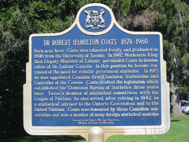
(www.tandfonline.com/na101/home/literatum/publisher/tandf/... and www.tandfonline.com/na101/home/literatum/publisher/tandf/...)
Tunney's Pasture; Ottawa, Ontario.
America: One Nation, Divisible
Why Are You the One Who Got the Election Right?
7:30 pm - 8:30 pm MDT on Wednesday, June 26, 2013
Columnist, statistician, and prognosticator Nate Silver, whose website FiveThirtyEight.com is the only one to have correctly predicted the outcomes of the 2012 and 2008 elections, shares his perspectives with award-winning journalist Katie Couric. (He also really knows baseball!) Underwritten by Thomson Reuters.
Nate Silver Katie Couric
Doerr-Hosier Center, McNulty Room
Film of Stac Pollaidh Wild Camp :
A Stac Pollaidh Wild Camp – Searching for a Scottish Sunrise
“You’re going where?”
“Four hours in the car to spend the night on a freezing mountain!?!”
“Why?”
Ok, so I am maybe paraphrasing here but you get the gist of a conversation I had with a colleague who had asked me what my weekend plans were. Those “in the know” don’t ask and even those who don’t understand but have known us for long enough start to accept our addiction with such activities!
For me, I love any outdoor activity but there is something about being on the summit of the mountain, alone and spending the night in solitude. The effort required to transport your temporary belongings up the hill is sometimes energy sapping, and just the solitude is sometime award enough, but occasionally you get rewarded with natures finest spectacles! I was rewarded at sunrise in Assynt on this weekend’s adventure for sure……
Stac Pollaidh ain’t big, not even in Scottish terms. At just 2008ft in height a statistician looking at lists and numbers may well dismiss it. However it may well be one of the finest mountains (and not just “small mountains”) in Scotland. This was my fourth visit to Pollaidh and my first in over 8 years. On every prior visit I have been amazed at how much fun and adventure can be packed in to 2008ft of ascent and an afternoon or mornings exertion! A well-made path takes you round to the north side of the mountain before ascending to a col near the Eastern Summit. From here the fun starts as the route to the higher western summit takes you along the mohican ridge of Stac Pollaidh. The mountain’s ridge had attained its hair cut “Mohawk” during the last ice age as the ice sheet swept past its lower ramparts but left the ridge poking out and exposed to weathering. This Nunatak had Mother Nature as a hair stylist and I am so glad it did!
Weaving in and out of the sandstone pinnacles and rocky blocks was great fun and for those with a scrambling or climbing frame of mind can increase or decrease the level of difficulty as so desired. Paths do bypass most of the difficulties but this isn’t the mountain for you if one doesn’t like exposure or hands on fun. The real and most tricky scramble isn’t optional if you want to make the summit however! A rocky block bars the way just as the summit looks touchable! A tricky, but short lived scramble gets the adrenaline pumping for the final few strides to the summit!
Having set up camp on the Eastern Summit and then taken my time enjoying the Torridonian Pinnacles I was aware that daylight was staring to run out, and I wanted to get back to camp for sunset – did I mention the views you get from this hill (more of that later!).
A careful reversing of the “bad step” and I was heading back down the Mohawk, taking a different route back. The Bad Step is seen by many as the trickiest part of the scramble but I think it’s the views that provide the danger. You can’t keep your eyes on your feet as the views over Assynt – in all directions – are amazing! Forget the 3hr timing that most guidebooks suggest – just spend the whole day up here, you won’t be disappointed! There is a reason why Landscape Photographers flock here as individuals and also whole classes! I’ll not bore you with the view descriptions – just watch the video ! (please ignore my stupidness as I got the Culs mixed up right throughout the length of the film – doh!).
Safely back at camp and Mother Nature had extinguished any chances of a fiery sunset. The cloud had moved westwards and dusk approached in monochrome… However winds were light and the views stunning, a few light showers drifted in over the watery landscape before night arrived.
In the wee small hours I was woken as the wind had picked up. The tents sheets were making it a bit noisy and my sleep was broken until I decided to rise around 05.30am. It was still pitch black but by the time a coffee had been made I could make out a band of clear sky towards the lightening eastern horizon… A good sign for sunrise… The next 90 minutes were fantastic. The light just got better and better, the skies burned red then pink towards the east and I was so occupied by this view that I nearly missed the pink rainbow lurking over Stac Pollaidh behind me! I have seen many rainbows but never one this colour and a manifestation from the sunrise- it was some sight!
As the sun rose over the horizon the light shifted and the focus on the sky changed to the landscape of Assynt lighting up. Suilven won the crown with the light contrasting its rugged form perfectly. Surely this must be one of the most impressive landscapes in Scotland. I had managed to time the sunrise perfectly as shortly after this the sun was extinguished by the encroaching weather front that was to bring high winds and blizzards later in the day. I counted my blessings, packed up and headed back home. Another memorable trip….
Literacy results from the 2016 Scottish Survey of Literacy and Numeracy have been published by Scotland’s Chief Statistician today. Deputy First Minister visited Craigroyston Primary School in Edinburgh which is using new techniques to teach language and vocabulary, and has received £132,000 in Pupil Equity Funding.
NEW YORK, NY - SEPTEMBER 30: FiveThirtyEight Politics Editor Michah Cohen, FiveThirtyEight Statistician, Author and Founder Nate Silver, and FiveThirtyEight Senior Political Writer and Analyst Harry Enten speak onstage at the Nate Silver and FiveThirtyEight: The Election Playoff Preview panel presented by ESPN during Advertising Week 2015 AWXII at Nasdaq MarketSite on September 30, 2015 in New York City. (Photo by Andrew Toth/Getty Images for AWXII)
This picture is #35 in my 100 strangers project.
I met Natalie after I did a few pictures with Adriana (Stranger #34) and was just about getting ready to leave. Natalie was out on a casual stroll and basically chilling out with her younger sister Nicole. I thought she would make a nice portrait with her big eyes, and strong features and of course the hair. I approached the two ladies and made my request to Natalie – my initial impression was that her sister would be too young (but realized late that I was mistaken). Anyways, Natalie agreed and walked with me to the same background where I met the last stranger a few minutes back. Nicole was a little unsure with regards the purpose of the ‘strangers’ project and I explained my reasons as honestly as I could. It seemed to help but she continued to be amused with the whole idea - especially doing the pics in a relatively busy area. I had a large reflector which I requested Nicole to hold – on hindsight I should probably use the smaller reflector since the one I used was rather unwieldy. But I think it did help add some light to the mix. Also, I think it’s a good idea for the photographer to wear white when doing portraits – as a last ditch effort to add some white for catch-lights. I do not know how Natalie’s portraits rank on a technical or aesthetic scale (and what the ‘model’ herself would think of it) but these definitely made me quite happy. I liked how the light (including the reflected light from the white walls) and the focus on the eyes turned out, with the strong expression from the ‘model’. I also use the 'clarity' slider in Lightroom t smoothen the skin but in this particular case decided to retain the skin texture.to emphasize her strong features. I had a difficult time choosing the pic for the project - close-up vs wide and color v/s b/w and finally settled on this one (and added the alternate pic to the comments
Natalie is a statistician and works with healthcare research. She also is mommy to a one-year old who she adores and which was visible in the way her eyes lit up for the few seconds she spoke about him.
Thank you Natalie (and Nicole) for participating on the project and wish you all the very best for your future. If you'd like copies of your pictures please feel free to contact me.
Original Image Credit: American statistician Nate Silver at SXSW in Austin, Texas USA on March 15, 2009 by Randy Stewart
Licensed Creative Commons Attribution Share-Alike on January 10, 2012
en.wikipedia.org/wiki/File:Nate_Silver_2009.png
Quote from: Data King Nate Silver Isn't Sold on Evaluating Teachers With Test Scores
www.good.is/posts/data-king-nate-silver-isn-t-sold-on-eva...
Slide by Bill Ferriter
The Tempered Radical
@plugusin
Film of Stac Pollaidh Wild Camp :
A Stac Pollaidh Wild Camp – Searching for a Scottish Sunrise
“You’re going where?”
“Four hours in the car to spend the night on a freezing mountain!?!”
“Why?”
Ok, so I am maybe paraphrasing here but you get the gist of a conversation I had with a colleague who had asked me what my weekend plans were. Those “in the know” don’t ask and even those who don’t understand but have known us for long enough start to accept our addiction with such activities!
For me, I love any outdoor activity but there is something about being on the summit of the mountain, alone and spending the night in solitude. The effort required to transport your temporary belongings up the hill is sometimes energy sapping, and just the solitude is sometime award enough, but occasionally you get rewarded with natures finest spectacles! I was rewarded at sunrise in Assynt on this weekend’s adventure for sure……
Stac Pollaidh ain’t big, not even in Scottish terms. At just 2008ft in height a statistician looking at lists and numbers may well dismiss it. However it may well be one of the finest mountains (and not just “small mountains”) in Scotland. This was my fourth visit to Pollaidh and my first in over 8 years. On every prior visit I have been amazed at how much fun and adventure can be packed in to 2008ft of ascent and an afternoon or mornings exertion! A well-made path takes you round to the north side of the mountain before ascending to a col near the Eastern Summit. From here the fun starts as the route to the higher western summit takes you along the mohican ridge of Stac Pollaidh. The mountain’s ridge had attained its hair cut “Mohawk” during the last ice age as the ice sheet swept past its lower ramparts but left the ridge poking out and exposed to weathering. This Nunatak had Mother Nature as a hair stylist and I am so glad it did!
Weaving in and out of the sandstone pinnacles and rocky blocks was great fun and for those with a scrambling or climbing frame of mind can increase or decrease the level of difficulty as so desired. Paths do bypass most of the difficulties but this isn’t the mountain for you if one doesn’t like exposure or hands on fun. The real and most tricky scramble isn’t optional if you want to make the summit however! A rocky block bars the way just as the summit looks touchable! A tricky, but short lived scramble gets the adrenaline pumping for the final few strides to the summit!
Having set up camp on the Eastern Summit and then taken my time enjoying the Torridonian Pinnacles I was aware that daylight was staring to run out, and I wanted to get back to camp for sunset – did I mention the views you get from this hill (more of that later!).
A careful reversing of the “bad step” and I was heading back down the Mohawk, taking a different route back. The Bad Step is seen by many as the trickiest part of the scramble but I think it’s the views that provide the danger. You can’t keep your eyes on your feet as the views over Assynt – in all directions – are amazing! Forget the 3hr timing that most guidebooks suggest – just spend the whole day up here, you won’t be disappointed! There is a reason why Landscape Photographers flock here as individuals and also whole classes! I’ll not bore you with the view descriptions – just watch the video ! (please ignore my stupidness as I got the Culs mixed up right throughout the length of the film – doh!).
Safely back at camp and Mother Nature had extinguished any chances of a fiery sunset. The cloud had moved westwards and dusk approached in monochrome… However winds were light and the views stunning, a few light showers drifted in over the watery landscape before night arrived.
In the wee small hours I was woken as the wind had picked up. The tents sheets were making it a bit noisy and my sleep was broken until I decided to rise around 05.30am. It was still pitch black but by the time a coffee had been made I could make out a band of clear sky towards the lightening eastern horizon… A good sign for sunrise… The next 90 minutes were fantastic. The light just got better and better, the skies burned red then pink towards the east and I was so occupied by this view that I nearly missed the pink rainbow lurking over Stac Pollaidh behind me! I have seen many rainbows but never one this colour and a manifestation from the sunrise- it was some sight!
As the sun rose over the horizon the light shifted and the focus on the sky changed to the landscape of Assynt lighting up. Suilven won the crown with the light contrasting its rugged form perfectly. Surely this must be one of the most impressive landscapes in Scotland. I had managed to time the sunrise perfectly as shortly after this the sun was extinguished by the encroaching weather front that was to bring high winds and blizzards later in the day. I counted my blessings, packed up and headed back home. Another memorable trip….
Standing: Shirley Mills, Alexandre Leblanc, Lawrence McCandless, Ed Susko, Jean-Françoise Plante, Joel Dobbin, Christian Léger, Noel Cadigan, Larry Weldon, Fernando Camancho, Tim Swartz, John Koval, Ed Chen; Seated: Russell Steele, Jenna Tichon, Anne-Sophie Charest, Mike Evans, John Petkau, Cynthis Bocci, Larysa Valanchko.
America: One Nation, Divisible
Why Are You the One Who Got the Election Right?
7:30 pm - 8:30 pm MDT on Wednesday, June 26, 2013
Columnist, statistician, and prognosticator Nate Silver, whose website FiveThirtyEight.com is the only one to have correctly predicted the outcomes of the 2012 and 2008 elections, shares his perspectives with award-winning journalist Katie Couric. (He also really knows baseball!) Underwritten by Thomson Reuters.
Nate Silver Katie Couric
Doerr-Hosier Center, McNulty Room
I suspect that not many people are aware of this courtyard but I visit it a few times year in case there is anything of interest - one never knows. Anyway, today I noticed an interesting visual history of the docklands on the hoarding around the Tropical Fruit Warehouse development.
The space shown in my photographs is behind the Clayton Hotel Cardiff Lane which can be accessed via Rope Walk which connects East Hanover Street to Sir John Rogerson's Quay [there was until recently a locked gate at the Hanover Street end of the lane]. Rope Walk [not to be confused with Ropewalk Place in Ringsend] runs parallel to Lime Street.
A ropewalk is a long straight narrow lane, or a covered pathway, where long strands of material are laid before being twisted into rope. Due to the length of some ropewalks, workers may use bicycles to get from one end to the other. Many ropewalks were in the open air, while others were covered only by roofs. Ropewalks historically were harsh sweatshops, and frequently caught fire, as hemp dust ignites easily and burns fiercely.
The court yard is named Whitaker Square and it is home to The Economic and Social Research Institute. It is amusing to see that the ESRI has received one Google Review and they received only one star.
The institute was founded in 1960 by a group of senior academics and public servants, led by T. K. Whitaker, Secretary of the Department of Finance. While conducting an economic study of Ireland, Whitaker became aware of the necessity for an independent research organisation to conduct analysis of data using up-to-date quantitative techniques in order to make the data useful for public policy makers. The US-based Ford Foundation provided seed funding to establish the Economic Research Institute in 1960. In 1966 the remit of the institute was expanded to include social research and the name changed to Economic and Social Research Institute. The first Director of the institute was Roy C. Geary, Irish statistician and founder of the Central Statistics Office.
The Tropical Fruit Warehouse development is described as follows: "Designed by Henry J Lyons Architects this cutting-edge scheme will deliver over 80,000 sq. ft. of unique river front offices and will include a new 6 storey office block at the rear overlooking an existing public square. The original warehouse building will be sensitively restored and the design incorporates the addition of two floating, fully glazed office floors which will cantilever over the protected structure providing panoramic views over the River Liffey."
Inverforth House, Hampstead Heath, LONDON
The original house on this site was built in 1807 and one of the notable families that lived there was the Fisher family. Mr & Mrs George Fisher and their 5 children, they occupied the house from 1896-1904. Fisher was in joint partnership with a Mr. Robinson, auctioneers and dealers in fine art. Unfortunately following the death of his wife, Fisher lost his fortune and was forced to sell and leave. It was purchased by William Lever, 1st Viscount Leverhulme in that same year, 1904 and that family lived there until 1925.
The house was renovated and almost completely rebuilt. It was Grayson and Ould, a Liverpool architectural company who did the work. They rebuilt the Central Block, plus the northern and southern wings. They also undertook a terrace and a verandah which was added to the terrace was designed by Thomas Mawson. The gardens were also designed by Thomas Mawson in 1906, who also remodelled the south wing of the house.
The greater part of the gardens are now owned by the City of London Corporation and open to the public but the house is definitely private.
The house was to become a hospital after Lord Leverhulme’s death in 1956. The Orthopaedic Society Hospital occupied the house from 1956 well into the 1980’s. Sometime during the late 1990’s the house was converted into two houses and seven apartments.
There are two blue plaques, 1: To Viscount Leverholme and 2: Ronald Fisher, son of George Fisher. Ronald Fisher was a famous geneticist and statistician.
This is the last of two posting that I've made.
Mariam (left) and Uche are, respectivley, a statistician and a software developer in Lagos.
They were both in involved in DFID's recent Trade Transparency Project, where DFID challenged young technology experts in Lagos, Capetown and London to interpret complex trade data and come up with visualisation, mobile apps or websites to help people understand the data.
Uche occasionally works on projects with the Co-Creation Hub in Lagos, a shared working space for small IT start-up companies. She curently works as a mobile app developer for a Nigerian bank, but says it's good that there's a place like Co-Creation Hub in Lagos, as it's a place to come and share ideas and build her skills in developing business ideas.
"It's important that software developers also know how to market their ideas and apps. It's not enough to just be able to create a product, you have to know how to sell it as well", she says.
Picture: Russell Watkins/Department for International Development
Terms of use
This image is posted under a Creative Commons - Attribution Licence, in accordance with the Open Government Licence. You are free to embed, download or otherwise re-use it, as long as you credit the source as Russell Watkins/Department for International Development'.
Film of Stac Pollaidh Wild Camp :
A Stac Pollaidh Wild Camp – Searching for a Scottish Sunrise
“You’re going where?”
“Four hours in the car to spend the night on a freezing mountain!?!”
“Why?”
Ok, so I am maybe paraphrasing here but you get the gist of a conversation I had with a colleague who had asked me what my weekend plans were. Those “in the know” don’t ask and even those who don’t understand but have known us for long enough start to accept our addiction with such activities!
For me, I love any outdoor activity but there is something about being on the summit of the mountain, alone and spending the night in solitude. The effort required to transport your temporary belongings up the hill is sometimes energy sapping, and just the solitude is sometime award enough, but occasionally you get rewarded with natures finest spectacles! I was rewarded at sunrise in Assynt on this weekend’s adventure for sure……
Stac Pollaidh ain’t big, not even in Scottish terms. At just 2008ft in height a statistician looking at lists and numbers may well dismiss it. However it may well be one of the finest mountains (and not just “small mountains”) in Scotland. This was my fourth visit to Pollaidh and my first in over 8 years. On every prior visit I have been amazed at how much fun and adventure can be packed in to 2008ft of ascent and an afternoon or mornings exertion! A well-made path takes you round to the north side of the mountain before ascending to a col near the Eastern Summit. From here the fun starts as the route to the higher western summit takes you along the mohican ridge of Stac Pollaidh. The mountain’s ridge had attained its hair cut “Mohawk” during the last ice age as the ice sheet swept past its lower ramparts but left the ridge poking out and exposed to weathering. This Nunatak had Mother Nature as a hair stylist and I am so glad it did!
Weaving in and out of the sandstone pinnacles and rocky blocks was great fun and for those with a scrambling or climbing frame of mind can increase or decrease the level of difficulty as so desired. Paths do bypass most of the difficulties but this isn’t the mountain for you if one doesn’t like exposure or hands on fun. The real and most tricky scramble isn’t optional if you want to make the summit however! A rocky block bars the way just as the summit looks touchable! A tricky, but short lived scramble gets the adrenaline pumping for the final few strides to the summit!
Having set up camp on the Eastern Summit and then taken my time enjoying the Torridonian Pinnacles I was aware that daylight was staring to run out, and I wanted to get back to camp for sunset – did I mention the views you get from this hill (more of that later!).
A careful reversing of the “bad step” and I was heading back down the Mohawk, taking a different route back. The Bad Step is seen by many as the trickiest part of the scramble but I think it’s the views that provide the danger. You can’t keep your eyes on your feet as the views over Assynt – in all directions – are amazing! Forget the 3hr timing that most guidebooks suggest – just spend the whole day up here, you won’t be disappointed! There is a reason why Landscape Photographers flock here as individuals and also whole classes! I’ll not bore you with the view descriptions – just watch the video ! (please ignore my stupidness as I got the Culs mixed up right throughout the length of the film – doh!).
Safely back at camp and Mother Nature had extinguished any chances of a fiery sunset. The cloud had moved westwards and dusk approached in monochrome… However winds were light and the views stunning, a few light showers drifted in over the watery landscape before night arrived.
In the wee small hours I was woken as the wind had picked up. The tents sheets were making it a bit noisy and my sleep was broken until I decided to rise around 05.30am. It was still pitch black but by the time a coffee had been made I could make out a band of clear sky towards the lightening eastern horizon… A good sign for sunrise… The next 90 minutes were fantastic. The light just got better and better, the skies burned red then pink towards the east and I was so occupied by this view that I nearly missed the pink rainbow lurking over Stac Pollaidh behind me! I have seen many rainbows but never one this colour and a manifestation from the sunrise- it was some sight!
As the sun rose over the horizon the light shifted and the focus on the sky changed to the landscape of Assynt lighting up. Suilven won the crown with the light contrasting its rugged form perfectly. Surely this must be one of the most impressive landscapes in Scotland. I had managed to time the sunrise perfectly as shortly after this the sun was extinguished by the encroaching weather front that was to bring high winds and blizzards later in the day. I counted my blessings, packed up and headed back home. Another memorable trip….