View allAll Photos Tagged songsTen
Shangri-La lies at an elevation of some 3,290 m in Yunnan Province, China. Originally named Zhongdian, in 2001, the name was changed to Shangri-la. The Dukezong Tibetan Neighborhood was established in the 7th century by Songsten Gampo, the founder of the Tibetan Empire (ruled 614-648), as a garrison town. The Guishan Si (Guishan Temple), built during the reign of the Qing Dynasty Emperor Kangxi (ruled 1661-1722), is seen on the horizon. The top of a 21 m high prayer wheel erected in 2002, which contains some one milliion Buddhist scriptures, scrolls and mantras is seen left of center.
Like to see the pictures as LARGE as your screen? Just click on this Slideshow : www.flickr.com/photos/reurinkjan/sets/72157624932250006/s...
རླུང་རྟ་, rlung rta, pronounced lungta, Tibetan for wind horse
Mato county, also known as Machukha མ་ ཆུ་ཁ་ , has several marshy plains dotted with tiny lakes and meandering rivers which provide good grasslands for the many nomads around the source of the Ma chu རྨ་ཆུ་ (Yellow River). There are, however, two particularly large lakes, known as Kyaring Tso and Ngoring Tso, trough which the Ma chu རྨ་ཆུ་ (Yellow River) itself flows. To reach these lakes, take the jeep dirt road from Mato which follows the Ma chu རྨ་ཆུ་ (Yellow River) upstream, for 57 km to Ngoring Tso, the closer of the two lakes (area 618 sq km, average depth 17 m). There is a bird sanctuary at the southwest corner of Kyaring Lake (area 526 sq km, average depth 9 m), where swans, gulls, wild geese and ducks can be seen nesting. Both lakes provide a rich fishing ground for Chinese immigrants. Tibetans, even in these remote parts, are reluctant to eat fish. On a hilltop (4610 m)between the lakes there is a very small reconstructed monastery, Tsowar Kartse Doka མཚོ་ ཝ་ རྐ་ རྩེ་ དོ་ཀ་, said to mark the unknown site of Kartse Palace, which, according to old Chinese sources, is where Songsten Gampo met and married Princess Wencheng. It contains the mortal remains of Mani Lama, who passed away at jyekundo in the late 1950s, and is maintained by Nyingmapa and Gelukpa monks, despite having been built originally by a Bon Lama. A hilltop monument to the west has a monument, said to mark the source of the Ma chu རྨ་ཆུ་ (Yellow River), but this is a symbolic approximation.
Shangri-La lies at an elevation of some 3,290 m in Yunnan Province, China. Originally named Zhongdian, in 2001, the name was changed to Shangri-la. It is a center of Tibetan Buddhist culture. The Dukezong Tibetan Neighborhood was established in the 7th century by Songsten Gampo, the founder of the Tibetan Empire (ruled 614-648), as a garrison town. The Guishan Si (Guishan Temple), built during the reign of the Qing Dynasty Emperor Kangxi (ruled 1661-1722), is seen here on the right. The top of a 21 m high prayer wheel erected in 2002, which contains some one milliion Buddhist scriptures, scrolls and mantras is seen on the left. They overlook the city from a hilltop in The Dukezong Tibetan Neighborhood.
Jokhang Temple, Jokhang Monastery or Tsuklakang (gTsug lag khang), is located on Barkhor Square in Lhasa. It was built during the reign of king Songsten Gampo (605?-650 CE) to celebrate his marriage with Chinese Tang Dynasty princess Wencheng, who was a Buddhist. During the Bon period of Tibet the temple was (and sometimes still is), called the 'Tsuklakang' (Tsulag Khang) — 'House of Religious Science' or 'House of Wisdom.' The term tsuklak refers to the 'sciences' such as geomancy, astrology, and divination which formed part of the pre-Buddhist shamanistic religion now referred to as Bon. It is more commonly known today as the Jokhang, which means the 'House of the Buddha'. For most Tibetans it is the most sacred and important temple in Tibet. It is in some regards pan-sectarian, but is presently controlled by the Gelug school. Along with the Potala Palace, it is probably the most popular tourist attraction in Lhasa. It is part of the UNESCO World Heritage Site "Historic Ensemble of the Potala Palace," and a spiritual centre of Lhasa.
www.thlib.org/reference/dictionaries/tibetan-dictionary/t...
The Jokhang, (Tibetan: ཇོ་ཁང་; Wylie: Jo-khang; also called the Jokang, Jokhang Temple, Jokhang Monastery or Tsuklakang (gTsug lag khang), is located on Barkhor Square in Lhasa. It was built during the reign of king Songsten Gampo (605?-650 CE) to celebrate his marriage with Chinese Tang Dynasty princess Wencheng, who was a Buddhist.
During the Bon period of Tibet the temple was (and sometimes still is), called the 'Tsuklakang' (Tsulag Khang) — 'House of Religious Science' or 'House of Wisdom.' The term tsuklak refers to the 'sciences' such as geomancy, astrology, and divination which formed part of the pre-Buddhist shamanistic religion now referred to as Bon. It is more commonly known today as the Jokhang, which means the 'House of the Buddha'.
For most Tibetans it is the most sacred and important temple in Tibet. It is in some regards pan-sectarian, but is presently controlled by the Gelug school.
Along with the Potala Palace, it is probably the most popular tourist attraction in Lhasa. It is part of the UNESCO World Heritage Site "Historic Ensemble of the Potala Palace," and a spiritual centre of Lhasa.
lha ldan gtsug lag khang ལྷ་ལྡན་གཙུག་ལག་ཁང་ The Jokhang, (Tibetan: ཇོ་ཁང་; Wylie: Jo-khang; also called the Jokang, Jokhang Temple, Jokhang Monastery or Tsuklakang (gTsug lag khang), is located on Barkhor Square in Lhasa. It was built during the reign of king Songsten Gampo (605?-650 CE) to celebrate his marriage with Chinese Tang Dynasty princess Wencheng, who was a Buddhist. During the Bon period of Tibet the temple was (and sometimes still is), called the 'Tsuklakang' (Tsulag Khang) — 'House of Religious Science' or 'House of Wisdom.' The term tsuklak refers to the 'sciences' such as geomancy, astrology, and divination which formed part of the pre-Buddhist shamanistic religion now referred to as Bon. It is more commonly known today as the Jokhang, which means the 'House of the Buddha'. For most Tibetans it is the most sacred and important temple in Tibet. It is in some regards pan-sectarian, but is presently controlled by the Gelug school. Along with the Potala Palace, it is probably the most popular tourist attraction in Lhasa. It is part of the UNESCO World Heritage Site "Historic Ensemble of the Potala Palace," and a spiritual centre of Lhasa. History Jokhang – mid 1840sThe Jokhang temple was constructed by King Songtsän Gampo (see also internet variant Songsten Gampo) probably in 642. It was originally called the Rasa Tulnang Tsuklakang or The House of Mysteries, The Magical Emanation at Rasa [the early name for Lhasa], and also Gazhi Trulnang (`magical apparition endowed with four joys`. Both Bhrituti and Wencheng, the Nepalese and Chinese wives of Songsten Gampo are said to have brought important Buddhist statues and images to Tibet as part of their dowries, and they were housed here. It was boarded up during the reign of the Bönpo king, Langdharma (reigned 838–841 CE). The famous Buddhist Master Atisha taught here in the 11th century and it has been considered the most important temple in Lhasa ever since. This temple has remained a key center of Buddhist pilgrimage for centuries. It was sacked several times by the Mongols, but the building survived. In the past several centuries the temple complex was expanded and now covers an area of about 25,000 sq meters. Architecture The Jokhang temple is a four-story construction, with:..read more
www.thlib.org/reference/dictionaries/tibetan-dictionary/t...
The Jokhang, (Tibetan: ཇོ་ཁང་; Wylie: Jo-khang; also called the Jokang, Jokhang Temple, Jokhang Monastery or Tsuklakang (gTsug lag khang), is located on Barkhor Square in Lhasa. It was built during the reign of king Songsten Gampo (605?-650 CE) to celebrate his marriage with Chinese Tang Dynasty princess Wencheng, who was a Buddhist.
During the Bon period of Tibet the temple was (and sometimes still is), called the 'Tsuklakang' (Tsulag Khang) — 'House of Religious Science' or 'House of Wisdom.' The term tsuklak refers to the 'sciences' such as geomancy, astrology, and divination which formed part of the pre-Buddhist shamanistic religion now referred to as Bon. It is more commonly known today as the Jokhang, which means the 'House of the Buddha'.
For most Tibetans it is the most sacred and important temple in Tibet. It is in some regards pan-sectarian, but is presently controlled by the Gelug school.
Along with the Potala Palace, it is probably the most popular tourist attraction in Lhasa. It is part of the UNESCO World Heritage Site "Historic Ensemble of the Potala Palace," and a spiritual centre of Lhasa.
Like to see the pictures as Large as your screen? Than why not click on the Slideshow : www.flickr.com/photos/reurinkjan/sets/72157603564732566/s...
The Red Palace is part of the Potala palace that is completely devoted to religious study and Buddhist prayer. It consists of a complicated layout of many different halls, chapels and libraries on many different levels with a complex array of smaller galleries and winding passages:
farm4.static.flickr.com/3149/3550627609_578c111c44_o.jpg
The Great West Hall
A Dhvaja on the roof The main central hall of the Red Palace is the Great West Hall which consists of four great chapels that proclaim the glory and power of the builder of the Potala, the Fifth Dalai Lama. The hall is noted for its fine murals reminiscent of Persian miniatures, depicting events in the fifth Dalai Lama's life. The famous scene of his visit to Emperor Shun Zhi in Beijing is located on the east wall outside the entrance. Special cloth from Bhutan wraps the Hall's numerous columns and pillars.
The Saint's Chapel
On the north side of this hall in the Red Palace is the holiest shrine of the Potala. A large blue and gold inscription over the door was written by the 19th century Tongzhi Emperor of China. proclaiming Buddhism a Blessed Field of Wonderful Fruit. This chapel like the Dharma cave below it dates from the seventh century. It contains a small ancient jewel encrusted statue of Avalokiteshvara and two of his attendants. On the floor below, a low, dark passage leads into the Dharma Cave where Songsten Gampo is believed to have studied Buddhism. In the holy cave are images of Songsten Gampo, his wives, his chief minister and Sambhota, the scholar who developed Tibetan writing in the company of his many divinities.
The North Chapel
Snow Lions protect the entrance to the Potala PalaceThe North Chapel centres on a crowned Sakyamuni Buddha on the left and the Fifth Dalai Lama on the right seated on magnificent gold thrones. Their equal height and shared aura implies equal status. On the far left of the chapel is the gold stupa tomb of the Eleventh Dalai Lama who died as a child, with rows of benign Medicine Buddhas who were the heavenly healers. On the right of the chapel are Avalokiteshvara and his historical incarnations including Songsten Gampo and the first four Dalai Lamas. Scriptures covered in silk between wooden covers form a specialized library in a room branching off it.
The walls of the Red Palace.
The South Chapel
The South Chapel centres on Padmasambhava, the 8th century Indian magician and saint. His consort Yeshe Tsogyal, a gift from the King is by his left knee and his other wife from his native land of Swat is by his right. On his left, eight of his holy manifestations meditate with an inturned gaze. On his right, eight wrathful manifestations wield instruments of magic powers to subdue the demons of the Bön faith.
The East Chapel
The East chapel is dedicated to Tsong Khapa, founder of the Gelug tradition. His central figure is surrounded by lamas from Sakya Monastery who had briefly ruled Tibet and formed their own tradition until converted by Tsong Khapa. Other statues are displayed made of various different materials and display noble expressions.
The West Chapel
This is the chapel that contains the five golden stupas. The enormous central stupa, 14.85 metres (49 ft) high, contains the mummified body of the Fifth Dalai Lama. This stupa is built of sandalwood and is remarkably coated in 3,727 kg (8,200 lb) of solid gold and studded with 18,680 pearls and semi-precious jewels. On the left is the funeral stupa for the Twelfth Dalai Lama and on the right that of the Tenth Dalai Lama. The nearby stupa for the 13th Dalai Lama is 22 metres (72 ft) high. The stupas on both ends contain important scriptures.
The First Gallery
The quiet and peaceful park, pond, and chapel behind the PotalaThe first gallery is on the floor above the West chapel and has a number of large windows that give light and ventilation to the Great West Hall and its chapels below. Between the windows, superb murals show the Potala's construction is fine detail.
The Second Gallery
The Second Gallery gives access to the central pavilion which is used for visitors to the palace for refreshments and to buy souvenirs.
The Third Gallery
The Third Gallery besides fine murals has a number of dark rooms branching off it containing enormous collections of bronze statues and miniature figures made of copper and gold worth a fortune. The chanting hall of the Seventh Dalai Lama is on the south side and on the east an entrance connects the section to the Saints chapel and the Deyangshar between the two palaces.
The Tomb of the Thirteenth Dalai Lama
The tomb of the 13th Dalai Lama is located west of the Great West Hall and it can only be reached from an upper floor and with the company of a monk or a guide of the Potala. Built in 1933, the giant stupa contains priceless jewels and one ton of solid gold. It is 14 metres (46 ft) high. Devotional offerings include elephant tusks from India, porcelain lions and vases and a pagoda made from over 200,000 pearls. Elaborate murals in traditional Tibetan styles depict many events of the life of the Thirteenth Dalai Lama during the early 20th century.
Today the Potala Palace has been converted into a dead museum by the Chinese.
Like to see the pictures as LARGE as your screen? Just click on this Slideshow : www.flickr.com/photos/reurinkjan/sets/72157624932250006/s...
Mato county, also known as Machukha མ་ ཆུ་ཁ་ , has several marshy plains dotted with tiny lakes and meandering rivers which provide good grasslands for the many nomads around the source of the Ma chu རྨ་ཆུ་ (Yellow River). There are, however, two particularly large lakes, known as Kyaring Tso and Ngoring Tso, trough which the Ma chu རྨ་ཆུ་ (Yellow River) itself flows. To reach these lakes, take the jeep dirt road from Mato which follows the Ma chu རྨ་ཆུ་ (Yellow River) upstream, for 57 km to Ngoring Tso, the closer of the two lakes (area 618 sq km, average depth 17 m). There is a bird sanctuary at the southwest corner of Kyaring Lake (area 526 sq km, average depth 9 m), where swans, gulls, wild geese and ducks can be seen nesting. Both lakes provide a rich fishing ground for Chinese immigrants. Tibetans, even in these remote parts, are reluctant to eat fish. On a hilltop (4610 m)between the lakes there is a very small reconstructed monastery, Tsowar Kartse Doka མཚོ་ ཝ་ རྐ་ རྩེ་ དོ་ཀ་, said to mark the unknown site of Kartse Palace, which, according to old Chinese sources, is where Songsten Gampo met and married Princess Wencheng. It contains the mortal remains of Mani Lama, who passed away at jyekundo in the late 1950s, and is maintained by Nyingmapa and Gelukpa monks, despite having been built originally by a Bon Lama. A hilltop monument to the west has a monument, said to mark the source of the Ma chu རྨ་ཆུ་ (Yellow River), but this is a symbolic approximation.
A view from the courtyard of the Lhagang Gompa (Lhagang Monastery) at Tagong (elevation 3,726 m, 12,224 ft.), 245 km (152 mi.) west of Chengdu in the Garze Tibetan Autonomous Prefecture, Sichuan Province, China. The gompa was founded in 652 by Princess Wencheng, the Chinese wife of the great Tibetan King Songsten Gampo, who founded the Jokhang Gompa in Lhasa.
Like to see the pictures as LARGE as your screen? Just click on this Slideshow : www.flickr.com/photos/reurinkjan/sets/72157624932250006/s...
This Buzzard was playing on a traditinal Tibetan dress.
The Upland Buzzard (Buteo hemilasius) is a species of bird of prey in the Accipitridae family.
Large buzzard with both pale and dark morphs. Similar in plumage to others buzzards. Pale morph has lightly marked whitish head, nape and underparts with large brown spots irregularly distributed in upper breast and abdomen. Flanks and sides of the belly dark, tail with greyish centre and dark sides, tail bands prominently dark, with heavier sub-terminal band. Tarsi is fully (or at least three-quarters) feathered brown. Dark morph bird has the upper parts, lower body and wing coverts solid dark, with the flight feather pattern similar to pale morph.
Normally found in open montane grass lands and cultivation in summer, wintering to lower altitudes. Frequently hovers. Hunts from air or ground. Breeds between April and August on crags and ledges of cliffs. Nest is made of sticks and well lined. Feeds on small mammals, birds and insects.
It is found in Bhutan, Tibet and its Tibetan Plateau,China, Hong Kong, India, Pakistan, Iran, Japan, Kazakhstan, North Korea, South Korea, Mongolia, Nepal, Tajikistan, and Uzbekistan.
Russia in S Siberia and E to Manchuria. Winters in N India (Kashmir to Sikkim), E China and Korea.
en.wikipedia.org/wiki/Upland_Buzzard
Ngoring tso ངོ་ རིང་ མཚོ་ in Amdo ཨ༌མདོ,Matö རྨ་སྟོད། county.
Mato county has several marshy plains dotted with tiny lakes and meandering rivers which provide good grasslands for the many nomads around the source of the Ma chu རྨ་ཆུ་ (Yellow River). There are, however, two particularly large lakes, known as Kyaring Tso and Ngoring Tso, trough which the Ma chu རྨ་ཆུ་ (Yellow River) itself flows. To reach these lakes, take the jeep dirt road from Mato which follows the Ma chu རྨ་ཆུ་ (Yellow River) upstream, for 57 km to Ngoring Tso, the closer of the two lakes (area 618 sq km, average depth 17 m). There is a bird sanctuary at the southwest corner of Kyaring Lake (area 526 sq km, average depth 9 m), where swans, gulls, wild geese and ducks can be seen nesting. Both lakes provide a rich fishing ground for Chinese immigrants. Tibetans, even in these remote parts, are reluctant to eat fish. On a hilltop (4610 m)between the lakes there is a very small reconstructed monastery, Tsowar Kartse Doka མཚོ་ ཝ་ རྐ་ རྩེ་ དོ་ཀ་, said to mark the unknown site of Kartse Palace, which, according to old Chinese sources, is where Songsten Gampo met and married Princess Wencheng. It contains the mortal remains of Mani Lama, who passed away at jyekundo in the late 1950s, and is maintained by Nyingmapa and Gelukpa monks, despite having been built originally by a Bon Lama. A hilltop monument to the west has a monument, said to mark the source of the Ma chu རྨ་ཆུ་ (Yellow River), but this is a symbolic approximation.
Le palais de Yumbulagang, Yumbu Lhakhang ou encore Yungbulakang est une forteresse de la vallée du fleuve du Yarlung Tsangpo, située dans le district de Nêdong, centre urbain de la préfecture de Shannan, dans la Région autonome du Tibet. Elle est située à moins de 100 km de Lhassa à vol d'oiseau.
Plus tard, Yumbulagang fut le palais d'été du 33e roi et 1er empereur du Tibet, Songtsen Gampo et des princesses Bhrikuti et Wencheng. Après que Songtsen Gampo eut transporté son siège principal à Lhassa, Yumbulagang devint une sorte de chapelle, et sous le règne du 5e dalaï-lama, Ngawang Lobsang Gyatso, un monastère de l'école Gelugpa du Bouddhisme tibétain.
A l'intérieur, l'ensemble est divisé en une partie avant, une construction de trois étages, et une partie arrière, une grande tour comme celle d'un château. Sont conservées dans le palais les statues du Bouddha Thiesung Sangjie, le roi Niechi, du premier Roi de Tibet, de Songsten Gampo et d'autres rois du Tibet.
D'après diapositive.
Jokhang (Lhaden Tsuglakhang)(Jowokhang) ཇོ་ཁང་/ ལྷ་ལྡན་གཙུག་ལག་ཁང་
For most Tibetans it is the most sacred and important temple in Tibet. It is in some regards pan-sectarian, but is presently controlled by the Gelug school.
Along with the Potala Palace, it is probably the most popular tourist attraction in Lhasa. It is part of the UNESCO World Heritage Site "Historic Ensemble of the Potala Palace," and a spiritual centre of Lhasa.
History
Jokhang – mid 1840sThe Jokhang temple was constructed by King Songtsän Gampo (see also internet variant Songsten Gampo) probably in 642. It was originally called the Rasa Tulnang Tsuklakang or The House of Mysteries, The Magical Emanation at Rasa [the early name for Lhasa], and also Gazhi Trulnang (`magical apparition endowed with four joys`. Both Bhrituti and Wencheng, the Nepalese and Chinese wives of Songsten Gampo are said to have brought important Buddhist statues and images to Tibet as part of their dowries, and they were housed here.
It was boarded up during the reign of the Bönpo king, Langdharma (reigned 838–841 CE). The famous Buddhist Master Atisha taught here in the 11th century and it has been considered the most important temple in Lhasa ever since.Read more: places.thlib.org/features/iframe/15536#ixzz1mdGsBiqO
Like to see the pictures as LARGE as your screen? Just click on this Slideshow : www.flickr.com/photos/reurinkjan/sets/72157624932250006/s...
Mato county, also known as Machukha མ་ ཆུ་ཁ་ , has several marshy plains dotted with tiny lakes and meandering rivers which provide good grasslands for the many nomads around the source of the Ma chu རྨ་ཆུ་ (Yellow River). There are, however, two particularly large lakes, known as Kyaring Tso and Ngoring Tso, trough which the Ma chu རྨ་ཆུ་ (Yellow River) itself flows. To reach these lakes, take the jeep dirt road from Mato which follows the Ma chu རྨ་ཆུ་ (Yellow River) upstream, for 57 km to Ngoring Tso, the closer of the two lakes (area 618 sq km, average depth 17 m). There is a bird sanctuary at the southwest corner of Kyaring Lake (area 526 sq km, average depth 9 m), where swans, gulls, wild geese and ducks can be seen nesting. Both lakes provide a rich fishing ground for Chinese immigrants. Tibetans, even in these remote parts, are reluctant to eat fish. On a hilltop (4610 m)between the lakes there is a very small reconstructed monastery, Tsowar Kartse Doka མཚོ་ ཝ་ རྐ་ རྩེ་ དོ་ཀ་, said to mark the unknown site of Kartse Palace, which, according to old Chinese sources, is where Songsten Gampo met and married Princess Wencheng. It contains the mortal remains of Mani Lama, who passed away at jyekundo in the late 1950s, and is maintained by Nyingmapa and Gelukpa monks, despite having been built originally by a Bon Lama. A hilltop monument to the west has a monument, said to mark the source of the Ma chu རྨ་ཆུ་ (Yellow River), but this is a symbolic approximation.
Like to see the pictures as LARGE as your screen? Just click on this Slideshow : www.flickr.com/photos/reurinkjan/sets/72157624932250006/s...
རླུང་རྟ་, rlung rta, pronounced lungta, Tibetan for wind horse
Mato county, also known as Machukha མ་ ཆུ་ཁ་ , has several marshy plains dotted with tiny lakes and meandering rivers which provide good grasslands for the many nomads around the source of the Ma chu རྨ་ཆུ་ (Yellow River). There are, however, two particularly large lakes, known as Kyaring Tso and Ngoring Tso, trough which the Ma chu རྨ་ཆུ་ (Yellow River) itself flows. To reach these lakes, take the jeep dirt road from Mato which follows the Ma chu རྨ་ཆུ་ (Yellow River) upstream, for 57 km to Ngoring Tso, the closer of the two lakes (area 618 sq km, average depth 17 m). There is a bird sanctuary at the southwest corner of Kyaring Lake (area 526 sq km, average depth 9 m), where swans, gulls, wild geese and ducks can be seen nesting. Both lakes provide a rich fishing ground for Chinese immigrants. Tibetans, even in these remote parts, are reluctant to eat fish. On a hilltop (4610 m)between the lakes there is a very small reconstructed monastery, Tsowar Kartse Doka མཚོ་ ཝ་ རྐ་ རྩེ་ དོ་ཀ་, said to mark the unknown site of Kartse Palace, which, according to old Chinese sources, is where Songsten Gampo met and married Princess Wencheng. It contains the mortal remains of Mani Lama, who passed away at jyekundo in the late 1950s, and is maintained by Nyingmapa and Gelukpa monks, despite having been built originally by a Bon Lama. A hilltop monument to the west has a monument, said to mark the source of the Ma chu རྨ་ཆུ་ (Yellow River), but this is a symbolic approximation.
The Jokhang temple was constructed by King Songtsän Gampo (see also internet variant Songsten Gampo) probably in 642. It was originally called the Rasa Tulnang Tsuklakang or The House of Mysteries,
There is a walled enclosure in front of the Jokhang which contains some willows called the Jowo Utra ('Hair of the Jowo') and a doring or inscribed pillar erected by the Chinese in 1793 during a smallpox epidemic. It records the Sino-Tibetan treaty of 822 concluded by King Ralpacan and includes the following inscription: "Tibet and China shall abide by the frontiers of which they are now in occupation. All to the east is the country of Great China; and all to the west is, without question, the country of Great Tibet. Henceforth on neither side shall there be waging of war nor seizing of territory. If any person incurs suspicion he shall be arrested; his business shall be inquired into and he shall be escorted back," as well as advice on hygiene measures to prevent smallpox.
The mountains of Bhutan are some of the most prominent natural geographic features of the kingdom. Located on the southern end of the Eastern Himalaya, Bhutan has one of the most rugged mountain terrains in the world, whose elevations range from 160 metres (520 ft) to more than 7,000 metres (23,000 ft) above sea level, in some cases within distances of less than 100 kilometres (62 mi) of each other. Bhutan's highest peak, at 7,554 metres (24,783 ft) above sea level, is north-central Kula Kangri, close to the border with China; the second highest peak, Jomolhari, overlooking the Chumbi Valley in the west, is 7,314 metres (23,996 ft) above sea level; nineteen other peaks exceed 7,000 metres (23,000 ft). Weather is extreme in the mountains: the high peaks have perpetual snow, and the lesser mountains and hewn gorges have high winds all year round, making them barren brown wind tunnels in summer, and frozen wastelands in winter. The blizzards generated in the north each winter often drift southward into the central highlands.
The mountains of Bhutan define its three main geographic zones: the Great Himalaya, the Lower Himalayan Range (or Inner Himalaya), and the Sub-Himalayan Range. The snowcapped Great Himalaya in the north ranges from about 5,500 metres (18,000 ft) to peaks of over 7,500 metres (24,600 ft) above sea level, extending along the Bhutan-China border. The northern region consists of an arc of glaciated mountain peaks with an arctic climate at the highest elevations. Watered by snow-fed rivers, alpine valleys in this region provide pasturage for livestock tended by a sparse population of migratory shepherds. Spur-like mountain ranges of the Lower Himalaya, between 1,500 metres (4,900 ft) and 5,500 metres (18,000 ft), run northwest to southeast in western Bhutan, and northeast to southwest in eastern Bhutan. These mountains, and especially their western valleys, make up the economic and cultural heart of the kingdom, including most of its dzongs. These mountainous areas are contrasted with the hilly Sub-Himalaya, with elevations of up to 1,500 metres (4,900 ft), and the lower Duars. Many lower mountain ranges are composed of coarse granite sandstone, while rocks at the highest elevations consist of gneiss among upheaved strata of mica and talcose slate. Many ranges are abundant in limestone.
Bhutan's valleys are carved into the Himalaya by its rivers, fed by glacial melt and monsoon rains. Much of the Bhutanese population is concentrated in valleys and lowlands, separated by the rugged southward spurs of the Inner Himalaya. Despite modernization and development of transport in Bhutan, including a national highway system, travel from one valley to the next remains difficult. Western valleys are bound to the east by the Black Mountains in central Bhutan, which form a watershed between two major river systems, the Mo Chhu (Sankosh River) and the Drangme Chhu. Central valleys are separated from the east by the Donga Range. The more isolated mountain valleys protect several tiny, distinct cultural and linguistic groups.
Bhutan controls several strategic Himalayan mountain passes including routes between Tibet and Assam. These routes, being the only way into the kingdom, along with centuries-old policies of isolationism, have gained Bhutan the nickname "Mountain Fortress of the Gods." Although the British established a protectorate over Bhutan and occupied its lowlands, the mountainous interior has never been successfully invaded.
The Great Himalaya Range
The mountains of Great Himalaya dominate the north of Bhutan, where peaks can easily reach 7,000 metres (23,000 ft). The tallest peaks range, from west to east, along northern Haa, Paro and Thimphu Districts; the bulk of Gasa District; northernmost Wangdue Phodrang District; and northern Bumthang and Lhuentse Districts. The highest point in Bhutan is Gangkhar Puensum, which has the distinction of being the highest unclimbed mountain in the world, at 7,570 metres (24,840 ft). Some massive summits such as Gangkhar Puensum, Kula Kangri, and Tongshanjiabu lie in territory disputed among Bhutan and China. According to Bhutanese claims, these giants should be part of Gasa District. Other peaks of the Great Himalaya, such as Mount Jitchu Drake, lie squarely within Gasa.
The Great Himalaya contains most of the glaciers of Bhutan. This region contains the vast majority of Bhutan's 677 glaciers and 2,674 glacial lakes and subsidiary lakes, out of which 25 pose a risk of GLOFs. The vast number of glaciers in Bhutan are classed as "valley" and "mountain glaciers," although significant numbers of "ice apron," and "niche glacier" types also exist. Some glacial lakes, such as Thorthormi Lake in Lunana Gewog, are not a single bodies of water but collections supraglacial ponds.
Best seen LARGE
Technically, there can be improvements in the shot. But, for me this is a very special place. I was fortunate to be in this very sacred place at a wonderfully warm moment.
Exposure:0.5 sec
Aperture:f/2.8
This was shot in the holiest temple of all Tibetans is in the city centre, the Jokhang Temple. The main building of the Jokhang was built on a square Mandala foundation, date from the mid 7th century. The temple had been built as a shrine for a Buddha statue that the Chinese princess Wen Cheng had brought to Lhasa as a wedding gift from the Chinese emperor. The centre of the temple is occupied by a light courtyard, four gilded roofs mark the holiest halls, the chapel of the Jobo Buddha, the Avalokiteshvara Chapel, the Maitreya Chapel and the Chapel of King Songsten Gampo. The golden Jobo statue is richly decorated with jewels and usually covered with brocade and silk bands. At the feet of the Buddha, lamps made of heavy silver and filled with yak oil burn continouslly. It is not quite certain whether the statue is really is the original from the year 641.
Boudhnath Stupa, Kathmandu, Nepal before earthquake
Boudhnath Stupa, located roughly 5 kilometers to the east of the center of Kathmandu, is the largest and most important Buddhist holy place in all of Nepal. Similar in appearance to the hilltop Swayambhunath Stupa in the western part of the Kathmandu, Boudhnath is popular with both pilgrims and foreign tourists.
While it is impossible to say with any certainty when the site first became a sacred place, there are three legends that give some indication of the antiquity of the place. According to one Tibetan text a daughter of Indra (the Hindu God of War, Storms, and Rainfall) stole flowers from heaven and was exiled to earth as a poultry man’s daughter. While on earth she prospered and decided to use her wealth to build a monument to honor a mythical Buddha of an earlier age. She asked for land from a local ruler, who cynically gave her only as much land as could be covered by the hide of a buffalo. Undeterred, she cut the hide into extremely thin strips, which when tied together enclosed a large area upon which she was able to erect a temple.
Another legend tells of a great drought that struck Kathmandu during the early 5th century reign of the Lichhavi king, Vishvadeva. When court astrologers advised that only the sacrifice of a virtuous man would bring rain, King Vishvadeva told his son Manadeva to go to a royal well on a moonless night and behead the shrouded body he would find there. Manadeva followed this order, only to find to his horror that he had sacrificed his own father. When he asked the goddess Bajra Yogini of Sankhu how to atone for his sin, she let fly a bird and told him to erect a stupa at the place where it landed, which was the site where Boudhnath is now located.
Still another legend relates that the first stupa at Boudhnath was built sometime after 600 AD, when the Tibetan King, Songsten Gampo, converted to Buddhism. The king constructed the stupa as an act of penance after unwittingly killing his father. Unfortunately, Mughal invaders destroyed this stupa in the 14th century, so the current stupa is a more recent construction.
National Museum of Bhutan is a cultural museum in the town of Paro in western Bhutan. Established in 1968, in the renovated ancient Ta-dzong building, above Rinpung Dzong under the command of His Majesty, the King Jigme Dorji Wangchuck, the third hereditary Monarch of Bhutan. The necessary infrastructure was created to house some of the finest specimens of Bhutanese art, including masterpieces of bronze statues and paintings. Suitable galleries were constructed to house the extensive collections. Works of art were elegantly displayed on scientific lines.
Today the National Museum has in its possession over 3,000 works of Bhutanese art, covering more than 1,500 years of Bhutan's cultural heritage. Its rich holdings of various creative traditions and disciplines, represent a remarkable blend of the past with the present and is a major attraction for local and foreign visitors.
The mountains of Bhutan are some of the most prominent natural geographic features of the kingdom. Located on the southern end of the Eastern Himalaya, Bhutan has one of the most rugged mountain terrains in the world, whose elevations range from 160 metres (520 ft) to more than 7,000 metres (23,000 ft) above sea level, in some cases within distances of less than 100 kilometres (62 mi) of each other. Bhutan's highest peak, at 7,554 metres (24,783 ft) above sea level, is north-central Kula Kangri, close to the border with China; the second highest peak, Jomolhari, overlooking the Chumbi Valley in the west, is 7,314 metres (23,996 ft) above sea level; nineteen other peaks exceed 7,000 metres (23,000 ft). Weather is extreme in the mountains: the high peaks have perpetual snow, and the lesser mountains and hewn gorges have high winds all year round, making them barren brown wind tunnels in summer, and frozen wastelands in winter. The blizzards generated in the north each winter often drift southward into the central highlands.
The mountains of Bhutan define its three main geographic zones: the Great Himalaya, the Lower Himalayan Range (or Inner Himalaya), and the Sub-Himalayan Range. The snowcapped Great Himalaya in the north ranges from about 5,500 metres (18,000 ft) to peaks of over 7,500 metres (24,600 ft) above sea level, extending along the Bhutan-China border. The northern region consists of an arc of glaciated mountain peaks with an arctic climate at the highest elevations. Watered by snow-fed rivers, alpine valleys in this region provide pasturage for livestock tended by a sparse population of migratory shepherds. Spur-like mountain ranges of the Lower Himalaya, between 1,500 metres (4,900 ft) and 5,500 metres (18,000 ft), run northwest to southeast in western Bhutan, and northeast to southwest in eastern Bhutan. These mountains, and especially their western valleys, make up the economic and cultural heart of the kingdom, including most of its dzongs. These mountainous areas are contrasted with the hilly Sub-Himalaya, with elevations of up to 1,500 metres (4,900 ft), and the lower Duars. Many lower mountain ranges are composed of coarse granite sandstone, while rocks at the highest elevations consist of gneiss among upheaved strata of mica and talcose slate. Many ranges are abundant in limestone.
Bhutan's valleys are carved into the Himalaya by its rivers, fed by glacial melt and monsoon rains. Much of the Bhutanese population is concentrated in valleys and lowlands, separated by the rugged southward spurs of the Inner Himalaya. Despite modernization and development of transport in Bhutan, including a national highway system, travel from one valley to the next remains difficult. Western valleys are bound to the east by the Black Mountains in central Bhutan, which form a watershed between two major river systems, the Mo Chhu (Sankosh River) and the Drangme Chhu. Central valleys are separated from the east by the Donga Range. The more isolated mountain valleys protect several tiny, distinct cultural and linguistic groups.
Bhutan controls several strategic Himalayan mountain passes including routes between Tibet and Assam. These routes, being the only way into the kingdom, along with centuries-old policies of isolationism, have gained Bhutan the nickname "Mountain Fortress of the Gods." Although the British established a protectorate over Bhutan and occupied its lowlands, the mountainous interior has never been successfully invaded.
The Great Himalaya Range
The mountains of Great Himalaya dominate the north of Bhutan, where peaks can easily reach 7,000 metres (23,000 ft). The tallest peaks range, from west to east, along northern Haa, Paro and Thimphu Districts; the bulk of Gasa District; northernmost Wangdue Phodrang District; and northern Bumthang and Lhuentse Districts. The highest point in Bhutan is Gangkhar Puensum, which has the distinction of being the highest unclimbed mountain in the world, at 7,570 metres (24,840 ft). Some massive summits such as Gangkhar Puensum, Kula Kangri, and Tongshanjiabu lie in territory disputed among Bhutan and China. According to Bhutanese claims, these giants should be part of Gasa District. Other peaks of the Great Himalaya, such as Mount Jitchu Drake, lie squarely within Gasa.
The Great Himalaya contains most of the glaciers of Bhutan. This region contains the vast majority of Bhutan's 677 glaciers and 2,674 glacial lakes and subsidiary lakes, out of which 25 pose a risk of GLOFs. The vast number of glaciers in Bhutan are classed as "valley" and "mountain glaciers," although significant numbers of "ice apron," and "niche glacier" types also exist. Some glacial lakes, such as Thorthormi Lake in Lunana Gewog, are not a single bodies of water but collections supraglacial ponds.
Statue of Princess Wen Cheng & Songsten Gampo.
During the Tang dynasty (618-907 AD), the Tibetan King Songsten Gampo married the Chinese Princess Wen Cheng forming an important political bond between both kingdoms.
Songsten Gampo and Princess Wen Cheng are among the most highly revered figures in Tibetan history. The couple is often regarded as having introduced Buddhism and Chinese culture to Tibet.
Huanglong, Sichuan province, China. 2006
Hasselblad 503CX with Carl Zeiss Planar 80mm F2.8 T* Film: Fujifilm Provia 100f RDP (resolution compressed)
Location: Jokhang Monastery, Lhasa, Tibet
Jokhang Monastery, constructed by King Songtsän Gampprobably in 642, was originally called the Rasa Tulnang Tsuklakang or The House of Mysteries, The Magical Emanation at Rasa [the early name for Lhasa]. Both Bhrituti and Wencheng, the Nepalese and Chinese wives of Songsten Gampo are said to have brought important Buddhist statues and images to Tibet as part of their dowries, and they were housed here.
With its irreplacable religious position, similar to other cultural heritage in China, it failed to be an exception from the ridiculous attacks and destruction during the Cultural Revolution in 1970s where most of the precious Buddha statues, Buddhism articles and treasures are forever lost. During those chaotic years, Jokhang became a slaughterhouse for pigs and toilet where local people were not allowed to enter and pray. In fact, Many of the existing statues being prayed in the temple were recreated in around 1980s and 1990s – often including broken pieces of the original statues.
Now Jokhang Monastery is probably the most popular tourist attraction in Lhasa. It is part of the UNESCO World Heritage Site "Historic Ensemble of the Potala Palace," and a spiritual centre of Lhasa and has remained as a key center of Buddhist pilgrimage for centuries.
大昭寺始建於七世紀吐蕃王朝的鼎盛時期,建造的目的據傳說是為了供奉一尊明久多吉佛像,即釋迦牟尼八歲等身像,據傳是當時的吐蕃王松贊干布迎娶的尼泊爾尺尊公主從家鄉帶去的。據說當地原為一座湖泊,但在松贊干布的努力之下,將它填平建為寺院。
現在大昭寺內供奉的是文成公主帶去的釋迦牟尼十二歲等身像,而八歲等身像於八世紀被轉供奉在小昭寺,後毀於文化大革命。
大昭寺在文化大革命期間成為「破四舊」的目標。1966年,紅衛兵攻擊大昭寺,摧毀了許多佛像,而很多經典、珠寶亦從此來歷不明。大昭寺的泥製大佛之中安放著的尺尊公主帶至西藏的木製釋迦牟尼佛像,後來輾轉流傳到印度達蘭薩拉,由十四世達賴收藏。大昭寺成為豬的屠宰場及公廁,西藏人被禁止進入膜拜,直至1972年,開始重建大昭寺,1980年完成重建工程。然那段破壞歷史,已成為很多藏人、佛教徒永久的痛。
大昭寺是西藏現存最輝煌的吐蕃時期的建築,也是西藏現存最古老的土木結構建築,開創了藏式平川式的寺廟布局規式。大昭寺融合了藏、唐、尼泊爾、印度的建築風格,成為藏式宗教建築的千古典範。寺院內的佛殿主要有釋迦牟尼殿、宗喀巴大師殿、松贊干布殿、班旦拉姆殿(格魯派的護法神)、神羊熱姆傑姆殿、藏王殿等等。寺內各種木雕、壁畫精美絕倫,空氣中瀰漫著酥油香氣,藏民們神情虔誠地參拜轉經。
The Jokhang temple was constructed by King Songtsän Gampo (see also internet variant Songsten Gampo) probably in 642. It was originally called the Rasa Tulnang Tsuklakang or The House of Mysteries,
There is a walled enclosure in front of the Jokhang which contains some willows called the Jowo Utra ('Hair of the Jowo') and a doring or inscribed pillar erected by the Chinese in 1793 during a smallpox epidemic. It records the Sino-Tibetan treaty of 822 concluded by King Ralpacan and includes the following inscription: "Tibet and China shall abide by the frontiers of which they are now in occupation. All to the east is the country of Great China; and all to the west is, without question, the country of Great Tibet. Henceforth on neither side shall there be waging of war nor seizing of territory. If any person incurs suspicion he shall be arrested; his business shall be inquired into and he shall be escorted back," as well as advice on hygiene measures to prevent smallpox.
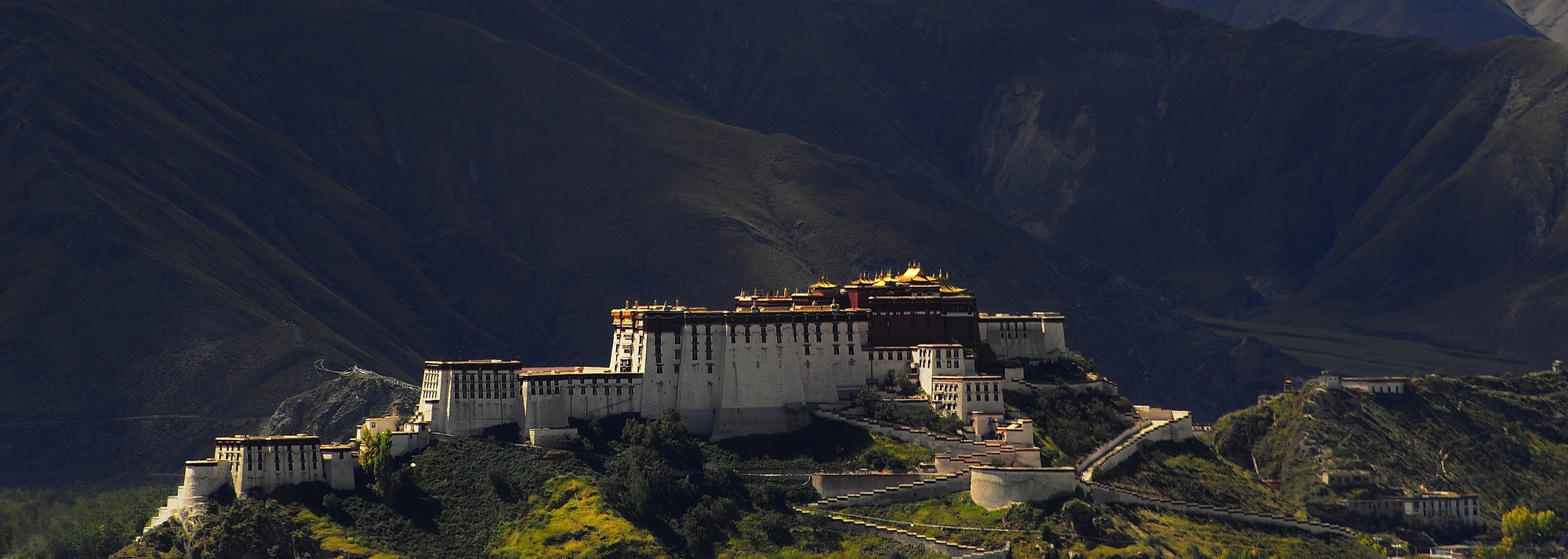
The Potala Palace (Tibetan: ཕོ་བྲང་པོ་ཏ་ལ་, Wylie: pho brang Potala) in Lhasa, Tibet Autonomous Region was the chief residence of the Dalai Lama until the 14th Dalai Lama fled to India during the 1959 Tibetan uprising. It is now a museum and World Heritage Site.
The palace is named after Mount Potalaka, the mythical abode of the bodhisattva Avalokiteśvara. The 5th Dalai Lama started its construction in 1645 after one of his spiritual advisers, Konchog Chophel (died 1646), pointed out that the site was ideal as a seat of government, situated as it is between Drepung and Sera monasteries and the old city of Lhasa. It may overlay the remains of an earlier fortress called the White or Red Palace on the site, built by Songtsän Gampo in 637.
The building measures 400 metres east-west and 350 metres north-south, with sloping stone walls averaging 3 m. thick, and 5 m. thick at the base, and with copper poured into the foundations to help proof it against earthquakes. Thirteen stories of buildings - containing over 1,000 rooms, 10,000 shrines and about 200,000 statues - soar 117 metres on top of Marpo Ri, the "Red Hill", rising more than 300 m in total above the valley floor.
Tradition has it that the three main hills of Lhasa represent the "Three Protectors of Tibet". Chokpori, just to the south of the Potala, is the soul-mountain (Wylie: bla ri) of Vajrapani, Pongwari that of Manjusri, and Marpori, the hill on which the Potala stands, represents Avalokiteśvara.
HISTORY
The site on which the Potala Palace rises is built over a palace erected by Songtsän Gampo on the Red Hill. The Potala contains two chapels on its northwest corner that conserve parts of the original building. One is the Phakpa Lhakhang, the other the Chogyel Drupuk, a recessed cavern identified as Songtsän Gampo's meditation cave. Lozang Gyatso, the Great Fifth Dalai Lama, started the construction of the modern Potala Palace in 1645 after one of his spiritual advisers, Konchog Chophel (died 1646), pointed out that the site was ideal as a seat of government, situated as it is between Drepung and Sera monasteries and the old city of Lhasa. The external structure was built in 3 years, while the interior, together with its furnishings, took 45 years to complete. The Dalai Lama and his government moved into the Potrang Karpo ('White Palace') in 1649. Construction lasted until 1694, some twelve years after his death. The Potala was used as a winter palace by the Dalai Lama from that time. The Potrang Marpo ('Red Palace') was added between 1690 and 1694.
The new palace got its name from a hill on Cape Comorin at the southern tip of India - a rocky point sacred to the bodhisattva of compassion, who is known as Avalokitesvara, or Chenrezi. The Tibetans themselves rarely speak of the sacred place as the "Potala", but rather as "Peak Potala" (Tse Potala), or usually as "the Peak".
The palace was slightly damaged during the Tibetan uprising against the Chinese in 1959, when Chinese shells were launched into the palace's windows. It also escaped damage during the Cultural Revolution in 1966 through the personal intervention of Zhou Enlai, who was then the Premier of the People's Republic of China. Still, almost all of the over 100,000 volumes of scriptures, historical documents and other works of art were either removed, damaged or destroyed.
The Potala Palace was inscribed to the UNESCO World Heritage List in 1994. In 2000 and 2001, Jokhang Temple and Norbulingka were added to the list as extensions to the sites. Rapid modernisation has been a concern for UNESCO, however, which expressed concern over the building of modern structures immediately around the palace which threaten the palace's unique atmosphere. The Chinese government responded by enacting a rule barring the building of any structure taller than 21 metres in the area. UNESCO was also concerned over the materials used during the restoration of the palace, which commenced in 2002 at a cost of RMB180 million (US$22.5 million), although the palace's director, Qiangba Gesang, has clarified that only traditional materials and craftsmanship were used. The palace has also received restoration works between 1989 and 1994, costing RMB55 million (US$6.875 million).
The number of visitors to the palace was restricted to 1,600 a day, with opening hours reduced to six hours daily to avoid over-crowding from 1 May 2003. The palace was receiving an average of 1,500 a day prior to the introduction of the quota, sometimes peaking to over 5,000 in one day. Visits to the structure's roof was banned after restoration works were completed in 2006 to avoid further structural damage. Visitorship quotas were raised to 2,300 daily to accommodate a 30% increase in visitorship since the opening of the Qingzang railway into Lhasa on 1 July 2006, but the quota is often reached by mid-morning. Opening hours were extended during the peak period in the months of July to September, where over 6,000 visitors would descend on the site.
ARCHITECTURE
Built at an altitude of 3,700 m, on the side of Marpo Ri ('Red Mountain') in the center of Lhasa Valley, the Potala Palace, with its vast inward-sloping walls broken only in the upper parts by straight rows of many windows, and its flat roofs at various levels, is not unlike a fortress in appearance. At the south base of the rock is a large space enclosed by walls and gates, with great porticos on the inner side. A series of tolerably easy staircases, broken by intervals of gentle ascent, leads to the summit of the rock. The whole width of this is occupied by the palace.
The central part of this group of buildings rises in a vast quadrangular mass above its satellites to a great height, terminating in gilt canopies similar to those on the Jokhang. This central member of Potala is called the "red palace" from its crimson colour, which distinguishes it from the rest. It contains the principal halls and chapels and shrines of past Dalai Lamas. There is in these much rich decorative painting, with jewelled work, carving and other ornamentation.
The Chinese Putuo Zongcheng Temple, also a UNESCO World Heritage Site, built between 1767 and 1771, was in part modeled after the Potala Palace. The palace was named by the American television show Good Morning America and newspaper USA Today as one of the "New Seven Wonders".
WHITE PALACE
The White Palace or Potrang Karpo is the part of the Potala Palace that makes up the living quarters of the Dalai Lama. The first White Palace was built during the lifetime of the Fifth Dalai Lama and he and his government moved into it in 1649. It then was extended to its size today by the thirteenth Dalai Lama in the early 20th century. The palace contained the living quarters, offices, the seminary and the printing house. A central, yellow-painted courtyard known as a Deyangshar separates the living quarters of the Lama and his monks with the Red Palace, the other side of the sacred Potala, which is completely devoted to religious study and prayer. It contains the sacred gold stupas - the tombs of eight Dalai Lamas - the monks' assembly hall, numerous chapels and shrines, and libraries for the important Buddhist scriptures, the Kangyur in 108 volumes and the Tengyur with 225. The yellow building at the side of the White Palace in the courtyard between the main palaces houses giant banners embroidered with holy symbols which hung across the south face of the Potala during New Year festivals.
RED PALACE
The Red Palace or Potrang Marpo is part of the Potala palace that is completely devoted to religious study and Buddhist prayer. It consists of a complicated layout of many different halls, chapels and libraries on many different levels with a complex array of smaller galleries and winding passages:
GREAT WEST HALL
The main central hall of the Red Palace is the Great West Hall which consists of four great chapels that proclaim the glory and power of the builder of the Potala, the Fifth Dalai Lama. The hall is noted for its fine murals reminiscent of Persian miniatures, depicting events in the fifth Dalai Lama's life.[citation needed] The famous scene of his visit to the Shunzhi Emperor in Beijing is located on the east wall outside the entrance. Special cloth from Bhutan wraps the Hall's numerous columns and pillars.
THE SAINT`S CHAPEL
On the north side of this hall in the Red Palace is an important shrine of the Potala. The chapel like the Dharma cave below it dates from the 7th century. It contains a small ancient jewel encrusted statue of Avalokiteshvara and two of his attendants. On the floor below, a low, dark passage leads into the Dharma Cave where Songsten Gampo is believed to have studied Buddhism. In the holy cave are images of Songsten Gampo, his wives, his chief minister and Sambhota, the scholar who developed Tibetan writing in the company of his many divinities.
NORTH CHAPEL
The North Chapel centres on a crowned Sakyamuni Buddha on the left and the Fifth Dalai Lama on the right. On the far left of the chapel is the gold stupa tomb of the Eleventh Dalai Lama who died as a child, with rows of benign Medicine Buddhas who were the heavenly healers. On the right of the chapel are Avalokiteshvara and his historical incarnations including Songsten Gampo and the first four Dalai Lamas. Scriptures covered in silk between wooden covers form a specialized library in a room branching off it.
SOUTH CHAPEL
The South Chapel centres on Padmasambhava, the 8th century Indian magician and saint. His consort Yeshe Tsogyal, a gift from the King is by his left knee and his other wife from his native land of Swat is by his right. On his left, eight of his holy manifestations meditate with an inturned gaze. On his right, eight wrathful manifestations wield instruments of magic powers to subdue the demons of the Bön faith.
EAST CHAPEL
The East chapel is dedicated to Tsong Khapa, founder of the Gelug tradition. His central figure is surrounded by lamas from Sakya Monastery who had briefly ruled Tibet and formed their own tradition until converted by Tsong Khapa. Other statues are displayed made of various different materials and display noble expressions.
WEST CHAPEL
This is the chapel that contains the five golden stupas. The enormous central stupa, 14.85 metres high, contains the mummified body of the Fifth Dalai Lama. This stupa is built of sandalwood, and is remarkably coated in gold, and studded with 18,680 pearls and semi-precious jewels. On the left is the funeral stupa for the Twelfth Dalai Lama and on the right that of the Tenth Dalai Lama. The nearby stupa for the 13th Dalai Lama is 22 metres high. The stupas on both ends contain important scriptures.
FIRST GALLERY
The first gallery is on the floor above the West chapel and has a number of large windows that give light and ventilation to the Great West Hall and its chapels below. Between the windows, superb murals show the Potala's construction is fine detail.
SECOND GALLERY
The Second Gallery gives access to the central pavilion which is used for visitors to the palace for refreshments and to buy souvenirs.
THIRD GALLERY
The Third Gallery besides fine murals has a number of dark rooms branching off it containing enormous collections of bronze statues. The chanting hall of the Seventh Dalai Lama is on the south side and on the east an entrance connects the section to the Saints chapel and the Deyangshar between the two palaces.
TOMB OF THE THIRZEENTH DALAI LAMA
The tomb of the 13th Dalai Lama is located west of the Great West Hall and it can be reached only from an upper floor and with the company of a monk or a guide of the Potala. Built in 1933, the giant stupa is 14 metres high. Devotional offerings include elephant tusks from India, porcelain lions and vases. Elaborate murals in traditional Tibetan styles depict many events of the life of the Thirteenth Dalai Lama during the early 20th century.
THE LHASA ZHOL PILLARS
Lhasa Zhol Village has two stone pillars or rdo-rings, an interior stone pillar or doring nangma, which stands within the village fortification walls, and the exterior stone pillar or doring chima,[24] which originally stood outside the South entrance to the village. Today the pillar stands neglected to the East of the Liberation Square, on the South side of Beijing Avenue.
The doring chima dates as far back as c. 764, "or only a little later", and is inscribed with what may be the oldest known example of Tibetan writing.
The pillar contains dedications to a famous Tibetan general and gives an account of his services to the king including campaigns against China which culminated in the brief capture of the Chinese capital Chang'an (modern Xian) in 763 during which the Tibetans temporarily installed as Emperor a relative of Princess Jincheng Gongzhu (Kim-sheng Kong co), the Chinese wife of Trisong Detsen's father, Me Agtsom.
WIKIPEDIA
The mountains of Bhutan are some of the most prominent natural geographic features of the kingdom. Located on the southern end of the Eastern Himalaya, Bhutan has one of the most rugged mountain terrains in the world, whose elevations range from 160 metres (520 ft) to more than 7,000 metres (23,000 ft) above sea level, in some cases within distances of less than 100 kilometres (62 mi) of each other. Bhutan's highest peak, at 7,554 metres (24,783 ft) above sea level, is north-central Kula Kangri, close to the border with China; the second highest peak, Jomolhari, overlooking the Chumbi Valley in the west, is 7,314 metres (23,996 ft) above sea level; nineteen other peaks exceed 7,000 metres (23,000 ft). Weather is extreme in the mountains: the high peaks have perpetual snow, and the lesser mountains and hewn gorges have high winds all year round, making them barren brown wind tunnels in summer, and frozen wastelands in winter. The blizzards generated in the north each winter often drift southward into the central highlands.
The mountains of Bhutan define its three main geographic zones: the Great Himalaya, the Lower Himalayan Range (or Inner Himalaya), and the Sub-Himalayan Range. The snowcapped Great Himalaya in the north ranges from about 5,500 metres (18,000 ft) to peaks of over 7,500 metres (24,600 ft) above sea level, extending along the Bhutan-China border. The northern region consists of an arc of glaciated mountain peaks with an arctic climate at the highest elevations. Watered by snow-fed rivers, alpine valleys in this region provide pasturage for livestock tended by a sparse population of migratory shepherds. Spur-like mountain ranges of the Lower Himalaya, between 1,500 metres (4,900 ft) and 5,500 metres (18,000 ft), run northwest to southeast in western Bhutan, and northeast to southwest in eastern Bhutan. These mountains, and especially their western valleys, make up the economic and cultural heart of the kingdom, including most of its dzongs. These mountainous areas are contrasted with the hilly Sub-Himalaya, with elevations of up to 1,500 metres (4,900 ft), and the lower Duars. Many lower mountain ranges are composed of coarse granite sandstone, while rocks at the highest elevations consist of gneiss among upheaved strata of mica and talcose slate. Many ranges are abundant in limestone.
Bhutan's valleys are carved into the Himalaya by its rivers, fed by glacial melt and monsoon rains. Much of the Bhutanese population is concentrated in valleys and lowlands, separated by the rugged southward spurs of the Inner Himalaya. Despite modernization and development of transport in Bhutan, including a national highway system, travel from one valley to the next remains difficult. Western valleys are bound to the east by the Black Mountains in central Bhutan, which form a watershed between two major river systems, the Mo Chhu (Sankosh River) and the Drangme Chhu. Central valleys are separated from the east by the Donga Range. The more isolated mountain valleys protect several tiny, distinct cultural and linguistic groups.
Bhutan controls several strategic Himalayan mountain passes including routes between Tibet and Assam. These routes, being the only way into the kingdom, along with centuries-old policies of isolationism, have gained Bhutan the nickname "Mountain Fortress of the Gods." Although the British established a protectorate over Bhutan and occupied its lowlands, the mountainous interior has never been successfully invaded.
The Great Himalaya Range
The mountains of Great Himalaya dominate the north of Bhutan, where peaks can easily reach 7,000 metres (23,000 ft). The tallest peaks range, from west to east, along northern Haa, Paro and Thimphu Districts; the bulk of Gasa District; northernmost Wangdue Phodrang District; and northern Bumthang and Lhuentse Districts. The highest point in Bhutan is Gangkhar Puensum, which has the distinction of being the highest unclimbed mountain in the world, at 7,570 metres (24,840 ft). Some massive summits such as Gangkhar Puensum, Kula Kangri, and Tongshanjiabu lie in territory disputed among Bhutan and China. According to Bhutanese claims, these giants should be part of Gasa District. Other peaks of the Great Himalaya, such as Mount Jitchu Drake, lie squarely within Gasa.
The Great Himalaya contains most of the glaciers of Bhutan. This region contains the vast majority of Bhutan's 677 glaciers and 2,674 glacial lakes and subsidiary lakes, out of which 25 pose a risk of GLOFs. The vast number of glaciers in Bhutan are classed as "valley" and "mountain glaciers," although significant numbers of "ice apron," and "niche glacier" types also exist. Some glacial lakes, such as Thorthormi Lake in Lunana Gewog, are not a single bodies of water but collections supraglacial ponds.
Hasselblad 503CX with Carl Zeiss Planar 80mm F2.8 T* Film: Fujifilm Provia 100f RDP (resolution compressed)
Location: Jokhang Monastery, Lhasa, Tibet
Jokhang Monastery, constructed by King Songtsän Gampprobably in 642, was originally called the Rasa Tulnang Tsuklakang or The House of Mysteries, The Magical Emanation at Rasa [the early name for Lhasa]. Both Bhrituti and Wencheng, the Nepalese and Chinese wives of Songsten Gampo are said to have brought important Buddhist statues and images to Tibet as part of their dowries, and they were housed here.
With its irreplacable religious position, similar to other cultural heritage in China, it failed to be an exception from the ridiculous attacks and destruction during the Cultural Revolution in 1970s where most of the precious Buddha statues, Buddhism articles and treasures are forever lost. During those chaotic years, Jokhang became a slaughterhouse for pigs and toilet where local people were not allowed to enter and pray. In fact, Many of the existing statues being prayed in the temple were recreated in around 1980s and 1990s – often including broken pieces of the original statues.
Now Jokhang Monastery is probably the most popular tourist attraction in Lhasa. It is part of the UNESCO World Heritage Site "Historic Ensemble of the Potala Palace," and a spiritual centre of Lhasa and has remained as a key center of Buddhist pilgrimage for centuries.
大昭寺始建於七世紀吐蕃王朝的鼎盛時期,建造的目的據傳說是為了供奉一尊明久多吉佛像,即釋迦牟尼八歲等身像,據傳是當時的吐蕃王松贊干布迎娶的尼泊爾尺尊公主從家鄉帶去的。據說當地原為一座湖泊,但在松贊干布的努力之下,將它填平建為寺院。
現在大昭寺內供奉的是文成公主帶去的釋迦牟尼十二歲等身像,而八歲等身像於八世紀被轉供奉在小昭寺,後毀於文化大革命。
大昭寺在文化大革命期間成為「破四舊」的目標。1966年,紅衛兵攻擊大昭寺,摧毀了許多佛像,而很多經典、珠寶亦從此來歷不明。大昭寺的泥製大佛之中安放著的尺尊公主帶至西藏的木製釋迦牟尼佛像,後來輾轉流傳到印度達蘭薩拉,由十四世達賴收藏。大昭寺成為豬的屠宰場及公廁,西藏人被禁止進入膜拜,直至1972年,開始重建大昭寺,1980年完成重建工程。然那段破壞歷史,已成為很多藏人、佛教徒永久的痛。
大昭寺是西藏現存最輝煌的吐蕃時期的建築,也是西藏現存最古老的土木結構建築,開創了藏式平川式的寺廟布局規式。大昭寺融合了藏、唐、尼泊爾、印度的建築風格,成為藏式宗教建築的千古典範。寺院內的佛殿主要有釋迦牟尼殿、宗喀巴大師殿、松贊干布殿、班旦拉姆殿(格魯派的護法神)、神羊熱姆傑姆殿、藏王殿等等。寺內各種木雕、壁畫精美絕倫,空氣中瀰漫著酥油香氣,藏民們神情虔誠地參拜轉經。
The mountains of Bhutan are some of the most prominent natural geographic features of the kingdom. Located on the southern end of the Eastern Himalaya, Bhutan has one of the most rugged mountain terrains in the world, whose elevations range from 160 metres (520 ft) to more than 7,000 metres (23,000 ft) above sea level, in some cases within distances of less than 100 kilometres (62 mi) of each other. Bhutan's highest peak, at 7,554 metres (24,783 ft) above sea level, is north-central Kula Kangri, close to the border with China; the second highest peak, Jomolhari, overlooking the Chumbi Valley in the west, is 7,314 metres (23,996 ft) above sea level; nineteen other peaks exceed 7,000 metres (23,000 ft). Weather is extreme in the mountains: the high peaks have perpetual snow, and the lesser mountains and hewn gorges have high winds all year round, making them barren brown wind tunnels in summer, and frozen wastelands in winter. The blizzards generated in the north each winter often drift southward into the central highlands.
The mountains of Bhutan define its three main geographic zones: the Great Himalaya, the Lower Himalayan Range (or Inner Himalaya), and the Sub-Himalayan Range. The snowcapped Great Himalaya in the north ranges from about 5,500 metres (18,000 ft) to peaks of over 7,500 metres (24,600 ft) above sea level, extending along the Bhutan-China border. The northern region consists of an arc of glaciated mountain peaks with an arctic climate at the highest elevations. Watered by snow-fed rivers, alpine valleys in this region provide pasturage for livestock tended by a sparse population of migratory shepherds. Spur-like mountain ranges of the Lower Himalaya, between 1,500 metres (4,900 ft) and 5,500 metres (18,000 ft), run northwest to southeast in western Bhutan, and northeast to southwest in eastern Bhutan. These mountains, and especially their western valleys, make up the economic and cultural heart of the kingdom, including most of its dzongs. These mountainous areas are contrasted with the hilly Sub-Himalaya, with elevations of up to 1,500 metres (4,900 ft), and the lower Duars. Many lower mountain ranges are composed of coarse granite sandstone, while rocks at the highest elevations consist of gneiss among upheaved strata of mica and talcose slate. Many ranges are abundant in limestone.
Bhutan's valleys are carved into the Himalaya by its rivers, fed by glacial melt and monsoon rains. Much of the Bhutanese population is concentrated in valleys and lowlands, separated by the rugged southward spurs of the Inner Himalaya. Despite modernization and development of transport in Bhutan, including a national highway system, travel from one valley to the next remains difficult. Western valleys are bound to the east by the Black Mountains in central Bhutan, which form a watershed between two major river systems, the Mo Chhu (Sankosh River) and the Drangme Chhu. Central valleys are separated from the east by the Donga Range. The more isolated mountain valleys protect several tiny, distinct cultural and linguistic groups.
Bhutan controls several strategic Himalayan mountain passes including routes between Tibet and Assam. These routes, being the only way into the kingdom, along with centuries-old policies of isolationism, have gained Bhutan the nickname "Mountain Fortress of the Gods." Although the British established a protectorate over Bhutan and occupied its lowlands, the mountainous interior has never been successfully invaded.
The Great Himalaya Range
The mountains of Great Himalaya dominate the north of Bhutan, where peaks can easily reach 7,000 metres (23,000 ft). The tallest peaks range, from west to east, along northern Haa, Paro and Thimphu Districts; the bulk of Gasa District; northernmost Wangdue Phodrang District; and northern Bumthang and Lhuentse Districts. The highest point in Bhutan is Gangkhar Puensum, which has the distinction of being the highest unclimbed mountain in the world, at 7,570 metres (24,840 ft). Some massive summits such as Gangkhar Puensum, Kula Kangri, and Tongshanjiabu lie in territory disputed among Bhutan and China. According to Bhutanese claims, these giants should be part of Gasa District. Other peaks of the Great Himalaya, such as Mount Jitchu Drake, lie squarely within Gasa.
The Great Himalaya contains most of the glaciers of Bhutan. This region contains the vast majority of Bhutan's 677 glaciers and 2,674 glacial lakes and subsidiary lakes, out of which 25 pose a risk of GLOFs. The vast number of glaciers in Bhutan are classed as "valley" and "mountain glaciers," although significant numbers of "ice apron," and "niche glacier" types also exist. Some glacial lakes, such as Thorthormi Lake in Lunana Gewog, are not a single bodies of water but collections supraglacial ponds.
The Jokhang, (Tibetan: ཇོ་ཁང།, Wylie: Jo-khang, ZYPY: Qokang; Chinese: 大昭寺; pinyin: Dàzhāo Sì), also called the Qokang Monastery, Jokang, Jokhang Temple, Jokhang Monastery or Zuglagkang (Tibetan: གཙུག་ལག་ཁང༌།, Wylie: gtsug-lag-khang, ZYPY: Zuglagkang; also Tsuklakang), is located on Barkhor Square in Lhasa. For most Tibetans it is the most sacred and important temple in Tibet. It is in some regards pan-sectarian, but is controlled by the Gelug school. The temple's architectural style is a mixture of Indian vihara design, Chinese Tang Dynasty design, and Nepalese design.
It was founded during the reign of king Songsten Gampo. According to tradition, the temple was built for the two brides of the king, Princess Wencheng of the Chinese Tang Dynasty and Princess Bhrikuti of Nepal. Both wives are said to have brought important Buddhist statues and images from China and Nepal to Tibet as part of their dowries, and they were housed here. Many Nepalese artists worked to construct this temple.
During the Bon period of Tibet the temple was (and sometimes still is), called the Zuglagkang (House of Religious Science or House of Wisdom). The term zuglag refers to the 'sciences' such as geomancy, astrology, and divination which formed part of the pre-Buddhist shamanistic religion now referred to as Bon. It is more commonly known today as the Jokhang, which means the 'House of the Buddha'.
Along with the Potala Palace, it is probably the most popular tourist attraction in Lhasa. It is part of the UNESCO World Heritage Site "Historic Ensemble of the Potala Palace," and a spiritual centre of Lhasa.
The Jokhang owns a large and very important collection of about eight hundred metal sculptures, in addition to thousands of painted scrolls known as thangkas. The statues are hidden away in temples closed to the public and access is almost impossible. During numerous visits to the Jokhang between 1980 and 1996, Ulrich von Schroeder managed to take photographs of about five hundred metal statues of interest. Among them are some extremely rare and important brass and copper statues originating from Kashmir, Northern India, Nepal, Tibet, and China. However, the most important statues of the Jokhang collection are those that date back to the Yarlung dynasty (7th–9th century).
The mountains of Bhutan are some of the most prominent natural geographic features of the kingdom. Located on the southern end of the Eastern Himalaya, Bhutan has one of the most rugged mountain terrains in the world, whose elevations range from 160 metres (520 ft) to more than 7,000 metres (23,000 ft) above sea level, in some cases within distances of less than 100 kilometres (62 mi) of each other. Bhutan's highest peak, at 7,554 metres (24,783 ft) above sea level, is north-central Kula Kangri, close to the border with China; the second highest peak, Jomolhari, overlooking the Chumbi Valley in the west, is 7,314 metres (23,996 ft) above sea level; nineteen other peaks exceed 7,000 metres (23,000 ft). Weather is extreme in the mountains: the high peaks have perpetual snow, and the lesser mountains and hewn gorges have high winds all year round, making them barren brown wind tunnels in summer, and frozen wastelands in winter. The blizzards generated in the north each winter often drift southward into the central highlands.
The mountains of Bhutan define its three main geographic zones: the Great Himalaya, the Lower Himalayan Range (or Inner Himalaya), and the Sub-Himalayan Range. The snowcapped Great Himalaya in the north ranges from about 5,500 metres (18,000 ft) to peaks of over 7,500 metres (24,600 ft) above sea level, extending along the Bhutan-China border. The northern region consists of an arc of glaciated mountain peaks with an arctic climate at the highest elevations. Watered by snow-fed rivers, alpine valleys in this region provide pasturage for livestock tended by a sparse population of migratory shepherds. Spur-like mountain ranges of the Lower Himalaya, between 1,500 metres (4,900 ft) and 5,500 metres (18,000 ft), run northwest to southeast in western Bhutan, and northeast to southwest in eastern Bhutan. These mountains, and especially their western valleys, make up the economic and cultural heart of the kingdom, including most of its dzongs. These mountainous areas are contrasted with the hilly Sub-Himalaya, with elevations of up to 1,500 metres (4,900 ft), and the lower Duars. Many lower mountain ranges are composed of coarse granite sandstone, while rocks at the highest elevations consist of gneiss among upheaved strata of mica and talcose slate. Many ranges are abundant in limestone.
Bhutan's valleys are carved into the Himalaya by its rivers, fed by glacial melt and monsoon rains. Much of the Bhutanese population is concentrated in valleys and lowlands, separated by the rugged southward spurs of the Inner Himalaya. Despite modernization and development of transport in Bhutan, including a national highway system, travel from one valley to the next remains difficult. Western valleys are bound to the east by the Black Mountains in central Bhutan, which form a watershed between two major river systems, the Mo Chhu (Sankosh River) and the Drangme Chhu. Central valleys are separated from the east by the Donga Range. The more isolated mountain valleys protect several tiny, distinct cultural and linguistic groups.
Bhutan controls several strategic Himalayan mountain passes including routes between Tibet and Assam. These routes, being the only way into the kingdom, along with centuries-old policies of isolationism, have gained Bhutan the nickname "Mountain Fortress of the Gods." Although the British established a protectorate over Bhutan and occupied its lowlands, the mountainous interior has never been successfully invaded.
The Great Himalaya Range
The mountains of Great Himalaya dominate the north of Bhutan, where peaks can easily reach 7,000 metres (23,000 ft). The tallest peaks range, from west to east, along northern Haa, Paro and Thimphu Districts; the bulk of Gasa District; northernmost Wangdue Phodrang District; and northern Bumthang and Lhuentse Districts. The highest point in Bhutan is Gangkhar Puensum, which has the distinction of being the highest unclimbed mountain in the world, at 7,570 metres (24,840 ft). Some massive summits such as Gangkhar Puensum, Kula Kangri, and Tongshanjiabu lie in territory disputed among Bhutan and China. According to Bhutanese claims, these giants should be part of Gasa District. Other peaks of the Great Himalaya, such as Mount Jitchu Drake, lie squarely within Gasa.
The Great Himalaya contains most of the glaciers of Bhutan. This region contains the vast majority of Bhutan's 677 glaciers and 2,674 glacial lakes and subsidiary lakes, out of which 25 pose a risk of GLOFs. The vast number of glaciers in Bhutan are classed as "valley" and "mountain glaciers," although significant numbers of "ice apron," and "niche glacier" types also exist. Some glacial lakes, such as Thorthormi Lake in Lunana Gewog, are not a single bodies of water but collections supraglacial ponds.
King Srongtsong Gampo was the founder of the Tibetan Empire about 605/617 to 649 CE. The image show he and his wives, Princess Bhrikuti of Nepal to the left and Princess Wencheng of China. Read more in the following URL: en.wikipedia.org/wiki/Songts%c3%a4n_Gampo
Public domain file Wikimedia by Ernst Stavro Blofeld, 2007.
This photo was taken at Lhatse where we stayed a night before heading off to Everest. I was suprised to see so many kids playing snooker and what would their future be. I was holding back to take some photos of them snookering as few kids did gave me a 'sharp' weird look, as is they were asking for money or else I will be beaten to dead. But once I took some photos, they actually start possing and curiously staring at the camera...
Info
The new town of Lhatse (Lha rtse) or Lhatse Xian (Pinyin: Lhazê), is also known as Chusar (Quxar), is a small town of a few thousand people in Tibet, 151 km southwest of Shigatse, and just west of the mountain pass leading to it. Lhatse is 4,050 m. (13,287 ft) above sea-level.
The modern town is 10 km south of the old village of Lhatse and the small Gelugpa monastery of Lhatse Chode. Above the monastery are the ruins of the old fort or Lhatse Dzong (Lha rtse rdong) or Drampa Lhatse (Gram pa Lha rtse) which are on a rock 150 m (492 ft) high at the opening of the Yarlung Tsangpo Canyon.
At the western end of the town is another small monastery, the Changmoche Monastery. 10 km east of Lhatse are the Xiqian Hot Springs widely renowned for their healing properties.
Further east are the ruins of the Drampa Gyang (Gram pa rgyangs) Lhakhang, one of King Songsten Gampo's main geomantic temples built in the 7th century. It was thought to pin down the troublesome left hip of the demoness whose body lay under all the high plateau with her heart located under the Jokhang temple in Lhasa. It once housed a famous image of Vairocana Buddha.
Near this spot in the 14th century the famous terton or treasure finder, Sangpo Drakpa, discovered the popular Nyingma text by Guru Rinpoche called the Leu Dunma, which is a collection of prayers and devotions. To the north are the massive ruins of the Gyang Bumoche or Gyang Bumpoche, once 20 m (66 ft) high, which was built in the style of the Gyantse Kumbum by Sakyapa Sonam Tashi (1352-1417) and the famous polymath and bridge builder, Thangtong Gyalpo or Tangton Gyelpo (1385-1464), and decorated in the Lato style of painting. This Jonang kumbum was also called Tongdrol Chempo ('The Great Chorten that Gives Liberation by Setting Eyes upon It').
East of the ruins of the kumbum is the reconstructed Phuntsoling Monastery which was once attached to it. The main monastery and kumbum were restored and expanded by the renowned historian Taranatha (1575-1634) of the Jonangpa sect of the Kagyupa. Under the Great Fifth Dalai Lama (1617 – 1682), the Jonang school was suppressed and it was converted to the Gelugpa school after Taranatha's death.
Further east is a beautiful little valley where there was previously a Nyingma gompa and hermitages, above which is the large Guru Rinpoche cave of Gyang Lompo Lung which contains a shrine. The whole valley was, however, deserted in 1985.
Because the roads to Mount Everest and to Mount Kailash divide just west of Lhatse, the town is a popular lunch stop for tour groups heading to those locations. Buddhist festivals are sometimes held at the monastery, drawing inhabitants from the surrounding region. There are several hotels and restaurants in the town..
His Eminence Garchen Rinpoche is a Drikung Kagyu lama who was known in the thirteenth century as the Siddha Gar Chodingpa, a heart disciple of Kyobpa Jigten Sumgon, founder of the Drikung Kagyu lineage of Tibetan Buddhism. In ancient India, he had incarnated as Mahasiddha Aryadeva, the lotus-born disciple of the great Nagarjuna. In the seventh century, he was known as Lonpo Gar, the minister of the Tibetan Dharma King Songsten Gampo.
Garchen Rinpoche was recognized and enthroned in eastern Tibet by the former Drikung Kyabgon Zhiwe Lodro. When he was seven, he was brought to Lho Miyal Monastery, which he administered from the age of eleven. Studying and practicing under the direction of the Siddha Chime Dorje, Garchen Rinpoche received vast and profound instructions on the preliminary practices (ngondro), the fivefold practice of Mahamudra and the six yogas of Naropa.
Then, at the age of 22, after completing a two and a half year retreat, he was imprisoned for 20 years during the political turmoil of China's Cultural Revolution. While in the labor camp, he received meditation instruction from his root lama, the Nyingma master Khenpo Munsel. Enduring hardship and practicing secretly, Garchen Rinpoche attained realization of the lama's wisdom mind. Since his release from prison in 1979, Garchen Rinpoche has made great effort to rebuild the Drikung Kagyu monasteries, reestablish the Buddhist teachings, and build two boarding schools for local children in eastern Tibet. Rinpoche is the founder and spiritual director of the Garchen Buddhist Institute in Chino Valley, Arizona.
Garchen Rinpoche is known for his vast realization, as well as for his great kindness.
Ina Bieler, a native Austrian, is fluent in German, English, and Tibetan. She began her translator education in 2003 at the Lotsawa Rinchen Zangpo Translator Program of the Foundation for the Preservation of the Mahayana Tradition in Dharamsala, India. After participating in this two-year course, His Eminence Garchen Rinpoche assigned her to serve as the resident translator for the Garchen Institute in Arizona. Since 2006, she has been translating for His Eminence Garchen Rinpoche, Ven. Tranga Rinpoche, Ven. Lama Gape, and several other Drinkung Kagyu lamas.
Hasselblad 503CX with Carl Zeiss Planar 80mm F2.8 T* Film: Fujifilm Provia 100f RDP (resolution compressed)
Location: Jokhang Monastery, Lhasa, Tibet
Jokhang Monastery, constructed by King Songtsän Gampprobably in 642, was originally called the Rasa Tulnang Tsuklakang or The House of Mysteries, The Magical Emanation at Rasa [the early name for Lhasa]. Both Bhrituti and Wencheng, the Nepalese and Chinese wives of Songsten Gampo are said to have brought important Buddhist statues and images to Tibet as part of their dowries, and they were housed here.
With its irreplacable religious position, similar to other cultural heritage in China, it failed to be an exception from the ridiculous attacks and destruction during the Cultural Revolution in 1970s where most of the precious Buddha statues, Buddhism articles and treasures are forever lost. During those chaotic years, Jokhang became a slaughterhouse for pigs and toilet where local people were not allowed to enter and pray. In fact, Many of the existing statues being prayed in the temple were recreated in around 1980s and 1990s – often including broken pieces of the original statues.
Now Jokhang Monastery is probably the most popular tourist attraction in Lhasa. It is part of the UNESCO World Heritage Site "Historic Ensemble of the Potala Palace," and a spiritual centre of Lhasa and has remained as a key center of Buddhist pilgrimage for centuries.
大昭寺始建於七世紀吐蕃王朝的鼎盛時期,建造的目的據傳說是為了供奉一尊明久多吉佛像,即釋迦牟尼八歲等身像,據傳是當時的吐蕃王松贊干布迎娶的尼泊爾尺尊公主從家鄉帶去的。據說當地原為一座湖泊,但在松贊干布的努力之下,將它填平建為寺院。
現在大昭寺內供奉的是文成公主帶去的釋迦牟尼十二歲等身像,而八歲等身像於八世紀被轉供奉在小昭寺,後毀於文化大革命。
大昭寺在文化大革命期間成為「破四舊」的目標。1966年,紅衛兵攻擊大昭寺,摧毀了許多佛像,而很多經典、珠寶亦從此來歷不明。大昭寺的泥製大佛之中安放著的尺尊公主帶至西藏的木製釋迦牟尼佛像,後來輾轉流傳到印度達蘭薩拉,由十四世達賴收藏。大昭寺成為豬的屠宰場及公廁,西藏人被禁止進入膜拜,直至1972年,開始重建大昭寺,1980年完成重建工程。然那段破壞歷史,已成為很多藏人、佛教徒永久的痛。
大昭寺是西藏現存最輝煌的吐蕃時期的建築,也是西藏現存最古老的土木結構建築,開創了藏式平川式的寺廟布局規式。大昭寺融合了藏、唐、尼泊爾、印度的建築風格,成為藏式宗教建築的千古典範。寺院內的佛殿主要有釋迦牟尼殿、宗喀巴大師殿、松贊干布殿、班旦拉姆殿(格魯派的護法神)、神羊熱姆傑姆殿、藏王殿等等。寺內各種木雕、壁畫精美絕倫,空氣中瀰漫著酥油香氣,藏民們神情虔誠地參拜轉經。
Paro Chhu
OriginChomo Lhari
MouthChhuzom
Basin countriesBhutan
River systemWong Chhu
The Paro Chhu is a river of western Bhutan. It is a tributary of the Wong Chhu, which is known as the Raidak in its lower reaches.
The Paro Chhu rises to the south of Chomo Lhari (mountain of the Goddess). Its glacial waters plunge torrentially through alpine meadows and deep gorges in the Jigme Dorji National Park, and descends into a wide, open, undulating valley. Sub-alpine and temperate forests are found along its middle and lower reaches. A prime trout stream, it nourishes lush green rice fields and apple and peach orchards on its banks.
The Paro Chhu flows through the Paro Valley, which is the site of one of Bhutan's main towns, Paro, and many important monasteries. The two best known of the monasteries are Taktshang ("Tiger's nest" in Dzongkha), and Paro Dzong. Taktshang clings to a ledge of a high cliff approximately 15 km north of Paro. Taktshang and Paro Dzong are two of the finest examples of Bhutanese architecture. Below the dzong, a traditional wooden covered bridge called Nyamai Zam spans the Paro Chhu. The original bridge was washed away in a flood in 1969 and the present one is a reconstruction. Earlier versions of this bridge were removed to protect the dzong. The bridge was also shown in the movie Little Buddha by Bernardo Bertolucci Below the town of Paro, the river runs immediately to the west of Bhutan's only international airport. That airport is renowned for the hair-raising final approach. Only one airline, Druk Air, is licensed to fly into and out of this airport.
The Jokhang, (Tibetan: ཇོ་ཁང།, Wylie: Jo-khang, ZYPY: Qokang; Chinese: 大昭寺; pinyin: Dàzhāo Sì), also called the Qokang Monastery, Jokang, Jokhang Temple, Jokhang Monastery or Zuglagkang (Tibetan: གཙུག་ལག་ཁང༌།, Wylie: gtsug-lag-khang, ZYPY: Zuglagkang; also Tsuklakang), is located on Barkhor Square in Lhasa. For most Tibetans it is the most sacred and important temple in Tibet. It is in some regards pan-sectarian, but is controlled by the Gelug school. The temple's architectural style is a mixture of Indian vihara design, Chinese Tang Dynasty design, and Nepalese design.
It was founded during the reign of king Songsten Gampo. According to tradition, the temple was built for the two brides of the king, Princess Wencheng of the Chinese Tang Dynasty and Princess Bhrikuti of Nepal. Both wives are said to have brought important Buddhist statues and images from China and Nepal to Tibet as part of their dowries, and they were housed here. Many Nepalese artists worked to construct this temple.
During the Bon period of Tibet the temple was (and sometimes still is), called the Zuglagkang (House of Religious Science or House of Wisdom). The term zuglag refers to the 'sciences' such as geomancy, astrology, and divination which formed part of the pre-Buddhist shamanistic religion now referred to as Bon. It is more commonly known today as the Jokhang, which means the 'House of the Buddha'.
Along with the Potala Palace, it is probably the most popular tourist attraction in Lhasa. It is part of the UNESCO World Heritage Site "Historic Ensemble of the Potala Palace," and a spiritual centre of Lhasa.
The Jokhang owns a large and very important collection of about eight hundred metal sculptures, in addition to thousands of painted scrolls known as thangkas. The statues are hidden away in temples closed to the public and access is almost impossible. During numerous visits to the Jokhang between 1980 and 1996, Ulrich von Schroeder managed to take photographs of about five hundred metal statues of interest. Among them are some extremely rare and important brass and copper statues originating from Kashmir, Northern India, Nepal, Tibet, and China. However, the most important statues of the Jokhang collection are those that date back to the Yarlung dynasty (7th–9th century).
Kyichu Lhakhang, (also known as Kyerchu Temple or Lho Kyerchu) is an important Himalayan Buddhist temple situated in Lamgong Gewog of Paro District in Bhutan.
The Jowo Temple of Kyichu is one of the oldest temples in Bhutan, originally built in the 7th century by the Tibetan Emperor Songsten Gampo. It is considered to be one of the 108 border taming temples he built.
In the 8th century the temple was visited by Guru Rinpoche and it is believed he concealed many spiritual treasures here.
Je Khenpo Sherab Gyaltshen wrote that during the 12th century the temple was looked after by the Lhapa Kagyu tradition and that during the 13th century it was handed over to a descendant of Phajo Drugom Zhigpo's son Nyima.
In his The Nyingma School of Tibetan Buddhism: It's Fundamentals and History H.H. Dudjom Rinpoche, Jigdrel Yeshe Dorje records that the Jowo Temple of Kyichu could not be seen and that Terton Pema Lingpa (1450-1521) uncovered the temple and restored it as it was before.
In 1644 the temple was taken over by Shabdrung Ngawang Namgyal. From 1836 to 1838 the temple was restored and re-consecrated by the 25th Je Khenpo Sherab Gyaltshen.
In 1971 HM Kesang Choden Wangchuck,the Queen of King Jigme Dorji Wangchuck, built a Guru Temple next to the old Jowo Temple which was consecrated by HH Dilgo Khyentse Rinpoche. Ever since then the annual rites of great accomplishment for the deities Vajrasattva, Palchen Heruka, and Vajrakilaya have been held in this temple for the well being of the country under the patronage of HM Kesang Choden Wangchuck.
There is a belief that the two orange trees in the courtyard of Kyichu Lhakhang bear fruit throughout the year.
Paro Chhu
OriginChomo Lhari
MouthChhuzom
Basin countriesBhutan
River systemWong Chhu
The Paro Chhu is a river of western Bhutan. It is a tributary of the Wong Chhu, which is known as the Raidak in its lower reaches.
The Paro Chhu rises to the south of Chomo Lhari (mountain of the Goddess). Its glacial waters plunge torrentially through alpine meadows and deep gorges in the Jigme Dorji National Park, and descends into a wide, open, undulating valley. Sub-alpine and temperate forests are found along its middle and lower reaches. A prime trout stream, it nourishes lush green rice fields and apple and peach orchards on its banks.
The Paro Chhu flows through the Paro Valley, which is the site of one of Bhutan's main towns, Paro, and many important monasteries. The two best known of the monasteries are Taktshang ("Tiger's nest" in Dzongkha), and Paro Dzong. Taktshang clings to a ledge of a high cliff approximately 15 km north of Paro. Taktshang and Paro Dzong are two of the finest examples of Bhutanese architecture. Below the dzong, a traditional wooden covered bridge called Nyamai Zam spans the Paro Chhu. The original bridge was washed away in a flood in 1969 and the present one is a reconstruction. Earlier versions of this bridge were removed to protect the dzong. The bridge was also shown in the movie Little Buddha by Bernardo Bertolucci Below the town of Paro, the river runs immediately to the west of Bhutan's only international airport. That airport is renowned for the hair-raising final approach. Only one airline, Druk Air, is licensed to fly into and out of this airport.
The Driglam Namzha (Tibetan: སྒྲིག་ལམ་རྣམ་གཞག་, Wylie: sgrig-lam rnam-gzhag) is the official behaviour and dress code of the Kingdom of Bhutan. It governs how citizens should dress in public and how they should behave in formal settings. It also regulates a number of cultural assets such as art and architecture. In English, driglam means "order, discipline, custom, rules, regimen" and namzha means "system," though the term may be styled "The Rules for Disciplined Behaviour."
Under the Driglam Namzha, men wear a heavy knee-length robe tied with a belt, called a gho, folded in such a way to form a pocket in front of the stomach. Women wear colorful blouses called wonju over which they fold and clasp a large rectangular cloth called a kira, thereby creating an ankle-length dress. A short silk jacket, or toego may be worn over the kira. Everyday gho and kira are cotton or wool, according to the season, patterned in simple checks and stripes in earth tones. For special occasions and festivals, colourfully patterned silk kira and, more rarely, gho may be worn.
Additional rules apply when visiting a dzong or a temple, and when appearing before a high level official. A white sash called a kabney is worn by male commoners from left shoulder to opposite hip, with other colors reserved for officials and monks. Women wear a rachu, a narrow embroidered cloth draped over the left shoulder.
A statue of Sakyamuni (the Historical Buddha, Gautama Buddha) in the Lhagang Gompa (Lhagang Monastery) at Tagong (elevation 3,726 m, 12,224 ft.), 245 km (152 mi.) west of Chengdu in the Garze Tibetan Autonomous Prefecture, Sichuan Province, China. The gompa was founded in 652 by Princess Wencheng, the Chinese wife of the great Tibetan King Songsten Gampo, who founded the Jokhang Gompa in Lhasa.
Kyichu Lhakhang, (also known as Kyerchu Temple or Lho Kyerchu) is an important Himalayan Buddhist temple situated in Lamgong Gewog of Paro District in Bhutan.
The Jowo Temple of Kyichu is one of the oldest temples in Bhutan, originally built in the 7th century by the Tibetan Emperor Songsten Gampo. It is considered to be one of the 108 border taming temples he built.
In the 8th century the temple was visited by Guru Rinpoche and it is believed he concealed many spiritual treasures here.
Je Khenpo Sherab Gyaltshen wrote that during the 12th century the temple was looked after by the Lhapa Kagyu tradition and that during the 13th century it was handed over to a descendant of Phajo Drugom Zhigpo's son Nyima.
In his The Nyingma School of Tibetan Buddhism: It's Fundamentals and History H.H. Dudjom Rinpoche, Jigdrel Yeshe Dorje records that the Jowo Temple of Kyichu could not be seen and that Terton Pema Lingpa (1450-1521) uncovered the temple and restored it as it was before.
In 1644 the temple was taken over by Shabdrung Ngawang Namgyal. From 1836 to 1838 the temple was restored and re-consecrated by the 25th Je Khenpo Sherab Gyaltshen.
In 1971 HM Kesang Choden Wangchuck,the Queen of King Jigme Dorji Wangchuck, built a Guru Temple next to the old Jowo Temple which was consecrated by HH Dilgo Khyentse Rinpoche. Ever since then the annual rites of great accomplishment for the deities Vajrasattva, Palchen Heruka, and Vajrakilaya have been held in this temple for the well being of the country under the patronage of HM Kesang Choden Wangchuck.
There is a belief that the two orange trees in the courtyard of Kyichu Lhakhang bear fruit throughout the year.
The Jokhang, (Tibetan: ཇོ་ཁང།, Wylie: Jo-khang, ZYPY: Qokang; Chinese: 大昭寺; pinyin: Dàzhāo Sì), also called the Qokang Monastery, Jokang, Jokhang Temple, Jokhang Monastery or Zuglagkang (Tibetan: གཙུག་ལག་ཁང༌།, Wylie: gtsug-lag-khang, ZYPY: Zuglagkang; also Tsuklakang), is located on Barkhor Square in Lhasa. For most Tibetans it is the most sacred and important temple in Tibet. It is in some regards pan-sectarian, but is controlled by the Gelug school. The temple's architectural style is a mixture of Indian vihara design, Chinese Tang Dynasty design, and Nepalese design.
It was founded during the reign of king Songsten Gampo. According to tradition, the temple was built for the two brides of the king, Princess Wencheng of the Chinese Tang Dynasty and Princess Bhrikuti of Nepal. Both wives are said to have brought important Buddhist statues and images from China and Nepal to Tibet as part of their dowries, and they were housed here. Many Nepalese artists worked to construct this temple.
During the Bon period of Tibet the temple was (and sometimes still is), called the Zuglagkang (House of Religious Science or House of Wisdom). The term zuglag refers to the 'sciences' such as geomancy, astrology, and divination which formed part of the pre-Buddhist shamanistic religion now referred to as Bon. It is more commonly known today as the Jokhang, which means the 'House of the Buddha'.
Along with the Potala Palace, it is probably the most popular tourist attraction in Lhasa. It is part of the UNESCO World Heritage Site "Historic Ensemble of the Potala Palace," and a spiritual centre of Lhasa.
The Jokhang owns a large and very important collection of about eight hundred metal sculptures, in addition to thousands of painted scrolls known as thangkas. The statues are hidden away in temples closed to the public and access is almost impossible. During numerous visits to the Jokhang between 1980 and 1996, Ulrich von Schroeder managed to take photographs of about five hundred metal statues of interest. Among them are some extremely rare and important brass and copper statues originating from Kashmir, Northern India, Nepal, Tibet, and China. However, the most important statues of the Jokhang collection are those that date back to the Yarlung dynasty (7th–9th century).
Kyichu Lhakhang, (also known as Kyerchu Temple or Lho Kyerchu) is an important Himalayan Buddhist temple situated in Lamgong Gewog of Paro District in Bhutan.
The Jowo Temple of Kyichu is one of the oldest temples in Bhutan, originally built in the 7th century by the Tibetan Emperor Songsten Gampo. It is considered to be one of the 108 border taming temples he built.
In the 8th century the temple was visited by Guru Rinpoche and it is believed he concealed many spiritual treasures here.
Je Khenpo Sherab Gyaltshen wrote that during the 12th century the temple was looked after by the Lhapa Kagyu tradition and that during the 13th century it was handed over to a descendant of Phajo Drugom Zhigpo's son Nyima.
In his The Nyingma School of Tibetan Buddhism: It's Fundamentals and History H.H. Dudjom Rinpoche, Jigdrel Yeshe Dorje records that the Jowo Temple of Kyichu could not be seen and that Terton Pema Lingpa (1450-1521) uncovered the temple and restored it as it was before.
In 1644 the temple was taken over by Shabdrung Ngawang Namgyal. From 1836 to 1838 the temple was restored and re-consecrated by the 25th Je Khenpo Sherab Gyaltshen.
In 1971 HM Kesang Choden Wangchuck,the Queen of King Jigme Dorji Wangchuck, built a Guru Temple next to the old Jowo Temple which was consecrated by HH Dilgo Khyentse Rinpoche. Ever since then the annual rites of great accomplishment for the deities Vajrasattva, Palchen Heruka, and Vajrakilaya have been held in this temple for the well being of the country under the patronage of HM Kesang Choden Wangchuck.
There is a belief that the two orange trees in the courtyard of Kyichu Lhakhang bear fruit throughout the year.
Jokhang Temple to Tibetans is like Haram (the Sacred Mosque in Mecca) to Muslims; it is their most sacred temple. This image shows the roof top of the temple.
Pilgrims gather in front of the main gate every morning before 8am in order to get in and make offerings when the gate opens at 8:15. I hid myself among the huge crowd one morning and got in without paying the US$10 entrance fee :). It was an exciting yet terrifying experience, as I was almost squeezed to suffocation, while at the same time trying to protect my camera and balance myself to avoid falling and get trampled on. It certainly felt in the middle of a riot or stampede when the temple gate opened!
FYI:
Jokhang Temple was constructed around AD642 by Tibetan's legendary king Songsten Gampo (松贊干布), it houses the Jowo Sakyamuni statue (釋迦牟尼十二歲等身像), brought to Tibet by Songsten Gampo's 2nd wife princess Wencheng (文成公主) from China.
The Jowo Sakyamuni statue was said to depict Buddha at the age of 12, it is one of a handful of Buddha statues made during his lifetime (more than 2000 years old). It is perhaps the single most venerated object in Tibetan Buddhism.
Kyichu Lhakhang, (also known as Kyerchu Temple or Lho Kyerchu) is an important Himalayan Buddhist temple situated in Lamgong Gewog of Paro District in Bhutan.
The Jowo Temple of Kyichu is one of the oldest temples in Bhutan, originally built in the 7th century by the Tibetan Emperor Songsten Gampo. It is considered to be one of the 108 border taming temples he built.
In the 8th century the temple was visited by Guru Rinpoche and it is believed he concealed many spiritual treasures here.
Je Khenpo Sherab Gyaltshen wrote that during the 12th century the temple was looked after by the Lhapa Kagyu tradition and that during the 13th century it was handed over to a descendant of Phajo Drugom Zhigpo's son Nyima.
In his The Nyingma School of Tibetan Buddhism: It's Fundamentals and History H.H. Dudjom Rinpoche, Jigdrel Yeshe Dorje records that the Jowo Temple of Kyichu could not be seen and that Terton Pema Lingpa (1450-1521) uncovered the temple and restored it as it was before.
In 1644 the temple was taken over by Shabdrung Ngawang Namgyal. From 1836 to 1838 the temple was restored and re-consecrated by the 25th Je Khenpo Sherab Gyaltshen.
In 1971 HM Kesang Choden Wangchuck,the Queen of King Jigme Dorji Wangchuck, built a Guru Temple next to the old Jowo Temple which was consecrated by HH Dilgo Khyentse Rinpoche. Ever since then the annual rites of great accomplishment for the deities Vajrasattva, Palchen Heruka, and Vajrakilaya have been held in this temple for the well being of the country under the patronage of HM Kesang Choden Wangchuck.
There is a belief that the two orange trees in the courtyard of Kyichu Lhakhang bear fruit throughout the year.
Jampey Lhakhang at Bumthang valley.
The Jampey Lhakhang was built in the year 659 by the Tibetan King Songsten Gampo to pin down the left knee of a giant ogress whose body lay across the Himalayas. When a statue that was part of the King's wife's dowry was being transported throughLhasa, it became stuck in the mud. The King divined that the mudpit was the navel of a "huge supine ogress" laying on her back across Himalaya. In 659, the King ordered 108 temples built in a single day to pin down "The Ogress of Tibet" and, at the same time, convert the locals to Buddhism. Lhasa's temple, Jokhang, marks the ogress's navel.
Inside the lhakhang are several buildings of various significance.
Outside are several chorten and prayer wheels. In the entry is a pile representing the guardians of the four directions, who you will see painted on the dzongs and goembas in many places..