View allAll Photos Tagged possible
St Valentin le jour de l'amour éternel. Ce vieux Monsieur plein d'intention sur les allée Paul Riquet de Béziers prise au 21 mm leica R Super Angulon f 4 . Symbolise le temps qui passe, les sentiments reste intacte, c'est possible.
St Valentin the day of eternal love. This old Sir full of intention on them gone Paul Riquet de Béziers taking with 21 mm leica R Super Angulon f 4. Symbolize the time which passes, the feelings remain intact, it is possible.
Please push "C" key on your keybord to leave a comment :-) and "F" to favour this image Thank you!
Please don't use this image on websites, blogs or other media without my explicit permission
© gD Under copyright Bern agreement(convention) all right reserved © GillesD « Tous droits réservés »
It's possible to date this shot to an IRRS visit in 1974 as 008 was destroyed by a bomb at Meigh on 23 October 1973. Originally A8, 008 came from Metropolitan Vickers in October 1955. Officially withdrawn on 5 October 1977, what remained was scrapped at Inchicore.
All photographs are my copyright and must not be used without permission. Unauthorised use will result in my invoicing you £1,500 per photograph and, if necessary, taking legal action for recovery.
The Red Arrows, in their usual impressive form and back in a 9-man formation, displaying at the Bournemouth Air Festival
……………………………….
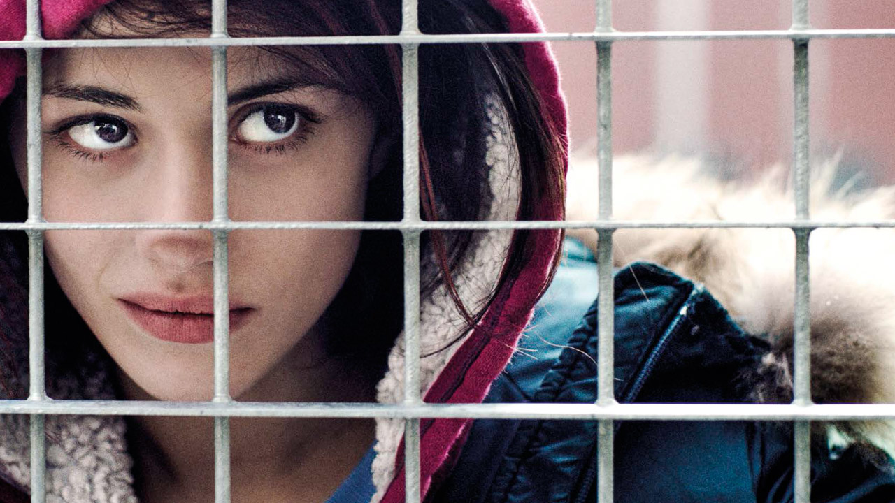
Locandina:
pad.mymovies.it/filmclub/2016/04/067/coverlg_home.jpg
variety.com/wp-content/uploads/2016/05/fiore_06.jpg?w=100...
www.nonsolocinema.com/wp/wp-content/uploads/2016/05/MG_76...
amnc.it/wp-content/uploads/2023/11/perdialogocarcere_post...
www.italyformovies.com/film-serie-tv-games/detail/56/fiore
----------------------------------------------------------
click to activate the small icon of slideshow: the small triangle inscribed in the small rectangle, at the top right, in the photostream (it means the monitor);
or…. Press the “L” button to zoom in the image;
clicca sulla piccola icona per attivare lo slideshow: sulla facciata principale del photostream, in alto a destra c'è un piccolo rettangolo (rappresenta il monitor) con dentro un piccolo triangolo nero;
oppure…. premi il tasto “L” per ingrandire l'immagine;
www.worldphoto.org/sony-world-photography-awards/winners-...
www.fotografidigitali.it/gallery/2726/opere-italiane-segn...
………………………………………………………………………
The municipality of Mongiuffi Melia (ME), not far from Taormina, is made up of two villages, Mongiuffi and Melia, separated by a valley, a bridge joins them, they climb up the opposite ridge of two mountains, looking at each other; in this municipality (defined as a "scattered municipality" for not having a single inhabited center), there are two patron saints, San Sebastian for Melia (his float was built with the money collected by Sicilian soldiers sent to the front, to fight in Greece during the Second World War, hoping in this way to receive His intercession to save their lives), and San Leonard di Noblac (or Abbot) for Mongiuffi; but in this municipality there is also the cult of the "Virgin Mary of the Chain", whose sanctuary attracts pilgrims from everywhere. I have made this description to introduce a singular coincidence that not everyone is aware of, and to do this it is necessary to describe the figure of Saint Leonard (a kind of Saint Francis), and that of the Virgin Mary of the Chain, trying to be concise. Saint Leonard was born in Orléans around 496 (and died in Noblac, on November 6 – the feast day – of 545 or 559), and for most of his life (very interesting) he lived as a hermit; one episode of his life in particular I would like to recall, he received from Clovis, king of the Franks, the privilege of being able to free those prisoners, who he believed had been unjustly imprisoned, so from that moment on, he incessantly committed himself to giving freedom to all those prisoners who were reduced to visibly critical conditions. Let us leave this Saint for a moment, the cult of the “Virgin Mary of the Chain”, this name given to the Blessed Virgin, derives from a prodigious event that occurred in Palermo in 1392, known as the “miracle of the chains”. In short, in August 1392 in Palermo, three men for a glaring miscarriage of justice, were sentenced to death by hanging, shortly before going up to the gallows a violent storm broke out, which forced the three unfortunates and the gendarmes to take refuge in the nearby church of Saint Mary of the Port, close to the sea, also called "Churc of the Chain" due to the presence of a chain that, when positioned, prevented the Saracen pirate ships from accessing the inside of the port; in this holy place, the three condemned, were tied with double chains, in the meantime the door of the church was barred, in fact the storm did not seem to stop and in addition night had come, clearly the execution was now postponed to the next day. The three desperate men, in chains, under the gaze of the gendarmes, approached the painting of the Madonna in tears, imploring her to intercede for them, a voice was heard coming from the painting, which reassured them of their new freedom, this while the chains broke, and the door of the little church was thrown open. From then on, the cult of the Virgin Mary of the Chain spread from Palermo throughout Sicily, and even beyond. Now let's get to the coincidences I mentioned before, both Saint Leonard and the Virgin Mary of the Chain (and also Her Child that She holds in Her arms) carry a long chain in their hands, in fact both the Saint and the Blessed Virgin have given freedom to prisoners, furthermore to access Mongiuffi Melia, coming from Letojanni, you have to pass through a tunnel, called "Gallery of Postoleone" dug in the rock in 1916, with bare hands or with pickaxe blows, as explosives could not be used, by 300 Austrian prisoners, during the First World War (and also on this occasion, in Mongiuffi Melia, there are prisoners forced to do forced labor). Finally, a curiosity, very often from the cult of the Virgin Mary of the Chain, comes a singular name, very common in these parts, both in the masculine with the name of "Cateno" and in the feminine "Catena" (to quote a well-known character, the writer Catena Fiorello). Furthermore, if it rains, whatever the religious procession-feast, with the float carried on the shoulders, the float with the saint does not come out, but if the rain arrives during the event, then the event becomes a source of strong psycho-physical stress for the devotee-bearers (not for the devotee-pullers or devotee-pushers...), as the ground made slippery by the rain (or perhaps, worse, by the presence of mud mixed with water) makes the route risky due to the possibility that one, or more, bearers, could slip, with the possible overturning of the float, and easily imaginable consequences.
The photographic story that I present here was created by assembling photographs taken on November 6, 2022, November 6 and 10 of this year 2024; the heart of the celebration-procession is when the priest hangs a large “cuddurra” (donut) on the hand of Sint Leonard, on that occasion small “cuddure” (donuts) are offered to the population (prepared by hand in the days preceding the procession); there are girls wearing a typical monk's habit-like dress, adorning their head with a veil, they belong to the congregation of the "daughters of Mary" (third order Carmelite); at the end of the procession, with the float that has returned to the church, we witness a rite that has the "affective" purpose of keeping it alive, it is done so as not to lose its memory, even if it has not lost its original meaning, what remains is now only a symbolic fact, it is the ritual of "weighing" (in some centers of Sicily, it has maintained its original meaning) a wooden board is placed "in balance" on one of the two beams that are used to carry the float with the Saint on the shoulders, at the two ends a child is placed on one side, and on the other side a sack with grain, filled until the weight of the grain reaches the weight of the child, and that grain will be given as a gift to the Saint, in reality the symbolic aspect of the procedure remains, and the donation is still made to the Saint, but in paper money.
Postscript: Our Lady of the Chain and Saint Leonard freed from chains, these as such, are not only physical, there are also psychic ones, and perhaps they are the worst….
……………………………..
Il comune di Mongiuffi Melia (ME), non molto distante da Taormina, è formato da due borghi, Mongiuffi e Melia, separati da una vallata, un ponte li congiunge, essi si inerpicano sul crinale opposto di due monti, guardandosi l’un l’altro; in questo comune (definito “comune sparso” per non avere un centro abitato unico), si hanno due santi patroni, San Sebastiano per Melia (la sua vara fu costruita con i soldi racimolati dai soldati Siciliani mandati al fronte, a combattere in Grecia durante la seconda guerra mondiale, sperando così facendo di ricevere la Sua intercessione per avere salva la vita), e San Leonardo di Noblac (o Abate) per Mongiuffi; ma in questo comune vi è anche il culto per la “Madonna della Catena”, il cui santuario attira pellegrini da ogni dove. Ho fatto questa descrizione, per introdurre una singolare coincidenza della quale non tutti sono a conoscenza, e per far questo è necessario descrivere la figura di San Leonardo (una specie di San Francesco), e quella della Madonna della Catena, cercando di essere sintetico. San Leonardo nasce ad Orléans nel 496 circa (e morto a Noblac, il 6 novembre – giorno della festa – del 545 o 559), per gran parte della sua vita (interessantissima) visse da eremita; un episodio della sua vita in particolare desidero ricordare, egli riceve da Clodoveo, re dei Franchi, il privilegio di poter rendere liberi quei prigionieri, che egli riteneva fossero stati incarcerati ingiustamente, egli così, da quel momento, si impegna incessantemente a dare la libertà a tutti quei prigionieri che erano ridotti in condizioni visibilmente critiche. Lasciamo per un attimo questo Santo, il culto della “Madonna della Catena”, questo nome dato alla Beata Vergine, deriva da un evento prodigioso avvenuto a Palermo nel 1392, conosciuto come “miracolo delle catene”. In breve, nell’agosto del 1392 a Palermo, tre uomini per un eclatante errore giudiziario, furono condannati a morte per impiccagione, poco prima di salire sul patibolo si scatenò un violento temporale, che costrinse i tre malcapitati ed i gendarmi a riparare nella vicina chiesa di S. Maria del Porto, a ridosso del mare, detta anche “Chiesa della Catena” per la presenza di una catena che, quando posizionata, impediva alle navi pirata Saracene di accedere all’interno del porto; in questo luogo santo, i tre condannati, furono legati con doppie catene, nel mentre la porta della chiesa veniva sbarrata, infatti il temporale non accennava a smettere ed in più era subentrata la notte, chiaramente l’esecuzione era oramai rimandata al giorno dopo. I tre disperati, in catene, sotto lo sguardo dei gendarmi, si avvicinarono in lacrime al quadro della Madonna implorandola di intercedere per loro, dal quadro si udì provenire una voce, che li rassicurava sulla sopraggiunta libertà, questo mentre le catene si spezzavano, e la porta della chiesetta si spalancava. Da allora il culto per la Madonna della Catena si diffuse da Palermo in tutta la Sicilia, ed anche oltre. Veniamo adesso alle coincidenze di cui accennavo prima, sia San Leonardo che la Madonna della Catena (ed anche il suo Bimbo che regge in braccio) recano in mano una lunga catena, infatti sia San Leonardo che la Beata Vergine hanno dato la liberà a dei prigionieri, inoltre per accedere a Mongiuffi Melia, provenendo da Letojanni, si deve passare necessariamente da una galleria, chiamata “Galleria di Postoleone” scavata nel 1916 nella roccia, a mani nude o con colpi di piccone, in quanto non si poteva usare l’esplosivo, da parte di 300 prigionieri austriaci, durante la prima guerra mondiale (ed anche in questa occasione, a Mongiuffi Melia, si ha la presenza di prigionieri costretti ai lavori forzati). Infine una curiosità, molto spesso dal culto della Madonna della Catena, proviene un singolare nome, molto comune da queste parti, sia al maschile col nome di “Cateno” che al femminile, “Catena” (per citare un personaggio noto, la scrittrice Catena Fiorello). Inoltre, se piove, qualsiasi sia la processione-festa religiosa, con la vara portata in spalla, la vara col santo non esce, se invece la pioggia arriva durante la manifestazione, allora l’evento acquista per i devoti-portatori (non per i devoti-tiratori o devoti-spingitori…) un motivo di forte stress psico-fisico, in quanto il terreno reso scivoloso dalla pioggia (o magari, peggio, dalla presenza di fango misto ad acqua) rende rischioso il percorso per la possibilità che uno, o più portatori, possano scivolare, con il possibile ribaltamento della vara, e conseguenze facilmente immaginabili.
Il racconto fotografico che qui presento, è stato realizzato assemblando fotografie fatte il 6 novembre del 2022, il 6 ed il 10 novembre di quest’anno 2024; il fulcro della festa-processione è quando il sacerdote appende una grande cuddurra (ciambella) sulla mano di San Leonardo, in quella occasione piccole cuddure vengono offerte alla popolazione (preparate ed intrecciate a mano nei giorni precedenti la processione); sono presenti delle ragazze che indossano un tipico vestito “tipo saio di monaco”, adornando il capo con un velo, appartengono alla congregazione delle “figlie di Maria” (terz’ordine carmelitano); alla fine della processione, con la vara che ha fatto rientro in chiesa, si assiste ad un rito che ha lo scopo “affettivo” di tenerlo in vita, viene fatto per non disperderne la memoria, pur non avendo perso il suo significato originario, quel che resta è oramai solamente un fatto simbolico, è il rito della “pesatura” (in alcuni centri della Sicilia, esso ha mantenuto il suo significato originario) un asse di legno viene messo “in equilibrio” su di una delle due travi che servono a portare in spalla la vara col Santo, alle due estremità si pongono da un lato un bimbo/a, e dall’altro lato un sacco con del grano, riempito fino a quando il peso del grano raggiungerà il peso del bimbo/a, e quel grano verrà dato in dono al Santo, in realtà resta l’aspetto simbolico della procedura, la donazione viene ugualmente fatta al Santo, ma in cartamoneta.
P.S. La Madonna della Catena e San Leonardo liberavano dalle catene, queste in quanto tali, non sono solo fisiche, ci sono anche quelle psichiche, e forse sono le peggiori….
……………………………………………………………….
Whenever possible, Stormtrooper Bruce tries to make the best of the weekends. That includes having the guys over when they’re off duty, and supplying them with movie marathons, nonstop dinner, desserts and snacks, and of course, cooler after cooler of cold ones! Unfortunately, not all weekends are created equal.
STB: OK, guys, before you sit down, we have a slight problem with tonight’s events, which I need to explain. If you decide to leave, I’ll completely understand. No harm, no foul. We’ll just reconvene next week, and those of us, who still have them, can cross our fingers that next week the problem will be corrected.
TK-432: Dude! Is that any way to greet us? We’re your best buds, your Bro’s. How dare you suggest we may not have all our fingers. We’re the best in our units. We’re the few who actually know how to use our weapons properly!
TK-1110: Um, really? I think that was his failed attempt at humor, to lighten up the mood before he spills the beans about this supposed “slight problem” that’ll be a dealbreaker for tonight’s Movie Night.
TK-432: Oh, my bad. So, what is it? Vader is stopping by? Or the P, or his nephew? Or all of the above? What?
STB: Um, well… it seems the ship delivering supplies to the Mess Hall ran into a meteor shower, and the compartment containing the brewskies, among other things was compromised, and all its contents blew out into space. So, the only beverages left, stored in a different section of the ship, that I was able to order for tonight were water, milk, and these sodas. So, you see what I opted for.
TK-432: Is that the “slight problem” you thought would make us bail on Movie Night?
Tk-1110: Dude! As they say, no problema! No problem. Actually, it’s kind of a refreshing change of pace. Who knows, we might even remember some of tonight for a change.
STB: Now you’re the one making jokes. But, are you two serious? You’re actually OK with this unexpected menu change? You guys! You’re the bestest amigos ever!
TK-432: Meteor Schmeteor, it’s all good! Your supply chain hick-up was out of your control. These things happen. Let’s get this Movie Night started!
________________________________________
Viewing Large is always fun. Just click on the image.
"TV in Brazil"
Simply Red will be performing live on the Domingão do Faustão show on TV Globo this evening. More on the show here. It may be possible to view the performance online here afterwards.
-----
enton,
sou fan dessa porra CONFESSO!!!
é a minha vergonha mais fudida....
desde muito pequena eu gosto desse cara. heheh
quando vi stars apaixonei completamente pela musica, estilo pelo SER TODO.
E agora que ele ta velho e caido e já com 25 anos de banda nas costas Mick anunciou em 2008 qua a banda não passará de 2009!!! GENTE, ON LAST SHOW IN BRAZIL SAN PAOLO EU TINHA QUE VER NÉ?!
Ficarei fora durante esse dias fazendo as correrias para o show e para alguns trampos...
prometo postar fotos!
bjooos gatinhas do meu cuore!
Má
Doing a lttle house cleaning when I came across this shot, one of many taken at Websters Falls last year. This taken as close the edge as I wanted to get as this is the start of a very long drop. These falls are just short of the height of Niagara Falls.
View Large, click photo or type L
"...suffered from the position to which by neglect of nature which, in instituting the division of bodies, did not think to make possible the interpenetration of souls...", Mechanical pencil on drawing paper, 12.5inx9.5in, 2020
It is quite possible that SJ-1 continued north to White River Junction light, as I earlier noted that they brought the entire train from Springfield into the yard here in East Deerfield. But, I do see cars well back, so I'm not sure what the plan was, this day. Sometimes, a switcher from the yard would bring them a cut of cars. The units are on the north/south CT River line, the two closer tracks are the east/west B&M main, which eventually passes under the north/south line, and curves into East Deerfield yard. For the same lead locomotive, this means that the power took the southern lead backwards, got onto the CT River main and headed up to my position. Perhaps they are now backing to pick up the cars left on the east/west tracks, left by a switcher, and then head north to Bellows Falls, and later, White River Junction. Late September 1976
James's flamingos abound in the area. Also it is possible to find Andean and Chilean flamingos, but in a minor quantity.
***
Laguna Colorada (Red Lagoon) is a shallow salt lake in the southwest of the altiplano of Bolivia, within Eduardo Avaroa Andean Fauna National Reserve and close to the border with Chile.
The lake contains borax islands, whose white color contrasts with the reddish color of its waters, which is caused by red sediments and pigmentation of some algae.
Laguna Colorada is part of the Los Lípez (formerly Laguna Colorada) Ramsar wetland. It was listed as a "Ramsar Wetland of International Importance" in 1990.
On, July 13, 2009 the site was expanded from 513.18 to 14,277.17 km2 (5,512.45 sq mi) to include the surrounding high Andean endorheic, hypersaline and brackish lakes and associated wetlands (known as bofedales).
Whenever possible I avoid horizontal landscapes. Like a horse wearing blinkers, they fail to recreate what the viewer experiences. But there are a few times when I can't resist. In remote Sequoia National Park near Kaweah Gap, the striped and incised cliff on Eagle Scout Peak (12,040) on the far side of Precipice Lake (10,380) has become known as "Ansel Adam's Wall ", after his well-known extracted landscape of the cliff with melting ice on the lake. Although more than twenty miles from the Crescent Meadows trailhead (6,600 ft.), the rather flat and very scenic traverse on the High Sierra Trail makes access easier than other remote Sierra locations.
“Anything’s possible if you’ve got enough nerve.” —J.K. Rowling
Odette Lake of Tears, posing in front of artist’s paper from Somerset Studio magazine.
The awful window coverings, peeling paint, crude foundation, decaying and dysfunctional wooden step and assorted hideous decorative items suggest man cave.
Cloe: That's so awesome. Your dad's an adventurer. My dad doesn't do anything cool like that. He just wants to go to church or read.
Frankie: Your dad's so nice, Cloe. And, he's your dad. I love my dad. He's a better adopted dad than most real dads. But I always wonder about my past.
Cloe: Your life is so cool, Frankie. And I would kill to have your legs.
Frankie: For all I know, someone was killed for me to have these legs.
Cloe ... Oh, I didn't mean...
Kim Possible: Guys! There's a warp hole opening. And it looks huge.
Hopefully not. While I was taking another shot after this one, the last shot of the day before going home, a small wave came, and I left the camera on tripod and retreated back. Then I saw the tripod fell into the waves, and I rushed to the water to pick up the camera, but there was already blue error light on. Fortunately, the flash and lens are still working, the pictures on memory card are fine. I sent the camera in for repair.
Ursula is a member of the Eastern Counties Heavy Horse Association (ECHHA) Display Team that was displaying at the 2022 Strumpshaw Steam Engine Rally.
Originating from the Brabant region of Belgium, it is theoretically possible that the Belgian may have had ancestors that were 'destriers' (war horses) in the Middle Ages, although no independent evidence supports this claim. The foundation stock for the Belgian was originally known as the Brabant, other names for essentially the same breed include the Cheval de trait Belge, Brabançon, and Belgisch Trekpaard. Until the 1940's, the Belgian and the Brabant were essentially the same breed but following World War II the Brabant in was selectively bred to be thicker bodied and heavier, while the Belgian was bred to be somewhat taller and lighter bodied.
A male Belgian stands between 16.2 to 17 hands (66 to 70 in. - 167 to 178 cm) and a female stands 15.2 to 16 hands (62 to 66 - 157 to 167 cm). On average a male Belgian grows to weigh slightly over 2,000 lb. (900 kg) with a female weighing 1,550 lb. (700 kg).
The breed is compact and muscular, powerful and strong. The head is relatively small and well shaped, its body is heavy, it's back is broad and the legs are short and strong.
Belgian horses are intelligence and they are also known for being docile, kind, quiet, and willing to please. They are hard working animals that are loyal, easy to handle, and friendly to their human companions.
The number of Belgian horses declined after World War II, thanks to industrialization and mechanization, but their numbers have been increasing in modern times. These animals are still often utilized for draught work that includes pulling carts, carriages or sleighs as well as logging. The horse is also suitable for riding.
A moment changes everything
When a moment, it changes everything
The summer sky is blushing pink
The heart is running out of sync (?)
Could this just be the day, I think
When anything is possible...
~David Gray
Sanchez Street crossing Hancock Street here is so steep it wasn't possible to make a flat intersection.
My submission for the Recording Images group. This week’s theme is “strangers”. I don’t think I’ve done a great job of this, but it’s been one of those weeks where I didn’t get out to see enough people! Anyway, this will have to do for now.
Have a great Thursday.
Better on black - hit "L"
~~~~~~~~~~~~~~~~~~~~~~~~~~~~~~~~~~~~~~~~~~~~~~~~~
All your comments and favourites are very much appreciated.
© Wan Mekwi 2012. Do not use without permission
This is separate from the house and other outbuildings on the property.
I am not sure whether this is a man cave but it is rather shabby and, more important, has that bad-ass face on the gable.
I several more possible man caves in queue for posting.
I was asked a question about man caves in one of my recent posts. Here a Wiki post on the concept. I generally agree with most of what I read but know that there are areas of controversy. I am not interested in man caves that are in rooms of the house.
en.wikipedia.org/wiki/Man_cave#:~:text=The%20first%20know....
The north side of the building is pretty featureless, and nay very bonnie! There are various blocked-up windows in the 17th century half, including a large and probably original one a first floor level, with a relieving arch above it, to keep the weight of the wall above off the lintel. (It has been suggested that this was actually a door, reached, as was often the case, by a ladder.)
In 1982 it was still possible to “bunk round” depots and on 9th May 1982 I am doing just that my local depot, Toton. Amongst a line of Class 08 shunters stabled in the yard is 08021.
Locomotive History
08021 was originally 13029 and then later under the 1957 renumbering scheme D3029. It was built at Derby Works and entered traffic October 1953. For the first half of its career it was based in the West Midlands with its first Allocation being Tyseley. In August 1960 it transferred to Stourbridge Junction and then to Bescot when Stourbridge closed in April 1967. It transferred to Toton in July 1968 (one of the Class 10 replacements) where it remained until withdrawn in December 1986. Following withdrawal it has entered preservation and is the resident shunter at the Tyseley Locomotive Works, its first home in 1953.
Toton Diesel Shunter Allocation – 1967/68
In the 1950’s and early 1960’s British Railways built/purchased around two thousand diesel shunters which replaced considerably more steam shunting engines. By the middle of the 1960’s changing operating methods and the reducing size of the network lead to a surplus of diesel shunting locomotives. Withdrawal commenced with the classes containing only a few locomotives however as the surplus grew a start was made on the larger less reliable classes.
I first started visiting Toton MPD in the summer of 1966 and in November 1966 Toton MPD had an allocation of twenty five diesel shunters. Over the next two years this fleet would be totally replaced and was also reduced to fifteen locomotives. The diesel shunter allocation in November 1966 consisted of four types of locomotive:
Class D2/2 - (TOPS class 03) –204bhp diesel mechanical shunter built by Swindon and Doncaster works between 1957 - 1961
Class D3/3 – 350bhp diesel electric shunter (mechanically a class 08) fitted with a Crossley ESNT6 engine and Crompton Parkinson electrical equipment, built by Derby Works in 1955.
Class D3/4 - (TOPS class 10) –350bhp diesel electric shunter (mechanically a class 08) fitted with a Blackstone ER6T engine and GEC electrical equipment built by Darlington and Doncaster Works between 1953 and 1962.
Class D3/8 (TOPS class 11) - 350bhp diesel electric shunter (the prototype for the class 08) fitted with an English Electric 6KT engine and English Electric electrical equipment built at Derby Works between 1945 and 1952.
Those allocated were as follows
Class D2/2 (class03) – D2116
Class D3/3 – D3117 – D3126 (complete class)
Class D3/4 (class 10) – D3476/93/95/97-99, D3500-02, D3632
Class D3/8 (class 11) – 12038/55/63/82
Of note is D2116 which had officially arrived in September 1966 but despite regular visits at this time I can not personally ever recall seeing it at Toton.
The first change was the transfer of the four D3/8 locomotives in November/December 1966 (with 12038 going to Speke Junction and 12055/63/82 going to Crewe) and the withdrawal of four of the class D3/3 locomotives D3122-24/26. These were replaced by eight class D3/4 locomotives, D3446/47/48/49/50 from Peterborough, D3452/75 from Tinsley and D3473 from Doncaster.
In April 1967 a further class D3/3 locomotive was withdrawn D3121 and in July 1967 the remaining five class D3/3 locomotives D3117-20/25 were withdrawn.
In September 1967 the class D2/2 locomotive D2116 was transferred to Barrow
In November 1967 the first two class D3/2 (TOPS class 08) locomotives D3400/02 arrived from Cardiff
In December 1967 two further class D3/2 locomotives D3050 and D3997 arrived from Willesden and Bescot respectively as did two class D3/4 locomotives D3442/89 from Colwick however a start was made on withdrawing the D3/4 locomotives with the withdrawal of D3449.
So the situation at the end of 1967 was an allocation of twenty five diesel shunters (the same total as November 1966) of only two types:
Class D3/2 (class 08) - D3050, D3400/02, D3997
Class D3/4 (class 10) – D3442/46-50/52/73/75/76/89/93/95/97-99, D3500-02, D3632.
This was to be the high point as over the next nine months twenty of the class D3/4 locomotives were withdrawn with the remaining one D3497 being transferred to Colwick. As replacements eleven class D3/2 locomotives arrived, D3021/25/29/34/36/37 from Bescot, D3026 from Tyseley, D3039 from Derby and D3340/45/90 from the Scottish Region (Thornton Junction, Dunfermline and Eastfield respectively). One class D3/4 D3490 also arrived from Colwick but was withdrawn one month later.
So by September 1968 in less than two years the Toton diesel shunter allocation was totally replaced initially by additional class D3/4 (class 10) locomotives which were in turn quickly withdrawn and replaced by class D3/2 (class 08) locomotives. Also in the first nine months of 1968 the fleet was significantly reduced, being reduced from twenty five to fifteen locomotives as follows.
D3/2 (class 08) – D3021/25/26/29/34/36/37/39/50, D3340/45/90, D3400/02, D3997
As a young spotter this meant plenty of new “cops” on a regular basis.
Praktica LTL, Boots Colourslide 5
Full Moon. Rises at sunset, high in the sky around midnight. Visible all night.
This marks the first time that accurate shadows at this level of detail are possible in such a computer simulation. The shadows are based on the global elevation map being developed from measurements by the Lunar Orbiter Laser Altimeter (LOLA) aboard the Lunar Reconnaissance Orbiter (LRO). LOLA has already taken more than 10 times as many elevation measurements as all previous missions combined.
The Moon always keeps the same face to us, but not exactly the same face. Because of the tilt and shape of its orbit, we see the Moon from slightly different angles over the course of a month. When a month is compressed into 12 seconds, as it is in this animation, our changing view of the Moon makes it look like it's wobbling. This wobble is called libration.
The word comes from the Latin for "balance scale" (as does the name of the zodiac constellation Libra) and refers to the way such a scale tips up and down on alternating sides. The sub-Earth point gives the amount of libration in longitude and latitude. The sub-Earth point is also the apparent center of the Moon's disk and the location on the Moon where the Earth is directly overhead.
The Moon is subject to other motions as well. It appears to roll back and forth around the sub-Earth point. The roll angle is given by the position angle of the axis, which is the angle of the Moon's north pole relative to celestial north. The Moon also approaches and recedes from us, appearing to grow and shrink. The two extremes, called perigee (near) and apogee (far), differ by more than 10%.
The most noticed monthly variation in the Moon's appearance is the cycle of phases, caused by the changing angle of the Sun as the Moon orbits the Earth. The cycle begins with the waxing (growing) crescent Moon visible in the west just after sunset. By first quarter, the Moon is high in the sky at sunset and sets around midnight. The full Moon rises at sunset and is high in the sky at midnight. The third quarter Moon is often surprisingly conspicuous in the daylit western sky long after sunrise.
Celestial north is up in these images, corresponding to the view from the northern hemisphere. The descriptions of the print resolution stills also assume a northern hemisphere orientation. To adjust for southern hemisphere views, rotate the images 180 degrees, and substitute "north" for "south" in the descriptions.
Credit: NASA/Goddard Space Flight Center Scientific Visualization Studio
NASA Goddard Space Flight Center enables NASA’s mission through four scientific endeavors: Earth Science, Heliophysics, Solar System Exploration, and Astrophysics. Goddard plays a leading role in NASA’s accomplishments by contributing compelling scientific knowledge to advance the Agency’s mission.
Follow us on Twitter
Join us on Facebook
Find us on Instagram