View allAll Photos Tagged maps
www.geog.ntu.edu.tw/cml/ca_room/map_his/east/taiwan.htm
1845年英國海軍部正式發行的海圖,根據 Collins 船長
等的實地測量,而得以正確繪出台灣東岸的海岸線。
A bit of artistic licence is going on.
The street is made to appear much wider than it actually was.
This was usual.
The map is dated 1823-24.
Great Charlotte Street is the first street on the right,
Cases Street is the first street at the Church Street end.
The shops in Church Street are quite tall being 5 stories high -
of course this is before elevators were invented.
The churches from left to right are:
St Peter's in Church Street;
St Georges in Derby Square, Lord Street;
and St Nicholas, the only one which survives.
View large to read the caption.
2560sqm, 878 land capacity, Laka. Protected navigable lot for rent in volcanic islands & Linden Waterfalls. Beautiful home furnished and landscaped. Waterfall, and enough water for medium sized boat. Lot is for sale or rent.
Collection of old maps scanned from books and other print sources Download them all at Photoshop Roadmap.
Ukraine is located in Eastern Europe, bordering the Black Sea, between Poland, Romania, and Moldova in the west and Russia in the east, comprising of 603,700 sq km. It has a population of 47,425,336 (2005). Major environmental concerns are: inadequate supplies of potable water; air and water pollution; deforestation; radiation contamination in the northeast from 1986 accident at Chernobyl Nuclear Power Plant.
For any form of publication, please include the link to this page:
This photo has been graciously provided to be used in the GRID-Arendal resources library by: Philippe Rekacewicz, Emmanuelle Bournay, UNEP/GRID-Arendal
Where in Winchester is this map displayed? It can be found somewhere in the area shown on the map, as can all the photos I've posted to GWW so far.
weihner plan of wroclaw from 1562, the medieval and renaissance city. Collection of the University Library of Wroclaw.
Map showing Angola and surrounding countries with international borders, the national capital, major cities, main roads, and railroads.
BAe ATP msn2037 de 1991
West Air Sweden (19/11/2007 - 12/2011) et (31/08/2015 - ...)
aéroport Marseille Provence
23/06/2011
G-11-037, G-BTNK, N860AW, G-BTNK, G-CORP, SE-MAP, LX-WAE, SE-MAP.
By Andrés Bentancourt
EyeEm | 500px | Flickr | Instagram | Tumblr | Twitter | DeviantArt | Pinterest | Facebook | Contact email
This map goes along with this post, which was an attempt to inventory all the independant shops and businesses in my area of central Austin.
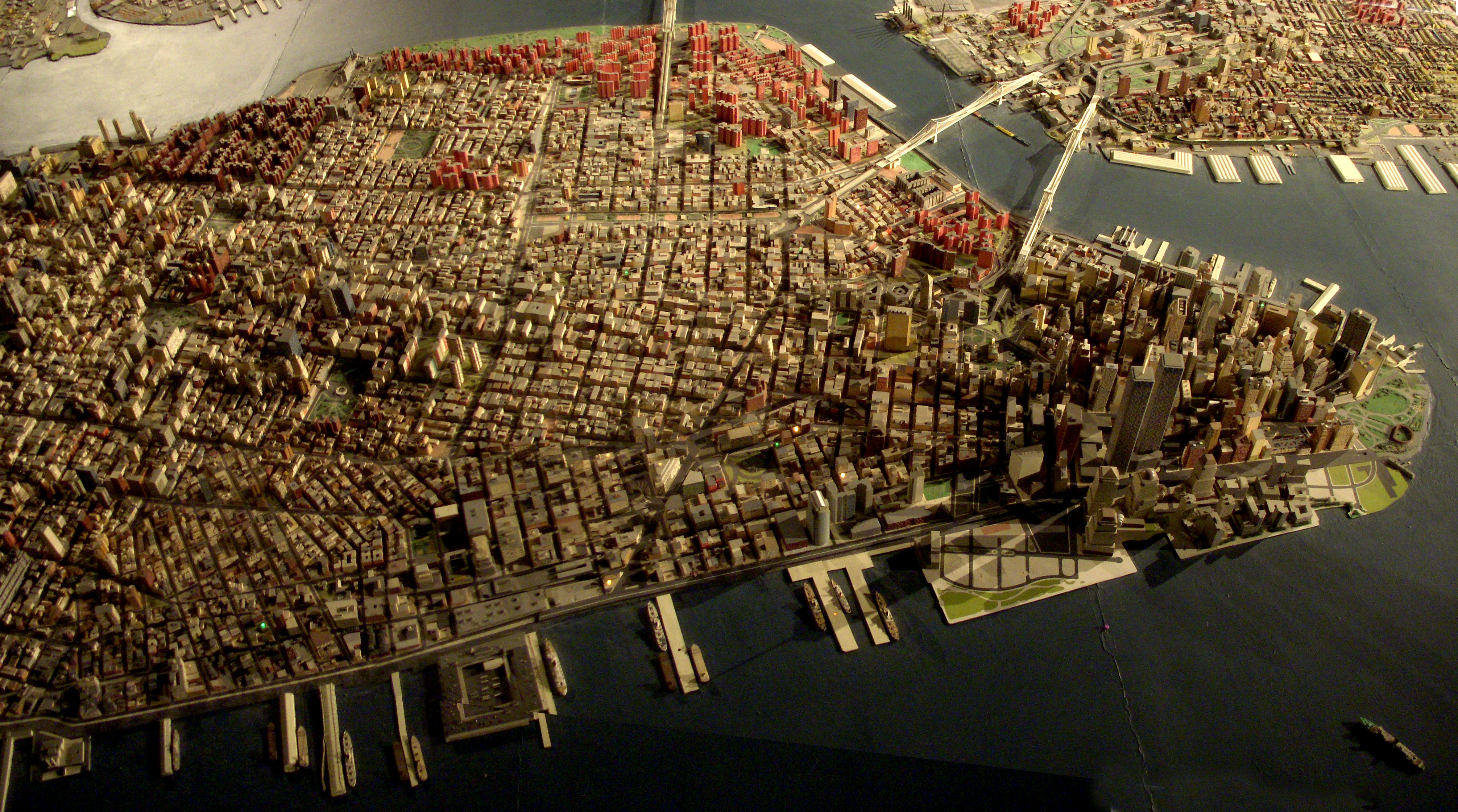
Giant map of NYC in the Queens Museum of Art. I uploaded this full size panorama of downtown Manhattan so my neighbors can have fun finding their own apartment building.
Robert Moses had 'The Panorama of the City of New York' built for the 1964 World's Fair, but it has been updated, and supposedly has every building built before 1992. Originally you flew over it on a simulate helicopter ride. Now there is a ramp that spirals around it from the first to second floor of the museum.
Left & Centre: Modern Pictorial World Atlas c1939
Right: Encyclopaedia Brittanica 10th Edition Maps c1897
Now, I want 60044. And it is my intention to be out for it on the Wensleydale this weekend.
It's a wee bit of a trek from here. But Windows maps seemingly turns a trek into an epic. This was seriously offered up as an option.
Toodle pip. Got a boat to be on...
12 July 2017
This is a close up of an old map I carry around while exploring Honolulu's Chinatown.
I've linked a few of my pinhole photographs taken in this area [click on notes in map above].
More photos in my Chinatown series.
Map courtesy: University of Hawaiʻi at Mānoa Library, Map Collection
Sanborn Fire Insurance Map, Honolulu, 1914, sheet 37 [cropped].
On another sunny spring day I took a cross-country walk from home to Lane End skirting the north side of town via Four Ashes, Hughenden Manor, Downley, West Wycombe and Toweridge catching the old boys bus back home, total distance about 15.0km
It's on Strava so it must be true!
.
Walkabout 2025 album ... flic.kr/s/aHBqjBXsk2
Description: Map of Massachusetts with political boundaries and topographic relief.
Note: Map with tactile elements for use by the blind.
Creator: Perkins School for the Blind
Date: 1908
Format: map
Digital Identifier: MAPS-00032
Rights: Samuel P. Hayes Research Library, Perkins School for the Blind, Watertown, MA