View allAll Photos Tagged establishment
One of the most iconic signs of spring in the United States is the return and territory establishment of male Red-winged Blackbirds in cattail marshes. Males travel around their territories singing from sentinel perches to establish territories and attract mates. This male was particularly cooperative and tolerated my presence while he displayed repeatedly.
The Heugh Lighthouse is a navigation light on The Headland in Hartlepool, in north-east England. The current lighthouse dates from 1927; it is owned and operated by PD Ports. It is claimed that its early-Victorian predecessor was the first lighthouse in the world reliably lit by gas.
History
Following the establishment of the Hartlepool Dock & Railway company, West Hartlepool quickly grew into a sizeable coal port on the Durham coast. In 1844, mariners tasked with navigating their way into the new docks had expressed concern about the inadequate provision of lights on this dangerous stretch of rocky coastline, and in 1846 the Corporation of Trinity House instructed the harbour authority to make necessary provision.
1847–1915: the first light on The Heugh
A lighthouse was promptly built in sandstone, at a cost of £3,200: a tapering cylindrical tower 73 ft (22 m) high. It was first lit on 1 October 1847, fuelled by natural gas from one of the local coal mines. The lens (a first-order fixed catadioptric optic) was the last to be manufactured by the pioneering Newcastle firm of Cookson & Co., following its takeover by Robert W. Swinburne. The main light was visible for 18 miles out to sea. A subsidiary (red) light was shown from a window lower down on the tower 'from half flood to half ebb' to signal the state of the tide (during the day a red spherical day mark was displayed in place of the red light).
In December 1895 the characteristic of the main light was changed from fixed to occulting (going dark for one second every five seconds).
The old light's demise came about as an indirect result of the German raid on Hartlepool in December 1914. The lighthouse itself was unscathed (though several nearby buildings received severe damage), but it was realised that the tower obstructed the line of fire of the defensive guns of the Headland batteries. It was therefore dismantled in 1915.
1915–1927: temporary light on the Town Moor
As a temporary measure, the light, lantern and lens from the Heugh Lighthouse were instead mounted on a wooden lattice structure on the nearby town moor. They remained here until the erection of the new Heugh light in 1927. When the structure was dismantled, the optic (lenses) and light array were saved; they are now on display in the Museum of Hartlepool.
1927 onwards: the current lighthouse
The current lighthouse, of a prefabricated steel construction, is a white-painted cylindrical tower, 54 ft (16 m) high. Built not far from the site of the first lighthouse (though without obstructing the line of fire of the guns) it was designed to be able to be dismantled in the event of war, so as not to provide a landmark for enemy gunsights. It was, from the start, electrically-powered and fully automated: the light was switched on and off at sunset and sunrise automatically, by a patent sun valve; mains electricity was used, but as a backup a petrol generator was provided which was automatically engaged in the event of a power failure; and in the event of the bulb failing an automatic lamp changer would bring a spare bulb into operation (this change being signalled by a warning light mounted on the shore side of the lighthouse). The light displayed two white flashes every ten seconds.
Present-day operation
The lighthouse is still in use today, under the management of the local port authority. It displays a white light, flashing twice every ten seconds. One of the adjacent buildings housed a nautophone fog signal, which used to sound three 3-second blasts every 45 seconds. The other building houses radio equipment for HM Coastguard.
Other nearby lighthouses
Nearby Seaton Carew had a pair of lighthouses for many years. They were decommissioned in the late nineteenth century; years later one of the two was re-erected in Hartlepool Marina as a mariners' memorial.
South Gare Lighthouse stands on a pierhead at the opposite end of the bay to the Heugh, marking the southern approach to the River Tees.
Just south-west of the Heugh, the Old or 'Pilots' Pier has been marked by a lighthouse since 1836. The present wooden structure (painted white with two narrow red horizontal stripes) dates from 1899; the lantern is strikingly topped by a rotating radar. It displays a green light (one flash every three seconds) with a white sector indicating the deep-water channel into the Old Harbour and Hartlepool Docks.
Headland is a civil parish in the Borough of Hartlepool, County Durham, England. The parish covers the old part of Hartlepool and nearby villages.
History
The Heugh Battery, one of three constructed to protect the port of Hartlepool in 1860, is located in the area along with a museum.
The area made national headlines in July 1994 in connection with the murder of Rosie Palmer, a local toddler.
On 19 March 2002 the Time Team searched for an Anglo-Saxon monastery.
Hartlepool is a seaside and port town in County Durham, England. It is governed by a unitary authority borough named after the town. The borough is part of the devolved Tees Valley area. With an estimated population of 87,995, it is the second-largest settlement (after Darlington) in County Durham.
The old town was founded in the 7th century, around the monastery of Hartlepool Abbey on a headland. As the village grew into a town in the Middle Ages, its harbour served as the County Palatine of Durham's official port. The new town of West Hartlepool was created in 1835 after a new port was built and railway links from the South Durham coal fields (to the west) and from Stockton-on-Tees (to the south) were created. A parliamentary constituency covering both the old town and West Hartlepool was created in 1867 called The Hartlepools. The two towns were formally merged into a single borough called Hartlepool in 1967. Following the merger, the name of the constituency was changed from The Hartlepools to just Hartlepool in 1974. The modern town centre and main railway station are both at what was West Hartlepool; the old town is now generally known as the Headland.
Industrialisation in northern England and the start of a shipbuilding industry in the later part of the 19th century meant it was a target for the Imperial German Navy at the beginning of the First World War. A bombardment of 1,150 shells on 16 December 1914 resulted in the death of 117 people in the town. A severe decline in heavy industries and shipbuilding following the Second World War caused periods of high unemployment until the 1990s when major investment projects and the redevelopment of the docks area into a marina saw a rise in the town's prospects. The town also has a seaside resort called Seaton Carew.
History
The place name derives from Old English heort ("hart"), referring to stags seen, and pōl (pool), a pool of drinking water which they were known to use. Records of the place-name from early sources confirm this:
649: Heretu, or Hereteu.
1017: Herterpol, or Hertelpolle.
1182: Hierdepol.
Town on the heugh
A Northumbrian settlement developed in the 7th century around an abbey founded in 640 by Saint Aidan (an Irish and Christian priest) upon a headland overlooking a natural harbour and the North Sea. The monastery became powerful under St Hilda, who served as its abbess from 649 to 657. The 8th-century Northumbrian chronicler Bede referred to the spot on which today's town is sited as "the place where deer come to drink", and in this period the Headland was named by the Angles as Heruteu (Stag Island). Archaeological evidence has been found below the current high tide mark that indicates that an ancient post-glacial forest by the sea existed in the area at the time.
The Abbey fell into decline in the early 8th century, and it was probably destroyed during a sea raid by Vikings on the settlement in the 9th century. In March 2000, the archaeological investigation television programme Time Team located the foundations of the lost monastery in the grounds of St Hilda's Church. In the early 11th century, the name had evolved into Herterpol.
Hartness
Normans and for centuries known as the Jewel of Herterpol.
During the Norman Conquest, the De Brus family gained over-lordship of the land surrounding Hartlepool. William the Conqueror subsequently ordered the construction of Durham Castle, and the villages under their rule were mentioned in records in 1153 when Robert de Brus, 1st Lord of Annandale became Lord of Hartness. The town's first charter was received before 1185, for which it gained its first mayor, an annual two-week fair and a weekly market. The Norman Conquest affected the settlement's name to form the Middle English Hart-le-pool ("The Pool of the Stags").
By the Middle Ages, Hartlepool was growing into an important (though still small) market town. One of the reasons for its escalating wealth was that its harbour was serving as the official port of the County Palatine of Durham. The main industry of the town at this time was fishing, and Hartlepool in this period established itself as one of the primary ports upon England's Eastern coast.
In 1306, Robert the Bruce was crowned King of Scotland, and became the last Lord of Hartness. Angered, King Edward I confiscated the title to Hartlepool, and began to improve the town's military defences in expectation of war. In 1315, before they were completed, a Scottish army under Sir James Douglas attacked, captured and looted the town.
In the late 15th century, a pier was constructed to assist in the harbour's workload.
Garrison
Hartlepool was once again militarily occupied by a Scottish incursion, this time in alliance with the Parliamentary Army during the English Civil War, which after 18 months was relieved by an English Parliamentarian garrison.
In 1795, Hartlepool artillery emplacements and defences were constructed in the town as a defensive measure against the threat of French attack from seaborne Napoleonic forces. During the Crimean War, two coastal batteries were constructed close together in the town to guard against the threat of seaborne attacks from the Imperial Russian Navy. They were entitled the Lighthouse Battery (1855) and the Heugh Battery (1859).
Hartlepool in the 18th century became known as a town with medicinal springs, particularly the Chalybeate Spa near the Westgate. The poet Thomas Gray visited the town in July 1765 to "take the waters", and wrote to his friend William Mason:
I have been for two days to taste the water, and do assure you that nothing could be salter and bitterer and nastier and better for you... I am delighted with the place; there are the finest walks and rocks and caverns.
A few weeks later, he wrote in greater detail to James Brown:
The rocks, the sea and the weather there more than made up to me the want of bread and the want of water, two capital defects, but of which I learned from the inhabitants not to be sensible. They live on the refuse of their own fish-market, with a few potatoes, and a reasonable quantity of Geneva [gin] six days in the week, and I have nowhere seen a taller, more robust or healthy race: every house full of ruddy broad-faced children. Nobody dies but of drowning or old-age: nobody poor but from drunkenness or mere laziness.
Town by the strand
By the early nineteenth century, Hartlepool was still a small town of around 900 people, with a declining port. In 1823, the council and Board of Trade decided that the town needed new industry, so the decision was made to propose a new railway to make Hartlepool a coal port, shipping out minerals from the Durham coalfield. It was in this endeavour that Isambard Kingdom Brunel visited the town in December 1831, and wrote: "A curiously isolated old fishing town – a remarkably fine race of men. Went to the top of the church tower for a view."
But the plan faced local competition from new docks. 25 kilometres (16 mi) to the north, the Marquis of Londonderry had approved the creation of the new Seaham Harbour (opened 31 July 1831), while to the south the Clarence Railway connected Stockton-on-Tees and Billingham to a new port at Port Clarence (opened 1833). Further south again, in 1831 the Stockton and Darlington Railway had extended into the new port of Middlesbrough.
The council agreed the formation of the Hartlepool Dock and Railway Company (HD&RCo) to extend the existing port by developing new docks, and link to both local collieries and the developing railway network in the south. In 1833, it was agreed that Christopher Tennant of Yarm establish the HD&RCo, having previously opened the Clarence Railway (CR). Tennant's plan was that the HD&RCo would fund the creation of a new railway, the Stockton and Hartlepool Railway, which would take over the loss-making CR and extended it north to the new dock, thereby linking to the Durham coalfield.
After Tennant died, in 1839, the running of the HD&RCo was taken over by Stockton-on-Tees solicitor, Ralph Ward Jackson. But Jackson became frustrated at the planning restrictions placed on the old Hartlepool dock and surrounding area for access, so bought land which was mainly sand dunes to the south-west, and established West Hartlepool. Because Jackson was so successful at shipping coal from West Hartlepool through his West Hartlepool Dock and Railway Company and, as technology developed, ships grew in size and scale, the new town would eventually dwarf the old town.
The 8-acre (3.2-hectare) West Hartlepool Harbour and Dock opened on 1 June 1847. On 1 June 1852, the 14-acre (5.7-hectare) Jackson Dock opened on the same day that a railway opened connecting West Hartlepool to Leeds, Manchester and Liverpool. This allowed the shipping of coal and wool products eastwards, and the shipping of fresh fish and raw fleeces westwards, enabling another growth spurt in the town. This in turn resulted in the opening of the Swainson Dock on 3 June 1856, named after Ward Jackson's father-in-law. In 1878, the William Gray & Co shipyard in West Hartlepool achieved the distinction of launching the largest tonnage of any shipyard in the world, a feat to be repeated on a number of occasions. By 1881, old Hartlepool's population had grown from 993 to 12,361, but West Hartlepool had a population of 28,000.
Ward Jackson Park
Ward Jackson helped to plan the layout of West Hartlepool and was responsible for the first public buildings. He was also involved in the education and the welfare of the inhabitants. In the end, he was a victim of his own ambition to promote the town: accusations of shady financial dealings, and years of legal battles, left him in near-poverty. He spent the last few years of his life in London, far away from the town he had created.
World Wars
In Hartlepool near Heugh Battery, a plaque in Redheugh Gardens War Memorial "marks the place where the first ...(German shell) struck... (and) the first soldier was killed on British soil by enemy action in the Great War 1914–1918."
The area became heavily industrialised with an ironworks (established in 1838) and shipyards in the docks (established in the 1870s). By 1913, no fewer than 43 ship-owning companies were located in the town, with the responsibility for 236 ships. This made it a key target for Germany in the First World War. One of the first German offensives against Britain was a raid and bombardment by the Imperial German Navy on the morning of 16 December 1914,
Hartlepool was hit with a total of 1150 shells, killing 117 people. Two coastal defence batteries at Hartlepool returned fire, launching 143 shells, and damaging three German ships: SMS Seydlitz, SMS Moltke and SMS Blücher. The Hartlepool engagement lasted roughly 50 minutes, and the coastal artillery defence was supported by the Royal Navy in the form of four destroyers, two light cruisers and a submarine, none of which had any significant impact on the German attackers.
Private Theophilus Jones of the 18th Battalion Durham Light Infantry, who fell as a result of this bombardment, is sometimes described as the first military casualty on British soil by enemy fire. This event (the death of the first soldiers on British soil) is commemorated by the 1921 Redheugh Gardens War Memorial together with a plaque unveiled on the same day (seven years and one day after the East Coast Raid) at the spot on the Headland (the memorial by Philip Bennison illustrates four soldiers on one of four cartouches and the plaque, donated by a member of the public, refers to the 'first soldier' but gives no name). A living history group, the Hartlepool Military Heritage Memorial Society, portray men of that unit for educational and memorial purposes.
Hartlepudlians voluntarily subscribed more money per head to the war effort than any other town in Britain.
On 4 January 1922, a fire starting in a timber yard left 80 people homeless and caused over £1,000,000 of damage. Hartlepool suffered badly in the Great Depression of the 1930s and endured high unemployment.
Unemployment decreased during the Second World War, with shipbuilding and steel-making industries enjoying a renaissance. Most of its output for the war effort were "Empire Ships". German bombers raided the town 43 times, though, compared to the previous war, civilian losses were lighter with 26 deaths recorded by Hartlepool Municipal Borough[19] and 49 by West Hartlepool Borough. During the Second World War, RAF Greatham (also known as RAF West Hartlepool) was located on the South British Steel Corporation Works.
The merge
In 1891, the two towns had a combined population of 64,000. By 1900, the two Hartlepools were, together, one of the three busiest ports in England.
The modern town represents a joining of "Old Hartlepool", locally known as the "Headland", and West Hartlepool. As already mentioned, what was West Hartlepool became the larger town and both were formally unified in 1967. Today the term "West Hartlepool" is rarely heard outside the context of sport, but one of the town's Rugby Union teams still retains the name.
The name of the town's professional football club reflected both boroughs; when it was formed in 1908, following the success of West Hartlepool in winning the FA Amateur Cup in 1905, it was called "Hartlepools United" in the hope of attracting support from both towns. When the boroughs combined in 1967, the club renamed itself "Hartlepool" before re-renaming itself Hartlepool United in the 1970s. Many fans of the club still refer to the team as "Pools"
Fall out
After the war, industry went into a severe decline. Blanchland, the last ship to be constructed in Hartlepool, left the slips in 1961. In 1967, Betty James wrote how "if I had the luck to live anywhere in the North East [of England]...I would live near Hartlepool. If I had the luck". There was a boost to the retail sector in 1970 when Middleton Grange Shopping Centre was opened by Princess Anne, with over 130 new shops including Marks & Spencer and Woolworths.
Before the shopping centre was opened, the old town centre was located around Lynn Street, but most of the shops and the market had moved to a new shopping centre by 1974. Most of Lynn Street had by then been demolished to make way for a new housing estate. Only the north end of the street remains, now called Lynn Street North. This is where the Hartlepool Borough Council depot was based (alongside the Focus DIY store) until it moved to the marina in August 2006.
In 1977, the British Steel Corporation announced the closure of its Hartlepool steelworks with the loss of 1500 jobs. In the 1980s, the area was afflicted with extremely high levels of unemployment, at its peak consisting of 30 per cent of the town's working-age population, the highest in the United Kingdom. 630 jobs at British Steel were lost in 1983, and a total of 10,000 jobs were lost from the town in the economic de-industrialization of England's former Northern manufacturing heartlands. Between 1983 and 1999, the town lacked a cinema and areas of it became afflicted with the societal hallmarks of endemic economic poverty: urban decay, high crime levels, drug and alcohol dependency being prevalent.
Rise and the future
Docks near the centre were redeveloped and reopened by Queen Elizabeth II in 1993 as a marina with the accompanying National Museum of the Royal Navy opened in 1994, then known as the Hartlepool Historic Quay.
A development corporation is under consultation until August 2022 to organise projects, with the town's fund given to the town and other funds. Plans would be (if the corporation is formed) focused on the railway station, waterfront (including the Royal Navy Museum and a new leisure centre) and Church Street. Northern School of Art also has funds for a TV and film studios.
Governance
There is one main tier of local government covering Hartlepool, at unitary authority level: Hartlepool Borough Council. There is a civil parish covering Headland, which forms an additional tier of local government for that area; most of the rest of the urban area is an unparished area. The borough council is a constituent member of the Tees Valley Combined Authority, led by the directly elected Tees Valley Mayor. The borough council is based at the Civic Centre on Victoria Road.
Hartlepool was historically a township in the ancient parish of Hart. Hartlepool was also an ancient borough, having been granted a charter by King John in 1200. The borough was reformed to become a municipal borough in 1850. The council built Hartlepool Borough Hall to serve as its headquarters, being completed in 1866.
West Hartlepool was laid out on land outside Hartlepool's historic borough boundaries, in the neighbouring parish of Stranton. A body of improvement commissioners was established to administer the new town in 1854. The commissioners were superseded in 1887, when West Hartlepool was also incorporated as a municipal borough. The new borough council built itself a headquarters at the Municipal Buildings on Church Square, which was completed in 1889. An events venue and public hall on Raby Road called West Hartlepool Town Hall was subsequently completed in 1897. In 1902 West Hartlepool was elevated to become a county borough, making it independent from Durham County Council. The old Hartlepool Borough Council amalgamated with West Hartlepool Borough Council in 1967 to form a county borough called Hartlepool.
In 1974 the borough was enlarged to take in eight neighbouring parishes, and was transferred to the new county of Cleveland. Cleveland was abolished in 1996 following the Banham Review, which gave unitary authority status to its four districts, including Hartlepool. The borough was restored to County Durham for ceremonial purposes under the Lieutenancies Act 1997, but as a unitary authority it is independent from Durham County Council.
Emergency services
Hartlepool falls within the jurisdiction of Cleveland Fire Brigade and Cleveland Police. Before 1974, it was under the jurisdiction of the Durham Constabulary and Durham Fire Brigade. Hartlepool has two fire stations: a full-time station at Stranton and a retained station on the Headland.
Economy
Hartlepool's economy has historically been linked with the maritime industry, something which is still at the heart of local business. Hartlepool Dock is owned and run by PD Ports. Engineering related jobs employ around 1700 people. Tata Steel Europe employ around 350 people in the manufacture of steel tubes, predominantly for the oil industry. South of the town on the banks of the Tees, Able UK operates the Teesside Environmental Reclamation and Recycling Centre (TERRC), a large scale marine recycling facility and dry dock. Adjacent to the east of TERRC is the Hartlepool nuclear power station, an advanced gas-cooled reactor (AGR) type nuclear power plant opened in the 1980s. It is the single largest employer in the town, employing 1 per cent of the town's working age people.
The chemicals industry is important to the local economy. Companies include Huntsman Corporation, who produce titanium dioxide for use in paints, Omya, Baker Hughes and Frutarom.
Tourism was worth £48 million to the town in 2009; this figure excludes the impact of the Tall Ships 2010. Hartlepool's historic links to the maritime industry are centred on the Maritime Experience, and the supporting exhibits PS Wingfield Castle and HMS Trincomalee.
Camerons Brewery was founded in 1852 and currently employs around 145 people. It is one of the largest breweries in the UK. Following a series of take-overs, it came under the control of the Castle Eden Brewery in 2001 who merged the two breweries, closing down the Castle Eden plant. It brews a range of cask and bottled beers, including Strongarm, a 4% abv bitter. The brewery is heavily engaged in contract brewing such beers as Kronenbourg 1664, John Smith's and Foster's.
Orchid Drinks of Hartlepool were formed in 1992 after a management buy out of the soft drinks arm of Camerons. They manufactured Purdey's and Amé. Following a £67 million takeover by Britvic, the site was closed down in 2009.
Middleton Grange Shopping Centre is the main shopping location. 2800 people are employed in retail. The ten major retail companies in the town are Tesco, Morrisons, Asda, Next, Argos, Marks & Spencer, Aldi, Boots and Matalan. Aside from the local sports clubs, other local entertainment venues include a VUE Cinema and Mecca Bingo.
Companies that have moved operations to the town for the offshore wind farm include Siemens and Van Oord.
Culture and community
Festivals and Fairs
Since November 2014 the Headland has hosted the annual Wintertide Festival, which is a weekend long event that starts with a community parade on the Friday and culminating in a finale performance and fireworks display on the Sunday.
Tall Ships' Races
On 28 June 2006 Hartlepool celebrated after winning its bid to host The Tall Ships' Races. The town welcomed up to 125 tall ships in 2010, after being chosen by race organiser Sail Training International to be the finishing point for the race. Hartlepool greeted the ships, which sailed from Kristiansand in Norway on the second and final leg of the race. Hartlepool also hosted the race in July 2023.
Museums, art galleries and libraries
Hartlepool Art Gallery is located in Church Square within Christ Church, a restored Victorian church, built in 1854 and designed by the architect Edward Buckton Lamb (1806–1869). The gallery's temporary exhibitions change frequently and feature works from local artists and the permanent Fine Art Collection, which was established by Sir William Gray. The gallery also houses the Hartlepool tourist information centre.
The Heugh Battery Museum is located on the Headland. It was one of three batteries erected to protect Hartlepool's port in 1860. The battery was closed in 1956 and is now in the care of the Heugh Gun Battery Trust and home to an artillery collection.
Hartlepool is home to a National Museum of the Royal Navy (more specifically the NMRN Hartlepool). Previously known simply as The Historic Quay and Hartlepool's Maritime Experience, the museum is a re-creation of an 18th-century seaport with the exhibition centre-piece being a sailing frigate, HMS Trincomalee. The complex also includes the Museum of Hartlepool.
Willows was the Hartlepool mansion of the influential Sir William Gray of William Gray & Company and he gifted it to the town in 1920, after which it was converted to be the town's first museum and art gallery. Fondly known locally as "The Gray" it was closed as a museum in 1994 and now houses the local authority's culture department.
There are six libraries in Hartlepool, the primary one being the Community Hub Central Library. Others are Throston Grange Library, Community Hub North Library, Seaton Carew Library, Owton Manor Library and Headland Branch Library.
Sea
Hartlepool has been a major seaport virtually since it was founded, and has a long fishing heritage. During the industrial revolution massive new docks were created on the southern side of the channel running below the Headland, which gave rise to the town of West Hartlepool.
Now owned by PD Ports, the docks are still in use today and still capable of handling large vessels. However, a large portion of the former dockland was converted into a marina capable of berthing 500 vessels. Hartlepool Marina is home to a wide variety of pleasure and working craft, with passage to and from the sea through a lock.
Hartlepool also has a permanent RNLI lifeboat station.
Education
Secondary
Hartlepool has five secondary schools:
Dyke House Academy
English Martyrs School and Sixth Form College
High Tunstall College of Science
Manor Community Academy
St Hild's Church of England School
The town had planned to receive funding from central government to improve school buildings and facilities as a part of the Building Schools for the Future programme, but this was cancelled because of government spending cuts.
College
Hartlepool College of Further Education is an educational establishment located in the centre of the town, and existed in various forms for over a century. Its former 1960s campus was replaced by a £52million custom-designed building, it was approved in principle in July 2008, opened in September 2011.
Hartlepool also has Hartlepool Sixth Form College. It was a former grammar and comprehensive school, the college provides a number of AS and A2 Level student courses. The English Martyrs School and Sixth Form College also offers AS, A2 and other BTEC qualification to 16- to 18-year-olds from Hartlepool and beyond.
A campus of The Northern School of Art is a specialist art and design college and higher education, located adjacent to the art gallery on Church Square. The college has a further site in Middlesbrough that facilitates further education.
Territorial Army
Situated in the New Armoury Centre, Easington Road are the following units.
Royal Marines Reserve
90 (North Riding) Signal Squadron
Religion
They are multiple Church of England and Roman Catholic Churches in the town. St Hilda's Church is a notable church of the town, it was built on Hartlepool Abbey and sits upon a high point of the Headland. The churches of the Church of England's St Paul and Roman Catholic's St Joseph are next to each other on St Paul's Road. Nasir Mosque on Brougham Terrace is the sole purpose-built mosque in the town.
Sport
Football
Hartlepool United is the town's professional football club and they play at Victoria Park. The club's most notable moment was in 2005 when, with 8 minutes left in the 2005 Football League One play-off final, the team conceded a penalty, allowing Sheffield Wednesday to equalise and eventually beat Hartlepool to a place in the Championship. The club currently play in the National League.
Supporters of the club bear the nickname of Monkey Hangers. This is based upon a legend that during the Napoleonic wars a monkey, which had been a ship's mascot, was taken for a French spy and hanged. Hartlepool has also produced football presenter Jeff Stelling, who has a renowned partnership with Chris Kamara who was born in nearby Middlesbrough. Jeff Stelling is a keen supporter of Hartlepool and often refers to them when presenting Sky Sports News. It is also the birthplace and childhood home of Pete Donaldson, one of the co-hosts of the Football Ramble podcast as well as co-host of the Abroad in Japan podcast, and a prominent radio DJ.
The town also has a semi-professional football club called FC Hartlepool who play in Northern League Division Two.
Rugby union
Hartlepool is something of an anomaly in England having historically maintained a disproportionate number of clubs in a town of only c.90,000 inhabitants. These include(d) West Hartlepool, Hartlepool Rovers, Hartlepool Athletic RFC, Hartlepool Boys Brigade Old Boys RFC (BBOB), Seaton Carew RUFC (formerly Hartlepool Grammar School Old Boys), West Hartlepool Technical Day School Old Boys RUFC (TDSOB or Tech) and Hartlepool Old Boys' RFC (Hartlepool). Starting in 1904 clubs within eight miles (thirteen kilometres) of the headland were eligible to compete for the Pyman Cup which has been contested regularly since and that the Hartlepool & District Union continue to organise.
Perhaps the best known club outside the town is West Hartlepool R.F.C. who in 1992 achieved promotion to what is now the Premiership competing in 1992–93, 1994–95, 1995–96 and 1996–97 seasons. This success came at a price as soon after West was then hit by bankruptcy and controversially sold their Brierton Lane stadium and pitch to former sponsor Yuills Homes. There then followed a succession of relegations before the club stabilised in the Durham/Northumberland leagues. West and Rovers continue to play one another in a popular Boxing Day fixture which traditionally draws a large crowd.
Hartlepool Rovers, formed in 1879, who played at the Old Friarage in the Headland area of Hartlepool before moving to West View Road. In the 1890s Rovers supplied numerous county, divisional and international players. The club itself hosted many high-profile matches including the inaugural Barbarians F.C. match in 1890, the New Zealand Maoris in 1888 and the legendary All Blacks who played against a combined Hartlepool Club team in 1905. In the 1911–12 season, Hartlepool Rovers broke the world record for the number of points scored in a season racking up 860 points including 122 tries, 87 conversions, five penalties and eleven drop goals.
Although they ceased competing in the RFU leagues in 2008–09, West Hartlepool TDSOB (Tech) continues to support town and County rugby with several of the town's other clubs having played at Grayfields when their own pitches were unavailable. Grayfields has also hosted a number of Durham County cup finals as well as County Under 16, Under 18 and Under 20 age group games.
Olympics
Boxing
At the 2012 Summer Olympics, 21-year-old Savannah Marshall, who attended English Martyrs School and Sixth Form College in the town of Hartlepool, competed in the Women's boxing tournament of the 2012 Olympic Games. She was defeated 12–6 by Marina Volnova of Kazakhstan in her opening, quarter-final bout. Savannah Marshall is now a professional boxer, currently unbeaten as a pro and on 31 October 2020 in her 9th professional fight Marshall became the WBO female middleweight champion with a TKO victory over opponent Hannah Rankin at Wembley Arena.
Swimming
In August 2012 Jemma Lowe, a British record holder who attended High Tunstall College of Science in the town of Hartlepool, competed in the 2012 Olympic Games. She finished sixth in the 200-metre butterfly final with a time of 58.06 seconds. She was also a member of the eighth-place British team in the 400m Medley relay.
Monkeys
Hartlepool is known for allegedly executing a monkey during the Napoleonic Wars. According to legend, fishermen from Hartlepool watched a French warship founder off the coast, and the only survivor was a monkey, which was dressed in French military uniform, presumably to amuse the officers on the ship. The fishermen assumed that this must be what Frenchmen looked like and, after a brief trial, summarily executed the monkey.
Historians have pointed to the prior existence of a Scottish folk song called "And the Boddamers hung the Monkey-O". It describes how a monkey survived a shipwreck off the village of Boddam near Peterhead in Aberdeenshire. Because the villagers could only claim salvage rights if there were no survivors from the wreck, they allegedly hanged the monkey. There is also an English folk song detailing the later event called, appropriately enough, "The Hartlepool Monkey". In the English version the monkey is hanged as a French spy.
"Monkey hanger" and Chimp Choker are common terms of (semi-friendly) abuse aimed at "Poolies", often from footballing rivals Darlington. The mascot of Hartlepool United F.C. is H'Angus the monkey. The man in the monkey costume, Stuart Drummond, stood for the post of mayor in 2002 as H'angus the monkey, and campaigned on a platform which included free bananas for schoolchildren. To widespread surprise, he won, becoming the first directly elected mayor of Hartlepool, winning 7,400 votes with a 52% share of the vote and a turnout of 30%. He was re-elected by a landslide in 2005, winning 16,912 on a turnout of 51% – 10,000 votes more than his nearest rival, the Labour Party candidate.
The monkey legend is also linked with two of the town's sports clubs, Hartlepool Rovers RFC, which uses the hanging monkey as the club logo. Hartlepool (Old Boys) RFC use a hanging monkey kicking a rugby ball as their tie crest.
Notable residents
Michael Brown, former Premier League footballer
Edward Clarke, artist
Brian Clough, football manager who lived in the Fens estate in town while manager of Hartlepools United
John Darwin, convicted fraudster who faked his own death
Pete Donaldson, London radio DJ and podcast host
Janick Gers, guitarist from British heavy metal band Iron Maiden
Courtney Hadwin, singer
Jack Howe, former England international footballer
Liam Howe, music producer and songwriter for several artists and member of the band Sneaker Pimps
Saxon Huxley, WWE NXT UK wrestler
Andy Linighan, former Arsenal footballer who scored the winning goal in the 1993 FA Cup Final
Savannah Marshall, professional boxer
Stephanie Aird, comedian and television personality
Jim Parker, composer
Guy Pearce, film actor who lived in the town when he was younger as his mother was from the town
Narbi Price, artist
Jack Rowell, coached the England international rugby team and led them to the semi-final of the 1995 Rugby World Cup
Wayne Sleep, dancer and actor who spent his childhood in the town.
Reg Smythe, cartoonist who created Andy Capp
Jeremy Spencer, guitarist who was in the original Fleetwood Mac line-up
Jeff Stelling, TV presenter, famous for hosting Gillette Soccer Saturday
David Eagle, Folk singer and stand-up comedian,
Local media
Hartlepool Life - local free newspaper
Hartlepool Mail – local newspaper
BBC Radio Tees – BBC local radio station
Radio Hartlepool – Community radio station serving the town
Hartlepool Post – on-line publication
Local television news programmes are BBC Look North and ITV News Tyne Tees.
Town twinning
Hartlepool is twinned with:
France Sète, France
Germany Hückelhoven, Germany (since 1973)
United States Muskegon, Michigan
Malta Sliema, Malta
This past Saturday afternoon I dropped Vanessa off at a nearby Target store, where she wanted to do some shopping. Rather than hang around at Target, where I tend to become bored rather quickly, I wandered over to a nearby establishment called The Bird House and decided to hang around there instead. As the name suggests, it is a pet store which specializes only in birds. I stuck my finger into a cage full of cockatiels, one of which came right up to it and tried to climb on. I asked the manager if I could take that one out and hold it for a few minutes, and she told me I could. The bird spent the next 15 minutes or so climbing all over me, mainly on my arms and shoulders, but atop my head as well. The manager said this had been a friendly bird, but that she had never seen him this friendly with anyone -- not until that moment, at least.
I left after a few minutes when the store closed, went to pick up Vanessa, and took her home, where I told my wife I had come within an eyelash of bringing home yet another new member of our family. (About three weeks before, we had purchased a new cockatiel to replace Ceci, who had died on April 23. That one is named Yo-yo, and I will be posting pictures of her soon.) But then I spent the entire weekend thinking about the friendly little bird in that pet store, and Sunday evening I told my wife that even though she might think I was crazy, I had thought it over, and wanted to go back and buy it. She agreed, so after work Tuesday -- the store is closed on Mondays -- I went over to The Bird House to pick up the new cockatiel, who as yet does not have a name, but probably will by week's end. (Dante is one possibility, by the way. I wanted to name him Slim, but Sheila opposed it, saying the name reminded her too much of a song by Eminem. I, on the other hand, thought of General Jonathan Wainwright -- a lanky soldier whose nickname actually was Skinny -- as well as countless western movies and stereotypes.)
This is a baby cockatiel, only about three months old and barely weaned. He is also perhaps the friendliest bird I've ever seen or known, and he appears to be bonding very easily with all three of us, plus the other two cockatiels we already have. The newcomer has some interesting and entertaining little quirks; for instance, he likes to perch himself squarely on the back of my neck, where it is very difficult for me to reach him to put him back into his cage. (That was essentially the reason I had to ask my wife to drive me to my bus stop this morning. I usually walk to it.) He helped me shave and eat breakfast today as well. I took a pinch of my granola cereal out of its box and put it on the table for the bird, but he more or less ignored it, made a beeline for my cereal bowl, stepped right up on the rim of the bowl, and started gorging away happily on cereal and milk before I was able to move him away.
When I arrived home this evening, he was sitting at the bottom of his cage, which briefly concerned me -- but only briefly. I quickly realized that he simply wanted to get out of it, and the bottom of the cage is where the door is located. I took a number of pictures, of which I liked this one the best. (He is sitting on my shoulder right now as I post this image, by the way.)
I can't believe I was unable to resist buying yet another cockatiel, but with this one, it was love at first sight, plain and simple. But for the sake of our already-tight budget, I think I should avoid visiting pet stores for awhile. My wife, meanwhile, has started calling me the Birdman of Chandler, and perhaps the title fits.
(Update: It took us about 10 days to do it, but we finally came up with a name for this newcomer -- or rather, my wife did. Ladies and gentlemen, meet Spoots! That name is unusual enough that I don't think anyone else would come up with it, but it brings back some amusing memories for us. When our daughter Vanessa was very young and learning how to talk, she came up with some creative pronunciations for some basic words. For example, we might drive by a pasture, and Vanessa would say something about the "cwows" that were grazing in the field. "Spoots" were something you wore to protect your feet against the snow.
My own first three choices, in order, would have been Spike, Scooter, and Calvin, but Sheila prefers Spoots, and I can't come up with anything she likes better, so I'll let her have her way on this by default. At least my first choice and our final one are alliterative names!)
Moonta.
The original occupants of the land around Moonta were the Narrunga people who lived across Yorke Peninsula. Once white settlements appeared in the Copper Triangle towns a group of interdenominational zealots formed a committee in 1867 to set up a mission for Aboriginal people. A year later the group was granted 600 acres of land by the government for the establishment of Point Pearce Aboriginal Mission near Port Victoria. The first superintendent of the Mission was the Reverend Julius Kuhn. White settlement really began in the district in 1861 when Walter Watson Hughes of the Wallaroo run began mining operations at Wallaroo Mines. Patrick Ryan, one of his shepherds had discovered copper ore in a wombat burrow the year before. At that time in the 1860s copper was binging as much as £87 per ton so Walter Hughes became a wealthy man quickly. He developed the mine with capital from Elder Smith and Company and his fellow company directors. The first miners in the Copper Triangle were Cornish miners moving down from Burra. The majority of settlers though came directly as sponsored immigrants from Cornwall. In 1865 some 43% of all immigrants to SA came from Cornwall. This direct migration continued especially after the closure of some big mines in Cornwall in 1866. Mining began at Moonta about the same time as mining at Wallaroo Mines (1861.) Hughes was the major investor in both the Wallaroo Mining Company and the Moonta Mining Company. The smelters for the district were located at Wallaroo. The Moonta Mines were the richest in the whole district and in its first year of operations the Moonta Mines made a profit of £101,000.
One of the first shafts sunk at Moonta was the Ryan shaft, after Watson’s shepherd. From 1864 the mine superintendent was Henry Hancock and consequently the second shaft was named the Hancock shaft. Hancock was the one who made sure the mines operated efficiently. His “reign” lasted until 1898. He also had advanced social welfare ideas for the times and he established a school of mines for the boys and a library for the miners. By 1876 under Hancock’s expert management the mine had produced £1,000,000 in dividends. Upon his retirement in 1898 Hancock’s son took over management of the Moonta mines which had been amalgamated with the Wallaroo mines into one company in 1890. Mining operations at Moonta were complex and some shafts exceeded 700 metres in depth. This created problems with water (and heat for the miners) so large pump houses were required such as the Hughes Engine House which still stands, albeit in ruins. The Moonta mine lasted for over sixty years and Cornish miners influenced the style of buildings in the town and the design of pump and engines houses as they were all the same as those in Cornwall. Some engines were made in Cornish foundries but others were made by James Martin‘s large foundry in Gawler. After World War One the price of copper fell dramatically and the mines became financially unviable and closed in 1923. Their heyday had been between 1900 and 1910 when much of the mining equipment had been replaced and modernised and prices were good, but a disastrous underground fire in 1904 in Taylor’s shaft began a slow decline in returns for the mine investors.
The Copper Triangle towns of Moonta-Wallaroo- Kadina had 12,000 people by 1890, representing about 10% of Adelaide’s population which was only 130,000. Consequently government services for the area were given priority and by 1878 the Triangle had a daily rail connecting service to Adelaide via Port Wakefield, Balaklava and Hamley Bridge. Apart from their mining skills the Cornish brought with them their religious faith hence the numerous Methodist chapels and churches in the area. All three branches of Methodism were well represented- Bible Christian Methodists, Primitive Methodists and Wesleyan Methodists. The 1891 census showed that 80% of the residents of the Moonta district were Methodists. Not surprisingly the Moonta Methodist Circuit (like a synod) had more church members than the big circuits in Adelaide such as Pirie Street, Norwood or Kent Town. The old Methodist Church at Moonta Mines was built in 1865 and with its gallery it can hold 1,250 worshippers. It seldom gets 50 worshippers these days! At one stage there were 14 Methodist churches in Moonta with a further 10 in Wallaroo/Kadina. As the Cornish used to say “Methodist churches are as common as currents in a cake.” The pulpits of the churches provided good training ground for public speaking as lay preachers were often used in these churches. One such trainee was John Verran who was Premier of SA between 1910-12. He once remarked “he was a MP because he was a PM” i.e Primitive Methodist!
The miners built their own cottages on the mining lands so many were poorly built and did not last but some still remain. In 1878 the very large Moonta Mines School opened as a model school. It soon had an enrolment of 1,000 children, although it was built to accommodate 800. Today the old school is the town museum. The biggest problem facing the Cornish miners was a lack of water. There are no rivers on Yorke Peninsula. Rainwater was gathered from puddles in roads and from roofs and in 1863, in just one week, 110 deaths were registered during a typhoid outbreak. The Moonta cemetery has many sad tales to tell and it is well worth a visit. Reticulated water was not piped to the town until 1890 when the pipeline from Beetaloo Reservoir reached the town and ended the summer typhoid outbreaks. Moonta was declared a town in 1863; the local Council was instituted in 1872; and by 1873 the town had 80 businesses, five hotels, numerous churches, its own newspaper, four banks and an Institute. A horse tramway connected the suburbs of Moonta Mines, Moonta and Moonta Bay. Other “suburban” areas of Moonta were Yelta, North Yelta, Cross Roads and Hamley Flat. When the mines closed in 1923 many left the town and it had a population of just over 1,000 people in 1980. Today it has a population of just over 4,000 people.
Moonta Historical Walk.
1. Moonta Area School, Blanche Terrace. Selina Hancock first started a licensed school on this site, with 41 children, in 1865. After the passing of the compulsory school act of 1875, a school building was erected by the Colonial Architect in 1877, at a cost of £6,400– a large sum for those days. The local builders were Rossiter and Davies and almost immediately the school had an enrolment of 800 – a solid number of students! The school was extended further in 1903. The original school had six classrooms plus three other large rooms (65’ by 24’), one for boys and one for girls and another for infants. Until 1978 this was the Moonta Primary School.
2. St Francis of Assisi Roman Catholic Church, Blanche Terrace. This simple Gothic style limestone building was completed in 1869. Priests from Kadina serviced this church. Four buttresses support each side. The modern additions on the sides of the building unfortunately detract from its general appearance.
3. The Masonic Temple, Blanche Terrace. This magnificent Italian style building was completed in 1875. It has cement dressings and fine fretwork quoins. It is believed to be the oldest purpose built Masonic Temple still used for that purpose in Australia. The first lodge meetings were held in Moonta in July 1868 as lodges were strongly supported by the Cornish miners. The interior was especially fine and described in 1899 as having ornate ceilings, with chocolate, gold and salmon coloured scrolls painted on the walls. It has a fine tile floor and wooden benches and fittings. The building was fitted out in 1899 with gas hanging lamps. Like most Masonic Temples it has half windows only. The side and rear parts of the building are like a medieval crenulated castle. A good limestone garden wall surrounds the whole complex.
4. All Saints Anglican Church, corner of Blanche Terrace & Milne Terrace. This limestone church with brick quoins has a fine hammer and beam ceiling inside. The bell was made of local copper in 1874, whilst the church itself dates from 1873. The bell was donated by the Wallaroo Smelter Company. It stands in a separate wooden bell structure on the west side of the church. Unfortunately the original slate roof was replaced with asbestos imitation slate in 1973. The stone is local and the bricks were made at the Woods Brickyard at Moonta Mines. It is commonly regarded as the Anglican “cathedral” church of Yorke Peninsula. Note the fine triangular stone windows above the larger Gothic windows. Stone was left near the doorway for the addition of a stone porch that has not happened yet! The adjoining church hall was built in 1903.
5. School of Mines, Ellen Street on cnr of Robert Street. This important building was built in two stages, the southern half being built in 1866 as a Baptist Chapel (with a manse next door). In 1891 it became the School of Mines, the first school outside Adelaide for the training of adults and youths in trades and bookwork. The northern half of the School of Mines was built in 1903 to match the southern half. It is a fine limestone building in the Gothic style with a pediment to the roofline. When the School of Mines opened in 1891 it started with 33 students and a government grant of £200 per annum. The first subjects taught were Mine Surveying, Mechanical Drawing and Mathematics. By 1896 there were 100 students enrolled and by 1898 this had grown to 275 students. New subjects were added to the curriculum such as Sheet Metalwork, Plumbing, Carpentry, Bookkeeping and Metallurgy. Scholarships were made available to underground mine workers and early in the 20th century the government grant increased to £1000 per annum. There is a stable block next to the building.
6. Bible Christian Church, Cnr Henry and Robert Streets. This imposing and distinctive old church dating from 1873 was built for the Bible Christians. It was built by Nettle and Thor. In 1913 it was sold to the Church of Christ but it has been unused for religious services for many years and is now almost derelict. It is a Romanesque style church with a grand arched central doorway with three small Romanesque arched windows above. It is one of the most distinctive buildings in Moonta. Made of local stone, it has a fine finial on top of the gable façade. As with most Romanesque style buildings it has relatively small windows and this gives an impression of mass and solidness. Note the fretwork dividing the windows. The triple arched rounded windows above the doors are typical of this style of building.
7. The Uniting Church, Robert Street facing Queen’s Square. This former Wesleyan Methodist Church is a grand building reflecting the prominence of Methodism amongst the Cornish miners of Moonta. £4,000 was raised to build this church in 1873. Its Gothic style is offset with some fine Mintaro slate steps and a slate roof. The pulpit, large enough to hold four speakers, is a decorative example made of imported Bath stone from England. Delabole Slate Yards in Willunga carved it. The main window facing the street and square displays stone tracery dividing the stained glass panels. The church has seven buttresses and the symmetry of the façade is emphasised by four stone spires. It is a fine example of a Gothic style church designed by architect Roland Rees. The church was placed alongside the town square to indicate its importance to the town. Mining company officials and the first Mayor of Moonta, Mr Drew worshipped here. He laid the foundation stone on October 6th 1873. The adjoining hall was built in 1866.
8. Polly Bennet’s Shop, Robert Street facing Queen’s Square. This interesting little shop was a fashionable milliner’s shop. The wealthiest of the Methodist ladies purchased their hats here to wear to the Sunday services. The shop was built between 1864 and 1874. It is a nondescript little building only of historical interest because of its links to the premier Moonta Methodist congregation.
9. Queen’s Square. This attractive town square was named after Queen Victoria. It was planted and laid out in 1897 – (the 25th anniversary of the town) and in the centre a fountain commemorates the work of Charles Drew. The pretty cast iron three tiered fountain was erected in 1893. A rotunda for bands and concerts was also erected in 1893, but pulled down in 1947. However a modern replica was later erected. Some of the trees planted in 1897 include Moreton Bay Figs, Tamarisks and Norfolk Island Pines. Until 1945 the square was fenced.
10. Moonta Town Hall, George Street facing the Square. This prominent structure was built in 1885 as the fourth local institute, using volunteer labour. Mrs Corpe, wife of the then chairman of the Institute committee and a major Moonta mines investor, laid the foundation stone and the Governor of South Australia, Sir W. C. F. Robinson opened the building. Thomas Smeaton of Adelaide designed it. The grand design reflects the prosperity of the times for Moonta. It has a three storey clock tower with French metal roof, classical half round windows, and the ground level window sills have the original metal spikes on them to stop loitering! The clock tower was added in 1907 and the new clock faces were fitted in 1963. Around 1907 the Institute became the Town Hall. In 1928 some internal remodelling saw the introduction of a cinema room and Art Deco entrance leadlight doors. Outside the Town Hall is a cast iron drinking fountain erected in 1890 to commemorate the arrival of reservoir water from Beetaloo Dam.
11. Shop – formerly an Institute Building at 55 George Street. This quaint building was the third Institute erected in Moonta. It dates from 1870. The land was donated by David Bowers for the Institute. It is a classical designed building with Greek triangular pediments above the two doors and a rounded arch over the central window. It has had many uses in latter years. The current veranda ruins the classical appearance of the building and it must be seen from across the street to appreciate its architecture. Note the round louvred roof vent.
12. Former Bank of South Australia, 46 George Street. Built in 1864, this was the first bank in Moonta. It later became the Union Bank. The arched porch is very distinctive and the quoins around the windows and corners give the building an attractive frontage. The Moonta Mining Company banked here.
13. Prince of Wales Hotel, George and Ellen Streets. This pug, limestone and plaster building is one of the oldest in Moonta, dating from 1863, which was the year the town was laid out. The first meetings of the Moonta Council were held here and the first licensee of the hotel was Mr Weekes. The hotel lost its licence in 1911. It has been an antique shop for many years. It is one of the few partly pug buildings left in Moonta as opposed to Moonta Mines which has many pug buildings. Its large 160,000 gallon rain water tank was used by many townspeople in times of drought.
14. Old Union Bank, Ellen Street. This grand façade dates from 1865 when it was opened as the Bank of South Australia, later becoming the Union Bank in 1892 and trading as a bank until 1943. The façade is noted for its classical arches, symmetry and balustrades along the parapet roof. This is the finest commercial building in Moonta. A fine photograph of the building and Ellen Street in 1874 appears on the cover of Philip Payton’s, Pictorial History of Australia’s Little Cornwall, Rigby, Adelaide, 1978. Note the wooden louvred rounded window on the southern wall, the bricked up one, and the five half rounded windows of grand proportions and two half rounded doors on the front. Note the fine scrollwork around the windows. You can still faintly see “Union Bank” on the front parapet.
15. Cornwall Hotel, Cnr Ellen and Ryan Streets. This old public house was licensed and erected in 1865 with the upper storey added in 1890. The wood worked veranda clearly dates the upstairs to this time. There are four stables for coaches at the rear. It is a solid limestone building with cement rendered quoins.
16. Post Office, Ryan Street opposite Cornwall Hotel. This typical Georgian style Post Office was built in 1866, one of the early buildings of Moonta. The bull-nosed veranda was added in 1909 destroying the Georgian appearance of the building. Note the fine semi-circular small paned windows - half rounded and rectangular. This complex included the postmaster’s residence. A similar style police station next door was demolished in the 1960’s.
17. Druid’s Hall, Ryan Street. This small gothic building was erected as an Anglican schoolroom in 1866 and taken over by the Druids in 1902. Its simple façade with a gable, scrolls and Gothic arched windows is quite pleasing.
18. Royal Hotel, Cnr Ryan Street and Blanche Terrace. Dating from 1865 this is one of the three original hotels of Moonta. Originally it was called the Globe. After fire damage it was extensively rebuilt in 1885. The upper storey is an unusual mixture of half rounded windows with rectangular doors! The Ryan Street façade has a beautiful Art Nouveau style leadlight semi-circular window.
19. Moonta Railway Station and Information Centre. A display of old photographs and a number of books are available for reading here etc. The building is a typical Art Nouveau style station that was built in a number of South Australian country towns. Although there was a horse tramway between Wallaroo and Moonta as early as 1866 the government did not acquire the line until 1878. It was then converted to a 3’6” rail gauge track in 1891 with the first train arriving from Wallaroo in 1892. This line was converted to the usual South Australian 5’3’’ gauge at the time when the station was built in 1914. The building cost £2,000. The last passenger train to Adelaide ran in 1969 and the line closed in 1979.
20. Moonta Cemetery. Just 5 minutes’ walk from the Anglican Church is the cemetery established in 1866 just 5 years after mining began. The first recorded burial was for the infant son of the licensee of the Cornwall Hotel (then known as the Globe). There is a fine Gothic style gatehouse and a limestone wall complete with broken glass atop, surrounding the cemetery which was completed in 1874. The cemetery bell was erected in 1896 from local copper and cast in Adelaide by Horwood and Company. The bell called mourners to funerals. A small area of the cemetery was allocated for Jewish burials in 1875. It is located along the eastern wall (ie on your left when standing at the gatehouse) opposite the old original toilet block, which is on the right hand wall of the cemetery. The “new” section of the cemetery begins immediately beyond the Jewish section. The “new” section was opened in 1897! The area to the left of the main entrance is for unmarked children’s graves. There is a small memorial to them all. As noted previously typhoid and other epidemics caused by lack of freshwater caused many childhood deaths. This area also has an unusual wooden “headstone” dating from 1865 for Samuel Jones, which predates the opening of the cemetery! The cemetery has about 9,000 burials in it. In the 19th century over a quarter of all deaths recorded were of people 21 years or younger.
The War against Putin. A book by M.S King.
The propaganda war.
The globalists versus the anti-globalists.
The elitist, globalist establishment targets anti-globalist Vladimir Putin and Russia.
Why Putin is being demonised by the globalists and liberal left establishment.:
youtu.be/Y4I7Cnpirw8 This video is no longer available. (Censored by YouTube?)
The European Union - the return to Babel
The irrefutable evidence in plain sight.
AND:
EUbabel. The shocking occult symbolism of the European Union.
peuplesobservateursblog.wordpress.com/2017/09/23/togo-all...
'The New World Order' - a book by A. Ralph Epperson. Exposes the globalist plot for world domination.
Globalist agenda - World government.
The return to Babel.
thewildvoice.org/wp-content/uploads/2014/06/the-wild-voic...
The European Union - the return to Babel
The irrefutable evidence in plain sight.
Also see:
AND:
EUbabel. The shocking occult symbolism of the European Union.
peuplesobservateursblog.wordpress.com/2017/09/23/togo-all...
Empty seat number 666
www.jesus-is-savior.com/End of the World/seat_666.htm
‘Imagine there’s no Heaven, it’s easy if you try
No Hell below us, above us only sky”
John Lennon.
‘Imagine’ a nightmare, world dictatorship.
Why satanism is now on the center stage in the culture war.
www.crisismagazine.com/2019/why-satanism-is-now-on-the-ce...
European Union project, undemocratic, expansionist empire. Prototype and fledgling, World Government.
Brexit - The anti-globalist struggle against the NWO globalists.
Aaron Banks:
Asked if he would back the Leave side in a rerun of the 2016 referendum, Mr Banks said: “The corruption I have seen in British politics, the sewer that exists and the disgraceful behaviour of the Government over what they are doing with Brexit and how they are selling out, means that if I had my time again I think we would have been better to probably remain and not unleash these demons.”
Maybe Mr Banks didn't realise that he hit the nail squarely on the head when he described the incredibly fierce opposition to Brexit as the unleashing of "demons". The globalist agenda is truly demonic. It is no surprise that the globalists, and their puppets in the media and liberal establishment, are so desperate to stop Brexit interfering with their diabolical plans for world domination.
See: ‘Brexit, The Movie’ - available on YouTube.
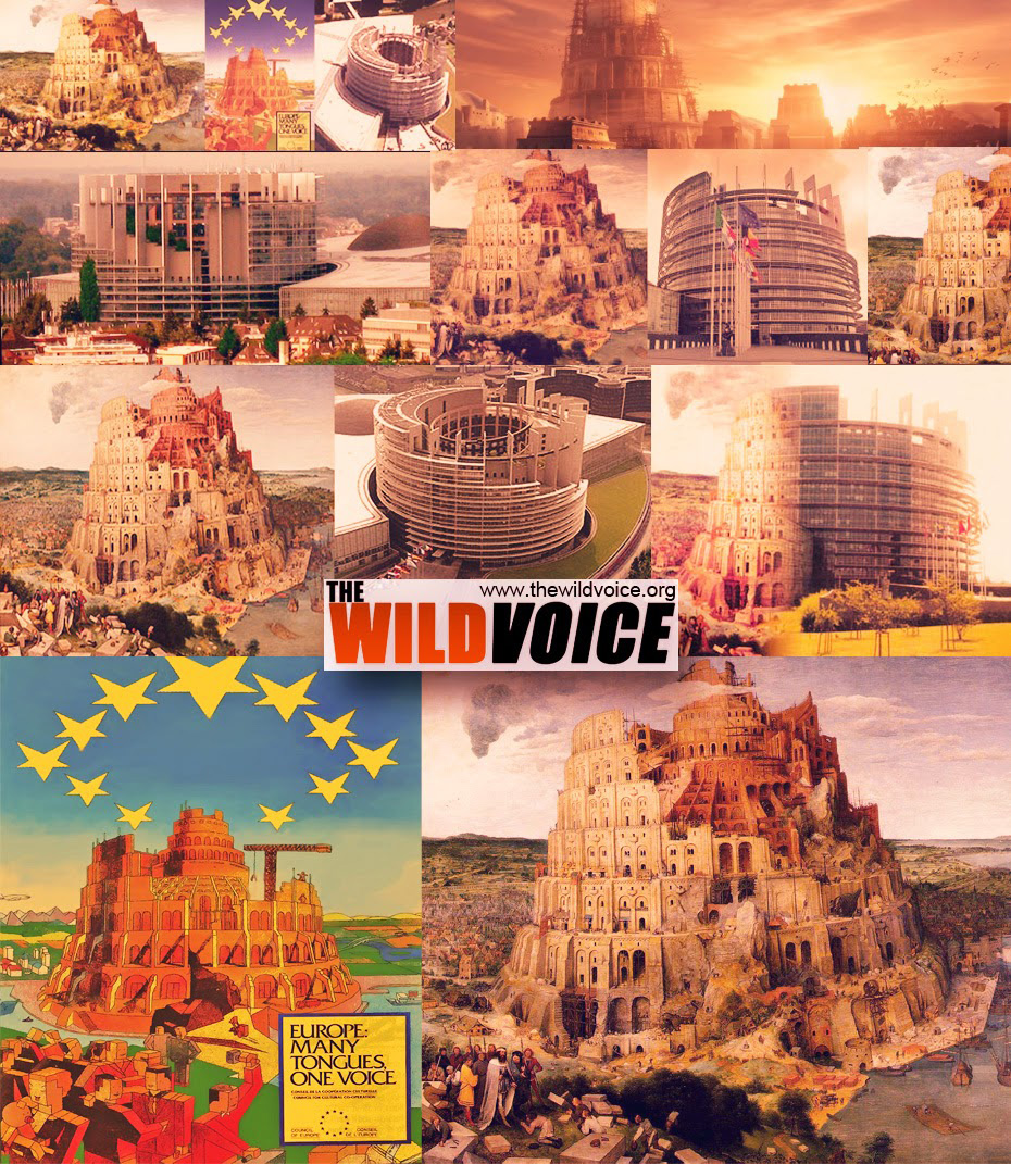
The EU, mystery Babylon. www.biblelight.net/tower-painting-parliament.jpg
The EU parliament in Strasbourg is modelled on the Tower of Babel.
thewildvoice.org/mystery-babylon-european-union/#comment-...
The symbolism of the EU in plain sight, is the desire of its advocates to return to the spirit of Babel.
The Council of Europe's poster produced to promote the European Union and the EU Parliament building in Strasbourg grandmageri422.files.wordpress.com/2015/07/europe-many-to... is filled with occult symbolism: a tower of Babel, 11 inverted stars (pentagrams),, the 12th pentagram is behind the top (head) of the tower. This is a Satanic parody of the 12 stars surrounding the head of the Woman (Church/Mary) in the book of Revelation. The inverted pentagram is an occult symbol designed to represent the head of Baphomet (Satan or the Goat of Mendes), illuminati pyramids are also evident in the background (since when have Egyptian pyramids been part of Europe? Square, blockheaded (indoctrinated) people (useful idiots) are featured, building a tower designed for their own enslavement and suppression, with a round-headed baby, who is too young to have been indoctrinated.
The dangerous, climate change scam:
A high level of Co2 is essential for our survival. The exact opposite of what we a led to believe by the popular, eco- fanatic narrative which is designed to convince people of the necessity for globalist control.
See the truth here:
The reason the elite hate Trump so much is because he is opposed to the one world agenda globalists.
www.zerohedge.com/news/2017-02-10/reason-elite-hate-trump...
Extinction Rebellion, Agenda 2021, Sustainable Development, W.H.O, Common Purpose, Agenda 2030, WEF, Davos, Google Camp, World Economic Forum, ‘fiat’ money, SWIFT, World Governance Council, G7, Society for Worldwide Interbank Financial Telecommunications, Bank of International Settlements, Institute of International Affairs, New World Order, Globalism, European Union, EU Commission, ECJ, European Empire, evil empire, global conspiracy, United Nations, UNICEF, League of Nations, NAFTA, Freemasonry, Edward Mandal House, Fabian Society, Thule Society, Kabbala, Kaaba, fractional reserve banking, Company Interbank Financial Telecommunication, internationalism, IMF, World Bank, ECB, European Central Bank, usury, Ruling Elite, Liberal fascism, Euro, EU cartel, EU empire, EU single currency, federalism, EUSSR, global elite, Federal Reserve, Paul Warburg, globalists, world government, WGS, World Government Summit, liberalism, Situational ethics, moral relativism, cultural imperialism, Bribery, Corruption, blackmail, slander, assassination, Moral relativism, Propaganda, project fear, fake news, Liberty, National Council for Civil Liberties, selective democracy, Illuminati, False religion, Maitreya, false ecumenism, World Council of Churches, Cultural Marxism, Censorship, Ted Turner, Timothy Wirth, Hilary Clinton, Club of Rome, Treaty of Rome, Maastricht Treaty, Lisbon Treaty, climate change scam, global warming, Green Party, EU federalism, liberal establishment, Multiculturalism, EU Army, Palmera Arch, Temple of Baal, Nazis, National Socialism, Red Flag, hammer and sickle, useful idiots, globalist puppets, quislings, internationalism, Internationale, anti-Brexit, anti-Putin, FBI, people’s vote, EU army, Islamisation, Multinationals, multinational conglomerates, nationalisation, Fake News, Bellingcat, Bureaucracy, Climategate, chemtrails, Deep State, Council on Foreign Relations, CFR, Trilateral Commission, GM seed, GM food, quantitive easing, Bilderbergers, Eco-fanaticism, Greenpeace, eco warriors, Chatham House, New Age, Illiberal Undemocrats, EU, Open Society, Open Britain, George Soros, Nancy Pelosi, Clinton foundation, John Podesta, John Dewey, Socialism, Humanists UK, Young Humanists, National Secular Society, British Humanist Association, neo Darwinism, Darwinism, evolution scam, CNN, New York Times, NBC news, PBS, MSNBC, BBC, liberal media, Drug legalisation, Money manipulation, IG Farben, quantitative easing, punitive taxation, Green taxes, progressives, Transgenderism, Social engineering, Communism, arch capitalism, Social Darwinism, Marxism, neo Darwinism, Erasmus Darwin, Charles Darwin, Charles Lyell, Bertrand Russell, James Hutton, David Hume, National Socialism (Nazism), Racism, international socialism, Gay mafia, gay adoption, rainbow alliance, UFOLOGY, global warming, Yakov Sverdlovsk, Red Terror, new age, Rothschilds, Rockefellers, Jacob Schiff, Adam Weishaupt, Alistair Crowley. Albert Pike, Theosophy, Antichrist, Abortion, Population control, Karl Marx, Stalin, Mao, Pol Pot, Hitler, Lenin, Trotsky, Engels, Euthanasia, Eugenics, Atheism, Soviet Union, USSR, People’s Democratic Republics, ‘People’s Vote’, Secularism, Andrew Copson, False science, Scientism, Lawrence Krauss, Richard Dawkins, Christopher Hitchens, Bill Nye, Gary Kasparov, Pussy Riot, radical left, atheist naturalism, pagan naturalism, A C Grayling, militant atheism, secular humanism, atheist pseudoscience, Cloning, Surrogacy, Fabianism, Central Banking, Fiat Currencies, banking cartels, LGBTQ agenda, Political correctness, liberal establishment, propaganda, progressive evolution, Hollywood, State control, Labour Party, Democratic Party, Green Party, Liberal Democrats, Fabian society, Secular Society, Antifa, BHA, FFRF, RDFRS, ACLU, gay priests, gay Bishops, gay pride, child abuse, gay fascism, sodomites, Stonewall, indoctrination, LGTB, LGBT, left wing feminism, lesbianism, homosexual agenda, Redefined marriage, Gender fanaticism, gay marriage, political correctness, hedonism, false equality, gender reassignment, surrogacy, Gay adoption, perverted sex education, Embryo experimentation, sperm banks, IVF, cloning, useful idiots, globalist puppets, UN, snowflakes, quislings, internationalism, liberal media, pornography, quislings, fifth column, Trojan horses, Sankt Galen Mafia, infiltrators, modernism, amnesty international, UNICEF, CIA, cyber surveillance, CCTV, Neo Darwinism, cultural Marxism, social Darwinism, atheist naturalism, paganism, Charles Darwin, Charles Lyell, Christianophobia, Secular Humanism, Militant atheism, abortion, Margaret Sanger, Moloch, Planned Parenthood, pro choice, Klu Klux Klan, Southern Poverty Law Centre, progressives, Christophobia, Newspeak, Satanism, Hate speech, political correctness, LibDems, women’s march, False Ecumenism, election rigging, mass migration, Green taxes, climate change scam, global warming scam, carbon credits scam, debt enslavement, international bankers, Arch capitalism, Kuhn Loeb, Goldman Sachs, John D Rockefeller, Lehman Brothers, J P Morgan, Max Warburg, Order of the Skull and Bones, Extortionate taxation, class war, gender war, ageism, divide and rule, centralisation, climate change scam, mass migrations, cultural imperialism, Marie Stopes, Cultural war. human trafficking. Liberal Democrats, liberal media, Socialist Workers Party, Morning Star, Emmanuel Macron, Planned Parenthood, Marie Stopes International, BPAS, British Pregnancy Advisory Service, Satanism, Wicca, Witchcraft, Luciferian. Bohemian Grove, Lunar Society, secret societies, Annie Besant, Helena Blavatsky. Alice Bailey, Marxist Social Democratic Federation. Alliance for Global Justice, Malthusian League. House of Sulzberger-Ochs, House of Meyer-Graham, Mike Bloomberg, Pierre Omidyar, Sheldon Adelson, Brzezinski, Benjamin Creme, George Kennan, James Baker, Carroll Quigley, Strobe Talbott, Lev Dobriansky, PNAC, William Kristol, Donald Rumsfeld, Dick Cheney, Paul Walfowitz, Robert Kagan, Professor Joseph Nye, Lester Mondale, American atheists, British Humanist Association, Outright Action International, National Secular Society. Abolition of nation states, NWO. World dictatorship, Tower of Babel, European Parliament. European Commission.
The war against anti-globalist Putin, and the globalist demonising of Russia.
www.flickr.com/photos/truth-in-
science/43042520105
The reason the elite hate Trump so much is because he is opposed to the one world agenda of the globalists.
endoftheamericandream.com/archives/the-reason-the-elite-h...
Ending the crime of abortion is crucial in curbing the power, of Satan.
www.flickr.com/photos/truth-in-science/43172544140
Ending the crime of abortion is crucial in curbing the power, of Satan.
www.flickr.com/photos/truth-in-science/43172544140
IF and THEN, the atheist dilemma
www.flickr.com/photos/truth-in-science/46553358861w
Who trusts the MSM? Their lies are not just fake news, they deliberately set out to slander those who don’t agree with the liberal left, globalist elite. Their lies are positively evil. Everyone should watch this video and they will never trust the media again: banned.video/watch?id=5f00ca7c672706002f4026a9
Wednesday noon, March 8, Zipolite, Oaxaca
My journal has fallen a couple of days behind as a result of a poor choice of “dining establishments” on Monday night. It is a humbling and miserable experience to have food poisoning anywhere, but being alone in a foreign country seems to make the discomfort even greater. I was laid low for about 36 hours. Fortunately I have met a few very nice people here who were very helpful. A gay couple from L.A., Paco and Ron, loaned me a stack of dvds that they had with them, so yesterday afternoon I laid in bed and watched “North Country” with Charlize Theron. Did I phrase that correctly? I wasn’t actually in bed with Charlize Theron.
Earlier in the day, while trying to recuperate on the beach, I received a tip from a woman named Suzy who recommended that I go last night to an establishment called “Casa de Marcos”. She told me that the proprietor made a delicious Thai noodle soup that would be good medicine and that he also showed movies in the evening on his patio which had a very unique ambience. Feeling somewhat strenghtened by about 7:00 yesterday evening I decided to take her advice.
I would like to try and describe what that experience was like.
I saw a flyer for Casa de Marcos which described the location as near Roca Blanca on the hill behind the Pharmacia. I had seen the Pharmacia which also advertised as Medico Consultorio. The pharmacist offers a sort of short cut so that you don’t actually have to go to the doctor for a prescription. Imagine that.
Anyway I knew where the pharmacy was, so I drove my little car and parked at the foot of the hill. I saw the Casa de Marcos sign at the bottom of some steep stairs leading up to a patio festooned in strands of colored lights. I started walking up the hill and said good evening to the pharmacist who was sitting on his front porch as I passed by. A little more climbing and I was on Marco’s patio. There, arranged very comfortably in the open, were a couple of couches and a variety of sizes and types of chairs. At the front was a screen for the movie, probably six feet by sixteen feet. Behind all the chairs, a digital projector, a dvd player and a sound system. Adjacent to the patio was a small round dwelling with a thatched roof. There was no one sitting in the chairs and I saw no in the casa. But then Marcos appeared. He is a very sophisticated looking, greying, bespectacled gentleman dressed completely in loose white clothing. I will learn later that he is from Poland, but has lived in the United States and Thailand (where he became a Bhuddist), before moving to Mexico. I tell him that I have come for the soup and he says, “ah yes, it will take just a minute.”
I take a seat alone in the front row of the theatre, the first to arrive. Then I really start to absorb the atmosphere. I can see inside Marcos’ home. It is probably 20 feet in diameter. There is a bed, and a small kitchen where he is preparing the soup. On the walls are a tapestry of shiva like figure and a large wooden carving of figures which appear to be Christian saints, but I can’t really tell. Candles are everywhere, and incense fills the air. The house is immaculately arranged for simple living and as a place of business.
There is some very atmospheric music playing. I would describe it as a latin “Hearts of Space” sound. The colored lights are draped overhead through palm trees and are adjusted to a low moody level. I am lapsing into a dream state when Marcos appears with the soup. A large bowl with chopsticks and the traditional asian soup spoon, is filled with chicken broth, noodles, cilantro, carrots, green beans, mushrooms, etc. The flavor is delicious and I know that this will in fact cure what lingers of my malady. Now more people begin to arrive, and as each enters the patio “buenos noches” echoes through the air. A blond woman from Stockholm sits down next to me and tells me a little about her six month adventure in Mexico. She is joined by a Russian woman who tells similar stories. The place begins to fill with people which probably amounts to a crowd ofabout 25. Some are having the soup, all are waiting for the movie. Marcos is busy tending to his patrons and filling a few orders for margaritas. Tonight’s showing is “Amores Perros”, an intense film about life in Mexico City. At exactly 8:30 Marcos disappears behind a gold curtain in his house like something from the Wizard of Oz. The lights are very gradually dimmed, the background music, too, and the movie begins. The audience is quiet, but somewhat ill at ease throughout the 2.5 hour movie. It is a gritty and violent picture of urban Mexican life. A story of multiple characters entertwined with similarly unfortunate and tragic fates.
The movie ends, the lights come back up and Marcos reappears in front of the screen to say “thank you for coming”. Each guest, in turn, quietly steps up to Marcos’ door to pay their bills. For soup, $2.50, for the movie $1.50. Except for the sound of ocean waves crashing on the shore, there is silence as everyone walks back down the hill, strangers who have come together for a few hours in a unique setting, all returning to their individual lives.
I have forgotten how sick I felt such a short time ago. I think I have just met a witch doctor.
Port Augusta.
In 1888, John Henry Reid discovered coal-bearing shale in the Leigh Creek area. This discovery led to the establishment of underground workings but only small quantities of coal were extracted and operations ceased in 1894. It was not until 1940 that worked started again on searching for useable coal, with plans for an open cut mine. Premier Sir Thomas Playford saw that the electricity supply industry would be the largest user of Leigh Creek coal, and control of the coalfield was transferred by the government to the Electricity Trust of South Australia in 1948 by act of parliament. The story behind this is one of the drive, foresight and determination of Premier Sir Thomas Playford. SA was the only state with no good supplies of coal and during World War Two SA was left with no power supply on occasions due to strikes and war needs in NSW. Playford wanted SA to be self-reliant for power but the progress to develop brown coal for power generation was difficult. The first bill introduced to parliament was defeated in the Legislative Council. Playford then courted some upper house members and finally got his bill through parliament to establish the coal field in 1946. He had started out on this course in 1943. Part of the political deal was to supply electricity to country towns and regions. If the bill had been defeated Playford would have resigned.
ETSA had control of the coal field and after seeking tenders for special boilers to burn the brown coal at the Osborne Power Station, decided to establish a power station at Port Augusta. The new power station was named the Playford power station when it opened in 1954. Another power station was built and Pt Augusta used to produce around 40% of SA electricity. It is now closed and partially demolished. It used to employ around 450 people in Port Augusta, Leigh Creek and in Adelaide but sadly that has all ended too. The Port Augusta power station and the Leigh Creek coalfields were closed in April of 2016 with SA reverting to the 1940s situation when we were reliant on the eastern states of Australia (for black coal for electricity generation.)
Pt Augusta has a population of 14,000 people of which almost 20% are of Aboriginal descent. Nationally 2.3% of the Australian population is Aboriginal. Port Augusta is the fourth largest town outside Adelaide after Mt Gambier, Whyalla and Murray Bridge. Part of the reason for the current large Aboriginal population of Port Augusta stems from the early establishment of an aboriginal mission near the city. In 1937 the Christian Brethren Assemblies established an aboriginal mission in the sand hills just north of the town. The mission was originally called Umeewarra. In 1964 the government took control of the mission and renamed it Davenport Reserve and in 1968 an aboriginal community council took charge of the Reserve. During the 1970s most of the Aboriginal children fostered out to white families came from Davenport Reserve. Davenport Reserve closed in 1995.
Matthew Flinders had mapped the Port Augusta area in 1802. Europeans named it Port Augusta on May 24 1852 when a survey was undertaken. Land was put up for auction in 1854 signalling the start of the town. Previous to this in 1851 the first leases had been granted in the district to James Paterson, and Messers White and Pollhill. By 1854 these runs and others further north in the Flinders Ranges were carting wool to the town for transhipment to England. Then by around 1857, copper was being transported from the Blinman copper mines to Port Augusta for shipment overseas. Some copper was smelted in the port before shipment. The Blinman mining company erected their own wharf in Port Augusta in 1863, the first of several private and government wharves. Consequently one of the first significant buildings in the town was the Customs House, erected in 1861 on the site of the present day yacht club. The first bank in this growing commercial centre was the National Bank opened in Gibson Street in 1863. In later years grain and flour from the mills in Quorn and Wilmington were shipped out from the port too.
The first hotel, the Port Augusta Hotel, was licensed in 1855. In 1864 the Northern Hotel was first licensed. More hotels were so that by 1878 there were six hotels in the town! Once the railway to Quorn opened the first Railway Terminus Hotel was licensed in 1880. The brewery, which is now part of the Northern Gateway Shopping Centre, first started operations in the early 1870s. In 1879 it was greatly extended by new owners with a high tower, large cellars and more machinery. Aerated waters were produced as well as beer. Mr. Perrers, the brewery owner also owned the Laura brewery in the 1890s. He sold both breweries to SA Brewing Company in 1894 which closed them.
From the earliest days a water pipe had been laid from springs on Woolundunga Station 14 miles away to the town. The 1860s and 1870s were boom years for the town and it progressed greatly. Private schools were replaced by the first government school in 1878; the Anglican Church was opened in 1868; the first Bible Christian Church had opened earlier in 1866. The town’s post office was built in 1866 with a telegraph service starting four years later. The town’s first newspaper started in 1877; the corporation of Port Augusta was gazetted in 1875. A wharf had been established in 1871 at Port Augusta West, a new subdivision and a large new government jetty was erected in 1877. Large pastoral companies, like Sir Thomas Elder’s company which had been set up in the town in 1855, had their own wharves. Towards the end of the 1870s a Wesleyan Methodist church was built (1878) and the town was preparing for the exciting advances of the 1880s.
A wooden hut served as the first police station in Point Augusta from around 1855 where Mr. Minchin the Sub-Protector of Aborigines also worked. It was sent by ship from Port Adelaide and assembled upon being landed. A new stone police station and court house was built in 1867. This was where the first police barracks were located. Later in 1884 the current Court House was erected and the old wooden police station was dismantled. Note the VR for Victoria Regina above the doors. The big events of this decade were the arrival of the train service from Quorn in 1882, and the erection of the lavish and grand town hall in 1887. The great northern railway started in 1878 and reached Quorn in 1880 and Farina beyond Hawker in 1882. It was eventually extended to Oodnadatta in 1892.
From 1875 the first council meetings were held in the old institute building. The corporation then borrowed £6,000 for the erection of a town hall suitable for a progressive town like Port Augusta. This impressive classical style building situated in the main street is sadly now vacant and in disrepair. It was made of stone quarried near Quorn, with Ionic columns and a square tower topped with a pyramidal dome and cupola. The summit was 72 feet above the footpath! From its opening day the town hall had electric lighting from its own generating supply. The Catholic Church and presbytery were also erected in the 1880s, finally opening in 1883. A few years later the first Bishop of Port Augusta (Willochra) diocese was consecrated and the first cathedral services held in 1888.
Industrially in 1880 John Dunn, the flour miller from Mt Barker with mills in many SA towns opened his flour mill in Port Augusta. This finally burnt down in 1926. The 1881 census showed that Port Augusta had over 2,100 citizens. During the 1880s Port Augusta was the second port for the state after Port Adelaide before Port Pirie surpassed it. It finally closed as a working port in 1974. The first bridge across the Gulf to Port Augusta West was opened in 1927. With Federation in 1901 came the promise to build a transcontinental railway line to link Kalgoorlie (and Perth) with Port Augusta and the eastern states. This line was finally completed in 1917 and Port Augusta then became a hub for Commonwealth Railways, in addition to South Australian Railways. The Commonwealth government established their major railway workshops in Port Augusta which was a major employer in the town until 1997 when Australian National Railways (the former Commonwealth Railways) were privatised. However, there was hope of new railway work when in January 2004 the first freight train rolled out of Port Augusta on its way to the new rail had of Darwin and the enlarged Port of Darwin. Prior to this time the northern railways had terminated in Alice Springs.
In 1756, the establishment of theatres and hotels in the Inner City 內城 of Beijing was prohibited by Emperor Qianlong 乾隆 (1711-1799). The capital city’s hospitality industry moved to the Outer City 外城 and gathered in front of the Inner City gates - especially the Gate of Righteous Yang 正陽門, since it was the central city entrance leading to the Forbidden City 紫禁城 and imperial ministries.
In 1906, the former Beijing railway terminal station was built right beside the Gate of Righteous Yang, which once again boosted hospitality industry in its near-city-gate area as it became the central destination of national-wide transportation and freight. Therefore, the historical blocks here – such as Dashilar 大柵欄 and the streets of Damochang – were exceptionally rich in historical restaurants, hotels, brothels and luxurious shops selling rare goods from all over the empire.
In addition, thanks to the spirit of cultural exchange brought in by international trade, these narrow streets also became a showcase where new exotic fashions would be debuted. This little hostel tower was one of those once fashionable early ‘Western Overseas 西洋’ style urban buildings appeared near Beijing’s Gate of Righteous Yang. The adoption of concrete pseudo-pilasters as well as Western Ionic column-top orders on the surface of local grey-brick walls formed a unique sense of inculturation. Such new style was the herald of much more drastic social and aesthetic revolutions that took place in China later. Unfortunately, this building was demolished around 2005 during the construction of a new motorway.
This photo was taken in 2004.
The Japan Ground Self-Defense Force (JGSDF)'s Komatsu Light Armored Vehicle (LAV) (05-2141), assigned to the 6th Company, 2nd Infantry Battalion(Airborne), 1st Airborne Brigade, Ground Component Command based at Camp Narashino, waits to join the pass in review at Camp Narashino, Japan, March 31, 2019, during the Camp Narashino 68th anniversary of establishment and 1st Airborne Brigade 61st anniversary of establishment ceremony.
On display at Showsbus 1999, Dew's C310 RRX is a Bedford YMT with Wadham Stringer Vanguard bodywork, new to the Atomic Weapons Establishment, Aldermaston in 1986.
Historical Background. Edward Gibbon Wakefield established the New Zealand Company to settle the land in 1839 just after the establishment of SA. He began his settlements in Wellington with his brother in charge, followed by later settlements in Whanganui, New Plymouth and Nelson. He also established the Canterbury Association with Robert Godley for the settlement of Christchurch in 1848. NZ was established as a serious of very separate settlements and the major cities of NZ today reflect that early history. His original Wellington settlement covered the area from Wellington to Napier and Hastings. Napier was a favoured spot in the Hawkes Bay region (named by Captain Cook in 1769) as it had a good port. The Crown purchased land from the Maoris in 1851 in Hawkes Bay. Before this purchase in 1851 William Colenso, a Cornishman had established a mission station here to work with the Maori in 1844. He was dismissed from the Missionary Society in 1852 as he had fathered a child with their Maori maid in 1850.His wife separated from him in 1853 but they never divorced. Colenso stayed on as a settler in Hawkes Bay. He became a MP for Napier in the national parliament in 1861. The illegitimate son Wiremu left NZ when he grew up and returned to live in Cornwall. A few settlers began to arrive in Hawks Bay around 1852 and in 1854 a town named Napier was laid out. It was named after Sir Charles Napier the British Army Commander in Chief in India who had died in 1853. As more settlers came to Hawkes Bay in the mid-1850s a public meeting in Napier moved to separate from the province of Wellington which they did in 1858. The port and the rich agricultural lands of Hawkes Bay provided wealth to the city of Napier. The region was known as a major export port of NZ wool. More recently it has become known as the fruit bowl on NZ. It produces kiwi fruits, grapes (for wine), stone fruits etc. Timber is also exported from the port of Napier. Just a few kilometres away is the city of Hastings. Napier has around 62,000 inhabitants and Hastings 80,000. The district has 165,000 residents.
The coastal flood plains are traversed by five rivers flowing down from the central tablelands and volcanic area. The major river is the Wairoa River. Hawkes Bay is a very seismically active region of NZ with over 50 damaging earthquakes recorded since 1800 but only 6 of these have occurred since 1934. The early 1930s was a dramatic period for Hawkes Bay. A major earthquake occurred on 3rd February 1931 followed by subsequent earthquakes over the next three years. The 7.8 scale earthquake of 1931 was centred 15 kilometres from Napier. It struck mid-morning and killed 256 people and injured thousands with over 400 hundred admitted to hospital. Hundreds of aftershocks resulted. It remains NZ worst earthquake eclipsing even the more recent Christchurch earthquakes for damage and death. Most of the buildings of the city centres of Napier and Hastings were destroyed. Hawkes Bay lies almost directly on the fault line caused by the abutting of the Australia and Pacific tectonic plates. The coastline at Napier was raised two metres with 40 square kilometres of seabed being raised to create dry land! A 4,000 acre lagoon was drained and today Hawkes Bay airport, industrial estates and new housing lies on this reclaimed land. The earthquake set off fires (and many buildings were made of wood) and the fires raged for several day destroying what was left of some buildings. Fires were controlled very quickly in Hastings. The two cities were quite quickly rebuilt with government support within two years at the height of the Depression. Building regulations were changed and well-known architects rebuilt the cities in Art Deco style influenced by the rise of California with its Aztec and Spanish influenced Art Deco architecture. Even today there are only four specially designed buildings taller than five storeys in Napier. On a more positive note Napier decided to prosper from the earthquake and its Art Deco heritage. The Art Deco Trust was formed in 1985 and still operates an internationally recognised Art Deco festival each year in February. With local government support the Art Deco Trust employs 10 people and uses the services of 120 volunteers. It operates a shop, it runs tours, it turns over more than $1.5 a year and it prints publications etc. It encourages the preservation of Napier’s Art Deco buildings and helps with restoration. It attracts around 25,000 people to Napier each year. Citizens of Napier dress in 1930s style for the Festival, vintage cars from the era are part of the festival, a public great Gatsby arty is held in a city park, movie events, art shows, many jazz musical events, balls, dinners, parades, and an Art Deco spotter competition are all part of the festival. The Art Deco Trust shop opens all year selling 1930s hats, women’s’ fashion, jewellery, Art Deco style statues, glassware, china, books, posters etc. Among the 200 events is the Art Deco Dog Parade. I wonder what that is?
What is special about Napier and Art Deco? Art Deco as a design and architectural style emerged at the Paris Exhibition of 1925. It became popular throughout the 1920s, 1930s and even into the 1940s. The style was applied to buildings, especially American skyscrapers, jewellery, china, lighting, furniture, etc. Unlike the Art Nouveau style which had emerged around 1900 with colours, curves and flowing detail the Art Deco style was rectangular, geometric and modern industrial techniques were used to achieve this style doing away with handicraft and hand worked items. Just think of the designs used in the Poirot detective TV series from Agatha Christie. The designers drew their inspirations from old European, Mayan, Aztec, and in the case of New Zealand, Maori design elements. The European influences led to the Spanish Mission style of architecture with simulated adobe brick, rounded terracotta window shades, roof tiles, roof parapets etc. The American influences developed Mayan and Aztec and sometimes North American Indian elements with zigzags, stepped patterns etc. One special feature of Art Deco buildings was the colourful and soft pastel shades of varying depths of colour used on the decorative features. Art Deco buildings can be found across the world with many in Adelaide but unlike Napier there is no concentration of buildings in any one area and they have not been maintained since the 1930s. Art Deco buildings in Adelaide no longer have some of the design elements as they have been removed with modernisation, the colour schemes have been painted out and often replaced with current gaudy or grey colour schemes designed to hide the Art Deco elements. But several country towns in SA have many Art Deco buildings as they were being built and developed in the early 1930s – for example, Barmera and Renmark in the Riverland. Art Deco was popular for 1930s hotels in Adelaide and suburbs and Art Deco, especially the Spanish Mission style was popular for domestic housing in the 1930s. Napier, along with Miami in Florida and Santa Barbara in California have concentrations of Art Deco buildings, but Miami has especially grand multi storey buildings in the Art Deco style that you do not find in Napier. Napier Art Deco Trust applied for UNESCO World Heritage status for the city and its Art Deco heritage but this was rejected. Napier is special because of the earthquake behind the erection of the Art Deco buildings and the use of Maori motifs in some of its buildings.
Within days of the earthquake the NZ government established a Rehabilitation Committee and all houses could have one chimney repaired free of charge before residents re-occupied their homes. The government loaned money to start the rebuilding of commercial premises (but not to banks or international companies) near Civic Square. Loans were granted interest free for up to three years for commercial businesses. Two government Commissioners were appointed to oversee works and loans. They immediately contacted some Napier architects. The architects sought out ideas from American architectural pattern books and photographs and the five leading architectural practices agreed to share their limited resources and to rebuild with the city with a sense of unity and common style. The leading architectural firms were Finch and Westerholm who specialised in Spanish Mission style; Louis Hay a local who was influenced by Frank Lloyd Wright in America and his best building was the National Tobacco Company building; Natusch & Sons who specialised in houses and restrained Art Deco style; E A Williams who produced some quite flamboyant buildings; and J T Watson who became the Napier Borough Architect and is known for the Colonnade, Sunbay, Parker Fountain, esplanade Soundshell and the Egyptian inspired Municipal Theatre. Most of the central business district of Napier was rebuilt within two years although Art Deco buildings were still being erected in the late 1930s.
Napier’s Art Deco buildings and Trail.
National Tobacco Company. Corner of Ossian and Bridge St. We stop here on the way to the city centre. Stunning entrance with fantastic detail in sculpted plaster – roses, sunbursts, fruit etc. It was built in 1832 and the architect was Louis Hay. No expense was spared on this structure. Note the rounded “rising sun” style doorway, with motifs below the roof parapet, roses beside the wooden doors, almost nautical style lights beside the arched doorway, symmetrical steps, and the bold horizontal lines in the cement work below the height of the doorhandles. A brilliant building in the Art Deco style.
We start at the corner of Marine Parade and Emerson Street- the mall. The parallel street to the north is Tennyson St; from Marine Parade the first cross street is Hastings St; the next cross street is Dalton St. At the end of Emerson St just off the map below is Civic Square Park. The Napier Art Deco Historic Trust is located near Civic Square. We begin along Emerson Street Mall. You will note that central Napier streets are named after literary figures, Emerson from the USA, Tennyson, Dickens, Shakespeare, Browning from England etc.
1. T and G (Temperance and General) Building with the rounded tower and clock. Built in 1936. City landmark. Built in the Art Deco nautical style as it is on the esplanade. It is now a boutique hotel. Across Marine Parade is the 1936 Colonnade – memorial to those killed in the 1931 earthquake and the Soundshell built in 1935 has some Maori motifs on it. A good example of the work of J T Watson, Borough Architect.
2. The Masonic Hotel on the right. Note the Art Deco style lettering of Masonic. Built in 1932 and looked modern then as it does today. Very rectangular. Parapet hides roof line. Architects from Wellington.
3. ASB Bank next to T & G. Built 1932. Has best examples of Maori carving, Maori patterns in ceiling panels, exterior Maori bas reliefs and Maori designs on parapet. Note Art Deco external lighting between the vertical pilasters. Top of pilaster has Maori design. Turn left here into Hastings St and look at buildings on left.
4. (i) – Jessica’s Design – 1932, originally a drapers, Art Deco entrance. Beautiful pas or is it Maori?
4 (iii) – former Odeon Theatre – 1930s, burn and renovated 1950s. Old Art Deco stained glass in window. Stepped design around the central gable piece.
4 (iv) - Callinicos Building 1932 with Greek gods motifs naturally. Now a Farmers Dept. Store.
4(v) - Paxies Building 1932 – Spanish Mission style. Very unusual cartouche on shop front. Architects Finch and Westerholm. Cross to the other side of Hastings St return to Emerson St.
4(vi) – Built 1931 before quake as Post Office but in the Art Deco style. Burn out in the quake and rebuilt. Remodelled in 1950s. Now the Farmers Dept. Store.
4(vii) –Two doors up from Farmers. Bennett’s Building -1929 – a quake survivor. Built with floating foundation and reinforced concrete. Stripped classical style not Art Deco at all.
4 (viii) – Originally Blythes Department Store. Built in 1933. Architects were Natusch and Sons. Pink and green colours, roof parapet. Note little triangle shapes in the tops of the windows.
5 On right in Emerson St. Criterion Hotel - 1932- largest Spanish Mission building in town. Concrete walls look like adobe. Note triangular shapes in the ground floor windows. Stepped up entrance in veranda is so geometric.
6. On left – Hannah’s Building now a small shoe store – 1933. Note linked chain beneath parapet, flower motif on end columns. Modernise with grey paint work and some pink.
7. On left – Blythe’s building – 1933. Façade was covered at one stage. Not much left except V shapes and stylised fleur de lis along roof parapet.
8. On left –McGruer’s building – 1932 – department store – note unusual balcony and wrought iron work.
9. On right –Hawke’s Bay Chambers - 1932 quintessential Art Deco – zigzags, herring bone, and monogram – stylish.
10. On left. Emerson Building. Blue on blue. Built as Hurst Building in 1930 before the earthquake. Owner photographed it in the hour after the quake before the fires started.
11. On right Smith and Chambers Building 1932 with unusual 6 sided windows. Best feature is the zigzags below parapet with “rising sun” in the zags and stepped squares below in the zags.
12. On left. Lockyer’s Building. Beautiful chevron shaped columns painted in appropriate Art Deco pastel colours.
13. On right Briasco’s Building. Built 1930 before the quake. Architect E A Williams. It is said that this is restrained but his buildings after the quake are more dynamic and exuberant. Possible Maori motifs below the parapet.
14. On right. Kidson’s Corner Building. Built 1933. One of the best buildings in Napier. It has zigzag friezes, beautiful colour palette, and triangular pieces in rectangular windows etc. Turn left here into Dalton St.
15 (i). On right of Dalton is the former Hotel Central. Architect E A Williams and built in 1932. A grand building with highly decorative motifs around the hotel windows. Egyptian inspired motifs with sunbursts or “rising suns” and zigzag borders. Balustrades on balconies, pink and cream palette.
15 (ii). On left, Masson House. Built 1932 by E A Williams again. Central panel above the central doorway is interesting with the M and H for Masson House.
15 (iii). On left is a stripped classical building which is not Art Deco. NZ Broadcasting house was built in 1926 also by E A Williams. It survived the earthquake.
15 (iv) On the diagonally opposite corner. The former State Cinema built in 1932 with Finch & Westerholm as architects. Now an Asian café. Striking colour scheme of pink and grey, rounded windows with sunbursts in the top rounded bits. It has a classical feel about it.
16. On right is Colenso (he was the first missionary settler) Building. Built in 1932 as a hotel now apartments. The end window segments with tripartite windows are the best features. Yellow and ochre type colours.
17. On left. Loo Key Building. Architect J T Watson. Built later in Art Deco style in 1940. The central stepped feature is quaint. The unnamed building next door has great friezes and motifs.
18. On right. Sangs Building 1932. Very plain with unusual shaped parapet with a slope. Its claim to fame are the beautiful grey toned Aztec motif panels on ends and the wavy motif panel in the middle of the façade. Worth more than a glance.
19. On right corner. The Provincial Hotel by architects Finch and Westerholm in 1932. Superb example of Spanish Mission style with not a full rounded roof tile in sight except for half bits along the parapet. Rounded windows with twist pile columns. Dominating colour palette from cream to blue to orange. Turn right here into Civic Square.
20. Straight ahead is the old Central Fire Station building. Designed by Louis Hay in 1932. Concrete façade with some Art Deco features. Turn right at the corner a walk along Tennyson Street.
21. On the left. The Municipal Theatre. Architect J t Watson the Borough Architect. Built 1938. Note the good symmetry; the flame lighting in the external walls, the lintels above the theatre entrance doors are very Egyptian, through the doors you can see the nautical design inside, chrome, neon lights etc.
22. On right on next corner. The classical designed Public Trust Office for dealing with deceased estates entrusted to it. Built in 1922. Survived the quake almost unscathed. Sold by the government in the 1990s.
23. On right. Hildebrandt’s. Built 1933 with Louis Hay the architect. Note the wavy lines in blue. Meant to represent the waves between Hildebrandt’s native Germany and his adopted home of New Zealand.
24. On right. Halsbury Chambers built in 1932 and designed by Louis Hay. Simple, small and restrained. Central doorway with torchlike motif in the middle is interesting. Good Art Deco style lettering for Halsbury Chambers.
25. On left. Scinde Building. 1932. A stripped classical building with dominant pilasters but also with Art Deco motifs along the roof parapet and then almost Art Nouveau decorations in cartouches above and below the windows. A mixed style building but pleasant.
26. On left. Napier Antique centre. Built in 1932 and designed by E A Williams. Has the best Maori motifs in Napier .
27. On left. Hello Superman and Lois Lane. The Daily Telegraph building completed in 1932 and deigned by E A Williams. Look at the top of the pilasters- so Art Deco. Note the external lighting; the zigzags on the wrought iron balcony above the main door; the nautical style central part of the building with the flag flying above; and the stepped lines around the main entrance doors. Cross over Hastings Street.
28. On the left. The Art Deco Shop and centre.
29. On the next corner is the Museum and Art Gallery. Admission is free. Learn more about the earthquake, the history of Napier and explore the Art Deco china (including Clarice Cliff), paintings (early New Zealand Modernism 1925 to 1950), textiles and sculpture of the museum. The museum has a good collection of Maori and ethnographic exhibits. It has an excellent shop for arts and crafts and souvenirs. Beyond that is the esplanade again. Turn right and you will be back at the T & G Building.
Hastings. In 1873 the government planned a railway inland from Napier and laid out a new town at a rail junction to be called Hastings. The railway opened up the interior land to the Napier port at Ahuriri. These days Hastings is slightly bigger than Napier and it is the regional district council. Hastings has a rail link to Palmerston North. Like Napier the 1931 earthquake destroyed many city centre buildings which were replaced with iconic Art Deco buildings. Like Napier it is a popular place to reside as it is one of the sunniest parts of New Zealand. In its Civic Square are 18 pouwhenua. Pouwhenua are artistically carved post to mark Maori places of significance or iwi boundaries. A team of 20 Maori carvers created them from totara trees. Each pou tells the story of the genealogy of each Marae represented. The pou represent the link between the people (tangata) and the land (whenua.) Each pou represents one Maori ancestor. If we have time we will briefly stop at Stoneycroft homestead and gardens. Built 1875. Owned by the City. Near corner of Napier-Hastings expressway and Omahu Rd. Turn left when coming from Napier.
Royal Aircraft Establishment's Shorts SC.9 XH132 Canberra on display at the 1983 International Air Tattoo held at RAF Greenham Common
Converted by Short Brothers, the basic Canberra design was re-configured to carry a range of nose-mounted equipment for missile homing head trails - spending all her life as a Test-bed
Initially at Hatfield with De Havilland Propellors, XH132 was used as part of the 'Red Top' guided missile programme before moving to Hawker-Siddeley Dynamics to continue the trails and then in 1972 she moved to the Radar Research Establishment at Pershore for the 'Sky Flash' guided weapon development
In 1986 she was retired to St Mawgan for BDR training, lanquishing there before being broken up
The nose was saved and moved to Italy
Scanned Agfa 50 35mm Transparency
Margolies, John,, photographer.
Chicken cowboy billboard wreck, B-80, Elko, Nevada
1991.
1 photograph : color transparency ; 35 mm (slide format).
Notes:
Title, date and keywords based on information provided by the photographer.
Margolies categories: Eating and drinking establishment signs.
Purchase; John Margolies 2008 (DLC/PP-2008:109-3).
Credit line: John Margolies Roadside America photograph archive (1972-2008), Library of Congress, Prints and Photographs Division.
Please use digital image: original slide is kept in cold storage for preservation.
Forms part of: John Margolies Roadside America photograph archive (1972-2008).
Subjects:
Restaurants--1990-2000.
Billboards--1990-2000.
United States--Nevada--Elko.
Format: Slides--1990-2000.--Color
Rights Info: No known restrictions on publication. For more information, see "John Margolies Roadside America Photograph Archive - Rights and Restrictions Information" www.loc.gov/rr/print/res/723_marg.html
Repository: Library of Congress, Prints and Photographs Division, Washington, D.C. 20540 USA, hdl.loc.gov/loc.pnp/pp.print
Part Of: Margolies, John John Margolies Roadside America photograph archive (DLC) 2010650110
General information about the John Margolies Roadside America photograph archive is available at hdl.loc.gov/loc.pnp/pp.mrg
Higher resolution image is available (Persistent URL): hdl.loc.gov/loc.pnp/mrg.01519
Call Number: LC-MA05- 1519
The Episkopiana Hotel is a renowned establishment located in Episkopi, in the Limassol District of the Republic of Cyprus. With a rich history spanning several decades, it has become an iconic landmark in the area. Let's delve into the fascinating history of the Episkopiana Hotel in 1000 words.
The Episkopiana Hotel's story begins in the mid-20th century when tourism in Cyprus was rapidly developing. In the early 1960s, a visionary entrepreneur named George Zenonos recognized the potential of the picturesque coastal town of Episkopi and decided to establish a hotel there. Zenonos acquired a piece of land and embarked on the ambitious project of constructing a modern hotel that would cater to the growing number of tourists visiting Cyprus.
Construction of the Episkopiana Hotel commenced in 1962 and was completed two years later. The hotel boasted 120 rooms, each tastefully furnished and equipped with modern amenities of the time. The architecture of the building blended traditional Cypriot elements with contemporary design, creating a unique and welcoming ambiance for guests.
In 1964, the Episkopiana Hotel officially opened its doors to the public, marking the beginning of its journey as a premier destination for tourists seeking a comfortable and memorable stay in Cyprus. The hotel quickly gained a reputation for its exceptional service, picturesque location, and warm Cypriot hospitality.
Over the following years, the Episkopiana Hotel expanded its facilities and services to meet the growing demands of visitors. Additional wings were added, increasing the number of rooms to 180. The hotel also developed a range of amenities, including swimming pools, restaurants, bars, and conference facilities, ensuring it could cater to a diverse clientele.
In 1974, a pivotal event in Cyprus' history occurred—the Turkish invasion and subsequent division of the island. Episkopi, located in the Greek Cypriot-controlled area, was heavily affected by the conflict. Despite the challenges posed by the political situation, the Episkopiana Hotel managed to continue operating, providing a sanctuary for visitors seeking respite from the turmoil.
As the years passed, the hotel underwent various renovations and modernizations to stay at the forefront of the hospitality industry. It embraced emerging technologies, upgraded its infrastructure, and refined its services, all while preserving its authentic charm and character.
The Episkopiana Hotel played a significant role in promoting tourism in the Limassol District, attracting both local and international visitors. Its strategic location near cultural and historical landmarks, such as the ancient city of Kourion and the Kolossi Castle, made it an ideal base for exploring the region's rich heritage.
Throughout its existence, the Episkopiana Hotel has witnessed numerous memorable moments and hosted distinguished guests. It has served as a venue for weddings, conferences, and other special events, leaving a lasting impression on the countless individuals who have passed through its doors.
In recent years, the hotel has embraced sustainability and eco-friendly practices, recognizing the importance of preserving the natural beauty of its surroundings. Initiatives such as energy-efficient systems, waste reduction programs, and the use of locally sourced products have been implemented, aligning the Episkopiana Hotel with the global movement towards responsible tourism.
Today, the Episkopiana Hotel stands as a testament to the resilience, dedication, and passion of its founders and staff. It continues to provide exceptional hospitality to guests from around the world, offering a tranquil oasis where visitors can relax, unwind, and create cherished memories.
With its rich history, stunning location, and commitment to excellence, the Episkopiana Hotel remains an integral part of Cyprus' tourism landscape. It serves as a bridge between the past and the present, showcasing the beauty and cultural heritage of the Limassol District while embracing the modern comforts expected by discerning travelers.
As the Episkopiana Hotel looks towards the future, it remains steadfast in its mission to provide unforgettable experiences, ensuring that its legacy as a beacon of Cypriot hospitality endures for generations to come.
The Jewish community in Libya was one of the oldest in the diaspora, with a presence of 2300 continuous years. The majority immigrated to Israel at the time of the establishment of the State, and the remaining were forced to leave in 1967. The Museum is located in Or Yehuda (Israel), originally a camp for immigrants Libya.
The permanent exhibition consists of items of Libyan Jewish craftsmanship, documents, photographs and textiles.
A remembrance hall lists the names of the victims of pogroms in the years 1945 to 1967 and documents the persecution of Libyan Jews under Fascist and Nazi rules. A gallery hosts art work by contemporary artists from the community.
An anti-establishment view or belief is one which stands in opposition to the conventional social, political, and economic principles of a society. The term was first used in the modern sense in 1958, by the British magazine New Statesman to refer to its political and social agenda. Antiestablishmentarianism (or anti-establishmentarianism) is an expression for such a political philosophy.
In the UK anti-establishment figures and groups are seen as those who argue or act against the ruling class. Having an established church, in England, a British monarchy, an aristocracy, and an unelected upper house in Parliament made up in part by hereditary nobles, the UK has a clearly definable[citation needed] Establishment against which anti-establishment figures can be contrasted. In particular, satirical humour is commonly used to undermine the deference shown by the majority of the population towards those who govern them. Examples of British anti-establishment satire include much of the humour of Peter Cook and Ben Elton; novels such as Rumpole of the Bailey; magazines such as Private Eye; and television programmes like Spitting Image, That Was The Week That Was, and The Prisoner (see also the satire boom of the 1960s). Anti-establishment themes also can be seen in the novels of writers such as Will Self.
However, by operating through the arts and media, the line between politics and culture is blurred, so that pigeonholing figures such as Banksy as either anti-establishment or counter-culture figures can be difficult. The tabloid newspapers such as The Sun, are less subtle, and commonly report on the sex-lives of the Royals simply because it sells newspapers, but in the process have been described as having anti-establishment views that have weakened traditional institutions. On the other hand, as time passes, anti-establishment figures sometimes end up becoming part of the Establishment, as Mick Jagger, the Rolling Stones frontman, became a Knight in 2003, or when The Who frontman Roger Daltrey was made a Commander of the Order of the British Empire in 2005 in recognition of both his music and his work for charity.
Anti-establishment in the United States began in the 1940s and continued through the 1950s.
Many World War II veterans, who had seen horrors and inhumanities, began to question every aspect of life, including its meaning. Urged to return to "normal lives" and plagued by post traumatic stress disorder (discussing it was "not manly"), in which many of them went on to found the outlaw motorcycle club Hells Angels. Some veterans, who founded the Beat Movement, were denigrated as Beatniks and accused of being "downbeat" on everything. Lawrence Ferlinghetti wrote a Beat autobiography that cited his wartime service.
Citizens had also begun to question authority, especially after the Gary Powers U-2 Incident, wherein President Eisenhower repeatedly assured people the United States was not spying on Russia, then was caught in a blatant lie. This general dissatisfaction was popularized by Peggy Lee's laconic pop song "Is That All There Is?", but remained unspoken and unfocused. It was not until the Baby Boomers came along in huge numbers that protest became organized, who were named by the Beats as "little hipsters".
"Anti-establishment" became a buzzword of the tumultuous 1960s. Young people raised in comparative luxury saw many wrongs perpetuated by society and began to question "the Establishment". Contentious issues included the ongoing Vietnam War with no clear goal or end point, the constant military build-up and diversion of funds for the Cold War, perpetual widespread poverty being ignored, money-wasting boondoggles like pork barrel projects and the Space Race, festering race issues, a stultifying education system, repressive laws and harsh sentences for casual drug use, and a general malaise among the older generation. On the other side, "Middle America" often regarded questions as accusations, and saw the younger generation as spoiled, drugged-out, sex-crazed, unambitious slackers.
Anti-establishment debates were common because they touched on everyday aspects of life. Even innocent questions could escalate into angry diatribes. For example, "Why do we spend millions on a foreign war and a space program when our schools are falling apart?" would be answered with "We need to keep our military strong and ready to stop the Communists from taking over the world." As in any debate, there were valid and unsupported arguments on both sides. "Make love not war" invoked "America, love it or leave it."
As the 1960s simmered, the anti-Establishment adopted conventions in opposition to the Establishment. T-shirts and blue jeans became the uniform of the young because their parents wore collar shirts and slacks. Drug use, with its illegal panache, was favored over the legal consumption of alcohol. Promoting peace and love was the antidote to promulgating hatred and war. Living in genteel poverty was more "honest" than amassing a nest egg and a house in the suburbs. Rock 'n roll was played loudly over easy listening. Dodging the draft was passive resistance to traditional military service. Dancing was free-style, not learned in a ballroom. Over time, anti-establishment messages crept into popular culture: songs, fashion, movies, lifestyle choices, television.
The emphasis on freedom allowed previously hushed conversations about sex, politics, or religion to be openly discussed. A wave of radical liberation movements for minority groups came out of the 1960s, including second-wave feminism; Black Power, Red Power, and the Chicano Movement; and gay liberation. These movements differed from previous efforts to improve minority rights by their opposition to respectability politics and militant tone. Programs were put in place to deal with inequities: Equal Opportunity Employment, the Head Start Program, enforcement of the Civil Rights Act, busing, and others. But the widespread dissemination of new ideas also sparked a backlash and resurgence in conservative religions, new segregated private schools, anti-gay and anti-abortion legislation, and other reversals. Extremists[clarification needed] tended to be heard more because they made good copy for newspapers and television.[citation needed] In many ways, the angry debates of the 1960s led to modern right-wing talk radio and coalitions for "traditional family values".
As the 1960s passed, society had changed to the point that the definition of the Establishment had blurred, and the term "anti-establishment" seemed to fall out of use.
In recent years, with the rise of the populist right, the term anti-establishment has tended to refer to both left and right-wing movements expressing dissatisfaction with mainstream institutions. For those on the right, this can be fueled by feelings of alienation from major institutions such as the government, corporations, media, and education system, which are perceived as holding progressive social norms, an inversion of the meaning formerly associated with the term. This can be accounted for by a perceived cultural and institutional shift to the left by many on the right. According to Pew Research, Western European populist parties from both sides of the ideological spectrum tapped into anti-establishment sentiment in 2017, "from the Brexit referendum to national elections in Italy." Sarah Kendzior of QZ opines that "The term "anti-establishment" has lost all meaning," citing a campaign video from then candidate Donald Trump titled "Fighting the Establishment." The term anti-establishment has tended to refer to Right-wing populist movements, including nationalist movements and anti-lockdown protests, since Donald Trump and the global populist wave, starting as far back as 2015 and as recently as 2021.
Until the establishment of the Mersey Railway in 1886, the ferries were the only means of crossing the river, and so all of the routes were heavily used. All of the ferry routes were owned by private interests before coming under municipal ownership in the mid 19th century. The Woodside ferry was taken over by the Birkenhead Commissioners in 1858 and, in 1861, the Wallasey Local Board took over the ferry services at Seacombe, Egremont and New Brighton. At Woodside, land between the Woodside Hotel and the end of the old pier was reclaimed, and in 1861 the floating landing stage was opened. The pontoons were towed into position, moored by chains originally made for the SS Great Eastern, and linked to the mainland by two double bridges.
2015 04 22 193403 Wirral Poulton Dazzle Ferry 3HDR
2018 artist concept of a lunar colony
Colonization of the Moon is the proposed establishment of a permanent human community or robotic industries on the Moon.Concept art from NASA showing astronauts entering a lunar outpost
Discovery of lunar water at the lunar poles by Chandrayaan-1 has renewed interest in the Moon. Locating such a colony at one of the lunar poles would also avoid the problem of long lunar nights – about 354 hours long, a little more than two weeks – and allow the colony to take advantage of the continuous sunlight there for generating solar power.
Permanent human habitation on a planetary body other than the Earth is one of science fiction's most prevalent themes. As technology has advanced, and concerns about the future of humanity on Earth have increased, the argument that space colonization as an achievable and worthwhile goal has gained momentum. Because of its proximity to Earth, the Moon is seen as the best and most obvious location for the first permanent off-planet colony. Currently, the main problem hindering the development of such a colony is the high cost of spaceflight.
There are also a number of projects that have been proposed for the near future by space tourism startup companies for tourism on the Moon.
The notion of a lunar colony originated before the Space Age. In 1638 Bishop John Wilkins wrote A Discourse Concerning a New World and Another Planet, in which he predicted a human colony on the Moon.Konstantin Tsiolkovsky (1857–1935), among others, also suggested such a step.[8] From the 1950s onwards, a number of concepts and designs have been suggested by scientists, engineers and others.
In 1954, science-fiction writer Arthur C. Clarke proposed a lunar base of inflatable modules covered in lunar dust for insulation. A spaceship, assembled in low Earth orbit, would launch to the Moon, and astronauts would set up the igloo-like modules and an inflatable radio mast. Subsequent steps would include the establishment of a larger, permanent dome; an algae-based air purifier; a nuclear reactor for the provision of power; and electromagnetic cannons to launch cargo and fuel to interplanetary vessels in space.
In 1959, John S. Rinehart suggested that the safest design would be a structure that could "[float] in a stationary ocean of dust", since there were, at the time this concept was outlined, theories that there could be mile-deep dust oceans on the Moon.[ The proposed design consisted of a half-cylinder with half-domes at both ends, with a micrometeoroid shield placed above the base.
Project Horizon
Project Horizon was a 1959 study regarding the United States Army's plan to establish a fort on the Moon by 1967. Heinz-Hermann Koelle, a German rocket engineer of the Army Ballistic Missile Agency (ABMA) led the Project Horizon study. It was proposed that the first landing would be carried out by two "soldier-astronauts" in 1965 and that more construction workers would soon follow. It was posited that through numerous launches (61 Saturn Is and 88 Saturn C-2s), 245 tons of cargo could be transported to the outpost by 1966.
Lunex Project
Main article: Lunex Project
Lunex Project was a US Air Force plan for a manned lunar landing prior to the Apollo Program in 1961. It envisaged a 21-airman underground Air Force base on the Moon by 1968 at a total cost of $7.5 billion.
Sub-surface base
In 1962, John DeNike and Stanley Zahn published their idea of a sub-surface base located at the Sea of Tranquility.[9] This base would house a crew of 21, in modules placed four meters below the surface, which was believed to provide radiation shielding on par with Earth's atmosphere. DeNike and Zahn favored nuclear reactors for energy production, because they were more efficient than solar panels, and would also overcome the problems with the long lunar nights. For the life support system, an algae-based gas exchanger was proposed.
Recent proposals
In 2007 Jim Burke of the International Space University in France said people should plan to preserve humanity's culture in the event of a civilization-stopping asteroid impact with Earth. A Lunar Noah's Ark was proposed. Subsequent planning may be taken up by the International Lunar Exploration Working Group (ILEWG).
In 2016 Johann-Dietrich Wörner, the Chief of ESA, proposed the International Moon Village as a non-governmental organization (NGO), and in November 2017 the Moon Village Association was created. This organization aims to promote international discussions to foster the implementation of a permanent human settlement near the lunar south pole.
Exploration through 2017
Main articles: Exploration of the Moon and List of missions to the Moon
Exploration of the lunar surface by spacecraft began in 1959 with the Soviet Union's Luna program. Luna 1 missed the Moon, but Luna 2 made a hard landing (impact) into its surface, and became the first artificial object on an extraterrestrial body. The same year, the Luna 3 mission radioed photographs to Earth of the Moon's hitherto unseen far side, marking the beginning of a decade-long series of robotic lunar explorations.
Responding to the Soviet program of space exploration, US President John F. Kennedy in 1961 told the US Congress on May 25: "I believe that this nation should commit itself to achieving the goal, before this decade is out, of landing a man on the Moon and returning him safely to the Earth." The same year the Soviet leadership made some of its first public pronouncements about landing a man on the Moon and establishing a lunar base.
Crewed exploration of the lunar surface began in 1968 when the Apollo 8 spacecraft orbited the Moon with three astronauts on board. This was mankind's first direct view of the far side. The following year, the Apollo 11 Apollo Lunar Module landed two astronauts on the Moon, proving the ability of humans to travel to the Moon, perform scientific research work there, and bring back sample materials.
Additional missions to the Moon continued this exploration phase. In 1969 the Apollo 12 mission landed next to the Surveyor 3 spacecraft, demonstrating precision landing capability. The use of a manned vehicle on the Moon's surface was demonstrated in 1971 with the Lunar Rover during Apollo 15. Apollo 16 made the first landing within the rugged lunar highlands. However, interest in further exploration of the Moon was beginning to wane among the American public. In 1972 Apollo 17 was the final Apollo lunar mission, and further planned missions were scrapped at the directive of President Nixon. Instead, focus was turned to the Space Shuttle and crewed missions in near Earth orbit.
In addition to its scientific returns, the Apollo program also provided valuable lessons about living and working in the lunar environment.
The Soviet manned lunar programs failed to send a manned mission to the Moon. However, in 1966 Luna 9 was the first probe to achieve a soft landing and return close-up shots of the lunar surface. Luna 16 in 1970 returned the first Soviet lunar soil samples, while in 1970 and 1973 during the Lunokhod program two robotic rovers landed on the Moon. Lunokhod 1 explored the lunar surface for 322 days, and Lunokhod 2 operated on the Moon about four months only but covered a third more distance. 1974 saw the end of the Soviet Moonshot, two years after the last American manned landing. Besides the manned landings, an abandoned Soviet moon program included building the moonbase "Zvezda", which was the first detailed project with developed mockups of expedition vehicles and surface modules.
In the decades following, interest in exploring the Moon faded considerably, and only a few dedicated enthusiasts supported a return. However, evidence of lunar ice at the poles gathered by NASA's Clementine (1994) and Lunar Prospector (1998) missions rekindled some discussion, as did the potential growth of a Chinese space program that contemplated its own mission to the Moon. Subsequent research suggested that there was far less ice present (if any) than had originally been thought, but that there may still be some usable deposits of hydrogen in other forms.However, in September 2009, the Chandrayaan probe of India, carrying an ISRO instrument, discovered that the lunar soil contains 0.1% water by weight, overturning hypotheses that had stood for 40 years.
In 2004, US President George W. Bush called for a plan to return crewed missions to the Moon by 2020 (since cancelled – see Constellation program). On June 18, 2009 NASA’s LCROSS/LRO mission to the moon was launched. The LCROSS mission was designed to acquire research information to assist with future lunar exploratory missions, and was scheduled to conclude with a controlled collision of the craft on the lunar surface.LCROSS's mission concluded as scheduled with its controlled impact on October 9, 2009.
In 2010, due to reduced congressional NASA appropriations, President Barack Obama halted the Bush administration's earlier lunar exploration initiative, and directed a generic focus on crewed missions to asteroids and Mars, as well as extending support for the International Space Station.
As of 2016, Russia is planning to begin building a human colony on the moon by 2030. Initially, the Moon base would be crewed by no more than 4 people, with their number later rising to maximum of 12 people. Japan also has plans to land a man on the moon by 2030,while the People's Republic of China is currently planning to land a human on the Moon by 2036 (see Chinese Lunar Exploration Program).
The United States currently (2017) has plans to send a crewed space mission to orbit (but not to land on) the Moon in 2021. While the US Trump administration has called for a return of crewed missions to the Moon, it has currently (2018) not authorized any funding for any such lunar missions in the next 20 years, the current administration has focused funding on Mars missions. What President Trump requests is the development of a lunar orbiting station called Lunar Orbital Platform-Gateway. A stated goal of aerospace company SpaceX is to enable the creation of a colony on the Moon using its upcoming BFR launch system. Billionaire Jeff Bezos has outlined his plans for a lunar base in the next decade.
Advantages and disadvantages
Placing a colony on a natural body would provide an ample source of material for construction and other uses in space, including shielding from cosmic radiation. The energy required to send objects from the Moon to space is much less than from Earth to space. This could allow the Moon to serve as a source of construction materials within cis-lunar space. Rockets launched from the Moon would require less locally produced propellant than rockets launched from Earth. Some proposals include using electric acceleration devices (mass drivers) to propel objects off the Moon without building rockets. Others have proposed momentum exchange tethers (see below). Furthermore, the Moon does have some gravity, which experience to date indicates may be vital for fetal development and long-term human health.[Whether the Moon's gravity (roughly one sixth of Earth's) is adequate for this purpose, however, is uncertain.
In addition, the Moon is the closest large body in the Solar System to Earth. While some Earth-crosser asteroids occasionally pass closer, the Moon's distance is consistently within a small range close to 384,400 km. This proximity has several advantages:
A lunar base could be a site for launching rockets with locally manufactured fuel to distant planets such as Mars. Launching rockets from the Moon would be easier than from Earth because the Moon's gravity is lower, requiring a lower escape velocity. A lower escape velocity would require less propellant, but there is no guarantee that less propellant would cost less money than that required to launch from Earth. Asteroid mining, however, may prove useful in lowering various costs accrued during the construction and management of a lunar base and its activities.
The energy required to send objects from Earth to the Moon is lower than for most other bodies.
Transit time is short. The Apollo astronauts made the trip in three days and future technologies could improve on this time.
The short transit time would also allow emergency supplies to quickly reach a Moon colony from Earth, or allow a human crew to evacuate relatively quickly from the Moon to Earth in case of emergency. This could be an important consideration when establishing the first human colony.
If the Moon were colonized then it could be tested if humans can survive in low gravity. Those results could be utilized for a viable Mars colony as well.
The round trip communication delay to Earth is less than three seconds, allowing near-normal voice and video conversation, and allowing some kinds of remote control of machines from Earth that are not possible for any other celestial body. The delay for other Solar System bodies is minutes or hours; for example, round trip communication time between Earth and Mars ranges from about eight to forty minutes. This, again, could be particularly valuable in an early colony, where life-threatening problems requiring Earth's assistance could occur.
On the lunar near side, the Earth appears large and is always visible as an object 60 times brighter than the Moon appears from Earth, unlike more distant locations where the Earth would be seen merely as a star-like object, much as the planets appear from Earth. As a result, a lunar colony might feel less remote to humans living there.
Building observatory facilities on the Moon from lunar materials allows many of the benefits of space based facilities without the need to launch these into space. The lunar soil, although it poses a problem for any moving parts of telescopes, can be mixed with carbon nanotubes and epoxies in the construction of mirrors up to 50 meters in diameter. It is relatively nearby; astronomical seeing is not a concern; certain craters near the poles are permanently dark and cold, and thus especially useful for infrared telescopes; and radio telescopes on the far side would be shielded from the radio chatter of Earth. A lunar zenith telescope can be made cheaply with ionic liquid.
A farm at the lunar north pole could provide eight hours of sunlight per day during the local summer by rotating crops in and out of the sunlight which is continuous for the entire summer. A beneficial temperature, radiation protection, insects for pollination, and all other plant needs could be artificially provided during the local summer for a cost. One estimate suggested a 0.5 hectare space farm could feed 100 people.
There are several disadvantages to the Moon as a colony site:
The long lunar night would impede reliance on solar power and require that a colony exposed to the sunlit equatorial surface be designed to withstand large temperature extremes (about 95 K (−178.2 °C) to about 400 K (127 °C)). An exception to this restriction are the so-called "peaks of eternal light" located at the lunar north pole that are constantly bathed in sunlight. The rim of Shackleton Crater, towards the lunar south pole, also has a near-constant solar illumination. Other areas near the poles that get light most of the time could be linked in a power grid. The temperature 1 meter below the surface of the Moon is estimated to be near constant over the period of a month varying with latitude from near 220 K (−53 °C) at the equator to near 150 K (−123 °C) at the poles.
The Moon is highly depleted in volatile elements, such as nitrogen and hydrogen. Carbon, which forms volatile oxides, is also depleted. A number of robot probes including Lunar Prospector gathered evidence of hydrogen generally in the Moon's crust consistent with what would be expected from solar wind, and higher concentrations near the poles. There had been some disagreement whether the hydrogen must necessarily be in the form of water. The 2009 mission of the Lunar Crater Observation and Sensing Satellite (LCROSS) proved that there is water on the Moon.This water exists in ice form perhaps mixed in small crystals in the regolith in a colder landscape than people have ever mined. Other volatiles containing carbon and nitrogen were found in the same cold trap as ice. If no sufficient means is found for recovering these volatiles on the Moon, they would need to be imported from some other source to support life and industrial processes. Volatiles would need to be stringently recycled. This would limit the colony's rate of growth and keep it dependent on imports. The transportation cost of importing volatiles from Earth could be reduced by constructing the upper stage of supply ships using materials high in volatiles, such as carbon fiber and plastics.[citation needed] The 2006 announcement by the Keck Observatory that the binary Trojan asteroid 617 Patroclus, and possibly large numbers of other Trojan objects in Jupiter's orbit, are likely composed of water ice, with a layer of dust, and the hypothesized large amounts of water ice on the closer, main-belt asteroid 1 Ceres, suggest that importing volatiles from this region via the Interplanetary Transport Network may be practical in the not-so-distant future. However, these possibilities are dependent on complicated and expensive resource utilization from the mid to outer Solar System, which is not likely to become available to a Moon colony for a significant period of time.
It is uncertain whether the low (one-sixth g) gravity on the Moon is strong enough to prevent detrimental effects to human health in the long term. Exposure to weightlessness over month-long periods has been demonstrated to cause deterioration of physiological systems, such as loss of bone and muscle mass and a depressed immune system. Similar effects could occur in a low-gravity environment, although virtually all research into the health effects of low gravity has been limited to micro gravity.
The lack of a substantial atmosphere for insulation results in temperature extremes and makes the Moon's surface conditions somewhat like a deep space vacuum.[citation needed] It also leaves the lunar surface exposed to half as much radiation as in interplanetary space (with the other half blocked by the Moon itself underneath the colony), raising the issues of the health threat from cosmic rays and the risk of proton exposure from the solar wind. Lunar rubble can protect living quarters from cosmic rays.Shielding against solar flares during expeditions outside is more problematic.
When the Moon passes through the magnetotail of the Earth, the plasma sheet whips across its surface. Electrons crash into the Moon and are released again by UV photons on the day side but build up voltages on the dark side.[60] This causes a negative charge build up from −200 V to −1000 V. See Magnetic field of the Moon.
The lack of an atmosphere increases the chances of the colony's being hit by meteors. Even small pebbles and dust (micrometeoroids) have the potential to damage or destroy insufficiently protected structures.
Moon dust is an extremely abrasive glassy substance formed by micrometeorites and unrounded due to the lack of weathering. It sticks to everything, can damage equipment, and it may be toxic. Since it is bombarded by charged particles in the solar wind, it is highly ionized, and is extremely harmful when breathed in. During the 1960s and 70s Apollo missions, astronauts were subject to respiratory problems on return flights from the Moon, for this reason.
Growing crops on the Moon faces many difficult challenges due to the long lunar night (354 hours), extreme variation in surface temperature, exposure to solar flares, nitrogen-poor soil, and lack of insects for pollination. Due to the lack of any atmosphere on the Moon, plants would need to be grown in sealed chambers, though experiments have shown that plants can thrive at pressures much lower than those on Earth. The use of electric lighting to compensate for the 354-hour night might be difficult: a single acre of plants on Earth enjoys a peak 4 megawatts of sunlight power at noon. Experiments conducted by the Soviet space program in the 1970s suggest it is possible to grow conventional crops with the 354-hour light, 354-hour dark cycle. A variety of concepts for lunar agriculture have been proposed, including the use of minimal artificial light to maintain plants during the night and the use of fast-growing crops that might be started as seedlings with artificial light and be harvestable at the end of one lunar day.
One of the less obvious difficulties lies not with the Moon itself but rather with the political and national interests of the nations engaged in colonization. Assuming that colonization efforts were able to overcome the difficulties outlined above – there would likely be issues regarding the rights of nations and their colonies to exploit resources on the lunar surface, to stake territorial claims and other issues of sovereignty which would have to be agreed upon before one or more nations established a permanent presence on the Moon. The ongoing negotiations and debate regarding the Antarctic is a good case study for prospective lunar colonization efforts in that it highlights the numerous pitfalls of developing/inhabiting a location that is subject to the claims of multiple sovereign nations.
Historical Background. Edward Gibbon Wakefield established the New Zealand Company to settle the land in 1839 just after the establishment of SA. He began his settlements in Wellington with his brother in charge, followed by later settlements in Whanganui, New Plymouth and Nelson. He also established the Canterbury Association with Robert Godley for the settlement of Christchurch in 1848. NZ was established as a serious of very separate settlements and the major cities of NZ today reflect that early history. His original Wellington settlement covered the area from Wellington to Napier and Hastings. Napier was a favoured spot in the Hawkes Bay region (named by Captain Cook in 1769) as it had a good port. The Crown purchased land from the Maoris in 1851 in Hawkes Bay. Before this purchase in 1851 William Colenso, a Cornishman had established a mission station here to work with the Maori in 1844. He was dismissed from the Missionary Society in 1852 as he had fathered a child with their Maori maid in 1850.His wife separated from him in 1853 but they never divorced. Colenso stayed on as a settler in Hawkes Bay. He became a MP for Napier in the national parliament in 1861. The illegitimate son Wiremu left NZ when he grew up and returned to live in Cornwall. A few settlers began to arrive in Hawks Bay around 1852 and in 1854 a town named Napier was laid out. It was named after Sir Charles Napier the British Army Commander in Chief in India who had died in 1853. As more settlers came to Hawkes Bay in the mid-1850s a public meeting in Napier moved to separate from the province of Wellington which they did in 1858. The port and the rich agricultural lands of Hawkes Bay provided wealth to the city of Napier. The region was known as a major export port of NZ wool. More recently it has become known as the fruit bowl on NZ. It produces kiwi fruits, grapes (for wine), stone fruits etc. Timber is also exported from the port of Napier. Just a few kilometres away is the city of Hastings. Napier has around 62,000 inhabitants and Hastings 80,000. The district has 165,000 residents.
The coastal flood plains are traversed by five rivers flowing down from the central tablelands and volcanic area. The major river is the Wairoa River. Hawkes Bay is a very seismically active region of NZ with over 50 damaging earthquakes recorded since 1800 but only 6 of these have occurred since 1934. The early 1930s was a dramatic period for Hawkes Bay. A major earthquake occurred on 3rd February 1931 followed by subsequent earthquakes over the next three years. The 7.8 scale earthquake of 1931 was centred 15 kilometres from Napier. It struck mid-morning and killed 256 people and injured thousands with over 400 hundred admitted to hospital. Hundreds of aftershocks resulted. It remains NZ worst earthquake eclipsing even the more recent Christchurch earthquakes for damage and death. Most of the buildings of the city centres of Napier and Hastings were destroyed. Hawkes Bay lies almost directly on the fault line caused by the abutting of the Australia and Pacific tectonic plates. The coastline at Napier was raised two metres with 40 square kilometres of seabed being raised to create dry land! A 4,000 acre lagoon was drained and today Hawkes Bay airport, industrial estates and new housing lies on this reclaimed land. The earthquake set off fires (and many buildings were made of wood) and the fires raged for several day destroying what was left of some buildings. Fires were controlled very quickly in Hastings. The two cities were quite quickly rebuilt with government support within two years at the height of the Depression. Building regulations were changed and well-known architects rebuilt the cities in Art Deco style influenced by the rise of California with its Aztec and Spanish influenced Art Deco architecture. Even today there are only four specially designed buildings taller than five storeys in Napier. On a more positive note Napier decided to prosper from the earthquake and its Art Deco heritage. The Art Deco Trust was formed in 1985 and still operates an internationally recognised Art Deco festival each year in February. With local government support the Art Deco Trust employs 10 people and uses the services of 120 volunteers. It operates a shop, it runs tours, it turns over more than $1.5 a year and it prints publications etc. It encourages the preservation of Napier’s Art Deco buildings and helps with restoration. It attracts around 25,000 people to Napier each year. Citizens of Napier dress in 1930s style for the Festival, vintage cars from the era are part of the festival, a public great Gatsby arty is held in a city park, movie events, art shows, many jazz musical events, balls, dinners, parades, and an Art Deco spotter competition are all part of the festival. The Art Deco Trust shop opens all year selling 1930s hats, women’s’ fashion, jewellery, Art Deco style statues, glassware, china, books, posters etc. Among the 200 events is the Art Deco Dog Parade. I wonder what that is?
What is special about Napier and Art Deco? Art Deco as a design and architectural style emerged at the Paris Exhibition of 1925. It became popular throughout the 1920s, 1930s and even into the 1940s. The style was applied to buildings, especially American skyscrapers, jewellery, china, lighting, furniture, etc. Unlike the Art Nouveau style which had emerged around 1900 with colours, curves and flowing detail the Art Deco style was rectangular, geometric and modern industrial techniques were used to achieve this style doing away with handicraft and hand worked items. Just think of the designs used in the Poirot detective TV series from Agatha Christie. The designers drew their inspirations from old European, Mayan, Aztec, and in the case of New Zealand, Maori design elements. The European influences led to the Spanish Mission style of architecture with simulated adobe brick, rounded terracotta window shades, roof tiles, roof parapets etc. The American influences developed Mayan and Aztec and sometimes North American Indian elements with zigzags, stepped patterns etc. One special feature of Art Deco buildings was the colourful and soft pastel shades of varying depths of colour used on the decorative features. Art Deco buildings can be found across the world with many in Adelaide but unlike Napier there is no concentration of buildings in any one area and they have not been maintained since the 1930s. Art Deco buildings in Adelaide no longer have some of the design elements as they have been removed with modernisation, the colour schemes have been painted out and often replaced with current gaudy or grey colour schemes designed to hide the Art Deco elements. But several country towns in SA have many Art Deco buildings as they were being built and developed in the early 1930s – for example, Barmera and Renmark in the Riverland. Art Deco was popular for 1930s hotels in Adelaide and suburbs and Art Deco, especially the Spanish Mission style was popular for domestic housing in the 1930s. Napier, along with Miami in Florida and Santa Barbara in California have concentrations of Art Deco buildings, but Miami has especially grand multi storey buildings in the Art Deco style that you do not find in Napier. Napier Art Deco Trust applied for UNESCO World Heritage status for the city and its Art Deco heritage but this was rejected. Napier is special because of the earthquake behind the erection of the Art Deco buildings and the use of Maori motifs in some of its buildings.
Within days of the earthquake the NZ government established a Rehabilitation Committee and all houses could have one chimney repaired free of charge before residents re-occupied their homes. The government loaned money to start the rebuilding of commercial premises (but not to banks or international companies) near Civic Square. Loans were granted interest free for up to three years for commercial businesses. Two government Commissioners were appointed to oversee works and loans. They immediately contacted some Napier architects. The architects sought out ideas from American architectural pattern books and photographs and the five leading architectural practices agreed to share their limited resources and to rebuild with the city with a sense of unity and common style. The leading architectural firms were Finch and Westerholm who specialised in Spanish Mission style; Louis Hay a local who was influenced by Frank Lloyd Wright in America and his best building was the National Tobacco Company building; Natusch & Sons who specialised in houses and restrained Art Deco style; E A Williams who produced some quite flamboyant buildings; and J T Watson who became the Napier Borough Architect and is known for the Colonnade, Sunbay, Parker Fountain, esplanade Soundshell and the Egyptian inspired Municipal Theatre. Most of the central business district of Napier was rebuilt within two years although Art Deco buildings were still being erected in the late 1930s.
The construction of a new fire station to replace Gipton and Stanks fire stations and removal of 24 fulltime posts from the establishment by way of planned retirements.
Key Points:
Gipton is classed as a very high risk area and Stanks as medium risk area.
Stanks fire station is poorly located at the outer edge of the local community and access/egress from the site is problematic.
In the 5 year period between 2004/5 and 2009/10 operational demand in these areas reduced by 28% (there has been a reduction of 61% of serious fires) . 2
WYFRS has piloted a new type of vehicle (Fire Response Unit) to deal with smaller fires and incidents to free up fire appliances to respond to more serious emergencies.
The pilot has been successful and it is believed that a District based Fire Response Unit will handle in the region of 3,000 calls per year.
The new fire station would have lower running costs.
The two Killingbeck fire appliances would be supplemented by a Resilience Pump for use during spate conditions.
Targeted community safety and risk reduction work would continue.
1. Foreword
1.1 This proposal forms one of a number of similar initiatives developed by West Yorkshire Fire and Rescue Service (WYFRS) as part of its plans for the future provision of a highly effective and professional Fire and Rescue Service.
1.2 Each proposal is based on sound and comprehensive research, using real data from past performance and predictions of future demand and risk. Multiple sources of analysis have been used, allied to professional judgment and experience, to form the basis of robust business cases for change. The proposals are also reflective of the significant improvements in fire and community safety achieved over the past 10 years and represents a return on the investment made by the Authority on behalf of the public of West Yorkshire.
1.3 The proposals also incorporate a number of new and innovative approaches to addressing the challenge of maintaining high standards of performance for an emergency response service, within ever tightening financial constraints. The proposals have been developed as a package of inter related initiatives, representing major capital investment in local communities, whilst at the same time delivering annual recurring savings.
2. Introduction
2.1. Gipton fire station was constructed in 1937; it provides the initial emergency response cover for the residential and commercial areas of Gipton, Harehills, Burmantofts, Killingbeck, Halton Moor and Oakwood.
The fire station area covers approximately 8.45 square miles.
There is a population of 75,316.
There are approximately 2015 commercial properties within the area.
2.2. Stanks fire station was constructed 1973; it provides the initial emergency response cover for the mainly residential locations of Whinmoor, Swarcliffe, Whitkirk, Colton, Halton, Crossgates, Scarcroft, North Seacroft, Wellington Hill, Manston, Barwick-in-Elmet, Scholes and Thorner.
The station area covers approximately 14.39 square miles
There is a population of 42,452
There are approximately 663 commercial properties within the area.
2.3. Gipton has been classified as a very high risk area using the WYFRS Risk Matrix methodology. During 2009/10 there were 2196 operational incidents within this area including 86 dwelling fires and 33 Road Traffic Collisions. Stanks fire station area has been classified as medium risk and during the same period there were 688 operational incidents in the area including 34 dwelling fires and 12 Road Traffic Collisions. 1
2.4. Three fire appliances currently provide the initial fire and rescue coverage for Gipton and Stanks and are constantly crewed by 60 whole-time firefighters. The operational demand in these areas has reduced by 28% between 2004/5 and 2009/10 (there has been a reduction of 61% of serious fires) yet the provision of operational resources has remained the same over this period of time. 24
3. Community Impact Assessment
3.1. The following statement is taken from the 2011-2015 Community Risk Management Strategy and emphasises our commitment to deliver an efficient economic and effective range of services, “Every area within WYFRS will be considered in order to provide a better service at reduced cost”.
3.2. To enable WYFRS to deliver against this commitment a wide range of analysis and modelling tools have been used to determine the current and predicted levels of service delivery, together with their associated costs. These tools have also been used to undertake four separate impact assessments in regard to WYFRS proposals which will seek to:
Identify options which minimise reductions in service delivery standards and where there is scope for service delivery improvement.
Develop measures that will mitigate any negative impact upon service delivery and where possible maximise opportunities to achieve improvements.
3.3. WYFRS has developed a risk matrix which allocates a separate score/rating for hazards within communities. It is possible to use this risk rating in conjunction with the costs for providing services to each fire station to compare the cost of fire and rescue cover for each area. Gipton is one of the more cost effective stations in West Yorkshire but Stanks is almost 50% more expensive proportionate to the risk. 6
3.4. For most parts of the day the operational demand on resources based at the new station will be comparable to those of equally resourced fire stations. Figure 1 compares the predicted average operational activity levels for the new station with those of two other fire stations provided with two appliances. It indicates that although operational activity levels are generally comparable they are slightly higher during the evening hours due to the occurrence of smaller nuisance fires. 7
3.5. A Fire Response Unit has been piloted in Leeds District; this unit will attend small fires, car fires and certain fire alarms. These types of incident occur frequently in the East Leeds area. Figure 2 shows the level of activity in the new fire station area with the incidents the Fire response Unit attends taken out of the activity levels. The benefit of the Fire Response Unit can clearly be seen. The activity levels for the new station have been reduced considerably compared to other stations; it also shows that the new station will be less operationally active during the evening than the other local stations.
3.6. The new station in East Leeds will have a comparable level of activity to other fire stations provided with two appliances. 7
Figure 2 - Activity Timeline of Incidents Excluding Secondary Fires and Some False Alarms
Site Locations
3.7. An extensive review of emergency response cover has recently been completed and this has included the use of evaluation tools alongside local knowledge and professional judgment to identify optimum locations to build new WYFRS fire stations.
3.8. A site search mapping system has identified a number of appropriate areas across the County to build new fire stations and a number of sites have been identified within these areas which would provide the best solutions. A new fire station site must first be available for purchase and also provide access to road networks, it must not be located within flood plains and it must meet local planning permission requirements.
3.9. Analysis has been undertaken using the Fire Service Emergency Cover (FSEC – see also para 3.15) toolkit, together with the Phoenix/Active resource modelling toolkit.
3.10. The optimum area for a fire station between Gipton and Stanks has been identified as being situated on the A64 in the vicinity of Killingbeck police station. This proposed site is approximately 1.6 miles from Gipton Approach and 2.2 miles from Sherburn Road. The presence of a large site owned by West Yorkshire Police at this location may also present some potential to co-locate resources.
Determining where resources should be located
3.11. Independent research has assisted WYFRS to determine the potential impact that the implementation of each proposal would have on fire appliance attendance times to operational incidents. A simulation model has been used to identify the performance impact of moving resources to the new fire station. This modelling measures how the location of a new fire station would have performed if it had been in existence and responded to the actual incidents that did occurred in this area between 2007/8 and 2009/10. 4
3.12. Models have been run for locating a two fire appliances at Gipton and closing Stanks, and then run again for locating a two fire appliances at Stanks and closing Gipton, both these options provide a significantly lower level of response performance than would be achieved by locating
3.13. The proposals has a small reduction in performance in fire appliance attendance times against the Risk based Planning Assumptions for all incidents across the whole of West Yorkshire of approximately 0.3% for first appliance and 0.1% for the second appliance. 4
3.14. Local Impact – Figure 3 identifies that:
There is a reduction in response performance against the Risk Based Planning Assumptions in the Gipton station area. The main reason for this is simultaneous activity. This change will be greatly mitigated by the Fire Response Unit. The predicted response times still represent good performance and are appropriate for the. Further impact will be achieved by targeted risk reduction activities.
Fire Service Emergency Cover (FSEC) toolkit
3.15 The FSEC software toolkit has been developed by Central Government (Department for Communities and Local Government) for use by Fire and Rescue Authorities in determining appropriate fire and emergency cover. It enables the relationship between dwelling fire casualties and the social demographics of small areas in the county (super output areas) and the location of response resources (fire stations) to be determined. Four demographic benchmarks are used to demonstrate this relationship and to represent predicted risk associated with a range of appliance response times.
3.16 Analysis of the FSEC outputs (which is a cost benefit analysis in regard to property and life risk) predicts that the relocating the fire station to Killingbeck will:
Reduce the risk to the community.
Result in significant efficiencies. 9
3.17 The FSEC modelling suggests that the impact of the Killingbeck proposal would be less than other relocation options
3.18 The Phoenix/Active software tool is another analysis tool used to identify the impact of any changes of the Risk Based Planning Assumptions referred to above. It predicts that locally there is likely to be a small adverse impact on the performance against Risk Based Planning Assumptions. Across the Brigade the impact is negligible. 10
Predicted Risk Level
3.19. A new fire station located, within the Killingbeck area would attract the same risk classification as the Gipton fire station area therefore the new fire station would be classified as very high risk. Targeted risk reduction activity will help to reduce the risk, with the aim of reducing it sufficiently enough to re-categorise the area as high risk in the future. 1
3.20. Isochrones (travel distance) can be drawn around the proposed location of the new fire station (Section 8). These indicate the distance the appliance would be able to travel within the Risk Based Planning Assumption time of 7 minutes.
3.21. Section 8 also illustrates that for this area of West Yorkshire a single fire station in the new location provides fire appliance coverage which is more proportionate to risk than the current arrangements.
Risk Reduction
3.20 During 2010 a comprehensive and integrated framework for service delivery was developed, this is outlined in the Community Risk Management Strategy 2011-15. This was implemented in 2011 and is proving a very effective means for targeting resources and reducing risk and is an essential method for reducing any negative impact of change in fire cover. Fundamental to this approach is the introduction of District Risk Reduction Teams and Local Area Risk Reductions Teams.
3.21 The location of a fire station in the Killingbeck area will enable targeted community safety activities such as Home Fire Safety Checks to continue.
4 Firefighter Safety Impact Assessment
Risk and firefighters gathering risk information about premises.
4.1 One of WYFRS’s risk indicators is dedicated solely to “Firefighter safety” and has taken cognisance of the following statement within the 2009 WYFRS Firefighter Safety Strategy; “Effective gathering and analysis of information prior to operational incident attendance is of critical importance”.
4.2 The firefighter safety indicator captures the following information to reflect this statement:
The predominance of specified commercial properties within each fire station area.
The availability of associated risk information held for commercial properties.
The predominance of high-rise properties within each fire station area.
4.3 The swift arrival of supporting resources can have a beneficial impact upon the safe management of operational incidents and this is the rationale for this information being captured by the indicator.
4.4 Following the 2009/10 evaluation process the firefighter safety risk bandings for Gipton and Stanks have been determined as high and very low respectively. 1
8
4.5 The targets for operational risk information for the 2012/13 IRMP Action Plan will be set in a proportionate manner, with areas of higher risk levels receiving a greater number of operational risk information inspections. More inspections will take place in areas such as Gipton to increase the availability of risk information available to firefighters via the Mobile Data Terminals (MDT’s) and as more information is made available the corresponding risk level will be reduced.
4.6 The Premises Data-base currently indicates that there are a total of 1650 commercial properties within the Gipton and Stanks area that have not been made subject to an operational information inspection. A high priority has been placed on firefighters in Gipton visiting the premises where incidents could potentially occur. 11
4.7 It is therefore anticipated that the availability of risk information via the Mobile Data Terminals (MDT’s) for properties within all areas will be considerably improved by 2015, by which time the corresponding firefighter safety risk banding will have been reduced to Medium
The arrival times of the 2nd fire appliance
4.9. During 2009/10 there were a total of 333 operational incidents within the areas of Gipton and Stanks which required the attendance of more than one pumping appliance (one every 1.1 days). 12
4.10. Currently the North and East Leeds area has two fire appliances based at Gipton, Moortown and Leeds with one at Rothwell, Garforth, Stanks and Wetherby.
4.11. Increased second pump arrival times require the first attending crew to manage the initial stages of certain incidents in isolation; there is some potential for fires to become more developed in these initial stages.
4.12. The proposal improves the second appliance attendance times into Garforth station areas and there is little impact for the others local station areas.
5. Equality Impact Assessment
5.1 The new Public Sector Equality Duty places a requirement on the organisation to ensure where changes affect service delivery to the community or employees WYFRS assess those changes for any possible negative impact on equality. In this context equality refers to the protected characteristics in the Equality Act 2010, race, gender, disability, religion and belief, sexual orientation, age, gender-reassignment, maternity and pregnancy and marriage and civil partnerships.
5.2 This Equality Impact Assessment has been completed by using information drawn from the Office for National Statistics in regard to this area and has been used to determine whether the removal of a fire appliance from the area will lead to an adverse or disproportionate impact upon any sections of the population. 13
5.3 A 2008 report provided by the Communities and Local Government (CLG) department analysed the correlation between dwelling fires and socio demographics. This report has been used to provide an indication of whether any particular groups within the population are at heightened risk from fire. The report indicates that sick/disabled persons, lone pensioners and Black Caribbean/African groups were associated with a greater incidence of dwelling fires.
5.4 The Gipton and Harehills population was estimated as being 24,904 during 2001 with a fairly equal gender distribution. The predominant ethnic group within the population is White British with Asian/Asian British representing the next major group, followed by Pakistani, Black British/Caribbean and Asian/British Bangladeshi.
9
5.5 Approximately 49% of the resident Gipton and Harehills population are Christians, 23% are of Muslim faith and 25% declared no religious preference. In 2001 16% of the population was aged over 60 and 20% of the population had a limiting long-term illness.
5.6 The WYFRS Prevention strategy contained within the 2011-2015 Community Risk Management Strategy emphasises that risk reduction activities will be focussed toward areas of the county identified as being at higher risk from dwelling fires, deliberate fire setting and road traffic collisions and that an appropriate and proportionate allocation of resources will be made available for District Risk Reduction Teams (DRRT) to achieve this.
5.7 Although the Ward statistics indicate that the communities of Gipton and Harehills are very diverse the findings of the Equality Impact Assessment are that this proposal will not lead to any negative changes in the delivery of Prevention, Protection and Response services and consequently there will be no anticipated impact upon any under-represented groups. The Equality Impact Assessment also confirms that there is no negative impact on any employee group.
6. Organisational Impact Assessment
Efficiencies
6.1 This proposal will enable WYFRS to manage some of the financial deficit caused by reduced government funding.
6.2. The proposal has considered the less than optimal positioning of existing fire stations and appliances together with the reduced operational demand placed and associated costs. The most cost effective solution to these issues is to provide a new fire station and ensure that two fire appliances will be crewed by nine firefighters who will respond to emergencies in less than two minutes from being mobilised.
6.3. This can be achieved by reducing the staffing at Gipton and Stanks by 24 posts; this will be done by way of planned retirements. The staffing and duty system at the new fire station will remain the same.
6.4. The removal of posts that coincide with forecasted retirements will achieve significant revenue savings.
6.5. Although capital investment will be required to construct a new fire station, part of these costs will potentially be off-set by the sale of the two existing fire station sites.
6.6. There will be other associated savings delivered by this proposal, including:
Reduction of Personal Protective Equipment.
Reduction in consumables and station maintenance costs.
The new station will be more environmentally friendly and have energy efficiency technology.
6.7. The analysis undertaken for Gipton and Stanks has identified that there is considerable overlap in the existing Risk Based Planning Assumption isochrones (footprints) for these areas. This overlap represents a duplication of resource coverage and therefore one of the objectives for providing a more efficient service within these areas is to reduce this overlap. 14
10
Impact across West Yorkshire and Resilience
6.8 The reduction in pumping appliances in this area does have a small impact upon attendance times against the Risk Based Planning Assumptions across West Yorkshire for all incidents; performance is reduced by 0.3% for first appliances and 0.1% for second appliances. 4
6.9 In order to maintain WYFRS’s operational resilience, the fire appliance currently sited at Stanks will be relocated at the new fire station. This fire appliance will not be continually staff but will be activated during periods of anticipated or unanticipated high levels of operational activity and in response to significant events which could affect emergency response; such as wide area flooding, bonfire night, periods of bad weather or when attending very large incidents.
6.10 The use of Resilience Pumps supports WYFRS strategy of staffing the appropriate number of fire appliances for normal levels of activity and having the mechanisms to add further fire appliance when required. This strategy is important in maintaining an excellent fire and rescue service whilst meeting the efficiencies required by the reduction in public service budgets.
7. Conclusions
7.1 The existing fire stations at Gipton and Stanks are 3.7 miles apart and consolidating resources at a new fire station at a central location is an economic, effective and efficient way of providing fire and rescue services for these areas.
7.2 The provision of two front-line fire appliances constantly crewed by whole-time firefighters is still deemed appropriate for this area despite the success of previous year’s risk reduction activities.
7.3 Targeted risk reduction initiatives co-ordinated by the Leeds Outer North East, Inner North East and Outer East Local Area Risk Reduction Teams will be undertaken.
7.4 It is expected that the targets established for gathering safety critical risk information, will mitigate the impact upon the safety of WYFRS firefighters resulting from the removal of a pumping appliance from this area.
7.5 The introduction of a Resilience Pump will maintain three appliances in the area and support WYFRSs resilience arrangements
7.6 The consolidation of Gipton and Stanks resources at one central location together with the addition of a Resilience Pump will deliver significant efficiency savings whilst maintaining a high level of service delivery and providing employees with vastly improved accommodation facilities.
Contrary to the narrative that is being pushed by the mainstream that the COVID 19 virus was the result of a natural mutation and that it was transmitted to humans from bats via pangolins, Dr Luc Montagnier the man who discovered the HIV virus back in 1983 disagrees and is saying that the virus was man made.Professor Luc Montagnier, 2008 Nobel Prize winner for Medicine, claims that SARS-CoV-2 is a manipulated virus that was accidentally released from a laboratory in Wuhan, China. Chinese researchers are said to have used coronaviruses in their work to develop an AIDS vaccine. HIV DNA fragments are believed to have been found in the SARS-CoV-2 genome. We knew that the Chinese version of how the coronavirus emerged was increasingly under attack, but here’s a thesis that tells a completely different story about the Covid-19 pandemic, which is already responsible for more than 110,000 deaths worldwide. According to Professor Luc Montagnier, winner of the Nobel Prize for Medicine in 2008 for “discovering” HIV as the cause of the AIDS epidemic together with Françoise Barré-Sinoussi, the SARS-CoV-2 is a virus that was manipulated and accidentally released from a laboratory in Wuhan, China, in the last quarter of 2019. According to Professor Montagnier, this laboratory, known for its work on coronaviruses, tried to use one of these viruses as a vector for HIV in the search for an AIDS vaccine! “With my colleague, bio-mathematician Jean-Claude Perez, we carefully analyzed the description of the genome of this RNA virus,” explains Luc Montagnier, interviewed by Dr Jean-François Lemoine for the daily podcast at Pourquoi Docteur, adding that others have already explored this avenue: Indian researchers have already tried to publish the results of the analyses that showed that this coronavirus genome contained sequences of another virus, … the HIV virus (AIDS virus), but they were forced to withdraw their findings as the pressure from the mainstream was too great. To insert an HIV sequence into this genome requires molecular tools. In a challenging question Dr Jean-François Lemoine inferred that the coronavirus under investigation may have come from a patient who is otherwise infected with HIV. No, “says Luc Montagnier,” in order to insert an HIV sequence into this genome, molecular tools are needed, and that can only be done in a laboratory. According to the 2008 Nobel Prize for Medicine, a plausible explanation would be an accident in the Wuhan laboratory. He also added that the purpose of this work was the search for an AIDS vaccine. The truth will eventually come out In any case, this thesis, defended by Professor Luc Montagnier, has a positive turn. According to him, the altered elements of this virus are eliminated as it spreads: “Nature does not accept any molecular tinkering, it will eliminate these unnatural changes and even if nothing is done, things will get better, but unfortunately after many deaths.” Luc Montagnier added that with the help of interfering waves, we could eliminate these sequences and as a result stop the pandemic. This is enough to feed some heated debates! So much so that Professor Montagnier’s statements could also place him in the category of “conspiracy theorists”: “Conspirators are the opposite camp, hiding the truth,” he replies, without wanting to accuse anyone, but hoping that the Chinese will admit to what he believes happened in their laboratory.
www.pourquoidocteur.fr/Articles/Question-d-actu/32184-EXC...
To entice a confession from the Chinese he used the example of Iran which after taking full responsibility for accidentally hitting a Ukrainian plane was able to earn the respect of the global community. Hopefully the Chinese will do the right thing he ads. “In any case, the truth always comes out, it is up to the Chinese government to take responsibility.”
www.gilmorehealth.com/chinese-coronavirus-is-a-man-made-v...
Back in January, when the pandemic now consuming the world was still gathering force, a Berkeley research scientist named Xiao Qiang was monitoring China’s official statements about a new coronavirus then spreading through Wuhan and noticed something disturbing. Statements made by the World Health Organization, the international body that advises the world on handling health crises, often echoed China’s messages. “Particularly at the beginning, it was shocking when I again and again saw WHO’s [director-general], when he spoke to the press … almost directly quoting what I read on the Chinese government’s statements,” he told me.
Sign up for The Atlantic’s daily newsletter.
Each weekday evening, get an overview of the day’s biggest news, along with fascinating ideas, images, and voices.
Email Address (required)
Sign Up
Thanks for signing up!
The most notorious example came in the form of a single tweet from the WHO account on January 14: “Preliminary investigations conducted by the Chinese authorities have found no clear evidence of human-to-human transmission of the novel #coronavirus.” That same day, the Wuhan Health Commission’s public bulletin declared, “We have not found proof for human-to-human transmission.” But by that point even the Chinese government was offering caveats not included in the WHO tweet. “The possibility of limited human-to-human transmission cannot be excluded,” the bulletin said, “but the risk of sustained transmission is low.”
MORE STORIES
Marine recruits sit in a group listening to a speaker off camera.
We Can’t Rely on Just the Military
URI FRIEDMAN
Donald Trump
This Is Trump’s Fault
DAVID FRUM
Xi Jinping at the School of Medicine at Tsinghua University in Beijing
China Is Avoiding Blame by Trolling the World
SHADI HAMID
This, we now know, was catastrophically untrue, and in the months since, the global pandemic has put much of the world under an unprecedented lockdown and killed more than 100,000 people.
Read: The pandemic will cleave America in two
The U.S. was also slow to recognize the seriousness of this new coronavirus, which caught the entire country unprepared. President Donald Trump has blamed the catastrophe on any number of different actors, most recently, singling out the WHO. “They missed the call,” Trump said about the body at a briefing this week. “They could have called it months earlier.”
Trump may well be looking to deflect blame for his own missed calls, but inherent structural problems at the WHO do make the organization vulnerable to misinformation and political influence, especially at a moment when China has invested considerable resources cultivating influence in international organizations whose value the Trump administration has questioned. (Trump just in March announced he would nominate someone to fill the U.S. seat on the WHO’s Executive Board, which has been vacant since 2018.)
Even in January, when Chinese authorities were downplaying the extent of the virus, doctors at the epicenter of the outbreak in Wuhan reportedly observed human-to-human transmission, not least by contracting the disease themselves. In the most famous example, Dr. Li Wenliang was censured for “spreading rumors” after trying to alert other doctors of the new respiratory ailment; he later died of the virus himself at age 33. China now claims him as a martyr. Asked about Li’s case at a press conference, the executive director of the WHO’s Health Emergencies Programme, Michael Ryan, said, “We all mourn the loss of a fellow physician and colleague” but stopped short of condemning China for accusing him. “There is an understandable confusion that occurs at the beginning of an epidemic,” Ryan added. “So we need to be careful to label misunderstanding versus misinformation; there's a difference. People can misunderstand and they can overreact.”
Those lost early weeks also coincided with the Chinese New Year, for which millions of people travel to visit family and friends. “That’s when millions of Wuhan people were misinformed,” Xiao said. “Then they traveled all over China, all over the world.”
Read: China hawks are calling the coronavirus a ‘wake-up call’
The WHO, meanwhile, was getting its information from the same Chinese authorities who were misinforming their own public, and then offering it to the world with its own imprimatur. On January 20, a Chinese official confirmed publicly for the first time that the virus could indeed spread among humans, and within days locked down Wuhan. But by then it was too late.
It took another week for the WHO to declare the spread of the virus a global health emergency—during which time Dr. Tedros Adhanom Ghebreyesus, the WHO’s director-general, visited China and praised the country’s leadership for “setting a new standard for outbreak response.” Another month and a half went by before the WHO called COVID-19 a pandemic, at which point the virus had killed more than 4,000 people, and had infected 118,000 people across nearly every continent.
The organization’s detractors are now seizing on these missteps and delays to condemn the WHO (for which the U.S. is the largest donor), call for cutting the organization’s funding, or demand Tedros’s resignation. At the White House, Trump’s trade adviser Peter Navarro has been a sharp critic.
“Even as the WHO under Tedros refused to brand the outbreak as a pandemic for precious weeks and WHO officials repeatedly praised the [Chinese Communist Party] for what we now know was China’s coordinated effort to hide the dangers of the Wuhan virus from the world, the virus spread like wildfire, in no small part because thousands of Chinese citizens continued to travel around the world,” Navarro wrote to me in an email. Secretary of State Mike Pompeo recently said the administration was “reevaluating our funding with respect to the World Health Organization;” Trump has said an announcement on the matter will come next week. On the Hill, Republican Senators Martha McSally of Arizona and Rick Scott of Florida are both seeking an investigation of the WHO’s performance in the crisis and whether China somehow manipulated the organization. “Anybody who’s clear-eyed about it understands that Communist China has been covering up the realities of the coronavirus from Day 1,” McSally, who has called for Tedros to resign, told me. “We don’t expect the WHO to parrot that kind of propaganda.” Scott told me he wants to know whether the WHO followed their own procedures for handling a pandemic and why the organization hasn’t been forceful in condemning China’s missteps.
Asked for comment, a representative from the WHO pointed to a press conference Tedros gave this week. “Please quarantine politicizing COVID,” Tedros said then. “We will have many body bags in front of us if we don’t behave … The United States and China should come together and fight this dangerous enemy.” Even in early January, when it was still describing the disease as a mysterious new pneumonia, the WHO was publishing regular guidance for countries and health-care workers on how to mitigate its spread. And the organization says it has now shipped millions of pieces of protective gear to 75 countries, sent tests to more than 126, and offered training materials for health-care workers.
In any case, it’s not the WHO’s fault if China obscured the problem early on, says Charles Clift, a senior consulting fellow at Chatham House’s Center for Universal Health who worked at the WHO from 2004 to 2006. “We’d like more transparency, that’s true, but if countries find reasons to not be transparent, it’s difficult to know what we can do about it.” The organization’s major structural weakness is that it relies on information from its member countries—and the WHO team that visited China in February to evaluate the response did so jointly with China’s representatives. The resulting report did not mention delays in information-sharing, but did say that “China’s bold approach to contain the rapid spread of this new respiratory pathogen has changed the course of a rapidly escalating and deadly epidemic.” The mission came back telling reporters they were largely satisfied with the information China was giving them.
Read: The problem with China’s victory lap
If this is something short of complicity in a Chinese cover-up—which is what former National Security Adviser John Bolton has alleged of the WHO—it does point to a big vulnerability: The group’s membership includes transparent democracies and authoritarian states and systems in between, which means the information the WHO puts out is only as good as what it’s getting from the likes of Xi Jinping and Russian President Vladimir Putin. North Korea, for instance, has reported absolutely no coronavirus cases, and the WHO isn’t really in a position to say otherwise.
The structure also gives WHO leaders like Tedros an incentive not to anger member states, and this is as true of China as it is of countries with significantly less financial clout. During the Ebola epidemic in 2014, Clift said, WHO took months to declare a public-health emergency. “That’s three very small West African countries, and WHO didn’t want to upset them,” Clift said. “WHO didn’t cover itself in glory in that one.” The response this time has been much faster and better, in Clift’s observation. “It doesn’t mean it shouldn’t be examined afterwards to see what they could have done better,” he said. “And one should really investigate the origins of what happened in China.”
The WHO has also shown, however, that it can walk the line between the need for cooperation and information-sharing from member states and the need to hold them accountable for mistakes. During the SARS outbreak in 2003, a WHO spokesman criticized China for its lack of transparency and preparation, which had allowed the virus to spread unchecked. China even later admitted to mistakes in handling the outbreak.
No such critique has been forthcoming this time. One study found that China could have limited its own infections by up to 95 percent had the government acted in that early period when doctors were first raising the alarm and the Chinese Communist Party was still denying the extent of the problem. “The WHO at that time didn’t do their job,” Xiao said. “The opposite: They actually compounded Chinese authorities’ misinformation for a few weeks. That is, to me, unforgivable.”
We want to hear what you think about this article. Submit a letter to the editor or write to letters@theatlantic.com.
www.theatlantic.com/politics/archive/2020/04/world-health...
The colonization of the Moon is the proposed establishment of permanent human communities on the Moon. Advocates of space exploration have seen settlement of the Moon as a logical step in the expansion of humanity beyond the Earth. Recent indication that water might be present in noteworthy quantities at the Lunar poles has increased interest in the Moon. Polar colonies could also avoid the problem of long Lunar nights (about 354 hours, a little more than two weeks) and take advantage of the sun continuously.
Permanent human habitation on a planetary body other than the Earth is one of science fiction's most prevalent themes. As technology has advanced, and concerns about the future of humanity on Earth have increased, the argument that space colonization is an achievable and worthwhile goal has gained momentum. Because of its proximity to Earth, the Moon has been seen as a prime candidate for the location of humanity's first permanently occupied extraterrestrial base.
A lunar outpost was an element of the George W. Bush era Vision for Space Exploration, which has been replaced with President Barack Obama's space policy. The outpost would have been an inhabited facility on the surface of the Moon. At the time it was proposed, NASA was to construct the outpost over the five years between 2019 and 2024. The United States Congress directed that the U.S. portion, "shall be designated the Neil A. Armstrong Lunar Outpost".
On December 4, 2006, NASA announced the conclusion of its Global Exploration Strategy and Lunar Architecture Study. The Lunar Architecture Study's purpose was to "define a series of lunar missions constituting NASA's Lunar campaign to fulfill the Lunar Exploration elements" of the Vision for Space Exploration. What resulted was a basic plan for a lunar outpost near one of the poles of the Moon, which would permanently house astronauts in six-month shifts. These studies were made before the discovery of water ice (5.6 ± 2.9% by mass) in a polar crater, which may substantially affect plans.
If you enjoy please comment. Thank you very much.
Port Augusta has a population of 14,000 people of which almost 20% are of Aboriginal descent. Nationally 2.3% of the Australian population is Aboriginal. Port Augusta is the fourth largest town outside Adelaide after Mt Gambier, Whyalla and Murray Bridge.
The first inhabitants of the area were the Nukunu Aboriginal people. The division with the Ngadjuri people was the eastern slopes of the Mount Lofty Ranges and the Southern Flinders Ranges. So the Ngadjuri occupied lands from near Gawler right up to Hawker and beyond, whilst west of the mountains was the tribal area of the Nukunu. Part of the reason for the current large Aboriginal population of Port Augusta stems from the early establishment of an aboriginal mission near the city. In 1937 the Christian Brethren Assemblies established an aboriginal mission in the sand hills just north of the town. The main focus was to provide a home, schooling and medical services for children separated from their families. The mission was originally called Umeewarra. Some parents also lived on the mission whilst their children attended school. Children were trained in woodwork, needlework, cooking, crafts and religion. In 1964 the government took control of the mission and renamed it Davenport Reserve and in 1968 an aboriginal community council took charge of the Reserve. During the 1970s most of the children there were fostered out to white families. Davenport Reserve closed in 1995.
The history of Port Augusta is significant in explaining the history of the northern regions of the state. The local Aboriginal people called the place Curdnatta, meaning plenty of sand. Matthew Flinders had mapped the area in 1802. Europeans named it Port Augusta on May 24 1852 when a survey was undertaken. Land was put up for auction in 1854 signalling the start of the town. Previous to this in 1851 the first leases had been granted in the district to James Paterson, and Messers White and Pollhill. By 1854 these runs and others further north in the Flinders Ranges were carting wool to the town for transhipment to England. Then by around 1857, copper was being transported from the Blinman copper mines to Port Augusta for shipment overseas. Some copper was smelted in the port before shipment. The Blinman mining company erected their own wharf in Port Augusta in 1863, the first of several private and government wharves. The prosperity of the town was sealed in these early years as a major port of SA for wool, and for copper. Consequently one of the first significant buildings in the town was the Customs House, erected in 1861 on the site of the present yacht club. The first bank in this growing commercial centre was the National Bank opened in Gibson Street in 1863. The first Rounsevell coach, operated on behalf of Cobb and Co via Melrose, arrived with mail for Port Augusta in 1864. In later years grain and flour from the mills in Quorn and Wilmington were shipped out from the port too.
The first hotel, the Port Augusta Hotel, was licensed in 1855! This was followed by the licensing of the Dover Castle Hotel in 1856 which was later demolished in 1878. In 1864 the Northern Hotel was first licensed. More hotels were licensed in later decades such as the Western Hotel (in Port Augusta West) and the Globe Inn in 1871. The first two storey hotel erected was the Royal Hotel in 1877. Taylor’s Hotel, later the Exchange was opened in 1878. MacKay’s Hotel of 1878 soon became the Flinders hotel. So by 1878 there were six hotels in the town! Once the railway to Quorn opened the first Railway Terminus Hotel was licensed in 1880.
The brewery, which is now part of the Northern Gateway Shopping Centre, first started operations in the early 1870s. In 1879 it was greatly extended by new owners with a high tower, large cellars and more machinery. Aerated waters were produced as well as beer. Mr. Perrers, the brewery owner also owned the Laura brewery in the 1890s. He sold both breweries to SA Brewing Company in 1894.
When drought struck in 1865 a boiling down works was established in the town to produce tallow from sheep and cattle that could not be fed. This closed down in 1870 when better seasons returned. From the earliest days a water pipe had been laid from springs on Woolundunga Station 14 miles away. The 1860s and 1870s were boom years for the town and it progressed greatly. Private schools were replaced by the first government school in 1878; the Anglican Church was opened in 1868; the first Bible Christian Church had opened earlier in 1866. The town’s post office was built in 1866 with a telegraph service starting four years later. The town’s first newspaper started in 1877; the corporation of Port Augusta was gazetted in 1875; several hotels were operating by then, most having been established in the late 1850s or early 1860s. A wharf had been established in 1871 at Port Augusta West, a new subdivision and a large new government jetty was erected in 1877. Large pastoral companies, like Sir Thomas Elder’s company which had been set up in the town in 1855, had their own wharves. Towards the end of the 1870s a Wesleyan Methodist church was built (1878) and the town was preparing for the exciting advances of the 1880s.
A wooden hut served as the first police station in Point Augusta from around 1855 where Mr. Minchin the Sub-Protector of Aborigines also worked. It was sent by ship from Port Adelaide and assembled upon being landed. A new stone police station and court house was built in 1867. This was where the first police barracks were located. Later in 1884 the current Court House was erected and the old wooden police station was dismantled. Note the VR for Victoria Regina above the doors.
The big events of this decade were the arrival of the train service from Quorn in 1882, and the erection of the lavish and grand town hall in 1887. The great northern railway started in 1878 and reached Quorn in 1880 and Farina beyond Hawker in 1882. It was eventually extended to Oodnadatta in 1892.
From 1875 the first council meetings were held in the old institute building. The corporation then borrowed £6,000 for the erection of a town hall suitable for a progressive town like Port Augusta. This impressive classical style building situated in the main street is sadly now vacant and in disrepair. It was made of stone quarried near Quorn, with Ionic columns and a square tower topped with a pyramidal dome and cupola. The summit was 72 feet above the footpath! From its opening day the town hall had electric lighting from its own generating supply. Also in the 1880s came the new court house, still a magnificent building which was opened in 1884. The Catholic Church and presbytery were also erected in the 1880s, finally opening in 1883. A few years later the first Bishop of Port Augusta (Willochra) diocese was consecrated and the first cathedral services held in 1888.
Industrially in 1880 John Dunn, the flour miller from Mt Barker with mills in many SA towns opened his flour mill in Port Augusta. This finally burnt down in 1926. The Port Augusta hospital was started around 1880 on Cudmore Hill- the Cudmores were a major pastoralist family of South Australia. The 1881 census showed that Port Augusta had over 1,100 citizens and the district, which included Port Augusta West over 2,100 residents. During the 1880s Port Augusta was the second port for the state after Port Adelaide. It finally closed as a working port in 1974. The first bridge across to Port Augusta West was opened in 1927.
With Federation in 1901 came the promise to build a transcontinental railway line to link Kalgoorlie (and Perth) with Port Augusta and the eastern states. This line was finally completed in 1917 and Port Augusta then became a hub for Commonwealth Railways, in addition to South Australian Railways. The port activities declined as a major employer in the town. The Commonwealth government established their major Commonwealth railway workshops in Port Augusta which became a major employer in the town until 1997 when Australian National Railways (the former Commonwealth Railways) were privatised. However, there was hope of new railway work when in January 2004 the first freight train rolled out of Port Augusta on its way to the new rail had of Darwin and the enlarged Port of Darwin. Prior to this time the northern railways had terminated in Alice Springs. Below, Port Augusta from the Water Tower
The Aeroplane & Armament Experimental Establishment's lovely De Havilland Comet 4C, XS235 'Canopus' performing her very last display at the 1994 Royal International Air Tattoo
Delivered new to the MoD, '235' spent her 'military' service as a Navigation and Radio Division trials aircraft
Following her retirement she was delivered to Bruntingthorpe where she still resides. Registered as G-CPDA, she's kept active there, making fast-taxi runs on their 'Cold War jets' days
If you get the chance, it's always worth going to see her and the others that perform there a couple of times each year
Scanned Kodak 35mm transparency
Lockheed C-130K Hercules W.2 XV208 of the Royal Aircraft Establishment Meteorological Research Flight based at Farnborough on final approach for RAF Mildenhall in June 1984. Built in 1967 she now lies derelict at Cambridge following her use as the flying testbed for the A400M powerplant (copied slide)
St. Andrew's Russian Orthodox Church, located in Episkopeio, Republic of Cyprus, has a rich and fascinating history that spans several decades. From its establishment to its growth and contributions to the local community, this article will explore the significant milestones and events that have shaped the church into what it is today.
The foundation of St. Andrew's Russian Orthodox Church can be traced back to the early 1990s when an influx of Russian immigrants began arriving in Cyprus. Many of these immigrants were Orthodox Christians who sought to establish a place of worship that would cater to their spiritual needs and cultural traditions. Recognizing the importance of providing a religious sanctuary for this growing community, plans were set in motion to establish a Russian Orthodox Church in Episkopeio.
In 1995, with the support of the local Russian Orthodox community, construction of St. Andrew's Russian Orthodox Church commenced. The church was designed in the traditional Russian Orthodox architectural style, featuring ornate domes and intricate interior decorations. It quickly became a focal point for the Russian community in Cyprus, providing a space for worship, community gatherings, and cultural events.
On October 10, 1999, St. Andrew's Russian Orthodox Church was officially consecrated and opened to the public. The consecration ceremony was presided over by His Eminence Archbishop Chrysostomos II, the Primate of the Autocephalous Orthodox Church of Cyprus, and His Eminence Archbishop Mark of Yegoryevsk, the head of the Moscow Patriarchate's Administration for Institutions Abroad.
With its doors open, St. Andrew's Russian Orthodox Church began serving the spiritual needs of the Russian Orthodox community in Episkopeio and the surrounding areas. Regular divine services were conducted, including the celebration of the Divine Liturgy and various sacraments. The church also established a Sunday school, offering religious education for children and young adults.
Over the years, St. Andrew's Russian Orthodox Church expanded its activities beyond the realm of worship. Recognizing the importance of fostering a sense of community and providing assistance to those in need, the church initiated various social and charitable programs. These programs included organizing cultural events, concerts, and exhibitions that showcased Russian traditions and heritage. Additionally, the church actively participated in fundraising efforts to support local charities and humanitarian organizations.
St. Andrew's Russian Orthodox Church also played a significant role in promoting interfaith dialogue and understanding. It welcomed visitors from different religious backgrounds and engaged in various interfaith initiatives to foster harmony and mutual respect among different faith communities in Cyprus.
As the Russian community in Cyprus continued to grow, so did the influence and activities of St. Andrew's Russian Orthodox Church. The church became a hub for Russian cultural events, such as traditional music concerts, art exhibitions, and language classes. It also established strong ties with other Russian Orthodox churches and organizations worldwide, further enhancing its presence and outreach.
In 2013, St. Andrew's Russian Orthodox Church celebrated its 15th anniversary. The occasion was marked with a series of events, including religious services, cultural performances, and a gala dinner. The celebration not only commemorated the church's achievements but also highlighted its ongoing commitment to serving the spiritual and cultural needs of the Russian Orthodox community in Cyprus.
Today, St. Andrew's Russian Orthodox Church continues to thrive as a vibrant spiritual and cultural center. It remains an important institution for the Russian Orthodox community in Episkopeio and serves as a bridge between Cyprus and Russia, fostering cultural exchange and understanding. The church's dedication to religious worship, community outreach, and interfaith dialogue ensures that it will continue to play a vital role in the spiritual and social fabric of the Republic of Cyprus for years to come.
The establishment of the Diocese of Portsmouth, which had split from the Diocese of Winchester in 1927, brought about significant changes. On 1 May of that year, the parish church of St Thomas of Canterbury became the pro-cathedral of the new diocese, becoming the second cathedral in Portsmouth, as the Roman Catholic Cathedral of St John the Evangelist had already opened in 1882. At a chapter meeting in October 1932, a first sketch plan for an extension to the church was submitted by Charles Nicholson. He was called upon to extend the church to a size that would dignify its cathedral status; by 1935 the "provisional" nature of its title had been dropped.
The style that Nicholson chose is that of a round-arched "Neo-Byzantine" style that echoed the "classical" style of the late seventeenth century quire. By 1939 the outer quire aisles, the tower, the transepts and three bays of the nave had been completed.[2] The base of the seventeenth century tower had been opened up to form the tower arch. However, with the Fall of France in June 1940 during World War II, work on the extension scheme stopped and the bays of the nave were blocked off with a "temporary" brick wall. This wall remained there for over fifty years. During the Second World War, the Cathedral suffered minor damage to the windows and the roof. Nicholson died in 1949 and attempts headed by Bernard Montgomery to finish the structure in the 1960s proved unsuccessful due to substantive failure to find sufficient funds. However, as the building had been used for many years without its extension, it was quite usable and there was no urgency to finish the work. By the mid 1980s, however, the "temporary" brick wall was found to have become unstable and in danger of collapse, which made the completion work pressing. The task of the architects was to find a solution to the problem of finishing Nicholson's truncated nave: the nave was originally intended to be longer, in the traditional style of an English cathedral, but the changing needs of the diocese meant that the building was finally built with a foreshortened nave, the final west wall being located close to where the temporary structure had been. Efforts were started to raise the £3 million necessary to carry out the plans. Work began in January 1990 and eventually a fourth bay of the nave, western towers, tower rooms, rose window, gallery, ambulatory, together with the stone altar beneath Nicholson's tester and the new stone font were added. In November 1991, the completed building, much smaller than the original plans envisaged, was consecrated in the presence of Queen Elizabeth The Queen Mother. Wikipedia
Canyonlands National Park is an American national park located in southeastern Utah near the town of Moab. The park preserves a colorful landscape eroded into numerous canyons, mesas, and buttes by the Colorado River, the Green River, and their respective tributaries. Legislation creating the park was signed into law by President Lyndon Johnson on September 12, 1964.
The park is divided into four districts: the Island in the Sky, the Needles, the Maze, and the combined rivers—the Green and Colorado—which carved two large canyons into the Colorado Plateau. While these areas share a primitive desert atmosphere, each retains its own character. Author Edward Abbey, a frequent visitor, described the Canyonlands as "the most weird, wonderful, magical place on earth—there is nothing else like it anywhere."
In the early 1950s, Bates Wilson, then superintendent of Arches National Monument, began exploring the area to the south and west of Moab, Utah. After seeing what is now known as the Needles District of Canyonlands National Park, Wilson began advocating for the establishment of a new national park that would include the Needles. Additional explorations by Wilson and others expanded the areas proposed for inclusion into the new national park to include the confluence of Green and Colorado rivers, the Maze District, and Horseshoe Canyon.
In 1961, Secretary of the Interior Stewart Udall was scheduled to address a conference at Grand Canyon National Park. On his flight to the conference, he flew over the Confluence (where the Colorado and Green rivers meet). The view apparently sparked Udall's interest in Wilson's proposal for a new national park in that area and Udall began promoting the establishment of Canyonlands National Park.
Utah Senator Frank Moss first introduced legislation into Congress to create Canyonlands National Park. His legislation attempted to satisfy both nature preservationists' and commercial developers' interests. Over the next four years, his proposal was struck down, debated, revised, and reintroduced to Congress many times before being passed and signed into creation.
In September, 1964, after several years of debate, President Lyndon B. Johnson signed Pub.L. 88–590, which established Canyonlands National Park as a new national park. Bates Wilson became the first superintendent of the new park and is often referred to as the "Father of Canyonlands."
The Colorado River and Green River combine within the park, dividing it into three districts called the Island in the Sky, the Needles, and the Maze. The Colorado River flows through Cataract Canyon below its confluence with the Green River.
The Island in the Sky district is a broad and level mesa in the northern section of the park, between the Colorado and Green rivers. The district has many viewpoints overlooking the White Rim, a sandstone bench 1,200 feet (370 m) below the Island, and the rivers, which are another 1,000 feet (300 m) below the White Rim.
The Needles district is located south of the Island in the Sky, on the east side of the Colorado River. The district is named for the red and white banded rock pinnacles which are a major feature of the area. Various other naturally sculpted rock formations are also within this district, including grabens, potholes, and arches. Unlike Arches National Park, where many arches are accessible by short to moderate hikes, most of the arches in the Needles district lie in backcountry canyons, requiring long hikes or four-wheel drive trips to reach them.
The Ancestral Puebloans inhabited this area and some of their stone and mud dwellings are well-preserved, although the items and tools they used were mostly removed by looters. The Ancestral Puebloans also created rock art in the form of petroglyphs, most notably on Newspaper Rock along the Needles access road.
The Maze district is located west of the Colorado and Green rivers. The Maze is the least accessible section of the park, and one of the most remote and inaccessible areas of the United States.
A geographically detached section of the park located north of the Maze district, Horseshoe Canyon contains panels of rock art made by hunter-gatherers from the Late Archaic Period (2000-1000 BC) pre-dating the Ancestral Puebloans. Originally called Barrier Canyon, Horseshoe's artifacts, dwellings, pictographs, and murals are some of the oldest in America. The images depicting horses date from after 1540 AD, when the Spanish reintroduced horses to America.
Since the 1950s, scientists have been studying an area of 200 acres (81 ha) completely surrounded by cliffs. The cliffs have prevented cattle from ever grazing on the area's 62 acres (25 ha) of grassland. According to the scientists, the site may contain the largest undisturbed grassland in the Four Corners region. Studies have continued biannually since the mid-1990s. The area has been closed to the public since 1993 to maintain the nearly pristine environment.
Mammals that roam this park include black bears, coyotes, skunks, bats, elk, foxes, bobcats, badgers, ring-tailed cats, pronghorns, desert bighorn sheep, and cougars. Desert cottontails, kangaroo rats and mule deer are commonly seen by visitors.
At least 273 species of birds inhabit the park. A variety of hawks and eagles are found, including the Cooper's hawk, the northern goshawk, the sharp-shinned hawk, the red-tailed hawk, the golden and bald eagles, the rough-legged hawk, the Swainson's hawk, and the northern harrier. Several species of owls are found, including the great horned owl, the northern saw-whet owl, the western screech owl, and the Mexican spotted owl. Grebes, woodpeckers, ravens, herons, flycatchers, crows, bluebirds, wrens, warblers, blackbirds, orioles, goldfinches, swallows, sparrows, ducks, quail, grouse, pheasants, hummingbirds, falcons, gulls, and ospreys are some of the other birds that can be found.
Several reptiles can be found, including eleven species of lizards and eight species of snake (including the midget faded rattlesnake). The common kingsnake and prairie rattlesnake have been reported in the park, but not confirmed by the National Park Service.
The park is home to six confirmed amphibian species, including the red-spotted toad, Woodhouse's toad, American bullfrog, northern leopard frog, Great Basin spadefoot toad, and tiger salamander. The canyon tree frog was reported to be in the park in 2000, but was not confirmed during a study in 2004.
Canyonlands National Park contains a wide variety of plant life, including 11 cactus species,[34] 20 moss species, liverworts, grasses and wildflowers. Varieties of trees include netleaf hackberry, Russian olive, Utah juniper, pinyon pine, tamarisk, and Fremont's cottonwood. Shrubs include Mormon tea, blackbrush, four-wing saltbush, cliffrose, littleleaf mountain mahogany, and snakeweed
Cryptobiotic soil is the foundation of life in Canyonlands, providing nitrogen fixation and moisture for plant seeds. One footprint can destroy decades of growth.
According to the Köppen climate classification system, Canyonlands National Park has a cold semi-arid climate ("BSk"). The plant hardiness zones at the Island in the Sky and Needles District Visitor Centers are 7a with an average annual extreme minimum air temperature of 4.0 °F (-15.6 °C) and 2.9 °F (-16.2 °C), respectively.
The National Weather Service has maintained two cooperative weather stations in the park since June 1965. Official data documents the desert climate with less than 10 inches (250 millimetres) of annual rainfall, as well as hot, mostly dry summers and cold, occasionally wet winters. Snowfall is generally light during the winter.
The station in The Neck region reports an average January temperature of 29.6 °F and an average July temperature of 79.3 °F. Average July temperatures range from a high of 90.8 °F (32.7 °C) to a low of 67.9 °F (19.9 °C). There are an average of 45.7 days with highs of 90 °F (32 °C) or higher and an average of 117.3 days with lows of 32 °F (0 °C) or lower. The highest recorded temperature was 105 °F (41 °C) on July 15, 2005, and the lowest recorded temperature was −13 °F (−25 °C) on February 6, 1989. Average annual precipitation is 9.33 inches (237 mm). There are an average of 59 days with measurable precipitation. The wettest year was 1984, with 13.66 in (347 mm), and the driest year was 1989, with 4.63 in (118 mm). The most precipitation in one month was 5.19 in (132 mm) in October 2006. The most precipitation in 24 hours was 1.76 in (45 mm) on April 9, 1978. Average annual snowfall is 22.8 in (58 cm). The most snowfall in one year was 47.4 in (120 cm) in 1975, and the most snowfall in one month was 27.0 in (69 cm) in January 1978.
The station in The Needles region reports an average January temperature of 29.7 °F and an average July temperature of 79.1 °F.[44] Average July temperatures range from a high of 95.4 °F (35.2 °C) to a low of 62.4 °F (16.9 °C). There are an average of 75.4 days with highs of 90 °F (32 °C) or higher and an average of 143.6 days with lows of 32 °F (0 °C) or lower. The highest recorded temperature was 107 °F (42 °C) on July 13, 1971, and the lowest recorded temperature was −16 °F (−27 °C) on January 16, 1971. Average annual precipitation is 8.49 in (216 mm). There are an average of 56 days with measurable precipitation. The wettest year was 1969, with 11.19 in (284 mm), and the driest year was 1989, with 4.25 in (108 mm). The most precipitation in one month was 4.43 in (113 mm) in October 1972. The most precipitation in 24 hours was 1.56 in (40 mm) on September 17, 1999. Average annual snowfall is 14.4 in (37 cm). The most snowfall in one year was 39.3 in (100 cm) in 1975, and the most snowfall in one month was 24.0 in (61 cm) in March 1985.
National parks in the Western US are more affected by climate change than the country as a whole, and the National Park Service has begun research into how exactly this will effect the ecosystem of Canyonlands National Park and the surrounding areas and ways to protect the park for the future. The mean annual temperature of Canyonlands National Park increased by 2.6 °F (1.4 °C) from 1916 to 2018. It is predicted that if current warming trends continue, the average highs in the park during the summer will be over 100 °F (40 °C) by 2100. In addition to warming, the region has begun to see more severe and frequent droughts which causes native grass cover to decrease and a lower flow of the Colorado River. The flows of the Upper Colorado Basin have decreased by 300,000 acre⋅ft (370,000,000 m3) per year, which has led to a decreased amount of sediment carried by the river and rockier rapids which are more frequently impassable to rafters. The area has also begun to see an earlier spring, which will lead to changes in the timing of leaves and flowers blooming and migrational patterns of wildlife that could lead to food shortages for the wildlife, as well as a longer fire season.
The National Park Service is currently closely monitoring the impacts of climate change in Canyonlands National Park in order to create management strategies that will best help conserve the park's landscapes and ecosystems for the long term. Although the National Park Service's original goal was to preserve landscapes as they were before European colonization, they have now switched to a more adaptive management strategy with the ultimate goal of conserving the biodiversity of the park. The NPS is collaborating with other organizations including the US Geological Survey, local indigenous tribes, and nearby universities in order to create a management plan for the national park. Right now, there is a focus on research into which native plants will be most resistant to climate change so that the park can decide on what to prioritize in conservation efforts. The Canyonlands Natural History Association has been giving money to the US Geological Survey to fund this and other climate related research. They gave $30,000 in 2019 and $61,000 in 2020.
A subsiding basin and nearby uplifting mountain range (the Uncompahgre) existed in the area in Pennsylvanian time. Seawater trapped in the subsiding basin created thick evaporite deposits by Mid Pennsylvanian. This, along with eroded material from the nearby mountain range, became the Paradox Formation, itself a part of the Hermosa Group. Paradox salt beds started to flow later in the Pennsylvanian and probably continued to move until the end of the Jurassic. Some scientists believe Upheaval Dome was created from Paradox salt bed movement, creating a salt dome, but more modern studies show that the meteorite theory is more likely to be correct.
A warm shallow sea again flooded the region near the end of the Pennsylvanian. Fossil-rich limestones, sandstones, and shales of the gray-colored Honaker Trail Formation resulted. A period of erosion then ensued, creating a break in the geologic record called an unconformity. Early in the Permian an advancing sea laid down the Halgaito Shale. Coastal lowlands later returned to the area, forming the Elephant Canyon Formation.
Large alluvial fans filled the basin where it met the Uncompahgre Mountains, creating the Cutler red beds of iron-rich arkose sandstone. Underwater sand bars and sand dunes on the coast inter-fingered with the red beds and later became the white-colored cliff-forming Cedar Mesa Sandstone. Brightly colored oxidized muds were then deposited, forming the Organ Rock Shale. Coastal sand dunes and marine sand bars once again became dominant, creating the White Rim Sandstone.
A second unconformity was created after the Permian sea retreated. Flood plains on an expansive lowland covered the eroded surface and mud built up in tidal flats, creating the Moenkopi Formation. Erosion returned, forming a third unconformity. The Chinle Formation was then laid down on top of this eroded surface.
Increasingly dry climates dominated the Triassic. Therefore, sand in the form of sand dunes invaded and became the Wingate Sandstone. For a time climatic conditions became wetter and streams cut channels through the sand dunes, forming the Kayenta Formation. Arid conditions returned to the region with a vengeance; a large desert spread over much of western North America and later became the Navajo Sandstone. A fourth unconformity was created by a period of erosion.
Mud flats returned, forming the Carmel Formation, and the Entrada Sandstone was laid down next. A long period of erosion stripped away most of the San Rafael Group in the area, along with any formations that may have been laid down in the Cretaceous period.
The Laramide orogeny started to uplift the Rocky Mountains 70 million years ago and with it, the Canyonlands region. Erosion intensified and when the Colorado River Canyon reached the salt beds of the Paradox Formation the overlying strata extended toward the river canyon, forming features such as The Grabens. Increased precipitation during the ice ages of the Pleistocene quickened the rate of canyon excavation along with other erosion. Similar types of erosion are ongoing, but occur at a slower rate.
Utah is a landlocked state in the Mountain West subregion of the Western United States. It borders Colorado to its east, Wyoming to its northeast, Idaho to its north, Arizona to its south, and Nevada to its west. Utah also touches a corner of New Mexico in the southeast. Of the fifty U.S. states, Utah is the 13th-largest by area; with a population over three million, it is the 30th-most-populous and 11th-least-densely populated. Urban development is mostly concentrated in two areas: the Wasatch Front in the north-central part of the state, which is home to roughly two-thirds of the population and includes the capital city, Salt Lake City; and Washington County in the southwest, with more than 180,000 residents. Most of the western half of Utah lies in the Great Basin.
Utah has been inhabited for thousands of years by various indigenous groups such as the ancient Puebloans, Navajo, and Ute. The Spanish were the first Europeans to arrive in the mid-16th century, though the region's difficult geography and harsh climate made it a peripheral part of New Spain and later Mexico. Even while it was Mexican territory, many of Utah's earliest settlers were American, particularly Mormons fleeing marginalization and persecution from the United States via the Mormon Trail. Following the Mexican–American War in 1848, the region was annexed by the U.S., becoming part of the Utah Territory, which included what is now Colorado and Nevada. Disputes between the dominant Mormon community and the federal government delayed Utah's admission as a state; only after the outlawing of polygamy was it admitted in 1896 as the 45th.
People from Utah are known as Utahns. Slightly over half of all Utahns are Mormons, the vast majority of whom are members of the Church of Jesus Christ of Latter-day Saints (LDS Church), which has its world headquarters in Salt Lake City; Utah is the only state where a majority of the population belongs to a single church. A 2023 paper challenged this perception (claiming only 42% of Utahns are Mormons) however most statistics still show a majority of Utah residents belong to the LDS church; estimates from the LDS church suggests 60.68% of Utah's population belongs to the church whilst some sources put the number as high as 68%. The paper replied that membership count done by the LDS Church is too high for several reasons. The LDS Church greatly influences Utahn culture, politics, and daily life, though since the 1990s the state has become more religiously diverse as well as secular.
Utah has a highly diversified economy, with major sectors including transportation, education, information technology and research, government services, mining, multi-level marketing, and tourism. Utah has been one of the fastest growing states since 2000, with the 2020 U.S. census confirming the fastest population growth in the nation since 2010. St. George was the fastest-growing metropolitan area in the United States from 2000 to 2005. Utah ranks among the overall best states in metrics such as healthcare, governance, education, and infrastructure. It has the 12th-highest median average income and the least income inequality of any U.S. state. Over time and influenced by climate change, droughts in Utah have been increasing in frequency and severity, putting a further strain on Utah's water security and impacting the state's economy.
The History of Utah is an examination of the human history and social activity within the state of Utah located in the western United States.
Archaeological evidence dates the earliest habitation of humans in Utah to about 10,000 to 12,000 years ago. Paleolithic people lived near the Great Basin's swamps and marshes, which had an abundance of fish, birds, and small game animals. Big game, including bison, mammoths and ground sloths, also were attracted to these water sources. Over the centuries, the mega-fauna died, this population was replaced by the Desert Archaic people, who sheltered in caves near the Great Salt Lake. Relying more on gathering than the previous Utah residents, their diet was mainly composed of cattails and other salt tolerant plants such as pickleweed, burro weed and sedge. Red meat appears to have been more of a luxury, although these people used nets and the atlatl to hunt water fowl, ducks, small animals and antelope. Artifacts include nets woven with plant fibers and rabbit skin, woven sandals, gaming sticks, and animal figures made from split-twigs. About 3,500 years ago, lake levels rose and the population of Desert Archaic people appears to have dramatically decreased. The Great Basin may have been almost unoccupied for 1,000 years.
The Fremont culture, named from sites near the Fremont River in Utah, lived in what is now north and western Utah and parts of Nevada, Idaho and Colorado from approximately 600 to 1300 AD. These people lived in areas close to water sources that had been previously occupied by the Desert Archaic people, and may have had some relationship with them. However, their use of new technologies define them as a distinct people. Fremont technologies include:
use of the bow and arrow while hunting,
building pithouse shelters,
growing maize and probably beans and squash,
building above ground granaries of adobe or stone,
creating and decorating low-fired pottery ware,
producing art, including jewelry and rock art such as petroglyphs and pictographs.
The ancient Puebloan culture, also known as the Anasazi, occupied territory adjacent to the Fremont. The ancestral Puebloan culture centered on the present-day Four Corners area of the Southwest United States, including the San Juan River region of Utah. Archaeologists debate when this distinct culture emerged, but cultural development seems to date from about the common era, about 500 years before the Fremont appeared. It is generally accepted that the cultural peak of these people was around the 1200 CE. Ancient Puebloan culture is known for well constructed pithouses and more elaborate adobe and masonry dwellings. They were excellent craftsmen, producing turquoise jewelry and fine pottery. The Puebloan culture was based on agriculture, and the people created and cultivated fields of maize, beans, and squash and domesticated turkeys. They designed and produced elaborate field terracing and irrigation systems. They also built structures, some known as kivas, apparently designed solely for cultural and religious rituals.
These two later cultures were roughly contemporaneous, and appear to have established trading relationships. They also shared enough cultural traits that archaeologists believe the cultures may have common roots in the early American Southwest. However, each remained culturally distinct throughout most of their existence. These two well established cultures appear to have been severely impacted by climatic change and perhaps by the incursion of new people in about 1200 CE. Over the next two centuries, the Fremont and ancient Pueblo people may have moved into the American southwest, finding new homes and farmlands in the river drainages of Arizona, New Mexico and northern Mexico.
In about 1200, Shoshonean speaking peoples entered Utah territory from the west. They may have originated in southern California and moved into the desert environment due to population pressure along the coast. They were an upland people with a hunting and gathering lifestyle utilizing roots and seeds, including the pinyon nut. They were also skillful fishermen, created pottery and raised some crops. When they first arrived in Utah, they lived as small family groups with little tribal organization. Four main Shoshonean peoples inhabited Utah country. The Shoshone in the north and northeast, the Gosiutes in the northwest, the Utes in the central and eastern parts of the region and the Southern Paiutes in the southwest. Initially, there seems to have been very little conflict between these groups.
In the early 16th century, the San Juan River basin in Utah's southeast also saw a new people, the Díne or Navajo, part of a greater group of plains Athabaskan speakers moved into the Southwest from the Great Plains. In addition to the Navajo, this language group contained people that were later known as Apaches, including the Lipan, Jicarilla, and Mescalero Apaches.
Athabaskans were a hunting people who initially followed the bison, and were identified in 16th-century Spanish accounts as "dog nomads". The Athabaskans expanded their range throughout the 17th century, occupying areas the Pueblo peoples had abandoned during prior centuries. The Spanish first specifically mention the "Apachu de Nabajo" (Navaho) in the 1620s, referring to the people in the Chama valley region east of the San Juan River, and north west of Santa Fe. By the 1640s, the term Navaho was applied to these same people. Although the Navajo newcomers established a generally peaceful trading and cultural exchange with the some modern Pueblo peoples to the south, they experienced intermittent warfare with the Shoshonean peoples, particularly the Utes in eastern Utah and western Colorado.
At the time of European expansion, beginning with Spanish explorers traveling from Mexico, five distinct native peoples occupied territory within the Utah area: the Northern Shoshone, the Goshute, the Ute, the Paiute and the Navajo.
The Spanish explorer Francisco Vázquez de Coronado may have crossed into what is now southern Utah in 1540, when he was seeking the legendary Cíbola.
A group led by two Spanish Catholic priests—sometimes called the Domínguez–Escalante expedition—left Santa Fe in 1776, hoping to find a route to the California coast. The expedition traveled as far north as Utah Lake and encountered the native residents. All of what is now Utah was claimed by the Spanish Empire from the 1500s to 1821 as part of New Spain (later as the province Alta California); and subsequently claimed by Mexico from 1821 to 1848. However, Spain and Mexico had little permanent presence in, or control of, the region.
Fur trappers (also known as mountain men) including Jim Bridger, explored some regions of Utah in the early 19th century. The city of Provo was named for one such man, Étienne Provost, who visited the area in 1825. The city of Ogden, Utah is named for a brigade leader of the Hudson's Bay Company, Peter Skene Ogden who trapped in the Weber Valley. In 1846, a year before the arrival of members from the Church of Jesus Christ of latter-day Saints, the ill-fated Donner Party crossed through the Salt Lake valley late in the season, deciding not to stay the winter there but to continue forward to California, and beyond.
Members of the Church of Jesus Christ of Latter-day Saints, commonly known as Mormon pioneers, first came to the Salt Lake Valley on July 24, 1847. At the time, the U.S. had already captured the Mexican territories of Alta California and New Mexico in the Mexican–American War and planned to keep them, but those territories, including the future state of Utah, officially became United States territory upon the signing of the Treaty of Guadalupe Hidalgo, February 2, 1848. The treaty was ratified by the United States Senate on March 10, 1848.
Upon arrival in the Salt Lake Valley, the Mormon pioneers found no permanent settlement of Indians. Other areas along the Wasatch Range were occupied at the time of settlement by the Northwestern Shoshone and adjacent areas by other bands of Shoshone such as the Gosiute. The Northwestern Shoshone lived in the valleys on the eastern shore of Great Salt Lake and in adjacent mountain valleys. Some years after arriving in the Salt Lake Valley Mormons, who went on to colonize many other areas of what is now Utah, were petitioned by Indians for recompense for land taken. The response of Heber C. Kimball, first counselor to Brigham Young, was that the land belonged to "our Father in Heaven and we expect to plow and plant it." A 1945 Supreme Court decision found that the land had been treated by the United States as public domain; no aboriginal title by the Northwestern Shoshone had been recognized by the United States or extinguished by treaty with the United States.
Upon arriving in the Salt Lake Valley, the Mormons had to make a place to live. They created irrigation systems, laid out farms, built houses, churches, and schools. Access to water was crucially important. Almost immediately, Brigham Young set out to identify and claim additional community sites. While it was difficult to find large areas in the Great Basin where water sources were dependable and growing seasons long enough to raise vitally important subsistence crops, satellite communities began to be formed.
Shortly after the first company arrived in the Salt Lake Valley in 1847, the community of Bountiful was settled to the north. In 1848, settlers moved into lands purchased from trapper Miles Goodyear in present-day Ogden. In 1849, Tooele and Provo were founded. Also that year, at the invitation of Ute chief Wakara, settlers moved into the Sanpete Valley in central Utah to establish the community of Manti. Fillmore, Utah, intended to be the capital of the new territory, was established in 1851. In 1855, missionary efforts aimed at western native cultures led to outposts in Fort Lemhi, Idaho, Las Vegas, Nevada and Elk Mountain in east-central Utah.
The experiences of returning members of the Mormon Battalion were also important in establishing new communities. On their journey west, the Mormon soldiers had identified dependable rivers and fertile river valleys in Colorado, Arizona and southern California. In addition, as the men traveled to rejoin their families in the Salt Lake Valley, they moved through southern Nevada and the eastern segments of southern Utah. Jefferson Hunt, a senior Mormon officer of the Battalion, actively searched for settlement sites, minerals, and other resources. His report encouraged 1851 settlement efforts in Iron County, near present-day Cedar City. These southern explorations eventually led to Mormon settlements in St. George, Utah, Las Vegas and San Bernardino, California, as well as communities in southern Arizona.
Prior to establishment of the Oregon and California trails and Mormon settlement, Indians native to the Salt Lake Valley and adjacent areas lived by hunting buffalo and other game, but also gathered grass seed from the bountiful grass of the area as well as roots such as those of the Indian Camas. By the time of settlement, indeed before 1840, the buffalo were gone from the valley, but hunting by settlers and grazing of cattle severely impacted the Indians in the area, and as settlement expanded into nearby river valleys and oases, indigenous tribes experienced increasing difficulty in gathering sufficient food. Brigham Young's counsel was to feed the hungry tribes, and that was done, but it was often not enough. These tensions formed the background to the Bear River massacre committed by California Militia stationed in Salt Lake City during the Civil War. The site of the massacre is just inside Preston, Idaho, but was generally thought to be within Utah at the time.
Statehood was petitioned for in 1849-50 using the name Deseret. The proposed State of Deseret would have been quite large, encompassing all of what is now Utah, and portions of Colorado, Idaho, Nevada, Wyoming, Arizona, Oregon, New Mexico and California. The name of Deseret was favored by the LDS leader Brigham Young as a symbol of industry and was derived from a reference in the Book of Mormon. The petition was rejected by Congress and Utah did not become a state until 1896, following the Utah Constitutional Convention of 1895.
In 1850, the Utah Territory was created with the Compromise of 1850, and Fillmore (named after President Fillmore) was designated the capital. In 1856, Salt Lake City replaced Fillmore as the territorial capital.
The first group of pioneers brought African slaves with them, making Utah the only place in the western United States to have African slavery. Three slaves, Green Flake, Hark Lay, and Oscar Crosby, came west with this first group in 1847. The settlers also began to purchase Indian slaves in the well-established Indian slave trade, as well as enslaving Indian prisoners of war. In 1850, 26 slaves were counted in Salt Lake County. Slavery didn't become officially recognized until 1852, when the Act in Relation to Service and the Act for the relief of Indian Slaves and Prisoners were passed. Slavery was repealed on June 19, 1862, when Congress prohibited slavery in all US territories.
Disputes between the Mormon inhabitants and the federal government intensified after the Church of Jesus Christ of Latter-day Saints' practice of polygamy became known. The polygamous practices of the Mormons, which were made public in 1854, would be one of the major reasons Utah was denied statehood until almost 50 years after the Mormons had entered the area.
After news of their polygamous practices spread, the members of the LDS Church were quickly viewed by some as un-American and rebellious. In 1857, after news of a possible rebellion spread, President James Buchanan sent troops on the Utah expedition to quell the growing unrest and to replace Brigham Young as territorial governor with Alfred Cumming. The expedition was also known as the Utah War.
As fear of invasion grew, Mormon settlers had convinced some Paiute Indians to aid in a Mormon-led attack on 120 immigrants from Arkansas under the guise of Indian aggression. The murder of these settlers became known as the Mountain Meadows massacre. The Mormon leadership had adopted a defensive posture that led to a ban on the selling of grain to outsiders in preparation for an impending war. This chafed pioneers traveling through the region, who were unable to purchase badly needed supplies. A disagreement between some of the Arkansas pioneers and the Mormons in Cedar City led to the secret planning of the massacre by a few Mormon leaders in the area. Some scholars debate the involvement of Brigham Young. Only one man, John D. Lee, was ever convicted of the murders, and he was executed at the massacre site.
Express riders had brought the news 1,000 miles from the Missouri River settlements to Salt Lake City within about two weeks of the army's beginning to march west. Fearing the worst as 2,500 troops (roughly 1/3rd of the army then) led by General Albert Sidney Johnston started west, Brigham Young ordered all residents of Salt Lake City and neighboring communities to prepare their homes for burning and evacuate southward to Utah Valley and southern Utah. Young also sent out a few units of the Nauvoo Legion (numbering roughly 8,000–10,000), to delay the army's advance. The majority he sent into the mountains to prepare defenses or south to prepare for a scorched earth retreat. Although some army wagon supply trains were captured and burned and herds of army horses and cattle run off no serious fighting occurred. Starting late and short on supplies, the United States Army camped during the bitter winter of 1857–58 near a burned out Fort Bridger in Wyoming. Through the negotiations between emissary Thomas L. Kane, Young, Cumming and Johnston, control of Utah territory was peacefully transferred to Cumming, who entered an eerily vacant Salt Lake City in the spring of 1858. By agreement with Young, Johnston established the army at Fort Floyd 40 miles away from Salt Lake City, to the southwest.
Salt Lake City was the last link of the First Transcontinental Telegraph, between Carson City, Nevada and Omaha, Nebraska completed in October 1861. Brigham Young, who had helped expedite construction, was among the first to send a message, along with Abraham Lincoln and other officials. Soon after the telegraph line was completed, the Deseret Telegraph Company built the Deseret line connecting the settlements in the territory with Salt Lake City and, by extension, the rest of the United States.
Because of the American Civil War, federal troops were pulled out of Utah Territory (and their fort auctioned off), leaving the territorial government in federal hands without army backing until General Patrick E. Connor arrived with the 3rd Regiment of California Volunteers in 1862. While in Utah, Connor and his troops soon became discontent with this assignment wanting to head to Virginia where the "real" fighting and glory was occurring. Connor established Fort Douglas just three miles (5 km) east of Salt Lake City and encouraged his bored and often idle soldiers to go out and explore for mineral deposits to bring more non-Mormons into the state. Minerals were discovered in Tooele County, and some miners began to come to the territory. Conner also solved the Shoshone Indian problem in Cache Valley Utah by luring the Shoshone into a midwinter confrontation on January 29, 1863. The armed conflict quickly turned into a rout, discipline among the soldiers broke down, and the Battle of Bear River is today usually referred to by historians as the Bear River Massacre. Between 200 and 400 Shoshone men, women and children were killed, as were 27 soldiers, with over 50 more soldiers wounded or suffering from frostbite.
Beginning in 1865, Utah's Black Hawk War developed into the deadliest conflict in the territory's history. Chief Antonga Black Hawk died in 1870, but fights continued to break out until additional federal troops were sent in to suppress the Ghost Dance of 1872. The war is unique among Indian Wars because it was a three-way conflict, with mounted Timpanogos Utes led by Antonga Black Hawk fighting federal and Utah local militia.
On May 10, 1869, the First transcontinental railroad was completed at Promontory Summit, north of the Great Salt Lake. The railroad brought increasing numbers of people into the state, and several influential businessmen made fortunes in the territory.
Main article: Latter Day Saint polygamy in the late-19th century
During the 1870s and 1880s, federal laws were passed and federal marshals assigned to enforce the laws against polygamy. In the 1890 Manifesto, the LDS Church leadership dropped its approval of polygamy citing divine revelation. When Utah applied for statehood again in 1895, it was accepted. Statehood was officially granted on January 4, 1896.
The Mormon issue made the situation for women the topic of nationwide controversy. In 1870 the Utah Territory, controlled by Mormons, gave women the right to vote. However, in 1887, Congress disenfranchised Utah women with the Edmunds–Tucker Act. In 1867–96, eastern activists promoted women's suffrage in Utah as an experiment, and as a way to eliminate polygamy. They were Presbyterians and other Protestants convinced that Mormonism was a non-Christian cult that grossly mistreated women. The Mormons promoted woman suffrage to counter the negative image of downtrodden Mormon women. With the 1890 Manifesto clearing the way for statehood, in 1895 Utah adopted a constitution restoring the right of women's suffrage. Congress admitted Utah as a state with that constitution in 1896.
Though less numerous than other intermountain states at the time, several lynching murders for alleged misdeeds occurred in Utah territory at the hand of vigilantes. Those documented include the following, with their ethnicity or national origin noted in parentheses if it was provided in the source:
William Torrington in Carson City (then a part of Utah territory), 1859
Thomas Coleman (Black man) in Salt Lake City, 1866
3 unidentified men at Wahsatch, winter of 1868
A Black man in Uintah, 1869
Charles A. Benson in Logan, 1873
Ah Sing (Chinese man) in Corinne, 1874
Thomas Forrest in St. George, 1880
William Harvey (Black man) in Salt Lake City, 1883
John Murphy in Park City, 1883
George Segal (Japanese man) in Ogden, 1884
Joseph Fisher in Eureka, 1886
Robert Marshall (Black man) in Castle Gate, 1925
Other lynchings in Utah territory include multiple instances of mass murder of Native American children, women, and men by White settlers including the Battle Creek massacre (1849), Provo River Massacre (1850), Nephi massacre (1853), and Circleville Massacre (1866).
Beginning in the early 20th century, with the establishment of such national parks as Bryce Canyon National Park and Zion National Park, Utah began to become known for its natural beauty. Southern Utah became a popular filming spot for arid, rugged scenes, and such natural landmarks as Delicate Arch and "the Mittens" of Monument Valley are instantly recognizable to most national residents. During the 1950s, 1960s, and 1970s, with the construction of the Interstate highway system, accessibility to the southern scenic areas was made easier.
Beginning in 1939, with the establishment of Alta Ski Area, Utah has become world-renowned for its skiing. The dry, powdery snow of the Wasatch Range is considered some of the best skiing in the world. Salt Lake City won the bid for the 2002 Winter Olympics in 1995, and this has served as a great boost to the economy. The ski resorts have increased in popularity, and many of the Olympic venues scattered across the Wasatch Front continue to be used for sporting events. This also spurred the development of the light-rail system in the Salt Lake Valley, known as TRAX, and the re-construction of the freeway system around the city.
During the late 20th century, the state grew quickly. In the 1970s, growth was phenomenal in the suburbs. Sandy was one of the fastest-growing cities in the country at that time, and West Valley City is the state's 2nd most populous city. Today, many areas of Utah are seeing phenomenal growth. Northern Davis, southern and western Salt Lake, Summit, eastern Tooele, Utah, Wasatch, and Washington counties are all growing very quickly. Transportation and urbanization are major issues in politics as development consumes agricultural land and wilderness areas.
In 2012, the State of Utah passed the Utah Transfer of Public Lands Act in an attempt to gain control over a substantial portion of federal land in the state from the federal government, based on language in the Utah Enabling Act of 1894. The State does not intend to use force or assert control by limiting access in an attempt to control the disputed lands, but does intend to use a multi-step process of education, negotiation, legislation, and if necessary, litigation as part of its multi-year effort to gain state or private control over the lands after 2014.
Utah families, like most Americans everywhere, did their utmost to assist in the war effort. Tires, meat, butter, sugar, fats, oils, coffee, shoes, boots, gasoline, canned fruits, vegetables, and soups were rationed on a national basis. The school day was shortened and bus routes were reduced to limit the number of resources used stateside and increase what could be sent to soldiers.
Geneva Steel was built to increase the steel production for America during World War II. President Franklin D. Roosevelt had proposed opening a steel mill in Utah in 1936, but the idea was shelved after a couple of months. After the attack on Pearl Harbor, the United States entered the war and the steel plant was put into progress. In April 1944, Geneva shipped its first order, which consisted of over 600 tons of steel plate. Geneva Steel also brought thousands of job opportunities to Utah. The positions were hard to fill as many of Utah's men were overseas fighting. Women began working, filling 25 percent of the jobs.
As a result of Utah's and Geneva Steels contribution during the war, several Liberty Ships were named in honor of Utah including the USS Joseph Smith, USS Brigham Young, USS Provo, and the USS Peter Skene Ogden.
One of the sectors of the beachhead of Normandy Landings was codenamed Utah Beach, and the amphibious landings at the beach were undertaken by United States Army troops.
It is estimated that 1,450 soldiers from Utah were killed in the war.
Interior of a salmon canning establishment, Astoria, Oregon, USA, 1904.
Photographe : Singley Benjamin Lloyd;
À peine finis, il faut que je tombe sur une version bien mieux équilibré côté luminosité !
Et pourtant j'aime les contres-jour...
Premier « nettoyage » avec Gimp.
À utiliser avec parcimonie.
Belle stéréo, ou l'entourage du gamin en apprentissage devant le chef d’atelier le regard bloqué sur son travail,s'amusent soit de la venue d'un photographe, ou de leurs propres souvenirs d'embauche.
Le gamin sort tout juste de l'enfance...
Tiendra-t-il ces douze heures?
Je ne l’espère pas, qu'il trouve sa voie autre part....
Un autre gamin est passé par ces usines de mise en boîte de conserve du poisson, un certain Jack London, il a bien vite compris que ce n’était pas pour lui et il est partis voguer sur d'autres latitudes... Mais ce sont d'autres histoires !
As soon as I finish, I have to come across a much better balanced version on the brightness side!
And yet I like contras-day...
First «cleaning» with Gimp.
To be used sparingly.
Beautiful stereo, or the environment of the boy in apprenticeship in front of the workshop manager with his eyes blocked on his work,
have fun either with a photographer, or with their own job memories.
The kid just got out of childhood...
Will he last those 12 hours?
I hope not, that he finds his way elsewhere....
Another kid went through these fish canning plants, a certain Jack London, he quickly understood that it was not for him and he left to sail on other latitudes... But these are other stories!
The Grade I Listed Bath Abbey, in Bath, Somerset.
In 675 Osric, King of the Hwicce, granted the Abbess Berta 100 hides near Bath for the establishment of a convent. This religious house became a monastery under the patronage of the Bishop of Worcester. King Offa of Mercia successfully wrested "that most famous monastery at Bath" from the bishop in 781. William of Malmesbury tells that Offa rebuilt the monastic church, which may have occupied the site of an earlier pagan temple.
Bath was ravaged in the power struggle between the sons of William the Conqueror following his death in 1087. The victor, William II Rufus, granted the city to a royal physician, John of Tours, who became Bishop of Wells and Abbot of Bath. Shortly after his consecration John bought Bath Abbey's grounds from the king, as well as the city of Bath itself.
When this was effected in 1090, John became the first Bishop of Bath, and St Peter's was raised to cathedral status. As the roles of bishop and abbot had been combined, the monastery became a priory, run by its prior. With the elevation of the abbey to cathedral status, it was felt that a larger, more up-to-date building was required. John of Tours planned a new cathedral on a grand scale, dedicated to Saint Peter and Saint Paul, but only the ambulatory was complete when he died in December 1122.
The half-finished cathedral was devastated by fire in 1137, but work continued under Godfrey, the new bishop, until about 1156; the completed building was approximately 330 feet (101 m) long. It was consecrated while Robert of Bath was bishop. The specific date is not known however it was between 1148 and 1161.
In 1197, Reginald Fitz Jocelin's successor, Savaric FitzGeldewin, with the approval of Pope Celestine III, officially moved his seat to Glastonbury Abbey, but the monks there would not accept their new Bishop of Glastonbury and the title of Bishop of Bath and Glastonbury was used until the Glastonbury claim was abandoned in 1219. Savaric's successor, Jocelin of Wells, again moved the bishop's seat to Bath Abbey, with the title Bishop of Bath.
Joint cathedral status was awarded by Pope Innocent IV to Bath and Wells in 1245. Roger of Salisbury was appointed the first Bishop of Bath and Wells, having been Bishop of Bath for a year previously. Bath Cathedral gradually fell into disrepair. When Oliver King, Bishop of Bath and Wells 1495–1503, visited Bath in 1499 he was shocked to find this famous church in ruins. King took a year to consider what action to take, before writing to the Prior of Bath in October 1500 to explain that a large amount of the priory income would be dedicated to rebuilding the cathedral.
Robert and William Vertue, the king's masons were commissioned, promising to build the finest vault in England. The new design incorporated the surviving Norman crossing wall and arches.
Prior Holloway surrendered Bath Priory to the crown in January 1539. It was sold to Humphry Colles of Taunton. The church was stripped of lead, iron and glass and left to decay. Colles sold it to Matthew Colthurst of Wardour Castle in 1543. His son Edmund Colthurst gave the roofless remains of the building to the corporation of Bath in 1572. The corporation had difficulty finding private funds for its restoration.
In 1574, Queen Elizabeth I promoted the restoration of the church, to serve as the grand parish church of Bath. She ordered that a national fund should be set up to finance the work, and in 1583 decreed that it should become the parish church of Bath. James Montague, the Bishop of Bath and Wells from 1608–1616, paid £1,000 for a new nave roof of timber lath construction; according to the inscription on his tomb, this was prompted after seeking shelter in the roofless nave during a thunderstorm.
Rochester is a town and historic city in the unitary authority of Medway in Kent, England. It is situated at the lowest bridging point of the River Medway about 30 miles (50 km) from London.
Rochester was for many years a favourite of Charles Dickens, who owned nearby Gads Hill Place, Higham,[1] basing many of his novels on the area. The Diocese of Rochester, the second oldest in England, is based at Rochester Cathedral and was responsible for the founding of a school, now The King's School in 604 AD,[2] which is recognised as being the second oldest continuously running school in the world. Rochester Castle, built by Bishop Gundulf of Rochester, has one of the best preserved keepsin either England or France, and during the First Barons' War (1215–1217) in King John's reign, baronial forces captured the castle from Archbishop Stephen Langton and held it against the king, who then besieged it.[3]
Neighbouring Chatham, Gillingham, Strood and a number of outlying villages, together with Rochester, nowadays make up the MedwayUnitary Authority area. It was, until 1998,[4]under the control of Kent County Council and is still part of the ceremonial county of Kent, under the latest Lieutenancies Act.[5]
Toponymy[edit]
The Romano-British name for Rochester was Durobrivae, later Durobrivis c. 730 and Dorobrevis in 844. The two commonly cited origins of this name are that it either came from "stronghold by the bridge(s)",[6] or is the latinisation of the British word Dourbruf meaning "swiftstream".[7]Durobrivis was pronounced 'Robrivis. Bede copied down this name, c. 730, mistaking its meaning as Hrofi's fortified camp (OE Hrofes cæster). From this we get c. 730 Hrofæscæstre, 811 Hrofescester, 1086 Rovescester, 1610 Rochester.[6] The Latinised adjective 'Roffensis' refers to Rochester.[7]
Neolithic remains have been found in the vicinity of Rochester; over time it has been variously occupied by Celts, Romans, Jutes and/or Saxons. During the Celtic period it was one of the two administrative centres of the Cantiaci tribe. During the Roman conquest of Britain a decisive battle was fought at the Medway somewhere near Rochester. The first bridge was subsequently constructed early in the Roman period. During the later Roman period the settlement was walled in stone. King Ethelbert of Kent(560–616) established a legal system which has been preserved in the 12th century Textus Roffensis. In AD 604 the bishopric and cathedral were founded. During this period, from the recall of the legions until the Norman conquest, Rochester was sacked at least twice and besieged on another occasion.
The medieval period saw the building of the current cathedral (1080–1130, 1227 and 1343), the building of two castles and the establishment of a significant town. Rochester Castle saw action in the sieges of 1215 and 1264. Its basic street plan was set out, constrained by the river, Watling Street, Rochester Priory and the castle.
Rochester has produced two martyrs: St John Fisher, executed by Henry VIII for refusing to sanction the divorce of Catherine of Aragon; and Bishop Nicholas Ridley, executed by Queen Mary for being an English Reformation protestant.
The city was raided by the Dutch as part of the Second Anglo-Dutch War. The Dutch, commanded by Admiral de Ruijter, broke through the chain at Upnor[8] and sailed to Rochester Bridge capturing part of the English fleet and burning it.[9]
The ancient City of Rochester merged with the Borough of Chatham and part of the Strood Rural District in 1974 to form the Borough of Medway. It was later renamed Rochester-upon-Medway, and its City status transferred to the entire borough. In 1998 another merger with the rest of the Medway Towns created the Medway Unitary Authority. The outgoing council neglected to appoint ceremonial "Charter Trustees" to continue to represent the historic Rochester area, causing Rochester to lose its City status – an error not even noticed by council officers for four years, until 2002.[10][11]
Military History
Rochester has for centuries been of great strategic importance through its position near the confluence of the Thames and the Medway. Rochester Castle was built to guard the river crossing, and the Royal Dockyard's establishment at Chatham witnessed the beginning of the Royal Navy's long period of supremacy. The town, as part of Medway, is surrounded by two circles of fortresses; the inner line built during the Napoleonic warsconsists of Fort Clarence, Fort Pitt, Fort Amherst and Fort Gillingham. The outer line of Palmerston Forts was built during the 1860s in light of the report by the Royal Commission on the Defence of the United Kingdomand consists of Fort Borstal, Fort Bridgewood, Fort Luton, and the Twydall Redoubts, with two additional forts on islands in the Medway, namely Fort Hoo and Fort Darnet.
During the First World War the Short Brothers' aircraft manufacturing company developed the first plane to launch a torpedo, the Short Admiralty Type 184, at its seaplane factory on the River Medway not far from Rochester Castle. In the intervening period between the 20th century World Wars the company established a world-wide reputation as a constructor of flying boats with aircraft such as the Singapore, Empire 'C'-Class and Sunderland. During the Second World War, Shorts also designed and manufactured the first four-engined bomber, the Stirling.
The UK's decline in naval power and shipbuilding competitiveness led to the government decommissioning the RN Shipyard at Chatham in 1984, which led to the subsequent demise of much local maritime industry. Rochester and its neighbouring communities were hit hard by this and have experienced a painful adjustment to a post-industrial economy, with much social deprivation and unemployment resulting. On the closure of Chatham Dockyard the area experienced an unprecedented surge in unemployment to 24%; this had dropped to 2.4% of the local population by 2014.[12]
Former City of Rochester[edit]
Rochester was recognised as a City from 1211 to 1998. The City of Rochester's ancient status was unique, as it had no formal council or Charter Trustees nor a Mayor, instead having the office of Admiral of the River Medway, whose incumbent acted as de facto civic leader.[13] On 1 April 1974, the City Council was abolished under the Local Government Act 1972, and the territory was merged with the District of Medway, Borough of Chatham and most of Strood Rural District to form a new a local government district called the Borough of Medway, within the county of Kent. Medway Borough Council applied to inherit Rochester's city status, but this was refused; instead letters patent were granted constituting the area of the former Rochester local government district to be the City of Rochester, to "perpetuate the ancient name" and to recall "the long history and proud heritage of the said City".[14] The Home Officesaid that the city status may be extended to the entire borough if it had "Rochester" in its name, so in 1979, Medway Borough Council renamed the borough to Borough of Rochester-upon-Medway, and in 1982, Rochester's city status was transferred to the entire borough by letters patent, with the district being called the City of Rochester-upon-Medway.[13]
On 1 April 1998, the existing local government districts of Rochester-upon-Medway and Gillingham were abolished and became the new unitary authority of Medway. The Department of Environment, Transport and the Regions informed the city council that since it was the local government district that officially held City status under the 1982 Letters Patent, the council would need to appoint charter trustees to preserve its city status, but the outgoing Labour-run council decided not to appoint charter trustees, so the city status was lost when Rochester-upon-Medway was abolished as a local government district.[15][16][17] The other local government districts with City status that were abolished around this time, Bath and Hereford, decided to appoint Charter Trustees to maintain the existence of their own cities and the mayoralties. The incoming Medway Council apparently only became aware of this when, in 2002, it was advised that Rochester was not on the Lord Chancellor's Office's list of cities.[18][19]
In 2010, Medway Council started to refer to the "City of Medway" in promotional material, but it was rebuked and instructed not to do so in future by the Advertising Standards Authority.[20]
Governance[edit]
Civic history and traditions[edit]
Rochester and its neighbours, Chatham and Gillingham, form a single large urban area known as the Medway Towns with a population of about 250,000. Since Norman times Rochester had always governed land on the other side of the Medway in Strood, which was known as Strood Intra; before 1835 it was about 100 yards (91 m) wide and stretched to Gun Lane. In the 1835 Municipal Corporations Act the boundaries were extended to include more of Strood and Frindsbury, and part of Chatham known as Chatham Intra. In 1974, Rochester City Council was abolished and superseded by Medway Borough Council, which also included the parishes of Cuxton, Halling and Cliffe, and the Hoo Peninsula. In 1979 the borough became Rochester-upon-Medway. The Admiral of the River Medway was ex-officio Mayor of Rochester and this dignity transferred to the Mayor of Medway when that unitary authority was created, along with the Admiralty Court for the River which constitutes a committee of the Council.[21]
Like many of the mediaeval towns of England, Rochester had civic Freemen whose historic duties and rights were abolished by the Municipal Corporations Act 1835. However, the Guild of Free Fishers and Dredgers continues to the present day and retains rights, duties and responsibilities on the Medway, between Sheerness and Hawkwood Stone.[22] This ancient corporate body convenes at the Admiralty Court whose Jury of Freemen is responsible for the conservancy of the River as enshrined in current legislation. The City Freedom can be obtained by residents after serving a period of "servitude", i.e. apprenticeship (traditionally seven years), before admission as a Freeman. The annual ceremonial Beating of the Boundsby the River Medway takes place after the Admiralty Court, usually on the first Saturday of July.
Rochester first obtained City status in 1211, but this was lost due to an administrative oversight when Rochester was absorbed by the Medway Unitary Authority.[10] Subsequently, the Medway Unitary Authority has applied for City status for Medway as a whole, rather than merely for Rochester. Medway applied unsuccessfully for City status in 2000 and 2002 and again in the Queen's Diamond Jubilee Year of 2012.[23] Any future bid to regain formal City status has been recommended to be made under the aegis of Rochester-upon-Medway.
Ecclesiastical parishes[edit]
There were three medieval parishes: St Nicholas', St Margaret's and St Clement's. St Clement's was in Horsewash Lane until the last vicar died in 1538 when it was joined with St Nicholas' parish; the church last remaining foundations were finally removed when the railway was being constructed in the 1850s. St Nicholas' Church was built in 1421 beside the cathedral to serve as a parish church for the citizens of Rochester. The ancient cathedral included the Benedictine monastic priory of St Andrew with greater status than the local parishes.[24] Rochester's pre-1537 diocese, under the jurisdiction of the Church of Rome, covered a vast area extending into East Anglia and included all of Essex.[25]
As a result of the restructuring of the Church during the Reformation the cathedral was reconsecrated as the Cathedral Church of Christ and the Blessed Virgin Mary without parochial responsibilities, being a diocesan church.[26] In the 19th century the parish of St Peter's was created to serve the burgeoning city with the new church being consecrated in 1859. Following demographic shifts, St Peter's and St Margaret's were recombined as a joint benefice in 1953 with the parish of St Nicholas with St Clement being absorbed in 1971.[27] The combined parish is now the "Parish of St Peter with St Margaret", centred at the new (1973) Parish Centre in The Delce (St Peter's) with St Margaret's remaining as a chapel-of-ease. Old St Peter's was demolished in 1974, while St Nicholas' Church has been converted into the diocesan offices but remains consecrated. Continued expansion south has led to the creation of an additional more recent parish of St Justus (1956) covering The Tideway estate and surrounding area.[28]
A church dedicated to St Mary the Virgin at Eastgate, which was of Anglo-Saxon foundation, is understood to have constituted a parish until the Middle Ages, but few records survive.[29]
Geography
Rochester lies within the area, known to geologists, as the London Basin. The low-lying Hoo peninsula to the north of the town consists of London Clay, and the alluvium brought down by the two rivers—the Thames and the Medway—whose confluence is in this area. The land rises from the river, and being on the dip slope of the North Downs, this consists of chalksurmounted by the Blackheath Beds of sand and gravel.
As a human settlement, Rochester became established as the lowest river crossing of the River Medway, well before the arrival of the Romans.
It is a focal point between two routes, being part of the main route connecting London with the Continent and the north-south routes following the course of the Medway connecting Maidstone and the Weald of Kent with the Thames and the North Sea. The Thames Marshes were an important source of salt. Rochester's roads follow north Kent's valleys and ridges of steep-sided chalk bournes. There are four ways out of town to the south: up Star Hill, via The Delce,[30] along the Maidstone Road or through Borstal. The town is inextricably linked with the neighbouring Medway Towns but separate from Maidstone by a protective ridge known as the Downs, a designated area of Outstanding Natural Beauty.
At its most limited geographical size, Rochester is defined as the market town within the city walls, now associated with the historic medieval city. However, Rochester historically also included the ancient wards of Strood Intra on the river's west bank, and Chatham Intra as well as the three old parishes on the Medway's east bank.
The diocese of Rochester is another geographical entity which can be referred to as Rochester.
Climate[edit]
Rochester has an oceanic climate similar to much of southern England, being accorded Köppen Climate Classification-subtype of "Cfb" (Marine West Coast Climate).[31]
On 10 August 2003, neighbouring Gravesend recorded one of the highest temperatures since meteorogical records began in the United Kingdom, with a reading of 38.1 degrees Celsius (100.6 degrees Fahrenheit),[32]only beaten by Brogdale, near Faversham, 22 miles (35 km) to the ESE.[33] The weather station at Brogdale is run by a volunteer, only reporting its data once a month, whereas Gravesend, which has an official Met Office site at the PLA pilot station,[34] reports data hourly.
Being near the mouth of the Thames Estuary with the North Sea, Rochester is relatively close to continental Europe and enjoys a somewhat less temperate climate than other parts of Kent and most of East Anglia. It is therefore less cloudy, drier and less prone to Atlanticdepressions with their associated wind and rain than western regions of Britain, as well as being hotter in summer and colder in winter. Rochester city centre's micro-climate is more accurately reflected by these officially recorded figures than by readings taken at Rochester Airport.[35]
North and North West Kent continue to record higher temperatures in summer, sometimes being the hottest area of the country, eg. on the warmest day of 2011, when temperatures reached 33.1 degrees.[36]Additionally, it holds at least two records for the year 2010, of 30.9 degrees[37] and 31.7 degrees C.[38] Another record was set during England's Indian summer of 2011 with 29.9 degrees C., the highest temperature ever recorded in the UK for October.
North and North West Kent continue to record higher temperatures in summer, sometimes being the hottest area of the country, eg. on the warmest day of 2011, when temperatures reached 33.1 degrees.[36]Additionally, it holds at least two records for the year 2010, of 30.9 degrees[37] and 31.7 degrees C.[38] Another record was set during England's Indian summer of 2011 with 29.9 degrees C., the highest temperature ever recorded in the UK for October.
Building
Rochester comprises numerous important historic buildings, the most prominent of which are the Guildhall, the Corn Exchange, Restoration House, Eastgate House, as well as Rochester Castle and Rochester Cathedral. Many of the town centre's old buildings date from as early as the 14th century up to the 18th century. The chapel of St Bartholomew's Hospital dates from the ancient priory hospital's foundation in 1078.
Economy
Thomas Aveling started a small business in 1850 producing and repairing agricultural plant equipment. In 1861 this became the firm of Aveling and Porter, which was to become the largest manufacturer of agricultural machinery and steam rollers in the country.[39] Aveling was elected Admiral of the River Medway (i.e. Mayor of Rochester) for 1869-70.
Culture[edit]
Sweeps Festival[edit]
Since 1980 the city has seen the revival of the historic Rochester Jack-in-the-Green May Day dancing chimney sweeps tradition, which had died out in the early 1900s. Though not unique to Rochester (similar sweeps' gatherings were held across southern England, notably in Bristol, Deptford, Whitstable and Hastings), its revival was directly inspired by Dickens' description of the celebration in Sketches by Boz.
The festival has since grown from a small gathering of local Morris dancesides to one of the largest in the world.[40] The festival begins with the "Awakening of Jack-in-the-Green" ceremony,[41] and continues in Rochester High Street over the May Bank Holiday weekend.
There are numerous other festivals in Rochester apart from the Sweeps Festival. The association with Dickens is the theme for Rochester's two Dickens Festivals held annually in June and December.[42] The Medway Fuse Festival[43] usually arranges performances in Rochester and the latest festival to take shape is the Rochester Literature Festival, the brainchild of three local writers.[44]
Library[edit]
A new public library was built alongside the Adult Education Centre, Eastgate. This enabled the registry office to move from Maidstone Road, Chatham into the Corn Exchange on Rochester High Street (where the library was formerly housed). As mentioned in a report presented to Medway Council's Community Services Overview and Scrutiny Committee on 28 March 2006, the new library opened in late summer (2006).[45]
Theatre[edit]
There is a small amateur theatre called Medway Little Theatre on St Margaret's Banks next to Rochester High Street near the railway station.[46] The theatre was formed out of a creative alliance with the Medway Theatre Club, managed by Marion Martin, at St Luke's Methodist Church on City Way, Rochester[47] between 1985 and 1988, since when drama and theatre studies have become well established in Rochester owing to the dedication of the Medway Theatre Club.[48]
Media[edit]
Local newspapers for Rochester include the Medway Messenger, published by the KM Group, and free newspapers such as Medway Extra(KM Group) and Yourmedway (KOS Media).
The local commercial radio station for Rochester is KMFM Medway, owned by the KM Group. Medway is also served by community radio station Radio Sunlight. The area also receives broadcasts from county-wide stations BBC Radio Kent, Heart and Gold, as well as from various Essex and Greater London radio stations.[49]
Sport[edit]
Football is played with many teams competing in Saturday and Sunday leagues.[50] The local football club is Rochester United F.C. Rochester F.C. was its old football club but has been defunct for many decades. Rugby is also played; Medway R.F.C. play their matches at Priestfields and Old Williamsonians is associated with Sir Joseph Williamson's Mathematical School.[51]
Cricket is played in the town, with teams entered in the Kent Cricket League. Holcombe Hockey Club is one of the largest in the country,[52]and is based at Holcombe Park. The men's and women's 1st XI are part of the England Hockey League.[53] Speedway was staged on a track adjacent to City Way that opened in 1932. Proposals for a revival in the early 1970s did not materialise and the Rochester Bombers became the Romford Bombers.[54]
Sailing and rowing are also popular on the River Medway with respective clubs being based in Rochester.[55][56]
Film[edit]
The 1959 James Bond Goldfinger describes Bond driving along the A2through the Medway Towns from Strood to Chatham. Of interest is the mention of "inevitable traffic jams" on the Strood side of Rochester Bridge, the novel being written some years prior to the construction of the M2 motorway Medway bypass.
Rochester is the setting of the controversial 1965 Peter Watkins television film The War Game, which depicts the town's destruction by a nuclear missile.[57] The opening sequence was shot in Chatham Town Hall, but the credits particularly thank the people of Dover, Gravesend and Tonbridge.
The 2011 adventure film Ironclad (dir. Jonathan English) is based upon the 1215 siege of Rochester Castle. There are however a few areaswhere the plot differs from accepted historical narrative.
Notable people[edit]
Charles Dickens
The historic city was for many years the favourite of Charles Dickens, who lived within the diocese at nearby Gads Hill Place, Higham, many of his novels being based on the area. Descriptions of the town appear in Pickwick Papers, Great Expectations and (lightly fictionalised as "Cloisterham") in The Mystery of Edwin Drood. Elements of two houses in Rochester, Satis House and Restoration House, are used for Miss Havisham's house in Great Expectations, Satis House.[58]
Sybil Thorndike
The actress Dame Sybil Thorndike and her brother Russell were brought up in Minor Canon Row adjacent to the cathedral; the daughter of a canon of Rochester Cathedral, she was educated at Rochester Grammar School for Girls. A local doctors' practice,[59] local dental practice[60] and a hall at Rochester Grammar School are all named after her.[61]
Peter Buck
Sir Peter Buck was Admiral of the Medway in the 17th century; knightedin 1603 he and Bishop Barlow hosted King James, the Stuart royal familyand the King of Denmark in 1606. A civil servant to The Royal Dockyardand Lord High Admiral, Buck lived at Eastgate House, Rochester.
Denis Redman
Major-General Denis Redman, a World War II veteran, was born and raised in Rochester and later became a founder member of REME, head of his Corps and a Major-General in the British Army.
Kelly Brook
The model and actress Kelly Brook went to Delce Junior School in Rochester and later the Thomas Aveling School (formerly Warren Wood Girls School).
The singer and songwriter Tara McDonald now lives in Rochester.
The Prisoners, a rock band from 1980 to 1986, were formed in Rochester. They are part of what is known as the "Medway scene".
Kelly Tolhurst MP is the current parliamentary representative for the constituency.
Chase River, formerly Chase, named for the Chase River, is a community within the City of Nanaimo, British Columbia, Canada on Vancouver Island. Originally "Chase" as of official adoption of the name in 1924, this was changed to Chase River in 1951. The post office at this location was named Chase River from its establishment in 1910 until it was closed in 1919. It is located within the "City of Nanaimo", toward the south end, Nanaimo Land District.
(from 1918 - Wrigley's British Columbia directory) - CHASE RIVER - a post office and farming settlement at mouth of Chase River, which is 6 miles long and runs into south end of Nanaimo Harbour 2 miles south of Nanaimo, in Newcastle Provincial Electoral District.
The Chase River Post Office opened - 1 June 1910 and closed - 30 June 1919.
/ CHASE RIVER / AP 12 / 11 / B.C. / - split ring cancel - this split ring hammer was proofed - 3 May 1910 - (RF E / now a RF D).
Message on birthday postcard reads: Dear Lillian, With best wishes for a happy Birthday - With Love an fond regards. I remain your Friend - Hannah C.
Hannah Custison (b. 1892)
Father - Charles Custison (b. 17 December 1861 in Finland - d. 23 February 1937 in Chase River, B.C.)
Mother - Amanda (Pohjosmaki) Custison (b. 1869 in Finland)
Alexander “Sandy” Baker, the youngest son of Peter, was born in 1883. In his early twenties he met Sennie Custison, a young woman from Finland who grew up in a Finnish community in Nanaimo. Sandy and Sennie married in 1908 and produced three children: Leslie Charles Baker, Gerald Gordon Baker, and Elvie Baker - LINK to the complete article - Peter Baker family - mapleridgemuseum.org/discover-our-stories/our-neighbourho...
Birthday postcard was addressed to: Miss Lillian Matson (Mattson) / 1120 Davis Street / Vancouver, B.C.
Name - Lillian Helena Mattson
Birth - April 1893 in Nanaimo, British Columbia
Death - 1988
Lillian Mattson met John Lampi at her family farm in British Columbia while he was there as a director of dramatics. They married in Red Lodge in 1917.
The Oscar Mattson family:
Oscar and Ina Mattson*, both Finnish immigrants, were married in British Columbia around 1891. They had six children, all of whom were born in Nanaimo: Lillian, Edwin, Arnold, Adiel, William and Emil. Adiel passed away during the 1919 influenza epidemic.
The Mattson family moved to Albion in March of 1903 from Nanaimo. Oscar had met John Jackson [another Finn despite his adopted English name] on Vancouver Island, who had told him about land in Maple Ridge. When John moved to Albion, the Mattson family followed suit. Oscar and Ina purchased their land from Hector Ferguson on Bosomworth Road off 17 Ave (now 240th Street). When the family moved onto the land, they were lucky enough to inherit a small house, which was eventually moved and converted into a sauna.
Daughter Lillian married John Lampi in 1917 and moved to Red Lodge, Montana. In a letter that she wrote to the Gazette in 1971, she talked about her first year of high school in 1908-1909 and how she had to walk four miles to the school. She would first take Bosomworth Road, then go up along Kanaka Creek Road to River Road.
Link to the complete article (with photos) - mapleridgemuseum.org/discover-our-stories/our-neighbourho...
Lillian (Mattson) Lampi’s Memories - Our family, Oscar Mattson’s, moved to the community in March, 1903, from Nanaimo. I am the oldest from a family of six children. We bought a place on 15th Road off 17th Ave, called Bosomworth Road at that time, from Hector Ferguson Sr. of Haney. We still have interest in this property and my brother, William Mattson, lives on the place. In the year 1903, on our arrival, we attended school in Albion. Our schoolroom was located in a private home that belonged to the Ritchie family. The family is still occupying the home. Then, when more newcomers arrived, the schoolroom was too small to accommodate us, so a new school was built further up on 17th Ave. (Baker Road) near the present 9th Road, which in the meantime has been sold, when changes were made in the school system. LINK to the complete article (including a photo of Lillian Mattson) - mapleridgemuseum.org/discover-our-stories/our-neighbourho...
Since the establishment of Israel (in 1948) it denotes 'The Holocaust Day'.
Very symbolically (i.e., victim-ly) it did not denote 'The Victory over the Nazis Day'.
This has changed about 20 years ago when many immigrants from Russia came
to Israel, and brought with them the event. Many of them participated in the war (and are, currently, very old > 90 years old).
The photo was taken at the parade to denote the victory date
(on May 8th). I don't know what is 'the story' of this man. He carried with him
a sign with photos of people that participated in the war. He looked very different
than the other veterans. As opposed to many others, he did not wear uniform or had medals on his chest.
==
A Photograph: A girl in the night train. By: Nathan Zach
A girl alone on the night train
takes the mirror out of her purse;
not sky are reflecting in the mirror
and makeup a bit to hide
freckles from a lurking eye and the swings
of the train layout too long line
above the eyelid. And telegraph wires
and electricity in the window. And I became so exhausts, exhausts
An anti-establishment view or belief is one which stands in opposition to the conventional social, political, and economic principles of a society. The term was first used in the modern sense in 1958, by the British magazine New Statesman to refer to its political and social agenda. Antiestablishmentarianism (or anti-establishmentarianism) is an expression for such a political philosophy.
In the UK anti-establishment figures and groups are seen as those who argue or act against the ruling class. Having an established church, in England, a British monarchy, an aristocracy, and an unelected upper house in Parliament made up in part by hereditary nobles, the UK has a clearly definable[citation needed] Establishment against which anti-establishment figures can be contrasted. In particular, satirical humour is commonly used to undermine the deference shown by the majority of the population towards those who govern them. Examples of British anti-establishment satire include much of the humour of Peter Cook and Ben Elton; novels such as Rumpole of the Bailey; magazines such as Private Eye; and television programmes like Spitting Image, That Was The Week That Was, and The Prisoner (see also the satire boom of the 1960s). Anti-establishment themes also can be seen in the novels of writers such as Will Self.
However, by operating through the arts and media, the line between politics and culture is blurred, so that pigeonholing figures such as Banksy as either anti-establishment or counter-culture figures can be difficult. The tabloid newspapers such as The Sun, are less subtle, and commonly report on the sex-lives of the Royals simply because it sells newspapers, but in the process have been described as having anti-establishment views that have weakened traditional institutions. On the other hand, as time passes, anti-establishment figures sometimes end up becoming part of the Establishment, as Mick Jagger, the Rolling Stones frontman, became a Knight in 2003, or when The Who frontman Roger Daltrey was made a Commander of the Order of the British Empire in 2005 in recognition of both his music and his work for charity.
Anti-establishment in the United States began in the 1940s and continued through the 1950s.
Many World War II veterans, who had seen horrors and inhumanities, began to question every aspect of life, including its meaning. Urged to return to "normal lives" and plagued by post traumatic stress disorder (discussing it was "not manly"), in which many of them went on to found the outlaw motorcycle club Hells Angels. Some veterans, who founded the Beat Movement, were denigrated as Beatniks and accused of being "downbeat" on everything. Lawrence Ferlinghetti wrote a Beat autobiography that cited his wartime service.
Citizens had also begun to question authority, especially after the Gary Powers U-2 Incident, wherein President Eisenhower repeatedly assured people the United States was not spying on Russia, then was caught in a blatant lie. This general dissatisfaction was popularized by Peggy Lee's laconic pop song "Is That All There Is?", but remained unspoken and unfocused. It was not until the Baby Boomers came along in huge numbers that protest became organized, who were named by the Beats as "little hipsters".
"Anti-establishment" became a buzzword of the tumultuous 1960s. Young people raised in comparative luxury saw many wrongs perpetuated by society and began to question "the Establishment". Contentious issues included the ongoing Vietnam War with no clear goal or end point, the constant military build-up and diversion of funds for the Cold War, perpetual widespread poverty being ignored, money-wasting boondoggles like pork barrel projects and the Space Race, festering race issues, a stultifying education system, repressive laws and harsh sentences for casual drug use, and a general malaise among the older generation. On the other side, "Middle America" often regarded questions as accusations, and saw the younger generation as spoiled, drugged-out, sex-crazed, unambitious slackers.
Anti-establishment debates were common because they touched on everyday aspects of life. Even innocent questions could escalate into angry diatribes. For example, "Why do we spend millions on a foreign war and a space program when our schools are falling apart?" would be answered with "We need to keep our military strong and ready to stop the Communists from taking over the world." As in any debate, there were valid and unsupported arguments on both sides. "Make love not war" invoked "America, love it or leave it."
As the 1960s simmered, the anti-Establishment adopted conventions in opposition to the Establishment. T-shirts and blue jeans became the uniform of the young because their parents wore collar shirts and slacks. Drug use, with its illegal panache, was favored over the legal consumption of alcohol. Promoting peace and love was the antidote to promulgating hatred and war. Living in genteel poverty was more "honest" than amassing a nest egg and a house in the suburbs. Rock 'n roll was played loudly over easy listening. Dodging the draft was passive resistance to traditional military service. Dancing was free-style, not learned in a ballroom. Over time, anti-establishment messages crept into popular culture: songs, fashion, movies, lifestyle choices, television.
The emphasis on freedom allowed previously hushed conversations about sex, politics, or religion to be openly discussed. A wave of radical liberation movements for minority groups came out of the 1960s, including second-wave feminism; Black Power, Red Power, and the Chicano Movement; and gay liberation. These movements differed from previous efforts to improve minority rights by their opposition to respectability politics and militant tone. Programs were put in place to deal with inequities: Equal Opportunity Employment, the Head Start Program, enforcement of the Civil Rights Act, busing, and others. But the widespread dissemination of new ideas also sparked a backlash and resurgence in conservative religions, new segregated private schools, anti-gay and anti-abortion legislation, and other reversals. Extremists[clarification needed] tended to be heard more because they made good copy for newspapers and television.[citation needed] In many ways, the angry debates of the 1960s led to modern right-wing talk radio and coalitions for "traditional family values".
As the 1960s passed, society had changed to the point that the definition of the Establishment had blurred, and the term "anti-establishment" seemed to fall out of use.
In recent years, with the rise of the populist right, the term anti-establishment has tended to refer to both left and right-wing movements expressing dissatisfaction with mainstream institutions. For those on the right, this can be fueled by feelings of alienation from major institutions such as the government, corporations, media, and education system, which are perceived as holding progressive social norms, an inversion of the meaning formerly associated with the term. This can be accounted for by a perceived cultural and institutional shift to the left by many on the right. According to Pew Research, Western European populist parties from both sides of the ideological spectrum tapped into anti-establishment sentiment in 2017, "from the Brexit referendum to national elections in Italy." Sarah Kendzior of QZ opines that "The term "anti-establishment" has lost all meaning," citing a campaign video from then candidate Donald Trump titled "Fighting the Establishment." The term anti-establishment has tended to refer to Right-wing populist movements, including nationalist movements and anti-lockdown protests, since Donald Trump and the global populist wave, starting as far back as 2015 and as recently as 2021.
The Royal Aircraft Establishment's lovely BAC-One Eleven XX105 in the static park at the 1991 RIAT at RAF Fairford
She was ex RAE Bedford's BLEU (Blind Landing Experimental Unit) and moved across to Farnborough and then Boscombe Down when those former Establishments were closed down.
She eventually expired at the latter within the last five years.
Scanned print with HDR Tonemapping.
Welcome to the Irrlicht Engine
The Irrlicht Engine is an open source realtime 3D engine written in C++. It is cross-platform, using D3D, OpenGL and its own software renderers. OpenGL-ES2 and WebGL renderers are also in development. It is a stable library which has been worked on for nearly 2 decades. We've got a huge community and Irrlicht is used by hobbyists and professional companies alike. You can find enhancements for it all over the web, like alternative terrain renderers, portal renderers, exporters, world layers, tutorials, editors, language bindings and so on. And best of all: It's completely free.
Irrlichtelieren (Will-o’-the-wisping-around)
Jane K. Brown
UNIVERSITY OF WASHINGTON
The lexeme Irrlichtelieren (will-o’-the-wisping-around, i.e. thinking outside the box) is Goethe’s neologism for a heterodox line of thought that displaces traditional methods of philosophy and science. Although the term occurs only once, in the student scene of Faust, Part One (FA 1.7:83.1917), the shifting value of will-o’-the-wisps in Faust and other works corresponds to the theories of scientific method Goethe advanced in essays of the 1790s and especially to the methodology of his Zur Farbenlehre (Theory of Color) of 1810. While in Goethe’s letters and in the devil’s language in Faust, will-o’-the-wisps betoken illusion, they develop in the course of Faust into symbols of the ineffable truth that Kantian metaphysics had effectively substituted for God. The ironic dialectic of the will-o’-the-wisps shapes Goethe’s views of pedagogy and scientific epistemology and his positions on the idealist subject/object dichotomy, on the relationships of nature and truth, on representation and knowledge, and on knowledge and community.
Introduction
Etymological Implications
Learning as Flitting Around
Subject-Object Relations
The Relationship of Nature and Truth
Representation as Knowledge
Knowledge and Community
Notes
Related Entries
Works Cited and Further Reading
Introduction
The neologism irrlichtelieren can be defined as: “An innovative and eccentric line of thought, [. . .] a lexical innovation [. . .] that configures the ‘improper’ imperative of Goethean thought [. . .] to displace the ‘proper’ way of doing philosophy (including logic, rationalist metaphysics, and transcendental idealism) by repurposing its traditional instruments of torture.”1 Goethe invented the word and used it only once, in the student scene of Faust I. Derived from the noun Irrlicht (will-o’-the-wisp, or ignis fatuus), it initially identifies the confused thinking of the student who has yet to learn logic,
Daß er bedächtiger so fortan
Hinschleiche die Gedankenbahn,
Und nicht etwa, die Kreuz und Quer,
Irrlichteliere hin und her. (FA 1.7:83.1914–17)2
So that he creep more circumspectly
along the train of thought
and not go will-o’-the-wisping
back and forth and here and there.
However, the use of will-o’-the-wisp in Faust transforms this apparent praise of logic into its opposite, so that “will-o’-the-wisping back and forth” comes to represent the epistemology actually promoted not only in Faust but also in Goethe’s essays on scientific methodology and optics from the 1790s and in his massive Zur Farbenlehre (Theory of Colors) of 1810. Derived from irren (erring), the central theme of Faust, where the Lord says “Es irrt der Mensch, so lang er strebt” (FA 1.7:27.317; man errs as long as he strives) and Licht (light), used consistently as an image for knowledge or truth in Goethe, as so often in the period, irrlichtelieren becomes a useful term for Goethe’s process of learning truth by trial and error. It engages a series of epistemological issues typical of the period: thinking outside the box, subject/object, the relation of nature and truth, the role of representation in knowledge, and the epistemology of community formation. Irrlichtelieren not only exemplifies Goethe’s tendency to heuristic rather than systematic thought (unlike that of his Romantic colleagues), but indeed embodies its own meaning—for will-o’-the-wisps and similar figures appear as characters in his (arguably) most characteristic works: Faust and the Märchen (Fairy Tale) of 1795. Furthermore, the word irrlichtelieren appears in Faust in the context of philosophical discourse when Mephistopheles is holding forth on the place of logic in the curriculum; similarly, in Faust II, a will-o’-wisp-like creature named Homunculus, seeking to become, is introduced in the context of implied questions of becoming in idealist philosophy as well as the philosophical-scientific discourse of classical antiquity invoked by the two pre-Socratics Anaxagoras and Thales. Yet because, unlike most of the terms in this lexicon, irrlichtelieren begins in Goethe’s poetic works as a metaphor that then becomes a personification, it emerges as a philosophical concept only in the metadiscourse of scholarly analysis.
Etymological Implications
The addition of “-ieren” to the word “Irrlicht” turns it into a verb, so that it means “to wisp around.” The combination of “will-o’-the-wisp” with the formal French suffix is intentionally frivolous, as is often the case with Goethe at his most ironic and most profound moments. In Goethe’s day, an Irrlicht was a still mysterious natural phenomenon (now understood as a natural fluorescence originating in the spontaneous combustion of gases from rotting matter in marshy places). Its entry into folklore, specifically as a mischievous nature spirit, is documented in Germany only beginning in the sixteenth century, when the Latin term ignis fatuus (silly flame) was invented by a German humanist to lend the long-existing German word intellectual credibility.3 Although Goethe was familiar with explanations for Irrlichter extending back to Paracelsus (1493–1541) and, beyond him, to the pre-Socratics, he used it as a scientific term only once, in a reference to two essays by his friend, the botanist and Romantic natural philosopher Christian Gottfried Nees von Esenbeck (1776–1858).4 Esenbeck considered both will-o’-the-wisps and falling stars to be entirely natural phenomena connected to a slime (Schleim), but in a tension typical of Romantic Naturphilosophie remained uncertain as to whether its effects were natural or supernatural. Sly allusions to Esenbeck are to be found in Faust via the presence of falling stars in the “Walpurgis Night’s Dream” and the sticky roses that torment Mephistopheles in act five of Faust II. Otherwise, Goethe used Irrlicht in his poetic works, essays, and correspondence always negatively, to refer to delusions.5 Thus, in Faust, “will-o’-the-wisp” emerges primarily from the mouth of Mephistopheles, the skeptical conjuror of illusions, and its ultimate significance as the best way to learn about truth arises from the fundamental irony inherent in the devil’s role in the play.
Learning as Flitting Around
Irrlichter are delusive because they constantly move around and because their light leads travelers astray. And yet, for the author of innumerable works about characters who wander aimlessly, wandering is a primary mode of being. Examples of such characters include Faust, for whom erring is the only path to salvation; the hero of Wilhelm Meisters Lehrjahre (1795/96; Wilhelm Meister’s Apprenticeship) and almost everyone in Wilhelm Meisters Wanderjahre (1829; Wilhelm Meister’s Journeyman Years); the indecisive traveler of Briefe aus der Schweiz (1808; Letters from Switzerland), who worries whether he should climb the Furka in winter; and the traveler in Italienische Reise (1816/17; Italian Journey), who hesitates to go to Sicily and decides not to go to Greece. In his autobiography, Dichtung und Wahrheit (1833; Poetry and Truth), Goethe regularly defines epochs of his life in terms of place and consistently features his own lack of agency in his choice of places. He, too, was a constant wanderer, even after he was more or less settled in Weimar.
Wandering is also the primary mode of scientific experimentation in the essays of the 1790s, where a “good experiment” (Goethe’s word is “Erfahrung [. . .] einer höhern Art”; FA 1.25:34) requires multiple observations of the same object from many different points of view (see, especially, “Der Versuch als Vermittler zwischen Objekt und Subjekt” of 1793). Indeed, the word Erfahrung contains the verb fahren (to travel). In this respect, Goethe was already ahead of Hegel, whose Phänomenologie was originally called “Die Wissenschaft der Erfahrung des Bewußtseins” (The Science of the Experience of Consciousness) and who emphasizes the notion of “dialektische Bewegung” (dialectical movement) at the heart of Erfahrung. Similarly, Part 1 of the Farbenlehre calls upon the reader to engage in several long series of observations, each of which ends with analogical amplifications of central observation rather than with a theoretical conclusion. Indeed, at the end of a Goethean experiment, the phenomenon “kann niemals isoliert werden” (FA 1.25:126; can never be isolated), the truth is to remain untouched in the unarticulated center of all the different observations. The same is still true in the Wanderjahre of the late 1820s, a text that both celebrates wandering and delights in the juxtaposition of seemingly contradictory points of view in its narratives and aphorisms. Indeed, Goethe’s cultivation of aphorism, as also his history of the science of color in the form of separate descriptions of scientists without an overarching narrative, reflect this same method of what, at first, seems to be random flitting. Irrlichterlieren is the freedom to attend to each detail carefully in itself before connecting it to others.
Subject-Object Relations
The experimental method Goethe described in the 1790s, when he was doing research in botany, anatomy, geology, and optics, when he was also absorbed in Kant’s Kritik der Urteilskraft (Critique of Judgment) and bringing scientists and philosophers (like Hegel) of the new idealist movement to the university at Jena had, as its explicit purpose, the mediation between subject and object. The multiperspectivism of “Der Versuch als Vermittler” (The Experiment as Mediator) arises from the need to keep scientific knowledge from imposing the subject on the object, the basic problem of idealism. Too much subjectivity causes the investigator to draw arbitrary and often unwarranted connections among phenomena and to become too attached to hypotheses, while too much objectivity reduces scientific knowledge to a mere collection of isolated facts (FA 1.25:31–33). Goethe resolves the problem with the term “Entäußerung,” renunciation, or, literally, withdrawal of one’s self to the outside. Goethe’s “experiment” escapes subjectivity but connects facts by multiplying and varying the conditions of observation. The quality of wandering now becomes flitting around outside of the box—that is, behaving like an Irrlicht flitting around outdoors. Similarly, Faust removes himself to the outside of his study and his identity with the aid of Mephistopheles, the invoker of will-o’-the-wisps in the play, while the world of the Märchen transcends itself through the mediation of actual will-o’-the-wisps visiting from abroad. Such is the model for Goethe’s epistemology.
The Relationship of Nature and Truth
In the Farbenlehre and repeatedly in the Wanderjahre Goethe asserts that the truth, the phenomenon (and later Urphänomen, or sometimes das Absolute), remains unknowable. Ringed about by observations, it is incommensurable, a secret to be respected, in some contexts to be reverenced, but to remain unviolated. Especially the Farbenlehre makes generous use of the terms “higher” and “highest” to rank insights and phenomena and does not hesitate to address transition points from the material to the spiritual/intellectual realm. Above all, the volume communicates the profound respect the scientist owes to the purity and essential impenetrability of the natural phenomenon. Just as in the earlier methodological essays, the phenomenon proper, which Goethe calls the “Urphänomen,” remains, to the end, a riddle at the center of all the scientist’s observations. Esenbeck’s theory of the mysterious slime that characterizes will-o’-the-wisps and falling stars is a similar mystery at the heart of a scientific explanation, leaving an opening to the realm of Geist (spirit/mind). The Irrlicht is Goethe’s image for this essential part of his epistemology. The Irrlicht can never be grasped, like the rainbow in the first scene of Faust II or the jewels scattered by Knabe Lenker (Boy Charioteer) in act two that turn to insects in the hand. In its inconstant motion, it escapes the control even of Mephistopheles in the Walpurgis Night of Faust I and it is repeatedly imagined in evanescent lights in Faust I and in a series of mysterious attractive figures in Faust II, such as Knabe Lenker, Homunculus, the angels of the burning roses in act five, and, finally, the rising Mater Gloriosa, always just out of reach at the very end of the play. In the Märchen the will-o’-the-wisps, having transubstantiated the green snake, restore the world to order and harmony and end by scattering gold, always in Goethe a symbol of the vital force of life, natura naturans. As folklore figures, will-o’-the-wisps are Goethe’s ideal image of Romantic natural supernaturalism, of the permeable, ungraspable boundary between nature and spirit, between the real and the ideal.
Representation as Knowledge
While the Absolute cannot be grasped directly, it can nevertheless be known through representations the mind stages for itself. The essay “Physik überhaupt” (1798; Physics in general) already introduces aesthetic terminology: the goal of Goethe’s series of observations is not to pin down the phenomenon but to understand it in a sequence or in a series of episodes. To present it, then, requires the condensing activity of the subject to represent aspects of the object “in einer stetigen Folge der Erscheinungen” (FA 1.25:126; in a regular series of appearances). “Aesthetic” is the appropriate term here, because all of Goethe’s poetic writing of the 1790s has episodic plots consisting of a series of experiences repeated from varied perspectives. The tripartite structure of the Farbenlehre similarly reflects Goethe’s basic principle of examining any phenomenon from several different points of view, both between and within parts, and his corresponding stylistic tendency toward episodic organization.
Yet, aesthetic terminology plays an even greater role in the epistemology of the Farbenlehre. Part 1 discusses the subject-object tension, for example, by focusing on “Begrenzung” (limitation) as the essential cause of color rather than Newton’s refraction. Color, like any other phenomenon, can only be recognized as such through its boundaries. Defining the edges of color or of light, then, transforms it into an image, a Bild (“Anzeige und Übersicht des goetheschen Werkes zur Farbenlehre,” FA 1.23.1:1045). Such framing equates to looking at the phenomenon from outside, a single perspective at a time, followed by connecting single observations into patterns in order to transform attentive looking into theorizing (FA 1.23.1:14), as already in the essays of the 1790s. But the consistent focus on the word Bild for what Goethe calls “theorizing” dominates this work (see also FA 1.23.1:12, 120). The foreword to the Farbenlehre compares understanding people’s inner (hidden) character through their deeds to understanding the nature of light through color: “Die Farben sind Taten des Lichts, Taten und Leiden” (FA 1.23.1:12; Colors are the deeds of light, what it does and what it endures). The comparison of human character to light has suddenly morphed into personification when colors become the deeds and sufferings of humanity. Colors have become actors, and indeed, given the Aristotelian atmosphere evoked by “Taten und Leiden,” tragic actors. Actors are images, personifications, representations, and not essences, but these “actors” are the realia of empirical observations. Reality is now something staged. Indeed, the first part of the Farbenlehre provides illustrations to enable the reader to repeat, to reenact, the “experiments” described in the text, and Goethe justifies this move by comparing his illustrations to a play performance, which requires spectacle, sound, and motion to be realized (FA 1.23.1:18–19). Theorizing is transformed into interpretation as observation of nature is equated to observation of a play on stage.
This dramatizing personification underpins Goethe’s understanding of light. The human eye, he asserts, does not see forms, but only light, dark, and color. He continues, “Das Auge hat sein Dasein dem Licht zu danken. Aus gleichgültigen thierischen Hülfsorganen ruft sich das Licht ein Organ hervor, das seines Gleichen werde; und so bildet sich das Auge am Lichte für’s Licht, damit das innere Licht dem äußeren entgegentrete” (FA 1.23.1:24; The eye owes its existence to light. From among the lesser ancillary organs of the animals, light calls forth one organ to be its like, and thus the eye is formed by the light and for the light so that the inner light may emerge to meet the outer light).6 Now light is the creator god calling forth the human eye, made in the god’s own image. From here it is but a step back to Faust, with its little erring lights, the will-o’-the-wisps, and Faust as, in effect, the erring human eye, looking at and wanting to experience the entire creation, a notion of experience as viewing already adumbrated at the end of the Vorspiel auf dem Theater (Prelude on the Stage) and in the final line of the first scene in Faust II, “Am farbigen Abglanz haben wir das Leben” (FA 1.7.206:4727; Life is ours in the colorful reflection). Indeed, the Irrlichter in Faust actually anticipate the trajectory of color and light in the Farbenlehre. They enter the play in Mephistopheles’ frivolous neologism, irrlichtelieren, and appear on stage as speaking actors in the Walpurgis Night and in the Walpurgis Night’s Dream, then as Knabe Lenker, Homunculus, and the impish angels in Faust II. Seeming at first to be delusions leading into error, they become images, then actors, who mirror for Faust and for us the presence in the world of the invisible and incommensurable truth that gives it meaning. The whole drama is nothing but plays within the play, and, in the end, it turns out that is all anyone can expect. In the final scene, Faust floats upward and onward apparently into the infinite, but in order to know that, to perceive the infinites, images are still necessary. Hence the baroque Catholic imagery that is obviously and uncomfortably not “real.” The final “chorus mysticus” (FA 1.7:464.12104–11) speaks of “Gleichnis” (parable), an extreme form of image, and then of dramatic action (“getan” [done], “Ereignis” [event]), exactly the way the Farbenlehre describes the representation of light in color. “Das Unzulängliche” (what is inadequate/unachievable) itself is transformed in the process. In Goethe’s day, this adjective meant “inadequate” but, in Goethe’s usage, becomes “unachievable”—a category of the object becomes a category of subjective striving. The play ends with the impossible riddle, “das ewig-Weibliche” (the eternal feminine). It is the Urphänomen, the phenomenon that underlies all our observations but remains alone as a riddle in the center.
Knowledge and Community
As Irrlichter are promoted from metaphor to personification in Faust, they become mediators, agents of cooperation. They take on bodies, and in the course of Faust II appear in the bodies of poetry, the vital spirit of life, in effect as Beauty in the form of Helen, and eventually as the angelic messengers of Divine Love. In the course of the play, they represent everything up a great chain of being from delusive nature to higher truth, to pure spirit. In the Märchen their ontological status engages the same totality, but not in such a clearly ordered hierarchy. In that tale, they become brighter and apparently more solid after substantial meals of gold, and as they scatter their energy in showers of gold coins they lose substance and even visibility. But the fact that they generously spend their golden substance is crucial. In both their getting and spending they enable the troubled inhabitants of the fairytale world to work together as a community and to restore their golden age of unity, peace, and prosperity. Their arrival signals the beginning of the restoration, and their departure its completion. They are the circulators of gold, of the vitality of nature and spirit; they are the light of this particular world, its erring light. As the mediators between spirit and nature, they also enable the establishment of human community, the injection of ideal order into an otherwise imperfect real world. Cooperation is also an essential element of Goethe’s scientific epistemology: scientific knowledge is built up one small piece at a time, whether as the process of repeated observations by a single individual or, at least as importantly, as the accumulation of observations by many individuals over long periods. The historical section of the Farbenlehre is longer than its theoretical section and polemic against Newton put together. Irrlichtelieren, as a unique mode of engagement with others, inspires a different kind of cooperative knowledge from the chains of tradition.
Nevertheless, it would be naive and most un-Goethean to regard this view as simple optimistic progressivism. Irrlichter are transient, evanescent phenomena. They may inspire social cohesion for the moment, as in the Märchen, but they are eternal wanderers, succeeded in the tale, to be sure, by other wanderers, but hardly guarantors of a permanent future outside of a fairy tale. Similarly, Faust’s utopian draining of swamps does not last forever in the real world of Faust, and Faust’s own vision of the future foresees them constantly recreated in a permanent struggle with the sea. And the sea is not only a force of destruction, but is also, in itself, a life-giving force. It, too, is a wanderer. It takes wanderers, the force of constant change, to promote social community but, like the visitors to the New World in the Wanderjahre, they always leave again.
Goethe’s early political ideal was Justus Möser’s federalism of small states. While he read political thinkers like Jean-Jacques Rousseau, Gaetano Filangieri, and Cesare Beccaria, he never favored large permanent systems. He loved Rome, center of the world, for the personal relationships and development it afforded him, but not as the great political center. Not the Aeneid, the great epic of the founding of the Roman Empire, excited him, but the Odyssey, in which the hero’s struggles increasingly have to do with escaping the lures of women to return to his small island home, when he must yet again depart on another journey to plant an oar in a place where journeying by sea and epic heroism are unknown. Goethe admired but did not celebrate Napoleon, and he juxtaposed to his demonic hero Faust the passive, bourgeois heroes Wilhelm Meister and the Hermann of Hermann und Dorothea (1797; Hermann and Dorothea). His politics favored the small-scale operations that allowed for variation, change, indeed the “frivolity” of will-o’-wisps. In a common cliché, Goethe is the last Renaissance man, the last universalist, which is another way of saying that his scientific and poetic epistemologies, or his epistemology and his poetology, are essentially linked, as in this anything but frivolous term irrlichtelieren.
Clark Muenzer, personal communication. See also Muenzer’s “Begriff” entry in this volume. ↩
All references to Faust are cited parenthetically by line number. All translations are my own unless otherwise indicated. ↩
See the entry “Irrlicht” in Handwörterbuch des deutschen Aberglaubens, ed. Hanns Bächtold-Stäubli and Eduard Hoffmann-Krayer (Berlin: de Gruyter, 1931-32). ↩
G. Schmid, “Irrlicht und Sternschnuppe,” Goethe 13 (1951): 268-89. ↩
See the entries “Irrlicht,” “irrlichtartig,” and “irrlichtelieren” in the Goethe-Wörterbuch, ed. Berlin-Brandenburgische Akademie der Wissenschaften, Deutsche Akademie der Wissenschaften zu Berlin, Akademie der Wissenschaften in Göttingen, and the Heidelberger Akademie der Wissenschaften (Stuttgart: Kohlhammer, 1978), 2:235-43. woerterbuchnetz.de/?sigle=GWB#0. ↩
Johann Wolfgang Goethe. Scientific Studies, trans. Douglas Miller (Suhrkamp: New York, 1988), 164. First sentence altered by JKB. ↩
Still resplendent in her 'Raspberry Ripple' colour scheme, ex Royal Aircraft Establishment Blackburn (Hawker-Siddeley) Buccaneer S.2 XW986 seen stored at Wellesbourne Mountford in March 1996.
One of three 'Buccs', 986-988 that were acquired new for weapons trials up at the RAE at West Freugh in Scotland.
After retirement and disposal she was sold privately and is seen here prior to leaving these shores for Cape Town down in South Africa.
With the tailplane already removed prior to shipping by sea, 986 eventually joined Mike Beachyhead's 'Thunder City' collection of Buccaneers, Lightnings and other fast-jets becoming ZU-NIP.
Scanned 35mm Transparency
Photographs in the 1880's show a wooden mercantile establishment with a gabled front facing east on this property. There was an open area to the south lying between this building and the mercantile establishment of Mayer & Schmidt.
The Henderson-based Wettermark Bank opened in Nacogdoches in 1883 at the west end of this block. In 1896 the firm purchased this corner for $2,500.00 and commissioned D. Rulfs to design a new building. Rulfs planned a two-story rectangular brick structure with a flat roof and elaborate brickwork cornice above in set panels. For the main banking entrance on the east side, he used a chamfered doorways between two-story pilasters, a prominent band of bricks between the two floors, and a doorway crowned by a wooden bank sign and flagpole. The Henderson Times in 1899 described the firm as "an imposing bank, in a magnificent two story edifice." In a 1917 picture, the cornice appeared more pronounced than it is today and the ground floor windows were different.
Ben S. Wettermark, son of the founder and the principal in charge of the Nacogdoches branch, was the mayor of Nacogdoches at the turn of the century and a leading promoter of business in the community. While the bank had operated successfully in Nacogdoches for nineteen years, in January of 1903 Wettermark abruptly closed the doors of the bank and fled town with all the vault's contents. While the failure of the bank was due in part to the cotton market collapse, the Daily Sentinel did publish examples of Wettermark's forgeries and frauds. Estimates of missing funds amounted to over half a million dollars. Since none of the cash was ever recovered, stockholders and citizens lost heavily in the collapse. Wettermark left his unsuspecting father and family to cope with the creditors; they sold everything and moved from Nacogdoches by the end of the year. Reports later placed Wettermark in South America.
Many businesses, from a pool hall to barber shops and clothing stores, later occupied the building. J.W. Kennedy's Stone Fort Drug Store, Western Union, and Pool-Perkins Pharmacy were long-term tenants. In the 1990s Reese and Carolyn Andrews purchased the building and undertook restoration of the exterior with the help of funds approved by the Nacogdoches Landmark Committee.
The establishment of the Diocese of Portsmouth, which had split from the Diocese of Winchester in 1927, brought about significant changes. On 1 May of that year, the parish church of St Thomas of Canterbury became the pro-cathedral of the new diocese, becoming the second cathedral in Portsmouth, as the Roman Catholic Cathedral of St John the Evangelist had already opened in 1882. At a chapter meeting in October 1932, a first sketch plan for an extension to the church was submitted by Charles Nicholson. He was called upon to extend the church to a size that would dignify its cathedral status; by 1935 the "provisional" nature of its title had been dropped.
The style that Nicholson chose is that of a round-arched "Neo-Byzantine" style that echoed the "classical" style of the late seventeenth century quire. By 1939 the outer quire aisles, the tower, the transepts and three bays of the nave had been completed.[2] The base of the seventeenth century tower had been opened up to form the tower arch. However, with the Fall of France in June 1940 during World War II, work on the extension scheme stopped and the bays of the nave were blocked off with a "temporary" brick wall. This wall remained there for over fifty years. During the Second World War, the Cathedral suffered minor damage to the windows and the roof. Nicholson died in 1949 and attempts headed by Bernard Montgomery to finish the structure in the 1960s proved unsuccessful due to substantive failure to find sufficient funds. However, as the building had been used for many years without its extension, it was quite usable and there was no urgency to finish the work. By the mid 1980s, however, the "temporary" brick wall was found to have become unstable and in danger of collapse, which made the completion work pressing. The task of the architects was to find a solution to the problem of finishing Nicholson's truncated nave: the nave was originally intended to be longer, in the traditional style of an English cathedral, but the changing needs of the diocese meant that the building was finally built with a foreshortened nave, the final west wall being located close to where the temporary structure had been. Efforts were started to raise the £3 million necessary to carry out the plans. Work began in January 1990 and eventually a fourth bay of the nave, western towers, tower rooms, rose window, gallery, ambulatory, together with the stone altar beneath Nicholson's tester and the new stone font were added. In November 1991, the completed building, much smaller than the original plans envisaged, was consecrated in the presence of Queen Elizabeth The Queen Mother.