THE ONLINE MUSEUM OF ART MODERN P1, C-1
View allAll Photos Tagged constituency
The Scottish Parliament (Scottish Gaelic: Pàrlamaid na h-Alba; Scots: The Scots Pairlament) is the devolved national, unicameral legislature of Scotland. Located in the Holyrood area of the capital city, Edinburgh, it is frequently referred to by the metonym Holyrood.
The Parliament is a democratically elected body comprising 129 members known as Members of the Scottish Parliament (MSPs), elected for five-year terms under the additional member system: 73 MSPs represent individual geographical constituencies elected by the plurality ("first past the post") system, while a further 56 are returned from eight additional member regions, each electing seven MSPs.
The Forest of Dean is a geographical, historical and cultural region in the western part of the county of Gloucestershire, England. It forms a roughly triangular plateau bounded by the River Wye to the west and north-west, Herefordshire to the north, the River Severn to the south, and the City of Gloucester to the east.
The area is characterised by more than 110 square kilometres (42.5 sq mi) of mixed woodland, one of the surviving ancient woodlands in England. A large area was reserved for royal hunting before 1066, and remained as the second largest crown forest in England, the largest being New Forest. Although the name is used loosely to refer to the part of Gloucestershire between the Severn and Wye, the Forest of Dean proper has covered a much smaller area since medieval times. In 1327 it was defined to cover only the royal demesne and parts of parishes within the hundred of St Briavels, and after 1668 comprised the royal demesne only. The Forest proper is within the civil parishes of West Dean, Lydbrook, Cinderford, Ruspidge, and Drybrook, together with a strip of land in the parish of English Bicknor.
Traditionally the main sources of work have been forestry – including charcoal production - iron working and coal mining. Archaeological studies have dated the earliest use of coal to Roman times for domestic heating and industrial processes such as the preparation of iron ore.
The area gives its name to the local government district, Forest of Dean, and a parliamentary constituency, both of which cover wider areas than the historic Forest. The administrative centre of the local authority is Coleford, one of the main towns in the historic Forest area, together with Cinderford and Lydney.
For further information please visit en.wikipedia.org/wiki/Forest_of_Dean
The Storting is the supreme legislature of Norway, established in 1814 by the Constitution of Norway. It is located in Oslo. The unicameral parliament has 169 members and is elected every four years based on party-list proportional representation in nineteen multi-seat constituencies. A member of Stortinget is known in Norwegian as a stortingsrepresentant, literally "Storting representative".
The assembly is led by a president and, since 2009, five vice presidents: the presidium. The members are allocated to twelve standing committees as well as four procedural committees. Three ombudsmen are directly subordinate to parliament: the Parliamentary Intelligence Oversight Committee and the Office of the Auditor General.
Parliamentarianism was established in 1884, with the Storting operating a form of "qualified unicameralism", in which it divided its membership into two internal chambers making Norway a de facto bicameral parliament, the Lagting and the Odelsting. Following a constitutional amendment in 2007, this was abolished, taking effect following the 2009 election.
Following the 2021 election, ten parties are represented in parliament: the Labour Party (48), the Conservative Party (36), the Centre Party (28), the Progress Party (21), the Socialist Left Party (13), the Red Party (8), the Liberal Party (8), the Christian Democratic Party (3), the Green Party (3), and the Patient Focus Party (1). Since 2021, Masud Gharahkhani has been President of the Storting.
The Scottish Parliament (Scottish Gaelic: Pàrlamaid na h-Alba; Scots: The Scots Pairlament) is the devolved national, unicameral legislature of Scotland. Located in the Holyrood area of the capital city, Edinburgh, it is frequently referred to by the metonym Holyrood.
The Parliament is a democratically elected body comprising 129 members known as Members of the Scottish Parliament (MSPs), elected for five-year terms under the additional member system: 73 MSPs represent individual geographical constituencies elected by the plurality ("first past the post") system, while a further 56 are returned from eight additional member regions, each electing seven MSPs.
ILE DE MAN
Peel est une ville et une circonscription de l'île de Man. Elle en est la seule ville qui peut prétendre au titre de cité dans la mesure où elle abrite la seule cathédrale de l'île. Dans les faits, il ne s'agit que de la quatrième ville par le nombre d'habitants, après Douglas, Onchan et Ramsey. Wikipédia
Peel is a town and constituency in the Isle of Man. It is the only city that can claim the title of city insofar as it houses the only cathedral on the island. In fact, it is only the fourth city by the number of inhabitants, after Douglas, Onchan and Ramsey. Wikipedia
The National Assembly (French: Assemblée nationale) is the lower house of the bicameral French Parliament under the Fifth Republic, the upper house being the Senate (Sénat). The National Assembly's legislators are known as députés.
There are 577 députés, each elected by a single-member constituency (at least one per department) through a two-round system; thus, 289 seats are required for a majority. The president of the National Assembly presides over the body. The officeholder is usually a member of the largest party represented, assisted by vice presidents from across the represented political spectrum. The National Assembly's term is five years; however, the President of France may dissolve the Assembly, thereby calling for new elections, unless it has been dissolved in the preceding twelve months.
Following a tradition started by the first National Assembly during the French Revolution, the left-wing parties sit to the left as seen from the president's seat and the right-wing parties to the right; the seating arrangement thus directly indicates the left–right political spectrum as represented in the Assembly. The official seat of the National Assembly is the Palais Bourbon on the Rive Gauche of the Seine in the 7th arrondissement of Paris. The Assembly also uses other neighboring buildings, including the Immeuble Chaban-Delmas on the Rue de l'Université, Paris. Like most institutions of importance in Paris, it is guarded by Republican Guards.
(Source: Wikipedia)
Solitaire is a small settlement in the Khomas Region of central Namibia near the Namib-Naukluft National Park. It currently features the only gasoline station, bakery, cafe, and the only general dealer between the dunes at Sossusvlei and the coast at Walvis Bay, as well as on the road to the capital Windhoek. Solitaire belongs to the Windhoek Rural electoral constituency.
Solitaire is known in the Netherlands because of a book with the same name by Dutch author Ton van der Lee, dealing with his stay at the settlement.
In 1948 Willem Christoffel van Coller bought 33,000 hectares of land from the South West Administration (the government of Namibia at the time) for the purpose of farming Karakul sheep. The land was previously an undeveloped area called Areb, situated between the Ababis region to the South and the Koireb region to the North.
The area was named Solitaire by Elsie Sophia van Coller (wife of Willem Christoffel van Coller). The name was chosen because of two meanings. Solitaire can mean a single set diamond and Solitaire can also mean solitude or loneliness. Combined these two meanings create the definition of being unique or one-of-a-kind and a precious but solitary place.
The first man-made structure on the Solitaire farm was a 2-room cottage constructed by Mr. Van Coller who also later constructed the main farm house, a stone kraal adjacent to the farmhouse and a dam wall across the river bed. Later he was responsible for constructing the current shop and installing the first petrol pump. The shop acted as the regional post office where weekly postbags were delivered. In 1948, construction of a small chapel was started; it was completed in 1951. The small Dutch-Reformed church is still in use by the local congregation. The church building is also used as a community meeting place, holding Farmer's Union meetings, elections, and health clinics. In 1968 the farm 'Solitaire' was sold to a Mr. Maritz, and has since gone through numerous owners. The two farms that make up Solitaire, the businesses, and other area land holdings, are now part of the 45,000 acre Solitaire Land Trust, which is focused on habitat preservation. This semi-arid region, frequented by drought, is home to healthy populations of wildlife, including the endemic Hartmann's mountain zebra. Farm Solitaire starts at the Great African Escarpment, an important watershed, and includes grasslands, gravel plains, ephemeral rivers and stretches to the edge of the Namib, one of the oldest deserts in the world.
Port Dickson, or PD to locals, is a coastal city and parliamentary constituency in Negeri Sembilan, Malaysia. It takes just over an hour by car to travel from Kuala Lumpur to Port Dickson along the North–South Expressway. The 18 km long beach from Tanjung Gemuk to Tanjung Tuan is a popular holiday destination for local visitors, especially those who come from Kuala Lumpur. Many Singaporeans have invested in holiday homes in and around Port Dickson. Over the years, many hotels and resorts were opened to capitalize on the tourist draw. In the 1990s, Port Dickson boomed with new hotels and resorts being planned and constructed. 20737
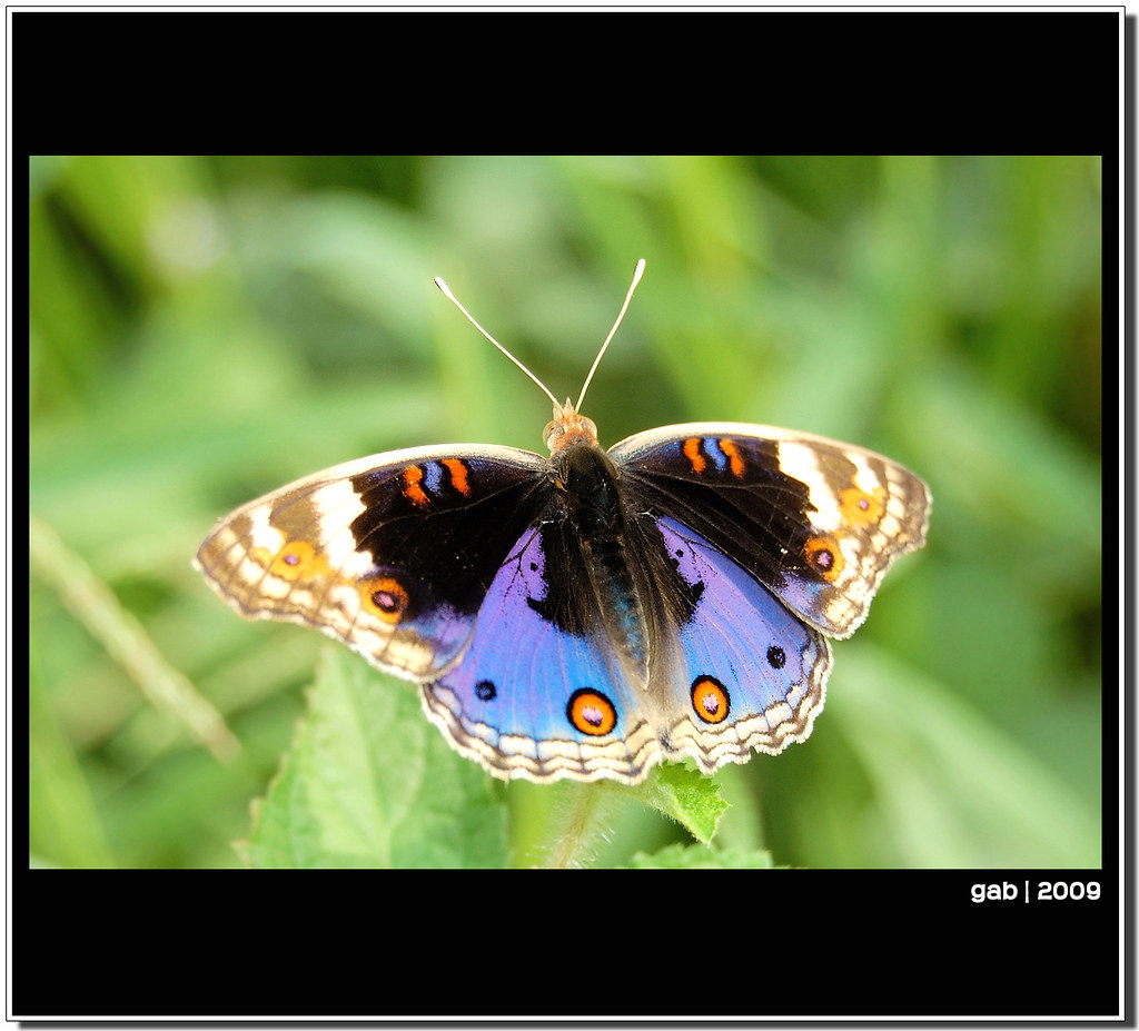
Ijok is a constituency in the state of Selangor, some 65km from Kuala Lumpur. From my house to this tiny dreary township of Ijok, it is only some 15km on a straight line, no big deal for me to get there. But it’s a big deal to go there if I don’t really have any apparent purpose.
Of all the places on earth, I went there looking for butterflies to capture. As if butterflies are that scarce that cannot be found elsewhere but Ijok. When I got back home, I saw similar butterfly was happily roaming in my yard.
Anyway, I spent my morning next to the cemetery in Ijok by myself shooting butterflies. In the picture is my catch of the day – a splendor.
What good is Ijok without her?!!
Jaywick Sands fills the foreground of this aerial view, with Clacton-on-Sea stretching away into the distance along the North Sea coast. The image shows the distinctive low-lying shoreline, sandy beaches, sea defences, caravan parks and dense coastal housing that mark this part of Tendring.
Jaywick began as a seaside holiday settlement, developed from 1928 by entrepreneur Frank Stedman as an affordable plotland resort for working-class Londoners. Small plots were sold for holiday chalets and self-built homes, making Jaywick one of the best-known surviving examples of England’s inter-war plotlands movement. What began as a cheap seaside escape gradually became a permanent community, especially after the Second World War housing shortages.
Today Jaywick Sands is often discussed for very different reasons. It has repeatedly been identified among the most deprived neighbourhoods in England, with long-standing issues around housing quality, employment, flood risk and coastal vulnerability. Its story is therefore both seaside history and social history: a place created for leisure and escape that became a permanent home for thousands of people.
In the distance is Clacton-on-Sea, Essex’s largest seaside resort, developed rapidly after the opening of its pier in 1871 and the arrival of the railway in 1882. Clacton remains strongly associated with beach holidays, amusements, caravan parks and traditional East Coast seaside tourism.
Both Jaywick Sands and Clacton lie within the Clacton parliamentary constituency. The area is in the national news again after Nigel Farage resigned as MP for Clacton, triggering a by-election which he is contesting.
Port Dickson, or PD to locals, is a coastal city and parliamentary constituency in Negeri Sembilan, Malaysia. It takes just over an hour by car to travel from Kuala Lumpur to Port Dickson along the North–South Expressway. The 18 km long beach from Tanjung Gemuk to Tanjung Tuan is a popular holiday destination for local visitors, especially those who come from Kuala Lumpur. Many Singaporeans have invested in holiday homes in and around Port Dickson. Over the years, many hotels and resorts were opened to capitalize on the tourist draw. In the 1990s, Port Dickson boomed with new hotels and resorts being planned and constructed. 20766
New Ridley is a hamlet in the county of Northumberland, England. It is in the parish of Stocksfield and the parliamentary constituency of Hexham. It is one of four "Ridleys" in the parish, along with Old Ridley, East Ridley and Ridley Mill.
Services in New Ridley include Stocksfield Golf Club[2] and the Dr. Syntax public house. The pub is named after a racehorse of the same name which was in turn named after a fictional character created by the writer William Combe.
On the way to Luderitz via an overnight stop at Helmeringhausen. Helmeringhausen is a settlement in southern Namibia in the Berseba Constituency in the Karas Region. It is located 200 km northeast of Lüderitz and 500 km south of Windhoek on the crossing of the national roads C14 and C13, and the road D414. (from Wikipedia)
The River Don (also called River Dun in some stretches) is a river in South Yorkshire and the East Riding of Yorkshire, England. It rises in the Pennines, west of Dunford Bridge, and flows for 69 miles (111 km) eastwards, through the Don Valley, via Penistone, Sheffield, Rotherham, Mexborough, Conisbrough, Doncaster and Stainforth. It originally joined the Trent, but was re-engineered by Cornelius Vermuyden as the Dutch River in the 1620s, and now joins the River Ouse at Goole. Don Valley is a UK parliamentary constituency near the Doncaster stretch of the river.
Below Doncaster, the main channel of the lower Don originally meandered in a north-easterly direction across the marshland of Hatfield Chase to enter the Trent just above its junction with the Ouse. A second channel flowed to the north, along a Roman channel called Turnbridgedike. The eastern channel formed the boundary between Yorkshire and Lincolnshire.
In the Hatfield Level drainage project which started in 1626, the Dutch civil engineer Cornelius Vermuyden diverted the Don northwards along Turnbridgedike. He constructed Dikesmarsh bank some distance to the east of the channel, so that the intervening land could be used as washlands. The main work was completed by 1628, but after flooding in 1629, a "Great Sluice" was constructed at the junction between the river and the Aire, with 17 openings which were 6 by 8 feet (1.8 by 2.4 m), probably by Hugo Spiering, who had assisted Vermuyden on the main project. The washlands had insufficient capacity, and in 1632 work started on a new channel, which would run for 5 miles (8.0 km) from Newbridge, near Thorne, eastwards to enter the Ouse at the site of Goole, 9 miles (14 km) upstream of the Trent. Water levels here were between 5 and 10 feet (1.5 and 3.0 m) lower than at Turnbridge. This new channel was called the "Dutch River", and was finished in 1635, at a cost of £33,000. It ended in a sluice at Goole, and was never intended to be navigable, as boats could access the Aire at Turnbridge. The sluice was later swept away in a flood and never replaced.
The Dutch River was difficult to navigate, made more hazardous by shoals, three awkward bridges, and low water levels at neap tides. With the opening of the Stainforth and Keadby Canal in 1802, from the Don at Stainforth to the Trent at Keadby, most traffic for the Trent used that in preference to the Dutch River and the route around Trent Falls, where the Trent joins the Humber. Construction of a railway from Doncaster to Goole in 1869 reduced traffic on the river, but the Sheffield and South Yorkshire Navigation Company was formed in 1889, to buy back the River Don Navigation, the Sheffield Canal and the Stainforth and Keadby Canal from railway ownership, to keep them competitive. They acquired the waterways in 1895, but failed to raise sufficient capital for the major improvements they had planned. However, they succeeded in constructing the New Junction Canal from Stainforth to the Aire and Calder Navigation (Knottingley and Goole Canal) west of Goole, which was jointly funded by the Aire and Calder, and opened in 1905. The Dutch River reverted almost entirely to its original drainage function, and Stainforth lock, which connected it to the Stainforth and Keadby Canal, was closed in 1939.
Navigation to Sheffield was made possible by the construction of weirs, locks and canal cuttings to avoid circuitous and unnavigable sections of the Don downstream of Tinsley, and then by a canal from Tinsley to Sheffield. The first serious attempts at improvements were authorised by an Act of Parliament obtained in 1726 by Sheffield's Company of Cutlers to make the river navigable from Holmstile in Doncaster to Tinsley, on the edge of Sheffield, and another obtained by the Corporation of Doncaster in 1727 to improve the river below Holmstile, as far as Wilsick House in Barnby Dun. An Act of 1733 created "The Company of the Proprietors of the Navigation of the River Don", and authorised further cuts above Rotherham, while a further Bill of 1740 sought powers to improve the river from Barnby Dun to Fishlake Ferry, to avoid the shallows at Stainforth and Bramwith. The river was navigable to Rotherham in 1740, and to Tinsley by 1751.
Stainforth was connected to the River Trent by the opening on the Stainforth and Keadby Canal in 1802 and to the Aire and Calder Navigation by the New Junction Canal, opened in 1905. There were plans to use compartment boats to carry coal on the navigation, but although some locks were lengthened around 1910, Long Sandall lock was not, and it was not until 1959 that it was extended to 215 by 22 feet (65.5 by 6.7 m) and trains of 17 compartment boats could work through to Doncaster. The navigation was the subject of one of the last major attempts in the UK to attract commercial freight to the waterways. In 1983, it was upgraded to the 700-tonne Eurobarge standard by deepening the channels and enlarging the locks as far as Rotherham. The expected rise in freight traffic did not occur, however.
The cuts and navigable river sections, with the Stainforth and Keadby and the New Junction canals constitute the Sheffield and South Yorkshire Navigation. Locks on the Bramwith to Rotherham section can accommodate boats which are 230 by 20 feet (70.1 by 6.1 m), but above that, boats are restricted to 56 by 15 feet (17.1 by 4.6 m) by the short Rotherham lock.
The Storting (Stortinget in Norwegian, literally meaning 'the Great Thing') is the supreme legislature of Norway, established in 1814 by the Constitution of Norway, located in Oslo. The unicameral parliament has 169 members and is elected every four years based on party-list proportional representation in nineteen multi-seat constituencies. A member of the Storting is known in Norwegian as a stortingsrepresentant, literally "Storting representative."
Since March 5, 1866, parliament has met in the Parliament of Norway Building at Karl Johans gate 22 in Oslo. The building was designed by the Swedish architect Emil Victor Langlet and is built featuring yellow brick with details and basement in light gray granite. It is a combination of several styles, including inspirations from France and Italy. Parliamentary offices and meeting rooms are also housed in nearby buildings, since the Parliament building is too small to hold all the current staff of the legislature.
Information from: en.wikipedia.org/wiki/Storting
Oslo is the capital and most populous city of Norway. It constitutes both a county and a municipality. The municipality of Oslo had a population of 709,037 in 2022, while the city's greater urban area had a population of 1,064,235 in 2022 with a metropolitan population estimated at 1,546,706 in 2021.
During the Viking Age, the area was part of Viken. Oslo was founded as a city at the end of the Viking Age in 1040 under the name Ánslo, and established as a kaupstad or trading place in 1048 by Harald Hardrada. The city was elevated to a bishopric in 1070 and a capital under Haakon V of Norway around the year 1300. Personal unions with Denmark from 1397 to 1523 and again from 1536 to 1814 reduced its influence. After being destroyed by a fire in 1624, during the reign of King Christian IV, a new city was built closer to Akershus Fortress and named Christiania in honor of the king. It became a municipality (formannskapsdistrikt) on January 1, 1838. The city functioned as the capital of Norway during the 1814-1905 union between Sweden and Norway. From 1877, the city's name was spelled Kristiania in government usage, a spelling that was adopted by the municipal authorities in 1897, although 'Christiania' was also used. In 1925, the city was renamed Oslo.
Oslo is the economic and governmental center of Norway. The city is also a hub of Norwegian trade, banking, industry and shipping. It is an important hub for maritime industries and maritime trade in Europe.
Information from: en.wikipedia.org/wiki/Oslo
North West Essex is a constituency of the House of Commons in the UK Parliament.[2] Further to the completion of the 2023 periodic review of Westminster constituencies, it was first contested at the 2024 general election; it has since been held by Kemi Badenoch of the Conservative Party, the current leader of the opposition. She was MP for the predecessor seat of Saffron Walden from 2017 to 2024.
Jeremy Corbyn was one of four speakers at a meeting at St. George's and All Saints Church hosted in his Islington North Labour constituency on the situation facing refugees in the wake of the passing of the Illegal Migration Bill. I recorded Jeremy Corbyn's talk here ( please subscribe ) youtu.be/XPT6_gozmP8
Corbyn attacked the language of hatred against refugees, the lack of safe routes, the shocking treatment of refugees at the Calais refugee encampment and the role of multinationals, the arms trade and mining companies in fuelling conflict in Congo and elsewhere, thereby exacerbating the world's growing refugee crisis.
He also stressed that refugees have a right to be proud of their social and economic contribution and that they have helped to change Britain for the better.
The bill, has been variously applauded or criticized for not going far enough by many political commentators and mainstream media, with the Daily Mail reporting (13 July) that the bill "aims to prevent people from claiming asylum in the UK if they arrive through unauthorised means and ensure their prompt removal, either to their home country or a third country," and pointing the finger at members of the "unelected chamber" (the House of Lords) for "their further watering down of the plan," though failing to explain that there are no safe routes for refugees from most countries afflicted by conflict or murderous authoritarian regimes.
More sober commentators have reflected on the huge cost of the measures that the government is likely to face in confining refugees in increasingly austere and often dangerous conditions, such as the scheme to pack 500 asylum seekers on to the floating barge, the Bibby Stockholm, off Portland despite serious concerns expressed about fire and safety.[1]
At the most "extreme" end of the critical spectrum, a small number of Labour MPs along with churches, charities, NGOs, the United Nations and international news outlets, such as Al Jazeera, have pointed out that the bill breaks international law.
www.aljazeera.com/news/2023/7/18/uk-migration-bill-at-odd...
Corbyn told the hundred or more people packed into the church
"We are meeting in the aftermath of the horrors of the Illegal Migration Bill that has gone through parliament... No human being is illegal. It is not illegal to seek asylum and this piece of legislation that was pushed through parliament is utterly disgusting in every conceivable way."
"First of all it says that anyone arriving in this country without pre-entry arrangements - it's quite hard if you are a refugee to get pre-entry arrangements anyway - will then be removed to Rwanda and in return the Rwandan government will be paid a great deal of money. Well, they've already been paid a great deal of money and they haven't provided the housing they promised they would. They haven't provided the facilities they said that they would and nobody has actually yet been removed to Rwanda."
Footnotes
1. The firefighters' union explained that they were "concerned about a potential lack of ingress and exit points; narrow corridors and doorways; and increased occupancy. The barge was originally built to house 222 people but is now expected to house more than 500." www.fbu.org.uk/news/2023/08/02/firefighters-union-demands...
++++++ from Wikipedia ++++++
Taipei (/ˌtaɪˈpeɪ/), officially known as Taipei City, is the capital city and a special municipality of Taiwan (officially known as the Republic of China, "ROC"). Sitting at the northern tip of the island, Taipei City is an enclave of the municipality of New Taipei City. It is about 25 km (16 mi) southwest of the northern port city Keelung. Most of the city is located on the Taipei Basin, an ancient lakebed bounded by the two relatively narrow valleys of the Keelung and Xindian rivers, which join to form the Tamsui River along the city's western border.[5] Formerly known as Taipeh-fu during Qing era and Taihoku under Japanese rule, Taipei became the capital of the Taiwan Province as part of the Republic of China in 1945 and recently has been the capital[a] of the ROC since 1949, when the Kuomintang lost the mainland to the Communists in the Chinese Civil War.
The city proper is home to an estimated population of 2,704,810 in 2015,[6] forming the core part of the Taipei–Keelung metropolitan area which includes the nearby cities of New Taipei and Keelung with a population of 7,047,559,[6][7] the 40th most-populous urban area in the world—roughly one-third of Taiwanese citizens live in the metro district. The name "Taipei" can refer either to the whole metropolitan area or the city proper.
Taipei is the political, economic, educational, and cultural center of Taiwan island, and one of the major hubs of Greater China. Considered to be a global city,[8] Taipei is part of a major high-tech industrial area.[9] Railways, high-speed rail, highways, airports, and bus lines connect Taipei with all parts of the island. The city is served by two airports – Taipei Songshan and Taiwan Taoyuan. Taipei is home to various world-famous architectural or cultural landmarks which include Taipei 101, Chiang Kai-shek Memorial Hall, Dalongdong Baoan Temple, Hsing Tian Kong, Lungshan Temple of Manka, National Palace Museum, Presidential Office Building, Taipei Guest House, Ximending, and several night markets dispersing over the city. Its natural features such as Maokong, Yangmingshan, and hot springs are also well known to international visitors.
As the capital city, "Taipei" is sometimes used as a synecdoche for the Republic of China. Due to the ongoing controversy over the political status of Taiwan, the name Chinese Taipei is designated for official use when Taiwanese governmental representatives or national teams participate in some international organizations or international sporting events (which may require UN statehood) in order to avoid extensive political controversy by using other names.
Contents
1 History
1.1 First settlements
1.2 Empire of Japan
1.3 Republic of China
2 Geography
2.1 Climate
2.2 Air quality
2.3 Cityscape
3 Demographics
4 Economy
5 Culture
5.1 Tourism
5.1.1 Commemorative sites and museums
5.1.2 Taipei 101
5.1.3 Performing arts
5.1.4 Shopping and recreation
5.1.5 Temples
5.2 Festivals and events
5.3 Taipei in films
6 Romanization
7 Government
7.1 Garbage recycling
7.2 Administrative divisions
7.3 City planning
8 Transportation
8.1 Metro
8.2 Rail
8.3 Bus
8.4 Airports
8.5 Ticketing
9 Education
9.1 Chinese language program for foreigners
10 Sports
10.1 Major sporting events
10.2 Youth baseball
11 Media
11.1 Television
11.2 Newspapers
12 International relations
12.1 Twin towns and sister cities
12.2 Partner cities
12.3 Friendship cities
13 Gallery
14 See also
15 Notes
16 References
17 External links
History
Main article: History of Taipei
The National Chiang Kai-shek Memorial Hall is a famous monument and tourist attraction in Taipei.
Prior to the significant influx of Han Chinese immigrants, the region of Taipei Basin was mainly inhabited by the Ketagalan plains aborigines. The number of Han immigrants gradually increased in the early 18th century under Qing Dynasty rule after the government began permitting development in the area.[10] In 1875, the northern part of the island was incorporated into the new Taipeh Prefecture.
The Qing dynasty of China made Taipeh the temporary capital of Fujian-Taiwan Province in 1886 when Taiwan was separated from Fujian Province.[11][12] Taipeh was formally made the provincial capital in 1894.
Japan acquired Taiwan in 1895 under the Treaty of Shimonoseki after the First Sino-Japanese War. Taiwan became a colony of Imperial Japan with Taihoku (formerly Taipeh) as its capital, in which the city was administered under Taihoku Prefecture. Taiwan's Japanese rulers embarked on an extensive program of advanced urban planning that featured extensive railroad links. A number of Taipei landmarks and cultural institutions date from this period.[13]
Following the Japanese surrender of 1945, control of Taiwan was handed to the Republic of China (ROC) (see Retrocession Day). After losing mainland China to the Chinese Communist Party in the Chinese Civil War, the ruling Kuomintang (KMT) relocated the ROC government to Taiwan and declared Taipei the provisional capital of the ROC in December 1949.[14][15] In 1990 Taipei provided the backdrop for the Wild Lily student rallies that moved Taiwanese society from one-party rule to multi-party democracy. The city is today home to Taiwan's democratically elected national government.
First settlements
The region known as the Taipei Basin was home to Ketagalan tribes before the eighteenth century.[16] Han Chinese mainly from Fujian Province of Qing dynasty China began to settle in the Taipei Basin in 1709.[17][18]
In the late 19th century, the Taipei area, where the major Han Chinese settlements in northern Taiwan and one of the designated overseas trade ports, Tamsui, were located, gained economic importance due to the booming overseas trade, especially that of tea export. In 1875, the northern part of Taiwan was separated from Taiwan Prefecture and incorporated into the new Taipeh Prefecture as a new administrative entity of the Qing dynasty.[13] Having been established adjoining the flourishing townships of Bangka, Dalongdong, and Twatutia, the new prefectural capital was known as Chengnei (Chinese: 城內; pinyin: chéngnèi; Pe̍h-ōe-jī: siâⁿ-lāi), "the inner city", and government buildings were erected there. From 1875 (still Qing era) until the beginning of Japanese rule in 1895, Taipei was part of Tamsui County of Taipeh Prefecture and the prefectural capital.
In 1885, work commenced to create an independent Taiwan Province, and Taipei City was temporarily made the provincial capital. Taipei officially became the capital of Taiwan in 1894.[citation needed] All that remains from the Qing era is the north gate. The west gate and city walls were demolished by the Japanese while the south gate, little south gate, and east gate were extensively modified by the Kuomintang (KMT) and have lost much of their original character.[19]
Empire of Japan
The Taihoku Prefecture government building in the 1910s (now the Control Yuan)
As settlement for losing the First Sino-Japanese War, China ceded the island of Taiwan to the Empire of Japan in 1895 as part of the Treaty of Shimonoseki. After the Japanese take-over, Taipei, called Taihoku in Japanese, was retained as the capital and emerged as the political center of the Japanese Colonial Government.[13] During that time the city acquired the characteristics of an administrative center, including many new public buildings and housing for civil servants. Much of the architecture of Taipei dates from the period of Japanese rule, including the Presidential Building which was the Office of the Governor-General of Taiwan.
During Japanese rule, Taihoku was incorporated in 1920 as part of Taihoku Prefecture. It included Bangka, Twatutia, and Jōnai (城內) among other small settlements. The eastern village of Matsuyama (松山庄, modern-day Songshan District, Taipei) was annexed into Taihoku City in 1938. Upon the Japanese defeat in the Pacific War and its consequent surrender in August 1945, the Kuomintang (Chinese Nationalist Party) assumed control of Taiwan. Subsequently, a temporary Office of the Taiwan Province Administrative Governor was established in Taipei City.[20]
Republic of China
With President Chiang Kai-shek, U.S. President Dwight D. Eisenhower waved to a crowd during his visit to Taipei in June 1960.
In 1947 the KMT government under Chiang Kai-shek declared island-wide martial law in Taiwan as a result of the February 28 Incident, which began with incidents in Taipei but led to an island-wide crackdown on the local population by forces loyal to Chiang. Two years later, on December 7, 1949, Chiang and the Kuomintang were forced to flee mainland China by the Communists near the end of the Chinese Civil War. The refugees declared Taipei to be the provisional capital of a continuing Republic of China, with the official capital at Nanjing (Nanking) even though that city was under Communist control.[14][15]
Taipei expanded greatly in the decades after 1949, and as approved on December 30, 1966 by the Executive Yuan, Taipei was declared a special centrally administered municipality on July 1, 1967 and given the administrative status of a province.[18] In the following year, Taipei City expanded again by annexing Shilin, Beitou, Neihu, Nangang, Jingmei, and Muzha. At that time, the city's total area increased fourfold through absorbing several outlying towns and villages and the population increased to 1.56 million people.[18]
The city's population, which had reached one million in the early 1960s, also expanded rapidly after 1967, exceeding two million by the mid-1970s. Although growth within the city itself gradually slowed thereafter[20] — its population had become relatively stable by the mid-1990s — Taipei remained one of the world's most densely populated urban areas, and the population continued to increase in the region surrounding the city, notably along the corridor between Taipei and Keelung.
In 1990 Taipei's 16 districts were consolidated into the current 12 districts.[21] Mass democracy rallies that year in the plaza around Chiang Kai-shek Memorial Hall led to an island-wide transition to multi-party democracy, where legislators are chosen via regularly scheduled popular elections, during the presidency of Lee Teng-Hui.
Geography
The city of Taipei, as seen from Maokong.
Taipei City is located in the Taipei Basin in northern Taiwan.[22] It is bordered by the Xindian River on the south and the Tamsui River on the west. The generally low-lying terrain of the central areas on the western side of the municipality slopes upward to the south and east and especially to the north,[5] where it reaches 1,120 metres (3,675 ft) at Qixing Mountain, the highest (inactive) volcano in Taiwan in Yangmingshan National Park. The northern districts of Shilin and Beitou extend north of the Keelung River and are bordered by Yangmingshan National Park. The Taipei city limits cover an area of 271.7997 km2,[23] ranking sixteenth of twenty-five among all counties and cities in Taiwan.
Two peaks, Qixing Mountain and Mt. Datun, rise to the northeast of the city.[24] Qixing Mountain is located on the Tatun Volcano Group and the tallest mountain at the rim of the Taipei Basin, with its main peak at 1,120 metres (3,670 ft). Mt. Datun's main peak is 1,092 metres (3,583 ft). These former volcanoes make up the western section of Yangmingshan National Park, extending from Mt. Datun northward to Mt. Caigongkeng (菜公坑山). Located on a broad saddle between two mountains, the area also contains the marshy Datun Pond.
To the southeast of the city lie the Songshan Hills and the Qingshui Ravine, which form a barrier of lush woods.[24]
Climate
Taipei has a monsoon-influenced humid subtropical climate[25][26][27] (Köppen: Cfa).[28] Summers are long-lasting, hot and humid, and accompanied by occasional heavy rainstorms and typhoons, while winters are short, generally warm and generally very foggy due to the northeasterly winds from the vast Siberian High being intensified by the pooling of this cooler air in the Taipei Basin. As in the rest of Northern Taiwan, daytime temperatures of Taipei can often peak above 26 degrees Celsius during a warm winter day, while they can dip below 26 degrees Celsius during a rainy summer's afternoon. Occasional cold fronts during the winter months can drop the daily temperature by 3 to 5 degrees Celsius, though temperatures rarely drop below 10 degrees Celsius.[29] Extreme temperatures ranged from −0.2 °C (31.6 °F) on February 13, 1901 to 39.3 °C (102.7 °F) on August 8, 2013, while snow has never been recorded in the city besides on mountains located within the city limit such as Mount Yangmingshan. Due to Taiwan's location in the Pacific Ocean, it is affected by the Pacific typhoon season, which occurs between June and October.
Air quality
When compared to other Asian cities, Taipei has "excellent" capabilities for managing air quality in the city.[31] Its rainy climate, location near the coast, and strong environmental regulations have prevented air pollution from becoming a substantial health issue, at least compared to cities in southeast Asia and industrial China. However, smog is extremely common and there is poor visibility throughout the city after rain-less days.
Motor vehicle engine exhaust, particularly from motor scooters, is a source of air pollution in Taipei. There are higher levels of fine particulate matter and polycyclic aromatic hydrocarbons in the mornings because of less air movement; sunlight reduces some pollution.[32] Occasionally, dust storms from Mainland China can temporarily bring extremely poor air quality to the city.[33]
Cityscape
Taipei viewed from Tiger Mountain, with Taipei 101 on the left.
Demographics
Taipei City is home to 2,704,810 people (2015), while the metropolitan area has a population of 7,047,559 people.[6] The population of the city has been decreasing in recent years while the population of the adjacent New Taipei has been increasing. The population loss, while rapid in its early years, has been stabilized by new lower density development and campaigns designed to increase birthrate in the city. The population has begun to rise since 2010.[6][34][35]
Due to Taipei's geography and location in the Taipei Basin as well as differing times of economic development of its districts, Taipei's population is not evenly distributed. The districts of Daan, Songshan, and Datong are the most densely populated. These districts, along with adjacent communities such as Yonghe and Zhonghe contain some of the most densely populated neighborhoods in the world.[34]
In 2008, the crude birth rate stood at 7.88% while the mortality rate stood at 5.94%. A decreasing and rapidly aging population is an important issue for the city.[34] By the end of 2009, one in ten people in Taipei was over 65 years of age.[36] Residents who had obtained a college education or higher accounted for 43.48% of the population, and the literacy rate stood at 99.18%.[34]
Like the rest of Taiwan, Taipei is composed of four major ethnic groups: Hoklos, Mainlanders, Hakkas, and aborigines.[34] Although Hoklos and Mainlanders form the majority of the population of the city, in recent decades many Hakkas have moved into the city. The aboriginal population in the city stands at 12,862 (<0.5%), concentrated mostly in the suburban districts. Foreigners (mainly from Indonesia, Vietnam, and the Philippines) numbered 52,426 at the end of 2008.[34]
Economy
As the center of Taiwan's largest conurbation, Taipei has been at the center of rapid economic development in the country and has now become one of the global cities in the production of high technology and its components.[37] This is part of the so-called Taiwan Miracle which has seen dramatic growth in the city following foreign direct investment in the 1960s. Taiwan is now a creditor economy, holding one of the world's largest foreign exchange reserves of over US$403 billion as of December 2012.[38]
Despite the Asian financial crisis, the economy continues to expand at about 5% per year, with virtually full employment and low inflation. As of 2013, the nominal GDP per capita in Taipei city is lower than that in Hong Kong by a narrow margin according to The Economist(Nominal GDP per capita in HK is US$38181 in 2013 from IMF).[39] Furthermore, according to Financial times, GDP per capita based on Purchasing Power Parity(PPP) in Taipei in 2015 is 44173 USD, behind that in Singapore(US$48900 from IMF) and Hong Kong(US$56689 from IMF).[40]
Taipei and its environs have long been the foremost industrial area of Taiwan, consisting of industries of the secondary and tertiary sectors.[41] Most of the country's important factories producing textiles and apparel are located there; other industries include the manufacture of electronic products and components, electrical machinery and equipment, printed materials, precision equipment, and foods and beverages. Such companies include Shihlin Electric, CipherLab and Insyde Software. Shipbuilding, including yachts and other pleasure craft, is done in the port of Keelung northeast of the city.
Services, including those related to commerce, transportation, and banking, have become increasingly important. Tourism is a small but significant component of the local economy[42][43] with international visitors totaling almost 3 million in 2008.[44] Taipei has many top tourist attractions and contributes a significant amount to the US$6.8 billion tourism industry in Taiwan.[45] National brands such as ASUS,[46] Chunghwa Telecom,[47] Mandarin Airlines,[48] Tatung,[49] and Uni Air,[50][51] D-Link [52] are headquartered in Taipei City.
Culture
Tourism
See also: List of tourist attractions in Taipei
Tourism is a major part of Taipei's economy. In 2013, over 6.3 million overseas visitors visited Taipei, making the city the 15th most visited globally.[53] The influx of visitors contributed $10.8 billion USD to the city's economy in 2013, the 9th highest in the world and the most of any city in the Chinese-speaking world.[54]
Commemorative sites and museums
The National Palace Museum
The National Chiang Kai-shek Memorial Hall is a famous monument, landmark and tourist attraction that was erected in memory of General Chiang Kai-shek, former President of the Republic of China.[55] The structure stands at the east end of Memorial Hall Square, site of the National Concert Hall and National Theater and their adjacent parks as well as the memorial. The landmarks of Liberty Square stand within sight of Taiwan's Presidential Building in Taipei's Zhongzheng District.
The National Taiwan Museum
The National Taiwan Museum sits nearby in what is now 228 Peace Memorial Park and has worn its present name since 1999. The museum is Taiwan's oldest, founded on October 24, 1908 by Taiwan's Japanese colonial government (1895-1945) as the Taiwan Governor's Museum. It was launched with a collection of 10,000 items to celebrate the opening of the island's North-South Railway.[56] In 1915 a new museum building opened its doors in what is now 228 Peace Memorial Park. This structure and the adjacent governor's office (now Presidential Office Building), served as the two most recognizable public buildings in Taiwan during its period of Japanese rule.[56]
Shung Ye Museum of Formosan Aborigines
The National Palace Museum is a vast art gallery and museum built around a permanent collection centered on ancient Chinese artifacts. It should not be confused with the Palace Museum in Beijing (which it is named after); both institutions trace their origins to the same institution. The collections were divided in the 1940s as a result of the Chinese Civil War.[57][58] The National Palace Museum in Taipei now boasts a truly international collection while housing one of the world's largest collections of artifacts from ancient China.[58]
The Shung Ye Museum of Formosan Aborigines stands just 200 metres across the road from the National Palace Museum. The museum offers displays of art and historical items by Taiwanese aborigines along with a range of multimedia displays.
The Taipei Fine Arts Museum was established in 1983 as the first museum in Taiwan dedicated to modern art. The museum is housed in a building designed for the purpose that takes inspiration from Japanese designs. Most art in the collection is by Taiwanese artists since 1940. Over 3,000 art works are organized into 13 groups.
The National Sun Yat-sen Memorial Hall near Taipei 101 in Xinyi District is named in honor of a founding father of the Republic of China, Sun Yat-sen. The hall, completed on May 16, 1972, originally featured exhibits that depicted revolutionary events in China at the end of the Qing Dynasty. Today it functions as multi-purpose social, educational, concert and cultural center for Taiwan's citizens.[59]
Museum of Contemporary Art Taipei, aka "old city hall"
In 2001 a new museum opened as Museum of Contemporary Art Taipei. The museum is housed in a building that formerly housed Taipei City government offices.[60]
Night view of a fully lit Taipei 101
Taipei 101
Taipei 101 is a 101-floor landmark skyscraper that claimed the title of world's tallest building when it opened in 2004, a title it held for six years before relinquishing it to the Burj Khalifa in Dubai. Designed by C.Y. Lee & Partners and constructed by KTRT Joint Venture, Taipei 101 measures 509 m (1,670 ft) from ground to top, making it the first skyscraper in the world to break the half-kilometer mark in height. Built to withstand typhoon winds and earthquake tremors, its design incorporates many engineering innovations and has won numerous international awards. Taipei 101 remains one of the tallest skyscrapers in the world and holds LEED's certification as the world's largest "green" building. Its shopping mall and its indoor and outdoor observatories draw visitors from all over the world. Taipei 101's New Year's Eve fireworks display is a regular feature of international broadcasts.
Performing arts
Taiwan's National Concert Hall at night
The National Theater and Concert Hall stand at Taipei's Liberty Square and host events by foreign and domestic performers. Other leading concert venues include Zhongshan Hall at Ximending and the Sun Yat-sen Memorial Hall near Taipei 101.
A new venue, the Taipei Performing Arts Center, is under construction and slated to open in 2015.[61][62] The venue will stand near the Shilin Night Market[63] and will house three theaters for events with multi-week runs. The architectural design, by Rem Koolhaas and OMA, was determined in 2009 in an international competition.[64] The same design process is also in place for a new Taipei Center for Popular Music and Taipei City Museum.[65]
Shopping and recreation
Main article: Shopping in Taipei
Taipei is known for its many night markets, the most famous of which is the Shilin Night Market in the Shilin District. The surrounding streets by Shilin Night Market are extremely crowded during the evening, usually opening late afternoon and operating well past midnight. Most night markets feature individual stalls selling a mixture of food, clothing, and consumer goods.
The busy streets of Ximending at night
Ximending has been a famous area for shopping and entertainment since the 1930s. Historic structures include a concert hall, a historic cinema, and the Red House Theater. Modern structures house karaoke businesses, art film cinemas, wide-release movie cinemas, electronic stores, and a wide variety of restaurants and fashion clothing stores.[66] The pedestrian area is especially popular with teens and has been called the "Harajuku" of Taipei.[67]
Eastern district at night
The newly developed Xinyi District is popular with tourists and locals alike for its many entertainment and shopping venues, as well as being the home of Taipei 101, a prime tourist attraction. Malls in the area include the sprawling Shin Kong Mitsukoshi complex, Breeze Center, Bellavita, Taipei 101 mall, Eslite Bookstore's flagship store (which includes a boutique mall), The Living Mall, ATT shopping mall, and the Vieshow Cinemas (formerly known as Warner Village). The Xinyi district also serves as the center of Taipei's active nightlife, with several popular lounge bars and nightclubs concentrated in a relatively small area around the Neo19, ATT 4 FUN and Taipei 101 buildings. Lounge bars such as Barcode and nightclubs such as Spark and Myst are among the most-visited places here.
Eslite Bookstore in Xinyi District
The thriving shopping area around Taipei Main Station includes the Taipei Underground Market and the original Shin Kong Mitsukoshi department store at Shin Kong Life Tower. Other popular shopping destinations include the Zhongshan Metro Mall, Dihua Street, the Guang Hua Digital Plaza, and the Core Pacific City. The Miramar Entertainment Park is known for its large Ferris wheel and IMAX theater.
Taipei maintains an extensive system of parks, green spaces, and nature preserves. Parks and forestry areas of note in and around the city include Yangmingshan National Park, Taipei Zoo and Da-an Forest Park. Yangmingshan National Park (located 10 kilometres (6.2 mi) north of the central city) is famous for its cherry blossoms, hot springs, and sulfur deposits. It is the home of famous writer Lin Yutang, the summer residence of Chiang Kai-shek, residences of foreign diplomats, the Chinese Culture University, the meeting place of the now defunct National Assembly of the Republic of China, and the Kuomintang Party Archives. The Taipei Zoo was founded in 1914 and covers an area of 165 hectares for animal sanctuary.
Bitan is known for boating and water sports. Tamsui is a popular sea-side resort town. Ocean beaches are accessible in several directions from Taipei.
Temples
Built in 1738, Longshan Temple is one of the oldest temples in the city.
Street corner shrine, Taipei 2013
Taipei is rich in beautiful, ornate temples housing Buddhist, Taoist, and Chinese folk religion deities. The Longshan Temple, built in 1738 and located in the Wanhua District, demonstrates an example of architecture with southern Chinese influences commonly seen on older buildings in Taiwan.
Xinsheng South Road is known as the "Road to Heaven" due to its high concentration of temples, shrines, churches, and mosques.[68][69] Other famous temples include Baoan Temple located in historic Dalongdong, a national historical site, and Xiahai City God Temple, located in the old Dadaocheng community, constructed with architecture similar to temples in southern Fujian.[70] The Taipei Confucius Temple traces its history back to 1879 during the Qing Dynasty and also incorporates southern Fujian-style architecture.[71]
Besides large temples, small outdoor shrines to local deities are very common and can be spotted on road sides, parks, and neighborhoods. Many homes and businesses may also set up small shrines of candles, figurines, and offerings. Some restaurants, for example, may set up a small shrine to the Kitchen god for success in a restaurant business.[72]
New Year's Eve fireworks at Taipei 101
Festivals and events
Many yearly festivals are held in Taipei. In recent years some festivals, such as the Double Ten Day fireworks and concerts, are increasingly hosted on a rotating basis by a number of cities around Taiwan.
When New Year's Eve arrives on the solar calendar, thousands of people converge on Taipei's Xinyi District for parades, outdoor concerts by popular artists, street shows, round-the clock nightlife. The high point is of course the countdown to midnight, when Taipei 101 assumes the role of the world's largest fireworks platform.
The Taipei Lantern Festival concludes the Lunar New Year holiday. The timing of the city's lantern exhibit coincides with the national festival in Pingxi, when thousands of fire lanterns are released into the sky.[73] The city's lantern exhibit rotates among different downtown locales from year to year, including Liberty Square, Taipei 101, and Zhongshan Hall in Ximending.
On Double Ten Day, patriotic celebrations are held in front of the Presidential Building. Other annual festivals include Ancestors Day (Tomb-Sweeping Day), the Dragon Boat Festival, the Ghost Festival, and the Mid-Autumn Festival (Moon Festival).[73]
Taipei regularly hosts its share of international events. The city recently hosted the 2009 Summer Deaflympics.[74] This event was followed by the Taipei International Flora Exposition, a garden festival hosted from November 2010 to April 2011. The Floral Expo was the first of its kind to take place in Taiwan and only the seventh hosted in Asia; the expo admitted 110,000 visitors on February 27, 2011.
Taipei in films
Romanization
The spelling "Taipei" derives from the Wade–Giles romanization T'ai-pei.[75] The name could be also romanized as Táiběi according to Hanyu Pinyin and Tongyong Pinyin.[76][77]
Government
Taipei City is a special municipality which is directly under the Executive Yuan (Central Government) of ROC. The mayor of Taipei City had been an appointed position since Taipei's conversion to a centrally administered municipality in 1967 until the first public election was held in 1994.[78] The position has a four-year term and is elected by direct popular vote. The first elected mayor was Chen Shui-bian of the Democratic Progressive Party. Ma Ying-jeou took office in 1998 for two terms, before handing it over to Hau Lung-pin who won the 2006 mayoral election on December 9, 2006.[79] Both Chen Shui-bian and Ma Ying-Jeou went on to become President of the Republic of China. The incumbent mayor, Ko Wen-je, was elected on November 29, 2014 and took office on December 25, 2014.[80]
Based on the outcomes of previous elections in the past decade, the vote of the overall constituency of Taipei City shows a slight inclination towards the pro-KMT camp (the Pan-Blue Coalition);[81] however, the pro-DPP camp (the Pan-Green Coalition) also has considerable support.[82]
Ketagalan Boulevard, where the Presidential Office Building and other government structures are situated, is often the site of mass gatherings such as inauguration and national holiday parades, receptions for visiting dignitaries, political demonstrations,[83][84] and public festivals.[85]
Garbage recycling
Taipei City is also famous for its effort in garbage recycling, which has become such a good international precedent that other countries have sent teams to study the recycling system. After the Environmental Protection Administration (EPA) established a program in 1998 combining the efforts of communities, a financial resource named the Recycling Fund was made available to recycling companies and waste collectors. Manufacturers, vendors and importers of recyclable waste pay fees to the Fund, which uses the money to set firm prices for recyclables and subsidize local recycling efforts. Between 1998 and 2008, the recycling rate increased from 6 percent to 32 percent.[86] This improvement enabled the government of Taipei to demonstrate its recycling system to the world at the Shanghai World Expo 2010.
Administrative divisions
Taipei City is divided up into 12 administrative districts (區 qu).[87] Each district is further divided up into urban villages (里), which are further sub-divided up into neighborhoods (鄰).
Map District Population
(Jan. 2016) Area
(km2) Postal
code
Beitou 北投區 Běitóu Pei-t'ou Pak-tâu 257,922 56.8216 112
Da'an 大安區 Dà'ān Ta-an Tāi-an 312,909 11.3614 106
Datong 大同區 Dàtóng Ta-t'ung Tāi-tông 131,029 5.6815 103
Nangang 南港區 Nángǎng Nan-kang Lâm-káng 122,296 21.8424 115
Neihu 內湖區 Nèihú Nei-hu Lāi-ô͘ 287,726 31.5787 114
Shilin 士林區 Shìlín Shih-lin Sū-lîm 290,682 62.3682 111
Songshan 松山區 Sōngshān Sung-shan Siông-san 209,689 9.2878 105
Wanhua 萬華區 Wànhuá Wan-hua Báng-kah 194,314 8.8522 108
Wenshan 文山區 Wénshān Wen-shan Bûn-san 275,433 31.5090 116
Xinyi 信義區 Xìnyì Hsin-yi Sìn-gī 229,139 11.2077 110
Zhongshan 中山區 Zhōngshān Chung-shan Tiong-san 231,286 13.6821 104
Zhongzheng 中正區 Zhōngzhèng Chung-cheng Tiong-chèng 162,549 7.6071 100
City planning
The city is characterized by straight roads and public buildings of grand Western architectural styles.[88] The city is built on a square grid configuration, however these blocks are huge by international standards with 500 m (1,640.42 ft) sides. The area in between these blocks are infilled with lanes and alleys, which provide access to quieter residential or mixed-use development. Other than a citywide 30 kilometres per hour (19 mph) speed limit, there is little uniform planning within this "hidden" area; therefore lanes (perpendicular to streets) and alleys (parallel with street, or conceptually, perpendicular to the lane) spill out from the main throughways. These minor roads are not always perpendicular and sometimes cut through the block diagonally.
Although development began in the western districts (still considered the cultural heart of the city) of the city due to trade, the eastern districts of the city have become the focus of recent development projects. Many of the western districts, already in decline, have become targets of new urban renewal initiatives.[88]
Transportation
Platform of Wende Station on the Taipei Metro system.
Public transport accounts for a substantial portion of different modes of transport in Taiwan, with Taipei residents having the highest utilization rate at 34.1%.[89] Private transport consists of motor scooters, private cars, and bicycles. Motor-scooters often weave between cars and occasionally through oncoming traffic. Respect for traffic laws, once scant, has improved with deployment of traffic cameras and increasing numbers of police roadblocks checking riders for alcohol consumption and other offenses.
Taipei Station serves as the comprehensive hub for the subway, bus, conventional rail, and high-speed rail.[41] A contactless smartcard, known as EasyCard, can be used for all modes of public transit as well as several retail outlets. It contains credits that are deducted each time a ride is taken.[90] The EasyCard is read via proximity sensory panels on buses and in MRT stations, and it does not need to be removed from one's wallet or purse.
Metro
Main article: Taipei Metro
Taipei's public transport system, the Taipei Metro (commonly referred to as the MRT), incorporates a metro and light rail system based on advanced VAL and Bombardier technology. There are currently five metro lines that are labelled in three ways: color, line number and depot station name. In addition to the rapid transit system itself, the Taipei Metro also includes several public facilities such as the Maokong Gondola, underground shopping malls, parks, and public squares. Modifications to existing railway lines to integrate them into the metro system are underway.
In 2017 a rapid transit line was opened to connect Taipei with Taiwan Taoyuan International Airport and Taoyuan City. The new line is part of the new Taoyuan Metro system.
Taipei Railway Station front
Rail
Main articles: Taiwan High Speed Rail and Taiwan Railway Administration
Beginning in 1983, surface rail lines in the city were moved underground as part of the Taipei Railway Underground Project.[91] The Taiwan High Speed Rail system opened in 2007. The bullet trains connect Taipei with the west coast cities of New Taipei, Taoyuan, Hsinchu, Taichung, Chiayi, and Tainan before terminating at Zuoying (Kaohsiung) at speeds that cut travel times by 60% or more from what they normally are on a bus or conventional train.[92] The Taiwan Railway Administration also runs passenger and freight services throughout the entire island.
Bus
An extensive city bus system serves metropolitan areas not covered by the metro, with exclusive bus lanes to facilitate transportation.[41] Riders of the city metro system are able to use the EasyCard for discounted fares on buses, and vice versa. Several major intercity bus terminals are located throughout the city, including the Taipei Bus Station and Taipei City Hall Bus Station.[93]
Taipei Songshan Airport
Airports
Main articles: Taiwan Taoyuan International Airport and Taipei Songshan Airport
Most scheduled international flights are served by Taiwan Taoyuan International Airport in nearby Taoyuan City. Songshan Airport at the heart of the city in the Songshan District serves domestic flights and scheduled flights to Tokyo International Airport (also known as Haneda Airport), Gimpo International Airport in Seoul, and about 15 destinations in the People's Republic of China. Songshan Airport is accessible by the Taipei Metro Neihu Line; Taiwan Taoyuan International Airport is accessible by the Taoyuan International Airport MRT system.
Ticketing
In 1994, with the rapid development of Taipei, a white paper for transport policies expressed the strong objective to "create a civilised transport system for the people of Taipei." In 1999, they chose Mitac consortium, which Thales-Transportation Systems is part of. Thales was then selected again in 2005 to deploy an upgrade of Taipei's public transport network with an end-to-end and fully contactless automatic fare collection solution that integrates 116 metro stations, 5,000 buses and 92 car parks.[citation needed]
Education
West Site of National Taiwan University Hospital
24 universities have campuses located in Taipei:
National Taiwan University (1928)
National Chengchi University (1927)
National Defense Medical Center (1902)
National Defense University (1906)
National Taipei University (1949)
National Taipei University of Business (1917)
National Taipei University of Education (1895)
National Taipei University of Nursing and Health Science (1947)
National Taiwan University of Science and Technology (1974)
National Taipei University of Technology (1912)
National Taiwan College of Performing Arts (1957)
National Taiwan Normal University (1946)
National Yang-Ming University (1975)
Taipei National University of the Arts (1982)
University of Taipei (2013)
Tamkang University (1950)
Soochow University (1900)
Chinese Culture University (1962)
Ming Chuan University (1957)
Shih Hsin University (1956)
Shih Chien University (1958)
Taipei Medical University (1960)
Tatung University (1956)
China University of Technology (1965)
National Taiwan University (NTU) was established in 1928 during the period of Japanese colonial rule. NTU has produced many political and social leaders in Taiwan. Both pan-blue and pan-green movements in Taiwan are rooted on the NTU campus. The university has six campuses in the greater Taipei region (including New Taipei) and two additional campuses in Nantou County. The university governs farms, forests, and hospitals for educational and research purposes. The main campus is in Taipei's Da-An district, where most department buildings and all the administrative buildings are located. The College of Law and the College of Medicine are located near the Presidential Building. The National Taiwan University Hospital is a leading international center of medical research.[94]
National Taiwan Normal University (NTNU or Shida) likewise traces its origins to the Japanese colonial period. Originally a teacher training institution, NTNU has developed into a comprehensive international university with demanding entrance requirements. The university boasts especially strong programs in the humanities and international education. Worldwide it is perhaps best known as home of the Mandarin Training Center, a program that offers Mandarin language training each year to over a thousand students from dozens of countries throughout the world. The main campus in Taipei's Da-An district, near MRT Guting Station, is known for its historic architecture and giving its name to the Shida Night Market, one of the most popular among the numerous night markets in Taipei.
Chinese language program for foreigners
Taiwan Mandarin Institute (TMI) (福爾摩莎)
International Chinese Language Program (ICLP) (國際華語研習所) of National Taiwan University
Mandarin Training Center (MTC) (國語教學中心) of National Taiwan Normal University
Taipei Language Institute (中華語文研習所)
Cavendish Mews is a smart set of flats in Mayfair where flapper and modern woman, the Honourable Lettice Chetwynd has set up home after coming of age and gaining her allowance. To supplement her already generous allowance, and to break away from dependence upon her family, Lettice has established herself as a society interior designer, so her flat is decorated with a mixture of elegant antique Georgian pieces and modern Art Deco furnishings, using it as a showroom for what she can offer to her well heeled clients.
Tonight, however we are not in Lettice’s flat. Instead, we have followed Lettice south-east, past the Royal Academy*, across Picadilly, through the neighbouring borough of St James’ with its private clubs and gentlemen’s tailors, over St James’ Park and Birdcage Walk where once the Royal Menagerie and aviaries of King James I and King Charles II had stood, to Queen Anne’s Gate** in Westminster, lined with fine early Eighteenth Century townhouses. It is here that Member of Parliament for the constituency of Towers Hamlets***, Mr. Charles Hatchett, and his wife Dolly have established their London base after extensive structural works to make it habitable after many years of neglect under its former owner, a decrepit old Admiral of Queen Victoria’s navy. Lettice was commissioned by Mrs. Hatchett to redecorate some of the principal rooms of the newly renovated and restored townhouse, and this evening, the Hatchetts have invited Lettice for celebratory drinks and canapés to thank her for all her hard work.
Lettice pays the driver of the blue London taxi through the glass divider between the driver’s compartment and the passenger carriage before pressing down on the shining chrome handle and stepping out onto the pavement, the flash of a white silk stocking clad leg and one of Gerald’s beautiful evening frocks embroidered with strings of glittering pink glass beads poking out from underneath her luxurious full length white fox fur coat**** as she moves from a seated to a standing position. With a glittering beaded headdress sparkling on her head and fine magenta dyed velvet pumps, she cuts a fashionable figure. The heels of her pumps click in the cool evening as she walks a few paces along the footpath before up with admiration at the simple, elegant façade of the red and rich brown brick building before her, set with rigid rows of twelve, nine and six pane Georgian windows. Lettice smiles up at the benign face of Queen Anne, as the former ruler peers out through a mixture of flowers, draped festoons, oak leaves and acorns that surround her on the ornately carved canopy** over the main door of the residence. Painted in white to match the window frames of the house, the wood of the canopy takes on a ghostly appearance in the evening light. Unlike her first visit to the townhouse, there are no muffled sounds of distant hammering emanating from within, and all is serene and quiet in the terrace lined street where Austins and Worsleys are parked awaiting their owners. Walking up the two Portland stone steps to the front door Lettice wraps her white kid leather evening glove hand around the brass bell pull sticking out of the red brick to the left of the door. From within the house the sound of the bell rings. As she waits on the stoop, Lettice can almost imagine she can hear the familiar sound of a pair of shuffling footsteps, indecipherable muttering and that known fruity cough, as Lettice remembers Mrs. Boothby answering the door the first time she visited, much to her astonishment. Lettice still wonders whether her Cockney charwoman******, who is not unknown from being a little sly, eavesdropped to know that Lettice was going to decorate for the Hatchett’s and secured herself a job as a cleaner for them when they were first clearing the house.
“Oh, good evening, Miss Chetwynd,” the maid who answers the door to Lettice says brightly in her slightly sing-song accent and elongated East Anglian vowels. “How lovely to see you again.” She beams happily. “Please come in.”
“Good evening Jennie.” Lettice replies as she steps across the threshold into the warmly it entrance hall, acknowledging the maid whom Lettice first met five years ago when she decorated ‘The Gables’: sprawling Arts and Crafts style home of Mr. and Mrs. Hatchett in Rotherfield and Mark Cross******* in Sussex.
“Madam is expecting you in the upstairs drawing room” Jennie says as she helps Lettice out of her coat, revealing the ravishing pale pink spangled bead evening frock she is wearing.
Lettice follows Jennie betheath the carved dividing screen of two burnished mahogany columns with a delicate glass lunette******** of seven panes of clear glass splaying out from a central semi-circle above, and ascends the sweeping balustraded Georgian staircase upstairs. As they traverse the long corridor, once dark and dingy but now ablaze with electric illumination, Lettice is pleased to see that even though she did not decide the décor of the passage, that her prevailing simplistic Art Deco style has been carried through it, with panels of geometrically patterned papers designed by Jeffrey and Company********* breaking up the mahogany panelled walls, and elegant and modern light fixtures suspended above their heads.
Jennie wraps smartly on the restored mahogany double doors leading to the first-floor drawing room before throwing them open. “Miss Chetwynd, Madam.” she announces proudly.
And then Lettice steps into her latest interior design masterpiece. Gone is the grime and darkness, along with the pervasive smell of damp that seemed to cling to your every pore. In its place is a room that is clean and gleams with modernity. The walls are hung with pale dove grey papers featuring a stylised geometric Art Deco pattern, created specifically for Lettice by Jeffrey and Company to her own designs, inspired by what she saw on her visit to the Exposition Internationale des Arts Décoratifs et Industriels Modernes********** in Paris in 1925. The mahogany floor-to-ceiling bookshelves flanking the white marble fireplace – the only original furnishings – are filled with a selection of titles Lettice would call ‘light shipboard reading’***********, owing to the fact that neither Mr. nor Mrs. Hatchett are great readers. Supplied by book dealer friend Mr. Mayhew of Charring Cross Road************, the books which suggest a level of intelligence and varied interests are indispersed with interesting and pretty objects to lighten the space. A thick Persian rug covers the polished parquetry floor, and soft furnishings in the latest Art Deco style are accessorised with choice pieces of Eighteenth Century chinoiserie************* furnishings. The gleaming white marble fireplace, once yellow, brown and black with fire and pipe smoke, is flanked by two large Dragonware************** jugs in black and blue with fine white tracings, standing atop two Art Deco stands, provided by her antiques and curios friend, Lancelot de Vries. And presiding over it all from her gilded frame over the fireplace, Mrs. Hatchett herself in a beautiful and most arresting portrait.
“Well Lettuce Leaf,” a familiar voice comes from behind an opened copy of the Daily Mirror.
“Gerald!” Lettice gasps in surprise, to startled to admonish him for using her most hated childhood pet name, as she sees him sitting in an armchair where he lowers the newspaper and smiles up at her. “I wasn’t expecting you!”
“Well, it was a last-minute idea that Dolly threw up at me at the last minute.” Gerald explains, putting the paper aside, getting up and walking over to Lettice. “She feels that it’s tradition, darling.” he continues as he embraces her.
“Tradition, Gerald darling?” Lettice queries.
“Yes.” Gerald replies. “At least that’s how she sees it, since we were both present at the little soirée she held following your redecoration of ‘The Gables’ back in 1921.”
“Good heavens!” Lettice exclaims. “Do you know, I had quite forgotten about that, Gerald darling!”
“I’m shocked!” Gerald replies in mock horror, making an exaggerated face of horror and throwing his hands up melodramatically. “You don’t remember every moment you’ve been with me at social occasions? Good god!”
Lettice’s blue eyes narrow and her well manicured eyebrows arch as she replies cheekily, “Getting acting lessons off your new thespian friends?” referring to the theatrical and rather melodramatic homosexual men who all board with his friend Harriet Milford in her large house in Putney, along with Gerlad’s lover, West End oboist Cyril.
“Cheeky Lettuce Leaf!” Gerald wags an admonishing finger at her. “And here I was, about to pay you the nicest compliment.”
“Well, you still can, Mr. Buttons.” Lettice retorts, using the nickname given him by Lettice’s former client, Lady Gladys Caxton: a name which Gerald despises as much as she abhors the nickname Lettice leaf.”
“Touché, my dear.” Gerald holds up his hands in acquiescence. He sighs before going on, “I was going to say that this room oozes your restrained good taste, as usual.” He waves his hand about in understated, laconic gesticulation.
“Thank you, Gerald darling.” Lettice replies with a contented sigh. “This was a very large job, and I’m pleased to say I think it a job well done.”
“I’m sure, with the Hatchetts being as prominent as they are at the moment, ascending to the heavens of politics, I have no doubt that this will elevate your services amongst the political elite.”
“Thank you, dear Gerald.” Lettice purrs. “At least I didn’t have to convince Mrs. Hatchett not to have chintz upholstery this time.”
“Thank goodness for that!” Gerald opines with a curt nod.
“And where are our hosts?” Lettice asks, looking around the room, which is empty save for themselves. “Jennie said that I was expected.”
“Call it another Hatchett tradition, Lettice my dear. Remember that they were late to dinner the night we did spend in Rotherfield and Mark Cross?” Gerald looks over at his friend, standing in a gown of pale pink satin decorated with glass bugle beads – one of his own creations. He looks down and runs his evening pump distractedly over the luxurious Persian carpet on the floor.
“I had quite forgotten that too, Gerald darling.”
“Dolly is seldom on time for her fittings, which is the bane of Edna’s life, since she runs to time like the Great Western Railway***************.”
“Poor Edna.” Lettice giggles girlishly. “I know how important her schedules are to her.”
“Champagne?” Gerald asks, changing the subject as he foists a bottle of Deutz champagne from its bed of ice in a silver cooler, also provided to Lettice after her visit to Lancelot de Vries curio shop**************** in Notting Hill.
“Oh Gerald darling!” Lettice exclaims, her cheeks flushing with embarrassment. “We mustn’t, without our hosts being here. You know it’s rude!” she admonishes.
“So too are they for being late. Don’t be such a stickler for the rules, Lettuce Leaf. I say we crack it open.” He starts to unwrap the foil from about the neck and opening of the bottle.
“Don’t call me that, Gerald!” Lettice finally quips peevishly. “We aren’t three any more, and you know I loathe it.”
“Then don’t be such a stickler for social niceties, and join me.”
He pops the cork, making both he and Lettice gasp as it flies forward, ricocheting off the bricks at the back of the fireplace and landing in the flames of the crackling fire.
“Gosh! That was a whizzer, wasn’t it?” he trills with delight as he pours bubbling champagne into the first of four champagne glasses sitting alongside the silver cooler on the tray.
“Rather!” Lettice laughs, accepting the glass from Gerald before he promptly fills his own.
“Actually,” Gerald goes on, lowing his voice slightly as he deposits the champagne bottle back into its bed of ice and taking up his glass returns his attentions to Lettice. “I’m rather glad we’re here alone just now.”
Lettice tilts her head and cocks her eyebrow again, this time questioningly.
“Guess from whom I received a short letter from this afternoon, just prior to coming here?” Gerald asks mysteriously.
“Not Mr. Cookson?” Lettice asks, referring to the Pinkerton that she and Gerald have engaged to investigate the truth behind the lie that Lettice’s former beau was engaged to an Antipodean***************** diamond mine heiress.
For nearly a year Lettice had been patiently awaiting the return of her then beau, Selwyn Spencely, son of the Duke of Walmsford, after being sent to Durban by his mother, Lady Zinnia in an effort to destroy their relationship which she wanted to end so that she could marry Selwyn off to his cousin, Pamela Fox-Chavers. Having been made aware by Lady Zinnia in October 1924 that during the course of the year, whilst Lettice had been biding her time, waiting for Selwyn’s eventual return, he had become engaged to the daughter of a Kenyan diamond mine owner whilst in Durban. Fleeing Lady Zinnia’s Park Lane mansion, Lettice returned to Cavendish Mews and milled over her options over a week as she reeled from the news. Then, after that week, she knew exactly what to do to resolve the unpleasant issues raised by Lady Zinnia’s unwelcome news about her son. Taking extra care in her dress, she took herself off to the neighbouring upper-class London suburb of Belgravia and paid a call upon Sir John Nettleford-Hughes.
Lettice is now engaged to Sir John Nettleford Hughes. Old enough to be her father, wealthy Sir John, according to London society gossip enjoys dalliances with a string of pretty chorus girls of Lettice’s age and younger. As an eligible man in a aftermath of the Great War when such men are a rare commodity, with a vast family estate in Bedfordshire, houses in Mayfair, Belgravia and Pimlico and Fontengil Park in Wiltshire, quite close to the Glynes estate belonging to her parents, Lettice’s mother, Lady Sadie, invited him as a potential suitor to her 1922 Hunt Ball, which she used as a marriage market for Lettice. Although she did not become engaged to him then, Lettice did reacquaint herself with Sir John at an amusing Friday to Monday long weekend party held by mutual friends Sir John and Lady Gladys Caxton at their Scottish country estate in 1924. To her surprise, Lettice found Sir John’s company rather enjoyable. She then ran into him again later that year at the Portland Gallery’s autumn show in Soho, where she found him yet again to be a pleasant and attentive companion for much of the evening. Sir John also made a proposition to her that night: he offered her his hand in marriage should she ever need it. More like a business arrangement than a marriage proposal, Sir John offered Lettice the opportunity to enjoy the benefits of his large fortune, be chatelain of all his estates and continue to have her interior design business, under the conditions that she agree to provide him with an heir, and that he be allowed to discreetly carry on his affairs in spite of their marriage vows. He even suggested that Lettice might be afforded the opportunity to have her own extra marital liaisons if she were discreet about them. When Lettice’s understanding with Selwyn Spencely, son of the Duke of Walmsford, fell apart, Lettice agreed to Sir John’s proposal. Then, during the General Strike****************** that almost brought the nation to a standstill earlier in the year, Selwyn and Lettice were reintroduced, and she found out that Selwyn wasn’t engaged to another woman at all, as she was led to believe by Lady Zinnia, and it had all been a fabrication, leaving her in a quandary over what to do: break her engagement with Sir John and marry the man she truly loves and has never stopped loving, or remain engaged to Sir John, preserving his honour and the good name of her own family.
Lettice and Gerald have engaged the services of an Inquiry Agent*******************, Mr. Cookson, to get to the bottom of the matter, who has left for Nairobi and Durban to further his investigations away from the difference paid to Lady Zinnia which have stymied his enquiries.
“The very same.” Gerald admits. “He docked in Mombasa last month and travelled overland to Nairobi, which is where his note was posted from.”
“What does he say?” Lettice asks with excitement.
“Well,” Gerald replies, putting his flute back down on the surface of the silver tray, before delving into the satin lined breast pocket of his black barathea******************** tail coat and withdrawing a small piece of creamy paper. “You may read it for yourself.”
Lettice passes Gerald her glass with a shaking hand before pouncing upon the note, unfolding it. Inside, Mr. Cookson’s spidery, sloping copperplate spreads across the page in untidy rows with splotches of ink blooming from the paper like inky flowers, looking as though the correspondence were written whilst aboard the overland from Mombasa to Nairobi. She glances up at Gerald with alarm.
“His penmanship is awful, but your perseverance will pay you dividends, Lettice darling.”
Lettice returns her gaze to the page.
‘Dear Mr. Bruton,
Well, I have reached Nairobi safely, albeit a little shaken from the rudimentary journey from Mombasa overland. The origins of Kitty Avendale remain elusive, however I have been able to ascertain that a Miss Kathy Daleeth, daughter of an agricultural labourer who immigrated from Ireland to Australia last century, arrived in British East Africa********************* about six months before Kitty Avendale appeared at the Muthaiga Club********************** in Nairobi. She promoted herself about town as a fine horsewoman, capable of breaking in wild horses after growing up on her father’s farm in the colony of New South Wales, where there were Brumbies, which from what I can gather are wild Australian horses. She was taken on as a stable hand by a rogue local racehorse breeder from the Aberdare Range***********************, Mr. Charlie Chet - none other than Miss Chetwynd’s errant elder brother Lionel. I have been able to establish that she was in his employ up until the time of Miss Avendale’s arrival. This seems mysteriously to coincide with a change in Mr. Chetwynd’s luck. Known locally as a mediocre horse breeder whose nags are better suited for farmwork than winning races, Mr. Chetwynd is somewhat of a profligate gambler, often losing what few decent brood mares he has in his stable on reckless wagers. Yet at the same time as Miss Avendale turned up at the gambling tables of the Muthaiga Club, throwing money around like pebbles, so too did Mr. Chetwynd. Sources close to him tell me that when he had imbibed a little too much, he spoke of going into partnership with a great lady with an eye for good business. I am now pursuing this lead, as well as the probable likelihood that Kathy Daleeth and Kitty Avendale are one and the same woman.
Sincerely,
J. E. Cookson Esq.’
Lettice’s hand holding the letter drops as she looks Gerald squarely in the face, her own face suddenly pale and drained of blood. Her lower lip begins to quiver as the gleam of unshed tears begin to shimmer in the corners of her blue eyes. “It’s Lionel. He’s involved.”
“As we speculated he was, Lettice darling.” Gerald reminds his best childhood chum sagely. “As we feared.”
“As we knew.” Lettice corrects, handing the letter back to Gerald before delving into her small beaded reticule covered in petit-point roses in sparkling pink and gold and withdrawing a small lace trimmed handkerchief which she begins to dab at her eyes with, trying very hard not to smudge the dark kohl************************ that she has rimmed her eyes with dramatically. “My worst nightmare come to fruition. My own brother involved in some way with Lady Zinnia and that awful Kitty Avendale.”
Gerald puts down Lettice’s glass alongside his own and reaches out to Lettice, grasping her around the upper arms and smiling at her. “No blubbing************************* now. You don’t want Dolly and Mr. Hatchett to guess anything is amiss, do you? We’re supposed to be here to celebrate. They’ll know something is afoot f they see tears.”
Lettice sniffs deeply and Gerald can feel her stiffen in his hands as she tries to steel herself.
“Besides,” Gerald goes on. “We have no definitive proof that Lionel and Lady Zinnia are connected.”
“Do we need it?” Lettice asks in a deflated fashion. “You know Lionel every bit as well as I do, and you know how perfectly perfidious he is. I know he’s involved.” She looks her best friend squarely in the face. “And so do you, Gerald darling. Let’s not insult each other’s and our own intelligence, and pretend otherwise.”
“Yes,” Gerald heaves a heavy sigh. “There is no denying that.”
As if she knew she was being spoken about, Mrs. Hatchett, followed by her husband, bustle rambunctiously into the room just at that moment, filled with apologies as they greet their guests.
“We’re so sorry to have kept you waiting Miss Chetwynd, Gerald.” Mrs. Hatchett apologises. “We couldn’t fasten up poor Charlie’s bow tie, and he was all a-bother after sitting later than expected in The House.”
“I need you to be my valet, Mr. Bruton.” Mr. Hatchett remarks jokingly as he puts his finger into the cavity between his stiff evening collar and the flesh of his neck.
Dressed semi formally compared to Gerald’s set of tails, Mr. Hatchett in his dinner jacket, looks every bit the successful politician who still enjoys a few too many long luncheons and dinners at his club, or in the Palace of Westminster. He still retains a certain handsomeness with salt and pepper hair. And Mrs. Hatchett is every inch the politician’s wife in a striking black frock shimmering with silver bead appliqués which has Gerald’s hallmarks of fine couture.
“I see you’ve cracked open the bottle of champagne already!” Mr. Hatchett chortles, the remark making Lettice blush, which helps to hide her underlying distress. “Capital! Capital, Gerald, old bean!”
“Now,” Mrs. Hatchett remarks with an air of conspiracy as she winds her arm though Lettice’s, as her husband pours both of them a champagne into the unused glasses. “What have you and Gerald been gossiping about in my absence, Miss Chetwynd? You must tell me! I insist!”
“Well… I… that is… we…” Lettice stammers.
“We were gossiping about home.” Gerald quickly interjects, thinking more quickly on his feet than Lettice. “I received a letter from my mother full of home county gossip. You know the thing, Dolly – cattle shows, country fêtes and that sort of thing.”
“Oh, how terribly dull.” Mrs, Hatchett opines with disappointment. “Well, I must tell you all about our first political soirée we had here the other night, Miss Chetwynd! Even Ellen Wilkinson had to admit that this was a tasteful interior, and she’s a Socialist! Come and sit.” She leads Lettice to the empty sofa and drags Lettice down to sit with her.
*The Royal Academy of Arts is a prestigious, independent institution in London dedicated to the visual arts, founded in 1768 by forty artists and architects under King George III. It was originally located at Somerset House before moving to Trafalgar Square and finally to its permanent home at Burlington House, Piccadilly, in 1868. It is renowned for hosting the annual Summer Exhibition (a major feature of the London Season) which it has been holding since 1769, promoting art through education, and being run by artists and architects.
**Queen Anne’s Gate is a street in Westminster, London. Many of the buildings are Grade I listed, known for their Queen Anne architecture. Simon Bradley and Nikolaus Pevsner described the Gate’s early Eighteenth Century houses as “the best of their kind in London.” The street’s proximity to the Palace of Westminster made it a popular residential area for politicians.
***The London constituency of Tower Hamlets includes such areas and historic towns as (roughly from west to east) Spitalfields, Whitechapel, Bethnal Green, Wapping, Shadwell, Mile End, Stepney, Limehouse, Old Ford, Bow, Bromley, Poplar, and the Isle of Dogs (with Millwall, the West India Docks, and Cubitt Town), making it a majority working class constituency in 1925 when this story is set. Tower Hamlets included some of the worst slums and societal issues of inequality and poverty in England at that time.
****White furs were highly sought after during the Jazz Age and were often used to create opulent, full-length coats, stoles, or large collars and cuffs on velvet evening coats. White fur coats in the 1920s were primarily made from fox, especially white and silver fox, mink, ermine, and dyed rabbit. For a more textured or voluminous look, women also wore Tibetan (or Mongolian) lamb. Additionally, faux fur (made from early synthetic textiles like plush pile) was already available.
*****Originally a street and a square, Queen Anne’s Gate began life as Queen Square and Park Street. The two were separated by a high wall until 1873when the two areas were combined into Queen Anne’s Gate. Queen Square was constructed first, then when Park Street was constructed, residents of Queen Square were so concerned that the road would be used as a cut through for carriages to avoid the traffic of King Street, the Sanctuary and Tothill Street that a subscription was collected for the building of the wall to avoid the residents having the peace of their square disturbed. The architecture of the buildings in the original Queen Square part of Queen Anne’s Gate is superb, and the main doors to the majority of buildings have very elaborate decorated wooden canopies.
A charwoman, chargirl, or char, jokingly charlady, is an old-fashioned occupational term, referring to a paid part-time worker who comes into a house or other building to clean it for a few hours of a day or week, as opposed to a maid, who usually lives as part of the household within the structure of domestic service. In the 1920s, chars usually did all the hard graft work that paid live-in domestics would no longer do as they looked for excuses to leave domestic service for better paying work in offices and factories.
*******Rotherfield is a large village and civil parish in East Sussex, located in the Wealden district, which includes the nearby village of Mark Cross. Known for its rich history dating back to the Eighth Century, the area is characterised by scenic farmland, and notable sites like Eridge Park and Rotherfield Hall.
********A lunette is a crescent- or half-moon–shaped or semi-circular architectural space or feature, usually above a doorway or walkway, variously filled by windows, masonry, a painted mural, or sometimes left void.
*********Jeffrey and Company was an English producer of fine wallpapers that operated between 1836 and the mid 1930s. Based at 64 Essex Road in London, the firm worked with a variety of designers who were active in the aesthetic and arts and crafts movements, such as E.W. Godwin, William Morris, and Walter Crane. Jeffrey and Company’s success is often credited to Metford Warner, who became the company’s chief proprietor in 1871. Under his direction the firm became one of the most lucrative and influential wallpaper manufacturers in Europe. The company clarified that wallpaper should not be reserved for use solely in mansions, but should be available for rooms in the homes of the emerging upper-middle class.
**********The International Exhibition of Modern Decorative and Industrial Arts was a specialized exhibition held in Paris, from April the 29th (the day after it was inaugurated in a private ceremony by the President of France) to October the 25th, 1925. It was designed by the French government to highlight the new modern style of architecture, interior decoration, furniture, glass, jewellery and other decorative arts in Europe and throughout the world. Many ideas of the international avant-garde in the fields of architecture and applied arts were presented for the first time at the exposition. The event took place between the esplanade of Les Invalides and the entrances of the Grand Palais and Petit Palais, and on both banks of the Seine. There were fifteen thousand exhibitors from twenty different countries, and it was visited by sixteen million people during its seven-month run. The modern style presented at the exposition later became known as “Art Deco”, after the exposition's name.
***********Light shipboard reading refers to engaging, easy-to-digest books, magazines, or articles that travelers can comfortably consume while journeying on a boat or ship. The phrase implies portable, accessible material that doesn't demand heavy concentration, making it ideal for passing time on a voyage.
************A. H. Mayhew was once one of many bookshops located in London’s Charring Cross Road, an area still famous today for its bookshops, perhaps most famously written about by American authoress Helene Hanff who wrote ’84, Charing Cross Road’, which later became a play and then a 1987 film starring Anne Bancroft and Anthony Hopkins. Number 56. Charing Cross Road was the home of Mayhew’s second-hand and rare bookshop. Closed after the war, their premises is now the home of Any Amount of Books bookshop.
*************Chinoiserie (from the French chinois, meaning "Chinese-esque") is a recurring Western decorative style and art movement. Inspired by traditional Asian art—primarily from China and Japan—it is characterised by fanciful, often idealised interpretations of Eastern motifs, including pagodas, exotic birds, lush flora, and fantastical landscapes.
**************Dragonware is a highly collectible style of Japanese export porcelain and pottery, typically produced from the late 1800s to the mid Twentieth Century. It is famous for its intricate, hand-painted raised relief dragons (a technique called moriage) and items often feature hidden "lithophane" images of a Geisha's face at their bottoms. The base porcelain usually features a matte or lustre glaze, commonly in black, grey, or dark blue.
***************The saying of “running to time like the British railways” stems from the Nineteenth Century Railway Time revolution. Before trains, towns operated on varying local solar times. To prevent collisions and schedule departures, the Science Museum notes that the network mandated a single standard Greenwich Mean Time across the country in 1847. Because trains allowed people to cross the country quickly, strict Great Western Railway timetables became the benchmark for discipline and synchronised timekeeping in Great Britain. This birthed a lasting idiom equating impeccable reliability to the railways.
****************In the 1920s, antique shops were commonly referred to as curiosity shops, antiquaries, or bric-à-brac shops. These spaces often served as a hybrid between a museum and a retail store, where dealers sold a mixed variety of historical relics, estate furniture, and decorative knick-knacks.
*****************Antipodean is a term relating to Australia or New Zealand (used by inhabitants of the northern hemisphere).
******************The 1926 General Strike was a nine-day nationwide stoppage in the United Kingdom between the third and twelfth of May. It was called by the Trades Union Congress to support over a million coal miners facing wage cuts and longer hours. Following "Black Friday" in 1921, miners faced a lockout after refusing "not a penny off the pay, not an hour on the day" wage reductions and longer hours. The Labour Party and trade union politicians faced intense backlash and accusations of "betrayal" from sections of the working class across Great Britain in the aftermath of the General Strike, when the Trades Union Congress abruptly called it off after only nine days. The Trades Union Congress leadership—which included prominent trade unionists and politicians—was widely condemned by rank-and-file workers. They were accused of capitulating to the Conservative government, who were pro mine owner and anti-worker, out of fear of the strike escalating into a broader social revolution. The Miners' Federation of Great Britain felt particularly betrayed because they continued their strike for seven months on their own before being starved back to work with pay cuts and longer hours. The Communist Party of Great Britain heavily criticized the reformist Labour leadership. The backlash fuelled an internal ideological battle between moderate politicians and the radical, pro-union left. In the aftermath, the Labour Party national leadership launched purges against Communist Party members and heavily disciplined local labour branches that defied official directives during the crisis.
*******************In 1920s England, private investigators were most commonly referred to as Inquiry Agents or Private Inquiry Agents. They were frequently engaged for matters involving surveillance and divorce, with other common terms including private detectives, commercial agents, and private investigators used.
********************Barathea is a soft, durable, high-end fabric known for its distinctive pebbled or broken-twill weave, offering a matte finish with a slight, elegant texture. Originally developed in the 1840s, it is typically produced as worsted wool, but can be found in silk or wool-cotton blends. It is traditionally used for formalwear, tuxedos, and military uniforms due to its ability to hold a deep black colour and a sharp crease, and it is favoured for its durability.
*********************The Colony and Protectorate of Kenya, commonly known as British Kenya or British East Africa, was part of the British Empire in Africa. It was established when the former East Africa Protectorate was transformed into a British Crown colony in 1920. Technically, the "Colony of Kenya" referred to the interior lands, with a ten mile coastal strip, nominally on lease from the Sultan of Zanzibar, was the "Protectorate of Kenya", but the two were controlled as a single administrative unit. The colony came to an end in 1963 when an ethnic Kenyan majority government was elected for the first time and eventually declared independence as the Republic of Kenya.
**********************The Muthaiga Club is a club in Nairobi. It is located in the suburb of Muthaiga, about fifteen minutes’ drive from the city centre. The Muthaiga Country Club opened on New Year's Eve in 1913, and became a gathering place for the colonial British settlers in British East Africa, which later became in 1920, the Colony of Kenya.
***********************The Aberdare Range (formerly the Sattima Range) is a one hundred mile long mountain range of upland, north of Kenya's capital Nairobi with an average elevation of thirteen thousand one hundred and thirty feet. It straddles across the counties of Nyandarua, Nyeri, Muranga, Kiambu and Laikipia.
************************Kohl is a cosmetic product, specifically an eyeliner, traditionally made from crushed stibnite (antimony sulfide). Modern formulations often include galena (lead sulfide) or other pigments like charcoal. Kohl is known for its ability to darken the edges of the eyelids, creating a striking, eye-enhancing effect. Kohl has a long history, with ancient Egyptians using it to define their eyes and protect them from the sun and dust, however there was a resurgence in its use in the 1920s and 1930s. In the 1920s, kohl eyeliner was a popular makeup trend, particularly among women embracing the "flapper" aesthetic. It was used to create a dramatic, "smoky eye" look by smudging it onto the lash line and even the inner and outer corners of the eyes. This contrasted with the more demure, natural looks favoured in the pre-war era.
*************************Blubbing (a word used in my own childhood, directed to me) means crying uncontrollably, and usually in a messy or dramatic way. It is a common British term that equates to "sobbing" or "bawling." The word often carries a slightly unsympathetic or mocking tone, implying that the person crying is making a scene or being overly dramatic, and shouldn’t.
**************************Ellen Wilkinson (1891–1947) was a pioneering British Labour Party politician, feminist, and lifelong socialist advocate for the working class. Standing under five feet tall with vibrant auburn hair, she was famously nicknamed "Red Ellen" and "The Mighty Atom" for her fierce oratory skills and radical political views.
This slightly chaotic upper-class still life of redecoration in progress is different to what you might think, for it is made up entirely of 1:12 size dollhouse miniatures, some of which come from my own childhood and teenage years.
Fun things to look for in this tableau include:
The two black and blue Dragonware jugs on the stands are from my early teenage years. They are from the 1860s. I bought them at a car boot sale one day, as I was slowly building my 1:12 miniatures collection. I knew that they would come in handy one day! The Art Deco pedestal stand in the midground has been made by the high end miniature furniture maker, Bespaq.
The sofa and chair are beautiful J.B.M. miniatures. The stylised Art Deco soft furnishings with their striking geometric patterns have removable cushions, just like their life sized examples. The black japanned chinoiserie table was made by the high end miniature furniture maker, Bespaq.
The painting hanging above the fireplace is my own selection of what I thought Mrs. Hatchett might look like, put into a gilded frame that also came from Kathleen Knight’s Dolls’ House Shop in the United Kingdom.
All the glass items on the floor and in the aged crate have been blown and decorated and tinted by hand by Beautifully Handmade Miniatures in Kettering. The stopper in the decanter in the foreground is removable.
The silver candelabra and punch bowl in the foreground, and the silver plates stacked on the sofa, come from Kathleen Knight’s Dolls’ House Shop.
The stylised Art Deco fire screen poking out from behind the sofa and pedestal is made using thinly laser cut wood, made by Pat’s Miniatures in England.
The miniature Oriental rug rolled up in the background of the photo was made by hand looming by Pike and Pike in England.
The metal step ladder, bucket and brush in the background come from Kathleen Knight’s Doll’s House Shop.
The fireplace is made of plaster, and also comes from Kathleen Knight’s Doll’s House Shop.
Cavendish Mews is a smart set of flats in Mayfair where flapper and modern woman, the Honourable Lettice Chetwynd has set up home after coming of age and gaining her allowance. To supplement her already generous allowance, and to break away from dependence upon her family, Lettice has established herself as a society interior designer, so her flat is decorated with a mixture of elegant antique Georgian pieces and modern Art Deco furnishings, using it as a showroom for what she can offer to her well heeled clients.
Today however we are not in Lettice’s flat. Instead, we have followed Lettice south-east, past the Royal Academy*, across Picadilly, through the neighbouring borough of St James’ with its private clubs and gentlemen’s tailors, over St James’ Park and Birdcage Walk where once the Royal Menagerie and aviaries of King James I and King Charles II had stood, to Queen Anne’s Gate** in Westminster, lined with fine early Eighteenth Century townhouses. It is here that Member of Parliament for the constituency of Towers Hamlets***, Mr. Charles Hatchett, and his wife Dolly are establishing their London base whilst their newly acquired townhouse after extensive structural works to make it habitable after many years of neglect under its former owner, a decrepit old Admiral of Queen Victoria’s navy. Lettice has been commissioned by Mrs. Hatchett to redecorate some of the principal rooms of the newly renovated and restored townhouse. Today is the day that after the hanging of very modish Art Deco papers from Jeffrey and Company****, the Hatchett’s rooms are finally ready to be furbished – Lettice’s favourite moment in the whole redecoration process, when her watercolour images of interior designs finally come to life.
Queen Anne’s Gate, already difficult to navigate with Twentieth Century traffic trying to manage Eighteenth Century layout, is additionally clogged and a hive of activity outside the Hatchett’s townhouse. A lorry emblazoned with Blessed Upholsterers in bold red letters is parked out the front and Mr. Blessed’s men bring furnishings carefully chosen by Lettice, some reupholstered or repurposed by Mr. Blessed under Lettice’s instructions, are carefully unloaded and down the ramp set at the back of the lorry and through the grand front door beneath the ornately carved canopy unique to the townhouse*****. Other men, painters and decorators judging by their paint splattered overalls are carrying ladders and pots of paint back to a lorry parked further down the narrow street.
We find Lettice in what a year ago had been the townhouse’s main reception room: at the time too gloomy and in a sad state of disrepair to be able to show off its elegant Georgian proportions and period features, smelling of the seemly pervasive unpleasant odour of damp. Yet what a transformation has taken place! The walls once papered in a dreary, faded and tattered old fashioned Victorian flocked wallpaper which must have been a beautiful gold when first hung, are now covered in a dove grey paper lightly embossed with a white geometric pattern imported from a French supplier Lettice met at the Exposition Internationale des Arts Décoratifs et Industriels Modernes****** last year, which highlighted and showcased the new modern style of architecture and interior design known as Art Deco of which Lettice is an exponent. The brighter paper and the removal of the dirty and torn scrim which obscured the view and daylight through the window have given the room a light airiness which is only enhanced by its high ceiling and ornate Georgian white marble fireplace, meticulously stripped of its layer of brown grime built up over decades of neglect. Even the large floor to ceiling bookshelves made of dark mahogany running along the walls to either side of the fireplace, no longer have the power to darken the room, having been polished to a warm burnished glow beneath a layer of fresh beeswax polish*******. The pervading smell of damp, like the dark cheerlessness of the room, has been banished and replaced with the fresh scents of paint, wallpaper glue and polish. The room is all at sixes and sevens with antique and daringly modern furnishings, paintings in gilded frames and crates of objets d’art all jostling for space whilst Mr. Blessed’s men bring in more items and other workmen traverse the room carrying ladders or holding pots of paint. And in the midst of this chaos, Lettice sits on the floor with her feet curled neatly beneath her, hidden by her powder blue skirt, surrounded by crates of silverware, glass and decorative china and froth of white tissue, strands of straw and butchers paper, all used for packing.
Lettice inspects the delivery docket attached to a lidded crate on the floor in front of her. “Aha!” she exclaims with satisfaction as she reads, ‘L. de Vries Curios’******** on it, her blue eyes brightening with excitement as she takes up a pair of sharp shears and severs the thick red and yellow striped twine from about the wooden crate which recoils like a snake as the tension is broken. Lancelot de Vries Curios and Collectables in the Portobello Road********* is a trove of treasures, and a regular haunt for Lettice when she is looking for that certain “Je ne sais quoi” to add to her interior designs and bring them to life with a unique and beautiful objet d’art. Opening the lid, Lettice delves with a noisy crinkle into the white tissue filling the crate and clears away the top sheets to reveal the second in a pair of large Japanese Dragonware********** jugs which are to stand on modern Art Deco pedestals to either side of the fireplace, flanking it. She runs her hand over the crisp white trailing moriage*********** form of the dragon’s back, raised like finely crafted marzipan icing. “Beautiful.” she murmurs. “Well done Mr. de Vries.”
“Ahem, Miss Chetwynd!” a moustached man in blue overalls and a flat tweed workman’s cap************ interrupts her quiet enthusiasm for the Dragonware she has bought from Mr. de Vries with an awkward, yet attention grabbing staged cough*************.
Lettice glances up into the man’s expectant face “Yes, Mr. Clarke?” she queries, her voice bristling with irritation at being disturbed.
“I’m sorry, Miss Chetwynd.” he replies meekly. “Could I trouble you to sigh this now?” He holds a small wooden clipboard and pen down towards her.
“I wasn’t overly impressed with your, or your men’s, work here.” Lettice politely berates the manager of the crew of men hired by Lettice to paint and paper the Hatchett’s principal rooms as she eyes the paper foisted under her nose unceremoniously with suspicion.
“Well, I did fix that bubbled paper around the fireplace, you pointed out, Miss Chetwynd,” He indicates to where a metal pail and wooden backed brush stands atop a ladder to the left of the fireplace surround. His cheeks flush with embarrassment like juicy red apple halves. “And you did say you were happy with the fix.”
“I’m happy with it, yes,” Lettice mutters in reply. “However, I am not happy with the fact that the paper wasn’t properly hung in the here in the first place. I shouldn’t have to point out your mistakes. There shouldn’t be any to begin with.” She gives him a withering look in response to his statement. “I don’t pay you good money to complete a shabby, haphazard job, Mr. Clarke.”
“No Miss!” Mr. Clarke acquiesces.
Lettice may not currently be in control of what impacts her private love life, but she is certainly has a grasp on the reigns of her interior design business.
“Don’t ‘no Miss’ me, Mr. Clarke. Mr. Hatchett is a Member of Parliament, and these rooms are meant to be his and his wife’s statement showpieces when entertaining other politicians and influential guest who will shape our government. How can they do so if work is poorly completed.”
“Err… no Miss.”
“I shan’t be signing anything until the job is done to my satisfaction, Mr. Clarke.” she affirms as she looks with distain at the invoice on the clipboard. “You know this. Take that away immediately, and don’t ask me to sign your ledger until I say I am satisfied.” She pauses. “Unless of course you want me to revise my arrangement with you as my painters and paper hangers of choice.”
“Oh no, Miss!” Mr. Clarke gasps, taking a step away from the young woman.
“And how many times must I remind you, to take off your hat when you talk to me for goodness sake?” Lettice asks as she grows impatient with his cloying presence. “I’m your employer, not your doxy down at your local pub. Treat me with the respect and dignity I deserve.”
“Yes Miss Chetwynd... err… I mean, no, Mis Chetwynd.” He snatches the cap from his head apologetically.
“I may only appear be a silly little girl, or a female dilettante************** in the interior design business to you in your eyes, Mr. Clarke,” Lettice commences extracting the Dragonware vase out of its packaging by wiggling it slightly, to loosen the protective paper bedding around it. “But I can assure you I am anything but that. I am a shrewd businesswoman, and I’m not in the habit of compromising my exactingly high standards, since my own name and reputation as a society interior designer relies upon your continued excellent finishes.”
“Err… no… no, of course not, Miss Chetwynd.” Mr, Clarke stammers.
“Good!” Lettice replies crisply. “Then we’ll have no more foisting of tradesman’s accounts before me until I have inspected the work, at my own pace. Thank you, Mr. Clarke.”
The way Lettice utters the last sentence indicates that this is a conclusion to their conversation, and summarily dismissed, Mr. Clarke retreats quietly without any recourse or protestation.
“Good riddance to him,” another male voice, a much softer one than Mr. Clarke’s, mutters a moment or two later.
“Chris!” Lettice purrs with the familiarity of seeing an old friends as she glances up into the bright face of her chosen furniture restorer and upholsterer from Croydon, Christopher Blessed.
“He’s out for himself at every turn, Miss Chetwynd.” Mr. Blessed continues, his face crumpling with concern. “You ought to watch yourself around him and his sneaky ways. If you give him an inch, he’ll take a mile***************.”
“Oh I know men like Mr. Clarke, dear Chris.” She extends her hands to the muscular young man with blonde hair in his workman’s overalls standing over her, and silently he helps Lettice get up. “But thank you for your concern.”
“That may be the case, Miss Chetwynd, but I’d keep my wits around him all the same, if I were you, Miss Chetwynd.”
Lettice smiles gratefully to Mr. Blessed as she stands fully upright in front of him, encircled by glassware with blue tinges, a silver punch bowl and candelabra, and the two large crates containing the Dragonware jugs. “I will heed your advice, Chris. Thank you”
“Decoration day is here at last, Miss Chetwynd.” Mr, Blessed opines, indicating to the mayhem occurring as his men return with crates of books destined for the mahogany bookshelves flanking the fireplace, where they will be dispersed on the shelves between pretty trinkets, since neither Mr. nor Mrs. Hatchett are great readers, and have no need of a library like the former owners might once have housed in this lofty room.
“Yes Chris,” Lettice sighs through her nostrils with a mixture of awe and satisfaction. “My favourite day! Aren’t you relieved?”
“The days when everything has to be set up in readiness for the new owners is always a day of reckoning, stresses and exhaustion for me and my men, Miss Chetwynd. I’ll be relieved when it is over and done with, leaving you to manage the little tweaks Mrs. Hatchett will doubtless like to make to ensure her own satisfaction.” He smiles at Lettice with his gentle and winning smile. “But I’m sure she will be grateful to you, for all you’ve done, once you’ve set it up just so. It all culminates in a job well done.” Mr. Blessed goes on. “And I’m sure it will be a job well done, knowing you, Miss Chetwynd.”
“Thank you for your vote of confidence, dear Chris.” Lettice says with an embarrassed smile. “I just hope Mrs. Hatchett will like it.”
“You told me that you once decorated for her. Miss Chetwynd. Isn’t that so?”
“You have a good memory, Chris. I did indeed. I decorated a few rooms at her home, ‘The Gables’ in Sussex a few years ago.”
“Then she knows what the quality of your interiors are like, Miss Chetwynd. She cannot help but be delighted. In fact,” Mr. Blessed nods towards one of the doors leading into the room. “You can ask her yourself, now.”
Lettice turns and sees Dolly Hatchett standing in the doorway leading from the next principal room. Like her latest vibrant portrait, which now rests on the sofa behind Lettice, waiting to be hung over the fireplace, Mrs. Hatchett’s pale blue eyes twinkle and sparkle with life, and her soft skin has a gentle glow to it as she smiles as she looks around the room with admiration, her simple gesture adding extra warmth and joy to the room. Again, Lettice is not at all surprised that handsome and dashing Captain Charles Hatchett, home on leave during the Great War, had fallen in love with the pretty chorus girl with the sparking blue eyes from ‘Chu Chin Chow’*************** as he watched her in the darkened auditorium of His Majesty’s Theatre. Today she is arrayed in a smart black and white crêpe de chiné outfit with a black pleated skirt that falls softly to just below her pretty knees and a white jacket with black lapels and black buttons – an ensemble Lettice immediately recognises as one of her best and oldest childhood chum Gerald Bruton’s designed outfits. She accessories it with her now standard string of pearls at her throat, a creamy white silk scarf decorated with playful polka dots draped loosely across her shoulders and down her front, and a fashionable little black felt hat pinned at a jaunty angle to her blonde marcelled waves*****************. The whole outfit gives her an air of elegance and confidence.
“Mrs. Hatchett!” Lettice exclaims, self-consciously brushing down her own skirt, anxious it be free of any dirt or smuts from unpacking boxes. “Welcome to your new home!” She goes on in an apologetic tone. “I’m afraid that we haven’t finished unpacking and arranging yet. Work on that has only commenced today.”
“Not at all, Miss Chetwynd.” Mrs. Hatchett replies as she steps into the room, carefully manoeuvring around a black japanned chinoiserie style desk and accompanying chair, a sleek Art Deco style club armchair with geometric patterning and several boxes of smaller decorative items which have only been partially unpacked. “I see you have remembered how much I love blue.” she remarks, pausing her traversing of the room towards Lettice and Mr. Blessed, and bending elegantly to retrieve a delicate blue spangled basket of spun glass from a box overflowing with a froth of creamy yellowish translucent tissue paper before carefully putting it down again.
“Of course I did, Mrs. Hatchett.” Lettice replies. “I hope you approve.”
“Oh yes, I do.” Mrs. Hatchett replies, but in a rather distracted tone which surprises Lettice and Mr. Blessed as flat, considering her enthusiastic words. “It’s all rather splendid, isn’t it?” Her eyes flit around the room in a desultory way, landing first upon one of the two Art Deco pedestals that the large Dragonware vases will stand on, then to the Dragonware jugs themselves in their open chests, framed by layers of protective paper, and then from the sofa and her portrait upon it, to the rolled up large carpet left near the fireplace.
“You don’t sound too pleased, if you don’t mind me saying, ma’am.” Mr. Blessed ventures.
“I… I beg your pardon?” Mrs, Hatchett replies falteringly, turning her attention to Lettice and her upholsterer.
“You don’t appear to be pleased, Mrs. Hatchett. Is the room’s décor not to your liking?” Lettice ventures politely.
“Oh, that.” Mrs. Hatchett answers rather wistfully. “No,” her attention returns from wherever it is. “No it’s looking lovely. Pardon me for showing up unannounced. I was passing you see, and I saw the lorries parked in the street, and your men unloading furniture.”
“Mrs. Hatchett,” Lettice remarks. “This is your property. You may come and go as you please. You need no permission from me.”
“No,” Mrs. Hatchett chuckles sadly. “No, of course not.”
“What’s wrong, Mrs. Hatchett?” Lettice persists.
“Pardon my moment of melancholy, Miss Chetwynd,” Mrs. Hatchett explains. “I was just wondering whether all this,” She gesticulates around her. “Might all be for naught.”
“For naught, Mrs. Hatchett? What on earth do you mean?” Lettice feels her pulse increase as Mrs. Hatchett’s words sink in, as a sudden chill fills her. “Mr. Hatchett isn’t planning to resign from politics, is he?”
“Oh no, Miss Chetwynd.” Mrs. Hatchett replies. “I didn’t mean to sound so dire in my predictions for you to jump to that conclusion. No, it is more that we might not get a change to enjoy this as a Member of Parliament and his wife because of the backlash from his constituents.”
“From his constituents?” Lettice persists. “I thought the people of Tower Hamlets loved your husband. I know my charwoman******************, certainly speaks highly of him according to my maid.”
“Well, she might not like Charlie so much now. The sheen seems to have worn off.”
“What on earth has happened, Mrs. Hatchett?”
“Last week Charlie and I went canvassing in Bethnal Green, and we were jeered in the street by the people around us. A woman even hurled a head of rotten lettuce at us, Miss Chetwynd. Can you imagine?”
“Oh, that’s horrible, Mrs. Hatchett!” Lettice gasps, raising her hands to her delicately painted lips. “It must have been quite traumatic.”
“It was awful, Miss Chetwynd. Positively beastly!” Mrs. Hatchett’s blue eyes now shimmer with tears threatening to spill from them. “We’ve never been received so hostilely before.”
“What has caused this sudden shift, Mrs. Hatchett?” Lettice queries. “Has Mr. Hatchett changed his stance on something that affects his constituents?”
“Oh no, Miss Chetwynd.” Mrs. Hatchett insists. “Charlie hasn’t changed at all. It’s that awful Trades Union Congress whom I blame, for abruptly calling off the General Strike the way they did. The working class feel abandoned by us******************* because we couldn’t stop the Conservative Government from siding with the mine owners who support the pay cuts and longer hours for the colliery workers********************. Even though Charlie still believes in the idea of a fair day’s work for a fair day’s pay, his constituents think him decidedly on the nose.”
“Oh,” Lettice huffs, shrugging her shoulders blithely. “I’m sure sentiment like that will all blow over soon enough. My maid and charwoman are just as hard-working and peaceable as they were before the strike.”
“I wish I had your faith, Miss Chetwynd.” Mrs. Hatchett replies dourly. “You are very lucky in the loyalty you have from your domestics. Our constituents are not so kind or forgiving of Charlie or his political party. The vehemence. The hatred they showed towards us.” She pauses for a moment. “It shook me so. I’m not used to being loathed like that, by people on the street, people I don’t even know, and who don’t know the first thing about Charlie or me.”
“But there are no mine workers here in London, Mrs. Hatchett.”
“No, but there are relations of them, Miss Chetwynd, and they are angry – positively mutinous – since some have relatives up north who are still on strike, even without the support of the Trades Union.”
“Well, I feel sure that things will settle down after a little while, Mrs. Hatchett. Don’t give up on your husband so easily with defeatist talk.”
Mrs. Hatchett clears her throat and coughs. “Yes, yes of course. I’m sure you’re right, Miss Chetwynd.” She tries to shake the feeling of despondency off. She sighs heavily. “Anyway, I have no wish to spoil your day of decorating. Now, tell me about these.” She points to the large Dragonware jugs. “They look rather smart and select, as well as exotic.”
*The Royal Academy of Arts is a prestigious, independent institution in London dedicated to the visual arts, founded in 1768 by forty artists and architects under King George III. It was originally located at Somerset House before moving to Trafalgar Square and finally to its permanent home at Burlington House, Piccadilly, in 1868. It is renowned for hosting the annual Summer Exhibition (a major feature of the London Season) which it has been holding since 1769, promoting art through education, and being run by artists and architects.
**Queen Anne’s Gate is a street in Westminster, London. Many of the buildings are Grade I listed, known for their Queen Anne architecture. Simon Bradley and Nikolaus Pevsner described the Gate’s early Eighteenth Century houses as “the best of their kind in London.” The street’s proximity to the Palace of Westminster made it a popular residential area for politicians.
***The London constituency of Tower Hamlets includes such areas and historic towns as (roughly from west to east) Spitalfields, Whitechapel, Bethnal Green, Wapping, Shadwell, Mile End, Stepney, Limehouse, Old Ford, Bow, Bromley, Poplar, and the Isle of Dogs (with Millwall, the West India Docks, and Cubitt Town), making it a majority working class constituency in 1925 when this story is set. Tower Hamlets included some of the worst slums and societal issues of inequality and poverty in England at that time.
****Jeffrey and Company was an English producer of fine wallpapers that operated between 1836 and the mid 1930s. Based at 64 Essex Road in London, the firm worked with a variety of designers who were active in the aesthetic and arts and crafts movements, such as E.W. Godwin, William Morris, and Walter Crane. Jeffrey and Company’s success is often credited to Metford Warner, who became the company’s chief proprietor in 1871. Under his direction the firm became one of the most lucrative and influential wallpaper manufacturers in Europe. The company clarified that wallpaper should not be reserved for use solely in mansions, but should be available for rooms in the homes of the emerging upper-middle class.
*****Originally a street and a square, Queen Anne’s Gate began life as Queen Square and Park Street. The two were separated by a high wall until 1873when the two areas were combined into Queen Anne’s Gate. Queen Square was constructed first, then when Park Street was constructed, residents of Queen Square were so concerned that the road would be used as a cut through for carriages to avoid the traffic of King Street, the Sanctuary and Tothill Street that a subscription was collected for the building of the wall to avoid the residents having the peace of their square disturbed. The architecture of the buildings in the original Queen Square part of Queen Anne’s Gate is superb, and the main doors to the majority of buildings have very elaborate decorated wooden canopies.
******The International Exhibition of Modern Decorative and Industrial Arts was a specialized exhibition held in Paris, from April the 29th (the day after it was inaugurated in a private ceremony by the President of France) to October the 25th, 1925. It was designed by the French government to highlight the new modern style of architecture, interior decoration, furniture, glass, jewellery and other decorative arts in Europe and throughout the world. Many ideas of the international avant-garde in the fields of architecture and applied arts were presented for the first time at the exposition. The event took place between the esplanade of Les Invalides and the entrances of the Grand Palais and Petit Palais, and on both banks of the Seine. There were fifteen thousand exhibitors from twenty different countries, and it was visited by sixteen million people during its seven-month run. The modern style presented at the exposition later became known as “Art Deco”, after the exposition's name.
*******Beeswax polish is a natural, non-toxic blend of pure beeswax and nourishing oils, like mineral oil, used to condition, protect, and shine timber. It penetrates the wood grain to highlight its natural beauty, prevents drying or cracking, and creates a water-resistant barrier. It nourishes, restores, and protects wooden furnishings, whilst providing a long-lasting, lustrous satin finish. It also helps to fill in and conceals minor scuffs and surface imperfections, as well as sealing wooden surfaces against moisture, causing water to bead on the surface.
********In the 1920s, antique shops were commonly referred to as curiosity shops, antiquaries, or bric-à-brac shops. These spaces often served as a hybrid between a museum and a retail store, where dealers sold a mixed variety of historical relics, estate furniture, and decorative knick-knacks.
*********In the 1920s, Portobello Road was a bustling, working-class hub in Notting Hill, London. Originally established to sell fresh food and daily essentials, the area featured legendary sites like the Electric Cinema—one of the UK's first cinemas—and famously provided inexpensive lodgings to the author George Orwell in 1927.b The antiques we know Portobello Road for today began its germination in the 1920s, becoming a mainstay and attraction by the 1930s.
*********“Je ne sais quoi” is a French phrase used in English to describe a little, (indescribable) something which cannot be pinpointed. A little 'I don't know what'. “Je ne sais quoi” translates directly from the French as “I don't know what”.
**********Dragonware is a highly collectible style of Japanese export porcelain and pottery, typically produced from the late 1800s to the mid Twentieth Century. It is famous for its intricate, hand-painted raised relief dragons (a technique called moriage) and items often feature hidden "lithophane" images of a Geisha's face at their bottoms. The base porcelain usually features a matte or lustre glaze, commonly in black, grey, or dark blue.
***********The dragons are applied by artisans using a slip-trailing technique called moriage, which is very similar to piping icing on a cake, to create a crisp bas relief against the matte or lustre baze glaze. The dragons wrap around the pieces alongside clouds and flames.
************A worker's flat cap is a traditional, rounded cap with a small, stiff brim in front, historically worn by working-class men in the UK, Ireland, and North America from the Fourteenth Century onwards. In 1571, the English government mandated that all males over six (except nobility) wear a wool cap on Sundays and holidays to boost the wool industry, solidifying the flat cap's status as a working-class staple. Over time, it became a symbol of working-class culture, often associated with the phrase "flat cap and whippet," before also being adopted for leisure activities like golf. It was designed to be practical for manual labour—worn by farmers, miners, and factory workers — providing weather protection. It is known for its simple, rounded shape, which can be pulled forward for extra protection against the wind. Made typically of wool, tweed, or cotton, it was favoured for its durability, affordability, and warmth.
*************A "staged cough" is a deliberate, acted-out cough usually used in dramatics as a plot device to signal an underlying emotion, cover an awkward moment, or establish a character's physical illness. It is a controlled physical action performed to sound convincing without causing actual vocal strain or interrupting the play's pacing.
**************A dilettante is a person who cultivates an area of interest, such as the arts or a field of knowledge, superficially or just for amusement rather than with serious dedication or professional expertise.
***************The phrase "give him an inch and he'll take a mile" means that if you make a small concession or offer a small favour, the recipient will unscrupulously take advantage of your generosity and expect much more. It warns that some people do not respect boundaries. The original phrase first appeared in print as "Give him an inch and he'll take an ell" in John Heywood's 1546 collection of English proverbs. An "ell" was an old measurement of cloth that was typically about 45 inches long (roughly the distance from a man's middle finger to his opposite shoulder). As the metric and imperial systems standardised measurements in the Twentieth Century, the old-fashioned "ell" fell out of common use. The proverb was then adapted to the modern "mile" to exaggerate the scale of the entitlement and make it punchier for modern speakers.
****************‘Chu Chin Chow’ is a musical comedy written, produced and directed by Oscar Asche, with music by Frederic Norton, based on the story of Ali Baba and the Forty Thieves. It was the most popular show in London’s West End during the Great War. It premiered at His Majesty’s Theatre in London on the 3rd of August 1916 and ran for 2,238 performances, a record number that stood for nearly forty years!
*****************Marcelling is a hair styling technique in which hot curling tongs are used to induce a curl into the hair. Its appearance was similar to that of a finger wave but it is created using a different method. Marcelled hair was a popular style for women's hair in the 1920s, often in conjunction with a bob cut. For those women who had longer hair, it was common to tie the hair at the nape of the neck and pin it above the ear with a stylish hair pin or flower. One famous wearer was American entertainer, Josephine Baker.
******************A charwoman, chargirl, or char, jokingly charlady, is an old-fashioned occupational term, referring to a paid part-time worker who comes into a house or other building to clean it for a few hours of a day or week, as opposed to a maid, who usually lives as part of the household within the structure of domestic service. In the 1920s, chars usually did all the hard graft work that paid live-in domestics would no longer do as they looked for excuses to leave domestic service for better paying work in offices and factories.
******************* The 1926 General Strike was a nine-day nationwide stoppage in the United Kingdom between the third and twelfth of May. It was called by the Trades Union Congress to support over a million coal miners facing wage cuts and longer hours. Following "Black Friday" in 1921, miners faced a lockout after refusing "not a penny off the pay, not an hour on the day" wage reductions and longer hours. The Labour Party and trade union politicians faced intense backlash and accusations of "betrayal" from sections of the working class across Great Britain in the aftermath of the General Strike, when the Trades Union Congress abruptly called it off after only nine days. The Trades Union Congress leadership—which included prominent trade unionists and politicians—was widely condemned by rank-and-file workers. They were accused of capitulating to the Conservative government, who were pro mine owner and anti-worker, out of fear of the strike escalating into a broader social revolution. The Miners' Federation of Great Britain felt particularly betrayed because they continued their strike for seven months on their own before being starved back to work with pay cuts and longer hours. The Communist Party of Great Britain heavily criticized the reformist Labour leadership. The backlash fuelled an internal ideological battle between moderate politicians and the radical, pro-union left. In the aftermath, the Labour Party national leadership launched purges against Communist Party members and heavily disciplined local labour branches that defied official directives during the crisis.
********************A colliery worker is someone employed at a coal mine (or "colliery"), either underground or on the surface. While often referring to coal hewers (who cut the coal), the term includes a variety of roles, such as byeworkers repairing tunnels, haulage staff moving coal, and surface workers managing machinery and processing.
This slightly chaotic upper-class still life of redecoration in progress is different to what you might think, for it is made up entirely of 1:12 size dollhouse miniatures, some of which come from my own childhood and teenage years.
Fun things to look for in this tableau include:
The two black and blue Dragonware jugs appearing out of the wooden crates are from my early teenage years. They are from the 1860s. I bought them at a car boot sale one day, as I was slowly building my 1:12 miniatures collection. I knew that they would come in handy one day! The lidded wooden crates they are in, with their Edwardian advertising labels have been purposely aged and came from The Dolls’ House Supplier in the United Kingdom. The shears with black handles balanced on the edge of the crate open and close. Made of metal, they came from Doreen Jeffries’ Small Wonders Miniature Shop in the United Kingdom.
The painting on the sofa is my own selection of what I thought Mrs. Hatchett might look like, put into a gilded frame that also came from Kathleen Knight’s Dolls’ House Shop in the United Kingdom.
The sofa and chair are beautiful J.B.M. miniatures. The stylised Art Deco soft furnishings with their striking geometric patterns have removable cushions, just like their life sized examples. The Art Deco pedestal stand in the midground has been made by the high end miniature furniture maker, Bespaq.
All the glass items on the floor and in the aged crate have been blown and decorated and tinted by hand by Beautifully Handmade Miniatures in Kettering. The stopper in the decanter in the foreground is removable.
The silver candelabra and punch bowl in the foreground, and the silver plates stacked on the sofa, come from Kathleen Knight’s Dolls’ House Shop.
The stylised Art Deco fire screen poking out from behind the sofa and pedestal is made using thinly laser cut wood, made by Pat’s Miniatures in England.
The miniature Oriental rug rolled up in the background of the photo was made by hand looming by Pike and Pike in England.
The metal step ladder, bucket and brush in the background come from Kathleen Knight’s Doll’s House Shop.
The fireplace is made of plaster, and also comes from Kathleen Knight’s Doll’s House Shop.
en.wikipedia.org/wiki/Mardan_District
Mardan is a district in the Khyber Pakhtunkhwa province of Pakistan. The city of Mardan is the headquarters of the district. The district also contains the famous archaeological site of Takht Bhai, Jamal Ghari and Sawal Dher.
Administration
The district of Mardan is administratively subdivided into three tehsils, these are:[1]
•Mardan
•Takht Bhai
•Katlang
The district is represented in the provincial assembly by eight elected MPAs who represent the following constituencies:[2]
•PF-23 (Mardan-1)
•PF-24 (Mardan-2)
•PF-25 (Mardan-3)
•PF-26 (Mardan-4)
•PF-27 (Mardan-5)
•PF-28 (Mardan-6)
•PF-29 (Mardan-7)
•PF-30 (Mardan-8)
History
Ancient History
Mardan District is a part of the Peshawar valley the whole area was once part of the ancient kingdom of Gandhara, the remains of which are scattered throughout the district.
The armies of Alexander the Great reached the Indus Valley by two separate routes, one through the Khyber Pass and the other led by Alexander himself through Kunar, Bajaur, Swat, and Buner in 326 BCE. After Alexander's death, the valley came under the rule of Chandragupta, who ruled the valley from 297 to 321 BCE. During the reign of the Buddhist emperor Ashoka (the grandson of Chandragupta) Buddhism became the religion of the Peshawar Valley. The valley saw the revival of Brahmanism after the Greeks took over in the time of King Mehanda. The Scythians and Indians followed and retained control of the valley till the 7th century CE.
Arrival of Afghans
By the 8th century, the Afghans had appeared in the valley. At that time the Peshawar valley was under control of the rulers at Lahore. The Afghans joined the Gakkhars who held the country between the Indus and the Jhelum rivers and compelled the Lahore rulers to cede to them the hill country west of the Indus and south of the Kabul River.
Ghaznavid Era
In the 10th century the area came under the control of Sultan Sabuktigin who defeated Raja Jaipal, the Hindu ruler of Lahore. Sabuktgin's son Sultan Mahmud of Ghazni made this area the rallying point for his numerous raids into the interior of India. In the 12th century the Pashtun of Ghor overthrew the Ghaznavis and the era of Ghaznavis came to an end.
Mughal Era
In 1505 the Mughal emperor Babar invaded the area through Khyber Pass. The most prominent rathan of emperor Akbar - Beerbal was killed in the Katlang Area during a battle with the Yousafzai tribe. Baber was defeated in Swat three times. The People of swat in those days were of mix origins. On one side of the river lived Pashtun along side syriake people of whom many were Sikhs and Hindus and Muslims. They all together march against Baber and defeated him three times. Baber then married some young lady of a Pashtun ruler from Bunair and made a peace treaty but had no control of the area except by word. During his Aurangzeb regime the Pashtun tribes revolted and Aurangzeb himself led his army to re-establish his authority but after a hard struggle which lasted for two years (1673–75) he was compelled to agree to the terms which left the Pashtuns practically independent. In 1738 came the surrender of Peshawar to Nadir Shah by which all the territory west of the Indus, which included present Mardan district was ceded by the Mughals to Nadir Shah.
British Era
Ranjit Singh conquered Attock 1814 and Peshawar city in 1822. He left Hari Singh Mfl1a in command and withdrew himself to Lahore. Peshawar city, Nowshera and Hazara were under Sikh for a while. Hazara was set free by tanooli clane from Sikhs but fell to Britain in 1838. Peshawar city also fell to Pashtuns in 1834 [Nowla died in the battle of jamroze] but soon the British took it in 1837. The British then went after the Sikhs and the Sikh were defeated by the British in the Second Sikh War. Major Lawrence was appointed first Deputy Commissioner of Peshawar. From that time Peshawar city and Attock regions only [This does not include most of what is Khyber-Pakhtunkhwa today] became an administrative district under the Punjab Government. In 1909 Khyber-Pakhtunkhwa (then NWFP) was constituted and in 1937, Peshawar district was bifurcated into Peshawar and Mardan districts. Britain tried its best to include FATA, DIR, Swat and other region into Khyber-Pakhtunkhwa but they suffered heavy setback and finally came to an agreement in 1920s that Britain will no longer bother the tribes and swat region. Which this till very day is a point of clash between the Pashtuns and the Pakistani
Food
The most common diet of the people is bread which is mainly made of wheat flour but maize bread is also eaten. Generally the foods are spicy. The people of the area are fond of meat, especially various forms of beef cooked in shape of chapli kebab, seekh kebab and tikkas etc. Mostly black tea with milk is taken as hot drink but Qahwa (green tea) is also popular and is liked by most of the people. The oranges are a local famous fruit which is grown in Rustam valley in Palay, Palo Dheray, Baroch and Malandray villages. These oranges are transported to various parts of the country. A new access road to these villages is being constructed via Rustam through Kaludheri Srakabroona Baringan Malandry to Buner District.
Dress and ornaments
The Pashtun dress is an ancient dress and date back to the time of Israel. This dress was brought into Iran by the Jews and spread from Iran to Afghanistan Tajikistan and a few more. It has undergone many changes but it originated from Israel Originally 2500 years ago. There is significant difference in dress of common people and educated and upper classes. The upper class people are inclined to western dress. The middle and lower classes are generally wearing typical Pashtun dress, the old loose coat or khalqa has been replaced by the less cumbersome qamiz with blanket or coarse chader during winter season around the body. Among the villagers use of mazari cloth is common for qamiz and shalwar. A chitrali woolen cap is used in winter white a typical light colour cap in summer. Chapplies are the most common foot wear. Shalwar qamiz and dopatta is the dress of female. Pardah is universal among women in a form of a printed coarse chaddar or plain white chaddar or burqa.
The use of ornaments among female is also common in the district. The women adorn themselves with ear rings and bangles with rare use of band quba, which consists of two egg like cups connected by chain or a flat circle shaped gold hanging on forehead.
Dwellings
The villages are divided into Kandis have congested house. Each Kandi is further occupied by sub-section. The division of Kandis are on the pattern of agricultural lands. Their houses are generally consists of two or three rooms and a court-yard turned as ghollai and verandah. The tattles and poultry are also accommodated beside the shelter for family.
Each Kandi of the village has its own mosque and its own Maulvi and a place of meeting or for public assembly called Hujra. In most cases it is the property of elders of the Kandi who is expected to feed and give shelter to the visitors and travellers. These Hujras are commonly used for the settlement of public disputes/business beside public meetings. Residents of Kandi assemble there to smoke, hear news of the day and discuss their problems and politics. Nowadays the people in service abroad have accumulated sufficient wealth which brought a distinct change in the life of the villagers who construct pacca houses of cement, bricks and timber.
A Tandoor (Oven) is also found for baking bread in many houses and some time women of three or four houses assembled on one Tandoor (Oven) for baking bread on their turn. The houses have huge compound walls around with gates. Chairs and tables are used in the houses of well-to-do persons whereas others use the ordinary cot (Charpoy).
Occupations
Most of the people are farmer in profession in villages. They are engaged in agriculture either directly or indirectly. Industrial labour has increased after the establishment of factories in different places of the district. Some people are engaged in-business and Government service also.
Name, location, boundary and area
The name means the land of brave men.The district lies from 34° 05' to 34° 32' north latitudes and 71" 48' to 72° 25' east longitudes. It is bounded on the north by Buner district and Malakand protected area, on the east by Swabi and Buner districts, on the south by Nowshera district and on the west by Charsadda district and Malakand protected area. The total area of the district is 1632 square kilometres.
Recently[when?] Mardan has made a lot of improvement specially in Education Sector, new talent is emerging with new ideas in the field of Software, Medical, and Engineering.
Physical features/topography
Mardan district may broadly be divided into two parts, north eastern hilly area and south western plain. The entire northern side of the district is bounded by the hills. In the district, the highest points in these hills are Pajja or Sakra, 2056 meters high and Garo or Pato, 1816 meters high. The south western half of the district is mostly composed of fertile plain with low hills strewn across it. It is generally accepted that this plain once formed the bed of a lake which was gradually filled up by the load of the river flowing into from the surrounding hills. From the foot hills the plain runs down at first with a steep slope which carried the rain water to the lower levels and ultimately to the Kabul river.
Rivers and streams
Generally stream flows from north to the south. Most of the streams drain into Kabul river. Kalpani, an important stream of the district rises in the Baizai and flowing southwards join Kabul river. Other important streams which join Kalpani are Baghiari Khawar on the west and Muqam Khawar, coming from Sudham valley and Naranji Khawar from the Narangi hills on the left.
Climate
The summer season is extremely hot. A steep rise of temperature observed from May to June. Even July, August and September record quite high temperatures. During May and June dust storms are frequent at night. The temperature reaches to its maximum in the month of June i.e. 43.5 °C (110.3 °F). Due to intensive cultivation and artificial irrigation the tract is humid and heat is oppressive (Heat Index 69 on 7 July 2006). However, a rapid fat! of temperature has been recorded from October onwards. The coldest months are December and January. The mean minimum temperature recorded for the month of January the coldest month is 0.5 °C (32.9 °F).
Most of the rainfall occurs in the month of July, August, December and January. Maximum rainfall recorded for the month of August the rainiest month is 12S.8Smm. Towards the end of cold weather there are occasional thunder storms and hail storms. The relative humidity is quite high throughout the year while maximum humidity has been recorded in December i.e. 73.33 percent.
Flora
The present flora of the irrigated areas is exotic. The common trees are mesquite, ber, different species of acacia and jand. The most common shrubs are tarmariax, articulata, spands, akk, small red poppy, spera, pueghambrigul, drab grass, spera, eamelthorl and pohli chaulai etc.
Fauna
The district has a variety of fauna comprising the following:.
1.Leopard.
2.Black Bear.
3.Brown Monkey
4.Jackal.
5.Wild Goat.
6.Pheasant.
Mardan is also home of the famous Guides Regiment, raised by Lumsdon. In president general Ayub era, Punjab Regimental centre has been established in premises of old Guides quarters to train soldiers for Punjab regiment, the oldest infantry group of Pakistan Army. Her Majesty Queen Elizabeth and Prince Philip visited the old Guides Mess at Mardan in the early 1960s. Sir Winston Churchill as a young officer stayed at Mardan for a while before he proceeded to Peshawar via the Bajaur valley.
The Dacia Logan is a small family car produced by both the French car manufacturer Renault and its Romanian subsidiary Dacia since mid-2004. It has been produced as a sedan, station wagon, or pick-up. It has been manufactured at Dacia's automobile plant in Mioveni, Romania, and at Renault (or its partners') plants in Morocco, Brazil, Argentina, Turkey, Russia, Colombia, Iran and India. The pick-up has also been produced at Nissan's plant in Rosslyn, South Africa.
Starting October 2008, the Logan Pick-Up is sold in South Africa as the Nissan NP200. Visually similar to the original model at launch, it received a light facelift in early 2009. It is being built at the Nissan plant outside Pretoria, alongside the Renault Sandero, and is also exported to neighbouring countries such as Zimbabwe. As of 2021, Nissan South Africa continues to offer the pick-up
Walvis Bay Urban Constituency, Erongo, Namibia
en.wikipedia.org/wiki/Palace_of_Westminster
The Palace of Westminster, also known as the Houses of Parliament, is the seat of the two houses of the Parliament of the United Kingdom—the House of Lords and the House of Commons. The Palace lies on the north bank of the River Thames[note 1] in the London borough of the City of Westminster, close to the government buildings of Whitehall.
The palace contains around 1,100 rooms, 100 staircases and 5 kilometres (3 mi) of corridors. Although the building mainly dates from the 19th century, remaining elements of the original historic buildings include Westminster Hall, used today for major public ceremonial events such as lyings in state, and the Jewel Tower.
Control of the Palace of Westminster and its precincts was for centuries exercised by the Queen's representative, the Lord Great Chamberlain. By agreement with the Crown, control passed to the two Houses in 1965. Certain ceremonial rooms continue to be controlled by the Lord Great Chamberlain.
After a fire in 1834, the present Houses of Parliament were built over the next 30 years. They were the work of the architect Sir Charles Barry (1795–1860) and his assistant Augustus Welby Pugin (1812–52). The design incorporated Westminster Hall and the remains of St Stephen's Chapel.
The Old Palace
The Palace of Westminster site was strategically important during the Middle Ages, as it was located on the banks of the River Thames. Buildings have occupied the site since at least Saxon times.[citation needed] Known in medieval times as Thorney Island, the site may have been first-used for a royal residence by Canute the Great (reigned 1016–35). St Edward the Confessor, the penultimate Saxon monarch of England, built a royal palace on Thorney Island just west of the City of London at about the same time as he built Westminster Abbey (1045–50). Thorney Island and the surrounding area soon became known as Westminster (a contraction of the words West Minster). After the Norman Conquest in 1066, King William I established himself at the Tower of London, but later moved to Westminster.[citation needed] Neither the buildings used by the Saxons nor those used by William I survive. The oldest existing part of the Palace (Westminster Hall) dates from the reign of William I's successor, King William II.
The Palace of Westminster was the monarch's principal residence in the late Medieval period. The predecessor of Parliament, the Curia Regis (Royal Council), met in Westminster Hall (although it followed the King when he moved to other palaces). The Model Parliament, the first official Parliament of England, met in the Palace in 1295;[1] almost all subsequent Parliaments have met there.
The Jewel Tower was built approximately in 1365 to house the treasures of King Edward III.[2]
Westminster remained the monarch's chief London residence until a fire destroyed part of the complex in 1512.[citation needed] In 1530, King Henry VIII acquired York Palace from Thomas Cardinal Wolsey,[3] a powerful minister who had lost the King's favour. Renaming it the Palace of Whitehall, Henry used it as his principal residence. Although Westminster officially remained a royal palace, it was used by the two Houses of Parliament and as a law court.
Because it was originally a royal residence, the Palace included no purpose-built chambers for the two Houses. Important state ceremonies were held in the Painted Chamber. The House of Lords originally met in the Queen's Chamber, a modest Medieval hall at the south end of the complex. In later years the Upper House met in the larger White Chamber, which had formerly housed the Court of Requests; the expansion of the Peerage by King George III during the 18th century necessitated the move as the original chamber could not accommodate the increased number of peers.
The House of Commons, which did not have a chamber of its own, sometimes held its debates in the Chapter House of Westminster Abbey. The Commons acquired a permanent home at the Palace in the form of St Stephen's Chapel during the reign of Edward VI. The Chantries Act 1547 (passed as a part of the Protestant Reformation) dissolved the religious order of the Canons of St Stephen's,[citation needed] among other institutions; thus, the building became available for the Commons' use. Alterations were made to St Stephen's Chapel for the convenience of the Lower House. Sir Christopher Wren was commissioned to carry out major work on the chapel in the late 17th century. During these works the chapel's clerestory was removed and its Gothic interiors concealed behind oak panelling. More seating was added over the years to accommodate the new MPs created by the Acts of Union with Scotland (1707) and Ireland (1800), including an upper-level gallery.
The palace complex was substantially remodelled by Sir John Soane during the early 19th century. The medieval House of Lords chamber, which had been the target of the failed Gunpowder Plot of 1605, was demolished as part of this work in order to create a new ceremonial entrance at the southern end of the palace. The original undercroft where Guy Fawkes was discovered guarding the barrels of gunpowder was also lost during the reconstruction. Soane's work at the palace included new law courts adjoining Westminster Hall and a new Members' entrance to St. Stephen's Chapel.
Fire and reconstruction
J. M. W. Turner watched the fire of 1834 and painted several canvases depicting it, including The Burning of the Houses of Lords and Commons (1835).
On 16 October 1834, a fire broke out in the Palace[1] after a stove used to destroy the Exchequer's stockpile of tally sticks ignited panelling in the Lords Chamber. In the resulting conflagration both houses of Parliament were destroyed along with most of the other buildings in the palace complex. Westminster Hall was saved largely due to heroic firefighting efforts. The Jewel Tower, the crypt of St Stephen's Chapel and the cloisters were the only other parts of the palace to survive.
At one stage, King William IV considered converting Buckingham Palace, which was being renovated at the time, into the new Houses of Parliament.[4]
A Royal Commission was appointed to study the rebuilding of the Palace and a heated public debate over the proposed styles ensued. The neo-Classical design, similar to that of the White House and the federal Capitol in the United States, was popular at the time, but had connotations of revolution and republicanism, whereas Gothic design embodied conservative values. The Commission announced in June 1835 that "the style of the buildings would be either Gothic or Elizabethan".[5]
In 1836, after studying 97 rival proposals, the Royal Commission chose Charles Barry's plan for a Gothic-style palace. The foundation stone was laid in 1840;[6] the Lords Chamber was completed in 1847, and the Commons Chamber in 1852 (at which point Barry received a knighthood). Although most of the work had been carried out by 1860, construction was not finished until a decade afterwards. Barry (whose own architectural style was more classical than Gothic) relied heavily on Augustus Pugin for the sumptuous and distinctive Gothic interiors, including wallpapers, carvings, stained glass and furnishings, like the royal thrones and canopies.
During the Second World War, the Palace of Westminster was hit fourteen times by bombs (see The Blitz). The worst of these was on 10 May 1941, when the Commons Chamber was destroyed and three people were killed.[7] The chamber was re-built under the architect Giles Gilbert Scott in a similar but more austere style; the work was completed in 1950.[1]
As the need for office space in the Palace increased, Parliament acquired office space in the nearby Norman Shaw Building in 1975,[8] and more recently in the custom-built Portcullis House, completed in 2000. This increase has now allowed all MPs to have their own office facilities.[1]
Exterior
Sir Charles Barry's collaborative design for the Palace of Westminster uses the Perpendicular Gothic style, which was popular during the 15th century and returned during the Gothic revival of the 19th century. Barry was a classical architect, but he was aided by the Gothic architect Augustus Pugin. Westminster Hall, which was built in the 11th century and survived the fire of 1834, was incorporated in Barry's design. Pugin was displeased with the result of the work, especially with the symmetrical layout designed by Barry; he famously remarked, "All Grecian, sir; Tudor details on a classic body".[9]
Stonework
The stonework of the building was originally Anston, a sand-coloured magnesian limestone quarried in the village of Anston in South Yorkshire.[10] The stone, however, soon began to decay due to pollution and the poor quality of some of the stone used. Although such defects were clear as early as 1849, nothing was done for the remainder of the 19th century. During the 1910s, however, it became clear that some of the stonework had to be replaced.
In 1928 it was deemed necessary to use Clipsham Stone, a honey-coloured limestone from Rutland, to replace the decayed Anston. The project began in the 1930s but was halted due to the Second World War, and completed only during the 1950s. By the 1960s pollution had once again begun to take its toll. A stone conservation and restoration programme to the external elevations and towers began in 1981, and ended in 1994.[11] The House Authorities have since been undertaking the external restoration of the many inner courtyards, a task due to continue until approximately 2010.
Towers
Sir Charles Barry's Palace of Westminster includes several towers. The tallest is the 98.5-metre (323 ft)[10] Victoria Tower, a square tower at the south-western end of the Palace. It was named after the reigning monarch at the time of the reconstruction of the Palace, Queen Victoria; today, it is home to the Parliamentary Archives. Atop the Victoria Tower is an iron flagstaff, from which either the Royal Standard (if the Sovereign is present in the Palace) or the Union Flag is flown. At the base of the tower is the Sovereign's Entrance to the Palace, used by the monarch whenever entering the Palace of Westminster for the State Opening of Parliament or for any other official ceremony.
Over the middle of the Palace, immediately above the Central Lobby, stands the octagonal Central Tower. At 91.4 metres (300 ft),[10] it is the shortest of the Palace's three principal towers. Unlike the other towers, the Central Tower culminates in a spire, and was designed as a high-level air intake.
At the north end of the Palace is the most famous of the towers, the Clock Tower, commonly known as Big Ben after its main bell. The Clock Tower is 96.3 metres (316 ft)[10] tall. Pugin's drawings for the tower were the last work he did for Barry. The Clock Tower houses a large, four-faced clock—the Great Clock of Westminster—also designed by Pugin. The tower also houses five bells, which strike the Westminster Chimes every quarter hour. The largest and most famous of the bells is Big Ben (officially The Great Bell of Westminster), which strikes the hour. This is the third-heaviest bell in England, weighing 13.8 tonnes (13.6 long tons).[10] Although Big Ben properly refers only to the bell, it is colloquially applied to the whole tower. A light, called the Ayrton Light, is located at the top of the Clock Tower. The Ayrton Light is lit when either the House of Commons or the House of Lords is sitting after dark. The light takes its name from Thomas Ayrton, the first Commissioner of Works who installed a gas lamp in the tower soon after it was built in 1885. It was installed at the request of Queen Victoria, so she could see from Buckingham Palace whether the members were "at work".
A small tower, St. Stephen's Tower, is positioned at the front of the Palace, between Westminster Hall and Old Palace Yard, and contains the main entrance to the House of Commons at its base, known as St. Stephen's Entrance.[12] Other towers include Speaker's and Chancellor's Towers, at the north and south ends of the building's river front respectively.[13] They are named after the presiding officers of the two Houses of Parliament at the time of the Palace's reconstruction, the Speaker of the House of Commons and the Lord High Chancellor.
Grounds
There are a number of small gardens surrounding the Palace of Westminster. Victoria Tower Gardens is open as a public park along the side of the river south of the palace. Black Rod's Garden (named after the office of Gentleman Usher of the Black Rod) is closed to the public and is used as a private entrance. Old Palace Yard, in front of the Palace, is paved over and covered in concrete security blocks (see security below). Cromwell Green (also on the frontage, and in 2006 enclosed by hoardings for the construction of a new visitor centre), New Palace Yard (on the north side) and Speaker's Green (directly north of the Palace) are all private and closed to the public. College Green, opposite the House of Lords, is a small triangular green commonly used for television interviews with politicians.
Interior
The Palace of Westminster includes over 1,100 rooms, 100 staircases and 4.8 kilometres (3 mi) of passageways.[10] The building includes four floors; the ground floor includes offices, dining rooms and bars. The "first floor" (known as the principal floor) houses the main rooms of the Palace, including the Chambers, the lobbies and the libraries. The Robing Room, the Royal Gallery, the Prince's Chamber, the Lords Chamber, the Peers' Lobby, the Central Lobby, the Members' Lobby and the Commons Chamber all lie in a straight line on this floor, from south to north, in the order noted. (Westminster Hall lies to a side at the Commons end of the Palace.) The top-two floors are used for committee rooms and offices.
Formerly, the Palace was controlled by the Lord Great Chamberlain,[citation needed] as it was (and formally remains) a royal residence. In 1965, however, it was decided that each House should control its own rooms;[citation needed] the Speakers now exercise control on behalf of their respective Houses. The Lord Great Chamberlain retains custody of certain ceremonial rooms.
Lords Chamber
The Chamber of the House of Lords is located in the southern part of the Palace of Westminster. The lavishly decorated room measures 13.7 by 24.4 metres (45 by 80 ft).[10] The benches in the Chamber, as well as other furnishings in the Lords' side of the Palace, are coloured red. The upper part of the Chamber is decorated by stained glass windows and by six allegorical frescoes representing religion, chivalry and law.
At the south end of the Chamber are the ornate gold Canopy and Throne; although the Sovereign may theoretically occupy the Throne during any sitting, he or she attends only the State Opening of Parliament. Other members of the Royal Family who attend the State Opening use Chairs of State next to the Throne. In front of the Throne is the Woolsack, a backless and armless red cushion stuffed with wool, representing the historical importance of the wool trade. The Woolsack is used by the officer presiding over the House (the Lord Speaker since 2006, but historically the Lord Chancellor or a deputy). The House's mace, which represents royal authority, is placed on the back of the Woolsack. In front of the Woolsack are the Judges' Woolsack, a larger red cushion occupied by the Law Lords during the State Opening, and the Table of the House, at which the clerks sit.
Members of the House occupy red benches on three sides of the Chamber. The benches on the Lord Speaker's right form the Spiritual Side and those to his left form the Temporal Side. The Lords Spiritual (archbishops and bishops of the established Church of England) all occupy the Spiritual Side. The Lords Temporal (nobles) sit according to party affiliation: members of the Government party sit on the Spiritual Side, while those of the Opposition sit on the Temporal Side. Some peers, who have no party affiliation, sit on the benches in the middle of the House opposite the Woolsack; they are accordingly known as cross-benchers.
The Lords Chamber is the site of important ceremonies, the most important of which is the State Opening of Parliament, which occurs at the beginning of each annual parliamentary session. The Sovereign, seated on the Throne, delivers the Speech from the Throne, outlining the Government's legislative agenda for the forthcoming parliamentary session. The Commons do not enter the Lords' debating floor; instead, they watch the proceedings from beyond the Bar of the House, just inside the door. A similar ceremony is held at the end of a parliamentary session; the Sovereign, however, does not normally attend, and is instead represented by a group of Lords Commissioners.
Commons Chamber
The Chamber of the House of Commons is at the northern end of the Palace of Westminster; it was opened in 1950 after the Victorian chamber had been destroyed in 1941 and re-built under the architect Giles Gilbert Scott. The Chamber measures 14 by 20.7 metres (46 by 68 ft)[10] and is far more austere than the Lords Chamber; the benches, as well as other furnishings in the Commons side of the Palace, are coloured green. Members of the public are forbidden to sit on the red benches, which are reserved for members of the House of Lords. Other parliaments in Commonwealth nations, including those of India, Canada and Australia, have copied the colour scheme under which the Lower House is associated with green, and the Upper House with red.
At the north end of the Chamber is the Speaker's Chair, a present to Parliament from the Commonwealth of Australia. The current British Speaker's Chair is an exact copy of the Speaker's Chair given to Australia, by the House of Commons, on the celebration of Australia's Parliamentary opening. In front of the Speaker's Chair is the Table of the House, at which the clerks sit, and on which is placed the Commons' ceremonial mace. The dispatch boxes, which front-bench Members of Parliament (MPs) often lean on or rest notes on during Questions and speeches, are a gift from New Zealand. There are green benches on either side of the House; members of the Government party occupy benches on the Speaker's right, while those of the Opposition occupy benches on the Speaker's left. There are no cross-benches as in the House of Lords. The Chamber is relatively small, and can accommodate only 427 of the 646 Members of Parliament[14]—during Prime Minister's Questions and in major debates MPs stand at either end of the House.
By tradition, the British Sovereign does not enter the Chamber of the House of Commons. The last monarch to do so was King Charles I, in 1642. The King sought to arrest five Members of Parliament on charges of high treason, but when he asked the Speaker, William Lenthall, if he had any knowledge of the whereabouts of these individuals, Lenthall famously replied: "May it please your Majesty, I have neither eyes to see nor tongue to speak in this place but as the House is pleased to direct me, whose servant I am here."[15]
The two red lines on the floor of the House of Commons are 2.5 metres (8 ft 2 in)[10] apart, which, by (probably apocryphal) tradition, is intended to be just over two sword-lengths. Protocol dictates that MPs may not cross these lines when speaking. Historically, this was to prevent disputes in the House from devolving into duels. If a Member of Parliament steps over this line while giving a speech he or she will be lambasted by opposition Members. This is a possible origin for the expression "to toe the line".
Westminster Hall
Westminster Hall, the oldest existing part of the Palace of Westminster, was erected in 1097,[16] at which point it was the largest hall in Europe, though it was subsequently overtaken by the Palais de la Cité in Paris (1301-6) and a hall in Padua of similar date.[17] The roof was probably originally supported by pillars, giving three aisles, but during the reign of King Richard II, this was replaced by a hammerbeam roof by the royal carpenter Hugh Herland, "the greatest creation of medieval timber architecture", which allowed the original three aisles to be replaced with a single huge open space, with a dais at the end. Richard's architect Henry Yevele left the original dimensions, refacing the walls, with fifteen life-size statues of kings placed in niches.[18] The rebuilding had been begun by Henry III in 1245, but had by Richard's time been dormant for over a century.
Westminster Hall has the largest clearspan medieval roof in England, measuring 20.7 by 73.2 metres (68 by 240 ft).[10] Despite an Essex legend that the oak timber came from woods in Thundersley, Essex, it is known that the original roof was constructed with Irish black oak from County Galway and the chestnut roof timberwork was framed in 1395 at Farnham in Surrey, 56 kilometres (35 mi) south-west of London.[19] Accounts record the large number of wagons and barges which delivered the jointed timbers to Westminster for assembly.[20]
Westminster Hall has served numerous functions. It was primarily used for judicial purposes, housing three of the most important courts in the land: the Court of King's Bench, the Court of Common Pleas and the Court of Chancery. In 1875, these courts were amalgamated into the High Court of Justice,[21] which continued to meet in Westminster Hall until it moved to the Royal Courts of Justice in 1882.[22] In addition to regular courts, Westminster Hall also housed important trials, including impeachment trials and the state trials of King Charles I at the end of the English Civil War, Sir William Wallace, Sir Thomas More, John Cardinal Fisher, Guy Fawkes, the Earl of Strafford, the rebel Scottish Lords of the 1715 and 1745 uprisings, and Warren Hastings.
Westminster Hall has also served ceremonial functions. From the twelfth century to the nineteenth, coronation banquets honouring new monarchs were held here. The last coronation banquet was that of King George IV, held in 1821;[23] his successor, William IV, abandoned the idea because he deemed it too expensive. The Hall has been used for lyings-in-state during state and ceremonial funerals. Such an honour is usually reserved for the Sovereign and for their consorts; the only non-royals to receive it in the twentieth century were Frederick Sleigh Roberts, 1st Earl Roberts (1914) and Sir Winston Churchill (1965). The most recent lying-in-state was that of Queen Elizabeth The Queen Mother in 2002.
The two Houses have presented ceremonial Addresses to the Crown in Westminster Hall on important public occasions. For example, Addresses were presented at Elizabeth II's Silver Jubilee (1977) and Golden Jubilee (2002), the 300th anniversary of the Glorious Revolution (1988), and the fiftieth anniversary of the end of the Second World War (1995).
Under reforms made in 1999, the House of Commons uses the Grand Committee Room next to Westminster Hall as an additional debating chamber. (Although it is not part of the main hall, the room is usually spoken of as such.) The room is shaped like an elongated horseshoe; it stands in contrast with the main Chamber, in which the benches are placed opposite each other. This pattern is meant to reflect the non-partisan nature of the debates held in Westminster Hall. Westminster Hall sittings occur thrice each week; controversial matters are not usually discussed.
Other Rooms
There are several other important rooms that lie on the first floor of the Palace. At the extreme southern end of the Palace is the Robing Room, the room in which the Sovereign prepares for the State Opening of Parliament by donning official robes and wearing the Imperial State Crown. Paintings by William Dyce in the Robing Room depict scenes from the legend of King Arthur. Immediately next to the Robing Room is the Royal Gallery, which is sometimes used by foreign dignitaries who wish to address both Houses. The walls are decorated by two enormous paintings by Daniel Maclise: "The Death of Nelson" (depicting Lord Nelson's demise at the Battle of Trafalgar) and "The Meeting of Wellington and Blücher" (showing the Duke of Wellington meeting Gebhard Leberecht von Blücher at the Battle of Waterloo).
To the immediate south of the Lords Chamber is the Prince's Chamber, a small anteroom used by members of the Lords. The Prince's Chamber is decorated with paintings of members of the Tudor dynasty by Richard Burchett and his pupils, and features a marble statue of Queen Victoria. To the immediate north of the Lords Chamber is the Peers' Lobby, where Lords informally discuss or negotiate matters during sittings of the House.
The centrepiece of the Palace of Westminster is the octagonal Central Lobby, which lies immediately beyond the Peers' Lobby. The lobby, which lies directly below the Central Tower, is adorned with statues of statesmen and with mosaics representing the United Kingdom's constituent nations' patron saints: St George for England, St Andrew for Scotland, St David for Wales and St Patrick for Ireland.[note 2] Constituents may meet their Members of Parliament in the Central Lobby. Beyond the Central Lobby, next to the Commons Chamber, lies the Members' Lobby, in which Members of Parliament hold discussions or negotiations. The Members' Lobby contains statues of several former Prime Ministers, including David Lloyd George, Winston Churchill, Clement Attlee and Margaret Thatcher.
There are two suites of libraries on the Principal Floor, overlooking the river, for the House of Lords Library and House of Commons Library.
The Palace of Westminster also includes state apartments for the presiding officers of the two Houses. The official residence of the Speaker stands at the northern end of the Palace; the Lord Chancellor's apartments are at the southern end. Each day, the Speaker and Lord Speaker take part in formal processions from their apartments to their respective Chambers.[24][25]
There are 19 bars and restaurants in the Palace of Westminster,[26] many of which never close while the House is sitting. There is also a gymnasium, and even a hair salon; the rifle range closed in the 1990s.[27] Parliament also has a souvenirs shop, where items on sale range from House of Commons key-rings and china to House of Commons Champagne.
Security
The Gentleman Usher of the Black Rod oversees security for the House of Lords, and the Serjeant at Arms does the same for the House of Commons. These officers, however, have primarily ceremonial roles outside the actual chambers of their respective Houses. Security is the responsibility of the Palace of Westminster Division of the Metropolitan Police, the police force for the Greater London area. Tradition still dictates that only the Serjeant at Arms may enter the Commons chamber armed.
With rising concern about the possibility of a lorry full of explosives being driven into the building, a series of concrete blocks was placed in the roadway in 2003.[28] On the river, an exclusion zone extending 70 metres (77 yd) from the bank exists, which no vessels are allowed to enter.[29]
Despite recent security breaches, members of the public continue to have access to the Strangers' Gallery (public gallery) in the House of Commons. Visitors pass through metal detectors and their possessions are scanned. Police from the Palace of Westminster Division of the Metropolitan Police, supported by some armed police from the Diplomatic Protection Group, are always on duty in and around the Palace.
Under a provision of the Serious Organised Crime and Police Act 2005, it has been illegal since 1 August 2005 to hold a protest, without the prior permission of the Metropolitan Police, within a designated area extending approximately one kilometre (0.6 mi) around the Palace.[30]
Eating, drinking and smoking
The Palace has accumulated many rules and traditions over the centuries. Smoking has not been allowed in the chambers of the House of Lords and the Commons since the 17th century.[38] As a result, Members may take snuff instead and the doorkeepers still keep a snuff-box for this purpose. Despite persistent media rumours, it has not been possible to smoke anywhere inside the Palace since 2005.[39] Members may not eat or drink in the chamber; the exception to this rule is the Chancellor of the Exchequer, who may have an alcoholic drink while delivering the Budget statement.[40]
Dress code
Hats must not be worn (although they formerly were when a point of order was being raised),[41] and Members may not wear military decorations or insignia. Members are not allowed to have their hands in their pockets—Andrew Robathan was heckled by opposing MPs for doing this on 19 December 1994.[42] Swords may not be worn in the Palace, and each MP has a loop of ribbon in the cloakroom for storing weapons.
Forms of address
Members may not refer to each other by name and use either "my honourable friend" (if a member of the same party) or "the honourable lady/gentleman" (for members from other parties); alternatively, "the honourable member for [the constituency]" is used. Members of the Privy Council are referred to as "the right honourable". Barrister MPs are entitled to be styled "my learned friend" or "the learned lady/gentleman".
In the House of Lords, members are referred to as "the noble lord/lady", or "my noble friend".
Other traditions
No animals may enter the Palace of Westminster, with the exception of guide dogs for the blind;[38] sniffer dogs and police horses are also allowed on the grounds.[43]
Speeches may not be read out during debate, although notes may be referred to. Similarly, the reading of newspapers is not allowed. Visual aids are discouraged in the chamber.[44]
Applause is not normally allowed in the Lords and Commons. Some notable exceptions to this were when Robin Cook gave his resignation speech in 2003,[45], when Prime Minister Tony Blair appeared for the last time at Prime Minister's Questions and when Speaker Michael Martin gave his leaving speech on 17 June 2009.[46]
It is a convention that MPs do not discuss the Sovereign nor use the name of the monarch as a point of debate without prior permission from the Speaker. This comes from 19th-century constitutionalist Erskine May, who said, "the irregular use of the Queen's name to influence a decision of the House is unconstitutional in principle and inconsistent with the independence of Parliament ... Any attempt to use her name in debate to influence the judgement of Parliament is immediately checked and censured." Vincent Cable was reprimanded for breaking this convention during a session of Prime Minister's Questions in 2008.[47]
The nearest London Underground station is Westminster on the District, Circle and Jubilee Lines.
en.wikipedia.org/wiki/Mardan_District
Mardan is a district in the Khyber Pakhtunkhwa province of Pakistan. The city of Mardan is the headquarters of the district. The district also contains the famous archaeological site of Takht Bhai, Jamal Ghari and Sawal Dher.
Administration
The district of Mardan is administratively subdivided into three tehsils, these are:[1]
•Mardan
•Takht Bhai
•Katlang
The district is represented in the provincial assembly by eight elected MPAs who represent the following constituencies:[2]
•PF-23 (Mardan-1)
•PF-24 (Mardan-2)
•PF-25 (Mardan-3)
•PF-26 (Mardan-4)
•PF-27 (Mardan-5)
•PF-28 (Mardan-6)
•PF-29 (Mardan-7)
•PF-30 (Mardan-8)
History
Ancient History
Mardan District is a part of the Peshawar valley the whole area was once part of the ancient kingdom of Gandhara, the remains of which are scattered throughout the district.
The armies of Alexander the Great reached the Indus Valley by two separate routes, one through the Khyber Pass and the other led by Alexander himself through Kunar, Bajaur, Swat, and Buner in 326 BCE. After Alexander's death, the valley came under the rule of Chandragupta, who ruled the valley from 297 to 321 BCE. During the reign of the Buddhist emperor Ashoka (the grandson of Chandragupta) Buddhism became the religion of the Peshawar Valley. The valley saw the revival of Brahmanism after the Greeks took over in the time of King Mehanda. The Scythians and Indians followed and retained control of the valley till the 7th century CE.
Arrival of Afghans
By the 8th century, the Afghans had appeared in the valley. At that time the Peshawar valley was under control of the rulers at Lahore. The Afghans joined the Gakkhars who held the country between the Indus and the Jhelum rivers and compelled the Lahore rulers to cede to them the hill country west of the Indus and south of the Kabul River.
Ghaznavid Era
In the 10th century the area came under the control of Sultan Sabuktigin who defeated Raja Jaipal, the Hindu ruler of Lahore. Sabuktgin's son Sultan Mahmud of Ghazni made this area the rallying point for his numerous raids into the interior of India. In the 12th century the Pashtun of Ghor overthrew the Ghaznavis and the era of Ghaznavis came to an end.
Mughal Era
In 1505 the Mughal emperor Babar invaded the area through Khyber Pass. The most prominent rathan of emperor Akbar - Beerbal was killed in the Katlang Area during a battle with the Yousafzai tribe. Baber was defeated in Swat three times. The People of swat in those days were of mix origins. On one side of the river lived Pashtun along side syriake people of whom many were Sikhs and Hindus and Muslims. They all together march against Baber and defeated him three times. Baber then married some young lady of a Pashtun ruler from Bunair and made a peace treaty but had no control of the area except by word. During his Aurangzeb regime the Pashtun tribes revolted and Aurangzeb himself led his army to re-establish his authority but after a hard struggle which lasted for two years (1673–75) he was compelled to agree to the terms which left the Pashtuns practically independent. In 1738 came the surrender of Peshawar to Nadir Shah by which all the territory west of the Indus, which included present Mardan district was ceded by the Mughals to Nadir Shah.
British Era
Ranjit Singh conquered Attock 1814 and Peshawar city in 1822. He left Hari Singh Mfl1a in command and withdrew himself to Lahore. Peshawar city, Nowshera and Hazara were under Sikh for a while. Hazara was set free by tanooli clane from Sikhs but fell to Britain in 1838. Peshawar city also fell to Pashtuns in 1834 [Nowla died in the battle of jamroze] but soon the British took it in 1837. The British then went after the Sikhs and the Sikh were defeated by the British in the Second Sikh War. Major Lawrence was appointed first Deputy Commissioner of Peshawar. From that time Peshawar city and Attock regions only [This does not include most of what is Khyber-Pakhtunkhwa today] became an administrative district under the Punjab Government. In 1909 Khyber-Pakhtunkhwa (then NWFP) was constituted and in 1937, Peshawar district was bifurcated into Peshawar and Mardan districts. Britain tried its best to include FATA, DIR, Swat and other region into Khyber-Pakhtunkhwa but they suffered heavy setback and finally came to an agreement in 1920s that Britain will no longer bother the tribes and swat region. Which this till very day is a point of clash between the Pashtuns and the Pakistani
Food
The most common diet of the people is bread which is mainly made of wheat flour but maize bread is also eaten. Generally the foods are spicy. The people of the area are fond of meat, especially various forms of beef cooked in shape of chapli kebab, seekh kebab and tikkas etc. Mostly black tea with milk is taken as hot drink but Qahwa (green tea) is also popular and is liked by most of the people. The oranges are a local famous fruit which is grown in Rustam valley in Palay, Palo Dheray, Baroch and Malandray villages. These oranges are transported to various parts of the country. A new access road to these villages is being constructed via Rustam through Kaludheri Srakabroona Baringan Malandry to Buner District.
Dress and ornaments
The Pashtun dress is an ancient dress and date back to the time of Israel. This dress was brought into Iran by the Jews and spread from Iran to Afghanistan Tajikistan and a few more. It has undergone many changes but it originated from Israel Originally 2500 years ago. There is significant difference in dress of common people and educated and upper classes. The upper class people are inclined to western dress. The middle and lower classes are generally wearing typical Pashtun dress, the old loose coat or khalqa has been replaced by the less cumbersome qamiz with blanket or coarse chader during winter season around the body. Among the villagers use of mazari cloth is common for qamiz and shalwar. A chitrali woolen cap is used in winter white a typical light colour cap in summer. Chapplies are the most common foot wear. Shalwar qamiz and dopatta is the dress of female. Pardah is universal among women in a form of a printed coarse chaddar or plain white chaddar or burqa.
The use of ornaments among female is also common in the district. The women adorn themselves with ear rings and bangles with rare use of band quba, which consists of two egg like cups connected by chain or a flat circle shaped gold hanging on forehead.
Dwellings
The villages are divided into Kandis have congested house. Each Kandi is further occupied by sub-section. The division of Kandis are on the pattern of agricultural lands. Their houses are generally consists of two or three rooms and a court-yard turned as ghollai and verandah. The tattles and poultry are also accommodated beside the shelter for family.
Each Kandi of the village has its own mosque and its own Maulvi and a place of meeting or for public assembly called Hujra. In most cases it is the property of elders of the Kandi who is expected to feed and give shelter to the visitors and travellers. These Hujras are commonly used for the settlement of public disputes/business beside public meetings. Residents of Kandi assemble there to smoke, hear news of the day and discuss their problems and politics. Nowadays the people in service abroad have accumulated sufficient wealth which brought a distinct change in the life of the villagers who construct pacca houses of cement, bricks and timber.
A Tandoor (Oven) is also found for baking bread in many houses and some time women of three or four houses assembled on one Tandoor (Oven) for baking bread on their turn. The houses have huge compound walls around with gates. Chairs and tables are used in the houses of well-to-do persons whereas others use the ordinary cot (Charpoy).
Occupations
Most of the people are farmer in profession in villages. They are engaged in agriculture either directly or indirectly. Industrial labour has increased after the establishment of factories in different places of the district. Some people are engaged in-business and Government service also.
Name, location, boundary and area
The name means the land of brave men.The district lies from 34° 05' to 34° 32' north latitudes and 71" 48' to 72° 25' east longitudes. It is bounded on the north by Buner district and Malakand protected area, on the east by Swabi and Buner districts, on the south by Nowshera district and on the west by Charsadda district and Malakand protected area. The total area of the district is 1632 square kilometres.
Recently[when?] Mardan has made a lot of improvement specially in Education Sector, new talent is emerging with new ideas in the field of Software, Medical, and Engineering.
Physical features/topography
Mardan district may broadly be divided into two parts, north eastern hilly area and south western plain. The entire northern side of the district is bounded by the hills. In the district, the highest points in these hills are Pajja or Sakra, 2056 meters high and Garo or Pato, 1816 meters high. The south western half of the district is mostly composed of fertile plain with low hills strewn across it. It is generally accepted that this plain once formed the bed of a lake which was gradually filled up by the load of the river flowing into from the surrounding hills. From the foot hills the plain runs down at first with a steep slope which carried the rain water to the lower levels and ultimately to the Kabul river.
Rivers and streams
Generally stream flows from north to the south. Most of the streams drain into Kabul river. Kalpani, an important stream of the district rises in the Baizai and flowing southwards join Kabul river. Other important streams which join Kalpani are Baghiari Khawar on the west and Muqam Khawar, coming from Sudham valley and Naranji Khawar from the Narangi hills on the left.
Climate
The summer season is extremely hot. A steep rise of temperature observed from May to June. Even July, August and September record quite high temperatures. During May and June dust storms are frequent at night. The temperature reaches to its maximum in the month of June i.e. 43.5 °C (110.3 °F). Due to intensive cultivation and artificial irrigation the tract is humid and heat is oppressive (Heat Index 69 on 7 July 2006). However, a rapid fat! of temperature has been recorded from October onwards. The coldest months are December and January. The mean minimum temperature recorded for the month of January the coldest month is 0.5 °C (32.9 °F).
Most of the rainfall occurs in the month of July, August, December and January. Maximum rainfall recorded for the month of August the rainiest month is 12S.8Smm. Towards the end of cold weather there are occasional thunder storms and hail storms. The relative humidity is quite high throughout the year while maximum humidity has been recorded in December i.e. 73.33 percent.
Flora
The present flora of the irrigated areas is exotic. The common trees are mesquite, ber, different species of acacia and jand. The most common shrubs are tarmariax, articulata, spands, akk, small red poppy, spera, pueghambrigul, drab grass, spera, eamelthorl and pohli chaulai etc.
Fauna
The district has a variety of fauna comprising the following:.
1.Leopard.
2.Black Bear.
3.Brown Monkey
4.Jackal.
5.Wild Goat.
6.Pheasant.
Mardan is also home of the famous Guides Regiment, raised by Lumsdon. In president general Ayub era, Punjab Regimental centre has been established in premises of old Guides quarters to train soldiers for Punjab regiment, the oldest infantry group of Pakistan Army. Her Majesty Queen Elizabeth and Prince Philip visited the old Guides Mess at Mardan in the early 1960s. Sir Winston Churchill as a young officer stayed at Mardan for a while before he proceeded to Peshawar via the Bajaur valley.
"Hullo everyone. Do you know what? On Saturday 18th of May it is the Federal Election in Australia.
I've decided to stand as a candidate in my constituency. Daddy's partner tells me that it's an electorate in Australia, but it's still a constituency to Daddy and me!
I'm standing for the Teddy Bear Party. We stand for the following:
- Free hugs for everyone (big little bear hugs or otherwise)
- Kisses for all (snuffly ones preferably)
- Fixing grumbly tummies (that was Scout's addition)
- Two birthdays for everyone, every year
All these things will make people happier, and a happier populace will make a happier country, and a happy country will make a happy planet!
So vote 1. for Paddy as PM!"
In all seriousness, no matter what party you feel is best placed to govern this country, if you are an Australian voter and have not voted yet, cast a considered vote on Saturday, and remember that your vote is important - even if sometimes you don't think it is.
My Paddington Bear came to live with me in London when I was two years old (many, many years ago). He was hand made by my Great Aunt and he has a chocolate coloured felt hat, the brim of which had to be pinned up by a safety pin to stop it getting in his eyes. The collar of his Macintosh is made of the same felt. He wears wellington boots made from the same red leather used to make the toggles on his Macintosh.
He has travelled with me across the world and he and I have had many adventures together over the years. He is a very precious member of my small family.
Cabbage is Paddy's Pug Dog. He was a gift to Paddy from a friend who also likes Pugs. He is fiercely loyal to Paddy and Scout, but seldom stays around long enough to have his picture taken, as there are always new adventures to sniff out.
Scout is a recent addition to our little family. He was a gift to Paddy from my friend. He is a Fair Trade Bear hand knitted in Africa. His name comes from the shop my friend found him in: Scout House. He tells me that life was very different where he came from, and Paddy is helping introduce him to many new experiences. Scout catches on quickly, and has proven to be a cheeky, but very lovable member of our closely knit family.
History
The building was constructed for Sir Thomas Mompesson, MP for the constituency of Salisbury in 1679, 1695 and 1701. The site was purchased at the end of the 17th century and the house reflects the classic Queen Anne style of that period with Chilmark stone facing.[3] To the right of the main house stands the brick-built service building which was constructed on the site of the old Eagle Inn that closed in 1625. Thomas's son Charles completed the building in 1701; his initials and date can be seen on the heads of the water downpipes.
After Charles' death in 1714, his brother-in-law Charles Longueville moved into the house with his widowed sister, Elizabeth. Charles added the plasterwork, staircase and the brick wing. From them the house passed via Charles' natural son, John Clark, to Mrs Hayter. Next the house was occupied by the Portman sisters, the last of whom died at a great age in 1846.[4] The Townsend family occupied the house from 1846 to 1939, and the flamboyant artist Miss Barbara Townsend, mentioned in Edith Olivier's book Four Victorian Ladies of Wiltshire, lived there for the whole of her 96 years.[5] The Bishop of Salisbury, Neville Lovett, lived there from 1942 to 1946.
In 1952 the freehold was purchased from the Church Commissioners by the architect, Denis Martineau, who bequeathed it to the National Trust on his death in 1975, a condition of the sale.[4]
The overthrow, iron railings, gates and iron lamps at the front of the building are Grade I listed separately from the house.[6]
Collections
The house is used to display the Turnbull collection of English 18th-century drinking glasses bequeathed to the Trust in 1970.[7] It also houses the Bessemer-Wright collection of ceramics, bequeathed by Mrs Adam Smith.[4]
In popular culture
Mompesson House was used as a location for the 1995 film adaptation of Sense and Sensibility. wikipedia
Hartlepool North Sands
In the 1930s, industrial works alongside this part of the coastline, extracted magnesia (magnesium carbonate), used in the lining of kilns and incinerators, from dolomitic lime and seawater. Today, all that remains of this industrial site are some derelict buildings, old pipes and the dangerous, magnificent remains of Steetley Pier, a long, derelict structure, which stretches out into the sea here.
Hartlepool is a seaside and port town in County Durham, England. It is governed by a unitary authority borough named after the town. The borough is part of the devolved Tees Valley area. With an estimated population of 87,995, it is the second-largest settlement (after Darlington) in County Durham.
The old town was founded in the 7th century, around the monastery of Hartlepool Abbey on a headland. As the village grew into a town in the Middle Ages, its harbour served as the County Palatine of Durham's official port. The new town of West Hartlepool was created in 1835 after a new port was built and railway links from the South Durham coal fields (to the west) and from Stockton-on-Tees (to the south) were created. A parliamentary constituency covering both the old town and West Hartlepool was created in 1867 called The Hartlepools. The two towns were formally merged into a single borough called Hartlepool in 1967. Following the merger, the name of the constituency was changed from The Hartlepools to just Hartlepool in 1974. The modern town centre and main railway station are both at what was West Hartlepool; the old town is now generally known as the Headland.
Industrialisation in northern England and the start of a shipbuilding industry in the later part of the 19th century meant it was a target for the Imperial German Navy at the beginning of the First World War. A bombardment of 1,150 shells on 16 December 1914 resulted in the death of 117 people in the town. A severe decline in heavy industries and shipbuilding following the Second World War caused periods of high unemployment until the 1990s when major investment projects and the redevelopment of the docks area into a marina saw a rise in the town's prospects. The town also has a seaside resort called Seaton Carew.
History
The place name derives from Old English heort ("hart"), referring to stags seen, and pōl (pool), a pool of drinking water which they were known to use. Records of the place-name from early sources confirm this:
649: Heretu, or Hereteu.
1017: Herterpol, or Hertelpolle.
1182: Hierdepol.
Town on the heugh
A Northumbrian settlement developed in the 7th century around an abbey founded in 640 by Saint Aidan (an Irish and Christian priest) upon a headland overlooking a natural harbour and the North Sea. The monastery became powerful under St Hilda, who served as its abbess from 649 to 657. The 8th-century Northumbrian chronicler Bede referred to the spot on which today's town is sited as "the place where deer come to drink", and in this period the Headland was named by the Angles as Heruteu (Stag Island). Archaeological evidence has been found below the current high tide mark that indicates that an ancient post-glacial forest by the sea existed in the area at the time.
The Abbey fell into decline in the early 8th century, and it was probably destroyed during a sea raid by Vikings on the settlement in the 9th century. In March 2000, the archaeological investigation television programme Time Team located the foundations of the lost monastery in the grounds of St Hilda's Church. In the early 11th century, the name had evolved into Herterpol.
Hartness
Normans and for centuries known as the Jewel of Herterpol.
During the Norman Conquest, the De Brus family gained over-lordship of the land surrounding Hartlepool. William the Conqueror subsequently ordered the construction of Durham Castle, and the villages under their rule were mentioned in records in 1153 when Robert de Brus, 1st Lord of Annandale became Lord of Hartness. The town's first charter was received before 1185, for which it gained its first mayor, an annual two-week fair and a weekly market. The Norman Conquest affected the settlement's name to form the Middle English Hart-le-pool ("The Pool of the Stags").
By the Middle Ages, Hartlepool was growing into an important (though still small) market town. One of the reasons for its escalating wealth was that its harbour was serving as the official port of the County Palatine of Durham. The main industry of the town at this time was fishing, and Hartlepool in this period established itself as one of the primary ports upon England's Eastern coast.
In 1306, Robert the Bruce was crowned King of Scotland, and became the last Lord of Hartness. Angered, King Edward I confiscated the title to Hartlepool, and began to improve the town's military defences in expectation of war. In 1315, before they were completed, a Scottish army under Sir James Douglas attacked, captured and looted the town.
In the late 15th century, a pier was constructed to assist in the harbour's workload.
Garrison
Hartlepool was once again militarily occupied by a Scottish incursion, this time in alliance with the Parliamentary Army during the English Civil War, which after 18 months was relieved by an English Parliamentarian garrison.
In 1795, Hartlepool artillery emplacements and defences were constructed in the town as a defensive measure against the threat of French attack from seaborne Napoleonic forces. During the Crimean War, two coastal batteries were constructed close together in the town to guard against the threat of seaborne attacks from the Imperial Russian Navy. They were entitled the Lighthouse Battery (1855) and the Heugh Battery (1859).
Hartlepool in the 18th century became known as a town with medicinal springs, particularly the Chalybeate Spa near the Westgate. The poet Thomas Gray visited the town in July 1765 to "take the waters", and wrote to his friend William Mason:
I have been for two days to taste the water, and do assure you that nothing could be salter and bitterer and nastier and better for you... I am delighted with the place; there are the finest walks and rocks and caverns.
A few weeks later, he wrote in greater detail to James Brown:
The rocks, the sea and the weather there more than made up to me the want of bread and the want of water, two capital defects, but of which I learned from the inhabitants not to be sensible. They live on the refuse of their own fish-market, with a few potatoes, and a reasonable quantity of Geneva [gin] six days in the week, and I have nowhere seen a taller, more robust or healthy race: every house full of ruddy broad-faced children. Nobody dies but of drowning or old-age: nobody poor but from drunkenness or mere laziness.
Town by the strand
By the early nineteenth century, Hartlepool was still a small town of around 900 people, with a declining port. In 1823, the council and Board of Trade decided that the town needed new industry, so the decision was made to propose a new railway to make Hartlepool a coal port, shipping out minerals from the Durham coalfield. It was in this endeavour that Isambard Kingdom Brunel visited the town in December 1831, and wrote: "A curiously isolated old fishing town – a remarkably fine race of men. Went to the top of the church tower for a view."
But the plan faced local competition from new docks. 25 kilometres (16 mi) to the north, the Marquis of Londonderry had approved the creation of the new Seaham Harbour (opened 31 July 1831), while to the south the Clarence Railway connected Stockton-on-Tees and Billingham to a new port at Port Clarence (opened 1833). Further south again, in 1831 the Stockton and Darlington Railway had extended into the new port of Middlesbrough.
The council agreed the formation of the Hartlepool Dock and Railway Company (HD&RCo) to extend the existing port by developing new docks, and link to both local collieries and the developing railway network in the south. In 1833, it was agreed that Christopher Tennant of Yarm establish the HD&RCo, having previously opened the Clarence Railway (CR). Tennant's plan was that the HD&RCo would fund the creation of a new railway, the Stockton and Hartlepool Railway, which would take over the loss-making CR and extended it north to the new dock, thereby linking to the Durham coalfield.
After Tennant died, in 1839, the running of the HD&RCo was taken over by Stockton-on-Tees solicitor, Ralph Ward Jackson. But Jackson became frustrated at the planning restrictions placed on the old Hartlepool dock and surrounding area for access, so bought land which was mainly sand dunes to the south-west, and established West Hartlepool. Because Jackson was so successful at shipping coal from West Hartlepool through his West Hartlepool Dock and Railway Company and, as technology developed, ships grew in size and scale, the new town would eventually dwarf the old town.
The 8-acre (3.2-hectare) West Hartlepool Harbour and Dock opened on 1 June 1847. On 1 June 1852, the 14-acre (5.7-hectare) Jackson Dock opened on the same day that a railway opened connecting West Hartlepool to Leeds, Manchester and Liverpool. This allowed the shipping of coal and wool products eastwards, and the shipping of fresh fish and raw fleeces westwards, enabling another growth spurt in the town. This in turn resulted in the opening of the Swainson Dock on 3 June 1856, named after Ward Jackson's father-in-law. In 1878, the William Gray & Co shipyard in West Hartlepool achieved the distinction of launching the largest tonnage of any shipyard in the world, a feat to be repeated on a number of occasions. By 1881, old Hartlepool's population had grown from 993 to 12,361, but West Hartlepool had a population of 28,000.
Ward Jackson Park
Ward Jackson helped to plan the layout of West Hartlepool and was responsible for the first public buildings. He was also involved in the education and the welfare of the inhabitants. In the end, he was a victim of his own ambition to promote the town: accusations of shady financial dealings, and years of legal battles, left him in near-poverty. He spent the last few years of his life in London, far away from the town he had created.
World Wars
In Hartlepool near Heugh Battery, a plaque in Redheugh Gardens War Memorial "marks the place where the first ...(German shell) struck... (and) the first soldier was killed on British soil by enemy action in the Great War 1914–1918."
The area became heavily industrialised with an ironworks (established in 1838) and shipyards in the docks (established in the 1870s). By 1913, no fewer than 43 ship-owning companies were located in the town, with the responsibility for 236 ships. This made it a key target for Germany in the First World War. One of the first German offensives against Britain was a raid and bombardment by the Imperial German Navy on the morning of 16 December 1914,
Hartlepool was hit with a total of 1150 shells, killing 117 people. Two coastal defence batteries at Hartlepool returned fire, launching 143 shells, and damaging three German ships: SMS Seydlitz, SMS Moltke and SMS Blücher. The Hartlepool engagement lasted roughly 50 minutes, and the coastal artillery defence was supported by the Royal Navy in the form of four destroyers, two light cruisers and a submarine, none of which had any significant impact on the German attackers.
Private Theophilus Jones of the 18th Battalion Durham Light Infantry, who fell as a result of this bombardment, is sometimes described as the first military casualty on British soil by enemy fire. This event (the death of the first soldiers on British soil) is commemorated by the 1921 Redheugh Gardens War Memorial together with a plaque unveiled on the same day (seven years and one day after the East Coast Raid) at the spot on the Headland (the memorial by Philip Bennison illustrates four soldiers on one of four cartouches and the plaque, donated by a member of the public, refers to the 'first soldier' but gives no name). A living history group, the Hartlepool Military Heritage Memorial Society, portray men of that unit for educational and memorial purposes.
Hartlepudlians voluntarily subscribed more money per head to the war effort than any other town in Britain.
On 4 January 1922, a fire starting in a timber yard left 80 people homeless and caused over £1,000,000 of damage. Hartlepool suffered badly in the Great Depression of the 1930s and endured high unemployment.
Unemployment decreased during the Second World War, with shipbuilding and steel-making industries enjoying a renaissance. Most of its output for the war effort were "Empire Ships". German bombers raided the town 43 times, though, compared to the previous war, civilian losses were lighter with 26 deaths recorded by Hartlepool Municipal Borough[19] and 49 by West Hartlepool Borough. During the Second World War, RAF Greatham (also known as RAF West Hartlepool) was located on the South British Steel Corporation Works.
The merge
In 1891, the two towns had a combined population of 64,000. By 1900, the two Hartlepools were, together, one of the three busiest ports in England.
The modern town represents a joining of "Old Hartlepool", locally known as the "Headland", and West Hartlepool. As already mentioned, what was West Hartlepool became the larger town and both were formally unified in 1967. Today the term "West Hartlepool" is rarely heard outside the context of sport, but one of the town's Rugby Union teams still retains the name.
The name of the town's professional football club reflected both boroughs; when it was formed in 1908, following the success of West Hartlepool in winning the FA Amateur Cup in 1905, it was called "Hartlepools United" in the hope of attracting support from both towns. When the boroughs combined in 1967, the club renamed itself "Hartlepool" before re-renaming itself Hartlepool United in the 1970s. Many fans of the club still refer to the team as "Pools"
Fall out
After the war, industry went into a severe decline. Blanchland, the last ship to be constructed in Hartlepool, left the slips in 1961. In 1967, Betty James wrote how "if I had the luck to live anywhere in the North East [of England]...I would live near Hartlepool. If I had the luck". There was a boost to the retail sector in 1970 when Middleton Grange Shopping Centre was opened by Princess Anne, with over 130 new shops including Marks & Spencer and Woolworths.
Before the shopping centre was opened, the old town centre was located around Lynn Street, but most of the shops and the market had moved to a new shopping centre by 1974. Most of Lynn Street had by then been demolished to make way for a new housing estate. Only the north end of the street remains, now called Lynn Street North. This is where the Hartlepool Borough Council depot was based (alongside the Focus DIY store) until it moved to the marina in August 2006.
In 1977, the British Steel Corporation announced the closure of its Hartlepool steelworks with the loss of 1500 jobs. In the 1980s, the area was afflicted with extremely high levels of unemployment, at its peak consisting of 30 per cent of the town's working-age population, the highest in the United Kingdom. 630 jobs at British Steel were lost in 1983, and a total of 10,000 jobs were lost from the town in the economic de-industrialization of England's former Northern manufacturing heartlands. Between 1983 and 1999, the town lacked a cinema and areas of it became afflicted with the societal hallmarks of endemic economic poverty: urban decay, high crime levels, drug and alcohol dependency being prevalent.
Rise and the future
Docks near the centre were redeveloped and reopened by Queen Elizabeth II in 1993 as a marina with the accompanying National Museum of the Royal Navy opened in 1994, then known as the Hartlepool Historic Quay.
A development corporation is under consultation until August 2022 to organise projects, with the town's fund given to the town and other funds. Plans would be (if the corporation is formed) focused on the railway station, waterfront (including the Royal Navy Museum and a new leisure centre) and Church Street. Northern School of Art also has funds for a TV and film studios.
Governance
There is one main tier of local government covering Hartlepool, at unitary authority level: Hartlepool Borough Council. There is a civil parish covering Headland, which forms an additional tier of local government for that area; most of the rest of the urban area is an unparished area. The borough council is a constituent member of the Tees Valley Combined Authority, led by the directly elected Tees Valley Mayor. The borough council is based at the Civic Centre on Victoria Road.
Hartlepool was historically a township in the ancient parish of Hart. Hartlepool was also an ancient borough, having been granted a charter by King John in 1200. The borough was reformed to become a municipal borough in 1850. The council built Hartlepool Borough Hall to serve as its headquarters, being completed in 1866.
West Hartlepool was laid out on land outside Hartlepool's historic borough boundaries, in the neighbouring parish of Stranton. A body of improvement commissioners was established to administer the new town in 1854. The commissioners were superseded in 1887, when West Hartlepool was also incorporated as a municipal borough. The new borough council built itself a headquarters at the Municipal Buildings on Church Square, which was completed in 1889. An events venue and public hall on Raby Road called West Hartlepool Town Hall was subsequently completed in 1897. In 1902 West Hartlepool was elevated to become a county borough, making it independent from Durham County Council. The old Hartlepool Borough Council amalgamated with West Hartlepool Borough Council in 1967 to form a county borough called Hartlepool.
In 1974 the borough was enlarged to take in eight neighbouring parishes, and was transferred to the new county of Cleveland. Cleveland was abolished in 1996 following the Banham Review, which gave unitary authority status to its four districts, including Hartlepool. The borough was restored to County Durham for ceremonial purposes under the Lieutenancies Act 1997, but as a unitary authority it is independent from Durham County Council.
Emergency services
Hartlepool falls within the jurisdiction of Cleveland Fire Brigade and Cleveland Police. Before 1974, it was under the jurisdiction of the Durham Constabulary and Durham Fire Brigade. Hartlepool has two fire stations: a full-time station at Stranton and a retained station on the Headland.
Economy
Hartlepool's economy has historically been linked with the maritime industry, something which is still at the heart of local business. Hartlepool Dock is owned and run by PD Ports. Engineering related jobs employ around 1700 people. Tata Steel Europe employ around 350 people in the manufacture of steel tubes, predominantly for the oil industry. South of the town on the banks of the Tees, Able UK operates the Teesside Environmental Reclamation and Recycling Centre (TERRC), a large scale marine recycling facility and dry dock. Adjacent to the east of TERRC is the Hartlepool nuclear power station, an advanced gas-cooled reactor (AGR) type nuclear power plant opened in the 1980s. It is the single largest employer in the town, employing 1 per cent of the town's working age people.
The chemicals industry is important to the local economy. Companies include Huntsman Corporation, who produce titanium dioxide for use in paints, Omya, Baker Hughes and Frutarom.
Tourism was worth £48 million to the town in 2009; this figure excludes the impact of the Tall Ships 2010. Hartlepool's historic links to the maritime industry are centred on the Maritime Experience, and the supporting exhibits PS Wingfield Castle and HMS Trincomalee.
Camerons Brewery was founded in 1852 and currently employs around 145 people. It is one of the largest breweries in the UK. Following a series of take-overs, it came under the control of the Castle Eden Brewery in 2001 who merged the two breweries, closing down the Castle Eden plant. It brews a range of cask and bottled beers, including Strongarm, a 4% abv bitter. The brewery is heavily engaged in contract brewing such beers as Kronenbourg 1664, John Smith's and Foster's.
Orchid Drinks of Hartlepool were formed in 1992 after a management buy out of the soft drinks arm of Camerons. They manufactured Purdey's and Amé. Following a £67 million takeover by Britvic, the site was closed down in 2009.
Middleton Grange Shopping Centre is the main shopping location. 2800 people are employed in retail. The ten major retail companies in the town are Tesco, Morrisons, Asda, Next, Argos, Marks & Spencer, Aldi, Boots and Matalan. Aside from the local sports clubs, other local entertainment venues include a VUE Cinema and Mecca Bingo.
Companies that have moved operations to the town for the offshore wind farm include Siemens and Van Oord.
Culture and community
Festivals and Fairs
Since November 2014 the Headland has hosted the annual Wintertide Festival, which is a weekend long event that starts with a community parade on the Friday and culminating in a finale performance and fireworks display on the Sunday.
Tall Ships' Races
On 28 June 2006 Hartlepool celebrated after winning its bid to host The Tall Ships' Races. The town welcomed up to 125 tall ships in 2010, after being chosen by race organiser Sail Training International to be the finishing point for the race. Hartlepool greeted the ships, which sailed from Kristiansand in Norway on the second and final leg of the race. Hartlepool also hosted the race in July 2023.
Museums, art galleries and libraries
Hartlepool Art Gallery is located in Church Square within Christ Church, a restored Victorian church, built in 1854 and designed by the architect Edward Buckton Lamb (1806–1869). The gallery's temporary exhibitions change frequently and feature works from local artists and the permanent Fine Art Collection, which was established by Sir William Gray. The gallery also houses the Hartlepool tourist information centre.
The Heugh Battery Museum is located on the Headland. It was one of three batteries erected to protect Hartlepool's port in 1860. The battery was closed in 1956 and is now in the care of the Heugh Gun Battery Trust and home to an artillery collection.
Hartlepool is home to a National Museum of the Royal Navy (more specifically the NMRN Hartlepool). Previously known simply as The Historic Quay and Hartlepool's Maritime Experience, the museum is a re-creation of an 18th-century seaport with the exhibition centre-piece being a sailing frigate, HMS Trincomalee. The complex also includes the Museum of Hartlepool.
Willows was the Hartlepool mansion of the influential Sir William Gray of William Gray & Company and he gifted it to the town in 1920, after which it was converted to be the town's first museum and art gallery. Fondly known locally as "The Gray" it was closed as a museum in 1994 and now houses the local authority's culture department.
There are six libraries in Hartlepool, the primary one being the Community Hub Central Library. Others are Throston Grange Library, Community Hub North Library, Seaton Carew Library, Owton Manor Library and Headland Branch Library.
Sea
Hartlepool has been a major seaport virtually since it was founded, and has a long fishing heritage. During the industrial revolution massive new docks were created on the southern side of the channel running below the Headland, which gave rise to the town of West Hartlepool.
Now owned by PD Ports, the docks are still in use today and still capable of handling large vessels. However, a large portion of the former dockland was converted into a marina capable of berthing 500 vessels. Hartlepool Marina is home to a wide variety of pleasure and working craft, with passage to and from the sea through a lock.
Hartlepool also has a permanent RNLI lifeboat station.
Education
Secondary
Hartlepool has five secondary schools:
Dyke House Academy
English Martyrs School and Sixth Form College
High Tunstall College of Science
Manor Community Academy
St Hild's Church of England School
The town had planned to receive funding from central government to improve school buildings and facilities as a part of the Building Schools for the Future programme, but this was cancelled because of government spending cuts.
College
Hartlepool College of Further Education is an educational establishment located in the centre of the town, and existed in various forms for over a century. Its former 1960s campus was replaced by a £52million custom-designed building, it was approved in principle in July 2008, opened in September 2011.
Hartlepool also has Hartlepool Sixth Form College. It was a former grammar and comprehensive school, the college provides a number of AS and A2 Level student courses. The English Martyrs School and Sixth Form College also offers AS, A2 and other BTEC qualification to 16- to 18-year-olds from Hartlepool and beyond.
A campus of The Northern School of Art is a specialist art and design college and higher education, located adjacent to the art gallery on Church Square. The college has a further site in Middlesbrough that facilitates further education.
Territorial Army
Situated in the New Armoury Centre, Easington Road are the following units.
Royal Marines Reserve
90 (North Riding) Signal Squadron
Religion
They are multiple Church of England and Roman Catholic Churches in the town. St Hilda's Church is a notable church of the town, it was built on Hartlepool Abbey and sits upon a high point of the Headland. The churches of the Church of England's St Paul and Roman Catholic's St Joseph are next to each other on St Paul's Road. Nasir Mosque on Brougham Terrace is the sole purpose-built mosque in the town.
Sport
Football
Hartlepool United is the town's professional football club and they play at Victoria Park. The club's most notable moment was in 2005 when, with 8 minutes left in the 2005 Football League One play-off final, the team conceded a penalty, allowing Sheffield Wednesday to equalise and eventually beat Hartlepool to a place in the Championship. The club currently play in the National League.
Supporters of the club bear the nickname of Monkey Hangers. This is based upon a legend that during the Napoleonic wars a monkey, which had been a ship's mascot, was taken for a French spy and hanged. Hartlepool has also produced football presenter Jeff Stelling, who has a renowned partnership with Chris Kamara who was born in nearby Middlesbrough. Jeff Stelling is a keen supporter of Hartlepool and often refers to them when presenting Sky Sports News. It is also the birthplace and childhood home of Pete Donaldson, one of the co-hosts of the Football Ramble podcast as well as co-host of the Abroad in Japan podcast, and a prominent radio DJ.
The town also has a semi-professional football club called FC Hartlepool who play in Northern League Division Two.
Rugby union
Hartlepool is something of an anomaly in England having historically maintained a disproportionate number of clubs in a town of only c.90,000 inhabitants. These include(d) West Hartlepool, Hartlepool Rovers, Hartlepool Athletic RFC, Hartlepool Boys Brigade Old Boys RFC (BBOB), Seaton Carew RUFC (formerly Hartlepool Grammar School Old Boys), West Hartlepool Technical Day School Old Boys RUFC (TDSOB or Tech) and Hartlepool Old Boys' RFC (Hartlepool). Starting in 1904 clubs within eight miles (thirteen kilometres) of the headland were eligible to compete for the Pyman Cup which has been contested regularly since and that the Hartlepool & District Union continue to organise.
Perhaps the best known club outside the town is West Hartlepool R.F.C. who in 1992 achieved promotion to what is now the Premiership competing in 1992–93, 1994–95, 1995–96 and 1996–97 seasons. This success came at a price as soon after West was then hit by bankruptcy and controversially sold their Brierton Lane stadium and pitch to former sponsor Yuills Homes. There then followed a succession of relegations before the club stabilised in the Durham/Northumberland leagues. West and Rovers continue to play one another in a popular Boxing Day fixture which traditionally draws a large crowd.
Hartlepool Rovers, formed in 1879, who played at the Old Friarage in the Headland area of Hartlepool before moving to West View Road. In the 1890s Rovers supplied numerous county, divisional and international players. The club itself hosted many high-profile matches including the inaugural Barbarians F.C. match in 1890, the New Zealand Maoris in 1888 and the legendary All Blacks who played against a combined Hartlepool Club team in 1905. In the 1911–12 season, Hartlepool Rovers broke the world record for the number of points scored in a season racking up 860 points including 122 tries, 87 conversions, five penalties and eleven drop goals.
Although they ceased competing in the RFU leagues in 2008–09, West Hartlepool TDSOB (Tech) continues to support town and County rugby with several of the town's other clubs having played at Grayfields when their own pitches were unavailable. Grayfields has also hosted a number of Durham County cup finals as well as County Under 16, Under 18 and Under 20 age group games.
Olympics
Boxing
At the 2012 Summer Olympics, 21-year-old Savannah Marshall, who attended English Martyrs School and Sixth Form College in the town of Hartlepool, competed in the Women's boxing tournament of the 2012 Olympic Games. She was defeated 12–6 by Marina Volnova of Kazakhstan in her opening, quarter-final bout. Savannah Marshall is now a professional boxer, currently unbeaten as a pro and on 31 October 2020 in her 9th professional fight Marshall became the WBO female middleweight champion with a TKO victory over opponent Hannah Rankin at Wembley Arena.
Swimming
In August 2012 Jemma Lowe, a British record holder who attended High Tunstall College of Science in the town of Hartlepool, competed in the 2012 Olympic Games. She finished sixth in the 200-metre butterfly final with a time of 58.06 seconds. She was also a member of the eighth-place British team in the 400m Medley relay.
Monkeys
Hartlepool is known for allegedly executing a monkey during the Napoleonic Wars. According to legend, fishermen from Hartlepool watched a French warship founder off the coast, and the only survivor was a monkey, which was dressed in French military uniform, presumably to amuse the officers on the ship. The fishermen assumed that this must be what Frenchmen looked like and, after a brief trial, summarily executed the monkey.
Historians have pointed to the prior existence of a Scottish folk song called "And the Boddamers hung the Monkey-O". It describes how a monkey survived a shipwreck off the village of Boddam near Peterhead in Aberdeenshire. Because the villagers could only claim salvage rights if there were no survivors from the wreck, they allegedly hanged the monkey. There is also an English folk song detailing the later event called, appropriately enough, "The Hartlepool Monkey". In the English version the monkey is hanged as a French spy.
"Monkey hanger" and Chimp Choker are common terms of (semi-friendly) abuse aimed at "Poolies", often from footballing rivals Darlington. The mascot of Hartlepool United F.C. is H'Angus the monkey. The man in the monkey costume, Stuart Drummond, stood for the post of mayor in 2002 as H'angus the monkey, and campaigned on a platform which included free bananas for schoolchildren. To widespread surprise, he won, becoming the first directly elected mayor of Hartlepool, winning 7,400 votes with a 52% share of the vote and a turnout of 30%. He was re-elected by a landslide in 2005, winning 16,912 on a turnout of 51% – 10,000 votes more than his nearest rival, the Labour Party candidate.
The monkey legend is also linked with two of the town's sports clubs, Hartlepool Rovers RFC, which uses the hanging monkey as the club logo. Hartlepool (Old Boys) RFC use a hanging monkey kicking a rugby ball as their tie crest.
Notable residents
Michael Brown, former Premier League footballer
Edward Clarke, artist
Brian Clough, football manager who lived in the Fens estate in town while manager of Hartlepools United
John Darwin, convicted fraudster who faked his own death
Pete Donaldson, London radio DJ and podcast host
Janick Gers, guitarist from British heavy metal band Iron Maiden
Courtney Hadwin, singer
Jack Howe, former England international footballer
Liam Howe, music producer and songwriter for several artists and member of the band Sneaker Pimps
Saxon Huxley, WWE NXT UK wrestler
Andy Linighan, former Arsenal footballer who scored the winning goal in the 1993 FA Cup Final
Savannah Marshall, professional boxer
Stephanie Aird, comedian and television personality
Jim Parker, composer
Guy Pearce, film actor who lived in the town when he was younger as his mother was from the town
Narbi Price, artist
Jack Rowell, coached the England international rugby team and led them to the semi-final of the 1995 Rugby World Cup
Wayne Sleep, dancer and actor who spent his childhood in the town.
Reg Smythe, cartoonist who created Andy Capp
Jeremy Spencer, guitarist who was in the original Fleetwood Mac line-up
Jeff Stelling, TV presenter, famous for hosting Gillette Soccer Saturday
David Eagle, Folk singer and stand-up comedian,
Local media
Hartlepool Life - local free newspaper
Hartlepool Mail – local newspaper
BBC Radio Tees – BBC local radio station
Radio Hartlepool – Community radio station serving the town
Hartlepool Post – on-line publication
Local television news programmes are BBC Look North and ITV News Tyne Tees.
Town twinning
Hartlepool is twinned with:
France Sète, France
Germany Hückelhoven, Germany (since 1973)
United States Muskegon, Michigan
Malta Sliema, Malta
It was election week and Ben the politician was doing the rounds of the rosebush constituency, smiling, associating himself with "lesser" insects and taking every opportunity to have his picture taken with larvae and the elderly. He always travelled with a couple of PR bugs and of course half a dozen ex special forces beetles wearing shades and speaking into hidden microphones. I saw Ben as he was doing the rounds and he was only too pleased for me to photograph him, under the right circumstances of course. Ben walked around with a perma-smile tattooed to his face that was as cold as the Icelandic permafrost and an air of aloofness that seemed almost sickeningly palpable. "I want to bring back the values of decency and morality to the garden," he said "I want to ensure that your larvae have a fighting chance of a decent future! For too long have we toiled away under the folly of the incumbent leadership, it is time for change and I am the man for the job. Put your trust in me and the future will be bright for all of us." Suddenly there was a voice from the edge of the bush "What about the allegations of sexual misconduct, fraudulent use of public funds and gross mismanagement of public funds to the extent that trillions were wiped off the pollen reserves." Ben visibly stumbled and a bead of sweat welled up on his carapace, his tattooed smile slipped just for an instance and almost imperceptibly became a grimace. "These false allegations have no foundation in fact," he said as if reading from a script "I have explained all of this to my colleagues and see no sense in further discourse. " The perma-smile reappeared once again as a citizen of the garden was arrested under the "public order act" and taken off for processing. Ben turned around and picked up a small larva and kissed it on the head, no-one saw him wipe his mouth as he handed the larva back to its father. The crowd of bugs that had gathered to hear his inane wittering soon forgot the dissident voice and as if hypnotised returned their glazed stare to Ben, once again lying to his electorate.
Cavendish Mews is a smart set of flats in Mayfair where flapper and modern woman, the Honourable Lettice Chetwynd has set up home after coming of age and gaining her allowance. To supplement her already generous allowance, and to break away from dependence upon her family, Lettice has established herself as a society interior designer, so her flat is decorated with a mixture of elegant antique Georgian pieces and modern Art Deco furnishings, using it as a showroom for what she can offer to her well heeled clients.
Today we are in the little maid’s room off the Cavendish Mews kitchen, which serves as Edith, Lettice’s maid’s, bedroom. The room is very comfortable and more spacious than the attic she shared with her friend and fellow maid, Hilda, in her last position sat Mrs. Plaistow’s. The room is papered with floral sprigged wallpaper, and whilst there is no carpet, unlike Lettice’s bedroom, there are rugs laid over the stained floorboards. The room is big enough for Edith to have a comfortable armchair and tea table as well as her bed, a chest of drawers and a small wardrobe. Best of all, the room has central heating, so it is always warm and cosy on cold nights.
Lettice is busily working on the redecoration of some of the principal rooms of Member of Parliament for the constituency of Towers Hamlets*, Mr. Charles Hatchett, and his wife Dolly’s new Queen Anne’s** Gate townhouse, which has finally been made habitable after many years of neglect under its former owner, a decrepit old Admiral of Queen Victoria’s navy. Lettice has been commissioned by Mrs. Hatchett to redecorate three principal rooms on the first floor of the newly renovated and restored townhouse. In her mistress’ absence, Edith has a little more free time on her hands, and so she is spending the morning pleasurably laying out some new fabric that she recently acquired from a jumble sale*** held at her family’s parish church of All Souls**** in Harlesden to raise funds for the underpaid Welsh coal miners*****. Edith sighs with pleasure as she runs her hand over the pretty pink, blue and yellow floral pattern of the fabric.
“Now, I wonder which buttons would be better?” Edith muses as she tosses two cards of buttons atop the fabric, one set made of a lovely chartreuse green faceted glass, and the other rounded clear glass. “Hhhmmm…” she ponders. “The clear, I think.”
She then unfurls four rolls of dainty lace: one dainty cream two very pale blue and one pink, also acquired from Vicar Dunn’s****** jumble sale for the Welsh miners. She carefully considers each pretty piece. “Which would I like?” she contemplates as she sits back on her haunches and picks out the pattern from her copy of The Lady’s World Fancy Workbook******* bought from Mrs. Minkin’s haberdashery in Whitechapel and considers the design of the pretty spring frock she has chosen.
Edith is so emersed in running her hands joyfully over the soft cotton fabric and playing with the lace that she doesn’t hear the back door to the flat open.
“Yoo-hoo********!” comes Edith’s voice in a cheerful call, drifting across the empty kitchen, which is quiet, save for the deep tick of the kitchen clock on the wall, which is made all the more sonorous by the silence enveloping the room. “It’s only me, Edith.”
“Oh, morning, Hilda,” Edith calls in reply through her open bedroom door. “I’m in here.”
The young maid’s head appears around the doorframe, her unruly and slightly wiry mousy brown waves, inherited from her father, pinned and shoved in a haphazard way beneath her cream straw cloche hat decorated with white feathers. “Morning Edith!” she says good naturedly with a cheery smile. “I got your postcard********* yesterday to say you wanted me to pop around after I’d run my errands for Mrs. Channon this morning.”
Edith glances up from the floor where she kneels and smiles at her best friend and fellow maid-of-all-work, who works around the corner from Cavendish Mews in Hill Street for Lettice’s married friends, Mr. and Mrs. Channon.
“I did!” Edith beams. “And your timing couldn’t be better. Come in! Come in!” she encourages Hilda with a beckoning hand.
Gingerly Hilda steps into Hilda’s room, feeling awkward at being in such an intimate and private space. Even though they are best friends, and shared a lumpy old horsehair mattress in one of Mrs. Plaistow’s attic rooms for a few years, that ended six years ago when Edith left the townhouse in Pimlico to come and work as Lettice’s live-in maid, so Hilda feels she is intruding. She tries not to look around the small room too much and focusses her gaze upon the floor, which is made up of stained wooden floorboards, over which a rug has been thrown.
“Now Hilda,” Edith begins earnestly. “I need your opinion about which of these laces to trim a new spring frock with.”
“My opinion?” Hilda asks in surprise, her eyes growing wide and her mouth falling open in astonishment at Edith’s proclamation.
“Yes, your opinion.” Edith replies matter-of-factly.
“About fashion?” Hilda goes on, flabbergasted.
“Why yes, Hilda.” Edith assures her. “Is that too onerous a task?”
“No. No!” Hilda defends. “Not at all. It’s only…” Her full and rounded cheeks flush with embarrassment. “You never ask me for my opinions on fashion, Edith.”
“Well, I am now, Hilda.” Edith insists, grabbing Hilda’s brown leather handbag and bringing her down more closely to where the fabric and lace are laid out on the floor.
“What am I looking at?” Hilda asks.
“If this fabric was used to make a new frock for you, which lace would you choose, Hilda?”
Edith hands up the ends of the four choices. Hilda lowers herself into Edith’s comfortable floral sprigged armchair and carefully considers the four examples of lace she has been handed. Her chubby and slightly jowly face screws up in concentration, her lips becoming a rich and full pout as she considers. Finally, after a few minutes of careful deliberation, Hilda hands Edith the pink lace, which is made up of a pretty Art Deco diamond pattern.
“That one.” Hilda affirms. “It’s simple and elegant, and quite fashionable. As you know,” She puts the more floral pieces aside, draping them over the arm of the chair. “I’m not that much of a florally girl myself.”
“And these clear glass buttons, rather than the green ones?”
Hilda looks as Edith holds up both button cards. “Oh yes, definitely the clear ones.” she opines.
“I thought so.” Edith agrees.
“But why are you asking me, Edith?” Hilda asks. “If the frock is for you, shouldn’t you suit yourself?”
“Because it’s not, Hilda.” Edith says with a happy laugh. “I’m going to make you a frock! Surprise!”
Hilda leaps from the armchair in astonishment and puts her hands over her mouth. “For me, Edith?”
“Yes!” Edith affirms, scrambling up off the floor and facing her friend, grasping her hands as she does. “That’s why I wanted to see you this morning. I wanted your opinion, and also to take your measurements.”
“Oh, but you mustn’t do that, Edith!” Hilda gasps. “That fabric is far too nice for me! Better you make a frock for yourself out of it. Frank will appreciate it so much. It’s such a lovely pattern and colours.”
“And what about Mr. Simpkin… John?” Edith asks.
“What about him?”
“Well,” Edith shrugs. “Wouldn’t he appreciate you dressed in a pretty summer frock made from this fabric?”
Hilda cannot speak for a moment, her mouth flapping open and closed like a codfish, but with no utterance emanating from it. Finally she manages to stammer, “Oh I… I’m sure he… he would.” Her cheeks feel with colour as she blushes red. “But you mustn’t Edith. This is your fabric.”
“I know.” Edith replies matter-of-factly. “Have you time to stop for a quick cup of tea?”
“Well yes,” Hilda replies. “Mrs. Channon isn’t expecting me back for a little while, I suppose.”
“Excellent!” Edith exclaims, as she leads the way out of her bedroom and back into the kitchen.
A short while later, Edith and Hilda are seated around Edith’s deal table which dominates the floorspace of the Cavendish Mews kitchen.
“Thank you!” Hilda says. “Lovely.” She accepts the cup of tea proffered to her by Edith, and sticks a biscuit from the Hunley and Palmers********** tin on the table between her full, unpainted lips. “Do you really mean to make me a frock, Edith?”
Edith nods as she slips her own cup of tea in front of her. “I do, Hilda.”
“I say! That’s awfully kind of you!” she munches on the biscuit.
“Well, I have the hand treadle sewing machine Mrs. Boothby sold me,” Edith says, mentioning Lettice’s chain smoking old Cockney charwoman*********** who comes every Tuesday to assist Edith by doing all the hard graft Edith doesn’t do, like scrub the linoleum, scour the bathroom or clean the stove. “It makes things ever so much easier than hand stitching an entire garment.”
“But why would you do that for me?” Hilda exclaims in disbelief.
“What do you mean, why would I? Why wouldn’t I?”
“Well, it’s your fabric, lace and buttons. You must at least allow me to pay for it, if you insist on making it.” She reaches out and grasps her handbag, opening the flap of it and delving into it to fins her coin purse.
As her right hand grasps her purse within the darkened confines of the bag, she feels Edith’s hand pressing on hers through the brown leather.
“No Hilda.” Edith insists. “I won’t hear of it. It only cost me a few pence anyway. I bought it at a jumble sale to raise money for the coal miners up north, when I was visiting Mum and Dad the other Sunday morning.”
“But I…” Hilda stammers.
“I’d like to make it for you, Hilda.” Edith persists. “Now that you and Mr. Simpkin seem to be getting along so well, I thought he might like to see you in a colour other than chocolate, mushroom, oatmeal or moss green.”
“They are good, serviceable colours, Edith!” Hilda defends her rather drab wardrobe choices.
“Good and serviceable is no good if Mr. Simpkin takes you dancing at the Hammersmith Palais************, Hilda.” Edith says with a wink as she takes a sip of her tea.
“Oh!” Hilda blushes red again. “John… err that is… Mr. Simpkin isn’t much for dancing, Edith. I doubt he’ll take me there.”
“You might be surprised what a young man who is smitten will do, Hilda.”
Hilda’s blush intensifies as she munches a mouthful of biscuit whilst Edith smiles across the table at her, giving her a knowing look.
Realising her gentle teasing is perhaps making her best friend feel a little uncomfortable, Edith changes tack.
“Well the museum then. Wouldn’t you like to walk into the British Museum************* on Mr. Simpkin’s arm in a smart new summer frock of pink and blue flowers, or sit at Lyon’s Corner House************** at the top of Tottenham Court Road with him, dressed so smartly. All the Nippies*************** will be so jealous to see you in an Edith Watsford original creation.” Edith laughs good naturedly.
Hilda joins in her best friend’s laughter.
“You’d really do that for me, Edith?”
“Of course I will, Hilda!” Edith replies. “haven’t you just heard me say so?”
“Yes, but it’s hard to believe, Edith. I’d never ask that of you.”
“Well, you aren’t Hilda.” Edith insists. “I want to make it for you. Besides,” Edith adds. “It will give me good practice for when I get married. Mum and I will need to make you a bridesmaid’s frock, as well as my own wedding frock, and they need to look perfect, since everyone will be looking at us.”
“At you.” Hilda interjects, correcting her friend.
“No, at both of us. You’ll be my maid-of-honour, not my matron-of-honour, which technically means you are unmarried. Anyway, I’m sure that as best man to Frank, Mr. Simpkin will have eyes for you, and certainly not for me.”
“Well…” Hilda murmurs.
“You’d be doing me a favour, Hilda. Really you will. I need to get in as much practice sewing as I can, and by me making it for you, we can see what cut and style is going to suit you best.”
“Are you sure you won’t take at least the cost of the fabric from me, Edith?” Hilda asks, reaching again towards her handbag as it sits on the tabletop.
“No Hilda!” Edith insists. “It didn’t cost me much, and I was aiding a cause Frank is proud to know I am supporting, since he feels for the poor miners plight.”
“Well so do I.” Hilda adds. “Mrs. Minkin passed around a hat**************** at our knitting circle the other week to help raise money for them, and I made sure I gave all could comfortably afford from my purse.”
“Well then,” Edith replies. “You’ve done your bit for the miners, and so have I. You deserve a nice present.”
Hilda sighs and smiles, tentatively at first, before breaking into a much wider, beaming grin. “You’re like a faerie godmother from a panto*****************, Edith.”
Edith laughs. Waving an imaginary magic wand over Hilda’s head, she pronounces, “Yes Hildarella, you shall go to the ball!”
*The London constituency of Tower Hamlets includes such areas and historic towns as (roughly from west to east) Spitalfields, Whitechapel, Bethnal Green, Wapping, Shadwell, Mile End, Stepney, Limehouse, Old Ford, Bow, Bromley, Poplar, and the Isle of Dogs (with Millwall, the West India Docks, and Cubitt Town), making it a majority working class constituency in 1925 when this story is set. Tower Hamlets included some of the worst slums and societal issues of inequality and poverty in England at that time.
**Queen Anne’s Gate is a street in Westminster, London. Many of the buildings are Grade I listed, known for their Queen Anne architecture. Simon Bradley and Nikolaus Pevsner described the Gate’s early Eighteenth Century houses as “the best of their kind in London.” The street’s proximity to the Palace of Westminster made it a popular residential area for politicians.
***A jumble sale is a British community event, often held in church or village halls, where donated second-hand goods are sold to raise funds for charity or local organisations. Common items sold include used clothes, books, toys, and bric-a-brac at very low prices.
****The parish of All Souls, Harlesden, was formed in 1875 from Willesden, Acton, St John's, Kensal Green, and Hammersmith. Mission services had been held by the curate of St Mary's, Willesden, at Harlesden institute from 1858. The parish church at Station Road, Harlesden, was built and consecrated in 1879. The town centre church is a remarkable brick octagon designed by E.J. Tarver. Originally there was a nave which was extended in 1890 but demolished in 1970.
*****Following a post-war slump, market downturns, and the government’s return to the Gold Standard, coal mine owners demanded substantial wage cuts in 1925, threatening to remove the national minimum wage. In some cases, proposed wages were lower than unemployment benefits. Owners sought to increase the working day as well, which would have meant more time in hazardous conditions for less pay for the miners. Mining was fraught with danger, with over one thousand two hundred miners killed annually across Britain and many more suffering life-altering injuries and industrial diseases. When mine owners, backed by the British government, threatened to terminate the 1924 wage agreement in July 1925 (known as Red Friday) a nine month government subsidy was paid to keep mines open. This was not a victory for the miners, but rather a temporary delay that allowed the government to stockpile coal and prepare for the inevitable showdown. The fear of the workhouse or absolute destitution was a constant pressure on mining families in the Valleys. Employers were already implementing harsh conditions, forcing miners into a position where they felt they had no choice but to fight for the right to work. These conditions, compounded by the eventual withdrawal of the subsidy and the subsequent lockout in May 1926, created a deeply entrenched, desperate situation for Welsh communities before the General Strike of 1926 occurred.
******The vicar of All Souls Parish Church in Harlesden between 1918 and 1927 was Ernest Arnold Dunn.
*******The Lady’s World Fancy Work Book was a quarterly magazine published from 1906 until the late 1920s – a spin-off from a monthly magazine, The Lady’s World. The Fancy Work Book covered sewing, included dress patterns and was well known for all the kinds of needlecrafts it covered, but especially knitting and crochet.
********The slang term "yoo-hoo" originated in the United States in the early 1920s as an imitative, informal exclamation used to grab someone's attention from a distance. It likely evolved from Nineteenth Century calls, with early examples appearing in the 1910s and specifically in Oxford English Dictionary records from 1924. Now you might think it odd that an English girl would use an American exclamation like that, but by 1926 when this story is set, girls like Hilda flocked to the cinema regularly, and the moving pictures shown came predominantly from the United States, and already American idioms, phrases and calls were slipping into the language of Britons, especially thee lower and middle-classes.
*********One hundred years ago, postcards were the most common and easiest way to communicate with loved ones not only across countries whilst on holidays, but across neighbourhoods on a daily basis with the minutiae of life on them. This is because unlike today where mail is delivered on a daily basis, or in some cases every few days, there were several deliveries done a day. At the height of the postcard mania in 1903, London residents could have as many as twelve separate visits from the mailman in one day.
**********Huntley and Palmers is a British firm of biscuit makers originally based in Reading, Berkshire. The company created one of the world’s first global brands and ran what was once the world’s largest biscuit factory. Over the years, the company was also known as J. Huntley and Son and Huntley and Palmer. Huntley and Palmer were renown for their ‘superior reading biscuits’ which they promoted in different varieties for different occasions, including at breakfast time.
***********A charwoman, chargirl, or char, jokingly charlady, is an old-fashioned occupational term, referring to a paid part-time worker who comes into a house or other building to clean it for a few hours of a day or week, as opposed to a maid, who usually lives as part of the household within the structure of domestic service. In the 1920s, chars usually did all the hard graft work that paid live-in domestics would no longer do as they looked for excuses to leave domestic service for better paying work in offices and factories.
************The Hammersmith Palais de Danse, in its last years simply named Hammersmith Palais, was a dance hall and entertainment venue in Hammersmith, London, England that operated from 1919 until 2007. It was the first palais de danse to be built in Britain.
*************The British Museum is a public museum dedicated to human history, art and culture located in the Bloomsbury area of London. Its permanent collection of eight million works is the largest in the world. It documents the story of human culture from its beginnings to the present. Established in 1753, the British Museum was the first public national museum.
**************J. Lyons and Co. was a British restaurant chain, food manufacturing, and hotel conglomerate founded in 1884 by Joseph Lyons and his brothers in law, Isidore and Montague Gluckstein. Lyons’ first teashop opened in Piccadilly in 1894, and from 1909 they developed into a chain of teashops, with the firm becoming a staple of the High Street in the United Kingdom. At its peak the chain numbered around two hundred cafes. The teashops provided for tea and coffee, with food choices consisting of hot dishes and sweets, cold dishes and sweets, and buns, cakes and rolls. Lyons' Corner Houses, which first appeared in 1909 and remained until 1977, were noted for their Art Deco style. Situated on or near the corners of Coventry Street, Strand and Tottenham Court Road, they and the Maison Lyonses at Marble Arch and in Shaftesbury Avenue were large buildings on four or five floors, the ground floor of which was a food hall with counters for delicatessen, sweets and chocolates, cakes, fruit, flowers and other products. In addition, they possessed hairdressing salons, telephone booths, theatre booking agencies and at one period a twice-a-day food delivery service. On the other floors were several restaurants, each with a different theme and all with their own musicians. For a time, the Corner Houses were open twenty-four hours a day, and at their peak each branch employed around four hundred staff including their famous waitresses, commonly known as Nippies for the way they nipped in and out between the tables taking orders and serving meals. The tea houses featured window displays, and, in the post-war period, the Corner Houses were smarter and grander than the local tea shops. Between 1896 and 1965 Lyons owned the Trocadero, which was similar in size and style to the Corner Houses.
***************The name 'Nippies' was adopted for the Lyons waitresses after a competition to rename them from the old fashioned 'Gladys' moniker - rejected suggestions included ‘Sybil-at-your-service’, ‘Miss Nimble’, Miss Natty’ and 'Speedwell'. The waitresses each wore a starched cap with a red ‘L’ embroidered in the centre and a black alpaca dress with a double row of pearl buttons.
****************"To pass the hat around" means to solicit or collect small voluntary donations of money from a group of people, usually to buy a gift, help someone in need, or fund a cause. It refers to an informal, often impromptu, fundraising effort.
*****************A pantomime (shortened to “panto”) is a theatrical entertainment, mainly for children, which involves music, topical jokes, and slapstick comedy and is based on a fairy tale or nursery story, usually produced around Christmas.
This cheerful and busy domestic sewing scene is not all it seems to be at first glance, for it is made up of part of my 1:12 size dollhouse miniatures collection.
Fun things to look for in this tableau include:
The copy of the Lady’s World Fancy Work Book is a 1:12 size miniatures made by the British miniature artisan Ken Blythe. Most of the books I own that he has made may be opened to reveal authentic printed interiors. In some cases, you can even read the words, depending upon the size of the print! I have quite a large representation of Ken Blythe’s work in my collection, but so little of his real artistry is seen because the books that he specialised in making are usually closed, sitting on shelves or closed on desks and table surfaces. In this case, the magazines are non-opening, however what might amaze you is that all Ken Blythe’s books and magazines are authentically replicated 1:12 scale miniatures of real volumes. To create something so authentic to the original in such detail and so clearly, really does make this a miniature artisan piece. Ken Blythe’s work is highly sought after by miniaturists around the world today and command high prices at auction for such tiny pieces, particularly now that he is no longer alive. I was fortunate enough to acquire pieces from Ken Blythe prior to his death about four years ago, as well as through his estate via his daughter and son-in-law. His legacy will live on with me and in my photography which I hope will please his daughter.
Hilda’s brown handbag, appearing on the floor in front of Edith’s chair, is handmade from soft leather. I bought it along with many other items from an American miniature collector named Marilyn Bickel.
The buttons on the cards are in truth tiny beads. They were acquired from Kathleen Knight’s Doll’s House Shop in the United Kingdom. The spools of cotton in the foreground, the lacquered sewing box in the background and tape measure all come from various online shops who sell dollhouse miniatures.
The shears with black handles on the fabric open and close. Made of metal, they came from Doreen Jeffries’ Small Wonders Miniature Shop in the United Kingdom.
The fabric is real, vintage and French (circa 1930) and is a small corner of a few metres I acquired from an antiques dealer. The lace is also real lace which all came from my friend in Dorset who helps find me interesting pieces of haberdashery.
The corner of Edith’s armchair that can be seen in the top of the photo is upholstered in blue chintz, and is made to the highest quality standards by J.B.M. Miniatures. The back and seat cushions come off the body of the armchair, just like a real piece of furniture.
The floorboards are a print of a photo taken of some floorboards that I scaled to 1:12 size to try and maintain a realistic look.
Headland is a civil parish in the Borough of Hartlepool, County Durham, England. The parish covers the old part of Hartlepool and nearby villages.
History
The Heugh Battery, one of three constructed to protect the port of Hartlepool in 1860, is located in the area along with a museum.
The area made national headlines in July 1994 in connection with the murder of Rosie Palmer, a local toddler.
On 19 March 2002 the Time Team searched for an Anglo-Saxon monastery.
Hartlepool is a seaside and port town in County Durham, England. It is governed by a unitary authority borough named after the town. The borough is part of the devolved Tees Valley area. With an estimated population of 87,995, it is the second-largest settlement (after Darlington) in County Durham.
The old town was founded in the 7th century, around the monastery of Hartlepool Abbey on a headland. As the village grew into a town in the Middle Ages, its harbour served as the County Palatine of Durham's official port. The new town of West Hartlepool was created in 1835 after a new port was built and railway links from the South Durham coal fields (to the west) and from Stockton-on-Tees (to the south) were created. A parliamentary constituency covering both the old town and West Hartlepool was created in 1867 called The Hartlepools. The two towns were formally merged into a single borough called Hartlepool in 1967. Following the merger, the name of the constituency was changed from The Hartlepools to just Hartlepool in 1974. The modern town centre and main railway station are both at what was West Hartlepool; the old town is now generally known as the Headland.
Industrialisation in northern England and the start of a shipbuilding industry in the later part of the 19th century meant it was a target for the Imperial German Navy at the beginning of the First World War. A bombardment of 1,150 shells on 16 December 1914 resulted in the death of 117 people in the town. A severe decline in heavy industries and shipbuilding following the Second World War caused periods of high unemployment until the 1990s when major investment projects and the redevelopment of the docks area into a marina saw a rise in the town's prospects. The town also has a seaside resort called Seaton Carew.
History
The place name derives from Old English heort ("hart"), referring to stags seen, and pōl (pool), a pool of drinking water which they were known to use. Records of the place-name from early sources confirm this:
649: Heretu, or Hereteu.
1017: Herterpol, or Hertelpolle.
1182: Hierdepol.
Town on the heugh
A Northumbrian settlement developed in the 7th century around an abbey founded in 640 by Saint Aidan (an Irish and Christian priest) upon a headland overlooking a natural harbour and the North Sea. The monastery became powerful under St Hilda, who served as its abbess from 649 to 657. The 8th-century Northumbrian chronicler Bede referred to the spot on which today's town is sited as "the place where deer come to drink", and in this period the Headland was named by the Angles as Heruteu (Stag Island). Archaeological evidence has been found below the current high tide mark that indicates that an ancient post-glacial forest by the sea existed in the area at the time.
The Abbey fell into decline in the early 8th century, and it was probably destroyed during a sea raid by Vikings on the settlement in the 9th century. In March 2000, the archaeological investigation television programme Time Team located the foundations of the lost monastery in the grounds of St Hilda's Church. In the early 11th century, the name had evolved into Herterpol.
Hartness
Normans and for centuries known as the Jewel of Herterpol.
During the Norman Conquest, the De Brus family gained over-lordship of the land surrounding Hartlepool. William the Conqueror subsequently ordered the construction of Durham Castle, and the villages under their rule were mentioned in records in 1153 when Robert de Brus, 1st Lord of Annandale became Lord of Hartness. The town's first charter was received before 1185, for which it gained its first mayor, an annual two-week fair and a weekly market. The Norman Conquest affected the settlement's name to form the Middle English Hart-le-pool ("The Pool of the Stags").
By the Middle Ages, Hartlepool was growing into an important (though still small) market town. One of the reasons for its escalating wealth was that its harbour was serving as the official port of the County Palatine of Durham. The main industry of the town at this time was fishing, and Hartlepool in this period established itself as one of the primary ports upon England's Eastern coast.
In 1306, Robert the Bruce was crowned King of Scotland, and became the last Lord of Hartness. Angered, King Edward I confiscated the title to Hartlepool, and began to improve the town's military defences in expectation of war. In 1315, before they were completed, a Scottish army under Sir James Douglas attacked, captured and looted the town.
In the late 15th century, a pier was constructed to assist in the harbour's workload.
Garrison
Hartlepool was once again militarily occupied by a Scottish incursion, this time in alliance with the Parliamentary Army during the English Civil War, which after 18 months was relieved by an English Parliamentarian garrison.
In 1795, Hartlepool artillery emplacements and defences were constructed in the town as a defensive measure against the threat of French attack from seaborne Napoleonic forces. During the Crimean War, two coastal batteries were constructed close together in the town to guard against the threat of seaborne attacks from the Imperial Russian Navy. They were entitled the Lighthouse Battery (1855) and the Heugh Battery (1859).
Hartlepool in the 18th century became known as a town with medicinal springs, particularly the Chalybeate Spa near the Westgate. The poet Thomas Gray visited the town in July 1765 to "take the waters", and wrote to his friend William Mason:
I have been for two days to taste the water, and do assure you that nothing could be salter and bitterer and nastier and better for you... I am delighted with the place; there are the finest walks and rocks and caverns.
A few weeks later, he wrote in greater detail to James Brown:
The rocks, the sea and the weather there more than made up to me the want of bread and the want of water, two capital defects, but of which I learned from the inhabitants not to be sensible. They live on the refuse of their own fish-market, with a few potatoes, and a reasonable quantity of Geneva [gin] six days in the week, and I have nowhere seen a taller, more robust or healthy race: every house full of ruddy broad-faced children. Nobody dies but of drowning or old-age: nobody poor but from drunkenness or mere laziness.
Town by the strand
By the early nineteenth century, Hartlepool was still a small town of around 900 people, with a declining port. In 1823, the council and Board of Trade decided that the town needed new industry, so the decision was made to propose a new railway to make Hartlepool a coal port, shipping out minerals from the Durham coalfield. It was in this endeavour that Isambard Kingdom Brunel visited the town in December 1831, and wrote: "A curiously isolated old fishing town – a remarkably fine race of men. Went to the top of the church tower for a view."
But the plan faced local competition from new docks. 25 kilometres (16 mi) to the north, the Marquis of Londonderry had approved the creation of the new Seaham Harbour (opened 31 July 1831), while to the south the Clarence Railway connected Stockton-on-Tees and Billingham to a new port at Port Clarence (opened 1833). Further south again, in 1831 the Stockton and Darlington Railway had extended into the new port of Middlesbrough.
The council agreed the formation of the Hartlepool Dock and Railway Company (HD&RCo) to extend the existing port by developing new docks, and link to both local collieries and the developing railway network in the south. In 1833, it was agreed that Christopher Tennant of Yarm establish the HD&RCo, having previously opened the Clarence Railway (CR). Tennant's plan was that the HD&RCo would fund the creation of a new railway, the Stockton and Hartlepool Railway, which would take over the loss-making CR and extended it north to the new dock, thereby linking to the Durham coalfield.
After Tennant died, in 1839, the running of the HD&RCo was taken over by Stockton-on-Tees solicitor, Ralph Ward Jackson. But Jackson became frustrated at the planning restrictions placed on the old Hartlepool dock and surrounding area for access, so bought land which was mainly sand dunes to the south-west, and established West Hartlepool. Because Jackson was so successful at shipping coal from West Hartlepool through his West Hartlepool Dock and Railway Company and, as technology developed, ships grew in size and scale, the new town would eventually dwarf the old town.
The 8-acre (3.2-hectare) West Hartlepool Harbour and Dock opened on 1 June 1847. On 1 June 1852, the 14-acre (5.7-hectare) Jackson Dock opened on the same day that a railway opened connecting West Hartlepool to Leeds, Manchester and Liverpool. This allowed the shipping of coal and wool products eastwards, and the shipping of fresh fish and raw fleeces westwards, enabling another growth spurt in the town. This in turn resulted in the opening of the Swainson Dock on 3 June 1856, named after Ward Jackson's father-in-law. In 1878, the William Gray & Co shipyard in West Hartlepool achieved the distinction of launching the largest tonnage of any shipyard in the world, a feat to be repeated on a number of occasions. By 1881, old Hartlepool's population had grown from 993 to 12,361, but West Hartlepool had a population of 28,000.
Ward Jackson Park
Ward Jackson helped to plan the layout of West Hartlepool and was responsible for the first public buildings. He was also involved in the education and the welfare of the inhabitants. In the end, he was a victim of his own ambition to promote the town: accusations of shady financial dealings, and years of legal battles, left him in near-poverty. He spent the last few years of his life in London, far away from the town he had created.
World Wars
In Hartlepool near Heugh Battery, a plaque in Redheugh Gardens War Memorial "marks the place where the first ...(German shell) struck... (and) the first soldier was killed on British soil by enemy action in the Great War 1914–1918."
The area became heavily industrialised with an ironworks (established in 1838) and shipyards in the docks (established in the 1870s). By 1913, no fewer than 43 ship-owning companies were located in the town, with the responsibility for 236 ships. This made it a key target for Germany in the First World War. One of the first German offensives against Britain was a raid and bombardment by the Imperial German Navy on the morning of 16 December 1914,
Hartlepool was hit with a total of 1150 shells, killing 117 people. Two coastal defence batteries at Hartlepool returned fire, launching 143 shells, and damaging three German ships: SMS Seydlitz, SMS Moltke and SMS Blücher. The Hartlepool engagement lasted roughly 50 minutes, and the coastal artillery defence was supported by the Royal Navy in the form of four destroyers, two light cruisers and a submarine, none of which had any significant impact on the German attackers.
Private Theophilus Jones of the 18th Battalion Durham Light Infantry, who fell as a result of this bombardment, is sometimes described as the first military casualty on British soil by enemy fire. This event (the death of the first soldiers on British soil) is commemorated by the 1921 Redheugh Gardens War Memorial together with a plaque unveiled on the same day (seven years and one day after the East Coast Raid) at the spot on the Headland (the memorial by Philip Bennison illustrates four soldiers on one of four cartouches and the plaque, donated by a member of the public, refers to the 'first soldier' but gives no name). A living history group, the Hartlepool Military Heritage Memorial Society, portray men of that unit for educational and memorial purposes.
Hartlepudlians voluntarily subscribed more money per head to the war effort than any other town in Britain.
On 4 January 1922, a fire starting in a timber yard left 80 people homeless and caused over £1,000,000 of damage. Hartlepool suffered badly in the Great Depression of the 1930s and endured high unemployment.
Unemployment decreased during the Second World War, with shipbuilding and steel-making industries enjoying a renaissance. Most of its output for the war effort were "Empire Ships". German bombers raided the town 43 times, though, compared to the previous war, civilian losses were lighter with 26 deaths recorded by Hartlepool Municipal Borough[19] and 49 by West Hartlepool Borough. During the Second World War, RAF Greatham (also known as RAF West Hartlepool) was located on the South British Steel Corporation Works.
The merge
In 1891, the two towns had a combined population of 64,000. By 1900, the two Hartlepools were, together, one of the three busiest ports in England.
The modern town represents a joining of "Old Hartlepool", locally known as the "Headland", and West Hartlepool. As already mentioned, what was West Hartlepool became the larger town and both were formally unified in 1967. Today the term "West Hartlepool" is rarely heard outside the context of sport, but one of the town's Rugby Union teams still retains the name.
The name of the town's professional football club reflected both boroughs; when it was formed in 1908, following the success of West Hartlepool in winning the FA Amateur Cup in 1905, it was called "Hartlepools United" in the hope of attracting support from both towns. When the boroughs combined in 1967, the club renamed itself "Hartlepool" before re-renaming itself Hartlepool United in the 1970s. Many fans of the club still refer to the team as "Pools"
Fall out
After the war, industry went into a severe decline. Blanchland, the last ship to be constructed in Hartlepool, left the slips in 1961. In 1967, Betty James wrote how "if I had the luck to live anywhere in the North East [of England]...I would live near Hartlepool. If I had the luck". There was a boost to the retail sector in 1970 when Middleton Grange Shopping Centre was opened by Princess Anne, with over 130 new shops including Marks & Spencer and Woolworths.
Before the shopping centre was opened, the old town centre was located around Lynn Street, but most of the shops and the market had moved to a new shopping centre by 1974. Most of Lynn Street had by then been demolished to make way for a new housing estate. Only the north end of the street remains, now called Lynn Street North. This is where the Hartlepool Borough Council depot was based (alongside the Focus DIY store) until it moved to the marina in August 2006.
In 1977, the British Steel Corporation announced the closure of its Hartlepool steelworks with the loss of 1500 jobs. In the 1980s, the area was afflicted with extremely high levels of unemployment, at its peak consisting of 30 per cent of the town's working-age population, the highest in the United Kingdom. 630 jobs at British Steel were lost in 1983, and a total of 10,000 jobs were lost from the town in the economic de-industrialization of England's former Northern manufacturing heartlands. Between 1983 and 1999, the town lacked a cinema and areas of it became afflicted with the societal hallmarks of endemic economic poverty: urban decay, high crime levels, drug and alcohol dependency being prevalent.
Rise and the future
Docks near the centre were redeveloped and reopened by Queen Elizabeth II in 1993 as a marina with the accompanying National Museum of the Royal Navy opened in 1994, then known as the Hartlepool Historic Quay.
A development corporation is under consultation until August 2022 to organise projects, with the town's fund given to the town and other funds. Plans would be (if the corporation is formed) focused on the railway station, waterfront (including the Royal Navy Museum and a new leisure centre) and Church Street. Northern School of Art also has funds for a TV and film studios.
Governance
There is one main tier of local government covering Hartlepool, at unitary authority level: Hartlepool Borough Council. There is a civil parish covering Headland, which forms an additional tier of local government for that area; most of the rest of the urban area is an unparished area. The borough council is a constituent member of the Tees Valley Combined Authority, led by the directly elected Tees Valley Mayor. The borough council is based at the Civic Centre on Victoria Road.
Hartlepool was historically a township in the ancient parish of Hart. Hartlepool was also an ancient borough, having been granted a charter by King John in 1200. The borough was reformed to become a municipal borough in 1850. The council built Hartlepool Borough Hall to serve as its headquarters, being completed in 1866.
West Hartlepool was laid out on land outside Hartlepool's historic borough boundaries, in the neighbouring parish of Stranton. A body of improvement commissioners was established to administer the new town in 1854. The commissioners were superseded in 1887, when West Hartlepool was also incorporated as a municipal borough. The new borough council built itself a headquarters at the Municipal Buildings on Church Square, which was completed in 1889. An events venue and public hall on Raby Road called West Hartlepool Town Hall was subsequently completed in 1897. In 1902 West Hartlepool was elevated to become a county borough, making it independent from Durham County Council. The old Hartlepool Borough Council amalgamated with West Hartlepool Borough Council in 1967 to form a county borough called Hartlepool.
In 1974 the borough was enlarged to take in eight neighbouring parishes, and was transferred to the new county of Cleveland. Cleveland was abolished in 1996 following the Banham Review, which gave unitary authority status to its four districts, including Hartlepool. The borough was restored to County Durham for ceremonial purposes under the Lieutenancies Act 1997, but as a unitary authority it is independent from Durham County Council.
Emergency services
Hartlepool falls within the jurisdiction of Cleveland Fire Brigade and Cleveland Police. Before 1974, it was under the jurisdiction of the Durham Constabulary and Durham Fire Brigade. Hartlepool has two fire stations: a full-time station at Stranton and a retained station on the Headland.
Economy
Hartlepool's economy has historically been linked with the maritime industry, something which is still at the heart of local business. Hartlepool Dock is owned and run by PD Ports. Engineering related jobs employ around 1700 people. Tata Steel Europe employ around 350 people in the manufacture of steel tubes, predominantly for the oil industry. South of the town on the banks of the Tees, Able UK operates the Teesside Environmental Reclamation and Recycling Centre (TERRC), a large scale marine recycling facility and dry dock. Adjacent to the east of TERRC is the Hartlepool nuclear power station, an advanced gas-cooled reactor (AGR) type nuclear power plant opened in the 1980s. It is the single largest employer in the town, employing 1 per cent of the town's working age people.
The chemicals industry is important to the local economy. Companies include Huntsman Corporation, who produce titanium dioxide for use in paints, Omya, Baker Hughes and Frutarom.
Tourism was worth £48 million to the town in 2009; this figure excludes the impact of the Tall Ships 2010. Hartlepool's historic links to the maritime industry are centred on the Maritime Experience, and the supporting exhibits PS Wingfield Castle and HMS Trincomalee.
Camerons Brewery was founded in 1852 and currently employs around 145 people. It is one of the largest breweries in the UK. Following a series of take-overs, it came under the control of the Castle Eden Brewery in 2001 who merged the two breweries, closing down the Castle Eden plant. It brews a range of cask and bottled beers, including Strongarm, a 4% abv bitter. The brewery is heavily engaged in contract brewing such beers as Kronenbourg 1664, John Smith's and Foster's.
Orchid Drinks of Hartlepool were formed in 1992 after a management buy out of the soft drinks arm of Camerons. They manufactured Purdey's and Amé. Following a £67 million takeover by Britvic, the site was closed down in 2009.
Middleton Grange Shopping Centre is the main shopping location. 2800 people are employed in retail. The ten major retail companies in the town are Tesco, Morrisons, Asda, Next, Argos, Marks & Spencer, Aldi, Boots and Matalan. Aside from the local sports clubs, other local entertainment venues include a VUE Cinema and Mecca Bingo.
Companies that have moved operations to the town for the offshore wind farm include Siemens and Van Oord.
Culture and community
Festivals and Fairs
Since November 2014 the Headland has hosted the annual Wintertide Festival, which is a weekend long event that starts with a community parade on the Friday and culminating in a finale performance and fireworks display on the Sunday.
Tall Ships' Races
On 28 June 2006 Hartlepool celebrated after winning its bid to host The Tall Ships' Races. The town welcomed up to 125 tall ships in 2010, after being chosen by race organiser Sail Training International to be the finishing point for the race. Hartlepool greeted the ships, which sailed from Kristiansand in Norway on the second and final leg of the race. Hartlepool also hosted the race in July 2023.
Museums, art galleries and libraries
Hartlepool Art Gallery is located in Church Square within Christ Church, a restored Victorian church, built in 1854 and designed by the architect Edward Buckton Lamb (1806–1869). The gallery's temporary exhibitions change frequently and feature works from local artists and the permanent Fine Art Collection, which was established by Sir William Gray. The gallery also houses the Hartlepool tourist information centre.
The Heugh Battery Museum is located on the Headland. It was one of three batteries erected to protect Hartlepool's port in 1860. The battery was closed in 1956 and is now in the care of the Heugh Gun Battery Trust and home to an artillery collection.
Hartlepool is home to a National Museum of the Royal Navy (more specifically the NMRN Hartlepool). Previously known simply as The Historic Quay and Hartlepool's Maritime Experience, the museum is a re-creation of an 18th-century seaport with the exhibition centre-piece being a sailing frigate, HMS Trincomalee. The complex also includes the Museum of Hartlepool.
Willows was the Hartlepool mansion of the influential Sir William Gray of William Gray & Company and he gifted it to the town in 1920, after which it was converted to be the town's first museum and art gallery. Fondly known locally as "The Gray" it was closed as a museum in 1994 and now houses the local authority's culture department.
There are six libraries in Hartlepool, the primary one being the Community Hub Central Library. Others are Throston Grange Library, Community Hub North Library, Seaton Carew Library, Owton Manor Library and Headland Branch Library.
Sea
Hartlepool has been a major seaport virtually since it was founded, and has a long fishing heritage. During the industrial revolution massive new docks were created on the southern side of the channel running below the Headland, which gave rise to the town of West Hartlepool.
Now owned by PD Ports, the docks are still in use today and still capable of handling large vessels. However, a large portion of the former dockland was converted into a marina capable of berthing 500 vessels. Hartlepool Marina is home to a wide variety of pleasure and working craft, with passage to and from the sea through a lock.
Hartlepool also has a permanent RNLI lifeboat station.
Education
Secondary
Hartlepool has five secondary schools:
Dyke House Academy
English Martyrs School and Sixth Form College
High Tunstall College of Science
Manor Community Academy
St Hild's Church of England School
The town had planned to receive funding from central government to improve school buildings and facilities as a part of the Building Schools for the Future programme, but this was cancelled because of government spending cuts.
College
Hartlepool College of Further Education is an educational establishment located in the centre of the town, and existed in various forms for over a century. Its former 1960s campus was replaced by a £52million custom-designed building, it was approved in principle in July 2008, opened in September 2011.
Hartlepool also has Hartlepool Sixth Form College. It was a former grammar and comprehensive school, the college provides a number of AS and A2 Level student courses. The English Martyrs School and Sixth Form College also offers AS, A2 and other BTEC qualification to 16- to 18-year-olds from Hartlepool and beyond.
A campus of The Northern School of Art is a specialist art and design college and higher education, located adjacent to the art gallery on Church Square. The college has a further site in Middlesbrough that facilitates further education.
Territorial Army
Situated in the New Armoury Centre, Easington Road are the following units.
Royal Marines Reserve
90 (North Riding) Signal Squadron
Religion
They are multiple Church of England and Roman Catholic Churches in the town. St Hilda's Church is a notable church of the town, it was built on Hartlepool Abbey and sits upon a high point of the Headland. The churches of the Church of England's St Paul and Roman Catholic's St Joseph are next to each other on St Paul's Road. Nasir Mosque on Brougham Terrace is the sole purpose-built mosque in the town.
Sport
Football
Hartlepool United is the town's professional football club and they play at Victoria Park. The club's most notable moment was in 2005 when, with 8 minutes left in the 2005 Football League One play-off final, the team conceded a penalty, allowing Sheffield Wednesday to equalise and eventually beat Hartlepool to a place in the Championship. The club currently play in the National League.
Supporters of the club bear the nickname of Monkey Hangers. This is based upon a legend that during the Napoleonic wars a monkey, which had been a ship's mascot, was taken for a French spy and hanged. Hartlepool has also produced football presenter Jeff Stelling, who has a renowned partnership with Chris Kamara who was born in nearby Middlesbrough. Jeff Stelling is a keen supporter of Hartlepool and often refers to them when presenting Sky Sports News. It is also the birthplace and childhood home of Pete Donaldson, one of the co-hosts of the Football Ramble podcast as well as co-host of the Abroad in Japan podcast, and a prominent radio DJ.
The town also has a semi-professional football club called FC Hartlepool who play in Northern League Division Two.
Rugby union
Hartlepool is something of an anomaly in England having historically maintained a disproportionate number of clubs in a town of only c.90,000 inhabitants. These include(d) West Hartlepool, Hartlepool Rovers, Hartlepool Athletic RFC, Hartlepool Boys Brigade Old Boys RFC (BBOB), Seaton Carew RUFC (formerly Hartlepool Grammar School Old Boys), West Hartlepool Technical Day School Old Boys RUFC (TDSOB or Tech) and Hartlepool Old Boys' RFC (Hartlepool). Starting in 1904 clubs within eight miles (thirteen kilometres) of the headland were eligible to compete for the Pyman Cup which has been contested regularly since and that the Hartlepool & District Union continue to organise.
Perhaps the best known club outside the town is West Hartlepool R.F.C. who in 1992 achieved promotion to what is now the Premiership competing in 1992–93, 1994–95, 1995–96 and 1996–97 seasons. This success came at a price as soon after West was then hit by bankruptcy and controversially sold their Brierton Lane stadium and pitch to former sponsor Yuills Homes. There then followed a succession of relegations before the club stabilised in the Durham/Northumberland leagues. West and Rovers continue to play one another in a popular Boxing Day fixture which traditionally draws a large crowd.
Hartlepool Rovers, formed in 1879, who played at the Old Friarage in the Headland area of Hartlepool before moving to West View Road. In the 1890s Rovers supplied numerous county, divisional and international players. The club itself hosted many high-profile matches including the inaugural Barbarians F.C. match in 1890, the New Zealand Maoris in 1888 and the legendary All Blacks who played against a combined Hartlepool Club team in 1905. In the 1911–12 season, Hartlepool Rovers broke the world record for the number of points scored in a season racking up 860 points including 122 tries, 87 conversions, five penalties and eleven drop goals.
Although they ceased competing in the RFU leagues in 2008–09, West Hartlepool TDSOB (Tech) continues to support town and County rugby with several of the town's other clubs having played at Grayfields when their own pitches were unavailable. Grayfields has also hosted a number of Durham County cup finals as well as County Under 16, Under 18 and Under 20 age group games.
Olympics
Boxing
At the 2012 Summer Olympics, 21-year-old Savannah Marshall, who attended English Martyrs School and Sixth Form College in the town of Hartlepool, competed in the Women's boxing tournament of the 2012 Olympic Games. She was defeated 12–6 by Marina Volnova of Kazakhstan in her opening, quarter-final bout. Savannah Marshall is now a professional boxer, currently unbeaten as a pro and on 31 October 2020 in her 9th professional fight Marshall became the WBO female middleweight champion with a TKO victory over opponent Hannah Rankin at Wembley Arena.
Swimming
In August 2012 Jemma Lowe, a British record holder who attended High Tunstall College of Science in the town of Hartlepool, competed in the 2012 Olympic Games. She finished sixth in the 200-metre butterfly final with a time of 58.06 seconds. She was also a member of the eighth-place British team in the 400m Medley relay.
Monkeys
Hartlepool is known for allegedly executing a monkey during the Napoleonic Wars. According to legend, fishermen from Hartlepool watched a French warship founder off the coast, and the only survivor was a monkey, which was dressed in French military uniform, presumably to amuse the officers on the ship. The fishermen assumed that this must be what Frenchmen looked like and, after a brief trial, summarily executed the monkey.
Historians have pointed to the prior existence of a Scottish folk song called "And the Boddamers hung the Monkey-O". It describes how a monkey survived a shipwreck off the village of Boddam near Peterhead in Aberdeenshire. Because the villagers could only claim salvage rights if there were no survivors from the wreck, they allegedly hanged the monkey. There is also an English folk song detailing the later event called, appropriately enough, "The Hartlepool Monkey". In the English version the monkey is hanged as a French spy.
"Monkey hanger" and Chimp Choker are common terms of (semi-friendly) abuse aimed at "Poolies", often from footballing rivals Darlington. The mascot of Hartlepool United F.C. is H'Angus the monkey. The man in the monkey costume, Stuart Drummond, stood for the post of mayor in 2002 as H'angus the monkey, and campaigned on a platform which included free bananas for schoolchildren. To widespread surprise, he won, becoming the first directly elected mayor of Hartlepool, winning 7,400 votes with a 52% share of the vote and a turnout of 30%. He was re-elected by a landslide in 2005, winning 16,912 on a turnout of 51% – 10,000 votes more than his nearest rival, the Labour Party candidate.
The monkey legend is also linked with two of the town's sports clubs, Hartlepool Rovers RFC, which uses the hanging monkey as the club logo. Hartlepool (Old Boys) RFC use a hanging monkey kicking a rugby ball as their tie crest.
Notable residents
Michael Brown, former Premier League footballer
Edward Clarke, artist
Brian Clough, football manager who lived in the Fens estate in town while manager of Hartlepools United
John Darwin, convicted fraudster who faked his own death
Pete Donaldson, London radio DJ and podcast host
Janick Gers, guitarist from British heavy metal band Iron Maiden
Courtney Hadwin, singer
Jack Howe, former England international footballer
Liam Howe, music producer and songwriter for several artists and member of the band Sneaker Pimps
Saxon Huxley, WWE NXT UK wrestler
Andy Linighan, former Arsenal footballer who scored the winning goal in the 1993 FA Cup Final
Savannah Marshall, professional boxer
Stephanie Aird, comedian and television personality
Jim Parker, composer
Guy Pearce, film actor who lived in the town when he was younger as his mother was from the town
Narbi Price, artist
Jack Rowell, coached the England international rugby team and led them to the semi-final of the 1995 Rugby World Cup
Wayne Sleep, dancer and actor who spent his childhood in the town.
Reg Smythe, cartoonist who created Andy Capp
Jeremy Spencer, guitarist who was in the original Fleetwood Mac line-up
Jeff Stelling, TV presenter, famous for hosting Gillette Soccer Saturday
David Eagle, Folk singer and stand-up comedian,
Local media
Hartlepool Life - local free newspaper
Hartlepool Mail – local newspaper
BBC Radio Tees – BBC local radio station
Radio Hartlepool – Community radio station serving the town
Hartlepool Post – on-line publication
Local television news programmes are BBC Look North and ITV News Tyne Tees.
Town twinning
Hartlepool is twinned with:
France Sète, France
Germany Hückelhoven, Germany (since 1973)
United States Muskegon, Michigan
Malta Sliema, Malta
Newburn is a village and district of Newcastle upon Tyne, in Tyne and Wear, England. Situated on the North bank of the River Tyne, it is built rising up the valley from the river. It is situated approximately 5 miles (8 km) from the city centre, 14 miles (23 km) east of Hexham and 13 miles (21 km) south south west of Morpeth. In the 2001 census, the population was given as 9,301, increasing to 9,536 at the 2011 Census. Newburn is in the Newcastle upon Tyne district of Tyne and Wear and is part of the parliamentary constituency of Newcastle upon Tyne North.
Historically, the area was larger than Newcastle upon Tyne as it was the most eastern fordable point of the River Tyne. The area has Roman remains, and a Norman church dating from 1070 AD. In 1640, the Battle of Newburn took place. The area grew with the Industrial Revolution with the discovery of coal, and in 1822 Spencer's Steelworks was opened. The village's steelworks fell into decline after the First World War, and the area is now home to a country park and various leisure facilities.
History
Though some claim the area's name comes from the Old English for "New Fort or Castle" (burh or burg being the Old English for fort or castle), the name is more commonly thought to have come from the Dewley or New Burn, which runs through the area. This is somewhat substantiated by the fact that the settlement was recorded as Neuburna in 1121, rather than Neuburh.
Newburn was originally considered to have pre-eminence over Newcastle, as Newburn was the first point up from the mouth of the river that was fordable. The Romans marked this ford with a framework of stones, and may have built a fort to command the crossing. The area has other Roman connections, with the route of Hadrian's Wall cutting across its northern half, before running toward Throckley. From the eighth century, Newburn was a royal vill or town, and Newcastle didn't become a more important settlement until Plantagenet times.
Between 1332 and 1974 the Percy family were associated with Newburn, and Hugh Percy was the last to inherit Newburn Manor House, which was built in the 16th century. Also in the area at this time was Newburn Hall, which was built in the 15th century.
Newburn Country Park
On 28 August 1640, the Battle of Newburn took place. The Scottish Covenanters, led by Alexander Leslie, 1st Earl of Leven, planted guns at Newburn to protect them while fording the river, after which they defeated the English on the south side of the river at Stellahaugh, and subsequently occupied Newcastle upon Tyne. The Scottish claim this occupation to have been the prologue to the English Civil War. The name of Scotswood, one of the manufacturing areas between Newburn and the city centre, commemorates one of their positions.
Newburn and nearby Lemington had always been considered among the greenest areas of Newcastle, and in the eighteenth and nineteenth centuries, the majority of vegetables supplied to local markets came from Newburn and Hexham. Prior to the early 19th century, the majority of employment in the Newburn area was for fishermen, keelmen and miners.
The district has many associations with the early development of the railway. The famous engineer George Stephenson, who was born in Wylam a few miles to the west of Newburn, was twice married in Newburn Church, though he is buried in Chesterfield in Derbyshire, and worked in the Water Row pit in Newburn. The area is also the birthplace of an earlier steam pioneer William Hedley, whose first locomotive Puffing Billy was built in 1812, two years prior to his rival's first locomotive Blücher. A gravestone in Newburn churchyard marks Hedley's burial in 1843. The future railway engineers Joseph and George Armstrong both lived in the village from 1824, and found their first employment at nearby Walbottle Colliery.
In 1855, William Whellan's History, Topography, and Directory of Northumberland described the banks of the Tyne at this point having extensive iron works, coal staithes, brickyards, chemical works and other manufactories.
In 1822 John Spencer established Newburn Steelworks in a small mill for grinding files, on the Dewley Burn in the north of Newburn. Over the course of next hundred or so years his mill grew to take over much of Newburn as the demand for steel boomed with the growth of railways and other industries. By the late 19th century, the works had spread to the east of the area along the banks of the Tyne to such an extent Newburn Hall was "embedded" in them. In 1916 the mill had a weekly output of 1,500 tons. Steel plates for the liner RMS Mauretania were made by Spencers. However the industry was hit hard by the depression after the First World War and the steel works closed between 1924 and 1926, despite a large effort to raise £75,000 needed to save the works. The works' large number of 130-foot (40 m) high chimneys were demolished in 1933. A number of buildings connected with the works still stand today, although with new uses, including two large sheds which are now owned by H. Pringle, used as a large indoor scrapyard, and offices which are now used by the Multi-Lab company.
In the 1850s, the Newburn Brickworks was built as part of the North Wallbottle and Blucher Colliery Company. The works were situated near Spencer's early mill in the north of Newburn. It was connected to the colliery at Blucher by a small railway, which continued onto the staithes at Lemington. Newburn bricks were mainly used for industrial buildings such as sewers, tunnels and arches. The works closed in 1965 and demolished in 1979 to make way for a council-run recycling centre. Its sister plant, Throckley Brick Works, still operates.
In the early twentieth century, around 4,000 people lived in the area. A working men's club was built, comprising a library, reading rooms and lecture rooms for community meetings. By 1925 the building was used as a dole office, and in 1990 adapted for use as a residential care home.
In 1922, Newburn U.D.C. High Street Fire Station was built. The building still stands today, but the Tyne and Wear Fire and Rescue Service moved to West Denton in December 1980.
Governance
In 1894, Newburn Urban District Council was formed. This governed Newburn, along with other suburbs to the west of Newcastle. In 1911, the district council offices were officially opened. On 1 April 1974, following the Local Government Act 1972, it became part of the metropolitan borough of Newcastle upon Tyne in the metropolitan county of Tyne and Wear. The area is now part of the parliamentary constituency of Newcastle upon Tyne
Demography
According to the United Kingdom Census 2001, the population of the Newburn ward was 9,301, making up 3.6% of the population of the Newcastle upon Tyne area.
Economy
Prior to its closure, Spencer's Steel Works was a major local employer. Newburn Industrial Park, and the Newburn Riverside business park are now two of the key local employers.
Culture and Community
In the late nineteenth century there was a funfair, known as Newburn Hoppings, set up near the area. This was similar to The Hoppings on Newcastle's Town Moor.
There was a wooden picturedrome on Westmacott Street in the early twentieth century. On 18 October 1911, the Imperial Cinema on Station Road opened. Designed by Thomas Eltringham of Throckley colliery, it originally had seating for 550. A 131-seat gallery was added later. By 1919, the cinema was doing so well, two shows a night could not satisfy demand. However, with the opening of the Lyric Cinema in Throckley in 1935, the cinema's audience was divided. Despite this the cinema was refurbished and given a modern façade. But with the impact of television, the Imperial Cinema was one of many small picture houses to close down, shutting in 1961. It was used as a bingo hall for a time, but is now owned by Industrial Engravers, producing signs, vehicle liveries and banners.
Landmarks
In 1920, the area's war memorial was unveiled. The Battle of the Somme in 1916 accounts for many of the names on the statue's honour roll.
The independent micro brewery The Big Lamp is attached to The Keelman public house which serves the brewery's own cask ale. Originally constructed in 1855 as a pumping station, it lay derelict for a number of years but was protected from demolition by becoming a grade II* listed building, renovated in 1996 and converted into a brewery and public house. The Keelman stands at the entrance to the Tyne Riverside Country Park and is approximately 3 miles (4.8 km) east from the neighbouring village of Wylam.
The Boat House pub stands near Newburn Bridge on Water Row. On it is marked the flood levels of 1771, 1815, 1832 and 1850.
Transport
In 1748, the Wylam wagonway opened between Wylam and Lemington, passing through Newburn in doing so. This used horse-drawn carts to take coal from Wylam colliery to the staithes at Lemington. This was upgraded to a five-foot gauge line, and then to a standard gauge line in 1862. Newburn was served by Newburn railway station on the Scotswood, Newburn & Wylam Railway (SN&WR) from 12 July 1875. This railway followed in part the old wagonway. In 1895, the Newburn Hotel was built by F.M. Laing. Located next to the station, the Hotel provided accommodation and stabling facilities for travelers. In 1927 it was acquired by Robert Deuchar. On 15 September 1958 the SN&WR was closed to passengers, preceding the Beeching Axe. The station was finally closed to goods trains on 26 April 1965. The railway line was closed in 1968. The route of the wagonway can still be followed today in the form of a bridleway leading to the Tyne Riverside Country Park, developed in the 1980s.
In the late nineteenth century, the Tyne Improvement Commission arranged for dredging and other works to improve the navigability of the River Tyne. For Newburn, it made the town not only easier to reach by boat, but necessitated the building of a river crossing, and so in 1893 Newburn Bridge was built. It was originally operated as a toll bridge, but was only freed of its tolls on 2 September 1947, making it the last bridge on the Tyne to do so.
In 1914, the Newcastle tramway network was extended to Throckley through Newburn. By then Newburn was a thriving community because of the expansion of Newcastle and the improvement in transport links. In 1946, the tram line to Throckley was replaced by a bus service.
Education
Newburn Library was built in the 1960s. However, it has bad accessibility and so there are plans to build a new library near Newburn's community centre. The new library is expected to incorporate a doctor's surgery and pharmacy, costing £24 million, with a planned opening of 2012. Newburn Hall Motor Museum is situated in the north of Newburn. The museum is housed in buildings originally built in 1924 as a drill hall for the 4th Northumberland Fusiliers. It became derelict in 1979 but was renovated by car enthusiasts and opened in 1981 to house vintage cars and motorcycles.
Newburn has a primary school and nursery called Newburn Manor Primary School, which has been part of the community since 1890.
Religious sites
St Michael and All Angels' church was built in a commanding position above the area on the site of an earlier wooden-built church, which was burned down in 1067. Osulf II of Bamburgh attacked Copsi, an appointee of William the Conqueror, setting the church alight and slaying Copsi when he emerged from its door. The current church was built over the course of 30 years, beginning in 1070. Parts of Hadrian's Wall were used in its construction. The church was damaged in another fire in 2006, but the current tower has stood since 1100.[6][19] In the early twentieth century, the Newburn Wesleyan Church was built. This has since been demolished.
Sport
Since the early twentieth century, football has been an overwhelming obsession of the north east working man and almost every village had football team. During World War I, there was a women's team from Spencer's Steelworks played in the league. Newburn A.F.C. played at various times through the twentieth century. Newburn won the Northern Football Alliance League Championship on several occasions; 1910–11, 1911–12, 1946–47, 1951–52, and 1961–62. They also won the Premier Division Championship Runners-up Trophy in 1960–61. They were runners-up in the Northern Alliance Challenge Cup in 1951–52, 1952–53 and 1955–56, where they played the Newcastle United A team. They won the Challenge Cup in 1956–57. The team folded in the 1950s, but Bill Humble restarted the team in 1961 and ran it through the 1960s.
Newburn Leisure Centre was built on the site of the club's ground in the 1980s. The land was reclaimed in 1980 as part of the Tyne Riverside Country Park. The first of the centre's two stages was completed in 1985, comprising changing rooms, management and staff facilities, a function room and car parking. The second phase was completed in 1989, with the completion of the sports hall, storage and ancillary facilities. The centre was formally opened in 1987 by Queen Elizabeth The Queen Mother. The Centre houses Newburn Judo Club, which has produced a number of junior medalists, and is the British Judo Association's centre of excellence for the northern area. The centre also houses a climbing wall, gym and day care, and provides facilities for archery, badminton and football, amongst other sports.
A number of rowing clubs also operate on the River Tyne at Newburn, including Durham University Boat Club, Tyne United Rowing Club, Tyne Rowing Club and Newcastle University Boat Club.
Notable people
Born in Newburn
Billy Allen, professional football
Jack Allen, professional footballer, centre forward
Ralph Allen, professional footballer
William Elsdon, railway engineer in Australia
Matt Forster, professional footballer
Tommy Hall, professional footballer
William Hedley, engineer
Jimmy Jones, professional footballer
Norman Smith, professional footballer for Charlton Athletic and Queens Park Rangers
Norman Smith, professional footballer for Huddersfield Town, Sheffield Wednesday and Queens Park Rangers. Later manager of Newcastle United.
Ralph Spencer, cricketer
Owen Swindlehurst, Auxiliary Bishop of the Roman Catholic Diocese of Hexham and Newcastle
Worked in Newburn
Andrew Aitken, footballer, played for Newburn Athletic for a time
Fraser Forster, footballer, played for Newburn FC as a boy
John Ingham, footballer, played for Newburn AFC for a time
Jim Mackey, footballer, played for Newburn Colliery FC
Andy Thompson, footballer, played for Newburn FC for a time
Joe Spence, footballer, played for Newburn FC for a time
George Stephenson, engineer, worked in Newburn's Water Row pit for a time
William John Allen, councillor for Newburn Urban District Council for 34 years until his death in 1949. Governor at RVI and Westerhope Primary School. Miners leader. Social housing. Plaque on house on Stamfordham Road / Windsor Gardens
Lived in Newburn
Joseph Armstrong, engineer
Newcastle upon Tyne, or simply Newcastle is a cathedral city and metropolitan borough in Tyne and Wear, England. It is located on the River Tyne's northern bank, opposite Gateshead to the south. It is the most populous settlement in the Tyneside conurbation and North East England.
Newcastle developed around a Roman settlement called Pons Aelius, the settlement became known as Monkchester before taking on the name of a castle built in 1080 by William the Conqueror's eldest son, Robert Curthose. It was one of the world's largest ship building and repair centres during the industrial revolution. Newcastle was part of the county of Northumberland until 1400, when it separated and formed a county of itself. In 1974, Newcastle became part of Tyne and Wear. Since 2018, the city council has been part of the North of Tyne Combined Authority.
The history of Newcastle upon Tyne dates back almost 2,000 years, during which it has been controlled by the Romans, the Angles and the Norsemen amongst others. Newcastle upon Tyne was originally known by its Roman name Pons Aelius. The name "Newcastle" has been used since the Norman conquest of England. Due to its prime location on the River Tyne, the town developed greatly during the Middle Ages and it was to play a major role in the Industrial Revolution, being granted city status in 1882. Today, the city is a major retail, commercial and cultural centre.
Roman settlement
The history of Newcastle dates from AD 122, when the Romans built the first bridge to cross the River Tyne at that point. The bridge was called Pons Aelius or 'Bridge of Aelius', Aelius being the family name of Roman Emperor Hadrian, who was responsible for the Roman wall built across northern England along the Tyne–Solway gap. Hadrian's Wall ran through present-day Newcastle, with stretches of wall and turrets visible along the West Road, and at a temple in Benwell. Traces of a milecastle were found on Westgate Road, midway between Clayton Street and Grainger Street, and it is likely that the course of the wall corresponded to present-day Westgate Road. The course of the wall can be traced eastwards to the Segedunum Roman fort at Wallsend, with the fort of Arbeia down-river at the mouth of the Tyne, on the south bank in what is now South Shields. The Tyne was then a wider, shallower river at this point and it is thought that the bridge was probably about 700 feet (210 m) long, made of wood and supported on stone piers. It is probable that it was sited near the current Swing Bridge, due to the fact that Roman artefacts were found there during the building of the latter bridge. Hadrian himself probably visited the site in 122. A shrine was set up on the completed bridge in 123 by the 6th Legion, with two altars to Neptune and Oceanus respectively. The two altars were subsequently found in the river and are on display in the Great North Museum in Newcastle.
The Romans built a stone-walled fort in 150 to protect the river crossing which was at the foot of the Tyne Gorge, and this took the name of the bridge so that the whole settlement was known as Pons Aelius. The fort was situated on a rocky outcrop overlooking the new bridge, on the site of the present Castle Keep. Pons Aelius is last mentioned in 400, in a Roman document listing all of the Roman military outposts. It is likely that nestling in the shadow of the fort would have been a small vicus, or village. Unfortunately, no buildings have been detected; only a few pieces of flagging. It is clear that there was a Roman cemetery near Clavering Place, behind the Central station, as a number of Roman coffins and sarcophagi have been unearthed there.
Despite the presence of the bridge, the settlement of Pons Aelius was not particularly important among the northern Roman settlements. The most important stations were those on the highway of Dere Street running from Eboracum (York) through Corstopitum (Corbridge) and to the lands north of the Wall. Corstopitum, being a major arsenal and supply centre, was much larger and more populous than Pons Aelius.
Anglo-Saxon development
The Angles arrived in the North-East of England in about 500 and may have landed on the Tyne. There is no evidence of an Anglo-Saxon settlement on or near the site of Pons Aelius during the Anglo-Saxon age. The bridge probably survived and there may well have been a small village at the northern end, but no evidence survives. At that time the region was dominated by two kingdoms, Bernicia, north of the Tees and ruled from Bamburgh, and Deira, south of the Tees and ruled from York. Bernicia and Deira combined to form the kingdom of Northanhymbra (Northumbria) early in the 7th century. There were three local kings who held the title of Bretwalda – 'Lord of Britain', Edwin of Deira (627–632), Oswald of Bernicia (633–641) and Oswy of Northumbria (641–658). The 7th century became known as the 'Golden Age of Northumbria', when the area was a beacon of culture and learning in Europe. The greatness of this period was based on its generally Christian culture and resulted in the Lindisfarne Gospels amongst other treasures. The Tyne valley was dotted with monasteries, with those at Monkwearmouth, Hexham and Jarrow being the most famous. Bede, who was based at Jarrow, wrote of a royal estate, known as Ad Murum, 'at the Wall', 12 miles (19 km) from the sea. It is thought that this estate may have been in what is now Newcastle. At some unknown time, the site of Newcastle came to be known as Monkchester. The reason for this title is unknown, as we are unaware of any specific monasteries at the site, and Bede made no reference to it. In 875 Halfdan Ragnarsson, the Danish Viking conqueror of York, led an army that attacked and pillaged various monasteries in the area, and it is thought that Monkchester was also pillaged at this time. Little more was heard of it until the coming of the Normans.
Norman period
After the arrival of William the Conqueror in England in 1066, the whole of England was quickly subjected to Norman rule. However, in Northumbria there was great resistance to the Normans, and in 1069 the newly appointed Norman Earl of Northumbria, Robert de Comines and 700 of his men were killed by the local population at Durham. The Northumbrians then marched on York, but William was able to suppress the uprising. That same year, a second uprising occurred when a Danish fleet landed in the Humber. The Northumbrians again attacked York and destroyed the garrison there. William was again able to suppress the uprising, but this time he took revenge. He laid waste to the whole of the Midlands and the land from York to the Tees. In 1080, William Walcher, the Norman bishop of Durham and his followers were brutally murdered at Gateshead. This time Odo, bishop of Bayeux, William's half brother, devastated the land between the Tees and the Tweed. This was known as the 'Harrying of the North'. This devastation is reflected in the Domesday Book. The destruction had such an effect that the North remained poor and backward at least until Tudor times and perhaps until the Industrial Revolution. Newcastle suffered in this respect with the rest of the North.
In 1080 William sent his eldest son, Robert Curthose, north to defend the kingdom against the Scots. After his campaign, he moved to Monkchester and began the building of a 'New Castle'. This was of the "motte-and-bailey" type of construction, a wooden tower on top of an earthen mound (motte), surrounded by a moat and wooden stockade (bailey). It was this castle that gave Newcastle its name. In 1095 the Earl of Northumbria, Robert de Mowbray, rose up against the king, William Rufus, and Rufus sent an army north to recapture the castle. From then on the castle became crown property and was an important base from which the king could control the northern barons. The Northumbrian earldom was abolished and a Sheriff of Northumberland was appointed to administer the region. In 1091 the parish church of St Nicholas was consecrated on the site of the present Anglican cathedral, close by the bailey of the new castle. The church is believed to have been a wooden building on stone footings.
Not a trace of the tower or mound of the motte and bailey castle remains now. Henry II replaced it with a rectangular stone keep, which was built between 1172 and 1177 at a cost of £1,444. A stone bailey, in the form of a triangle, replaced the previous wooden one. The great outer gateway to the castle, called 'the Black Gate', was built later, between 1247 and 1250, in the reign of Henry III. There were at that time no town walls and when attacked by the Scots, the townspeople had to crowd into the bailey for safety. It is probable that the new castle acted as a magnet for local merchants because of the safety it provided. This in turn would help to expand trade in the town. At this time wool, skins and lead were being exported, whilst alum, pepper and ginger were being imported from France and Flanders.
Middle Ages
Throughout the Middle Ages, Newcastle was England's northern fortress, the centre for assembled armies. The Border war against Scotland lasted intermittently for several centuries – possibly the longest border war ever waged. During the civil war between Stephen and Matilda, David 1st of Scotland and his son were granted Cumbria and Northumberland respectively, so that for a period from 1139 to 1157, Newcastle was effectively in Scottish hands. It is believed that during this period, King David may have built the church of St Andrew and the Benedictine nunnery in Newcastle. However, King Stephen's successor, Henry II was strong enough to take back the Earldom of Northumbria from Malcolm IV.
The Scots king William the Lion was imprisoned in Newcastle, in 1174, after being captured at the Battle of Alnwick. Edward I brought the Stone of Scone and William Wallace south through the town and Newcastle was successfully defended against the Scots three times during the 14th century.
Around 1200, stone-faced, clay-filled jetties were starting to project into the river, an indication that trade was increasing in Newcastle. As the Roman roads continued to deteriorate, sea travel was gaining in importance. By 1275 Newcastle was the sixth largest wool exporting port in England. The principal exports at this time were wool, timber, coal, millstones, dairy produce, fish, salt and hides. Much of the developing trade was with the Baltic countries and Germany. Most of the Newcastle merchants were situated near the river, below the Castle. The earliest known charter was dated 1175 in the reign of Henry II, giving the townspeople some control over their town. In 1216 King John granted Newcastle a mayor[8] and also allowed the formation of guilds (known as Mysteries). These were cartels formed within different trades, which restricted trade to guild members. There were initially twelve guilds. Coal was being exported from Newcastle by 1250, and by 1350 the burgesses received a royal licence to export coal. This licence to export coal was jealously guarded by the Newcastle burgesses, and they tried to prevent any one else on the Tyne from exporting coal except through Newcastle. The burgesses similarly tried to prevent fish from being sold anywhere else on the Tyne except Newcastle. This led to conflicts with Gateshead and South Shields.
In 1265, the town was granted permission to impose a 'Wall Tax' or Murage, to pay for the construction of a fortified wall to enclose the town and protect it from Scottish invaders. The town walls were not completed until early in the 14th century. They were two miles (3 km) long, 9 feet (2.7 m) thick and 25 feet (7.6 m) high. They had six main gates, as well as some smaller gates, and had 17 towers. The land within the walls was divided almost equally by the Lort Burn, which flowed southwards and joined the Tyne to the east of the Castle. The town began to expand north of the Castle and west of the Lort Burn with various markets being set up within the walls.
In 1400 Henry IV granted a new charter, creating a County corporate which separated the town, but not the Castle, from the county of Northumberland and recognised it as a "county of itself" with a right to have a sheriff of its own. The burgesses were now allowed to choose six aldermen who, with the mayor would be justices of the peace. The mayor and sheriff were allowed to hold borough courts in the Guildhall.
Religious houses
During the Middle Ages a number of religious houses were established within the walls: the first of these was the Benedictine nunnery of St Bartholomew founded in 1086 near the present-day Nun Street. Both David I of Scotland and Henry I of England were benefactors of the religious house. Nothing of the nunnery remains now.
The friary of Blackfriars, Newcastle (Dominican) was established in 1239. These were also known as the Preaching Friars or Shod Friars, because they wore sandals, as opposed to other orders. The friary was situated in the present-day Friars Street. In 1280 the order was granted royal permission to make a postern in the town walls to communicate with their gardens outside the walls. On 19 June 1334, Edward Balliol, claimant to be King of Scotland, did homage to King Edward III, on behalf of the kingdom of Scotland, in the church of the friary. Much of the original buildings of the friary still exist, mainly because, after the Dissolution of the Monasteries the friary of Blackfriars was rented out by the corporation to nine of the local trade guilds.
The friary of Whitefriars (Carmelite) was established in 1262. The order was originally housed on the Wall Knoll in Pandon, but in 1307 it took over the buildings of another order, which went out of existence, the Friars of the Sac. The land, which had originally been given by Robert the Bruce, was situated in the present-day Hanover Square, behind the Central station. Nothing of the friary remains now.
The friary of Austinfriars (Augustinian) was established in 1290. The friary was on the site where the Holy Jesus Hospital was built in 1682. The friary was traditionally the lodging place of English kings whenever they visited or passed through Newcastle. In 1503 Princess Margaret, eldest daughter of Henry VII of England, stayed two days at the friary on her way to join her new husband James IV of Scotland.
The friary of Greyfriars (Franciscans) was established in 1274. The friary was in the present-day area between Pilgrim Street, Grey Street, Market Street and High Chare. Nothing of the original buildings remains.
The friary of the Order of the Holy Trinity, also known as the Trinitarians, was established in 1360. The order devoted a third of its income to buying back captives of the Saracens, during the Crusades. Their house was on the Wall Knoll, in Pandon, to the east of the city, but within the walls. Wall Knoll had previously been occupied by the White Friars until they moved to new premises in 1307.
All of the above religious houses were closed in about 1540, when Henry VIII dissolved the monasteries.
An important street running through Newcastle at the time was Pilgrim Street, running northwards inside the walls and leading to the Pilgrim Gate on the north wall. The street still exists today as arguably Newcastle's main shopping street.
Tudor period
The Scottish border wars continued for much of the 16th century, so that during that time, Newcastle was often threatened with invasion by the Scots, but also remained important as a border stronghold against them.
During the Reformation begun by Henry VIII in 1536, the five Newcastle friaries and the single nunnery were dissolved and the land was sold to the Corporation and to rich merchants. At this time there were fewer than 60 inmates of the religious houses in Newcastle. The convent of Blackfriars was leased to nine craft guilds to be used as their headquarters. This probably explains why it is the only one of the religious houses whose building survives to the present day. The priories at Tynemouth and Durham were also dissolved, thus ending the long-running rivalry between Newcastle and the church for control of trade on the Tyne. A little later, the property of the nunnery of St Bartholomew and of Grey Friars were bought by Robert Anderson, who had the buildings demolished to build his grand Newe House (also known as Anderson Place).
With the gradual decline of the Scottish border wars the town walls were allowed to decline as well as the castle. By 1547, about 10,000 people were living in Newcastle. At the beginning of the 16th century exports of wool from Newcastle were more than twice the value of exports of coal, but during the century coal exports continued to increase.
Under Edward VI, John Dudley, Duke of Northumberland, sponsored an act allowing Newcastle to annexe Gateshead as its suburb. The main reason for this was to allow the Newcastle Hostmen, who controlled the export of Tyne coal, to get their hands on the Gateshead coal mines, previously controlled by the Bishop of Durham. However, when Mary I came to power, Dudley met his downfall and the decision was reversed. The Reformation allowed private access to coal mines previously owned by Tynemouth and Durham priories and as a result coal exports increase dramatically, from 15,000 tons in 1500 to 35,000 tons in 1565, and to 400,000 tons in 1625.
The plague visited Newcastle four times during the 16th century, in 1579 when 2,000 people died, in 1589 when 1700 died, in 1595 and finally in 1597.
In 1600 Elizabeth I granted Newcastle a charter for an exclusive body of electors, the right to elect the mayor and burgesses. The charter also gave the Hostmen exclusive rights to load coal at any point on the Tyne. The Hostmen developed as an exclusive group within the Merchant Adventurers who had been incorporated by a charter in 1547.
Stuart period
In 1636 there was a serious outbreak of bubonic plague in Newcastle. There had been several previous outbreaks of the disease over the years, but this was the most serious. It is thought to have arrived from the Netherlands via ships that were trading between the Tyne and that country. It first appeared in the lower part of the town near the docks but gradually spread to all parts of the town. As the disease gained hold the authorities took measures to control it by boarding up any properties that contained infected persons, meaning that whole families were locked up together with the infected family members. Other infected persons were put in huts outside the town walls and left to die. Plague pits were dug next to the town's four churches and outside the town walls to receive the bodies in mass burials. Over the course of the outbreak 5,631 deaths were recorded out of an estimated population of 12,000, a death rate of 47%.
In 1637 Charles I tried to raise money by doubling the 'voluntary' tax on coal in return for allowing the Newcastle Hostmen to regulate production and fix prices. This caused outrage amongst the London importers and the East Anglian shippers. Both groups decided to boycott Tyne coal and as a result forced Charles to reverse his decision in 1638.
In 1640 during the Second Bishops' War, the Scots successfully invaded Newcastle. The occupying army demanded £850 per day from the Corporation to billet the Scottish troops. Trade from the Tyne ground to a halt during the occupation. The Scots left in 1641 after receiving a Parliamentary pardon and a £4,000,000 loan from the town.
In 1642 the English Civil War began. King Charles realised the value of the Tyne coal trade and therefore garrisoned Newcastle. A Royalist was appointed as governor. At that time, Newcastle and King's Lynn were the only important seaports to support the crown. In 1644 Parliament blockaded the Tyne to prevent the king from receiving revenue from the Tyne coal trade. Coal exports fell from 450,000 to 3,000 tons and London suffered a hard winter without fuel. Parliament encouraged the coal trade from the Wear to try to replace that lost from Newcastle but that was not enough to make up for the lost Tyneside tonnage.
In 1644 the Scots crossed the border. Newcastle strengthened its defences in preparation. The Scottish army, with 40,000 troops, besieged Newcastle for three months until the garrison of 1,500 surrendered. During the siege, the Scots bombarded the walls with their artillery, situated in Gateshead and Castle Leazes. The Scottish commander threatened to destroy the steeple of St Nicholas's Church by gunfire if the mayor, Sir John Marley, did not surrender the town. The mayor responded by placing Scottish prisoners that they had captured in the steeple, so saving it from destruction. The town walls were finally breached by a combination of artillery and sapping. In gratitude for this defence, Charles gave Newcastle the motto 'Fortiter Defendit Triumphans' to be added to its coat of arms. The Scottish army occupied Northumberland and Durham for two years. The coal taxes had to pay for the Scottish occupation. In 1645 Charles surrendered to the Scots and was imprisoned in Newcastle for nine months. After the Civil War the coal trade on the Tyne soon picked up and exceeded its pre-war levels.
A new Guildhall was completed on the Sandhill next to the river in 1655, replacing an earlier facility damaged by fire in 1639, and became the meeting place of Newcastle Town Council. In 1681 the Hospital of the Holy Jesus was built partly on the site of the Austin Friars. The Guildhall and Holy Jesus Hospital still exist.
Charles II tried to impose a charter on Newcastle to give the king the right to appoint the mayor, sheriff, recorder and town clerk. Charles died before the charter came into effect. In 1685, James II tried to replace Corporation members with named Catholics. However, James' mandate was suspended in 1689 after the Glorious Revolution welcoming William of Orange. In 1689, after the fall of James II, the people of Newcastle tore down his bronze equestrian statue in Sandhill and tossed it into the Tyne. The bronze was later used to make bells for All Saints Church.
In 1689 the Lort Burn was covered over. At this time it was an open sewer. The channel followed by the Lort Burn became the present day Dean Street. At that time, the centre of Newcastle was still the Sandhill area, with many merchants living along the Close or on the Side. The path of the main road through Newcastle ran from the single Tyne bridge, through Sandhill to the Side, a narrow street which climbed steeply on the north-east side of the castle hill until it reached the higher ground alongside St Nicholas' Church. As Newcastle developed, the Side became lined with buildings with projecting upper stories, so that the main street through Newcastle was a narrow, congested, steep thoroughfare.
In 1701 the Keelmen's Hospital was built in the Sandgate area of the city, using funds provided by the keelmen. The building still stands today.
Eighteenth century
In the 18th century, Newcastle was the country's largest print centre after London, Oxford and Cambridge, and the Literary and Philosophical Society of 1793, with its erudite debates and large stock of books in several languages predated the London Library by half a century.
In 1715, during the Jacobite rising in favour of the Old Pretender, an army of Jacobite supporters marched on Newcastle. Many of the Northumbrian gentry joined the rebels. The citizens prepared for its arrival by arresting Jacobite supporters and accepting 700 extra recruits into the local militia. The gates of the city were closed against the rebels. This proved enough to delay an attack until reinforcements arrived forcing the rebel army to move across to the west coast. The rebels finally surrendered at Preston.
In 1745, during a second Jacobite rising in favour of the Young Pretender, a Scottish army crossed the border led by Bonnie Prince Charlie. Once again Newcastle prepared by arresting Jacobite supporters and inducting 800 volunteers into the local militia. The town walls were strengthened, most of the gates were blocked up and some 200 cannon were deployed. 20,000 regulars were billeted on the Town Moor. These preparations were enough to force the rebel army to travel south via the west coast. They were eventually defeated at Culloden in 1746.
Newcastle's actions during the 1715 rising in resisting the rebels and declaring for George I, in contrast to the rest of the region, is the most likely source of the nickname 'Geordie', applied to people from Tyneside, or more accurately Newcastle. Another theory, however, is that the name 'Geordie' came from the inventor of the Geordie lamp, George Stephenson. It was a type of safety lamp used in mining, but was not invented until 1815. Apparently the term 'German Geordie' was in common use during the 18th century.
The city's first hospital, Newcastle Infirmary opened in 1753; it was funded by public subscription. A lying-in hospital was established in Newcastle in 1760. The city's first public hospital for mentally ill patients, Wardens Close Lunatic Hospital was opened in October 1767.
In 1771 a flood swept away much of the bridge at Newcastle. The bridge had been built in 1250 and repaired after a flood in 1339. The bridge supported various houses and three towers and an old chapel. A blue stone was placed in the middle of the bridge to mark the boundary between Newcastle and the Palatinate of Durham. A temporary wooden bridge had to be built, and this remained in use until 1781, when a new stone bridge was completed. The new bridge consisted of nine arches. In 1801, because of the pressure of traffic, the bridge had to be widened.
A permanent military presence was established in the city with the completion of Fenham Barracks in 1806. The facilities at the Castle for holding assizes, which had been condemned for their inconvenience and unhealthiness, were replaced when the Moot Hall opened in August 1812.
Victorian period
Present-day Newcastle owes much of its architecture to the work of the builder Richard Grainger, aided by architects John Dobson, Thomas Oliver, John and Benjamin Green and others. In 1834 Grainger won a competition to produce a new plan for central Newcastle. He put this plan into effect using the above architects as well as architects employed in his own office. Grainger and Oliver had already built Leazes Terrace, Leazes Crescent and Leazes Place between 1829 and 1834. Grainger and Dobson had also built the Royal Arcade at the foot of Pilgrim Street between 1830 and 1832. The most ambitious project covered 12 acres 12 acres (49,000 m2) in central Newcastle, on the site of Newe House (also called Anderson Place). Grainger built three new thoroughfares, Grey Street, Grainger Street and Clayton Street with many connecting streets, as well as the Central Exchange and the Grainger Market. John Wardle and George Walker, working in Grainger's office, designed Clayton Street, Grainger Street and most of Grey Street. Dobson designed the Grainger Market and much of the east side of Grey Street. John and Benjamin Green designed the Theatre Royal at the top of Grey Street, where Grainger placed the column of Grey's Monument as a focus for the whole scheme. Grey Street is considered to be one of the finest streets in the country, with its elegant curve. Unfortunately most of old Eldon Square was demolished in the 1960s in the name of progress. The Royal Arcade met a similar fate.
In 1849 a new bridge was built across the river at Newcastle. This was the High Level Bridge, designed by Robert Stephenson, and slightly up river from the existing bridge. The bridge was designed to carry road and rail traffic across the Tyne Gorge on two decks with rail traffic on the upper deck and road traffic on the lower. The new bridge meant that traffic could pass through Newcastle without having to negotiate the steep, narrow Side, as had been necessary for centuries. The bridge was opened by Queen Victoria, who one year later opened the new Central Station, designed by John Dobson. Trains were now able to cross the river, directly into the centre of Newcastle and carry on up to Scotland. The Army Riding School was also completed in 1849.
In 1854 a large fire started on the Gateshead quayside and an explosion caused it to spread across the river to the Newcastle quayside. A huge conflagration amongst the narrow alleys, or 'chares', destroyed the homes of 800 families as well as many business premises. The narrow alleys that had been destroyed were replaced by streets containing blocks of modern offices.
In 1863 the Town Hall in St Nicholas Square replaced the Guildhall as the meeting place of Newcastle Town Council.
In 1876 the low level bridge was replaced by a new bridge known as the Swing Bridge, so called because the bridge was able to swing horizontally on a central axis and allow ships to pass on either side. This meant that for the first time sizeable ships could pass up-river beyond Newcastle. The bridge was built and paid for by William Armstrong, a local arms manufacturer, who needed to have warships access his Elswick arms factory to fit armaments to them. The Swing Bridge's rotating mechanism is adapted from the cannon mounts developed in Armstrong's arms works. In 1882 the Elswick works began to build ships as well as to arm them. The Barrack Road drill hall was completed in 1890.
Industrialisation
In the 19th century, shipbuilding and heavy engineering were central to the city's prosperity; and the city was a powerhouse of the Industrial Revolution. Newcastle's development as a major city owed most to its central role in the production and export of coal. The phrase "taking coals to Newcastle" was first recorded in 1538; it proverbially denotes bringing a particular commodity to a place that has more than enough of it already.
Innovation in Newcastle and surrounding areas included the following:
George Stephenson developed a miner's safety lamp at the same time that Humphry Davy developed a rival design. The lamp made possible the opening up of ever deeper mines to provide the coal that powered the industrial revolution.
George and his son Robert Stephenson were hugely influential figures in the development of the early railways. George developed Blücher, a locomotive working at Killingworth colliery in 1814, whilst Robert was instrumental in the design of Rocket, a revolutionary design that was the forerunner of modern locomotives. Both men were involved in planning and building railway lines, all over this country and abroad.
Joseph Swan demonstrated a working electric light bulb about a year before Thomas Edison did the same in the USA. This led to a dispute as to who had actually invented the light bulb. Eventually the two rivals agreed to form a mutual company between them, the Edison and Swan Electric Light Company, known as Ediswan.
Charles Algernon Parsons invented the steam turbine, for marine use and for power generation. He used Turbinia, a small, turbine-powered ship, to demonstrate the speed that a steam turbine could generate. Turbinia literally ran rings around the British Fleet at a review at Spithead in 1897.
William Armstrong invented a hydraulic crane that was installed in dockyards up and down the country. He then began to design light, accurate field guns for the British army. These were a vast improvement on the existing guns that were then in use.
The following major industries developed in Newcastle or its surrounding area:
Glassmaking
A small glass industry existed in Newcastle from the mid-15th century. In 1615 restrictions were put on the use of wood for manufacturing glass. It was found that glass could be manufactured using the local coal, and so a glassmaking industry grew up on Tyneside. Huguenot glassmakers came over from France as refugees from persecution and set up glasshouses in the Skinnerburn area of Newcastle. Eventually, glass production moved to the Ouseburn area of Newcastle. In 1684 the Dagnia family, Sephardic Jewish emigrants from Altare, arrived in Newcastle from Stourbridge and established glasshouses along the Close, to manufacture high quality flint glass. The glass manufacturers used sand ballast from the boats arriving in the river as the main raw material. The glassware was then exported in collier brigs. The period from 1730 to 1785 was the highpoint of Newcastle glass manufacture, when the local glassmakers produced the 'Newcastle Light Baluster'. The glassmaking industry still exists in the west end of the city with local Artist and Glassmaker Jane Charles carrying on over four hundred years of hot glass blowing in Newcastle upon Tyne.
Locomotive manufacture
In 1823 George Stephenson and his son Robert established the world's first locomotive factory near Forth Street in Newcastle. Here they built locomotives for the Stockton and Darlington Railway and the Liverpool and Manchester Railway, as well as many others. It was here that the famous locomotive Rocket was designed and manufactured in preparation for the Rainhill Trials. Apart from building locomotives for the British market, the Newcastle works also produced locomotives for Europe and America. The Forth Street works continued to build locomotives until 1960.
Shipbuilding
In 1296 a wooden, 135 ft (41 m) long galley was constructed at the mouth of the Lort Burn in Newcastle, as part of a twenty-ship order from the king. The ship cost £205, and is the earliest record of shipbuilding in Newcastle. However the rise of the Tyne as a shipbuilding area was due to the need for collier brigs for the coal export trade. These wooden sailing ships were usually built locally, establishing local expertise in building ships. As ships changed from wood to steel, and from sail to steam, the local shipbuilding industry changed to build the new ships. Although shipbuilding was carried out up and down both sides of the river, the two main areas for building ships in Newcastle were Elswick, to the west, and Walker, to the east. By 1800 Tyneside was the third largest producer of ships in Britain. Unfortunately, after the Second World War, lack of modernisation and competition from abroad gradually caused the local industry to decline and die.
Armaments
In 1847 William Armstrong established a huge factory in Elswick, west of Newcastle. This was initially used to produce hydraulic cranes but subsequently began also to produce guns for both the army and the navy. After the Swing Bridge was built in 1876 allowing ships to pass up river, warships could have their armaments fitted alongside the Elswick works. Armstrong's company took over its industrial rival, Joseph Whitworth of Manchester in 1897.
Steam turbines
Charles Algernon Parsons invented the steam turbine and, in 1889, founded his own company C. A. Parsons and Company in Heaton, Newcastle to make steam turbines. Shortly after this, he realised that steam turbines could be used to propel ships and, in 1897, he founded a second company, Parsons Marine Steam Turbine Company in Wallsend. It is there that he designed and manufactured Turbinia. Parsons turbines were initially used in warships but soon came to be used in merchant and passenger vessels, including the liner Mauretania which held the blue riband for the Atlantic crossing until 1929. Parsons' company in Heaton began to make turbo-generators for power stations and supplied power stations all over the world. The Heaton works, reduced in size, remains as part of the Siemens AG industrial giant.
Pottery
In 1762 the Maling pottery was founded in Sunderland by French Huguenots, but transferred to Newcastle in 1817. A factory was built in the Ouseburn area of the city. The factory was rebuilt twice, finally occupying a 14-acre (57,000 m2) site that was claimed to be the biggest pottery in the world and which had its own railway station. The pottery pioneered use of machines in making potteries as opposed to hand production. In the 1890s the company went up-market and employed in-house designers. The period up to the Second World War was the most profitable with a constant stream of new designs being introduced. However, after the war, production gradually declined and the company closed in 1963.
Expansion of the city
Newcastle was one of the boroughs reformed by the Municipal Corporations Act 1835: the reformed municipal borough included the parishes of Byker, Elswick, Heaton, Jesmond, Newcastle All Saints, Newcastle St Andrew, Newcastle St John, Newcastle St Nicholas, and Westgate. The urban districts of Benwell and Fenham and Walker were added in 1904. In 1935, Newcastle gained Kenton and parts of the parishes of West Brunton, East Denton, Fawdon, Longbenton. The most recent expansion in Newcastle's boundaries took place under the Local Government Act 1972 on 1 April 1974, when Newcastle became a metropolitan borough, also including the urban districts of Gosforth and Newburn, and the parishes of Brunswick, Dinnington, Hazlerigg, North Gosforth and Woolsington from the Castle Ward Rural District, and the village of Westerhope.
Meanwhile Northumberland County Council was formed under the Local Government Act 1888 and benefited from a dedicated meeting place when County Hall was completed in the Castle Garth area of Newcastle in 1910. Following the Local Government Act 1972 County Hall relocated to Morpeth in April 1981.
Twentieth century
In 1925 work began on a new high-level road bridge to span the Tyne Gorge between Newcastle and Gateshead. The capacity of the existing High-Level Bridge and Swing Bridge were being strained to the limit, and an additional bridge had been discussed for a long time. The contract was awarded to the Dorman Long Company and the bridge was finally opened by King George V in 1928. The road deck was 84 feet (26 m) above the river and was supported by a 531 feet (162 m) steel arch. The new Tyne Bridge quickly became a symbol for Newcastle and Tyneside, and remains so today.
During the Second World War, Newcastle was largely spared the horrors inflicted upon other British cities bombed during the Blitz. Although the armaments factories and shipyards along the River Tyne were targeted by the Luftwaffe, they largely escaped unscathed. Manors goods yard and railway terminal, to the east of the city centre, and the suburbs of Jesmond and Heaton suffered bombing during 1941. There were 141 deaths and 587 injuries, a relatively small figure compared to the casualties in other industrial centres of Britain.
In 1963 the city gained its own university, the University of Newcastle upon Tyne, by act of parliament. A School of Medicine and Surgery had been established in Newcastle in 1834. This eventually developed into a college of medicine attached to Durham University. A college of physical science was also founded and became Armstrong College in 1904. In 1934 the two colleges merged to become King's College, Durham. This remained as part of Durham University until the new university was created in 1963. In 1992 the city gained its second university when Newcastle Polytechnic was granted university status as Northumbria University.
Newcastle City Council moved to the new Newcastle Civic Centre in 1968.
As heavy industries declined in the second half of the 20th century, large sections of the city centre were demolished along with many areas of slum housing. The leading political figure in the city during the 1960s was T. Dan Smith who oversaw a massive building programme of highrise housing estates and authorised the demolition of a quarter of the Georgian Grainger Town to make way for Eldon Square Shopping Centre. Smith's control in Newcastle collapsed when it was exposed that he had used public contracts to advantage himself and his business associates and for a time Newcastle became a byword for civic corruption as depicted in the films Get Carter and Stormy Monday and in the television series Our Friends in the North. However, much of the historic Grainger Town area survived and was, for the most part, fully restored in the late 1990s. Northumberland Street, initially the A1, was gradually closed to traffic from the 1970s and completely pedestrianised by 1998.
In 1978 a new rapid transport system, the Metro, was built, linking the Tyneside area. The system opened in August 1980. A new bridge was built to carry the Metro across the river between Gateshead and Newcastle. This was the Queen Elizabeth II Bridge, commonly known as the Metro Bridge. Eventually the Metro system was extended to reach Newcastle Airport in 1991, and in 2002 the Metro system was extended to the nearby city of Sunderland.
As the 20th century progressed, trade on the Newcastle and Gateshead quaysides gradually declined, until by the 1980s both sides of the river were looking rather derelict. Shipping company offices had closed along with offices of firms related to shipping. There were also derelict warehouses lining the riverbank. Local government produced a master plan to re-develop the Newcastle quayside and this was begun in the 1990s. New offices, restaurants, bars and residential accommodation were built and the area has changed in the space of a few years into a vibrant area, partially returning the focus of Newcastle to the riverside, where it was in medieval times.
The Gateshead Millennium Bridge, a foot and cycle bridge, 26 feet (7.9 m) wide and 413 feet (126 m) long, was completed in 2001. The road deck is in the form of a curve and is supported by a steel arch. To allow ships to pass, the whole structure, both arch and road-deck, rotates on huge bearings at either end so that the road deck is lifted. The bridge can be said to open and shut like a human eye. It is an important addition to the re-developed quayside area, providing a vital link between the Newcastle and Gateshead quaysides.
Recent developments
Today the city is a vibrant centre for office and retail employment, but just a short distance away there are impoverished inner-city housing estates, in areas originally built to provide affordable housing for employees of the shipyards and other heavy industries that lined the River Tyne. In the 2010s Newcastle City Council began implementing plans to regenerate these depressed areas, such as those along the Ouseburn Valley.
Headland is a civil parish in the Borough of Hartlepool, County Durham, England. The parish covers the old part of Hartlepool and nearby villages.
History
The Heugh Battery, one of three constructed to protect the port of Hartlepool in 1860, is located in the area along with a museum.
The area made national headlines in July 1994 in connection with the murder of Rosie Palmer, a local toddler.
On 19 March 2002 the Time Team searched for an Anglo-Saxon monastery.
Hartlepool is a seaside and port town in County Durham, England. It is governed by a unitary authority borough named after the town. The borough is part of the devolved Tees Valley area. With an estimated population of 87,995, it is the second-largest settlement (after Darlington) in County Durham.
The old town was founded in the 7th century, around the monastery of Hartlepool Abbey on a headland. As the village grew into a town in the Middle Ages, its harbour served as the County Palatine of Durham's official port. The new town of West Hartlepool was created in 1835 after a new port was built and railway links from the South Durham coal fields (to the west) and from Stockton-on-Tees (to the south) were created. A parliamentary constituency covering both the old town and West Hartlepool was created in 1867 called The Hartlepools. The two towns were formally merged into a single borough called Hartlepool in 1967. Following the merger, the name of the constituency was changed from The Hartlepools to just Hartlepool in 1974. The modern town centre and main railway station are both at what was West Hartlepool; the old town is now generally known as the Headland.
Industrialisation in northern England and the start of a shipbuilding industry in the later part of the 19th century meant it was a target for the Imperial German Navy at the beginning of the First World War. A bombardment of 1,150 shells on 16 December 1914 resulted in the death of 117 people in the town. A severe decline in heavy industries and shipbuilding following the Second World War caused periods of high unemployment until the 1990s when major investment projects and the redevelopment of the docks area into a marina saw a rise in the town's prospects. The town also has a seaside resort called Seaton Carew.
History
The place name derives from Old English heort ("hart"), referring to stags seen, and pōl (pool), a pool of drinking water which they were known to use. Records of the place-name from early sources confirm this:
649: Heretu, or Hereteu.
1017: Herterpol, or Hertelpolle.
1182: Hierdepol.
Town on the heugh
A Northumbrian settlement developed in the 7th century around an abbey founded in 640 by Saint Aidan (an Irish and Christian priest) upon a headland overlooking a natural harbour and the North Sea. The monastery became powerful under St Hilda, who served as its abbess from 649 to 657. The 8th-century Northumbrian chronicler Bede referred to the spot on which today's town is sited as "the place where deer come to drink", and in this period the Headland was named by the Angles as Heruteu (Stag Island). Archaeological evidence has been found below the current high tide mark that indicates that an ancient post-glacial forest by the sea existed in the area at the time.
The Abbey fell into decline in the early 8th century, and it was probably destroyed during a sea raid by Vikings on the settlement in the 9th century. In March 2000, the archaeological investigation television programme Time Team located the foundations of the lost monastery in the grounds of St Hilda's Church. In the early 11th century, the name had evolved into Herterpol.
Hartness
Normans and for centuries known as the Jewel of Herterpol.
During the Norman Conquest, the De Brus family gained over-lordship of the land surrounding Hartlepool. William the Conqueror subsequently ordered the construction of Durham Castle, and the villages under their rule were mentioned in records in 1153 when Robert de Brus, 1st Lord of Annandale became Lord of Hartness. The town's first charter was received before 1185, for which it gained its first mayor, an annual two-week fair and a weekly market. The Norman Conquest affected the settlement's name to form the Middle English Hart-le-pool ("The Pool of the Stags").
By the Middle Ages, Hartlepool was growing into an important (though still small) market town. One of the reasons for its escalating wealth was that its harbour was serving as the official port of the County Palatine of Durham. The main industry of the town at this time was fishing, and Hartlepool in this period established itself as one of the primary ports upon England's Eastern coast.
In 1306, Robert the Bruce was crowned King of Scotland, and became the last Lord of Hartness. Angered, King Edward I confiscated the title to Hartlepool, and began to improve the town's military defences in expectation of war. In 1315, before they were completed, a Scottish army under Sir James Douglas attacked, captured and looted the town.
In the late 15th century, a pier was constructed to assist in the harbour's workload.
Garrison
Hartlepool was once again militarily occupied by a Scottish incursion, this time in alliance with the Parliamentary Army during the English Civil War, which after 18 months was relieved by an English Parliamentarian garrison.
In 1795, Hartlepool artillery emplacements and defences were constructed in the town as a defensive measure against the threat of French attack from seaborne Napoleonic forces. During the Crimean War, two coastal batteries were constructed close together in the town to guard against the threat of seaborne attacks from the Imperial Russian Navy. They were entitled the Lighthouse Battery (1855) and the Heugh Battery (1859).
Hartlepool in the 18th century became known as a town with medicinal springs, particularly the Chalybeate Spa near the Westgate. The poet Thomas Gray visited the town in July 1765 to "take the waters", and wrote to his friend William Mason:
I have been for two days to taste the water, and do assure you that nothing could be salter and bitterer and nastier and better for you... I am delighted with the place; there are the finest walks and rocks and caverns.
A few weeks later, he wrote in greater detail to James Brown:
The rocks, the sea and the weather there more than made up to me the want of bread and the want of water, two capital defects, but of which I learned from the inhabitants not to be sensible. They live on the refuse of their own fish-market, with a few potatoes, and a reasonable quantity of Geneva [gin] six days in the week, and I have nowhere seen a taller, more robust or healthy race: every house full of ruddy broad-faced children. Nobody dies but of drowning or old-age: nobody poor but from drunkenness or mere laziness.
Town by the strand
By the early nineteenth century, Hartlepool was still a small town of around 900 people, with a declining port. In 1823, the council and Board of Trade decided that the town needed new industry, so the decision was made to propose a new railway to make Hartlepool a coal port, shipping out minerals from the Durham coalfield. It was in this endeavour that Isambard Kingdom Brunel visited the town in December 1831, and wrote: "A curiously isolated old fishing town – a remarkably fine race of men. Went to the top of the church tower for a view."
But the plan faced local competition from new docks. 25 kilometres (16 mi) to the north, the Marquis of Londonderry had approved the creation of the new Seaham Harbour (opened 31 July 1831), while to the south the Clarence Railway connected Stockton-on-Tees and Billingham to a new port at Port Clarence (opened 1833). Further south again, in 1831 the Stockton and Darlington Railway had extended into the new port of Middlesbrough.
The council agreed the formation of the Hartlepool Dock and Railway Company (HD&RCo) to extend the existing port by developing new docks, and link to both local collieries and the developing railway network in the south. In 1833, it was agreed that Christopher Tennant of Yarm establish the HD&RCo, having previously opened the Clarence Railway (CR). Tennant's plan was that the HD&RCo would fund the creation of a new railway, the Stockton and Hartlepool Railway, which would take over the loss-making CR and extended it north to the new dock, thereby linking to the Durham coalfield.
After Tennant died, in 1839, the running of the HD&RCo was taken over by Stockton-on-Tees solicitor, Ralph Ward Jackson. But Jackson became frustrated at the planning restrictions placed on the old Hartlepool dock and surrounding area for access, so bought land which was mainly sand dunes to the south-west, and established West Hartlepool. Because Jackson was so successful at shipping coal from West Hartlepool through his West Hartlepool Dock and Railway Company and, as technology developed, ships grew in size and scale, the new town would eventually dwarf the old town.
The 8-acre (3.2-hectare) West Hartlepool Harbour and Dock opened on 1 June 1847. On 1 June 1852, the 14-acre (5.7-hectare) Jackson Dock opened on the same day that a railway opened connecting West Hartlepool to Leeds, Manchester and Liverpool. This allowed the shipping of coal and wool products eastwards, and the shipping of fresh fish and raw fleeces westwards, enabling another growth spurt in the town. This in turn resulted in the opening of the Swainson Dock on 3 June 1856, named after Ward Jackson's father-in-law. In 1878, the William Gray & Co shipyard in West Hartlepool achieved the distinction of launching the largest tonnage of any shipyard in the world, a feat to be repeated on a number of occasions. By 1881, old Hartlepool's population had grown from 993 to 12,361, but West Hartlepool had a population of 28,000.
Ward Jackson Park
Ward Jackson helped to plan the layout of West Hartlepool and was responsible for the first public buildings. He was also involved in the education and the welfare of the inhabitants. In the end, he was a victim of his own ambition to promote the town: accusations of shady financial dealings, and years of legal battles, left him in near-poverty. He spent the last few years of his life in London, far away from the town he had created.
World Wars
In Hartlepool near Heugh Battery, a plaque in Redheugh Gardens War Memorial "marks the place where the first ...(German shell) struck... (and) the first soldier was killed on British soil by enemy action in the Great War 1914–1918."
The area became heavily industrialised with an ironworks (established in 1838) and shipyards in the docks (established in the 1870s). By 1913, no fewer than 43 ship-owning companies were located in the town, with the responsibility for 236 ships. This made it a key target for Germany in the First World War. One of the first German offensives against Britain was a raid and bombardment by the Imperial German Navy on the morning of 16 December 1914,
Hartlepool was hit with a total of 1150 shells, killing 117 people. Two coastal defence batteries at Hartlepool returned fire, launching 143 shells, and damaging three German ships: SMS Seydlitz, SMS Moltke and SMS Blücher. The Hartlepool engagement lasted roughly 50 minutes, and the coastal artillery defence was supported by the Royal Navy in the form of four destroyers, two light cruisers and a submarine, none of which had any significant impact on the German attackers.
Private Theophilus Jones of the 18th Battalion Durham Light Infantry, who fell as a result of this bombardment, is sometimes described as the first military casualty on British soil by enemy fire. This event (the death of the first soldiers on British soil) is commemorated by the 1921 Redheugh Gardens War Memorial together with a plaque unveiled on the same day (seven years and one day after the East Coast Raid) at the spot on the Headland (the memorial by Philip Bennison illustrates four soldiers on one of four cartouches and the plaque, donated by a member of the public, refers to the 'first soldier' but gives no name). A living history group, the Hartlepool Military Heritage Memorial Society, portray men of that unit for educational and memorial purposes.
Hartlepudlians voluntarily subscribed more money per head to the war effort than any other town in Britain.
On 4 January 1922, a fire starting in a timber yard left 80 people homeless and caused over £1,000,000 of damage. Hartlepool suffered badly in the Great Depression of the 1930s and endured high unemployment.
Unemployment decreased during the Second World War, with shipbuilding and steel-making industries enjoying a renaissance. Most of its output for the war effort were "Empire Ships". German bombers raided the town 43 times, though, compared to the previous war, civilian losses were lighter with 26 deaths recorded by Hartlepool Municipal Borough[19] and 49 by West Hartlepool Borough. During the Second World War, RAF Greatham (also known as RAF West Hartlepool) was located on the South British Steel Corporation Works.
The merge
In 1891, the two towns had a combined population of 64,000. By 1900, the two Hartlepools were, together, one of the three busiest ports in England.
The modern town represents a joining of "Old Hartlepool", locally known as the "Headland", and West Hartlepool. As already mentioned, what was West Hartlepool became the larger town and both were formally unified in 1967. Today the term "West Hartlepool" is rarely heard outside the context of sport, but one of the town's Rugby Union teams still retains the name.
The name of the town's professional football club reflected both boroughs; when it was formed in 1908, following the success of West Hartlepool in winning the FA Amateur Cup in 1905, it was called "Hartlepools United" in the hope of attracting support from both towns. When the boroughs combined in 1967, the club renamed itself "Hartlepool" before re-renaming itself Hartlepool United in the 1970s. Many fans of the club still refer to the team as "Pools"
Fall out
After the war, industry went into a severe decline. Blanchland, the last ship to be constructed in Hartlepool, left the slips in 1961. In 1967, Betty James wrote how "if I had the luck to live anywhere in the North East [of England]...I would live near Hartlepool. If I had the luck". There was a boost to the retail sector in 1970 when Middleton Grange Shopping Centre was opened by Princess Anne, with over 130 new shops including Marks & Spencer and Woolworths.
Before the shopping centre was opened, the old town centre was located around Lynn Street, but most of the shops and the market had moved to a new shopping centre by 1974. Most of Lynn Street had by then been demolished to make way for a new housing estate. Only the north end of the street remains, now called Lynn Street North. This is where the Hartlepool Borough Council depot was based (alongside the Focus DIY store) until it moved to the marina in August 2006.
In 1977, the British Steel Corporation announced the closure of its Hartlepool steelworks with the loss of 1500 jobs. In the 1980s, the area was afflicted with extremely high levels of unemployment, at its peak consisting of 30 per cent of the town's working-age population, the highest in the United Kingdom. 630 jobs at British Steel were lost in 1983, and a total of 10,000 jobs were lost from the town in the economic de-industrialization of England's former Northern manufacturing heartlands. Between 1983 and 1999, the town lacked a cinema and areas of it became afflicted with the societal hallmarks of endemic economic poverty: urban decay, high crime levels, drug and alcohol dependency being prevalent.
Rise and the future
Docks near the centre were redeveloped and reopened by Queen Elizabeth II in 1993 as a marina with the accompanying National Museum of the Royal Navy opened in 1994, then known as the Hartlepool Historic Quay.
A development corporation is under consultation until August 2022 to organise projects, with the town's fund given to the town and other funds. Plans would be (if the corporation is formed) focused on the railway station, waterfront (including the Royal Navy Museum and a new leisure centre) and Church Street. Northern School of Art also has funds for a TV and film studios.
Governance
There is one main tier of local government covering Hartlepool, at unitary authority level: Hartlepool Borough Council. There is a civil parish covering Headland, which forms an additional tier of local government for that area; most of the rest of the urban area is an unparished area. The borough council is a constituent member of the Tees Valley Combined Authority, led by the directly elected Tees Valley Mayor. The borough council is based at the Civic Centre on Victoria Road.
Hartlepool was historically a township in the ancient parish of Hart. Hartlepool was also an ancient borough, having been granted a charter by King John in 1200. The borough was reformed to become a municipal borough in 1850. The council built Hartlepool Borough Hall to serve as its headquarters, being completed in 1866.
West Hartlepool was laid out on land outside Hartlepool's historic borough boundaries, in the neighbouring parish of Stranton. A body of improvement commissioners was established to administer the new town in 1854. The commissioners were superseded in 1887, when West Hartlepool was also incorporated as a municipal borough. The new borough council built itself a headquarters at the Municipal Buildings on Church Square, which was completed in 1889. An events venue and public hall on Raby Road called West Hartlepool Town Hall was subsequently completed in 1897. In 1902 West Hartlepool was elevated to become a county borough, making it independent from Durham County Council. The old Hartlepool Borough Council amalgamated with West Hartlepool Borough Council in 1967 to form a county borough called Hartlepool.
In 1974 the borough was enlarged to take in eight neighbouring parishes, and was transferred to the new county of Cleveland. Cleveland was abolished in 1996 following the Banham Review, which gave unitary authority status to its four districts, including Hartlepool. The borough was restored to County Durham for ceremonial purposes under the Lieutenancies Act 1997, but as a unitary authority it is independent from Durham County Council.
Emergency services
Hartlepool falls within the jurisdiction of Cleveland Fire Brigade and Cleveland Police. Before 1974, it was under the jurisdiction of the Durham Constabulary and Durham Fire Brigade. Hartlepool has two fire stations: a full-time station at Stranton and a retained station on the Headland.
Economy
Hartlepool's economy has historically been linked with the maritime industry, something which is still at the heart of local business. Hartlepool Dock is owned and run by PD Ports. Engineering related jobs employ around 1700 people. Tata Steel Europe employ around 350 people in the manufacture of steel tubes, predominantly for the oil industry. South of the town on the banks of the Tees, Able UK operates the Teesside Environmental Reclamation and Recycling Centre (TERRC), a large scale marine recycling facility and dry dock. Adjacent to the east of TERRC is the Hartlepool nuclear power station, an advanced gas-cooled reactor (AGR) type nuclear power plant opened in the 1980s. It is the single largest employer in the town, employing 1 per cent of the town's working age people.
The chemicals industry is important to the local economy. Companies include Huntsman Corporation, who produce titanium dioxide for use in paints, Omya, Baker Hughes and Frutarom.
Tourism was worth £48 million to the town in 2009; this figure excludes the impact of the Tall Ships 2010. Hartlepool's historic links to the maritime industry are centred on the Maritime Experience, and the supporting exhibits PS Wingfield Castle and HMS Trincomalee.
Camerons Brewery was founded in 1852 and currently employs around 145 people. It is one of the largest breweries in the UK. Following a series of take-overs, it came under the control of the Castle Eden Brewery in 2001 who merged the two breweries, closing down the Castle Eden plant. It brews a range of cask and bottled beers, including Strongarm, a 4% abv bitter. The brewery is heavily engaged in contract brewing such beers as Kronenbourg 1664, John Smith's and Foster's.
Orchid Drinks of Hartlepool were formed in 1992 after a management buy out of the soft drinks arm of Camerons. They manufactured Purdey's and Amé. Following a £67 million takeover by Britvic, the site was closed down in 2009.
Middleton Grange Shopping Centre is the main shopping location. 2800 people are employed in retail. The ten major retail companies in the town are Tesco, Morrisons, Asda, Next, Argos, Marks & Spencer, Aldi, Boots and Matalan. Aside from the local sports clubs, other local entertainment venues include a VUE Cinema and Mecca Bingo.
Companies that have moved operations to the town for the offshore wind farm include Siemens and Van Oord.
Culture and community
Festivals and Fairs
Since November 2014 the Headland has hosted the annual Wintertide Festival, which is a weekend long event that starts with a community parade on the Friday and culminating in a finale performance and fireworks display on the Sunday.
Tall Ships' Races
On 28 June 2006 Hartlepool celebrated after winning its bid to host The Tall Ships' Races. The town welcomed up to 125 tall ships in 2010, after being chosen by race organiser Sail Training International to be the finishing point for the race. Hartlepool greeted the ships, which sailed from Kristiansand in Norway on the second and final leg of the race. Hartlepool also hosted the race in July 2023.
Museums, art galleries and libraries
Hartlepool Art Gallery is located in Church Square within Christ Church, a restored Victorian church, built in 1854 and designed by the architect Edward Buckton Lamb (1806–1869). The gallery's temporary exhibitions change frequently and feature works from local artists and the permanent Fine Art Collection, which was established by Sir William Gray. The gallery also houses the Hartlepool tourist information centre.
The Heugh Battery Museum is located on the Headland. It was one of three batteries erected to protect Hartlepool's port in 1860. The battery was closed in 1956 and is now in the care of the Heugh Gun Battery Trust and home to an artillery collection.
Hartlepool is home to a National Museum of the Royal Navy (more specifically the NMRN Hartlepool). Previously known simply as The Historic Quay and Hartlepool's Maritime Experience, the museum is a re-creation of an 18th-century seaport with the exhibition centre-piece being a sailing frigate, HMS Trincomalee. The complex also includes the Museum of Hartlepool.
Willows was the Hartlepool mansion of the influential Sir William Gray of William Gray & Company and he gifted it to the town in 1920, after which it was converted to be the town's first museum and art gallery. Fondly known locally as "The Gray" it was closed as a museum in 1994 and now houses the local authority's culture department.
There are six libraries in Hartlepool, the primary one being the Community Hub Central Library. Others are Throston Grange Library, Community Hub North Library, Seaton Carew Library, Owton Manor Library and Headland Branch Library.
Sea
Hartlepool has been a major seaport virtually since it was founded, and has a long fishing heritage. During the industrial revolution massive new docks were created on the southern side of the channel running below the Headland, which gave rise to the town of West Hartlepool.
Now owned by PD Ports, the docks are still in use today and still capable of handling large vessels. However, a large portion of the former dockland was converted into a marina capable of berthing 500 vessels. Hartlepool Marina is home to a wide variety of pleasure and working craft, with passage to and from the sea through a lock.
Hartlepool also has a permanent RNLI lifeboat station.
Education
Secondary
Hartlepool has five secondary schools:
Dyke House Academy
English Martyrs School and Sixth Form College
High Tunstall College of Science
Manor Community Academy
St Hild's Church of England School
The town had planned to receive funding from central government to improve school buildings and facilities as a part of the Building Schools for the Future programme, but this was cancelled because of government spending cuts.
College
Hartlepool College of Further Education is an educational establishment located in the centre of the town, and existed in various forms for over a century. Its former 1960s campus was replaced by a £52million custom-designed building, it was approved in principle in July 2008, opened in September 2011.
Hartlepool also has Hartlepool Sixth Form College. It was a former grammar and comprehensive school, the college provides a number of AS and A2 Level student courses. The English Martyrs School and Sixth Form College also offers AS, A2 and other BTEC qualification to 16- to 18-year-olds from Hartlepool and beyond.
A campus of The Northern School of Art is a specialist art and design college and higher education, located adjacent to the art gallery on Church Square. The college has a further site in Middlesbrough that facilitates further education.
Territorial Army
Situated in the New Armoury Centre, Easington Road are the following units.
Royal Marines Reserve
90 (North Riding) Signal Squadron
Religion
They are multiple Church of England and Roman Catholic Churches in the town. St Hilda's Church is a notable church of the town, it was built on Hartlepool Abbey and sits upon a high point of the Headland. The churches of the Church of England's St Paul and Roman Catholic's St Joseph are next to each other on St Paul's Road. Nasir Mosque on Brougham Terrace is the sole purpose-built mosque in the town.
Sport
Football
Hartlepool United is the town's professional football club and they play at Victoria Park. The club's most notable moment was in 2005 when, with 8 minutes left in the 2005 Football League One play-off final, the team conceded a penalty, allowing Sheffield Wednesday to equalise and eventually beat Hartlepool to a place in the Championship. The club currently play in the National League.
Supporters of the club bear the nickname of Monkey Hangers. This is based upon a legend that during the Napoleonic wars a monkey, which had been a ship's mascot, was taken for a French spy and hanged. Hartlepool has also produced football presenter Jeff Stelling, who has a renowned partnership with Chris Kamara who was born in nearby Middlesbrough. Jeff Stelling is a keen supporter of Hartlepool and often refers to them when presenting Sky Sports News. It is also the birthplace and childhood home of Pete Donaldson, one of the co-hosts of the Football Ramble podcast as well as co-host of the Abroad in Japan podcast, and a prominent radio DJ.
The town also has a semi-professional football club called FC Hartlepool who play in Northern League Division Two.
Rugby union
Hartlepool is something of an anomaly in England having historically maintained a disproportionate number of clubs in a town of only c.90,000 inhabitants. These include(d) West Hartlepool, Hartlepool Rovers, Hartlepool Athletic RFC, Hartlepool Boys Brigade Old Boys RFC (BBOB), Seaton Carew RUFC (formerly Hartlepool Grammar School Old Boys), West Hartlepool Technical Day School Old Boys RUFC (TDSOB or Tech) and Hartlepool Old Boys' RFC (Hartlepool). Starting in 1904 clubs within eight miles (thirteen kilometres) of the headland were eligible to compete for the Pyman Cup which has been contested regularly since and that the Hartlepool & District Union continue to organise.
Perhaps the best known club outside the town is West Hartlepool R.F.C. who in 1992 achieved promotion to what is now the Premiership competing in 1992–93, 1994–95, 1995–96 and 1996–97 seasons. This success came at a price as soon after West was then hit by bankruptcy and controversially sold their Brierton Lane stadium and pitch to former sponsor Yuills Homes. There then followed a succession of relegations before the club stabilised in the Durham/Northumberland leagues. West and Rovers continue to play one another in a popular Boxing Day fixture which traditionally draws a large crowd.
Hartlepool Rovers, formed in 1879, who played at the Old Friarage in the Headland area of Hartlepool before moving to West View Road. In the 1890s Rovers supplied numerous county, divisional and international players. The club itself hosted many high-profile matches including the inaugural Barbarians F.C. match in 1890, the New Zealand Maoris in 1888 and the legendary All Blacks who played against a combined Hartlepool Club team in 1905. In the 1911–12 season, Hartlepool Rovers broke the world record for the number of points scored in a season racking up 860 points including 122 tries, 87 conversions, five penalties and eleven drop goals.
Although they ceased competing in the RFU leagues in 2008–09, West Hartlepool TDSOB (Tech) continues to support town and County rugby with several of the town's other clubs having played at Grayfields when their own pitches were unavailable. Grayfields has also hosted a number of Durham County cup finals as well as County Under 16, Under 18 and Under 20 age group games.
Olympics
Boxing
At the 2012 Summer Olympics, 21-year-old Savannah Marshall, who attended English Martyrs School and Sixth Form College in the town of Hartlepool, competed in the Women's boxing tournament of the 2012 Olympic Games. She was defeated 12–6 by Marina Volnova of Kazakhstan in her opening, quarter-final bout. Savannah Marshall is now a professional boxer, currently unbeaten as a pro and on 31 October 2020 in her 9th professional fight Marshall became the WBO female middleweight champion with a TKO victory over opponent Hannah Rankin at Wembley Arena.
Swimming
In August 2012 Jemma Lowe, a British record holder who attended High Tunstall College of Science in the town of Hartlepool, competed in the 2012 Olympic Games. She finished sixth in the 200-metre butterfly final with a time of 58.06 seconds. She was also a member of the eighth-place British team in the 400m Medley relay.
Monkeys
Hartlepool is known for allegedly executing a monkey during the Napoleonic Wars. According to legend, fishermen from Hartlepool watched a French warship founder off the coast, and the only survivor was a monkey, which was dressed in French military uniform, presumably to amuse the officers on the ship. The fishermen assumed that this must be what Frenchmen looked like and, after a brief trial, summarily executed the monkey.
Historians have pointed to the prior existence of a Scottish folk song called "And the Boddamers hung the Monkey-O". It describes how a monkey survived a shipwreck off the village of Boddam near Peterhead in Aberdeenshire. Because the villagers could only claim salvage rights if there were no survivors from the wreck, they allegedly hanged the monkey. There is also an English folk song detailing the later event called, appropriately enough, "The Hartlepool Monkey". In the English version the monkey is hanged as a French spy.
"Monkey hanger" and Chimp Choker are common terms of (semi-friendly) abuse aimed at "Poolies", often from footballing rivals Darlington. The mascot of Hartlepool United F.C. is H'Angus the monkey. The man in the monkey costume, Stuart Drummond, stood for the post of mayor in 2002 as H'angus the monkey, and campaigned on a platform which included free bananas for schoolchildren. To widespread surprise, he won, becoming the first directly elected mayor of Hartlepool, winning 7,400 votes with a 52% share of the vote and a turnout of 30%. He was re-elected by a landslide in 2005, winning 16,912 on a turnout of 51% – 10,000 votes more than his nearest rival, the Labour Party candidate.
The monkey legend is also linked with two of the town's sports clubs, Hartlepool Rovers RFC, which uses the hanging monkey as the club logo. Hartlepool (Old Boys) RFC use a hanging monkey kicking a rugby ball as their tie crest.
Notable residents
Michael Brown, former Premier League footballer
Edward Clarke, artist
Brian Clough, football manager who lived in the Fens estate in town while manager of Hartlepools United
John Darwin, convicted fraudster who faked his own death
Pete Donaldson, London radio DJ and podcast host
Janick Gers, guitarist from British heavy metal band Iron Maiden
Courtney Hadwin, singer
Jack Howe, former England international footballer
Liam Howe, music producer and songwriter for several artists and member of the band Sneaker Pimps
Saxon Huxley, WWE NXT UK wrestler
Andy Linighan, former Arsenal footballer who scored the winning goal in the 1993 FA Cup Final
Savannah Marshall, professional boxer
Stephanie Aird, comedian and television personality
Jim Parker, composer
Guy Pearce, film actor who lived in the town when he was younger as his mother was from the town
Narbi Price, artist
Jack Rowell, coached the England international rugby team and led them to the semi-final of the 1995 Rugby World Cup
Wayne Sleep, dancer and actor who spent his childhood in the town.
Reg Smythe, cartoonist who created Andy Capp
Jeremy Spencer, guitarist who was in the original Fleetwood Mac line-up
Jeff Stelling, TV presenter, famous for hosting Gillette Soccer Saturday
David Eagle, Folk singer and stand-up comedian,
Local media
Hartlepool Life - local free newspaper
Hartlepool Mail – local newspaper
BBC Radio Tees – BBC local radio station
Radio Hartlepool – Community radio station serving the town
Hartlepool Post – on-line publication
Local television news programmes are BBC Look North and ITV News Tyne Tees.
Town twinning
Hartlepool is twinned with:
France Sète, France
Germany Hückelhoven, Germany (since 1973)
United States Muskegon, Michigan
Malta Sliema, Malta
Stocksfield is a small village situated close to the River Tyne, about 14 miles (23 km) west of Newcastle upon Tyne in the southern part of Northumberland, England. There are several smaller communities within the parish of Stocksfield, including Branch End, New Ridley, Broomley, Hindley and the Painshawfield Estate. Other villages in Stocksfield's postal district include Bywell, Newton, Mickley, and Hedley on the Hill.
Dere Street, a Roman road, passes through the parish to the south of Broomley, and Roman stone was used in the construction of St Andrew's Church in 803 AD. Bywell gained in importance in the 600 years following the Norman conquest as a centre of metalworking. It was in the hands of the Barony of Balliol until 1296 when it passed in turn to the Nevilles, the Fenwicks, and finally in 1809 to the Beaumont family.
The township of "Stokesfeld" was first mentioned in 1242, and was part of Bywell St Andrew's parish. The origins of the name are uncertain, but it may be derived from the Old English for "open land belonging to an outlying hamlet". in 1673 Birches Nook was home to Ann Armstrong, a "notorious witch-finder" whose accusations caused a great sensation throughout the county.
Stocksfield is in the parliamentary constituency of Hexham. Guy Opperman of the Conservative Party is the Member of Parliament.
For Local Government purposes it belongs to Northumberland Council a unitary authority. At a local level it is governed by Stocksfield Parish Council. On 11 January 2019 the name of the parish was officially changed from "Broomley and Stocksfield" to Stocksfield, reflecting developments in the area and changes in population over the years.
In the 2011 census the median age in Stocksfield and Broomhaugh was 49 years. 98.6 per cent of the population had white ethnicity and 68.8 per cent were Christian. No other religion exceeded 0.3 per cent with 23.9 per cent having no religion.
The village is served by the Tyne Valley Line, with trains running to Newcastle, Hexham and Carlisle. Stocksfield station was opened on 9 March 1835 by the Newcastle and Carlisle Railway. Passenger services are operated by Northern, with the line also being used for freight.
Stocksfield is linked to Newcastle upon Tyne and the A1 by the A695 which passes through the village. It is also linked to Leadgate and Stamfordham by the B6309. The A695 and B6309 meet near the railway station. The village is served by the 10 bus service operated by Go North East running from Hexham (25 minutes away) to Newcastle (1 hour).
Stocksfield has a school, Broomley First School, which is part of the Whittonstall and Broomley First Schools Federation. Stocksfield lies in the catchment area for Ovingham Middle School and Prudhoe High School. Mowden Hall School is a private prep school near Newton, north of the river.
There are four Christian places of worship in Stocksfield: a Church of England Church, Quaker Meeting House, Baptist Church and Methodist Church. Nearby are the twin churches of St Peter's and St Andrew's in Bywell.
Amenities in Stocksfield include two post offices, an Esso petrol station, Spar store, garage, newsagent, three hairdressers, chemist, day nursery, first school, convenience store, pottery and studio, ice cream parlour, doctor's surgery and veterinary surgery.
Stocksfield Community Centre is owned and managed by Stocksfield Community Association (formerly SICA) which is a charitable company limited by guarantee. The Association's objectives are to promote the benefit of the all inhabitants of Stocksfield and its neighbourhood, without distinction by associating with local authorities, voluntary organisations and inhabitants in a common effort to advance education and provide facilities, in the interests of social welfare for recreational and leisure time occupation, with the object of improving the conditions of life for residents. The Community Centre is available for hire by local groups and individuals for events, activities, meetings and private functions.
Stocksfield boasts many sporting facilities including a cricket club, tennis club, golf club. and a running club known as Stocksfield Striders. There are also two play areas and a well-utilised Community Centre. In 2012, Stocksfield was one of the official stop off points for the Olympic torch before it made its way to the Olympic Games opening ceremony.
The parish of Broomley and Stocksfield was officially crowned Calor Northumberland Village of the Year in November 2008. The competition is organised annually by Community Action Northumberland (CAN) with sponsorship provided by LPG (liquefied petroleum gas) supplier Calor.
Born in Stocksfield
Mabel Atkinson (1876–1958), feminist and socialist
Dame Veronica Wedgwood (1910–1997), historian
Lives (or lived) in Stocksfield
Rodney Atkinson (born 1948), academic and author
Rowan Atkinson (born 1955), actor and comedian
Edgar Bainton (1880–1956), composer
Francoise Boufhal (born 1988), actress and model
Alan Clark (born 1952), ex Dire Straits keyboard player
Brendan Foster (born 1948), ex athletics 10,000 m record holder
Frances Hardcastle (1866–1941), mathematician and women's activist
Richard Harpin (born 1964), businessman
Graeme Lowdon (born 1965), businessman and entrepreneur
Alan Milburn (born 1958), politician
Chris Paisley (born 1986), professional golfer
Sir Richard Pease, 3rd Baronet (born 1922), banker
Ethel Williams (1863–1948), physician and suffragist
Northumberland is a ceremonial county in North East England, bordering Scotland. It is bordered by the Scottish Borders to the north, the North Sea to the east, Tyne and Wear and County Durham to the south, and Cumbria to the west. The town of Blyth is the largest settlement.
The county has an area of 5,013 km2 (1,936 sq mi) and a population of 320,274, making it the least-densely populated county in England. The south-east contains the largest towns: Blyth (37,339), Cramlington (27,683), Ashington (27,670), and Morpeth (14,304), which is the administrative centre. The remainder of the county is rural, and the largest towns are Berwick-upon-Tweed (12,043) in the far north and Hexham (13,097) in the west. For local government purposes the county is a unitary authority area. The county historically included the parts of Tyne and Wear north of the River Tyne.
The west of Northumberland contains part of the Cheviot Hills and North Pennines, while to the east the land becomes flatter before reaching the coast. The Cheviot (815 m (2,674 ft)), after which the range of hills is named, is the county's highest point. The county contains the source of the River North Tyne and much of the South Tyne; near Hexham they combine to form the Tyne, which exits into Tyne and Wear shortly downstream. The other major rivers in Northumberland are, from south to north, the Blyth, Coquet, Aln, Wansbeck and Tweed, the last of which forms part of the Scottish border. The county contains Northumberland National Park and two national landscapes: the Northumberland Coast and part of the North Pennines.
Much of the county's history has been defined by its position on a border. In the Roman era most of the county lay north of Hadrian's Wall, and the region was contested between England and Scotland into the Early Modern era, leading to the construction of many castles, peel towers and bastle houses, and the early modern fortifications at Berwick-upon-Tweed. Northumberland is also associated with Celtic Christianity, particularly the tidal island of Lindisfarne. During the Industrial Revolution the area had significant coal mining, shipbuilding, and armaments industries.
Northumberland, England's northernmost county, is a land where Roman occupiers once guarded a walled frontier, Anglian invaders fought with Celtic natives, and Norman lords built castles to suppress rebellion and defend a contested border with Scotland. The present-day county is a vestige of an independent kingdom that once stretched from Edinburgh to the Humber, hence its name, meaning literally 'north of the Humber'. Reflecting its tumultuous past, Northumberland has more castles than any other county in England, and the greatest number of recognised battle sites. Once an economically important region that supplied much of the coal that powered the industrial revolution, Northumberland is now a primarily rural county with a small and gradually shrinking population.
As attested by many instances of rock art, the Northumberland region has a rich prehistory. Archeologists have studied a Mesolithic structure at Howick, which dates to 7500 BC and was identified as Britain's oldest house until it lost this title in 2010 when the discovery of the even older Star Carr house in North Yorkshire was announced, which dates to 8770 BC. They have also found tools, ornaments, building structures and cairns dating to the bronze and iron ages, when the area was occupied by Brythonic Celtic peoples who had migrated from continental Europe, most likely the Votadini whose territory stretched from Edinburgh and the Firth of Forth to Northumberland. It is not clear where the boundary between the Votadini and the other large tribe, the Brigantes, was, although it probably frequently shifted as a result of wars and as smaller tribes and communities changed allegiances. Unlike neighbouring tribes, Votadini farms were surrounded by large walls, banks and ditches and the people made offerings of fine metal objects, but never wore massive armlets. There are also at least three very large hillforts in their territory (Yeavering Bell, Eildon Hill and Traprain Law, the latter two now in Scotland), each was located on the top of a prominent hill or mountain. The hillforts may have been used for over a thousand years by this time as places of refuge and as places for meetings for political and religious ceremonies. Duddo Five Stones in North Northumberland and the Goatstones near Hadrian's Wall are stone circles dating from the Bronze Age.
When Gnaeus Julius Agricola was appointed Roman governor of Britain in 78 AD, most of northern Britain was still controlled by native British tribes. During his governorship Agricola extended Roman control north of Eboracum (York) and into what is now Scotland. Roman settlements, garrisons and roads were established throughout the Northumberland region.
The northern frontier of the Roman occupation fluctuated between Pons Aelius (now Newcastle) and the Forth. Hadrian's Wall was completed by about 130 AD, to define and defend the northern boundary of Roman Britain. By 142, the Romans had completed the Antonine Wall, a more northerly defensive border lying between the Forth and Clyde. However, by 164 they abandoned the Antonine Wall to consolidate defences at Hadrian's Wall.
Two important Roman roads in the region were the Stanegate and Dere Street, the latter extending through the Cheviot Hills to locations well north of the Tweed. Located at the intersection of these two roads, Coria (Corbridge), a Roman supply-base, was the most northerly large town in the Roman Empire. The Roman forts of Vercovicium (Housesteads) on Hadrian's Wall, and Vindolanda (Chesterholm) built to guard the Stanegate, had extensive civil settlements surrounding them.
The Celtic peoples living in the region between the Tyne and the Forth were known to the Romans as the Votadini. When not under direct Roman rule, they functioned as a friendly client kingdom, a somewhat porous buffer against the more warlike Picts to the north.
The gradual Roman withdrawal from Britain in the 5th century led to a poorly documented age of conflict and chaos as different peoples contested territories in northern Britain.
Nearly 2000-year-old Roman boxing gloves were uncovered at Vindolanda in 2017 by the Vidolanda Trust experts led by Dr Andrew Birley. According to the Guardian, being similar in style and function to the full-hand modern boxing gloves, these two gloves found at Vindolanda look like leather bands date back to 120 AD. It is suggested that based on their difference from gladiator gloves warriors using this type of gloves had no purpose to kill each other. These gloves were probably used in a sport for promoting fighting skills. The gloves are currently displayed at Vindolanda's museum.
Conquests by Anglian invaders led to the establishment of the kingdoms of Deira and Bernicia. The first Anglian settlement was effected in 547 by Ida, who, accompanied by his six sons, pushed through the narrow strip of territory between the Cheviots and the sea, and set up a fortress at Bamburgh, which became the royal seat of the Bernician kings. About the end of the 6th century Bernicia was first united with the rival kingdom of Deira under the rule of Æthelfrith of Northumbria, and the district between the Humber and the Forth became known as the kingdom of Northumbria.
After Æthelfrith was killed in battle around 616, Edwin of Deira became king of Northumbria. Æthelfrith's son Oswald fled northwest to the Gaelic kingdom of Dál Riata where he was converted to Christianity by the monks of Iona. Meanwhile, Paulinus, the first bishop of York, converted King Edwin to Roman Christianity and began an extensive program of conversion and baptism. By his time the kingdom must have reached the west coast, as Edwin is said to have conquered the islands of Anglesey and Man. Under Edwin the Northumbrian kingdom became the chief power in Britain. However, when Cadwallon ap Cadfan defeated Edwin at Hatfield Chase in 633, Northumbria was divided into the former kingdoms of Bernicia and Deira and Christianity suffered a temporary decline.
In 634, Oswald defeated Cadwallon ap Cadfan at the Battle of Heavenfield, resulting in the re-unification of Northumbria. Oswald re-established Christianity in the kingdom and assigned a bishopric at Hexham, where Wilfrid erected a famous early English church. Reunification was followed by a period of Northumbrian expansion into Pictish territory and growing dominance over the Celtic kingdoms of Dál Riata and Strathclyde to the west. Northumbrian encroachments were abruptly curtailed in 685, when Ecgfrith suffered complete defeat by a Pictish force at the Battle of Nechtansmere.
When Saint Aidan came at the request of Oswald to preach to the Northumbrians he chose the island of Lindisfarne as the site of his church and monastery, and made it the head of the diocese which he founded in 635. For some years the see continued in peace, numbering among its bishops Saint Cuthbert, but in 793 Vikings landed on the island and burnt the settlement, killing many of the monks. The survivors, however, rebuilt the church and continued to live there until 883, when, through fear of a second invasion of the Danes, they fled inland, taking with them the body of Cuthbert and other holy relics.
Against this background, the monasteries of Northumbria developed some remarkably influential cultural products. Cædmon, a monk at Whitby Abbey, authored one of the earliest surviving examples of Old English poetry some time before 680. The Lindisfarne Gospels, an early example of insular art, is attributed to Eadfrith, the bishop of Lindisfarne from 698 to 721. Stenton (1971, p. 191) describes the book as follows.
In mere script it is no more than an admirable example of a noble style, and the figure drawing of its illustrations, though probably based on classical models, has more than a touch of naïveté. Its unique importance is due to the beauty and astonishing intricacy of its decoration. The nature of its ornament connects it very closely with a group of Irish manuscripts of which the Book of Kells is the most famous.
Bede's writing, at the Northumbrian monasteries at Wearmouth and Jarrow, gained him a reputation as the most learned scholar of his age. His work is notable for both its breadth (encompassing history, theology, science and literature) and quality, exemplified by the rigorous use of citation. Bede's most famous work is Ecclesiastical History of the English People, which is regarded as a highly influential early model of historical scholarship.
The kingdom of Northumbria ceased to exist in 927, when it was incorporated into England as an earldom by Athelstan, the first king of a united England[citation needed].. In 937, Athelstan's victory over a combined Norse-Celtic force in the battle of Brunanburh secured England's control of its northern territory.
The Scottish king Indulf captured Edinburgh in 954, which thenceforth remained in possession of the Scots. His successors made repeated attempts to extend their territory southwards. Malcolm II was finally successful, when, in 1018, he annihilated the Northumbrian army at Carham on the Tweed, and Eadulf the earl of Northumbria ceded all his territory to the north of that river as the price of peace. Henceforth Lothian, consisting of the former region of Northumbria between the Forth and the Tweed, remained in possession of the Scottish kings.
The term Northumberland was first recorded in its contracted modern sense in 1065 in an entry in the Anglo-Saxon Chronicle relating to a rebellion against Tostig Godwinson.
The vigorous resistance of Northumbria to William the Conqueror was punished by ruthless harrying, mostly south of the River Tees. As recounted by the Anglo-Saxon Chronicle:
A.D. 1068. This year King William gave Earl Robert the earldom over Northumberland; but the landsmen attacked him in the town of Durham, and slew him, and nine hundred men with him. Soon afterwards Edgar Etheling came with all the Northumbrians to York; and the townsmen made a treaty with him: but King William came from the South unawares on them with a large army, and put them to flight, and slew on the spot those who could not escape; which were many hundred men; and plundered the town. St. Peter's minster he made a profanation, and all other places also he despoiled and trampled upon; and the ethelling went back again to Scotland.
The Normans rebuilt the Anglian monasteries of Lindisfarne, Hexham and Tynemouth, and founded Norman abbeys at Newminster (1139), Alnwick (1147), Brinkburn (1180), Hulne, and Blanchland. Castles were built at Newcastle (1080), Alnwick (1096), Bamburgh (1131), Harbottle (1157), Prudhoe (1172), Warkworth (1205), Chillingham, Ford (1287), Dunstanburgh (1313), Morpeth, Langley (1350), Wark on Tweed and Norham (1121), the latter an enclave of the palatine bishops of Durham.
Northumberland county is not mentioned in the Domesday Survey, but the account of the issues of the county, as rendered by Odard the sheriff, is entered in the Great Roll of the Exchequer for 1131.
In 1237, Scotland renounced claims to Northumberland county in the Treaty of York.
During the reign of Edward I (1272–1307), the county of Northumberland was the district between the Tees and the Tweed, and had within it several scattered liberties subject to other powers: Durham, Sadberge, Bedlingtonshire, and Norhamshire belonging to the bishop of Durham; Hexhamshire to the archbishop of York; Tynedale to the king of Scotland; Emildon to the earl of Lancaster; and Redesdale to Gilbert de Umfraville, Earl of Angus. These franchises were exempt from the ordinary jurisdiction of the shire. Over time, some were incorporated within the county: Tynedale in 1495; Hexhamshire in 1572; and Norhamshire, Islandshire and Bedlingtonshire by the Counties (Detached Parts) Act 1844.
The county court for Northumberland was held at different times at Newcastle, Alnwick and Morpeth, until by statute of 1549 it was ordered that the court should thenceforth be held in the town and castle of Alnwick. Under the same statute the sheriffs of Northumberland, who had been in the habit of appropriating the issues of the county to their private use, were required thereafter to deliver in their accounts to the Exchequer in the same manner as the sheriffs of other counties.
From the Norman Conquest until the union of England and Scotland under James I and VI, Northumberland was the scene of perpetual inroads and devastations by the Scots. Norham, Alnwick and Wark were captured by David I of Scotland in the wars of Stephen's reign. In 1174, during his invasion of Northumbria, William I of Scotland, also known as William the Lion, was captured by a party of about four hundred mounted knights, led by Ranulf de Glanvill. This incident became known as the Battle of Alnwick. In 1295, Robert de Ros and the earls of Athol and Menteith ravaged Redesdale, Coquetdale and Tynedale. In 1314 the county was ravaged by king Robert Bruce. And so dire was the Scottish threat in 1382, that by special enactment the earl of Northumberland was ordered to remain on his estates to protect the border. In 1388, Henry Percy was taken prisoner and 1500 of his men slain at the battle of Otterburn, immortalised in the ballad of Chevy Chase.
Alnwick, Bamburgh and Dunstanburgh were garrisoned for the Lancastrian cause in 1462, but after the Yorkist victories of Hexham and Hedgley Moor in 1464, Alnwick and Dunstanburgh surrendered, and Bamburgh was taken by storm.
In September 1513, King James IV of Scotland was killed at the Battle of Flodden on Branxton Moor.
Roman Catholic support in Northumberland for Mary, Queen of Scots, led to the Rising of the North in 1569.
After uniting the English and Scottish thrones, James VI and I sharply curbed the lawlessness of the border reivers and brought relative peace to the region. There were Church of Scotland congregations in Northumberland in the 17th and 18th centuries.
During the Civil War of the 17th century, Newcastle was garrisoned for the king by the earl of Newcastle, but in 1644 it was captured by the Scots under the earl of Leven, and in 1646 Charles I was led there a captive under the charge of David Leslie.
Many of the chief Northumberland families were ruined in the Jacobite rebellion of 1715.
The mineral resources of the area appear to have been exploited to some extent from remote times. It is certain that coal was used by the Romans in Northumberland, and some coal ornaments found at Angerton have been attributed to the 7th century. In a 13th-century grant to Newminster Abbey a road for the conveyance of sea coal from the shore about Blyth is mentioned, and the Blyth coal field was worked throughout the 14th and 15th centuries. The coal trade on the Tyne did not exist to any extent before the 13th century, but from that period it developed rapidly, and Newcastle acquired the monopoly of the river shipping and coal trade. Lead was exported from Newcastle in the 12th century, probably from Hexhamshire, the lead mines of which were very prosperous throughout the 16th and 17th centuries. In a charter from Richard I to Hugh de Puiset creating him earl of Northumberland, mines of silver and iron are mentioned. A salt pan is mentioned at Warkworth in the 12th century; in the 13th century the salt industry flourished at the mouth of the river Blyth, and in the 15th century formed the principal occupation of the inhabitants of North and South Shields. In the reign of Elizabeth I, glass factories were set up at Newcastle by foreign refugees, and the industry spread rapidly along the Tyne. Tanning, both of leather and of nets, was largely practised in the 13th century, and the salmon fisheries in the Tyne were famous in the reign of Henry I.
John Smeaton designed the Coldstream Bridge and a bridge at Hexham.
Stephenson's Rocket
Invention of the steam turbine by Charles Algernon Parsons
Just south-west of the Heugh, the Old or 'Pilots' Pier has been marked by a lighthouse since 1836. The present wooden structure (painted white with two narrow red horizontal stripes) dates from 1899; the lantern is strikingly topped by a rotating radar. It displays a green light (one flash every three seconds) with a white sector indicating the deep-water channel into the Old Harbour and Hartlepool Docks.
Headland is a civil parish in the Borough of Hartlepool, County Durham, England. The parish covers the old part of Hartlepool and nearby villages.
History
The Heugh Battery, one of three constructed to protect the port of Hartlepool in 1860, is located in the area along with a museum.
The area made national headlines in July 1994 in connection with the murder of Rosie Palmer, a local toddler.
On 19 March 2002 the Time Team searched for an Anglo-Saxon monastery.
Hartlepool is a seaside and port town in County Durham, England. It is governed by a unitary authority borough named after the town. The borough is part of the devolved Tees Valley area. With an estimated population of 87,995, it is the second-largest settlement (after Darlington) in County Durham.
The old town was founded in the 7th century, around the monastery of Hartlepool Abbey on a headland. As the village grew into a town in the Middle Ages, its harbour served as the County Palatine of Durham's official port. The new town of West Hartlepool was created in 1835 after a new port was built and railway links from the South Durham coal fields (to the west) and from Stockton-on-Tees (to the south) were created. A parliamentary constituency covering both the old town and West Hartlepool was created in 1867 called The Hartlepools. The two towns were formally merged into a single borough called Hartlepool in 1967. Following the merger, the name of the constituency was changed from The Hartlepools to just Hartlepool in 1974. The modern town centre and main railway station are both at what was West Hartlepool; the old town is now generally known as the Headland.
Industrialisation in northern England and the start of a shipbuilding industry in the later part of the 19th century meant it was a target for the Imperial German Navy at the beginning of the First World War. A bombardment of 1,150 shells on 16 December 1914 resulted in the death of 117 people in the town. A severe decline in heavy industries and shipbuilding following the Second World War caused periods of high unemployment until the 1990s when major investment projects and the redevelopment of the docks area into a marina saw a rise in the town's prospects. The town also has a seaside resort called Seaton Carew.
History
The place name derives from Old English heort ("hart"), referring to stags seen, and pōl (pool), a pool of drinking water which they were known to use. Records of the place-name from early sources confirm this:
649: Heretu, or Hereteu.
1017: Herterpol, or Hertelpolle.
1182: Hierdepol.
Town on the heugh
A Northumbrian settlement developed in the 7th century around an abbey founded in 640 by Saint Aidan (an Irish and Christian priest) upon a headland overlooking a natural harbour and the North Sea. The monastery became powerful under St Hilda, who served as its abbess from 649 to 657. The 8th-century Northumbrian chronicler Bede referred to the spot on which today's town is sited as "the place where deer come to drink", and in this period the Headland was named by the Angles as Heruteu (Stag Island). Archaeological evidence has been found below the current high tide mark that indicates that an ancient post-glacial forest by the sea existed in the area at the time.
The Abbey fell into decline in the early 8th century, and it was probably destroyed during a sea raid by Vikings on the settlement in the 9th century. In March 2000, the archaeological investigation television programme Time Team located the foundations of the lost monastery in the grounds of St Hilda's Church. In the early 11th century, the name had evolved into Herterpol.
Hartness
Normans and for centuries known as the Jewel of Herterpol.
During the Norman Conquest, the De Brus family gained over-lordship of the land surrounding Hartlepool. William the Conqueror subsequently ordered the construction of Durham Castle, and the villages under their rule were mentioned in records in 1153 when Robert de Brus, 1st Lord of Annandale became Lord of Hartness. The town's first charter was received before 1185, for which it gained its first mayor, an annual two-week fair and a weekly market. The Norman Conquest affected the settlement's name to form the Middle English Hart-le-pool ("The Pool of the Stags").
By the Middle Ages, Hartlepool was growing into an important (though still small) market town. One of the reasons for its escalating wealth was that its harbour was serving as the official port of the County Palatine of Durham. The main industry of the town at this time was fishing, and Hartlepool in this period established itself as one of the primary ports upon England's Eastern coast.
In 1306, Robert the Bruce was crowned King of Scotland, and became the last Lord of Hartness. Angered, King Edward I confiscated the title to Hartlepool, and began to improve the town's military defences in expectation of war. In 1315, before they were completed, a Scottish army under Sir James Douglas attacked, captured and looted the town.
In the late 15th century, a pier was constructed to assist in the harbour's workload.
Garrison
Hartlepool was once again militarily occupied by a Scottish incursion, this time in alliance with the Parliamentary Army during the English Civil War, which after 18 months was relieved by an English Parliamentarian garrison.
In 1795, Hartlepool artillery emplacements and defences were constructed in the town as a defensive measure against the threat of French attack from seaborne Napoleonic forces. During the Crimean War, two coastal batteries were constructed close together in the town to guard against the threat of seaborne attacks from the Imperial Russian Navy. They were entitled the Lighthouse Battery (1855) and the Heugh Battery (1859).
Hartlepool in the 18th century became known as a town with medicinal springs, particularly the Chalybeate Spa near the Westgate. The poet Thomas Gray visited the town in July 1765 to "take the waters", and wrote to his friend William Mason:
I have been for two days to taste the water, and do assure you that nothing could be salter and bitterer and nastier and better for you... I am delighted with the place; there are the finest walks and rocks and caverns.
A few weeks later, he wrote in greater detail to James Brown:
The rocks, the sea and the weather there more than made up to me the want of bread and the want of water, two capital defects, but of which I learned from the inhabitants not to be sensible. They live on the refuse of their own fish-market, with a few potatoes, and a reasonable quantity of Geneva [gin] six days in the week, and I have nowhere seen a taller, more robust or healthy race: every house full of ruddy broad-faced children. Nobody dies but of drowning or old-age: nobody poor but from drunkenness or mere laziness.
Town by the strand
By the early nineteenth century, Hartlepool was still a small town of around 900 people, with a declining port. In 1823, the council and Board of Trade decided that the town needed new industry, so the decision was made to propose a new railway to make Hartlepool a coal port, shipping out minerals from the Durham coalfield. It was in this endeavour that Isambard Kingdom Brunel visited the town in December 1831, and wrote: "A curiously isolated old fishing town – a remarkably fine race of men. Went to the top of the church tower for a view."
But the plan faced local competition from new docks. 25 kilometres (16 mi) to the north, the Marquis of Londonderry had approved the creation of the new Seaham Harbour (opened 31 July 1831), while to the south the Clarence Railway connected Stockton-on-Tees and Billingham to a new port at Port Clarence (opened 1833). Further south again, in 1831 the Stockton and Darlington Railway had extended into the new port of Middlesbrough.
The council agreed the formation of the Hartlepool Dock and Railway Company (HD&RCo) to extend the existing port by developing new docks, and link to both local collieries and the developing railway network in the south. In 1833, it was agreed that Christopher Tennant of Yarm establish the HD&RCo, having previously opened the Clarence Railway (CR). Tennant's plan was that the HD&RCo would fund the creation of a new railway, the Stockton and Hartlepool Railway, which would take over the loss-making CR and extended it north to the new dock, thereby linking to the Durham coalfield.
After Tennant died, in 1839, the running of the HD&RCo was taken over by Stockton-on-Tees solicitor, Ralph Ward Jackson. But Jackson became frustrated at the planning restrictions placed on the old Hartlepool dock and surrounding area for access, so bought land which was mainly sand dunes to the south-west, and established West Hartlepool. Because Jackson was so successful at shipping coal from West Hartlepool through his West Hartlepool Dock and Railway Company and, as technology developed, ships grew in size and scale, the new town would eventually dwarf the old town.
The 8-acre (3.2-hectare) West Hartlepool Harbour and Dock opened on 1 June 1847. On 1 June 1852, the 14-acre (5.7-hectare) Jackson Dock opened on the same day that a railway opened connecting West Hartlepool to Leeds, Manchester and Liverpool. This allowed the shipping of coal and wool products eastwards, and the shipping of fresh fish and raw fleeces westwards, enabling another growth spurt in the town. This in turn resulted in the opening of the Swainson Dock on 3 June 1856, named after Ward Jackson's father-in-law. In 1878, the William Gray & Co shipyard in West Hartlepool achieved the distinction of launching the largest tonnage of any shipyard in the world, a feat to be repeated on a number of occasions. By 1881, old Hartlepool's population had grown from 993 to 12,361, but West Hartlepool had a population of 28,000.
Ward Jackson Park
Ward Jackson helped to plan the layout of West Hartlepool and was responsible for the first public buildings. He was also involved in the education and the welfare of the inhabitants. In the end, he was a victim of his own ambition to promote the town: accusations of shady financial dealings, and years of legal battles, left him in near-poverty. He spent the last few years of his life in London, far away from the town he had created.
World Wars
In Hartlepool near Heugh Battery, a plaque in Redheugh Gardens War Memorial "marks the place where the first ...(German shell) struck... (and) the first soldier was killed on British soil by enemy action in the Great War 1914–1918."
The area became heavily industrialised with an ironworks (established in 1838) and shipyards in the docks (established in the 1870s). By 1913, no fewer than 43 ship-owning companies were located in the town, with the responsibility for 236 ships. This made it a key target for Germany in the First World War. One of the first German offensives against Britain was a raid and bombardment by the Imperial German Navy on the morning of 16 December 1914,
Hartlepool was hit with a total of 1150 shells, killing 117 people. Two coastal defence batteries at Hartlepool returned fire, launching 143 shells, and damaging three German ships: SMS Seydlitz, SMS Moltke and SMS Blücher. The Hartlepool engagement lasted roughly 50 minutes, and the coastal artillery defence was supported by the Royal Navy in the form of four destroyers, two light cruisers and a submarine, none of which had any significant impact on the German attackers.
Private Theophilus Jones of the 18th Battalion Durham Light Infantry, who fell as a result of this bombardment, is sometimes described as the first military casualty on British soil by enemy fire. This event (the death of the first soldiers on British soil) is commemorated by the 1921 Redheugh Gardens War Memorial together with a plaque unveiled on the same day (seven years and one day after the East Coast Raid) at the spot on the Headland (the memorial by Philip Bennison illustrates four soldiers on one of four cartouches and the plaque, donated by a member of the public, refers to the 'first soldier' but gives no name). A living history group, the Hartlepool Military Heritage Memorial Society, portray men of that unit for educational and memorial purposes.
Hartlepudlians voluntarily subscribed more money per head to the war effort than any other town in Britain.
On 4 January 1922, a fire starting in a timber yard left 80 people homeless and caused over £1,000,000 of damage. Hartlepool suffered badly in the Great Depression of the 1930s and endured high unemployment.
Unemployment decreased during the Second World War, with shipbuilding and steel-making industries enjoying a renaissance. Most of its output for the war effort were "Empire Ships". German bombers raided the town 43 times, though, compared to the previous war, civilian losses were lighter with 26 deaths recorded by Hartlepool Municipal Borough[19] and 49 by West Hartlepool Borough. During the Second World War, RAF Greatham (also known as RAF West Hartlepool) was located on the South British Steel Corporation Works.
The merge
In 1891, the two towns had a combined population of 64,000. By 1900, the two Hartlepools were, together, one of the three busiest ports in England.
The modern town represents a joining of "Old Hartlepool", locally known as the "Headland", and West Hartlepool. As already mentioned, what was West Hartlepool became the larger town and both were formally unified in 1967. Today the term "West Hartlepool" is rarely heard outside the context of sport, but one of the town's Rugby Union teams still retains the name.
The name of the town's professional football club reflected both boroughs; when it was formed in 1908, following the success of West Hartlepool in winning the FA Amateur Cup in 1905, it was called "Hartlepools United" in the hope of attracting support from both towns. When the boroughs combined in 1967, the club renamed itself "Hartlepool" before re-renaming itself Hartlepool United in the 1970s. Many fans of the club still refer to the team as "Pools"
Fall out
After the war, industry went into a severe decline. Blanchland, the last ship to be constructed in Hartlepool, left the slips in 1961. In 1967, Betty James wrote how "if I had the luck to live anywhere in the North East [of England]...I would live near Hartlepool. If I had the luck". There was a boost to the retail sector in 1970 when Middleton Grange Shopping Centre was opened by Princess Anne, with over 130 new shops including Marks & Spencer and Woolworths.
Before the shopping centre was opened, the old town centre was located around Lynn Street, but most of the shops and the market had moved to a new shopping centre by 1974. Most of Lynn Street had by then been demolished to make way for a new housing estate. Only the north end of the street remains, now called Lynn Street North. This is where the Hartlepool Borough Council depot was based (alongside the Focus DIY store) until it moved to the marina in August 2006.
In 1977, the British Steel Corporation announced the closure of its Hartlepool steelworks with the loss of 1500 jobs. In the 1980s, the area was afflicted with extremely high levels of unemployment, at its peak consisting of 30 per cent of the town's working-age population, the highest in the United Kingdom. 630 jobs at British Steel were lost in 1983, and a total of 10,000 jobs were lost from the town in the economic de-industrialization of England's former Northern manufacturing heartlands. Between 1983 and 1999, the town lacked a cinema and areas of it became afflicted with the societal hallmarks of endemic economic poverty: urban decay, high crime levels, drug and alcohol dependency being prevalent.
Rise and the future
Docks near the centre were redeveloped and reopened by Queen Elizabeth II in 1993 as a marina with the accompanying National Museum of the Royal Navy opened in 1994, then known as the Hartlepool Historic Quay.
A development corporation is under consultation until August 2022 to organise projects, with the town's fund given to the town and other funds. Plans would be (if the corporation is formed) focused on the railway station, waterfront (including the Royal Navy Museum and a new leisure centre) and Church Street. Northern School of Art also has funds for a TV and film studios.
Governance
There is one main tier of local government covering Hartlepool, at unitary authority level: Hartlepool Borough Council. There is a civil parish covering Headland, which forms an additional tier of local government for that area; most of the rest of the urban area is an unparished area. The borough council is a constituent member of the Tees Valley Combined Authority, led by the directly elected Tees Valley Mayor. The borough council is based at the Civic Centre on Victoria Road.
Hartlepool was historically a township in the ancient parish of Hart. Hartlepool was also an ancient borough, having been granted a charter by King John in 1200. The borough was reformed to become a municipal borough in 1850. The council built Hartlepool Borough Hall to serve as its headquarters, being completed in 1866.
West Hartlepool was laid out on land outside Hartlepool's historic borough boundaries, in the neighbouring parish of Stranton. A body of improvement commissioners was established to administer the new town in 1854. The commissioners were superseded in 1887, when West Hartlepool was also incorporated as a municipal borough. The new borough council built itself a headquarters at the Municipal Buildings on Church Square, which was completed in 1889. An events venue and public hall on Raby Road called West Hartlepool Town Hall was subsequently completed in 1897. In 1902 West Hartlepool was elevated to become a county borough, making it independent from Durham County Council. The old Hartlepool Borough Council amalgamated with West Hartlepool Borough Council in 1967 to form a county borough called Hartlepool.
In 1974 the borough was enlarged to take in eight neighbouring parishes, and was transferred to the new county of Cleveland. Cleveland was abolished in 1996 following the Banham Review, which gave unitary authority status to its four districts, including Hartlepool. The borough was restored to County Durham for ceremonial purposes under the Lieutenancies Act 1997, but as a unitary authority it is independent from Durham County Council.
Emergency services
Hartlepool falls within the jurisdiction of Cleveland Fire Brigade and Cleveland Police. Before 1974, it was under the jurisdiction of the Durham Constabulary and Durham Fire Brigade. Hartlepool has two fire stations: a full-time station at Stranton and a retained station on the Headland.
Economy
Hartlepool's economy has historically been linked with the maritime industry, something which is still at the heart of local business. Hartlepool Dock is owned and run by PD Ports. Engineering related jobs employ around 1700 people. Tata Steel Europe employ around 350 people in the manufacture of steel tubes, predominantly for the oil industry. South of the town on the banks of the Tees, Able UK operates the Teesside Environmental Reclamation and Recycling Centre (TERRC), a large scale marine recycling facility and dry dock. Adjacent to the east of TERRC is the Hartlepool nuclear power station, an advanced gas-cooled reactor (AGR) type nuclear power plant opened in the 1980s. It is the single largest employer in the town, employing 1 per cent of the town's working age people.
The chemicals industry is important to the local economy. Companies include Huntsman Corporation, who produce titanium dioxide for use in paints, Omya, Baker Hughes and Frutarom.
Tourism was worth £48 million to the town in 2009; this figure excludes the impact of the Tall Ships 2010. Hartlepool's historic links to the maritime industry are centred on the Maritime Experience, and the supporting exhibits PS Wingfield Castle and HMS Trincomalee.
Camerons Brewery was founded in 1852 and currently employs around 145 people. It is one of the largest breweries in the UK. Following a series of take-overs, it came under the control of the Castle Eden Brewery in 2001 who merged the two breweries, closing down the Castle Eden plant. It brews a range of cask and bottled beers, including Strongarm, a 4% abv bitter. The brewery is heavily engaged in contract brewing such beers as Kronenbourg 1664, John Smith's and Foster's.
Orchid Drinks of Hartlepool were formed in 1992 after a management buy out of the soft drinks arm of Camerons. They manufactured Purdey's and Amé. Following a £67 million takeover by Britvic, the site was closed down in 2009.
Middleton Grange Shopping Centre is the main shopping location. 2800 people are employed in retail. The ten major retail companies in the town are Tesco, Morrisons, Asda, Next, Argos, Marks & Spencer, Aldi, Boots and Matalan. Aside from the local sports clubs, other local entertainment venues include a VUE Cinema and Mecca Bingo.
Companies that have moved operations to the town for the offshore wind farm include Siemens and Van Oord.
Culture and community
Festivals and Fairs
Since November 2014 the Headland has hosted the annual Wintertide Festival, which is a weekend long event that starts with a community parade on the Friday and culminating in a finale performance and fireworks display on the Sunday.
Tall Ships' Races
On 28 June 2006 Hartlepool celebrated after winning its bid to host The Tall Ships' Races. The town welcomed up to 125 tall ships in 2010, after being chosen by race organiser Sail Training International to be the finishing point for the race. Hartlepool greeted the ships, which sailed from Kristiansand in Norway on the second and final leg of the race. Hartlepool also hosted the race in July 2023.
Museums, art galleries and libraries
Hartlepool Art Gallery is located in Church Square within Christ Church, a restored Victorian church, built in 1854 and designed by the architect Edward Buckton Lamb (1806–1869). The gallery's temporary exhibitions change frequently and feature works from local artists and the permanent Fine Art Collection, which was established by Sir William Gray. The gallery also houses the Hartlepool tourist information centre.
The Heugh Battery Museum is located on the Headland. It was one of three batteries erected to protect Hartlepool's port in 1860. The battery was closed in 1956 and is now in the care of the Heugh Gun Battery Trust and home to an artillery collection.
Hartlepool is home to a National Museum of the Royal Navy (more specifically the NMRN Hartlepool). Previously known simply as The Historic Quay and Hartlepool's Maritime Experience, the museum is a re-creation of an 18th-century seaport with the exhibition centre-piece being a sailing frigate, HMS Trincomalee. The complex also includes the Museum of Hartlepool.
Willows was the Hartlepool mansion of the influential Sir William Gray of William Gray & Company and he gifted it to the town in 1920, after which it was converted to be the town's first museum and art gallery. Fondly known locally as "The Gray" it was closed as a museum in 1994 and now houses the local authority's culture department.
There are six libraries in Hartlepool, the primary one being the Community Hub Central Library. Others are Throston Grange Library, Community Hub North Library, Seaton Carew Library, Owton Manor Library and Headland Branch Library.
Sea
Hartlepool has been a major seaport virtually since it was founded, and has a long fishing heritage. During the industrial revolution massive new docks were created on the southern side of the channel running below the Headland, which gave rise to the town of West Hartlepool.
Now owned by PD Ports, the docks are still in use today and still capable of handling large vessels. However, a large portion of the former dockland was converted into a marina capable of berthing 500 vessels. Hartlepool Marina is home to a wide variety of pleasure and working craft, with passage to and from the sea through a lock.
Hartlepool also has a permanent RNLI lifeboat station.
Education
Secondary
Hartlepool has five secondary schools:
Dyke House Academy
English Martyrs School and Sixth Form College
High Tunstall College of Science
Manor Community Academy
St Hild's Church of England School
The town had planned to receive funding from central government to improve school buildings and facilities as a part of the Building Schools for the Future programme, but this was cancelled because of government spending cuts.
College
Hartlepool College of Further Education is an educational establishment located in the centre of the town, and existed in various forms for over a century. Its former 1960s campus was replaced by a £52million custom-designed building, it was approved in principle in July 2008, opened in September 2011.
Hartlepool also has Hartlepool Sixth Form College. It was a former grammar and comprehensive school, the college provides a number of AS and A2 Level student courses. The English Martyrs School and Sixth Form College also offers AS, A2 and other BTEC qualification to 16- to 18-year-olds from Hartlepool and beyond.
A campus of The Northern School of Art is a specialist art and design college and higher education, located adjacent to the art gallery on Church Square. The college has a further site in Middlesbrough that facilitates further education.
Territorial Army
Situated in the New Armoury Centre, Easington Road are the following units.
Royal Marines Reserve
90 (North Riding) Signal Squadron
Religion
They are multiple Church of England and Roman Catholic Churches in the town. St Hilda's Church is a notable church of the town, it was built on Hartlepool Abbey and sits upon a high point of the Headland. The churches of the Church of England's St Paul and Roman Catholic's St Joseph are next to each other on St Paul's Road. Nasir Mosque on Brougham Terrace is the sole purpose-built mosque in the town.
Sport
Football
Hartlepool United is the town's professional football club and they play at Victoria Park. The club's most notable moment was in 2005 when, with 8 minutes left in the 2005 Football League One play-off final, the team conceded a penalty, allowing Sheffield Wednesday to equalise and eventually beat Hartlepool to a place in the Championship. The club currently play in the National League.
Supporters of the club bear the nickname of Monkey Hangers. This is based upon a legend that during the Napoleonic wars a monkey, which had been a ship's mascot, was taken for a French spy and hanged. Hartlepool has also produced football presenter Jeff Stelling, who has a renowned partnership with Chris Kamara who was born in nearby Middlesbrough. Jeff Stelling is a keen supporter of Hartlepool and often refers to them when presenting Sky Sports News. It is also the birthplace and childhood home of Pete Donaldson, one of the co-hosts of the Football Ramble podcast as well as co-host of the Abroad in Japan podcast, and a prominent radio DJ.
The town also has a semi-professional football club called FC Hartlepool who play in Northern League Division Two.
Rugby union
Hartlepool is something of an anomaly in England having historically maintained a disproportionate number of clubs in a town of only c.90,000 inhabitants. These include(d) West Hartlepool, Hartlepool Rovers, Hartlepool Athletic RFC, Hartlepool Boys Brigade Old Boys RFC (BBOB), Seaton Carew RUFC (formerly Hartlepool Grammar School Old Boys), West Hartlepool Technical Day School Old Boys RUFC (TDSOB or Tech) and Hartlepool Old Boys' RFC (Hartlepool). Starting in 1904 clubs within eight miles (thirteen kilometres) of the headland were eligible to compete for the Pyman Cup which has been contested regularly since and that the Hartlepool & District Union continue to organise.
Perhaps the best known club outside the town is West Hartlepool R.F.C. who in 1992 achieved promotion to what is now the Premiership competing in 1992–93, 1994–95, 1995–96 and 1996–97 seasons. This success came at a price as soon after West was then hit by bankruptcy and controversially sold their Brierton Lane stadium and pitch to former sponsor Yuills Homes. There then followed a succession of relegations before the club stabilised in the Durham/Northumberland leagues. West and Rovers continue to play one another in a popular Boxing Day fixture which traditionally draws a large crowd.
Hartlepool Rovers, formed in 1879, who played at the Old Friarage in the Headland area of Hartlepool before moving to West View Road. In the 1890s Rovers supplied numerous county, divisional and international players. The club itself hosted many high-profile matches including the inaugural Barbarians F.C. match in 1890, the New Zealand Maoris in 1888 and the legendary All Blacks who played against a combined Hartlepool Club team in 1905. In the 1911–12 season, Hartlepool Rovers broke the world record for the number of points scored in a season racking up 860 points including 122 tries, 87 conversions, five penalties and eleven drop goals.
Although they ceased competing in the RFU leagues in 2008–09, West Hartlepool TDSOB (Tech) continues to support town and County rugby with several of the town's other clubs having played at Grayfields when their own pitches were unavailable. Grayfields has also hosted a number of Durham County cup finals as well as County Under 16, Under 18 and Under 20 age group games.
Olympics
Boxing
At the 2012 Summer Olympics, 21-year-old Savannah Marshall, who attended English Martyrs School and Sixth Form College in the town of Hartlepool, competed in the Women's boxing tournament of the 2012 Olympic Games. She was defeated 12–6 by Marina Volnova of Kazakhstan in her opening, quarter-final bout. Savannah Marshall is now a professional boxer, currently unbeaten as a pro and on 31 October 2020 in her 9th professional fight Marshall became the WBO female middleweight champion with a TKO victory over opponent Hannah Rankin at Wembley Arena.
Swimming
In August 2012 Jemma Lowe, a British record holder who attended High Tunstall College of Science in the town of Hartlepool, competed in the 2012 Olympic Games. She finished sixth in the 200-metre butterfly final with a time of 58.06 seconds. She was also a member of the eighth-place British team in the 400m Medley relay.
Monkeys
Hartlepool is known for allegedly executing a monkey during the Napoleonic Wars. According to legend, fishermen from Hartlepool watched a French warship founder off the coast, and the only survivor was a monkey, which was dressed in French military uniform, presumably to amuse the officers on the ship. The fishermen assumed that this must be what Frenchmen looked like and, after a brief trial, summarily executed the monkey.
Historians have pointed to the prior existence of a Scottish folk song called "And the Boddamers hung the Monkey-O". It describes how a monkey survived a shipwreck off the village of Boddam near Peterhead in Aberdeenshire. Because the villagers could only claim salvage rights if there were no survivors from the wreck, they allegedly hanged the monkey. There is also an English folk song detailing the later event called, appropriately enough, "The Hartlepool Monkey". In the English version the monkey is hanged as a French spy.
"Monkey hanger" and Chimp Choker are common terms of (semi-friendly) abuse aimed at "Poolies", often from footballing rivals Darlington. The mascot of Hartlepool United F.C. is H'Angus the monkey. The man in the monkey costume, Stuart Drummond, stood for the post of mayor in 2002 as H'angus the monkey, and campaigned on a platform which included free bananas for schoolchildren. To widespread surprise, he won, becoming the first directly elected mayor of Hartlepool, winning 7,400 votes with a 52% share of the vote and a turnout of 30%. He was re-elected by a landslide in 2005, winning 16,912 on a turnout of 51% – 10,000 votes more than his nearest rival, the Labour Party candidate.
The monkey legend is also linked with two of the town's sports clubs, Hartlepool Rovers RFC, which uses the hanging monkey as the club logo. Hartlepool (Old Boys) RFC use a hanging monkey kicking a rugby ball as their tie crest.
Notable residents
Michael Brown, former Premier League footballer
Edward Clarke, artist
Brian Clough, football manager who lived in the Fens estate in town while manager of Hartlepools United
John Darwin, convicted fraudster who faked his own death
Pete Donaldson, London radio DJ and podcast host
Janick Gers, guitarist from British heavy metal band Iron Maiden
Courtney Hadwin, singer
Jack Howe, former England international footballer
Liam Howe, music producer and songwriter for several artists and member of the band Sneaker Pimps
Saxon Huxley, WWE NXT UK wrestler
Andy Linighan, former Arsenal footballer who scored the winning goal in the 1993 FA Cup Final
Savannah Marshall, professional boxer
Stephanie Aird, comedian and television personality
Jim Parker, composer
Guy Pearce, film actor who lived in the town when he was younger as his mother was from the town
Narbi Price, artist
Jack Rowell, coached the England international rugby team and led them to the semi-final of the 1995 Rugby World Cup
Wayne Sleep, dancer and actor who spent his childhood in the town.
Reg Smythe, cartoonist who created Andy Capp
Jeremy Spencer, guitarist who was in the original Fleetwood Mac line-up
Jeff Stelling, TV presenter, famous for hosting Gillette Soccer Saturday
David Eagle, Folk singer and stand-up comedian,
Local media
Hartlepool Life - local free newspaper
Hartlepool Mail – local newspaper
BBC Radio Tees – BBC local radio station
Radio Hartlepool – Community radio station serving the town
Hartlepool Post – on-line publication
Local television news programmes are BBC Look North and ITV News Tyne Tees.
Town twinning
Hartlepool is twinned with:
France Sète, France
Germany Hückelhoven, Germany (since 1973)
United States Muskegon, Michigan
Malta Sliema, Malta
Hartlepool North Sands
In the 1930s, industrial works alongside this part of the coastline, extracted magnesia (magnesium carbonate), used in the lining of kilns and incinerators, from dolomitic lime and seawater. Today, all that remains of this industrial site are some derelict buildings, old pipes and the dangerous, magnificent remains of Steetley Pier, a long, derelict structure, which stretches out into the sea here.
Hartlepool is a seaside and port town in County Durham, England. It is governed by a unitary authority borough named after the town. The borough is part of the devolved Tees Valley area. With an estimated population of 87,995, it is the second-largest settlement (after Darlington) in County Durham.
The old town was founded in the 7th century, around the monastery of Hartlepool Abbey on a headland. As the village grew into a town in the Middle Ages, its harbour served as the County Palatine of Durham's official port. The new town of West Hartlepool was created in 1835 after a new port was built and railway links from the South Durham coal fields (to the west) and from Stockton-on-Tees (to the south) were created. A parliamentary constituency covering both the old town and West Hartlepool was created in 1867 called The Hartlepools. The two towns were formally merged into a single borough called Hartlepool in 1967. Following the merger, the name of the constituency was changed from The Hartlepools to just Hartlepool in 1974. The modern town centre and main railway station are both at what was West Hartlepool; the old town is now generally known as the Headland.
Industrialisation in northern England and the start of a shipbuilding industry in the later part of the 19th century meant it was a target for the Imperial German Navy at the beginning of the First World War. A bombardment of 1,150 shells on 16 December 1914 resulted in the death of 117 people in the town. A severe decline in heavy industries and shipbuilding following the Second World War caused periods of high unemployment until the 1990s when major investment projects and the redevelopment of the docks area into a marina saw a rise in the town's prospects. The town also has a seaside resort called Seaton Carew.
History
The place name derives from Old English heort ("hart"), referring to stags seen, and pōl (pool), a pool of drinking water which they were known to use. Records of the place-name from early sources confirm this:
649: Heretu, or Hereteu.
1017: Herterpol, or Hertelpolle.
1182: Hierdepol.
Town on the heugh
A Northumbrian settlement developed in the 7th century around an abbey founded in 640 by Saint Aidan (an Irish and Christian priest) upon a headland overlooking a natural harbour and the North Sea. The monastery became powerful under St Hilda, who served as its abbess from 649 to 657. The 8th-century Northumbrian chronicler Bede referred to the spot on which today's town is sited as "the place where deer come to drink", and in this period the Headland was named by the Angles as Heruteu (Stag Island). Archaeological evidence has been found below the current high tide mark that indicates that an ancient post-glacial forest by the sea existed in the area at the time.
The Abbey fell into decline in the early 8th century, and it was probably destroyed during a sea raid by Vikings on the settlement in the 9th century. In March 2000, the archaeological investigation television programme Time Team located the foundations of the lost monastery in the grounds of St Hilda's Church. In the early 11th century, the name had evolved into Herterpol.
Hartness
Normans and for centuries known as the Jewel of Herterpol.
During the Norman Conquest, the De Brus family gained over-lordship of the land surrounding Hartlepool. William the Conqueror subsequently ordered the construction of Durham Castle, and the villages under their rule were mentioned in records in 1153 when Robert de Brus, 1st Lord of Annandale became Lord of Hartness. The town's first charter was received before 1185, for which it gained its first mayor, an annual two-week fair and a weekly market. The Norman Conquest affected the settlement's name to form the Middle English Hart-le-pool ("The Pool of the Stags").
By the Middle Ages, Hartlepool was growing into an important (though still small) market town. One of the reasons for its escalating wealth was that its harbour was serving as the official port of the County Palatine of Durham. The main industry of the town at this time was fishing, and Hartlepool in this period established itself as one of the primary ports upon England's Eastern coast.
In 1306, Robert the Bruce was crowned King of Scotland, and became the last Lord of Hartness. Angered, King Edward I confiscated the title to Hartlepool, and began to improve the town's military defences in expectation of war. In 1315, before they were completed, a Scottish army under Sir James Douglas attacked, captured and looted the town.
In the late 15th century, a pier was constructed to assist in the harbour's workload.
Garrison
Hartlepool was once again militarily occupied by a Scottish incursion, this time in alliance with the Parliamentary Army during the English Civil War, which after 18 months was relieved by an English Parliamentarian garrison.
In 1795, Hartlepool artillery emplacements and defences were constructed in the town as a defensive measure against the threat of French attack from seaborne Napoleonic forces. During the Crimean War, two coastal batteries were constructed close together in the town to guard against the threat of seaborne attacks from the Imperial Russian Navy. They were entitled the Lighthouse Battery (1855) and the Heugh Battery (1859).
Hartlepool in the 18th century became known as a town with medicinal springs, particularly the Chalybeate Spa near the Westgate. The poet Thomas Gray visited the town in July 1765 to "take the waters", and wrote to his friend William Mason:
I have been for two days to taste the water, and do assure you that nothing could be salter and bitterer and nastier and better for you... I am delighted with the place; there are the finest walks and rocks and caverns.
A few weeks later, he wrote in greater detail to James Brown:
The rocks, the sea and the weather there more than made up to me the want of bread and the want of water, two capital defects, but of which I learned from the inhabitants not to be sensible. They live on the refuse of their own fish-market, with a few potatoes, and a reasonable quantity of Geneva [gin] six days in the week, and I have nowhere seen a taller, more robust or healthy race: every house full of ruddy broad-faced children. Nobody dies but of drowning or old-age: nobody poor but from drunkenness or mere laziness.
Town by the strand
By the early nineteenth century, Hartlepool was still a small town of around 900 people, with a declining port. In 1823, the council and Board of Trade decided that the town needed new industry, so the decision was made to propose a new railway to make Hartlepool a coal port, shipping out minerals from the Durham coalfield. It was in this endeavour that Isambard Kingdom Brunel visited the town in December 1831, and wrote: "A curiously isolated old fishing town – a remarkably fine race of men. Went to the top of the church tower for a view."
But the plan faced local competition from new docks. 25 kilometres (16 mi) to the north, the Marquis of Londonderry had approved the creation of the new Seaham Harbour (opened 31 July 1831), while to the south the Clarence Railway connected Stockton-on-Tees and Billingham to a new port at Port Clarence (opened 1833). Further south again, in 1831 the Stockton and Darlington Railway had extended into the new port of Middlesbrough.
The council agreed the formation of the Hartlepool Dock and Railway Company (HD&RCo) to extend the existing port by developing new docks, and link to both local collieries and the developing railway network in the south. In 1833, it was agreed that Christopher Tennant of Yarm establish the HD&RCo, having previously opened the Clarence Railway (CR). Tennant's plan was that the HD&RCo would fund the creation of a new railway, the Stockton and Hartlepool Railway, which would take over the loss-making CR and extended it north to the new dock, thereby linking to the Durham coalfield.
After Tennant died, in 1839, the running of the HD&RCo was taken over by Stockton-on-Tees solicitor, Ralph Ward Jackson. But Jackson became frustrated at the planning restrictions placed on the old Hartlepool dock and surrounding area for access, so bought land which was mainly sand dunes to the south-west, and established West Hartlepool. Because Jackson was so successful at shipping coal from West Hartlepool through his West Hartlepool Dock and Railway Company and, as technology developed, ships grew in size and scale, the new town would eventually dwarf the old town.
The 8-acre (3.2-hectare) West Hartlepool Harbour and Dock opened on 1 June 1847. On 1 June 1852, the 14-acre (5.7-hectare) Jackson Dock opened on the same day that a railway opened connecting West Hartlepool to Leeds, Manchester and Liverpool. This allowed the shipping of coal and wool products eastwards, and the shipping of fresh fish and raw fleeces westwards, enabling another growth spurt in the town. This in turn resulted in the opening of the Swainson Dock on 3 June 1856, named after Ward Jackson's father-in-law. In 1878, the William Gray & Co shipyard in West Hartlepool achieved the distinction of launching the largest tonnage of any shipyard in the world, a feat to be repeated on a number of occasions. By 1881, old Hartlepool's population had grown from 993 to 12,361, but West Hartlepool had a population of 28,000.
Ward Jackson Park
Ward Jackson helped to plan the layout of West Hartlepool and was responsible for the first public buildings. He was also involved in the education and the welfare of the inhabitants. In the end, he was a victim of his own ambition to promote the town: accusations of shady financial dealings, and years of legal battles, left him in near-poverty. He spent the last few years of his life in London, far away from the town he had created.
World Wars
In Hartlepool near Heugh Battery, a plaque in Redheugh Gardens War Memorial "marks the place where the first ...(German shell) struck... (and) the first soldier was killed on British soil by enemy action in the Great War 1914–1918."
The area became heavily industrialised with an ironworks (established in 1838) and shipyards in the docks (established in the 1870s). By 1913, no fewer than 43 ship-owning companies were located in the town, with the responsibility for 236 ships. This made it a key target for Germany in the First World War. One of the first German offensives against Britain was a raid and bombardment by the Imperial German Navy on the morning of 16 December 1914,
Hartlepool was hit with a total of 1150 shells, killing 117 people. Two coastal defence batteries at Hartlepool returned fire, launching 143 shells, and damaging three German ships: SMS Seydlitz, SMS Moltke and SMS Blücher. The Hartlepool engagement lasted roughly 50 minutes, and the coastal artillery defence was supported by the Royal Navy in the form of four destroyers, two light cruisers and a submarine, none of which had any significant impact on the German attackers.
Private Theophilus Jones of the 18th Battalion Durham Light Infantry, who fell as a result of this bombardment, is sometimes described as the first military casualty on British soil by enemy fire. This event (the death of the first soldiers on British soil) is commemorated by the 1921 Redheugh Gardens War Memorial together with a plaque unveiled on the same day (seven years and one day after the East Coast Raid) at the spot on the Headland (the memorial by Philip Bennison illustrates four soldiers on one of four cartouches and the plaque, donated by a member of the public, refers to the 'first soldier' but gives no name). A living history group, the Hartlepool Military Heritage Memorial Society, portray men of that unit for educational and memorial purposes.
Hartlepudlians voluntarily subscribed more money per head to the war effort than any other town in Britain.
On 4 January 1922, a fire starting in a timber yard left 80 people homeless and caused over £1,000,000 of damage. Hartlepool suffered badly in the Great Depression of the 1930s and endured high unemployment.
Unemployment decreased during the Second World War, with shipbuilding and steel-making industries enjoying a renaissance. Most of its output for the war effort were "Empire Ships". German bombers raided the town 43 times, though, compared to the previous war, civilian losses were lighter with 26 deaths recorded by Hartlepool Municipal Borough[19] and 49 by West Hartlepool Borough. During the Second World War, RAF Greatham (also known as RAF West Hartlepool) was located on the South British Steel Corporation Works.
The merge
In 1891, the two towns had a combined population of 64,000. By 1900, the two Hartlepools were, together, one of the three busiest ports in England.
The modern town represents a joining of "Old Hartlepool", locally known as the "Headland", and West Hartlepool. As already mentioned, what was West Hartlepool became the larger town and both were formally unified in 1967. Today the term "West Hartlepool" is rarely heard outside the context of sport, but one of the town's Rugby Union teams still retains the name.
The name of the town's professional football club reflected both boroughs; when it was formed in 1908, following the success of West Hartlepool in winning the FA Amateur Cup in 1905, it was called "Hartlepools United" in the hope of attracting support from both towns. When the boroughs combined in 1967, the club renamed itself "Hartlepool" before re-renaming itself Hartlepool United in the 1970s. Many fans of the club still refer to the team as "Pools"
Fall out
After the war, industry went into a severe decline. Blanchland, the last ship to be constructed in Hartlepool, left the slips in 1961. In 1967, Betty James wrote how "if I had the luck to live anywhere in the North East [of England]...I would live near Hartlepool. If I had the luck". There was a boost to the retail sector in 1970 when Middleton Grange Shopping Centre was opened by Princess Anne, with over 130 new shops including Marks & Spencer and Woolworths.
Before the shopping centre was opened, the old town centre was located around Lynn Street, but most of the shops and the market had moved to a new shopping centre by 1974. Most of Lynn Street had by then been demolished to make way for a new housing estate. Only the north end of the street remains, now called Lynn Street North. This is where the Hartlepool Borough Council depot was based (alongside the Focus DIY store) until it moved to the marina in August 2006.
In 1977, the British Steel Corporation announced the closure of its Hartlepool steelworks with the loss of 1500 jobs. In the 1980s, the area was afflicted with extremely high levels of unemployment, at its peak consisting of 30 per cent of the town's working-age population, the highest in the United Kingdom. 630 jobs at British Steel were lost in 1983, and a total of 10,000 jobs were lost from the town in the economic de-industrialization of England's former Northern manufacturing heartlands. Between 1983 and 1999, the town lacked a cinema and areas of it became afflicted with the societal hallmarks of endemic economic poverty: urban decay, high crime levels, drug and alcohol dependency being prevalent.
Rise and the future
Docks near the centre were redeveloped and reopened by Queen Elizabeth II in 1993 as a marina with the accompanying National Museum of the Royal Navy opened in 1994, then known as the Hartlepool Historic Quay.
A development corporation is under consultation until August 2022 to organise projects, with the town's fund given to the town and other funds. Plans would be (if the corporation is formed) focused on the railway station, waterfront (including the Royal Navy Museum and a new leisure centre) and Church Street. Northern School of Art also has funds for a TV and film studios.
Governance
There is one main tier of local government covering Hartlepool, at unitary authority level: Hartlepool Borough Council. There is a civil parish covering Headland, which forms an additional tier of local government for that area; most of the rest of the urban area is an unparished area. The borough council is a constituent member of the Tees Valley Combined Authority, led by the directly elected Tees Valley Mayor. The borough council is based at the Civic Centre on Victoria Road.
Hartlepool was historically a township in the ancient parish of Hart. Hartlepool was also an ancient borough, having been granted a charter by King John in 1200. The borough was reformed to become a municipal borough in 1850. The council built Hartlepool Borough Hall to serve as its headquarters, being completed in 1866.
West Hartlepool was laid out on land outside Hartlepool's historic borough boundaries, in the neighbouring parish of Stranton. A body of improvement commissioners was established to administer the new town in 1854. The commissioners were superseded in 1887, when West Hartlepool was also incorporated as a municipal borough. The new borough council built itself a headquarters at the Municipal Buildings on Church Square, which was completed in 1889. An events venue and public hall on Raby Road called West Hartlepool Town Hall was subsequently completed in 1897. In 1902 West Hartlepool was elevated to become a county borough, making it independent from Durham County Council. The old Hartlepool Borough Council amalgamated with West Hartlepool Borough Council in 1967 to form a county borough called Hartlepool.
In 1974 the borough was enlarged to take in eight neighbouring parishes, and was transferred to the new county of Cleveland. Cleveland was abolished in 1996 following the Banham Review, which gave unitary authority status to its four districts, including Hartlepool. The borough was restored to County Durham for ceremonial purposes under the Lieutenancies Act 1997, but as a unitary authority it is independent from Durham County Council.
Emergency services
Hartlepool falls within the jurisdiction of Cleveland Fire Brigade and Cleveland Police. Before 1974, it was under the jurisdiction of the Durham Constabulary and Durham Fire Brigade. Hartlepool has two fire stations: a full-time station at Stranton and a retained station on the Headland.
Economy
Hartlepool's economy has historically been linked with the maritime industry, something which is still at the heart of local business. Hartlepool Dock is owned and run by PD Ports. Engineering related jobs employ around 1700 people. Tata Steel Europe employ around 350 people in the manufacture of steel tubes, predominantly for the oil industry. South of the town on the banks of the Tees, Able UK operates the Teesside Environmental Reclamation and Recycling Centre (TERRC), a large scale marine recycling facility and dry dock. Adjacent to the east of TERRC is the Hartlepool nuclear power station, an advanced gas-cooled reactor (AGR) type nuclear power plant opened in the 1980s. It is the single largest employer in the town, employing 1 per cent of the town's working age people.
The chemicals industry is important to the local economy. Companies include Huntsman Corporation, who produce titanium dioxide for use in paints, Omya, Baker Hughes and Frutarom.
Tourism was worth £48 million to the town in 2009; this figure excludes the impact of the Tall Ships 2010. Hartlepool's historic links to the maritime industry are centred on the Maritime Experience, and the supporting exhibits PS Wingfield Castle and HMS Trincomalee.
Camerons Brewery was founded in 1852 and currently employs around 145 people. It is one of the largest breweries in the UK. Following a series of take-overs, it came under the control of the Castle Eden Brewery in 2001 who merged the two breweries, closing down the Castle Eden plant. It brews a range of cask and bottled beers, including Strongarm, a 4% abv bitter. The brewery is heavily engaged in contract brewing such beers as Kronenbourg 1664, John Smith's and Foster's.
Orchid Drinks of Hartlepool were formed in 1992 after a management buy out of the soft drinks arm of Camerons. They manufactured Purdey's and Amé. Following a £67 million takeover by Britvic, the site was closed down in 2009.
Middleton Grange Shopping Centre is the main shopping location. 2800 people are employed in retail. The ten major retail companies in the town are Tesco, Morrisons, Asda, Next, Argos, Marks & Spencer, Aldi, Boots and Matalan. Aside from the local sports clubs, other local entertainment venues include a VUE Cinema and Mecca Bingo.
Companies that have moved operations to the town for the offshore wind farm include Siemens and Van Oord.
Culture and community
Festivals and Fairs
Since November 2014 the Headland has hosted the annual Wintertide Festival, which is a weekend long event that starts with a community parade on the Friday and culminating in a finale performance and fireworks display on the Sunday.
Tall Ships' Races
On 28 June 2006 Hartlepool celebrated after winning its bid to host The Tall Ships' Races. The town welcomed up to 125 tall ships in 2010, after being chosen by race organiser Sail Training International to be the finishing point for the race. Hartlepool greeted the ships, which sailed from Kristiansand in Norway on the second and final leg of the race. Hartlepool also hosted the race in July 2023.
Museums, art galleries and libraries
Hartlepool Art Gallery is located in Church Square within Christ Church, a restored Victorian church, built in 1854 and designed by the architect Edward Buckton Lamb (1806–1869). The gallery's temporary exhibitions change frequently and feature works from local artists and the permanent Fine Art Collection, which was established by Sir William Gray. The gallery also houses the Hartlepool tourist information centre.
The Heugh Battery Museum is located on the Headland. It was one of three batteries erected to protect Hartlepool's port in 1860. The battery was closed in 1956 and is now in the care of the Heugh Gun Battery Trust and home to an artillery collection.
Hartlepool is home to a National Museum of the Royal Navy (more specifically the NMRN Hartlepool). Previously known simply as The Historic Quay and Hartlepool's Maritime Experience, the museum is a re-creation of an 18th-century seaport with the exhibition centre-piece being a sailing frigate, HMS Trincomalee. The complex also includes the Museum of Hartlepool.
Willows was the Hartlepool mansion of the influential Sir William Gray of William Gray & Company and he gifted it to the town in 1920, after which it was converted to be the town's first museum and art gallery. Fondly known locally as "The Gray" it was closed as a museum in 1994 and now houses the local authority's culture department.
There are six libraries in Hartlepool, the primary one being the Community Hub Central Library. Others are Throston Grange Library, Community Hub North Library, Seaton Carew Library, Owton Manor Library and Headland Branch Library.
Sea
Hartlepool has been a major seaport virtually since it was founded, and has a long fishing heritage. During the industrial revolution massive new docks were created on the southern side of the channel running below the Headland, which gave rise to the town of West Hartlepool.
Now owned by PD Ports, the docks are still in use today and still capable of handling large vessels. However, a large portion of the former dockland was converted into a marina capable of berthing 500 vessels. Hartlepool Marina is home to a wide variety of pleasure and working craft, with passage to and from the sea through a lock.
Hartlepool also has a permanent RNLI lifeboat station.
Education
Secondary
Hartlepool has five secondary schools:
Dyke House Academy
English Martyrs School and Sixth Form College
High Tunstall College of Science
Manor Community Academy
St Hild's Church of England School
The town had planned to receive funding from central government to improve school buildings and facilities as a part of the Building Schools for the Future programme, but this was cancelled because of government spending cuts.
College
Hartlepool College of Further Education is an educational establishment located in the centre of the town, and existed in various forms for over a century. Its former 1960s campus was replaced by a £52million custom-designed building, it was approved in principle in July 2008, opened in September 2011.
Hartlepool also has Hartlepool Sixth Form College. It was a former grammar and comprehensive school, the college provides a number of AS and A2 Level student courses. The English Martyrs School and Sixth Form College also offers AS, A2 and other BTEC qualification to 16- to 18-year-olds from Hartlepool and beyond.
A campus of The Northern School of Art is a specialist art and design college and higher education, located adjacent to the art gallery on Church Square. The college has a further site in Middlesbrough that facilitates further education.
Territorial Army
Situated in the New Armoury Centre, Easington Road are the following units.
Royal Marines Reserve
90 (North Riding) Signal Squadron
Religion
They are multiple Church of England and Roman Catholic Churches in the town. St Hilda's Church is a notable church of the town, it was built on Hartlepool Abbey and sits upon a high point of the Headland. The churches of the Church of England's St Paul and Roman Catholic's St Joseph are next to each other on St Paul's Road. Nasir Mosque on Brougham Terrace is the sole purpose-built mosque in the town.
Sport
Football
Hartlepool United is the town's professional football club and they play at Victoria Park. The club's most notable moment was in 2005 when, with 8 minutes left in the 2005 Football League One play-off final, the team conceded a penalty, allowing Sheffield Wednesday to equalise and eventually beat Hartlepool to a place in the Championship. The club currently play in the National League.
Supporters of the club bear the nickname of Monkey Hangers. This is based upon a legend that during the Napoleonic wars a monkey, which had been a ship's mascot, was taken for a French spy and hanged. Hartlepool has also produced football presenter Jeff Stelling, who has a renowned partnership with Chris Kamara who was born in nearby Middlesbrough. Jeff Stelling is a keen supporter of Hartlepool and often refers to them when presenting Sky Sports News. It is also the birthplace and childhood home of Pete Donaldson, one of the co-hosts of the Football Ramble podcast as well as co-host of the Abroad in Japan podcast, and a prominent radio DJ.
The town also has a semi-professional football club called FC Hartlepool who play in Northern League Division Two.
Rugby union
Hartlepool is something of an anomaly in England having historically maintained a disproportionate number of clubs in a town of only c.90,000 inhabitants. These include(d) West Hartlepool, Hartlepool Rovers, Hartlepool Athletic RFC, Hartlepool Boys Brigade Old Boys RFC (BBOB), Seaton Carew RUFC (formerly Hartlepool Grammar School Old Boys), West Hartlepool Technical Day School Old Boys RUFC (TDSOB or Tech) and Hartlepool Old Boys' RFC (Hartlepool). Starting in 1904 clubs within eight miles (thirteen kilometres) of the headland were eligible to compete for the Pyman Cup which has been contested regularly since and that the Hartlepool & District Union continue to organise.
Perhaps the best known club outside the town is West Hartlepool R.F.C. who in 1992 achieved promotion to what is now the Premiership competing in 1992–93, 1994–95, 1995–96 and 1996–97 seasons. This success came at a price as soon after West was then hit by bankruptcy and controversially sold their Brierton Lane stadium and pitch to former sponsor Yuills Homes. There then followed a succession of relegations before the club stabilised in the Durham/Northumberland leagues. West and Rovers continue to play one another in a popular Boxing Day fixture which traditionally draws a large crowd.
Hartlepool Rovers, formed in 1879, who played at the Old Friarage in the Headland area of Hartlepool before moving to West View Road. In the 1890s Rovers supplied numerous county, divisional and international players. The club itself hosted many high-profile matches including the inaugural Barbarians F.C. match in 1890, the New Zealand Maoris in 1888 and the legendary All Blacks who played against a combined Hartlepool Club team in 1905. In the 1911–12 season, Hartlepool Rovers broke the world record for the number of points scored in a season racking up 860 points including 122 tries, 87 conversions, five penalties and eleven drop goals.
Although they ceased competing in the RFU leagues in 2008–09, West Hartlepool TDSOB (Tech) continues to support town and County rugby with several of the town's other clubs having played at Grayfields when their own pitches were unavailable. Grayfields has also hosted a number of Durham County cup finals as well as County Under 16, Under 18 and Under 20 age group games.
Olympics
Boxing
At the 2012 Summer Olympics, 21-year-old Savannah Marshall, who attended English Martyrs School and Sixth Form College in the town of Hartlepool, competed in the Women's boxing tournament of the 2012 Olympic Games. She was defeated 12–6 by Marina Volnova of Kazakhstan in her opening, quarter-final bout. Savannah Marshall is now a professional boxer, currently unbeaten as a pro and on 31 October 2020 in her 9th professional fight Marshall became the WBO female middleweight champion with a TKO victory over opponent Hannah Rankin at Wembley Arena.
Swimming
In August 2012 Jemma Lowe, a British record holder who attended High Tunstall College of Science in the town of Hartlepool, competed in the 2012 Olympic Games. She finished sixth in the 200-metre butterfly final with a time of 58.06 seconds. She was also a member of the eighth-place British team in the 400m Medley relay.
Monkeys
Hartlepool is known for allegedly executing a monkey during the Napoleonic Wars. According to legend, fishermen from Hartlepool watched a French warship founder off the coast, and the only survivor was a monkey, which was dressed in French military uniform, presumably to amuse the officers on the ship. The fishermen assumed that this must be what Frenchmen looked like and, after a brief trial, summarily executed the monkey.
Historians have pointed to the prior existence of a Scottish folk song called "And the Boddamers hung the Monkey-O". It describes how a monkey survived a shipwreck off the village of Boddam near Peterhead in Aberdeenshire. Because the villagers could only claim salvage rights if there were no survivors from the wreck, they allegedly hanged the monkey. There is also an English folk song detailing the later event called, appropriately enough, "The Hartlepool Monkey". In the English version the monkey is hanged as a French spy.
"Monkey hanger" and Chimp Choker are common terms of (semi-friendly) abuse aimed at "Poolies", often from footballing rivals Darlington. The mascot of Hartlepool United F.C. is H'Angus the monkey. The man in the monkey costume, Stuart Drummond, stood for the post of mayor in 2002 as H'angus the monkey, and campaigned on a platform which included free bananas for schoolchildren. To widespread surprise, he won, becoming the first directly elected mayor of Hartlepool, winning 7,400 votes with a 52% share of the vote and a turnout of 30%. He was re-elected by a landslide in 2005, winning 16,912 on a turnout of 51% – 10,000 votes more than his nearest rival, the Labour Party candidate.
The monkey legend is also linked with two of the town's sports clubs, Hartlepool Rovers RFC, which uses the hanging monkey as the club logo. Hartlepool (Old Boys) RFC use a hanging monkey kicking a rugby ball as their tie crest.
Notable residents
Michael Brown, former Premier League footballer
Edward Clarke, artist
Brian Clough, football manager who lived in the Fens estate in town while manager of Hartlepools United
John Darwin, convicted fraudster who faked his own death
Pete Donaldson, London radio DJ and podcast host
Janick Gers, guitarist from British heavy metal band Iron Maiden
Courtney Hadwin, singer
Jack Howe, former England international footballer
Liam Howe, music producer and songwriter for several artists and member of the band Sneaker Pimps
Saxon Huxley, WWE NXT UK wrestler
Andy Linighan, former Arsenal footballer who scored the winning goal in the 1993 FA Cup Final
Savannah Marshall, professional boxer
Stephanie Aird, comedian and television personality
Jim Parker, composer
Guy Pearce, film actor who lived in the town when he was younger as his mother was from the town
Narbi Price, artist
Jack Rowell, coached the England international rugby team and led them to the semi-final of the 1995 Rugby World Cup
Wayne Sleep, dancer and actor who spent his childhood in the town.
Reg Smythe, cartoonist who created Andy Capp
Jeremy Spencer, guitarist who was in the original Fleetwood Mac line-up
Jeff Stelling, TV presenter, famous for hosting Gillette Soccer Saturday
David Eagle, Folk singer and stand-up comedian,
Local media
Hartlepool Life - local free newspaper
Hartlepool Mail – local newspaper
BBC Radio Tees – BBC local radio station
Radio Hartlepool – Community radio station serving the town
Hartlepool Post – on-line publication
Local television news programmes are BBC Look North and ITV News Tyne Tees.
Town twinning
Hartlepool is twinned with:
France Sète, France
Germany Hückelhoven, Germany (since 1973)
United States Muskegon, Michigan
Malta Sliema, Malta
Bridge Street in Lyme Regis is in the South West region of England. This street is within the Lyme Regis & Charmouth ward/electoral division, which is in the constituency of West Dorset.
On the left One of the The Lyme Fossil Shop which is the oldest and probably the best fossil shops in Europe with a massive range of low cost items right up to Museum grade collector pieces. A huge selection of semi precious stone jewellery and Baltic amber is a speciality. There are local fossils as well as rare fossils from around the world.
On the right is The Lyme Regis Museum (also previously known as The Philpot Museum). The museum building was commissioned in 1901 by Thomas Philpot, a relative of the fossil collector Elizabeth Philpot, hence the name. The architect of the building was George Vialls, who also designed the nearby Guildhall (now the Town Hall). It is built on the site of the birthplace and home of the fossil hunter Mary Anning. The family also ran a shop here.
The collections and subject areas exhibited include fossils from the surrounding area dating from the Jurassic period, geology, local maritime history, memorabilia, and writers associated with the town such as Jane Austen and John Fowles. The curator at the museum is Mary Godwin.
An ornate example of Coade stone work, in the form of ammonites is set into the pavement outside the museum, reflecting both local history (specifically Eleanor Coade, the inventor of Coade stone) and the palaeontology for which Lyme Regis is well known.
The building with a tower is the Guildhall whos history can be traced back as far as the Stuart period. The main Chamber with it's curved ceiling and coat of arms was once the local court and the main body of the building including the Mayor's Parlour was built in 1887 on the site of the town's lock-up.
www.streetcheck.co.uk/postcode/dt73qa
www.tripadvisor.co.uk/Attraction_Review-g315962-d2163490-...
en.wikipedia.org/wiki/Lyme_Regis_Museum
www.lymeregistowncouncil.gov.uk/our-town/civil-marriages-...
There's a federal election going on and the MP whose constituency office this is (well, he has three and this is not the main one) is constitutionally unemployed for the duration. If he's re-elected, he'll be re-employed and his office will open again. Given the signage in his riding, I don't think there's much chance he'll not be re-elected.
The Parish Church of ST MICHAEL AND ALL ANGELS, Newburn is in the centre of the village, just above the library. (NE15 8LT) The building stands in its commanding position on the north side of the Tyne Valley overlooking the village of Newburn.
It was restored following a fire in 2006 which caused £2.6million in damage. The building consists of a four bay nave with transepts and aisles, a west tower, a south porch, an unaisled chancel with a vestry and organ chamber to the north.
Before this present building, there was a wooden church on the site, which was burnt down in 1067 AD. (So we are not very good with fires!) Around this time a man, Copsi, an appointee of the Norman Ruler William I, was found murdered near the church door. He was hated by the local lords, whom he had displaced.
From the start of the second millennium with the murder of Copsi, there have been battles between the Scottish and the English which have frequently bathed the parish in blood. There was a plague of Cholera in the village in 1832 in which 66 of the 550 population died, including the vicar, The Reverend James Edmonson, and the village doctor.
Newburn is a village and district of Newcastle upon Tyne, in Tyne and Wear, England. Situated on the North bank of the River Tyne, it is built rising up the valley from the river. It is situated approximately 5 miles (8 km) from the city centre, 14 miles (23 km) east of Hexham and 13 miles (21 km) south south west of Morpeth. In the 2001 census, the population was given as 9,301, increasing to 9,536 at the 2011 Census. Newburn is in the Newcastle upon Tyne district of Tyne and Wear and is part of the parliamentary constituency of Newcastle upon Tyne North.
Historically, the area was larger than Newcastle upon Tyne as it was the most eastern fordable point of the River Tyne. The area has Roman remains, and a Norman church dating from 1070 AD. In 1640, the Battle of Newburn took place. The area grew with the Industrial Revolution with the discovery of coal, and in 1822 Spencer's Steelworks was opened. The village's steelworks fell into decline after the First World War, and the area is now home to a country park and various leisure facilities.
History
Though some claim the area's name comes from the Old English for "New Fort or Castle" (burh or burg being the Old English for fort or castle), the name is more commonly thought to have come from the Dewley or New Burn, which runs through the area. This is somewhat substantiated by the fact that the settlement was recorded as Neuburna in 1121, rather than Neuburh.
Newburn was originally considered to have pre-eminence over Newcastle, as Newburn was the first point up from the mouth of the river that was fordable. The Romans marked this ford with a framework of stones, and may have built a fort to command the crossing. The area has other Roman connections, with the route of Hadrian's Wall cutting across its northern half, before running toward Throckley. From the eighth century, Newburn was a royal vill or town, and Newcastle didn't become a more important settlement until Plantagenet times.
Between 1332 and 1974 the Percy family were associated with Newburn, and Hugh Percy was the last to inherit Newburn Manor House, which was built in the 16th century. Also in the area at this time was Newburn Hall, which was built in the 15th century.
Newburn Country Park
On 28 August 1640, the Battle of Newburn took place. The Scottish Covenanters, led by Alexander Leslie, 1st Earl of Leven, planted guns at Newburn to protect them while fording the river, after which they defeated the English on the south side of the river at Stellahaugh, and subsequently occupied Newcastle upon Tyne. The Scottish claim this occupation to have been the prologue to the English Civil War. The name of Scotswood, one of the manufacturing areas between Newburn and the city centre, commemorates one of their positions.
Newburn and nearby Lemington had always been considered among the greenest areas of Newcastle, and in the eighteenth and nineteenth centuries, the majority of vegetables supplied to local markets came from Newburn and Hexham. Prior to the early 19th century, the majority of employment in the Newburn area was for fishermen, keelmen and miners.
The district has many associations with the early development of the railway. The famous engineer George Stephenson, who was born in Wylam a few miles to the west of Newburn, was twice married in Newburn Church, though he is buried in Chesterfield in Derbyshire, and worked in the Water Row pit in Newburn. The area is also the birthplace of an earlier steam pioneer William Hedley, whose first locomotive Puffing Billy was built in 1812, two years prior to his rival's first locomotive Blücher. A gravestone in Newburn churchyard marks Hedley's burial in 1843. The future railway engineers Joseph and George Armstrong both lived in the village from 1824, and found their first employment at nearby Walbottle Colliery.
In 1855, William Whellan's History, Topography, and Directory of Northumberland described the banks of the Tyne at this point having extensive iron works, coal staithes, brickyards, chemical works and other manufactories.
In 1822 John Spencer established Newburn Steelworks in a small mill for grinding files, on the Dewley Burn in the north of Newburn. Over the course of next hundred or so years his mill grew to take over much of Newburn as the demand for steel boomed with the growth of railways and other industries. By the late 19th century, the works had spread to the east of the area along the banks of the Tyne to such an extent Newburn Hall was "embedded" in them. In 1916 the mill had a weekly output of 1,500 tons. Steel plates for the liner RMS Mauretania were made by Spencers. However the industry was hit hard by the depression after the First World War and the steel works closed between 1924 and 1926, despite a large effort to raise £75,000 needed to save the works. The works' large number of 130-foot (40 m) high chimneys were demolished in 1933. A number of buildings connected with the works still stand today, although with new uses, including two large sheds which are now owned by H. Pringle, used as a large indoor scrapyard, and offices which are now used by the Multi-Lab company.
In the 1850s, the Newburn Brickworks was built as part of the North Wallbottle and Blucher Colliery Company. The works were situated near Spencer's early mill in the north of Newburn. It was connected to the colliery at Blucher by a small railway, which continued onto the staithes at Lemington. Newburn bricks were mainly used for industrial buildings such as sewers, tunnels and arches. The works closed in 1965 and demolished in 1979 to make way for a council-run recycling centre. Its sister plant, Throckley Brick Works, still operates.
In the early twentieth century, around 4,000 people lived in the area. A working men's club was built, comprising a library, reading rooms and lecture rooms for community meetings. By 1925 the building was used as a dole office, and in 1990 adapted for use as a residential care home.
In 1922, Newburn U.D.C. High Street Fire Station was built. The building still stands today, but the Tyne and Wear Fire and Rescue Service moved to West Denton in December 1980.
Governance
In 1894, Newburn Urban District Council was formed. This governed Newburn, along with other suburbs to the west of Newcastle. In 1911, the district council offices were officially opened. On 1 April 1974, following the Local Government Act 1972, it became part of the metropolitan borough of Newcastle upon Tyne in the metropolitan county of Tyne and Wear. The area is now part of the parliamentary constituency of Newcastle upon Tyne
Demography
According to the United Kingdom Census 2001, the population of the Newburn ward was 9,301, making up 3.6% of the population of the Newcastle upon Tyne area.
Economy
Prior to its closure, Spencer's Steel Works was a major local employer. Newburn Industrial Park, and the Newburn Riverside business park are now two of the key local employers.
Culture and Community
In the late nineteenth century there was a funfair, known as Newburn Hoppings, set up near the area. This was similar to The Hoppings on Newcastle's Town Moor.
There was a wooden picturedrome on Westmacott Street in the early twentieth century. On 18 October 1911, the Imperial Cinema on Station Road opened. Designed by Thomas Eltringham of Throckley colliery, it originally had seating for 550. A 131-seat gallery was added later. By 1919, the cinema was doing so well, two shows a night could not satisfy demand. However, with the opening of the Lyric Cinema in Throckley in 1935, the cinema's audience was divided. Despite this the cinema was refurbished and given a modern façade. But with the impact of television, the Imperial Cinema was one of many small picture houses to close down, shutting in 1961. It was used as a bingo hall for a time, but is now owned by Industrial Engravers, producing signs, vehicle liveries and banners.
Landmarks
In 1920, the area's war memorial was unveiled. The Battle of the Somme in 1916 accounts for many of the names on the statue's honour roll.
The independent micro brewery The Big Lamp is attached to The Keelman public house which serves the brewery's own cask ale. Originally constructed in 1855 as a pumping station, it lay derelict for a number of years but was protected from demolition by becoming a grade II* listed building, renovated in 1996 and converted into a brewery and public house. The Keelman stands at the entrance to the Tyne Riverside Country Park and is approximately 3 miles (4.8 km) east from the neighbouring village of Wylam.
The Boat House pub stands near Newburn Bridge on Water Row. On it is marked the flood levels of 1771, 1815, 1832 and 1850.
Transport
In 1748, the Wylam wagonway opened between Wylam and Lemington, passing through Newburn in doing so. This used horse-drawn carts to take coal from Wylam colliery to the staithes at Lemington. This was upgraded to a five-foot gauge line, and then to a standard gauge line in 1862. Newburn was served by Newburn railway station on the Scotswood, Newburn & Wylam Railway (SN&WR) from 12 July 1875. This railway followed in part the old wagonway. In 1895, the Newburn Hotel was built by F.M. Laing. Located next to the station, the Hotel provided accommodation and stabling facilities for travelers. In 1927 it was acquired by Robert Deuchar. On 15 September 1958 the SN&WR was closed to passengers, preceding the Beeching Axe. The station was finally closed to goods trains on 26 April 1965. The railway line was closed in 1968. The route of the wagonway can still be followed today in the form of a bridleway leading to the Tyne Riverside Country Park, developed in the 1980s.
In the late nineteenth century, the Tyne Improvement Commission arranged for dredging and other works to improve the navigability of the River Tyne. For Newburn, it made the town not only easier to reach by boat, but necessitated the building of a river crossing, and so in 1893 Newburn Bridge was built. It was originally operated as a toll bridge, but was only freed of its tolls on 2 September 1947, making it the last bridge on the Tyne to do so.
In 1914, the Newcastle tramway network was extended to Throckley through Newburn. By then Newburn was a thriving community because of the expansion of Newcastle and the improvement in transport links. In 1946, the tram line to Throckley was replaced by a bus service.
Education
Newburn Library was built in the 1960s. However, it has bad accessibility and so there are plans to build a new library near Newburn's community centre. The new library is expected to incorporate a doctor's surgery and pharmacy, costing £24 million, with a planned opening of 2012. Newburn Hall Motor Museum is situated in the north of Newburn. The museum is housed in buildings originally built in 1924 as a drill hall for the 4th Northumberland Fusiliers. It became derelict in 1979 but was renovated by car enthusiasts and opened in 1981 to house vintage cars and motorcycles.
Newburn has a primary school and nursery called Newburn Manor Primary School, which has been part of the community since 1890.
Religious sites
St Michael and All Angels' church was built in a commanding position above the area on the site of an earlier wooden-built church, which was burned down in 1067. Osulf II of Bamburgh attacked Copsi, an appointee of William the Conqueror, setting the church alight and slaying Copsi when he emerged from its door. The current church was built over the course of 30 years, beginning in 1070. Parts of Hadrian's Wall were used in its construction. The church was damaged in another fire in 2006, but the current tower has stood since 1100.[6][19] In the early twentieth century, the Newburn Wesleyan Church was built. This has since been demolished.
Sport
Since the early twentieth century, football has been an overwhelming obsession of the north east working man and almost every village had football team. During World War I, there was a women's team from Spencer's Steelworks played in the league. Newburn A.F.C. played at various times through the twentieth century. Newburn won the Northern Football Alliance League Championship on several occasions; 1910–11, 1911–12, 1946–47, 1951–52, and 1961–62. They also won the Premier Division Championship Runners-up Trophy in 1960–61. They were runners-up in the Northern Alliance Challenge Cup in 1951–52, 1952–53 and 1955–56, where they played the Newcastle United A team. They won the Challenge Cup in 1956–57. The team folded in the 1950s, but Bill Humble restarted the team in 1961 and ran it through the 1960s.
Newburn Leisure Centre was built on the site of the club's ground in the 1980s. The land was reclaimed in 1980 as part of the Tyne Riverside Country Park. The first of the centre's two stages was completed in 1985, comprising changing rooms, management and staff facilities, a function room and car parking. The second phase was completed in 1989, with the completion of the sports hall, storage and ancillary facilities. The centre was formally opened in 1987 by Queen Elizabeth The Queen Mother. The Centre houses Newburn Judo Club, which has produced a number of junior medalists, and is the British Judo Association's centre of excellence for the northern area. The centre also houses a climbing wall, gym and day care, and provides facilities for archery, badminton and football, amongst other sports.
A number of rowing clubs also operate on the River Tyne at Newburn, including Durham University Boat Club, Tyne United Rowing Club, Tyne Rowing Club and Newcastle University Boat Club.
Notable people
Born in Newburn
Billy Allen, professional football
Jack Allen, professional footballer, centre forward
Ralph Allen, professional footballer
William Elsdon, railway engineer in Australia
Matt Forster, professional footballer
Tommy Hall, professional footballer
William Hedley, engineer
Jimmy Jones, professional footballer
Norman Smith, professional footballer for Charlton Athletic and Queens Park Rangers
Norman Smith, professional footballer for Huddersfield Town, Sheffield Wednesday and Queens Park Rangers. Later manager of Newcastle United.
Ralph Spencer, cricketer
Owen Swindlehurst, Auxiliary Bishop of the Roman Catholic Diocese of Hexham and Newcastle
Worked in Newburn
Andrew Aitken, footballer, played for Newburn Athletic for a time
Fraser Forster, footballer, played for Newburn FC as a boy
John Ingham, footballer, played for Newburn AFC for a time
Jim Mackey, footballer, played for Newburn Colliery FC
Andy Thompson, footballer, played for Newburn FC for a time
Joe Spence, footballer, played for Newburn FC for a time
George Stephenson, engineer, worked in Newburn's Water Row pit for a time
William John Allen, councillor for Newburn Urban District Council for 34 years until his death in 1949. Governor at RVI and Westerhope Primary School. Miners leader. Social housing. Plaque on house on Stamfordham Road / Windsor Gardens
Lived in Newburn
Joseph Armstrong, engineer
Newcastle upon Tyne, or simply Newcastle is a cathedral city and metropolitan borough in Tyne and Wear, England. It is located on the River Tyne's northern bank, opposite Gateshead to the south. It is the most populous settlement in the Tyneside conurbation and North East England.
Newcastle developed around a Roman settlement called Pons Aelius, the settlement became known as Monkchester before taking on the name of a castle built in 1080 by William the Conqueror's eldest son, Robert Curthose. It was one of the world's largest ship building and repair centres during the industrial revolution. Newcastle was part of the county of Northumberland until 1400, when it separated and formed a county of itself. In 1974, Newcastle became part of Tyne and Wear. Since 2018, the city council has been part of the North of Tyne Combined Authority.
The history of Newcastle upon Tyne dates back almost 2,000 years, during which it has been controlled by the Romans, the Angles and the Norsemen amongst others. Newcastle upon Tyne was originally known by its Roman name Pons Aelius. The name "Newcastle" has been used since the Norman conquest of England. Due to its prime location on the River Tyne, the town developed greatly during the Middle Ages and it was to play a major role in the Industrial Revolution, being granted city status in 1882. Today, the city is a major retail, commercial and cultural centre.
Roman settlement
The history of Newcastle dates from AD 122, when the Romans built the first bridge to cross the River Tyne at that point. The bridge was called Pons Aelius or 'Bridge of Aelius', Aelius being the family name of Roman Emperor Hadrian, who was responsible for the Roman wall built across northern England along the Tyne–Solway gap. Hadrian's Wall ran through present-day Newcastle, with stretches of wall and turrets visible along the West Road, and at a temple in Benwell. Traces of a milecastle were found on Westgate Road, midway between Clayton Street and Grainger Street, and it is likely that the course of the wall corresponded to present-day Westgate Road. The course of the wall can be traced eastwards to the Segedunum Roman fort at Wallsend, with the fort of Arbeia down-river at the mouth of the Tyne, on the south bank in what is now South Shields. The Tyne was then a wider, shallower river at this point and it is thought that the bridge was probably about 700 feet (210 m) long, made of wood and supported on stone piers. It is probable that it was sited near the current Swing Bridge, due to the fact that Roman artefacts were found there during the building of the latter bridge. Hadrian himself probably visited the site in 122. A shrine was set up on the completed bridge in 123 by the 6th Legion, with two altars to Neptune and Oceanus respectively. The two altars were subsequently found in the river and are on display in the Great North Museum in Newcastle.
The Romans built a stone-walled fort in 150 to protect the river crossing which was at the foot of the Tyne Gorge, and this took the name of the bridge so that the whole settlement was known as Pons Aelius. The fort was situated on a rocky outcrop overlooking the new bridge, on the site of the present Castle Keep. Pons Aelius is last mentioned in 400, in a Roman document listing all of the Roman military outposts. It is likely that nestling in the shadow of the fort would have been a small vicus, or village. Unfortunately, no buildings have been detected; only a few pieces of flagging. It is clear that there was a Roman cemetery near Clavering Place, behind the Central station, as a number of Roman coffins and sarcophagi have been unearthed there.
Despite the presence of the bridge, the settlement of Pons Aelius was not particularly important among the northern Roman settlements. The most important stations were those on the highway of Dere Street running from Eboracum (York) through Corstopitum (Corbridge) and to the lands north of the Wall. Corstopitum, being a major arsenal and supply centre, was much larger and more populous than Pons Aelius.
Anglo-Saxon development
The Angles arrived in the North-East of England in about 500 and may have landed on the Tyne. There is no evidence of an Anglo-Saxon settlement on or near the site of Pons Aelius during the Anglo-Saxon age. The bridge probably survived and there may well have been a small village at the northern end, but no evidence survives. At that time the region was dominated by two kingdoms, Bernicia, north of the Tees and ruled from Bamburgh, and Deira, south of the Tees and ruled from York. Bernicia and Deira combined to form the kingdom of Northanhymbra (Northumbria) early in the 7th century. There were three local kings who held the title of Bretwalda – 'Lord of Britain', Edwin of Deira (627–632), Oswald of Bernicia (633–641) and Oswy of Northumbria (641–658). The 7th century became known as the 'Golden Age of Northumbria', when the area was a beacon of culture and learning in Europe. The greatness of this period was based on its generally Christian culture and resulted in the Lindisfarne Gospels amongst other treasures. The Tyne valley was dotted with monasteries, with those at Monkwearmouth, Hexham and Jarrow being the most famous. Bede, who was based at Jarrow, wrote of a royal estate, known as Ad Murum, 'at the Wall', 12 miles (19 km) from the sea. It is thought that this estate may have been in what is now Newcastle. At some unknown time, the site of Newcastle came to be known as Monkchester. The reason for this title is unknown, as we are unaware of any specific monasteries at the site, and Bede made no reference to it. In 875 Halfdan Ragnarsson, the Danish Viking conqueror of York, led an army that attacked and pillaged various monasteries in the area, and it is thought that Monkchester was also pillaged at this time. Little more was heard of it until the coming of the Normans.
Norman period
After the arrival of William the Conqueror in England in 1066, the whole of England was quickly subjected to Norman rule. However, in Northumbria there was great resistance to the Normans, and in 1069 the newly appointed Norman Earl of Northumbria, Robert de Comines and 700 of his men were killed by the local population at Durham. The Northumbrians then marched on York, but William was able to suppress the uprising. That same year, a second uprising occurred when a Danish fleet landed in the Humber. The Northumbrians again attacked York and destroyed the garrison there. William was again able to suppress the uprising, but this time he took revenge. He laid waste to the whole of the Midlands and the land from York to the Tees. In 1080, William Walcher, the Norman bishop of Durham and his followers were brutally murdered at Gateshead. This time Odo, bishop of Bayeux, William's half brother, devastated the land between the Tees and the Tweed. This was known as the 'Harrying of the North'. This devastation is reflected in the Domesday Book. The destruction had such an effect that the North remained poor and backward at least until Tudor times and perhaps until the Industrial Revolution. Newcastle suffered in this respect with the rest of the North.
In 1080 William sent his eldest son, Robert Curthose, north to defend the kingdom against the Scots. After his campaign, he moved to Monkchester and began the building of a 'New Castle'. This was of the "motte-and-bailey" type of construction, a wooden tower on top of an earthen mound (motte), surrounded by a moat and wooden stockade (bailey). It was this castle that gave Newcastle its name. In 1095 the Earl of Northumbria, Robert de Mowbray, rose up against the king, William Rufus, and Rufus sent an army north to recapture the castle. From then on the castle became crown property and was an important base from which the king could control the northern barons. The Northumbrian earldom was abolished and a Sheriff of Northumberland was appointed to administer the region. In 1091 the parish church of St Nicholas was consecrated on the site of the present Anglican cathedral, close by the bailey of the new castle. The church is believed to have been a wooden building on stone footings.
Not a trace of the tower or mound of the motte and bailey castle remains now. Henry II replaced it with a rectangular stone keep, which was built between 1172 and 1177 at a cost of £1,444. A stone bailey, in the form of a triangle, replaced the previous wooden one. The great outer gateway to the castle, called 'the Black Gate', was built later, between 1247 and 1250, in the reign of Henry III. There were at that time no town walls and when attacked by the Scots, the townspeople had to crowd into the bailey for safety. It is probable that the new castle acted as a magnet for local merchants because of the safety it provided. This in turn would help to expand trade in the town. At this time wool, skins and lead were being exported, whilst alum, pepper and ginger were being imported from France and Flanders.
Middle Ages
Throughout the Middle Ages, Newcastle was England's northern fortress, the centre for assembled armies. The Border war against Scotland lasted intermittently for several centuries – possibly the longest border war ever waged. During the civil war between Stephen and Matilda, David 1st of Scotland and his son were granted Cumbria and Northumberland respectively, so that for a period from 1139 to 1157, Newcastle was effectively in Scottish hands. It is believed that during this period, King David may have built the church of St Andrew and the Benedictine nunnery in Newcastle. However, King Stephen's successor, Henry II was strong enough to take back the Earldom of Northumbria from Malcolm IV.
The Scots king William the Lion was imprisoned in Newcastle, in 1174, after being captured at the Battle of Alnwick. Edward I brought the Stone of Scone and William Wallace south through the town and Newcastle was successfully defended against the Scots three times during the 14th century.
Around 1200, stone-faced, clay-filled jetties were starting to project into the river, an indication that trade was increasing in Newcastle. As the Roman roads continued to deteriorate, sea travel was gaining in importance. By 1275 Newcastle was the sixth largest wool exporting port in England. The principal exports at this time were wool, timber, coal, millstones, dairy produce, fish, salt and hides. Much of the developing trade was with the Baltic countries and Germany. Most of the Newcastle merchants were situated near the river, below the Castle. The earliest known charter was dated 1175 in the reign of Henry II, giving the townspeople some control over their town. In 1216 King John granted Newcastle a mayor[8] and also allowed the formation of guilds (known as Mysteries). These were cartels formed within different trades, which restricted trade to guild members. There were initially twelve guilds. Coal was being exported from Newcastle by 1250, and by 1350 the burgesses received a royal licence to export coal. This licence to export coal was jealously guarded by the Newcastle burgesses, and they tried to prevent any one else on the Tyne from exporting coal except through Newcastle. The burgesses similarly tried to prevent fish from being sold anywhere else on the Tyne except Newcastle. This led to conflicts with Gateshead and South Shields.
In 1265, the town was granted permission to impose a 'Wall Tax' or Murage, to pay for the construction of a fortified wall to enclose the town and protect it from Scottish invaders. The town walls were not completed until early in the 14th century. They were two miles (3 km) long, 9 feet (2.7 m) thick and 25 feet (7.6 m) high. They had six main gates, as well as some smaller gates, and had 17 towers. The land within the walls was divided almost equally by the Lort Burn, which flowed southwards and joined the Tyne to the east of the Castle. The town began to expand north of the Castle and west of the Lort Burn with various markets being set up within the walls.
In 1400 Henry IV granted a new charter, creating a County corporate which separated the town, but not the Castle, from the county of Northumberland and recognised it as a "county of itself" with a right to have a sheriff of its own. The burgesses were now allowed to choose six aldermen who, with the mayor would be justices of the peace. The mayor and sheriff were allowed to hold borough courts in the Guildhall.
Religious houses
During the Middle Ages a number of religious houses were established within the walls: the first of these was the Benedictine nunnery of St Bartholomew founded in 1086 near the present-day Nun Street. Both David I of Scotland and Henry I of England were benefactors of the religious house. Nothing of the nunnery remains now.
The friary of Blackfriars, Newcastle (Dominican) was established in 1239. These were also known as the Preaching Friars or Shod Friars, because they wore sandals, as opposed to other orders. The friary was situated in the present-day Friars Street. In 1280 the order was granted royal permission to make a postern in the town walls to communicate with their gardens outside the walls. On 19 June 1334, Edward Balliol, claimant to be King of Scotland, did homage to King Edward III, on behalf of the kingdom of Scotland, in the church of the friary. Much of the original buildings of the friary still exist, mainly because, after the Dissolution of the Monasteries the friary of Blackfriars was rented out by the corporation to nine of the local trade guilds.
The friary of Whitefriars (Carmelite) was established in 1262. The order was originally housed on the Wall Knoll in Pandon, but in 1307 it took over the buildings of another order, which went out of existence, the Friars of the Sac. The land, which had originally been given by Robert the Bruce, was situated in the present-day Hanover Square, behind the Central station. Nothing of the friary remains now.
The friary of Austinfriars (Augustinian) was established in 1290. The friary was on the site where the Holy Jesus Hospital was built in 1682. The friary was traditionally the lodging place of English kings whenever they visited or passed through Newcastle. In 1503 Princess Margaret, eldest daughter of Henry VII of England, stayed two days at the friary on her way to join her new husband James IV of Scotland.
The friary of Greyfriars (Franciscans) was established in 1274. The friary was in the present-day area between Pilgrim Street, Grey Street, Market Street and High Chare. Nothing of the original buildings remains.
The friary of the Order of the Holy Trinity, also known as the Trinitarians, was established in 1360. The order devoted a third of its income to buying back captives of the Saracens, during the Crusades. Their house was on the Wall Knoll, in Pandon, to the east of the city, but within the walls. Wall Knoll had previously been occupied by the White Friars until they moved to new premises in 1307.
All of the above religious houses were closed in about 1540, when Henry VIII dissolved the monasteries.
An important street running through Newcastle at the time was Pilgrim Street, running northwards inside the walls and leading to the Pilgrim Gate on the north wall. The street still exists today as arguably Newcastle's main shopping street.
Tudor period
The Scottish border wars continued for much of the 16th century, so that during that time, Newcastle was often threatened with invasion by the Scots, but also remained important as a border stronghold against them.
During the Reformation begun by Henry VIII in 1536, the five Newcastle friaries and the single nunnery were dissolved and the land was sold to the Corporation and to rich merchants. At this time there were fewer than 60 inmates of the religious houses in Newcastle. The convent of Blackfriars was leased to nine craft guilds to be used as their headquarters. This probably explains why it is the only one of the religious houses whose building survives to the present day. The priories at Tynemouth and Durham were also dissolved, thus ending the long-running rivalry between Newcastle and the church for control of trade on the Tyne. A little later, the property of the nunnery of St Bartholomew and of Grey Friars were bought by Robert Anderson, who had the buildings demolished to build his grand Newe House (also known as Anderson Place).
With the gradual decline of the Scottish border wars the town walls were allowed to decline as well as the castle. By 1547, about 10,000 people were living in Newcastle. At the beginning of the 16th century exports of wool from Newcastle were more than twice the value of exports of coal, but during the century coal exports continued to increase.
Under Edward VI, John Dudley, Duke of Northumberland, sponsored an act allowing Newcastle to annexe Gateshead as its suburb. The main reason for this was to allow the Newcastle Hostmen, who controlled the export of Tyne coal, to get their hands on the Gateshead coal mines, previously controlled by the Bishop of Durham. However, when Mary I came to power, Dudley met his downfall and the decision was reversed. The Reformation allowed private access to coal mines previously owned by Tynemouth and Durham priories and as a result coal exports increase dramatically, from 15,000 tons in 1500 to 35,000 tons in 1565, and to 400,000 tons in 1625.
The plague visited Newcastle four times during the 16th century, in 1579 when 2,000 people died, in 1589 when 1700 died, in 1595 and finally in 1597.
In 1600 Elizabeth I granted Newcastle a charter for an exclusive body of electors, the right to elect the mayor and burgesses. The charter also gave the Hostmen exclusive rights to load coal at any point on the Tyne. The Hostmen developed as an exclusive group within the Merchant Adventurers who had been incorporated by a charter in 1547.
Stuart period
In 1636 there was a serious outbreak of bubonic plague in Newcastle. There had been several previous outbreaks of the disease over the years, but this was the most serious. It is thought to have arrived from the Netherlands via ships that were trading between the Tyne and that country. It first appeared in the lower part of the town near the docks but gradually spread to all parts of the town. As the disease gained hold the authorities took measures to control it by boarding up any properties that contained infected persons, meaning that whole families were locked up together with the infected family members. Other infected persons were put in huts outside the town walls and left to die. Plague pits were dug next to the town's four churches and outside the town walls to receive the bodies in mass burials. Over the course of the outbreak 5,631 deaths were recorded out of an estimated population of 12,000, a death rate of 47%.
In 1637 Charles I tried to raise money by doubling the 'voluntary' tax on coal in return for allowing the Newcastle Hostmen to regulate production and fix prices. This caused outrage amongst the London importers and the East Anglian shippers. Both groups decided to boycott Tyne coal and as a result forced Charles to reverse his decision in 1638.
In 1640 during the Second Bishops' War, the Scots successfully invaded Newcastle. The occupying army demanded £850 per day from the Corporation to billet the Scottish troops. Trade from the Tyne ground to a halt during the occupation. The Scots left in 1641 after receiving a Parliamentary pardon and a £4,000,000 loan from the town.
In 1642 the English Civil War began. King Charles realised the value of the Tyne coal trade and therefore garrisoned Newcastle. A Royalist was appointed as governor. At that time, Newcastle and King's Lynn were the only important seaports to support the crown. In 1644 Parliament blockaded the Tyne to prevent the king from receiving revenue from the Tyne coal trade. Coal exports fell from 450,000 to 3,000 tons and London suffered a hard winter without fuel. Parliament encouraged the coal trade from the Wear to try to replace that lost from Newcastle but that was not enough to make up for the lost Tyneside tonnage.
In 1644 the Scots crossed the border. Newcastle strengthened its defences in preparation. The Scottish army, with 40,000 troops, besieged Newcastle for three months until the garrison of 1,500 surrendered. During the siege, the Scots bombarded the walls with their artillery, situated in Gateshead and Castle Leazes. The Scottish commander threatened to destroy the steeple of St Nicholas's Church by gunfire if the mayor, Sir John Marley, did not surrender the town. The mayor responded by placing Scottish prisoners that they had captured in the steeple, so saving it from destruction. The town walls were finally breached by a combination of artillery and sapping. In gratitude for this defence, Charles gave Newcastle the motto 'Fortiter Defendit Triumphans' to be added to its coat of arms. The Scottish army occupied Northumberland and Durham for two years. The coal taxes had to pay for the Scottish occupation. In 1645 Charles surrendered to the Scots and was imprisoned in Newcastle for nine months. After the Civil War the coal trade on the Tyne soon picked up and exceeded its pre-war levels.
A new Guildhall was completed on the Sandhill next to the river in 1655, replacing an earlier facility damaged by fire in 1639, and became the meeting place of Newcastle Town Council. In 1681 the Hospital of the Holy Jesus was built partly on the site of the Austin Friars. The Guildhall and Holy Jesus Hospital still exist.
Charles II tried to impose a charter on Newcastle to give the king the right to appoint the mayor, sheriff, recorder and town clerk. Charles died before the charter came into effect. In 1685, James II tried to replace Corporation members with named Catholics. However, James' mandate was suspended in 1689 after the Glorious Revolution welcoming William of Orange. In 1689, after the fall of James II, the people of Newcastle tore down his bronze equestrian statue in Sandhill and tossed it into the Tyne. The bronze was later used to make bells for All Saints Church.
In 1689 the Lort Burn was covered over. At this time it was an open sewer. The channel followed by the Lort Burn became the present day Dean Street. At that time, the centre of Newcastle was still the Sandhill area, with many merchants living along the Close or on the Side. The path of the main road through Newcastle ran from the single Tyne bridge, through Sandhill to the Side, a narrow street which climbed steeply on the north-east side of the castle hill until it reached the higher ground alongside St Nicholas' Church. As Newcastle developed, the Side became lined with buildings with projecting upper stories, so that the main street through Newcastle was a narrow, congested, steep thoroughfare.
In 1701 the Keelmen's Hospital was built in the Sandgate area of the city, using funds provided by the keelmen. The building still stands today.
Eighteenth century
In the 18th century, Newcastle was the country's largest print centre after London, Oxford and Cambridge, and the Literary and Philosophical Society of 1793, with its erudite debates and large stock of books in several languages predated the London Library by half a century.
In 1715, during the Jacobite rising in favour of the Old Pretender, an army of Jacobite supporters marched on Newcastle. Many of the Northumbrian gentry joined the rebels. The citizens prepared for its arrival by arresting Jacobite supporters and accepting 700 extra recruits into the local militia. The gates of the city were closed against the rebels. This proved enough to delay an attack until reinforcements arrived forcing the rebel army to move across to the west coast. The rebels finally surrendered at Preston.
In 1745, during a second Jacobite rising in favour of the Young Pretender, a Scottish army crossed the border led by Bonnie Prince Charlie. Once again Newcastle prepared by arresting Jacobite supporters and inducting 800 volunteers into the local militia. The town walls were strengthened, most of the gates were blocked up and some 200 cannon were deployed. 20,000 regulars were billeted on the Town Moor. These preparations were enough to force the rebel army to travel south via the west coast. They were eventually defeated at Culloden in 1746.
Newcastle's actions during the 1715 rising in resisting the rebels and declaring for George I, in contrast to the rest of the region, is the most likely source of the nickname 'Geordie', applied to people from Tyneside, or more accurately Newcastle. Another theory, however, is that the name 'Geordie' came from the inventor of the Geordie lamp, George Stephenson. It was a type of safety lamp used in mining, but was not invented until 1815. Apparently the term 'German Geordie' was in common use during the 18th century.
The city's first hospital, Newcastle Infirmary opened in 1753; it was funded by public subscription. A lying-in hospital was established in Newcastle in 1760. The city's first public hospital for mentally ill patients, Wardens Close Lunatic Hospital was opened in October 1767.
In 1771 a flood swept away much of the bridge at Newcastle. The bridge had been built in 1250 and repaired after a flood in 1339. The bridge supported various houses and three towers and an old chapel. A blue stone was placed in the middle of the bridge to mark the boundary between Newcastle and the Palatinate of Durham. A temporary wooden bridge had to be built, and this remained in use until 1781, when a new stone bridge was completed. The new bridge consisted of nine arches. In 1801, because of the pressure of traffic, the bridge had to be widened.
A permanent military presence was established in the city with the completion of Fenham Barracks in 1806. The facilities at the Castle for holding assizes, which had been condemned for their inconvenience and unhealthiness, were replaced when the Moot Hall opened in August 1812.
Victorian period
Present-day Newcastle owes much of its architecture to the work of the builder Richard Grainger, aided by architects John Dobson, Thomas Oliver, John and Benjamin Green and others. In 1834 Grainger won a competition to produce a new plan for central Newcastle. He put this plan into effect using the above architects as well as architects employed in his own office. Grainger and Oliver had already built Leazes Terrace, Leazes Crescent and Leazes Place between 1829 and 1834. Grainger and Dobson had also built the Royal Arcade at the foot of Pilgrim Street between 1830 and 1832. The most ambitious project covered 12 acres 12 acres (49,000 m2) in central Newcastle, on the site of Newe House (also called Anderson Place). Grainger built three new thoroughfares, Grey Street, Grainger Street and Clayton Street with many connecting streets, as well as the Central Exchange and the Grainger Market. John Wardle and George Walker, working in Grainger's office, designed Clayton Street, Grainger Street and most of Grey Street. Dobson designed the Grainger Market and much of the east side of Grey Street. John and Benjamin Green designed the Theatre Royal at the top of Grey Street, where Grainger placed the column of Grey's Monument as a focus for the whole scheme. Grey Street is considered to be one of the finest streets in the country, with its elegant curve. Unfortunately most of old Eldon Square was demolished in the 1960s in the name of progress. The Royal Arcade met a similar fate.
In 1849 a new bridge was built across the river at Newcastle. This was the High Level Bridge, designed by Robert Stephenson, and slightly up river from the existing bridge. The bridge was designed to carry road and rail traffic across the Tyne Gorge on two decks with rail traffic on the upper deck and road traffic on the lower. The new bridge meant that traffic could pass through Newcastle without having to negotiate the steep, narrow Side, as had been necessary for centuries. The bridge was opened by Queen Victoria, who one year later opened the new Central Station, designed by John Dobson. Trains were now able to cross the river, directly into the centre of Newcastle and carry on up to Scotland. The Army Riding School was also completed in 1849.
In 1854 a large fire started on the Gateshead quayside and an explosion caused it to spread across the river to the Newcastle quayside. A huge conflagration amongst the narrow alleys, or 'chares', destroyed the homes of 800 families as well as many business premises. The narrow alleys that had been destroyed were replaced by streets containing blocks of modern offices.
In 1863 the Town Hall in St Nicholas Square replaced the Guildhall as the meeting place of Newcastle Town Council.
In 1876 the low level bridge was replaced by a new bridge known as the Swing Bridge, so called because the bridge was able to swing horizontally on a central axis and allow ships to pass on either side. This meant that for the first time sizeable ships could pass up-river beyond Newcastle. The bridge was built and paid for by William Armstrong, a local arms manufacturer, who needed to have warships access his Elswick arms factory to fit armaments to them. The Swing Bridge's rotating mechanism is adapted from the cannon mounts developed in Armstrong's arms works. In 1882 the Elswick works began to build ships as well as to arm them. The Barrack Road drill hall was completed in 1890.
Industrialisation
In the 19th century, shipbuilding and heavy engineering were central to the city's prosperity; and the city was a powerhouse of the Industrial Revolution. Newcastle's development as a major city owed most to its central role in the production and export of coal. The phrase "taking coals to Newcastle" was first recorded in 1538; it proverbially denotes bringing a particular commodity to a place that has more than enough of it already.
Innovation in Newcastle and surrounding areas included the following:
George Stephenson developed a miner's safety lamp at the same time that Humphry Davy developed a rival design. The lamp made possible the opening up of ever deeper mines to provide the coal that powered the industrial revolution.
George and his son Robert Stephenson were hugely influential figures in the development of the early railways. George developed Blücher, a locomotive working at Killingworth colliery in 1814, whilst Robert was instrumental in the design of Rocket, a revolutionary design that was the forerunner of modern locomotives. Both men were involved in planning and building railway lines, all over this country and abroad.
Joseph Swan demonstrated a working electric light bulb about a year before Thomas Edison did the same in the USA. This led to a dispute as to who had actually invented the light bulb. Eventually the two rivals agreed to form a mutual company between them, the Edison and Swan Electric Light Company, known as Ediswan.
Charles Algernon Parsons invented the steam turbine, for marine use and for power generation. He used Turbinia, a small, turbine-powered ship, to demonstrate the speed that a steam turbine could generate. Turbinia literally ran rings around the British Fleet at a review at Spithead in 1897.
William Armstrong invented a hydraulic crane that was installed in dockyards up and down the country. He then began to design light, accurate field guns for the British army. These were a vast improvement on the existing guns that were then in use.
The following major industries developed in Newcastle or its surrounding area:
Glassmaking
A small glass industry existed in Newcastle from the mid-15th century. In 1615 restrictions were put on the use of wood for manufacturing glass. It was found that glass could be manufactured using the local coal, and so a glassmaking industry grew up on Tyneside. Huguenot glassmakers came over from France as refugees from persecution and set up glasshouses in the Skinnerburn area of Newcastle. Eventually, glass production moved to the Ouseburn area of Newcastle. In 1684 the Dagnia family, Sephardic Jewish emigrants from Altare, arrived in Newcastle from Stourbridge and established glasshouses along the Close, to manufacture high quality flint glass. The glass manufacturers used sand ballast from the boats arriving in the river as the main raw material. The glassware was then exported in collier brigs. The period from 1730 to 1785 was the highpoint of Newcastle glass manufacture, when the local glassmakers produced the 'Newcastle Light Baluster'. The glassmaking industry still exists in the west end of the city with local Artist and Glassmaker Jane Charles carrying on over four hundred years of hot glass blowing in Newcastle upon Tyne.
Locomotive manufacture
In 1823 George Stephenson and his son Robert established the world's first locomotive factory near Forth Street in Newcastle. Here they built locomotives for the Stockton and Darlington Railway and the Liverpool and Manchester Railway, as well as many others. It was here that the famous locomotive Rocket was designed and manufactured in preparation for the Rainhill Trials. Apart from building locomotives for the British market, the Newcastle works also produced locomotives for Europe and America. The Forth Street works continued to build locomotives until 1960.
Shipbuilding
In 1296 a wooden, 135 ft (41 m) long galley was constructed at the mouth of the Lort Burn in Newcastle, as part of a twenty-ship order from the king. The ship cost £205, and is the earliest record of shipbuilding in Newcastle. However the rise of the Tyne as a shipbuilding area was due to the need for collier brigs for the coal export trade. These wooden sailing ships were usually built locally, establishing local expertise in building ships. As ships changed from wood to steel, and from sail to steam, the local shipbuilding industry changed to build the new ships. Although shipbuilding was carried out up and down both sides of the river, the two main areas for building ships in Newcastle were Elswick, to the west, and Walker, to the east. By 1800 Tyneside was the third largest producer of ships in Britain. Unfortunately, after the Second World War, lack of modernisation and competition from abroad gradually caused the local industry to decline and die.
Armaments
In 1847 William Armstrong established a huge factory in Elswick, west of Newcastle. This was initially used to produce hydraulic cranes but subsequently began also to produce guns for both the army and the navy. After the Swing Bridge was built in 1876 allowing ships to pass up river, warships could have their armaments fitted alongside the Elswick works. Armstrong's company took over its industrial rival, Joseph Whitworth of Manchester in 1897.
Steam turbines
Charles Algernon Parsons invented the steam turbine and, in 1889, founded his own company C. A. Parsons and Company in Heaton, Newcastle to make steam turbines. Shortly after this, he realised that steam turbines could be used to propel ships and, in 1897, he founded a second company, Parsons Marine Steam Turbine Company in Wallsend. It is there that he designed and manufactured Turbinia. Parsons turbines were initially used in warships but soon came to be used in merchant and passenger vessels, including the liner Mauretania which held the blue riband for the Atlantic crossing until 1929. Parsons' company in Heaton began to make turbo-generators for power stations and supplied power stations all over the world. The Heaton works, reduced in size, remains as part of the Siemens AG industrial giant.
Pottery
In 1762 the Maling pottery was founded in Sunderland by French Huguenots, but transferred to Newcastle in 1817. A factory was built in the Ouseburn area of the city. The factory was rebuilt twice, finally occupying a 14-acre (57,000 m2) site that was claimed to be the biggest pottery in the world and which had its own railway station. The pottery pioneered use of machines in making potteries as opposed to hand production. In the 1890s the company went up-market and employed in-house designers. The period up to the Second World War was the most profitable with a constant stream of new designs being introduced. However, after the war, production gradually declined and the company closed in 1963.
Expansion of the city
Newcastle was one of the boroughs reformed by the Municipal Corporations Act 1835: the reformed municipal borough included the parishes of Byker, Elswick, Heaton, Jesmond, Newcastle All Saints, Newcastle St Andrew, Newcastle St John, Newcastle St Nicholas, and Westgate. The urban districts of Benwell and Fenham and Walker were added in 1904. In 1935, Newcastle gained Kenton and parts of the parishes of West Brunton, East Denton, Fawdon, Longbenton. The most recent expansion in Newcastle's boundaries took place under the Local Government Act 1972 on 1 April 1974, when Newcastle became a metropolitan borough, also including the urban districts of Gosforth and Newburn, and the parishes of Brunswick, Dinnington, Hazlerigg, North Gosforth and Woolsington from the Castle Ward Rural District, and the village of Westerhope.
Meanwhile Northumberland County Council was formed under the Local Government Act 1888 and benefited from a dedicated meeting place when County Hall was completed in the Castle Garth area of Newcastle in 1910. Following the Local Government Act 1972 County Hall relocated to Morpeth in April 1981.
Twentieth century
In 1925 work began on a new high-level road bridge to span the Tyne Gorge between Newcastle and Gateshead. The capacity of the existing High-Level Bridge and Swing Bridge were being strained to the limit, and an additional bridge had been discussed for a long time. The contract was awarded to the Dorman Long Company and the bridge was finally opened by King George V in 1928. The road deck was 84 feet (26 m) above the river and was supported by a 531 feet (162 m) steel arch. The new Tyne Bridge quickly became a symbol for Newcastle and Tyneside, and remains so today.
During the Second World War, Newcastle was largely spared the horrors inflicted upon other British cities bombed during the Blitz. Although the armaments factories and shipyards along the River Tyne were targeted by the Luftwaffe, they largely escaped unscathed. Manors goods yard and railway terminal, to the east of the city centre, and the suburbs of Jesmond and Heaton suffered bombing during 1941. There were 141 deaths and 587 injuries, a relatively small figure compared to the casualties in other industrial centres of Britain.
In 1963 the city gained its own university, the University of Newcastle upon Tyne, by act of parliament. A School of Medicine and Surgery had been established in Newcastle in 1834. This eventually developed into a college of medicine attached to Durham University. A college of physical science was also founded and became Armstrong College in 1904. In 1934 the two colleges merged to become King's College, Durham. This remained as part of Durham University until the new university was created in 1963. In 1992 the city gained its second university when Newcastle Polytechnic was granted university status as Northumbria University.
Newcastle City Council moved to the new Newcastle Civic Centre in 1968.
As heavy industries declined in the second half of the 20th century, large sections of the city centre were demolished along with many areas of slum housing. The leading political figure in the city during the 1960s was T. Dan Smith who oversaw a massive building programme of highrise housing estates and authorised the demolition of a quarter of the Georgian Grainger Town to make way for Eldon Square Shopping Centre. Smith's control in Newcastle collapsed when it was exposed that he had used public contracts to advantage himself and his business associates and for a time Newcastle became a byword for civic corruption as depicted in the films Get Carter and Stormy Monday and in the television series Our Friends in the North. However, much of the historic Grainger Town area survived and was, for the most part, fully restored in the late 1990s. Northumberland Street, initially the A1, was gradually closed to traffic from the 1970s and completely pedestrianised by 1998.
In 1978 a new rapid transport system, the Metro, was built, linking the Tyneside area. The system opened in August 1980. A new bridge was built to carry the Metro across the river between Gateshead and Newcastle. This was the Queen Elizabeth II Bridge, commonly known as the Metro Bridge. Eventually the Metro system was extended to reach Newcastle Airport in 1991, and in 2002 the Metro system was extended to the nearby city of Sunderland.
As the 20th century progressed, trade on the Newcastle and Gateshead quaysides gradually declined, until by the 1980s both sides of the river were looking rather derelict. Shipping company offices had closed along with offices of firms related to shipping. There were also derelict warehouses lining the riverbank. Local government produced a master plan to re-develop the Newcastle quayside and this was begun in the 1990s. New offices, restaurants, bars and residential accommodation were built and the area has changed in the space of a few years into a vibrant area, partially returning the focus of Newcastle to the riverside, where it was in medieval times.
The Gateshead Millennium Bridge, a foot and cycle bridge, 26 feet (7.9 m) wide and 413 feet (126 m) long, was completed in 2001. The road deck is in the form of a curve and is supported by a steel arch. To allow ships to pass, the whole structure, both arch and road-deck, rotates on huge bearings at either end so that the road deck is lifted. The bridge can be said to open and shut like a human eye. It is an important addition to the re-developed quayside area, providing a vital link between the Newcastle and Gateshead quaysides.
Recent developments
Today the city is a vibrant centre for office and retail employment, but just a short distance away there are impoverished inner-city housing estates, in areas originally built to provide affordable housing for employees of the shipyards and other heavy industries that lined the River Tyne. In the 2010s Newcastle City Council began implementing plans to regenerate these depressed areas, such as those along the Ouseburn Valley.
Covent Garden (/ˈkɒvənt/) is a district in London on the eastern fringes of the West End, between St. Martin's Lane and Drury Lane. It is associated with the former fruit and vegetable market in the central square, now a popular shopping and tourist site, and the Royal Opera House, which is also known as "Covent Garden". The district is divided by the main thoroughfare of Long Acre, north of which is given over to independent shops centred on Neal's Yard and Seven Dials, while the south contains the central square with its street performers and most of the elegant buildings, theatres and entertainment facilities, including the Theatre Royal, Drury Lane, and the London Transport Museum.
Though mainly fields until the 16th century, the area was briefly settled when it became the heart of the Anglo-Saxon trading town of Lundenwic. After the town was abandoned, part of the area was walled off by 1200 for use as arable land and orchards by Westminster Abbey, and was referred to as "the garden of the Abbey and Convent". The land, now called "the Covent Garden", was seized by Henry VIII, and granted to the Earls of Bedford in 1552. The 4th Earl commissioned Inigo Jones to build some fine houses to attract wealthy tenants. Jones designed the Italianate arcaded square along with the church of St Paul's. The design of the square was new to London, and had a significant influence on modern town planning, acting as the prototype for the laying-out of new estates as London grew. A small open-air fruit and vegetable market had developed on the south side of the fashionable square by 1654. Gradually, both the market and the surrounding area fell into disrepute, as taverns, theatres, coffee-houses and brothels opened up; the gentry moved away, and rakes, wits and playwrights moved in. By the 18th century it had become a well-known red-light district, attracting notable prostitutes. An Act of Parliament was drawn up to control the area, and Charles Fowler's neo-classical building was erected in 1830 to cover and help organise the market. The area declined as a pleasure-ground as the market grew and further buildings were added: the Floral Hall, Charter Market, and in 1904 the Jubilee Market. By the end of the 1960s traffic congestion was causing problems, and in 1974 the market relocated to the New Covent Garden Market about three miles (5 km) south-west at Nine Elms. The central building re-opened as a shopping centre in 1980, and is now a tourist location containing cafes, pubs, small shops, and a craft market called the Apple Market, along with another market held in the Jubilee Hall.
Covent Garden, with the postcode WC2, falls within the London boroughs of Westminster and Camden, and the parliamentary constituencies of Cities of London and Westminster and Holborn and St Pancras. The area has been served by the Piccadilly line at Covent Garden tube station since 1907; the journey from Leicester Square, at 300 yards, is the shortest in London.
Early history
The route of the Strand on the southern boundary of what was to become Covent Garden was used during the Roman period as part of a route to Silchester, known as "Iter VII" on the Antonine Itinerary. Excavations in 2006 at St Martin-in-the-Fields revealed a Roman grave, suggesting the site had sacred significance. The area to the north of the Strand was long thought to have remained as unsettled fields until the 16th century, but theories by Alan Vince and Martin Biddle that there had been an Anglo-Saxon settlement to the west of the old Roman town of Londinium were borne out by excavations in 1985 and 2005. These revealed Covent Garden as the centre of a trading town called Lundenwic, developed around 600 AD, which stretched from Trafalgar Square to Aldwych. Alfred the Great gradually shifted the settlement into the old Roman town of Londinium from around 886 AD onwards, leaving no mark of the old town, and the site returned to fields.
Around 1200 the first mention of an abbey garden appears in a document mentioning a walled garden owned by the Benedictine monks of the Abbey of St. Peter, Westminster. A later document, dated between 1250 and 1283, refers to "the garden of the Abbot and Convent of Westminster". By the 13th century this had become a 40-acre (16 ha) quadrangle of mixed orchard, meadow, pasture and arable land, lying between modern-day St. Martin's Lane and Drury Lane, and Floral Street and Maiden Lane. The use of the name "Covent"—an Anglo-French term for a religious community, equivalent to "monastery" or "convent" —appears in a document in 1515, when the Abbey, which had been letting out parcels of land along the north side of the Strand for inns and market gardens, granted a lease of the walled garden, referring to it as "a garden called Covent Garden". This is how it was recorded from then on.
The Bedford Estate (1552–1918)
After the Dissolution of the Monasteries in 1540, Henry VIII took for himself the land belonging to Westminster Abbey, including the convent garden and seven acres to the north called Long Acre; and in 1552 his son, Edward VI, granted it to John Russell, 1st Earl of Bedford. The Russell family, who in 1694 were advanced in their peerage from Earl to Duke of Bedford, held the land from 1552 to 1918.
Russell had Bedford House and garden built on part of the land, with an entrance on the Strand, the large garden stretching back along the south side of the old walled-off convent garden. Apart from this, and allowing several poor-quality tenements to be erected, the Russells did little with the land until the 4th Earl of Bedford, Francis Russell, an active and ambitious businessman, commissioned Inigo Jones in 1630 to design and build a church and three terraces of fine houses around a large square or piazza. The commission had been prompted by Charles I taking offence at the condition of the road and houses along Long Acre, which were the responsibility of Russell and Henry Carey, 2nd Earl of Monmouth. Russell and Carey complained that under the 1625 Proclamation concerning Buildings, which restricted building in and around London, they could not build new houses; the King then granted Russell, for a fee of £2,000, a licence to build as many new houses on his land as he "shall thinke fitt and convenient". The church of St Paul's was the first building, begun in July 1631 on the western side of the square. The last house was completed in 1637.
The houses initially attracted the wealthy, though when a market developed on the south side of the square around 1654, the aristocracy moved out and coffee houses, taverns, and prostitutes moved in. The Bedford Estate was expanded in 1669 to include Bloomsbury, when Lord Russell married Lady Rachel Vaughan, one of the daughters of the 4th Earl of Southampton.
By the 18th century, Covent Garden had become a well-known red-light district, attracting notable prostitutes such as Betty Careless and Jane Douglas. Descriptions of the prostitutes and where to find them were provided by Harris's List of Covent Garden Ladies, the "essential guide and accessory for any serious gentleman of pleasure". In 1830 a market hall was built to provide a more permanent trading centre. In 1913, Herbrand Russell, 11th Duke of Bedford agreed to sell the Covent Garden Estate for £2 million to the MP and land speculator Harry Mallaby-Deeley, who sold his option in 1918 to the Beecham family for £250,000.
Modern changes
Charles Fowler's 1830 neo-classical building restored as a retail market.
The Covent Garden Estate was part of Beecham Estates and Pills Limited from 1924 to 1928, after which time it was managed by a successor company called Covent Garden Properties Company Limited, owned by the Beechams and other private investors. This new company sold some properties at Covent Garden, while becoming active in property investment in other parts of London. In 1962 the bulk of the remaining properties in the Covent Garden area, including the market, were sold to the newly established government-owned Covent Garden Authority for £3,925,000.
By the end of the 1960s, traffic congestion had reached such a level that the use of the square as a modern wholesale distribution market was becoming unsustainable, and significant redevelopment was planned. Following a public outcry, buildings around the square were protected in 1973, preventing redevelopment. The following year the market moved to a new site in south-west London. The square languished until its central building re-opened as a shopping centre in 1980. An action plan was drawn up by Westminster Council in 2004 in consultation with residents and businesses to improve the area while retaining its historic character. The market buildings, along with several other properties in Covent Garden, were bought by a property company in 2006.
Geography
Historically, the Bedford Estate defined the boundary of Covent Garden, with Drury Lane to the east, the Strand to the south, St. Martin's Lane to the west, and Long Acre to the north. However, over time the area has expanded northwards past Long Acre to High Holborn, and since 1971, with the creation of the Covent Garden Conservation Area which incorporated part of the area between St Martins Lane and Charring Cross Road, the Western boundary is sometimes considered to be Charring Cross Road. Shelton Street, running parallel to the north of Long Acre, marks the London borough boundary between Camden and Westminster. Long Acre is the main thoroughfare, running north-east from St Martin's Lane to Drury Lane.
The area to the south of Long Acre contains the Royal Opera House, the market and central square, and most of the elegant buildings, theatres and entertainment facilities, including the Theatre Royal, Drury Lane, and the London Transport Museum; while the area to the north of Long Acre is largely given over to independent retail units centred on Neal Street, Neal's Yard and Seven Dials; though this area also contains residential buildings such as Odhams Walk, built in 1981 on the site of the Odhams print works, and is home to over 6,000 residents.
Governance
The Covent Garden estate was originally under the control of Westminster Abbey and lay in the parish of St Margaret. During a reorganisation in 1542 it was transferred to St Martin in the Fields, and then in 1645 a new parish was created, splitting governance of the estate between the parishes of St Paul Covent Garden and St Martin, both still within the Liberty of Westminster. St Paul Covent Garden was completely surrounded by the parish of St Martin in the Fields. It was grouped into the Strand District in 1855 when it came within the area of responsibility of the Metropolitan Board of Works.
In 1889 the parish became part of the County of London and in 1900 it became part of the Metropolitan Borough of Westminster. It was abolished as a civil parish in 1922. Since 1965 Covent Garden falls within the London boroughs of Westminster and Camden, and is in the Parliamentary constituencies of Cities of London and Westminster and Holborn and St Pancras. For local council elections it falls within the St James's ward for Westminster, and the Holborn and Covent Garden ward for Camden.
Economy
The area's historic association with the retail and entertainment economy continues. In 1979, Covent Garden Market reopened as a retail centre; in 2010, the largest Apple Store in the world opened in The Piazza. The central hall has shops, cafes and bars alongside the Apple Market stalls selling antiques, jewellery, clothing and gifts; there are additional casual stalls in the Jubilee Hall Market on the south side of the square. Long Acre has a range of clothes shops and boutiques, and Neal Street is noted for its large number of shoe shops. London Transport Museum and the side entrance to the Royal Opera House box office and other facilities are also located on the square. During the late 1970s and 1980s the Rock Garden music venue was popular with up and coming punk rock and New Wave artists.
The market halls and several other buildings in Covent Garden were bought by CapCo in partnership with GE Real Estate in August 2006 for £421 million, on a 150-year head lease. The buildings are let to the Covent Garden Area Trust, who pay an annual peppercorn rent of one red apple and a posy of flowers for each head lease, and the Trust protects the property from being redeveloped. In March 2007 CapCo also acquired the shops located under the Royal Opera House. The complete Covent Garden Estate owned by CapCo consists of 550,000 sq ft (51,000 m2), and has a market value of £650 million.
Landmarks
The Royal Opera House, often referred to as simply "Covent Garden", was constructed as the "Theatre Royal" in 1732 to a design by Edward Shepherd. During the first hundred years or so of its history, the theatre was primarily a playhouse, with the Letters Patent granted by Charles II giving Covent Garden and Theatre Royal, Drury Lane exclusive rights to present spoken drama in London. In 1734, the first ballet was presented; a year later Handel's first season of operas began. Many of his operas and oratorios were specifically written for Covent Garden and had their premières here. It has been the home of The Royal Opera since 1945, and the Royal Ballet since 1946.
The current building is the third theatre on the site following destructive fires in 1808 and 1857. The façade, foyer and auditorium were designed by Edward Barry, and date from 1858, but almost every other element of the present complex dates from an extensive £178 million reconstruction in the 1990s. The Royal Opera House seats 2,268 people and consists of four tiers of boxes and balconies and the amphitheatre gallery. The stage performance area is roughly 15 metres square. The main auditorium is a Grade 1 listed building. The inclusion of the adjacent old Floral Hall, previously a part of the old Covent Garden Market, created a new and extensive public gathering place. In 1779 the pavement outside the playhouse was the scene of the murder of Martha Ray, mistress of the Earl of Sandwich, by her admirer the Rev. James Hackman.
Covent Garden square
Balthazar Nebot's 1737 painting of the square before the 1830 market hall was constructed.
The central square in Covent Garden is simply called "Covent Garden", often marketed as "Covent Garden Piazza" to distinguish it from the eponymous surrounding area. Laid out in 1630, it was the first modern square in London, and was originally a flat, open space or piazza with low railings. A casual market started on the south side, and by 1830 the present market hall was built. The space is popular with street performers, who audition with the site's owners for an allocated slot. The square was originally laid out when the 4th Earl of Bedford, Francis Russell, commissioned Inigo Jones to design and build a church and three terraces of fine houses around the site of a former walled garden belonging to Westminster Abbey. Jones's design was informed by his knowledge of modern town planning in Europe, particularly Piazza d'Arme, in Leghorn, Tuscany, Piazza San Marco in Venice, Piazza Santissima Annunziata in Florence, and the Place des Vosges in Paris. The centrepiece of the project was the large square, the concept of which was new to London, and this had a significant influence on modern town planning in the city,[56] acting as the prototype for the laying-out of new estates as the metropolis grew. Isaac de Caus, the French Huguenot architect, designed the individual houses under Jones's overall design.
The church of St Paul's was the first building, and was begun in July 1631 on the western side of the square. The last house was completed in 1637. Seventeen of the houses had arcaded portico walks organised in groups of four and six either side of James Street on the north side, and three and four either side of Russell Street. These arcades, rather than the square itself, took the name Piazza; the group from James Street to Russell Street became known as the "Great Piazza" and that to the south of Russell Street as the "Little Piazza". None of Inigo Jones's houses remain, though part of the north group was reconstructed in 1877–79 as Bedford Chambers by William Cubitt to a design by Henry Clutton.
Covent Garden market
The first record of a "new market in Covent Garden" is in 1654 when market traders set up stalls against the garden wall of Bedford House. The Earl of Bedford acquired a private charter from Charles II in 1670 for a fruit and vegetable market, permitting him and his heirs to hold a market every day except Sundays and Christmas Day. The original market, consisting of wooden stalls and sheds, became disorganised and disorderly, and the 6th Earl requested an Act of Parliament in 1813 to regulate it, then commissioned Charles Fowler in 1830 to design the neo-classical market building that is the heart of Covent Garden today. The contractor was William Cubitt and Company. Further buildings were added—the Floral hall, Charter Market, and in 1904 the Jubilee Market for foreign flowers was built by Cubitt and Howard.
By the end of the 1960s, traffic congestion was causing problems for the market, which required increasingly large lorries for deliveries and distribution. Redevelopment was considered, but protests from the Covent Garden Community Association in 1973 prompted the Home Secretary, Robert Carr, to give dozens of buildings around the square listed-building status, preventing redevelopment. The following year the market relocated to its new site, New Covent Garden Market, about three miles (5 km) south-west at Nine Elms. The central building re-opened as a shopping centre in 1980, with cafes, pubs, small shops and a craft market called the Apple Market. Another market, the Jubilee Market, is held in the Jubilee Hall on the south side of the square. The market halls and several other buildings in Covent Garden have been owned by the property company Capital & Counties Properties (CapCo) since 2006.
Theatre Royal, Drury Lane
The current Theatre Royal on Drury Lane is the most recent of four incarnations, the Second of which opened in 1663, making it the oldest continuously used theatre in London. For much of its first two centuries, it was, along with the Royal Opera House, a patent theatre granted rights in London for the production of drama, and had a claim to be one of London's leading theatres. The first theatre, known as "Theatre Royal, Bridges Street", saw performances by Nell Gwyn and Charles Hart. After it was destroyed by fire in 1672, English dramatist and theatre manager Thomas Killigrew engaged Christopher Wren to build a larger theatre on the same spot, which opened in 1674. This building lasted nearly 120 years, under leadership including Colley Cibber, David Garrick, and Richard Brinsley Sheridan. In 1791, under Sheridan's management, the building was demolished to make way for a larger theatre which opened in 1794; but that survived only 15 years, burning down in 1809. The building that stands today opened in 1812. It has been home to actors as diverse as Shakespearean actor Edmund Kean, child actress Clara Fisher, comedian Dan Leno, the comedy troupe Monty Python (who recorded a concert album there), and musical composer and performer Ivor Novello. Since November 2008 the theatre has been owned by composer Andrew Lloyd Webber and generally stages popular musical theatre. It is a Grade I listed building.
London Transport Museum
The London Transport Museum is in a Victorian iron and glass building on the east side of the market square. It was designed as a dedicated flower market by William Rogers of William Cubitt and Company in 1871, and was first occupied by the museum in 1980. Previously the transport collection had been held at Syon Park and Clapham. The first parts of the collection were brought together at the beginning of the 20th century by the London General Omnibus Company (LGOC) when it began to preserve buses being retired from service. After the LGOC was taken over by the London Electric Railway (LER), the collection was expanded to include rail vehicles. It continued to expand after the LER became part of the London Passenger Transport Board in the 1930s and as the organisation passed through various successor bodies up to TfL, London's transport authority since 2000. The Covent Garden building has on display many examples of buses, trams, trolleybuses and rail vehicles from 19th and 20th centuries as well as artefacts and exhibits related to the operation and marketing of passenger services and the impact that the developing transport network has had on the city and its population.
St Paul's Church
St Paul's, commonly known as the Actors' Church, was designed by Inigo Jones as part of a commission by Francis Russell in 1631 to create "houses and buildings fitt for the habitacons of Gentlemen and men of ability". Work on the church began that year and was completed in 1633, at a cost of £4,000, with it becoming consecrated in 1638. In 1645 Covent Garden was made a separate parish and the church was dedicated to St Paul. It is uncertain how much of Jones's original building is left, as the church was damaged by fire in 1795 during restoration work by Thomas Hardwick; though it is believed that the columns are original—the rest is mostly Georgian or Victorian reconstruction.
Culture
The Covent Garden area has long been associated with both entertainment and shopping, and this continues. Covent Garden has 13 theatres, and over 60 pubs and bars, with most south of Long Acre, around the main shopping area of the old market. The Seven Dials area in the north of Covent Garden was home to the punk rock club The Roxy in 1977, and the area remains focused on young people with its trendy mid-market retail outlets.
Street performance
Street entertainment at Covent Garden was noted in Samuel Pepys's diary in May 1662, when he recorded the first mention of a Punch and Judy show in Britain. Impromptu performances of song and swimming were given by local celebrity William Cussans in the eighteenth century. Covent Garden is licensed for street entertainment, and performers audition for timetabled slots in a number of venues around the market, including the North Hall, West Piazza, and South Hall Courtyard. The courtyard space is dedicated to classical music only. There are street performances at Covent Garden Market every day of the year, except Christmas Day. Shows run throughout the day and are about 30 minutes in length. In March 2008, the market owner, CapCo, proposed to reduce street performances to one 30-minute show each hour.
Pubs and bars
The Covent Garden area has over 60 pubs and bars; several of them are listed buildings, with some also on CAMRA's National Inventory of Historic Pub Interiors; some, such as The Harp in Chandos Place, have received consumer awards. The Harp's awards include London Pub of the Year in 2008 by the Society for the Preservation of Beers from the Wood, and National Pub of the Year by CAMRA in 2011. It was at one time owned by the Charrington Brewery, when it was known as The Welsh Harp; in 1995 the name was abbreviated to just The Harp, before Charrington sold it to Punch Taverns in 1997. It has been owned by the landlady since 2010.
The Lamb and Flag in Rose Street has a reputation as the oldest pub in the area, though records are not clear. The first mention of a pub on the site is 1772 (when it was called the Cooper's Arms – the name changing to Lamb & Flag in 1833); the 1958 brick exterior conceals what may be an early 18th-century frame of a house replacing the original one built in 1638.[94] The pub acquired a reputation for staging bare-knuckle prize fights during the early 19th century when it earned the nickname "Bucket of Blood". The alleyway beside the pub was the scene of an attack on John Dryden in 1679 by thugs hired by John Wilmot, 2nd Earl of Rochester, with whom he had a long-standing conflict.
The Salisbury in St. Martin's Lane was built as part of a six-storey block around 1899 on the site of an earlier pub that had been known under several names, including the Coach & Horses and Ben Caunt's Head; it is both Grade II listed, and on CAMRA's National Inventory, due to the quality of the etched and polished glass and the carved woodwork, summed up as "good fin de siècle ensemble". The Freemasons Arms on Long Acre is linked with the founding of the Football Association in 1896; however, the meetings took place at The Freemasons Tavern on Great Queen Street, which was replaced in 1909 by the Connaught Rooms.
Other pubs that are Grade II listed are of minor interest, they are three 19th century rebuilds of 17th century/18th century houses, the Nell Gwynne Tavern in Bull Inn Court, the Nag's Head on James Street, and the White Swan on New Row; a Victorian pub built by lessees of the Marquis of Exeter, the Old Bell on the corner of Exeter Street and Wellington Street; and a late 18th or early 19th century pub the Angel and Crown on St. Martin's Lane.
Cultural connections
Covent Garden, and especially the market, have appeared in a number of works. Eliza Doolittle, the central character in George Bernard Shaw's play, Pygmalion, and the musical adaptation by Alan Jay Lerner, My Fair Lady, is a Covent Garden flower seller. Alfred Hitchcock's 1972 film Frenzy about a Covent Garden fruit vendor who becomes a serial sex killer, was set in the market where his father had been a wholesale greengrocer. The daily activity of the market was the topic of a 1957 Free Cinema documentary by Lindsay Anderson, Every Day Except Christmas, which won the Grand Prix at the Venice Festival of Shorts and Documentaries.
Transport
Covent Garden is served by the Piccadilly line at Covent Garden tube station on the corner of Long Acre and James Street. The station was opened by Great Northern, Piccadilly and Brompton Railway on 11 April 1907, four months after services on the rest of the line began operating on 15 December 1906. Platform access is only by lift or stairs; until improvements to the exit gates in 2007, due to high passenger numbers (16 million annually), London Underground had to advise travellers to get off at Leicester Square and walk the short distance (the tube journey at less than 300 yards is London's shortest) to avoid the congestion. Stations just outside the area include the Charing Cross tube station and Charing Cross railway station, Leicester Square tube station, and Holborn tube station. While there is only one bus route in Covent Garden itself—the RV1, which uses Catherine Street as a terminus, just to the east of Covent Garden square—there are over 30 routes which pass close by, mostly on the Strand or Kingsway.
en.wikipedia.org/wiki/Covent_Garden
Cavendish Mews is a smart set of flats in Mayfair where flapper and modern woman, the Honourable Lettice Chetwynd has set up home after coming of age and gaining her allowance. To supplement her already generous allowance, and to break away from dependence upon her family, Lettice has established herself as a society interior designer, so her flat is decorated with a mixture of elegant antique Georgian pieces and modern Art Deco furnishings, using it as a showroom for what she can offer to her well heeled clients.
Today however we are south-east of Mayfair, past The Green Park and Buckingham Palace, just on the other side of St James’ Park in the borough of Westminster, near to Westminster Abbey, the Palace of Westminster and Big Ben, where Lettice has come via London taxi to Petty France* to Queen Anne’s Mansions**, which is where Member of Parliament for the constituency of Towers Hamlets***, Mr. Charles Hatchett, and his wife Dolly have set up their London base whilst their newly acquired Queen Anne’s Gate**** townhouse is made habitable after many years of neglect under its former owner, a decrepit old Admiral of Queen Victoria’s navy. Lettice has been commissioned by Mrs. Hatchett to redecorate some of the principal rooms of the newly renovated and restored townhouse, and today she is going to share her initial thoughts with Mrs. Hatchett.
Lettice sighs as she depresses the button for the sixth floor of the Queen Anne’s Mansions hydraulic lift***** and feels her stomach lurch as she begins her journey up, Lettice wishes Cavendish Mews had such smooth and comfortable conveyances. The cage lifts in Cavendish Mews are far from shabby, but are no-where near as smooth and comfortable as these lifts.
“Oh, good morning Miss Chetwynd,” the maid who answers the mansion flat****** door to Lettice says brightly. “How lovely to see you again.” She beams happily. “Please come in.”
As Lettice walks into the airy hallway of the flat her heels sinking into a luxurious Chinese silk rug laid over the dark stained wooden floorboards, she looks at the young girl in her neat morning uniform******* of a pink and white striped cotton flock and a neat cap. She is not conventionally pretty, but has a rather pert nose sprinkled with freckles, and a few curls of auburn hair have escaped from their prison, pinned under her morning cap. She has a freshness about her as if she is fresh from the country, and her slightly sing-song accent and elongated vowels suggest she is from East Anglia, so was possibly hired by Mrs. Hatchett when she was at home in Rotherfield and Mark Cross******** in Sussex, where ‘The Gables’, the original, sprawling Arts and Crafts style home of Mr. and Mrs. Hatchett is located, which was the first commission Lettice accepted from Mrs. Hatchett in 1921.
“Mrs. Hatchett is expecting you, Miss Chetwynd.” the maid goes on cheerfully. “She’s in the drawing room.”
As the maid moves towards Lettice to accept her fox fur stole and lemon yellow coat, Lettice looks at her again. There is something familiar about her face, although Lettice cannot place her. Did the employment agency consider her a suitable candidate for Cavendish Mews whom Lettice turned down in preference for her current maid-of-all-work, Edith?
“Pardon me,” Lettice apologises as she shrugs out of her coat, where it is adeptly accepted by the domestic. “But have we met before?”
“Oh yes, Miss Chetwynd.” The maid answers matter-of-factly. “I’m Jennie.” she states, as if that name should be familiar to Lettice.
“Please forgive me, but I don’t…” Lettice begins in an embarrassed tone.
“Oh, I don’t expect you to remember me, Miss Chetwynd, but I remember you, and Mr. Bruton.” she remarks, mentioning Lettice’s oldest childhood chum and best friend, Gerald.
“And how exactly did we meet…”
“Jennie, Miss.”
“Jennie?”
“I was only new then. Mrs. Hatchett employed me as head parlour maid down at ‘The Gables’ after she dismissed Augusta. It was when you decorated ‘The Gables’, Miss, so it was five years ago now.”
“My what a remarkable memory you have, Jennie.” Lettice remarks as she rubs her hands, now free of her leather gloves, together with awkwardness, as she wouldn’t have placed the domestic if she hadn’t said anything.
“I’m currently Mrs. Hatchett’s maid whilst we’re here in Queen Anne’s Mansions, however long that may be for.” She rolls her eyes. “But the new townhouse in Queen Anne’s Gate is almost finished, and when it is, I shall be the housekeeper, as Mr. and Mrs. Hatchett plan to make it their permanent base with Mr. Hatchett being an MP and all.”
“What a difference five years makes.” Lettice opines. “Well congratulations, Jennie.”
“Thank you, Miss Chetwynd.” Jennie remarks as she leads Lettice down the corridor to a short distance before politely knocking on some frosted glass French double doors. When a quiet voice from within calls for her to enter, the domestic opens the doors and announces Lettice’s arrival.
“Oh splendid!” Mrs, Hatchett exclaims, picking herself up out of a rather capacious sofa unholstered in white figured satin covered in cushions. “Punctual as always, Miss Chetwynd.”
Lettice admires Mrs. Hatchett’s appearance. Her hair has obviously been only recently styled and set into fashionable Marcelled waves********* by a skilled coiffeuse**********, and she wears a neatly knife pleated*********** wool crêpe frock in a rich berry pink over which she has a wool jersey cardigan draped across her shoulders in a paler shade of pink. Both items bear the hallmark of Gerald’s work. Since being introduced to Gerald, Dolly Hatchett has become one of his biggest clients, and has encouraged a great deal of business through the doors of his couture house, which helped to solidify his place amidst the London fashion houses.
“Mrs. Hatchett.” Lettice says warmly as she smiles in return. “It’s very good of you to see me.”
“Not at all, Miss Chetwynd.” She momentarily turns her attention to Jennie. “We’ll have tea, please Jennie.” she instructs her maid, before pausing. “Or would you prefer coffee, Miss Chetwynd?”
“No, no!” Lettice insists, holding up her hands in defence. “Tea is perfectly fine. I’ve not become a convert to coffee, unlike some of my friends who are married to Americans.”
“Tea then, Jennie,” Mrs. Hatchett agrees. “With a pot of hot water, please. I’ll play hostess.”
“Very good, Madam.” Jennie says with a polite bob curtsey before quietly exiting the room, discreetly closing the glass French doors.
“Please sit, Miss Chetwynd.” Mrs. Hatchett says as she indicates to the matching sofa opposite her own, equally covered in cushions, sinking back into her own seat once Lettice has taken hers.
“Your maid has a remarkable memory, Mrs. Hatchett.” Lettice remarks as she carefully adjusts some of the cushions behind her back, which are obviously more for show than for comfort judging by how lumpy and hard they are. “She remembers me from that weekend that I came down with Gerald Bruton to stay with you at ‘The Gables’ and introduced you to his services as a costumier.”
“And aside from decorating ‘The Gables’ so beautifully, it was one of the best things you have ever done for me.” Mrs, Hatchett remarks with a beaming smile. “Gerald has remoulded me completely, banishing the chorus girl from ‘Chu Chin Chow’************ who wore too much makeup and tried just a bit too hard to fit in with her social superiors.”
“Whom she considered to be her social superiors.” Lettice corrects.
Originally taking on Mrs. Hatchett’s commission partly because she was only really just building a name for herself in interior design, but more so to irk her parents at the time because they would not take her design career seriously, Lettice has developed a soft spot for Mrs. Hatchett, who is not only grateful for all of Lettice’s hard work, which some of her clients are not, but gracious about it as well. Charles Hatchett always settles the bills Lettice sends promptly, and Mrs. Hatchett has evolved from the ugly duckling she was in 1921, trying to shake off her chorus girl and insignificant background in the shadow of her snobbish and overbearing dead mother-in-law, to now being the beautiful and far more confident hostess for her parliamentary husband.
“Yes.” Mrs. Hatchett says with a shy smile as she blushes at Lettice’s compliment. “And as for Jennie, well I’m hardly surprised. She is invaluable, competent and confident, and is by far the best member of staff I have ever hired.”
“She says you are making her housekeeper of Queen Anne’s Gate.”
“I am. She rose to be housekeeper of ‘The Gables’ two years ago after my old housekeeper left my employ very suddenly.” Mrs, Hatchett pauses for a moment, glancing around anxiously before going on in a much quieter voice, as though someone might overhear her words. “She ran off to live France with the married doctor from Mark’s Cross.”
“Oh my!” Lettice gasps, raising her hand with its elegantly manicured nails to her neatly painted mouth delicately.
“Apparently the liaison had been going on for quite some time prior.” Mrs. Hatchett clears her throat awkwardly. “Anyway, Jennie just slipped into doing her duties whilst I looked for a new housekeeper, but she did them so well that I decided she could be Mrs. Jackson’s replacement.”
“Won’t you miss her at ‘The Gables’, Mrs. Hatchett?”
“Well, with Charlie being a Member of Parliament now, we really want Queen Anne’s Gate to be our principal home, and we won’t have much spare time to spend down in Suffolk anyway. We barely go there now as it is.”
“That’s a pity.” Lettice opines. “But this is a lovely flat, Mrs. Hatchett – so light, airy and elegant.”
“Yes, we’ve taken the flat fully furnished************* on a long lease, whilst Queen Anne’s Gate is restored to a habitable state. The rot really had set in there, literally, as we discovered as work went on downstairs towards the back of the house. And this place is only just around the corner from our future home, so its nice and convenient for Charlie to get to the Palace of Westminster, for me to the shopping district, and for both of us for the West End theatres.” Mrs, Hatchett chuckles a little awkwardly. “I still can’t quite get used to being on the other side of the velvet curtain and the stage lights, you know, Miss Chetwynd?”
“Really, Mrs. Hatchett?” Lettice asks in surprise.
“I think, once you have exposure to the razzle dazzle************** of the theatre, you find it infects your blood, Miss Chetwynd.” Mrs Hatchett admits a little guiltily, her face flushing as she does. “Still, I am the wife of Charles Hatchett, Member for the constituents of Towers Hamlets, so there will be no more razzle dazzle for me, in that respect anyway.” She sighs wistfully. “But as you can see, Miss Chetwynd, however charming this flat is, it has its drawbacks.”
Lettice looks around at the elegantly appointed room, which although not decorated in the latest Art Deco styles coming out of France in the wake of the Exposition Internationale des Arts Décoratifs et Industriels Modernes***************, is still quite stylish in that late pre-war, pearly post-war look, with William Morris’ Arts and Crafts ‘Willow Bough’ wallpaper****************, the overstuffed sofas and a few pieces of good quality late Victorian and Art Nouveau pieces of furniture, accessorised with some elegant decorative china.
“Oh, it’s not to my taste, but it’s very pleasant, Mrs, Hatchett.”
“It’s far too small to do any serious entertaining in.” Mrs. Hatchett grumbles in return. “And you are quite right about it not being decorated in the prevailing fashion.” She sighs heavily again. “I want to lead in the social circles I move in now. I’m tired of being a follower, and easily dismissed in the ways of art and fashion because of my lower family background and my career on the stage. So, what did you discover at the Exhibition of Modern Decorative and Industrial Arts exhibition in Paris?” she asks excitedly. “Was there anything you think you can apply at Queen Anne’s Gate?”
Just at that moment, Jennie returns with a silver galleried tray with a floral tea set, a silver hot water pot and a silver tea caddy***************** on it. She glides it onto a dainty lace doily set upon the polished surface of a central round loo table****************** positioned between the two sofas. Curtseying politely, she retreats through the French doors again.
“See, I don’t even have my own tea set.” Mrs. Hatchett remarks, indicating to the teapot, milk jug, sugar bowl and two cups and saucers, all featuring a purple floral pattern with entwining leaves and stalks upon them. “So you mustn’t balk at the floral chintz pattern, Miss Chetwynd.”
“I wouldn’t dream of it, Mrs, Hatchett.”
“I miss my own things, and the things I bought for our new townhouse. I was hoping that Charlie and I would be in, in time to celebrate Christmas there, but sadly not. However, work is finally nearing completion at Queen Anne’s Gate now, so not much longer.” She smiles as she leans forward, opens the tea caddy and adds several heaped teaspoons of black tea leaves into the empty pot before pouring hot water from the silver pot over them as they sit in the bottom of the floral pot. “So, was there anything you saw at the Modern Decorative and Industrial Arts exhibition that you can apply in your redecorating, Miss Chetwynd?” She looks hopefully at Lettice. “Remember, I did give you carte blanche to do whatever you thought was best,” She sits up a little more straightly in her seat, her bearing stiffening as her back straightens and her head tilts upwards ever so slightly. “And I did agree to your suggestions for modern and fashionable.”
“Well,” Lettice says with a smile. “You’ll be very pleased to hear that my trip to Paris and the Exposition Internationale des Arts Décoratifs et Industriels Modernes bore a great deal of fruit for me.”
“Oh! Excellent!” Mrs. Hatchett exclaims as she stirs the tealeaves in the pot, her shoulders rising and stiffening momentarily with the thrill. “So what were your ideas, Miss Chetwynd?”
“Of course I shall want your portrait for the exact colours,” Lettice begins.
“It’s at you disposal whenever you want it, Miss Chetwynd!” Mrs, Hatchett interrupts enthusiastically. “I can have it delivered this afternoon if you wish.”
“Tomorrow will be more than satisfactory, Mrs. Hatchett.” Lettice assures her, attempting somewhat unsuccessfully to temper Mrs. Hatchett’s sudden burst of enthusiasm.
Lettice waits a beat or two listening to the calming and gentle constant tick of a clock standing on a nearby sideboard.
“I was thinking that, unless rot has set in, I would like to keep the bookshelves to either side of the fireplace.”
“No, there is no rot in them.” Mrs, Hatchett replies. “That problem appears to be contained to the lower floors, especially around the leaky old conservatory with all its broken panes of glass. But,” she then adds with a worried tone. “You do remember that Mr. Hatchett and I aren’t great readers. Charlie is too busy with ministerial papers and then too tired after them these days to pick up a book, and I prefer the articles and illustrations of fashion in the ‘Gazette du Bon Ton’******************* and the society pages of Tatler********************.”
“Oh, the books I put on the shelves would only be for show, Mrs. Hatchett. You wouldn’t want to admit what you just did to me to members of the Cabinet or their wives, would you? You want it to appear that you are well read.”
“But what if someone asks me about any of the titles on the shelves?” Mrs, Hatchett asks in alarm.
Lettice shakes her head seriously. “They won’t. No-one will question the old leatherbound volumes I will obtain from my bookseller friend Mr. Mayhew*********************, freshly arrived from a dusty old country house estate sale, but they will look the part. Trust me. Besides, I would also like to disperse some interesting and beautiful objets d'art between the volumes: things that you can talk about with some semblance of authority.” She pauses for a moment and accepts the cup of tea proffered her by Mrs. Hatchett before then going on. “Mind you, I used to be like you, and barely read a thing for years beyond the fashion and society pages – maybe the occasional romance novel – but my friend Margot Channon alerted me to Dorothy L. Sayers**********************, and now I love detective fiction.” She smiles at Mrs. Hatchett. “I think you would enjoy her books too, and Agatha Christie.”
“We’ll see.” Mrs. Hatchett replies doubtfully. “What else?”
“I saw some very eye catching geometric wallpapers that I would love to apply in your suite of rooms. I’ll use light colours to avoid recreating those dark corners you had in there when you first took possession of the townhouse. It will also make the rooms lighter. And I think waterfall furniture.”
“Waterfall furniture?” Mrs. Hatchett asks in alarm. “What on earth is that? We have had too much water seep into Queen Anne’s Gate already!”
Lettice smiles indulgently. “No, no, Mrs. Hatchett. Waterfall furniture is the new name for the modernish style of furniture shown at the Exposition Internationale des Arts Décoratifs et Industriels Modernes. They have rounded edges and wide, horizontal surfaces – streamlined and ever so elegant.”
Mrs, Hatchett falls back against the hard and lumpy cushions on her own sofa and breathes a sigh of relief. “That’s alright then! For a moment I thought you were proposing some kind of furniture that uses water!” She breathes heavily. “And whilst I did say that you could have carte blanche when it came to decorating the reception rooms, Miss Chetwynd, I have to draw the line somewhere, and functionality is that line.”
“Believe me, Mrs. Hatchett, the furniture I shall install in your home will be very functional, elegant and beautiful.”
“I have no doubt you will, Miss Chetwynd. I feel that I am leaving the decorating in your very capable hands.”
The two ladies fall silent for a short while, sipping tea pleasurably in the not uncomfortable quiet as the clock ticks away and outside the distant drone of London traffic seven storeys below echoes up to them and whispers outside the windows of the mansion flat like a constant soft burbling wind.
“I suppose this will be your last interior, Miss Chetwynd.”
“My last interior, Mrs. Hatchett?”
“Yes, before you marry and become Lady Nettleford-Hughes. I don’t imagine that Sir John will want you running your own interior design business when he can support you. It will be a shame though.” Mrs. Hatchett sighs heavily again. “You are such an accomplished interior designer, and England needs more modern interior designers like you.”
“Well, as a matter of fact,” Lettice corrects. “My fiancée is not only quite happy for me to continue my interior design business, he is very supportive and encouraging of it. So no, I have no plans to discontinue interior designs.”
“Oh what a wonderful revelation!” Mrs, Hatchett exclaims as she deposits her cup and saucer back on to the edge of the loo table and claps her hands in delight. “I’m so pleased to hear it! You are fortunate in your choice of fiancée! Tell me, have you set a date yet?”
Lettice blushes as she admits awkwardly that she and Sir John have not even finalised a date yet. “We’re thinking perhaps October,” she bluffs in an effort to cover up their unusual lack of formal date. “You know how the Season is all about aristocratic weddings in London in October, Mrs. Hatchett.”
“Oh! Oh of course, Miss Chetwynd.” Mrs, Hatchett nods.
In an effort to steer conversation away from the awkwardness and doubts she feels about her forthcoming marriage to Sir John, and knowing Mrs. Hatchett enjoys a bit of gossip, Lettice lays down her conversational trump card.
“You know who I met recently, who I am sure would love to visit your Queen Anne’s Gate townhouse once I have decked it out the most modern and fashionable furnishings?”
“No, who?” Mrs. Hatchett queries with a cocked eyebrow, Lettice’s nuptials************************ entirely forgotten as she looks to Lettice with excited and expectant eyes.
“His Royal Highness, the Prince of Wales loves modernity he told me over luncheon the other week. He has been very impressed with my designs, Mrs. Hatchett.”
“The Prince of Wales?” Mrs. Hatchett squeals with excitement. “Really? You met the Prince of Wales, Miss Chetwynd?”
“I did.” Lettice replies matter-of-factly, happy that with a single master stroke she has shifted the conversation nicely away from subjects she has no wish to face up to, never mind discuss.
“Is he as charming as he appears in all the newspapers and on the newsreels?”
“Oh, every bit.” Lettice replies with a smile.
And, so saying, she takes another sip of tea from her cup and prepares to answer all of Mrs. Hatchett’s questions about the Prince of Wales.
*Petty France is a historic street in the City of Westminster, connecting Buckingham Gate with Broadway and Queen Anne's Gate. Originally named in the Fifteenth Century for a thriving settlement of French wool merchants or Huguenot refugees, it was formerly known as York Street until 1925, when it reverted back to its original name in 1925. It is now a prominent location, best known for housing the Ministry of Justice at 102 Petty France.
**Queen Anne's Mansions was a block of flats in Petty France, Westminster. In 1873, Henry Alers Hankey acquired a site between St James's Park and St James's Park Underground station. Acting as his own architect, and employing his own labour, he proceeded to erect the first stage of the block. At twelve storeys, later increased to fourteen, it was the loftiest residential building in Britain at the time, and for many years hence. The Court Circular for January 1897 describes it as "a stupendous pile which, for solidity, comfort and general convenience, sets all rivals at defiance, although twenty years have elapsed and imitations have been legion.” Hankey further extended the flats in 1874 and 1877 to the south and west. There were objections to the height of the flats, not least from Queen Victoria who could no longer view the Houses of Parliament from Buckingham Palace, but existing legislation did not explicitly prohibit building over one hundred feet in height, and thus the authorities could not stop Hankey. The west block became a hotel and the remainder was let as flats and service suites. Notwithstanding the prejudice against the building, no difficulty was found in letting the flats at high rents to tenants of the 'highest respectability'. A floor containing six rooms, without any grounds, commanded three hundred pounds per annum in 1926.
***The London constituency of Tower Hamlets includes such areas and historic towns as (roughly from west to east) Spitalfields, Whitechapel, Bethnal Green, Wapping, Shadwell, Mile End, Stepney, Limehouse, Old Ford, Bow, Bromley, Poplar, and the Isle of Dogs (with Millwall, the West India Docks, and Cubitt Town), making it a majority working class constituency in 1925 when this story is set. Tower Hamlets included some of the worst slums and societal issues of inequality and poverty in England at that time.
****Queen Anne’s Gate is a street in Westminster, London. Many of the buildings are Grade I listed, known for their Queen Anne architecture. Simon Bradley and Nikolaus Pevsner described the Gate’s early Eighteenth Century houses as “the best of their kind in London.” The street’s proximity to the Palace of Westminster made it a popular residential area for politicians.
*****The principal novelty of the Queen Anne’s Mansions building was the installation of hydraulic passenger lifts, at that time without precedent in domestic buildings in London. Fire control was also provided for by ninety eight hydrants, supplied from tanks storing seventy thousand gallons on the roofs.
******A mansion flat, usually four-to-seven storey buildings, were designed to look like grand, stately homes. They often feature red brick façades, white stone dressings, and iron-railed balconies. Known for high ceilings, large windows, and generous proportions compared to modern, smaller apartments, they often retain period features like fireplaces, detailed moulding and wooden floors. Typically, they feature a lateral, rather than vertical, layouts, offering large, open living spaces and in some older models, distinct and separate service areas to divide living and kitchen zones. Mansion blocks originated in London during the late Nineteenth Century as a, solution for high-density city, living, that still maintained a sense of grandeur for the upper-middle, classes.
*******In the 1920s, a maid’s morning uniform, commonly known as a "Wash Dress" or "Print Dress" was designed for functionality and durability during heavy cleaning, standing in sharp contrast to the formal black-and-white attire worn in the afternoon. The morning look focused on washability, often consisting of a cotton print dress, a sturdy apron, and a protective hair covering. Maids typically wore light, durable cotton dresses rather than wool. These were often in light colours or patterns, such as blue-and-white stripes, pink-and-white stripes, or even lavender and light blue by the mid-1920s.
********Rotherfield is a large village and civil parish in East Sussex, located in the Wealden district, which includes the nearby village of Mark Cross. Known for its rich history dating back to the Eighth Century, the area is characterised by scenic farmland, and notable sites like Eridge Park and Rotherfield Hall.
*********Marcelling is a hair styling technique in which hot curling tongs are used to induce a curl into the hair. Its appearance was similar to that of a finger wave but it is created using a different method. Marcelled hair was a popular style for women's hair in the 1920s, often in conjunction with a bob cut. For those women who had longer hair, it was common to tie the hair at the nape of the neck and pin it above the ear with a stylish hair pin or flower. One famous wearer was American entertainer, Josephine Baker.
**********Coiffeuse is the French, gender-specific term for a female hair stylist (as opposed to "coiffeur" for a male), often used for those crafting elaborate hairstyles. In Britian in the 1920s, the French name made what was basically a female hairdresser, sound elegant and synonymous with fashion, which meant that she would attract a far more salubrious clientele from the upper-classes.
***********Knife pleats fold in one direction, creating a sharp, crisp appearance and are different to box pleats, which consist of two pleats folded towards each other, creating a flatter, more subdued look.
************‘Chu Chin Chow’ is a musical comedy written, produced and directed by Oscar Asche, with music by Frederic Norton, based on the story of Ali Baba and the Forty Thieves. It was the most popular show in London’s West End during the Great War. It premiered at His Majesty’s Theatre in London on the 3rd of August 1916 and ran for 2,238 performances, a record number that stood for nearly forty years!
*************A fully furnished flat in 1920s London typically meant a self-contained, often high-ceilinged apartment, frequently located within newly built "mansion blocks" of five or six storeys, or converted houses. These rentals were designed for small households—singles, couples, or companions—and were typically characterised by Art Deco styling, modern convenience, and the inclusion of furniture, curtains, carpets, and essential household items. In some affluent areas like Mayfair, apartments in mansion blocks might offer services similar to hotels, such as room service from a concierge desk or, in more communal setups, shared kitchens. These furnished, "modern" apartments were popular with the middle classes and professionals, offering a stylish, "turnkey" home that allowed residents to live in desirable central London locations without the cost of buying or furnishing a house.
**************Contrary to what you may think, the term "razzle-dazzle" was first used in the 1880s as American English slang, with the earliest known evidence appearing around 1885–1886. It originated as a reduplication of "dazzle," used to describe confusion, rapid activity, a state of intoxication, or extravagant, showy, and confusing deception, becoming synonymous with the theatre worlds on both sides of the Atlantic.
***************The Exposition Internationale des Arts Décoratifs et Industriels Modernes (International Exhibition of Modern Decorative and Industrial Arts) was a specialized exhibition held in Paris, from April the 29th (the day after it was inaugurated in a private ceremony by the President of France) to October the 25th, 1925. It was designed by the French government to highlight the new modern style of architecture, interior decoration, furniture, glass, jewellery and other decorative arts in Europe and throughout the world. Many ideas of the international avant-garde in the fields of architecture and applied arts were presented for the first time at the exposition. The event took place between the esplanade of Les Invalides and the entrances of the Grand Palais and Petit Palais, and on both banks of the Seine. There were fifteen thousand exhibitors from twenty different countries, and it was visited by sixteen million people during its seven-month run. The modern style presented at the exposition later became known as “Art Deco”, after the exposition's name.
****************William Morris’ "Willow Bough" (1887) is an iconic Arts and Crafts pattern featuring a delicate, flowing network of intertwined willow branches and leaves, designed to evoke a natural, organic feel. The design focuses on intertwining, diagonal stems with curling, delicate leaves. Inspired by willow trees on country walks, this versatile design, which comes in various colours, was originally produced as block-printed wallpaper and is still popular for home décor, and is still produced by Morris and Company to this day.
*****************A tea caddy is a specialized container—typically a jar, canister, or decorative box—designed for storing tea leaves. Originating when tea was expensive, these containers were often ornate, airtight, and sometimes locked to protect the valuable contents. The term "caddy" derives from the Chinese “catty”, a unit of weight.
******************A loo table is a type of round or oval pedestal table that became highly popular in Britain and America during the 18th and 19th centuries. It was designed specifically for playing "loo" (or lanterloo), a popular card game at the time. The tabletop is usually hinged to a central pedestal (pillar), allowing it to be tilted vertically to save space when not in use.
*******************’The Gazette du Bon Ton’ was a prestigious, but sadly short-lived, French fashion magazine published primarily from November 1912 to 1925. Founded by Lucien Vogel, and distributed by Condé Nast, it was published as the ‘Gazette du Bon Genre’ in America. Both titles roughly translate as "Journal of Good Taste" or "Journal of Good Style." The magazine strove to present an elitist image to distinguish itself from larger, mainstream competitors like Vogue and Harper's Bazaar in America and Femina, Les Modes and L'Art et la Mode in France. It was available only to subscribers and was priced at a steep one hundred francs per year. It featured exclusive fashion illustrations using the pochoir (stencil) technique. Due to World War I, publication was suspended between summer 1915 and January 1920.
********************Tatler was introduced on the 3rd of July 1901, by Clement Shorter, publisher of The Sphere. It was named after the original literary and society journal founded by Richard Steele in 1709. Originally sold occasionally as The Tatler and for some time a weekly publication, it had a subtitle varying on "an illustrated journal of society and the drama". It contained news and pictures of high society balls, charity events, race meetings, shooting parties, fashion and gossip, with cartoons by "The Tout" and H. M. Bateman.
*********************A. H. Mayhew was once one of many bookshops located in London’s Charring Cross Road, an area still famous today for its bookshops, perhaps most famously written about by American authoress Helene Hanff who wrote ’84, Charing Cross Road’, which later became a play and then a 1987 film starring Anne Bancroft and Anthony Hopkins. Number 56. Charing Cross Road was the home of Mayhew’s second-hand and rare bookshop. Closed after the war, their premises is now the home of Any Amount of Books bookshop.
**********************Dorothy Leigh Sayers was an English crime novelist, playwright, translator and critic. Born in Oxford, Sayers was brought up in rural East Anglia and educated at Godolphin School in Salisbury and Somerville College, Oxford, graduating with first class honours in medieval French. She worked as an advertising copywriter between 1922 and 1929 before success as an author brought her financial independence. Her first novel, ‘Whose Body?’, was published in 1923. Between then and 1939 she wrote ten more novels featuring the upper-class amateur sleuth Lord Peter Wimsey. In 1930, in ‘Strong Poison’, she introduced a leading female character, Harriet Vane, the object of Wimsey's love. Harriet appears sporadically in future novels, resisting Lord Peter's proposals of marriage until ‘Gaudy Night’ in 1935, six novels later. Sayers moved the genre of detective fiction away from pure puzzles lacking characterisation or depth, and became recognised as one of the four "Queens of Crime" of the Golden Age of Detective Fiction of the 1920s and 1930s, along with Agatha Christie, Margery Allingham and Ngaio Marsh.
***********************"Waterfall" furniture was a term coined in the 1920s at the Exposition Internationale des Arts Décoratifs et Industriels Modernes to describe furnishings with rounded edges on horizontal surfaces, made from chrome, glass, and polished wood, mostly light mahogany or walnut, and upholstered in bold geometrically patterned fabric.
************************Nuptials is an alternative word for marriage. The term “nuptials” emphasizes the ceremonial and legal aspects of a marriage, lending a more formal tone to wedding communications and documentation.
This 1920s upper-class drawing room is different to what you may think at first glance, for it is made up entirely of 1:12 size dollhouse miniatures.
Fun things to look for in this tableau include:
The pretty floral tea set for two I acquired from a curios and collectables shop in Daylesford in provincial Victoria. The silver coffee pot, tea caddy and galleried oval tray on the round table were made by Warwick Miniatures in Ireland who are renown for the accuracy and detail they pay to their miniature pieces, all of which are based on real items. The inlaid wooden box on the table is a very fine miniature artisan piece with inlaid marquetry detailing. It opens to reveal a green velvet lined interior. It came from Kathleen Knight’s Dolls House Shop in the United Kingdom. The vase of red roses on the table was made by Falcon Miniatures.
Lettice’s black straw hat with yellow trimming and a yellow rose, which sits on the arm of the sofa is made by Mrs. Denton of Muffin Lodge. It is an artisan miniature made just like a real hat! 1:12 size miniature hats made to such exacting standards of quality and realism are often far more expensive than real hats are. When you think that it would sit comfortably on the tip of your index finger, yet it could cost in excess of $150.00 or £100.00, it is an extravagance. American artists seem to have the monopoly on this skill and some of the hats that I have seen or acquired over the years are remarkable. Lettice’s snakeskin purse is also an artisan piece and comes from Doreen Jeffries’ Small Wonders Miniatures in the United Kingdom. Lettice’s furled Art Deco umbrella is also a 1:12 artisan piece made of silk, acquired through an online stockist on E-Bay.
The two white damask sofas were supplied by Kathleen Knight’s Dolls House Shop. The round table, an artisan miniature with a marquetry inlaid top, also came from Kathleen Knight’s Dolls House Shop, as does the Arts and Crafts style pedestal plant stand behind the right-hand sofa, and the demilune table standing behind the left-hand sofa.
The enclosed cabinet full of fine china in the background, with its glass doors and beautifully detailed and delicate Art Nouveau fretwork was made by high-end miniature furniture maker, Bespaq Miniatures. The beautiful collection of china on display inside the cabinet, like the vase on the sideboard, is made by M.W. Reutter Porzellanfabrik in Germany. The tall vase on the demilune table to the left of the china cabinet was also made by M.W. Reutter Porzellanfabrik.
The vase of red roses on the Arts and Crafts pedestal is an amazing 1:12 miniature made by the Falcon Company, who specialise in high quality, realistic 1:12 miniatures, and they are well known for their floral arrangements.
The paintings on the wall come from Kathleen Knight’s Doll’s House Shop. The picture of the country scene with the fence at the right is a real and original oil on canvas board painting by miniature British painter Irene Stilgoe, and even comes with its own certificate of authenticity.
The wallpaper used to decorate the flat’s walls is William Morris’ ‘Willow Bough’ pattern.
The Chinese rug on the floor is a copy of a style that was very popular in the 1920s, and has been woven by Pike, Pike and Company in the United Kingdom.
Hopperstad Stave Church is a historic parish church of the Church of Norway in the village of Vikøyri in Vik Municipality in Vestland county. It was historically the church for the Hopperstad parish in the Diocese of Bjørgvin. The church is currently owned by the Society for the Preservation of Ancient Norwegian Monuments. The brown, wooden stave church was built during the 12th century. The church seats about 30 people.
The stave church is assumed to have been built around the year 1130 and still stands at its original location. The church is one of the oldest stave churches still standing in Norway. The church is currently owned by the Society for the Preservation of Ancient Norwegian Monuments.
There is a replica of the Hopperstad Stave Church at the Heritage Hjemkomst Center in the city of Moorhead in the state of Minnesota in the United States. It was consecrated in 1998. The replica church is part of a larger complex that includes a museum and Scandinavian heritage center.
The earliest existing historical records of the church date back to the year 1322, but the church was not new that year. The first church at Hopperstad was likely a small, wooden stave church that was built during the mid-11th century, possibly around the year 1060. This church was torn down and replaced with the present church during the early- to mid-12th century, possibly between the years 1130 and 1150. In 1982, archaeological evidence was found showing post holes for the large staves that support the idea of a previous church on the site. Again in 1997, a series of samples from the logs were collected for dendrochronological dating of the church. A total of seven samples produced an estimate for the construction ranging from 1034 to 1116 and resulted in no definite conclusion in the age of the church, however, this supports the idea that the materials from the old church were used in the construction of the present church.
No records exist as to what the medieval church actually looked like. There are a variety of sketches showing a nave and chancel. The church did not undergo any major changes until the 1600s. At that time the nave was lengthened to the west, and a bell-tower was added above the new extension. To the east, a new section was added and built out of logs. A new vestibule to the south with its own entrance was also added. In 1723, the church was sold into private ownership at the Norwegian church auction so the King could pay off debts from the Great Northern War.
The largest addition to the church came to the north with a log construction. This new part was named the "new church" (nykirken). The construction was finished during the 1700s (this area was torn down in around 1875). There are no known images of the interior from this time, but a story written by the priest Niels Dahl, who is assumed to have visited the church in 1824, describes the interior:
The church has galleries at three levels around all of the walls, that the church [had a rundt alle veggene og at den var lavloftet og tømret] with staircases up to the galleries. And the font is placed under the medieval baldaquin. And the walls are painted by numerous quotes from the Holy Scripture in vivid colours.
In 1814, this church served as an election church (Norwegian: valgkirke). Together with more than 300 other parish churches across Norway, it was a polling station for elections to the 1814 Norwegian Constituent Assembly which wrote the Constitution of Norway. This was Norway's first national elections. Each church parish was a constituency that elected people called "electors" who later met together in each county to elect the representatives for the assembly that was to meet in Eidsvoll later that year.
In the 1870s, the two neighboring Hove Church and Hopperstad Stave Church parishes were both in need of new churches. The issue was first raised by the local parish priest Jørgen Christian Andreas Grøner who complained about the size of the two churches. Both churches were old and small and due to their age, they were in dire need of improvements. The local villagers believed he was exaggerating and the private owners of the church did not want to spend money on the churches. Soon after, the local priest decided to no longer hold services at the Hopperstad Stave Church since it was so cold and drafty. Within a short period of time, it was decided to merge the two neighboring parishes into one larger parish. On 11 December 1875, a royal decree was issued that ordered the closure of both churches and the construction of a new church in Vikøyri for the newly created parish. In 1877, the new Vik Church was constructed and the two older churches were taken out of regular use and preserved as historical sites.
In 1877, after about 700 years in use, the old church was abandoned. The church had been in very poor condition for many years and three years after its closure, the Society for the Preservation of Ancient Norwegian Monuments purchased the building in 1880. All of the "new" additions were torn down, leaving just the medieval building still standing. Using the Borgund Stave Church as a model, architect Peter Andreas Blix reconstructed the church between 1884 and 1891. During the reconstruction, carved sections were found beneath the floor which indicated that the new church replaced an older church, which was probably built in the latter half of the 11th century. During the reconstruction, the nave and choir were left alone and the apse, corridors, and roof were all rebuilt. All of the newly rebuilt areas were based on similar existing stave churches such as the Borgund Stave Church and the Urnes Stave Church. Since its completion in 1891, the church has been used primarily as a museum, although the parish will still use the church for special occasions.
The church is a triple-nave stave church of what is known as the Borgund-type. It has three portals, and the western portal is an excellent example of Middle Age wood carving. The motifs are of a romance character, often associated with European influence. The nave is a raised central room with an aisle around it, and the choir is apsidal and narrower than the nave.
The church contains an altar dedicated to the Virgin Mary, and 14th-century ciborium with a baldachin on the north side. The ciborium has four sculptured heads, that of Christ with a halo, a queen, a king, and a monk. The roof of the baldachin bears a painting of the birth of Christ.
Vikøyri sits about 13 kilometres (8.1 mi) south of the village of Balestrand (across the fjord), about 25 kilometres (16 mi) northeast of the village of Arnafjord. To the north and west of Vikøyri lie the villages of Vangsnes, Feios, and Fresvik. Vikøyri is 10 kilometres (6.2 mi) northwest of the Fresvikbreen glacier and about 26 kilometres (16 mi) northeast of the big lake Holskardvatnet.
Vikøyri is the site of one of the Tine cheese factories. It is the only factory in the world that produces gammelost, a unique Norwegian cheese. The village also has the only prison in Sogn og Fjordane. There are also two medieval churches on the south side of the village: Hove Church (built c. 1170) and the Hopperstad Stave Church (built c. 1140). Vik Church is also located in the village, although it is much newer (built in 1877) and it is the main church for the municipality.
Norway , officially the Kingdom of Norway , is a Nordic , European country and an independent state in the west of the Scandinavian Peninsula . Geographically speaking, the country is long and narrow, and on the elongated coast towards the North Atlantic are Norway's well-known fjords . The Kingdom of Norway includes the main country (the mainland with adjacent islands within the baseline ), Jan Mayen and Svalbard . With these two Arctic areas, Norway covers a land area of 385,000 km² and has a population of approximately 5.5 million (2023). Mainland Norway borders Sweden in the east , Finland and Russia in the northeast .
Norway is a parliamentary democracy and constitutional monarchy , where Harald V has been king and head of state since 1991 , and Jonas Gahr Støre ( Ap ) has been prime minister since 2021 . Norway is a unitary state , with two administrative levels below the state: counties and municipalities . The Sami part of the population has, through the Sami Parliament and the Finnmark Act , to a certain extent self-government and influence over traditionally Sami areas. Although Norway has rejected membership of the European Union through two referendums , through the EEA Agreement Norway has close ties with the Union, and through NATO with the United States . Norway is a significant contributor to the United Nations (UN), and has participated with soldiers in several foreign operations mandated by the UN. Norway is among the states that have participated from the founding of the UN , NATO , the Council of Europe , the OSCE and the Nordic Council , and in addition to these is a member of the EEA , the World Trade Organization , the Organization for Economic Co-operation and Development and is part of the Schengen area .
Norway is rich in many natural resources such as oil , gas , minerals , timber , seafood , fresh water and hydropower . Since the beginning of the 20th century, these natural conditions have given the country the opportunity for an increase in wealth that few other countries can now enjoy, and Norwegians have the second highest average income in the world, measured in GDP per capita, as of 2022. The petroleum industry accounts for around 14% of Norway's gross domestic product as of 2018. Norway is the world's largest producer of oil and gas per capita outside the Middle East. However, the number of employees linked to this industry fell from approx. 232,000 in 2013 to 207,000 in 2015.
In Norway, these natural resources have been managed for socially beneficial purposes. The country maintains a welfare model in line with the other Nordic countries. Important service areas such as health and higher education are state-funded, and the country has an extensive welfare system for its citizens. Public expenditure in 2018 is approx. 50% of GDP, and the majority of these expenses are related to education, healthcare, social security and welfare. Since 2001 and until 2021, when the country took second place, the UN has ranked Norway as the world's best country to live in . From 2010, Norway is also ranked at the top of the EIU's democracy index . Norway ranks third on the UN's World Happiness Report for the years 2016–2018, behind Finland and Denmark , a report published in March 2019.
The majority of the population is Nordic. In the last couple of years, immigration has accounted for more than half of population growth. The five largest minority groups are Norwegian-Poles , Lithuanians , Norwegian-Swedes , Norwegian-Syrians including Syrian Kurds and Norwegian-Pakistani .
Norway's national day is 17 May, on this day in 1814 the Norwegian Constitution was dated and signed by the presidency of the National Assembly at Eidsvoll . It is stipulated in the law of 26 April 1947 that 17 May are national public holidays. The Sami national day is 6 February. "Yes, we love this country" is Norway's national anthem, the song was written in 1859 by Bjørnstjerne Bjørnson (1832–1910).
Norway's history of human settlement goes back at least 10,000 years, to the Late Paleolithic , the first period of the Stone Age . Archaeological finds of settlements along the entire Norwegian coast have so far been dated back to 10,400 before present (BP), the oldest find is today considered to be a settlement at Pauler in Brunlanes , Vestfold .
For a period these settlements were considered to be the remains of settlers from Doggerland , an area which today lies beneath the North Sea , but which was once a land bridge connecting today's British Isles with Danish Jutland . But the archaeologists who study the initial phase of the settlement in what is today Norway reckon that the first people who came here followed the coast along what is today Bohuslân. That they arrived in some form of boat is absolutely certain, and there is much evidence that they could easily move over large distances.
Since the last Ice Age, there has been continuous settlement in Norway. It cannot be ruled out that people lived in Norway during the interglacial period , but no trace of such a population or settlement has been found.
The Stone Age lasted a long time; half of the time that our country has been populated. There are no written accounts of what life was like back then. The knowledge we have has been painstakingly collected through investigations of places where people have stayed and left behind objects that we can understand have been processed by human hands. This field of knowledge is called archaeology . The archaeologists interpret their findings and the history of the surrounding landscape. In our country, the uplift after the Ice Age is fundamental. The history of the settlements at Pauler is no more than fifteen years old.
The Fosna culture settled parts of Norway sometime between 10,000–8,000 BC. (see Stone Age in Norway ). The dating of rock carvings is set to Neolithic times (in Norway between 4000 BC to 1700 BC) and show activities typical of hunters and gatherers .
Agriculture with livestock and arable farming was introduced in the Neolithic. Swad farming where the farmers move when the field does not produce the expected yield.
More permanent and persistent farm settlements developed in the Bronze Age (1700 BC to 500 BC) and the Iron Age . The earliest runes have been found on an arrowhead dated to around 200 BC. Many more inscriptions are dated to around 800, and a number of petty kingdoms developed during these centuries. In prehistoric times, there were no fixed national borders in the Nordic countries and Norway did not exist as a state. The population in Norway probably fell to year 0.
Events in this time period, the centuries before the year 1000, are glimpsed in written sources. Although the sagas were written down in the 13th century, many hundreds of years later, they provide a glimpse into what was already a distant past. The story of the fimbul winter gives us a historical picture of something that happened and which in our time, with the help of dendrochronology , can be interpreted as a natural disaster in the year 536, created by a volcanic eruption in El Salvador .
In the period between 800 and 1066 there was a significant expansion and it is referred to as the Viking Age . During this period, Norwegians, as Swedes and Danes also did, traveled abroad in longships with sails as explorers, traders, settlers and as Vikings (raiders and pirates ). By the middle of the 11th century, the Norwegian kingship had been firmly established, building its right as descendants of Harald Hårfagre and then as heirs of Olav the Holy . The Norwegian kings, and their subjects, now professed Christianity . In the time around Håkon Håkonsson , in the time after the civil war , there was a small renaissance in Norway with extensive literary activity and diplomatic activity with Europe. The black dew came to Norway in 1349 and killed around half of the population. The entire state apparatus and Norway then entered a period of decline.
Between 1396 and 1536, Norway was part of the Kalmar Union , and from 1536 until 1814 Norway had been reduced to a tributary part of Denmark , named as the Personal Union of Denmark-Norway . This staff union entered into an alliance with Napoléon Bonaparte with a war that brought bad times and famine in 1812 . In 1814, Denmark-Norway lost the Anglophone Wars , part of the Napoleonic Wars , and the Danish king was forced to cede Norway to the king of Sweden in the Treaty of Kiel on 14 January of that year. After a Norwegian attempt at independence, Norway was forced into a loose union with Sweden, but where Norway was allowed to create its own constitution, the Constitution of 1814 . In this period, Norwegian, romantic national feeling flourished, and the Norwegians tried to develop and establish their own national self-worth. The union with Sweden was broken in 1905 after it had been threatened with war, and Norway became an independent kingdom with its own monarch, Haakon VII .
Norway remained neutral during the First World War , and at the outbreak of the Second World War, Norway again declared itself neutral, but was invaded by National Socialist Germany on 9 April 1940 .
Norway became a member of the Western defense alliance NATO in 1949 . Two attempts to join the EU were voted down in referendums by small margins in 1972 and 1994 . Norway has been a close ally of the United States in the post-war period. Large discoveries of oil and natural gas in the North Sea at the end of the 1960s led to tremendous economic growth in the country, which is still ongoing. Traditional industries such as fishing are also part of Norway's economy.
Stone Age (before 1700 BC)
When most of the ice disappeared, vegetation spread over the landscape and due to a warm climate around 2000-3000 BC. the forest grew much taller than in modern times. Land uplift after the ice age led to a number of fjords becoming lakes and dry land. The first people probably came from the south along the coast of the Kattegat and overland into Finnmark from the east. The first people probably lived by gathering, hunting and trapping. A good number of Stone Age settlements have been found which show that such hunting and trapping people stayed for a long time in the same place or returned to the same place regularly. Large amounts of gnawed bones show that they lived on, among other things, reindeer, elk, small game and fish.
Flintstone was imported from Denmark and apart from small natural deposits along the southern coast, all flintstone in Norway is transported by people. At Espevær, greenstone was quarried for tools in the Stone Age, and greenstone tools from Espevær have been found over large parts of Western Norway. Around 2000-3000 BC the usual farm animals such as cows and sheep were introduced to Norway. Livestock probably meant a fundamental change in society in that part of the people had to be permanent residents or live a semi-nomadic life. Livestock farming may also have led to conflict with hunters.
The oldest traces of people in what is today Norway have been found at Pauler , a farm in Brunlanes in Larvik municipality in Vestfold . In 2007 and 2008, the farm has given its name to a number of Stone Age settlements that have been excavated and examined by archaeologists from the Cultural History Museum at UiO. The investigations have been carried out in connection with the new route for the E18 motorway west of Farris. The oldest settlement, located more than 127 m above sea level, is dated to be about 10,400 years old (uncalibrated, more than 11,000 years in real calendar years). From here, the ice sheet was perhaps visible when people settled here. This locality has been named Pauler I, and is today considered to be the oldest confirmed human traces in Norway to date. The place is in the mountains above the Pauler tunnel on the E18 between Larvik and Porsgrunn . The pioneer settlement is a term archaeologists have adopted for the oldest settlement. The archaeologists have speculated about where they came from, the first people in what is today Norway. It has been suggested that they could come by boat or perhaps across the ice from Doggerland or the North Sea, but there is now a large consensus that they came north along what is today the Bohuslän coast. The Fosna culture , the Komsa culture and the Nøstvet culture are the traditional terms for hunting cultures from the Stone Age. One thing is certain - getting to the water was something they mastered, the first people in our country. Therefore, within a short time they were able to use our entire long coast.
In the New Stone Age (4000 BC–1700 BC) there is a theory that a new people immigrated to the country, the so-called Stone Ax People . Rock carvings from this period show motifs from hunting and fishing , which were still important industries. From this period, a megalithic tomb has been found in Østfold .
It is uncertain whether there were organized societies or state-like associations in the Stone Age in Norway. Findings from settlements indicate that many lived together and that this was probably more than one family so that it was a slightly larger, organized herd.
Finnmark
In prehistoric times, animal husbandry and agriculture were of little economic importance in Finnmark. Livelihoods in Finnmark were mainly based on fish, gathering, hunting and trapping, and eventually domestic reindeer herding became widespread in the Middle Ages. Archaeological finds from the Stone Age have been referred to as the Komsa culture and comprise around 5,000 years of settlement. Finnmark probably got its first settlement around 8000 BC. It is believed that the coastal areas became ice-free 11,000 years BC and the fjord areas around 9,000 years BC. after which willows, grass, heather, birch and pine came into being. Finnmarksvidda was covered by pine forest around 6000 BC. After the Ice Age, the land rose around 80 meters in the inner fjord areas (Alta, Tana, Varanger). Due to ice melting in the polar region, the sea rose in the period 6400–3800 BC. and in areas with little land elevation, some settlements from the first part of the Stone Age were flooded. On Sørøya, the net sea level rise was 12 to 14 meters and many residential areas were flooded.
According to Bjørnar Olsen , there are many indications of a connection between the oldest settlement in Western Norway (the " Fosnakulturen ") and that in Finnmark, but it is uncertain in which direction the settlement took place. In the earliest part of the Stone Age, settlement in Finnmark was probably concentrated in the coastal areas, and these only reflected a lifestyle with great mobility and no permanent dwellings. The inner regions, such as Pasvik, were probably used seasonally. The archaeologically proven settlements from the Stone Age in inner Finnmark and Troms are linked to lakes and large watercourses. The oldest petroglyphs in Alta are usually dated to 4200 BC, that is, the Neolithic . Bjørnar Olsen believes that the oldest can be up to 2,000 years older than this.
From around 4000 BC a slow deforestation of Finnmark began and around 1800 BC the vegetation distribution was roughly the same as in modern times. The change in vegetation may have increased the distance between the reindeer's summer and winter grazing. The uplift continued slowly from around 4000 BC. at the same time as sea level rise stopped.
According to Gutorm Gjessing, the settlement in Finnmark and large parts of northern Norway in the Neolithic was semi-nomadic with movement between four seasonal settlements (following the pattern of life in Sami siida in historical times): On the outer coast in summer (fishing and seal catching) and inland in winter (hunting for reindeer, elk and bear). Povl Simonsen believed instead that the winter residence was in the inner fjord area in a village-like sod house settlement. Bjørnar Olsen believes that at the end of the Stone Age there was a relatively settled population along the coast, while inland there was less settlement and a more mobile lifestyle.
Bronze Age (1700 BC–500 BC)
Bronze was used for tools in Norway from around 1500 BC. Bronze is a mixture of tin and copper , and these metals were introduced because they were not mined in the country at the time. Bronze is believed to have been a relatively expensive material. The Bronze Age in Norway can be divided into two phases:
Early Bronze Age (1700–1100 BC)
Younger Bronze Age (1100–500 BC)
For the prehistoric (unwritten) era, there is limited knowledge about social conditions and possible state formations. From the Bronze Age, there are large burial mounds of stone piles along the coast of Vestfold and Agder, among others. It is likely that only chieftains or other great men could erect such grave monuments and there was probably some form of organized society linked to these. In the Bronze Age, society was more organized and stratified than in the Stone Age. Then a rich class of chieftains emerged who had close connections with southern Scandinavia. The settlements became more permanent and people adopted horses and ard . They acquired bronze status symbols, lived in longhouses and people were buried in large burial mounds . Petroglyphs from the Bronze Age indicate that humans practiced solar cultivation.
Finnmark
In the last millennium BC the climate became cooler and the pine forest disappears from the coast; pine forests, for example, were only found in the innermost part of the Altafjord, while the outer coast was almost treeless. Around the year 0, the limit for birch forest was south of Kirkenes. Animals with forest habitats (elk, bear and beaver) disappeared and the reindeer probably established their annual migration routes sometime at that time. In the period 1800–900 BC there were significantly more settlements in and utilization of the hinterland was particularly noticeable on Finnmarksvidda. From around 1800 BC until year 0 there was a significant increase in contact between Finnmark and areas in the east including Karelia (where metals were produced including copper) and central and eastern Russia. The youngest petroglyphs in Alta show far more boats than the earlier phases and the boats are reminiscent of types depicted in petroglyphs in southern Scandinavia. It is unclear what influence southern Scandinavian societies had as far north as Alta before the year 0. Many of the cultural features that are considered typical Sami in modern times were created or consolidated in the last millennium BC, this applies, among other things, to the custom of burying in brick chambers in stone urns. The Mortensnes burial ground may have been used for 2000 years until around 1600 AD.
Iron Age (c. 500 BC–c. 1050 AD)
The Einangsteinen is one of the oldest Norwegian runestones; it is from the 4th century
Simultaneous production of Vikings
Around 500 years BC the researchers reckon that the Bronze Age will be replaced by the Iron Age as iron takes over as the most important material for weapons and tools. Bronze, wood and stone were still used. Iron was cheaper than bronze, easier to work than flint , and could be used for many purposes; iron probably became common property. Iron could, among other things, be used to make solid and sharp axes which made it much easier to fell trees. In the Iron Age, gold and silver were also used partly for decoration and partly as means of payment. It is unknown which language was used in Norway before our era. From around the year 0 until around the year 800, everyone in Scandinavia (except the Sami) spoke Old Norse , a North Germanic language. Subsequently, several different languages developed in this area that were only partially mutually intelligible. The Iron Age is divided into several periods:
Early Iron Age
Pre-Roman Iron Age (c. 500 BC–c. 0)
Roman Iron Age (c. 0–c. AD 400)
Migration period (approx. 400–600). In the migration period (approx. 400–600), new peoples came to Norway, and ruins of fortress buildings etc. are interpreted as signs that there has been talk of a violent invasion.
Younger Iron Age
Merovingian period (500–800)
The Viking Age (793–1066)
Norwegian Vikings go on plundering expeditions and trade voyages around the coastal countries of Western Europe . Large groups of Norwegians emigrate to the British Isles , Iceland and Greenland . Harald Hårfagre starts a unification process of Norway late in the 8th century , which was completed by Harald Hardråde in the 1060s . The country was Christianized under the kings Olav Tryggvason , fell in the battle of Svolder ( 1000 ) and Olav Haraldsson (the saint), fell in the battle of Stiklestad in 1030 .
Sources of prehistoric times
Shrinking glaciers in the high mountains, including in Jotunheimen and Breheimen , have from around the year 2000 uncovered objects from the Viking Age and earlier. These are objects of organic material that have been preserved by the ice and that elsewhere in nature are broken down in a few months. The finds are getting older as the melting makes the archaeologists go deeper into the ice. About half of all archaeological discoveries on glaciers in the world are made in Oppland . In 2013, a 3,400-year-old shoe and a robe from the year 300 were found. Finds at Lomseggen in Lom published in 2020 revealed, among other things, well-preserved horseshoes used on a mountain pass. Many hundreds of items include preserved clothing, knives, whisks, mittens, leather shoes, wooden chests and horse equipment. A piece of cloth dated to the year 1000 has preserved its original colour. In 2014, a wooden ski from around the year 700 was found in Reinheimen . The ski is 172 cm long and 14 cm wide, with preserved binding of leather and wicker.
Pytheas from Massalia is the oldest known account of what was probably the coast of Norway, perhaps somewhere on the coast of Møre. Pytheas visited Britannia around 325 BC. and traveled further north to a country by the "Ice Sea". Pytheas described the short summer night and the midnight sun farther north. He wrote, among other things, that people there made a drink from grain and honey. Caesar wrote in his work about the Gallic campaign about the Germanic tribe Haruders. Other Roman sources around the year 0 mention the land of the Cimbri (Jutland) and the Cimbri headlands ( Skagen ) and that the sources stated that Cimbri and Charyds lived in this area. Some of these peoples may have immigrated to Norway and there become known as hordes (as in Hordaland). Sources from the Mediterranean area referred to the islands of Scandia, Scandinavia and Thule ("the outermost of all islands"). The Roman historian Tacitus wrote around the year 100 a work about Germania and mentioned the people of Scandia, the Sviones. Ptolemy wrote around the year 150 that the Kharudes (Hordes) lived further north than all the Cimbri, in the north lived the Finnoi (Finns or Sami) and in the south the Gutai (Goths). The Nordic countries and Norway were outside the Roman Empire , which dominated Europe at the time. The Gothic-born historian Jordanes wrote in the 5th century about 13 tribes or people groups in Norway, including raumaricii (probably Romerike ), ragnaricii ( Ranrike ) and finni or skretefinni (skrid finner or ski finner, i.e. Sami) as well as a number of unclear groups. Prokopios wrote at the same time about Thule north of the land of the Danes and Slavs, Thule was ten times as big as Britannia and the largest of all the islands. In Thule, the sun was up 40 days straight in the summer. After the migration period , southern Europeans' accounts of northern Europe became fuller and more reliable.
Settlement in prehistoric times
Norway has around 50,000 farms with their own names. Farm names have persisted for a long time, over 1000 years, perhaps as much as 2000 years. The name researchers have arranged different types of farm names chronologically, which provides a basis for determining when the place was used by people or received a permanent settlement. Uncompounded landscape names such as Haug, Eid, Vik and Berg are believed to be the oldest. Archaeological traces indicate that some areas have been inhabited earlier than assumed from the farm name. Burial mounds also indicate permanent settlement. For example, the burial ground at Svartelva in Løten was used from around the year 0 to the year 1000 when Christianity took over. The first farmers probably used large areas for inland and outland, and new farms were probably established based on some "mother farms". Names such as By (or Bø) show that it is an old place of residence. From the older Iron Age, names with -heim (a common Germanic word meaning place of residence) and -stad tell of settlement, while -vin and -land tell of the use of the place. Farm names in -heim are often found as -um , -eim or -em as in Lerum and Seim, there are often large farms in the center of the village. New farm names with -city and -country were also established in the Viking Age . The first farmers probably used the best areas. The largest burial grounds, the oldest archaeological finds and the oldest farm names are found where the arable land is richest and most spacious.
It is unclear whether the settlement expansion in Roman times, migrations and the Iron Age is due to immigration or internal development and population growth. Among other things, it is difficult to demonstrate where in Europe the immigrants have come from. The permanent residents had both fields (where grain was grown) and livestock that grazed in the open fields, but it is uncertain which of these was more important. Population growth from around the year 200 led to more utilization of open land, for example in the form of settlements in the mountains. During the migration period, it also seems that in parts of the country it became common to have cluster gardens or a form of village settlement.
Norwegian expansion northwards
From around the year 200, there was a certain migration by sea from Rogaland and Hordaland to Nordland and Sør-Troms. Those who moved settled down as a settled Iron Age population and became dominant over the original population which may have been Sami . The immigrant Norwegians, Bumen , farmed with livestock that were fed inside in the winter as well as some grain cultivation and fishing. The northern border of the Norwegians' settlement was originally at the Toppsundet near Harstad and around the year 500 there was a Norwegian settlement to Malangsgapet. That was as far north as it was possible to grow grain at the time. Malangen was considered the border between Hålogaland and Finnmork until around 1400 . Further into the Viking Age and the Middle Ages, there was immigration and settlement of Norwegian speakers along the coast north of Malangen. Around the year 800, Norwegians lived along the entire outer coast to Vannøy . The Norwegians partly copied Sami livelihoods such as whaling, fur hunting and reindeer husbandry. It was probably this area between Malangen and Vannøy that was Ottar from the Hålogaland area. In the Viking Age, there were also some Norwegian settlements further north and east. East of the North Cape are the scattered archaeological finds of Norwegian settlement in the Viking Age. There are Norwegian names for fjords and islands from the Viking Age, including fjord names with "-anger". Around the year 1050, there were Norwegian settlements on the outer coast of Western Finnmark. Traders and tax collectors traveled even further.
North of Malangen there were Norse farming settlements in the Iron Age. Malangen was considered Finnmark's western border until 1300. There are some archaeological traces of Norse activity around the coast from Tromsø to Kirkenes in the Viking Age. Around Tromsø, the research indicates a Norse/Sami mixed culture on the coast.
From the year 1100 and the next 200–300 years, there are no traces of Norwegian settlement north and east of Tromsø. It is uncertain whether this is due to depopulation, whether it is because the Norwegians further north were not Christianized or because there were no churches north of Lenvik or Tromsø . Norwegian settlement in the far north appears from sources from the 14th century. In the Hanseatic period , the settlement was developed into large areas specialized in commercial fishing, while earlier (in the Viking Age) there had been farms with a combination of fishing and agriculture. In 1307 , a fortress and the first church east of Tromsø were built in Vardø . Vardø became a small Norwegian town, while Vadsø remained Sami. Norwegian settlements and churches appeared along the outermost coast in the Middle Ages. After the Reformation, perhaps as a result of a decline in fish stocks or fish prices, there were Norwegian settlements in the inner fjord areas such as Lebesby in Laksefjord. Some fishing villages at the far end of the coast were abandoned for good. In the interior of Finnmark, there was no national border for a long time and Kautokeino and Karasjok were joint Norwegian-Swedish areas with strong Swedish influence. The border with Finland was established in 1751 and with Russia in 1826.
On a Swedish map from 1626, Norway's border is indicated at Malangen, while Sweden with this map showed a desire to control the Sami area which had been a common area.
The term Northern Norway only came into use at the end of the 19th century and administratively the area was referred to as Tromsø Diocese when Tromsø became a bishopric in 1840. There had been different designations previously: Hålogaland originally included only Helgeland and when Norse settlement spread north in the Viking Age and the Middle Ages, Hålogaland was used for the area north approximately to Malangen , while Finnmark or "Finnmarken", "the land of the Sami", lay outside. The term Northern Norway was coined at a cafe table in Kristiania in 1884 by members of the Nordlændingernes Forening and was first commonly used in the interwar period as it eventually supplanted "Hålogaland".
State formation
The battle in Hafrsfjord in the year 872 has long been regarded as the day when Norway became a kingdom. The year of the battle is uncertain (may have been 10-20 years later). The whole of Norway was not united in that battle: the process had begun earlier and continued a couple of hundred years later. This means that the geographical area became subject to a political authority and became a political unit. The geographical area was perceived as an area as it is known, among other things, from Ottar from Hålogaland's account for King Alfred of Wessex around the year 880. Ottar described "the land of the Norwegians" as very long and narrow, and it was narrowest in the far north. East of the wasteland in the south lay Sveoland and in the north lay Kvenaland in the east. When Ottar sailed south along the land from his home ( Malangen ) to Skiringssal, he always had Norway ("Nordveg") on his port side and the British Isles on his starboard side. The journey took a good month. Ottar perceived "Nordveg" as a geographical unit, but did not imply that it was a political unit. Ottar separated Norwegians from Swedes and Danes. It is unclear why Ottar perceived the population spread over such a large area as a whole. It is unclear whether Norway as a geographical term or Norwegians as the name of a ethnic group is the oldest. The Norwegians had a common language which in the centuries before Ottar did not differ much from the language of Denmark and Sweden.
According to Sverre Steen, it is unlikely that Harald Hårfagre was able to control this entire area as one kingdom. The saga of Harald was written 300 years later and at his death Norway was several smaller kingdoms. Harald probably controlled a larger area than anyone before him and at most Harald's kingdom probably included the coast from Trøndelag to Agder and Vestfold as well as parts of Viken . There were probably several smaller kingdoms of varying extent before Harald and some of these are reflected in traditional landscape names such as Ranrike and Ringerike . Landscape names of "-land" (Rogaland) and "-mark" (Hedmark) as well as names such as Agder and Sogn may have been political units before Harald.
According to Sverre Steen, the national assembly was completed at the earliest at the battle of Stiklestad in 1030 and the introduction of Christianity was probably a significant factor in the establishment of Norway as a state. Håkon I the good Adalsteinsfostre introduced the leasehold system where the "coastal land" (as far as the salmon went up the rivers) was divided into ship raiders who were to provide a longship with soldiers and supplies. The leidange was probably introduced as a defense against the Danes. The border with the Danes was traditionally at the Göta älv and several times before and after Harald Hårfagre the Danes had control over central parts of Norway.
Christianity was known and existed in Norway before Olav Haraldson's time. The spread occurred both from the south (today's Denmark and northern Germany) and from the west (England and Ireland). Ansgar of Bremen , called the "Apostle of the North", worked in Sweden, but he was never in Norway and probably had little influence in the country. Viking expeditions brought the Norwegians of that time into contact with Christian countries and some were baptized in England, Ireland and northern France. Olav Tryggvason and Olav Haraldson were Vikings who returned home. The first Christians in Norway were also linked to pre-Christian local religion, among other things, by mixing Christian symbols with symbols of Odin and other figures from Norse religion.
According to Sverre Steen, the introduction of Christianity in Norway should not be perceived as a nationwide revival. At Mostratinget, Christian law was introduced as law in the country and later incorporated into the laws of the individual jurisdictions. Christianity primarily involved new forms in social life, among other things exposure and images of gods were prohibited, it was forbidden to "put out" unwanted infants (to let them die), and it was forbidden to have multiple wives. The church became a nationwide institution with a special group of officials tasked with protecting the church and consolidating the new religion. According to Sverre Steen, Christianity and the church in the Middle Ages should therefore be considered together, and these became a new unifying factor in the country. The church and Christianity linked Norway to Roman Catholic Europe with Church Latin as the common language, the same time reckoning as the rest of Europe and the church in Norway was arranged much like the churches in Denmark, Sweden and England. Norway received papal approval in 1070 and became its own church province in 1152 with Archbishop Nidaros .
With Christianity, the country got three social powers: the peasants (organized through the things), the king with his officials and the church with the clergy. The things are the oldest institution: At allthings all armed men had the right to attend (in part an obligation to attend) and at lagthings met emissaries from an area (that is, the lagthings were representative assemblies). The Thing both ruled in conflicts and established laws. The laws were memorized by the participants and written down around the year 1000 or later in the Gulationsloven , Frostatingsloven , Eidsivatingsloven and Borgartingsloven . The person who had been successful at the hearing had to see to the implementation of the judgment themselves.
Early Middle Ages (1050s–1184)
The early Middle Ages is considered in Norwegian history to be the period between the end of the Viking Age around 1050 and the coronation of King Sverre in 1184 . The beginning of the period can be dated differently, from around the year 1000 when the Christianization of the country took place and up to 1100 when the Viking Age was over from an archaeological point of view. From 1035 to 1130 it was a time of (relative) internal peace in Norway, even several of the kings attempted campaigns abroad, including in 1066 and 1103 .
During this period, the church's organization was built up. This led to a gradual change in religious customs. Religion went from being a domestic matter to being regulated by common European Christian law and the royal power gained increased power and influence. Slavery (" servitude ") was gradually abolished. The population grew rapidly during this period, as the thousands of farm names ending in -rud show.
The urbanization of Norway is a historical process that has slowly but surely changed Norway from the early Viking Age to today, from a country based on agriculture and sea salvage, to increasingly trade and industry. As early as the ninth century, the country got its first urban community, and in the eleventh century we got the first permanent cities.
In the 1130s, civil war broke out . This was due to a power struggle and that anyone who claimed to be the king's son could claim the right to the throne. The disputes escalated into extensive year-round warfare when Sverre Sigurdsson started a rebellion against the church's and the landmen's candidate for the throne , Magnus Erlingsson .
Emergence of cities
The oldest Norwegian cities probably emerged from the end of the 9th century. Oslo, Bergen and Nidaros became episcopal seats, which stimulated urban development there, and the king built churches in Borg , Konghelle and Tønsberg. Hamar and Stavanger became new episcopal seats and are referred to in the late 12th century as towns together with the trading places Veøy in Romsdal and Kaupanger in Sogn. In the late Middle Ages, Borgund (on Sunnmøre), Veøy (in Romsdalsfjorden) and Vågan (in Lofoten) were referred to as small trading places. Urbanization in Norway occurred in few places compared to the neighboring countries, only 14 places appear as cities before 1350. Stavanger became a bishopric around 1120–1130, but it is unclear whether the place was already a city then. The fertile Jæren and outer Ryfylke were probably relatively densely populated at that time. A particularly large concentration of Irish artefacts from the Viking Age has been found in Stavanger and Nord-Jæren.
It has been difficult to estimate the population in the Norwegian medieval cities, but it is considered certain that the cities grew rapidly in the Middle Ages. Oscar Albert Johnsen estimated the city's population before the Black Death at 20,000, of which 7,000 in Bergen, 3,000 in Nidaros, 2,000 in Oslo and 1,500 in Tunsberg. Based on archaeological research, Lunden estimates that Oslo had around 1,500 inhabitants in 250 households in the year 1300. Bergen was built up more densely and, with the concentration of exports there, became Norway's largest city in a special position for several hundred years. Knut Helle suggests a city population of 20,000 at most in the High Middle Ages, of which almost half in Bergen.
The Bjarkøyretten regulated the conditions in cities (especially Bergen and Nidaros) and in trading places, and for Nidaros had many of the same provisions as the Frostating Act . Magnus Lagabøte's city law replaced the bjarkøretten and from 1276 regulated the settlement in Bergen and with corresponding laws also drawn up for Oslo, Nidaros and Tunsberg. The city law applied within the city's roof area . The City Act determined that the city's public streets consisted of wide commons (perpendicular to the shoreline) and ran parallel to the shoreline, similarly in Nidaros and Oslo. The roads were small streets of up to 3 cubits (1.4 metres) and linked to the individual property. From the Middle Ages, the Norwegian cities were usually surrounded by wooden fences. The urban development largely consisted of low wooden houses which stood in contrast to the relatively numerous and dominant churches and monasteries built in stone.
The City Act and supplementary provisions often determined where in the city different goods could be traded, in Bergen, for example, cattle and sheep could only be traded on the Square, and fish only on the Square or directly from the boats at the quayside. In Nidaros, the blacksmiths were required to stay away from the densely populated areas due to the risk of fire, while the tanners had to stay away from the settlements due to the strong smell. The City Act also attempted to regulate the influx of people into the city (among other things to prevent begging in the streets) and had provisions on fire protection. In Oslo, from the 13th century or earlier, it was common to have apartment buildings consisting of single buildings on a couple of floors around a courtyard with access from the street through a gate room. Oslo's medieval apartment buildings were home to one to four households. In the urban farms, livestock could be kept, including pigs and cows, while pastures and fields were found in the city's rooftops . In the apartment buildings there could be several outbuildings such as warehouses, barns and stables. Archaeological excavations show that much of the buildings in medieval Oslo, Trondheim and Tønsberg resembled the oblong farms that have been preserved at Bryggen in Bergen . The land boundaries in Oslo appear to have persisted for many hundreds of years, in Bergen right from the Middle Ages to modern times.
High Middle Ages (1184–1319)
After civil wars in the 12th century, the country had a relative heyday in the 13th century. Iceland and Greenland came under the royal authority in 1262 , and the Norwegian Empire reached its greatest extent under Håkon IV Håkonsson . The last king of Haraldsätten, Håkon V Magnusson , died sonless in 1319 . Until the 17th century, Norway stretched all the way down to the mouth of Göta älv , which was then Norway's border with Sweden and Denmark.
Just before the Black Death around 1350, there were between 65,000 and 85,000 farms in the country, and there had been a strong growth in the number of farms from 1050, especially in Eastern Norway. In the High Middle Ages, the church or ecclesiastical institutions controlled 40% of the land in Norway, while the aristocracy owned around 20% and the king owned 7%. The church and monasteries received land through gifts from the king and nobles, or through inheritance and gifts from ordinary farmers.
Settlement and demography in the Middle Ages
Before the Black Death, there were more and more farms in Norway due to farm division and clearing. The settlement spread to more marginal agricultural areas higher inland and further north. Eastern Norway had the largest areas to take off and had the most population growth towards the High Middle Ages. Along the coast north of Stad, settlement probably increased in line with the extent of fishing. The Icelandic Rimbegla tells around the year 1200 that the border between Finnmark (the land of the Sami) and resident Norwegians in the interior was at Malangen , while the border all the way out on the coast was at Kvaløya . From the end of the High Middle Ages, there were more Norwegians along the coast of Finnmark and Nord-Troms. In the inner forest and mountain tracts along the current border between Norway and Sweden, the Sami exploited the resources all the way down to Hedmark.
There are no censuses or other records of population and settlement in the Middle Ages. At the time of the Reformation, the population was below 200,000 and only in 1650 was the population at the same level as before the Black Death. When Christianity was introduced after the year 1000, the population was around 200,000. After the Black Death, many farms and settlements were abandoned and deserted, in the most marginal agricultural areas up to 80% of the farms were abandoned. Places such as Skien, Veøy and Borgund (Ålesund) went out of use as trading towns. By the year 1300, the population was somewhere between 300,000 and 560,000 depending on the calculation method. Common methods start from detailed information about farms in each village and compare this with the situation in 1660 when there are good headcounts. From 1300 to 1660, there was a change in the economic base so that the coastal villages received a larger share of the population. The inland areas of Eastern Norway had a relatively larger population in the High Middle Ages than after the Reformation. Kåre Lunden concludes that the population in the year 1300 was close to 500,000, of which 15,000 lived in cities. Lunden believes that the population in 1660 was still slightly lower than the peak before the Black Death and points out that farm settlement in 1660 did not reach the same extent as in the High Middle Ages. In 1660, the population in Troms and Finnmark was 6,000 and 3,000 respectively (2% of the total population), in 1300 these areas had an even smaller share of the country's population and in Finnmark there were hardly any Norwegian-speaking inhabitants. In the High Middle Ages, the climate was more favorable for grain cultivation in the north. Based on the number of farms, the population increased 162% from 1000 to 1300, in Northern and Western Europe as a whole the growth was 200% in the same period.
Late Middle Ages (1319–1537)
Due to repeated plague epidemics, the population was roughly halved and the least productive of the country's farms were laid waste. It took several hundred years before the population again reached the level before 1349 . However, those who survived the epidemics gained more financial resources by sharing. Tax revenues for the state almost collapsed, and a large part of the noble families died out or sank into peasant status due to the fall in national debt . The Hanseatic League took over trade and shipping and dominated fish exports. The Archbishop of Nidaros was the country's most powerful man economically and politically, as the royal dynasty married into the Swedish in 1319 and died out in 1387 . Eventually, Copenhagen became the political center of the kingdom and Bergen the commercial center, while Trondheim remained the religious center.
From Reformation to Autocracy (1537–1660)
In 1537 , the Reformation was carried out in Norway. With that, almost half of the country's property was confiscated by the royal power at the stroke of a pen. The large seizure increased the king's income and was able, among other things, to expand his military power and consolidated his power in the kingdom. From roughly the time of the Reformation and in the following centuries, the state increased its power and importance in people's lives. Until around 1620, the state administration was fairly simple and unspecialised: in Copenhagen, the central administration mainly consisted of a chancellery and an interest chamber ; and sheriffs ruled the civil (including bailiffs and sheriffs) and the military in their district, the sheriffs collected taxes and oversaw business. The accounts were not clear and without summaries. The clergy, which had great power as a separate organization, was appointed by the state church after the Reformation, administered from Copenhagen. In this period, Norway was ruled by (mainly) Danish noble sheriffs, who acted as intermediaries between the peasants and the Oldenborg king in the field of justice, tax and customs collection.
From 1620, the state apparatus went through major changes where specialization of functions was a main issue. The sheriff's tasks were divided between several, more specialized officials - the sheriffs retained the formal authority over these, who in practice were under the national administration in Copenhagen. Among other things, a separate military officer corps was established, a separate customs office was established and separate treasurers for taxes and fees were appointed. The Overbergamtet, the central governing body for overseeing mining operations in Norway, was established in 1654 with an office in Christiania and this agency was to oversee the mining chiefs in the Nordenfjeld and Sønnenfjeld areas (the mines at Kongsberg and Røros were established in the previous decades). The formal transition from county government to official government with fixed-paid county officials took place after 1660, but the real changes had taken place from around 1620. The increased specialization and transition to official government meant that experts, not amateurs, were in charge of each area, and this civil service meant, according to Sverre Steen that the dictatorship was not a personal dictatorship.
From 1570 until 1721, the Oldenborg dynasty was in repeated wars with the Vasa dynasty in Sweden. The financing of these wars led to a severe increase in taxation which caused great distress.
Politically-geographically, the Oldenborg kings had to cede to Sweden the Norwegian provinces of Jemtland , Herjedalen , Idre and Särna , as well as Båhuslen . As part of the financing of the wars, the state apparatus was expanded. Royal power began to assert itself to a greater extent in the administration of justice. Until this period, cases of violence and defamation had been treated as civil cases between citizens. The level of punishment was greatly increased. During this period, at least 307 people were also executed for witchcraft in Norway. Culturally, the country was marked by the fact that the written language became Danish because of the Bible translation and the University of Copenhagen's educational monopoly.
From the 16th century, business became more marked by production for sale and not just own consumption. In the past, it was particularly the fisheries that had produced such a large surplus of goods that it was sold to markets far away, the dried fish trade via Bergen is known from around the year 1100. In the 16th century, the yield from the fisheries multiplied, especially due to the introduction of herring in Western Norway and in Trøndelag and because new tools made fishing for herring and skre more efficient. Line fishing and cod nets that were introduced in the 17th century were controversial because the small fishermen believed it favored citizens in the cities.
Forestry and the timber trade became an important business, particularly because of the boom saw which made it possible to saw all kinds of tables and planks for sale abroad. The demand for timber increased at the same time in Europe, Norway had plenty of forests and in the 17th century timber became the country's most important export product. There were hundreds of sawmills in the country and the largest had the feel of factories . In 1680, the king regulated the timber trade by allowing exports only from privileged sawmills and in a certain quantity.
From the 1520s, some silver was mined in Telemark. When the peasants chased the German miners whereupon the king executed five peasants and demanded compensation from the other rebellious peasants. The background for the harsh treatment was that the king wanted to assert his authority over the extraction of precious metals. The search for metals led to the silver works at Kongsberg after 1624, copper in the mountain villages between Trøndelag and Eastern Norway, and iron, among other things, in Agder and lower Telemark. The financial gain of the quarries at that time is unclear because there are no reliable accounts. Kongsberg made Denmark-Norway self-sufficient in silver and the copper works produced a good deal more than the domestic demand and became an important export commodity. Kongsberg and Røros were the only Norwegian towns established because of the quarries.
In addition to the sawmills, in the 17th century, industrial production ( manufactures ) was established in, among other things, wool weaving, soap production, tea boiling , nail production and the manufacture of gunpowder .
The monopoly until the Peace of Kiel (1660–1814)
Until 1660, the king had been elected by the Danish Riksråd, while he inherited the kingdom of Norway, which was a tradition in Norway. After a series of military defeats, the king committed a coup d'état and deposed the Riksdag. King Frederik III introduced absolute power, which meant that there were hardly any legal restrictions on the king's power. This reinforced the expansion of the state apparatus that had been going on for a few decades, and the civil administration was controlled to a greater extent from the central administration in Copenhagen. According to Sverre Steen, the more specialized and expanded civil service meant that the period of autocracy was not essentially a personal dictatorship: The changing monarchs had the formal last word on important matters, but higher officials set the conditions. According to Steen, the autocracy was not tyrannical where the citizens were treated arbitrarily by the king and officials: the laws were strict and the punishments harsh, but there was legal certainty. The king rarely used his right to punish outside the judiciary and often used his right to commute sentences or pardons. It almost never happened that the king intervened in a court case before a verdict had been passed.
In 1662, the sheriff system (in which the nobility played an important role) was abolished and replaced with amt . Norway was divided into four main counties (Akershus, Kristiansands, Bergenhus and Trondhjems) which were later called stiftamt led by stiftamtmen with a number of county marshals and bailiffs (futer) under them. The county administrator in Akershus also had other roles such as governor. The former sheriffs were almost absolute within their fiefs, while the new stifamtmen and amtmen had more limited authority; among other things, they did not have military equipment like the sheriffs. The county officials had no control over state income and could not enrich themselves privately as the sheriffs could, taxes and fees were instead handled by their own officials. County officials were employed by the king and, unlike the sheriffs, had a fixed salary. Officials appointed by the king were responsible for local government. Before 1662, the sheriffs themselves appointed low officials such as bailiffs, mayors and councillors. A church commissioner was given responsibility for overseeing the churchwardens' accounts. In 1664, two general road masters were appointed for Norway, one for Sonnafjelske (Eastland and Sørlandet) and one for Nordafjelske (Westlandet and Trøndelag; Northern Norway had no roads).
Both Denmark and Norway got new law books. The wretched state finances led to an extensive sale of crown property, first to the state's creditors. Further sales meant that many farmers became self-owned at the end of the 18th century. Industrial exploitation of Norwegian natural resources began, and trade and shipping and especially increasing timber exports led to economic growth in the latter part of the 1700s.
From 1500 to 1814, Norway did not have its own foreign policy. After the dissolution of the Kalmar Union in 1523, Denmark remained the leading power in the Nordic region and dominated the Baltic Sea, while Sweden sought to expand geographically in all directions and strengthened its position. From 1625 to 1660, Denmark lost its dominance: Christian IV lost to the emperor in the Thirty Years' War and ceded Skåne, Blekinge, Halland, Båhuslen , Jemtland and Herjedalen as well as all the islands in the inner part of the Baltic Sea. With this, Norway got its modern borders, which have remained in place ever since. Sweden was no longer confined by Norway and Denmark, and Sweden became the great power in the Nordic region. At the same time, Norway remained far from Denmark (until 1660 there was an almost continuous land connection between Norway and Denmark). During the Great Nordic War, Danish forces moved towards Scania and ended with Charles the 12th falling at Fredriksten . From 1720 to 1807 there was peace except for the short Cranberry War in 1788. In August 1807, the British navy surrounded Denmark and demanded that the Danish fleet be handed over. After bombing 2-7. On September 1807, the Danes capitulated and handed over the fleet (known as the "fleet robbery") and the arsenal. Two weeks later, Denmark entered into an alliance with Napoleon and Great Britain declared war on Denmark in November 1807. The Danish leadership had originally envisioned an alliance with Great Britain. Anger at the fleet robbery and fear of French occupation of Denmark itself (and thus breaking the connection with Norway) were probably the motive for the alliance with France. According to Sverre Steen, the period 1807-1814 was the most significant in Norway's history (before the Second World War). Foreign trade was paralyzed and hundreds of Norwegian ships were seized by the British. British ships, both warships and privateers , blocked the sea route between Norway and Denmark as described in " Terje Vigen " by Henrik Ibsen . During the Napoleonic Wars , there was a food shortage and famine in Norway, between 20 and 30 thousand people out of a population of around 900 thousand died from sheer lack of food or diseases related to malnutrition.
From the late summer of 1807, Norway was governed by a government commission led by the governor and commander-in-chief, Prince Christian August . Christian August was considered an honorable and capable leader. In 1808, a joint Russian and Danish/Norwegian attack on Sweden was planned; the campaign fails completely and Christian August concludes a truce with the Swedes. The Swedish king was deposed, the country got a new constitution with a limited monarchy and in the summer of 1808, Christian August was elected heir to the throne in Sweden. Christian August died a few months aft