View allAll Photos Tagged Provided
Photo from the Stephan Barth collection kindly provided by him for inclusion on this page.
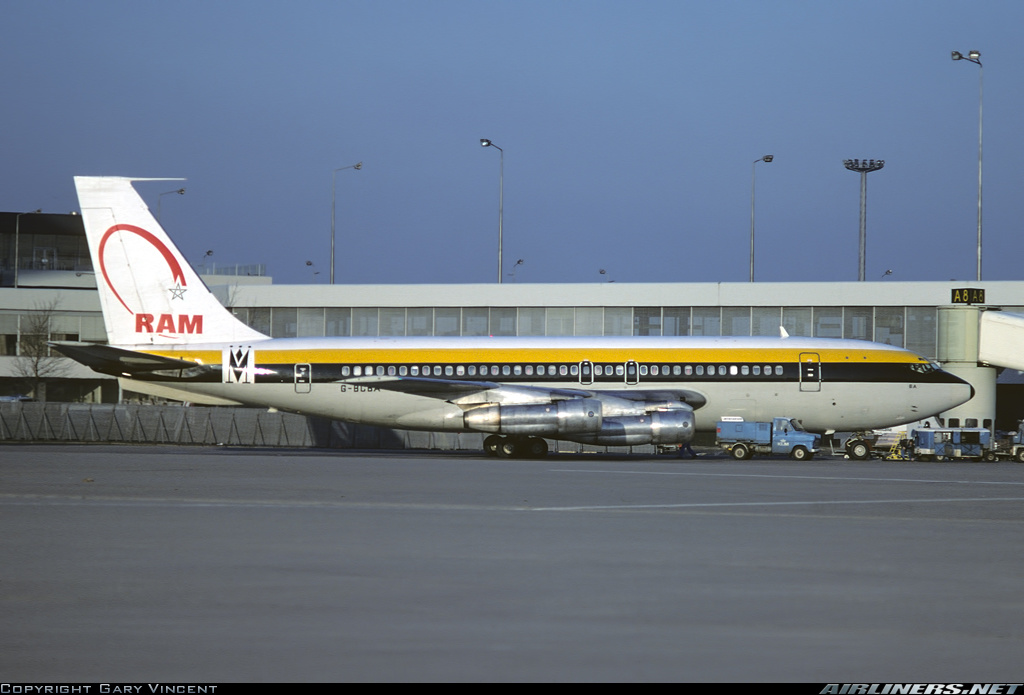
München-Riem
September 1983
4X-BMA
Boeing 720-023B
18014/143
Maof Airlines
4X-BMA was seen before as G-BCBA with Invicta in May 1975.
Information from flickr - thanks to heathrow junkie:
c/n 18014 Boeing 720-023B - was delivered new to American Airlines N7528A in July 1960. The aircraft was leased to Invicta International as G-BCBA in 1974, sub-leased to PNG airline Air Niugini as P2-ANG in 1976-77, and was then bought by Monarch Airlines in 1977. The aircraft was leased out for the winter season, to Cyprus Airways in 1978 and to RAM in 1979. In 1981, when Monarch started to receive their new 737s, the aircraft was sold off to MAOF of Israel as 4X-BMA. The aircraft was sold to Omega Air as N341A in 1985, and then went back to Boeing in 1986 to be parted out for the KC-135E program at Davis-Monthan AFB.
Registration details for this airframe:
www.planelogger.com/Aircraft/Registration/4X-BMA/489969
This airframe as N7528A with American Airlines at Toronto-Malton in 1960 before conversion to -023B:
www.flickr.com/photos/edk7/8560804214/
This airframe as N7528A with American Airlines (earlier colours):
cdn.jetphotos.com/full/3/18678_1327543017.jpg
This airframe as N7528A with American Airlines (later colours):
www.jetphotos.com/photo/6997452
This airframe as G-BCBA with Invicta at Riem in May 1975:
www.flickr.com/photos/161645265@N08/49639782151
This airframe as P2-ANG with Air Niugini at SYD in August 1976:
www.flickr.com/photos/leap1/14086437960/
This airframe as G-BCBA with Monarch Airlines:
www.flickr.com/photos/154191970@N03/34990030451
This airframe as G-BCBA leased to Royal Air Maroc:
imgproc.airliners.net/photos/airliners/5/2/5/2398525.jpg
This airframe as G-BCBA with Cyprus Airways:
www.flickr.com/photos/pslg05896/32678518801
This airframe as 4X-BMA with Maof Airlines at Riem in February 1982:
imgproc.airliners.net/photos/airliners/9/4/4/4107449.jpg
Scan from Kodachrome slide.
(photo provided by Ljubomir Risteski)
---------------------
This beautiful shot depicts an old quarry in Black Hand Gorge State Nature Preserve, near Toboso, Ohio. Quartzose sandstone was formerly quarried here, principally as a source of silica for making glass in nearby Newark, Ohio. For much of the year, these old quarries are partly filled with water. At times, water has receded sufficiently to allow walking on the old quarry floors (leaf-covered now).
The rocks here are thin-bedded Byer Sandstone over massive Black Hand Sandstone. Both are Lower Mississippian units. The Black Hand Sandstone was the quarrying target. The Byer is a relatively shallow marine unit - it has fossils such as brachiopods and crinoids. The Black Hand Sandstone is currently interpreted as an incised valley fill deposit - it consists of sandstone, pebbly sandstone, minor conglomeratic sandstone, and minor conglomerate.
Accompanying notes provided By V&A Mueseum, London
ELYTRA, Filament Pavilion
18 May - 6 November, 2016
Elytra is a responsive shelter. A robot will build new components of the structure on the site, allowing the canopy to grow over the course of the V&A Engineering Season. Your presnce in the pavilion today will be captured by sensors in the canopy and ultimately will affect how and where the structure grows.
The pavilion tests a possible future for architectural and engineering design, exploring how new robotics technologies might transform how buildings are designed and built. The design draws on research into lighhtweight construction principles found in nature. It is inspired by the filament structures of the shells of flying beetles, know as elytra.
Made of glass and carbon fibre, each component is produced using robotic winding technique developed by the designers. Unlike other fabrication methods, this does not require moulds and can produce an infinite variety of spun shapes, while reducing wate to a minimum. This unique method of fabrication integrates the process of design and making.
Like beetle elytra, the structure is both strong and very light. The pavilion's entire filament stutcure weighs less than 2.5 tonnes - equivalent to 1.4 by 1.4 m squared prortion of the V&A's wall around you.
Part of the V&A Engineering Season.
Bain News Service,, publisher.
Waldman's Shop Window
[between ca. 1920 and ca. 1925]
1 negative : glass ; 5 x 7 in. or smaller.
Notes:
Title from unverified data provided by the Bain News Service on the negatives or caption cards.
Forms part of: George Grantham Bain Collection (Library of Congress).
Format: Glass negatives.
Rights Info: No known restrictions on publication. For more information, see George Grantham Bain Collection - Rights and Restrictions Information www.loc.gov/rr/print/res/274_bain.html
Repository: Library of Congress, Prints and Photographs Division, Washington, D.C. 20540 USA, hdl.loc.gov/loc.pnp/pp.print
Part Of: Bain News Service photograph collection (DLC) 2005682517
General information about the George Grantham Bain Collection is available at hdl.loc.gov/loc.pnp/pp.ggbain
Higher resolution image is available (Persistent URL): hdl.loc.gov/loc.pnp/ggbain.32418
Call Number: LC-B2- 5469-12
A recent trip provided the opportunity to visit the Georgia Aquarium. I had specifically wanted to visit this aquarium to see their collection of Whale Sharks, and what a treat it was. The aquarium itself is really nice, and there are a few spaces within that are just phenomenal including this large viewing room. From the website: "This exhibit was specially designed to house whale sharks, the largest fish species in the world. Schools of predatory trevally jacks, squadrons of small and large stingrays, enormous goliath grouper and several sharks all ply the waters of this ocean habitat containing more than six million gallons of saltwater. With 4,574 square feet of viewing windows, a 100-foot-long underwater tunnel, 185 tons of acrylic windows and the second largest viewing window in the world at 23 feet tall by 61 feet wide and 2 feet thick..."
An impressive space to say the least. A large space for a large fish. There are four whale sharks as well as 4 giant manta rays in this single tank. They also have a program where you can dive in this tank (which I didn't do). I really look forward to diving in the wild someday with these gentle giants. If you are anywhere near Atlanta, don't hesitate to visit this great location which is the only aquarium outside of Asia to host this species.
This is a single exposure. The aquarium provided an interesting challenge for getting crisp shots.
Thanks for looking!
-----------------------------------------------------------------------------------
Comments and constructive criticism always appreciated.
The Saint Hilarion Castle lies on the Kyrenia mountain range, in Cyprus. This location provided the castle with command of the pass road from Kyrenia to Nicosia. It is the best preserved ruin of the three former strongholds in the Kyrenia mountains, the other two being Kantara and Buffavento.
History
The castle is not named after St. Hilarion, active in Palestine and Cyprus in the 4th century. It was named after an obscure saint, who is traditionally held to have fled to Cyprus after the Arab conquest of the Holy Land and retired to the hilltop on which the castle was built for hermitage. An English traveller reported the preservation of his relics in the 14th century. It has been proposed that a monastery built in his name preceded the castle, which was built around it. However, this view is not supported by any substantial evidence.
Starting in the 11th century, the Byzantines began fortification. Saint Hilarion, together with the castles of Buffavento and Kantara, formed the defense of the island against Arab raids against the coast. Some sections were further upgraded under the Lusignan dynasty, whose kings may have used it as a summer residence. During the rule of Lusignans, the castle was the focus of a four-year struggle between Holy Roman Emperor Frederick II and Regent John d' Ibelin for control of Cyprus.
Much of the castle was dismantled by the Venetians in the 15th century to reduce the cost of garrisons.
Architecture
The castle has three divisions or wards. The lower and middle wards served economic purposes, while the upper ward housed the royal family. The lower ward had the stables and the living quarters for the men-at-arms. The Prince John tower sits on a cliff high above the lower castle.
The upper ward was surrounded by a 1.4 metre-thick Byzantine wall, made of rough masonry. The entrance is through a pointed arch built by the Lusignans. This was protected by a semicircular tower to the east. Within the ward is a courtyard, with twin peaks being situated to either side of it. To the north-east is an extremely ruined kitchen. To the west are the royal apartments, dated by various sources to the 13th or 14th centuries. Although mostly ruined today, this was a structure in the northeast-southwest axis, with a length of 25 m and width of 6 m. It has a basement containing a cistern and two floors. The ground floor has a height of 7 m and a pointed barrel vault. The upper floor is known for its carved windows, one of which is dubbed the Queen's Window. These are placed on the western wall, which has a scenic view of the northern coast of Cyprus, especially the plains of Lapithos.
In fiction
Two of the main characters in the 1958 historical novel, Exodus, by Leon Uris, spend a day walking around the castle ruins. Featured in the 1999 novel “Race of Scorpions” by Dorothy Dunnett. The Castle of Saint Hilarion appears in the 2009 action-adventure video game Assassin's Creed: Bloodlines, the 2015 novel "The Lost Treasure of the Templars" by James Becker, and Death in Cyprus by M. M. Kaye. The castle is also featured in the 2016 crypto-thriller The Apocalypse Fire by Dominic Selwood.
The Kyrenia Mountains (Greek: Κερύνειο Όρος; Turkish: Girne Dağları) is a long, narrow mountain range that runs for approximately 160 km (100 mi) along the northern coast of the island of Cyprus. It is primarily made of hard crystalline limestone, with some marble. Its highest peak is Mount Selvili, at 1,024 m (3,360 ft). Pentadaktylos (also spelt Pentadactylos; Greek: Πενταδάκτυλος; Turkish: Beşparmak) is another name for the Kyrenia Mountains, though Britannica refers to Pentadaktylos as the "western portion" of the latter, or the part west of Melounta. Pentadaktylos (lit. "five-fingered") is so-named after one of its most distinguishing features, a peak that resembles five fingers.
The Kyrenian mountains are named after the Kyrenian mountains in Achaia, Greece, which are well known from mythology because of the connection with one of the 12 labours of Hercules, the capture of the Kerynitis deer that lived there. This sacred deer of Artemis with golden horns and bronze legs ran so fast that no one could reach it. Hercules, however, after pursuing it for a whole year, managed to catch it and transport it alive to Mycenae.
A devastating fire in July 1995 burned large portions of the Kyrenia Mountains, resulting in the loss of significant forest land and natural habitat.
The only other mountain range in Cyprus is the Troodos Mountains.
Geology
These mountains are a series of sedimentary formations from the Permian to the Middle Miocene pushed up by a collision of the African and Eurasian plates. Though only half the height of the Troodos Mountains, the Kyrenia Mountains are rugged and rise abruptly from the Mesaoria plain.
History
The location of the mountains near the sea made them desirable locations for watch towers and castles overlooking the northern Cyprus coast, as well as the central plain. These castles generally date from the 10th through the 15th centuries, primarily constructed by the Byzantines and Lusignans. The castles of St. Hilarion, Buffavento, and Kantara sit astride peaks and were of strategic importance during much of the history of Cyprus during the Middle Ages.
Painted flag
A flag of Northern Cyprus is painted on the southern slope of the Kyrenia Mountains. It is reportedly 425 metres wide and 250 metres high, and is illuminated at night.
The flag is considered controversial as evidenced in the Parliamentary Question put to the European Parliament by Antigoni Papadopoulou on 22 October 2009, "How can it permit the existence of such a flag which, apart from the catastrophic environmental damage it causes, the use of chemical substances and the brutal abuse of the environment, involves an absurd waste of electricity at a time of economic crisis? Does Turkey show sufficient respect towards the environment to justify its desire to open the relevant chapter of accession negotiations?"
Legends
There are many legends about the Pentadactylos mountains. One tells the story of a conceited villager who fell in love with the local queen and asked for her hand in marriage. The queen wished to be rid of the impertinent young man and requested that he bring her some water from the spring of Apostolos Andreas monastery in the Karpas, a perilous journey in those days. The man set off and after several weeks returned with a skin full of that precious water. The queen was most dismayed to see that he had succeeded, but still refused to marry him. In a fit of rage, he poured the water on to the earth, seized a handful of the resulting mud and threw it at the queens head. She ducked and the lump of mud sailed far across the plain to land on top of the Kyrenia mountain range, where it is to this day, still showing the impression of the thwarted villager’s five fingers.
Another famous one is of the Byzantine hero Digenis Akritas. Tradition has it that Digenis Akritas's hand gripped the mountain to get out of the sea when he came to free Cyprus from its Saracen invaders, and this is his handprint. He also threw a large rock across Cyprus to get at the Saracen ships. That rock landed in Paphos at the site of the birthplace of Aphrodite, thus known to this day as Petra Tou Romiou or "Rock of the Greek".
Northern Cyprus, officially the Turkish Republic of Northern Cyprus (TRNC), is a de facto state that comprises the northeastern portion of the island of Cyprus. It is recognised only by Turkey, and its territory is considered by all other states to be part of the Republic of Cyprus.
Northern Cyprus extends from the tip of the Karpass Peninsula in the northeast to Morphou Bay, Cape Kormakitis and its westernmost point, the Kokkina exclave in the west. Its southernmost point is the village of Louroujina. A buffer zone under the control of the United Nations stretches between Northern Cyprus and the rest of the island and divides Nicosia, the island's largest city and capital of both sides.
A coup d'état in 1974, performed as part of an attempt to annex the island to Greece, prompted the Turkish invasion of Cyprus. This resulted in the eviction of much of the north's Greek Cypriot population, the flight of Turkish Cypriots from the south, and the partitioning of the island, leading to a unilateral declaration of independence by the north in 1983. Due to its lack of recognition, Northern Cyprus is heavily dependent on Turkey for economic, political and military support.
Attempts to reach a solution to the Cyprus dispute have been unsuccessful. The Turkish Army maintains a large force in Northern Cyprus with the support and approval of the TRNC government, while the Republic of Cyprus, the European Union as a whole, and the international community regard it as an occupation force. This military presence has been denounced in several United Nations Security Council resolutions.
Northern Cyprus is a semi-presidential, democratic republic with a cultural heritage incorporating various influences and an economy that is dominated by the services sector. The economy has seen growth through the 2000s and 2010s, with the GNP per capita more than tripling in the 2000s, but is held back by an international embargo due to the official closure of the ports in Northern Cyprus by the Republic of Cyprus. The official language is Turkish, with a distinct local dialect being spoken. The vast majority of the population consists of Sunni Muslims, while religious attitudes are mostly moderate and secular. Northern Cyprus is an observer state of ECO and OIC under the name "Turkish Cypriot State", PACE under the name "Turkish Cypriot Community", and Organization of Turkic States with its own name.
The Turkish invasion of Cyprus began on 20 July 1974 and progressed in two phases over the following month. Taking place upon a background of intercommunal violence between Greek and Turkish Cypriots, and in response to a Greek junta-sponsored Cypriot coup d'état five days earlier, it led to the Turkish capture and occupation of the northern part of the island.
The coup was ordered by the military junta in Greece and staged by the Cypriot National Guard in conjunction with EOKA B. It deposed the Cypriot president Archbishop Makarios III and installed Nikos Sampson. The aim of the coup was the union (enosis) of Cyprus with Greece, and the Hellenic Republic of Cyprus to be declared.
The Turkish forces landed in Cyprus on 20 July and captured 3% of the island before a ceasefire was declared. The Greek military junta collapsed and was replaced by a civilian government. Following the breakdown of peace talks, Turkish forces enlarged their original beachhead in August 1974 resulting in the capture of approximately 36% of the island. The ceasefire line from August 1974 became the United Nations Buffer Zone in Cyprus and is commonly referred to as the Green Line.
Around 150,000 people (amounting to more than one-quarter of the total population of Cyprus, and to one-third of its Greek Cypriot population) were displaced from the northern part of the island, where Greek Cypriots had constituted 80% of the population. Over the course of the next year, roughly 60,000 Turkish Cypriots, amounting to half the Turkish Cypriot population, were displaced from the south to the north. The Turkish invasion ended in the partition of Cyprus along the UN-monitored Green Line, which still divides Cyprus, and the formation of a de facto Autonomous Turkish Cypriot Administration in the north. In 1983, the Turkish Republic of Northern Cyprus (TRNC) declared independence, although Turkey is the only country that recognises it. The international community considers the TRNC's territory as Turkish-occupied territory of the Republic of Cyprus. The occupation is viewed as illegal under international law, amounting to illegal occupation of European Union territory since Cyprus became a member.
Northern Cyprus, officially the Turkish Republic of Northern Cyprus (TRNC), is a de facto state that comprises the northeastern portion of the island of Cyprus. It is recognised only by Turkey, and its territory is considered by all other states to be part of the Republic of Cyprus.
Northern Cyprus extends from the tip of the Karpass Peninsula in the northeast to Morphou Bay, Cape Kormakitis and its westernmost point, the Kokkina exclave in the west. Its southernmost point is the village of Louroujina. A buffer zone under the control of the United Nations stretches between Northern Cyprus and the rest of the island and divides Nicosia, the island's largest city and capital of both sides.
A coup d'état in 1974, performed as part of an attempt to annex the island to Greece, prompted the Turkish invasion of Cyprus. This resulted in the eviction of much of the north's Greek Cypriot population, the flight of Turkish Cypriots from the south, and the partitioning of the island, leading to a unilateral declaration of independence by the north in 1983. Due to its lack of recognition, Northern Cyprus is heavily dependent on Turkey for economic, political and military support.
Attempts to reach a solution to the Cyprus dispute have been unsuccessful. The Turkish Army maintains a large force in Northern Cyprus with the support and approval of the TRNC government, while the Republic of Cyprus, the European Union as a whole, and the international community regard it as an occupation force. This military presence has been denounced in several United Nations Security Council resolutions.
Northern Cyprus is a semi-presidential, democratic republic with a cultural heritage incorporating various influences and an economy that is dominated by the services sector. The economy has seen growth through the 2000s and 2010s, with the GNP per capita more than tripling in the 2000s, but is held back by an international embargo due to the official closure of the ports in Northern Cyprus by the Republic of Cyprus. The official language is Turkish, with a distinct local dialect being spoken. The vast majority of the population consists of Sunni Muslims, while religious attitudes are mostly moderate and secular. Northern Cyprus is an observer state of ECO and OIC under the name "Turkish Cypriot State", PACE under the name "Turkish Cypriot Community", and Organization of Turkic States with its own name.
Several distinct periods of Cypriot intercommunal violence involving the two main ethnic communities, Greek Cypriots and Turkish Cypriots, marked mid-20th century Cyprus. These included the Cyprus Emergency of 1955–59 during British rule, the post-independence Cyprus crisis of 1963–64, and the Cyprus crisis of 1967. Hostilities culminated in the 1974 de facto division of the island along the Green Line following the Turkish invasion of Cyprus. The region has been relatively peaceful since then, but the Cyprus dispute has continued, with various attempts to solve it diplomatically having been generally unsuccessful.
Cyprus, an island lying in the eastern Mediterranean, hosted a population of Greeks and Turks (four-fifths and one-fifth, respectively), who lived under British rule in the late nineteenth-century and the first half of the twentieth-century. Christian Orthodox Church of Cyprus played a prominent political role among the Greek Cypriot community, a privilege that it acquired during the Ottoman Empire with the employment of the millet system, which gave the archbishop an unofficial ethnarch status.
The repeated rejections by the British of Greek Cypriot demands for enosis, union with Greece, led to armed resistance, organised by the National Organization of Cypriot Struggle, or EOKA. EOKA, led by the Greek-Cypriot commander George Grivas, systematically targeted British colonial authorities. One of the effects of EOKA's campaign was to alter the Turkish position from demanding full reincorporation into Turkey to a demand for taksim (partition). EOKA's mission and activities caused a "Cretan syndrome" (see Turkish Resistance Organisation) within the Turkish Cypriot community, as its members feared that they would be forced to leave the island in such a case as had been the case with Cretan Turks. As such, they preferred the continuation of British colonial rule and then taksim, the division of the island. Due to the Turkish Cypriots' support for the British, EOKA's leader, Georgios Grivas, declared them to be enemies. The fact that the Turks were a minority was, according to Nihat Erim, to be addressed by the transfer of thousands of Turks from mainland Turkey so that Greek Cypriots would cease to be the majority. When Erim visited Cyprus as the Turkish representative, he was advised by Field Marshal Sir John Harding, the then Governor of Cyprus, that Turkey should send educated Turks to settle in Cyprus.
Turkey actively promoted the idea that on the island of Cyprus two distinctive communities existed, and sidestepped its former claim that "the people of Cyprus were all Turkish subjects". In doing so, Turkey's aim to have self-determination of two to-be equal communities in effect led to de jure partition of the island.[citation needed] This could be justified to the international community against the will of the majority Greek population of the island. Dr. Fazil Küçük in 1954 had already proposed Cyprus be divided in two at the 35° parallel.
Lindley Dan, from Notre Dame University, spotted the roots of intercommunal violence to different visions among the two communities of Cyprus (enosis for Greek Cypriots, taksim for Turkish Cypriots). Also, Lindlay wrote that "the merging of church, schools/education, and politics in divisive and nationalistic ways" had played a crucial role in creation of havoc in Cyprus' history. Attalides Michael also pointed to the opposing nationalisms as the cause of the Cyprus problem.
By the mid-1950's, the "Cyprus is Turkish" party, movement, and slogan gained force in both Cyprus and Turkey. In a 1954 editorial, Turkish Cypriot leader Dr. Fazil Kuchuk expressed the sentiment that the Turkish youth had grown up with the idea that "as soon as Great Britain leaves the island, it will be taken over by the Turks", and that "Turkey cannot tolerate otherwise". This perspective contributed to the willingness of Turkish Cypriots to align themselves with the British, who started recruiting Turkish Cypriots into the police force that patrolled Cyprus to fight EOKA, a Greek Cypriot nationalist organisation that sought to rid the island of British rule.
EOKA targeted colonial authorities, including police, but Georgios Grivas, the leader of EOKA, did not initially wish to open up a new front by fighting Turkish Cypriots and reassured them that EOKA would not harm their people. In 1956, some Turkish Cypriot policemen were killed by EOKA members and this provoked some intercommunal violence in the spring and summer, but these attacks on policemen were not motivated by the fact that they were Turkish Cypriots.
However, in January 1957, Grivas changed his policy as his forces in the mountains became increasingly pressured by the British Crown forces. In order to divert the attention of the Crown forces, EOKA members started to target Turkish Cypriot policemen intentionally in the towns, so that Turkish Cypriots would riot against the Greek Cypriots and the security forces would have to be diverted to the towns to restore order. The killing of a Turkish Cypriot policeman on 19 January, when a power station was bombed, and the injury of three others, provoked three days of intercommunal violence in Nicosia. The two communities targeted each other in reprisals, at least one Greek Cypriot was killed and the British Army was deployed in the streets. Greek Cypriot stores were burned and their neighbourhoods attacked. Following the events, the Greek Cypriot leadership spread the propaganda that the riots had merely been an act of Turkish Cypriot aggression. Such events created chaos and drove the communities apart both in Cyprus and in Turkey.
On 22 October 1957 Sir Hugh Mackintosh Foot replaced Sir John Harding as the British Governor of Cyprus. Foot suggested five to seven years of self-government before any final decision. His plan rejected both enosis and taksim. The Turkish Cypriot response to this plan was a series of anti-British demonstrations in Nicosia on 27 and 28 January 1958 rejecting the proposed plan because the plan did not include partition. The British then withdrew the plan.
In 1957, Black Gang, a Turkish Cypriot pro-taksim paramilitary organisation, was formed to patrol a Turkish Cypriot enclave, the Tahtakale district of Nicosia, against activities of EOKA. The organisation later attempted to grow into a national scale, but failed to gain public support.
By 1958, signs of dissatisfaction with the British increased on both sides, with a group of Turkish Cypriots forming Volkan (later renamed to the Turkish Resistance Organisation) paramilitary group to promote partition and the annexation of Cyprus to Turkey as dictated by the Menderes plan. Volkan initially consisted of roughly 100 members, with the stated aim of raising awareness in Turkey of the Cyprus issue and courting military training and support for Turkish Cypriot fighters from the Turkish government.
In June 1958, the British Prime Minister, Harold Macmillan, was expected to propose a plan to resolve the Cyprus issue. In light of the new development, the Turks rioted in Nicosia to promote the idea that Greek and Turkish Cypriots could not live together and therefore any plan that did not include partition would not be viable. This violence was soon followed by bombing, Greek Cypriot deaths and looting of Greek Cypriot-owned shops and houses. Greek and Turkish Cypriots started to flee mixed population villages where they were a minority in search of safety. This was effectively the beginning of the segregation of the two communities. On 7 June 1958, a bomb exploded at the entrance of the Turkish Embassy in Cyprus. Following the bombing, Turkish Cypriots looted Greek Cypriot properties. On 26 June 1984, the Turkish Cypriot leader, Rauf Denktaş, admitted on British channel ITV that the bomb was placed by the Turks themselves in order to create tension. On 9 January 1995, Rauf Denktaş repeated his claim to the famous Turkish newspaper Milliyet in Turkey.
The crisis reached a climax on 12 June 1958, when eight Greeks, out of an armed group of thirty five arrested by soldiers of the Royal Horse Guards on suspicion of preparing an attack on the Turkish quarter of Skylloura, were killed in a suspected attack by Turkish Cypriot locals, near the village of Geunyeli, having been ordered to walk back to their village of Kondemenos.
After the EOKA campaign had begun, the British government successfully began to turn the Cyprus issue from a British colonial problem into a Greek-Turkish issue. British diplomacy exerted backstage influence on the Adnan Menderes government, with the aim of making Turkey active in Cyprus. For the British, the attempt had a twofold objective. The EOKA campaign would be silenced as quickly as possible, and Turkish Cypriots would not side with Greek Cypriots against the British colonial claims over the island, which would thus remain under the British. The Turkish Cypriot leadership visited Menderes to discuss the Cyprus issue. When asked how the Turkish Cypriots should respond to the Greek Cypriot claim of enosis, Menderes replied: "You should go to the British foreign minister and request the status quo be prolonged, Cyprus to remain as a British colony". When the Turkish Cypriots visited the British Foreign Secretary and requested for Cyprus to remain a colony, he replied: "You should not be asking for colonialism at this day and age, you should be asking for Cyprus be returned to Turkey, its former owner".
As Turkish Cypriots began to look to Turkey for protection, Greek Cypriots soon understood that enosis was extremely unlikely. The Greek Cypriot leader, Archbishop Makarios III, now set independence for the island as his objective.
Britain resolved to solve the dispute by creating an independent Cyprus. In 1959, all involved parties signed the Zurich Agreements: Britain, Turkey, Greece, and the Greek and Turkish Cypriot leaders, Makarios and Dr. Fazil Kucuk, respectively. The new constitution drew heavily on the ethnic composition of the island. The President would be a Greek Cypriot, and the Vice-President a Turkish Cypriot with an equal veto. The contribution to the public service would be set at a ratio of 70:30, and the Supreme Court would consist of an equal number of judges from both communities as well as an independent judge who was not Greek, Turkish or British. The Zurich Agreements were supplemented by a number of treaties. The Treaty of Guarantee stated that secession or union with any state was forbidden, and that Greece, Turkey and Britain would be given guarantor status to intervene if that was violated. The Treaty of Alliance allowed for two small Greek and Turkish military contingents to be stationed on the island, and the Treaty of Establishment gave Britain sovereignty over two bases in Akrotiri and Dhekelia.
On 15 August 1960, the Colony of Cyprus became fully independent as the Republic of Cyprus. The new republic remained within the Commonwealth of Nations.
The new constitution brought dissatisfaction to Greek Cypriots, who felt it to be highly unjust for them for historical, demographic and contributional reasons. Although 80% of the island's population were Greek Cypriots and these indigenous people had lived on the island for thousands of years and paid 94% of taxes, the new constitution was giving the 17% of the population that was Turkish Cypriots, who paid 6% of taxes, around 30% of government jobs and 40% of national security jobs.
Within three years tensions between the two communities in administrative affairs began to show. In particular disputes over separate municipalities and taxation created a deadlock in government. A constitutional court ruled in 1963 Makarios had failed to uphold article 173 of the constitution which called for the establishment of separate municipalities for Turkish Cypriots. Makarios subsequently declared his intention to ignore the judgement, resulting in the West German judge resigning from his position. Makarios proposed thirteen amendments to the constitution, which would have had the effect of resolving most of the issues in the Greek Cypriot favour. Under the proposals, the President and Vice-President would lose their veto, the separate municipalities as sought after by the Turkish Cypriots would be abandoned, the need for separate majorities by both communities in passing legislation would be discarded and the civil service contribution would be set at actual population ratios (82:18) instead of the slightly higher figure for Turkish Cypriots.
The intention behind the amendments has long been called into question. The Akritas plan, written in the height of the constitutional dispute by the Greek Cypriot interior minister Polycarpos Georkadjis, called for the removal of undesirable elements of the constitution so as to allow power-sharing to work. The plan envisaged a swift retaliatory attack on Turkish Cypriot strongholds should Turkish Cypriots resort to violence to resist the measures, stating "In the event of a planned or staged Turkish attack, it is imperative to overcome it by force in the shortest possible time, because if we succeed in gaining command of the situation (in one or two days), no outside, intervention would be either justified or possible." Whether Makarios's proposals were part of the Akritas plan is unclear, however it remains that sentiment towards enosis had not completely disappeared with independence. Makarios described independence as "a step on the road to enosis".[31] Preparations for conflict were not entirely absent from Turkish Cypriots either, with right wing elements still believing taksim (partition) the best safeguard against enosis.
Greek Cypriots however believe the amendments were a necessity stemming from a perceived attempt by Turkish Cypriots to frustrate the working of government. Turkish Cypriots saw it as a means to reduce their status within the state from one of co-founder to that of minority, seeing it as a first step towards enosis. The security situation deteriorated rapidly.
Main articles: Bloody Christmas (1963) and Battle of Tillyria
An armed conflict was triggered after December 21, 1963, a period remembered by Turkish Cypriots as Bloody Christmas, when a Greek Cypriot policemen that had been called to help deal with a taxi driver refusing officers already on the scene access to check the identification documents of his customers, took out his gun upon arrival and shot and killed the taxi driver and his partner. Eric Solsten summarised the events as follows: "a Greek Cypriot police patrol, ostensibly checking identification documents, stopped a Turkish Cypriot couple on the edge of the Turkish quarter. A hostile crowd gathered, shots were fired, and two Turkish Cypriots were killed."
In the morning after the shooting, crowds gathered in protest in Northern Nicosia, likely encouraged by the TMT, without incident. On the evening of the 22nd, gunfire broke out, communication lines to the Turkish neighbourhoods were cut, and the Greek Cypriot police occupied the nearby airport. On the 23rd, a ceasefire was negotiated, but did not hold. Fighting, including automatic weapons fire, between Greek and Turkish Cypriots and militias increased in Nicosia and Larnaca. A force of Greek Cypriot irregulars led by Nikos Sampson entered the Nicosia suburb of Omorphita and engaged in heavy firing on armed, as well as by some accounts unarmed, Turkish Cypriots. The Omorphita clash has been described by Turkish Cypriots as a massacre, while this view has generally not been acknowledged by Greek Cypriots.
Further ceasefires were arranged between the two sides, but also failed. By Christmas Eve, the 24th, Britain, Greece, and Turkey had joined talks, with all sides calling for a truce. On Christmas day, Turkish fighter jets overflew Nicosia in a show of support. Finally it was agreed to allow a force of 2,700 British soldiers to help enforce a ceasefire. In the next days, a "buffer zone" was created in Nicosia, and a British officer marked a line on a map with green ink, separating the two sides of the city, which was the beginning of the "Green Line". Fighting continued across the island for the next several weeks.
In total 364 Turkish Cypriots and 174 Greek Cypriots were killed during the violence. 25,000 Turkish Cypriots from 103-109 villages fled and were displaced into enclaves and thousands of Turkish Cypriot houses were ransacked or completely destroyed.
Contemporary newspapers also reported on the forceful exodus of the Turkish Cypriots from their homes. According to The Times in 1964, threats, shootings and attempts of arson were committed against the Turkish Cypriots to force them out of their homes. The Daily Express wrote that "25,000 Turks have already been forced to leave their homes". The Guardian reported a massacre of Turks at Limassol on 16 February 1964.
Turkey had by now readied its fleet and its fighter jets appeared over Nicosia. Turkey was dissuaded from direct involvement by the creation of a United Nations Peacekeeping Force in Cyprus (UNFICYP) in 1964. Despite the negotiated ceasefire in Nicosia, attacks on the Turkish Cypriot persisted, particularly in Limassol. Concerned about the possibility of a Turkish invasion, Makarios undertook the creation of a Greek Cypriot conscript-based army called the "National Guard". A general from Greece took charge of the army, whilst a further 20,000 well-equipped officers and men were smuggled from Greece into Cyprus. Turkey threatened to intervene once more, but was prevented by a strongly worded letter from the American President Lyndon B. Johnson, anxious to avoid a conflict between NATO allies Greece and Turkey at the height of the Cold War.
Turkish Cypriots had by now established an important bridgehead at Kokkina, provided with arms, volunteers and materials from Turkey and abroad. Seeing this incursion of foreign weapons and troops as a major threat, the Cypriot government invited George Grivas to return from Greece as commander of the Greek troops on the island and launch a major attack on the bridgehead. Turkey retaliated by dispatching its fighter jets to bomb Greek positions, causing Makarios to threaten an attack on every Turkish Cypriot village on the island if the bombings did not cease. The conflict had now drawn in Greece and Turkey, with both countries amassing troops on their Thracian borders. Efforts at mediation by Dean Acheson, a former U.S. Secretary of State, and UN-appointed mediator Galo Plaza had failed, all the while the division of the two communities becoming more apparent. Greek Cypriot forces were estimated at some 30,000, including the National Guard and the large contingent from Greece. Defending the Turkish Cypriot enclaves was a force of approximately 5,000 irregulars, led by a Turkish colonel, but lacking the equipment and organisation of the Greek forces.
The Secretary-General of the United Nations in 1964, U Thant, reported the damage during the conflicts:
UNFICYP carried out a detailed survey of all damage to properties throughout the island during the disturbances; it shows that in 109 villages, most of them Turkish-Cypriot or mixed villages, 527 houses have been destroyed while 2,000 others have suffered damage from looting.
The situation worsened in 1967, when a military junta overthrew the democratically elected government of Greece, and began applying pressure on Makarios to achieve enosis. Makarios, not wishing to become part of a military dictatorship or trigger a Turkish invasion, began to distance himself from the goal of enosis. This caused tensions with the junta in Greece as well as George Grivas in Cyprus. Grivas's control over the National Guard and Greek contingent was seen as a threat to Makarios's position, who now feared a possible coup.[citation needed] The National Guard and Cyprus Police began patrolling the Turkish Cypriot enclaves of Ayios Theodoros and Kophinou, and on November 15 engaged in heavy fighting with the Turkish Cypriots.
By the time of his withdrawal 26 Turkish Cypriots had been killed. Turkey replied with an ultimatum demanding that Grivas be removed from the island, that the troops smuggled from Greece in excess of the limits of the Treaty of Alliance be removed, and that the economic blockades on the Turkish Cypriot enclaves be lifted. Grivas was recalled by the Athens Junta and the 12,000 Greek troops were withdrawn. Makarios now attempted to consolidate his position by reducing the number of National Guard troops, and by creating a paramilitary force loyal to Cypriot independence. In 1968, acknowledging that enosis was now all but impossible, Makarios stated, "A solution by necessity must be sought within the limits of what is feasible which does not always coincide with the limits of what is desirable."
After 1967 tensions between the Greek and Turkish Cypriots subsided. Instead, the main source of tension on the island came from factions within the Greek Cypriot community. Although Makarios had effectively abandoned enosis in favour of an 'attainable solution', many others continued to believe that the only legitimate political aspiration for Greek Cypriots was union with Greece.
On his arrival, Grivas began by establishing a nationalist paramilitary group known as the National Organization of Cypriot Fighters (Ethniki Organosis Kyprion Agoniston B or EOKA-B), drawing comparisons with the EOKA struggle for enosis under the British colonial administration of the 1950s.
The military junta in Athens saw Makarios as an obstacle. Makarios's failure to disband the National Guard, whose officer class was dominated by mainland Greeks, had meant the junta had practical control over the Cypriot military establishment, leaving Makarios isolated and a vulnerable target.
During the first Turkish invasion, Turkish troops invaded Cyprus territory on 20 July 1974, invoking its rights under the Treaty of Guarantee. This expansion of Turkish-occupied zone violated International Law as well as the Charter of the United Nations. Turkish troops managed to capture 3% of the island which was accompanied by the burning of the Turkish Cypriot quarter, as well as the raping and killing of women and children. A temporary cease-fire followed which was mitigated by the UN Security Council. Subsequently, the Greek military Junta collapsed on July 23, 1974, and peace talks commenced in which a democratic government was installed. The Resolution 353 was broken after Turkey attacked a second time and managed to get a hold of 37% of Cyprus territory. The Island of Cyprus was appointed a Buffer Zone by the United Nations, which divided the island into two zones through the 'Green Line' and put an end to the Turkish invasion. Although Turkey announced that the occupied areas of Cyprus to be called the Federated Turkish State in 1975, it is not legitimised on a worldwide political scale. The United Nations called for the international recognition of independence for the Republic of Cyprus in the Security Council Resolution 367.
In the years after the Turkish invasion of northern Cyprus one can observe a history of failed talks between the two parties. The 1983 declaration of the independent Turkish Republic of Cyprus resulted in a rise of inter-communal tensions and made it increasingly hard to find mutual understanding. With Cyprus' interest of a possible EU membership and a new UN Secretary-General Kofi Annan in 1997 new hopes arose for a fresh start. International involvement from sides of the US and UK, wanting a solution to the Cyprus dispute prior to the EU accession led to political pressures for new talks. The believe that an accession without a solution would threaten Greek-Turkish relations and acknowledge the partition of the island would direct the coming negotiations.
Over the course of two years a concrete plan, the Annan plan was formulated. In 2004 the fifth version agreed upon from both sides and with the endorsement of Turkey, US, UK and EU then was presented to the public and was given a referendum in both Cypriot communities to assure the legitimisation of the resolution. The Turkish Cypriots voted with 65% for the plan, however the Greek Cypriots voted with a 76% majority against. The Annan plan contained multiple important topics. Firstly it established a confederation of two separate states called the United Cyprus Republic. Both communities would have autonomous states combined under one unified government. The members of parliament would be chosen according to the percentage in population numbers to ensure a just involvement from both communities. The paper proposed a demilitarisation of the island over the next years. Furthermore it agreed upon a number of 45000 Turkish settlers that could remain on the island. These settlers became a very important issue concerning peace talks. Originally the Turkish government encouraged Turks to settle in Cyprus providing transfer and property, to establish a counterpart to the Greek Cypriot population due to their 1 to 5 minority. With the economic situation many Turkish-Cypriot decided to leave the island, however their departure is made up by incoming Turkish settlers leaving the population ratio between Turkish Cypriots and Greek Cypriots stable. However all these points where criticised and as seen in the vote rejected mainly by the Greek Cypriots. These name the dissolution of the „Republic of Cyprus", economic consequences of a reunion and the remaining Turkish settlers as reason. Many claim that the plan was indeed drawing more from Turkish-Cypriot demands then Greek-Cypriot interests. Taking in consideration that the US wanted to keep Turkey as a strategic partner in future Middle Eastern conflicts.
A week after the failed referendum the Republic of Cyprus joined the EU. In multiple instances the EU tried to promote trade with Northern Cyprus but without internationally recognised ports this spiked a grand debate. Both side endure their intention of negotiations, however without the prospect of any new compromises or agreements the UN is unwilling to start the process again. Since 2004 negotiations took place in numbers but without any results, both sides are strongly holding on to their position without an agreeable solution in sight that would suit both parties.
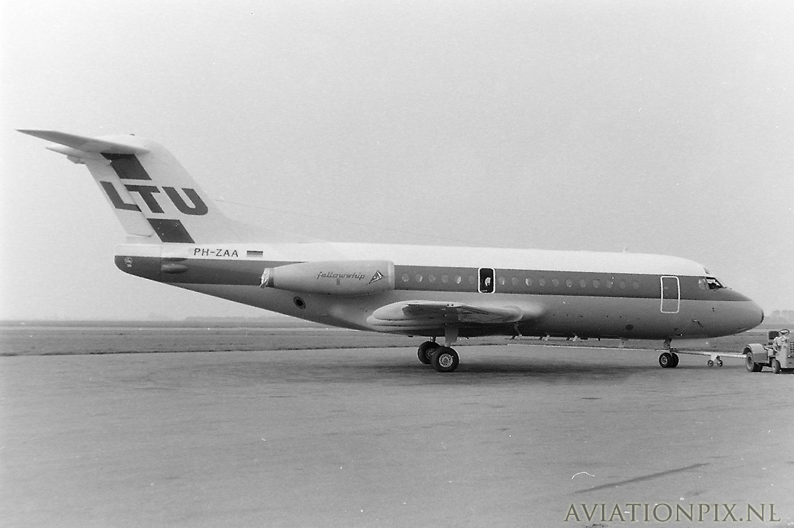
Photo taken by Norbert Kröpfl. Kindly provided from the NK slide collection by Stephan Barth.
München-Riem
April 1974
I-TIDU
Fokker F-28-1000
11004
Itavia
I-TIDU was noted at Riem on 5 April 1974. It had also visited on 1 April 1969 with LTU still wearing the Dutch registration PH-ZAA.
Information from airliners.net - thanks to Frank C. Duarte Jr (slightly adapted):
First flight was May 22, 1968, as PH-ZAA. Delivery date was February 24, 1969 to LTU as D-ABAQ. Other serials - I-TIDU with Itavia, delivered in April 1973, F-GECK with Air Littoral & DAT Delta Air Transport - from January thru April 1995, and also C5-ADE with Air Dabia - delivered in December 1996, re-registered C5-ACE in March 1997. Seen stored at BJL (Banjul) in 1999.
Registration details for this airframe:
www.planelogger.com/Aircraft/Registration/I-TIDU/698491
Here’s a site in Italian dedicated to the story and fleet of Itavia:
This airframe as PH-ZAA with LTU at AMS ca. 1969:
www.aviationpix.nl/albums/userpics/10290/PH-ZAA_1_220968.jpg
This airframe as D-ABAQ with LTU at DUS in April 1970:
imgproc.airliners.net/photos/airliners/5/1/9/1646915.jpg
D-ABAQ with LTU at NAP in August 1970 (later colours):
imgproc.airliners.net/photos/airliners/9/3/0/0178039.jpg
D-ABAQ with Itavia at GVA ca. 1973:
www.airlinefan.com/photos/memberdir203/watermarked/large_...
This airframe as I-TIDU with Itavia (later colours):
cdn.simplesite.com/i/28/27/284008260057638696/i2840082645...
This airframe as F-GECK with Air France/TAT at LHR in March 1986:
imgproc.airliners.net/photos/airliners/7/3/6/0959637.jpg
F-GECK with TAT at TLS in December 1995:
www.flickr.com/photos/jordi757/23426474392
Scan from Kodachrome slide.
Fish, any of approximately 34,000 species of vertebrate animals (phylum Chordata) found in the fresh and salt waters of the world. Living species range from the primitive jawless lampreys and hagfishes through the cartilaginous sharks, skates, and rays to the abundant and diverse bony fishes. Most fish species are cold-blooded; however, one species, the opah (Lampris guttatus), is warm-blooded.
The term fish is applied to a variety of vertebrates of several evolutionary lines. It describes a life-form rather than a taxonomic group. As members of the phylum Chordata, fish share certain features with other vertebrates. These features are gill slits at some point in the life cycle, a notochord, or skeletal supporting rod, a dorsal hollow nerve cord, and a tail. Living fishes represent some five classes, which are as distinct from one another as are the four classes of familiar air-breathing animals—amphibians, reptiles, birds, and mammals. For example, the jawless fishes (Agnatha) have gills in pouches and lack limb girdles. Extant agnathans are the lampreys and the hagfishes. As the name implies, the skeletons of fishes of the class Chondrichthyes (from chondr, “cartilage,” and ichthyes, “fish”) are made entirely of cartilage. Modern fish of this class lack a swim bladder, and their scales and teeth are made up of the same placoid material. Sharks, skates, and rays are examples of cartilaginous fishes. The bony fishes are by far the largest class. Examples range from the tiny seahorse to the 450-kg (1,000-pound) blue marlin, from the flattened soles and flounders to the boxy puffers and ocean sunfishes. Unlike the scales of the cartilaginous fishes, those of bony fishes, when present, grow throughout life and are made up of thin overlapping plates of bone. Bony fishes also have an operculum that covers the gill slits.
The study of fishes, the science of ichthyology, is of broad importance. Fishes are of interest to humans for many reasons, the most important being their relationship with and dependence on the environment. A more obvious reason for interest in fishes is their role as a moderate but important part of the world’s food supply. This resource, once thought unlimited, is now realized to be finite and in delicate balance with the biological, chemical, and physical factors of the aquatic environment. Overfishing, pollution, and alteration of the environment are the chief enemies of proper fisheries management, both in fresh waters and in the ocean. (For a detailed discussion of the technology and economics of fisheries, see commercial fishing.) Another practical reason for studying fishes is their use in disease control. As predators on mosquito larvae, they help curb malaria and other mosquito-borne diseases.
Fishes are valuable laboratory animals in many aspects of medical and biological research. For example, the readiness of many fishes to acclimate to captivity has allowed biologists to study behaviour, physiology, and even ecology under relatively natural conditions. Fishes have been especially important in the study of animal behaviour, where research on fishes has provided a broad base for the understanding of the more flexible behaviour of the higher vertebrates. The zebra fish is used as a model in studies of gene expression.
There are aesthetic and recreational reasons for an interest in fishes. Millions of people keep live fishes in home aquariums for the simple pleasure of observing the beauty and behaviour of animals otherwise unfamiliar to them. Aquarium fishes provide a personal challenge to many aquarists, allowing them to test their ability to keep a small section of the natural environment in their homes. Sportfishing is another way of enjoying the natural environment, also indulged in by millions of people every year. Interest in aquarium fishes and sportfishing supports multimillion-dollar industries throughout the world.
Fishes have been in existence for more than 450 million years, during which time they have evolved repeatedly to fit into almost every conceivable type of aquatic habitat. In a sense, land vertebrates are simply highly modified fishes: when fishes colonized the land habitat, they became tetrapod (four-legged) land vertebrates. The popular conception of a fish as a slippery, streamlined aquatic animal that possesses fins and breathes by gills applies to many fishes, but far more fishes deviate from that conception than conform to it. For example, the body is elongate in many forms and greatly shortened in others; the body is flattened in some (principally in bottom-dwelling fishes) and laterally compressed in many others; the fins may be elaborately extended, forming intricate shapes, or they may be reduced or even lost; and the positions of the mouth, eyes, nostrils, and gill openings vary widely. Air breathers have appeared in several evolutionary lines.
Many fishes are cryptically coloured and shaped, closely matching their respective environments; others are among the most brilliantly coloured of all organisms, with a wide range of hues, often of striking intensity, on a single individual. The brilliance of pigments may be enhanced by the surface structure of the fish, so that it almost seems to glow. A number of unrelated fishes have actual light-producing organs. Many fishes are able to alter their coloration—some for the purpose of camouflage, others for the enhancement of behavioral signals.
Fishes range in adult length from less than 10 mm (0.4 inch) to more than 20 metres (60 feet) and in weight from about 1.5 grams (less than 0.06 ounce) to many thousands of kilograms. Some live in shallow thermal springs at temperatures slightly above 42 °C (100 °F), others in cold Arctic seas a few degrees below 0 °C (32 °F) or in cold deep waters more than 4,000 metres (13,100 feet) beneath the ocean surface. The structural and, especially, the physiological adaptations for life at such extremes are relatively poorly known and provide the scientifically curious with great incentive for study.
Almost all natural bodies of water bear fish life, the exceptions being very hot thermal ponds and extremely salt-alkaline lakes, such as the Dead Sea in Asia and the Great Salt Lake in North America. The present distribution of fishes is a result of the geological history and development of Earth as well as the ability of fishes to undergo evolutionary change and to adapt to the available habitats. Fishes may be seen to be distributed according to habitat and according to geographical area. Major habitat differences are marine and freshwater. For the most part, the fishes in a marine habitat differ from those in a freshwater habitat, even in adjacent areas, but some, such as the salmon, migrate from one to the other. The freshwater habitats may be seen to be of many kinds. Fishes found in mountain torrents, Arctic lakes, tropical lakes, temperate streams, and tropical rivers will all differ from each other, both in obvious gross structure and in physiological attributes. Even in closely adjacent habitats where, for example, a tropical mountain torrent enters a lowland stream, the fish fauna will differ. The marine habitats can be divided into deep ocean floors (benthic), mid-water oceanic (bathypelagic), surface oceanic (pelagic), rocky coast, sandy coast, muddy shores, bays, estuaries, and others. Also, for example, rocky coastal shores in tropical and temperate regions will have different fish faunas, even when such habitats occur along the same coastline.
Although much is known about the present geographical distribution of fishes, far less is known about how that distribution came about. Many parts of the fish fauna of the fresh waters of North America and Eurasia are related and undoubtedly have a common origin. The faunas of Africa and South America are related, extremely old, and probably an expression of the drifting apart of the two continents. The fauna of southern Asia is related to that of Central Asia, and some of it appears to have entered Africa. The extremely large shore-fish faunas of the Indian and tropical Pacific oceans comprise a related complex, but the tropical shore fauna of the Atlantic, although containing Indo-Pacific components, is relatively limited and probably younger. The Arctic and Antarctic marine faunas are quite different from each other. The shore fauna of the North Pacific is quite distinct, and that of the North Atlantic more limited and probably younger. Pelagic oceanic fishes, especially those in deep waters, are similar the world over, showing little geographical isolation in terms of family groups. The deep oceanic habitat is very much the same throughout the world, but species differences do exist, showing geographical areas determined by oceanic currents and water masses.
All aspects of the life of a fish are closely correlated with adaptation to the total environment, physical, chemical, and biological. In studies, all the interdependent aspects of fish, such as behaviour, locomotion, reproduction, and physical and physiological characteristics, must be taken into account.
Correlated with their adaptation to an extremely wide variety of habitats is the extremely wide variety of life cycles that fishes display. The great majority hatch from relatively small eggs a few days to several weeks or more after the eggs are scattered in the water. Newly hatched young are still partially undeveloped and are called larvae until body structures such as fins, skeleton, and some organs are fully formed. Larval life is often very short, usually less than a few weeks, but it can be very long, some lampreys continuing as larvae for at least five years. Young and larval fishes, before reaching sexual maturity, must grow considerably, and their small size and other factors often dictate that they live in a habitat different than that of the adults. For example, most tropical marine shore fishes have pelagic larvae. Larval food also is different, and larval fishes often live in shallow waters, where they may be less exposed to predators.
After a fish reaches adult size, the length of its life is subject to many factors, such as innate rates of aging, predation pressure, and the nature of the local climate. The longevity of a species in the protected environment of an aquarium may have nothing to do with how long members of that species live in the wild. Many small fishes live only one to three years at the most. In some species, however, individuals may live as long as 10 or 20 or even 100 years.
Fish behaviour is a complicated and varied subject. As in almost all animals with a central nervous system, the nature of a response of an individual fish to stimuli from its environment depends upon the inherited characteristics of its nervous system, on what it has learned from past experience, and on the nature of the stimuli. Compared with the variety of human responses, however, that of a fish is stereotyped, not subject to much modification by “thought” or learning, and investigators must guard against anthropomorphic interpretations of fish behaviour.
Fishes perceive the world around them by the usual senses of sight, smell, hearing, touch, and taste and by special lateral line water-current detectors. In the few fishes that generate electric fields, a process that might best be called electrolocation aids in perception. One or another of these senses often is emphasized at the expense of others, depending upon the fish’s other adaptations. In fishes with large eyes, the sense of smell may be reduced; others, with small eyes, hunt and feed primarily by smell (such as some eels).
Specialized behaviour is primarily concerned with the three most important activities in the fish’s life: feeding, reproduction, and escape from enemies. Schooling behaviour of sardines on the high seas, for instance, is largely a protective device to avoid enemies, but it is also associated with and modified by their breeding and feeding requirements. Predatory fishes are often solitary, lying in wait to dart suddenly after their prey, a kind of locomotion impossible for beaked parrot fishes, which feed on coral, swimming in small groups from one coral head to the next. In addition, some predatory fishes that inhabit pelagic environments, such as tunas, often school.
Sleep in fishes, all of which lack true eyelids, consists of a seemingly listless state in which the fish maintains its balance but moves slowly. If attacked or disturbed, most can dart away. A few kinds of fishes lie on the bottom to sleep. Most catfishes, some loaches, and some eels and electric fishes are strictly nocturnal, being active and hunting for food during the night and retiring during the day to holes, thick vegetation, or other protective parts of the environment.
Communication between members of a species or between members of two or more species often is extremely important, especially in breeding behaviour (see below Reproduction). The mode of communication may be visual, as between the small so-called cleaner fish and a large fish of a very different species. The larger fish often allows the cleaner to enter its mouth to remove gill parasites. The cleaner is recognized by its distinctive colour and actions and therefore is not eaten, even if the larger fish is normally a predator. Communication is often chemical, signals being sent by specific chemicals called pheromones.
Many fishes have a streamlined body and swim freely in open water. Fish locomotion is closely correlated with habitat and ecological niche (the general position of the animal to its environment).
Many fishes in both marine and fresh waters swim at the surface and have mouths adapted to feed best (and sometimes only) at the surface. Often such fishes are long and slender, able to dart at surface insects or at other surface fishes and in turn to dart away from predators; needlefishes, halfbeaks, and topminnows (such as killifish and mosquito fish) are good examples. Oceanic flying fishes escape their predators by gathering speed above the water surface, with the lower lobe of the tail providing thrust in the water. They then glide hundreds of yards on enlarged, winglike pectoral and pelvic fins. South American freshwater flying fishes escape their enemies by jumping and propelling their strongly keeled bodies out of the water.
So-called mid-water swimmers, the most common type of fish, are of many kinds and live in many habitats. The powerful fusiform tunas and the trouts, for example, are adapted for strong, fast swimming, the tunas to capture prey speedily in the open ocean and the trouts to cope with the swift currents of streams and rivers. The trout body form is well adapted to many habitats. Fishes that live in relatively quiet waters such as bays or lake shores or slow rivers usually are not strong, fast swimmers but are capable of short, quick bursts of speed to escape a predator. Many of these fishes have their sides flattened, examples being the sunfish and the freshwater angelfish of aquarists. Fish associated with the bottom or substrate usually are slow swimmers. Open-water plankton-feeding fishes almost always remain fusiform and are capable of rapid, strong movement (for example, sardines and herrings of the open ocean and also many small minnows of streams and lakes).
Bottom-living fishes are of many kinds and have undergone many types of modification of their body shape and swimming habits. Rays, which evolved from strong-swimming mid-water sharks, usually stay close to the bottom and move by undulating their large pectoral fins. Flounders live in a similar habitat and move over the bottom by undulating the entire body. Many bottom fishes dart from place to place, resting on the bottom between movements, a motion common in gobies. One goby relative, the mudskipper, has taken to living at the edge of pools along the shore of muddy mangrove swamps. It escapes its enemies by flipping rapidly over the mud, out of the water. Some catfishes, synbranchid eels, the so-called climbing perch, and a few other fishes venture out over damp ground to find more promising waters than those that they left. They move by wriggling their bodies, sometimes using strong pectoral fins; most have accessory air-breathing organs. Many bottom-dwelling fishes live in mud holes or rocky crevices. Marine eels and gobies commonly are found in such habitats and for the most part venture far beyond their cavelike homes. Some bottom dwellers, such as the clingfishes (Gobiesocidae), have developed powerful adhesive disks that enable them to remain in place on the substrate in areas such as rocky coasts, where the action of the waves is great.
The methods of reproduction in fishes are varied, but most fishes lay a large number of small eggs, fertilized and scattered outside of the body. The eggs of pelagic fishes usually remain suspended in the open water. Many shore and freshwater fishes lay eggs on the bottom or among plants. Some have adhesive eggs. The mortality of the young and especially of the eggs is very high, and often only a few individuals grow to maturity out of hundreds, thousands, and in some cases millions of eggs laid.
Males produce sperm, usually as a milky white substance called milt, in two (sometimes one) testes within the body cavity. In bony fishes a sperm duct leads from each testis to a urogenital opening behind the vent or anus. In sharks and rays and in cyclostomes the duct leads to a cloaca. Sometimes the pelvic fins are modified to help transmit the milt to the eggs at the female’s vent or on the substrate where the female has placed them. Sometimes accessory organs are used to fertilize females internally—for example, the claspers of many sharks and rays.
In the females the eggs are formed in two ovaries (sometimes only one) and pass through the ovaries to the urogenital opening and to the outside. In some fishes the eggs are fertilized internally but are shed before development takes place. Members of about a dozen families each of bony fishes (teleosts) and sharks bear live young. Many skates and rays also bear live young. In some bony fishes the eggs simply develop within the female, the young emerging when the eggs hatch (ovoviviparous). Others develop within the ovary and are nourished by ovarian tissues after hatching (viviparous). There are also other methods utilized by fishes to nourish young within the female. In all live-bearers the young are born at a relatively large size and are few in number. In one family of primarily marine fishes, the surfperches from the Pacific coast of North America, Japan, and Korea, the males of at least one species are born sexually mature, although they are not fully grown.
Some fishes are hermaphroditic—an individual producing both sperm and eggs, usually at different stages of its life. Self-fertilization, however, is probably rare.
Successful reproduction and, in many cases, defense of the eggs and the young are assured by rather stereotypical but often elaborate courtship and parental behaviour, either by the male or the female or both. Some fishes prepare nests by hollowing out depressions in the sand bottom (cichlids, for example), build nests with plant materials and sticky threads excreted by the kidneys (sticklebacks), or blow a cluster of mucus-covered bubbles at the water surface (gouramis). The eggs are laid in these structures. Some varieties of cichlids and catfishes incubate eggs in their mouths.
Some fishes, such as salmon, undergo long migrations from the ocean and up large rivers to spawn in the gravel beds where they themselves hatched (anadromous fishes). Some, such as the freshwater eels (family Anguillidae), live and grow to maturity in fresh water and migrate to the sea to spawn (catadromous fishes). Other fishes undertake shorter migrations from lakes into streams, within the ocean, or enter spawning habitats that they do not ordinarily occupy in other ways.
The basic structure and function of the fish body are similar to those of all other vertebrates. The usual four types of tissues are present: surface or epithelial, connective (bone, cartilage, and fibrous tissues, as well as their derivative, blood), nerve, and muscle tissues. In addition, the fish’s organs and organ systems parallel those of other vertebrates.
The typical fish body is streamlined and spindle-shaped, with an anterior head, a gill apparatus, and a heart, the latter lying in the midline just below the gill chamber. The body cavity, containing the vital organs, is situated behind the head in the lower anterior part of the body. The anus usually marks the posterior termination of the body cavity and most often occurs just in front of the base of the anal fin. The spinal cord and vertebral column continue from the posterior part of the head to the base of the tail fin, passing dorsal to the body cavity and through the caudal (tail) region behind the body cavity. Most of the body is of muscular tissue, a high proportion of which is necessitated by swimming. In the course of evolution this basic body plan has been modified repeatedly into the many varieties of fish shapes that exist today.
The skeleton forms an integral part of the fish’s locomotion system, as well as serving to protect vital parts. The internal skeleton consists of the skull bones (except for the roofing bones of the head, which are really part of the external skeleton), the vertebral column, and the fin supports (fin rays). The fin supports are derived from the external skeleton but will be treated here because of their close functional relationship to the internal skeleton. The internal skeleton of cyclostomes, sharks, and rays is of cartilage; that of many fossil groups and some primitive living fishes is mostly of cartilage but may include some bone. In place of the vertebral column, the earliest vertebrates had a fully developed notochord, a flexible stiff rod of viscous cells surrounded by a strong fibrous sheath. During the evolution of modern fishes the rod was replaced in part by cartilage and then by ossified cartilage. Sharks and rays retain a cartilaginous vertebral column; bony fishes have spool-shaped vertebrae that in the more primitive living forms only partially replace the notochord. The skull, including the gill arches and jaws of bony fishes, is fully, or at least partially, ossified. That of sharks and rays remains cartilaginous, at times partially replaced by calcium deposits but never by true bone.
The supportive elements of the fins (basal or radial bones or both) have changed greatly during fish evolution. Some of these changes are described in the section below (Evolution and paleontology). Most fishes possess a single dorsal fin on the midline of the back. Many have two and a few have three dorsal fins. The other fins are the single tail and anal fins and paired pelvic and pectoral fins. A small fin, the adipose fin, with hairlike fin rays, occurs in many of the relatively primitive teleosts (such as trout) on the back near the base of the caudal fin.
The skin of a fish must serve many functions. It aids in maintaining the osmotic balance, provides physical protection for the body, is the site of coloration, contains sensory receptors, and, in some fishes, functions in respiration. Mucous glands, which aid in maintaining the water balance and offer protection from bacteria, are extremely numerous in fish skin, especially in cyclostomes and teleosts. Since mucous glands are present in the modern lampreys, it is reasonable to assume that they were present in primitive fishes, such as the ancient Silurian and Devonian agnathans. Protection from abrasion and predation is another function of the fish skin, and dermal (skin) bone arose early in fish evolution in response to this need. It is thought that bone first evolved in skin and only later invaded the cartilaginous areas of the fish’s body, to provide additional support and protection. There is some argument as to which came first, cartilage or bone, and fossil evidence does not settle the question. In any event, dermal bone has played an important part in fish evolution and has different characteristics in different groups of fishes. Several groups are characterized at least in part by the kind of bony scales they possess.
Scales have played an important part in the evolution of fishes. Primitive fishes usually had thick bony plates or thick scales in several layers of bone, enamel, and related substances. Modern teleost fishes have scales of bone, which, while still protective, allow much more freedom of motion in the body. A few modern teleosts (some catfishes, sticklebacks, and others) have secondarily acquired bony plates in the skin. Modern and early sharks possessed placoid scales, a relatively primitive type of scale with a toothlike structure, consisting of an outside layer of enamel-like substance (vitrodentine), an inner layer of dentine, and a pulp cavity containing nerves and blood vessels. Primitive bony fishes had thick scales of either the ganoid or the cosmoid type. Cosmoid scales have a hard, enamel-like outer layer, an inner layer of cosmine (a form of dentine), and then a layer of vascular bone (isopedine). In ganoid scales the hard outer layer is different chemically and is called ganoin. Under this is a cosminelike layer and then a vascular bony layer. The thin, translucent bony scales of modern fishes, called cycloid and ctenoid (the latter distinguished by serrations at the edges), lack enameloid and dentine layers.
Skin has several other functions in fishes. It is well supplied with nerve endings and presumably receives tactile, thermal, and pain stimuli. Skin is also well supplied with blood vessels. Some fishes breathe in part through the skin, by the exchange of oxygen and carbon dioxide between the surrounding water and numerous small blood vessels near the skin surface.
Skin serves as protection through the control of coloration. Fishes exhibit an almost limitless range of colours. The colours often blend closely with the surroundings, effectively hiding the animal. Many fishes use bright colours for territorial advertisement or as recognition marks for other members of their own species, or sometimes for members of other species. Many fishes can change their colour to a greater or lesser degree, by movement of pigment within the pigment cells (chromatophores). Black pigment cells (melanophores), of almost universal occurrence in fishes, are often juxtaposed with other pigment cells. When placed beneath iridocytes or leucophores (bearing the silvery or white pigment guanine), melanophores produce structural colours of blue and green. These colours are often extremely intense, because they are formed by refraction of light through the needlelike crystals of guanine. The blue and green refracted colours are often relatively pure, lacking the red and yellow rays, which have been absorbed by the black pigment (melanin) of the melanophores. Yellow, orange, and red colours are produced by erythrophores, cells containing the appropriate carotenoid pigments. Other colours are produced by combinations of melanophores, erythrophores, and iridocytes.
The major portion of the body of most fishes consists of muscles. Most of the mass is trunk musculature, the fin muscles usually being relatively small. The caudal fin is usually the most powerful fin, being moved by the trunk musculature. The body musculature is usually arranged in rows of chevron-shaped segments on each side. Contractions of these segments, each attached to adjacent vertebrae and vertebral processes, bends the body on the vertebral joint, producing successive undulations of the body, passing from the head to the tail, and producing driving strokes of the tail. It is the latter that provides the strong forward movement for most fishes.
The digestive system, in a functional sense, starts at the mouth, with the teeth used to capture prey or collect plant foods. Mouth shape and tooth structure vary greatly in fishes, depending on the kind of food normally eaten. Most fishes are predacious, feeding on small invertebrates or other fishes and have simple conical teeth on the jaws, on at least some of the bones of the roof of the mouth, and on special gill arch structures just in front of the esophagus. The latter are throat teeth. Most predacious fishes swallow their prey whole, and the teeth are used for grasping and holding prey, for orienting prey to be swallowed (head first) and for working the prey toward the esophagus. There are a variety of tooth types in fishes. Some fishes, such as sharks and piranhas, have cutting teeth for biting chunks out of their victims. A shark’s tooth, although superficially like that of a piranha, appears in many respects to be a modified scale, while that of the piranha is like that of other bony fishes, consisting of dentine and enamel. Parrot fishes have beaklike mouths with short incisor-like teeth for breaking off coral and have heavy pavementlike throat teeth for crushing the coral. Some catfishes have small brushlike teeth, arranged in rows on the jaws, for scraping plant and animal growth from rocks. Many fishes (such as the Cyprinidae or minnows) have no jaw teeth at all but have very strong throat teeth.
Some fishes gather planktonic food by straining it from their gill cavities with numerous elongate stiff rods (gill rakers) anchored by one end to the gill bars. The food collected on these rods is passed to the throat, where it is swallowed. Most fishes have only short gill rakers that help keep food particles from escaping out the mouth cavity into the gill chamber.
Once reaching the throat, food enters a short, often greatly distensible esophagus, a simple tube with a muscular wall leading into a stomach. The stomach varies greatly in fishes, depending upon the diet. In most predacious fishes it is a simple straight or curved tube or pouch with a muscular wall and a glandular lining. Food is largely digested there and leaves the stomach in liquid form.
Between the stomach and the intestine, ducts enter the digestive tube from the liver and pancreas. The liver is a large, clearly defined organ. The pancreas may be embedded in it, diffused through it, or broken into small parts spread along some of the intestine. The junction between the stomach and the intestine is marked by a muscular valve. Pyloric ceca (blind sacs) occur in some fishes at this junction and have a digestive or absorptive function or both.
The intestine itself is quite variable in length, depending upon the fish’s diet. It is short in predacious forms, sometimes no longer than the body cavity, but long in herbivorous forms, being coiled and several times longer than the entire length of the fish in some species of South American catfishes. The intestine is primarily an organ for absorbing nutrients into the bloodstream. The larger its internal surface, the greater its absorptive efficiency, and a spiral valve is one method of increasing its absorption surface.
Sharks, rays, chimaeras, lungfishes, surviving chondrosteans, holosteans, and even a few of the more primitive teleosts have a spiral valve or at least traces of it in the intestine. Most modern teleosts have increased the area of the intestinal walls by having numerous folds and villi (fingerlike projections) somewhat like those in humans. Undigested substances are passed to the exterior through the anus in most teleost fishes. In lungfishes, sharks, and rays, it is first passed through the cloaca, a common cavity receiving the intestinal opening and the ducts from the urogenital system.
Oxygen and carbon dioxide dissolve in water, and most fishes exchange dissolved oxygen and carbon dioxide in water by means of the gills. The gills lie behind and to the side of the mouth cavity and consist of fleshy filaments supported by the gill arches and filled with blood vessels, which give gills a bright red colour. Water taken in continuously through the mouth passes backward between the gill bars and over the gill filaments, where the exchange of gases takes place. The gills are protected by a gill cover in teleosts and many other fishes but by flaps of skin in sharks, rays, and some of the older fossil fish groups. The blood capillaries in the gill filaments are close to the gill surface to take up oxygen from the water and to give up excess carbon dioxide to the water.
Most modern fishes have a hydrostatic (ballast) organ, called the swim bladder, that lies in the body cavity just below the kidney and above the stomach and intestine. It originated as a diverticulum of the digestive canal. In advanced teleosts, especially the acanthopterygians, the bladder has lost its connection with the digestive tract, a condition called physoclistic. The connection has been retained (physostomous) by many relatively primitive teleosts. In several unrelated lines of fishes, the bladder has become specialized as a lung or, at least, as a highly vascularized accessory breathing organ. Some fishes with such accessory organs are obligate air breathers and will drown if denied access to the surface, even in well-oxygenated water. Fishes with a hydrostatic form of swim bladder can control their depth by regulating the amount of gas in the bladder. The gas, mostly oxygen, is secreted into the bladder by special glands, rendering the fish more buoyant; the gas is absorbed into the bloodstream by another special organ, reducing the overall buoyancy and allowing the fish to sink. Some deep-sea fishes may have oils, rather than gas, in the bladder. Other deep-sea and some bottom-living forms have much-reduced swim bladders or have lost the organ entirely.
The swim bladder of fishes follows the same developmental pattern as the lungs of land vertebrates. There is no doubt that the two structures have the same historical origin in primitive fishes. More or less intermediate forms still survive among the more primitive types of fishes, such as the lungfishes Lepidosiren and Protopterus.
The circulatory, or blood vascular, system consists of the heart, the arteries, the capillaries, and the veins. It is in the capillaries that the interchange of oxygen, carbon dioxide, nutrients, and other substances such as hormones and waste products takes place. The capillaries lead to the veins, which return the venous blood with its waste products to the heart, kidneys, and gills. There are two kinds of capillary beds: those in the gills and those in the rest of the body. The heart, a folded continuous muscular tube with three or four saclike enlargements, undergoes rhythmic contractions and receives venous blood in a sinus venosus. It passes the blood to an auricle and then into a thick muscular pump, the ventricle. From the ventricle the blood goes to a bulbous structure at the base of a ventral aorta just below the gills. The blood passes to the afferent (receiving) arteries of the gill arches and then to the gill capillaries. There waste gases are given off to the environment, and oxygen is absorbed. The oxygenated blood enters efferent (exuant) arteries of the gill arches and then flows into the dorsal aorta. From there blood is distributed to the tissues and organs of the body. One-way valves prevent backflow. The circulation of fishes thus differs from that of the reptiles, birds, and mammals in that oxygenated blood is not returned to the heart prior to distribution to the other parts of the body.
The primary excretory organ in fishes, as in other vertebrates, is the kidney. In fishes some excretion also takes place in the digestive tract, skin, and especially the gills (where ammonia is given off). Compared with land vertebrates, fishes have a special problem in maintaining their internal environment at a constant concentration of water and dissolved substances, such as salts. Proper balance of the internal environment (homeostasis) of a fish is in a great part maintained by the excretory system, especially the kidney.
The kidney, gills, and skin play an important role in maintaining a fish’s internal environment and checking the effects of osmosis. Marine fishes live in an environment in which the water around them has a greater concentration of salts than they can have inside their body and still maintain life. Freshwater fishes, on the other hand, live in water with a much lower concentration of salts than they require inside their bodies. Osmosis tends to promote the loss of water from the body of a marine fish and absorption of water by that of a freshwater fish. Mucus in the skin tends to slow the process but is not a sufficient barrier to prevent the movement of fluids through the permeable skin. When solutions on two sides of a permeable membrane have different concentrations of dissolved substances, water will pass through the membrane into the more concentrated solution, while the dissolved chemicals move into the area of lower concentration (diffusion).
The kidney of freshwater fishes is often larger in relation to body weight than that of marine fishes. In both groups the kidney excretes wastes from the body, but the kidney of freshwater fishes also excretes large amounts of water, counteracting the water absorbed through the skin. Freshwater fishes tend to lose salt to the environment and must replace it. They get some salt from their food, but the gills and skin inside the mouth actively absorb salt from water passed through the mouth. This absorption is performed by special cells capable of moving salts against the diffusion gradient. Freshwater fishes drink very little water and take in little water with their food.
Marine fishes must conserve water, and therefore their kidneys excrete little water. To maintain their water balance, marine fishes drink large quantities of seawater, retaining most of the water and excreting the salt. Most nitrogenous waste in marine fishes appears to be secreted by the gills as ammonia. Marine fishes can excrete salt by clusters of special cells (chloride cells) in the gills.
There are several teleosts—for example, the salmon—that travel between fresh water and seawater and must adjust to the reversal of osmotic gradients. They adjust their physiological processes by spending time (often surprisingly little time) in the intermediate brackish environment.
Marine hagfishes, sharks, and rays have osmotic concentrations in their blood about equal to that of seawater and so do not have to drink water nor perform much physiological work to maintain their osmotic balance. In sharks and rays the osmotic concentration is kept high by retention of urea in the blood. Freshwater sharks have a lowered concentration of urea in the blood.
Endocrine glands secrete their products into the bloodstream and body tissues and, along with the central nervous system, control and regulate many kinds of body functions. Cyclostomes have a well-developed endocrine system, and presumably it was well developed in the early Agnatha, ancestral to modern fishes. Although the endocrine system in fishes is similar to that of higher vertebrates, there are numerous differences in detail. The pituitary, the thyroid, the suprarenals, the adrenals, the pancreatic islets, the sex glands (ovaries and testes), the inner wall of the intestine, and the bodies of the ultimobranchial gland make up the endocrine system in fishes. There are some others whose function is not well understood. These organs regulate sexual activity and reproduction, growth, osmotic pressure, general metabolic activities such as the storage of fat and the utilization of foodstuffs, blood pressure, and certain aspects of skin colour. Many of these activities are also controlled in part by the central nervous system, which works with the endocrine system in maintaining the life of a fish. Some parts of the endocrine system are developmentally, and undoubtedly evolutionarily, derived from the nervous system.
As in all vertebrates, the nervous system of fishes is the primary mechanism coordinating body activities, as well as integrating these activities in the appropriate manner with stimuli from the environment. The central nervous system, consisting of the brain and spinal cord, is the primary integrating mechanism. The peripheral nervous system, consisting of nerves that connect the brain and spinal cord to various body organs, carries sensory information from special receptor organs such as the eyes, internal ears, nares (sense of smell), taste glands, and others to the integrating centres of the brain and spinal cord. The peripheral nervous system also carries information via different nerve cells from the integrating centres of the brain and spinal cord. This coded information is carried to the various organs and body systems, such as the skeletal muscular system, for appropriate action in response to the original external or internal stimulus. Another branch of the nervous system, the autonomic nervous system, helps to coordinate the activities of many glands and organs and is itself closely connected to the integrating centres of the brain.
The brain of the fish is divided into several anatomical and functional parts, all closely interconnected but each serving as the primary centre of integrating particular kinds of responses and activities. Several of these centres or parts are primarily associated with one type of sensory perception, such as sight, hearing, or smell (olfaction).
The sense of smell is important in almost all fishes. Certain eels with tiny eyes depend mostly on smell for location of food. The olfactory, or nasal, organ of fishes is located on the dorsal surface of the snout. The lining of the nasal organ has special sensory cells that perceive chemicals dissolved in the water, such as substances from food material, and send sensory information to the brain by way of the first cranial nerve. Odour also serves as an alarm system. Many fishes, especially various species of freshwater minnows, react with alarm to a chemical released from the skin of an injured member of their own species.
Many fishes have a well-developed sense of taste, and tiny pitlike taste buds or organs are located not only within their mouth cavities but also over their heads and parts of their body. Catfishes, which often have poor vision, have barbels (“whiskers”) that serve as supplementary taste organs, those around the mouth being actively used to search out food on the bottom. Some species of naturally blind cave fishes are especially well supplied with taste buds, which often cover most of their body surface.
Sight is extremely important in most fishes. The eye of a fish is basically like that of all other vertebrates, but the eyes of fishes are extremely varied in structure and adaptation. In general, fishes living in dark and dim water habitats have large eyes, unless they have specialized in some compensatory way so that another sense (such as smell) is dominant, in which case the eyes will often be reduced. Fishes living in brightly lighted shallow waters often will have relatively small but efficient eyes. Cyclostomes have somewhat less elaborate eyes than other fishes, with skin stretched over the eyeball perhaps making their vision somewhat less effective. Most fishes have a spherical lens and accommodate their vision to far or near subjects by moving the lens within the eyeball. A few sharks accommodate by changing the shape of the lens, as in land vertebrates. Those fishes that are heavily dependent upon the eyes have especially strong muscles for accommodation. Most fishes see well, despite the restrictions imposed by frequent turbidity of the water and by light refraction.
Fossil evidence suggests that colour vision evolved in fishes more than 300 million years ago, but not all living fishes have retained this ability. Experimental evidence indicates that many shallow-water fishes, if not all, have colour vision and see some colours especially well, but some bottom-dwelling shore fishes live in areas where the water is sufficiently deep to filter out most if not all colours, and these fishes apparently never see colours. When tested in shallow water, they apparently are unable to respond to colour differences.
Sound perception and balance are intimately associated senses in a fish. The organs of hearing are entirely internal, located within the skull, on each side of the brain and somewhat behind the eyes. Sound waves, especially those of low frequencies, travel readily through water and impinge directly upon the bones and fluids of the head and body, to be transmitted to the hearing organs. Fishes readily respond to sound; for example, a trout conditioned to escape by the approach of fishermen will take flight upon perceiving footsteps on a stream bank even if it cannot see a fisherman. Compared with humans, however, the range of sound frequencies heard by fishes is greatly restricted. Many fishes communicate with each other by producing sounds in their swim bladders, in their throats by rasping their teeth, and in other ways.
A fish or other vertebrate seldom has to rely on a single type of sensory information to determine the nature of the environment around it. A catfish uses taste and touch when examining a food object with its oral barbels. Like most other animals, fishes have many touch receptors over their body surface. Pain and temperature receptors also are present in fishes and presumably produce the same kind of information to a fish as to humans. Fishes react in a negative fashion to stimuli that would be painful to human beings, suggesting that they feel a sensation of pain.
An important sensory system in fishes that is absent in other vertebrates (except some amphibians) is the lateral line system. This consists of a series of heavily innervated small canals located in the skin and bone around the eyes, along the lower jaw, over the head, and down the mid-side of the body, where it is associated with the scales. Intermittently along these canals are located tiny sensory organs (pit organs) that apparently detect changes in pressure. The system allows a fish to sense changes in water currents and pressure, thereby helping the fish to orient itself to the various changes that occur in the physical environment.
This photo was taken on Amsterdam Ave, between 74th and 75th Street.
Even today, the majority of people who listen to music on their iPods or iPhones use the simple white-colored earphones provided by Apple; they're free, and the sound is adequate.
You could always spend more money, of course, to get big bulky headphones … which might or might not provide a substantially better quality of sound.
But if you want good sound, also want to look cool, then it's likely that you'll have the Beats Studio headphones identified by the red, lower-case "b" that you can see from a block away. Designed by famous rapper Dr. Dre, after "two years and hundreds of prototypes" of development. The ones being worn by the young woman in this photo will probably set you back about $250.
As for me, I'll keep using the free earphones. They're good enough ...
***************
This set of photos is based on a very simple concept: walk every block of Manhattan with a camera, and see what happens. To avoid missing anything, walk both sides of the street.
That's all there is to it …
Of course, if you wanted to be more ambitious, you could also walk the streets of Brooklyn, Queens, Staten Island, and the Bronx. But that's more than I'm willing to commit to at this point, and I'll leave the remaining boroughs of New York City to other, more adventurous photographers.
Oh, actually, there's one more small detail: leave the photos alone for a month -- unedited, untouched, and unviewed. By the time I actually focus on the first of these "every-block" photos, I will have taken more than 8,000 images on the nearby streets of the Upper West Side -- plus another several thousand in Rome, Coney Island, and the various spots in NYC where I traditionally take photos. So I don't expect to be emotionally attached to any of the "every-block" photos, and hope that I'll be able to make an objective selection of the ones worth looking at.
As for the criteria that I've used to select the small subset of every-block photos that get uploaded to Flickr: there are three. First, I'll upload any photo that I think is "great," and where I hope the reaction of my Flickr-friends will be, "I have no idea when or where that photo was taken, but it's really a terrific picture!"
A second criterion has to do with place, and the third involves time. I'm hoping that I'll take some photos that clearly say, "This is New York!" to anyone who looks at it. Obviously, certain landscape icons like the Empire State Building or the Statue of Liberty would satisfy that criterion; but I'm hoping that I'll find other, more unexpected examples. I hope that I'll be able to take some shots that will make a "local" viewer say, "Well, even if that's not recognizable to someone from another part of the country, or another part of the world, I know that that's New York!" And there might be some photos where a "non-local" viewer might say, "I had no idea that there was anyplace in New York City that was so interesting/beautiful/ugly/spectacular."
As for the sense of time: I remember wandering around my neighborhood in 2005, photographing various shops, stores, restaurants, and business establishments -- and then casually looking at the photos about five years later, and being stunned by how much had changed. Little by little, store by store, day by day, things change … and when you've been around as long as I have, it's even more amazing to go back and look at the photos you took thirty or forty years ago, and ask yourself, "Was it really like that back then? Seriously, did people really wear bell-bottom jeans?"
So, with the expectation that I'll be looking at these every-block photos five or ten years from now (and maybe you will be, too), I'm going to be doing my best to capture scenes that convey the sense that they were taken in the year 2013 … or at least sometime in the decade of the 2010's (I have no idea what we're calling this decade yet). Or maybe they'll just say to us, "This is what it was like a dozen years after 9-11".
Movie posters are a trivial example of such a time-specific image; I've already taken a bunch, and I don't know if I'll ultimately decide that they're worth uploading. Women's fashion/styles are another obvious example of a time-specific phenomenon; and even though I'm definitely not a fashion expert, I suspected that I'll be able to look at some images ten years from now and mutter to myself, "Did we really wear shirts like that? Did women really wear those weird skirts that are short in the front, and long in the back? Did everyone in New York have a tattoo?"
Another example: I'm fascinated by the interactions that people have with their cellphones out on the street. It seems that everyone has one, which certainly wasn't true a decade ago; and it seems that everyone walks down the street with their eyes and their entire conscious attention riveted on this little box-like gadget, utterly oblivious about anything else that might be going on (among other things, that makes it very easy for me to photograph them without their even noticing, particularly if they've also got earphones so they can listen to music or carry on a phone conversation). But I can't help wondering whether this kind of social behavior will seem bizarre a decade from now … especially if our cellphones have become so miniaturized that they're incorporated into the glasses we wear, or implanted directly into our eyeballs.
Oh, one last thing: I've created a customized Google Map to show the precise details of each day's photo-walk. I'll be updating it each day, and the most recent part of my every-block journey will be marked in red, to differentiate it from all of the older segments of the journey, which will be shown in blue. You can see the map, and peek at it each day to see where I've been, by clicking on this link
URL link to Ed's every-block progress through Manhattan
If you have any suggestions about places that I should definitely visit to get some good photos, or if you'd like me to photograph you in your little corner of New York City, please let me know. You can send me a Flickr-mail message, or you can email me directly at ed-at-yourdon-dot-com
Stay tuned as the photo-walk continues, block by block ...
Textures kindly provided by Ana Librillana and Kim Klassen.
McLean House, Appomattox Court House National Historical Park, Virginia
Photo from the Michael Bernhard collection kindly provided by him for inclusion on this page.
München-Riem
1986
PH-SFB
Fokker F-27-400 Friendship
10295
Schreiner Airways
This airframe was delivered to ARAMCO as N714A in March 1966 and was sold to Schreiner Airways as PH-SFB more than 20 years later, in September 1986. It was leased to NLM City Hopper in 1987 and then went on to Farner Air Transport as HB-ITQ and HA-ACK. To MiniLiner as I-MLQT in October 1997 and to Sky Gabon as 9H-MQT in December 2012. To Safari Express Cargo as 5Y-SEP in August 2017 (still active in October 2019). (Source: Scramble)
Registration details for this airframe:
www.scramble.nl/database/civil/details/F27_404
This airframe as N714A with ARAMCO ca. late 1960s:
www.fokker-aircraft.info/aramco-n714a-1.jpg
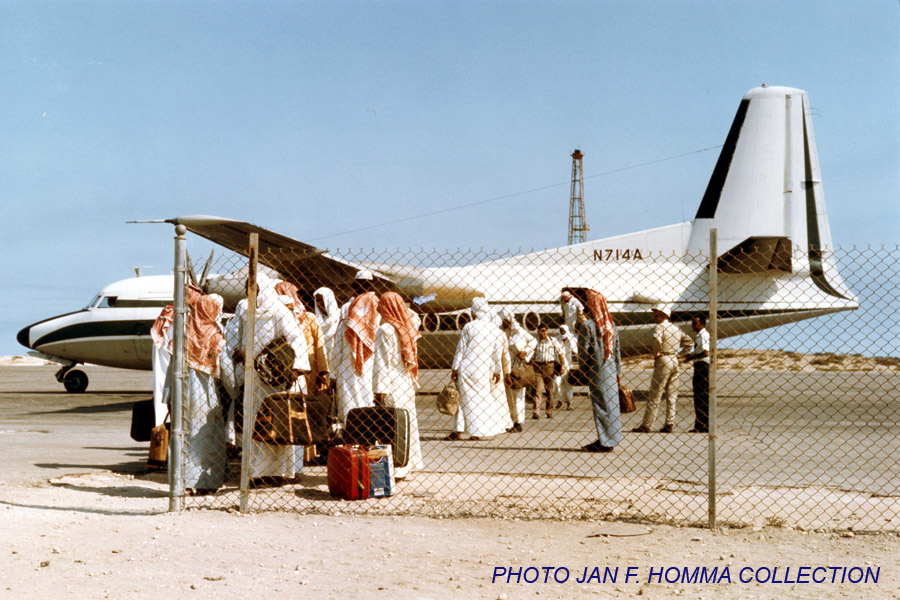
This airframe as N714A with ARAMCO at RTM in 1979:
www.douglasdc8.com/photos/RTM-1144G.jpg
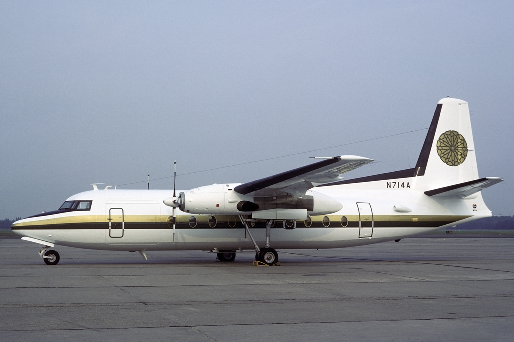
PH-SFB with NLM City Hopper at AMS in July 1990:
imgproc.airliners.net/photos/airliners/1/0/0/0790001.jpg
This airframe as HB-ITQ with Farner Air Transport at MST in June 1993:
www.flickr.com/photos/190105067@N03/50327230301
This airframe as 9H-MQT with Sky Gabon at LBV in Nov. 2013:
www.planes.cz/photo/1181/1181555/1181555.jpg
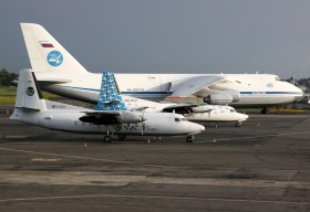
This airframe as 5Y-SEP with Safari Express Cargo at HLA in August 2017:
www.flickr.com/photos/satransport/36445015791
Scan from Kodachrome slide.
Photo taken by Herwart Schneider and kindly provided by him for inclusion on this page.
München-Riem
1973-03-21 (21 March 1973)
An unusual view of the Riem ramp taken with a strong tele lens from the east of the field looking west on the day of the European Champions' Cup quarter finals between Ajax Amsterdam and FC Bayern.
The tower and terminal buildings were situated to the right from this perspective, and the widebodies are parked on the outer parking positions.
The three DC-10s were KLM’s PH-DTD and THY’s TC-JAV and TC-JAY. These were the early days of widebody traffic at Riem, and three DC-10s at the same time were highly unusual.
Also visible are BEA Airtours B707-436 G-APFD and Martinair Holland DC-8-33 PH-DCD, a Britannia B737, Martinair DC-9 and Transavia Caravelle.
Here’s the list of visitors that day from "COINCAT Air News International":
PH-MAN DC-9-33RC Martinair Holland
PH-MAO DC-9-33RC Martinair Holland
PH-MAR DC-9-33RC Martinair Holland
PH-DCD DC-8-33 Martinair Holland
PH-DTD DC-10-30 KLM Royal Dutch Airlines
TC-JAV DC-10-10 Turk Hava Yollari (THY)
TC-JAY DC-10-10 Turk Hava Yollari (THY)
OY-APZ Boeing 720-051B Maersk Air
G-APFD Boeing 707-436 BEA Airtours
PH-TRR Caravelle III Transavia Holland
PH-TRS Caravelle VI-R Transavia Holland
PH-TRX Caravelle VI-R Transavia Holland
PH-TRY Caravelle VI-R Transavia Holland
PI-C801 DC-8-53 Philippine Airlines (PAL)
KY-1/OT-CDA DC-6A Belgian Air Force
What I specially like about this shot are the two persons apparently walking their dog on the airport grounds, inside the fence, in the bottom right corner.
Aerial shot from the same day:
www.airporthistory.org/uploads/1/2/1/4/121407428/muc-aeri...
Scan from Kodachrome slide.
The T-34 is a Soviet medium tank from World War II. When introduced, its 76.2 mm (3 in) tank gun was more powerful than its contemporaries, and its 60-degree sloped armour provided good protection against anti-tank weapons. The T-34 had a profound effect on the conflict on the Eastern Front, and had a long-lasting impact on tank design. The tank was praised by multiple German generals when encountered during Operation Barbarossa, although its armour and armament were surpassed later in the war. Though, its main strength was its cost and production time, meaning that German panzer forces would often fight against Soviet tank forces several times their size. The T-34 is also a critical part of the mechanized divisions that form the backbone of the Deep Battle Strategy.
The T-34 was the mainstay of the Soviet Red Army armoured forces throughout the war. Its general specifications remained nearly unchanged until early 1944, when it received a firepower upgrade with the introduction of the greatly improved T-34-85 variant. Its production method was continuously refined and rationalized to meet the needs of the Eastern Front, making the T-34 quicker and cheaper to produce. The Soviets ultimately built over 80,000 T-34s of all variants, allowing steadily greater numbers to be fielded despite the loss of tens of thousands in combat against the German Wehrmacht.
Replacing many light and medium tanks in Red Army service, it was the most-produced tank of the war, as well as the second most-produced tank of all time (after its successor, the T-54/T-55 series). With 44,900 lost during the war, it also suffered the most tank losses ever. Its development led directly to the T-44, then the T-54 and T-55 series of tanks, which in turn evolved into the later T-62, that form the armoured core of many modern armies. T-34 variants were widely exported after World War II, and as recently as 2010 more than 130 were still in service.
Development and production
Origins
In 1939, the most numerous Soviet tank models were the T-26 infantry tank and the BT series of fast tanks. The T-26 was slow-moving, designed to keep pace with infantry on the ground. The BT tanks were cavalry tanks: fast-moving and light, designed for manoeuver warfare. Both were Soviet developments of foreign designs from the early 1930s: the T-26 was based on the British Vickers 6-Ton, and the BT tanks were based on a design from American engineer J. Walter Christie.
In 1937, the Red Army had assigned engineer Mikhail Koshkin to lead a new team to design a replacement for the BT tanks at the Kharkiv Komintern Locomotive Plant (KhPZ). The prototype tank, designated A-20, had a modified BA-20 engine and was specified with 20 mm (0.8 in) of armour, a 45 mm (1.77 in) gun, the production model used a Model V-2-34 engine, a less-flammable diesel fuel in a V12 configuration designed by Konstantin Chelpan. It also had an 8×6-wheel convertible drive similar to the BT tank's 8×2, which allowed it to run on wheels without caterpillar tracks. This feature had greatly saved on maintenance and repair of the unreliable tank tracks of the early 1930s, and allowed tanks to exceed 85 kilometres per hour (53 mph) on roads, but gave no advantage in combat and its complexity made it difficult to maintain. By 1937–38, track design had improved and the designers considered it a waste of space, weight, and maintenance resources, despite the road speed advantage. The A-20 also incorporated previous research (BT-IS and BT-SW-2 projects) into sloped armour: its all-round sloped armour plates were more likely to deflect rounds than perpendicular armour.
During the Battle of Lake Khasan in July 1938 and the Battles of Khalkhin Gol in 1939, an undeclared border war with Japan on the frontier with occupied Manchuria, the Soviets deployed numerous tanks against the Imperial Japanese Army (IJA). Although the IJA Type 95 Ha-Go light tanks had diesel engines, the Red Army's T-26 and BT tanks used petrol engines which, while common in tank designs of the time, often burst into flames when hit by IJA tank-killer teams using Molotov cocktails. Poor-quality welds in the Soviet armour plates left small gaps between them, and flaming petrol from the Molotov cocktails easily seeped into the fighting and engine compartment; portions of the armour plating that had been assembled with rivets also proved to be vulnerable. The Soviet tanks were also easily destroyed by the Japanese Type 95 tank's 37 mm gunfire, despite the low velocity of that gun, or "at any other slightest provocation". The use of riveted armour led to a problem whereby the impact of enemy shells, even if they failed to disable the tank or kill the crew on their own, would cause the rivets to break off and become projectiles inside the tank.
After these battles, Koshkin convinced Soviet leader Joseph Stalin to let him develop a second prototype, a more heavily armed and armoured "universal tank" that reflected the lessons learned and could replace both the T-26 and the BT tanks. Koshkin named the second prototype A-32, after its 32 mm (1.3 in) of frontal armour. It had an L-10 76.2 mm (3 in) gun, and the same Model V-2-34 diesel. Both were tested in field trials at Kubinka in 1939, with the heavier A-32 proving to be as mobile as the A-20. A still heavier version of the A-32, with 45 mm (1.77 in) of front armour, wider tracks, and a newer L-11 76.2 mm gun, was approved for production as the T-34. Koshkin chose the name after the year 1934, when he began to formulate his ideas about the new tank, and to commemorate that year's decree expanding the armoured force and appointing Sergo Ordzhonikidze to head tank production.
Valuable lessons from Lake Khasan and Khalkhin Gol regarding armour protection, mobility, quality welding, and main guns were incorporated into the new T-34 tank, which represented a substantial improvement over the BT and T-26 tanks in all four areas. Koshkin's team completed two prototype T-34s in January 1940. In April and May, they underwent a grueling 2,000-kilometre (1,200 mi) drive from Kharkiv to Moscow for a demonstration for the Kremlin leaders, to the Mannerheim Line in Finland, and back to Kharkiv via Minsk and Kiev. Some drivetrain shortcomings were identified and corrected.
Initial production
Resistance from the military command and concerns about high production cost were finally overcome by anxieties about the poor performance of Soviet tanks in the Winter War in Finland, and the effectiveness of German tanks during the Battle of France. The first production T-34s were completed in September 1940, completely replacing the production of the T-26, the BT series and the multi-turreted T-28 medium tank at the KhPZ plant. Koshkin died of pneumonia (exacerbated by the drive from Kharkiv to Moscow) at the end of that month, and the T-34's drivetrain developer, Alexander Morozov, was appointed Chief Designer.
The T-34 posed new challenges for the Soviet industry. It had heavier armour than any medium tank produced to date, and there were problems with defective armour plates. Only company commanders' tanks could be fitted with radios (originally the 71-TK-3 radio set), due to their expense and short supply – the rest of the tank crews in each company signalled with flags. The L-11 gun did not live up to expectations, so the Grabin Design Bureau at Gorky Factory N.92 designed the superior 76.2 mm F-34 gun. No bureaucrat would approve production of the new gun, but Gorky and KhPZ started producing it anyway; official permission came from the State Defense Committee only after troops praised the weapon's performance in combat against the Germans.
Production of this first T-34 series – the Model 1940 – totalled only about 400, before production was switched to the Model 1941, with the F-34 gun, 9-RS radio set (also installed on the SU-100), and even thicker armour.
Mass production
Subassemblies for the T-34 originated at several plants: Kharkiv Diesel Factory N.75 supplied the model V-2-34 engine, Leningrad Kirovsky Factory (formerly the Putilov works) made the original L-11 gun, and the Dinamo Factory in Moscow produced electrical components. Tanks were initially built at Plant N.183, in early 1941 at the Stalingrad Tractor Factory (STZ), and starting in July at Krasnoye Sormovo Factory N.112 in Gorky.
Total Soviet tank production
TypeNumber
Light tanks14,508
T-3435,119
T-34-8529,430
KV and KV-854,581
IS-3,854
SU-7612,671
SU-852,050
SU-1001,675
SU-1221,148
SU-1524,779
After Germany's surprise invasion of the Soviet Union on 22 June 1941 (Operation Barbarossa), the Wehrmacht's rapid advances forced the evacuation and relocation of Soviet tank factories eastwards to the Ural Mountains, an undertaking of immense scale and haste that presented enormous logistic difficulties and was extremely punishing to the workers involved. Alexander Morozov personally supervised the evacuation of all skilled engineers and laborers, machinery and stock from KhPZ to re-establish the factory at the site of the Dzerzhinsky Ural Railcar Factory in Nizhny Tagil, renamed Stalin Ural Tank Factory N.183. The Kirovsky Factory, evacuated just weeks before the Germans surrounded Leningrad, moved with the Kharkiv Diesel Factory to the Stalin Tractor Factory in Chelyabinsk, soon to be nicknamed Tankograd ("Tank City"). The workers and machinery from Leningrad's Voroshilov Tank Factory N.174 were incorporated into the Ural Factory and the new Omsk Factory N.174. The Ordzhonikidze Ural Heavy Machine Tool Works (UZTM) in Sverdlovsk absorbed workers and machines from several small machine shops in the path of German forces.
While these factories were being rapidly moved, the industrial complex surrounding the Dzerzhinsky Tractor Factory in Stalingrad continued to work double shifts throughout the period of withdrawal (September 1941 to September 1942) to make up for production lost, and produced 40% of all T-34s during the period. As the factory became surrounded by heavy fighting in the Battle of Stalingrad in 1942, the situation there grew desperate: manufacturing innovations were necessitated by material shortages, and stories persist of unpainted T-34 tanks driven out of the factory directly to the battlefields around it. Stalingrad kept up production until September 1942.
Soviet designers were aware of design deficiencies in the tank, but most of the desired remedies would have slowed tank production and so were not implemented: the only changes allowed on the production lines through to 1944 were those to make production simpler and cheaper. New methods were developed for automated welding and hardening the armour plate, including innovations by Prof. Evgeny Paton. The design of the 76.2 mm F-34 gun Model 1941 was reduced from an initial 861 parts to 614. The initial narrow, cramped turrets, both the cast one and the one welded of rolled armour plates bent to shape, were since 1942 gradually replaced with the somewhat less cramped hexagonal one; as it was mostly cast with only a few, simple flat armour plates welded in (roof etc.), this turret was actually faster to produce. Limited rubber supplies led to the adoption of all-steel, internally sprung road wheels, and a new clutch was added to an improved five-speed transmission and engine, improving reliability.
Over two years, the unit production cost of the T-34 was reduced from 269,500 Rbls in 1941, to 193,000 Rbls, and then to 135,000 Rbls.
In 1943, T-34 production had reached an average of 1,300 per month; this was the equivalent of three full-strength tank divisions. By the end of 1945, over 57,300 T-34s had been built: 34,780 T-34 tanks in multiple variants with 76.2 mm guns in 1940–44, and another 22,609 of the revised T-34-85 model in 1944–45. The single largest producer was Factory N.183 (UTZ), building 28,952 T-34s and T-34-85s from 1941 to 1945. The second-largest was Krasnoye Sormovo Factory N.112 in Gorky, with 12,604 in the same period.
At the start of the German-Soviet war, T-34s comprised about four percent of the Soviet tank arsenal, but by the end it made up at least 55% of tank production (based on figures from; Zheltov lists even larger numbers.
Following the end of the war, a further 2,701 T-34s were built prior to the end of Soviet production. Under licence, production was restarted in Poland (1951–55) and Czechoslovakia (1951–58), where 1,380 and 3,185 T-34-85s were made, respectively, by 1956. Altogether, as many as 84,070 T-34s are thought to have been built, plus 13,170 self-propelled guns built on T-34 chassis. It was the most-produced tank of the Second World War, and the second most-produced tank of all time, after its successor, the T-54/55 series.
Design
The T-34 had well-sloped armour, a relatively powerful engine and wide tracks. The initial T-34 version had a powerful 76.2 mm gun, and is often called the T-34/76 (originally a World War II German designation, never used by the Red Army). In 1944, a second major version began production, the T-34-85, with a larger 85 mm gun intended to deal with newer German tanks.
Comparisons can be drawn between the T-34 and the U.S. M4 Sherman tank. Both tanks were the backbone of the armoured units in their respective armies, both nations distributed these tanks to their allies, who also used them as the mainstay of their own armoured formations, and both were upgraded extensively and fitted with more powerful guns. Both were designed for mobility and ease of manufacture and maintenance, sacrificing some performance for these goals. Both chassis were used as the foundation for a variety of support vehicles, such as armour recovery vehicles, tank destroyers, and self-propelled artillery. Both were an approximately even match for the standard German medium tank, the Panzer IV, though each of these three tanks had particular advantages and weaknesses compared with the other two. Neither the T-34 nor the M4 was a match for Germany's heavier tanks, the Panther (technically a medium tank) or the Tiger I; the Soviets used the IS-2 heavy tank and the U.S. used the M26 Pershing as the heavy tanks of their forces instead.
Armour
The heavily sloped armour design made the tank better protected than the armour thickness alone would indicate. The shape also saved weight by reducing the thickness required to achieve equal protection. A few tanks also had appliqué armour of varying thickness welded onto the hull and turret. Tanks thus modified were called s ekranami (Russian: с экранами, "with screens").
The USSR donated two combat-used Model 1941 T-34s to the United States for testing purposes in late 1942. The examinations, performed at the Aberdeen Proving Ground, revealed problems with overall armour build quality, especially of the plate joins and welds, as well as the use of soft steel combined with shallow surface tempering. Leak issues were noted: "In a heavy rain lots of water flows through chinks/cracks, which leads to the disabling of the electrical equipment and even the ammunition". Earlier models of the T-34, until the Model 1942, had cast turrets whose armour was softer than that of the other parts of the tank, and offered poor resistance even to 37 mm anti-aircraft shells. Early T-34s also suffered from poor quality welds, leading to instances of shells which would not have penetrated the tank under normal circumstances to penetrate anyway. They also suffered from rushed manufacturing, leading to inconsistent protection.
In addition, close examination of the T-34 at the Aberdeen Testing Ground showed that a variety of alloys were used in different portions of the armour on the T-34. "Mn-Si-Mo steels were employed for the thinner rolled armour sections, Cr-Mo steels for the thicker rolled armour sections, Mn-Si-Ni-Cr-Mo steels were employed for both rolled and cast steel components from 2" to 5" in thickness, and Ni-Cr-Mo steels were employed for some of the moderately thick cast armour sections". The armour was heat-treated in order to prevent penetration by armour-piercing shells, but this also caused it to be structurally weak, as the armor was very hard and thus brittle, resulting in strikes by high explosive shells causing spalling.
Despite these deficiencies, the T-34's armour proved problematic for the Germans in the initial stages of the war on the Eastern Front. In one wartime account, a single T-34 came under heavy fire upon encountering one of the most common German anti-tank guns at that stage of the war: "Remarkably enough, one determined 37 mm gun crew reported firing 23 times against a single T-34 tank, only managing to jam the tank’s turret ring." Similarly, a German report of May 1942 noted the ineffectiveness of their 50 mm gun as well, noting that "Combating the T-34 with the 5 cm KwK tank gun is possible only at short ranges from the flank or rear, where it is important to achieve a hit as perpendicular to the surface as possible." However, a Military Commissariat Report of the 10th Tank Division, dated 2 August 1941 reported that within 300–400 m the 37 mm Pak 36's armour-piercing shot could defeat the frontal armour. According to an examination of damaged T-34 tanks in several repair workshops in August to September 1942, collected by the People's Commissariat for Tank Industry in January 1943, 54.3% of all T-34 losses were caused by the German long-barreled 5 cm KwK 39 gun.
As the war went on, the T-34 gradually lost some of its initial advantages. The Germans responded to the T-34 by fielding large numbers of improved anti-tank weapons such as the towed 7.5 cm Pak 40 anti-tank gun, while hits from 88 mm-armed Tigers, anti-aircraft guns and 8.8 cm Pak 43 anti-tank guns usually proved lethal. In 1942 the German Panzer IVs were refitted with the 7.5 cm KwK 40 due to the inadequate anti-tank performance of previous German tank designs against the T-34. The upgunned Panzer IV posed a serious threat to the T-34-76, being able to penetrate the frontal turret of a T-34-76 at a range of 1,200 m (3,900 ft) at any angle.
A Wa Pruef 1 report estimated that, with the target angled 30° sideward, a Panther tank could penetrate the turret of a T-34-85 from the front at ranges up to 2000 m, the mantlet at 1200 m, and the frontal hull armour at 300 m. According to the Pantherfibel (the Panther tank manual for its crew), the T-34's glacis could be penetrated from 800 m and the mantlet from 1500 m at 30° sideward angle.
A Waffenamt-Prüfwesen 1 report estimated that with the T-34 angled 30 degrees sidewards and APCBC round, the Tiger I's 8.8 cm KwK 36 L/56 would have to close in to 100 m (110 yd) to achieve a penetration in the T-34's glacis, and could penetrate the frontal turret of a T-34-85 at 1,400 m, the mantlet at 400 m, and the nose at 300 m Ground trials by employees of NIBT Polygon in May 1943 reported that the 88 mm KwK 36 gun could pierce the T-34 frontal hull from 1,500 meters at 90 degrees and cause a disastrous burst effect inside the tank. The examined hull showed cracks, spalling, and delamination due to the poor quality of the armour. It was recommended to increase and improve the quality of welds and armour.
Analysis of destroyed T-34 tanks in the Korean War found that the 76 and 90 mm armour-piercing rounds of the M41 Walker Bulldog and M46 Patton could penetrate the T-34 at most angles from 800 yd (730 m). The maximum range at which the tanks could penetrate the T-34 could not be determined due to a lack of data at higher combat ranges.
In late 1950 a T-34-85 tank was captured by the UN security force in the Korean War. An evaluation of the tank was conducted by the USA which found that the sloped armour of the T-34 was desirable for deflecting shells. They also concluded that the armour was deemed as satisfactory as armour strength was comparable to US armour of similar hardness and that the quality of the material used was "high-grade". Similarly, casting was seen as high quality although casting defects were found in the side armour of the tank that negatively affected armour strength. The abundance of gaps in the joints of the armour was seen as an undesirable feature of the tank due to the risk of injury from "entry of bullet splash and shell fragments".
Firepower
The 76.2 mm (3.00 in) F-34 gun, fitted on the vast majority of T-34s produced through to the beginning of 1944, was able to penetrate any early German tank's armour at normal combat ranges. When firing APCR shells, it could pierce 92 mm (3.6 in) at 500 m (1,600 ft) and 60 mm (2.4 in) of armour at 1,000 m (3,300 ft) The best German tanks of 1941, the Panzer III and Panzer IV, had no more than 50 or 60 mm (2.0 or 2.4 in) of flat frontal armour. However by 1942 the Germans had increased the hull armour on the Panzer IV to 80 mm (3.1 in) which provided good protection at normal combat distances. The F-34 also fired an adequate high explosive round.
The gun sights and range finding for the F-34 main gun (either the TMFD-7 or the PT4-7) were rather crude, especially compared to those of their German adversaries, affecting accuracy and the ability to engage at long ranges.[68] As a result of the T-34's two-man turret, weak optics and poor vision devices, the Germans noted:
T-34s operated in a disorganized fashion with little coordination or else tended to clump together like a hen with its chicks. Individual tank commanders lacked situational awareness due to the poor provision of vision devices and preoccupation with gunnery duties. A tank platoon would seldom be capable of engaging three separate targets but would tend to focus on a single target selected by the platoon leader. As a result, T-34 platoons lost the greater firepower of three independently operating tanks.
The Germans also noted that the T-34 was very slow to find and engage targets, while their own tanks could typically get off three rounds for every one fired by the T-34. As the war progressed the Germans created heavier tank designs like the Tiger I or Panther which were both immune to the 76mm gun of the T-34 when fired upon from the front. This meant that they could only be penetrated from the sides at ranges of a few hundred metres. Due to low anti-tank performance, the T-34 was upgraded to the T-34-85 model. This model, with its 85 mm (3.35 in) ZiS gun, provided greatly increased firepower compared to the previous T-34's 76.2mm gun. The 85 mm gun could penetrate the turret front of a Tiger I tank from 500 m (550 yd) and the driver's front plate from 300 m (330 yd) at the side angle of 30 degrees, and the larger turret enabled the addition of another crew member, allowing the roles of commander and gunner to be separated and increasing the rate of fire and overall effectiveness. The D-5T was capable of penetrating the Tiger I's upper hull armour at 1,000 metres. When firing on the frontal armour of the Panther at an angle of 30 degrees sidewards, the T-34-85 could not penetrate its turret at 500 m (550 yd). This meant that the T-34 would have to resort to using tungsten rounds or firing on the weaker sides of the Panther to destroy it.
The greater length of the 85 mm gun barrel – 4.645 m (15 ft 2.9 in) – made it necessary for crews to be careful not to plough it into the ground on bumpy roads or in combat. Tank commander A.K. Rodkin commented: "the tank could have dug the ground with it in the smallest ditch [filling the barrel with dirt]. If you fired it after that, the barrel would open up at the end like the petals of a flower", destroying the barrel. Standard practice when moving the T-34-85 cross-country in non-combat situations was to fully elevate the gun, or reverse the turret.
During the Korean War, the USA captured a T-34-85. US engineering analysis and testing concluded that the T-34-85 could penetrate 4.1 in (100 mm) at 1,000 yd (910 m), performing similarly to the HVAP rounds of the M41. The Americans also concluded the maximum range of the gun was 2–3 km (1.2–1.9 mi), but the effective range was only up to 1,900 m (1.2 mi).
Mobility
The T-34 was powered by a Model V-2-34 38.8 L V12 Diesel engine of 500 hp (370 kW),[d] giving a top speed of 53 km/h (33 mph). It used the coil-spring Christie suspension of the earlier BT-series tanks, using a "slack track" tread system with a rear-mounted drive sprocket and no system of return rollers for the upper run of track, but dispensed with the heavy and ineffective convertible drive. T-34 tanks equipped with the 4-speed gearbox could only use 4th gear on road, being limited to 3rd on terrain. In the first batch of T-34s, shifting from 2nd to 3rd required a force of 46-112 kg. In September 1941, however, changes were made which lowered the effort to under 31 kg by changing the 3rd gear ratio, which lowered top speed in 3rd gear from 29 km/h to 25 km/h, but made shifting easier. Using the 5-speed gearbox allowed the T-34 to use 4th gear on terrain, with which it could reach 30 km/h.
The T-34-76's ground pressure was around 0.72 kg/cm². Its wide tracks allowed for superior performance on dirt roads and off-road when compared to contemporary tanks. There were, however, still examples of T-34s getting stuck in mud. For example, in 1944 February 4, the 21st Guards Tank Brigade with 32 T-34, was ordered to proceed by road to Tolstoye Rogi, a journey of approximately 80 kilometers. Of the 32 tanks, no less than 19 got stuck in the mud or suffered mechanical breakdowns.
Ergonomics
The original 76mm armed T-34 suffered from the unsatisfactory ergonomic layout of its crew compartment compared to the later 85mm variant. The two-man turret crew arrangement required the commander to aim and fire the gun, an arrangement common to most Soviet tanks of the day. The two-man turret was "cramped and inefficient" and was inferior to the three-man (commander, gunner, and loader) turret crews of German Panzer III and Panzer IV tanks. The Germans noted the T-34 was very slow to find and engage targets while the Panzers could typically get off three rounds for every one fired by the T-34.
Early in the war, the commander fought at a further disadvantage; the forward-opening hatch and the lack of a turret cupola forced him to observe the battlefield through a single vision slit and traversable periscope.[81] German commanders liked to fight "heads-up", with their seat raised and having a full field of view – in the T-34 this was impossible. Soviet veterans condemned the turret hatches of the early models. Nicknamed pirozhok ("stuffed bun") because of its characteristic shape, it was heavy and hard to open. The complaints of the crews urged the design group led by Alexander Morozov to switch in August 1942 to using two hatches in the turret.
The loader also had a difficult job due to the lack of a turret basket (a rotating floor that moves as the turret turns); the same fault was present on all German tanks prior to the Panzer IV. The floor under the T-34's turret was made up of ammunition stored in small metal boxes, covered by a rubber mat. There were nine ready rounds of ammunition stowed in racks on the sides of the fighting compartment. Once these rounds had been used, the crew had to pull additional ammunition out of the floor boxes, leaving the floor littered with open bins and matting and reducing their performance.
The main weakness [of the two-man turret of a T-34 Model 1941] is that it is very tight. The Americans couldn't understand how our tankers could fit inside during a winter when they wear sheepskin jackets. The electrical mechanism for rotating the turret is very bad. The motor is weak, very overloaded and sparks horribly, as a result of which the device regulating the speed of the rotation burns out, and the teeth of the cogwheels break into pieces. They recommend replacing it with a hydraulic or simply manual system. Due to not having a turret basket the crew was [sic] could be injured by getting caught in the drive mechanism, this could leave them out of combat for a while, the lack of a turret basket also caused general discomfort to the crew, having to manually turn.
Most of the problems created by the cramped T-34/76 turret, known before the war, were corrected with the provision of a bigger cast three-man turret[86] on the T-34-85 in 1944.
General reliability
The T-34's wide track and good suspension gave it excellent cross-country performance. Early in the tank's life, however, this advantage was greatly reduced by the numerous teething troubles the design displayed: a long road trip could be a lethal exercise for a T-34 tank at the start of the war. When in June 1941, the 8th Mechanised Corps under Dmitry Ryabyshev marched 500 km towards Dubno, the corps lost half of its vehicles. A.V. Bodnar, who was in combat in 1941–42, recalled:
From the point of view of operating them, the German armoured machines were almost perfect, they broke down less often. For the Germans, covering 200 km was nothing, but with T-34s something would have been lost, something would have broken down. The technological equipment of their machines was better, the combat gear was worse.
The T-34 gearbox had four forward and one reverse gear, replaced by a five-speed box on the last of the 1943 model of the T-34.
The tracks of early models were the most frequently repaired part. A.V. Maryevski later remembered:
The caterpillars used to break apart even without a bullet or shell hits. When earth got stuck between the road wheels, the caterpillar, especially during a turn – strained to such an extent that the pins and tracks themselves couldn't hold out.
The USSR donated two combat-used Model 1941 T-34s to the United States for testing purposes in late 1942. The examinations, performed at the Aberdeen Proving Ground, highlighted these early faults, which were in turn acknowledged in a 1942 Soviet report on the results of the testing:
The Christie's suspension was tested a long time ago by the Americans and unconditionally rejected. On our tanks, as a result of the poor steel on the springs, it very quickly fatigues and as a result clearance is noticeably reduced. The deficiencies in our tracks from their viewpoint result from the lightness of their construction. They can easily be damaged by small-caliber and mortar rounds. The pins are extremely poorly tempered and made of poor steel. As a result, they quickly wear and the track often breaks.
Testing at Aberdeen also revealed that engines could grind to a halt from dust and sand ingestion, as the original "Pomon" air filter was almost totally ineffective and had an insufficient air-inflow capacity, starving the combustion chambers of oxygen, lowering compression, and thereby restricting the engine from operating at full capacity. The air filter issue was later remedied by the addition of "Cyclone" filters on the Model 1943, and even more efficient "Multi-Cyclone" filters on the T-34-85.
The testing at Aberdeen revealed other problems as well. The turret drive also suffered from poor reliability. The use of poorly machined, low quality steel side friction clutches and the T-34's outdated and poorly manufactured transmission meant frequent mechanical failure occurred and that they "create an inhuman harshness for the driver". A lack of properly installed and shielded radios – if they existed at all – restricted their operational range to under 16 km (9.9 mi).
Judging by samples, Russians when producing tanks pay little attention to careful machining or the finishing and technology of small parts and components, which leads to the loss of the advantage what would otherwise accrue from what on the whole are well-designed tanks. Despite the advantages of the use of diesel, the good contours of the tanks, thick armor, good and reliable armaments, the successful design of the tracks etc., Russian tanks are significantly inferior to American tanks in their simplicity of driving, manoeuvrability, the strength of firing (reference to muzzle velocity), speed, the reliability of mechanical construction and the ease of keeping them running.
Soviet tests on newly built T-34’s showed that in April 1943 only 10.1% could complete a 330 km trial and in June ’43 this went down to 7.7%. The percentage stayed below 50% till October 1943 when it rose to 78%, in the next month it dropped to 57% and in the period December ’43 – January ’44 the average was 82%. During February 1944 tests, 79% of tanks reached 300 kilometers, and of the test batches 33% reached 1,000 kilometers. This became immediately apparent to the tank troops. The deputy commander of the 1st Guards Tank Army, P. G. Dyner, commented that tanks in 1943 would reach only 75 percent of their guaranteed life span in engine hours and mileage, but in 1944 they reached 150 percent.
In 1944 June, a report written by the 2. Panzerjäger-Abteilung Company 128 (23. PzDiv.) described experiences acquired during operations with its Beutepanzer SU-85 and T-34:
Despite not having much experience yet, it can be said that the Russian battle tank is not suitable for carrying out long marches as well as high-speed marches. A maximum driving speed of 10–12 km / h has become convenient. During the marches and in order to allow the engines to cool down, it is absolutely necessary to make a stop every half hour for a minimum duration of between fifteen and twenty minutes.
Steering gears have caused problems and breakdowns on all new battle tanks. In difficult terrain, during the gears or also during the course of attacks where many changes of direction are made, the steering clutch heats up and covers with oil quickly: consequently the clutch does not engage and it is impossible to maneuver the vehicle. Once it has cooled down, the clutch should be cleaned with copious amounts of fuel.
In relation to the armament and based on the experiences acquired so far, it can be affirmed that the power of the 7.62 cm cannon is good. If the barrel is adjusted correctly it has good precision even at great distances. The same can be said of the rest of the automatic weapons of the battle tank. The weapons have good precision and reliability, although a slow rate of fire.
The Company has had the same positive experiences with the 8.5 cm assault gun. Regarding the true power of fire compared to the 7.62 cm gun, the Company is not yet able to give details. The effect of explosive projectiles ( Sprenggranaten ) at great distances and its precision is much higher than that of the 7.62 cm cannon.
The optical systems of the Russian battle tank are, in comparison with the Germans, much inferior. The German gunner has to get used to the Russian telescopic sight. Observing the impact or the trajectory of the projectile through the telescopic sight is only partially possible. The gunner of the Russian T-43 [sic] battle tank has only a panoramic optic, located in the upper left area, in front of the telescopic sight. In order for the loader to be able to observe the trajectory of the projectile in any case, the Company has additionally incorporated a second panoramic optics for this member of the crew.
In the Russian tank it is very difficult to steer the vehicle or a unit and shoot simultaneously. Coordinating fire within a company is only partially possible.
On January 29, 1945, the State Defense Committee approved a decree that extended the service life guarantee of the T-34's V-2-34 engine from 200 hours to 250 hours. A report by the 2nd Guards Tank Army in February 1945 revealed that the average engine service life of a T-34 was lower than the official warranty at 185–190 hours. For comparison, the US M4 Sherman had an average engine service life of 195–205 hours.
Operational history
Operation Barbarossa (1941)
Germany launched Operation Barbarossa, its invasion of the Soviet Union, on 22 June 1941. At the start of hostilities, the Red Army had 967 T-34 tanks and 508 KV tanks concentrated in five of their twenty-nine mechanized corps. The existence of the T-34 and KV heavy tanks proved a psychological shock to German soldiers, who had expected to face an inferior enemy. The T-34 was superior to any tank the Germans then had in service. The diary of Alfred Jodl seems to express surprise at the appearance of the T-34 in Riga, noting "the surprise at this new and thus unknown wunder-armament being unleashed against the German assault divisions". Paul Ludwig Ewald von Kleist, called it "the finest tank in the world" and Heinz Guderian affirmed the T-34's "vast superiority" over German tanks.
Initially, the Wehrmacht had great difficulty destroying T-34s in combat, as standard German anti-tank weaponry proved ineffective against its heavy, sloped armour. In one of the first known encounters, a T-34 crushed a 3.7 cm PaK 36, destroyed two Panzer IIs, and left a 14-kilometre (8.7 mi) long swathe of destruction in its wake before a howitzer destroyed it at close range. In another incident, a single Soviet T-34 was hit more than 30 times by a battalion-sized contingent of German 37mm and 50mm anti-tank guns, yet survived intact and drove back to its own lines a few hours later. The inability to penetrate the T-34's armour led to the Germans' standard anti-tank gun, the 37 mm PaK 36, being dubbed the Panzeranklopfgerät ("tank door knocker") because the PaK 36 crew simply revealed their presence and wasted their shells without damaging the T-34's armour. Anti-tank gunners began aiming at tank tracks, or vulnerable margins on the turret ring and gun mantlet, rather than the bow and turret armour. The Germans were forced to deploy 105 mm field guns and 88 mm anti-aircraft guns in a direct fire role to stop them.
Despite this, the Soviet corps equipped with these new tanks lost most of them within weeks. The combat statistics for 1941 show that the Soviets lost an average of over seven tanks for every German tank lost. The Soviets lost a total of 20,500 tanks in 1941 (approximately 2,300 of them T-34s, as well as over 900 heavy tanks, mostly KVs). The destruction of the Soviet tank force was accomplished not only by the glaring disparity in the tactical and operational skills of the opponents, but also by mechanical defects that afflicted Soviet armour. Besides the poor state of older tanks, the new T-34s and KVs suffered from initial mechanical and design problems, particularly with regard to clutches and transmissions. Mechanical breakdowns accounted for at least 50 percent of the tank losses in the summer fighting, and recovery or repair equipment was not to be found. The shortage of repair equipment and recovery vehicles led the early T-34 crews to enter combat carrying a spare transmission on the engine deck.
Other key factors diminishing the initial impact of T-34s on the battlefield were the poor state of leadership, tank tactics, initial lack of radios in tanks, and crew training; these factors were partially consequences of Stalin's purge of the Soviet officer corps in 1937, reducing the army's efficiency and morale. This was aggravated as the campaign progressed by the loss of many of the properly trained personnel during the Red Army's disastrous defeats early in the invasion. Typical crews went into combat with only basic military training plus 72 hours of classroom instruction; according to historian Steven Zaloga:
The weakness of mechanized corps lay not in the design of their equipment, but rather in its poor mechanical state, the inadequate training of their crews, and the abysmal quality of Soviet military leadership in the first month of the war.
Further action (1942–1943)
As the invasion progressed, German infantry began receiving increasing numbers of the 7.5 cm Pak 40 anti-tank guns, which were capable of penetrating the T-34's armour at long range. Larger numbers of the 88 mm Flak guns also arrived, which could easily defeat a T-34 at very long ranges, though their size and general unwieldiness meant that they were often difficult to move into position in the rough Soviet terrain.
At the same time, the Soviets incrementally upgraded the T-34. The Model 1942 featured increased armour on the turret and many simplified components. The Model 1943 (confusingly also introduced in 1942) had yet more armour, as well as increased fuel capacity and more ammunition storage. Also added were an improved engine air filter and a new clutch mated to an improved and more reliable five-speed transmission. Finally, the Model 1943 also had a new, slightly roomier (but still two-man) turret of a distinctive hexagonal shape that was easier to manufacture, derived from the abandoned T-34M project.
The T-34 was essential in resisting the German summer offensive in 1942, and executing the double encirclement manoeuvre that cut off the German Sixth Army at Stalingrad in December 1942. The Sixth Army was surrounded, and eventually surrendered in February 1943, a campaign widely regarded as the turning point of the war on the Eastern Front.
In 1943, the Soviets formed Polish and Czechoslovak armies-in-exile, and these started to receive the T-34 Model 1943 with a hexagonal turret. Like the Soviet forces themselves, the Polish and Czechoslovak tank crews were sent into action quickly with little training, and suffered high casualties.
In July 1943, the Germans launched Operation Citadel, in the region around Kursk, their last major offensive on the Eastern Front in the Second World War. It was the debut of the German Panther tank, although the numbers employed at the resulting Battle of Kursk were small and the brunt of the burden was carried by the Panzer III, StuG III, and Panzer IV. The campaign featured the largest tank battles in history. The high-water mark of the battle was the massive armour engagement at Prokhorovka, which began on 12 July, though the vast majority of armour losses on both sides were caused by artillery and mines, rather than tanks. Over 6,000 fully tracked armoured vehicles, 4,000 combat aircraft, and 2 million men are believed to have participated in these battles.
The Soviet high command's decision to focus on one cost-effective design, cutting costs and simplifying production wherever possible while only allowing relatively minor improvements, had proven to be an astute choice for the first two years of the war. However, the battles in the summer of 1943 demonstrated that the 76.2 mm gun of the T-34 was no longer as effective as it was in 1941. Soviet tank crews struggled at longer ranges with the additional frontal armour applied to the later variants of the Panzer III and Panzer IV, and were unable to penetrate the frontal armour of the new German Panther or Tiger I tank at standard combat ranges without tungsten rounds, and had to rely on tactical skill through flanking manoeuvres and combined arms.
T-34-85
After improved German Panzer IVs with the high-velocity 7.5cm (2.95 in) KwK 40 gun were encountered in combat in 1942, a project to design an entirely new Soviet tank was begun, with the goals of increasing armour adding modern features like a torsion-bar suspension and a three-man turret. The new tank, the T-43, was intended to be a universal model to replace both the T-34 and the KV-1 heavy tank. However, the T-43 prototype's armour, though heavier, was not capable against German 88 mm guns, while its mobility was found to be inferior to the T-34. Finally, although the T-43 shared over 70% of its components with the T-34, manufacturing it would still have required a significant slow-down in production. Consequently, the T-43 was cancelled.
Not only were the weapons of German tanks improving, so was their armour. Soviet firing tests against a captured Tiger I heavy tank in April 1943 showed that the T-34's 76 mm gun could not penetrate the front of the Tiger I at all, and the side only at very close range. A Soviet 85 mm anti-aircraft gun, the M1939 (52-K), was found capable of doing the job, and so derivatives of it were developed for tanks. One of the resulting guns used on the original T-34 85 model (the D-5T) was capable of penetrating the Tiger I's upper hull armour at 1,000 metres. It was still not enough to match the Tiger, which could destroy the T-34 from a distance of 1,500 to 2,000 m (4,900 to 6,600 ft), but it was a noticeable improvement.
With the T-43 canceled, the Soviet command made the decision to retool the factories to produce an improved version of the T-34. Its turret ring was enlarged from 1,425 mm (56 in) to 1,600 mm (63 in), allowing a larger turret to be fitted supporting the larger 85 mm gun. The prototype T-43's turret design was hurriedly adopted by Vyacheslav Kerichev at the Krasnoye Sormovo Factory to fit the T-34. This was a larger three-man turret, with radio (previously in the hull) and observation cupola in the roof. Now the tank commander needed only to command (aided by cupola and radio systems), leaving the operation of the gun to the gunner and the loader. The turret was bigger and less sloped than the original T-34 turret, making it a bigger target (due to the three-man crew and bigger gun), but with thicker 90 mm armour, making it more resistant to enemy fire. The shells were 50% heavier (9 kg) and were much better in the anti-armour role, and reasonable in a general purpose role, though only 55–60 could be carried, instead of 90–100 of the earlier shells. The resulting new tank, the T-34-85, was seen as a compromise between advocates for the T-43 and others who wanted to continue to build as many 76 mm-armed T-34s as possible without interruption.
Production of the T-34-85 began in January 1944 at Factory No. 112, first using the D-5T 85 mm gun. Parallel to the production of the T-34-85 with the D-5T gun, production of the T-34-85 using the S-53 gun (later to be modified and redesignated as the ZIS-S-53 gun) began in February 1944 at Factory No. 112. The improved T-34-85 became the standard Soviet medium tank, with an uninterrupted production run until the end of the war. A T-34-85 initially cost about 30 percent more to produce than a Model 1943, at 164,000 Rbls; by 1945 this had been reduced to 142,000 Rbls during the course of World War II the cost of a T-34 tank had almost halved, from 270,000 Rbls in 1941, while its top speed remained about the same, and its main gun's armour penetration and turret frontal armour thickness both nearly doubled.
The T-34-85 gave the Red Army a tank with better armour and mobility than the German Panzer IV tank and StuG III assault gun. While it could not match the armour or weapons of the heavier Panther and Tiger tanks, its improved firepower made it much more effective than earlier models, and overall it was more cost-effective than the heaviest German tanks. In comparison with the T-34-85 program, the Germans instead chose an upgrade path based on the introduction of completely new, expensive, heavier, and more complex tanks, greatly slowing the growth of their tank production and helping the Soviets to maintain a substantial numerical superiority in tanks. By May 1944, T-34-85 production had reached 1,200 tanks per month. In the entire war, production figures for all Panther types reached no more than 6,557, and for all Tiger types (including the Tiger I and Tiger II) 2,027. Production figures for the T-34-85 alone reached 22,559.
On 12 January 1945, a column of Tiger IIs and other tanks from 424th Heavy Panzer Battalion were involved in a short-range engagement with T-34-85 tanks near the village of Lisow. Forty T-34-85 tanks commanded by Colonel N. Zhukov were attacked by the 424th Heavy Panzer battalion, which had been reinforced by 13 Panthers. The Germans permanently lost five Tiger IIs, seven Tiger Is and five Panthers for the loss of four T-34-85 tanks burnt out.
German use of T-34s
The German army often employed as much captured materiel as possible and T-34s were not an exception. Large numbers of T-34s were captured in fighting on the Eastern Front though few were T-34-85s. These were designated by the Germans as Panzerkampfwagen T-34 747. From late 1941, captured T-34s were transported to a German workshop for repairs and modification to German requirements. In 1943 a local tank factory in Kharkiv was used for this purpose. These were sometimes modified to German standards by the installation of a German commander's cupola and radio equipment.
The first captured T-34s entered German service during the summer of 1941. In order to prevent recognition mistakes, large-dimension crosses or even swastikas were painted on the tanks, including on top of the turret, in order to prevent attack by Axis aircraft. Badly damaged tanks were either dug in as pillboxes or were used for testing and training purposes.
After the end of World War II, East Germany continued to utilize the T-34.
Manchurian campaign (August 1945)
Just after midnight on 9 August 1945, though the terrain was believed by the Japanese to be impassable by armoured formations, the Soviet Union invaded Japanese-occupied Manchuria. Red Army combined-arms forces achieved complete surprise and used a powerful, deep-penetrating attack in a classic double encirclement pattern, spearheaded by the T-34-85. The opposing Japanese forces had been reduced as elite units had been drawn off to other fronts and the remaining forces were in the middle of a redeployment. The Japanese tanks remaining to face them were all held in the rear and not used in combat; the Japanese had weak support from IJAAF forces, engineering, and communications. Japanese forces were overwhelmed, though some put up resistance. The Japanese emperor transmitted a surrender order on 14 August, but the Kwantung Army was not given a formal cease-fire until 17 August.
Korean War (1950–1953)
A full North Korean People's Army (KPA) brigade equipped with about 120 Soviet-supplied T-34-85s spearheaded the invasion of South Korea in June 1950. The WWII-era 2.36-inch bazookas initially used by the US troops in South Korea were useless against the KPA's T-34 tanks, as were the 75 mm main guns of the M24 Chaffee light tank. However, following the introduction of heavier and more capable armour into the war by US and UN forces, such as the American M4 Sherman, M26 Pershing and M46 Patton tanks, as well as the British Comet and Centurion tanks, the KPA began to suffer more T-34 tank losses in combat from enemy armour, aside from further losses due to numerous US/UN airstrikes and increasingly-effective anti-tank firepower for US/UN infantry on the ground, such as the then-new 3.5-inch M20 "Super Bazooka" (replacing the earlier 2.36-inch model). By the time the NKPA were forced to withdraw from the south, about 239 T-34s and 74 SU-76 assault guns had been lost or abandoned. After October 1950, NKPA armour was rarely encountered. Despite China's entry into the conflict in the following month, no major armour deployments were carried out by them, as the Chinese focus was on massed infantry attacks rather than large-scale armour assaults. Several T-34-85s and a few IS-2 tanks were fielded, primarily dispersed amongst their infantry, thus making armoured engagements with US and UN forces rare from then on.
A Chinese T-34 tank No. 215 from 4th Tank Regiment, 2nd Tank Division, allegedly destroyed four enemy tanks and damaged another M46 Patton tank during its fight from 6 to 8 July 1953. It also destroyed 26 bunkers,9 artillery pieces, and a truck. That tank is now preserved in the Military Museum of the Chinese People's Revolution.
In summary, a 1954 US military survey concluded that there were, in all, 119 tanks vs. tank actions involving US Army and US Marine units against North Korean and Chinese forces during the Korean War, with 97 T-34-85 tanks knocked out and another 18 considered probable. American losses were somewhat greater.
Angolan Civil War (1975–1988)
One of the last modern conflicts which saw the extensive combat deployment of the T-34-85 was the Angolan Civil War. In 1975, the Soviet Union shipped eighty T-34-85s to Angola as part of its support for the ongoing Cuban military intervention there. Cuban crewmen instructed FAPLA personnel in their operation; other FAPLA drivers and gunners accompanied Cuban crews in an apprentice role.
FAPLA began deploying T-34-85s against the UNITA and FNLA forces on June 9, 1975. The appearance of FAPLA and Cuban tanks prompted South Africa to reinforce UNITA with a single squadron of Eland-90 armoured cars.
Other regions and countries
In early 1991, the Yugoslav People's Army possessed 250 T-34-85s, none of which were in active service. During the breakup of Yugoslavia, the T-34-85s were inherited by the national armies of Croatia, Bosnia-Herzegovina, and Serbia and Montenegro and continued to see action during the Yugoslav Wars. Some were also acquired from Yugoslav reserve stocks by Serbian separatist armies, namely the Army of the Republic of Serb Krajina (SVK) and the Army of Republika Srpska (VRS). Most of these tanks were in poor condition at the beginning of the conflict and some were soon rendered unserviceable, likely through inadequate maintenance and lack of spares.
On 3 May 1995, a VRS T-34-85 attacked an UNPROFOR outpost manned by the 21st Regiment of the Royal Engineers in Maglaj, Bosnia, injuring six British peacekeepers, with at least one of them sustaining a permanent disability. A number of T-34s being stored by the VRS at a base in Zvornik were temporarily confiscated by UNPROFOR as part of a local disarmament programme the following year.
Middle East
Czechoslovak-produced T-34-85s were used by Egypt in the Arab-Israeli Wars of 1956 and 1967 (Six-Day War) in the Sinai Peninsula. Egypt went on to build the T-34-100, a local and unique conversion that was made up of a Soviet BS-3 100 mm heavy field-artillery gun mounted within a heavily modified turret, as well as the T-34-122 mounting the D-30 gun. In 1956, they were used as regular tanks to support Egyptian infantry, the tank was still in use by the Yom Kippur War in October 1973.
The Syrian Army also received T-34-85s from the Soviet Union and they took part in the many artillery duels with Israeli tanks in November 1964 and in the Six-Day War of 1967.
Warsaw Pact
T-34-85s equipped many of the armies of Eastern European countries (later forming the Warsaw Pact) and the armies of other Soviet client-states elsewhere. East German, Hungarian and Soviet T-34-85s served in the suppression of the East German uprising of 17 June 1953 as well as the Hungarian Revolution of 1956.
Afghanistan
T-34-85s were sporadically available in Afghanistan. During the Soviet–Afghan War, most of the T-34s were fielded by the Sarandoy internal security forces. Some were also kept in service with the Army of the Democratic Republic of Afghanistan.
China
After the formation of the People's Republic of China (PRC) in 1949, the Soviet Union sent many T-34-85s to the PRC's People's Liberation Army (PLA). Factory 617 had the ability to produce every part of the T-34-85, and during decades of service many modifications were made that visibly distinguish the PRC T-34-85 from the original specification, but no T-34-85 was actually made in China. The production plan of the T-34-85 in China was ended soon after the PRC received T-54A main battle tanks from the Soviet Union and began to build the Type 59 tank, a licensed production version of the T-54A.
Cuba
Cuba received 150 T-34-85 tanks as military aid from the Soviet Union in 1960. The T-34-85 was the first Soviet tank to enter service with the Cuban Revolutionary Armed Forces (FAR), along with the IS-2. Many T-34-85 tanks first saw action in April 1961 during the Bay of Pigs Invasion with an unknown number destroyed or knocked out during the battle. In 1975, many T-34-85s were also donated by the USSR to the FAR to support its lengthy intervention in the Angolan Civil War.
A platoon of five Cuban T-34-85s saw combat in Angola against South African troops during the Battle of Cassinga. The tanks were based along with a company of Cuban mechanized infantry equipped with BTR-152 armoured personnel carriers. In May 1978, South Africa launched a major airborne raid on Cassinga with the objective of destroying a SWAPO (South West African People's Organisation) base there. The Cuban forces were mobilised to stop them. As they approached Cassinga they were strafed by South African aircraft, which destroyed most of the BTR-152s and three of the T-34-85s; a fourth T-34-85 was disabled by an anti-tank mine buried in the road. The remaining tank continued to engage the withdrawing South African paratroops from a hull down position until the battle was over.
Over a hundred Cuban T-34-85s and their respective crews remained in Angola as of the mid 1980s. In September 1986, Cuban president Fidel Castro complained to General Konstantin Kurochkin, head of the Soviet military delegation to Angola, that his men could no longer be expected to fight South African armour with T-34s of "World War II vintage"; Castro insisted that the Soviets furbish the Cuban forces with a larger quantity of T-55s. By 1987 Castro's request appeared to have been granted, as Cuban tank battalions were able to deploy substantial numbers of T-54Bs, T-55s, and T-62s; the T-34-85 was no longer in service.
Cyprus
Cypriot National Guard forces equipped with some 35 T-34-85 tanks helped to support a coup by the Greek junta against President Archbishop Makarios on 15 July 1974. They also saw extensive action against Turkish forces during the Turkish invasion in July and August 1974, with two major actions at Kioneli and at Kyrenia on 20 July 1974.
Namibia
In 1984, the South West African People's Organisation (SWAPO) made a concerted attempt to establish its own conventional armoured battalion through its armed wing, the People's Liberation Army of Namibia (PLAN). As part of this effort, SWAPO diplomatic representatives in Europe approached the German Democratic Republic with a request for ten T-34 tanks, which were delivered. PLAN T-34s were never deployed during offensive operations against the South African military, being confined to the role of protecting strategic bases inside northern Angola.
By 1988 the PLAN T-34-85s had been stationed near Luanda, where their crews received training from Cuban instructors. In March 1989, the PLAN tanks were mobilised and moved south towards the Namibian border. South Africa accused PLAN of planning a major offensive to influence Namibia's pending general elections, but the tank crews did not cross the border and refrained from intervening in a series of renewed clashes later that year. Between 1990 and 1991, SWAPO ordered the PLAN tanks in Angola repatriated to Namibia at its own expense. Four later entered service with the new Namibian Army.
Finland
The Soviet and Finnish armies used T-34s until the 1960s; the former included the 76.2 mm-armed versions until at least 1968, when they were used in filming the sequel to the movie The Alive and the Dead. The Finnish tanks were captured directly from the Soviets or purchased from Germany's captured stocks. Many of the Т-34-85s were enhanced with Finnish or Western equipment, such as improved optics.
Vietnam
During the Vietnam War, the North Vietnamese Army was equipped with many Soviet T-34-85 and these were used in the Operation Lam Son 719, the 1972 Easter Offensive and the 1975 Spring Offensive. They were later used during the Vietnamese invasion of Kampuchea and the Sino-Vietnamese War. A small number are currently being used as trainers. The rest are in storage and no longer serve as active duty battle tanks.
Yemen
In 2015, both T-34-85 Model 1969 tanks and SU-100 self-propelled guns were photographed being used in Houthi takeover in Yemen. Some were even being fitted with anti-tank guided missiles.
Current active service
In 2018, there were nine countries that maintained T-34s in the inventories of their national armed forces: Cuba, Yemen, the Republic of the Congo, Guinea, Guinea-Bissau, Namibia, North Korea, Laos, and Vietnam. Of these operators, Vietnam possessed the largest known surviving fleet of T-34 series tanks, with 45. Yemen possessed 30, Guinea 30, Guinea-Bissau 10, Mali 21, and Laos 30. It was unclear how many Cuban and North Korean T-34s remained in service. All the Congolese, Namibian and Malian tanks were believed to be in reserve storage or inoperable. The Laotian Army retired its T-34s in early 2019 and sold them to Russia, to be used for public displays and museum exhibits.
Successors
In 1944, pre-war development of a more advanced T-34 tank was resumed, leading to the T-44. The new tank had a turret design based on the T-34-85's, but featured a new hull with torsion-bar suspension and transversely mounted engine; it had a lower profile than the T-34-85 and was simpler to manufacture. Between 150 and 200 of these tanks were built before the end of the war. With substantial drivetrain changes, a new turret, and 100 mm gun, it became the T-54, starting production in 1947
A trip into Nottingham provided the opportunity to add to my stranger project. Walking through an area that has proved fruitful in the past I spotted a young lady across the road whose silvery hair stood out against the darker tones of the brick building she was standing next to. I quickly crossed the street and introduced the project to her.
As the sky had been darkening rapidly I quickly took a few photographs using the brick wall as a backdrop as I liked the contrast between their orange/red colour and the blue of Chelsea’s jacket. The bricks dark tones also meant Chelsea’s hair and face would become the brightest elements within the picture.
As I took my last couple of shots the skies released a downpour and we managed to find a bit of shelter under a small overhang and this gave me time to find out a little about Chelsea who proved to be very easy to talk to, possibly because we both had an interest in photography.
Chelsea told me she was studying photography and her favourite areas were street and abstract work. Although she hadn’t heard of the 100 Strangers Project she was knowledgeable of the People of New York project having had to study it for her A levels. At the moment she enjoyed capturing street images of people in a candid fashion but after talking to me about the stranger project she was now wondering if she should try this type of street photography too. Chelsea told me one of her favourite photographers was Zed Nelson. Back home in Suffolk Chelsea’s father runs a successful photography business and I guess that’s where her interest in photography comes from.
I asked Chelsea why she’d chosen Nottingham to study in and she said she fell in love with the city when she came to look around, liking the fact that everything was close-by meaning she could keep costs down on traveling – very important on a student budget. She also mentioned how she liked the diversity in architecture which gave her a choice in a variety of backdrops for her photography, although she did state the subject came first when she went out to take street photographs.
My final question was to ask my usual random query of who her first star crush had been on and Chelsea laughed and said Justin Timberlake and that she still had a soft spot for him even today.
Thank-you Chelsea for agreeing to be part of the 100 Stranger Project and I hope you like your portrait and I wish you all success with your photography studies.
This picture is #127 in the 100 Strangers project, yes I’m doing a second 100. Find out more about the project and see pictures taken by other photographers at the 100 Strangers Flickr Group page
This is my 98th submission to the Human Family Group. To view more street portraits and stories visit www.flickr.com/groups/thehumanfamily/</a
First PMT provided two Optare Solos to accompany the Queen's Baton Relay on the Stoke-on-Trent to Chester leg of the journey to the 2002 Commonwealth Games in Manchester. 293 (X293FFA) was one of ten 27 seat Optare Solos that were new to First PMT in September 2000 and was photographed at Macclesfield on 20 July 2002.
Six men of the 1st Bavarian Landwehr Regiment, 3rd Btln. Dated 19 Dezember 1914, Somme-Py, France. On the reverse, (German content provided by xiphophilos):
An Herrn
Johann Sirch
in Rosenheim
Münchenerstraße 28B
Oberbayern.
Somme-Py, den 19.XII.14
Liebe Eltern!
Habe gestern Euren Brief vom 6. Dezember erhalten. Schicke Euch hiermit ein Bild von meinen Kompagnieoffizieren. Der links mit dem Gewehr in der Hand ist Lehrer Amort aus Rosenheim, der mit dem Stern auf dem Helm ist Salinenassessor in Rosenheim. Der mit 2 Sternen auf dem Helm ist unser Kompagnieführer Rechtsanwalt Schönecker aus Freising. Der ganz rechts, der da steht, ist mein Feldwebel. Die 2 Pakete und Gummijacke habe ich noch nicht. Fröhliche Weihnachten u(nd) herzl(ichen) Gruß sendet euch euer Stefan (Sirch).
Dear Parents
Yesterday I have your letter of 6. December received. Sending you hereby a picture of my Company officers. The one at left with the gun in hand is teacher Amort from Rosenheim, the one with the star on the helmet is an assessor of the salt mines in Rosenheim. The one with 2 stars on the helmet is our Company Leader lawyer Schönecker from Freising. There at the far right, is my master sergeant. The 2 packages and rain jacket I have not yet received. Merry Christmas and sending you a cordial greeting your Stefan.
The unteroffizier at left is identified as teacher Amort from Rosenheim. He is armed with a Gewehr 88/05. He wears an M1896 pickelhaube with a plain M1892 uberzug. To his right, armed with a Rifle 98 and wearing a tschako with cover and hand applied regimentals is identified on an identical photo as assessor Oberleutnant Moritz Koch. His feldrock has Swedish cuffs oddly enough. A replacement? To his right, with the binoculars and wearing an 1886 pickelhaube with cover and hand applied regimentals, is a man identified as an assessor of the salt mines in Rosenheim, who is armed with a Gewehr 98. To his front right, a man identified with 2 stars on his helmet and the only man with collar and cuff litzen is Company Leader / lawyer Hauptmann d. R. Leonhard Schönecker from Freising, armed with a P08 Luger, wearing an 1886 pickelhaube and cover. He wears puttees over laced-up boots. His feldrock appears to be sans shoulder boards. Behind him is possibly the sender, Stefan Sirch, wearing an 1896 pickelhaube and plain cover, who is armed with a Gewehr 98. The Feldwebel at far right is armed with a Gewehr 98, wearing a square visored 1886 pickelhaube with plain cover. He is armed with a Gewehr 98.
Sender:
Name:Stefan Sirch
Birth Date:29 Feb 1888
Birth Place:Willmathshofen, Bezirksamt Zusmarshausen, Bayern (Bavaria)
Profession: Rentamts-Assistent
Marital Status: single
Place of Residence: Rosenheim
Parents: Johann Sirch, Handelsmann, and Maria, née Müller, both in Rosenheim
Unit:Bayer. Landwehr-Infanterie-Regiment Nr. 1 (Augsburg)
Volume:3493. Kriegsrangliste: Bd. 3
Unit:Bayer. Landwehr-Infanterie-Regiment Nr. 1 (Augsburg)
Volume:3516. Kriegstammrolle: 9. Kompanie
Military Service:
1.10.1906 - : Einjährig-Freiwilliger with the 2. Inf. Regt.
14.8.1914: Landwehrmann with Landwehr Inf. Regt. 1 (Augsburg)
8.2.1915 zum Offiziers-Ausbildungskurs (to an officer training cursus)
8.3.1915 promoted to Leutnant der Reserve
Awards:
18.7.1916: Eisernes Kreuz 2. Klasse
Combat:
4 & 6.9.-1.10.1914 fighting in the Kaysersbergertal
8.10.1914: Gefecht bei Kamershoek-Donck
9.10.1914: Gefecht bei Kersmakery
11.12.1914-8.2.1915 Battle near Souhain and positional fighting in the Champagne.
15.8.-5.9.1915 Second Battle around Münster
since 6.9.1915 positional fighting Urbeis-Lingekopf.
10.11.1916, Stefan Sirch is transferred to:
Unit: 27. bayer. Infanterie-Regiment
Volume: 2170. Kriegsrangliste: Bd. 1 (Renner im Band 2)
On 19.8.1917 near Malasesti (Rumania), he is seriously wounded through infantry projectile on his right foot and left thigh and since then has been missing in action.
We have provided links to the Independent Voices website for two important D.C. alternative periodicals--Off Our Backs and The Furies; to the D.C. Public Library for The Washington Blade and to the Civil Rights Movement Veterans for the SNCC Student Voice.
Please let us know if these links stop working by e-mailing Washington_area_spark@yahoo.com
Off Our Backs
Off Our Backs was a long-running women’s news journal published from 1970-2008. The publications was based in Washington, D.C. and in its early years widely covered events in the city. All issues are available on the pay site JSTOR. The site linked to here is Independent Voices and has 69 issues posted from 1970 – 1976.
Vol. 1 No. 1 through Vol. 5 No. 11 – February 1970 through January 1976 – (off-site at Independent Voices) - voices.revealdigital.org/?a=cl&cl=CL1&sp=BADICEB&...
The Furies
The Furies was published by a Washington, D.C. lesbian separatist collective 1972-73. All issues are available at the Independent Voices website.
Collective member Ginny Berson wrote in the first issue “... Sexism is the root of all other oppressions, and Lesbian and woman oppression will not end by smashing capitalism, racism, and imperialism. Lesbianism is not a matter of sexual preference, but rather one of political choice which every woman must make if she is to become woman-identified and thereby end male supremacy."
Vol. 1 No 1 through Vol. 2 No. 3 – January 1972 through May 1973 (off-site at Independent Voices) - voices.revealdigital.org/?a=cl&cl=CL1&sp=CDDEJEE&...
The Washington Blade
Originally published as the Gay Blade, the periodical has covered the Washington, D.C. area’s LBGTQ community since 1969 and as of 2020 continues to publish an online version
The District of Columbia Public Library has digitalized copies from 1969 – 1996
Vol. 1 No. 1 through Vol. 25 No. 53 – October 1, 1969 through December 30, 1994 – (off-site at the D.C. Public Library) - digdc.dclibrary.org/islandora/object/dcplislandora%3A2841
SNCC Student Voice
The original periodical of the Student Non-Violent Coordinating Committee (SNCC) was published from 1960-66. The Student Voice became The Voice in April 1965. It features news of campaigns and chapter news about the struggle to desegregate facilities open to the public and campaigns to expand voting rights. It in turn replaced by SNCC News of the Field for 1966.
Vol. 1 No. 1 through Vol. 6 No. 6 – June 1960 through December 20, 1965 – (off - ite at the CRMV website) - www.crmvet.org/docs/sv/sv.htm
For other alternative periodicals, see our periodicals page at washingtonareaspark.com/contributors/periodicals/
Photo taken by Norbert Kröpfl. Kindly provided from the NK slide collection by Stephan Barth.
München-Riem
June 1974
OO-VGT
Convair 440-80 Metropolitan
404
Delta Air Transport (DAT)
The F-28 on the right looks like Netherlands government’s PH-PBX.
Information from airliners.net - thanks to Richard Vandervord:
Formerly Iberia's EC-AMU, DAT sold this Convair to American Airlines in 3.77 for use on their Virgin Islands connections. Passed on to All Resorts Airlines in 11.82, stored at Carlsbad, CA in 1990 and scrapped by the end of the decade.
The aircraft came on the Belgian register as OO-TVG on 28 June 1972 and was re-registered to OO-VGT on 17 July 1973.
Registration details for this airframe:
www.planelogger.com/Aircraft/Registration/OO-TVG/764802
This airframe as EC-AMU with Iberia at OPO in 1961:
imgproc.airliners.net/photos/airliners/9/7/3/2176379.jpg
This airframe as OO-VGT with Delta Air Transport at AMS in 1976 (later colours):
imgproc.airliners.net/photos/airliners/0/6/8/1785860.jpg
This airframe as OO-VGT with Delta Air Transport at Antwerp (later colours):
www.flickr.com/photos/154191970@N03/43544209075
This airframe as N44845 with American Inter-Island:
www.flickr.com/photos/154191970@N03/45833891521
This airframe as N44825 with Air Resorts Airlines:
www.flickr.com/photos/154191970@N03/34847033285
Scan from Kodachrome slide.
We provided a variety of buses for the Walthamstow Junior Citizen Scheme over the years. From a recently found collection of prints, not taken by me!
The Evening sun provided the most amazing light on this Eagle as it flew by me.
Best when viewed large:
farm5.static.flickr.com/4047/4388884170_40f07b3705_b.jpg
Thank you for your comments.
© DouglasMcCartney, SomewhereOutside, All Rights Reserved
en.wikipedia.org/wiki/Al-Azhar_Mosque
Al-Azhar Mosque (Arabic: الجامع الأزهر, romanized: al-Jāmiʿ al-ʾAzhar, lit. 'The Resplendent Congregational Mosque', Egyptian Arabic: جامع الأزهر, romanized: Gāmiʿ el-ʾazhar), known in Egypt simply as al-Azhar, is a mosque in Cairo, Egypt in the historic Islamic core of the city. Commissioned as the new capital of the Fatimid Caliphate in 970, it was the first mosque established in a city that eventually earned the nickname "the City of a Thousand Minarets". Its name is usually thought to derive from az-Zahrāʾ (lit. 'the shining one'), a title given to Fatimah, the daughter of Muhammad.
After its dedication in 972, and with the hiring by mosque authorities of 35 scholars in 989, the mosque slowly developed into what it is today.
The affiliated Al-Azhar University is the second oldest continuously run one in the world after Al-Qarawiyyin in Idrisid Fes. It has long been regarded as the foremost institution in the Islamic world for the study of Sunni theology and sharia, or Islamic law. In 1961, the university, integrated within the mosque as part of a mosque school since its inception, was nationalized and officially designated an independent university, Al-Azhar Al Sharif, following the Egyptian Revolution of 1952.
Over the course of its over a millennium-long history, the mosque has been alternately neglected and highly regarded. Because it was founded as a Shiite Ismaili institution, Saladin and the Sunni Ayyubid dynasty that he founded shunned al-Azhar, removing its status as a congregational mosque and denying stipends to students and teachers at its school. These moves were reversed under the Mamluk Sultanate, under whose rule numerous expansions and renovations took place. Later rulers of Egypt showed differing degrees of deference to the mosque and provided widely varying levels of financial assistance, both to the school and to the upkeep of the mosque. Today, al-Azhar remains a deeply influential institution in Egyptian society that is highly revered in the Sunni Muslim world and a symbol of Islamic Egypt.
Name
The city of Cairo was established by the Fatimid general Jawhar al-Siqilli, on behalf of the Fatimid caliph al-Mu'izz, following the Fatimid conquest of Egypt in 969. It was originally named al-Manṣūriyya (المنصورية) after the prior seat of the Fatimid caliphate, al-Mansuriyya in modern Tunisia. The mosque, first used in 972, may have initially been named Jāmiʿ al-Manṣūriyya (جامع المنصورية, "the mosque of Mansuriyya"), as was common practice at the time. It was al-Mu'izz who renamed the city al-Qāhira (القاهرة, "the Victorious"). The name of the mosque thus became Jāmiʿ al-Qāhira (جامع القاهرة, "the mosque of Cairo"), the first transcribed in Arabic sources.
The mosque acquired its current name, al-ʾAzhar, sometime between the caliphate of al-Mu'izz and the end of the reign of the second Fatimid caliph in Egypt, al-Aziz Billah (r. 975–996).ʾAzhar is the masculine form for zahrāʾ, meaning "splendid" or "most resplendent". Zahrāʾ is an epithet applied to Muhammad's daughter Fatimah, wife of caliph Ali. She was claimed as the ancestress of al-Mu'izz and the imams of the Fatimid dynasty; one theory is that her epithet is the source for the name al-ʾAzhar. The theory, however, is not confirmed in any Arabic source and its plausibility has been both supported and denied by later Western sources.
An alternative theory is that the mosque's name is derived from the names given by the Fatimid caliphs to their palaces. Those near the mosque were collectively named al-Quṣūr al-Zāhira (القصور الزاهرة, "the Brilliant Palaces") by al-Aziz Billah, and the royal gardens were named after another derivative of the word zahra. The palaces had been completed and named prior to the mosque changing its name from Jāmiʿ al-Qāhira to al-ʾAzhar.
The word Jāmiʿ is derived from the Arabic root word jamaʿa (g-m-ʿ), meaning "to gather". The word is used for large congregational mosques. While in classical Arabic the name for al-Azhar remains Jāmiʿ al-ʾAzhar, the pronunciation of the word Jāmiʿ changes to Gāmaʿ in Egyptian Arabic.[c]
History
A paved courtyard is visible in the foreground, and behind it a wall of angular keel-shaped arched bays supported by columns. Behind the wall, two minarets, a dome, and another minaret are visible from left to right. In the far background in the center the top of another minaret can be seen.
The courtyard of the mosque, dating to the Fatimid period. Above, the minarets date from the Mamluk period. From left to right: the double-finial minaret of Qansuh al-Ghuri, the minaret of Qaytbay, and the minaret of Aqbugha (behind the dome).
Fatimid Caliphate
After the conquest of Egypt, Jawhar al-Siqilli oversaw the construction of the royal enclosure for the caliph's court and the Fatimid army, and had al-Azhar built as a base to spread Isma'ili Shi'a Islam. Located near the densely populated Sunni city of Fustat, Cairo became the center of the Isma'ili sect of Shi'a Islam, and seat of the Fatimid empire.
Jawhar ordered the construction of a congregational mosque for the new city and work commenced on April 4, 970. The mosque was completed in 972 and the first Friday prayers were held there on June 22, 972 during Ramadan.
Al-Azhar soon became a center of learning in the Islamic world, and official pronouncements and court sessions were issued from and convened there. Under Fatimid rule, the previously secretive teachings of the Isma'ili madh'hab (school of law) were made available to the general public. Al-Nu'man ibn Muhammad was appointed qadi (judge) under al-Mu'izz and placed in charge of the teaching of the Isma'ili doctrine. Classes were taught at the palace of the caliph, as well as at al-Azhar, with separate sessions available to women. During Eid al-Fitr in 973, the mosque was rededicated by the caliph as the official congregational mosque in Cairo. Al-Mu'izz, and his son—when he in turn became caliph—would preach at least one Friday khutbah (sermon) during Ramadan at al-Azhar.
Yaqub ibn Killis, a polymath, jurist and the first official vizier of the Fatimids, made al-Azhar a key center for instruction in Islamic law in 988. The following year, 45 scholars were hired to give lessons, laying the foundation for what would become the leading university in the Muslim world.
The mosque was expanded during the rule of the caliph al-Aziz Billah. According to al-Mufaddal, he ordered the restoration of portions of the mosque and had the ceiling raised by one cubit. The next Fatimid caliph, al-Hakim bi-Amr Allah (r. 996–1021), would continue to renovate the mosque, providing a new wooden door in 1010. However, al-Hakim's reign saw the completion of the al-Hakim Mosque, and al-Azhar lost its status as Cairo's primary congregational mosque. In May 1009 the al-Hakim Mosque became the sole location for the caliph's sermons; prior to this, al-Hakim would rotate where the Friday sermon was held. Following al-Hakim's reign, al-Azhar was restored by Caliph al-Mustansir Billah (r. 1036–1094). Additions and renovations were carried during the reign of the remaining Fatimid caliphs. Caliph al-Hafiz undertook a major refurbishment in 1138, which established the keel-shaped arches and carved stucco decoration seen in the courtyard today, as well as the dome at the central entrance of the prayer hall.
Initially lacking a library, al-Azhar was endowed by the Fatimid caliph in 1005 with thousands of manuscripts that formed the basis of its collection. Fatimid efforts to establish Isma'ili practice among the population were, however largely unsuccessful. Much of its manuscript collection was dispersed in the chaos that ensued with the fall of the Fatimid Caliphate, and Al-Azhar became a Sunni institution shortly thereafter.
Ayyubid dynasty
Saladin, who overthrew the Fatimids in 1171, was hostile to the Shi’ite principles of learning propounded at al-Azhar during the Fatimid Caliphate, and under his Ayyubid dynasty the mosque suffered from neglect. Congregational prayers were banned by Sadr al-Din ibn Dirbass, appointed qadi by Saladin. The reason for this edict may have been Shāfi‘ī teachings that proscribe congregational prayers in a community to only one mosque, or mistrust of the former Shi'a institution by the new Sunni ruler. By this time, the much larger al-Hakim Mosque was completed; congregational prayers in Cairo were held there.
In addition to stripping al-Azhar of its status as congregational mosque, Saladin also ordered the removal from the mihrab of the mosque a silver band on which the names of the Fatimid caliphs had been inscribed. This and similar silver bands removed from other mosques totaled 5,000 dirhems. Saladin did not completely disregard the upkeep of the mosque and according to al-Mufaddal one of the mosque's minarets was raised during Saladin's rule.
The teaching center at the mosque also suffered. The once well stocked library at al-Azhar was neglected, and manuscripts of Fatimid teachings that were held at al-Azhar were destroyed. The Ayyubid dynasty promoted the teaching of Sunni theology in subsidized madrasas (schools) built throughout Cairo. Student funding was withdrawn, organized classes were no longer held at the mosque, and the professors that had prospered under the Fatimids were forced to find other means to earn their living.
Al-Azhar nevertheless remained the seat of Arabic philology and a place of learning throughout this period. While official classes were discontinued, private lessons were still offered in the mosque. There are reports that a scholar, possibly al-Baghdadi, taught a number of subjects, such as law and medicine, at al-Azhar. Saladin reportedly paid him a salary of 30 dinars, which was increased to 100 dinars by Saladin's heirs. While the mosque was neglected by Saladin and his heirs, the policies of the Sunni Ayyubid dynasty would have a lasting impact on al-Azhar. Educational institutions were established by Sunni rulers as a way of combating what they regarded as the heretical teachings of Shi'a Islam. These colleges, ranging in size, focused on teaching Sunni doctrine, had an established and uniform curriculum that included courses outside of purely religious topics, such as rhetorics, math, and science. No such colleges had been established in Egypt by the time of Saladin's conquest. Saladin and the later rulers of the Ayyubid dynasty would build twenty-six colleges in Egypt, among them the Salihiyya Madrasa.
Al-Azhar eventually adopted Saladin's educational reforms modeled on the college system he instituted, and its fortunes improved under the Mamluks, who restored student stipends and salaries for the shuyūkh (teaching staff).
Mamluk Sultanate
A man with a full beard and turban reclines on his right side on a carpet, with his elbow and back resting on a pillow, next to an open arched window. His right hand holds a fly-whisk; in front of him on the floor is a sheathed sword.
A Mamluk bey
Congregational prayers were reestablished at al-Azhar during the Mamluk Sultanate by Sultan Baibars in 1266. While Shāfi‘ī teachings, which Saladin and the Ayyubids followed, stipulated that only one mosque should be used as a congregational mosque in a community, the Hanafi madh'hab, to which the Mamluks adhered, placed no such restriction. Al-Azhar had by now lost its association with the Fatimids and Ismāʿīli doctrines, and with Cairo's rapid expansion, the need for mosque space allowed Baibars to disregard al-Azhar's history and restore the mosque to its former prominence. Under Baibars and the Mamluk Sultanate, al-Azhar saw the return of stipends for students and teachers, as well as the onset of work to repair the mosque, which had been neglected for nearly 100 years. According to al-Mufaddal, the emir 'Izz al-Din Aydamur al-Hilli built his house next to the mosque and while doing so repaired the mosque. Al-Maqrizi reports that the emir repaired the walls and roof as well as repaving and providing new floor mats. The first khutbah since the reign of the Fatimid caliph al-Hakim took place on 16 January 1266 with the sermon delivered on a new pulpit completed five days earlier.
An earthquake in 1302 caused damage to al-Azhar and a number of other mosques throughout Mamluk territory. The responsibility for reconstruction was split among the amirs (princes) of the Sultanate and the head of the army, Sayf al-Din Salar, who was tasked with repairing the damage. These repairs were the first done since the reign of Baibars. Seven years later, a dedicated school, the Madrasa al-Aqbughawiyya, was built along the northwest wall of the mosque. Portions of the wall of the mosque were removed to accommodate the new building. Construction of another school, the Madrasa al-Taybarsiyya began in 1332–1333. This building, which was completed in 1339-1340, would also impact the structure of the mosque as it was built over the site of the mida'a, the fountain for ablution. Both of the madrasas were built as complementary buildings to al-Azhar, with separate entrances and prayer halls.
Though the mosque had regained its standing in Cairo, repairs and additional work were carried out by those in positions lower than sultan. This changed under the rule of al-Zahir Barquq, the first sultan of the Burji dynasty. Both Sultan Barquq and then Sultan al-Mu'ayyad tried, in 1397 and 1424 respectively, to replace the minaret of al-Azhar with a new one in stone, but on both occasions the construction was found to be defective and had to be pulled down. The resumption of direct patronage by those in the highest positions of government continued through to the end of Mamluk rule. Improvements and additions were made by the sultans Qaytbay and Qansuh al-Ghuri, each of whom oversaw numerous repairs and erected minarets that still stand today. It was common practice among the Mamluk sultans to build minarets, perceived as symbols of power and the most effective way of cementing one's position in the Cairo cityscape. The sultans wished to have a noticeable association with the prestigious al-Azhar. Al-Ghuri may also have rebuilt the dome in front of the original mihrab.
Although the mosque-school was the leading university in the Islamic world and had regained royal patronage, it did not overtake the madrasas as the favored place of education among Cairo's elite. Al-Azhar maintained its reputation as an independent place of learning, whereas the madrasas that had first been constructed during Saladin's rule were fully integrated into the state educational system. Al-Azhar did continue to attract students from other areas in Egypt and the Middle East, far surpassing the numbers attending the madrasas. Al-Azhar's student body was organized in riwaqs (fraternities) along national lines, and the branches of Islamic law were studied. The average degree required six years of study.
By the 14th century, al-Azhar had achieved a preeminent place as the center for studies in law, theology, and Arabic, becoming a cynosure for students all around the Islamic world. However, only one third of the ulema (Islamic scholars) of Egypt were reported to have either attended or taught at al-Azhar. One account, by Muhammad ibn Iyas, reports that the Salihiyya Madrasa, and not al-Azhar, was viewed as the "citadel of the ulema" at the end of the Mamluk Sultanate.
Province of the Ottoman Empire
Two arched entrance-ways in the portico of a large two-story building face a street. Above the arches the building's wall is carved and ornamented. To the right, the building rises to a third story. Behind the wall two minarets framing the top of a dome are visible.
Bab al-Muzayinīn (Gate of the Barbers), built by Abd al-Rahman Katkhuda during Ottoman rule. The minaret on the left, atop the Madrasa al-Aqbughawiyya, was also remodeled by Katkhuda, before being remodeled again in the 20th century.
With the Ottoman annexation of 1517, despite the mayhem their fight to control the city engendered, the Turks showed great deference to the mosque and its college, though direct royal patronage ceased. Sultan Selim I, the first Ottoman ruler of Egypt, attended al-Azhar for the congregational Friday prayer during his last week in Egypt, but did not donate anything to the upkeep of the mosque. Later Ottoman amirs likewise regularly attended Friday prayers at al-Azhar, but rarely provided subsidies for the maintenance of the mosque, though they did on occasion provide stipends for students and teachers. In contrast to the expansions and additions undertaken during the Mamluk Sultanate, only two Ottoman walīs (governors) restored al-Azhar in the early Ottoman period.
Despite their defeat by Selim I and the Ottomans in 1517, the Mamluks remained influential in Egyptian society, becoming beys ("chieftains"), nominally under the control of the Ottoman governors, instead of amirs at the head of an empire. The first governor of Egypt under Selim I was Khai'r Bey, a Mamluk amir who had defected to the Ottomans during the Battle of Marj Dabiq. Though the Mamluks launched multiple revolts to reinstate their Sultanate, including two in 1523, the Ottomans refrained from completely destroying the Mamluk hold over the power structure of Egypt. The Mamluks did suffer losses—both economic and military—in the immediate aftermath of the Ottoman victory, and this was reflected in the lack of financial assistance provided to al-Azhar in the first hundred years of Ottoman rule. By the 18th century the Mamluk elite had regained much of its influence and began to sponsor numerous renovations throughout Cairo and at al-Azhar specifically.
Al-Qazdughli, a powerful Mamluk bey, sponsored several additions and renovations in the early 18th century. Under his direction, a riwaq for blind students was added in 1735. He also sponsored the rebuilding of the Turkish and Syrian riwaqs, both of which had originally been built by Qaytbay.
This marked the beginning of the largest set of renovations to be undertaken since the expansions conducted under the Mamluk Sultanate. Abd al-Rahman Katkhuda was appointed katkhuda (head of the Janissaries) in 1749 and embarked on several projects throughout Cairo and at al-Azhar. Under his direction, three new gates were built: the Bab al-Muzayinīn (the Gate of the Barbers), so named because students would have their heads shaved outside of the gate, which eventually became the main entrance to the mosque; the Bab al-Sa'ayida (the Gate of the Sa'idis), named for the Sa'idi people of Upper Egypt; and, several years later, the Bab al-Shurba (the Soup Gate), from which food, often rice soup, would be served to the students. A prayer hall was added to the south of the original one, doubling the size of the available prayer space. Katkhuda also refurbished or rebuilt several of the riwaqs that surrounded the mosque. Katkhuda was buried in a mausoleum he himself had built in Al-Azhar; in 1776, he became the first person (and the last) to be interred within the mosque since Nafissa al-Bakriyya, a female mystic who had died around 1588.
During the Ottoman period, al-Azhar regained its status as a favored institution of learning in Egypt, overtaking the madrasas that had been originally instituted by Saladin and greatly expanded by the Mamluks. By the end of the 18th century, al-Azhar had become inextricably linked to the ulema of Egypt. The ulema also were able to influence the government in an official capacity, with several sheikhs appointed to advisory councils that reported to the pasha (honorary governor), who in turn was appointed for only one year. This period also saw the introduction of more secular courses taught at al-Azhar, with science and logic joining philosophy in the curriculum. During this period, al-Azhar saw its first non-Maliki rector; Abdullah al-Shubrawi, a follower of the Shafii madhab, was appointed rector. No follower of the Maliki madhab would serve as rector until 1899 when Salim al-Bishri was appointed to the post.
Al-Azhar also served as a focal point for protests against the Ottoman occupation of Egypt, both from within the ulema and from among the general public. Student protests at al-Azhar were common, and shops in the vicinity of the mosque would often close out of solidarity with the students. The ulema was also on occasion able to defy the government. In one instance, in 1730–31, Ottoman aghas harassed the residents living near al-Azhar while pursuing three fugitives. The gates at al-Azhar were closed in protest and the Ottoman governor, fearing a larger uprising, ordered the aghas to refrain from going near al-Azhar. Another disturbance occurred in 1791 in which the wāli harassed the people near the al-Hussein Mosque, who then went to al-Azhar to demonstrate. The wāli was subsequently dismissed from his post.
French occupation
Napoleon invaded Egypt in July 1798, arriving in Alexandria on July 2 and moving on to Cairo on July 22. In a bid to placate both the Egyptian population and the Ottoman Empire, Napoleon gave a speech in Alexandria in which he proclaimed his respect for Islam and the Sultan:
People of Egypt, you will be told that I have come to destroy your religion: do not believe it! Answer that I have come to restore your rights and punish the usurpers, and that, more than the Mamluks, I respect God, his Prophet and the Koran ... Is it not we who have been through the centuries the friends of the Sultan
A man in a late 17th-century French military uniform, wearing a bicorne hat decorated with three large plumes or leaves stands on the right of the image, a sheathed sword at his left side. He is presenting a red white and blue scarf to a full-bearded man on the left of the image. The man accepting the scarf stands with his head slightly bowed and palms crossed and flat on his chest, wearing a large square turban and long blue and gold caftan that reaches his feet. To his left is a palm tree, and in the far background pyramids and camels.
Napoleon presenting an Egyptian bey a tricolor scarf (1798–1800)
On July 25 Napoleon set up a diwan made up of nine al-Azhar sheikhs tasked with governing Cairo, the first body of Egyptians to hold official powers since the beginning of the Ottoman occupation. This practice of forming councils among the ulema of a city, first instituted in Alexandria, was put in place throughout French-occupied Egypt. Napoleon also unsuccessfully sought a fatwa from the al-Azhar imams that would deem it permissible under Islamic law to declare allegiance to Napoleon.
Napoleon's efforts to win over both the Egyptians and the Ottomans proved unsuccessful; the Ottoman Empire declared war on 9 September 1798, and a revolt against French troops was launched from al-Azhar on 21 October 1798. Egyptians armed with stones, spears, and knives rioted and looted. The following morning the diwan met with Napoleon in an attempt to bring about a peaceful conclusion to the hostilities. Napoleon, initially incensed, agreed to attempt a peaceful resolution and asked the sheikhs of the diwan to organize talks with the rebels. The rebels, believing the move indicated weakness among the French, refused. Napoleon then ordered that the city be fired upon from the Cairo Citadel, aiming directly at al-Azhar. During the revolt two to three hundred French soldiers were killed, with 3,000 Egyptian casualties. Six of the ulema of al-Azhar were killed following summary judgments laid against them, with several more condemned. Any Egyptian caught by French troops was imprisoned or, if caught bearing weapons, beheaded. The French troops intentionally desecrated the mosque, walking in with their shoes on and guns displayed. The troops tied their horses to the mihrab and ransacked the student quarters and libraries, throwing copies of the Quran on the floor. The leaders of the revolt then attempted to negotiate a settlement with Napoleon, but were rebuffed.
Napoleon, who had been well respected in Egypt and had earned himself the nickname Sultan el-Kebir (the Great Sultan) among the people of Cairo, lost their admiration and was no longer so addressed. In March 1800, French General Jean Baptiste Kléber was assassinated by Suleiman al-Halabi, a student at al-Azhar. Following the assassination, Napoleon ordered the closing of the mosque; the doors remained bolted until Ottoman and British assistance arrived in August 1801.
The conservative tradition of the mosque, with its lack of attention to science, was shaken by Napoleon's invasion. A seminal innovation occurred with the introduction of printing presses to Egypt, finally enabling the curriculum to shift from oral lectures and memorization to instruction by text, though the mosque itself only acquired its own printing press in 1930. Upon the withdrawal of the French, Muhammad Ali Pasha encouraged the establishment of secular learning, and history, math, and modern science were adopted into the curriculum. By 1872, under the direction of Jamāl al-Dīn al-Afghānī, European philosophy was also added to the study program.
Muhammad Ali Dynasty and British occupation
A man with a full white beard and long trained mustache faces the viewer. He wears a white turban and back robe. High on his waist is a gold sash decorated with purple and orange stripes. His left hand holds a cord that goes across his chest, and is connected to a sheathed sword in front of him.
Muhammad Ali, founder of the Alawiyya Dynasty which ruled Egypt from 1805 until the Egyptian Revolution in 1952
Following the French withdrawal, Ali, the wāli (governor) and self-declared khedive (viceroy) of Egypt, sought to consolidate his newfound control of the country. To achieve this goal he took a number of steps to limit, and eventually eliminate, the ability of the al-Azhar ulema to influence the government. He imposed taxes on rizqa lands (tax-free property owned by mosques) and madrasas, from which al-Azhar drew a major portion of its income. In June 1809, he ordered that the deeds to all rizqa lands be forfeited to the state in a move that provoked outrage among the ulema. As a result, Umar Makram, the naqib al-ashraf, a prestigious Islamic post, led a revolt in July 1809. The revolt failed and Makram, an influential ally of the ulema, was exiled to Damietta.
Ali also sought to limit the influence of the al-Azhar sheikhs by allocating positions within the government to those educated outside of al-Azhar. He sent select students to France to be educated under a Western system and created an educational system based on that model that was parallel to, and thus bypassed, the system of al-Azhar.
Under the rule of Isma'il Pasha, the grandson of Muhammad Ali, major public works projects were initiated with the aim of transforming Cairo into a European styled city. These projects, at first funded by a boom in the cotton industry, eventually racked up a massive debt which was held by the British, providing an excuse for the British to occupy Egypt in 1882 after having pushed out Isma'il Pasha in 1879.
The reign of Isma'il Pasha also saw the return of royal patronage to al-Azhar. As khedive, Isma'il restored the Bab al-Sa'ayida (first built by Katkhuda) and the Madrasa al-Aqbughawiyya. Tewfik Pasha, Isma'il's son, who became khedive when his father was deposed as a result of British pressure, continued to restore the mosque. Tewfik renovated the prayer hall that was added by Katkhuda, aligned the southeastern facade of the hall with the street behind it, and remodeled the facade of the Madrasa al-Aqbughawiya along with several other areas of the mosque. Abbas Hilmi II succeeded his father Tewfik as khedive of Egypt and Sudan in 1892, and continued the renovations started by his grandfather Isma'il. He restructured the main facade of the mosque and built a new three-story riwaq in neo-Mamluk style along the mosque's southwestern corner (known as the Riwaq al-'Abbasi) which was completed in 1901. Under his rule, the Committee for the Conservation of Monuments of Arab Art (also known as the "Comité"), also restored the original Fatimid sahn. These renovations were both needed and helped modernize al-Azhar and harmonize it with what was becoming a metropolis.
The major set of reforms that began under the rule of Isma'il Pasha continued under the British occupation. Muhammad Mahdi al-'Abbasi, sheikh al-Azhar, had instituted a set of reforms in 1872 intended to provide structure to the hiring practices of the university as well as to standardize the examinations taken by students. Further efforts to modernize the educational system were made under Hilmi's rule during the British occupation. The mosque's manuscripts were gathered into a centralized library, sanitation for students improved, and a regular system of exams instituted. From 1885, other colleges in Egypt were placed directly under the administration of the al-Azhar Mosque.
During Sa'ad Zaghloul's term as minister of education, before he went on to lead the Egyptian Revolution of 1919, further efforts were made to modify the educational policy of al-Azhar. While a bastion of conservatism in many regards, the mosque was opposed to Islamic fundamentalism, especially as espoused by the Muslim Brotherhood, founded in 1928.[59] The school attracted students from throughout the world, including students from Southeast Asia and particularly Indonesia, providing a counterbalance to the influence of the Wahhabis in Saudi Arabia.
Under the reign of King Fuad I, two laws were passed that reorganized the educational structure at al-Azhar. The first of these, in 1930, split the school into three departments: Arabic language, sharia, and theology, with each department located in buildings outside of the mosque throughout Cairo. Additionally, formal examinations were required to earn a degree in one of these three fields of study. Six years later, a second law was passed that moved the main office for the school to a newly constructed building across the street from the mosque. Additional structures were later added to supplement the three departmental buildings.
The ideas advocated by several influential reformers in the early 1900s, such as Muhammad Abduh and Muhammad al-Ahmadi al-Zawahiri, began to take hold at al-Azhar in 1928, with the appointment of Mustafa al-Maraghi as rector. A follower of Abduh, the majority of the ulema opposed his appointment. Al-Maraghi and his successors began a series of modernizing reforms of the mosque and its school, expanding programs outside of the traditional subjects. Fuad disliked al-Maraghi, and had him replaced after one year by al-Zawahiri, but al-Maraghi would return to the post of rector in 1935, serving until his death in 1945. Under his leadership, al-Azhar's curriculum was expanded to include non-Arabic languages and modern sciences. Al-Zawahiri, who had also been opposed by the ulema of the early 1900s, continued the efforts to modernize and reform al-Azhar. Following al-Maraghi's second term as rector, another student of Abduh was appointed rector.
Post 1952 revolution
Following the Egyptian Revolution of 1952, led by the Free Officers Movement of Mohamed Naguib and Gamal Abdel Nasser, in which the Egyptian monarchy was overthrown, the university began to be separated from the mosque. A number of properties that surrounded the mosque were acquired and demolished to provide space for a modern campus by 1955. The mosque itself would no longer serve as a school, and the college was officially designated a university in 1961. The 1961 law separated the dual roles of the educational institution and the religious institution which made judgments heeded throughout the Muslim world. The law also created secular departments within al-Azhar, such as colleges of medicine, engineering, and economics, furthering the efforts at modernization first seen following the French occupation. The reforms of the curriculum have led to a massive growth in the number of Egyptian students attending al-Azhar run schools, specifically youths attending primary and secondary schools within the al-Azhar system. The number of students reported to attend al-Azhar primary and secondary schools increased from under 90,000 in 1970 to 300,000 in the early 1980s, up to nearly one million in the early 1990s, and exceeding 1.3 million students in 2001.
A smiling man with a black mustache faces the viewer's left. His hair is dark and short, white at the temples. He is wearing a western-style two-piece gray suit and white shirt, with an angularly striped tie and visible white pocket handkerchief. Behind him several faces are visible.
Gamal Abdel Nasser, who led the Egyptian Revolution in 1952 with Mohamed Naguib, instituted several reforms of al-Azhar
During his tenure as Prime Minister, and later President, Nasser continued the efforts to limit the power of the ulema of al-Azhar and to use its influence to his advantage. In 1952, the waqfs were nationalized and placed under the authority of the newly created Ministry of Religious Endowments, cutting off the ability of the mosque to control its financial affairs. He abolished the sharia courts, merging religious courts with the state judicial system in 1955, severely limiting the independence of the ulema. The 1961 reform law, which invalidated an earlier law passed in 1936 that had guaranteed the independence of al-Azhar, gave the President of Egypt the authority to appoint the sheikh al-Azhar, a position first created during Ottoman rule and chosen from and by the ulema since its inception. Al-Azhar, which remained a symbol of the Islamic character of both the nation and the state, continued to influence the population while being unable to exert its will over the state. Al-Azhar became increasingly co-opted into the state bureaucracy after the revolution—independence of its curriculum and its function as a mosque ceased. The authority of the ulema were further weakened by the creation of government agencies responsible for providing interpretations of religious laws. While these reforms dramatically curtailed the independence of the ulema, they also had the effect of reestablishing their influence by integrating them further into the state apparatus. The 1961 reform law also provided the ulema with the resources of the state, though the purse strings were outside of their control. While Nasser sought to subjugate the ulema beneath the state, he did not allow more extreme proposals to limit the influence of al-Azhar. One such proposal was made by Taha Hussein in 1955. Hussein sought to dismantle the Azharite primary and secondary educational system and transform the university into a faculty of theology which would be included within the modern, secular, collegiate educational system. The ulema opposed this plan, though Nasser's choice of maintaining al-Azhar's status was due more to personal political considerations, such as the use of al-Azhar to grant legitimacy to the regime, than on the opposition of the ulema.
Al-Azhar, now fully integrated as an arm of the government, was then used to justify actions of the government. Although the ulema had in the past issued rulings that socialism is irreconcilable with Islam, following the Revolution's land reforms new rulings were supplied giving Nasser a religious justification for what he termed an "Islamic" socialism. The ulema would also serve as a counterweight to the Muslim Brotherhood, and to Saudi Arabia's Wahhabi influence. An assassination attempt on Nasser was blamed on the Brotherhood, and the organization was outlawed. Nasser, needing support from the ulema as he initiated mass arrests of Brotherhood members, relaxed some of the restrictions placed on al-Azhar. The ulema of al-Azhar in turn consistently supported him in his attempts to dismantle the Brotherhood, and continued to do so in subsequent regimes. Despite the efforts of Nasser and al-Azhar to discredit the Brotherhood, the organization continued to function. Al-Azhar also provided legitimacy for war with Israel in 1967, declaring the conflict against Israel a "holy struggle".
Following Nasser's death in 1970, Anwar Sadat became President of Egypt. Sadat wished to restore al-Azhar as a symbol of Egyptian leadership throughout the Arab world, saying that "the Arab world cannot function without Egypt and its Azhar". Recognizing the growing influence of the Muslim Brotherhood, Sadat relaxed several restrictions on the Brotherhood and the ulema as a whole. However, in an abrupt about-face, in September 1971 a crackdown was launched on journalists and organizations that Sadat felt were undermining or attacking his positions. As part of this effort to silence criticism of his policies, Sadat instituted sanctions against any of the ulema who criticized or contradicted official state policies. The ulema of al-Azhar continued to be used as a tool of the government, sparking criticism among several groups, including Islamist and other more moderate groups. Shukri Mustafa, an influential Islamist figure, accused the ulema of providing religious judgments for the sole purpose of government convenience. When Sadat needed support for making peace with Israel, which the vast majority of the Egyptian population regarded as an enemy, al-Azhar provided a decree stating that the time had come to make peace.
Hosni Mubarak succeeded Sadat as President of Egypt following Sadat's assassination in 1981. While al-Azhar would continue to oblige the government in granting a religious legitimacy to its dictates, the mosque and its clergy were given more autonomy under Mubarak's regime. Under Jad al-Haq, the sheikh of al-Azhar from 1982 until his death in 1994, al-Azhar asserted its independence from the state, at times criticizing policies of the state for instigating extremist Islamist sects. Al-Haq argued that if the government wished al-Azhar to effectively combat groups such as al-Gama'a al-Islamiyya then al-Azhar must be permitted greater independence from the state and for it to be allowed to make religious declarations without interference. Under Mubarak, a number of powers of the state were ceded to al-Azhar. During the 1990s, modifications to existing censorship laws gave al-Azhar the ability to censor both print and electronic media. Though the law stipulates that al-Azhar may only become involved following a complaint, in practice its role has been much more pervasive; for example, television scripts were routinely sent to al-Azhar for approval prior to airing.
Al-Azhar continues to hold a status above other Sunni religious authorities throughout the world, and as Sunnis form a large majority of the total Muslim population al-Azhar exerts considerable influence on the Islamic world as a whole. In addition to being the default authority within Egypt, al-Azhar has been looked to outside of Egypt for religious judgments. Prior to the Gulf War, Saudi Arabia's King Fahd asked for a fatwa authorizing the stationing of foreign troops within the kingdom, and despite Islam's two holiest sites being located within Saudi Arabia, he asked the head sheikh of al-Azhar instead of the Grand Mufti of Saudi Arabia. In 2003, Nicolas Sarkozy, at the time French Minister of the Interior, requested a judgment from al-Azhar allowing Muslim girls to not wear the hijab in French public schools, despite the existence of the French Council of Islam. The sheikh of al-Azhar provided the ruling, saying that while wearing the hijab is an "Islamic duty" the Muslim women of France are obligated to respect and follow French laws. The ruling drew much criticism within Egypt as compromising Islamic principles to convenience the French government, and in turn the Egyptian government.
Post 2011 revolution
Al-Azhar was not unaffected by the 2011 Egyptian revolution that saw the removal of Hosni Mubarak as president of Egypt. Student government elections in the months following the revolution resulted in an overwhelming victory for the once banned Muslim Brotherhood. Protests demanding that the military junta ruling Egypt restore the mosque's independence from the state broke out, and the mosque itself commissioned the writing of a draft law that would grant al-Azhar greater independence from the government. Within al-Azhar, debate on its future and rightful role within the state has replaced what had been a mollified single-voice in support of the policies of the Mubarak regime. The various views on al-Azhar's future role in Egypt come from several parties, including leading Islamist organizations such as the Muslim Brotherhood, liberal voices that wish to see al-Azhar stand as a bulwark against ultra-conservative Islamists (known as Salafists), and those that hope to see al-Azhar become wholly independent from the state and in complete control of its finances, leadership, and further that it be placed in charge of the religious ministries of the state.
In 2018 a major restoration of the mosque was completed, financed by both King Abdullah and King Salman of Saudi Arabia. Among the goals of the restoration was the reinforcement of the building's foundations, the restoration of its architectural elements, and upgrades to its infrastructure. The Bab al-Muzayinīn (Gate of the Barbers), formerly one of the main public entrances to the mosque, has been made less accessible as a result of the restoration project.
In 2020, representatives from the mosque spoke out against sexual violence in Egypt, prompted by the social media campaign instigated by student Nadeen Ashraf.
Architecture
Foundation and structural evolution under Fatimids
A large room filled with rows of cylindrical columns on top of square bases. The columns support arches which are pierced by square beams going the length of the room in both directions. Hanging from the beams are lamps, and the room's floor is covered with a red carpet with a repeated beige arched doorway shaped design on it. Exterior light enters from right of the room.
Hypostyle prayer hall with columns used from various periods in Egyptian history
The original structure of the mosque was 280 feet (85 m) in length and 227 feet (69 m) wide, and was made up of three arcades situated around a courtyard. To the southeast of the courtyard was the original prayer hall, built as a hypostyle hall, five aisles deep, though with its qibla wall slightly off the correct angle. The marble columns supporting the four arcades that made up the prayer hall were reused from sites extant at different times in Egyptian history, from Pharaonic times through Roman rule to Coptic dominance. The different heights of the columns were made level by using bases of varying thickness.[100] The stucco exterior shows influences from Abbasid, Coptic and Byzantine architecture.
Ultimately a total of three domes were built, a common trait among early north African mosques, although none of them have survived Al-Azhar's many renovations. The historian al-Maqrizi recorded that in the original dome al-Siqilli inscribed the following:
In the name of Allah, the Merciful, the Compassionate; according to the command for its building from the servant of Allah, His governor abu Tamim Ma'ad, the Imam al-Mu‘izz li-Dīn Allāh, Amir al-Mu'minin, for whom and his illustrious forefathers and his sons may there be the blessings of Allah: By the hand of his servant Jawhar, the Secretary, the Ṣiqillī in the year 360.
Gawhar included the honorific Amir al-Mu'minin, Commander of the Faithful, as the Caliphs title and also included his nickname "the Secretary" which he had earned serving as a secretary prior to becoming a general.
K. A. C. Creswell wrote that the original structure certainly had one dome, and likely a second for symmetry. The original mihrab, uncovered in 1933, has a semi-dome above it with a marble column on either side. Intricate stucco decorations were a prominent feature of the mosque, with the mihrab and the walls ornately decorated. The mihrab had two sets of verses from the Quran inscribed in the conch, which is still intact. The first set of verses are the three that open al-Mu’minoon:
قَدْ أَفْلَحَ الْمُؤْمِنُونَ – الَّذِينَ هُمْ فِي صَلَاتِهِمْ خَاشِعُونَ – وَالَّذِينَ هُمْ عَنِ اللَّغْوِ مُعْرِضُونَ
Successful indeed are the believers – who are humble in their prayers – and who avoid vain talk
The next inscription is made up of verses 162 and 163 of al-An'am:
قُلْ إِنَّ صَلَاتِي وَنُسُكِي وَمَحْيَايَ وَمَمَاتِي لِلَّهِ رَبِّ الْعَالَمِينَ – لَا شَرِيكَ لَهُ وَبِذَلِكَ أُمِرْتُ وَأَنَا أَوَّلُ الْمُسْلِمِينَ
Say: Surely my prayer and my sacrifice and my life and my death are (all) for Allah, the Lord of the worlds – No associate has He; and this am I commanded, and I am the first of those who submit.
These inscriptions are the only surviving piece of decoration that has been definitively traced to the Fatimids.
Five keel shaped arches (and part of a sixth) are visible. The arches are supported by cylindrical columns. Above each arch is a large circular inscribed stucco decoration, and above each column is a large inscribed stucco decoration that mirrors the shape of arch and columns. Behind the row of columns is a walkway, and then a wall with entrances the shape and size of the arches and columns.
The marble paved central courtyard was added between 1009 and 1010. The arcades that surround the courtyard have keel shaped arches with stucco inscriptions. The arches were built during the reign of al-Hafiz li-Din Allah. The stucco ornaments also date to his rule and were redone in 1891. Two types of ornaments are used. The first appears above the center of the arch and consists of a sunken roundel and twenty-four lobes. A circular band of vegetal motifs was added in 1893. The second ornament used, which alternates with the first appearing in between each arch, consists of shallow niches below a fluted hood. The hood rests on engaged columns which are surrounded by band of Qu'ranic writing in Kufic script. The Qu'ranic script was added after the rule of al-Hafiz but during the Fatimid period. The walls are topped by a star shaped band with tiered triangular crenellations. The southeastern arcade of the courtyard contains the main entrance to the prayer hall. A Persian framing gate, in which the central arch of the arcade is further in with a higher rectangular pattern above it, opens into the prayer hall.
A new wooden door was installed during the reign of al-Hakim in 1009. In 1125, al-Amir installed a new wooden mihrab. An additional dome was constructed during the reign of al-Hafiz li-Din Allah. He additionally ordered the creation of a fourth arcade around the courtyard and had a porch built on the western end of the sahn.
Mamluk additions
An ornate carved stone minaret, with a carved stone railing around balconies at its center and near its top. The tip of the minaret is a large bulb-shaped stone decoration with a small bulb-shaped metal finial. Behind the minaret part of the top of a dome is visible.
The Fatimid dynasty was succeeded by the rule of Saladin and his Ayyubid dynasty. Initially appointed vizier by the last Fatimid Caliph Al-'Āḍid (who incorrectly thought he could be easily manipulated), Saladin consolidated power in Egypt, allying that country with the Sunni Abbasid Caliphate in Baghdad. Distrusting al-Azhar for its Shi'a history, the mosque lost prestige during his rule. However, the succeeding Mamluk dynasty made restorations and additions to the mosque, overseeing a rapid expansion of its educational programs. Among the restorations was a modification of the mihrab, with the installation of a polychrome marble facing.
Madrasa al-Taybarsiyya
The Madrasa al-Taybarsiyya, which contains the tomb of Amir Taybars, was built in 1309. Originally intended to function as a complementary mosque to al-Azhar it has since been integrated with the rest of the mosque. The Maliki and Shāfi‘ī madh'hab were studied in this madrasa, though it now is used to hold manuscripts from the library. The only surviving piece from the original is the qibla wall and its polychrome mihrab. Al-Maqrizi reported that the madrasa was used only for studying the Shāfi‘ī while the historian Ibn Duqmaq reported that one of the liwans in the madrasa was reserved for Shāfi‘ī teachings while the other was for Maliki teachings.
The madrasa was completely rebuilt by Abd al-Rahman Katkhuda, leaving only the southeastern wall and its mihrab untouched. The mihrab was described by K. A. C. Creswell as being "one of the finest in Cairo". The niche of the mihrab is 1.13 meters (3.7 ft) wide and 76 centimeters (30 in) deep. On each side of the niche stands a 2.78 meters (9.1 ft) high porphyry column. Above the columns are impost blocks decorated with colored geometrical designs. The semi-dome at the top of the mihrab is set within an outer arch. Surrounding this arch is a molding that forms a rectangular outer frame. This is the first mihrab in Egypt to have this type of frame. Inside the frame are glass mosaics depicting pomegranate trees.
Madrasa and mausoleum of Aqbugha
A dome and minaret cover the Madrasa al-Aqbughawiyya, which contains the tomb of Amir Aqbugha, which was built in 1339. Intended by its founder, another Mamluk amir called Sayf al-Din Aqbugha 'Abd al-Wahid, to be a stand-alone mosque and school, the madrasa has since become integrated with the rest of the mosque. It includes both a small tomb chamber and a larger hall, both with mihrabs. The entrance, qibla wall, and the mihrabs with glass mosaics are all original, while the pointed dome was rebuilt in the Ottoman period. Parts of the facade were remodeled by Khedive Tewfik in 1888. The top of the minaret was remodelled by Abd al-Rahman Katkhuda so as to have a pointed top like the other Ottoman-style minarets he built around the entrances of the mosque, but at some point after 1932 the top was once again refashioned to end with a Mamluk-style finial which we see today.
Madrasa Gawhariyya
Built in 1440, the Madrasa Gawhariyya contains the tomb of Gawhar al-Qanaqba'i, a Sudanese eunuch who became treasurer to the sultan. The floor of the madrasa is marble, the walls lined with cupboards, decoratively inlaid with ebony, ivory, and nacre. The tomb chamber is covered by small stone dome whose exterior is carved with an arabesque pattern, making it one for the earliest domes in Cairo with this type of decoration (later refined in the dome of Qaytay's mausoleum in the Northern Cemetery). The structure was restored between 1980 and 1982.
Minaret of Qaytbay
An ornate carved stone minaret, with a carved stone railing around three balconies, the first below its center, the second two thirds the way up, and the third near its top. The tip of the minaret is a large bulb-shaped stone decoration with a small bulb-shaped metal finial. Behind the minaret most of a dome is visible.
Built in 1483 or in 1495, it has a square base, a transitional segment leading into an octagonal shaft, then a 10-sided polygon shaft, followed by a cylindrical shaft that consists of 8 brick pillars, each two adjoined by bricks in between. The Minaret of Qaytbay also has three balconies, supported by muqarnas, a form of stalactite vaulting which provide a smooth transition from a flat surface to a curved one (first recorded to have been used in Egypt in 1085), that adorn the minaret. The first shaft is octagonal is decorated with keel-arched panels on each side, with a cluster of three columns separating each panel. Above this shaft is the second octagonal shaft which is separated from the first by a balcony and decorated with plaiting. A second balcony separates this shaft with the final cylindrical shaft, decorated with four arches. Above this is the third balcony, crowned by the finial top of the minaret.
The minaret is believed to have been built in the area of an earlier, Fatimid-era brick minaret that had itself been rebuilt several times. Contemporary accounts suggest that the Fatimid minaret had defects in its construction and needed to be rebuilt several times, including once under the direction of Sadr al-Din al-Adhra'i al-Dimashqi al-Hanafi, the qadi al-qudat (Chief Justice of the Highest Court) during the rule of Sultan Baibars. Recorded to have been rebuilt again under Barquq in 1397, the minaret began to lean at a dangerous angle and was rebuilt in 1414 by Taj al-Din al-Shawbaki, the walī and muhtasib of Cairo, and again in 1432. The Qaytbay minaret was built in its place as part of a reconstruction of the entrance to the mosque.
Gate of Qaytbay
Directly across the courtyard from the entrance from the Bab al-Muzayinīn is the Gate of Qaytbay. It is a refined example of the late Mamuk architectural and decorative style. Built in 1495, this gate leads to the court of the prayer hall.
Minaret of al-Ghuri
An ornate carved stone octagonal minaret, with a carved stone railing around balconies at its center and near its top. Above the second balcony the minaret splits into two rectangular shafts, each tipped by railing and a bulb-shaped finial.
The double finial minaret was built in 1509 by Qansuh al-Ghuri. Sitting on a square base, the first shaft is octagonal, and four sides have a decorative keel arch, separated from the adjacent sides with two columns. The second shaft, a 12-sided polygon separated from the first by fretted balconies supported by muqarnas, is decorated with blue faience. A balcony separates the third level from the second shaft. The third level is made up of two rectangular shafts with horseshoe arches on each side of both shafts. Atop each of these two shafts rests a finial atop two identical onion shaped bulbs, with a balcony separating the finials from the shafts.
Ottoman renovations and additions
Several additions and restorations were made during Ottoman reign in Egypt, many of which were completed under the direction of Abd al-Rahman Katkhuda who nearly doubled the size of the mosque. Three gates were added by Katkhuda, the Bab al-Muzayinīn (see below), which became the main entrance to the mosque, the Bab al-Shurba (the Soup Gate), and the Bab al-Sa'ayida (the Gate of the Sa'idis). To each gate he added a pointed Ottoman-style minaret, of which one was later demolished during the creation of al-Azhar Street. For the Bab al-Muzayinīn, which was adjacent to the Madrasa al-Aqbughiyya, he remodelled the top of Aqbugha's minaret to make it resemble the other Ottoman minarets (though the top was later rebuilt again in a Mamluk style during the 20th century). Several riwaqs were added, including one for the blind students of al-Azhar, as well as refurbished during the Ottoman period. Katkhuda also added an additional prayer hall south of the original Fatimid hall, with an additional mihrab, doubling the total prayer area. His overall work reintegrated the mosque's disparate elements in a relatively unified whole.
Bab al-Muzayinīn
Two large arches recessed into a wall are visible, with entrance-ways at their bottom. Above the arches the wall is ornately decorated with carvings and geometric designs. Parts of the decorations are colored red, blue and gold. The arches and decorations are surmounted and flanked by large, closely set rectangular blocks.
The Bab al-Muzayinīn ("Gate of the Barbers", Arabic: باب المزينين) was built in 1753. Credited to Katkhuda the gate has two doors, each surrounded by recessed arches. Two molded semi-circular arches with tympanums decorated with trefoils stand above the doors. Above the arches is a frieze with panels of cypress trees, a common trait of Ottoman work.
A free-standing minaret, built by Katkhuda, originally stood outside the gate. The minaret was demolished prior to the opening of al-Azhar street by Tewfik Pasha during modernization efforts which took place throughout Cairo.
Current layout and structure
A niche made of multiple types of decorative stone is embedded in a wall, facing a red carpeted area. The niche is flanked by stone columns, and surmounted by a stone arch. The wall at the back of the niche is a semi-circular curve, with a geometric design covering most of it. The wall beside the niche also has patterned stone on it. To the right is a dark wooden structure, a narrow staircase with a lattice door at the foot of it, and lattice railings leading to a seat topped by a square wooden canopy.
The present main entrance to the mosque is the Bab al-Muzayinīn, which opens into the white marble-paved courtyard at the opposite end of the main prayer hall. To the northeast of the Bab al-Muzayinīn, the courtyard is flanked by the façade of the Madrasa al-Aqbughawiyya; the southwestern end of the courtyard leads to the Madrasa al-Taybarsiyya. Directly across the courtyard from the entrance to the Bab al-Muzayinīn is the Bab al-Gindi (Gate of Qaytbay), built in 1495, above which stands the minaret of Qaytbay. Through this gate lies the courtyard of the prayer hall.
The mihrab has recently been changed to a plain marble facing with gold patterns, replacing some of the Mamluk marble facing, but the stucco carvings in the semi-dome are likely from the Fatimid era.
Photo taken by Stephan Barth and scan kindly provided by him for inclusion on this page.
München-Riem
November 1982
D-IBPF (2)
Cessna 551 Citation II SP
551-0038
Pleuger Flugdienst
Note: D-IBPF (1) was Beech 99A Airliner c/n U-14 also flying for
Pleuger Flugdienst.
Information from Stephan Barth:
Built in 1981, this Citation was bought new by the Pleuger Flugdienst company and operated by them until fall 1984. It then flew on under a number of US registrations and operators until 2005, when it returned to Europe as YU-BTT and was still active in January 2021.
The aircraft is currently operated by Adriatic Airways:
Registration details for this airframe:
www.planelogger.com/Aircraft/Registration/D-IBPF/587396
This airframe as YU-BTT at MUC in March 2007:
www.planepictures.net/a/60/62/1175444058.jpg
YU-BTT at BUD in February 2015 (current colours):
cdn.jetphotos.com/full/6/17503_1423847464.jpg
Inside view of YU-BTT with Adriatic Airways, ca. 2020:
www.adriaticairways.com/wp-content/gallery/1-cessna-551-r...
Scan from Kodachrome slide.
On January 24, 2022, the United States, in partnership with COVAX, provided nearly 900,000 Pfizer COVID-19 vaccine doses to Laos as part of the U.S. commitment to help end this pandemic. Since January 1, we have provided nearly 2.6 million vaccine doses to Laos.
Photo taken by Reimar Wendt and uploaded with his kind permission (slide kindly provided for scanning by Florian Weiß).
München-Riem
January 1988
G-MOND
Boeing 757-2T7
22960 / 19
Monarch Airlines
Classic Riem shot with G-MOND in front of the airport’s landmark red tower.
Information from flickr - thanks to Kerry Taylor:
Delivered to Monarch on 16May83, the 19th 757 off the line. Leased to Australian Airlines as G-MOND 07Nov89 to 29Mar90. Leased to Condor as D-ABNZ 21Apr90 to 01May92. WFU and ferried to Kemble for scrapping on 21Jan09. G reg cancelled 27Jan09 and completely broken up by 23Apr09.
Registration details for this airframe:
www.planelogger.com/Aircraft/Registration/G-MOND/529616
This airframe as D-ABNZ with Condor at DUS in April 1992:
www.airhistory.net/photo/152198/D-ABNZ
G-MOND with Monarch Airlines at LGW in August 2007 (as Hedkandi logo jet):
www.flickr.com/photos/15139816@N04/48682227347
G-MOND with Monarch Airlines at INN in January 2009 (final colours):
imgproc.airliners.net/photos/airliners/3/2/4/1469423.jpg
G-MOND at MAN in January 2009 prior to its last flight to Kemble (not titles & logo):
imgproc.airliners.net/photos/airliners/8/2/9/1469928.jpg
G-MOND at Kemble in February 2009 (engines removed):
imgproc.airliners.net/photos/airliners/7/3/7/1793737.jpg
Scan from Kodachrome slide.
Background illumination provided by SB-26 camera left. 1/16 power, 85mm zoom. Heavily snooted to further restrict beam spread.
Triggered by hot-shoe-mounted SB-26, slightly snooted to prevent direct reflections, and bounced off the ceiling. 1/2 power, 24mm zoom.
Natural fill on right hand side provided by frosted windows behind thin, white curtains.
Nikon D90. 105mm at f/4.0, 1/50s.
This was shot for the Strobist Lighting 102 Assignment 2. The purpose of this assignment was to shoot a strobe through an umbrella, using a dark, reflective background to create a halo-like highlight around a softly-lit subject.
It should be obvious from my lighting information that I didn't actually follow the rules of the assignment. The problem was that, due to recent rain, late working hours, and the lack of non-white reflective surfaces in my apartment, I was forced to use the black surface of a five-in-one reflector for my background. Of course, the purpose of the black surface is to kill reflections, so problems were pretty inevitable.
After 150 photos, many of which looked good, I uploaded to Lightroom. Then I discovered a problem with the camera's histogram: even if it tells you your exposure is fine, it might not be the way you want in all of the relevant places. Along with the histogram fooling me, here was another case of the camera's LCD tricking me into thinking I'd lit the background sufficiently, when really it was way underexposed. That's inexperience for you.
(The other option using a single umbrella was to light the background as desired but massively overexpose the subject.)
Sometime, I'd like to reshoot with the same setup plus an added rim light to provide better separation; but for this session, I had to keep shooting, abandoning the original lighting plan. From that point, I had the sense to attach the tethering cable I recently bought, and checked each exposure at a larger size on my computer monitor. That was a real lifesaver.
Because the background was so non-reflective, I could only get the exposure I wanted by dedicating a strobe solely to that purpose, snooting it to avoid spill. This meant that instead of using a hot-shoe mounted SB-400 solely to trigger the other light, I needed to use the hot shoe position for my main light, so I switched to an SB-26 for more power and control.
Then I moved the whole set up over close to the window and increased my exposure time to allow some ambient fill. As much as David Hobby talks about avoiding light meters, I used an incident meter to choose 1/50s at f/4, since my model was getting fed up and I'd been having problems with chimping off the histogram.
In the second round of shooting, everything fell into place nicely.
One of the most useful things I learned was about the ring of light on the background. If you place your model in front of the edge of the light, right where it begins to fall off, you can move the halo in and out dramatically with only very small changes in camera position/angle. It's easier if you fill the frame with your model like I did here because then you don't have to worry so much about the exact shape or size of the light on the background, as long as the edge is curved.
For catchlights in the eyes and for fill, I had her substitute the book I`d given her to keep herself occupied with a piece of white card held just out of the frame.
At the end of this long explanation, I'd like to thank my wonderful model for putting up with me flashing lights in her face for 90 minutes on her day off work.
P.S. I know I didn't follow the rules of the assignment in the end, and therefore fail by default; but making this photo has been such a big learning experience for me, and that's what Lighting 102 is all about, so I'm submitting it anyway without feeling too bad.
Photo provided by Aerodynamic Media.
This photo is the property of Aerodynamic Media and is not to be used in any way and is for reference purposes only.
Please contact Aerodynamic Media if you have any questions.
Please contact me if you have any questions or concerns.
The Haltwhistle Burn is a river which lies to the east of the Northumbrian town of Haltwhistle. Rising in the peaty uplands below the ridge of the Whin Sill, the burn passes through the Roman Military Zone south of Hadrian's Wall and through a dramatic sandstone gorge before descending between wooded banks to the South Tyne Valley. The Haltwhistle Burn drains an area of approximately 42 km2. Today the Burn is a haven for wildlife and a popular walk for residents and tourists but from Roman times until the 1930s the combination of valuable minerals and water power attracted a succession of industries which provided goods and employment to the town.
The rocks underlying this part of Northumberland were laid down during the Carboniferous Period when variations in sea level resulted in successive deposits of limestone, shale, sandstone, and coal, known in the UK as Yoredale Series and in the US as cyclothems. The water of the Haltwhistle Burn has cut through these deposits giving access to building stone, clay and coal, leading to the development of the associated industries of quarrying, lime burning, brick, tile and pipe manufacture, coal mining and coke (fuel) and coal-gas production. Ironstone, found in association with the coal seams was also smelted on the banks of the burn.
The bed of the burn descends into the valley at a gentle angle of approximately 1 degree but the fall is sufficient to have run a corn mill and three woollen manufactories during the 18th and 19th centuries. The earliest of these processes to be mechanised was fulling, with the first records on the site dating to 1612. Later, with advances in technology, the carding and spinning of wool was also carried out in watermills. The advent of steam-driven mills led to the abandonment of woollen processing along the burn. Two mills were demolished in the 1930s and the remaining fulling mill is now a dwelling.
The remains of Haltwhistle Burn Roman Fort are situated on the eastern bank of Haltwhistle Burn, just north of the point where it is crossed by the B6318, the so-called Military Road here dating from the eighteenth century (grid reference NY71456614). In-between the fort and the Military Road is the Stanegate Roman road dating from AD 71, the earlier northern frontier preceding Hadrian's Wall, as did Haltwhistle Burn Roman fort which it served. A large curving embankment survives which was built to carry the Stanegate from near the south gate of the fort down to the river, and another stretch of embankment carries the Stanegate up through a Roman cutting on the west side of the river.
Just to the north of the fort are three separate Roman marching camps.
The Haltwhistle Burn has been used as an important pilot site for an innovative citizen science research project led by Newcastle University. The project enabled the local community to monitor the weather and water environment using simple and low-cost methods, including rainfall, river levels and flood events. This has provided locals and scientists, who are concerned about preserving the health of the Haltwhsitle Burn, with increased knowledge in order to manage flood risk, water quality and river morphology issues. These citizen science observations are being used to fill the data gaps in order to understand and manage location-specific issues. Commencing in 2013, the project was one of the first in the UK to explore and implement citizen science in this way.
Northumberland is a ceremonial county in North East England, bordering Scotland. It is bordered by the Scottish Borders to the north, the North Sea to the east, Tyne and Wear and County Durham to the south, and Cumbria to the west. The town of Blyth is the largest settlement.
The county has an area of 5,013 km2 (1,936 sq mi) and a population of 320,274, making it the least-densely populated county in England. The south-east contains the largest towns: Blyth (37,339), Cramlington (27,683), Ashington (27,670), and Morpeth (14,304), which is the administrative centre. The remainder of the county is rural, and the largest towns are Berwick-upon-Tweed (12,043) in the far north and Hexham (13,097) in the west. For local government purposes the county is a unitary authority area. The county historically included the parts of Tyne and Wear north of the River Tyne.
The west of Northumberland contains part of the Cheviot Hills and North Pennines, while to the east the land becomes flatter before reaching the coast. The Cheviot (815 m (2,674 ft)), after which the range of hills is named, is the county's highest point. The county contains the source of the River North Tyne and much of the South Tyne; near Hexham they combine to form the Tyne, which exits into Tyne and Wear shortly downstream. The other major rivers in Northumberland are, from south to north, the Blyth, Coquet, Aln, Wansbeck and Tweed, the last of which forms part of the Scottish border. The county contains Northumberland National Park and two national landscapes: the Northumberland Coast and part of the North Pennines.
Much of the county's history has been defined by its position on a border. In the Roman era most of the county lay north of Hadrian's Wall, and the region was contested between England and Scotland into the Early Modern era, leading to the construction of many castles, peel towers and bastle houses, and the early modern fortifications at Berwick-upon-Tweed. Northumberland is also associated with Celtic Christianity, particularly the tidal island of Lindisfarne. During the Industrial Revolution the area had significant coal mining, shipbuilding, and armaments industries.
Northumberland, England's northernmost county, is a land where Roman occupiers once guarded a walled frontier, Anglian invaders fought with Celtic natives, and Norman lords built castles to suppress rebellion and defend a contested border with Scotland. The present-day county is a vestige of an independent kingdom that once stretched from Edinburgh to the Humber, hence its name, meaning literally 'north of the Humber'. Reflecting its tumultuous past, Northumberland has more castles than any other county in England, and the greatest number of recognised battle sites. Once an economically important region that supplied much of the coal that powered the industrial revolution, Northumberland is now a primarily rural county with a small and gradually shrinking population.
As attested by many instances of rock art, the Northumberland region has a rich prehistory. Archeologists have studied a Mesolithic structure at Howick, which dates to 7500 BC and was identified as Britain's oldest house until it lost this title in 2010 when the discovery of the even older Star Carr house in North Yorkshire was announced, which dates to 8770 BC. They have also found tools, ornaments, building structures and cairns dating to the bronze and iron ages, when the area was occupied by Brythonic Celtic peoples who had migrated from continental Europe, most likely the Votadini whose territory stretched from Edinburgh and the Firth of Forth to Northumberland. It is not clear where the boundary between the Votadini and the other large tribe, the Brigantes, was, although it probably frequently shifted as a result of wars and as smaller tribes and communities changed allegiances. Unlike neighbouring tribes, Votadini farms were surrounded by large walls, banks and ditches and the people made offerings of fine metal objects, but never wore massive armlets. There are also at least three very large hillforts in their territory (Yeavering Bell, Eildon Hill and Traprain Law, the latter two now in Scotland), each was located on the top of a prominent hill or mountain. The hillforts may have been used for over a thousand years by this time as places of refuge and as places for meetings for political and religious ceremonies. Duddo Five Stones in North Northumberland and the Goatstones near Hadrian's Wall are stone circles dating from the Bronze Age.
When Gnaeus Julius Agricola was appointed Roman governor of Britain in 78 AD, most of northern Britain was still controlled by native British tribes. During his governorship Agricola extended Roman control north of Eboracum (York) and into what is now Scotland. Roman settlements, garrisons and roads were established throughout the Northumberland region.
The northern frontier of the Roman occupation fluctuated between Pons Aelius (now Newcastle) and the Forth. Hadrian's Wall was completed by about 130 AD, to define and defend the northern boundary of Roman Britain. By 142, the Romans had completed the Antonine Wall, a more northerly defensive border lying between the Forth and Clyde. However, by 164 they abandoned the Antonine Wall to consolidate defences at Hadrian's Wall.
Two important Roman roads in the region were the Stanegate and Dere Street, the latter extending through the Cheviot Hills to locations well north of the Tweed. Located at the intersection of these two roads, Coria (Corbridge), a Roman supply-base, was the most northerly large town in the Roman Empire. The Roman forts of Vercovicium (Housesteads) on Hadrian's Wall, and Vindolanda (Chesterholm) built to guard the Stanegate, had extensive civil settlements surrounding them.
The Celtic peoples living in the region between the Tyne and the Forth were known to the Romans as the Votadini. When not under direct Roman rule, they functioned as a friendly client kingdom, a somewhat porous buffer against the more warlike Picts to the north.
The gradual Roman withdrawal from Britain in the 5th century led to a poorly documented age of conflict and chaos as different peoples contested territories in northern Britain.
Nearly 2000-year-old Roman boxing gloves were uncovered at Vindolanda in 2017 by the Vidolanda Trust experts led by Dr Andrew Birley. According to the Guardian, being similar in style and function to the full-hand modern boxing gloves, these two gloves found at Vindolanda look like leather bands date back to 120 AD. It is suggested that based on their difference from gladiator gloves warriors using this type of gloves had no purpose to kill each other. These gloves were probably used in a sport for promoting fighting skills. The gloves are currently displayed at Vindolanda's museum.
Conquests by Anglian invaders led to the establishment of the kingdoms of Deira and Bernicia. The first Anglian settlement was effected in 547 by Ida, who, accompanied by his six sons, pushed through the narrow strip of territory between the Cheviots and the sea, and set up a fortress at Bamburgh, which became the royal seat of the Bernician kings. About the end of the 6th century Bernicia was first united with the rival kingdom of Deira under the rule of Æthelfrith of Northumbria, and the district between the Humber and the Forth became known as the kingdom of Northumbria.
After Æthelfrith was killed in battle around 616, Edwin of Deira became king of Northumbria. Æthelfrith's son Oswald fled northwest to the Gaelic kingdom of Dál Riata where he was converted to Christianity by the monks of Iona. Meanwhile, Paulinus, the first bishop of York, converted King Edwin to Roman Christianity and began an extensive program of conversion and baptism. By his time the kingdom must have reached the west coast, as Edwin is said to have conquered the islands of Anglesey and Man. Under Edwin the Northumbrian kingdom became the chief power in Britain. However, when Cadwallon ap Cadfan defeated Edwin at Hatfield Chase in 633, Northumbria was divided into the former kingdoms of Bernicia and Deira and Christianity suffered a temporary decline.
In 634, Oswald defeated Cadwallon ap Cadfan at the Battle of Heavenfield, resulting in the re-unification of Northumbria. Oswald re-established Christianity in the kingdom and assigned a bishopric at Hexham, where Wilfrid erected a famous early English church. Reunification was followed by a period of Northumbrian expansion into Pictish territory and growing dominance over the Celtic kingdoms of Dál Riata and Strathclyde to the west. Northumbrian encroachments were abruptly curtailed in 685, when Ecgfrith suffered complete defeat by a Pictish force at the Battle of Nechtansmere.
When Saint Aidan came at the request of Oswald to preach to the Northumbrians he chose the island of Lindisfarne as the site of his church and monastery, and made it the head of the diocese which he founded in 635. For some years the see continued in peace, numbering among its bishops Saint Cuthbert, but in 793 Vikings landed on the island and burnt the settlement, killing many of the monks. The survivors, however, rebuilt the church and continued to live there until 883, when, through fear of a second invasion of the Danes, they fled inland, taking with them the body of Cuthbert and other holy relics.
Against this background, the monasteries of Northumbria developed some remarkably influential cultural products. Cædmon, a monk at Whitby Abbey, authored one of the earliest surviving examples of Old English poetry some time before 680. The Lindisfarne Gospels, an early example of insular art, is attributed to Eadfrith, the bishop of Lindisfarne from 698 to 721. Stenton (1971, p. 191) describes the book as follows.
In mere script it is no more than an admirable example of a noble style, and the figure drawing of its illustrations, though probably based on classical models, has more than a touch of naïveté. Its unique importance is due to the beauty and astonishing intricacy of its decoration. The nature of its ornament connects it very closely with a group of Irish manuscripts of which the Book of Kells is the most famous.
Bede's writing, at the Northumbrian monasteries at Wearmouth and Jarrow, gained him a reputation as the most learned scholar of his age. His work is notable for both its breadth (encompassing history, theology, science and literature) and quality, exemplified by the rigorous use of citation. Bede's most famous work is Ecclesiastical History of the English People, which is regarded as a highly influential early model of historical scholarship.
The kingdom of Northumbria ceased to exist in 927, when it was incorporated into England as an earldom by Athelstan, the first king of a united England[citation needed].. In 937, Athelstan's victory over a combined Norse-Celtic force in the battle of Brunanburh secured England's control of its northern territory.
The Scottish king Indulf captured Edinburgh in 954, which thenceforth remained in possession of the Scots. His successors made repeated attempts to extend their territory southwards. Malcolm II was finally successful, when, in 1018, he annihilated the Northumbrian army at Carham on the Tweed, and Eadulf the earl of Northumbria ceded all his territory to the north of that river as the price of peace. Henceforth Lothian, consisting of the former region of Northumbria between the Forth and the Tweed, remained in possession of the Scottish kings.
The term Northumberland was first recorded in its contracted modern sense in 1065 in an entry in the Anglo-Saxon Chronicle relating to a rebellion against Tostig Godwinson.
The vigorous resistance of Northumbria to William the Conqueror was punished by ruthless harrying, mostly south of the River Tees. As recounted by the Anglo-Saxon Chronicle:
A.D. 1068. This year King William gave Earl Robert the earldom over Northumberland; but the landsmen attacked him in the town of Durham, and slew him, and nine hundred men with him. Soon afterwards Edgar Etheling came with all the Northumbrians to York; and the townsmen made a treaty with him: but King William came from the South unawares on them with a large army, and put them to flight, and slew on the spot those who could not escape; which were many hundred men; and plundered the town. St. Peter's minster he made a profanation, and all other places also he despoiled and trampled upon; and the ethelling went back again to Scotland.
The Normans rebuilt the Anglian monasteries of Lindisfarne, Hexham and Tynemouth, and founded Norman abbeys at Newminster (1139), Alnwick (1147), Brinkburn (1180), Hulne, and Blanchland. Castles were built at Newcastle (1080), Alnwick (1096), Bamburgh (1131), Harbottle (1157), Prudhoe (1172), Warkworth (1205), Chillingham, Ford (1287), Dunstanburgh (1313), Morpeth, Langley (1350), Wark on Tweed and Norham (1121), the latter an enclave of the palatine bishops of Durham.
Northumberland county is not mentioned in the Domesday Survey, but the account of the issues of the county, as rendered by Odard the sheriff, is entered in the Great Roll of the Exchequer for 1131.
In 1237, Scotland renounced claims to Northumberland county in the Treaty of York.
During the reign of Edward I (1272–1307), the county of Northumberland was the district between the Tees and the Tweed, and had within it several scattered liberties subject to other powers: Durham, Sadberge, Bedlingtonshire, and Norhamshire belonging to the bishop of Durham; Hexhamshire to the archbishop of York; Tynedale to the king of Scotland; Emildon to the earl of Lancaster; and Redesdale to Gilbert de Umfraville, Earl of Angus. These franchises were exempt from the ordinary jurisdiction of the shire. Over time, some were incorporated within the county: Tynedale in 1495; Hexhamshire in 1572; and Norhamshire, Islandshire and Bedlingtonshire by the Counties (Detached Parts) Act 1844.
The county court for Northumberland was held at different times at Newcastle, Alnwick and Morpeth, until by statute of 1549 it was ordered that the court should thenceforth be held in the town and castle of Alnwick. Under the same statute the sheriffs of Northumberland, who had been in the habit of appropriating the issues of the county to their private use, were required thereafter to deliver in their accounts to the Exchequer in the same manner as the sheriffs of other counties.
From the Norman Conquest until the union of England and Scotland under James I and VI, Northumberland was the scene of perpetual inroads and devastations by the Scots. Norham, Alnwick and Wark were captured by David I of Scotland in the wars of Stephen's reign. In 1174, during his invasion of Northumbria, William I of Scotland, also known as William the Lion, was captured by a party of about four hundred mounted knights, led by Ranulf de Glanvill. This incident became known as the Battle of Alnwick. In 1295, Robert de Ros and the earls of Athol and Menteith ravaged Redesdale, Coquetdale and Tynedale. In 1314 the county was ravaged by king Robert Bruce. And so dire was the Scottish threat in 1382, that by special enactment the earl of Northumberland was ordered to remain on his estates to protect the border. In 1388, Henry Percy was taken prisoner and 1500 of his men slain at the battle of Otterburn, immortalised in the ballad of Chevy Chase.
Alnwick, Bamburgh and Dunstanburgh were garrisoned for the Lancastrian cause in 1462, but after the Yorkist victories of Hexham and Hedgley Moor in 1464, Alnwick and Dunstanburgh surrendered, and Bamburgh was taken by storm.
In September 1513, King James IV of Scotland was killed at the Battle of Flodden on Branxton Moor.
Roman Catholic support in Northumberland for Mary, Queen of Scots, led to the Rising of the North in 1569.
After uniting the English and Scottish thrones, James VI and I sharply curbed the lawlessness of the border reivers and brought relative peace to the region. There were Church of Scotland congregations in Northumberland in the 17th and 18th centuries.
During the Civil War of the 17th century, Newcastle was garrisoned for the king by the earl of Newcastle, but in 1644 it was captured by the Scots under the earl of Leven, and in 1646 Charles I was led there a captive under the charge of David Leslie.
Many of the chief Northumberland families were ruined in the Jacobite rebellion of 1715.
The mineral resources of the area appear to have been exploited to some extent from remote times. It is certain that coal was used by the Romans in Northumberland, and some coal ornaments found at Angerton have been attributed to the 7th century. In a 13th-century grant to Newminster Abbey a road for the conveyance of sea coal from the shore about Blyth is mentioned, and the Blyth coal field was worked throughout the 14th and 15th centuries. The coal trade on the Tyne did not exist to any extent before the 13th century, but from that period it developed rapidly, and Newcastle acquired the monopoly of the river shipping and coal trade. Lead was exported from Newcastle in the 12th century, probably from Hexhamshire, the lead mines of which were very prosperous throughout the 16th and 17th centuries. In a charter from Richard I to Hugh de Puiset creating him earl of Northumberland, mines of silver and iron are mentioned. A salt pan is mentioned at Warkworth in the 12th century; in the 13th century the salt industry flourished at the mouth of the river Blyth, and in the 15th century formed the principal occupation of the inhabitants of North and South Shields. In the reign of Elizabeth I, glass factories were set up at Newcastle by foreign refugees, and the industry spread rapidly along the Tyne. Tanning, both of leather and of nets, was largely practised in the 13th century, and the salmon fisheries in the Tyne were famous in the reign of Henry I.
John Smeaton designed the Coldstream Bridge and a bridge at Hexham.
Stephenson's Rocket
Invention of the steam turbine by Charles Algernon Parsons
The Maybrook Line of the New York, New Haven & Hartford Railroad provided a crucial east-west freight transportation route between Maybrook, New York, and Derby, Connecticut. The line's centerpiece was the Poughkeepsie-Highland Railroad Bridge, which spanned the Hudson River and was one of the longest of its kind in the United States upon its completion in 1888. The Maybrook Line played a significant role in the NH's operations until its merger with Penn Central in 1969.
However, in 1974, a fire caused the closure of the Poughkeepsie-Highland Railroad Bridge, rendering the Maybrook Line inaccessible for through traffic. As a result, a substantial portion of the line was abandoned. Nonetheless, some sections of the line were repurposed for public use, including the Hudson Valley Rail Trail, the Dutchess Rail Trail, the Maybrook Trailway, and the Walkway Over the Hudson. Moreover, several short-line operators and Metro-North continued to operate on certain portions of the line and still do so to this day. More recently, a 14-mile stretch of the Maybrook Line from Danbury, Connecticut to Brewster may either be abandoned for a rail-to-trail or repurposed as a commuter rail line for Metro-North.
➤ Check out more photos, map, and a history of the Maybrook Line at abandonedonline.net/location/new-york-new-haven-hartford-...
➤ Learn more about the Poughkeepsie-Highland Railroad Bridge at bridgestunnels.com/location/walkway-over-the-hudson/
Photo taken by Klaus Held, scan kindly provided by him for inclusion on this page.
München-Riem
1966
N774R
Douglas DC-7B
44868 / 595
The Rank Organization
This DC-7B had also stopped at Riem for three days in 1964 as the Global Presentations - Greater Hartford Flying Showcase. It apparently also served as a flying showcase for The Rank Organization here (note the Bavarian flag next to the stairs).
In 1967, N774R was again noted at Riem, this time leased by the Beach Boys (later that year, Herman's Hermits, The Who, and Blue's Magoo would use the aircraft for their tour).
Information from flickr - thanks to Ken Fielding:
This aircraft was delivered to Pan-American World Airways as N774PA in Jul-55. It entered the 'Corporate' market when it was sold to Global Presentations Inc as N774R in Oct-63, however it was repossessed by Pan-Am in Apr-65.
It was leased to the IBM Corporation in Sep-65 and at some stage was sub-leased to The Rank Organisation and painted in their full Corporate livery.
The aircraft was sold to the Miami Aviation Corporation in Mar-68 and was used for a US tour by 'Hermans Hermits' in May/Jun-68, still in basic Rank Organisation green livery.
It was sold to Bertair Inc in May-72 and leased to Air Cambodge in Aug-72. It was abandoned at Bangkok, Thailand in early 1973 and was seen there, derelict, in Jun-75. It was eventually broken up.
Registration details for this airframe:
www.planelogger.com/Aircraft/Registration/N774R/635596
This airframe as N774PA with Pan American ca. late 1950s:
www.impdb.org/images/1/1f/AAAvlcsnap-2014-05-21-23h15m30s...
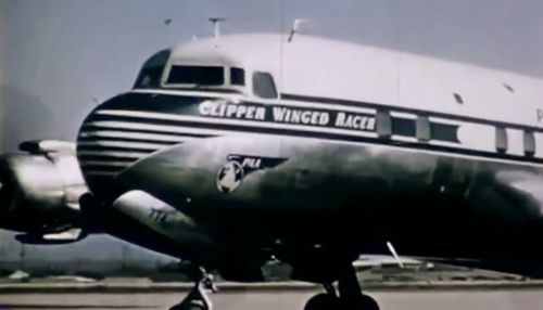
www.impdb.org/images/2/22/AAAvlcsnap-2014-05-21-23h16m08s...
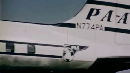
N774R with Global Presentations - Greater Hartford Flying Showcase at THF in October 1964:
imgproc.airliners.net/photos/airliners/7/2/8/1227827.jpg
N774R with Global Presentations - Greater Hartford Flying Showcase at JFK ca. 1964:
abpic.co.uk/pictures/view/1571021
N774R with Global Presentations - IBM Computour at MAN in July 1965:
www.airhistory.net/photo/26816/N774R
Colour shot of N774R with The Rank Organization at LHR in April 1966 (starboard side view):
www.flickr.com/photos/60580721@N06/33350421804
Colour shot of N774R with The Rank Organization at MAN in June 1966:
www.flickr.com/photos/kenfielding/5575617010
N774R leased by Herman’s Hermits at DAL in July 1967:
www.flickr.com/photos/23032926@N05/4949553946
N774R with Air Cambodge (untitled) at FLL in June 1973:
imgproc.airliners.net/photos/airliners/8/3/8/2575838.jpg
A DC-7 reported to be N774R at Bangkok-Don Mueang in September 1975:
www.goodall.com.au/photographs/bangkok-1975/SEA75-BGK-Tha...
Scan from black-and-white print.
Photo taken by Norbert Kröpfl. Kindly provided from the NK slide collection by Stephan Barth.
München-Riem
December 1974
72
Nord 262E-29 Frégate
72
Aéronavale (French Navy)
Aéronavale Nord 262 72 accompanied by sister ship 65 at Riem in 1974. 72 was seen at Riem again on 7 October 1977, 65 on 2 November 1977.
Aéronavale Nord 262s noted at Riem in the 1970s, 1980s and 1990s include (I guess there were more):
43 (October 1990)
45 (February 1980)
52 (October 1981)
53 (7 October 1978)
60 (3 July 1975, 21 June 1990)
61 (13 March 1975)
65 (December 1974, 2 November 1977)
69 (13 March 1975)
70 (6 July 1978)
71 (17 November 1976)
72 (December 1974, 7 October 1977)
75 (21 June 1977, 29 June 1979)
85 (3 July 1975)
100 (December 1986)
1970 built Nord 262, delivered to Aéronavale on 22 December 1970 (source: rzjets.net). This aircraft officially performed the last flight of a French Navy Nord 262 on 25 February 2009 at Nîmes Garons and was withdrawn from use but still flown from Nîmes to Paris-Le Bourget on 23 June 2009 where it is now preserved in the Paris-Le Bourget Air & Space Museum.
List of Aéronavale Nord 262s:
www.ffaa.net/aircraft/fregate/fleet.htm
Report on Aéronavale 72’s last flight (in French):
www.netmarine.net/aero/aeronefs/n262/derniervol.htm
Portrait of this airframe on the Musée de l’Air et de l’Espace website, including photos and video:
www.museeairespace.fr/aller-plus-haut/collections/nord-av...
72 at FFD in July 1993, fitted with a search radar in a radome underneath the forward fuselage:
www.flickr.com/photos/jaydeekay/35669663281
72 at LBG in October 2018:
www.flickr.com/photos/bds13/44410890705
Scan from Kodachrome slide.
Accompanying notes provided By V&A Mueseum, London. Copyright the V&A Museum.
ELYTRA, Filament Pavilion
18 May - 6 November, 2016
Elytra is a responsive shelter. A robot will build new components of the structure on the site, allowing the canopy to grow over the course of the V&A Engineering Season. Your presnce in the pavilion today will be captured by sensors in the canopy and ultimately will affect how and where the structure grows.
The pavilion tests a possible future for architectural and engineering design, exploring how new robotics technologies might transform how buildings are designed and built. The design draws on research into lighhtweight construction principles found in nature. It is inspired by the filament structures of the shells of flying beetles, know as elytra.
Made of glass and carbon fibre, each component is produced using robotic winding technique developed by the designers. Unlike other fabrication methods, this does not require moulds and can produce an infinite variety of spun shapes, while reducing wate to a minimum. This unique method of fabrication integrates the process of design and making.
Like beetle elytra, the structure is both strong and very light. The pavilion's entire filament stutcure weighs less than 2.5 tonnes - equivalent to 1.4 by 1.4 m squared prortion of the V&A's wall around you.
Part of the V&A Engineering Season.
Photo taken by Norbert Kröpfl. Kindly provided from the NK slide collection by Stephan Barth.
München-Riem
February 1976
D-IFZO
Dornier Do-28D-1/S
4036
DFVLR
c/n 4036, modified to Do 28D-1/S, Luftwaffe [West German Air Force] ('41+01' ?), Luftwaffe '58+01', operational with FBS BMVg [Flight Readiness Service of the German Federal Ministry of Defence] (04/10/1970 - 06/07/1973), 'D-IFZO' DFVLR (Deutsche Forschungs- und Versuchsanstalt für Luft- und Raumfahrt, German Aerospace Research and Test Establishment).
Four Do 28D-1/S were specially equipped for VIP (Very Important Person) or staff transport for the German military.
(Source: www.ais.org/~schnars/aero/do28.htm)
The only photo I found of this airframe as 58+01 with Luftwaffe, on the poster for the 2020 model builders' convention at Leipheim, Germany (cancelled):
fliegerhorstmuseum-leipheim.de/wp-content/uploads/2019/03...
D-IFZO stored at Oberschleissheim, Germany, in October 2015:
www.flickr.com/photos/gooneybird29/22326757181
In February 2017, D-IFZO was used as a stage prop in Jonathan Dove’s opera "Flight" performed four times at Munich’s Prinzregententheater:
www.theaterakademie.de/media/images/Eigenproduktionen/201...
See here for additional photos and videos:
blog.theaterakademie.de/post/news/ja-es-ist-echt.html
www.theaterakademie.de/spielplan-tickets/stueckinfo/fligh...
Following her stint at the theatre, D-IFZO went on to the Fliegerhorstmuseum Leiphheim, where she was noted in September 2019:
www.demobbed.org.uk/images/5/58+01_do28.jpg
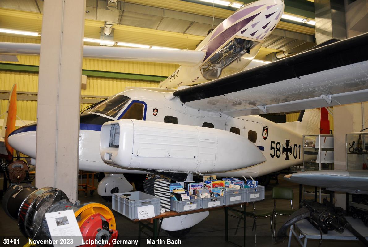
Scan from Kodachrome slide.
Leslie Anne provided the steak and asparagus for the grill, and I brought mushrooms for the grill and the squash casserole that I had cooked the night before. Since this was to be a football night, she told me not to wear red, white, and blue for New England and try to wear black and gold for Pittsburgh. The black with gold sparkles skirt and top is a set I got for a company Christmas party back in 2006. 2007 was the last year my old company gave Christmas parties for employees. We didn't win the game, but the meal was a success.
Photo graciously provided by Allan Leedy, Pualine Eubanks Rea Hammond descendant through her son Donald Pierce Rea descendant. Please read the below obituary of Albert with caution. Many "facts" are overinflated.
HAMMOND, Albert Ernest, Medford (Oregon) Mail Tribune, Friday, 24 Apr 1925
Albert Ernest Hammond, the oldest son of Anson P. Hammond and Elizabeth Schermerhorn Hammond, was born on a farm in Johnson township, Lagrange county, Indiana, on February 5, 1855.
On his paternal side he was descended from distinguished early Americans. His great grandfather was one Richard Lawson, an Englishman of noble family who was an officer in the army of Lord Cornwallis during the War of the Revolution. During or after one of the principal battles early in the War, he decided that the colonists were fighting a righteous battle, and he left the British army and threw all his efforts, fortune and his fighting experience on the side of the colonists.
He was reported as among the missing in the British records, and naturally never dared to make any claims for his estates and property in England.
He married a woman from Connecticut, and had only one daughter, who married William, one of the ten sons of Benjamin Hammond, of English descent and also a veteran of the Revolutionary war. William Hammond served his country through the War of 1812.
One of their sons, Anson P. Hammond, married Elizabeth Schermerhorn, a granddaughter of Aaron Schermerhorn who served in the colonial armies during the War of the Revolution, and was a descendant of the old Knickerbocker Dutch who early settled in New York. Aaron Schermerhorn received a patent for his services and placed the same upon lands in the Mohawk valley in the state
of New York. Elizabeth Hammond's father was also a nephew of General Israel Putnam, and her mother, Ann Johnson was a direct descendant of the Pilgrims who landed at Plymouth Rock in 1620.
Albert E. Hammond, the oldest child of this union, spent his early school days in Indiana and in southern Wisconsin, where his family had moved. He went to college at Asbury academy, now known as DePauw University in Indiana, and after finishing his course there joined his family in Yankton, Dakota territory. His early engineering work was spent on the plains of the Dakotas; and as this was during the days when the Sioux Indians were on the warpath, he and his party were frequently chased in to headquarters by the scalp hunting savages. It was during this time that he witnessed the departure from Yankton of General Custer and his troops for his momentous campaign against the Sioux, which had such a disastrous ending at the Battle of the Little Big Horn.
His father's family had moved out west to the little city of Ashland, in the state of Oregon, and Albert Hammond followed them there along in the early [18]'80s. He taught school for awhile and operated a saw mill, and tried his luck at mining and other things in southern Oregon, and finally became one of the engineers under the supervision of John T. Hurlburt, and took a very active part in the building of the O. & C. Railroad over the Siskiyou mountains. This is now a part of the main line of the Southern Pacific, and is one of the finest and most difficult pieces of mountain railway engineering in this country. After the heavy part of this work was completed he went with Mr. Hurlburt to Washington where he helped locate and construct the line of the Northern Pacific across the Cascade mountains through the famous Stampede Pass. This is also one of the stupendous engineering feats in American railway history. His work here was so well done that he was sent into Montana with the title of assistant chief engineer of the Northern Pacific railways, and for a number of years was in active charge of all the work of that company in western Montana, which involved the construction of the lines to Butte, Helena and many of the principal branch lines.
In 1889 Mr. Hammond married Pauline E. Rea in San Francisco and removed with his family to Portland, Oregon, where he followed the calling of his profession for a long period of years, and left his mark in the way of the construction of many well known public utilities in the northwest. During this period he built many of the first electric street car lines in Portland, including the Mount Tabor, Woodlawn, Woodstock, the Albina lines and many others that are now in active use. He made the first location for the railroad line down the Columbia river between Portland and Astoria, Oregon.
From about 1898 on for several years he was associated with E. E. Lytle, and during this time he located and built the Columbia Southern railroad from Biggs to Shaniko, Oregon, and was its chief engineer and general manager for several years. During thistime he also located the line from the mouth of the Klickitat river to Goldendale, Washington; also made the first railroad location lines through central Oregon and those up the Canyon of the Deschutes river, which surveys were later covered with lines constructed by the Hill interests and those of the Union Pacific.
During the time that George E. Chamberlain was governor of Oregon, Mr. Hammond was state engineer, and the first steps toward the immense irrigation projects in the Deschutes valley were planned and started under his direction. He also built the Portage railroad at the Celilo Rapids on the Columbia river, and supervised a number of other public works of great importance. After his retirement as state engineer he had charge of the first construction work at the upper end of the great Celilo canal.
His later years in Oregon were spent principally in consulting engineering work and in mining in various parts of the northwest.
In 1918 he took up his residence in California and lived in that state until his death on March 7, 1925.
His life was all spent in the great west, and his work was all constructive. He was one of the best of those strong, pioneer men who trod the unbeaten paths of the wilderness, and made it possible for the following generations to obtain the benefits of the wonderful resources of the western country.
A fitting epitaph for Mr. Hammond would be that engraved on the stone that marks the last resting place of Robert Louis Stevenson: "Under the side and starry sky,/Dig the grave and let me lie./Glad did I live and gladly die,/And I laid me down with awill./This be the verse you grave for me:/Here he lies where he longed to be;/Home is the sailor, home from the sea/And the hunter home from the hill."
NOTE: Alanson Peck Hammond was not a son of Benjamin Hammond. Richard Lawson's daughter Elizabeth Lawson married John N. Hammond. Per census records, his father’s obituary, and other records, A.P. Hammond was the son of John N. Hammond.
The Saint Hilarion Castle lies on the Kyrenia mountain range, in Cyprus. This location provided the castle with command of the pass road from Kyrenia to Nicosia. It is the best preserved ruin of the three former strongholds in the Kyrenia mountains, the other two being Kantara and Buffavento.
History
The castle is not named after St. Hilarion, active in Palestine and Cyprus in the 4th century. It was named after an obscure saint, who is traditionally held to have fled to Cyprus after the Arab conquest of the Holy Land and retired to the hilltop on which the castle was built for hermitage. An English traveller reported the preservation of his relics in the 14th century. It has been proposed that a monastery built in his name preceded the castle, which was built around it. However, this view is not supported by any substantial evidence.
Starting in the 11th century, the Byzantines began fortification. Saint Hilarion, together with the castles of Buffavento and Kantara, formed the defense of the island against Arab raids against the coast. Some sections were further upgraded under the Lusignan dynasty, whose kings may have used it as a summer residence. During the rule of Lusignans, the castle was the focus of a four-year struggle between Holy Roman Emperor Frederick II and Regent John d' Ibelin for control of Cyprus.
Much of the castle was dismantled by the Venetians in the 15th century to reduce the cost of garrisons.
Architecture
The castle has three divisions or wards. The lower and middle wards served economic purposes, while the upper ward housed the royal family. The lower ward had the stables and the living quarters for the men-at-arms. The Prince John tower sits on a cliff high above the lower castle.
The upper ward was surrounded by a 1.4 metre-thick Byzantine wall, made of rough masonry. The entrance is through a pointed arch built by the Lusignans. This was protected by a semicircular tower to the east. Within the ward is a courtyard, with twin peaks being situated to either side of it. To the north-east is an extremely ruined kitchen. To the west are the royal apartments, dated by various sources to the 13th or 14th centuries. Although mostly ruined today, this was a structure in the northeast-southwest axis, with a length of 25 m and width of 6 m. It has a basement containing a cistern and two floors. The ground floor has a height of 7 m and a pointed barrel vault. The upper floor is known for its carved windows, one of which is dubbed the Queen's Window. These are placed on the western wall, which has a scenic view of the northern coast of Cyprus, especially the plains of Lapithos.
In fiction
Two of the main characters in the 1958 historical novel, Exodus, by Leon Uris, spend a day walking around the castle ruins. Featured in the 1999 novel “Race of Scorpions” by Dorothy Dunnett. The Castle of Saint Hilarion appears in the 2009 action-adventure video game Assassin's Creed: Bloodlines, the 2015 novel "The Lost Treasure of the Templars" by James Becker, and Death in Cyprus by M. M. Kaye. The castle is also featured in the 2016 crypto-thriller The Apocalypse Fire by Dominic Selwood.
The Kyrenia Mountains (Greek: Κερύνειο Όρος; Turkish: Girne Dağları) is a long, narrow mountain range that runs for approximately 160 km (100 mi) along the northern coast of the island of Cyprus. It is primarily made of hard crystalline limestone, with some marble. Its highest peak is Mount Selvili, at 1,024 m (3,360 ft). Pentadaktylos (also spelt Pentadactylos; Greek: Πενταδάκτυλος; Turkish: Beşparmak) is another name for the Kyrenia Mountains, though Britannica refers to Pentadaktylos as the "western portion" of the latter, or the part west of Melounta. Pentadaktylos (lit. "five-fingered") is so-named after one of its most distinguishing features, a peak that resembles five fingers.
The Kyrenian mountains are named after the Kyrenian mountains in Achaia, Greece, which are well known from mythology because of the connection with one of the 12 labours of Hercules, the capture of the Kerynitis deer that lived there. This sacred deer of Artemis with golden horns and bronze legs ran so fast that no one could reach it. Hercules, however, after pursuing it for a whole year, managed to catch it and transport it alive to Mycenae.
A devastating fire in July 1995 burned large portions of the Kyrenia Mountains, resulting in the loss of significant forest land and natural habitat.
The only other mountain range in Cyprus is the Troodos Mountains.
Geology
These mountains are a series of sedimentary formations from the Permian to the Middle Miocene pushed up by a collision of the African and Eurasian plates. Though only half the height of the Troodos Mountains, the Kyrenia Mountains are rugged and rise abruptly from the Mesaoria plain.
History
The location of the mountains near the sea made them desirable locations for watch towers and castles overlooking the northern Cyprus coast, as well as the central plain. These castles generally date from the 10th through the 15th centuries, primarily constructed by the Byzantines and Lusignans. The castles of St. Hilarion, Buffavento, and Kantara sit astride peaks and were of strategic importance during much of the history of Cyprus during the Middle Ages.
Painted flag
A flag of Northern Cyprus is painted on the southern slope of the Kyrenia Mountains. It is reportedly 425 metres wide and 250 metres high, and is illuminated at night.
The flag is considered controversial as evidenced in the Parliamentary Question put to the European Parliament by Antigoni Papadopoulou on 22 October 2009, "How can it permit the existence of such a flag which, apart from the catastrophic environmental damage it causes, the use of chemical substances and the brutal abuse of the environment, involves an absurd waste of electricity at a time of economic crisis? Does Turkey show sufficient respect towards the environment to justify its desire to open the relevant chapter of accession negotiations?"
Legends
There are many legends about the Pentadactylos mountains. One tells the story of a conceited villager who fell in love with the local queen and asked for her hand in marriage. The queen wished to be rid of the impertinent young man and requested that he bring her some water from the spring of Apostolos Andreas monastery in the Karpas, a perilous journey in those days. The man set off and after several weeks returned with a skin full of that precious water. The queen was most dismayed to see that he had succeeded, but still refused to marry him. In a fit of rage, he poured the water on to the earth, seized a handful of the resulting mud and threw it at the queens head. She ducked and the lump of mud sailed far across the plain to land on top of the Kyrenia mountain range, where it is to this day, still showing the impression of the thwarted villager’s five fingers.
Another famous one is of the Byzantine hero Digenis Akritas. Tradition has it that Digenis Akritas's hand gripped the mountain to get out of the sea when he came to free Cyprus from its Saracen invaders, and this is his handprint. He also threw a large rock across Cyprus to get at the Saracen ships. That rock landed in Paphos at the site of the birthplace of Aphrodite, thus known to this day as Petra Tou Romiou or "Rock of the Greek".
Northern Cyprus, officially the Turkish Republic of Northern Cyprus (TRNC), is a de facto state that comprises the northeastern portion of the island of Cyprus. It is recognised only by Turkey, and its territory is considered by all other states to be part of the Republic of Cyprus.
Northern Cyprus extends from the tip of the Karpass Peninsula in the northeast to Morphou Bay, Cape Kormakitis and its westernmost point, the Kokkina exclave in the west. Its southernmost point is the village of Louroujina. A buffer zone under the control of the United Nations stretches between Northern Cyprus and the rest of the island and divides Nicosia, the island's largest city and capital of both sides.
A coup d'état in 1974, performed as part of an attempt to annex the island to Greece, prompted the Turkish invasion of Cyprus. This resulted in the eviction of much of the north's Greek Cypriot population, the flight of Turkish Cypriots from the south, and the partitioning of the island, leading to a unilateral declaration of independence by the north in 1983. Due to its lack of recognition, Northern Cyprus is heavily dependent on Turkey for economic, political and military support.
Attempts to reach a solution to the Cyprus dispute have been unsuccessful. The Turkish Army maintains a large force in Northern Cyprus with the support and approval of the TRNC government, while the Republic of Cyprus, the European Union as a whole, and the international community regard it as an occupation force. This military presence has been denounced in several United Nations Security Council resolutions.
Northern Cyprus is a semi-presidential, democratic republic with a cultural heritage incorporating various influences and an economy that is dominated by the services sector. The economy has seen growth through the 2000s and 2010s, with the GNP per capita more than tripling in the 2000s, but is held back by an international embargo due to the official closure of the ports in Northern Cyprus by the Republic of Cyprus. The official language is Turkish, with a distinct local dialect being spoken. The vast majority of the population consists of Sunni Muslims, while religious attitudes are mostly moderate and secular. Northern Cyprus is an observer state of ECO and OIC under the name "Turkish Cypriot State", PACE under the name "Turkish Cypriot Community", and Organization of Turkic States with its own name.
The Turkish invasion of Cyprus began on 20 July 1974 and progressed in two phases over the following month. Taking place upon a background of intercommunal violence between Greek and Turkish Cypriots, and in response to a Greek junta-sponsored Cypriot coup d'état five days earlier, it led to the Turkish capture and occupation of the northern part of the island.
The coup was ordered by the military junta in Greece and staged by the Cypriot National Guard in conjunction with EOKA B. It deposed the Cypriot president Archbishop Makarios III and installed Nikos Sampson. The aim of the coup was the union (enosis) of Cyprus with Greece, and the Hellenic Republic of Cyprus to be declared.
The Turkish forces landed in Cyprus on 20 July and captured 3% of the island before a ceasefire was declared. The Greek military junta collapsed and was replaced by a civilian government. Following the breakdown of peace talks, Turkish forces enlarged their original beachhead in August 1974 resulting in the capture of approximately 36% of the island. The ceasefire line from August 1974 became the United Nations Buffer Zone in Cyprus and is commonly referred to as the Green Line.
Around 150,000 people (amounting to more than one-quarter of the total population of Cyprus, and to one-third of its Greek Cypriot population) were displaced from the northern part of the island, where Greek Cypriots had constituted 80% of the population. Over the course of the next year, roughly 60,000 Turkish Cypriots, amounting to half the Turkish Cypriot population, were displaced from the south to the north. The Turkish invasion ended in the partition of Cyprus along the UN-monitored Green Line, which still divides Cyprus, and the formation of a de facto Autonomous Turkish Cypriot Administration in the north. In 1983, the Turkish Republic of Northern Cyprus (TRNC) declared independence, although Turkey is the only country that recognises it. The international community considers the TRNC's territory as Turkish-occupied territory of the Republic of Cyprus. The occupation is viewed as illegal under international law, amounting to illegal occupation of European Union territory since Cyprus became a member.
Northern Cyprus, officially the Turkish Republic of Northern Cyprus (TRNC), is a de facto state that comprises the northeastern portion of the island of Cyprus. It is recognised only by Turkey, and its territory is considered by all other states to be part of the Republic of Cyprus.
Northern Cyprus extends from the tip of the Karpass Peninsula in the northeast to Morphou Bay, Cape Kormakitis and its westernmost point, the Kokkina exclave in the west. Its southernmost point is the village of Louroujina. A buffer zone under the control of the United Nations stretches between Northern Cyprus and the rest of the island and divides Nicosia, the island's largest city and capital of both sides.
A coup d'état in 1974, performed as part of an attempt to annex the island to Greece, prompted the Turkish invasion of Cyprus. This resulted in the eviction of much of the north's Greek Cypriot population, the flight of Turkish Cypriots from the south, and the partitioning of the island, leading to a unilateral declaration of independence by the north in 1983. Due to its lack of recognition, Northern Cyprus is heavily dependent on Turkey for economic, political and military support.
Attempts to reach a solution to the Cyprus dispute have been unsuccessful. The Turkish Army maintains a large force in Northern Cyprus with the support and approval of the TRNC government, while the Republic of Cyprus, the European Union as a whole, and the international community regard it as an occupation force. This military presence has been denounced in several United Nations Security Council resolutions.
Northern Cyprus is a semi-presidential, democratic republic with a cultural heritage incorporating various influences and an economy that is dominated by the services sector. The economy has seen growth through the 2000s and 2010s, with the GNP per capita more than tripling in the 2000s, but is held back by an international embargo due to the official closure of the ports in Northern Cyprus by the Republic of Cyprus. The official language is Turkish, with a distinct local dialect being spoken. The vast majority of the population consists of Sunni Muslims, while religious attitudes are mostly moderate and secular. Northern Cyprus is an observer state of ECO and OIC under the name "Turkish Cypriot State", PACE under the name "Turkish Cypriot Community", and Organization of Turkic States with its own name.
Several distinct periods of Cypriot intercommunal violence involving the two main ethnic communities, Greek Cypriots and Turkish Cypriots, marked mid-20th century Cyprus. These included the Cyprus Emergency of 1955–59 during British rule, the post-independence Cyprus crisis of 1963–64, and the Cyprus crisis of 1967. Hostilities culminated in the 1974 de facto division of the island along the Green Line following the Turkish invasion of Cyprus. The region has been relatively peaceful since then, but the Cyprus dispute has continued, with various attempts to solve it diplomatically having been generally unsuccessful.
Cyprus, an island lying in the eastern Mediterranean, hosted a population of Greeks and Turks (four-fifths and one-fifth, respectively), who lived under British rule in the late nineteenth-century and the first half of the twentieth-century. Christian Orthodox Church of Cyprus played a prominent political role among the Greek Cypriot community, a privilege that it acquired during the Ottoman Empire with the employment of the millet system, which gave the archbishop an unofficial ethnarch status.
The repeated rejections by the British of Greek Cypriot demands for enosis, union with Greece, led to armed resistance, organised by the National Organization of Cypriot Struggle, or EOKA. EOKA, led by the Greek-Cypriot commander George Grivas, systematically targeted British colonial authorities. One of the effects of EOKA's campaign was to alter the Turkish position from demanding full reincorporation into Turkey to a demand for taksim (partition). EOKA's mission and activities caused a "Cretan syndrome" (see Turkish Resistance Organisation) within the Turkish Cypriot community, as its members feared that they would be forced to leave the island in such a case as had been the case with Cretan Turks. As such, they preferred the continuation of British colonial rule and then taksim, the division of the island. Due to the Turkish Cypriots' support for the British, EOKA's leader, Georgios Grivas, declared them to be enemies. The fact that the Turks were a minority was, according to Nihat Erim, to be addressed by the transfer of thousands of Turks from mainland Turkey so that Greek Cypriots would cease to be the majority. When Erim visited Cyprus as the Turkish representative, he was advised by Field Marshal Sir John Harding, the then Governor of Cyprus, that Turkey should send educated Turks to settle in Cyprus.
Turkey actively promoted the idea that on the island of Cyprus two distinctive communities existed, and sidestepped its former claim that "the people of Cyprus were all Turkish subjects". In doing so, Turkey's aim to have self-determination of two to-be equal communities in effect led to de jure partition of the island.[citation needed] This could be justified to the international community against the will of the majority Greek population of the island. Dr. Fazil Küçük in 1954 had already proposed Cyprus be divided in two at the 35° parallel.
Lindley Dan, from Notre Dame University, spotted the roots of intercommunal violence to different visions among the two communities of Cyprus (enosis for Greek Cypriots, taksim for Turkish Cypriots). Also, Lindlay wrote that "the merging of church, schools/education, and politics in divisive and nationalistic ways" had played a crucial role in creation of havoc in Cyprus' history. Attalides Michael also pointed to the opposing nationalisms as the cause of the Cyprus problem.
By the mid-1950's, the "Cyprus is Turkish" party, movement, and slogan gained force in both Cyprus and Turkey. In a 1954 editorial, Turkish Cypriot leader Dr. Fazil Kuchuk expressed the sentiment that the Turkish youth had grown up with the idea that "as soon as Great Britain leaves the island, it will be taken over by the Turks", and that "Turkey cannot tolerate otherwise". This perspective contributed to the willingness of Turkish Cypriots to align themselves with the British, who started recruiting Turkish Cypriots into the police force that patrolled Cyprus to fight EOKA, a Greek Cypriot nationalist organisation that sought to rid the island of British rule.
EOKA targeted colonial authorities, including police, but Georgios Grivas, the leader of EOKA, did not initially wish to open up a new front by fighting Turkish Cypriots and reassured them that EOKA would not harm their people. In 1956, some Turkish Cypriot policemen were killed by EOKA members and this provoked some intercommunal violence in the spring and summer, but these attacks on policemen were not motivated by the fact that they were Turkish Cypriots.
However, in January 1957, Grivas changed his policy as his forces in the mountains became increasingly pressured by the British Crown forces. In order to divert the attention of the Crown forces, EOKA members started to target Turkish Cypriot policemen intentionally in the towns, so that Turkish Cypriots would riot against the Greek Cypriots and the security forces would have to be diverted to the towns to restore order. The killing of a Turkish Cypriot policeman on 19 January, when a power station was bombed, and the injury of three others, provoked three days of intercommunal violence in Nicosia. The two communities targeted each other in reprisals, at least one Greek Cypriot was killed and the British Army was deployed in the streets. Greek Cypriot stores were burned and their neighbourhoods attacked. Following the events, the Greek Cypriot leadership spread the propaganda that the riots had merely been an act of Turkish Cypriot aggression. Such events created chaos and drove the communities apart both in Cyprus and in Turkey.
On 22 October 1957 Sir Hugh Mackintosh Foot replaced Sir John Harding as the British Governor of Cyprus. Foot suggested five to seven years of self-government before any final decision. His plan rejected both enosis and taksim. The Turkish Cypriot response to this plan was a series of anti-British demonstrations in Nicosia on 27 and 28 January 1958 rejecting the proposed plan because the plan did not include partition. The British then withdrew the plan.
In 1957, Black Gang, a Turkish Cypriot pro-taksim paramilitary organisation, was formed to patrol a Turkish Cypriot enclave, the Tahtakale district of Nicosia, against activities of EOKA. The organisation later attempted to grow into a national scale, but failed to gain public support.
By 1958, signs of dissatisfaction with the British increased on both sides, with a group of Turkish Cypriots forming Volkan (later renamed to the Turkish Resistance Organisation) paramilitary group to promote partition and the annexation of Cyprus to Turkey as dictated by the Menderes plan. Volkan initially consisted of roughly 100 members, with the stated aim of raising awareness in Turkey of the Cyprus issue and courting military training and support for Turkish Cypriot fighters from the Turkish government.
In June 1958, the British Prime Minister, Harold Macmillan, was expected to propose a plan to resolve the Cyprus issue. In light of the new development, the Turks rioted in Nicosia to promote the idea that Greek and Turkish Cypriots could not live together and therefore any plan that did not include partition would not be viable. This violence was soon followed by bombing, Greek Cypriot deaths and looting of Greek Cypriot-owned shops and houses. Greek and Turkish Cypriots started to flee mixed population villages where they were a minority in search of safety. This was effectively the beginning of the segregation of the two communities. On 7 June 1958, a bomb exploded at the entrance of the Turkish Embassy in Cyprus. Following the bombing, Turkish Cypriots looted Greek Cypriot properties. On 26 June 1984, the Turkish Cypriot leader, Rauf Denktaş, admitted on British channel ITV that the bomb was placed by the Turks themselves in order to create tension. On 9 January 1995, Rauf Denktaş repeated his claim to the famous Turkish newspaper Milliyet in Turkey.
The crisis reached a climax on 12 June 1958, when eight Greeks, out of an armed group of thirty five arrested by soldiers of the Royal Horse Guards on suspicion of preparing an attack on the Turkish quarter of Skylloura, were killed in a suspected attack by Turkish Cypriot locals, near the village of Geunyeli, having been ordered to walk back to their village of Kondemenos.
After the EOKA campaign had begun, the British government successfully began to turn the Cyprus issue from a British colonial problem into a Greek-Turkish issue. British diplomacy exerted backstage influence on the Adnan Menderes government, with the aim of making Turkey active in Cyprus. For the British, the attempt had a twofold objective. The EOKA campaign would be silenced as quickly as possible, and Turkish Cypriots would not side with Greek Cypriots against the British colonial claims over the island, which would thus remain under the British. The Turkish Cypriot leadership visited Menderes to discuss the Cyprus issue. When asked how the Turkish Cypriots should respond to the Greek Cypriot claim of enosis, Menderes replied: "You should go to the British foreign minister and request the status quo be prolonged, Cyprus to remain as a British colony". When the Turkish Cypriots visited the British Foreign Secretary and requested for Cyprus to remain a colony, he replied: "You should not be asking for colonialism at this day and age, you should be asking for Cyprus be returned to Turkey, its former owner".
As Turkish Cypriots began to look to Turkey for protection, Greek Cypriots soon understood that enosis was extremely unlikely. The Greek Cypriot leader, Archbishop Makarios III, now set independence for the island as his objective.
Britain resolved to solve the dispute by creating an independent Cyprus. In 1959, all involved parties signed the Zurich Agreements: Britain, Turkey, Greece, and the Greek and Turkish Cypriot leaders, Makarios and Dr. Fazil Kucuk, respectively. The new constitution drew heavily on the ethnic composition of the island. The President would be a Greek Cypriot, and the Vice-President a Turkish Cypriot with an equal veto. The contribution to the public service would be set at a ratio of 70:30, and the Supreme Court would consist of an equal number of judges from both communities as well as an independent judge who was not Greek, Turkish or British. The Zurich Agreements were supplemented by a number of treaties. The Treaty of Guarantee stated that secession or union with any state was forbidden, and that Greece, Turkey and Britain would be given guarantor status to intervene if that was violated. The Treaty of Alliance allowed for two small Greek and Turkish military contingents to be stationed on the island, and the Treaty of Establishment gave Britain sovereignty over two bases in Akrotiri and Dhekelia.
On 15 August 1960, the Colony of Cyprus became fully independent as the Republic of Cyprus. The new republic remained within the Commonwealth of Nations.
The new constitution brought dissatisfaction to Greek Cypriots, who felt it to be highly unjust for them for historical, demographic and contributional reasons. Although 80% of the island's population were Greek Cypriots and these indigenous people had lived on the island for thousands of years and paid 94% of taxes, the new constitution was giving the 17% of the population that was Turkish Cypriots, who paid 6% of taxes, around 30% of government jobs and 40% of national security jobs.
Within three years tensions between the two communities in administrative affairs began to show. In particular disputes over separate municipalities and taxation created a deadlock in government. A constitutional court ruled in 1963 Makarios had failed to uphold article 173 of the constitution which called for the establishment of separate municipalities for Turkish Cypriots. Makarios subsequently declared his intention to ignore the judgement, resulting in the West German judge resigning from his position. Makarios proposed thirteen amendments to the constitution, which would have had the effect of resolving most of the issues in the Greek Cypriot favour. Under the proposals, the President and Vice-President would lose their veto, the separate municipalities as sought after by the Turkish Cypriots would be abandoned, the need for separate majorities by both communities in passing legislation would be discarded and the civil service contribution would be set at actual population ratios (82:18) instead of the slightly higher figure for Turkish Cypriots.
The intention behind the amendments has long been called into question. The Akritas plan, written in the height of the constitutional dispute by the Greek Cypriot interior minister Polycarpos Georkadjis, called for the removal of undesirable elements of the constitution so as to allow power-sharing to work. The plan envisaged a swift retaliatory attack on Turkish Cypriot strongholds should Turkish Cypriots resort to violence to resist the measures, stating "In the event of a planned or staged Turkish attack, it is imperative to overcome it by force in the shortest possible time, because if we succeed in gaining command of the situation (in one or two days), no outside, intervention would be either justified or possible." Whether Makarios's proposals were part of the Akritas plan is unclear, however it remains that sentiment towards enosis had not completely disappeared with independence. Makarios described independence as "a step on the road to enosis".[31] Preparations for conflict were not entirely absent from Turkish Cypriots either, with right wing elements still believing taksim (partition) the best safeguard against enosis.
Greek Cypriots however believe the amendments were a necessity stemming from a perceived attempt by Turkish Cypriots to frustrate the working of government. Turkish Cypriots saw it as a means to reduce their status within the state from one of co-founder to that of minority, seeing it as a first step towards enosis. The security situation deteriorated rapidly.
Main articles: Bloody Christmas (1963) and Battle of Tillyria
An armed conflict was triggered after December 21, 1963, a period remembered by Turkish Cypriots as Bloody Christmas, when a Greek Cypriot policemen that had been called to help deal with a taxi driver refusing officers already on the scene access to check the identification documents of his customers, took out his gun upon arrival and shot and killed the taxi driver and his partner. Eric Solsten summarised the events as follows: "a Greek Cypriot police patrol, ostensibly checking identification documents, stopped a Turkish Cypriot couple on the edge of the Turkish quarter. A hostile crowd gathered, shots were fired, and two Turkish Cypriots were killed."
In the morning after the shooting, crowds gathered in protest in Northern Nicosia, likely encouraged by the TMT, without incident. On the evening of the 22nd, gunfire broke out, communication lines to the Turkish neighbourhoods were cut, and the Greek Cypriot police occupied the nearby airport. On the 23rd, a ceasefire was negotiated, but did not hold. Fighting, including automatic weapons fire, between Greek and Turkish Cypriots and militias increased in Nicosia and Larnaca. A force of Greek Cypriot irregulars led by Nikos Sampson entered the Nicosia suburb of Omorphita and engaged in heavy firing on armed, as well as by some accounts unarmed, Turkish Cypriots. The Omorphita clash has been described by Turkish Cypriots as a massacre, while this view has generally not been acknowledged by Greek Cypriots.
Further ceasefires were arranged between the two sides, but also failed. By Christmas Eve, the 24th, Britain, Greece, and Turkey had joined talks, with all sides calling for a truce. On Christmas day, Turkish fighter jets overflew Nicosia in a show of support. Finally it was agreed to allow a force of 2,700 British soldiers to help enforce a ceasefire. In the next days, a "buffer zone" was created in Nicosia, and a British officer marked a line on a map with green ink, separating the two sides of the city, which was the beginning of the "Green Line". Fighting continued across the island for the next several weeks.
In total 364 Turkish Cypriots and 174 Greek Cypriots were killed during the violence. 25,000 Turkish Cypriots from 103-109 villages fled and were displaced into enclaves and thousands of Turkish Cypriot houses were ransacked or completely destroyed.
Contemporary newspapers also reported on the forceful exodus of the Turkish Cypriots from their homes. According to The Times in 1964, threats, shootings and attempts of arson were committed against the Turkish Cypriots to force them out of their homes. The Daily Express wrote that "25,000 Turks have already been forced to leave their homes". The Guardian reported a massacre of Turks at Limassol on 16 February 1964.
Turkey had by now readied its fleet and its fighter jets appeared over Nicosia. Turkey was dissuaded from direct involvement by the creation of a United Nations Peacekeeping Force in Cyprus (UNFICYP) in 1964. Despite the negotiated ceasefire in Nicosia, attacks on the Turkish Cypriot persisted, particularly in Limassol. Concerned about the possibility of a Turkish invasion, Makarios undertook the creation of a Greek Cypriot conscript-based army called the "National Guard". A general from Greece took charge of the army, whilst a further 20,000 well-equipped officers and men were smuggled from Greece into Cyprus. Turkey threatened to intervene once more, but was prevented by a strongly worded letter from the American President Lyndon B. Johnson, anxious to avoid a conflict between NATO allies Greece and Turkey at the height of the Cold War.
Turkish Cypriots had by now established an important bridgehead at Kokkina, provided with arms, volunteers and materials from Turkey and abroad. Seeing this incursion of foreign weapons and troops as a major threat, the Cypriot government invited George Grivas to return from Greece as commander of the Greek troops on the island and launch a major attack on the bridgehead. Turkey retaliated by dispatching its fighter jets to bomb Greek positions, causing Makarios to threaten an attack on every Turkish Cypriot village on the island if the bombings did not cease. The conflict had now drawn in Greece and Turkey, with both countries amassing troops on their Thracian borders. Efforts at mediation by Dean Acheson, a former U.S. Secretary of State, and UN-appointed mediator Galo Plaza had failed, all the while the division of the two communities becoming more apparent. Greek Cypriot forces were estimated at some 30,000, including the National Guard and the large contingent from Greece. Defending the Turkish Cypriot enclaves was a force of approximately 5,000 irregulars, led by a Turkish colonel, but lacking the equipment and organisation of the Greek forces.
The Secretary-General of the United Nations in 1964, U Thant, reported the damage during the conflicts:
UNFICYP carried out a detailed survey of all damage to properties throughout the island during the disturbances; it shows that in 109 villages, most of them Turkish-Cypriot or mixed villages, 527 houses have been destroyed while 2,000 others have suffered damage from looting.
The situation worsened in 1967, when a military junta overthrew the democratically elected government of Greece, and began applying pressure on Makarios to achieve enosis. Makarios, not wishing to become part of a military dictatorship or trigger a Turkish invasion, began to distance himself from the goal of enosis. This caused tensions with the junta in Greece as well as George Grivas in Cyprus. Grivas's control over the National Guard and Greek contingent was seen as a threat to Makarios's position, who now feared a possible coup.[citation needed] The National Guard and Cyprus Police began patrolling the Turkish Cypriot enclaves of Ayios Theodoros and Kophinou, and on November 15 engaged in heavy fighting with the Turkish Cypriots.
By the time of his withdrawal 26 Turkish Cypriots had been killed. Turkey replied with an ultimatum demanding that Grivas be removed from the island, that the troops smuggled from Greece in excess of the limits of the Treaty of Alliance be removed, and that the economic blockades on the Turkish Cypriot enclaves be lifted. Grivas was recalled by the Athens Junta and the 12,000 Greek troops were withdrawn. Makarios now attempted to consolidate his position by reducing the number of National Guard troops, and by creating a paramilitary force loyal to Cypriot independence. In 1968, acknowledging that enosis was now all but impossible, Makarios stated, "A solution by necessity must be sought within the limits of what is feasible which does not always coincide with the limits of what is desirable."
After 1967 tensions between the Greek and Turkish Cypriots subsided. Instead, the main source of tension on the island came from factions within the Greek Cypriot community. Although Makarios had effectively abandoned enosis in favour of an 'attainable solution', many others continued to believe that the only legitimate political aspiration for Greek Cypriots was union with Greece.
On his arrival, Grivas began by establishing a nationalist paramilitary group known as the National Organization of Cypriot Fighters (Ethniki Organosis Kyprion Agoniston B or EOKA-B), drawing comparisons with the EOKA struggle for enosis under the British colonial administration of the 1950s.
The military junta in Athens saw Makarios as an obstacle. Makarios's failure to disband the National Guard, whose officer class was dominated by mainland Greeks, had meant the junta had practical control over the Cypriot military establishment, leaving Makarios isolated and a vulnerable target.
During the first Turkish invasion, Turkish troops invaded Cyprus territory on 20 July 1974, invoking its rights under the Treaty of Guarantee. This expansion of Turkish-occupied zone violated International Law as well as the Charter of the United Nations. Turkish troops managed to capture 3% of the island which was accompanied by the burning of the Turkish Cypriot quarter, as well as the raping and killing of women and children. A temporary cease-fire followed which was mitigated by the UN Security Council. Subsequently, the Greek military Junta collapsed on July 23, 1974, and peace talks commenced in which a democratic government was installed. The Resolution 353 was broken after Turkey attacked a second time and managed to get a hold of 37% of Cyprus territory. The Island of Cyprus was appointed a Buffer Zone by the United Nations, which divided the island into two zones through the 'Green Line' and put an end to the Turkish invasion. Although Turkey announced that the occupied areas of Cyprus to be called the Federated Turkish State in 1975, it is not legitimised on a worldwide political scale. The United Nations called for the international recognition of independence for the Republic of Cyprus in the Security Council Resolution 367.
In the years after the Turkish invasion of northern Cyprus one can observe a history of failed talks between the two parties. The 1983 declaration of the independent Turkish Republic of Cyprus resulted in a rise of inter-communal tensions and made it increasingly hard to find mutual understanding. With Cyprus' interest of a possible EU membership and a new UN Secretary-General Kofi Annan in 1997 new hopes arose for a fresh start. International involvement from sides of the US and UK, wanting a solution to the Cyprus dispute prior to the EU accession led to political pressures for new talks. The believe that an accession without a solution would threaten Greek-Turkish relations and acknowledge the partition of the island would direct the coming negotiations.
Over the course of two years a concrete plan, the Annan plan was formulated. In 2004 the fifth version agreed upon from both sides and with the endorsement of Turkey, US, UK and EU then was presented to the public and was given a referendum in both Cypriot communities to assure the legitimisation of the resolution. The Turkish Cypriots voted with 65% for the plan, however the Greek Cypriots voted with a 76% majority against. The Annan plan contained multiple important topics. Firstly it established a confederation of two separate states called the United Cyprus Republic. Both communities would have autonomous states combined under one unified government. The members of parliament would be chosen according to the percentage in population numbers to ensure a just involvement from both communities. The paper proposed a demilitarisation of the island over the next years. Furthermore it agreed upon a number of 45000 Turkish settlers that could remain on the island. These settlers became a very important issue concerning peace talks. Originally the Turkish government encouraged Turks to settle in Cyprus providing transfer and property, to establish a counterpart to the Greek Cypriot population due to their 1 to 5 minority. With the economic situation many Turkish-Cypriot decided to leave the island, however their departure is made up by incoming Turkish settlers leaving the population ratio between Turkish Cypriots and Greek Cypriots stable. However all these points where criticised and as seen in the vote rejected mainly by the Greek Cypriots. These name the dissolution of the „Republic of Cyprus", economic consequences of a reunion and the remaining Turkish settlers as reason. Many claim that the plan was indeed drawing more from Turkish-Cypriot demands then Greek-Cypriot interests. Taking in consideration that the US wanted to keep Turkey as a strategic partner in future Middle Eastern conflicts.
A week after the failed referendum the Republic of Cyprus joined the EU. In multiple instances the EU tried to promote trade with Northern Cyprus but without internationally recognised ports this spiked a grand debate. Both side endure their intention of negotiations, however without the prospect of any new compromises or agreements the UN is unwilling to start the process again. Since 2004 negotiations took place in numbers but without any results, both sides are strongly holding on to their position without an agreeable solution in sight that would suit both parties.
From time to time, I get called Charlie Coats this goes way back to those days, the 60’s. Jack Bell provided me with his dad’s formal Navy coat. It was a Great Coat, three quarter length, thick pure wool, dark dark navy blue, brass double breasted buttons with a lapel pocket, inside pockets and warm outer pockets. I gave Jack either ten or twenty dollars for the coat but there was one stipulation, don’t wear it to the Bell household. Good old Jack didn’t bother to get permission to sell me the coat that had been hanging in Mr. and Mrs. Bells basement closet for decades. Who knows, they might have buried Iggy Bell in it if it was still around at the time of his death. You’ve got to be into wearing coats to understand my love of them. The comfort of a coat and the security it provides is like a mother’s breast.
Pete The Hook and I had a parting of company, the rent was due at the basement apartment off of Weston Road on Summerhill Ave. That’s the place where I had hand painted each brick leading to the basement entrance in either red white or blue like the Union Jack a tribute to the British Music scene. Lots of fun times happened at that place. Mom showed up one day with a pack of wieners and a jar of peanut butter, the Stone’s new album Let It Bleed, the one with the cake on the cover was getting heavy rotation, I recall putting on the tune, “You can’t always get what you want” for mom who listened, somewhat bewildered. One time a local girl who enjoyed sex came over. Ten of us hid in the tiny bathroom and one after another we took turns and hopped into bed with her. As a bonus, a few days later all of us were crawling with crabs, not the edible type! I was preening in the bathroom mirror when I saw a pair racing towards my moustache for cover!
For some reason Hook and I were both broke at the same time and thusly had to find new digs. I recall, as if it was yesterday, Hook pointing out how many days we had shared the apartment and how many times he had left a chunk of hash or joint to smoke on the kitchen table for me. He was right, he had done this daily for over six months. At that time I don’t think my buddy he put much of a value on the free security I provided, and the fact the place was used as a stash. Hook and Cooper aka Mike Cooper aka Coop de Grasser were partners in crime and owned a black 63 Cadillac limousine in mint condition. Their friend, Ron Warren aka Scarecrow was the principal driver and Coop and Hook would Lord it all over the west end of the city in the Caddy. We got plenty of respect from everyone as our demeanor when necessary could be quite obnoxious.
We took in a concert at the Colonial Tavern on Yonge St one night, maybe it was Muddy Waters or perhaps John Lee Hooker playing. We got into a scuffle outside the bar after the early show. I took care of the situation with one punch and later we drove up Yonge towards Dundas in the limo. Hook, a crafty and creative individual who wore coke bottle thick glasses, put the windows down and leaned out the rear door window shouting at the throngs of people, “CRIME PAYS”, at the top of his voice! “CRIME PAYS”!
It was quite a shock to be forced to move back with my mom Gisele and the family. I’d been away for a few years, I didn’t have any other choices. I was broke, out of work, the UIC benefits had run out and I was very grateful to have a place to go. Mom gave me the middle bedroom of the thirteenth floor Ontario Housing Corporation apartment at 121 Humber Blvd. The apartment number was 1413 but it was actually 1313 because in apartments they don’t count the thirteenth floor. Big Al was at the height of his speeding days, hanging out with all sorts of speedy types like J.R. Al Buckley and others. He worked at something, maybe grave digging at Prospect Cemetery or possibly cement pouring for Dufferin Construction. For the most part he gave me my space. Barb, Sue and Mom lived in the big back bedroom. Shane and Kevin shared a bedroom, Kevin being away at boy’s training school or he may have graduated by then to prison. He just seemed to get caught breaking into homes a lot, he was quite likeable, handsome, a good talker, like all of us, he had lots of friends, always had a girlfriend, Joanne mostly, he just couldn’t stop himself from crime. Shane was hanging out with his new friends up the road a ways, Hime, Tim, Gidge, Stewey, Kyle, Larry, a whole new group of people who had their own preferences. Barb was cute and at a young age was going steady with Gordon Gilbert who lived across the street on Humber Blvd.
Mom would go to work at the Simpson’s Arcadian Court downtown on Yonge St. I can still see her dressed in a brownish nylon waitress uniform with a white collar, slowly walking up the back stairs of Humber and over to Weston Rd to catch the bus to the subway then all the way downtown. She put food on the table every night without fail. She had figured it out to only buy what she needed for each day, if she had left anything extra around, Alex in particular, would eat it, disregarding everyone else. Some nights we ate grilled cheese and tomato soup for dinner and were glad to. Other times she made her famous salmon loaf with tomato soup poured on top of the crescent roll pastry, we never missed a meal. She would stop at the Dominion store on Rogers Road after her shift at Simpson’s and pick up the days groceries with her tip money. I don’t recall her ever complaining; now and then she would jokingly say, “Should have left you all here in Toronto and went back to Montreal when your father died!” Now, here I show up at her door, with my hand out, a bag of clothes, another bag with art work, writings and photos, the by now beaten up RCA record player and a few records all scratched from heavy rotation. The middle bedroom quickly became my new headquarters.
I settled into life at Humber with all of its intricacies as one may imagine from living in a family as dynamic as the Gregory’s. We were poor, mom got a cheque from welfare, it was probably the first time in my life that I realized we were poor. One time, I got a swollen throat and I couldn’t breathe. Mom’s boyfriend Johnny Basala, who was still chasing Mom, rushed me to the emergency department at Northwestern General Hospital on Keele St. They gave me an injection of antibiotics and sent me home to sleep. The injection eased the pain and when I awoke that night I spit up a hunk of phlegm the size of a golf ball and flushed it down the toilet, I had something called Quincey and apparently was lucky to ‘get it in time’.
The word “flashbacks” never worried me much in those days. Lying on the couch one weekend afternoon, before dinner, I fell asleep. I fell into a deep trance-like state and recall being conscious of my soul entering various bodies. One, a black slave in Africa as he ran through some fields, a cowboy in Western times and numerous other reincarnations including that of a snake charmer in ancient India with curly hair like Jimmi Hendrix who could make coins and jewelry appear and a north American Indian at war standing over the dead bodies of his tribesmen. Mom said I had been sweating quite profusely as I slept. When I awoke I was quite grateful to be in the correct body. The event reminded me of a story Paramahansa Yogananda was telling one time about a dream he had as a young man. He dreamed he was the captain of a ship that had been attacked by another ship. He swam for shore, where he was hit by a shell and as he lay dying he began to slip into various consciousnesses and he said, “Am I dreaming I am a Captain of a ship who has been in a war and dying or, am I dreaming I am lying in my bed here at 4 Garpur Road in Calcutta dreaming? What was it?”
Cooper was a great guy and has been sadly missed since his death in the early seventies of misadventure while on vacation in Jamaica. The usual, died in bed, choked on his vomit after drinking 120 proof rum. Mom would watch from the thirteenth floor window of Humber, always walking onto the balcony to wave to me early in the mornings as I headed up to catch the bus on Keele St. I worked at yet another Continental Can Company plant way up Keele St. past Steeles Ave. Word gets around when plants are hiring and Don Humes (aka Snorks) was working there. He told me about them hiring at CCC, so I went up to the personnel office and filled out an application for work. It was a three shift operation, just some labour kind of function. The plant was the major supplier of cans to soda pop bottlers. I just left the application with the receptionist.
I was all excited, as I’d been out of work for some time and it gets on your nerves. Other people were in school and I had no dough with too much time on my hands. The personnel office called an asked me in for an interview on the following Monday morning. Great! Great Fucking News! But stop right there, guess who didn’t make it to the interview? I had gotten high and fucked up this opportunity. But not to worry, I did some quick thinking and visited Cooper at his home on Brownville Avenue. He was recuperating from some illness, maybe hepatitis or pneumonia. He was bedridden and did his share of the dealing from his house. His mom made the best roast pork dinner I ever ate. I recall her telling me the secret was to cook the pork at a high temperature for thirty minutes at the beginning and then lower it to the normal temperature as this seals in the juices. Any way, Coop says yeah to my request to go back to the plant and reapply for work using his name and social insurance number. He says it will be great for him to have a job on his resumes in the future, I don’t think he had ever worked. He had figured out the dealing business at a young age. He was way ahead of himself in life; he had this young chick, maybe sixteen if that, she was gorgeous. They had a Kama Sutra chart on the bedroom wall and he pointed out how they were trying to do all seventy two of the various positions shown on the chart, they were half way through the chart. Coop was also very generous with his stash always laying a toke or ten on me.
Continental Can was still hiring and they called me in for an interview. That is to say they called Mike Cooper in for an interview. I started right away, doing general plant stuff, filling boxes, putting stuff on the line, nothing to strenuous as the cans were made of aluminum and were somewhat machine controlled. They just needed bodies around to keep the equipment going, to shut things down and restart when the problem had been resolved. Another area of the plant was for testing the finished product. At this station, I had to take the cans off the belt after they had been put through a heating process. They were too hot to touch so they gave me a type of rake to grab a few at a time. This was slow so I created a better tool that would pick up many more cans at once, actually it was quite simple, just a drawing of a gadget that could pick uo twenty four cans at a time and place them neatly in a box, a time saver. I got called up to the office, had to enter my invention officially and apply for a prize or bonus. Mike Cooper, the inventor! It was kind of neat having people call you Mike while at lunch in the cafeteria. I kept the job for most of that summer and Mom always waved each morning as I made the walk up to Keele St.. I would cut through the old trestle that led to Keelesdale Park and George Harvey High School and the big Church where the teacher Bill Rowland’s father was the minister. When I left the job Coop even let me collect UIC under his name and also claim the Federal taxes for a refund.
That summer of 1970 an entrepreneur put on a rock concert at Porter Field which was located at the former dump site on Humber Blvd where as a young boy I saw rats crawling around the open garbage. The same field where five years earlier the policeman had challenged me to a fight. Porter Field was below Rogers Rd, and ran south from Weston Rd. The concerts were called Beggars Banquets, and that year there were about five different shows with this title, one might think a comment on the working class status of the area. Nothing like this had ever happened before in working class Mt. Dinky. A bunch of us were partying at Giseles, either on the balcony or in the apartment getting a head-start on the upcoming events. Alex had some Crystal Methamphetamine, speed for short, and he was in a sharing mood. He loved the fact the guys from high school, his former friends as well, were at the house. We were among the first to get to the stadium. We set up mom’s aluminum lawn chairs in the very front row and sped all over the place, greeting people, guzzling wine, more speed, tokes, beers. The under cover coppers Smith and Criscoe (Mutt and Jeff) gave us space, these concerts were a bonanza for the cops, like Vancouver’s downtown east side, keep the bad people all within this zone where it is easier to watch them. Three Dog Night played at the concert they had a big # 1 tune at the time. Another band played their hit song of the day Orange Blossom Special, and then, at some point in the middle of the day, our group came on the portable stageThe Band. Here we are all ripped and sweating, about six of us, in lawn chairs. Thousands of people, maybe five or ten thousand and we’ve got the front row locked up. Robbie Robertson cranked his guitar real good and stared at us making motions with his guitar, it was ecstatic. Nobody got busted; a few guys barfed up some cheap wine. We headed back to Giseles. I recall my blue Mexican four pocket Hippie shirt with the Mazaltan Bird embroidery on it being soaked right through several times.
The fun was just beginning, we continued speeding up at the apartment, now I’d been up for two days straight and getting to sleep was impossible. I thought I was falling asleep and I got real paranoid, this had never happened before. I was having bad hallucinations, shaking, shivering, nervous, my teeth felt like they would fall out, they were chattering! In my mind I was seeing these tiny little coppers, in uniform, cops climbing up the walls of the big building and crawling along the balcony railings, hundreds of them thousands of them like little pac mens in uniform, sneaking up on me, miniature police nightmares. I wasn’t asleep; I was in some kind of pre-sleep hellish hallucination. Al came though with the cure, he laid a toke of hash on me and it calmed me down and I fell asleep.
Al was fried in those days, he was using a lot of speed. There was a whole cult of guys who were speeders in the neighborhood. Once, he chipped some plaster from the ceiling in the living room and sold it to some speeders who came to the apartment to score. What a nice guy that Al was. Other times found him in his bed, the light was never on. He used to pump iron, and eat about four litres of ice cream a day, nothing else just ice cream. He ate the ice cream with a large tablespoon; meanwhile Mom could hardly put food on the table. He didn’t give a fuck about anyone, we were powerless. In his room, he would rock himself to sleep, listening to Van playing Astral Weeks over and over or better still, just rock, a habit he had incorporated into his insanity. We all avoided him as best we could, as his moods were very unpredictable. There were times when he would be in that bedroom for days on end and never leave it, maybe just for a piss or a tub of ice cream. We went in there one time and he was all fucked up. He had taken the plaster off the walls near the electric plug boxes and was down to the meshing wire that held the plaster in and he was claiming these wires were networks leading to aliens, very weird. I think he was trying to connect wires from the plug box to the plaster mesh to fry the aliens, as he thought “they” were trying to wire his underwear. He even had dismantled the intercom system to ferret out the invaders; this made my miniature police adventure seem quite tame.
Another concert that proved entertaining was held in Rockwood Ontario, somewhere near Orangeville, on a summer Saturday. A bunch of us piled into the Cadillac, Hook, Pete, Frankie, Jack B myself and a few others that I can’t recall. Nobody in particular was playing the gig except an acquaintance of ours, Tony Flaim, from Keele and Eglinton. Tony had practiced blues singing and playing the harp for years and was just about ready to make some records. He later cut tunes with the Downchild Blues Band. As we get closer to the concert, the radio was giving people the heads up that the pigs are busting people who show up with their stash. Now we were not stupid, several miles from the gig we pull over and go into the woods. I now think Coop was with us as well, and we hid all our goodies under some branches, marking the spot so we could pick them up later because we didn’t want to get busted. I remember snorting some “H”, one of the few times I tried this, it was real good. I didn't do a lot that’s for sure as I was ‘with’ things the entire time, just real mellow, confident, on top of things. Everyone else was stoned as well on their choice of medication. Besides hash and pot, one could easily obtain, mushrooms or psillocybinn, LSD in various forms and strengths, Purple Microdot, Orange Sunshine from Owsley in California, the best LSD was the little clear plastic like squares called Windowpanes it was so clean such an opening to hidden places, unexplored capabilities within ones mind/brain, there was MDA as well which was more of a body stone with hints of oak and late nights in Brazil.
We got to the gate and the local plainclothes and uniformed cops tell us to get out of the Cadillac. They are going to search the vehicle, so we get out. A little creep goes in after the local fuzz came out with nothing, and a minute or two later he comes out with a five dollar baggie of pot which he says he got it in between the seat cushions. Fucking pricks, they planted the bag of weed on us. We were all pretty high but we still knew this was bullshit. They marched us off to a rental shack like the ones used at construction sites and in this big tin portable building there are about ten other scared kids already waiting for interrogation or something. I seize the moment, put on my stern look, find the stern voice and as I entered the building these kid’s first thoughts are that I was an undercover agent. I raised my voice and said, “You people standing over there, stop chatting and stand at attention.” They did and I had command of the room for a moment or two, then a pig caught the play and quickly separated me from my friends and chastised my prank.
I was now quite high on the “H”, in control but buzzing real good. My eyes would have been all glassy, when you are like that you are pretty carefree, besides, I'd been busted lots of times and been in jail, so this was nothing new to me. The other guys made bail using their own signatures but because I had the previous bust for that tab of acid and conviction, they decided not to give me bail. I was taken later by paddy wagon to the Orangeville cells that were located in this neat century old building. I was up grooving half the night, chatting up other unfortunate kids, sharing smokes, jailhouse stories, wondering if I would start itching the way junkies do, if I would have withdrawals. This was all new to me, the effects of this drug. Mr. Herbert came and bailed me out the following Monday after the guys told him how we had been set up and framed. They had all been charged as well and had hired a couple of lawyers to act on their behalf.
Going to trial seemed to take forever. It was at least six months which is pretty fast compared to the situation of backlogs in courts these days. I actually went to the Don Jail and turned myself in for a big mess of tickets, parking, speeding, drinking fines, about three or four hundred dollars worth, everything would be wiped out if I did a weekend in jail, no big deal for me. I went in on a Friday morning and was supposed to be released on Sunday on time for my court appearance in Orangeville on the Monday morning. Someone at the Don Jail goofed up and I didn’t get out on Sunday, they let me out on Monday morning, and I missed my ride to the Orangeville court house. I was on a bus, the Weston Rd bus around ten am and I was going to take a bus as far as I could then hitch hike to Orangeville.
The bus passes the HFC office in Weston, a lending institution that charges the highest rates and this creep, Snidely the manager, spots me sitting on the bus and I pretend I don’t see him. I watch him get into his crappy car and follow the bus. When we get to the Albion Loop where the Weston Rd bus turns around to go south again. I got out of the bus and very nonchalantly entered this dive of a restaurant called the Pelmo. The Pelmo was so bad that a cockroach wouldn’t visit it, nobody ever went in there. I casually entered, not letting on to the HFC goof watching me in the car that I knew he was following me. As quick as I went in, I ran out the back door and hid under a car that was parked along the property line with several others. Snidely came in after me a few minutes later and it was so funny watching him going nuts trying to locate me, it was all I could do to not start tittering. Eventually I crept over to a pay phone, put a dime in and called Cooper who sent Crow up to rescue me in the Caddy. They drove me to court where they remanded the case for another month. HFC are still waiting for their money!
When the case finally came before the courts, I acted on my own behalf. The judge asked me to sit with the other lawyers and I must have looked quite the part in Mr. Bell’s dark blue Navy Great Coat, my moustache curled and waxed and a gleam in my eye. A cheap camera that I had taken out to take a snapshot was quickly put away at the judges request and I regret that I have only my memories of the events. The other guys were very tense and a little poorer for having hired lawyers. The case was called, and as there had been a meeting beforehand of the crown attorney and the hired lawyers the charges were dismissed as no one on our side was about to plead guilty to these bullshit charges. We were intent on telling the truth about the frame up and you can be sure the pigs did not want this. The proceedings took place in a second floor courtroom and afterwards, upon leaving the court, I ran into the little prick who had framed us, His name was Ryan and he was an RCMP. I stopped him in the stairwell and told him if I ever saw him on the street I would kick the shit out of him, and I meant it. The concert had been a big party spoiled by these assholes, our friend Tony never made it to the stage as he ended up nodding out in the woods like so many others.
From information provided by the V&A Museum accompanying the object. Copyright the V&A Museum.
'Outer Kimono (uchikake)' - 1870-90
This exhuberant outre Kimono features scenes formtwo well-known plays. Decorative themes on the actual Kabuki stage costumes were not literal, so thi sgarment may not have been worn by an actor, but by a high-ranking couretsan. The pleasures of the theatre and the brothel were closely linked during the Edo period.
Probably Kyoto
Satin silk with applique and embroidery and metal-wrapped threads.
Effects provided by UV light and a laser.
For the let's chillax group challenge with We're Here.
Day 163-365
MGS Memorabilia Letters and Writings from Veronica Laryea aka Vero Nima Accra Ghana West Africa. Photo provided by Vero.
Vero & Mike are in Love 20th December 1999 To someone Special
Sample provided by Victor Mozqueda
Fluorescence Kit: macroscopicsolutions.com/product/excitation-filters-for-f...
Illuminated with: macroscopicsolutions.com/product-category/imaging-product...
Imaged with: macroscopicsolutions.com/product/the-macropod/
Images in this gallery were captured by:
Mark Smith M.S. Geoscientist mark@macroscopicsolutions.com
Annette Evans Ph.D. Student at the University of Connecticut annette@macroscopicsolutions.com
Chad Fagan B.S. Geoscientist
chad@macroscopicsolutions.com
Eudunda –German Settlers Town.
The Government extended the Kapunda railway to Eudunda in 1878. This provided a great boost to the newly settled town which had been surveyed in 1872. Eudunda was selected as a town site on the eastern side of the Mt Loft Ranges at 415 metres above sea level, with annual rainfall of 450 mm. To the east of Eudunda the rainfall drops sharply and at 250mm Goyder’s Line is crossed, which depicts the limit of reliable cereal cropping land. Eudunda is often one of the coldest places in SA during the winter months.
The town was established in 1872 a few years prior to the arrival of the railway and it was located near a permanent spring. A town water supply was always essential in the 19th century. Thus the name Eudunda is of aboriginal derivation, Ngadjuri meaning “sheltered water or spring.” This water supply was crucial for the sheep and cattle overlanders coming down from Morgan. In 1872 A & G Neumann erected a flour mill, and in 1874 Mr Appelt opened his general store, having also been appointed Postmaster. The earliest settlers were second generation Lutheran Germans moving on from the Barossa Valley. With the opening of the railway to the Adelaide in 1878 the district thrived. To complement their flour mill Laucke’s established a chaff mill in Kapunda Street and the Eudunda Bakery has been in operation for over 100 years. Eudunda foundries provided employment for many town dwellers, especially the Lutz Farm Machinery Foundry which operated 1892-1905 until it was taken over as Jansen’s Foundry (operated 1905-1951). This foundry survived until recently and was last being run by a Canadian company trading as Emco-Wheaton in the 1980s. It still employed 30 men in the 1980s. A new engineering firm established in Eudunda in 1985 called Buschutz Engineering. The company now employs 20 staff producing hay conditioners, water tanks, silos, fertilizer spreaders and under vine feeders. Edwin Davey the successful flour miller from Angaston later had a second flour mill built in Eudunda to complement his mills in Salisbury, Port Adelaide, Melbourne and Sydney. This second flour mill later became Laucke’s mill. It opened in 1879 and still stands in Kapunda Road.
But before the industry got under way the hotels opened! The first was the Eudunda Hotel which opened in 1873 (what we see today is the 1886 building) and the Royal Hotel which was built as a grand two storey structure in 1878. The first banking service operated from Appelt’s Store in 1877 with the first National Bank (a house type building) being erected in 1888. When it opened, all advertisements for its services were in German. Another indication of the strong German origins of the town was the establishment of the Eudunda Club in 1888 as a club for German workingmen, especially employees of the local foundry. The Club, like German schools etc was closed by Act of parliament in 1917 but it re-opened in 1919. It is still operating in Bruce Street. The Club built the Centenary Hall in 1900 which became the town Institute building when the Town Council took it over.
Police were stationed in Eudunda from 1877 but the first police station was not built until 1883. The town had an early fire station, and like most SA towns the hospital was not opened until the 1920s. It opened in 1922. The first government school opened for classes in 1878 in a large brick and stone Gothic style building. During World War One it became a Higher Primary School offering classes for year 8 and year 9 students. A new building was provided for the town in 1946 and opened as Eudunda Area School (which had been established in 1943) as around half a dozen outlying schools had been closed during the Second World War. From that time children were bussed into Eudunda Area School. At some stage the old 1878 school buildings were demolished. The Lutheran churches provided some early school classes but Emmaus Lutheran Church did not open a formal school until 1904 in Eudunda. The school was closed by state legislation in 1917 during World War One, but it re-opened in 1925 and still operates today with over 200 enrolments. Lutheran church services were mainly conducted in German until the 1920s. The last German language church services in the district were held at Point Pass Lutheran Church in 1939. The outbreak of World War Two finally stopped the German language services.
The history of the churches in Eudunda show the strong Lutheran heritage. Emmaus congregation formed a Lutheran Church in 1871 as the town began. They built a fine church in 1884 at a cost of £1,100. Another Lutheran congregation formed in 1885 and built a second Lutheran Church, St Paul’s in 1893. St Paul’s finally closed in 1979 and a new church for the combined congregations was erected in 1980 called St John’s. The Anglican Church was set up in 1889 when they purchased a former Lutheran Church. It is called St Hilda’s. The Methodist Church was opened in 1885. There is also a Catholic Church in Eudunda.
Among the many successful businesses in Eudunda was Wiesner and Company timber and hardware merchants. Their impressive warehouse and store still remains in the town. The Wiesner family started a blacksmith and foundry business in Eudunda in 1884 which eventually employed 50 people. In 1905 they sold that business and opened the iron mongers and furniture store in large two storey premises to which they added. It became the largest hardware and furniture store outside of Adelaide. It sold everything from pianos, china, glassware and silver cutlery to iron, nails, tools and timber and sewing machines. Johannes Wiesner and his son Adolph ran the business until it was sold in 1951 but they had downsized it in 1945 when they sold they sold part of the warehouse to the Masonic Lodge. Interestingly Adolph married an English girl Mary Cranston and he became a Methodist and his grandson became a Methodist Minister.
When the government extended the railway form Kapunda to Eudunda in 1878 they wanted to push it further across the Murray Flats to Morgan. Why, one might ask? Well, they wanted to tap into the lucrative river trade that came down from New South Wales. Wool was shipped down the Darling and Murray and supplies shipped up the river to many NSW properties. By having a railway to Morgan and extensive wharves there, the SA government could transport the wool to Port Adelaide for transhipping to Europe. The rise of Morgan, of course, was to mean the demise of the major shipping ports lower down the Murray such as Milang, Goolwa and Murray Bridge. Because this trade was so important economically the train line crossed the flat through Mount Mary to Morgan in 1878. During the 1890s a quarter of ALL wool exported from SA came from other colonies, mainly NSW but some also came from Queensland and Victoria. Once the South Australian Railways were making a profit (their first profits were in 1907) they also extended the railway from Eudunda to Robertstown in 1914. Passenger services to Robertstown ceased in 1962. The Morgan railway was the most profitable in the state.