View allAll Photos Tagged Permit
A female Red-winged Blackbird (Agelaius phoenixes) near its nest in a cattail bed in a small wetland west of Borstal, Saskatchewan, Canada.
25 May, 2016.
Slide # GWB_20160525_2569.CR2
Use of this image on websites, blogs or other media without explicit permission is not permitted.
© Gerard W. Beyersbergen - All Rights Reserved Worldwide In Perpetuity - No Unauthorized Use.
American Robin (Turdus migratorius) feeding on frozen Mountain Ash berries in a small urban park in north Edmonton, Alberta, Canada.
Solid, winter overcast conditions made for a gray/white background and low light. Fill flash was used to bring the highlights out in the bird.
16 January, 2016.
Slide # GWB_20160116_3261.CR2
Use of this image on websites, blogs or other media without explicit permission is not permitted.
© Gerard W. Beyersbergen - All Rights Reserved Worldwide In Perpetuity - No Unauthorized Use.
This is the second year I got lucky to win an Enchantment core zone permit during its larch season. Last year, with all the preparation and expectations, an unexpected snow storm completely ruined the trip. With 10lbs of camera gear I only had chance to take one photo in three days. This year, I got a permit that's two weeks earlier than last year and weather was really cooperative as well. During our 4 day / 3 nights backpacking trip, we got to experience Enchantments in its full beauty. Larches were in peak color everywhere and we got the best lights we could only imagine in our wildest dreams.
This shot was taken at Gnome Tarn, a very famous place to take Prusik Peak reflections, in the early morning. The night before, the gust lasted the whole night and thank god we selected our base camp with enough wind blockers to shield our tents. In the morning, the wind was still quite strong, but this actually helped to create this magical moment when the fog and low clouds were blown around near the tarn. With the sun rising, everything was lit up and we all screamed and cannot believe this magical moment was just revealing itself in front of us. This is a shot I've been dreaming for years and I finally got it in the best condition I want.
AROUCA (Portugal): Passadiços do Paiva.
Os passadiços do Paiva são uma atração turística que permite aos visitantes desfrutar da natureza em estado puro, ao longo de um percurso de quase 9 quilómetros pela margem esquerda do rio Paiva, em Arouca. Os passadiços são feitos de madeira e atravessam paisagens deslumbrantes, como descidas de águas bravas, cristais de quartzo e espécies raras de fauna e flora.
Antes estaba permitido el baño, pero después de una erupción cercana, la temperatura del agua subió hasta los 43 grados y prohibieron.
Catalogada como Punto de Interés Geológico, la Fuentona de Ruente es una surgencia natural de agua que brota al pie de una pared de roca caliza, al sur del pueblo de Ruente.
Se caracterizada por manar variables caudales de forma intermitente, llegando a quedar totalmente seca por cortos espacios de tiempo de una forma no periódica. Lo destacable de esta fuente es que no es tal fuente, sino el nacimiento de un río.
De las aguas de esta cavidad se sirvieron viejos batanes y molinos harineros, piscifactorías de trucha y la fábrica de luz “la Deseada”; aún hoy día sigue siendo útil, surtiendo de agua potable a varias poblaciones del valle del Saja. Muchos estudios identifican la Fuentona con las “Fuentes Tamáricas” descritas por Plinio en el s.I d.C. El origen probable de la fuente es la intercomunicación en un curso subaéreo de una red de conductos subterráneos (fuentes) existentes en la zona, con lo cual la naturaleza freática puede ser la más acertada.
La Fuentona es bien conocida por la rareza de su cavidad y por el fenómeno de las intermitencias. El manantial de flujo regular, repentinamente deja de manar por un tiempo que oscila entre algunos minutos y varias horas, volviendo a surgir sus aguas con el mismo caudal anterior. Esta deseca temporal es descrita como de “remota antigüedad” y que a partir del siglo XX ha permitido documentar unas 12 paradas. La última seca ocurrió el 1 de Noviembre de 2011 durante 2 horas 30 minutos.
Científicamente se suele relacionar las paradas de volumen de agua con las incidencias meteorológicas. El problema es que en la Fuentona este fenómeno no está en relación con este factor, y sigue manteniéndose. Algunos autores sostienen que estas interrupciones pueden deberse a la existencia de un sistema sifónico en el interior de la cueva, en el que periódicamente la presencia de bolsas de aire interrumpa el flujo de agua.
Sin duda se trata de uno de los lugares más hermosos de Ruente.
This is llyn y Dwarchen it a fly fishing lake only, you can get daily permit from the pub at Rhyd Ddu just over a mile away.
Also beautiful landscape view of Eryri mountains in spring sunshine.
There are over 3 Million motorcycle riders in Spain.
Moped Permit. The AM license can be obtained at 15 years old and allows you to drive 2 or 3 wheel mopeds
Sturgeon County, Alberta
_IMG_1095_18-11-16
Use of this image on websites, blogs or other media without explicit permission is not permitted.
© Glenn Parker - All Rights Reserved Worldwide In Perpetuity - No Unauthorized Use
El verano nos permite fotografiar con el sol situado bastante más hacia el norte que el resto del año. En esta esquina de la Península se agradece para que la luz cálida de la puesta penetre en algunas playas.
En esta localización, durante los días más cortos del invierno ,nuestra estrella se despide justo tras el pequeño monte del fondo, Punta Frouxeira.
Esta playa es de las más visitadas de Ferrolterra. Si te alejas un poco de la arena, empleando estrechos senderos franqueados por los siempre cariñosos tojos (Ulex europeaus), la costa es muy fotogénica.
La altura de los "toxos" puede superar ampliamente los dos metros. Suficiente para acribillarnos con sus recias espinas desde cualquier ángulo. A cambio, inundan de tonos amarillos toda la costa con la llegada de la primavera y mantienen la zona despoblada de tumbonas y de turistas. Por desgracia es una especie invasora en algunos lugares como la lejana isla de Tenerife.
En estas tomas, donde salen pequeñas olas rompiendo ,procuro elegir con calma el tiempo de exposición para proporcionar el máximo dinamismo.
___________________
Valdoviño - A Coruña
20 mm a f/8 durante 1 s.
Filtro polarizador, degradado inverso de 2EV y densidad neutra de 3 EV
Revelada en Lightroom y editada por zonas con máscaras de luminosidad y con Nik color Efex. Aplicadas dominantes de color en luces y sombras.
Trípode Leofoto LP-284C y rótula Leofoto LH-40PCL
When I finally got a permit to The Wave after years of trying I knew I wanted to try and do something different out there. When I saw this spot and the lines in the rock, while facing north, I knew what I wanted to do almost instantly.
It was very nerve wracking listening to the camera fire off exposures all night long, knowing that I would only get one chance at this shot as I may never be able to draw a permit again (especially during a new moon), but not being able to check on the progress until the image series was complete. Thankfully, in the end it came out exactly as I'd had envisioned it, which is not usually how things turn out.
El Lago Maggiore es uno de los destinos más fascinantes del norte de Italia y el sur de Suiza, famoso por su entorno natural espectacular, pintorescos pueblos, islas históricas y una mezcla única de cultura alpina y mediterránea. Selección de las mejores recomendaciones para disfrutar al máximo tu visita, desde lugares imprescindibles hasta experiencias únicas y centros de información turística.
Islas Borromeas (Isola Bella, Isola Madre, Isola dei Pescatori): Las Islas Borromeas son el corazón del Lago Maggiore y una parada obligada. Isola Bella destaca por su palacio barroco y jardines espectaculares, Isola Madre por su exuberante vegetación y pavos reales, e Isola dei Pescatori por su ambiente auténtico de pueblo de pescadores. Estas islas ofrecen una combinación única de arte, historia y naturaleza que no encontrarás en ningún otro lago italiano.
Barco turístico con paradas libres desde Stresa: El servicio más popular es el pase de un día tipo “hop-on hop-off”, que permite subir y bajar ilimitadamente en las tres islas principales: Isola Madre, Isola dei Pescatori e Isola Bella. Los barcos salen cada 30 minutos de 9:30 a 18:00 horas, la última salida es a las 13:45 horas. La última salida para la Isola Madre es a las 14:50 horas, de marzo a noviembre. El recorrido clásico parte de Stresa, hace parada primero en Isola Madre, luego en Isola dei Pescatori y finalmente en Isola Bella, regresando después a Stresa. Es ideal para explorar los palacios, jardines y restaurantes de cada isla a tu ritmo. Precio 15 euros c/u. Barco turístico de las islas Borromeas, Stresa - Central de Reservas. Scalo di Stresa, Piazza Guglielmo Marconi, 28838 Stresa VB, Italy
Stresa: Stresa es la localidad más famosa del lago, conocida por su elegante paseo marítimo, villas históricas y vistas panorámicas. Es el punto de partida ideal para explorar las islas y disfrutar de la arquitectura y el ambiente refinado. Además, su ubicación la convierte en un excelente centro logístico para excursiones por la región.
There were no nearby clouds to contend with this morning and that permitted the view I was after with Merriam Crater. On any given day that old cinder cone is perfect—then catching it sharing the horizon with this graceful comet gets kind of goosebumpy for me.
In
Details:
I tried to see how long I could observe it visually with binoculars and was able to see it from 3:31–4:54AM—basically right on the horizon up to 13° at the end when the sun was 5° below the horizon. I was able to observe it naked eye, including the tail, up to the last 20 minutes or so.
Theta Auriga was conveniently 3° away for comparison, so naked eye the tail appeared about 1° in length. Through binoculars more like 2.5° long and photographically, about 3.5°. It kept its yellowish color up to the last 20 minutes or so when the sky was pretty bright and making it hard to detect. The pseudonucleus appeared more neutral in color and the tail had that bifurcation both visually through binoculars and photographically. I made a quick field sketch — first one I've done in a while — hopefully I can get that finished up & posted soon.
Photographically I think I'm picking up a hint of an ion tail very faintly just left of the curving dust tail. I need to work on some of the other magnified images to see if it's really there.
Image is from east of Flagstaff, Arizona, USA. 3:44AM MST/1044 UT.
The comet is 2° above horizon/sun is 16° below horizon.
Image comprised of 6 sequential exposures stacked and aligned to improve signal-to-noise ratio.
Canon EOS 6D Mark II, Canon EF 70-300mm lens at 130mm, f/5.0, 2 sec, ISO 6400.
A 2.700 metros de la Ruta Provincial Nº 31, sobre acceso de tierra mejorado, que permite su ingreso en días de lluvias. Al sureste de la ciudad cabecera “Rojas”, sobre el trazado del Ferrocarril General Urquiza.
En la localidad funciona el CEPT Nº10 de Hunter – Centro Educativo para la Producción Total, (educación media con orientación agropecuaria).
Encontramos un establecimiento cooperativo de acopio de granos; el Club Sportivo Hunter con instalaciones para fiestas y canchas de fútbol; la estación de tren manteniendo su fachada (actualmente no presta servicio como tal); y varios caseríos.
Pocas familias conforman la sociedad de la localidad. La iglesia Católica Argentina tiene el previo de junto a la Capilla.
Fiestas populares y aniversarios
Almuerzo en iglesia todos los 9 de Julio.
Vías de Comunicación
A 2.700 metros de la Ruta Provincial Nº 31, sobre acceso de tierra mejorado, que permite su ingreso en días de lluvias.
Ferrocarril Nuevo Central Argentino – Ex. Estación Hunter.
Camino Rural Nº32, Nº33, Nº40.
Historia
La historia de Hunter se remonta a después de mediados del siglo XIX; ya en sus últimas décadas, (1870-1890), contaba con almacén de Ramos Generales. Lleva el nombre de quien fuera el dueño de los terrenos que hoy ocupan la estacion ferroviaria y el casco urbano, Dr Juan Hunter
En el año 1910 fue inaugurada la estación ferroviaria del Ferrocarril Central Buenos Aires, que luego tomara el nombre de Ferrocarril General Urquiza.
Sólo algunos almacenes de ramos generales perduraron durante varios años. El éxodo de habitantes que sufre el partido en la década del 40 (1940-1955) dan comienzo del fin de su pueblo, lo cual se acentúa con la clausura del ramal ferroviario en el año 1990.
Es de recordar, por quienes lo habitan y/o habitaron, que en el año 1974 el equipo de Fútbol del Club Sportivo Hunter, obtiene el campeonato de la Liga de Fútbol de Rojas.
Podemos permitirnos este lujo
de abandonar los nombres,
porque el nombre es razón de los ausentes,
y nosotros estamos en la luz,
en el aire que corta las dulces siluetas,
en el tiempo que ordena las palabras
y en los escalofríos del jardín.
Incluso en la memoria que quiso ser presente.
Luis García Montero
La intimidad de la serpiente (2003)
The Harrisburg Covered Bridge was built over the East Fork of the Little Pigeon River by Elbert Stephenson Early in 1875. The bridge is of quite simple design. It was originally supported by what is known as a "queenpost" truss. This type of truss made of hardwood beams permitted the engineer to span a greater distance than the more simplistic "kingpost" truss. The Harrisburg Bridge is roughly sixty feet long and the flooring of the bridge is made of oak planks which were laid from side to side. Windows are set between the vertical post of the truss. Shingles were probably the original roofing material, however, a new galvanized tin roof was added during restoration. Clapboard siding covers the vertical posts which support the roof. The bridge is located a short distance off U.S. Highway 411 with one lane width that adequately serves the residents of the rolling countryside beyond the East Fork.
Like many covered bridges in America, it had fallen into dilapidated condition. In 1972, the Great Smokies Chapter and the Spencer Clack Chapter of the Daughters of the American Revolution financed the repair and restoration of the structure. At this time, a large concrete support was also added at the center of the bridge.
Harrisburg is a small community in rural Sevier County. There was never any extensive development in the area that it is marked by some fine examples of mid and late nineteenth century homes. The Harrisburg Covered Bridge, long a landmark in the area and some of the only infrastructure since its construction in 1875, is significant as an example of the covered bridges which were once numerous in the state, but have now almost disappeared. It is, in fact, one of just a half-dozen or so which are still standing in Tennessee. Fortunately, it was saved from total dilapidation when two local DAR chapters saw fit to restore the structure and it is one of only three still in use today.
On June 10, 1975, the Harrisburg Covered Bridge was added to the National Register of Historic Places (NRHP) in the areas of engineering and transportation. All of the information above was found on the original documents submitted for listing consideration that can be viewed here:
npgallery.nps.gov/NRHP/AssetDetail/d2c42d61-3de6-4aeb-891...
Three bracketed photos were taken with a handheld Nikon D7200 and combined with Photomatix Pro to create this HDR image. Additional adjustments were made in Photoshop CS6.
"For I know the plans I have for you", declares the LORD, "plans to prosper you and not to harm you, plans to give you hope and a future." ~Jeremiah 29:11
The best way to view my photostream is through Flickriver with the following link: www.flickriver.com/photos/photojourney57/
A vida é uma peça de teatro que não permite ensaios. Por isso, cante, chore, dance, ria e viva intensamente, antes que a cortina se feche e a peça termine sem aplausos
“Estou sempre alegre e essa é a melhor maneira de resolver os problemas da vida.”
Charles Chaplin
Esta simples homenagem é para a memoria de uma amiga que a muitos anos partiu, viveu sua vida como um brilho de Estrela Cadente, intenso e forte, alegrando e iluminando a todos com sua Beleza e Alegria no curto espaço de tempo que conosco aqui viveu, que Saudade...
A postagem de hoje não tem sequencia, apenas a foto postada no ano passado....
Foto: Flor Silvestre - Mirante Dois Irmãos - Leblon - Rio de Janeiro - Brasil
According to Law 9.610/98, it is prohibited the partial or total commercial reproduction without the previous written authorization of the author (article 29). ® All rights are reserved.
Conforme a Lei 9.610/98, é proibida a reprodução total e parcial ou divulgação comercial ou não sem a autorização prévia e expressa do autor (artigo 29). ® Todos os direitos reservados.
After finding Adamson's calotype method didn't permit much time between coating and developing when it was warm here, I decided to try Arsène Pélegry's method as modified by Rick Lanning. Aside from some speckles (my fault) it worked a treat. It's 2 stops slower than Adamson's method and perhaps more expensive, but the negatives just might last long enough to take on a trip - that would be wonderful.
Plus it seems to work well right up to the edge. I had problems with my Adamson's negatives where the varying ratios of chemicals - plus my fingerprints - would cause a lot of crap near the borders.
Puedes seguirme en mi /follow me in my web, 500px, en facebook
o en instagram
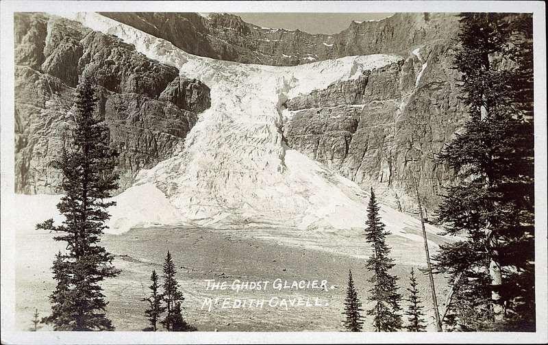
Un lugar espectacular el que pudimos disfrutar en las Rocosas, este resquicio de glaciar que se esconde del sol, en ese recoveco de la montaña. Hace menos de 70 años cubría todo parte del valle, y esa laguna de verde esmeralda no existía
Aqui podeis ver el cambio: viajeseideas.com/wp-content/uploads/2017/10/Mount-Edith-C...
Creo que nuestra hipocresía no está permitiendo avanzar en este campo, decimos que hay que pararlo, que hay que cuidar el medio ambiente, pero seguimos viajando en nuestro estupendo coche, cogiendo aviones, comprando mas de lo que nos hace falta, consumiendo mas energía de la que deberíamos...
Como siempre con Canon 5D Mark IV y 16-35mm f4 de Canon España
Filtros y portafiltro LucrOit
Seen in Covered Bridge Park, South Whitehall Township, Pennsylvania.
www.southwhitehall.com/departments/parks-and-recreaction/...
I actually won a lotto permit for the wave out of over 70 people. Took me two tries though. I found a bone prop on the hike there.
Imagine going to a place where baiters are not permitted! A
fellow patrolling this location, protecting the nature as things they
should be. A place where it is unacceptable to walk off the trails.
A place that people can visit with respect toward wildlife
and birds, and not need tobe so concerned with confrontations
involving those who selfishly and ignorantly disrespect.
What a superb experience. We had 2 Great grey owls
yesterday afternoon, up near Montreal. 3 hours of enjoyment with
my friend of many emailing years (10) Chuck Kling, a fellow
who has kept me informed regarding all the conservation issues
in his area of Quebec.
Brilliant !! Watching this bird hunt from perch to perch,
carefully examining the area for any sign of
a possible meal. Using it's facial disks to listen for any
sort of rodent squeak! I have never in
my life seen a bird hunt so aggressively... real nature
is spectacular to witness.
Personally, photography of nature is not about getting
the most likes, the most followers, the most "great shot!"
comments, biggest chest, adulation, etc. Enjoying
the beauty of nature, then sharing the images with folks
around the world to help gain a greater appreciation
of our nature world.
So we can all strive toward conservation and appreciation
of all birds, animals, and fauna.
This is absolutely not about me. or my picture, or my ego,
or a contest - biggest chest?? Never.
Having fun with my friends and workshop guests, teaching
techniques, settings,approach and respect, and the most
fun, helping people understand the natural way of things.
Understanding your subject, and showing respect will always
be the best advantage in the real world of nature photography.
Taking advantage, and virtual abuse is done selfishly
with poor judgement (unreal lazy). If you really want
to be a hero, go play golf, go racing, play baseball, compete
in a sport. Tossing bait to a helpless animal doesn't make
you special, it doesn't gain you respect, and does not make you special.
Only my opinions, hoping a few beginners understand some values, and etiquette.
Best regards, raymond.
Northern Saw-whet Owl (Aegolius acadicus) owlet near an artificial nest box in the mixed woods of the aspen parkland region north of Thorhild, Alberta, Canada.
15 June, 2016.
Slide # GWB_20160615_4987.CR2
Use of this image on websites, blogs or other media without explicit permission is not permitted.
© Gerard W. Beyersbergen - All Rights Reserved Worldwide In Perpetuity - No Unauthorized Use.
Esta deve ser a imagem de maior sucesso do Rio de Janeiro.
O fotógrafo permite que ela seja usada, desde que, seja creditada a foto a ele com link.
Mas existem canalhas que usaram a foto aqui no Flickr sem atender ao pedido do fotógrafo.
Ele foi obrigado a abri uma conta e pedir para que a foto fosse creditada.
Foi manipulado por ser pessoa de bom caráter e o ladrão de imagem ainda escreveu que conhece o artista desta imagem. Ele nunca o viu.
Rio de Janeiro 443 vezes.
Happy Birthday to You
Hoje 1° de Março é aniversário do Rio de Janeiro.
A Cidade exuberante de corpo esculpida por Deus e adornada pelo homem.
Mesmo contra tudo e contra todos o Rio continua sendo sinônimo de Brasil.
Não consegui escolher uma nova Foto panoramica no meu estilo para o dia de hoje e nem a música do dia.
Vai então um dos seus hinos. Pensei numa música menos óbvia, mas acho que nenhuma outra cairia tão bem.
A foto não é minha. É foto divulgação de Ricardo Zerrener.
Essa foto foi muito tempo meu papel de parede.
O site dele tem ótimas matérias e dicas para fotógrafos. Visitem e se gostarem do trabalho e quiserem uma foto do Rio, este é o site.
Parabéns pra nós cariocas.
:)
♪ ≡ ♫ = ♪ = ♫
[♪] Música do Dia - Only A Dream In Rio
James Taylor - Only A Dream In Rio
More than a distant land
Over a shining sea
More than the steaming green
More than the shining eyes
Well they tell me it’s only a dream in rio
Nothing could be as sweet as it seems
On this very first day down
They remind me "son have you so soon forgotten
Often as not it’s rotten inside
And the mask soon slips away"
I wanted to take a picture of some lavender, so researched some lavender farms, but I had a bit of a panic about this shot, as having telephoned before we went, it turned out they had started the lavender harvest! so we were on borrowed time. Thankfully the weather was good to us and the other 8 photographers who were all stood in the fields looking at this amazing sight and smelling it!! the scent was incredible!
This is a wonderful place to visit, the owners are very accomodating and incredibly friendly. But it is always courteous to ask to visit out of hours many didn't.
(oh and its not out of focus... just it was blurred as it was blowing in the wind!)
Buy this photo in various formats here - www.redbubble.com/products/configure/11988909
26.3.11 - Update: won 3rd Place in the News and Crier public competition for General Scene category today at the St Neots photo exhibition. Most embarassing, prize giving and piccies taken for press, and I hadn't even brushed my hair or put a face on!!! argggh.
Permite cruzar el río siempre que no tengas que hacerlo llevando un coche de bebé, desplazándote en silla de ruedas o con muletas, No es recomendable hacerlo en bici, ni con bastón de ciego.
No, this is not the world famous Wave, though it is in the general vicinity. the Wave has 400+ applicants each day for 20 permits. One can still get permits to this area, tho I do not know for how much longer. Tour groups are now bring their truck loads of clients, much to my dismay.
Cuando te das cuenta o mas bien te hacen dar cuenta de muchas de las cosas que tu dabas como hechas y aprendidas o mas obviadas por ti, se desmorona como el castillo de arena levantando por un niño en la orilla de la playa , todo cae y va siendo aplastado por la gente al pasar, es triste , pero suele suceder y mas cuando se trata de relaciones entre personas , son redes tan complejas tan abismantes, quizás me paso por confiado ,por ingenuo , por abrir mi corazón mas de lo permitido , muchas veces si hay que pensar con la mente primero y no con el corazón, por que uno al equivocarse en las personas lo que mas duele es el corazón , por que la mente te hace dar cuenta de que lo hiciste no fue lo correcto.
Conocer a alguien, suena una odisea, son dos desconocidos frente a frente, parados en el peor de los vacíos ya que el menor paso en falso te ara fallar, un desconocido con otro desconocido, que pasara si todo lo que te dice es mentira , o mas bien todo lo que dice lo hace para no que dar mal frente a ti , de manera que tu no te lleves una mala imagen de el , pero mas irracional resulta cuando te das cuenta de lo real por otro, otro que te dice que no , fuiste engañado , todo cae y no cae lento sino muy rápido tu cuerpo se paraliza ante tal mentira ante tal engaño , lo creías tan tuyo ,pero no nada era tuyo , nada era nuestro , creímos vivir un mundo perfecto un mundo de nosotros el mas lindo el mas especial , el cual aunque durase un centésima o una noche entera , seria el mas mágico de todos, estuviste con un anónimo ,contándole de ti , q horror.
Desconocidos , mas desconocidos que el primer encuentro , ya no sabes si confiar y salir huyendo de este ser que se planto ante ti con una cara llena de esperanzas , llenas de sueños , talvez me pasa por ser tan iluso y crear un mundo desde el primer momento , por proyectarme tan fácil.
Se que yo cometo errores, no soy perfecto, pero llegar a inventar cosas, talvez yo me este equivocando una vez mas, en creerle a otro ser anónimo, tal vez ahí este mi otro error ser tan confiado, me dejo llevar por palabras, ser iluso mi mayor karma.
Comenzar de cero o olvidar y escapar de la gente, aunque suene cobarde, es lo mejor para no seguir engañándote a ti mismo así no se volverá a caer con la misma piedra.
O será que ¿lo que no te mata te fortalece?
Ahí veré lo que pasa como se van dando las cosas, solo que levantar la cabeza y seguir por este sendero, lleno de asperezas, es lo que me toco y será, me gustan los desafíos, así la vida se hace mas emociónate y no tan plana, por lo plano y fácil es para los que no se arriesgan y no se sienten capases de seguir adelante.
Hoy escuchando canciones:
Me basta que me digas que talvez en una semana o en un mes, me puedas perdonar que te mentí....
Como pude fallar, como te fui a perder, buscaras otro amor que se te parezca a mi, pero no, no hallaras a otro loco como yo.
Nadie te robara tu corazón, y si lo intentas te lo robo yo
Te perdí otra vez, necesito saber, si es que ya te perdí? ¿
. (Netamente autoreferente).
También está esta otra canción que la escuche en un lugar que me hizo hacer cosas que no quería, la rabia te hace hacer cosas demasiado irracionales, pero ya están hechas, no se puede andar llorando por la vida.
No me preguntes mas por mi, si ya se cual es la respuesta, desde el momento en que te vi... Una victima casi perfecta...
Será una cuestión de suerte, creo que empiezo a entender...
Yo te propongo un desliz, un error convertido en acierto...
.( La victima casi perfecta , como si uno fuese un juguete para el resto, jugar con los sentimientos, un acto macabro. )
Reinicio. Dando vuelta la pagina
Sunrise on Sprague Lake
Rocky Mountain NP, Colorado
June 2020
Rocky Mountain NP is a real paradise on summer. If you'd like to go now, It is required entry permit or camping reservation to enter . I was lucky to be able to book my camping spot at the Moraine Park Campground at the last moment. Can't wait to go back.
Those indeed were the days! Armed with a Western Region line side permit, it was a case of breezing into Laira , flashing the pass, and the depot was yours to explore! On 3rd April 1976 'Western' No. 1054 'Western Governor' was receiving attention, along with an unidentified Class 08 shunter. Copyright Photograph John Whitehoused - all rights reserved
(note: more details later, as time permits)
*********************************************
I have visited Rome's Piazza del Popolo on several occasions over the past 38 years, and have taken numerous photos there. As it turns out, most of my visits have been in the afternoon, and I have simply walked around the broad, open plaza to photograph whatever interesting sights and people presented themselves. (For photos from a morning visit, see Sunday morning at Piazza del Popolo, Nov 2009).
On this most recent visit in May 2010, I arrived on a Saturday morning and looked forward to another photographic expedition to the Piazza. But it rained most of the weekend, and the sun didn't come out until late Sunday afternoon. At that point, I strolled across the river from my hotel to the Piazza, taking a couple of pictures along the way. Unexpectedly, I found myself in the middle of a celebration marking the 158th anniversary of the creation of Rome's police department -- with displays of police cars and helicopters, politicians giving speeches, and music from a marching band. Indeed, I was surprised to hear the band playing "Stars and Stripes Forever" (the national march of the United States), along with a couple of other John Philip Sousa marches; it seemed out of place in the Eternal City.
In any case, I found lots of interesting photographs of people in the crowd that was wandering around. And I came back to Piazza del Popolo several days later, on a late Friday afternoon, after I had finished the computer lectures that brought me to Rome on this trip. The sun was out, the temperature was mild, and as usual, the piazza was filled with numerous tourists and students and children, older people out for an afternoon stroll, families, couples, and people coming and going to church services at nearby churches. There was even a soccer game underway on one side of the piazza, with hordes of young boys dashing about at full speed...
I took nearly a thousand photos during the two visits to Piazza del Popolo on this trip; these are the ones I felt were worthy of sharing ...
North American Elk (Cervus canadensis) stalking through the woods in response to the bugle or call of another bull elk. This interaction occurred near the town of Jasper in Jasper National Park, Alberta, Canada.
19 September, 2016.
Slide # GWB_20160919_5068.CR2
Use of this image on websites, blogs or other media without explicit permission is not permitted.
© Gerard W. Beyersbergen - All Rights Reserved Worldwide In Perpetuity - No Unauthorized Use.
A 2.700 metros de la Ruta Provincial Nº 31, sobre acceso de tierra mejorado, que permite su ingreso en días de lluvias. Al sureste de la ciudad cabecera “Rojas”, sobre el trazado del Ferrocarril General Urquiza.
En la localidad funciona el CEPT Nº10 de Hunter – Centro Educativo para la Producción Total, (educación media con orientación agropecuaria).
Encontramos un establecimiento cooperativo de acopio de granos; el Club Sportivo Hunter con instalaciones para fiestas y canchas de fútbol; la estación de tren manteniendo su fachada (actualmente no presta servicio como tal); y varios caseríos.
Pocas familias conforman la sociedad de la localidad. La iglesia Católica Argentina tiene el previo de junto a la Capilla.
Fiestas populares y aniversarios
Almuerzo en iglesia todos los 9 de Julio.
Vías de Comunicación
A 2.700 metros de la Ruta Provincial Nº 31, sobre acceso de tierra mejorado, que permite su ingreso en días de lluvias.
Ferrocarril Nuevo Central Argentino – Ex. Estación Hunter.
Camino Rural Nº32, Nº33, Nº40.
Historia
La historia de Hunter se remonta a después de mediados del siglo XIX; ya en sus últimas décadas, (1870-1890), contaba con almacén de Ramos Generales. Lleva el nombre de quien fuera el dueño de los terrenos que hoy ocupan la estacion ferroviaria y el casco urbano, Dr Juan Hunter
En el año 1910 fue inaugurada la estación ferroviaria del Ferrocarril Central Buenos Aires, que luego tomara el nombre de Ferrocarril General Urquiza.
Sólo algunos almacenes de ramos generales perduraron durante varios años. El éxodo de habitantes que sufre el partido en la década del 40 (1940-1955) dan comienzo del fin de su pueblo, lo cual se acentúa con la clausura del ramal ferroviario en el año 1990.
Es de recordar, por quienes lo habitan y/o habitaron, que en el año 1974 el equipo de Fútbol del Club Sportivo Hunter, obtiene el campeonato de la Liga de Fútbol de Rojas.
we are trying to work outside when the weather permits. the dogs romp out with us, and then return to the house to romp and play inside.
making one big mess.
leon's been vacuuming. and I try to do a quickie vacuuming after I do the dishes after dinner.
notice the floor. yuck.
I spend my life picking up dog toys and re-arranging the slip covers on couch and chairs.
life with dogs.
digital.
Two rock climbers on one of red rock formations within the Garden of The Gods in Colorado Springs Colorado. One of the many geological sedimentary rock formations created by the erosion of ancient sea mountain ranges. The shift have stood-up, moved and slanted some of the formations. It was names Garden of the Gods by two surveyors in 1859 originating from Denver City, Rufus Cable commented it a fit place for the Gods to assemble and called it Garden of The Gods and that name for this amazing geological area persists to today. Rock climbers can obtain permits and scale the formations as seen in this picture. OM Systems Olympus OM-D EM-1 Mark III Olympus Pro M.Zuiko 40-150mm f/2.8 #developportdev @gothamtomato @developphotonewsletter @omsystem.cameras #excellent_america #omsystem @bheventspace @bhphoto @adorama @tamracphoto @tiffencompany #usaprimeshot #tamractales @kehcamera @mpbcom @visitcolorado @tenbabags @gardenofthegodspark
LAGOA (Açores / Portugal): Miradouro do Pisão.
Este miradouro situa-se no concelho da Lagoa, na freguesia da Ribeira Chã.
Situado do lado direito da Estrada Regional 1-1 quem desce o Pisão em direção à Praia de Água de Alto, este miradouro permite admirar a zona do portinho da Caloura.
If you hold this postcard up to the light the windows brighten up somewhat. Presumably this was a daytime shot made to look as though it is taken during the night.
The statue of Samuel Morley can be seen standing outside the Theatre Royal. The building on right hand corner of Market Street and Long Row was the old Nottingham Department store of Griffin & Spalding. The building was rebuilt in the 1920's. In c.1966 Debenhams purchased the store and I believe quickly rebranded it.
This postcard shows its vintage in that Post Office Regulations in the UK during the 1900's only permitted you to write a message on the reverse for inland postage. This postcard is franked Nottingham 5.45pm Aug 11 (19)03. It was sent to Mrs I Skelton, Fesserton, Tay, Ontario, Canada.
Instead of the usual Ha'penny stamp it cost a full 1d. to send this abroad. One penny in 1903 equates to 33p in 2008 using the Retail Prices Index. 1d in 1903 equates to £2.21 in 2008 if you use Per Captia GDP. (Per Capita GDP gives a better idea of how 'affordable' something was for someone taking into account earnings etc.)
The message on the front reads: -
' 4 Ossington Villas Sherwood Nottingham
Thanks for letter & ?. Aunt's address is
Swiss Cottage Albury Heath Guildford Surrey
Will write to you soon
Much love to you all
from us both. Hubert
Annie is collecting these cards please (Do you remember this street?) send her one or two.'